ground and airborne validation plans for gpm in … · ground and airborne validation plans for gpm...
TRANSCRIPT

GROUND AND AIRBORNE VALIDATION PLANS FOR GPM IN THE CENTRAL STATE OF SÃO PAULO, BRAZIL
P6R.8 Roberto V. Calheiros1*, Gerhard Held1, Valentin Mitev2, Carlos Alberto de A Antonio1, Giovanni Martucci2
and Renaud Matthey2
1 Instituto de Pesquisas Meteorológicas, Universidade Estadual Paulista, Bauru, S.P., Brazil 2 Observatory of Neuchâtel, Neuchâtel, CH-2000 Switzerland
1. INTRODUCTION The Meteorological Research Institute (IPMet), of the São Paulo State University (UNESP), which pioneered weather radar surveillance for general purposes in Brazil, presently operates two S-Band Doppler radars in a round-the-clock routine, backed by an R&D group. Short-term experiments, coordinated by IPMet, have taken place along the years, which included many ground-based measuring devices/systems, such as radiosondes, radiometers, GPS, instrumented tethered balloons, etc. Also, six balloon campaigns have been carried out since 1995 until 2004, primarily in partnership with the French CNRS (Centre National de la Recherche Scientifique) and CNES (Centre National d'Études Spatiales). More recently, broader field campaigns, involving stratospheric balloons and aircraft flying in the mid-troposphere and lower stratosphere, have been conducted jointly. These are part of ongoing cooperation programs with EU countries, in particular France and Germany. With respect to the latter, in 2004 and 2005, two outstanding campaigns were effected within the context of the EC project TROCCINOX (Tropical Convection, Cirrus and Nitrogen Oxides), through the Brazilian project TroCCiBras (Tropical Convection & Cirrus Brasil), based on a low-level Embraer Bandeirante, a mid-level Mystère Falcon and a low stratosphere Russian M-55 (Geophysica) aircraft (Held et al., 2004). Furthermore, IPMet is a key partner in the new SIHESP (Portuguese acronym for “Integrated Hydrometeorological System of the State of São Paulo”) project, through which its observational capability will be substantially enhanced with new instruments, e.g., a tropospheric wind profiler with RASS, a Sodar (acoustic sounder), a microwave radiometer and GPS.
* Corresponding author address: Roberto V. Calheiros, Instituto de Pesquisas Meteoro-lógicas, UNESP, CX-281, 17001-970 Bauru, S.P., Brazil; e-mail: [email protected]
Thus, a favorable scenario then exists for validation of satellite measurements, among many other important applications. In fact, IPMet had already been selected as a validation site, providing dedicated observations for validation of the AIRS/AMSU/HSB instrument suite flying onboard the AQUA polar platform (Fetzer et al., 2003). Furthermore, during the last two large field campaigns, the first one in 2004 (involving two aircraft and stratospheric balloons) and an other one in 2005 (involving three aircraft, one of which for stratospheric flight-levels), dedicated validation flights were performed for Envisat and Icesat spacecrafts. Brazil, comprising vast tropical areas in a continent surrounded by oceans, relies heavily on satellite observations for its needs related to weather and climate, as well as for agriculture and other planning purposes. Of particular importance is rainfall, which is highly variable in the tropics, due to its mostly convective nature. In this sense, the Global Precipitation Mission (GPM) Project represents a marked improvement over its predecessor program TRMM (Tropical Rainfall Measuring Mission), reducing considerably the time required for mapping the global precipitation distribution, viz. to three hours, through the deployment of a constellation of orbiting satellites. Therefore, validation efforts were established as an outstanding matter within IPMet´s research program, backed by more than three decades of experience in rainfall measurements by radar, as well as corresponding processing and analysis methods. One outstanding issue, already focused within TRMM and GPM dedicated research at IPMet, is that of TRMM MDZ impact, as dealt with by Calheiros et al. (2000, 2001a and 2001b). This paper summarizes both IPMet´s ground observational base to be in routine operations by 2008 and the field campaigns coordinated in Brazil by IPMet, involving aircraft and stratospheric balloons. An outlook on the latter, for 2008 and beyond, is presented in the Conclusion section of this paper.

Also considered is the role to be played by IPMet as an integrator of the São Paulo State radar network, gathering information from its two S-band radars (already integrated), one Dual Pol X-band radar, which will be deployed to survey the São Paulo (city) Metropolitan Area (RMSP) and another similar X-band radar to be deployed in the coastal region of the State as part of the oceanic radar network, which will be operated by IPMet as another component of SIHESP. To illustrate measurements effected during the campaign, which could be of particular interest in a GPM validation experiment, one segment of the January and February 2005 aircraft field experiment is presented, which refers to cloud top observations by both ground radar and an airborne micro-lidar. Comments are included in the Conclusion section of this paper on the GPM/Brazil project, recently established by the Brazilian Space Agency (AEB), with which IPMet´s validation activities will be coordinated. 2. FIELD CAMPAIGNS IN 2004 AND 2005 A unique opportunity to become more involved in the validation of satellite observations opened, when two EU-funded international projects, viz., HIBISCUS (a project on “Impact of tropical convection on the upper troposphere and lower stratosphere”) and TROCCINOX (Tropical Convection, Cirrus and Nitrogen Oxides), joined the Brazilian TroCCiBras (Tropical Convection & Cirrus Brasil) Project to conduct a major field experiment in the State of São Paulo early in 2004. The overall duration of the TroCCiBras Experiment was from 21 January until 11 March 2004, but not all subprojects extended throughout this time frame. Since the participation of one of the major components in the TROCCINOX project, viz. the high-flying Russian Geophysica M55 aircraft, was cancelled at the last moment, the coordinators of TROCCINOX decided to extend the project and stage a second campaign during January and February 2005. The TROCCINOX research aircraft, the DLR Falcon D-CMET and the Russian M55 Geophysica, performed various research missions from 1 – 18 February 2005. TroCCiBras comprises a variety of sub-projects proposed by the major atmospheric sciences specialist research groups in Brazil. The two main components, constituting the data acquisition, were ground-based sensors and airborne platforms, e.g., specifically instrumented aircraft and stratospheric balloons.
The ground segment involved operational observations by two meteorological S-band radars, one in Bauru and the other 240 km west of it. The radars are located in Bauru (Lat: 22°21’28” S, Lon: 49°01’36” W, 624 m amsl) and in Presidente Prudente, 240 km west of Bauru (Lat: 22°10’30” S, Lon: 51°22’22” W, 460 m amsl), respectively, as shown in Figure 1. Both have a 2° beam width and a range of 450 km for surveillance, but when operated in volume-scan mode every 7.5 minutes it is limited to 240 km, with a resolution of 1 km radially and 1° in azimuth, recording reflectivities and radial velocities. Both radars have Sigmet processors and run under the IRIS Operating System.
Figure 1. IPMet’s Radar Network (BRU = Bauru; PPR = Presidente Prudente), showing 240 and 450 km range rings. X marks the airports used in 2004 (GPX = Gavião Peixoto) and 2005 (ARA = Araçatuba), respectively. Furthermore, data from rain gages and Automatic Weather Stations, as well as dedicated instruments operating for a limited period of time, were made available by IPMet’s partner organizations during the field campaigns in support of special research programs. This is the case with aerosol lidars (e.g., the elastic backscattering Lidar of IPEN, the “Instituto de Pesquisas Energéticas e Nucleares”), radiosondes and small networks of experimental lightning detectors. Due, mainly, to both logistic and technology transfer difficulties, IPMet developed a policy of international cooperation for joint experiments in Brazil, which allows that specific measurements of high value, essential for sophisticated research projects, but for practical or financial reasons unattainable in Brazil, are obtained with instrumentation temporarily imported by the foreign partner(s).

2.1 Brief objectives of the TroCCiBras, TROCCINOX and HIBISCUS Projects TroCCiBras The general objective of the TroCCiBras project is to obtain a set of special measurements throughout the troposphere and the lower stratosphere, to meet specific research needs of Brazilian research institutions, through the realization of the EU project TROCCINOX and the joint Brazilian / European project HIBISCUS in Brazil (Held et al., 2004). The different research sub-projects, although classified into three main topics, viz., “Meteorology, Atmospheric Physics and Forecasting”, “Atmospheric Chemistry” and “Validation of Satellite-borne and Ground-based Remote Sensors”, constitute in fact a comprehensive ensemble. Table 1 (Appendix) lists the various sub-projects and responsible institutions. In conclusion, it can be stated that all sub-projects will contribute major milestones to the overall knowledge of the atmosphere over the State of São Paulo and thus facilitate the achievement of the two primary goals of TroCCiBras, viz., the validation of satellite-derived measurements (especially those of the HSB) and the improvement of Nowcasting methods. The complete project proposal and other relevant documents can be downloaded from the TroCCiBras Website http://www.ipmet.unesp.br/troccibras/
TROCCINOX
The main objectives of TROCCINOX, which is an RTD Program of the European Commission, can be summarized as follows: • To improve the knowledge about lightning-
produced NOx (LNOX) in tropical thunderstorms by quantifying the produced amounts, by comparing it to other major sources of NOx and by assessing its global impact, and
• to improve the current knowledge on the occurrence of other trace gases (including water vapor and halogens) and particles (ice crystals and aerosols) in the upper troposphere and lower stratosphere in connection with tropical deep convection, as well as large-scale upwelling motions.
Thus, the project TROCCINOX will perform first measurements of the combined properties of convection, aerosol and cirrus particles and chemical air composition (nitrogen oxides in particular) in the tropics over oceanic and continental regions (State of São Paulo and adjoining areas) in the upper troposphere and lower stratosphere, including troposphere-
stratosphere exchange. Bauru was identified as the ideal base point, due to its proximity to observed high lightning frequencies over the South American continent. A modeling component aims in providing improved descriptions of processes relevant to global climate problems. Details about the TROCCINOX project can be found at the following Website - http://www.pa.op.dlr.de/troccinox/ HIBISCUS The general objective of the HIBISCUS project, which is also partly funded by the European Commission, is to investigate the impact of tropical convection on the stratosphere at global scale. Thus, more specific objectives of the HIBISCUS project can be summarized as follows: • Past and present meteorological analyses • Vertical and horizontal transport • Clouds and microphysics • Source of stratospheric water vapor • Chemistry, impact of lightning and pollution • Satellite validation (ENVISAT, SAGE-III)
Further specific objectives will characterize the impact of convection on the tropical upper troposphere and lower stratosphere, the transport pattern, radiation, micro-physics and atmospheric chemistry. Details about the HIBISCUS project can be found at the following Website http://www.aero.jussieu.fr/projet/HIBISCUS/ 2.2 Periods of Field Campaigns The TroCCiBras field experiment, which comprised its own sub-projects, as well as the HIBISCUS campaign, coordinated by the French CNRS (Service d’Aéronomie of the Centre National de la Recherche Scientifique) in collaboration with CNES (Centre National d'Études Spatiales) and the TROCCINOX experiment, coordinated by the German “Institut für Physik der Atmospäre” (IPA) of the “Deutsches Zentrum für Luft- und Raumfahrt” (DLR), officially extended from 21 January to 11 March 2004, and all data that have been collected under the TroCCiBras project have been assembled in a special, PassWord-protected, data base to which all partici-pating organizations and researchers have access via FTP (Held et al., 2004). TroCCiBras and HIBISCUS were based at IPMet in Bauru, while the TROCCINOX aircraft were using the Embraer airport at Gavião Peixoto (GPX, Figure 1). Due to the fact, that the Russian high-flying research aircraft, M55 Geophysica, could not participate in 2004, it was decided to conduct a
second phase of TROCCINOX in the State of São Paulo during February 2005, with the aircraft being based at Araçatuba (ARA, Figure 1), since the facilities at GPX were no longer available. The M55 Geophysica is a stratospheric aircraft, 23 m long and has a wing span of 37.5 m. Its maximum take-off weight is 24.5 tons and it has a range of 3000 km, with a ceiling altitude of 20-22 km. The aircraft is instrumented by project partners to measure the air composition, under the coordination of the Italian group “Geophysica EEIG” (http://www.geophysica-eeig.cnr.it). The total compliment of payload instruments flown on the M55 Geophysica during the TROCCINOX experiment has been summarized by Stefanutti et al. (2004). 3. GROUND (REGULAR) OBSERVATIONAL BASE IPMet’s set of ground instruments would play a key role in validation within the context of programs dedicated to measurements of precipitation, such as TRMM and GPM, due, in particular, to its continuous operation of two radars covering much of the State of São Paulo. One approach to validate the precipitation screening/retrieval derived from satellite microwave radiometry to be adopted by IPMet, is that implemented by Bennartz and Petty (2001), and Bennartz and Michelson (2002), who correlated coincident radar precipitation and Special Sensor Microwave Imager (SSM/I) data during BALTEX-PIDCAP. Another approach under consideration is that of Chen and Staelin (2003), who applied a neural-network-based technique to retrieve precipitation rates utilizing the Advanced Microwave Sounding Unit (AMSU) on the US NOAA-15 satellite. The retrieval technique relies on opaque oxygen and water vapor channels near 54 and 183 GHz, which are indirectly responsive to vertical wind velocity and humidity, and whose product is approximately proportional to precipitation rate. They successfully correlated retrieved rain-rates with corresponding NEXRAD derived ones and indicated the regional nature of the validation for different areas of the world. In the Bauru radar coverage area, a Tb (brightness temperature) - Z (reflectivity) relation was derived (Calheiros et al., 2005) through the cumulative probability equivalence method (Calheiros and Zawadski, 1987). The relationships obtained are compatible with other available results and show stratifications, which tend to follow approximately the different meteorological condition in the area (Calheiros and Machado,
2004). This is the technique of first choice for validating spaceborne microwave radiometry measurements, in the area of IPMet radars. Besides precipitation, IPMet’s radar products include echo tops, Vertically Integrated Liquid water content (VIL) and accumulated rainfall. Presently, IPMet’s observational basis comprises two S-band weather radars (BRU and PPR, Figure 1), 4 Joss-Waldvogel distrometers, as well as a Vaisala Radiosonde System with GPS (not in routine operations, but activated during intensive campaigns). As a main component of the operational observations capability for the before-mentioned SIHESP project, IPMet will incorporate other relevant instrumentation, as listed below: • Tropospheric Wind Profiler with RASS (Bauru), • Sodar (Acoustic Sounder, Bauru) • Water Vapor Radiometer (Bauru), • GPS network (Bauru plus 8 UNESP stations
spread throughout the State), and • X-band radar, as part of an oceanic radar
network to be deployed by IPMet along the shoreline of the State.
This instrumentation will integrate the statewide SIHESP data collection complex, which includes the equipment discriminated in the sequence, to be operated by partner institutions: • X-band (dual pol) mobile radar, for basic
coverage of the City of São Paulo Metropolitan Area (RMSP),
• Wind Profiler (lower troposphere) at São Paulo, • Mesonetwork (surface) in RMSP, and • Automatic Weather Station Network covering the
whole of the State.
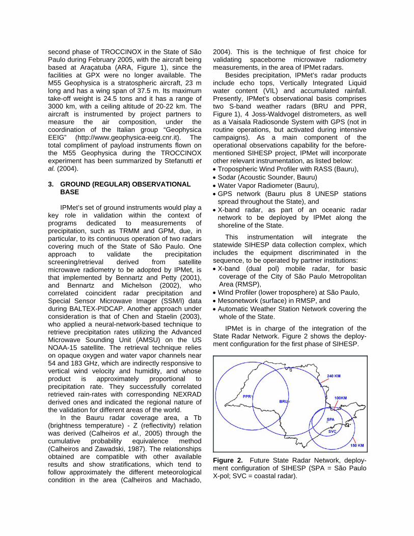
IPMet is in charge of the integration of the State Radar Network. Figure 2 shows the deploy-ment configuration for the first phase of SIHESP.
Figure 2. Future State Radar Network, deploy-ment configuration of SIHESP (SPA = São Paulo X-pol; SVC = coastal radar).

Presently both Institute radars (BRU and PPR) are under the process of update and upgrade, by which digital reception and new processing capabilities will replace aging hardware and open the possibility of the user to interact with the radar signal processor – no longer proprietary. The increased data accuracy and better detection capability is to be followed by a narrower antenna beam (1 degree at – 3 dB) and dual polarization. 4. CLOUD OBSERVATIONS WITH AIRBORNE
MICRO-LIDAR AND GROUND RADAR The MAL-2 (Miniature Aerosol Lidar Mark 2; Figure 3) is a backscatter-depolarisation lidar operating onboard the stratospheric research aircraft M55 Geophysica (Figure 4). The lidar was designed and built in the Observatory of Neuchâtel (Mitev et al., 2002). The objective of this instrument is the determination of the backscatter and the depolarisation ratios of subvisible clouds and the altitude of the top of opaque clouds. The direction of probing is downwards and the operational wavelength of the lidar is 532 nm. In order to be mounted in the stratospheric aircraft, the lidar is compact (32 kg total mass) and operates automatically. The intrinsic altitude and time resolution for signal detection and acquisitions are respectively 10 m and 12 sec, but in order to increase the signal-to-noise ratio, those values are degraded in the signal processing. During TROCCINOX 2, with daytime measurements, the typical altitude and time resolution for cloud parameter determination were 85 m and 60 s, respectively.
Figure 3. MAL-2 (Miniature Aerosol Lidar Mark 2), on the right: mounted in aircraft bay of M55 Geophysica.
Figure 4. M55 Geophysica aircraft laboratory during TROCCINOX 2 (2005), indicating the position of the bay containing the MAL-2. As an illustration of the kind of observations of value for GPM validation, measurements performed during one event in the TroCCiBras/TROCCINOX 2 Campaign during the Brazilian summer of 2005, are briefly considered below. The event refers to the flight of 04 February 2005, when rain clouds were surveyed by both MAL-2 and the S-band Bauru radar (BRU). Figure 5 shows the echo tops as observed by the Bauru radar, while Figure 6 reproduces a short period of the MAL backscattering ratio vertical profiles during the M55 flight on 04 February 2005. Times are LT for the radar map (UTC-3h) and UTC for the flight trajectory and MAL-2 measurements. Radar threshold is set at -15 dBZ, and the selected time interval, delineated by vertical lines in Figure 6, corresponds to the radar volume scan period. The color area in Figure 6 presents the observed clouds (scattering ratio), from which the cloud top and base may be assessed. The black line in this figure indicates the M55 altitude. The blank area shows altitude and time interval where the lidar backscatter signal is below the SNR threshold (2.3), indicating that no clouds are observed. A good agreement is noted between the radar echo top and that indicated by the MAL-2. The synergistic use of radar and lidar can, for instance, provide a reliable cloud boundary estimate in many cases (which often is not possible using one of those instruments in isolation). A good discussion on this is found in Venema (2000). The knowledge of cloud boundaries, by its turn, is directly important for some algorithms for retrieving microphysical cloud properties, in addition to climate studies (Boers et al., 2000).
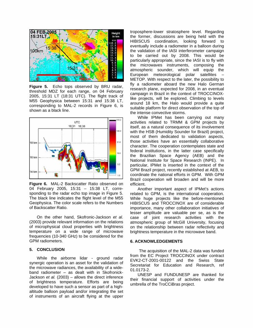
Figure 5. Echo tops observed by BRU radar, threshold MDZ for each range, on 04 February 2005, 15:31 LT (18:31 UTC). The flight track of M55 Geophysica between 15:31 and 15:38 LT, corresponding to MAL-2 records in Figure 6, is shown as a black line.
Figure 6. MAL-2 Backscatter Ratio observed on 04 February 2005, 15:31 – 15:38 LT, corre-sponding to the radar echo top image in Figure 5. The black line indicates the flight level of the M55 Geophysica. The color scale refers to the Numbers of Backscatter Ratio. On the other hand, Skofronic-Jackson et al. (2003) provide relevant information on the relations of microphysical cloud properties with brightness temperature on a wide range of microwave frequencies (10-340 GHz) to be considered for the GPM radiometers. 5. CONCLUSION While the airborne lidar - ground radar synergic operation is an asset for the validation of the microwave radiances, the availability of a wide-band radiometer – as dealt with in Skofronick-Jackson et al. (2003) – allows the direct inference of brightness temperature. Efforts are being developed to have such a sensor as part of a high-altitude balloon payload and/or integrating the set of instruments of an aircraft flying at the upper
troposphere-lower stratosphere level. Regarding the former, discussions are being held with the HIBISCUS coordination, looking forward to eventually include a radiometer in a balloon during the validation of the IASI interferometer campaign to be carried out by 2008. This would be particularly appropriate, since the IASI is to fly with the microwaves instruments, composing the atmospheric sounder, which will equip the European meteorological polar satellites – METOP. With respect to the later, the possibility to fly a radiometer aboard the new Halo German research plane, expected for 2008, in an eventual campaign in Brazil in the context of TROCCINOX-like projects, will be explored. Climbing to levels around 18 km, the Halo would provide a quite suitable platform for direct observation of the top of the intense convective storms. While IPMet has been carrying out many activities related to TRMM & GPM projects by itself, as a natural consequence of its involvement with the HSB (Humidity Sounder for Brazil) project, most of them dedicated to validation aspects, those activities have an essentially collaborative character. The cooperation contemplates state and federal institutions, in the latter case specifically the Brazilian Space Agency (AEB) and the National Institute for Space Research (INPE). In particular, IPMet is inserted in the context of the GPM Brazil project, recently established at AEB, to coordinate the national efforts in GPM. With GPM Brazil cooperation will broaden and will be more efficient. Another important aspect of IPMet’s actions related to GPM, is the international cooperation. While huge projects like the before-mentioned HIBISCUS and TROCCINOX are of considerable importance, many other collaboration initiatives of lesser amplitude are valuable per se, as is the case of joint research activities with the atmospheric group of McGill University, focusing on the relationship between radar reflectivity and brightness temperature in the microwave band. 6. ACKNOWLEDGEMENTS
The acquisition of the MAL-2 data was funded from the EC Project TROCCINOX under contract EVK2-CT-2001-00122 and the Swiss State Secretariat for Education and Research, ref 01.0173-2. UNESP and FUNDUNESP are thanked for their financial support of activities under the umbrella of the TroCCiBras project.
7. REFERENCES Bennartz, R. and G.W. Petty, 2001: The sensitivity
of microwave remote sensing observations of precipitation of to ice particles size distribution. J. Appl. Meteorol., 40, 345-364.
Bennartz, R. and Micholson D.B., 2002: Correlation of precipitation estimates from space-borne passive microwave sensors and weather radar imagery for BALTEX PIDCAP, Int. J. Remote Sens., 24, 723-739.
Boers, R, Russchenberg, H.W.J., Erkelens, J.S., Venema, V.C.K., Van Lammeren, A.C.A.P., Apituley, A. and Jongen, S., 2000: Ground-based remote sensing of stratocumulus properties during CLARA-1996, J. Appl. Meteorol., 39, 169-181.
Calheiros, R. and Zawadski, I.I., 1987: Reflectivity-rain rate relationships for radar hydrology in Brazil, J. Cl. Appl. Meteorol., 26, 118-132.
Calheiros, R. and Machado, R., 2004: Stratification of Tb-Z relationships in operational cell detection at far radar ranges. Third European Conference on Radar Meteorology and Hydrology (ERAD), 6-10 Sept 2004, Visby, Sweden, Abstract Volume.
Calheiros, R.V., Morales, C.A. and Anagnostou, N., 2000: Precipitation Structure from Joint Ground and Space Based Radar Observations, 1st European Conference on radar Meteorology, June 2000, Bologna, Italy, Abstract Volume.
Calheiros, R.V., Lima, M.A. and Silva Dias, M.A.F., 2001a: Rainfall Volume Equivalent LHR Loss due to TRMM MDZ, GPM Workshop, May 2000, College Park, MD, USA.
Calheiros, R.V. and Lima, M.A., 2001b: Combined Space and Ground Radar Observations, Preprints, 30th International Conference on Radar Meteorology, 19-24 July 2001 Munich, Germany, AMS, Boston, 353-356.
Calheiros, R.V., Machado, R., and Lima, M.A., 2005: Cell detection at far ranges: supporting Tb-Z relationships, Atmos. Sci. Letters, 6, 54-58.
Chen, F.W. and Staelin, D.H., 2003: AIRS / AMSU / HSB Precipitation Estimates. IEEE Trans-actions on Geoscience and Remote Sensing, 41, 410-417.
Fetzer, E., McMillin, L.M., Tobin, D., Aumann, H.H., et al., 2003: AIRS/AMSU/HSB Validation. IEEE Transactions on Geoscience and Remote Sensing, 41, 418-431.
Held, G., Calheiros, R.V., Pommereau, J.-P. and Gomes, A.M., 2004: A preview of preliminary results from the TroCCiBras, TROCCINOX and HIBISCUS campaign 2004. Proceedings, XIII Congresso Brasileiro de Meteorologia, (CD ROM), SBMET, Fortaleza, 29 August – 3 September 2004, 15pp.
Mitev, V.R., Matthey, R. and Makarov, V., 2002: Miniature backscatter lidar for cloud and aerosol observation from high altitude aircraft. Recent Res. Develop. Geophysics, 4, 207-223.
Skofronic-Jackson, G.M., Wang, J.R., Heymsfield, G.M., Hood, R., Manning, W., Meneghini, R. and Weinman, J.W., 2003: Combined Radiometer-Radar Microphysical Profile Estimations with Emphasis on High-Frequency Brightness Temperature Observations, J. Appl. Meteor., 4, 476-487.
Stefanutti, L., MacKenzie, A.R., Santacesaria, V.C., Adriani, A., Balestri, S., Borrmann, S., Khattatov, V., Mazzinghi, P., Mitev, V., Rudakov, V., Schiller, C., Toci, G., Volk, C.M., Yushkov, V., Flentje, H., Kiemle, C., Redaelli, G., Carslaw, K.S., Noone, K. and Peter, Th., 2004: The APE-THESEO tropical campaign: an overview, J. Atmos. Chem., 48, 1-33.
Venema, V., 2000: Cloud measurements with radar, PhD thesis, International Centre for Telecommunications-transmission and Radar (IRCTR), faculty of Information Technology and Systems, Delft University of Technology, 162 pp.
8. APPENDIX Abbreviations used in Table 1: Only those acronyms are listed below, which had not been explained in the text. INPE National Institute for Space Research CPTEC Center for Weather Prediction and
Climate Studies (INPE) ELAT Atmospheric Electricity Group (INPE) CTA Technological Aerospace Center UECE Ceará State University USP University of São Paulo IAG Institute for Astronomy, Geophysics &
Atmospheric Sciences (USP) IF Institute of Physics (USP) MPIC Max Planck Institute for Chemistry
(Mainz, Germany)

Table 1. TroCCiBras “umbrella projects” with the specific sub-projects. (Topics shown in italics could not be realized due to a limitation of funds). AREA OF SUB-PROJECT TITLE OF SUB-PROJECT RESPONSIBLE
INSTITUTION Radar Observations, Integration of Lightning Observations, Numerical Models & Nowcasting
IPMet / UNESP
Validation of Atmospheric and Chemistry Numerical Models
CPTEC / INPE
The Coupling Between the Boundary Layer and the Onset and Vigor of Moist Convection
CTA and CPTEC / INPE
Cloud Physics Studies UECE Lightning and Sprites Studies ELAT / INPE
Meteorology, Atmospheric Physics and Forecasting
Air Pollution, Cloud and Climate Interactions IAG / USP Atmospheric Chemistry Vertical Distribution of Aerosols and Trace Gases
between the Ground and the Mid-Troposphere IF / USP and MPIC
Matching Measurements from Different Sensors IPMet / UNESP Assessing Clear Air Detection and Cloud Boundaries IPMet / UNESP
Validation of Satellite-Borne and Ground-Based Remote Sensors Rainfall Quantification by Satellite Microwave
Channels IPMet / UNESP