ground disturbance guidelines
TRANSCRIPT
B - 1
ALL-CAN ENGINEERING & SURVEYS (1976) LTD.
APPENDIX "B”
Ground Disturbance Guidelines
B - 2
Introduction
Section 1 Application
Section 2 What is a Ground Disturbance
Section 3 Undertaking a Ground Disturbance
Section 4 Defining the Search Area 4.1 The Search Area 4.2 The Controlled Area
Section 5 Notification 5.1 Alberta 1 Call 5.2 Land Titles Office 5.3 Consult Area Operations Personnel 5.4 Discussion With Land Owner 5.5 Company Markers 5.6 Visible Indicators
Section 6 Crossing Agreements
Section 7 Plot Plan or Site Drawings
Section 8 Line Locating 8.1 International Color Code 8.2 Marking Job-Site Boundaries 8.3 Pipeline Markers 8.4 Right-Of-Way Markers 8.5 Verification/Cross Checks
Section 9 Exposure 9.1 Hydrovac Exposure 9.2 Land Owner Trenching On Private Property 9.3 Customer Trenching on
Commercial/Industrial Property
Section 10 Agreements and Pre-Job Meetings 10.1 Safe Work Agreements/Checklists 10.2 Pre-Job Safety Meeting
Appendix
B - 3
INTRODUCTION
Ground Disturbance is a complex subject, with every jurisdiction having varied opinions, rules, and penalties for damaging an underground facility. There is no confusion, however, on the fact that damage to underground facilities can lead to disastrous repercussions.
SECTION 1 APPLICATION
The following guidelines will apply to all operated areas under All-Can control. In addition to this guideline, All-Can personnel (including select sub-contractors) will follow company procedures as described in Section 3.2 “Dig Procedure for Oil/Gas Lines” of the All-Can Health, Safety and Procedures Manual.
SECTION 2 WHAT IS A GROUND DISTURBANCE
The Alberta Energy and Utilities Board (EUB) describes “Ground Disturbance” as: Any work, operation or activity that results in a disturbance of the earth, including, without limitation, excavating, digging, trenching, plowing, drilling, tunneling, auguring, backfilling, blasting, top soil stripping, land leveling, peat removing, quarrying, clearing and grading, but does not include,
(i) Except as otherwise provided in sub clause (ii), a disturbance of the earth to a depth of less
than 30 centimetres that does not result in the reduction of the earth cover over the pipeline to a depth that is less than the cover provided when the pipeline was installed,
(ii) Cultivation to a depth of less than 45 centimetres below the surface of the ground, or (iii) Any work, operation or activity that is specified in the regulations not to be a ground
disturbance.” (Pipeline Act, 1(e.1)
It is not
ground disturbance if it can be proven that the penetration is less than 30 cm deep and does not result in a reduction of the earth cover over the pipeline to a depth less than the cover provided when the pipeline was installed.
B - 4
SECTION 3 UNDERTAKING A GROUND DISTURBANCE
The EUB (Energy Utilities Board) states that:
“31.1 (1) A person proposing to undertake or undertaking a ground disturbance shall, before commencing any work, operation or activity,
(a) Take all precautions reasonably necessary (i) To ascertain whether or not a pipeline exists within:
(A) the area in which he proposes to undertake or undertakes the ground disturbance, and
(B) the distance, 30 m described in the regulations, from the area referred to in paragraph (A),
(ii) To determine who is the permittee or licensee of a pipeline in existence within the area or distance referred to in clause (a)(i), and
(b) Notify the permittee or licensee referred to in clause (a)(ii) of the nature of
the proposed ground disturbance and the proposed schedule for the undertaking of that ground disturbance in accordance with the regulations.
(2) A permittee and a licensee shall, on the request of a person proposing to undertake
or undertaking a ground disturbance, provide to that person any information respecting a pipeline in existence within the area or distance referred to in subsection (1)(a)(i) that is contained in the records of the permittee or licensee and is required by that person for the purpose of complying with subsection 10 and the regulations.
(3) A permittee or licensee of a pipeline that may be or is affected by a ground
disturbance shall provide to the person proposing to undertake or undertaking the ground disturbance any assistance that the person may reasonably require to enable him to comply with this Act and the regulations.”
The EUB clearly states that all operating companies should take all precautions reasonably necessary to ascertain whether or not a pipeline exists within the area. From here, the client must define the distance to be searched.
B - 5
SECTION 4 DEFINING THE SEARCH AREA
The EUB (Energy Utilities Board) states that:
“20 For the purposes of section 31.1(1)(a)(B) of the Act, the distance from the area in which a person proposes to undertake or undertakes a ground disturbance within which he must take all precautions reasonably necessary to ascertain whether or not a pipeline exists before commencing any work, operation or activity, is 30 metres.
20.1 A person shall not undertake a ground disturbance within 5 metres of a pipeline where
there is no right of way without the approval of:
a. The permittee or licensee of the pipeline, or b. If approval cannot be reasonably obtained from the permittee or licensee, (approval
can be obtained by) the Board.” (Pipeline Regulation, 20)”
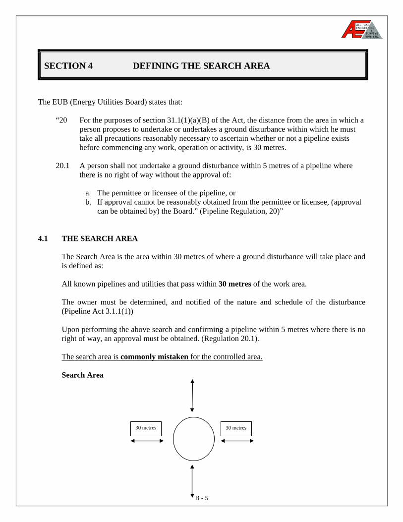
4.1 THE SEARCH AREA
The Search Area is the area within 30 metres of where a ground disturbance will take place and is defined as: All known pipelines and utilities that pass within 30 metres of the work area. The owner must be determined, and notified of the nature and schedule of the disturbance (Pipeline Act 3.1.1(1)) Upon performing the above search and confirming a pipeline within 5 metres where there is no right of way, an approval must be obtained. (Regulation 20.1).
The search area is commonly mistaken for the controlled area.
Search Area
30 metres 30 metres
B - 6
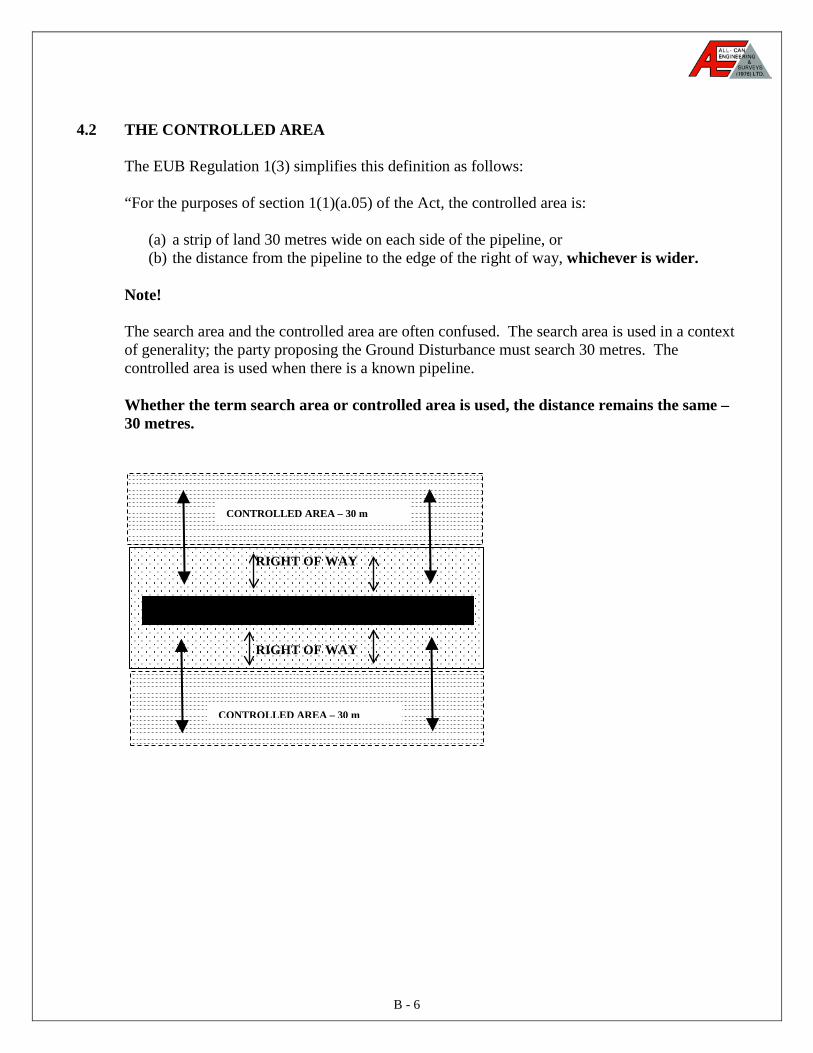
4.2 THE CONTROLLED AREA The EUB Regulation 1(3) simplifies this definition as follows: “For the purposes of section 1(1)(a.05) of the Act, the controlled area is:
(a) a strip of land 30 metres wide on each side of the pipeline, or (b) the distance from the pipeline to the edge of the right of way, whichever is wider.
Note! The search area and the controlled area are often confused. The search area is used in a context of generality; the party proposing the Ground Disturbance must search 30 metres. The controlled area is used when there is a known pipeline. Whether the term search area or controlled area is used, the distance remains the same – 30 metres.
RIGHT OF WAY
RIGHT OF WAY
CONTROLLED AREA – 30 m
CONTROLLED AREA – 30 m

B - 7
SECTION 5: NOTIFICATION
The EUB has set guidelines and time frames for notification to the pipeline owner of a company’s intent to cause a ground disturbance within the controlled area. The EUB states this as follows:
“21 (1) Subject to subsection (5), a person proposing to undertake a ground disturbance in
a controlled area shall give notice to the permittee or licensee of the pipelines in accordance with section 31.1(1)(b) of the Act at least 2 days and not more than 7 days, excluding Saturdays and holidays, before commencing the disturbance or within any other mutually acceptable alternative period.” (Pipeline Regulation 21(1))
Section 31.1(1)(b) states that a company must notify the permittee or licensee the nature of
the proposed ground disturbance and the proposed schedule of the undertaking of the ground disturbance.”
Notification is most commonly performed through Alberta 1 Call, but if the owner is not a member, notification still must be performed as previously referenced.
Note!
The Regulations state that notification does not apply if the ground disturbance is undertaken in connection with the restoration of essential public services in an emergency.
The Client’s Land Department usually can provide access to the available records, approvals, licenses, permits and contacts. The following is a listing of the information that may be available.
Availability of the following records and/or information should be accessed FIRST through the Surface Rights Department and copies obtained for your possession:
• Legal Survey Plan
A copy of the Legal Survey plan sent to Land Titles for registrations. • Certificate of Title
The Certificate of Title will show all Legal Survey Plans, Easements and/or Caveats registered against a title to protect interest in land.
• Plot Plan A Plot Plan or lease drawing from previous project or survey.
• Line List The Line List will provide information on the owners of the land, personal data (i.e., telephone numbers, address) and any conditions noted at the time the original contact was made.
B - 8
A copy of ALL Approvals, Licenses and Permits (if applicable) obtained:
EUB Pipeline Licenses Crossing Agreements Owner Notification Alberta Transportation and Utilities for Low Pressure Gas Distribution Records Ministerial consent for TUC (Transportation Utility Corridors) Ministerial consent for RDA (Restricted Development Areas) Municipal consent for URW (Utility Right-of-Ways) Environmental Alberta for Water Course Crossings National Energy Board for Pipelines that cross Provincial Boundaries
5.1 ALBERTA 1 CALL
Alberta 1 Call provides a free, computerized location service to advise and help the crosser with the location of buried pipelines and utilities. Using the Rural Fax Locate Request Forms (see Appendix: Forms #1 & #2), Client’s personnel can provide the information required by Alberta 1 Call. Having the information provided ahead of time will ensure the communication process is fluent. Revisions to Alberta 1 Call If you wish to change some of the information given to Alberta 1 Call when a locate request was made, you should contact Alberta 1 Call and give the operator the ticket number and the new information. CAUTION: Not all companies are members of Alberta 1 Call. You are still required to contact pipeline and utility owners who are not presently members of Alberta 1 Call. Non-Alberta 1 Call Members The Site Supervisor must directly contact owners who are not members of Alberta 1 Call. The Site Supervisor must: 1. Provide all the same excavation information provided to the Alberta 1 Call. 2. Ensure confirmation by owner of receipt of notification. 3. Ensure that an appointment date for line location is set. 4. Secure an agreement for an authorized supervisor from the line owner to witness the
crossing for their line at the time of excavation. 5. Provide a contact name and number, and if different for an emergency, the emergency
contact name and number.
B - 9
5.2 LAND TITLES OFFICE
To research land titles for title certificates and survey plans, obtain the legal land description (LSD) of the land and make a search at the local Land Titles Office. A system such as EGIS can be incorporated very easily for departments that need title searches frequently. Upon receiving the certificate of title, look for any caveats, easements, registrants of interest, or future interest or claim, TUC, RDA, or URW registered against title. If any are found, they must be fully investigated to ensure that they do not reflect on the company project. Note! If a pipeline survey is available it will make the search considerably easier, but you must ensure that the survey is current. CAUTION! Dates must be checked to ensure that documents are current. Land Title Deeds are not helpful where facilities are confined within road allowances. Several different parties may be involved in a crossing; therefore, pertinent plans could be unavailable at the time of the search. The Energy and Utilities Board (EUB) – Can provide information, which will show licensed pipelines with operating pressures above 700 kpa, registered with EUB. Township plans showing registered pipelines are available and must be obtained when applicable. Note! Lines may not be exactly as shown, and locations may not be accurate.
• Maps will probably be out-of-date if property has recently changed ownership. • Locations may not be accurate. • Gas co-ops, utilities, flowlines, sewers, etc. are not registered.
Sources:
• If a pipeline survey is available, you will find the land title certificate enclosed with the survey – check the dates.
• Check well files for a Land Title Certificate – check the date. • The Clients’ Land Department may also have a current Land Title Certificate or
pipeline survey.
Note: Two essential sources of information that are commonly ignored are the area operations personnel for the underground facility owners and the landowners. These two sources must be used more extensively.
B - 10
CONSULT AREA OPERATIONS PERSONNEL
Using the plot plans and drawings, consult with area operations personnel and or knowledgeable contractors to discuss the identified lines and underground facilities. Experienced company personnel familiar with area operations may have knowledge of pipelines or utilities not otherwise documented. The use of area personnel is essential, as the operations may have changed extensively from previous operating companies. Although their record systems and accuracy may have improved dramatically, the mapping of older installations are commonly poor. The input by operation personnel should not be bypassed under any circumstances. The area operations personnel have access to several sources of information within their company that could prove essential such as:
• A facility plot plan • Pipeline survey • Line List
CAUTION: Due to the continual shifting of personnel, you should ensure that any employee with beneficial information is utilized, without regard to or hesitation of the operating center they are currently working from. The name, date and results of the communications between client and other area operators should be recorded for future reference and to ascertain due diligence.
5.4 DISCUSSION WITH LANDOWNER
Landowners may have additional knowledge of buried utilities not documented elsewhere. You should meet personally with each landowner involved in the Ground Disturbance. The following are the key issues to be discussed:
• Length of time at present location (provides backing for information given.) • Name, Contact, Phone Number, Mailing Address. • Any further underground facilities other than shown on plot plan. (Landowner may
need an explanation of term “underground facilities.”) • Expected dates work is to commence • Expected time length of project. • Conditions during project that require land owner input if applicable:
- Stripped top soil storage - Gate open/closure policy - Access/egress to site - Livestock on site - Affected crops
Note: Discussion with the landowner may not be required if all operations are contained within the lease site.
B - 11
5.5 COMPANY MARKERS
Check the work area for pipeline or utility markers and ensure the company named has been contacted to supply any additional information regarding underground facilities. NEVER rely solely on company markers for location purposes. Markers may have been knocked down or removed at some point in the past and may have been repositioned inaccurately.
5.6 VISIBLE INDICATORS Upon performing the site visit, it is critical that you look for any visible indicators that previous construction has taken place. Look for any indications
• Is the vegetation: greener, taller, shorter, or browner than the vegetation surrounding it?
• Are there any depressions in the land or buildings within the control zone? Note! If there are any visible indicators, they must be thoroughly investigated before construction can start.
SECTION 6: CROSSING AGREEMENTS
Before a crossing can be accomplished, a crossing agreement is required. The EUB states:
“22 (1) An approval granted by a permittee or licensee or the Board pursuant to (a) Section 42.1 of the Act for a Ground Disturbance to take place in the right of way
of a pipeline, or (b) Section 20.1 of this Regulation for a Ground Disturbance to take place within 5
metres of a pipeline where there is no right of way, must be in writing.
(2) If the Board pursuant to section 42.1 of the Act grants an approval, the Board may make its approval subject to terms and conditions it considers appropriate in the circumstances.
B - 12
(3) A permittee or licensee of an existing pipeline who has been notified under section
31.1(1)(b) of the Act of a proposed Ground Disturbance shall: (a) inspect his pipeline before the commencement of the Ground Disturbance to
ensure that the locating and marking referred to in section 21(3) has been properly carried out, and
(b) carry out such inspections of the Ground Disturbance that are necessary to ensure the continued safety of the pipeline.
(4) The person responsible for a Ground Disturbance shall keep all pipeline warning signs
or markers referred to in section 21(2) and (3) visible and legible for the duration of the disturbance, and shall place or relocate them where necessary.
(5) A person undertaking a Ground Disturbance that exposes any part of a pipeline shall
notify the permittee or licensee at least 24 hours prior to backfilling the pipeline, and on being so notified, the permittee or licensee shall forthwith inspect the exposed part of the pipeline before backfilling, to ensure that no damage has occurred.
(6) Where a permittee or licensee inspects a pipeline under subsection (3) and (5), a
written record of the inspection shall be made and retained for at least 2 years. (7) Except as permitted by subsection (13), (14) or (15), a person proposing to undertake
a Ground Disturbance that will cross or be carried out within 5 metres of an existing pipeline shall, before commencing any mechanical excavation, locate and expose the existing pipeline by hand excavation.
(8) If a person is conducting an excavation for the purpose of locating a pipeline, it shall
be done by hand excavation until the pipeline is sufficiently exposed to enable its identification.
(9) A representative of the permittee or licensee of an existing pipeline referred to in
subsection (7) shall be present at the time the pipeline is exposed, if requested by person proposing to undertake the Ground Disturbance.
(10) After a pipeline has been located in accordance with subsection (7), no person shall
use or cause to be used mechanical excavation equipment within 60 centimetres of the pipeline, except under the direct on-site supervision of a representative for the permittee or licensee of the existing pipeline.
(11) A person does not commit an offense under subsections (5) and (10) if he establishes
that he has made all reasonable efforts to procure the inspection or supervision referred to in the subsection.
B - 13
(12) If, in the opinion of the Board it is desirable to do so, the Board may require that an
existing pipeline located adjacent to a Ground Disturbance in a controlled area be de-pressured, operated at a reduced pressure or otherwise protected throughout the period of the Ground Disturbance.
SECTION 7: PLOT PLAN OR SITE DRAWINGS
A plot plan or site drawing indicating the location of all underground pipelines and utilities as determined from the previous steps will be provided or prepared for reference at the worksite. The plot plan should be referenced on the clients Safe Work Agreement.
All plot plans or site drawings should be reviewed and cross-referenced with other sources of information as from the previous steps to ensure they are accurate and complete.
Note! Al-Can personnel must never consider a map to be completely accurate as maps and plot plans should be used as a guide only. It is up to the party creating the Ground Disturbance to ensure the location of the facility through line locating and hand exposure.
All underground facilities which pass within a 5 metre radius of the Ground Disturbance area should be highlighted on the drawing with a colored marker to ensure their encroachment into the work area is readily noted.
Overhead power lines that may pose a hazard during movement of equipment must also be identified and clearly indicated so proper clearances can be maintained. (Refer to OH&S regulations for these distances.) A copy of this drawing should also be provided to the equipment operator and/or observer.
B - 14
SECTION 8: LINE LOCATING
All known pipelines and utilities as noted on the plot plan or drawing that pass within the controlled area should be located and staked to indicate location alignment, line size and depth.
The line locating procedures should be conducted in the presence of the competent person who is thoroughly familiar with the area and has in his possession a copy of the site drawing or plot plan, and understands line locator procedures.
The area must be swept by a person considered competent in line locating using an opposite “grid pattern” (i.e. North-South, East-West, then Angular) to ensure maximum detection capabilities.
The Competent Person should have the plot plan and site drawing in their possession and ensure all known pipelines and utilities on the plot/site plan that are within 30 metres of either side of the Ground Disturbance, have been located and staked.
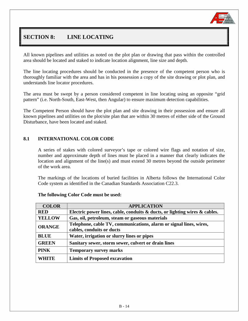
8.1 INTERNATIONAL COLOR CODE
A series of stakes with colored surveyor’s tape or colored wire flags and notation of size, number and approximate depth of lines must be placed in a manner that clearly indicates the location and alignment of the line(s) and must extend 30 metres beyond the outside perimeter of the work area. The markings of the locations of buried facilities in Alberta follows the International Color Code system as identified in the Canadian Standards Association C22.3. The following Color Code must be used:
COLOR APPLICATION RED Electric power lines, cable, conduits & ducts, or lighting wires & cables. YELLOW Gas, oil, petroleum, steam or gaseous materials
ORANGE Telephone, cable TV, communications, alarm or signal lines, wires, cables, conduits or ducts
BLUE Water, irrigation or slurry lines or pipes GREEN Sanitary sewer, storm sewer, culvert or drain lines PINK Temporary survey marks
WHITE Limits of Proposed excavation
B - 15
8.2 MARKING JOB-SITE BOUNDARIES Where possible, the Site Supervisor should mark the limits of job site(s) with white flags. Flags, stakes or paint can be used to provide the Line Locator and project personnel with a clear visual image of the construction project boundaries.
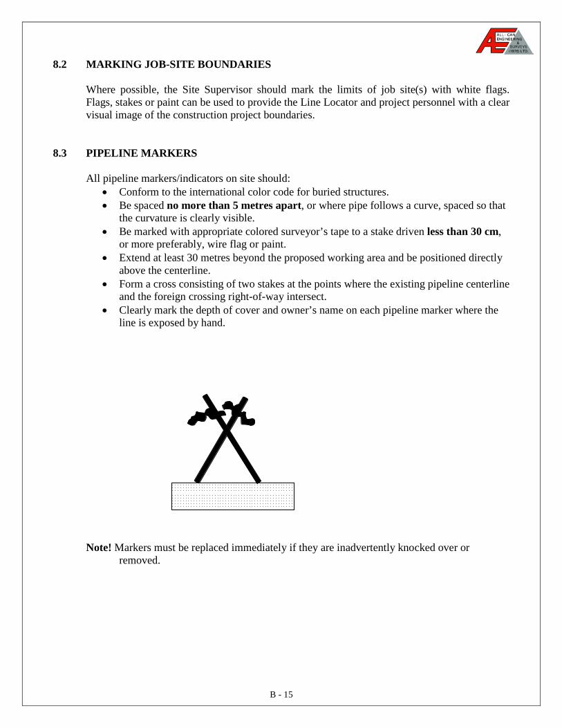
8.3 PIPELINE MARKERS All pipeline markers/indicators on site should:
• Conform to the international color code for buried structures. • Be spaced no more than 5 metres apart, or where pipe follows a curve, spaced so that
the curvature is clearly visible. • Be marked with appropriate colored surveyor’s tape to a stake driven less than 30 cm,
or more preferably, wire flag or paint. • Extend at least 30 metres beyond the proposed working area and be positioned directly
above the centerline. • Form a cross consisting of two stakes at the points where the existing pipeline centerline
and the foreign crossing right-of-way intersect. • Clearly mark the depth of cover and owner’s name on each pipeline marker where the
line is exposed by hand.
Note! Markers must be replaced immediately if they are inadvertently knocked over or
removed.
B - 16
8.4 RIGHT-OF-WAY MARKERS (Marking the Right-of-Way)
Markers should also be used to show Facility right-of-way or right-of-way outline. Care should be taken that these markers are not confused with the facility center line markers. The Client Site Supervisor should provide information about right-of-way and specify who is responsible for placement of the markers. To reduce confusion, recommendations for markers instead of flags include:
• Temporary fencing • Temporary barricades
8.5 VERIFICATION/CROSS CHECKS
Plot plans and site drawings must be cross-referenced with the placement of markers prior to the mechanical excavation to ensure there are no apparent inconsistencies. If there are inconsistencies between the plot plan, site drawing and/or the placement of stakes, another line locate must be completed to verify correct line location and alignment. Each area under the clients control should maintain a complete set of plot plans and site drawings identifying all known underground pipelines and utilities. In addition formal updating of plot plans and drawings should be completed following any Ground Disturbance related to new and or existing facilities or as a minimum, annually. Caution:
• Check the entire width of the right-of-way to be crossed for known and unknown structures.
• If, during the search, other facilities are found, identify them and inform the owners of the work in progress.
• Locating is not a replacement for hand exposure. Note! The Clients Site Supervisor should ensure that all the locate stakes and flags are removed when the work is completed. This will avoid confusion for other excavators who may be working in the area at a later time, reduce chances of livestock eating flags, and reduce damage to agricultural equipment, particularly grass cutting equipment.
B - 17
SECTION 9: EXPOSURE
All underground pipelines and utilities within a 5-metre radius of the Ground Disturbance Area or within a pipeline right-of-way must be hand exposed or hydrovaced to verify location, line size, and alignment. The EUB regulation states:
“(7) Except as permitted by subsection (13), (14) or (15), a person proposing to undertake
a Ground Disturbance that will cross or be carried out within 5 metres of an existing pipeline shall, before commencing any mechanical excavation, locate and expose the existing pipeline by hand excavation.
(8) If a person is conducting an excavation for the purpose of locating a pipeline, it shall
be done by hand excavation until the pipeline is sufficiently exposed to enable its identification.”
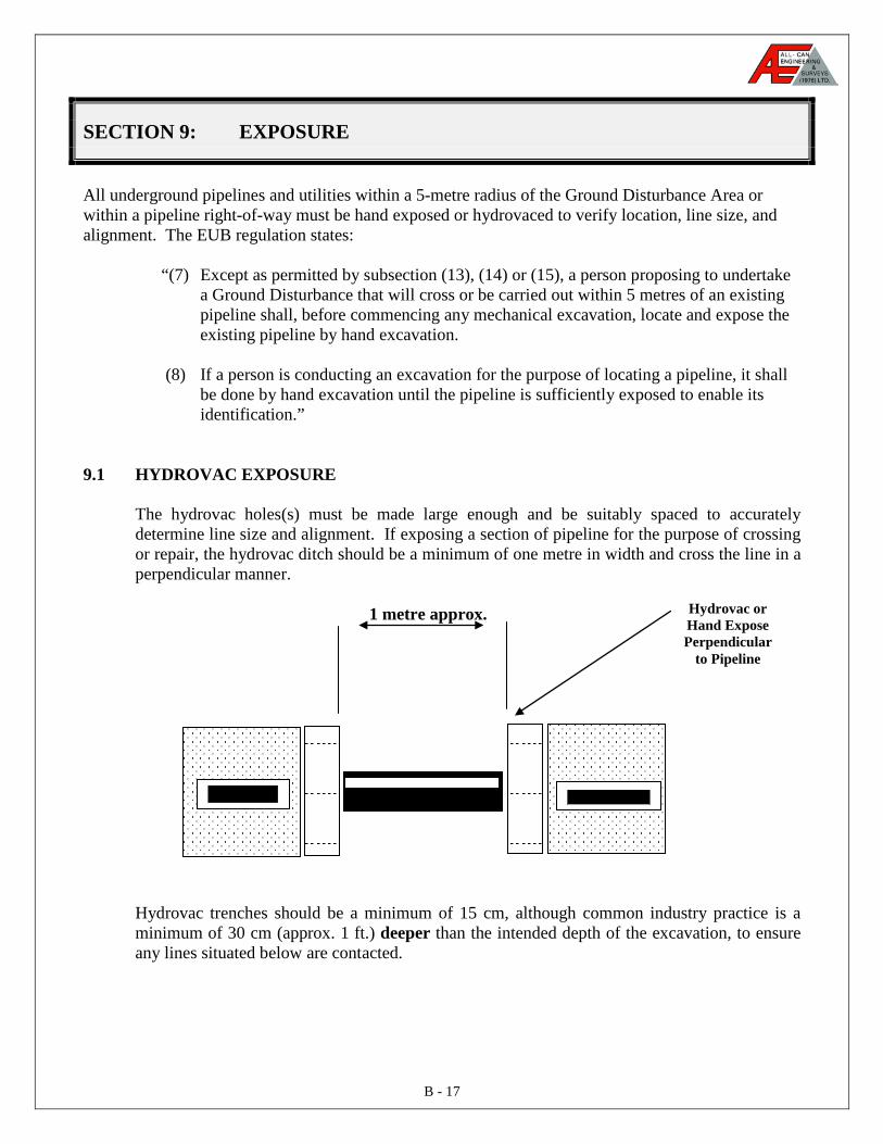
9.1 HYDROVAC EXPOSURE
The hydrovac holes(s) must be made large enough and be suitably spaced to accurately determine line size and alignment. If exposing a section of pipeline for the purpose of crossing or repair, the hydrovac ditch should be a minimum of one metre in width and cross the line in a perpendicular manner.
1 metre approx.
Hydrovac trenches should be a minimum of 15 cm, although common industry practice is a minimum of 30 cm (approx. 1 ft.) deeper than the intended depth of the excavation, to ensure any lines situated below are contacted.
Hydrovac or Hand Expose Perpendicular
to Pipeline
B - 18
Note: If you have reason to suspect that there may be an untraced plastic or fiberglass line in the area, and you have already made every reasonable effort to locate and expose the line the following procedures may apply with the approval of the Client’s Production Superintendent or his designate. 1. Depressure and isolate the suspected line. 2. Use only a flat hoe bucket or weld a protective blade across the hoe teeth. 3. Scrape and hand probe the entire ditch line. Always probe to twice the depth of the next
pass with the bucket, and probe very carefully to avoid damaging the line with the probe. 4. Continue until the line is encountered, or the desired depth is achieved. EUB Regulation 22.(14) states: “Where a proposed ground disturbance will be parallel to and within 5 metres of a pipeline, the pipeline may be exposed at intervals along the pipeline with the length of the intervals being at the discretion of the licensee of the existing pipeline or at the Board’s discretion.
9.2 LAND-OWNER TRENCHING ON PRIVATE PROPERTY In cases where the landowner is trenching on his/her own property, they must still obtain all crossing approvals. The client must provide its own trench and place its own facilities across registered right-of-ways.
9.3 CUSTOMER TRENCHING ON COMMERCIAL/INDUSTRIAL PROPERTY
Customer provided trenches (conduits) crossing right-of-way on commercial industrial property, are placed by the property owner’s contractor or agent. Although the property owner’s agreement would cover his liability during the actual Ground Disturbance, each Company requires its own agreement to address its ongoing liability concerns. Each Company is required to obtain written approval, consent and agreement from the pipeline company prior to placing its facility within the conduit crossing the right-of-way. Where the excavation is complex or involves multiple lines, hydrovac should be considered as the perfect means for exposing of lines.
B - 19
SECTION 10: AGREEMENTS AND PRE-JOB MEETINGS
10.1 SAFE WORK AGREEMENTS/CHECKLISTS
Safe Work Agreements must be issued for all Ground Disturbance Projects where there is a potential for loss. The Safe Work Agreement will include the following information:
• specific work location (complete LSD) • clear description of the work to be completed • identification of potentially hazardous conditions which have been evaluated by a
qualified person • protective measures and PPE required • work description, potential hazards and safety measures communicated to all personnel
working on the site Several permits/checklists may be required for the Ground Disturbance. The following permits/checklists could be used depending on the scope of work:
• Clients Hot or Cold Safe Work Agreements • Clients Confined Space Entry Permit • Clients Ground Disturbance Checklist
The client may require Safe Work Agreements and the Ground Disturbance Checklist Form #4 (see Appendix) be completed and initiated for all ground disturbance operations where:
• excavations are carried out on or near a pipeline right-of-way, • excavations are required to complete pipeline repairs, • or for any other reason the Client Site Supervisor deems necessary.
The applicable permit(s) will be issued in accordance with Client’s existing Safe Work Agreement system and these guidelines prior to commencement of operations.
B - 20
10.2 PRE-JOB SAFETY MEETING
A pre-job safety meeting must be conducted prior the job commencing. The main purpose of this meeting is to review specific safety and procedural aspects of the job ensuring all personnel have a good understanding of their roles and responsibilities. The following topics (as minimum) should be discussed and meeting minutes recorded and retained on file (See Appendix: Form #5):
(a) Review all job safety and procedural aspects, and permit requirements, orientation
completed, applicable OH&S and EUB regulations covered, etc. (b) Communicate all potential hazards and controls associated with the job. (c) Who is the responsible Client Site Supervisor/Representative on site. (d) Review applicable plot plans or site drawings, the number of facilities being
crossed, and/or exposed. (e) Colored Markers, Paint, Flagging used to identify various locations. (f) Explanations of the following:
• Nature of material in the facility/pipeline. • Location of applicable product MSD’s used at the facility. Minimum distance
requirements for overhead power lines and a signalman in place. • Exposure techniques to be used. • Mechanical excavation parameters. • Information on cutting back and/or shoring of excavations, warning
signage/lights/barricades etc. • Personal protective equipment requirements. • Accidents/Incident and emergency reporting procedures.
For all critical tasks performed on major jobs, it is recommended that representatives of the owner, crosser and contractor be present/available. The pre-job meeting is exactly as stated. The meeting takes place before the job starts. Note! The pre-job meeting does not replace the need for daily tailgate meetings. Tail-gate meetings must be conducted to ensure that:
• Work phases are identified and reviewed by all responsible parties. • New crew members or any members not present at the pre-job meeting such as
replacements are informed. • Changes to work procedures or job scope are communicated.
B - 21
APPENDIX
SAMPLE FORMS
Rural Fax Locate Request Form – SM-B-001
Rural Fax Locate Request Form – SM-B-002
Pipelines & Utilities Record – SM-B-003
Client Ground Disturbance Checklist – SM-B-004
Pre-Job Meeting Minutes – SM-B-005
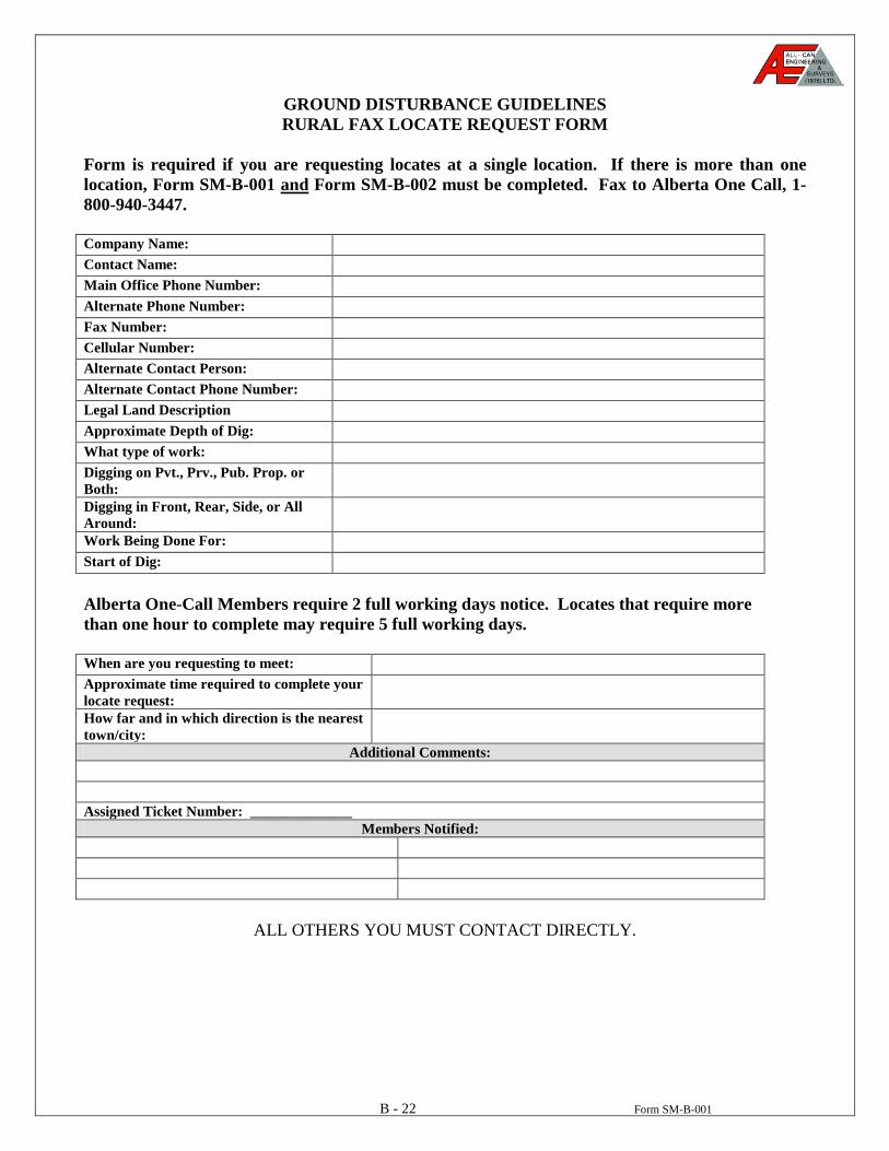
B - 22 Form SM-B-001
GROUND DISTURBANCE GUIDELINES RURAL FAX LOCATE REQUEST FORM
Form is required if you are requesting locates at a single location. If there is more than one location, Form SM-B-001 and
Form SM-B-002 must be completed. Fax to Alberta One Call, 1-800-940-3447.
Company Name: Contact Name: Main Office Phone Number: Alternate Phone Number: Fax Number: Cellular Number: Alternate Contact Person: Alternate Contact Phone Number: Legal Land Description Approximate Depth of Dig: What type of work: Digging on Pvt., Prv., Pub. Prop. or Both:
Digging in Front, Rear, Side, or All Around:
Work Being Done For: Start of Dig: Alberta One-Call Members require 2 full working days notice. Locates that require more than one hour to complete may require 5 full working days. When are you requesting to meet: Approximate time required to complete your locate request:
How far and in which direction is the nearest town/city:
Additional Comments: Assigned Ticket Number: ______________
Members Notified:
ALL OTHERS YOU MUST CONTACT DIRECTLY.
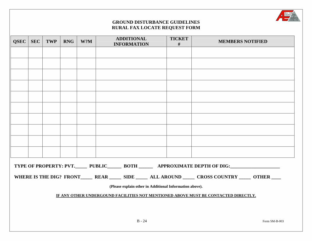
B - 24 Form SM-B-003
GROUND DISTURBANCE GUIDELINES RURAL FAX LOCATE REQUEST FORM
QSEC SEC TWP RNG W?M ADDITIONAL INFORMATION
TICKET # MEMBERS NOTIFIED
TYPE OF PROPERTY: PVT._____ PUBLIC______ BOTH ______ APPROXIMATE DEPTH OF DIG:_____________________ WHERE IS THE DIG? FRONT_____ REAR _____ SIDE _____ ALL AROUND _____ CROSS COUNTRY _____ OTHER ____
(Please explain other in Additional Information above).
IF ANY OTHER UNDERGOUND FACILITIES NOT MENTIONED ABOVE MUST BE CONTACTED DIRECTLY.
B - 24 Form SM-B-003
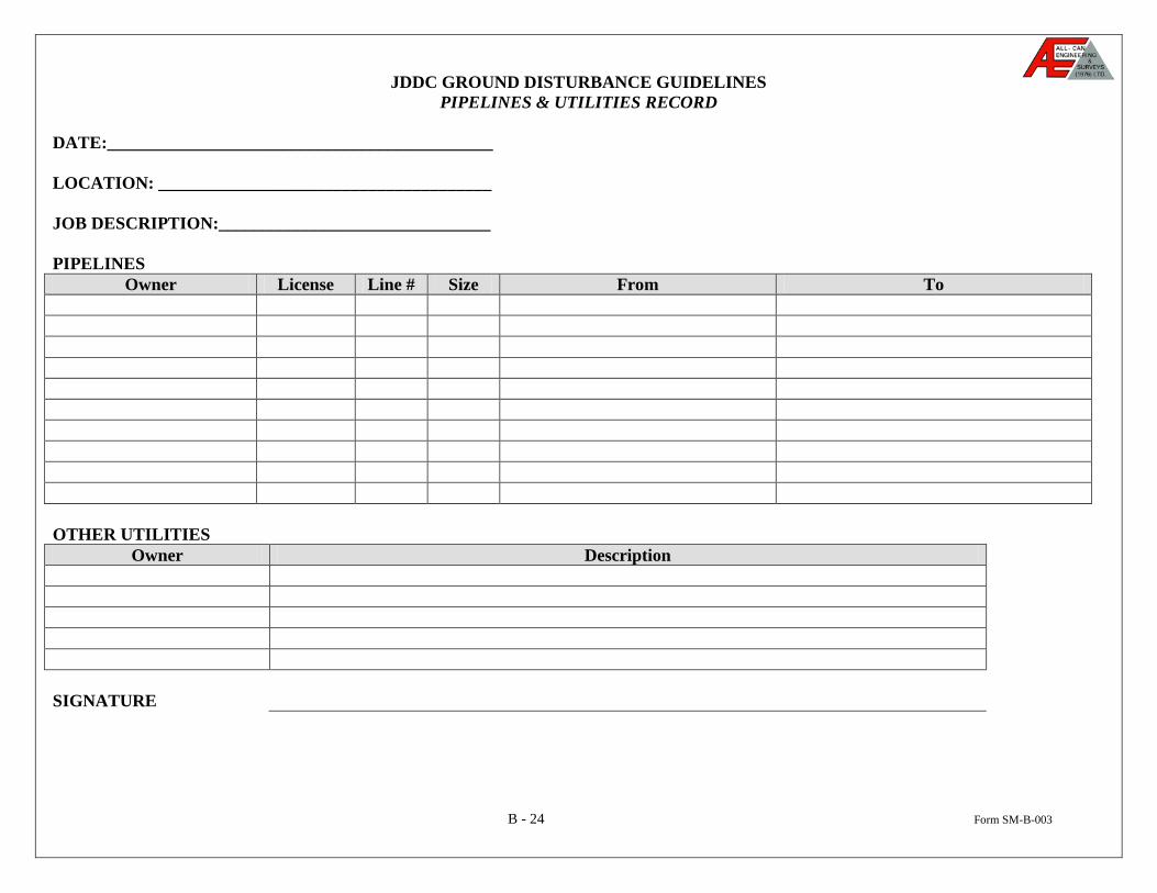
JDDC GROUND DISTURBANCE GUIDELINES PIPELINES & UTILITIES RECORD
DATE:____________________________________________ LOCATION: ______________________________________ JOB DESCRIPTION:_______________________________ PIPELINES
Owner License Line # Size From To OTHER UTILITIES
Owner Description SIGNATURE
B - 25 Form SM-B-004 (Page 1 of 2)
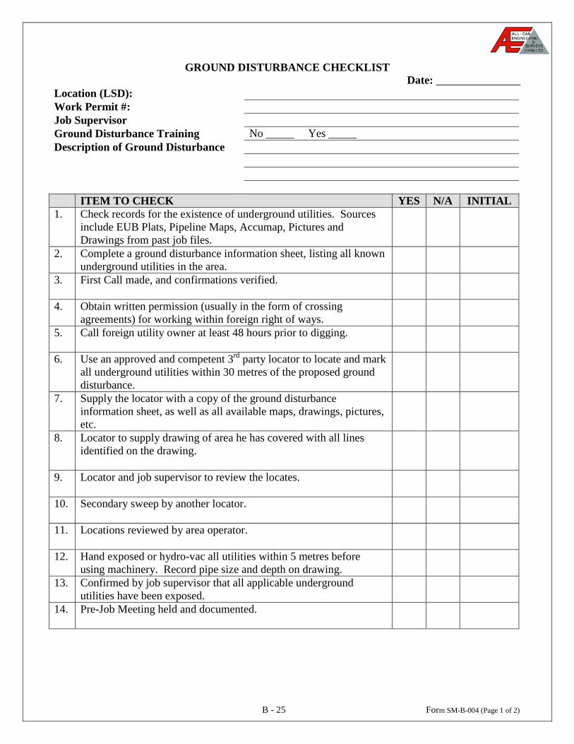
GROUND DISTURBANCE CHECKLIST Date: _______________
Location (LSD): Work Permit #: Job Supervisor Ground Disturbance Training No _____ Yes _____ Description of Ground Disturbance
ITEM TO CHECK YES N/A INITIAL 1. Check records for the existence of underground utilities. Sources
include EUB Plats, Pipeline Maps, Accumap, Pictures and Drawings from past job files.
2. Complete a ground disturbance information sheet, listing all known underground utilities in the area.
3. First Call made, and confirmations verified.
4. Obtain written permission (usually in the form of crossing agreements) for working within foreign right of ways.
5. Call foreign utility owner at least 48 hours prior to digging.
6. Use an approved and competent 3rd party locator to locate and mark all underground utilities within 30 metres of the proposed ground disturbance.
7. Supply the locator with a copy of the ground disturbance information sheet, as well as all available maps, drawings, pictures, etc.
8. Locator to supply drawing of area he has covered with all lines identified on the drawing.
9. Locator and job supervisor to review the locates.
10. Secondary sweep by another locator.
11. Locations reviewed by area operator.
12. Hand exposed or hydro-vac all utilities within 5 metres before using machinery. Record pipe size and depth on drawing.
13.
Confirmed by job supervisor that all applicable underground utilities have been exposed.
14. Pre-Job Meeting held and documented.
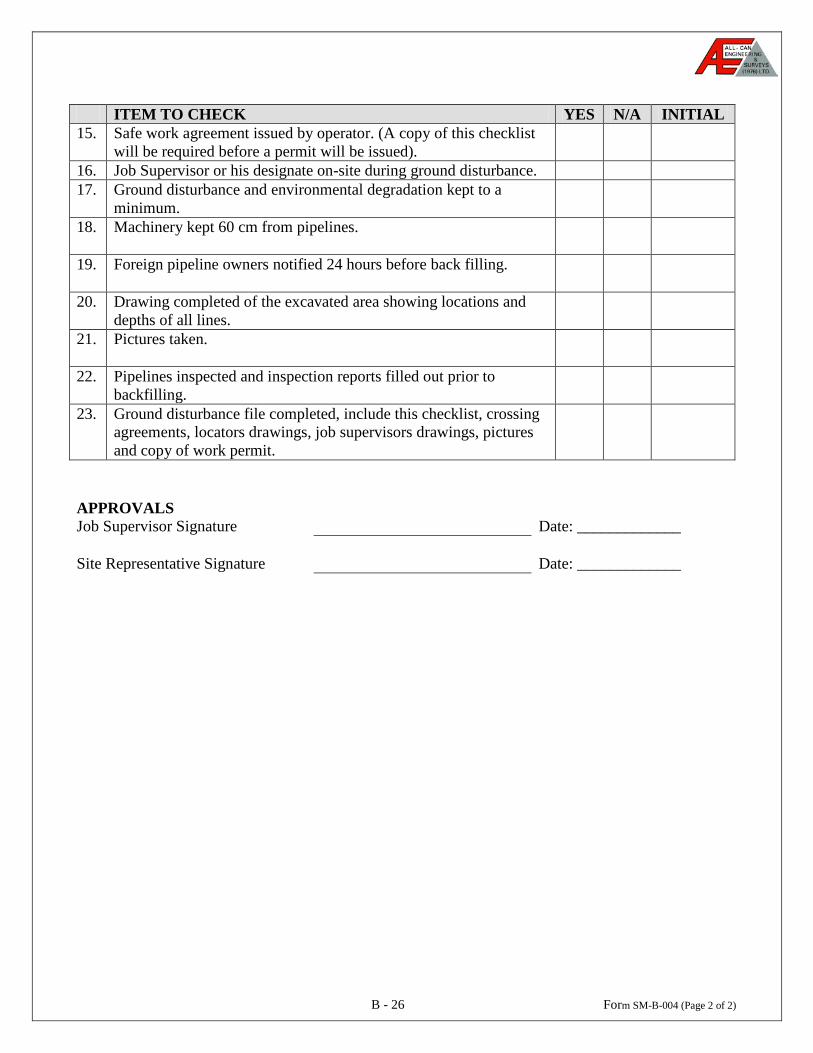
B - 26 Form SM-B-004 (Page 2 of 2)
ITEM TO CHECK YES N/A INITIAL
15. Safe work agreement issued by operator. (A copy of this checklist will be required before a permit will be issued).
16. Job Supervisor or his designate on-site during ground disturbance. 17.
Ground disturbance and environmental degradation kept to a minimum.
18.
Machinery kept 60 cm from pipelines.
19.
Foreign pipeline owners notified 24 hours before back filling.
20.
Drawing completed of the excavated area showing locations and depths of all lines.
21.
Pictures taken.
22.
Pipelines inspected and inspection reports filled out prior to backfilling.
23.
Ground disturbance file completed, include this checklist, crossing agreements, locators drawings, job supervisors drawings, pictures and copy of work permit.
APPROVALS Job Supervisor Signature Date: _____________ Site Representative Signature Date: _____________
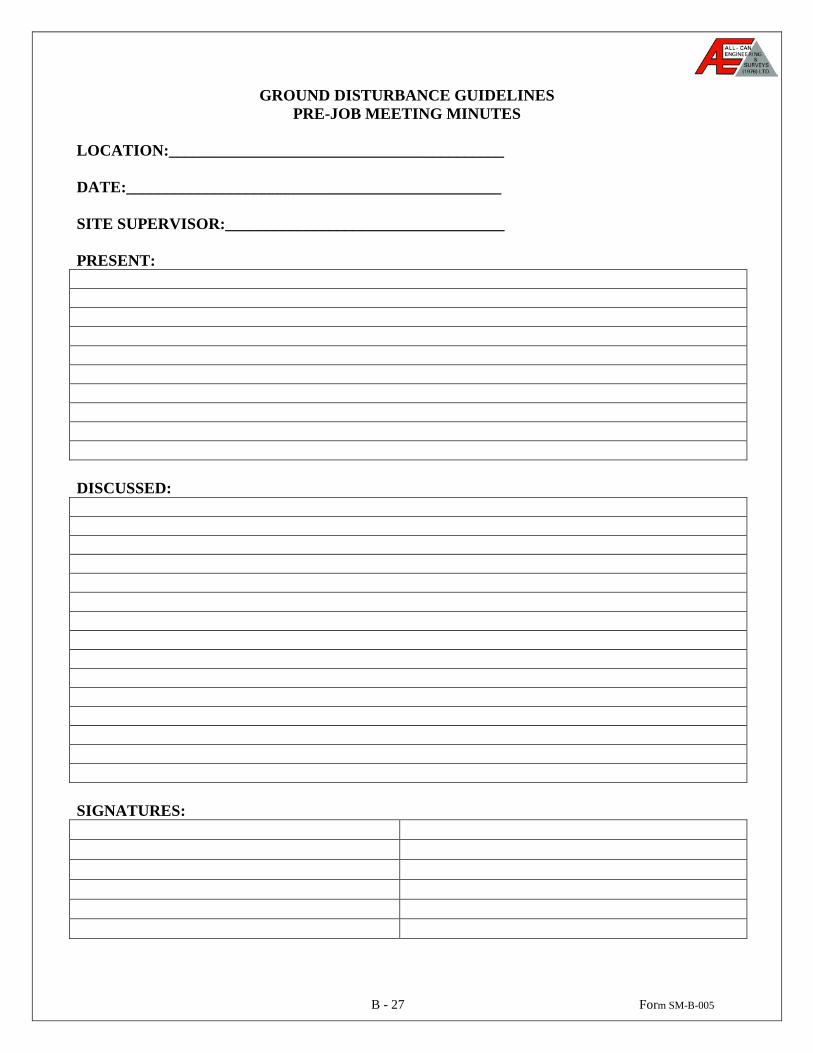
B - 27 Form SM-B-005
GROUND DISTURBANCE GUIDELINES PRE-JOB MEETING MINUTES
LOCATION:__________________________________________ DATE:_______________________________________________ SITE SUPERVISOR:___________________________________
PRESENT: DISCUSSED: SIGNATURES: