grounding of the singapore flag off-shore support vessel · into the grounding of the singapore...
TRANSCRIPT
138Departmental investigation
into the grounding of the
Singapore flag
off-shore support vessel
Britoil 22
off the coast of
Western Australia
on 18 November 1998
Navigation Act 1912 Navigation (Marine Casualty) Regulations
into the grounding of the Singapore flag off-shore support vessel
Britoil 22
off the coast of Western Australia on 18 November 1998
Published: December 1999
ISBN 0 642 20031 9Investigations into marine casualties occurring within the Commonwealth's jurisdiction areconducted under the provisions of the Navigation (Marine Casualty) Regulations, madepursuant to subsections 425 (1) (ea) and 425 (1AAA) of the Navigation Act 1912. TheRegulations provide discretionary powers to the Inspector of Marine Accidents to investigateincidents as defined by the Regulations. Where an investigation is undertaken, the inspectormust submit a report to the executive director of the Australian Transport Safety Bureau(ATSB).
It is ATSB policy to publish such reports in full as an educational tool to increase awarenessof the causes of marine incidents so as to improve safety at sea and enhance the protectionof the marine enviroment.
To increase the value of the safety material presented in this report readers are encouraged tocopy or reprint the material, in part or in whole, for further distribution, but shouldacknowledge the source. Additional copies of the report can be obtained from:
For further information please contact:
Inspector of Marine AccidentsMarine Incident Investigation UnitPO Box 967 Civic Square 2608AUSTRALIAPhone: +61 2 6274 7324
Fax: +61 2 6274 6699
Email: [email protected]
MIIU on the INTERNET
Information relating to this report and other marine investigation reports can be located fromthe Marine Incident Investigation Unit's Internet homepage at our URL: http://www.miiu.gov.au
ContentsSources of information
Summary
Narrative
Comment and analysis
Conclusions
Submissions
Details of Britoil 22
Sources of information
The master, officers and crew of Britoil 22
Australian Maritime Safety Authority
Kvaerner Clough Joint Venture
Clough Offshore (a division of Clough Engineering Ltd)
Apache Energy Ltd
Total Marine Services Pty Ltd
Racal Survey Australia Ltd
Fugro Survey Pty Ltd
American Bureau of Shipping
Britoil Offshore Services Pte Ltd
Mermaid Marine
London Offshore Consultants
National Tidal Facility, Flinders University of South Australia
Acknowledgement
Photograph of Britoil 22 supplied by Britoil Offshore Services Pte Ltd in Singapore.
Portion of chart Aus 742 reproduced by permission of the Hydrographic Office, RAN.
The inspector acknowledges the assistance of the Australian Maritime Safety Authority (AMSA) inconducting the field investigation.
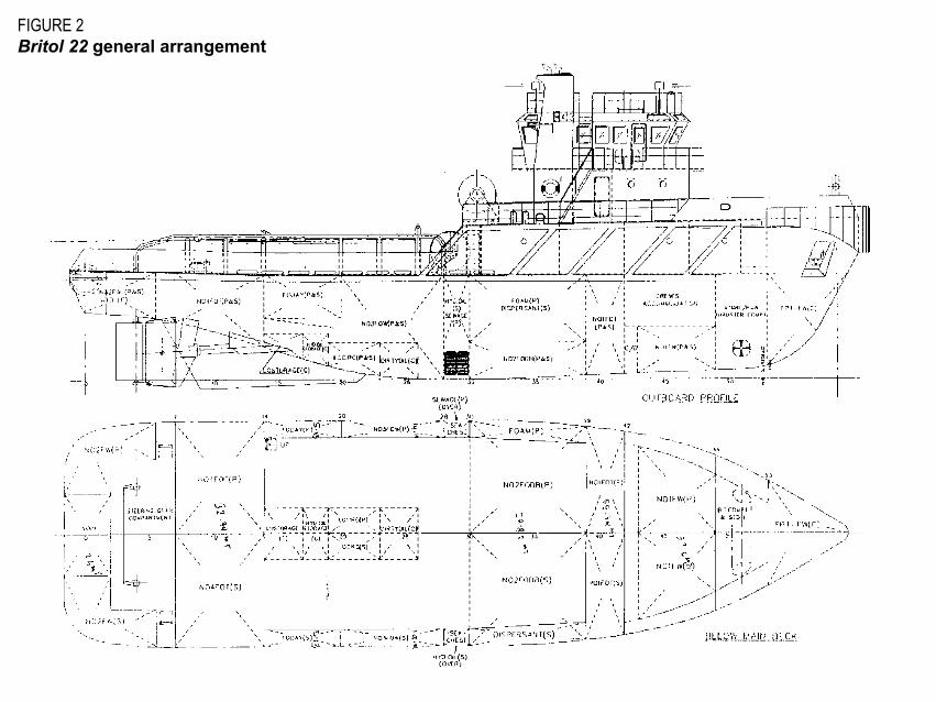
FIGURE 2Britol 22 general arrangement

Summary
At 0600 on 18 November 1998, the Singapore flag offshore anchor-handling vessel and ocean-going tugBritoil 22 was engaged in deploying anchors for the offshore construction barge Java Constructor,approximately 1 mile* north east of Varanus Island, which lies 6 miles north-east of Barrow Island, WesternAustralia.
Java Constructor was in the process of laying a new 16-inch gas pipeline from the mainland to VaranusIsland, as part of The Varanus Island Pipelines Project. The role of Britoil 22 was to reposition the mothervessel�s anchors to allow forward travel of the barge.
The immediate area of operation of Britoil 22 contained several submerged gas and oil pipelines, and manycoral pinnacles in shallow water. The weather at the time was good, with wind from the south-south-west atforce 3-4. There was a low swell and the tide was just past low water.
At about 0605, Britoil 22 was directed by Java Constructor to move the port 3 anchor. In the process ofapproaching the anchor to raise it, the vessel struck and rode up on a submerged object. The vessel wassubsequently moved astern clear of the object. Fearing the vessel had been damaged, the masterinstructed the mate and second engineer to sound the tanks and check all spaces. A short while later theyreported no sign of damage.
The anchor was approached from a new direction, raised, and successfully re-deployed in the new requiredposition.
Britoil 22 was next instructed to move the port 1 anchor. At 0730, after raising the anchor to the stern roller,an engine room bilge alarm sounded. Investigation revealed the engine room was taking water. Theanchor was dropped and the available engine room bilge pumps brought on line. Britoil 22 proceededimmediately back to Java Constructor, where the flooding was brought under control and the hole locatedand temporarily plugged by a diver. The engine room bilge was pumped dry and an internal �cement box�repair effected over the hole.
* Miles referred as Nautical miles = 1 852 metres
Britoil 22 proceeded, with the materials barge Sea Sovereign in tow, back to Dampier, finally arriving at 1425 on19 November. A damage survey was conducted and a condition of class was placed on the vessel. The vesselwas subsequently re-delivered to the owners in Singapore and the charter prematurely terminated under theterms of the contract.
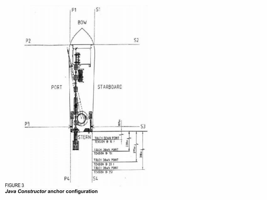
FIGURE 3Java Constructor anchor configuration

Narrative
Britoil 22
Britoil 22 was built in1996 by the Fujian Fishery Shipyard, China, for Britoil Offshore Services Pty Ltd,Singapore. It was one of four sister ships and the first to be launched. All four vessels were constructed forBritoil Offshore Services. Britoil 22 is registered in Singapore and was constructed to American Bureau ofShipping class A1 E Towing Vessel with AMS notation.
The vessel has an overall length of 37.00 m, a beam of 10.60 m, a moulded depth of 4.95 m and a designeddraft of 4.00 m. Its tonnages are 443 gross, 133 net. Maximum speed is 13.0 knots and endurance is7 200 miles at 12 knots. Britoil 22 has a rated bollard pull of 60 tonnes. The vessel is equipped with atowing/anchor winch (rated at 75 tonnes line pull), a stern roller, a set of hydraulic sharkjaws/towing pins,and a tugger winch for the purpose of anchor-handling.
Propulsive power is provided by two Yanmar Z280A-EN 6-cylinder engines each of 1492 kW. The mainengines are coupled via a clutch to reversing reduction gearboxes that in turn drive two propeller shafts andfixed pitch propellers inside Kort nozzles. Electrical power is provided by three 300 kW Detroit 8V-92TAauxiliary generator sets. An Ulstein 45-TV bow thruster rated at 250 kW and producing 3.7 tonnes oftransverse thrust enhances manoeuvrability.
Structurally, Britoil 22 is similar to many vessels of this type (Figure 2). The bridge and accommodation arelocated forward and the after deck is open to the stern roller, with heavy bulwarks down each side and atimber sheathed deck. The engine room is located immediately beneath the after deck. The steering flat islocated aft with freshwater tanks and a void space adjacent to it in the sponson. Forward of the steering flatare, in turn, the number 4 fuel tanks, engine room, number 1 fuel tank, crew accommodation, bow thrustercompartment and the forepeak tank. There are double bottom tanks beneath some of the engine room andmuch of the accommodation space. There are no double bottoms immediately beneath each main enginebedplate. Britoil 22�s keel tapers down slightly, from forward to aft, with the lowest point between frames 25
to 34. There is a substantial keel skeg between the two propeller shafts, which is designed to protect thepropellers, shafts, Kort nozzles and rudder assemblies in the event of grounding.
The bridge has two control positions, forward and aft. Most of the navigational aids including the radar,depth sounder and Global Positioning System (GPS) are located on the forward bridge console. Theforward console houses the main propulsion, bow thruster and steering controls. The after position hasmain propulsion, bow thruster, and anchor-handling winch and shark jaw controls.
Britoil 22 was operated on a two-crew system, each a crew of 14, working four weeks on, four weeks off.The agreed manning for the vessel under the terms of the charter was originally 11. Clough Offshore hadagreed to an increase in manning by a mate, engineer, and integrated rating in recognition of the long hoursworked by the vessel�s crew.
The master of Britoil 22 had extensive offshore experience, having started in the industry in 1978. A largeproportion of his time had been spent in anchor-handling vessels. He had a Master Class 1 certificate ofcompetency and 11 years command experience. He had taken command of Britoil 22 in Singapore on 1September 1998. The master had completed his first �swing� on 4 October and proceeded on leave,resuming command of the vessel on 3 November.
The chief engineer had 14 years experience in the offshore industry, six of those in anchor-handling vesselsbetween 4 000 and 9 000 horsepower. He held an Engineer Class 1 certificate of competency and hadserved in the vessel, on the same swing as the master, since the delivery from Singapore.
The mate had a total of 34 years experience at sea, the last 16 in the offshore industry. He had handled rigtenders up to 70 m in length as mate, and up to 40 m in the capacity of master. He had first joined thevessel on 3 November 1998. At the time of the incident he held a Master Class 4 certificate of competency.
The second engineer held an Engineer Watchkeeper certificate. He first joined Britoil 22 in Singapore forthe delivery voyage and, after four weeks leave, rejoined the vessel on 3 November 1998.
The rest of the crew were also suitably qualified with varying levels of experience in offshore vessel anchor-handling.
Java Constructor
Java Constructor is a steel, non-propelled, construction/accommodation work barge owned by Clough JavaOffshore Pty Ltd. The barge is 105.93 m in length, 32 m wide and has a moulded depth of 7.62 m. Thebarge has a gross tonnage of 8 614. Java Constructor�s crew were Australian nationals.
Java Constructor is fitted with an eight-point mooring system; the anchor winches are located at the four quartersof the barge. Each winch has two wire drums and a maximum working load of 90 tonnes. When working bothdrums, each drum has a maximum working load of 45 tonnes. When pipelaying it is usual practice to use alleight points of the mooring system and thus both drums on each winch (Figure 3). Each winch drum canaccommodate 1 335 m of 52 mm diameter anchor cable. During pipelay operations, with the pipe being laidover the stern, the forward anchors P1, P2, S1 and S2 are used to offset the tension in the pipeline andprovide forward pull during barge advance. The stern breast anchors P3 and S3 are used to stabilise thewaist of the barge and control its heading, while the two stern anchors P4 and S4 control the forwardmovement of the barge.
The project
The Varanus Island Pipelines Project consisted of the installation of a 16-inch sales gas line extending 70km offshore between the mainland and Varanus Island on the North West Shelf. The new pipeline was tobe laid parallel to, and about 20 m away from, an existing 30 cm (12-inch) sales gas* pipeline in maximumwater depths of 20 m at lowest astronomical tide (LAT). Construction of the pipeline had commenced fromthe mainland end and progressed north towards Varanus Island.
The 40 cm (16-inch) sales gas line project had been undertaken through contractual arrangements betweenthe turnkey contractor, Apache Energy, and joint venture partners, Kvaerner Oil and Gas Australia, andClough Offshore. Kvaerner provided the design and engineering expertise while Clough Offshore managedand executed the installation of the pipeline.
* Sales gas: processed natural gas
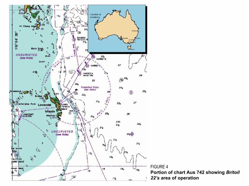
FIGURE 4Portion of chart Aus 742 showing Britoil22�s area of operation
Kvaerner Clough Joint Venture (KCJV) in turn contacted Total Marine Services to charter two anchor-handling vessels for the duration of the project. Total Marine Services sourced and chartered, underbareboat arrangements, the vessels Jaya Valiant and Britoil 22. These vessels were picked up inSingapore and delivered by their Australian Total Marine Services crews to Dampier in Western Australiafor the commencement of the project. The delivery voyages were completed with the materials handlingbarges Java 252 and Sea Sovereign in tow.
KCJV also time-chartered Mermaid Titan (of Mermaid Marine, Karratha) as scout vessel for the duration ofthe project.
Survey
As part of the preparation for the project, KCJV had contracted Fugro Survey Pty Ltd to undertake a seabedsurvey of the proposed pipeline route. The contract with Fugro stipulated the provision of bathymetric,sidescan sonar, sub-bottom and geotechnical data. The position of the existing 12-inch gas line was to berecorded and, in addition, bottom features including rocky outcrops, chasms, sand waves and otherfeatures noted. The contract required Fugro to survey a corridor 75 m either side of the existing 12-inchgas line. Additionally, in recognition of the shallow water anchor-handling operations, the survey corridorwas extended to 500 m either side of the gas line in the vicinity of Varanus Island.
Fugro completed the survey using echo sounder, side scanning sonar and boomer* equipment. Thesoundings were reduced to LAT datum using predictions for the area produced by WNI Science andEngineering. The data collected on-site was processed and interpreted by geophysicists and stored aselectronic files. The final report to KCJV included sounding charts drawn using the Australian NationalSpheroid as positional datum (Figures 5&6, pgs. 9&10), and the sounding data in digitised format oncompact disc.
KCJV in turn contracted Racal Survey Australia to provide a surface navigation system suitable fordynamically positioning Java Constructor, and its attendant vessels, 24 hours a day. KCJV also stipulated
* Boomer: Sub-bottom profiler system using sound waves to determie what�s buried in the top 0-30 m of the seabed

FIGURE 5Extract from Fugro survey bathymetric chart,Varanus Island
FIGURE 6Extract from Fugro seabed features chart,Varanus Island
Position of port 3 anchor Port 3 anchor position
Existing pipelineGravelly sediments
Coarse sand
Variable low to highacoustic reflectivityseabed exhibitingshadowing effectsinterpreted to representrock/reef outcrops withsignificant relief aboveseabed* 2.0x5 Significant coralpinnacles/outcrops feature withestimated height and size inmetres

that the system display the relative positions of the anchors, cables, existing seabed structures, and tracklines etc. for the anchor-handling vessels during anchor-handling operations.
To fulfil the KCJV contract specifications, Racal installed their General Navigation System (GNS) on JavaConstructor. GNS is an IBM-compatible PC-based software package specifically designed for rig move,pipelay, vertical seismic profiling, and offshore construction. GNS was used in the pipelay operation tocompute, display and record all positioning and survey data. The Fugro survey data was supplied to Racalby KCJV and converted into a format suitable for their GNS system. Surface positioning data for JavaConstructor was supplied to the GNS system by Racal�s Skyfix GPS system, with Skyfix Spot DGPSproviding differential corrections. A gyrocompass on Java Constructor provided its heading information.
Position information for the anchor-handling vessels was provided by the Racal Sky Trac system. As partof the Barge Management Package, Racal installed three components on each of the anchor-handlingvessels: orientation control, in the form of a flux gate compass to provide GNS with the vessel�s heading;positioning and telemetry integrated with a GPS receiver; and a computer to run the software. Anchor droppositions were accurately located on GNS by correcting the Sky Trac receiver position to the stern roller ofeach anchor-handling vessel. The accuracy of the GNS positioning system, when used in this application,was typically to within1 metre.
A full-sized Racal monitor was fitted on Britoil 22, located near the after control position to port of the centreline. During the anchor-handling operations, the Racal Surveyor on Java Constructor, using TUGNAVsoftware, displayed on the monitor a heading line together with the track in three-figure notation, a planview of Britoil 22 to scale, the position of his vessel and the distance to the required position.
Racal had written tidal information into the GNS software. This had been drawn from Admiralty predictionsbased on the Barrow Island Tanker mooring. Additional tidal information based on mean sea levels atSolitary Island was available from Clough Offshore in facsimile or e-mail format.
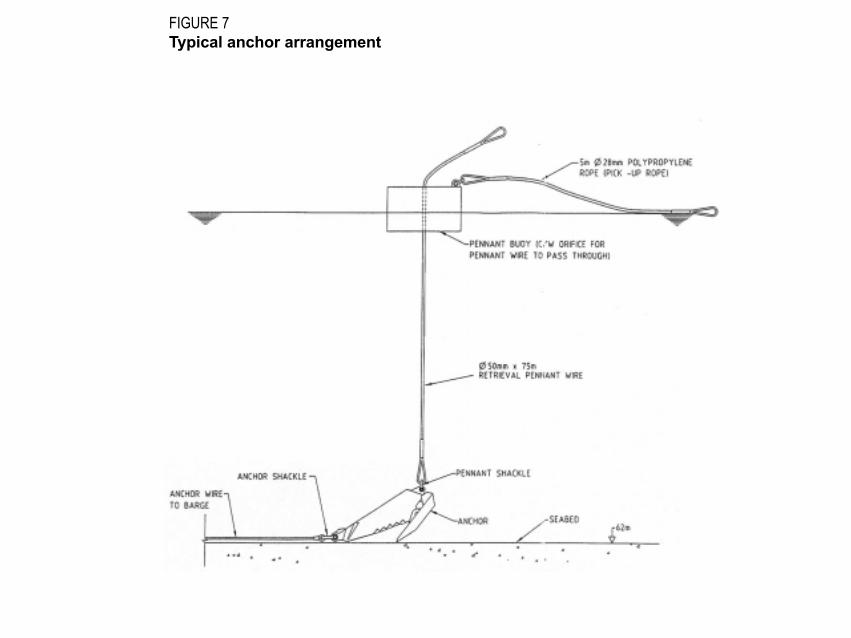
FIGURE 7Typical anchor arrangement
Anchor-handling
Anchor-handling is an operation commonly performed by offshore support vessels. A typical anchorarrangement is shown. When moving an anchor, the anchor-handling vessel moves into position to recoverthe light polypropylene buoy pennant or �pick-up� line. This line is designed to float on the surface of thewater to facilitate recovery. Once recovered, the pick-up line is led to the tugger winch located forward on thevessels work deck (port side on Britoil 22). The pick-up line is winched until the anchor pennant is recovered;this is secured in the shark jaws. During this process the mother vessel (Java Constructor in this case)eases the tension on the anchor cable. A work wire from the anchor-handling vessel�s work winch is nextattached to the ring end of the anchor pennant. The weight is taken on the work wire and the shark jawsreleased. The anchor pennant is winched in, bringing the buoy and anchor to the stern roller. The anchor istransported, suspended at the stern roller to the new desired position and then lowered, using the workwinch. Once the anchor has touched bottom, the pennant is released, the mother vessel retensions theanchor cable and the anchor is set.
Offshore support vessels, whilst engaged in anchor-handling activities, do not navigate in the conventionalsense. The process of anchor-handling is controlled from the mother vessel. The anchor to be moved isspecified, a course line to follow to the anchor is generated and, once the anchor is recovered, a positionand new course line directing the anchor-handling vessel to the position where the anchor is to be deployedis also generated. A sophisticated differential global positioning system (DGPS) is used to control thewhole process.
Anchor-handling operations on the Varanus Island Pipelines Project were controlled and coordinated by thebarge superintendent aboard Java Constructor. The superintendent delegated the appropriateresponsibilities to the barge anchor-handling team (barge supervisor, barge foreman, and anchor winchoperators). The barge supervisor or barge foreman, who split the day into two twelve-hour shifts, wereresponsible for the day-to-day operation of the barge, including the decisions on anchor placement. Thescope of the anchor wire was determined by the contract Racal surveyor on duty at the time.
During the operation no contact could be made between the barge�s anchor and anchor wires and theexisting pipelines, wellheads etc. There was a Prohibited Anchoring Area extending to 150 m around these

existing structures. In the shallow waters of Varanus Island this requirement presented a number ofchallenges. These included the need to maintain tension, and thus a clearance, between the anchor wiresand existing structures while moving anchors from place to place.
Procedures for the barge personnel detailing the anchor-handling operations were produced by KCJV.These included:
� responsibilities of the various operational personnel;
� procedures for running and retrieving the anchors;
� anchoring arrangements for various contingencies to be encountered at different stages in the project;
� anchoring restrictions.
The KCJV deep-water pipelay anchor-handling procedures did not include any specific arrangements orprecautions for anchor-handling vessels operating in shallow water.
Britoil 22 operated on a 12-hour duty cycle whilst engaged in the Varanus Island Pipelines Project. Britoil22 operated between the hours of 0001 and 1200, with Jaya Valiant operating from 1200 to 2400. Thetimes of operation meant that a substantial amount of the anchor-handling was performed in darkness, withalmost complete reliance on the crew of Java Constructor for guidance to the correct anchor recovery anddrop positions.
Safety Management
Clough Offshore operated a Safety Management System which provided the systems and guidelines tomanage the safety elements of the project. It was Clough Offshore policy to ensure that all subcontractorswere responsible for the management and operation of their own Safety Management Systems. KCJV hadsubmitted a safety case for the project to the Western Australian Department of Mines and Energy (DOME),which had been assessed and accepted. Clough Offshore, through Apache and Brown Root & Kenney, had
appointed London Offshore Consultants (LOC) to vet the procedures relating to the anchor-handlingoperations. LOC had concluded that the procedures envisaged were acceptable.
Total Marine Services Pty Ltd is ISO 9002 accredited. They also hold an International Safety ManagementCode document of compliance for offshore support vessels. A set of Total Marine�s ISM Code, Quality/Safety Procedures manuals were supplied to Britoil 22 for the project. The master indicated that he ran thevessel using the Total Marine Services Navigation and Deck Manual together with the Australian OffshoreSupport Vessel Code of Working Practice.
Grounding
On 18 November, Britoil 22 started her duty cycle at 0001. The master took over the watch the previousnight at 2330 and handled the Java Constructor�s anchors, as directed, until being relieved by the mate at0500. The master estimated the vessel�s draft at 2.5 m forward and 2.0 m aft. At no time during the watchhad there been less than 2.8 m under-keel clearance showing on the echo sounder. After being relieved bythe mate, the master remained on the bridge to supervise the handling of the port 4 anchor. He was awareof the existence of a southerly set and that high water had been predicted for 1045 that morning. Heestimated the wind at Beaufort force 3-4 from the south-south-west. The master went below to rest at about0525.
The mate was left on the bridge to carry on the watch; he was aware that the tide was close to low water.The second engineer was also present on the bridge to control the anchor-handling winch and shark jaws.The mate was next instructed by the barge foreman on Java Constructor to move starboard 4 anchor (droptime 0546), followed by starboard 3 anchor (drop time 0605) and then port 3 anchor.
Jaya Valiant had dropped port 3 anchor the previous evening at 2249 at the position; Easting 353689.87,Northing 7716353.97 (Figures 5&6, Figure 10).
About this time, the mate overheard a conversation on the VHF radio between the barge foreman and theduty Racal surveyor on Java Constructor that the available operating depth for Britoil 22 was 6 m. He wasnot made aware of any specific dangers in the area of port 3 anchor by the staff on Java Constructor.

Increasing engine speed to 500 rpm, the mate brought Britoil 22 around Java Constructor�s stern. TheRacal surveyor aboard Java Constructor provided a �bullseye� display, with range and heading line to theanchor, on Britoil 22�s bridge monitor. The mate followed the heading line and, as he passed the port 4anchor buoy, reduced the shaft revolutions on both main engines to 400 and clutched out ready formanoeuvring.
On approaching port 3 anchor buoy, the mate noted the echo sounder showing a marked reduction inunder-keel clearance to 3.8 m. At the time, there had been insufficient light to see the sea bottom or todiscern the changes in colour of the water.
Standing at the forward controls and with the buoy in sight, he made his approach downwind on a headingof 040°. He manoeuvred using the bow thruster and engines to keep the buoy on his port side. Losingsight of the buoy on the port shoulder and with the vessel making slight headway, he declutched theengines and transferred control to the after console. He took control at the after console and passed 10 moff the buoy, noting that the tide was setting southward at an estimated 1 knot. He observed that the buoypennant pick-up line was being carried to the south-east on the surface of the water. He later recalled thata low swell had been running. At this time, the echo sounder indicated a further reduction in under-keelclearance to 2.8 m. He stopped and took all way off with the buoy about 20 m on the port quarter. It washis intention at the time to swing the stern to port, using an astern movement on the starboard engine andlow revolutions ahead on the port engine.
At that moment, the mate felt the port side of Britoil 22 make contact with the �bottom�, and lurch over tostarboard. He then felt a series of bumps. He reversed the vessel until clear of the object. Instinctively, hededuced that the anchor could not have been dropped in such close proximity to a rock. He informed thebarge foreman by VHF radio that he had touched bottom and asked whether it was possible Britoil 22 couldhave run over the anchor wire. He was assured otherwise.
On ensuring Britoil 22 was afloat, the mate navigated into deeper water. The barge foreman asked whetherhe could pick up another anchor and the mate responded that he would need to inform the master of thebottom contact. He called the master at 0620.
The master responded immediately to the mate�s call, was appraised of the incident, and then took controlof the vessel. The mate was sent to inspect the steering flat and forecastle store and to sound bothforepeak and forward fresh water tanks.
The chief engineer at this time arrived on the bridge to relieve the second engineer on the winch controls.He instructed the second engineer to sound the fuel tanks and check the engine room.
The mate and second engineer reported, approximately 15 minutes later, that they had found no sign ofdamage or water ingress.
The master relayed this information to the personnel on Java Constructor, who then instructed him to re-attempt the recovery of port 3 anchor. The master made a different approach to the anchor buoy while JavaConstructor tensioned the anchor cable to ensure that it did not foul the bottom. During this secondapproach, the chief and second engineers both reported that Britoil 22 made contact with the bottom again.The anchor was finally successfully retrieved and redeployed in the new required position at 0700.
The next instruction from Java Constructor was to move port 1 anchor. As this anchor was brought to thestern roller, the second engineer received an engine room bilge alarm. On entering the engine room, henoticed that there was water lapping the floor plates and that water was being thrown up to the deck headby the main engine flywheels. At the same time, the engine room integrated rating arrived and the secondengineer instructed him to fetch the chief engineer from the bridge immediately. The time was 0730.
Damage Control
The chief engineer proceeded quickly to the engine room and noted that there was water to a level of 30 cmbeneath the floor plates of the entire compartment. The second engineer had already started the bilge andgeneral service pumps. The two pumps had a total rated capacity of 72 m³/h. The chief engineer double-checked the bilge valve line-ups and opened the direct bilge suction. The third engineer arrived to assist atthis time. To the chief engineer it was clear, after observing the water level in the bilge, that the pumpswere only just coping with the inflow. He instructed the mate to bring the portable diesel-driven pump downfrom the deck store. The water level started to fall when this pump was brought on line.

FIGURE 8Scoring of shell plate and paint forward of hole
FIGURE 9Repair with wooden plugs and Denso tape
The chief engineer then went to the bridge and reported to the master the seriousness of the situation in theengine room; he in turn reported the situation to the barge foreman on Java Constructor. Port 1 anchor waslowered immediately off the stern roller and Britoil 22 proceeded back alongside the materials handlingbarge Sea Sovereign, which was tied up alongside Java Constructor. The time was 0800.
The master notified Total Marine of the situation and was instructed to inform Jaya Valiant not to enter theshallow area.
An air-driven salvage pump was borrowed from Java Constructor and this greatly assisted Britoil 22�s ownpumps in controlling the water ingress.
Temporary repairs
At 0830, equipped with a video camera, a diver entered the water to perform a hull inspection of Britoil 22.He quickly located a hole between frames 24 and 25. The master and chief engineer of Britoil 22, in thedive shack of Java Constructor, saw on the video monitor an L-shaped hole approximately 100 mm on thelong leg, 30 mm on the short leg, and 20 mm at the widest point.
A large piece of rag was obtained from Britoil 22 and used by the diver to stem the flow of water into thevessel. The engine room bilges were then pumped dry and the hole located, by the third engineer, underthe port main engine.
It was decided to make wooden plugs, wrapped in Denso tape, to effect a temporary external repair.Wooden plugs were fabricated by Britoil 22�s engineers, then driven into the hole by the diver. The secondengineer reported that the instant the rag was removed from the hole by the diver prior to driving in theplugs, the water gushed in to strike the sump below the port main engine.
Some form of temporary repair was necessary on the inside of the shell plate. After considering theavailable options, it was decided to construct a cement box over the hole. A wooden frame wasconstructed around the hole, and the vessel�s surrounding structural members used for bracing. A bag ofquick drying cement, obtained from Java Constructor, was mixed and then poured into the cement box.
The cement box construction was completed at approximately 1500.
A final underwater inspection of the hull was conducted with the chief engineer carefully viewing the diver�svideo. The tanks were also re-sounded and the possibility of further hull leakage eliminated.
At 1700, the master was informed that the hardened cement box was holding.
The master and chief engineer then advised Total Marine and the barge superintendent aboard JavaConstructor of the necessity to return to Dampier to undertake a damage survey and effect more permanentrepairs. They were instructed by the barge superintendent to wait until Sea Sovereign was discharged ofcargo and then to tow it back to Dampier. There was some disagreement, as the master of Britoil 22wanted to sail unencumbered back to port as quickly as possible. The barge superintendent held the viewthat Britoil 22 was still on hire to Clough Offshore and while there was no danger of the vessel sinking, theterms of the contract would be observed.
Britoil 22 finally sailed for Dampier, with the materials-handling barge in tow, at 0320 on 19 November.Throughout the passage, engine room watches were kept and the cement box repair checked at 20 minuteintervals. The engine room bilges remained dry on the return voyage except for a slight trickle from thecement box.
Britoil 22�s crew estimated that, during the holing and subsequent direct bilge pumping there was approximately20 litres of oil pumped from the engine room bilges into the sea. This was reflected in an entry in their oilrecord book.
Damage Survey
At 1130 on 19 November, Britoil 22 shortened the tow and �hipped� up alongside Sea Sovereign. The bargewas secured at the Mermaid Strait Cyclone Mooring and, at 1320, the tow was disconnected. At 1425,Britoil 22 arrived alongside the Public Wharf at Dampier. The same day, a marine surveyor from ABSPacific attended the vessel and conducted a survey.
Total Marine engaged the ABS-accredited dive-company, Oceanic Offshore Pty Ltd, to undertake an

underwater inspection of the hull of Britoil 22. To this end, the divers took both video footage and stillphotographs of the hull damage. (Figures 8&9)
As a result of the underwater inspection, the marine surveyor noted the damage to the port side shellplating comprising a number of indentations below the lower chine between frames 30 and 39, 40 and 41,and 42 to 48. Additionally, immediately forward of frame 24 and below the engine girder was an indentationapproximately 400 mm long and 600 mm wide. This contained the perforation that had been pluggedearlier. Internally he noted the cement box constructed between frames 24 and 25. He had agreed totemporary repairs in the vicinity, in consideration of which he had issued a Temporary International LoadlineCertificate, having withdrawn the full-term certificate.
After the temporary repairs were completed Britoil 22 proceeded, with Sea Sovereign in tow, from Dampierto Singapore, where the charter was terminated on 30 November.
Seabed re-survey
After the incident, the barge superintendent instructed the scout vessel Mermaid Titan to re-survey theshallows of Varanus Island. This survey started at 1420 on 19 November, by which time Java Constructorhad moved on. The barge superintendent was concerned for the safety of future anchor-handlingoperations and the area of operation west of the grounding position was examined. The area where Britoil22 had run aground was not re-surveyed by Mermaid Titan.
Mermaid Titan was fitted with satellite navigation equipment, and the re-survey was carried out usingparallel search techniques, in full daylight. When any isolated dangers were discovered, their size and depthwere estimated, and the position fixed on GNS aboard Java Constructor, using the Skytrac system. Theresultant search found many isolated coral heads not defined by the Fugro survey (Figure 11).
As a further safety measure, Mermaid Titan was used to scout the shallows before the anchor-handling vesselsmoved in to recover and deploy the anchors after the incident.
Comment and analysis
Britoil 22 came into contact with an uncharted coral head or Java Constructor�s port 3 anchor. There isinsufficient evidence to form a definite conclusion either way. In any case, Britoil 22 was operating in shoalwater with minimum under-keel clearance.
The operation
The initial route survey for the proposed gas pipeline, conducted by Fugro, met the survey specificationsupplied by KCJV. The position of the port 3 anchor, as deployed in the evening of 17 November, waswithin the area surveyed by Fugro.
In submission Fugro stated:
Regarding the survey of a 500 m wide corridor in the vicinity of Varanus Island, while this may have been part of a specification, the
work was carried out on day rates and the client directed the scope on a day to day basis, and called for the scope to be varied by
directing the work to cease when they were happy with the results and coverage.
When planning the pipelaying operation, the Racal staff took the Fugro survey data and converted it for useby their GNS system. Racal staff accepted the positions of the individual coral heads shown on the seabedfeatures chart and entered them manually into their database. In so doing, they made the assumption thatthe Fugro survey had identified all of the significant underwater obstructions in the area.
In fact, the Fugro survey only identified the �significant� coral heads generally higher than 2 m. WhenMermaid Titan re-surveyed the remaining area of operation, many more underwater obstructions wereidentified. (Figure 11, pg.18). Although generally smaller, these coral heads still represented a significantdanger to the anchor-handling vessels.
In submission Fugro stated:
Fugro�s report on the route survey and the accompanying drawing No.14421-11, clearly delineated an area adjacent to Varanus Island
where the seabed was interpreted to be formed by rock/reef outcrops with significant relief above the seabed. The report also noted
that in the areas adjacent to Varanus Island only the larger features (ie those generally 2m or more in height) have been plotted and
may be approximate.
Despite their apparent misinterpretation of the Fugro survey data, there was recognition on the part of theRacal survey staff on Java Constructor of dangers associated with this type of seabed. The survey partychief stated that they had warned the anchor-handling vessels to take extreme care while manoeuvring inthe shallows on the port side of the pipelay barge. They also told the anchor-handling vessels that theirposition, with respect to the known coral heads, was being tracked.
The crews of the support vessels stated that they had requested additional survey information on theshallows of Varanus Island prior to the incident. These were not supplied, as apparently there wereinsufficient copies of these charts to allow each vessel a full set. Britoil 22 did not have on board therelevant bathymetric or seabed features charts. The only chart carried was the normal navigation chart,Aus 742: Rosemary Island to Barrow Island, on a scale of 1:150,000. Such charts are not intended orsuitable for the type of operation or the waters in which Java Constructor and its support vessels wereoperating. The Fugro bathymetric and seabed features charts would have given the crews of the anchor-handling vessels a much better picture of the hazards in the area of operation around Varanus Island.
With regard to the provision of the detailed survey charts, Clough Offshore stated in submission:
We believe that detailed survey charts (pipeline alignment charts) were issued to the anchor-handling tugs, attached to the project
specific anchor-handling procedure, although we do not have on record that the charts were received by the anchor-handling tugs. We
will now issue the pipeline alignment sheets as a separate package to ensure we have record of them being received by the vessel
master. This will also be added to the vessel audit list during the project audit schedule to ensure these alignment sheets are still on
board the vessels and that the revisions are current.
The mate at the time of the incident was following accepted anchor-handling practice. He was relying on theGNS screen, the echo sounder, tidal information and directions from the Java Constructor. When closingthe anchor position, he was concentrating on visual manoeuvring to recover the anchor buoy.
Clough Offshore management stated it was their view that the anchor-handling vessels were responsiblefor ensuring they had adequate under-keel clearance. The implication of this statement is that there was a
system on board the anchor-handling vessels to accurately indicate the vessels� under-keel clearance. Theonly instruments fitted to the anchor-handling vessels for indicating bottom clearance, were echo sounders.An echo sounder shows the depth below its transducer at any given time. It does not look forward or toeither side. When operating in shoal water with minimum under-keel clearance, an echo sounder is noteffective in showing that the vessel is about to ground.
The mate of Britoil 22 had little information on which to base any judgement regarding safe operation. Hewas reliant upon accurate and safe direction from the controllers aboard Java Constructor. As with thegrounding of Boa Force, (Incident Report no. 66), Britoil 22 really was totally reliant upon the pipelay bargefor safe direction. In this case, the directions given were based on an incomplete or incorrect interpretationof bottom survey data.
Water depths and environmental issues
At 1240 and 1311 on 17 November, Jaya Valiant had been operating in the general area in which Britoil 22sustained damage on 18 November. Jaya Valiant laid two of Java Constructor�s anchors, port 1 and port 2,about 180 m and 120 m respectively from the position in which it laid port 3 at 2249 on 17 November. At notime was Jaya Valiant operating in the immediate area of the incident with a tide less than 2.75 m abovedatum, and when it positioned port 3, it did so at high water, 3.69 m above datum. Jaya Valiant wastrimmed by the stern but with an average draft similar to that of Britoil 22. Low water on the morning of18 November 1998 was at 0510. Just before 0620, when Britoil 22 made its first approach to retrieve theanchor, the tidal height above datum was 1.2 m.
The mate of Britoil 22 accepted that the available operating depth in the area of port 3 anchor, as indicatedby the Racal surveyor on Java Constructor, was 6 m. The Fugro survey bathymetric chart indicates a depthof approximately 5 m below datum. With the predicted height of tide, Britoil 22 should have been operatingin 6.2 m of water, giving a minimum under-keel clearance of 3.7 m. This was 2.5 m less than for JayaValiant the previous evening. It is not clear that the crew of Britoil 22 gave this fact any consciousconsideration.
The mate stated that he could not see the seabed approaching the port 3 anchor. Sunrise on 18 November

1998, was at 0632. When the mate first approached the port 3 anchor just before 0620 the anchor buoyand floating pick up line would have been visible on top of the water. However, despite the clear shallowwater, the direction of the light would indeed have meant that the mate would not have seen the port 3anchor or a coral head, beneath the surface, in his line of approach.
Contact with a coral head
It is possible that Britoil 22 grounded on an uncharted coral head. The statements and documentationsupplied by the crew indicate that they thought that this was the case.
On a course of 040°, the mate would have been approaching the anchor from outside the area covered byFugro�s bathymetric survey but probably within the area covered by the more extensive seabed featureschart. The Fugro survey seabed features chart did not identify a specific coral head in the area adjacent tothe port 3 anchor.
The decreasing under-keel clearance indicated by Britoil 22�s echo sounder as the vessel approached JavaConstructor�s port 3 anchor, indicated an area of shelving seabed. This is supported by the Fugrosubmission:
A review of the side scan sonar records covering the port 3 anchor position indicates the possible presence of a broad (approximately
20 m diameter) mound, about 1m high. This is entirely consistent with the description of the nature of the seabed in this area in
Fugro�s report and on the chart.
The masters of both Jaya Valiant and Mermaid Titan supplied evidence to the investigation of the existenceof numerous coral heads in the area of the port 3 anchor. It is probable that, if Mermaid Titan had includedthis area in the re-survey, additional coral heads would have been identified.
The statements by the master and mate of Britoil 22 indicate that, prior to the incident, they did not properlyappreciate the general nature of the seabed in the area in which they were operating. When Jaya Valiant�screw had positioned port 1 and port 2 anchors just after noon on17 November, they could see numerous coral heads standing up to 2 m proud of the general level of theseabed. Why Britoil 22�s crew did not indicate similar observations is not clear. At the time of the incident,

the mate made his approach to the port 3 anchor apparently ignorant of any danger in the immediatevicinity.
Given the probable existence of uncharted coral heads in the area in which Britoil 22 was operating early on18 November, it is possible that the vessel grounded on such an obstruction.
Contact with port 3 anchor
The pattern of damage was in a line on Britoil 22�s port side bottom shell plate, with the indentationsbetween the frames linked by longitudinal scores in the hull paint and plating. The scoring of the steelworkof the hull and the shape of the hole are consistent with contact with a relatively sharp and regularly shapedobject. The divers indicated that there was no evidence of rock or coral wedged in the hole in the shellplate. Port 3 was the only anchor in the immediate area.
The anchors in use on the Varanus Island Pipelines Project were of Stevshark design, weighing 8.4 tonnes.The anchors were 5 m in length and 6 m wide. The barge superintendent indicated in his statement that theanchors used on the project could protrude up to 2 m above the �calcarinite� seabed in the vicinity ofVaranus Island.
The length of the anchor pennants for this phase of the operation was between 40 m and 50 m. This gavethe anchor buoy a theoretical maximum watch circle of just under 50 m in 5 m of water. In actuality, theweight of the first 5 or 6 m of 50 mm steel pennant was enough to anchor the buoy in conditions of slightwind and low tidal flow. The wind at the time was slight SSW force 3�4, and the tide had just turned andwas setting to the south at 1 knot. The position of the buoy relative to the anchor would be a product of thescope of the anchor pennant and the relative effect of wind and tide. These factors cannot be calculatedaccurately, but experience would suggest that the buoy would be somewhere down-tide of the anchor. Itwould be entirely consistent to find the buoy within 30 m of the anchor and thus make contact a possibility.
The GNS positions for the port 3 anchor and Britoil 22 were displayed on the Racal monitor on JavaConstructor. The barge staff used their display to monitor Britoil 22�s position with respect to the port 3anchor and charted underwater obstructions. However, the size of the GNS display screen, and the
symbols displayed on it, would not have been sufficiently precise to determine that Britoil 22 was anythingother than close to the anchor. To determine the vessel�s position relative to the anchor with absoluteaccuracy by monitoring the eastings and northings, would not seem a practical proposition given the rapidrate of change of this data.
On board Britoil 22, the mate also had the anchor drop position displayed on the Racal monitor but, oncethe vessel was close to the anchor buoy, it would be normal practice to rely on visual judgement whilemanoeuvring to recover the buoy.
The Fugro submission indicated the possibility of a 1 m high, 20 m diameter, �mound� at the port 3 anchorposition. If the anchor had been dropped on this mound with its estimated 2 m protrusion above theseabed, Britoil 22�s minimum under-keel clearance would have been reduced from 3.7 m to 0.7 m. With thelow swell and the roll of the vessel when manoeuvring, it can be plausibly argued that Britoil 22 came intocontact with Java Constructor�s port 3 anchor.
The second contact
The engineers reported a second contact when the master was making the second attempt to recover port3 anchor. The master and mate made no reference to, or record of, this contact. The linked pattern ofdamage seems to indicate only one contact was made. A second contact with the bottom in the area ispossible. A more likely explanation for the reported second impact, is that the vessel landed heavily on theanchor buoy itself.
Response
The second engineer did not detect the leakage into the engine room on the first inspection. Perhaps hisinitial inspection after the grounding had not allowed sufficient time for the leak to fill the bilges to a levelthat was readily observable. The check of the engine room space and tank sounding took, from themaster�s statement, 15 min, a relatively short time to complete these tasks. The inaccessibility of the leakmay have meant that it was not obvious on a quick inspection.
The crew�s quick response in bringing the available engine room pumps on line when the leak wasdiscovered was commendable. The provision of the diesel driven salvage pump as ship�s equipment was asignificant factor in saving Britoil 22 from worse flooding and possible loss.
Procedures
The Australian Offshore Support Vessel Code of Safe Working Practice (OSV code)
�applies to all vessels engaged in the carriage of cargo, in towing and in anchor-handling operations in the Australian Exclusive
Economic Zone, irrespective of flag or ownership.
The code details the statutory requirements for offshore installations and their attendant support vesselswith respect to operational procedures, responsibilities, equipment etc.
The master of Britoil 22 stated that he ran the vessel using the OSV code. The Total Marine Servicesprocedure manuals also reflected the contents of the OSV code. The Clough Offshore, project specific,anchor-handling procedures vetted by LOC did not contain any reference to the shallow water anchor-handling operations. There is no doubt Java Constructor�s barge superintendent was aware of the contentsof the OSV code and the Clough Offshore operating procedures also reflected the requirements of thecode.
Some sections of the OSV code are relevant to the grounding of Britoil 22, namely:
Section 2:
�Communications between charterers and vessel owners/Masters� 2.1 It is important that a direct line of communication is established
between Owners and Charterers, to enable ll safety matters to be raised and, where appropriate, action taken.
In this case, the �Owners� can be considered to be Total Marine Services and the �Charterers� CloughOffshore. There was no evidence that any relevant dialogue took place between Total Marine Services andClough Offshore in relation to the safety of the shallow water anchor-handling operations.
Section 10 of the OSV code also contains relevant instructions: - section 10.4 under the heading: -
�Anchor-handling and Rig Shifts�
10.4.2 Agreed Procedures, Written Program, Briefing of Masters, Responsibilities
10.4.2.1 Full procedures for rig move operations must be agreed by operators and their Mobile Installation Contractors and clear
instructions laid down in writing. Where particular nstallations have detailed procedures for anchor-handling and towing, these must be
passed to the relevant vessels via the operator as required, so that Masters are fully briefed on the operation to be conducted. If
possible, Masters should be briefed prior to leaving port or, failing that, on location prior to rig move operations.
Although some non-specific warnings to �take extreme care while manoeuvring on the port side of thepipelay barge� off Varanus Island were given to the support vessels, there seemed to be no structured �toolbox� meetings or briefings. In fact, there were no records of briefings of the support vessel masters at anystage during the Project. Information pertaining to the shallows of Varanus Island was requested by theanchor-handling vessel crews, but never supplied. There was no provision of operation-specific writteninstructions to the crew of Britoil 22.
In submission, Clough Offshore stated that they have already made the following revision to theirprocedures:
Currently daily and weekly safety/toolbox meetings are undertaken on board each operating vessel. We now require the master or
mate of anchor-handling vessels to attend a weekly meeting on board the pipelay vessel. These meetings are to have minutes
recorded.
The OSV code also details requirements when operating close to sub-sea obstructions; at section 10.4.4 itstates under the heading:
�Pipelines, Sub-Sea Obstructions/Structures�
10.4.4.1All personnel involved must have full details regarding the location of pipelines and sub-sea obstructions/structures
relating to the whole operation.
10.4.4.2 Where it is known that anchor-handlingand/or towing operations will be conducted near to pipelines or sub-sea
obstructions/structures, then full written procedures should be agreed by all parties.

Clough Offshore again did not provide the anchor-handling vessels with details of the known sub-seaobstructions or the appropriate written instructions.
Responsibility for the safe operation of Britoil 22 ultimately rested with the master. However, the anchor-handling operation and the area of operation close to Varanus Island was of a special nature. The areawas known to contain numerous coral heads prior to Britoil 22 being holed. The master of Mermaid Titanstated this knowledge from past experience. The master of Jaya Valiant had also observed coral headsand stated that he was only prepared to handle anchors in the shallow water adjacent to Varanus Island 2hours either side of high water. He was extremely circumspect when handling anchors in this area.
The master of Britoil 22, on the other hand, was prepared to operate his vessel in the area at any stage ofthe tide. This inconsistent approach to a critical operation would seem to be contrary to current safetymanagement practice. There had been insufficient assessment of the dangers, no consultation with, and noclear instructions issued to the masters of the two anchor-handling vessels. It would be reasonable toassume that if meetings between the barge and attendant vessel crews had been held and even ad hocprocedures formulated, there would have been a unified, safer approach to the anchor-handling operationsin the shallows of Varanus Island.
Conclusions
These conclusions identify the different factors contributing to the incident and should not be read asapportioning blame or liability to any particular organisation or individual.
Britoil 22 either made contact with, Java Constructor�s port 3 anchor, or grounded on an uncharted coralhead in the shallow water adjacent to Varanus Island. Given the pattern of damage and the Fugrostatement concerning the possible existence of a 1 m �high mound� in the port 3 anchor position, it is morelikely that the vessel made contact with the anchor.
The grounding or contact and consequent holing of Britoil 22 was the result of a combination of factors.These factors include but are not limited to:
1. The initial route survey data wasmisinterpreted by the construction survey team and thus specific hazards to the anchor-handlingvessels in the shallows of Varanus Island were not identified.
2. There was poor and/or insufficient communication of operational information, in the form of adequatesurvey data, between project control on the pipelay barge and the anchor-handling vessels.
3. There was a lack of a cohesive plan or procedure identifying the specific responsibilities, hazards,actions and contingencies for the shallow water anchor-handling operations adjacent to VaranusIsland.
4. There was a lack of anticipatory action by project control, in the form of a supplementary survey, whenknowledge of uncharted hazards came to light.
5. The difficulties associated with anchor-handling operations in shallow waters, in low light and adversetidal conditions, were not sufficiently considered.
6. There was inadequate adherence to the OSV Code with respect to the provision of agreed written
procedures and, in fact, any reasonable operational dialogue between the pipelay barge and anchor-handling vessels.
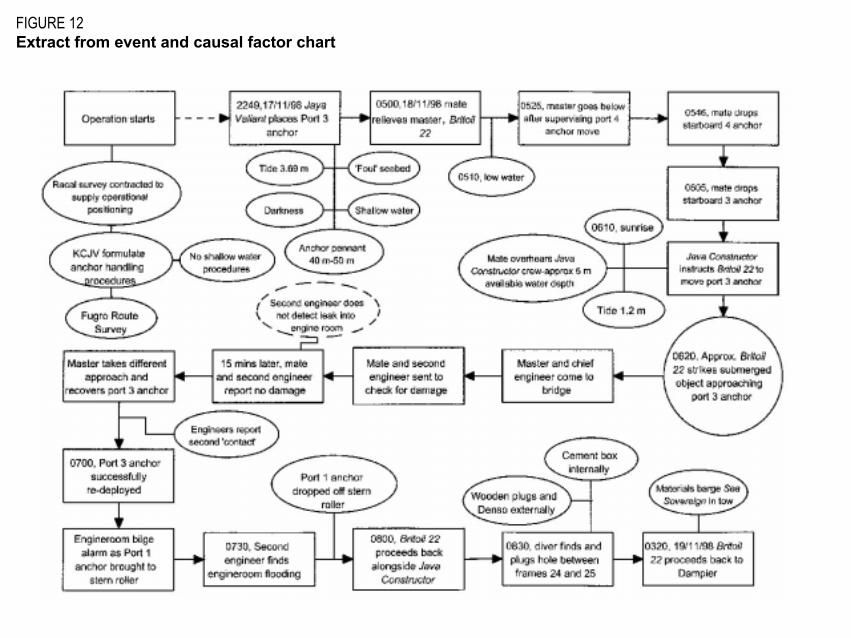
FIGURE 12Extract from event and causal factor chart
Submissions
Under sub-regulation 16(3) of the Navigation (Marine Casualty) Regulations, if a report, or part of a report,relates to a person�s affairs to a material extent, the Inspector must, if it is reasonable to do so, give thatperson a copy of the report or the relevant part of the report. Sub-regulation 16(4) provides that such aperson may provide written comments or information relating to the report.
The final draft of the report was sent to the following:
Master Britoil 22
Mate Britoil 22
Chief engineer Britoil 22
Master Jaya Valiant
Australian Maritime Safety Authority
Clough Offshore
Fugro Survey Pty Ltd, Australia
Racal Survey Australia Ltd
Total Marine Services Pty Ltd
Submissions were received from the Australian Maritime Safety Authority, Fugro Survey Pty Ltd, andClough Offshore. The text was amended and portions of the submissions included as appropriate.

Details of Britoil 22
IMO No. 9147629
Flag Singapore
Classification Society American Bureau of Shipping
Ship type Offshore support and towing vessel
Owner Britoil Offshore Services Pte Ltd
Operator Total Marine Services Pte Ltd
Year of build 1996
Builder Fujian Fishery Shipyard, China
Gross tonnage 443
Net tonnage 133
Deadweight 350 tonnes
Length overall 37.0 m
Beam moulded 10.60 m
Depth moulded 4.95 m
Designed draft 4.00 m
Speed 12 knots
Endurance 7 200 miles at 12 knots
Bollard pull 60 tonnes

Engines 2 x Yanmar Z280A-EN 6-cylinder
Engine power 1 492 kW each
Crew 11(Australian)