groundsure geoinsight user guide - emapsite - … geoinsight user guide if you would like further...
TRANSCRIPT
GroundSure GeoInsight User Guide
If you would like further assistance regarding this user guide please contact GroundSure on (T) 01273 819500, (F) 01273 819550, email: maps&[email protected]
1
GroundSure GeoInsight User Guide
Version: Draft January 2009
To be used with the
GroundSure GeoInsight
GroundSure Limited
Level 7 New England House, New England Street,
Brighton, BN1 4GH Tel: 01273 819 700 Fax: 01273 819 550
E-mail: maps&[email protected]
GroundSure GeoInsight User Guide
If you would like further assistance regarding this user guide please contact GroundSure on (T) 01273 819500, (F) 01273 819550, email: maps&[email protected]
2
Internet: www.historicalmappacks.co.uk
Contents
1. INTRODUCTION ...........................................................................................................................4
2. WHAT IS A GROUNDSURE GEOINSIGHT? ....................................................................................4
3. WHY DO YOU NEED A GROUNDSURE GEOINSIGHT?...................................................................4
4. HOW TO ORDER REPORTS...........................................................................................................5
5. PAYING FOR REPORTS ................................................................................................................5
6. REPORT LIMITATIONS .................................................................................................................5
7. OUR TERMS AND CONDITIONS ...................................................................................................5
8. GROUNDSURE DATA ...................................................................................................................7
8.1 How is the Data Organised?.......................................................................................................................... 7
8.2 Data Quality................................................................................................................................................... 7
8.3 Data Sources................................................................................................................................................. 7
8.4 What Does the Data Mean?........................................................................................................................... 8
8.5 Ground Workings .......................................................................................................................................... 8 8.5.1 Historical Surface Working Features ..........................................................................................................................8 8.5.2 Historical Underground Working Features.................................................................................................................8 8.5.3 Current Ground Workings ...........................................................................................................................................9
8.6 Mining, Extraction & Natural Cavities .......................................................................................................... 9 8.6.1 Historical Mining..........................................................................................................................................................9 8.6.2 Coal Mining ..................................................................................................................................................................9 8.6.3 Shallow Mining...........................................................................................................................................................10 8.6.4 Non Coal Mining Cavities ...........................................................................................................................................11 8.6.5 Natural Cavities .........................................................................................................................................................12 8.6.6 Brine Extraction .........................................................................................................................................................13 8.6.7 Gypsum Extraction.....................................................................................................................................................14 8.6.8 Tin Mining...................................................................................................................................................................14 8.6.9 Kaolin & Ball Clay Mining ............................................................................................. Error! Bookmark not defined.
8.7 Natural Ground Subsidence ........................................................................................................................15 8.7.1 Shrink-Swell Clay ......................................................................................................................................................15 8.7.2 Running Sand.............................................................................................................................................................17 8.7.3 Landslide....................................................................................................................................................................18 8.7.4 Ground Dissolution of Soluble Rocks ........................................................................................................................19

GroundSure GeoInsight User Guide
If you would like further assistance regarding this user guide please contact GroundSure on (T) 01273 819500, (F) 01273 819550, email: maps&[email protected]
3
8.7.5 Compressible & Collapsible Deposits.......................................................................................................................20
8.8 Geology ........................................................................................................................................................22 8.8.1 Geology Maps .............................................................................................................................................................22 8.8.2 Artificial/Made Ground...............................................................................................................................................22 8.8.3 Superficial Deposits/Drift Geology ............................................................................................................................23 8.8.4 Landslip......................................................................................................................................................................23 8.8.5 Bedrock/Solid Geology ..............................................................................................................................................23 8.8.6 Faults .........................................................................................................................................................................23
8.9 Borehole Records ........................................................................................................................................24
9. FUTURE IMPROVEMENTS .........................................................................................................24
APPENDIX I – GROUNDSURE’S TERMS AND CONDITIONS............ERROR! BOOKMARK NOT DEFINED.
APPENDIX II – DATA UPDATE FREQUENCY TABLE..............................................................................32

GroundSure GeoInsight User Guide
If you would like further assistance regarding this user guide please contact GroundSure on (T) 01273 819500, (F) 01273 819550, email: maps&[email protected]
4
1. Introduction The GroundSure GeoInsight (GGI) provides high quality geo-environmental information that allows professional’s to make rapid and informed decisions regarding the potential geo-environmental liabilities of a study site. The GroundSure GeoInsight forms part of a suite of services and can be used either as stand alone report or in conjunction with other reports to form a complimentary suite of products. These complimentary products are:
• GroundSure EnviroInsight • GroundSure GeoInsight • GroundSure MapInsight with historical mapping at 1:10 560, 1:10 000, 1:2 500 and 1:1 250
scales. This User Guide outlines the GroundSure GeoInsight only. The User guides for our other services can be found online at www.historicalmappacks.co.uk. GroundSure has dedicated teams of professionals engaged in the systematic collation, management, visualisation and presentation of such information with the key objective of presenting complex geo-environmental information in a user friendly format enabling rapid and effective professional interpretation by the reader.
2. What is a GroundSure GeoInsight? The GroundSure GeoInsight provides a cost effective assessment that for the first time details a sites geohazards and ground stability in one report. The report is based on the BGS’s 1:50,000 scale mapping and includes GroundSure’s unique datasets which are presented for the first time including Historical Surface Working features and Historical Underground Working features created from the digitisation of 6,500 land use features extracted from 1:10,560 and 1:10,000 historical maps dating back to the 1840’s. The report also includes the British Geological Survey (BGS) BRITPITS database, BGS Shallow Mining data, BGS GeoSure dataset, BGS 1:50,000 Geology maps and borehole records. In addition, the Coal Authority has provided data on coal mining and brine extraction affected areas and Peter Brett Associates Non-coal mining and natural cavities database. Utilising GroundSure’s unique databases, the report also provides an overview of Kaolin & Ball Clay Mining areas and Tin mining areas. No other report offers such breadth and depth as the GroundSure Geology & Ground Stability Report.
3. Why do you need a GroundSure GeoInsight? The GroundSure GeoInsight is designed for environmental consultants, geotechnical specialists, property developers, structural and civil engineers and other professionals. It enables them to be forewarned at the desk study or Phase I stage of potential ground instability problems, which may affect ground investigation, foundation design, contamination pathways and possibly remediation options that may lead to possible additional costs. A wide range of data-sets have been selected to cover as wide a range of potential issues.
GroundSure GeoInsight User Guide
If you would like further assistance regarding this user guide please contact GroundSure on (T) 01273 819500, (F) 01273 819550, email: maps&[email protected]
5
4. How to order Reports GroundSure has utilised our award winning website to supply the GroundSure Insight along with its complementary reports (the GroundSure EnviroInsight and GroundSure MapInsight). Ordering could not be simpler. To register for the online ordering system, please go to www.historicalmappacks.co.uk and click on Register and fill in the required fields. Alternatively, please email your contact details, including your name, company name, address, telephone number and email address to maps&[email protected] and a GroundSure representative will provide your account details and a username and password of your choice. Our Online Ordering system has been developed to allow easy, convenient order placement and to facilitate rapid delivery of your Environmental Data Reports as a PDF file conveniently directly emailed into your mailbox or posted to you as a hard copy if you prefer. All reports are covered by our substantial professional indemnity insurance. A User Guide to the Online Ordering is available on our website and it will also be sent to you as part of your Registration and Getting Started email. However, if you have any questions or wish to discuss the ordering process in any way please contact GroundSure on 01273 819500.
5. Paying for Reports Account arrangements can be set up for customers as part of the registration process as outlined above, or the GroundSure MapInsight can be ordered and paid for by cheque on an ad hoc basis. GroundSure will invoice all customers by sending you a single itemised monthly invoice listing all the services you have ordered during that period. GroundSure’s unique referencing system ensures a clear audit trail for every report purchased.
6. Report Limitations The report comprises a compilation of data obtained from a number of third party data providers and partners in addition to some unique datasets developed by GroundSure – further details are contained within the appendices of this User Guide. GroundSure does not undertake any site inspection as part of the report. Information is presented so as to allow the user to formulate their own professional opinion on a site or property that may include additional elements of work in addition to the Geology and Ground Stability Report itself. GroundSure may from time to time use a substitute database at its discretion and will not usually inform the client of this. Although we take professional care to identify, prepare and use the best databases available for reasonable cost, it is not practicable to make any large geo-environmental database of this nature entirely error free. If you find an error, please contact GroundSure either through the maps & Data Customer Services on 01273 819500 or email maps&[email protected]
7. Our Terms and Conditions GroundSure GeoInsight is covered by substantial Professional Indemnity Insurance and is governed by our terms and conditions. The terms and conditions can be seen in Appendix I, on the GroundSure Data website (www.historicalmaps.co.uk) or provided by post on request.

GroundSure GeoInsight User Guide
If you would like further assistance regarding this user guide please contact GroundSure on (T) 01273 819500, (F) 01273 819550, email: maps&[email protected]
6
Please note: these are the standard terms and conditions provided by GroundSure for reports sold directly to clients. Resellers may have different terms and conditions and you may wish to contact the reseller directly to obtain a copy of their terms and conditions.
GroundSure GeoInsight User Guide
If you would like further assistance regarding this user guide please contact GroundSure on (T) 01273 819500, (F) 01273 819550, email: maps&[email protected]
7
8. GroundSure Data
8.1 How is the Data Organised? The data within GroundSure GeoInsight is arranged in logical sections to help you interpret the results. These sections are:
• Ground Workings • Mining, Extraction & Natural Cavities • Natural Ground Subsidence • Borehole Records • Artificial Ground, Superficial Deposits & Landslips • Bedrock, Solid Geology & Faults
Each section deals with a specific range of issues and provides a simple data summary of the property search we have conducted. Where the database has been searched a numerical result will be recorded. Where the database has not been searched a ‘ – ‘ will be recorded. Most data sets are also represented on the maps provided throughout the report. These give a graphical representation of the findings of the report and are followed by detailed data records. Each data record has a unique identification number that links it to its map position.
8.2 Data Quality Data is either sourced from GroundSure or select third parties. We only select those suppliers who can provide high detailed, quality data that is both accurate and reliable at a reasonable cost. All data within the report is subject to strict levels of quality control and management GroundSure operates a continuous program of improvement and data enhancement. If a potential inaccuracy is found in a report, it should be reported to GroundSure who will log, check and amend it if necessary. GroundSure can not amend certain third party records but, GroundSure will endeavour to inform the third party of the error.
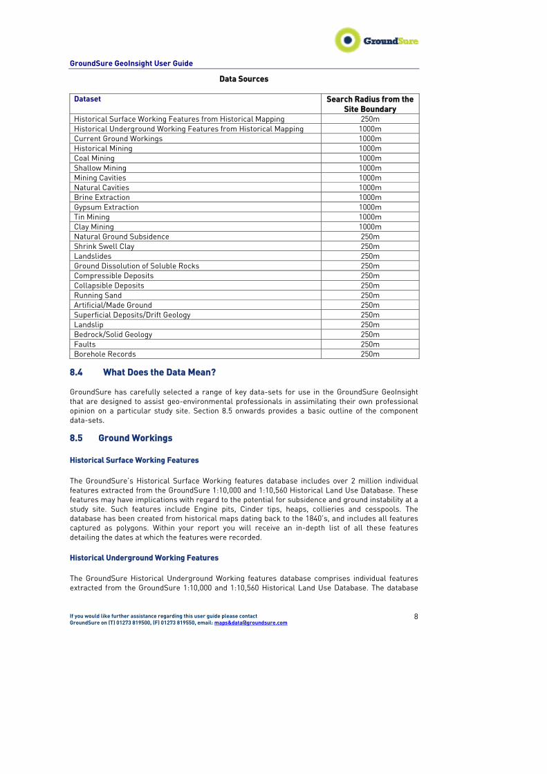
8.3 Data Sources Data contained in the GroundSure GeoInsight is gathered from a wide range of commercially owned data sources, including those developed by GroundSure. These data sources together with their update cycles are outlined in Appendix II. A summary of the data provided in the GroundSure GeoInsight (including the search radii used) can be found in Table 8.1 below.
GroundSure GeoInsight User Guide
If you would like further assistance regarding this user guide please contact GroundSure on (T) 01273 819500, (F) 01273 819550, email: maps&[email protected]
8
Data Sources
Dataset Search Radius from the Site Boundary
Historical Surface Working Features from Historical Mapping 250m Historical Underground Working Features from Historical Mapping 1000m Current Ground Workings 1000m Historical Mining 1000m Coal Mining 1000m Shallow Mining 1000m Mining Cavities 1000m Natural Cavities 1000m Brine Extraction 1000m Gypsum Extraction 1000m Tin Mining 1000m Clay Mining 1000m Natural Ground Subsidence 250m Shrink Swell Clay 250m Landslides 250m Ground Dissolution of Soluble Rocks 250m Compressible Deposits 250m Collapsible Deposits 250m Running Sand 250m Artificial/Made Ground 250m Superficial Deposits/Drift Geology 250m Landslip 250m Bedrock/Solid Geology 250m Faults 250m Borehole Records 250m
8.4 What Does the Data Mean? GroundSure has carefully selected a range of key data-sets for use in the GroundSure GeoInsight that are designed to assist geo-environmental professionals in assimilating their own professional opinion on a particular study site. Section 8.5 onwards provides a basic outline of the component data-sets.
8.5 Ground Workings Historical Surface Working Features The GroundSure’s Historical Surface Working features database includes over 2 million individual features extracted from the GroundSure 1:10,000 and 1:10,560 Historical Land Use Database. These features may have implications with regard to the potential for subsidence and ground instability at a study site. Such features include Engine pits, Cinder tips, heaps, collieries and cesspools. The database has been created from historical maps dating back to the 1840’s, and includes all features captured as polygons. Within your report you will receive an in-depth list of all these features detailing the dates at which the features were recorded. Historical Underground Working Features The GroundSure Historical Underground Working features database comprises individual features extracted from the GroundSure 1:10,000 and 1:10,560 Historical Land Use Database. The database
GroundSure GeoInsight User Guide
If you would like further assistance regarding this user guide please contact GroundSure on (T) 01273 819500, (F) 01273 819550, email: maps&[email protected]
9
includes over 200,000 individual features. These features may have implications with regard to the potential for subsidence and ground instability at a study site. Such features include tunnels, drifts, spouts, veins and wells. The database has been created from historical maps dating back to the 1840’s, and includes all features captured as polygons. Within your report you will receive an in-depth list of all these features detailing the dates at which the features were recorded. Current Ground Workings The British Geological Survey (BGS) holds a large amount of information on the mineral workings of Britain. The Current Ground Workings database is based on the BRITPITS database. The BRITPITS database is continually updated through links with Government and associated industry. There are over 15,500 records in the BRITPITS database covering active and inactive mines, quarries, oil wells, gas wells, mineral wharves and rail depots throughout the British Isles. The BRITPITS database is generated by the BGS through collecting geological information about working mines and quarries since its formation in 1835. The BGS has also been collecting mineral resource data on producing mines and quarries for nearly as long and its current publication, the Directory of Mines and Quarries (DMQ), is produced at approximately two yearly intervals. In recent years the DMQ has also been derived from the BRITPITS (an abbreviation of British Pits, and the word 'pits' is used here to include both surface quarries and underground mines). The database holds information on the name of active mines and quarries, their geographic location, address, operator, mineral planning authority, geology, mineral commodities produced and end-uses. Originally, only details of currently active sites were included in the database but, because of the importance of former workings for waste disposal and as Sites of Special Scientific Interest, information is now collected on both inactive and closed operations. Data is gathered from a number of sources: BGS's own extensive records, Mineral Planning Authorities (MPAs), the minerals industry and various central Government Departments and Agencies (CLG, The Coal Authority, etc). BRITPITS is one of the most comprehensive and up-to-date sources of mines and quarries available. The database can be used for many purposes: route planning, market intelligence/analysis, environmental reports and resource planning,
8.6 Mining, Extraction & Natural Cavities Historical Mining The Historical Mining Database includes features extracted from the GroundSure 1:10,000 and 1:10,560 Historical Land Use Databases indicative of mining or extraction activities that have occurred since the 1840’s. The database includes over 200,000 individual features. Such features include but are not limited to, mine shafts, entrances, adits and levels. The database has been created from historical maps dating back to the 1840’s, and includes all features captured as polygons based on the surface features presented on the historical maps. No indication of the extent of the underground workings has been given. Within your report you will receive an in-depth list of all these features detailing the dates at which the features were recorded. Coal Mining The GroundSure GeoInsight provides information as to whether the study site lies within a coal mining affected area. If a positive response is returned, then a coal mining report should be purchased from the Coal Authority. The Coal Authority Report can provide the following information:
• Past and Present Underground Coal Mining • Past and Present Opencast Coal Mining
GroundSure GeoInsight User Guide
If you would like further assistance regarding this user guide please contact GroundSure on (T) 01273 819500, (F) 01273 819550, email: maps&[email protected]
10
• Future Underground Coal Mining • Presence of Shafts and Adits around the Property • Details of geological faults or other mines of weakness activated by coal mining that may
have affected the property • Details of any coal mining related subsidence (as required under the Coal Mining Subsidence
Act, 1991) The amount of information provided may vary according to the records in the possession of the Coal Authority. Shallow Mining
The BGS Shallow Mining Hazard data refers to the (largely very old) extraction of mineral deposits (metalliferous minerals, stone, salt, gypsum, limestone, chalk, coal etc) by means of underground working. These workings usually occur as bell-shaped chambers (bell pits) or near-horizontal excavations in which the roof is supported by pillars of unworked mineral (pillar & stall workings) or stopes which area steeply inclined passages that follow mineral veins and with near-horizontal adits running of from the main passage. All such workings may have the supporting pillars partly removed (‘robbed’) on the completion of mining so that partial collapse may have taken place or they may have been partly backfilled with waste material. Supporting pillars may deteriorate with time leading to eventual collapse, Such shallow mines were accessed either by near-vertical shafts or by near-horizontal or inclined adits. These entrances may have been covered or capped on completion of mining or may have partly collapsed; in either case they may not be easily visible. With time, coverings or caps can deteriorate leading to later collapse. Most of these old workings took place at relatively shallow depths of less than about 50 metres.
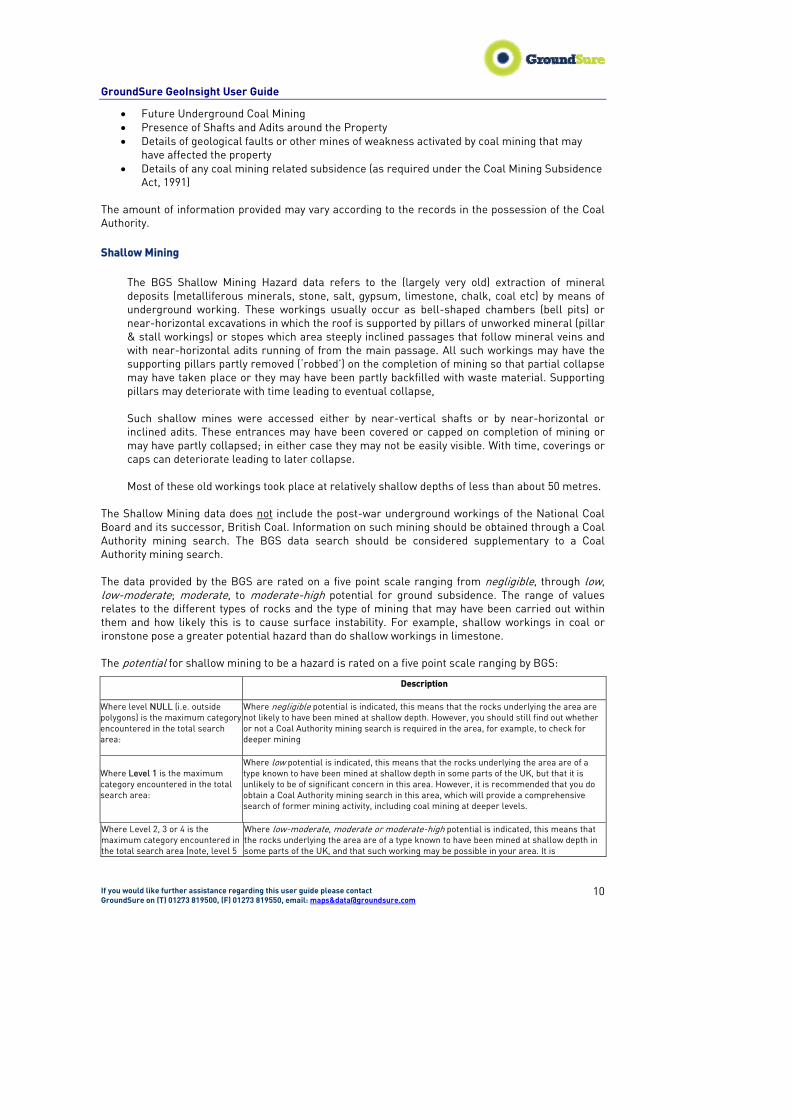
The Shallow Mining data does not include the post-war underground workings of the National Coal Board and its successor, British Coal. Information on such mining should be obtained through a Coal Authority mining search. The BGS data search should be considered supplementary to a Coal Authority mining search. The data provided by the BGS are rated on a five point scale ranging from negligible, through low, low-moderate; moderate, to moderate-high potential for ground subsidence. The range of values relates to the different types of rocks and the type of mining that may have been carried out within them and how likely this is to cause surface instability. For example, shallow workings in coal or ironstone pose a greater potential hazard than do shallow workings in limestone. The potential for shallow mining to be a hazard is rated on a five point scale ranging by BGS:
Description
Where level NULL (i.e. outside polygons) is the maximum category encountered in the total search area:
Where negligible potential is indicated, this means that the rocks underlying the area are not likely to have been mined at shallow depth. However, you should still find out whether or not a Coal Authority mining search is required in the area, for example, to check for deeper mining
Where Level 1 is the maximum category encountered in the total search area:
Where low potential is indicated, this means that the rocks underlying the area are of a type known to have been mined at shallow depth in some parts of the UK, but that it is unlikely to be of significant concern in this area. However, it is recommended that you do obtain a Coal Authority mining search in this area, which will provide a comprehensive search of former mining activity, including coal mining at deeper levels.
Where Level 2, 3 or 4 is the maximum category encountered in the total search area (note, level 5
Where low-moderate, moderate or moderate-high potential is indicated, this means that the rocks underlying the area are of a type known to have been mined at shallow depth in some parts of the UK, and that such working may be possible in your area. It is
GroundSure GeoInsight User Guide
If you would like further assistance regarding this user guide please contact GroundSure on (T) 01273 819500, (F) 01273 819550, email: maps&[email protected]
11
Description
does not occur in current dataset):
recommended that you obtain a Coal Authority mining search, which will provide a comprehensive search of former mining activity, including coal mining at deeper levels.
Non Coal Mining Cavities Great Britain has a long history of mineral extraction by mining. While coal mining records are centrally held by British Coal, the focus of the PBA/DEFRA mining cavities database is on non-coal mining records. There are a variety of mineral types that have been mined historically including Slate, Limestone, and Gypsum etc. Styles of mining vary according to the nature of the mineral, the strength of the surrounding rock layers, the depth that the mineral occurs below the surface and the geological structure of the rock strata in which the mineral is found. In addition some mining styles show changes through time as technology and mechanisation has advanced. The simplest mine forms (e.g. bell pits) tend to be associated with mineral layers that occur at shallow depth above the water table. Sometimes a mineral layer is initially extracted at the surface via a quarry, but as the mineral layer dips downwards, or becomes overlain by an increasing thickness of rock and soil cover, the extraction is achieved by driving mine tunnels (adits) into the quarry face to continue to follow the mineral horizon underground. Elsewhere deep level mineral layers tend to be mined via shaft entry mines, the plan extent and layout of which varies. The mining cavities' database was originally compiled for the national study entitled ‘Review of mining instability in Great Britain’ that was published in 1990. The aim of the study was to obtain a clear, but general picture of the extent and nature of non coal mining instability. In addition the work was used to assess the degree of hazard presented by mining cavities and their influence on planning and development of land. The database, as originally compiled, was setup to record areas where there is conclusive evidence of mining and areas where there is some evidence to suggest mining, but the evidence may not be conclusive. Beyond such areas mining is assumed to be absent, but is of course subject to the discovery of new mines where there was previously no known evidence. The boundaries of mined ground have been recorded relative to the Ordnance Survey national grid within 0.5km square blocks or pixels. Individual small-scale mines tend to be recorded as the nearest 1km national grid square that entirely covers the mined area. Since the original database was compiled PBA has continued to collect more mining data, principally within the southern half of the country, adding another approximately 1,500 mining records. These mining locations have been recorded as national grid references, based usually on the mine entry location. PBA continues to actively collect and compile new mining cavity data at least annually. The cavity data has been collected from a diverse range of sources such as published information (e.g. technical papers, cave and mine guides, books etc), unpublished information (e.g. library and museum archives, academic studies, consultant and contractor archives etc), district and county councils, British Geological Survey and many others. The database includes mines excavated for the extraction of non-ferrous metals (e.g. fluorite, calcite and barytes), rock (e.g. slate, chalk, limestone, oil-shale, and fullers’ earth and non-coalfield fireclays), iron (non-coalfield) and evaporites (e.g. salt and gypsum). General information on the geographical database, but no detailed mining information is available. The detailed mining information can be obtained from the Coal Authority and other sources. The presence or absence of mining may be significant in terms of engineering and environmental risks posed to the intended site usage. The results of the database search help the client to be forewarned of potential ground instability problems, safety and health issues, and potential additional costs for foundations, and possibly ground stabilisation. Subsurface cavities may also form

GroundSure GeoInsight User Guide
If you would like further assistance regarding this user guide please contact GroundSure on (T) 01273 819500, (F) 01273 819550, email: maps&[email protected]
12
pathways along which contaminants and hazardous soil gases may travel to impact various receptors within and at some distance from the site, so posing an environmental risk. PBA's database is referred to in Planning Policy Guidance (PPG) 14 Development on Unstable Land, Annex 2 Subsidence and Planning. More detailed information can be provided about mining cavities if required – please contact PBA for further details. Natural Cavities Natural cavities have been classified into four categories based on the way in which the cavities have been formed. The formational processes include: dissolution, cambering, marine erosion and other miscellaneous processes. Natural cavities have been classified into four categories based on the way they form as follows. Dissolution Limestone, chalk, rock-salt and gypsum-bearing rocks are progressively dissolved on contact with water to form a wide variety of natural cavities. Dissolution rates for salt and gypsum are greater than those for limestone and chalk. Most dissolution activity is concentrated within the upper zone of soluble rocks where, therefore, the majority of cavities occur. These have been formed by the downward percolation of circulating groundwater gradually dissolving the rock along the natural discontinuities (e.g. joints). However, dissolution can also take place at depth producing, for example, cave systems in limestone. This pattern is also illustrated well in soluble salt and gypsum horizons where zones of complete and partial dissolution progressively grade downwards into fresh undissolved evaporate. Cambering Where a competent jointed rock such as a limestone or sandstone overlies a less competent deposit such as clay, marl or mudstone, forming a slope profile, natural cavities may form by cambering of the jointed stratum capping the slope. Cambering takes the form of tilting and vertical movements concentrated along the joint planes to produce gulls and fissures. The rock capping the slope becomes progressively disturbed as the underlying clay undergoes lateral movement in the down slope direction. It is generally thought that these disturbances resulted from a combination of stress relief, frost heave and down-slope creep movement associated with past glacial and periglacial episodes. Where opposing valley sides have moved compressively towards one another bulging of the valley floor also occurs. Additionally, natural joint openings, particularly those trending along valley sides and hill crests in coal mining areas, can be widened by subsidence over old coal mine workings to form tension fissures. The effects are most noticeable at mineral rights boundaries and along fault zones. Marine erosion Coastlines composed of competent rocks are prone to sea cave formation particularly where erosion is preferentially concentrated along joint, bedding or fault planes. The combined action of chemical weathering, corrosion, attrition and hydraulic action progressively weaken and cause the breakdown of the rock forming the cliff line. Other processes A number of other processes are responsible for a range of minor cavity forms. These include soil piping within sandy silty deposits; scour hollows resulting from periglacial processes; fault movement and erosion of natural discontinuities in sedimentary, igneous and metamorphic rocks chiefly by the action of water

GroundSure GeoInsight User Guide
If you would like further assistance regarding this user guide please contact GroundSure on (T) 01273 819500, (F) 01273 819550, email: maps&[email protected]
13
The natural cavities database was originally compiled for the national study entitled ‘Review of instability due to natural underground cavities in Great Britain’ that was published in 1993. The aim of the study was to obtain a clear, but general picture of the extent and nature of natural cavity instability. In addition the work was used to assess the degree of hazard presented by natural cavities and their influence on planning and development of land. The database, as originally compiled, contained information on 20,000 natural cavities. Since 1993 the database has been updated and expanded by the addition of more than 2,000 new natural cavity records. Individual cavity records within the database can reveal a wealth of information, where available from the original source. The fields of information include; the national grid reference, cavity address, cavity data source, cavity process of formation, cavity type, cavity shape and dimensions, nature of cavity infill, number of cavities present, details of subsidence activity, details of investigation and remedial measures. It is particularly useful if a database search is carried out at the desk study stage of a project to determine whether natural cavities are recorded at or within close proximity of the site. The type(s) of natural cavity found to be present locally may be significant in terms of engineering and environmental risks posed to the intended site usage. The results of the database search enables the client to be forewarned of potential ground instability problems and potential additional costs, perhaps associated with ground investigation and foundation design, and possibly ground stabilisation at the study site. Subsurface cavities may also form pathways along which contaminants and hazardous soil gases may travel to impact various receptors within and at some distance from the site, so posing an environmental risk. Natural cavities can also cause instability difficulties to various engineering works such as tunneling, or to the construction of roads and landfills. In cavity prone areas it can be difficult, without specialist knowledge, to decide what level of Hazard the presence of natural cavities represent in terms of the specific ground conditions at the site of interest. This is particularly the case when the cavity records, although local to the site; do not occur within the site of interest. Drawing an extensive specialist knowledge of the factors that are favorable to cavity occurrence, together with considerable experience of the engineering behaviour of natural cavities. PBA offers a 'Cavities Occurrence Assessment' service. By assessing the site specific geological, hydrogeological and geomorphological setting the probabilistic potential for cavity occurrence can be determined and ranked from low to high. The potential impacts upon the site development proposals can also be analysed if required. Brine Extraction In the Cheshire salt field, brine, which forms by the action of natural ground water on deposits of rock salt, has been extracted by pumping for several centuries to provide the raw material for the salt and chemical industries. As the natural brine forms and pumping takes place, underground cavities are created which may ultimately collapse to produce subsidence of the overlying surface and damage to property. Unlike most other forms of mineral extraction, like coal mining, it is not always possible to precisely define the areas which are likely to be affected by subsidence due to natural brine pumping or to attribute the cause to a particular pumping operator. Brine is also obtained by solution mining or ‘controlled brine pumping’ in which water is injected into the salt beds, via concentric tubes in a borehole, under pressure to raise the resultant brine to the surface. The cavities formed are controlled in size and shape so as to remain stable with the aim of eliminating the risk of ground movement at the surface and any damage to property. This method was developed over fifty years ago and has operated successfully ever since. At present over 98 per cent of the brine produced in Cheshire is obtained using this method. The rock salt deposits in Cheshire have also been mined since the 17th century but only one mine now operates.

GroundSure GeoInsight User Guide
If you would like further assistance regarding this user guide please contact GroundSure on (T) 01273 819500, (F) 01273 819550, email: maps&[email protected]
14
The Brine Board constituted and operated under the provisions of the Cheshire Brine Pumping (Compensation for Subsidence) Acts 1952 and 1964. This legislation defines the Cheshire Brine Subsidence Compensation District. The Brine Board is not connected with the industry of salt extraction and cannot therefore supply details of current natural or controlled brine pumping activities or any proposals for future development. If this information is required it is suggested that an enquiry be directed to the operator or reference made to the Cheshire County Minerals Plan prepared by the Cheshire County Council Planning Department. The main duties of the Brine Board were to make compensation for specified categories of damage to land and buildings caused by subsidence due to the brine pumping, and to give advice to the planning authorities in connection with any new-build development proposals on land which may be affected by subsidence caused by brine pumping. The Brine Board has no liability for damage resulting from the collapse of salt mine workings (whether current or abandoned) mined by conventional underground methods, or associated shafts or other entrances to underground salt workings. The liability is only for damage caused by subsidence due to brine pumping. As of Monday 23rd October 2006 the Cheshire Brine Subsidence Compensation Board has discontinued Cheshire Brine Searches. Cheshire Brine queries will now be covered by the Coal Authority. PBA's database is referred to in Planning Policy Guidance (PPG) 14 Development on Unstable Land, Annex 2 Subsidence and Planning. Within the report, an indication as to whether the study site is located in a Brine Extraction area will be recorded. More detailed site specific information can be provided about mining cavities if required – please contact PBA for further details. Gypsum Extraction Gypsum is widely distributed in rocks of Permian and Triassic age and lesser extent in strata of late Jurassic age in England. Gypsum extraction occurs predominately through underground mining using pillar and stall methods or through open cast workings.
Gypsum dissolves so rapidly that it poses a threat to any development that encounters it. Where this dissolution occurs underground at similar rates, caves can develop, expand rapidly and suddenly collapse. Such caves occur in the Permian rocks of the Vale of Eden, Cumbria and beneath Ripon, North Yorkshire. Under suitable groundwater flow conditions caves in gypsum can enlarge at a rapid rate resulting in large chambers. Collapse of these chambers produces breccia pipes which propagate through the overlying strata to break through at the surface and form subsidence hollows.
In all the places where gypsum occurs there are natural or induced geohazards associated with the rock and consideration should be given to them in the planning and development process.
Within the report, the Gypsum Extraction data reveals whether or not the study site is located within a Gypsum Extraction area which may pose a danger to the property or any proposed development of the land.
For more detailed site specific information – please contact Mr. C R Thomas, Company Surveyor, Geological & Mining Services, British Gypsum Ltd, East Leake, Loughborough, LE12 6JQ Tin Mining In the past, tin mining was a major industry in Cornwall, South West Devon and some areas of Somerset. Although much of the mining in this area has now ceased, there is still a risk of subsidence from old mine workings affecting properties in the area. The abandonment of the old

GroundSure GeoInsight User Guide
If you would like further assistance regarding this user guide please contact GroundSure on (T) 01273 819500, (F) 01273 819550, email: maps&[email protected]
15
mines has left a particularly thorny issue to be tackled, for which no Government agency or department or local authority has any remit.
Within the report, the Tin Mining data reveals whether or not the study site is located within a tin mining area which may pose a danger to the property or any proposed development of the land.
For more detailed site specific information – please contact by written application only Cornwall Consultants, Park Vean House, Coach Lane, Redruth, TR15 2TT.
Kaolin & Ball Clay Mining
Kaolin and Ball Clay mining has played an important role in the industrial history of parts of Devon, Dorset and Cornwall, with three million tons still being produced annually. During the 18th & 19th centuries, a number of companies were involved, working in excess of one hundred small pits. However, during the last seventy years the number of mining companies has declined and today all production comes from three main companies in areas around St. Austell and the edge of Dartmoor.
Kaolin Clay is extracted from the ground by surface working (open case method) while Ball Clay is extracted from the ground by surface working (open pit method), underground mining having ceased in 1999.
Within the report, the clay mining data highlights whether or not the study site is located within a clay mining area. Subsequently, further research will then reveal if the study site is in an area affected by previous or current Ball/Kaolin Clay mining and to discover whether the site is likely to be affected by clay deposits and if so, whether these deposits are likely to be worked in the future or if past workings have caused danger of subsidence to the property. For more detailed site specific information – please contact Kaolin and Ball Clay association, Tehidy Centre, Burn Gullow Lane, High street, St Austell, Cornwall, PL26 7TQ Tel: 01726 828517
8.7 Natural Ground Subsidence Many factors may contribute to natural ground subsidence problems. Natural ground stability refers to the upward, lateral or downward movement of the ground that can be caused by a range of natural geological hazards, such movements are typically in the order of centimetres, but exceptional circumstances can be larger. Significant natural ground instability has the potential to cause subsidence damage to some weaker buildings and structures.
For instance, significant problems can arise in conurbations underlain by clay rich bedrock, such as over clay strata in the South East of England, or South Wales. Whilst surveyors are normally aware of local problem areas, data provided by the BGS can highlight areas where a significant potential for natural ground subsidence exists and which may need particular consideration.
The natural ground subsidence rating is obtained through the evaluation of six natural ground stability hazard datasets, which are supplied by the British Geological Survey (BGS). These datasets indicate the hazard posed by the occurrence of: Swell-Shrink Clay, Landslide, Compressible Ground, Collapsible Ground, Dissolution of Soluble Rocks and Running Sand. Where significant natural ground instability is indicated, its level of significance is expressed on a scale of A to E (‘low’ to ‘high’), relating to its potential to cause subsidence damage in buildings that may not have been constructed to appropriate standards.
The BGS recommended this process as a guide to assessing subsidence hazards.
Shrink-Swell Clay Some clays increase or decrease in volume as they absorb or lose water. These volume changes can cause either swelling (heave) or shrinking (subsidence). In rocks that contain clay, the amount of
Comment [a1]:

GroundSure GeoInsight User Guide
If you would like further assistance regarding this user guide please contact GroundSure on (T) 01273 819500, (F) 01273 819550, email: maps&[email protected]
16
volume change will depend on both the amount and the type of clay minerals present because some clays can absorb more water than others with a proportionally greater effect.
The map indicates the potential for shrinking or swelling of the ground that may be a hazard. The problem is most widespread in southern and eastern England where young clay-rich rocks are at or near the surface.
Detailed information on the location and extent of swelling and shrinking clays is relevant to planners, landowners, engineers and householders and to those in the property transaction and insurance sectors. In areas where swelling and shrinking clays are a problem, foundations should be set sufficiently deeply to avoid the active shrink-swell zone and should be designed to resist lateral swelling pressures. Before planting or removing trees and shrubs near buildings sited in areas with significant shrink-swell potential it is advisable to seek professional advice.
Swelling and shrinking clay potential has been assessed using 1:50 000 scale maps of bedrock geology and superficial deposits, combined with information from several hundred thousand borehole records, scientific documents and engineering reports, photographs and geotechnical property values from the National Geotechnical Properties Database.
The potential for shrinking or swelling of the ground to be a hazard is calibrated on a fivefold scale by BGS:
GeoSure hazard rating
Level of Significance Description
A Negligible
Ground conditions predominantly non-plastic. No special actions required to avoid problems due to shrink-swell clays. No special ground investigation required, and increased construction costs or increased financial risks are unlikely likely due to potential problems with shrink-swell clays.
B Very Low
Ground conditions predominantly low plasticity. No special actions required to avoid problems due to shrink-swell clays. No special ground investigation required, and increased construction costs or increased financial risks are unlikely due to potential problems with shrink-swell clays.
C Low
Ground conditions predominantly medium plasticity. Do not plant trees with high soil moisture demands near to buildings. For new build, consideration should be given to advice published by the National House Building Council (NHBC) and the Building Research Establishment (BRE). There is a possible increase in construction cost to reduce potential shrink-swell problems. For existing property, there is a possible increase in insurance risk, especially during droughts or where vegetation with high moisture demands is present.
D Moderate
Ground conditions predominantly high plasticity. Do not plant or remove trees or shrubs near to buildings without expert advice about their effect and management. For new build, consideration should be given to advice published by the National House Building Council (NHBC) and the Building Research Establishment (BRE). There is a probable increase in construction cost to reduce potential shrink-swell problems. For existing property, there is a probable increase in insurance risk during droughts or where vegetation with high moisture demands is present.
E* High
Ground conditions predominantly very high plasticity. Do not plant or remove trees or shrubs near to buildings without expert advice about their effect and management. For new build, consideration should be given to advice published by the National House Building Council (NHBC) and the Building Research Establishment (BRE). There is likely to be an increase in construction cost to reduce potential shrink-swell problems. For existing property, there is a significant increase in insurance risk during droughts or where vegetation with high moisture demands is present.

GroundSure GeoInsight User Guide
If you would like further assistance regarding this user guide please contact GroundSure on (T) 01273 819500, (F) 01273 819550, email: maps&[email protected]
17
*Note: Level E swell-shrink clay does NOT occur in the GeoSure V2 dataset, i.e., Level D represents the highest level (this is because there are worse swelling-clay hazards outside the UK). Running Sand Running sand occurs when loosely packed sand becomes fluidised by water flowing through the spaces between the grains. The pressure of the flowing water reduces the contact between the grains and they are swept along in the flow. This may occur in a number of situations, for example where springs occur at the base of sand bodies, in excavations below the water table, and when saturated sand is vibrated during an earthquake.
The potential for sand to ‘run’ is assessed by combining information on the type of geological material, its geotechnical properties and the position of the water table. In Britain, running sand occurs widely in the alluvial deposits of the river valleys and, in the south-east, in uncemented bedrock deposits, such as the Thanet, Bagshot, Bracklesham and Barton sands. Problems are usually associated with construction activities such as excavation, tunnelling and dewatering or with leaking water supplies.
Information on where sand has the potential to run and to create a hazard is of interest to planners, landowners, engineers and householders. In areas with significant running sand potential, leaks in water services can pose a serious problem. There will be a need for groundwater control (dewatering or closed shuttering) during ground excavation. Irrigation or surface water disposal can have unforeseen consequences when running sand is present.
Running sand potential has been identified by using the 1:50 000 scale digital geological map data (both bedrock geology and superficial deposits) in combination with information from several hundred thousand borehole records, scientific documents, engineering reports and photographs.
The potential for sand to ‘run’ is calibrated on a fivefold scale by BGS:-
GeoSure hazard rating
Level of Significance Description
A Negligible
No indicators for running sand identified. No special actions required to avoid problems due to running sand. No special ground investigation required, and increased construction costs or increased financial risks are unlikely due to potential problems with running sand.
B Very Low
Very low potential for running sand problems if water table rises or if sandy strata are exposed to water. No special actions required, to avoid problems due to running sand. No special ground investigation required, and increased construction costs or increased financial risks are unlikely due to potential problems with running sand.
C Low
Possibility of running sand problems after major changes in ground conditions. Normal maintenance to avoid leakage of water-bearing services or water bodies (ponds, swimming pools) should reduce likelihood of problems due to running sand. For new build – consider possibility of running sand into trenches or excavations if water table is high or sandy strata are exposed to water. Avoid concentrated water inputs to site. Unlikely to be an increase in construction costs due to potential for running sand. For existing property – no significant increase in insurance risk due to running sand problems is likely.
D Moderate
Significant potential for running sand problems with relatively small changes in ground conditions. Avoid large amounts of water entering the ground (for example through pipe leakage or soak-aways). Do not dig (deep) holes into saturated ground near the property without technical advice. For new build – consider the consequences of soil and groundwater conditions during and after construction. For existing property – possible increase in insurance risk from running sand, for example, due to water leakage, high rainfall events or flooding.
GroundSure GeoInsight User Guide
If you would like further assistance regarding this user guide please contact GroundSure on (T) 01273 819500, (F) 01273 819550, email: maps&[email protected]
18
GeoSure hazard rating
Level of Significance Description
E High
Very significant potential for running sand problems. Avoid large amounts of water entering the ground, for example through pipe leakage or soak-always. Do not dig (deep) holes into saturated ground without technical advice. For new build – consider the consequences of soil and groundwater conditions during and after construction. Possible extra cost during construction. For existing property – possible increase in insurance risk from running sand, for instance ions due to water leakage, high rainfall events or flooding.
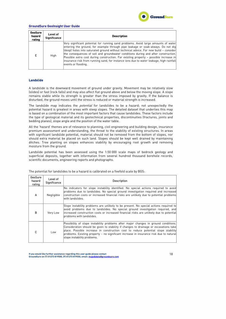
Landslide A landslide is the downward movement of ground under gravity. Movement may be relatively slow (slides) or fast (rock falls) and may also affect flat ground above and below the moving slope. A slope remains stable while its strength is greater than the stress imposed by gravity. If the balance is disturbed, the ground moves until the stress is reduced or material strength is increased.
The landslide map indicates the potential for landslides to be a hazard; not unexpectedly the potential hazard is greatest in areas with steep slopes. The detailed dataset that underlies this map is based on a combination of the most important factors that cause landslides. These factors include the type of geological material and its geotechnical properties, discontinuities (fractures, joints and bedding planes), slope angle and the position of the water table.
All the 'hazard' themes are of relevance to planning, civil engineering and building design, insurance premium assessment and understanding, the threat to the stability of existing structures. In areas with significant landslide potential, material should not be removed from the bottom of slopes, nor should extra material be placed on such land. Slopes should be kept well drained by maintaining ditches. Tree planting on slopes enhances stability by encouraging root growth and removing moisture from the ground.
Landslide potential has been assessed using the 1:50 000 scale maps of bedrock geology and superficial deposits, together with information from several hundred thousand borehole records, scientific documents, engineering reports and photographs.
The potential for landslides to be a hazard is calibrated on a fivefold scale by BGS:
GeoSure hazard rating
Level of Significance
Description
A Negligible
No indicators for slope instability identified. No special actions required to avoid problems due to landslides. No special ground investigation required and increased construction costs or increased financial risks are unlikely due to potential problems with landslides.
B Very Low
Slope instability problems are unlikely to be present. No special actions required to avoid problems due to landslides. No special ground investigation required, and increased construction costs or increased financial risks are unlikely due to potential problems with landslides.
C Low
Possibility of slope instability problems after major changes in ground conditions. Consideration should be given to stability if changes to drainage or excavations take place. Possible increase in construction cost to reduce potential slope stability problems. Existing property – no significant increase in insurance risk due to natural slope instability problems.
GroundSure GeoInsight User Guide
If you would like further assistance regarding this user guide please contact GroundSure on (T) 01273 819500, (F) 01273 819550, email: maps&[email protected]
19
GeoSure hazard rating
Level of Significance
Description
D Moderate
Significant potential for slope instability with relatively small changes in ground conditions. Avoid large amounts of water entering the ground through pipe leakage or soak-aways. Do not undercut or place large amounts of material on slopes without technical advice. For new build – consider the potential and consequences of ground movement during excavations, or consequence of changes to loading or drainage. For existing property – probable increase in insurance risk is likely due to potential natural slope instability after changes to ground conditions such as a very long, excessively wet winter.
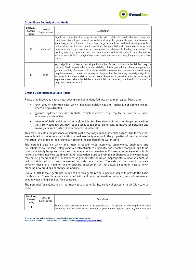
E High
Very significant potential for slope instability. Active or inactive landslides may be present; Seek expert advice about stability of the ground and the management of ground stability. For new build – slope stability assessment necessary, special design may be necessary, construction may not be possible. For existing property – significant increase in insurance risk in some cases. Site-specific consideration is necessary to separate cases where landslides are artificially or naturally stabilised from those that may be active or may fail.
Ground Dissolution of Soluble Rocks Rocks that dissolve to cause hazardous ground conditions fall into three main types. These are:
• rock salt, or common salt, which dissolves quickly causing general subsidence except where being extracted
• gypsum (hydrated calcium sulphate), which dissolves less rapidly but can cause local subsidence and cavities
• limestone/chalk (calcium carbonate), which dissolves slowly to form underground cavities that rarely collapse but may cause local subsidence, significant pathways for pollution and an irregular rock surface below superficial materials
This map indicates the presence of soluble rocks that may cause a potential hazard. The factors that are included in the assessment of this hazard are the type of rock, the properties of the surrounding materials, the shape of the ground surface and the position of the water table
The detailed data on which this map is based helps planners, landowners, engineers and householders to use land safely maintain infrastructure efficiently and enables marginal land to be used beneficially by appropriate hazard management or avoidance. For example: in areas of soluble rocks, activities involving loading, infilling, excavation, surface drainage or changes to the water table may cause ground collapse, subsidence or groundwater pollution. Appropriate foundations such as raft or reinforced strip may be needed for safe construction. The data can be used to indicate whether there is a need for a site-specific assessment of the actual dissolution hazard when planning new buildings or change of land use.
Digital 1:50 000 scale geological maps of bedrock geology and superficial deposits provide the basis for this map. These data were combined with additional information on rock type, rock sequence, groundwater and ground surface contours.
The potential for soluble rocks that may cause a potential hazard is calibrated on a six fold scale by BGS.
GeoSure hazard rating
Level of Significance
Description
NULL Soluble rocks are not present in the search area. No special actions required to avoid problems due to soluble rocks. No special ground investigation required, and increased
GroundSure GeoInsight User Guide
If you would like further assistance regarding this user guide please contact GroundSure on (T) 01273 819500, (F) 01273 819550, email: maps&[email protected]
20
GeoSure hazard rating
Level of Significance
Description
construction costs or increased financial risks are unlikely due to potential problems with soluble rocks.
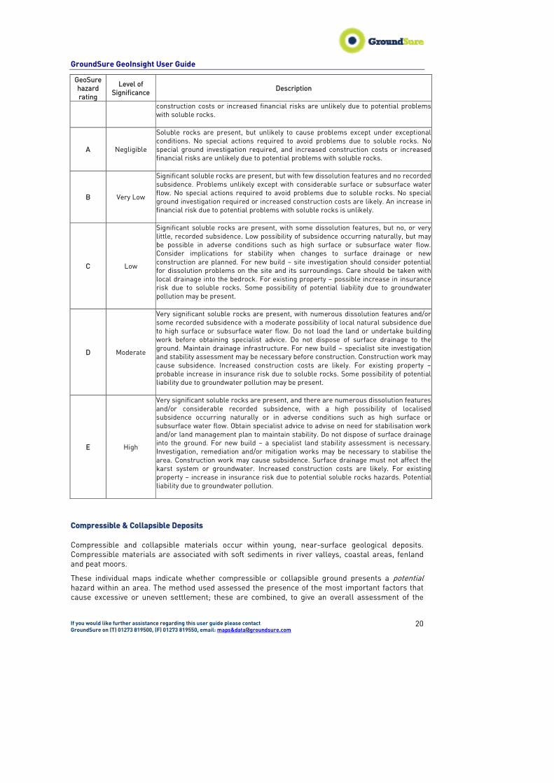
A Negligible
Soluble rocks are present, but unlikely to cause problems except under exceptional conditions. No special actions required to avoid problems due to soluble rocks. No special ground investigation required, and increased construction costs or increased financial risks are unlikely due to potential problems with soluble rocks.
B Very Low
Significant soluble rocks are present, but with few dissolution features and no recorded subsidence. Problems unlikely except with considerable surface or subsurface water flow. No special actions required to avoid problems due to soluble rocks. No special ground investigation required or increased construction costs are likely. An increase in financial risk due to potential problems with soluble rocks is unlikely.
C Low
Significant soluble rocks are present, with some dissolution features, but no, or very little, recorded subsidence. Low possibility of subsidence occurring naturally, but may be possible in adverse conditions such as high surface or subsurface water flow. Consider implications for stability when changes to surface drainage or new construction are planned. For new build – site investigation should consider potential for dissolution problems on the site and its surroundings. Care should be taken with local drainage into the bedrock. For existing property – possible increase in insurance risk due to soluble rocks. Some possibility of potential liability due to groundwater pollution may be present.
D Moderate
Very significant soluble rocks are present, with numerous dissolution features and/or some recorded subsidence with a moderate possibility of local natural subsidence due to high surface or subsurface water flow. Do not load the land or undertake building work before obtaining specialist advice. Do not dispose of surface drainage to the ground. Maintain drainage infrastructure. For new build – specialist site investigation and stability assessment may be necessary before construction. Construction work may cause subsidence. Increased construction costs are likely. For existing property – probable increase in insurance risk due to soluble rocks. Some possibility of potential liability due to groundwater pollution may be present.
E High
Very significant soluble rocks are present, and there are numerous dissolution features and/or considerable recorded subsidence, with a high possibility of localised subsidence occurring naturally or in adverse conditions such as high surface or subsurface water flow. Obtain specialist advice to advise on need for stabilisation work and/or land management plan to maintain stability. Do not dispose of surface drainage into the ground. For new build – a specialist land stability assessment is necessary. Investigation, remediation and/or mitigation works may be necessary to stabilise the area. Construction work may cause subsidence. Surface drainage must not affect the karst system or groundwater. Increased construction costs are likely. For existing property – increase in insurance risk due to potential soluble rocks hazards. Potential liability due to groundwater pollution.
Compressible & Collapsible Deposits Compressible and collapsible materials occur within young, near-surface geological deposits. Compressible materials are associated with soft sediments in river valleys, coastal areas, fenland and peat moors.
These individual maps indicate whether compressible or collapsible ground presents a potential hazard within an area. The method used assessed the presence of the most important factors that cause excessive or uneven settlement; these are combined, to give an overall assessment of the

GroundSure GeoInsight User Guide
If you would like further assistance regarding this user guide please contact GroundSure on (T) 01273 819500, (F) 01273 819550, email: maps&[email protected]
21
potential problem. The most important factors are the type of geological material, its geotechnical properties and microstructure.
In areas with significant potential for compression or collapse, uneven loading and changes to the water table (drainage or flooding) should be avoided. Appropriate foundations such as rafts or piles and flexible service connections may be needed. The detailed data, on which these maps are based, provide invaluable context and help identify whether a site-specific assessment of the actual hazard and risk is needed.
The potential for compressible or collapsible material to be a hazard has been assessed using 1:50 000 scale digital maps of bedrock geology and superficial deposits. These have been combined with information from several hundred thousand borehole records, scientific documents, engineering reports and photographs.
For compressible ground to present a potential hazard within an area is calibrated on a fivefold scale by the BGS:
GeoSure hazard rating
Level of Significance
Description
A Negligible
No indicators for compressible deposits identified. No special actions required to avoid problems due to compressible deposits. No special ground investigation required, and increased construction costs or increased financial risks are unlikely due to potential problems with compressible deposits.
B Very Low
Very low potential for compressible deposits to be present. No special actions required to avoid problems due to compressible deposits. No special ground investigation required, and increased construction costs or increased financial risks are unlikely due to potential problems with compressible deposits.
C Low
Low potential of compressibility problems. Take technical advice regarding settlement when planning extensions to existing property. For new build – consider the possibility of settlement during construction due to compressible deposits. Unlikely to be increase in construction costs due to potential compressibility problems. For existing property – no significant increase in insurance risk due to compressibility problems.
D Moderate
Significant potential for compressibility problems. Avoid large differential loadings of ground. Do not drain or de-water ground near the property without technical advice. For new build – consider possibility of compressible ground in ground investigation, construction and building design. Consider effects of groundwater changes. Extra construction costs are likely. For existing property –possible increase in insurance risk from compressibility, especially if water conditions or loading of the ground change significantly.
E High
Very significant potential for compressibility problems. Avoid large differential loadings of ground. Do not drain or de-water ground near the property without technical advice. For new build – consider possibility of compressible ground in ground investigation, construction and building design. Consider effects of groundwater changes. Construction may not be possible at economic cost. For existing property – probable increase in insurance risk from compressibility especially if water conditions or loading of the ground change significantly.
GroundSure GeoInsight User Guide
If you would like further assistance regarding this user guide please contact GroundSure on (T) 01273 819500, (F) 01273 819550, email: maps&[email protected]
22
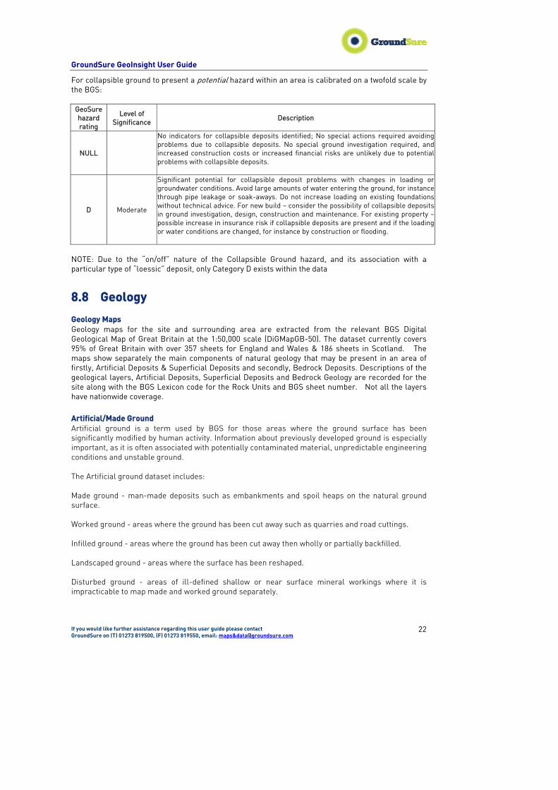
For collapsible ground to present a potential hazard within an area is calibrated on a twofold scale by the BGS:
GeoSure hazard rating
Level of Significance
Description
NULL
No indicators for collapsible deposits identified; No special actions required avoiding problems due to collapsible deposits. No special ground investigation required, and increased construction costs or increased financial risks are unlikely due to potential problems with collapsible deposits.
D Moderate
Significant potential for collapsible deposit problems with changes in loading or groundwater conditions. Avoid large amounts of water entering the ground, for instance through pipe leakage or soak-aways. Do not increase loading on existing foundations without technical advice. For new build – consider the possibility of collapsible deposits in ground investigation, design, construction and maintenance. For existing property – possible increase in insurance risk if collapsible deposits are present and if the loading or water conditions are changed, for instance by construction or flooding.
NOTE: Due to the “on/off” nature of the Collapsible Ground hazard, and its association with a particular type of “loessic” deposit, only Category D exists within the data
8.8 Geology Geology Maps Geology maps for the site and surrounding area are extracted from the relevant BGS Digital Geological Map of Great Britain at the 1:50,000 scale (DiGMapGB-50). The dataset currently covers 95% of Great Britain with over 357 sheets for England and Wales & 186 sheets in Scotland. The maps show separately the main components of natural geology that may be present in an area of firstly, Artificial Deposits & Superficial Deposits and secondly, Bedrock Deposits. Descriptions of the geological layers, Artificial Deposits, Superficial Deposits and Bedrock Geology are recorded for the site along with the BGS Lexicon code for the Rock Units and BGS sheet number. Not all the layers have nationwide coverage. Artificial/Made Ground Artificial ground is a term used by BGS for those areas where the ground surface has been significantly modified by human activity. Information about previously developed ground is especially important, as it is often associated with potentially contaminated material, unpredictable engineering conditions and unstable ground. The Artificial ground dataset includes: Made ground - man-made deposits such as embankments and spoil heaps on the natural ground surface. Worked ground - areas where the ground has been cut away such as quarries and road cuttings. Infilled ground - areas where the ground has been cut away then wholly or partially backfilled. Landscaped ground - areas where the surface has been reshaped. Disturbed ground - areas of ill-defined shallow or near surface mineral workings where it is impracticable to map made and worked ground separately.

GroundSure GeoInsight User Guide
If you would like further assistance regarding this user guide please contact GroundSure on (T) 01273 819500, (F) 01273 819550, email: maps&[email protected]
23
Artificial ground was not formerly mapped by BGS. It became a common requirement of the applied geological mapping projects in the 1980s and is now routinely recorded but information is only available for parts of the country. It is classified primarily on its mode of origin, which is usually apparent from the land form or the changes made to the topography. Superficial Deposits/Drift Geology
The 'Superficial deposits' shown on the map includes the youngest geological deposits laid down in England and Wales, Scotland and part of Northern Ireland. This map is based on the first edition Drift 1:625 000 scales Geological Map of the United Kingdom published in 1977 as two sheets, North and South.
The Superficial deposits mainly formed in the Quaternary period of geological time, which extends from the present back to 2 million years ago. Many of the deposits were formed during episodes of glaciation, or deposited by rivers. They occur as discontinuous patches and larger spreads and rest on top of the older rocks (referred to in the bedrock).
Most of these superficial deposits are unconsolidated sediments such as gravel, sand, silt and clay. The name of each deposit or group of deposits corresponds to that shown on the published 1: 625,000 map e.g. River Terrace Deposits.
The following caution should also be noted: The source geological maps originally used to compile the published 1:625 000 maps are 1:50 000 and 1:63 360 (one inch to one mile) scale maps published before 1977. Many of these have since been up-dated and may therefore not now agree with the 1:625,000 geology shown here. Due to the generalisation and simplification used in the compilation of this map, it should not be used to determine the detailed geology of any specific sites. It is best used to provide a basic understanding of the geology of the country in general, and for showing the geology of large regions where broad trends are more important than specific details. Landslip A landslide is a geological phenomenon which includes a wide range of ground movement, such as rock falls, deep failure of slopes and shallow debris flows. Although gravity acting on an over steepened slope is the primary reason for a landslide, there are other contributing factors affecting the original slope stability Bedrock/Solid Geology Bedrock is a term that is used to describe consolidated rocks. The Bedrock/Solid Geology maps produced by BGS show the distribution and composition of the solid rocks. Where bedrock is not exposed at the surface an interpretation of the geology can be made from boreholes, mine plans, geophysical surveys and interpolation from adjacent areas. It is this process of interpretation that distinguishes the geological map, from a topographical map such as the Ordnance Survey. Master Map. Because the geological maps are an interpretation of available data, they must be updated when new evidence becomes available or new scientific theories are established.
The bedrock geology of the UK is surveyed at a scale of 1:10, 000 and maps are published at 1:50, 000 scale. The geological maps within the Geology and Ground Stability Report are the BGS 1:50,000 scale Geological Map of Great Britain also as the DigMapGB-50. This map provides almost complete coverage of the UK.
Faults Geological faults, fault lines or simply faults are planar rock fractures, which show evidence of relative movement. The two sides of a non-vertical fault are called the hanging wall and footwall. By definition, the hanging wall occurs above the fault and the footwall occurs below the fault.
GroundSure GeoInsight User Guide
If you would like further assistance regarding this user guide please contact GroundSure on (T) 01273 819500, (F) 01273 819550, email: maps&[email protected]
24
More information on our Geological Maps and the BGS 1:50,000 Geological Map of Great Britain (DigMapGB-50) and how the various rock layers are classified can be found on the BGS website (www.bgs.ac.uk/data/dictionaries – search for DiGMap or the BGS Rock Classification Scheme). Further descriptions of the rocks listed in the map keys may also be obtained by searching against the Computer Code on the BGS Lexicon of named Rock Units, which is also on the BGS website (follow the ‘GeoData’ link). The computer codes are labelled on the maps to try and help in their interpretation. However, this should be treated with caution in areas of complex geology, where some of the labels may overlap several geological formations. If in doubt, contact the BGS at Keyworth at [email protected] or telephone 0115 936 3143.
8.9 Borehole Records Records of boreholes, shafts and wells from all forms of drilling and site investigation work. There are some 850,000 records dating back over 200 years and ranging from one to several thousand metres' deep. Currently some 50,000 new records are being added to the collection each year. The BGS record includes a unique reference number, grid reference number and grilled length for each record.
Please note that zero values for depth signify that the depth has not been database or has not been made available. Other borehole records exist within Great Britain but have not been catalogued in digital format. This data has not been included.
A small percentage of the borehole records are held 'commercial-in-confidence' for various reasons, and cannot be released without the written permission of the originator. NGRC staff will release the data where this is possible or provide you with the information needed to contact the originator.
The Mining Industry Act 1926 and Water Resources Act 1991 require organisations to notify the BGS prior to commencing drilling certain holes for water or minerals. Please contact the Records Officer R. Bowie phone 01159363106 and email [email protected] to notify any borehole operations. If you wish to voluntarily notify us of drilling or have data not covered by the Acts that you wish to donate, then the Records Officer will happy to discuss this with you. If you wish to send data or discuss collection of data, then please contact the Data Collection Officer R. Talbot phone 0115 936 3028 email [email protected].
9. Future Improvements GroundSure aims to constantly improve its services, both in terms of the products supplied, the data sets used and the continual professional development of all our staff. We consistently invest in compiling, updating and maintaining our numerous in-house databases as well as requiring our data suppliers to provide the most robust data sets available. GroundSure welcomes any suggestions or comments from our customers. Please contact us if there is particular information you would like to see included in our reports.
GroundSure GeoInsight User Guide
If you would like further assistance regarding this user guide please contact GroundSure on (T) 01273 819500, (F) 01273 819550, email: maps&[email protected]
25
Appendix 1- GroundSure Limited Standard Terms and conditions
1 Definitions
In these conditions unless the context otherwise requires:
“Beneficiary” means the Customer or the client of the Customer for whom the Customer has procured the Services.
“Consultancy Services” mean consultancy services provided by GroundSure including, without limitation, carrying out interpretation of third party and in-house environmental data, provision of environmental consultancy advice, undertaking environmental audits and assessments, site investigation, site monitoring and related items.
“Content” means any data, database or other information contained in a Report or Mapping which is provided to GroundSure by a Data Provider.
“Contract” means the contract between GroundSure and the Customer for the performance of the Services which shall incorporate these conditions, the relevant GroundSure user guide, proposal by GroundSure and the content of any subsequent report, and any agreed amendments in accordance with condition 12.
“Customer” means the party that submits an Order or commissions GroundSure further to a written proposal for environmental consultancy services.
“Data Provider” means any third party providing Content to GroundSure.
“Data Report” means reports comprising factual data with no professional interpretation in respect of the level of likely risk and/or liability available from GroundSure.
“GroundSure” means GroundSure Limited, a company registered in England and Wales under number 03421028 and whose registered office is at Greater London House, Hampstead Road, London NW1 7EJ.
“Intellectual Property” means any patent, copyright, registered design rights, service marks, moral rights, data protection rights, know-how, trade mark or other intellectual property rights.
“Mapping” an historical map or a combination of historical maps of various ages, time periods and scales available from GroundSure;
“Order” means an order form submitted by or for the Beneficiary requiring Services from GroundSure in respect of a specified site.
“Report” means a Risk Screening or Data Report for commercial or residential property available from GroundSure relating to a site identified in the Order prepared in accordance with the specifications set out in the relevant user guide.
“Risk Screening” means one of GroundSure’s risk screening reports such as GroundSure Homebuyers; GroundSure Home Environmental GroundSure SiteGuard, GroundSure Screening, GroundSure Review, GroundSure Developer Review, or any other risk screening report available from GroundSure.
“Services” means the provision of any Report, Mapping and Consultancy Services which GroundSure has agreed to carry out for the Customer/Beneficiary on these terms and conditions in respect of a site detailed in the Order.
2Scope of Services
2.1GroundSure agrees to carry out the Services in accordance with the Contract and to the extent set out therein.
2.2GroundSure shall exercise all reasonable skill, care and diligence in the performance of the Services.
2.3The Customer acknowledges that it has not relied on any statement or representation made by or on behalf of GroundSure which is not set out and expressly agreed in the Contract.
2.4Terms and conditions appearing on a Customer’s order form, printed stationery or other communication, including invoices, to GroundSure, its employees, servants, agents or other representatives shall be of no effect and these terms and conditions shall prevail over all others.
2.5In the event that a Customer/Beneficiary opts to take out insurance in conjunction with or as a result of the Services, such insurance shall be subject solely to the terms of any policy issued to it in that respect and GroundSure will have no liability therefore.
3The Customer’s obligations
3.1The Customer shall be solely responsible for ensuring that the Report/Mapping ordered is appropriate and suitable for the Beneficiary’s needs.
3.2The Customer shall (or shall procure that the Beneficiary shall) supply to GroundSure as soon as practicable and without charge all information necessary and accurate relevant data including any specific and/or unusual environmental information relating to the site known to the Customer/Beneficiary which may pertain to the Services and shall give such assistance as GroundSure shall reasonably require in the performance of the Services (including, without limitation, access to a site, facilities and equipment as agreed in the Contract).
GroundSure GeoInsight User Guide
If you would like further assistance regarding this user guide please contact GroundSure on (T) 01273 819500, (F) 01273 819550, email: maps&[email protected]
26
3.3Where Customer/Beneficiary approval or decision is required, such approval or decision shall be given or procured in reasonable time as not to delay or disrupt the performance of any other part of the Services.
3.4The Customer shall not and shall procure that the Beneficiary shall not, save as expressly permitted by these terms and conditions, re-sell, alter, add to, amend or use out of context the content of any Report, Mapping,or in respect of any service or information given by GroundSure. For the avoidance of doubt, the Customer and Beneficiary may make the Report, Mapping or GroundSure’s findings available to a third party, but such third party cannot rely on the same unless expressly permitted under condition 4.
3.5The Customer is responsible for maintaining the confidentiality of its user name and password if using GroundSure’s internet ordering service and accepts responsibility for all activity that occurs under such account and password.
4Reliance
4.1Upon full payment of all relevant fees and subject to the provisions of these terms and conditions, the Customer and Beneficiary are granted an irrevocable royalty-free licence to use the information contained in the Report, Mapping or in a report prepared by GroundSure in respect of or arising out of the Consultancy Services. The Services may only be used for the benefit of the Customer and those persons listed in conditions 4.2 and 4.3.
4.2 In relation to Data Reports, Mapping and Risk Screening, reliance shall be limited to the Customer, Beneficiary and subsequent first purchaser or first tenant of the site including the professional advisers and lenders of each. For the avoidance of doubt, such persons shall include any entity necessary under the Housing Act 2004 or as legally required because of the Home Information Pack.
4.3 In relation to Consultancy Services, reliance shall be limited to the Customer, Beneficiary and named parties on the GroundSure proposal and subsequent report.
4.4 No party referred to in conditions 4.2 and 4.3 shall assign any rights or obligations under these terms and conditions without the prior written consent of GroundSure. GroundSure reserves the right to charge an assignment fee which will be no higher than 15% of the original fee or £250 whichever is the highest. GroundSure may assign its rights and obligations under these terms.
4.5Save as set out in conditions 4.2 and 4.3, unless otherwise agreed in writing with GroundSure, any other party considering the information within a Report, Mapping or proposal and subsequent report in respect of Consultancy Services, including insurance underwriters, does so at their own risk and GroundSure has no legal obligations to such party unless otherwise agreed in writing.
4.6The Customer shall not and shall procure that any person (including the Beneficiary) who is provided with a copy of any Report shall not: (a) remove, suppress or modify any trade mark, copyright or other proprietary marking from the Report or Mapping; (b) create any product which is derived directly or indirectly from the data contained in the Report or Mapping; (c) combine the Report or Mapping with, or incorporate the Report or Mapping into any other information data or service; or (d) re-format or otherwise change (whether by modification, addition or enhancement) data or images contained in the Report or Mapping save to the extent that the Customer is adding its assessment to the Report or Mapping solely for the purposes of providing its services to the Beneficiary.
4.7Without prejudice to any other right or remedy available to GroundSure including without limitation any claim for infringement of copyright, breach of confidence or contract or otherwise howsoever arising if the Customer or a person to whom a Report or Mapping is provided, breaches any of the provisions of this condition 4, the Customer shall fully and effectually indemnify GroundSure and hold it harmless against any claim by any third party who may claim to have sustained injury loss or damage by reason of their reliance upon any report or document which GroundSure may have prepared for the Customer or upon the contents thereof.
5Fees and Disbursements
5.1GroundSure shall charge the Customer fees at the rate and frequency specified in the Contract together with all proper disbursements made in performing the Services. The Customer shall in addition pay all value added tax or other tax payable on such fees and disbursements in the country concerned in relation to the provision of the Services.
5.2Unless GroundSure requires prepayment, the Customer shall promptly pay all fees disbursements and other monies due to GroundSure in full without deduction, counterclaim or set off together with such Value Added Tax or equivalent local tax as may be required within 30 days from the date of GroundSure’s invoice. GroundSure reserves the right to charge interest which shall accrue on a daily basis from the date of invoice until the date of payment (whether before or after judgment) at the rate of two per cent per month.
5.3In the event that the Customer disputes the amount payable in respect of GroundSure’s invoice it shall notify GroundSure no later than 28 days after the date thereof that it is in dispute. In default of such notification the Customer shall be deemed to have agreed the amount thereof which shall thereupon be due and payable. As soon as reasonably practicable following receipt of any disputed invoice, a member of the management team at GroundSure shall contact the Customer and the parties shall use all reasonable endeavours to resolve the dispute.
6 Intellectual Property
6.1Unless expressly agreed in writing to the contrary GroundSure and its Data Providers (where relevant) retain all Intellectual Property rights and proprietary rights in all information, Content and data reproduced in a Report or as part of the Consultancy Services.
6.2Data Providers may enforce any breach of condition 6.1 against the Customer or Beneficiary.

GroundSure GeoInsight User Guide
If you would like further assistance regarding this user guide please contact GroundSure on (T) 01273 819500, (F) 01273 819550, email: maps&[email protected]
27
7 Liability
7.1GroundSure shall not be liable to pay compensation to the Customer or any person to whom the Customer provides a copy of the Report, Mapping or results of the Consultancy Services in any circumstances whatsoever unless arising out of a breach on its part of the obligations set out in the Contract.
7.2GroundSure shall not be liable if the Services are used otherwise than as provided or referred to in these conditions
7.3Where any person is engaged whether by the Customer or by GroundSure on the Customer or Beneficiary’s behalf in the performance of the Services or any part thereof GroundSure shall not be liable for acts of negligence, default or omission by such person.
7.4GroundSure makes no representation, warranties, express or implied, as to the accuracy, reliability, completeness, validity or fitness for purpose of the Content shall not be liable for any omission, error or inaccuracy in relation thereto.
7.5GroundSure shall not be liable for any inaccurate statement or risk rating in a Report which resulted from a reasonable interpretation of the Content.
7.6GroundSure shall not be liable for any indirect losses, loss of profit nor consequential loss caused by the suspension or reduction of activity on the site.
7.7 Notwithstanding anything to the contrary contained elsewhere in the Contract, and irrespective of whether multiple parties make use of the same Services, the total liability of GroundSure under or in connection with the Contract, whether in contract in tort for breach of statutory duty or otherwise shall not exceed the amount of GroundSure’s insurance as provided for below.
7.8GroundSure shall maintain professional indemnity insurance in respect of its liabilities in respect of the Services (provided it is available at reasonable commercial rates) giving cover of not less than £5 million in the aggregate which amount shall first include the whole of any sum payable for death or personal injury. GroundSure shall produce evidence of such insurance if requested by the Customer. A greater level of cover may be available upon request and agreement with the Customer.
7.9The Customer shall be liable to indemnify GroundSure where any loss arises as a result of any breach on the part of the Customer of its obligations under these terms and conditions.
7.10GroundSure’s liability under the Contract shall cease upon the expiry of six years from the date when the Customer/Beneficiary became aware that it may have a claim against GroundSure in respect of the Services provided always that there shall be no liability at the expiration of twelve years from the completion of the Contract.
7.11Whilst GroundSure will use all reasonable endeavours to maintain operability of its internet ordering service it will not be liable for any loss or damages caused by a delay or loss of use of such service. The Customer shall use GroundSure’s internet ordering service at its own risk. GroundSure shall not be responsible for any damage to a Customer or permitted assignee’s computer, software, modem, telephone or other property resulting from the use of GroundSure’s internet ordering service.
7.12The Customer accepts, and shall procure that anyone who is provided with a copy of the Report accepts, that it has no claim or recourse to any Data Provider or to GroundSure in respect of the acts or omissions of such Data Providers including Content supplied by them.
7.13Nothing in these terms and conditions shall limit GroundSure’s liability for causing death or personal injury through negligence or wilful default.
7.14GroundSure accepts no liability for use of any residential Reports or any data or information contained therein for development or other commercial property purposes in respect of which a commercial Report should have been obtained.
8 Remediation
8.1 For the purpose of this condition 8, ‘Claimant’ shall mean one of: (a) the Beneficiary, (b) the purchaser of the site from the Beneficiary or (c) the funder of (a) or (b) as applicable.
8.2 This condition 8 shall apply solely to GroundSure Homebuyers and GroundSure Home Environmental with passed rather than failed status.
8.3 GroundSure may, at its sole discretion without any admission of liability, make a contribution to the Claimant towards the costs of any clean up works required to be carried out under a notice served on a Claimant in respect of a site under Part II (A) Environmental protection Act 1990 (“Remediation Notice”) on the terms of this condition 8 (“Clean up Award”).
8.4 The Clean up Award:
(a) is only available once in respect of a site and to one Claimant only;(b) shall only apply where the site is a single residential dwelling house or a single residential flat within a block of flats. For the avoidance of doubt, a Clean up Award will not be considered in respect of commercial property or to any site being developed or redeveloped whether for residential purposes or otherwise; and (c) shall only apply to contamination or a pollution occurring as at or prior to the date of GroundSure Homebuyers.
8.5 The Clean up Award will not be paid in respect of any of the following, including without limitation:
(a) asbestos; (b) radioactive contamination arising directly or indirectly from or in connection with ionising radiations or contamination by radioactivity from any nuclear waste or fuel; from the combustion of nuclear fuel or the radioactive toxic explosive or other hazardous properties of any explosive nuclear assembly or nuclear component thereof; (c) naturally occurring materials or their removal except where such materials are present in excess of their natural concentration; (d) any condition caused by acts of war or an act of terrorism;(e) any condition which is known or ought reasonably to have been known to the Claimant prior to the purchase of GroundSure Homebuyers; (f) non-compliance
GroundSure GeoInsight User Guide
If you would like further assistance regarding this user guide please contact GroundSure on (T) 01273 819500, (F) 01273 819550, email: maps&[email protected]
28
by the Claimant or any other person with respect to the site with any statute, regulation, byelaws complaint, or notice from any regulatory authority; (g) any property belonging to or in the custody or control of the Claimant which does not form a fixed part of the site or the structure; (h)any losses incurred following a material change in use of, alteration or development of the site; or (i) financial loss in respect of loss of rental, profit, revenue, savings, business or any consequential, indirect or economic loss, damages or expenses, including the cost of temporary accommodation or business interruption.
8.6 In the event the Claimant wishes to apply for a Clean up Award, it shall notify GroundSure in writing within 3 months of the date of the Remediation Notice. The Claimant shall comply with all reasonable requirements of GroundSure with regard to the commission and conduct of the clean up works to be carried out under the Remediation Notice. In the event that the Claimant breaches this provision including, without limitation, failing to obtain GroundSure’s prior written consent in respect of estimates for such works GroundSure shall not be required to pay a Clean up Award.
8.7 GroundSure shall only pay a Clean up Award where a Remediation Notice is served within 36 months of the date of GroundSure Homebuyers.
8.8 The maximum sum of any Clean up Award shall be £60,000 and shall be paid subject to the Claimant having paid to GroundSure an excess in respect of its claim of £5,000.
8.9 GroundSure reserves the right at any time to withdraw the offer of payment of a Clean up Award.
8.10 The Claimant shall take all reasonable steps to appeal such Remediation Notice and mitigate any costs incurred in connection with the remediation works required under the terms of any Remediation Notice. GroundSure reserves the right to withhold or reduce the amount of its Clean up Award in the event of a breach of this condition or an appeal is still active.
9 GroundSure right to suspend or terminate
9.1In the event that GroundSure reasonably believes that the Customer or Beneficiary as applicable has not provided the information or assistance required to enable the proper performance of the Services, GroundSure shall be entitled on fourteen days written notice to suspend all further performance of the Services until such time as any such deficiency has been made good.
9.2 GroundSure may additionally terminate the Contract immediately on written notice in the event that:
(i)the Customer shall fail to pay any sum due to GroundSure within 28 days of the due date for payment; or (ii) the Customer (being an individual) has a bankruptcy order made against him or (being a company) shall enter into liquidation whether compulsory or voluntary or have an Administration Order made against it or if a Receiver shall be appointed over the whole or any part of its property assets or undertaking or if the Customer is struck off the Register of Companies or dissolved; or(iii) the Customer being a company is unable to pay its debts within the meaning of Section 123 of the Insolvency Act 1986 or being an individual appears unable to pay his debts within the meaning of Section 268 of the Insolvency Act 1986 or if the Customer shall enter into a composition or arrangement with the Customer’s creditors or shall suffer distress or execution to be levied on his goods; or (iv)the Customer breaches any material term of the Contract (including, but not limited to, the obligations in condition 4) incapable of remedy then and in any such case GroundSure shall be entitled to a fair and reasonable amount on account of the fees due commensurate with the services performed to the date of such termination and any outstanding expenses or other disbursements that it may have incurred in respect of the Contract including without limitation equipment hire costs for the remainder of any lease, storage costs, transportation costs, labour costs or sub-contractor fees.
10 Customer’s Right to Terminate and Suspend
10.1Subject to condition 11.2, the Customer may at any time after commencement of the Services by notice in writing to GroundSure require GroundSure to terminate or suspend immediately performance of all or any of the Services.
10.2 The Customer waives all and any right of cancellation it may have under the Consumer Protection (Distance Selling) Regulations 2000 (as amended) in respect of the Order of a Report/Mapping.
11 Consequences of Withdrawal, Termination or Suspension
11.1 Upon termination or any suspension of the Services, GroundSure shall take steps to bring to an end the Services in an orderly manner, vacate any site with all reasonable speed and shall deliver to the Customer/Beneficiary any property of the Customer/Beneficiary in GroundSure’s possession or control.
11.2 The Customer shall pay to GroundSure all and any fees as are due in respect of the Services performed up to or in respect of such termination or suspension.
12General
12.1GroundSure and the Customer agree not to rescind or vary these terms and conditions to Ordnance Survey’s or its successor’s detriment without obtaining Ordnance Survey’s or its successor’s prior written consent.
12.2Subject to condition 12.1, GroundSure reserves the right to amend these terms and conditions. No variation to these terms shall be valid unless signed by GroundSure or made in accordance with condition 12.1.
12.3No failure on the part of GroundSure to exercise and no delay in exercising, any right, power or provision under these terms and conditions shall operate as a waiver thereof.
12.4 Save as expressly provided in conditions 6.2 and 12.5, no person other than the Customer, Beneficiary and GroundSure shall have any right under the Contract (Rights of Third Parties) Act 1999 to enforce any terms of these terms and conditions.

GroundSure GeoInsight User Guide
If you would like further assistance regarding this user guide please contact GroundSure on (T) 01273 819500, (F) 01273 819550, email: maps&[email protected]
29
12.5 The Secretary of State for Communities and Local Government acting through Ordnance Survey, may enforce breach of conditions 6.1 or 12.1 of these terms and conditions against the Customer in accordance with the provisions of the Contracts (Rights of Third Parties) Act 1999.
12.6 GroundSure shall not be liable to the Customer if the provision of the Services is delayed or prevented by any circumstance which is beyond GroundSure’s reasonable control including without limitation one or more of the following circumstances:
(i) the Customer or Beneficiary’s failure to provide facilities, access or information; (ii)fire, storm, flood, tempest or epidemic; (iii)process shutdown; (iv) Acts of God or the public enemy; (v)riot, civil commotion or war; (vi)strikes, labour disputes or industrial action; (vii) acts or regulations of any governmental or other agency; (viii)suspension or delay of services at public registries by Data Providers; or (ix) changes in law.
12.7Any notice provided for shall be in writing and shall be deemed to be properly given if delivered by hand or sent by first class post, facsimile or by email to the address, facsimile number or email address of the relevant party as may have been notified by each party to the other for such purpose or in the absence of such notification the last known address.
12.8Such notice shall be deemed to have been received on the day of delivery if delivered by hand, facsimile or email and on the second working day after the day of posting if sent by first class post.
12.9The Contract constitutes the entire contract between the parties and shall supersede all previous arrangements between the parties.
12.10Each of the provisions of the Contract is severable and distinct from the others and if one or more provisions is or should become invalid, illegal or unenforceable, the validity and enforceability of the remaining provisions shall not in any way be tainted or impaired.
12.11 These terms and conditions shall be governed by and construed in accordance with English law and any proceedings arising out of or connected with these terms and conditions shall be subject to the exclusive jurisdiction of the English courts.
12.12These terms and conditions were produced on 28 May 2008.

GroundSure GeoInsight User Guide
If you would like further assistance regarding this user guide please contact GroundSure on (T) 01273 819500, (F) 01273 819550, email: maps&[email protected]
Appendix II – Data Update Frequency Table
Name Description Source Type Date Update Historical Surface & Underground Working Features from Historical Mapping
GroundSure’s comprehensive historical surface working and underground features databases have been created from 1:10,000 and 1:10,560 scale historical maps dating back to the 1840’s. It includes all features captured as text and polygons. The data is search within 250m of the site boundary for Historical Surface working features and within 1000m of the site boundary for historical underground working features.
GroundSure Polygon & Text
2006 Variable
Current Ground Workings
This dataset is taken from the BritPits database of onshore mineral workings in the UK. The data is searched within 1000m of the site boundary.
BGS Point 2006 Annual
Historical Mining The database has been created from 1:10,000 and 1:10,560 scale historical maps dating back to the 1840’s, and includes all surface identified features captured as polygons. The data is search within 1000m of the site boundary
GroundSure Polygon & Text
2006 Variable
Coal Mining Data searched to 1000m from the study site boundary
Coal Authority Point - Variable
Shallow Mining These data relate to areas where bedrock may have been extracted in mine workings close to the ground surface (within 50m) that could cause surface collapses. This includes coal and many other forms of mineral extraction e.g. ironstone. A 150m search buffer zone is extended from the property search boundary to allow for the data scale and spatial accuracy.
BGS Polygon and Text
- Bi-Annually
Non-Coal Mining Cavities
Mining Cavities (Non-coal) Database was originally compiled between about 1988 and 1991 by Ove Arup & Partners for the DoE. PBA now holds the Non-Coal Mining Cavities Database under licence from DEFRA. PBA has held the database since about 1999 and during this time has considerably upgraded and updated the databases. It is typical that batches of new cavity data are entered into the databases at regular intervals, therefore the number of cavity records in the database is continually increasing with time. The cavity records within the database outline a useful range of information, where available from the original source. The fields of information include the location by; national grid reference, mine name, minerals worked, mine entry and working methods, subsidence records, mining cavity data source and other relevant data.
Peter Brett Associates
Point 1989 - Variable

GroundSure GeoInsight User Guide
If you would like further assistance regarding this user guide please contact GroundSure on (T) 01273 819500, (F) 01273 819550, email: maps&[email protected]
Name Description Source Type Date Update Natural Cavities The Natural Cavities Database was originally
compiled between about 1989 and 1992 by Applied Geology Ltd for the Department of the Environment (DoE). PBA now holds the Natural Cavities Database under licence from DEFRA. PBA has held the database since about 1999 and during this time has considerably upgraded and updated the databases. It is typical that batches of new cavity data are entered into the databases at regular intervals, therefore the number of cavity records in the database is continually increasing with time. Database has a 10 figure NGR, so data is accurate to within 10m or so of the actual feature itself.
Peter Brett Associates
Point 1989 - Variable
Natural Ground
Subsidence &
GeoSure hazard
datasets.
These records relate to the combined hazard level attributed for all geo-hazards by BGS geoscientists. These levels are derived from a number of source materials including historical and modern geological map data, archive material, cavities information and other occurrences of geological hazard. The data provides an indication of any significant NATURAL ground instability based on a search of the property extent and a 50m buffer zone to allow for the data scale and spatial accuracy.
This ground stability and natural geological hazards search uses the BGS GeoSure database, which is based on 1:50,000 digital geological mapping.
BGS Polygon and Text
- Bi-Annually
Brine Extraction The database includes areas captures as Polygons. The data is searched within 1000m of the site boundary.
Coal Authority Polygon & text
Most Current
Not applicable
Gypsum Extraction
The database has been created from 1:10,000 scale mapping and includes areas captures as Polygons. The data is searched within 1000m of the site boundary.
British Gypsum Polygon & text
Most Current
Not applicable
Tin Mining The database has been created from 1:10,000 scale mapping and includes areas captures as Polygons. The data is searched within 1000m of the site boundary.
GroundSure Polygon & text
Most Current
Not applicable
Kaolin & Ball Clay Mining
The database has been created from 1:10,000 scale mapping and includes areas captures as Polygons. The data is searched within 1000m of the site boundary.
GroundSure Polygon & text
Most Current
Not applicable

GroundSure GeoInsight User Guide
If you would like further assistance regarding this user guide please contact GroundSure on (T) 01273 819500, (F) 01273 819550, email: maps&[email protected]
Name Description Source Type Date Update Natural Subsidence
The natural ground subsidence rating is obtained through the evaluation of six natural ground stability hazard datasets, which are supplied by the British Geological Survey (BGS) and are known as the GeoSure datasets. These datasets indicate the hazard posed by the occurrence of: Swell-Shrink Clay, Landslide, Compressible Ground, Collapsible Ground, Dissolution of Soluble Rocks and Running Sand. The GeoSure data sets are produced for use at approximately 1:50,000 scale providing 50m ground resolution.
BGS Polygon & text
Not applicable
Annually
BGS Geology The 1:50, 000 scale geological maps are generalized from detailed 1:10, 000 scale maps by cartographic selection, modification, simplification or exaggeration. The generalised geological lines were fitted to Ordnance Survey 1:50 000 (or 1:63 360) topographic bases available at the time of publication, as indicated by the nominal OS year attribute. The digital data does not necessarily fit other topographic bases, including more modern OS ones.
BGS Point or Polygon & Text
Not applicable
Annually
Boreholes Some 850,000 records dating back over 200 years and ranging from one to several thousand metres’ deep. Currently some 50,000 new records are being added to the collection each year.
The GeoIndex includes a unique reference number, grid reference number and grilled length for each record.
BGS Point & Text
Not applicable
Quarterly
Comment [a2]: