groundwater brochure banaskantha district...
TRANSCRIPT

For Official Use
Technical Report Series
GROUNDWATER BROCHURE
BANASKANTHA DISTRICT
GUJARAT
Compiled
by
B. K. Gupta
Scientist – B
Government of India
Ministry of Water Resources
Central Ground Water Board
West Central Region
Ahmedabad
September -2011

DISTRICT GROUND WATER BROCHURE BANASKANTHA
1.0 Introduction
The Banaskantha district takes its name from the river Banas, which flows through it. The district is situated in the north western part of the state and lies between north latitudes 23°33’ & 24°25’, and east longitude 71°07’ & 73°02’. It has an area of 10,303 sq. km and is bounded by state of Rajasthan in north, Rann of Kachchh in west, by Sabarkantha, Mahesana and Patan districts in east, south and south west respectively.
The district with its headquarter at Palanpur is consists of 12 taluks and 1249 villages. The talukas are Palanpur, Danta, Vadgam, Amirgadh, Dantiwada, Deesa, Dhanera, Kankrej, Diyodar,, Bhabhar, Vav and Tharad. Total population of the district, as per 2001 census, is 2502843.
Fig-1 Administrative map of the District
The district has a diverse landscape, it is characterized by hilly upland in the northeast with intermountain valleys, followed by piedmont zone with alluvium and residual hills/inselbergs and gently sloping vast alluvial – aeolian plain. The Rann in the west forms a totally different landscape in which a few isolated islands (Bets) are

inhabited. The elevation in the district ranges from less than 10 m in the western part to more than 800 m amsl in the northeastern part.
The district has semi arid climate. Extreme temperatures, erratic rainfall and high evaporation are the characteristic features of this type of climate. Since the district experiences a semi arid type of climate, the rivers flowing through it are of ephemeral nature i.e. have water during monsoon only and dry up after monsoon. The drainage network in the district is constituted mainly by the Banas and Sarashwati rivers and their tributaries. In the extreme east, Sabarmati river forms district boundary with Sabarkantha district and in part controls the drainage network of the hilly area east of Danta. The surface water resources of the district are very limited. Groundwater is the main source of irrigation. Important Irrigation schemes of
the districts are Dantiwada, Mukteshvar Irrigation Project, Sipu Reservoir Project and Hadmatiya Irrigation Scheme.
In Banaskantha district major part of the soils are sandy in nature. In general the soils are poor to medium in fertility and water retention capacity.
Economy of the district is basically dependent on agriculture as about 65% of the workers are engaged in primary sector.
1.1 Studies/Activities by CGWB Systematic hydrogeological surveys commenced by CGWB in the year 1967-
68, and continued by S.A. Faruqui (67-68), R.C. Tyagi(1968-69), Arun Kumar (1982-83) and R.C. Jain (1981-82,1982-83,1987-88). Reappraisal hydrogeological surveys were carried out by CGWB during 1979-80, 1987-88, 1988-89 and during 2006-08, in parts of Banaskantha districts.
Ground water exploration studies by test drilling in the district commenced during 1961-62 by ETO (now CGWB) and continued by CGWB under UNDP and regular exploration programme of CGWB. CGWB also constructed tubewells under Production well programme in Bhabhar area under Desert Development scheme (DDS) under Crash programme and Economic area Development programme during early seventies for the Government of Gujarat. Apart from the exploratory wells and production wells Piezometers tapping aquifer at different depths are also constructed for periodic monitoring of the ground water regime and quality in the district and is continued till date. Total 143 wells are constructed in the district (upto march 2010). I.e. 42 EW, 14 OW, 47 PZ and 40 Deposit wells are constructed. Arun Kumar, 1996 prepared report titled “Hydrogeological Framework and Ground water Resources of Banaskantha District”
Hydrogeological studies and exploratory drilling carried out in the district broadly indicated multi-aquifer system in the area. A phreatic and confined/semi-confined aquifer system was deciphered down to the explored depth of 600m. In hard rock area, there are strong evidences indicating presence of potential fracture zones at the depth below 100 m.

2.0 Rainfall and climate The district has semi arid climate. Climate in the district is characterised by
the hot summer and dryness in the non-rainy seasons. The year is marked by four distinct seasons i.e cold from December to February followed by the hot season from March to May/(mid-June). The south-west monsoon season is from mid June to mid September and Post monsoon season is from mid September to end of October. May is the hottest month with mean daily maximum temperature of 410 C. January is the coldest month in which the mean daily minimum temperature of 9.80 C recorded in 1998. Annual rainfall of the district is 578.8 mm and is mostly received during the south-west monsoon season from June to September. Climatological data of Deesa IMD station (1951-1980) is given in the table 1a & district wise spread and range of rainfall is given in Table-1b. and fig 2.
Table 1a - Climatological data of Deesa IMD station (1951-1980)
Month Maximum
Temp. ( ° C )
Minimum Temp. ( ° C )
Humidity (%)
Wind Speed ( kmpd)
Sunshine ( Hours)
Evapotranspiration
( mm/Day)
Rainfall ( mm)
January 27.3 9.8 44 129.4 8.9 3.5 2.7
February 30.2 12.0 38.5 127.7 9.5 4.3 0.9
March 35.1 17.1 34.5 136.3 10.1 5.7 4.3
April 39.0 21.9 34.5 134.6 10.8 6.8 0.1
May 41.0 25.3 43.0 184.6 11.4 8.2 1.4
June 38.5 26.7 56.5 246.7 8.7 7.5 59.2
July 33.6 25.4 73.0 201.8 5.3 5.0 215.7
August 32.2 24.5 77.0 162.2 5.4 4.4 163.2
September 33.7 23.5 68.0 122.5 7.9 4.8 102.2
October 36.1 19.7 47.0 100.1 9.6 4.7 12.6
November 33.0 15.2 42.0 103.5 9.3 3.8 10.2
December 29.3 11.2 44.5 115.6 8.9 3.3 6.3
Total 578.8
Average 34.1 19.4 50.2 147.1 8.8 5.2
Table 1b. - District wise Summary
Banaskantha Month -> June July Aug Sept Oct Total
District wise Monthly average rainfall
(in MM), 2007 44 520 217 63 0 844
Spread and range of rainfall
Spread of rainfall – 23rd June to 23rd Sept, 1990-2007
Maximum(Total) Rainfall(mm) in a year
Minimum(Total) Rainfall(mm) in a year
1578 (2006) 213 (1999)
There was no rain during the months Jan to May, October to December. Source: Directorate
of Relief, Gujarat State, Gandhinagar.

Fig 2- Climatological Parameters of Deesa Observatory
3.0 Physiography, Drainage and Soil
3.1 Physiography The district can be divided in three main parts – the hilly- mountainous region
having high relief and rugged topography covering parts of Dhanera, Palanpur, Vadgaon and entire Danta taluka in the east, the piedmont zone all along the periphery of hilly area, and west and southwest of River Banas the area is flat plain with occasional undulations given rise to by sand dunes and mounds in the west. The western extension of this plain merges into the marshy area of Rann of Kutch.
Geomorphologically the district can be divided into six sub micro regions on the basis of physiogarphy, climate, geology, soils and natural vegetation.
a) Vav Sandy Plain: It is mostly sandy plain with an altitude of 100 m above mean sea level. There are a few small channels, which merge into little Rann of Katchchh. Geologically area is composed of Alluvium, blown sand etc.
b) Sandy Plain: The region mainly extends over the north and north western parts of the district bounded by the state of Rajasthan in the north, Banas

valley in the east and south and Vav sandy plain in west. The region has the sloppy gradient, towards the west in which the river Sukal flows. Geologically area is composed of Alluvium, blown sand etc.
c) Banas Vally: This region extends over the central and south-western part of the district, It is mainly formed by the Banas River which flows southwesterly direction and ultimately merges into Rann of Katchchh. Northern part of this region is high in elevation than the south and western portions. Geologically area is composed predominantly of Alluvium, blown sand etc.
d) Banskantha Aravalli Range: The region spreads over the eastern part of Banaskantha district, occupying Danta and part of Palanpur and small area of Vadgaon talukas. It is bounded by the state of Rajasthan from north, Banas Valley from west, Mehsana district from south and Sabarkantha district from east. This region is highly elevated ranging between 100 and 300 m above mean sea level. Saraswati River is the main river of the region. Geologically area is composed Alluvium, blown sand etc
e) Jasor Chhotila Hills: The region lies in Dhanera and Palanpur taluks and is enclosed by the state of Rajastahn from three sides while Banaskantha Aravalli range makes its limit in the south. It is actually disrupted part of Aravalli range by the Banas valley. It is an undulating terrain with an elevation of 300 m above mean sea level and is covered by forest. Geologically this region is mainly composed of Eranpura granite formation.
f) Umardasi – Sarawati Plain: This region mainly extends over the south –eastern part of Banskantha district covering the taluks of Palanpur and Vadgaon. It is bounded by Banas valley in the west and north, Banaskantha Aravalli range in the east and Mehsana district in the south. This region is formed by the Umardasi and Saraswati River and having an elevation of 100 m above mean sea level. Geologically area is composed of alluvium, blown sand etc
3.2 Drainage:
The drainage network in the district is constituted mainly by the Banas and Sarashwati rivers and their tributaries. In the extreme east, Sabarmati river forms district boundary with Sabarkantha district and in part controls the drainage network of the hilly area east of Danta. Other important rivers passing through or originating from the district are Arjuni, Sipu, Balaram, Khari, Khapra, Kalari, Gujudi, Dholka, Umardashi, Chekaria, Selvam, Rel, Ravi and Sirinala. Since the district experiences a semi arid type of climate, the rivers flowing through it are of ephemeral nature i.e. have water during monsoon only and dry up after monsoon. Some of the rivers like Banas and Saraswati, however carry fairly good amount of water during rainy season. Most of the rivers have south and south westerly flow directions.
There are few important lakes in the district i.e Ganga Saragar near Jethi Village in Palanpur taluka, Man Sarover near Chitrasani village and Dantiwala lake constructed near Dantiwada Dam. Various canals drawn from the lakes irrigate the land of the district.

3.3 Soil:
In Banaskantha district major part of the soils are sandy in nature. In general the soils are poor to medium in fertility and water retention capacity. Most soils have good aeration, porosity and permeability. The hydraulic conductivity of the soils ranges from as low as 0 for saline and alkali soils in the western part to more than 7cm/hr for calcareous sandy soils in the north and west. Soils of the district fall in five broad categories as below. I) Saline and alkali soils: These are typically deep, grey calcareous sandy clay
loams of low permeability. II) Calcareous sandy loams: These are generally Deep, light grey or brown
sandy loams of moderate to good permeability and drainage. III) Calcareous sandy soils: These are mostly pale yellow and brown sands &
loamy sands of good depth and high permeability. IV) Non calcic brown soils: These are characterised by pale brown to brown
deep loamy sands and sandy loams of adequate to good permeability. V) Non calcic red brown soils: These are of mixed colluvial and alluvial
derivations from rocks of the Aravali system. Mostly deep loamy sands to sandy loams with adequate to good hydraulic conductivity.
3.4 Surface Water Resources
The surface water resources of the district are very limited. Groundwater is the main source of irrigation. There are no perennial rivers flowing through the district. Important irrigation schemes (Table-2) of the district are as follows:
Table-2 Medium & Major Irrigation Schemes (000 hectares)
Sr. No
Name of scheme
Ultimate Irrigation Potential
Potential created upto March '06
Balance Irrigation Potential
1 Mukteshvar Irri. Project 6.186 6.186 -
2 Sipu Reservoir Project 16.00 16.00
-
3 Hadmatiya Irri. Scheme 0.792 0.792 -
4 Dantiwada 44.52 44.52 -
Source: Irrigation Department, Palanpur
3.5 Irrigation - Area Irrigated by different Sources
The area irrigated by different sources in the district during 2006 – 07 are
presented in Table-3, which indicate that tubewells are the main source of irrigation in the district The gross area irrigated for both the sources taken together was 47400
Hact. for the year 2006 – 07 (Table-3).

Table-3 Area irrigated by different sources (00 hectares)
S No.
Source Area irrigated
S No. Source Area irrigated
1 Govt.Canals 1950.36 6 Tubewells(Electrified) 240
2 Tanks 237 7 River Lift
3 Wells 8 Other (Adbsnds Lift) 290
4 Wells (Electrified)
212 9 Net Irrigated Area 466
5 Tubewells 10 Gross Irrigated Area 474
Source: Irrigation Department Palanpur
The area irrigated by different sources during 2006 – 07 and presented above indicates that tubewells are the main source of irrigation in the district. The gross area irrigated for both the sources taken together was 47400 ha.. Estimated 75545 agriculture connections are there in district and equal Number of Pump Sets / Tubewells were energized
4.0 Ground Water Scenario
4.1 Hydrogeology Precambrian hard rocks, semi-consolidated Mesozoic and tertiary formations
and unconsolidated quaternary alluvial deposits form multi layer aquifer system in the district. Groundwater occurs both under phreatic and confined conditions, however its development is restricted depending upon the aquifer geometry and yield characteristic of individual aquifer and/or ground water quality of the formation water. The Hydrogeological framework of the district is presented in Fig.3.
Ground water in fissured formation (Hard rock):
The north-eastern part of the district is mainly occupied by metasediments and Post Delhi intrusives. The occurrence and movement of ground water is governed by secondary porosity i.e. thickness and extent of weathering and size & interconnections of fractures/joints.
These formations generally do not form very good aquifer system. The depth of dugwells ranges from 15-30 mbgl and of borewells ranges from 100-200 mbgl. Depth to water level in the dug wells varies from 5 -14 mbgl and in borewells from 15 to 60 mbgl. The successful borewells drilled so far, yielded in the range of 30-1036m3 /day with an average yield of 240m3/day.
There is a strong evidence indicating presence of potential fracture zones at the depth below 100 m, however contribution of yield to the total yield from these zones is about 15-30% in general except at suitably identified locations i.e Karanpur in Danta taluka where contribution of yield from potential deeper zones is more than 75%.
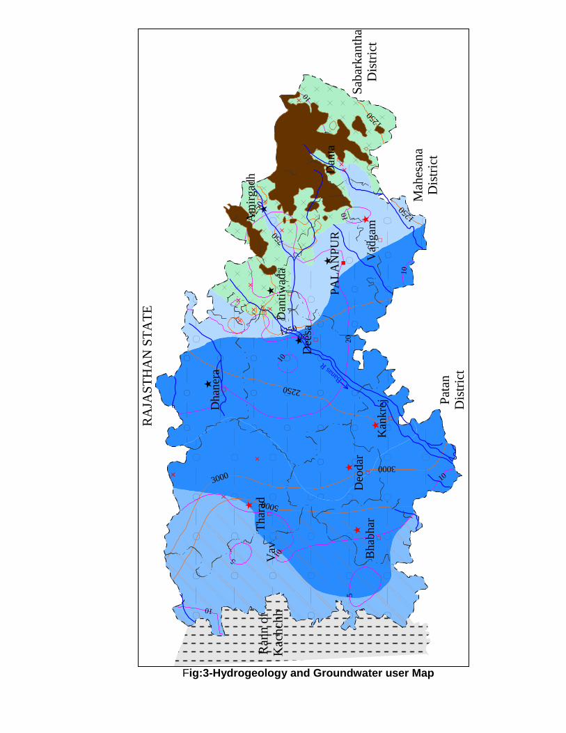
Fig:3-Hydrogeology and Groundwater user Map
RA
JAS
TH
AN
ST
AT
E
Sab
ark
anth
aD
istr
ict
Mah
esan
aD
istr
ict
Pat
anD
istr
ict
Ran
n o
fK
ach
chh
750
1250
1250
1250
1250
2250
3000
3000
5000
5
5
10
10
10
10
10
20
10
20
10
1010
Banas
RB
hab
har
Dan
ta
Dee
sa
Deo
dar
Dhan
era
Kan
kre
j
PA
LA
NP
UR
Thar
ad
Vad
gam
Vav
Am
irgad
h
Dan
tiw
ada

Legend Hydrogeological Map
Wells
Feasible
Rigs Suitable Depth of
Well (m)
Discharge
(lpm)
Artificial Recharge Structure
Suitable
Soft Rock Aquifer
Dug Well
Tubewell
Manual
Direct Rotary,
Reverse Rotary
10-25
50-100
200-300
600-1000
Percolation Tanks/
Ponds, Recharge Wells,
Soft Rock
Aquifer
Dug Well
Tubewell
Manual
Direct Rotary
Reverse Rotary
15-30
100-300
200-300
800-1000
Percolation Tanks/
Ponds, Recharge Wells,
Recharge Shaft
Soft Rock Aquifer
Dug Well
Tubewell
Manual
Direct Rotary
Reverse Rotary
15- 30
100-300
200-300
1000-1200
Percolation Tanks/
Ponds, Recharge Wells,
Recharge Shaft
Hard Rock
Aquifer
Dug Well
Borewell
Manual
Down the Hole
Hammer (DTH)
10-25
100-200
60-150
100-300
Percolation Tanks/
Ponds, Recharge Wells,
Check Dams, Nalla Bunds.
Hilly Areas
Not Suitable Check Dam, Nalla Bund, Gully
Plug
Saline Area
Not Suitable except localised
fresh water pockets
Pre-monsoon Decadal mean
(1993-2000) Depth to Water
Level (mbgl)
Electrical Conductivity (µS/cm at 25° C)
Fluoride > Maximum
Permissible Limit (1.5 mg/l)
Nitrate > Maximum Permissible Limit (100
mg/l)
Over Exploited Taluka Dark Taluka
Drainage / District/Taluka HQS
Rann/Marsh
2020
00

Groundwater in porous formations (Sedimentary ):
Northern and central parts of the north Gujarat including major part of the Banaskantha district is underlain by post Miocene alluvium and older semi consolidated Mesozoic and Tertiary sedimentary formations. These sedimentary formations form the most prolific multi-aquifer system comprising several confined aquifers; these sediments are mainly consisted of Coarse sand, gravel, kankar, silt, clay and clay stones. Groundwater occurs both under phreatic and confined conditions in arenaceous horizons within sedimentaries. The occurrence and movement of groundwater is mainly controlled by intergranular pore spaces. Two major aquifer units have been identified the upper unit is mostly phreatic but becomes semi confined to confined in some parts. It is designated as aquifer A and consists of relatively coarse grained sediments. The lower units comprising a few hundred metres of alternating sand and clay beds form confine aquifer system. It is further subdivided into aquifers of post Miocene sediments and aquifers in the Miocene sediments. The post Miocene aquifers are generally coarse to fine grained sand with occasional gravel beds. Confined aquifers in this area have been broadly grouped into, first confined (shallow) aquifer ranging in depth from 80 to 160 m bgl and the second confined aquifer (deep) ranging in depth from 155 to 275 m bgl. These aquifers extend from the foothill of the Aravallis in the northeast to the little Rann of Kachchh in the west. The Miocene aquifers are mainly fine to medium grained sand, sandstone interbedded with clay, clay stone and siltstone. Himmatnagar sandstone is generally coarse grained and friable. A typical schematic Hydrogeological cross section is presented below in Fig 4.
Fig:4 - Schematic Section showing dual aquifer system Concept

4.2 Depth to Water Levels:
Since 1969, Central Ground Water Board, as a part of its national programme, has established a network of observation wells in the state of Gujarat and UT of Daman and Diu for periodic monitoring of water levels and the variation in quality of groundwater. At present 1039 (dugwells-655 & 384 piezometers) National Network monitoring Stations including 19 open wells and 42 Piezometers in Banaskantha district which form the important part of North Gujarat mainland are being monitored. Distribution of Hydrograph network stations in different units is presented below in table 4. The ground water scenario of the district is presented here.
Table-4. Distributions of Monitoring Stations in Banaskantha District (Nov, 2010)
Rock Type Dug Wells
Piezometers Total
Area
Hard rock 6 1 7
Soft rock 13 41 54
Total 19 42 61
Basin Subbasin Dug Wells
Piezometers Total
Draining into Gulf
Rupam 25
Luni & other draining into Great Rann of Kutch
Luni 6
Draining into Great Rann of Kutch
26
Sabarmati Laft bank upto Hatmati 1
Right bank beyond Hatmati 1
Total 59
Talukas Dug Wells
Piezometer Total
Amirgadh 3 3
Bhabhar 1 1
Danta 3 2 5
Dantiwada 4 1 5
Deesa 2 12 14
Dhanera 1 6 7
Diyodar 2 2
Kankrej 1 1 2
Palanpur 1 2 3
Tharad 4 3 7
Vadgaon 7 7
Vav 5 5
Total 19 42 61

Unconfined Aquifer
Unconfined aquifer is the most extensive aquifer occurring in the different hydrogeological units in the district with thickness ranging from 20 m in the northeast, west and southern part to about 70 meters in the central part of the district.
Depth to Water Level during pre monsoon period (Fig.- 5 ) in 38% area falls in the range of 5 to 20 m bgl, mainly the western part of the district, 54% area in the range of 20 to 40 mbgl in central part and deeper water level of more than 40m bgl are observed in central part of the district in isolated patches in parts of Deesa – Dhanera – Thread - Deodar – Kankrej and Palanpur taluka of the district in about 8% of area. The shallowest water level 8.10 m bgl was observed in Tharad Taluka and the deepest water level 51.71 m bgl in Dhanera Taluka. Water level of less than 20 m bgl is also observed in the eastern part adjoining the hilly areas.
Figure 5
During post monsoon period (Fig.-6), 51% area falls in the water level range of 5 to 20 m bgl, 35% area in the range of 20 to 40 mbgl and deeper water level of more than 40m bgl are observed in parts of Deesa – Dhanera, Tharad - Deodar - Kankrej and Palanpur taluka of the district in isolated patches in about 14% of area. The shallowest water level 4.72 m bgl was observed in Tharad Taluka and the deepest water level 61.69 m bgl in Deesa Taluka.
Pre-monsoon to post monsoon fluctuation in the water level ranges from -0.5 m to more than 5 m in unconfined aquifers.

Figure 6
Confined Aquifer
Northern and central parts of the north Gujarat is underlain by the unconsolidated alluvial deposits of post Miocene age and semi consolidated Mesozoic and Tertiary sediments. These sedimentary formations form the most prolific multi-aquifer system comprising several confined aquifers. Confined aquifers in this area have been broadly grouped into, first confined (shallow) aquifer ranging in depth from 75 to 160 m bgl with an aerial extent up to Bharuch district and the second confined aquifer (deep) ranging in depth from 155 to 275 m bgl extended up to Anand district. These aquifers extend from the foothills of the Aravallis in the northeast to the little Rann of Kachchh in the west.
During the premonsoon, 2010, depth to water level recorded in the range of 18.12 mbgl in Vadgam talukas to 108.57 mbgl in Deesa Taluka in confined aquifers. In the postmonsoon, 2010, depth to water level in the range of 17.38 mbgl in Vadgam talukas to 199.15 mbgl in BhabharTaluka in confined aquifer was observed.
Pre-monsoon to post monsoon fluctuation in the water level ranges from 1 m (Rupal, Rah) to more than 10 m at Miyal in aquifers under semi confined and confined conditions with most frequent range being 5 to 8 m.
4.3 Long Term Water Level Trends: Rise and fall of water levels

Behaviour of ground water regime over longer period (2001 -2010), the data of NHS was analysed and the same is presented in table 5. The hydrograph of few representative wells are given in Fig. 7.
Table – 5 Long Term Premonsoon Water Level Trends (2001 -2010)
Location Rise
(m/year) Fall
(m/year) Location
Rise (m/year)
Fall (m/year)
Ambaji_Pz 0.4772
Kuchwada
0.6445
Amirgadh 1.3990
Lakhani i
3.0627
Aserda_Pz
3.1540 Lakhani ii
2.8140
Asodar
0.1310 Lakhani iii
2.6239
Balodhar_Pz-I
6.2742 Mahi twi
3.7976
Balodhar_Pz-II
5.8461 Meda 1.2754
Balodhar_Pz-III
3.5514 Miyal ii
0.3316
Bhabhar iii
0.7298 Miyal iii
0.2454
Bharol1 0.0090
Miyal pz-i
2.5320
Biyok_Pz-I 8.6435
Mohabbat gadh
0.0089
Biyok_Pz-II
1.3740 Moti mahudi 0.6203
Danta 1.3616
Palanpur_Pz 1.8439
Dantiwada
0.0840 Palanpur2 1.7450
Dhanera Pz- II
2.2419 Panthawada 0.1181
Dhanera Pz-I
1.9442 Rah Pz-III
1.5531
Dharnodhar_Pz-I
3.7908 Rah_Pz I
1.6575
Ganapipli 0.0230
Rah_Pz II
1.5239
Gangodra 0.5003
Rasna(Repl)_Pz_I
0.3604
Iqbalgarh 1.7040
Ratanpur2 1.2126
Jalotra Pz-I
0.5188 Rupal_Pz_I
0.4959
Jalotra Pz-II
0.2515 Rupal_Pz_II
0.3567
Jerda Pz-I
5.1198 Sankad
1.8584
Jerda Pz-II
8.6965 Sihori i
1.4425
Jhat 0.5801
Sodapur 0.2742
Jorapura 0.8975
Vav ii
1.1373
Khoda
0.8266 Vav i
0.1921
Kidotar 0.5962

Fig – 7 Hydrographs of selected Ground water monitoring stations
in Banaslantha District

4.2 Ground Water Resources
The ground water resources of the district as per GWRE are presented in Table no - . Out of 12 talukas, 6 talukas are categorised as over exploited, 1 taluka is categorised as semi-Critical, 1 as critical, 1 as Safe and 2 as Saline (Fig. - 8)
Table-6a Ground Water Development Potential of Banaskantha as on 31st
March, 2004
Table – 6b Categorization of talukas for Ground Water Development (2004)
District Saline
Over exploited Critical Semi critical Safe
Banaskantha Tharad Amirgadh Danta Dantiwada Bhabhar
Vadgam Deesa Vav
Palanpur
Kankrej
Dhanera
Deodar
Sr. No.
Assessment Unit/ Taluka
Net Annual Ground Water
Availability
Existing Gross
Ground Water Draft for irrigation
Existing Gross
Ground Water Draft for domestic and industrial water supply
Existing Gross
Ground Water Draft for All uses
(4+5)
Allocation for domestic
and industrial
requirement supply upto
next 25 years
Net Ground Water
Availability for future irrigation
development (3-4-7)
Stage of Ground Water
Development
{(6/3)*100} (%)
1 2 3 4 5 6 7 8 9
1 Amirgadh 3330 2863 275 3138 410 -218 94.24
2 Bhabhar SALINE
3 Danta 4421 3159 473 3632 703 87 82.14
4 Dantiwada 7802 4687 240 4927 356 2519 63.15
5 Deesa 19993 17273 1248 18521 1857 -386 92.64
6 Deodar 4585 7418 250 7667 371 -3453 167.22
7 Dhanera 7657 12496 494 12990 735 -6068 169.64
8 Kankrej 8682 8766 385 9151 572 -1041 105.40
9 Palanpur 12988 12749 1052 13801 1542 -2355 106.26
10 Tharad 6039 10348 173 10520 257 -4738 174.21
11 Vadgam 10451 16905 561 17466 835 -7850 167.13
12 Wav SALINE
TOTAL 85949 96663 5150 101813 7638 -23502 118.46

Figure 8 Categorization of Taluks for Ground Water Development
4.3 Ground Water Quality
Hydrochemistry: In general the ground water quality is good in eastern part. The ground water quality deteriorates towards west, in the western part along the Rann the ground water quality is poor. High concentration of Fluoride is observed in parts of the district. Quality of ground water gradually deteriorates from east (recharge zone) to west and south west (discharge zone). Ground Water is Saline in Vav, Bhabhar talukas and in most part of Tharad taluka. Higher EC value (3000 to more than 5000 µs/cm) in most parts of Bhabar, Diyodar and Kankrej talukais observed. High concentration of fluoride inparts of Danta, Vadgam, Amirgarh, Dhanera talukas. Nitrate beyond permissible lmt is found in some wells of Vadgam, Palanpur, Deesa, Dhanera in most of the talukas. General ground water quality of the district is presented in Fig 9 to 12.

Fig. 9 ISO Electrical conductivity Map of Banaskantha District
Fig. 10 ISO Chloride Map of Banaskantha District

Fig. 11 Fluoride Map of Banaskantha District
Fig. 12 Spatial Variation in Ground Water Quality in Banaskantha District
As per available information about drinking water sources about 16% of the wells are non potable due to salinity and 21% are due to fluoride beyond permissible limit.

4.4 Status of Ground Water Development (Block wise)
Groundwater development in the district is by dug wells, dug-cum-bored and shallow tubewells. Existing Irrigation scenario from ground water sources as per MI census 2000-01 there are 50941 dugwells out of which 42820 are in use. Irrigation potential created through these dugwells is 223009 Ha. and potential utilized is 217633 Ha. area. Tthere are 4950 shallow tubewells out which 4636 are in use. The irrigation potential created is 25768 Ha. and utilized is 25116 Ha. There are 21143 deep tubewells in the district out of which 20431 are in use. The irrigation potential created is 183940 Ha. and potential utilized is 180069. Taluka wise potential created by dug wells shallow tube wells and deep tube wells (M I Census 2000-01) is tabulated in table-7.
Table-:7 Potential Created by Groundwater abstraction structures
S. No.
Name of Taluka
Dug wells Shallow Tube
wells Deep Tube
wells Total
No.s in use
Potential Created
No.s in use
Potential Created
No.s in use
Potential Created
No.s in use
Potential Created
Ha. Ha. Ha. Ha.
1 Amirgadh 2698 1236 0 0 0 0 2698 12346
2 Bhabhar 393 2541 2 20 1577 17693 1972 20524
3 Danta 5188 14289 26 88 13 53 5227 14430
4 Dantiwada 1561 9170 336 1887 494 2990 2391 14047
5 Deesa 8570 58152 924 7089 4291 29611 13785 94852
6 Deodar 91 434 214 1597 4820 35269 5125 37300
7 Dhanera 7532 49400 16 177 203 3431 7751 53008
8 Kankrej 601 2740 142 1000 3991 42927 4734 46667
9
Palanpur 5001 17522 635 3187 1151 13241 6787 33980
10 Tharad 5592 31047 1305 6193 2353 19099 9250 56339
11 Vadgam 5299 23328 983 4288 1088 11420 7370 39036
12 Wav 294 2010 53 242 450 8207 797 10459
Total 42820 223009 4636 25768 20431 183941 67887 432718
(Source M.I. Census 2000 – 2001 )
Apart from Irrigation Ground water is extensively used for drinking water in most parts of the district through Tube wells and also through Hand pumps in isolated tribal pockets of Hard rock area. Summarized details of user aquifers for drinking water from the user point of view is given in table-8.

Table – 8 Summary of Drinking water structures and Groundwater situation in Banaskantha district
Sr No.
Taluka Area (sq.Km.)
Hard Rock Area suitable for GWD (sq.Km.)
Geological Formations
Normal Depth Range of wells (m)
Pumping Water level (m)
Quality (TDS) (mg/l)
Cl (mg/l)
No of Drinking water wells
GW Reso urce Category (GWRE 2004)
1 Amingarh 609.7 547 Alluvium Granite, Schist
60-90 35-40 500-1000 1.0-2.5 69 Critical
2 Bhabar 429.3
Alluvium 150-300 120-150 1500-2000
1.0-2.5 53 Saline
3 Danta 860.7 690
Granite, Quartzite, Schist, Phyllite
60-70 35-40 500-1000 1.0-2.5 185 Semi
Critical
4 Dantiwada 414.7 318
Alluvium Granite Gneiss Schist Phyllites
90-120 30-100 700-900 0.7-1.5 49 Safe
5 Deesa 1460.2 46.82 Alluvium 120-250 90-120 500-800 0.5-1.5 151 Critical
6 Deodar 582.2
Alluvium 120-300 100-150 1000-1500
1.0-2.5 71 OE
7 Dhanera 842.9 98 Alluvium Granite
90-200 50-120 800-1000 0.5-3.0 81 OE
8 Kankrej 795.5
Alluvium
106 OE
9 Palanpur 791.5 178 Alluvium Granite Gneiss
90-120 30-100 700-900 0.7-1.5 119 OE
10 Tharad 1358
Alluvium 150-300. 120 800-1800 0.5-2.5 135 OE
11 Vadgam 565.9 162 Alluvium Granite Gneiss
45-220 45-90
100-120 800-1200 1.5-4.5 110 OE
12 Vav 1694.7
Alluvium 120-130 100-150 2000 1.0-2.5 121 Saline
Bans Kantha Total
10405.3
1250
5.0 Ground Water Management Strategy
Judicious and cautious approach for developing ground water resources is to be adopted as there is an urgent need for management of resources for sustainable development. Suitable recharge structures are to be practiced in the area along with the withdrawal of ground water to minimize the effect of heavy withdrawal of ground water. Status of availability of agriculture land and source of irrigation is summarised in table-9.

Percolation tanks/ponds, Recharge wells, Recharge shaft, check dams, nalla bunds and gully plugs are the recharge structures feasible in the district depending on the terrain conditions. In the phreatic aquifers with deep water levels and de-saturated zones, spreading channels, recharge pits, recharge ponds etc are suitable to utilize surplus runoff and tail end releases from the canals.
Large number of Rainwater harvesting schemes depending on the suitable hydrogeological conditions have been constructed in the district viz. Check dams, Recharge tube wells, deepening the of the village ponds etc and the Recharge structures have shown good impact on the groundwater scenario n the vicinity of the recharge structures. Such rain water harvesting and water conservation schemes should be encouraged in future also.
6.0 Ground Water Related Issues and Problems
Distribution of source of water supply to the 1249 villages of the district is
mostly dependent on groundwater or wherever the ground water quality is saline villages are dependent on the regional water supply schemes. Summary of the source of drinking water supply and potability of groundwater in the district as a whole indicated that about 16% of the sources are non potable due to salinity and about 21% due to excess fluoride in ground water and 63% source are potable.
Table - 9 Agricultural land and source of irrigation (area in hac.)
Sl. No.
Name of taluka
Geographical area
Cultvable area
Net area sown
Net area irrigated through
Major/ medium scheme
Groundwater Surface water
Total
1 Amirgadh 52217 16805 13054 40 10120 0 10160
2 Bhabhar 47680 39212 30521 0 13156 212 13668
3 Danta 83521 25520 20144 76 12986 12 13074
4 Dantiwada 40985 34831 30776 0 26444 0 26444
5 Deesa 165984 123827 106032 363 84450 0 84813
6 Deodar 60233 51557 41633 0 21807 0 21807
7 Dhanera 81582 60715 50961 3 29485 0 29488
8 Kankrej 84734 66522 53434 120 26242 0 26362
9 Palanpur 82467 56739 42496 12 31808 0 31820
10 Tharad 164019 140090 107635 0 59035 37 59072
11 Vadgam 57698 38146 31933 0 16554 0 16554
12 Wav 264051 172754 140102 0 5671 0 5671
TOTAL 1185161 826718 66870 614 337768 261 338633
(Source: M I Census 2000-01)
Steady decline in water level due to - heavy withdrawal of ground water owing to intensive irrigation which demands unhindered development of fresh water resources.
Severe depletion in water level has lead to a large number of failures of tube wells in many parts of the district. Farmers who invested heavily in newer technology and deeper wells were severely affected economically. In the quest of more water deeper wells are drilled which resulted in further monetary loss.
Ever increasing population as well as industrialization has led to a great demand and thus immense pressure on the fresh water resources.
Deterioration in quality of ground water. o Quality of ground water gradually deteriorates from east (recharge zone)
to west and south west (discharge zone). o Saline water in Vav, Bhabhar talukas and most part of Tharad taluka.
Higher EC value (3000 to more than 5000 µs/cm) in most parts of Bhabar, Diyodar and kankrej taluka.
o High concentration of fluoride in Danta, Vadgam, Amirgarh, Dhanera talukas and excess nitrate (Vadgam, Palanpur, Deesa, Dhanera) in most of the talukas.
Tharad taluka: Except for 34 villages rest of the villages are dependent on the regional water supply scheme as the quality is saline. Over withdrawal of ground water resources for irrigation leads to continuous decline in water level in the taluka.
Bhabar , Diyodar Taluka -The quality of water is saline upto depth of 130-150 mbgl. Aquifer below this depth is under huge stress as ground water development is more. Excessive withdrawal of ground water resources for irrigation leads to continuous decline in water level in the taluka.
Vav Taluka: Quality of ground water is saline because of marshy land, salt/ mud flats devoid of vegetation (Rann). The villages are dependent on the regional water supply scheme as the quality is saline.
The farmers have no control over power supply, therefore they irrigate the crops by groundwater when power supply is available rather than waiting for the wilting to start.
Flood irrigation technique which is practised in the area is also the major cause of wastage of ground water as there is no control on the watering depth.

7.0 Awareness and Training Activity In order to increase awareness among farmers, other ground water users and custodians as well as the stakeholders, Central Ground Water Board conducted Mass awareness programs at Deesa in Dec 2004 & at Shiya in Kankrej Taluk during Febuary, 2007. In addition a Training program was also oranised at Palanpur during January,2007.
8.0 Recommendations
Judicious and cautious approach for developing ground water resources should be adopted together with creating awareness among the farmers in general and other ground water users regarding Rain water harvesting, water conservation and adoption of efficient irrigation techniques and about minimizing the effect of pumping on ground water resources in terms of quality and quantity.
Artificial recharge should be taken up on large scale through appropriate techniques on a regional scale with active community participation. Institutional finance and appropriate technology should be freely made available to any individual or cooperative group of farmers that undertake resource augmentation and management measures.
Artificial recharge practices should be encouraged by diverting surplus run-off during monsoon into ponds, percolation tanks, Spreading basins, abandoned dugwells etc.
Augmentation of ground water resource with artificial recharge and roof top rain water harvesting and Construction of water conservation structures like check dams etc. should be done at suitable locations for storage of water
Adopt method s and practices for reduction in wastage of irrigation water like use of drip irrigation system, sprinklers, plastic agriculture. Use of furrow irrigation method, mixed farming in order to use fresh water resources efficiently with more yields. Optimized irrigation agriculture in areas of intensive irrigation is required for sustainable development.
Farmers may be encouraged and made aware towards shifting to innovative, intensive and high valued crops.
In order to reduce the concentration of nitrate in ground water to some extent, use of bio pesticides, organic farming, bio fertilizers etc (Vadgam, Palanpur, Deesa, Dhanera) should be encouraged.

Schemes involving effective management for judicious distribution from existing surface reservoirs and extensive recharge of ground water through different methods for dilution of fluoride in subsurface reservoir. (Danta, Vadgam, Amirgarh, Dhanera talukas)
The land holding of the group of farmers under public tubewell irrigation should be brought under the provision of the change in crops, irrigation practices and installation of drip/sprinkler irrigation technique. Soft term institutional finances to the farmers and liberal subsidies in equipments are suggested.
Decreasing the stress on the ground water by using surface water in place of ground water for irrigation. This would prevent the upconing/mixing of inferior quality groundwater from the deeper aquifers. Alternatively, the existing cropping preference may be replaced with crops that require lesser irrigations or by replacing the crops by water quality tolerant crops, which can use low quality water.
Suitable ground water legislation may be enforced and all future ground water exploitation by deep tube wells be restricted followed by periodic monitoring of water level through closely knit monitoring system to appraise the condition more precisely from time to time.