guidance note 2 engaging local communities and increasing adaptive...
TRANSCRIPT

Engaging Local Communities and
Increasing Adaptive Capacity
e
Annex 3
Guidance Note 2

2
ANNEX 3
KENYA ADAPTATION TO CLIMATE CHANGE IN ARID LANDS (KACCAL) - INSTITUTIONAL CAPACITIES FOR CLIMATE RISK MANAGEMENT
Fredrick K. Karanja Department of Meteorology, University of Nairobi
& Muthoni M. Mwangi
Socioeconomics Consultant
Preparation Study for the Kenya Adaptation to Climate Change in Arid Lands (KACCAL) Project
Introduction Weather- and climate-related hazards present a serious threat to the socio-economic development Kenya. The most significant impacts on the poor will materialize through agriculture and livestock production, rural livelihoods and food security, particularly in the ASALs. Agriculture is the main sector of the Kenyan economy and its performance strongly influences overall economic performance. Livestock production, which accounts for 26 percent of total national agricultural production and small-scale agriculture are central to livelihoods in the ASALs and are highly affected by climate related risk. Climate risks have thus a direct impact on poverty reduction efforts. Food insecurity is a major problem, with malnutrition rates highest in the ASALs where there are acute malnutrition rates of over 15 percent in children under five, and up to 2-5 million people can quickly become dependent on aid relief during major droughts.
Besides direct impacts, increases in intensity, variability and frequency in either or both flooding and drought will also reduce the country’s long-term ability to recover between events. Given the dramatic impacts of current climate variability on Kenya’s economic performance and the livelihoods of the poor, climate change poses severe threats to sustainable economic development and poverty reduction1
.
The devastating consequences of Kenya’s droughts are partly a result of their frequency, which has also not allowed sufficient time for recovery, but poor resource management and low government investment in the ASALs have in the past exacerbated vulnerability to weather-related hazards. Problems identified by the National Policy on Sustainable Management of Arid and Semi Arid Lands (2005) include:
• Poor livestock marketing, health and movement control systems • Increasing poverty which forces people into unsustainable practices, such as
deforestation and charcoal burning for economic survival
11Linking Climate Change Adaptation and Disaster Risk Management for Sustainable Poverty Reduction. EC VARG Kenya Report, 2006

3
• Insecurity and conflicts arising due to lack of investment and marginalization, especially for pastoral societies
• Inadequate provision of basic services • Inadequate mechanisms for disaster management (e.g. provision of food aid rather
than long term solutions to food insecurity) • Inadequate development of local human resources which leads to dependence on
external skills • Poor local governance which weakens social structures and restricts social capital
development • Macro-level problems such as corruption, mismanagement of public resources, poor
development and socio-economic policies.
The KACCAL Project Objectives The objective of the KACCAL is to assist Kenya in adapting to expected changes in climactic conditions that otherwise threaten the sustainability of rural livelihoods in its arid and semi-arid lands. The Kenya Arid Lands and Resource Management Project (ALRMP), which is currently in its second phase, represents a long-term operation to enhance food-security and reduce livelihood vulnerability in drought-prone and marginalized communities. Based on an evaluation of the sustainability of livelihood activities, KACCAL will focus on i) reducing the near-term vulnerability to current climate variability and trends in conjunction with the ALRMP, and ii) strengthen the medium to long-term capacity to address climate change impacts, which will become visible as increasing climatic variability, associated changes magnitude and frequency of extremes.
The project will achieve this by strengthening institutional and technical capacity to manage current and future climate risks across scales, by specifically including the risks of climate change into the local and national strategies and activities that affect sustainable livelihood in ASALs and by supporting innovative initiatives to diversify and improve long-term livelihoods by engaging local communities and the private sector. The project will take the following approach:
At the governance and institutional level, the project focuses on strengthening the link between disaster risk management and climate change to ensure that development and operational planning, policy processes, and incentive systems address existing vulnerabilities, but also account for important climatic changes to avoid processes, which are maladaptive in medium to long-term. In this context, efforts will focus on supporting emerging development of partnerships and information sharing mechanisms, which bring together technical, development and policy perspectives and are essential for establishing a continuous economic framework for disaster and climate risk reduction.
The KACCAL project will also support decentralization of institutional capacity, particularly on adapting to climate related risk, and various investments that reduce the risk on humans and infrastructure due to extreme climate and weather related events. It will promote a harmonized

4
approach among key development partners in instituting the adaptive approach within the development agenda.
Project components The KACCAL project is divided into four components which focus on connecting activities at the local, sub-national and national level and engaging a broad range of stakeholder groups. The first specific project component of KACCAL deals with improving national coordination of information and action for management of climatic risk
Institutional efforts focused on disaster risk management and climate change are still largely fragmented. This component focuses on strengthening capacities among institutions jointly to understand and respond to current and future climate risks. Currently, the ALRMP is working to strengthen and institutionalize the drought monitoring system at the national and district level. The existing structures largely work separately from each other. The Office of the President (OP) coordinates the national disaster management structures and the support for sectoral Ministries in this area. The OP is also the implementing agency for the ALRMP. A National Disaster Management Authority (NADIMA) is being established, which would oversee sectoral decisions in research and response, form an overarching structure for special programs, and oversee the Disaster Trust Fund. KACCAL will provide support for coordination of the activities of these institutional structures in order to better focus on risks associated with climate change. At the community level, KACCAL will strengthen current early warning systems currently supported under the ALRMP by coupling the surveys at the household level with the weather and climate forecasts generated separately and at a more aggregated level. Mobile extension systems will be enhanced and staff trained on the communication of climate information in connection with advice on land-use and natural resource management. Extension agents will also be trained to record information received from communities on local climate indicators and environmental change. This feed-back mechanism to scientific institutions will be used to examine the relationship between external information and local knowledge systems and gain early clues in possible changing environmental conditions. The objectives of this report In support to the preparation of the Kenya –Adaptation to Climate Change in Arid Lands, the objective of the activities discussed in this report are to identify current capacity development needs of institutions at the national and district level in order to i) prepare for and respond to climate related disasters and ii) advance a forward looking perspective on vulnerability reduction by integrating information on climate change impacts into decision-making processes. Scope The assessments would draw and expand on a recently completed study for the Vulnerability and Adaptation Resource Group (VARG)1, which examines institutions in Kenya addressing disaster risk and climate change. Furthermore, the activities would also build on the already existing

5
information available in the context of communication produced for the United Nations Framework Convention on Climate Change (UNFCCC), the United Nations International Strategy for Disaster Reduction (UN/ISDR) and other relevant forums. District level information will include consultations with ALRMP offices and other sources. Building on this base-line information and consultations with stakeholder, the institutional assessment will focus on:
(a) Describing the current skill profile and number of staff in the relevant institutions and analyze:
• their understanding of the likely consequences of climate variability and change and the implications for their work.
• their analytical/technical, administrative and implementing capacity and effectiveness in dealing with climate risks in the exercise of their planning and implementation mandates at the national and district level
(b) Identifying capacity needs as well as requirements with respect to staffing, equipment, technologies and/or resources that would allow overcoming existing barriers to climate risk management and climate change adaptation in arid lands.
(c) Propose training programs at both national and district levels to improve the integration of climate risk management (including climate change risk) within decision-making process on development plans for arid lands
(d) Identify mechanisms to maintain and reinforce the capacity building mechanisms identified under © beyond the project life.
(e) Describe the level of coordination between government institutions and non-government institutions focused on disaster risk management at the national and district level.
(f) Recommend processes for horizontal and vertical information flow and coordination (between national and district institutions, between districts and between government and non-governmental institutions) to effectively address current risks and prepare for climate change through policy formulation, planning, implementation, monitoring and enforcement.
(g) Develop recommendations for incentives and enforcement mechanisms for improving the integration of climate change adaptation into land-use planning in arid lands and strengthening the coordination between institutions.
Methodology To gauge the level of awareness, preparedness and deliberate planning and activities geared towards warding off the impacts of climate change at national and district level Institutions, a CRM institutional capacity assessments were carried out. Heads or senior members of organizations were requested to fill in a structured questionnaire (Annex 1) that addressed awareness, preparedness, training and coordination activities in Climate Risk Management related aspects. The details of the study and results are discussed in the following chapters.

6
A. Institutions at National Level A number of Institutions at the national level, which were located in or around Nairobi were identified. This exercise built on the already identified Institutions and discussed in the VARG1
report. Table 1 below shows the main institutions interviewed.
Table 1. Main Institutions at the National level involved in CRM activities Institution Nature No. of Staff in
Institution No. of Staff in CRM activities
KMD GoK 800 ICPAC (IGAD ) 20 3 MoA GoK CRS NGO 60 3 MoWI GoK 3 FEWS-NET International 100 1 ALRMP (GoK) GoK MoH GoK none KFS GoK 8,000 WFP International >100 3 KWS GoK 3,200 NEMA GoK DRSRS GoK 100 22 MoLFD GoK >2,000 4 MoLFD/Vet. Labs GoK MoT GoK several None District level Institutions: Five districts within the ASAL region of the Country were selected by ALRMP in consultation with the World Bank for this assessment. The districts were Mwingi, Garissa, Malindi, Turkana and Marsabit (Fig. 1)

7
Figure 1. Districts selected within the ALRMP

8
Following are brief profiles of the selected districts:
Mwingi District
Mwingi is a semi-arid district located in the Eastern Province. The district covers an estimated area of 10,030.30 km2 and experiences a hot and dry climate, with an average annual temperature of 24 0
Mwingi has a population of about 303,828 people (1999 population census) with a growth rate of 2.4%. The average population density is 30 persons per km² with variations existing across the divisions. Migwani is the most densely populated division with 101 persons per km² while Ngomeni division, which is among the driest in the district, is the least densely populated with 7 persons, per km². An estimated 60% of the district’s inhabitants live below the poverty line (Kenya, 2002), with the majority of the poor residing in the dry divisions. The inhabitants are mainly engaged in agriculture, rural self-employment, waged employment, and urban self-employment.
C. The district has an erratic bimodal pattern of rainfall that ranges between 400mm and 800mm per year. The short rains are normally more reliable than the long rains and come in the months of October to December. The district is divided into nine administrative divisions.
The hazards experienced in the district are related to drought, livestock pests and diseases, crop pests, drinking water shortages, HIV/AIDS, high and variable food prices, and shortages of food in the market.
There are three-livelihood zones (LZ) in Mwingi District: 1. Mixed Farming 2. Marginal Mixed Farming 3. Formal Employment/Casual Waged Labour/Business
Institutions interviewed in Mwingi district include ALRMP, Action Aid, Red Cross, Kenya Forest Service, NGOCAP, MoLDF, MoRPW, and Farm Africa (Annex 1)
Malindi District
The District is located in the Coast Province and covers an area of approximately 7,751km2. The district is sub-divided into three administrative divisions: Magarini, Malindi and Marafa. It has a population of 281,552 with an average population density of 36 persons per km2. Magarini Division is the most densely populated (92 persons per km2), while Marafa Division is the least populated (26 persons per km2). Malindi Division has a population density of 32 persons per km2
.
Malindi District has monsoon climate, with hot and humid conditions all year round. During the short rain season (April/July) the average rainfall recorded is 1,200mm, while during the long rains (January/March) the district records rainfall of up to 1,400mm. Temperatures in Malindi District range from 210C to 320C, with a mean of 26.50
C annually.
9
There are four major topographic features in Malindi District that are closely related to the existing agro-ecological zones: Coastal Plains, Foot Plateau, Coastal Range and Nyika Plateau. The district has a 155km long coast line. About 56% of the district’s population is literate. The literacy level is higher among the male population (76.9%), than the female population (35%). On the other hand, income levels are low, with 59.1% of the rural population and 66.3% of the urban population living below the poverty line. Livelihood Zones (LZ) in Malindi District can be classified into six separate categories:
1. Mixed Farming 2. Formal Employment/Business/Trade 3. Casual Waged Labour 4. Forest/Tourism 5. Fisheries 6. Livestock Farming
Institutions interviewed in Malindi District are shown in Annex 1 and they include ALRMP, MoA, KFS, MoLFD/DVO, MOLFD/Fisheries Department, MoLFD/Livestock Department, Provincial Administration, MoH/Malindi Hospital, KRS. Action Aid, Catholic Diocese and NGOCAP
Garissa District:
Garissa District is located in the North Eastern Province of Kenya and covers an area of 33,681 km2. It is an arid district with relatively high temperatures ranging from 200C to 380
Garissa has a population of 392,510, in addition to an outstanding 130,000 refugees, mainly from neighbouring Somalia. The district has a density of 9 persons per km
C. The district has two rainfall seasons, the long rains (March – April) and the short rains (October – December), averaging 435 mm p.a. Garrisa is divided into eleven administrative divisions: Balambala, Benane, Bura, Central, Dadaab, Danyere, Jarajilla, Liboi, Modogashe, Sankuri and Shant Abaq.
2 ranging from 2 persons per km2 in Bura Division to 82 persons per km2
Poverty levels are very high in Garissa District, with 68% of the population living in absolute poverty. With a literacy level of 20%, the district has one of the lowest literacy levels in the country. Nomadic pastoralism is the backbone of the Garissa economy. However, the district can be divided into five distinct livelihood zones (LZ)
in Central Division.
1. Pastoral - All Species 2. Formal Employment/Casual Waged Labour/Business 3. Pastoral - Cattle/Sheep

10
4. Agro Pastoral 5. Pastoral - Camel/Sheep/Goats
Institutions interviewed in Garissa district include MoA, MoLFD, MoLFD/DVO, ALRMP, Red Cross, UNICEF and CARE-Kenya
Turkana District, is located in the Rift Valley Province. Being the largest district in Kenya, it occupies an area of approximately 68,388 km
Turkana District.
2, and is divided into seventeen administrative divisions: Lokichogio, Kaaling, Lopur, Lokitaung, Kibish, Lokichar, Oropoi, Lokori, Lomelo, Katilu, Kainuk, Central, Kerio, Kalokol, Turkwell, Loima and Kakuma. The district has a population of 450,860, with a population density of 7 persons per km2
Turkana district has a hot climate, with temperatures of between 24
.
0C and 380C and an annual average of 300
Income levels are very low and about 74% of the district’s population live below the poverty line. The poor, who are mainly found in the northern parts and central plains, are usually immigrants in search of relief food and assistance. Literacy levels are low, and primary school drop out rates supersede the enrolment rates.
C. Rainfall is bimodal, erratic and unreliable. The short rains (April-July) and the long rain season (October-November) average 300mm-400mm of rainfall yearly. The rain falls in brief, violent storms resulting in floods. The surface runoff and potential evaporation rates are extremely high.
The district can be sub-divided into four Livelihood Zones (LZ)
1. Pastoral-All Species 2. Formal Employment/Casual Waged Labour/Business 3. Fisheries 4. Agro Pastoral
Institutions interviewed in Turkana District include ALRMP, CCF, Catholic Diocese of Lodwar, MoA and Kenya Red Cross
Marsabit District
Located in the North Eastern province, Marsabit district lies in the driest parts of the country and is reported to receive low rainfall with fairly high temperatures. Rainfall varies between 200 and 1000mm, per annum, with the high elevation areas receiving most of the rain. The second largest in Kenya after Turkana, with an estimated area of about 66,000 km2
, the district comprises of six divisions, namely, Central, Gadamoji, Maikona, Laisamis, Loiyangalani and North Horr, and has an estimated population of 121,478.
The average household size, which stands at 4 people, is lower than the national average. Population density varies between 1 person per square kilometer to about 22 people per square
11
kilometer. The highest population densities are found in Central, Laisamis and north Horr divisions, with the three divisions settling about 60% of the district residents. The major hazards experienced in the area include drought, cattle rustling and shortage of drinking water. It is also documented that famine occurs frequently in the district. The district has both small scale and large scale agriculture, with average farm sizes of 3.2 and 13.4 acres respectively. The district has three main livelihood zones (LZ):
1. Pastoral, 2. Agro pastoral 3. Formal/business zones.
The pastoralists who form 68% of the population, are concentrated in Laisamis, Loiyangalani, Maikona and North Horr divisions, while the agro pastoralists, who also form a considerable proportion at 21% are concentrated in Gadamoji division, with a small number found in Loiyangalani and Central divisions. The formal/business comprising 11% of the population are only located in Central division. Table shows the Institutions interviewed within Marsabit district. Climate Related Hazards All the institutions interviewed at the districts were aware of some climate related hazards, and employed different methods in addressing these hazards. The main hazards addressed by these institutions include drought, floods, and disease epidemics (Table 2).

12
Table 2: Climate Related Hazards Addressed by Institutions/Agencies at the National and at District Levels
Of the 60 institutions interviewed at both National and district levels, drought was cited by 90% from 37 agencies. Floods were cited by 55% of the agencies, followed by livestock disease epidemics with 38% and crop pests and diseases with 23%. A number of the organizations, especially the NGOs address multiple climate related hazards as part of their daily work or terms of reference. Definition of Severity of Hazards The different agencies defined severity of hazards in different ways. For example, ALRMP defined severe hazard as collapse of production systems where all the early warning indicators deviate significantly from normal ranges; moderate hazard as affecting 3 indicators (rainfall; water and availability of food) deviate from normal ranges and mild hazard as having one indicator (e.g. rainfall) affected. Ministry of Agriculture defined severe hazard as causing heavy crop losses, interfering with human settlements, leading to prolonged food shortages, affecting large populations, and persisting for long periods. The Catholic Diocese defines severe hazards as that causing death to humans and livestock. Moderate and mild hazards were defined as having less intensity or damage and affecting less people than in severe hazards. Table 3 below highlights some of the definitions associated with severe hazards, with moderate and mild hazards generally having less intensity of the same attributes.
Organisation Hazards/Epidemics KMD Drought, Floods ICPAC Drought, Floods Action Aid Livestock disease epidemic, Drought ALRMP Drought, floods, land slides, fire outbreak, livestock disease epidemic, human disease
epidemic, crop pests and diseases, raids/conflicts AMREF Drought, human disease epidemic Catholic Diocese Drought, livestock disease epidemic, human disease epidemic, crop pests and
diseases CCF Drought, floods, fire outbreak, livestock disease epidemic NEMA Drought, livestock disease epidemic MoLFD/Fisheries Drought, floods KFS Drought, Floods, land slides, fire outbreaks, receding beaches MoH/Hospital Drought, Floods, Human disease epidemics KEFRI Drought MoA Drought, floods, livestock disease epidemic, crop pests, fire outbreak MoLFD Drought, floods (RVF), livestock disease epidemic (RVF) MoLFD/DVO Drought, floods, livestock disease epidemic Provincial Administration Floods, Drought Red Cross Drought, floods, fire outbreak, raids and bombings UNICEF Drought, floods, human disease epidemic World Vision Drought, Livestock disease epidemic

13
Table 3: Some definitions of Severe Hazards by various Institutions
Agency Definitions ALRMP Collapse of production systems where the major EWS indicators (rainfall, water
and availability of food) deviate significantly from normal ranges MoA Causing heavy crop losses; interfering with human settlements; leading to
prolonged food shortages; affecting large populations; persisting for long MoLFD When there is loss of human life Veterinary Department When over 80% of livestock are affected (Moderate 50%; mild 10%) Forestry Service Over 30% of crops, vegetation, and livestock are lost Provincial Administration
Many lives lost (Moderate: people are injured and property lost)
Red Cross Beyond human capacity to cope with using only their own resources Action Aid Loss of human and livestock life, property and crops Catholic Diocese Causing Death to humans and livestock WFP Over 1 million people affected FEWS-NET Significant percentage affected; lives and livelihoods lost Frequency and Intensity of Hazards The agencies interviewed reported increases in occurrence and intensity of climate related hazards in the last 10 years. ALRMP reported more frequent and more or less the same intensity in droughts, floods, and livestock diseases and associated the increase to changes in climate and weather patterns. The changes noted were further associated with prolonged dry spells, and outbreak of animal, human and crop diseases. Furthermore, a number of institutions reported that climate related hazards affect the normal schedule of work, as additional time and resources are moved to address effects of hazards such as drought. Planned activities are also affected by un-seasonal migrations. CARE Kenya reported that an increase in CRM activities leads to an increase in emergency response related activities. The Ministry of livestock reported that unseasonal migrations of whole families affect their work while sudden threat to livestock makes them change their priorities midstream from extension to mitigation activities. The field work of the Catholic diocese of Lodwar is restricted by floods and they have recently lost two members of staff to floods. Early Warning Information
Most of the organizations included in the study either collect or receive some type of early warning information that is relevant to their activities in order to prepare for particular hazards. The information is received through bulletins, as well as regular and irregular circulars, and is generally considered useful. According to MoA respondents, the information received is useful as it enables farmers to prepare for emergencies, and enables the government to maintain strategic reserves. KMD generates weather forecasts on short, medium and long ranges while ICPAC generates .The Ministry of Agriculture generates drought and pest infestation early warning information

14
while ALRMP generates impending drought info and table below shows the info generated by the various organizations. Table 4a: Early warning Information received and disseminated by some Institutions at the National Level. Institution EWI Received EWI Disseminated ALRMP Impending drought Impending drought
CRS
Impending drought, floods, livestock disease outbreaks, pest infestation, crop diseases
Impending drought
ICPAC Impending drought, impending floods KMD Impending drought, impending floods DSRS Impending drought Impending drought
FEWSNET
Impending drought, floods, livestock disease outbreak, human disease outbreak, conflict incidences
Impending drought, Impending floods, livestock disease outbreak
KFS Impending drought, fire outbreak warning, pest infestation
Impending drought, Fire outbreak warning
MoA Impending drought Impending drought
MoH Impending drought, impending floods
Impending drought, Impending floods, Human disease outbreak
MoLFD Impending drought MoLFD/DVO Livestock disease outbreak MoWI Impending drought
KWS Fire outbreak warning, impending
drought WFP Impending drought Impending drought, impending floods
Table 4b: Early warning Information received and disseminated by some Institutions in the Districts. Organization EWI Received EW Info Disseminated District Level
Action Aid
Impending drought, impending floods, livestock disease outbreak, human disease outbreak, pest infestation
Impending drought
ALRMP Impending drought, human disease outbreak
Impending drought
AMREF
Impending drought, impending floods, livestock disease outbreak, human disease outbreak, pest infestation
Impending drought, impending floods, fire outbreak warning, livestock disease outbreak, human disease outbreak, pest infestation, crop disease outbreak
Care-Kenya Impending drought, impending floods
Catholic Diocese
Impending drought, human disease outbreak
Impending drought, impending floods, fire outbreak warning, livestock disease outbreak, human disease outbreak, crop

15
disease outbreak
CCF
Impending drought, impending floods Impending drought, fire outbreak warning, livestock disease outbreak, Human disease outbreak, pest infestation
MoLFD/Fisheries
KFS Impending drought, impending floods Impending drought, impending floods, fire
outbreak warning, pest infestation
MoH Impending drought, human disease outbreak
Impending drought, human disease outbreak
LPD Impending drought, impending floods
MoA Impending drought, pest infestation e.g. army worms
Impending drought, crop disease outbreak
MoLFD Impending drought, impending floods Impending drought, impending floods
MoLFD/DVO Impending drought, livestock disease outbreak Livestock disease outbreak
Prov Admin Impending drought, impending floods Impending drought, impending floods,
livestock disease outbreak
KRC
Impending drought, impending floods, livestock disease outbreak
Planning systems, impending floods, fire outbreak warning, livestock disease outbreak
UNICEF Impending drought, impending floods, human disease outbreak
Impending drought, impending floods, human disease outbreak
WV-Relief Impending drought Impending drought, impending floods CRM Activities The ALRMP and the KRC are the main organizations carrying out various aspects of CRM activities. The Ministry of Agriculture, UNICEF and NEMA are also involved in different activities. Intervention planning, coordination, material donation and field interventions are the most popular activities. However, only a few organizations (e.g. Catholic Diocese, CCF, KRS, UNICEF and World Vision) are involved in CRM training with some degree of success. A few Institutions are involved in early warning information generation and dissemination, as well as risk zone mapping. Agencies were asked to list the major activities their organizations are involved in addressing the climate related hazards. A significant proportion of organizations at both national and district level (58%) are involved in field intervention activities. Also common is intervention planning (47%), and intervention coordination (43%). Only 12% organizations are involved in CRM training, as shown on the table below. Current Climate Risk Management Equipment Status
All the organizations interviewed use computers for their work. However, at the district level, only ALRMP and NEMA reported using computers for generation of early warning information while ALRMP in addition uses telephone facilities. ALRMP, Red Cross and UNICEF reported using computers for information dissemination while KRS and UNICEF use HF radios for the same. The government ministries of agriculture and livestock use computers for intervention

16
planning. The following tables show the equipment used for various CRM activities at national (Table 8a) and district (Table 8b) levels.
Table 5a: CRM Equipment requirements at some national Institutions
Institution EWI Generation
EWI Dissemination
Intervention Planning
Intervention Coordination
Material Donation
Field Intervention
Activities KMD Computers,
telephone, radio, vehicles Weather radars
Computers, telephone, radio, internet,
ICPAC Computers, telephone, internet
DRSRS Computers, telephone, air craft
MoA Computer, telephone
Telephone, vehicles
Assorted Tools
MoH Computer, telephone
KFS radio, telephone, vehicle, first aid kits
computer
CRS computer WFP Computer,
vehicle Vet Labs-Kabete
Computer, radio, telephone, vehicle, first aid kits
Computer, radio, telephone, vehicle, first aid kits
Computer, radio, telephone, vehicle, first aid kits
Computer, radio, telephone, vehicle, first aid kits
Computer, radio, telephone, vehicle, first aid kits
Computer, radio, telephone, vehicle, first aid kits
FEWS-NET Computer, telephone, vehicles, satellite
Computer, telephone, vehicles, satellite
Computer, telephone, vehicles, satellite
Table 5b: CRM Equipment at some district Institutions
Institutions EWI
Generation EWI
Dissemination Intervention Planning
Intervention Coordination
Material Donation
Field Intervention
Activities ALRMP Computer,
telephone Computer, telephone
Prov Admin vehicles vehicles vehicles vehicles Action Aid Computer,
radio vehicles vehicles
Catholic Diocese telephone Funding Telephone, vehicle

17
MoA vehicles computer Email/Fax/Tel. vehicles vehicles
MoLFD/DVO Computer, radio, telephone, vehicle
Computer, radio, telephone, vehicle
ALRMP Computer, telephone, radio
computer Computer, Telephone, vehicles
Computer, Telephone, vehicles
vehicles
Red Cross Radio, vehicles computer computer vehicles Telephone, vehicle, First aid kits
UNICEF Computer, radio, telephone, vehicle
Computer, radio, telephone, vehicle
Computer, radio, telephone, vehicle
Computer, radio, telephone, vehicle
Computer, radio, telephone, vehicle
Care-Kenya Computer, radio, telephone, vehicle, first aid kits
Computer, radio, telephone, vehicle, first aid kits
CCF vehicles telephone vehicles First aid kits WV-Relief Computer,
radio, telephone, vehicle
Computer, radio, telephone, vehicle
Computer, radio, telephone, vehicle
Computer, radio, telephone, vehicle
Action Aid Computer, telephone, vehicle
The limitations faced by the various institutions in carrying out various activities that address climate related hazards and associated impacts are numerous. They include the following:
• Limited financial resources • Inadequate or non-existent number of computers • Non availability of internet connectivity or inadequacy • Lack of telephone facilities • Inadequate means of transport • Inadequate HF radios for communication • Lack of equipments such as GPS and raingauges
CRM Equipment Requirements In order to alleviate the above limitations faced by the various Institutions in terms of their equipment requirements the following recommendations for equipment acquisition and use are proposed:
• Specialized equipment for CRM activities such as satellite receivers, weather radar

18
surveillance, river flood gauging equipment, data processing facilities etc that should be acquired and dedicated to continuous monitoring and reporting as may be appropriate.
• Modern telecommunication technology including Internet connectivity and wireless telephone communication for quick collection and retransmission of the required information.
• Equipment for monitoring weather and weather related extreme weather events such as droughts and floods, should also be made available to support CRM activities.
Institutional Considerations and Financial Provisions for CRM For CRM activities to be effective and sustainable, there should be:
• Institutional arrangements to avoid ad hoc approach to disaster management. • Budgetary provisions for CRM activities for every institution involved.
Training on Climate Risk Management
Most organizations interviewed do not carry out any type of climate risk management training because it not within the mandate of their core business. Those institutions that carry out some training programmes include ALRMP, CRS, KRS, UNICEF, MoLFD, etc. ALRMP, carries out internal training of its staff in contingency planning, data collection and REWAS (an internal EW database). The training targets senior, middle level and extension/field staff. The following table shows different training programs offered at various institutions. Table 6: Training programs carried out by some Institutions at both national and district levels.
Organisation Training Programmes No. of Staff Trained
District Level MoLFD/DVO Livestock Disease Outbreak 48 ALRMP Contingency Planning, Drought Cycle
Management, Data Collection, REWAS III 46
CCF Drought Management and mitigation, Environment Conservation
7
WV-Relief Community Disaster Preparedness Plan (CDPP)
11
KRC Disaster Preparedness & Response, fire safety, first aid training
60
Action Aid 4 KFS Preparedness & Response 400 CRS Contingency Planning, EWDPM,
emergency assessments 15
KWS Fire Management 29

19
Care-Kenya Flood Control Measures 821 Institutional Training Needs All Institutions indicated the need for CRM training capacity needs for staff members in their organizations. The type of training needed ranged from Drought Management through fire fighting to risk zone mapping. Table 10 below shows some of the training needs by the various Institutions. The desirable number of personnel to be trained range from 5 to15 staff members for each institution. Table 7: CRM Training Needs for some of the Institutions Organisation Training Programme Needs ALRMP Disaster Preparedness & Management MoA Disaster Preparedness & Management, Risk Zone Mapping, EWI
Generation MoLFD Flood Management Response, Climate Disaster Procedures and
Response MoLFD/DVO Livestock Disease Early Warning System, Emerging Livestock
Diseases KFS First Aid Management Provincial Admin EWI Generation & Dissemination, Training, Mapping, Planning KRC EWI, Drought Management, Environment Conservation &
Management Action Aid Disaster Management, Risk Reduction, Generation of EW, Rapid
Assessment Tools Catholic Diocese Disaster Mitigation and Management, Natural Resource
Management Training CCF Early Warning Systems MoH Disease Outbreak Forecasts for floods & Drought CRS Disaster Risk Mitigation KWS Fire Fighting Techniques Institutional CRM Staff Capacity Most Institutions indicated lack of staff involved in climate related CRM activities. However MoLFD/DVO and ALRMP have staff involved in these activities, as shown on the table below.

20
Table 8: Designation and training of some Staff Involved in CRM Activities for some Institutions
Organisation Staff designation Related Training Undertaken
ALRMP Drought Management Officer, Data Officer Drought EW System MoLFD/DVO DVO, Extension Officers, Vet Assistants RVF MoH Nutritionist, DMOH EWI Catholic Diocese Coordinator Development Office NONE KRC Branch Coordinator Drought Cycle Management MoH HPS-Staff, Feed-Staff NONE MoWI Assistant Directors NONE CRS VAM Officer, VAM Assistant NONE KWS In charge of Parks & Reserves Fire Management
Requirements for an Effective CRM System An attempt has been made to identify the major problems and constraints faced by both national and district levels Institutions carrying out CRM activities. The institutions needing attention include KMD, ICPAC, ALRMP, MoWI, KARI, DRSRS, KFS, MoA, MoH, MoLFD, amongst other sectors dependent on weather and climate. An attempt is made to discuss and make recommendations on the key issues affecting disaster preparedness such as management system, networking, integration into the national mode, feedback mechanism and the type of set up required. Capacity Development Although each of the institutions enumerated above makes effort to collect data relevant to CRM activities , it has been observed that lack of training for personnel to be in a position to take necessary action is in many occasions absent in some of these institutions because of the low priority given to CRM issues.
To deal with this lack of training and preparedness, it is being suggested that:
• Specialised training be provided for all personnel expected to be responsible for CRM activities on a regular basis.
• Each institution should identify individual(s) responsible for CRM activities co-ordination within and outside the institutions for ease of information flow.
• The identified officers should be exposed to the workings of national, regional and international meteorological services, and their products, as well as being introduced to improved understanding of local climatic and weather phenomena, and the risks that may be associated with their occurrences.

21
Disaster Risk Management Institutional Coordination Mechanisms for institutional coordination in disaster risk management have been developed in Kenya since 1999 although to a limited extent, covering only a few areas of common interest (e.g. dissemination of information/climate forecasting, collaboration amongst stakeholder community) following enhanced skills/technical capacity and regional/international networks. Regional coordination roles have been spearheaded by ICPAC through its leadership role in facilitating acquisition/development of high forecast products and integration of generated information related to risk and vulnerability over various timescales. The collaboration framework permits development of tools and other outputs that communicate readily in a user-friendly language. Of particular mention in this regard are the various activities conducted by ICPAC such as the inter-sectoral climate outlook forums for policy makers, weather forecasts to communities in local language by radio, integration of indigenous knowledge systems in development of forecasts to win the confidence of rural communities, training of agricultural extension workers, and awareness campaigns in collaboration with NEMA and KEMRI (Kenya Medical Research Institute) on health implications of climate change and weather-related disasters. Experience gained in the management of the frequent drought and flooding situations in Kenya has led to the establishment of a coordinated management structure that can prepare and respond timely to the impending rapid onset and slow onset of weather-related disasters, and the potential to manage future disasters caused by climate change. The Kenyan Food Security Structure, and associated committees under the Office of the President, provides linkage across preparedness and relief efforts to reach consensus in decision-making and limit duplication in DRR. Crucially, its structure increases communication between different stakeholders from different sectors, including Ministries, climate scientists and NGOs. Advances in risk assessments with monitoring from across sectors and at different scales also supply early warning systems (including socio-economic, livestock, agriculture, climate, markets, environmental, water etc). Although these structures primarily focus on food insecurity and drought as the most common threats to Kenya since the late 1990s, these structures can also be used for response to flood. Recent efforts are considering how to adapt strategy for tsunami and storm surge risk in coastal areas. Further, the National Disasters Operations Centre, coordinated under the Office of the President provides a mechanism to respond to different types of disasters and guarantees the allocation of resources and capacity during disasters. With strong linkages to the military, NDOC provides infrastructural experience and flexible access to an expert committee who can liaise with disaster focal units in each Ministry and communicate with directors of NGO disaster response (e.g. the WFP or KRC).

22
In this assessment, about half (53%) of the institutions coordinate their own CRM activities with other institutions. There is however, differences in the level of participation between district based institutions and national ones. Coordination for National Institutions At national level it was observed that 56% of the institutions have established coordination mechanisms for various activities jointly with other institutions. The activities coordinated at this level range from early warning, disaster preparedness and response, migratory pests and livestock disease epidemics. The table below shows the CRM activities coordinated at the national level along with the collaborating institutions. Table 9 : National institutions coordination National Institutions DFRP Coordinated Activities Collaborating Institutions CRS Emergency KFSM, WESCORD, Agro-pastoral WG DRSRS GHG Emissions Inventories Universities & Local NGOs, Parastatals, Govt Forest Service Response KWS, National Youth Service ICPAC Food Security, Forage, Drought Fews- Net, Lews, ISDR KMD Early Warnings NOC/OP(SP) MoA Migratory Pests, Diseases FAO, FAO
MOLFD
Food Security, Developing CB-LEWS, Arresting Land Degradation MOLFD for all, OP, ILRI&KARI, FAO&MOA
MoWI Disaster Preparedness & Prevention Other Govt ministries
NEMA Coordination of the National Committee Met. Dept, Universities, KEFRI, NGOs
MoLFD/DVO Livestock Disease Epidemic MoH, OP, NGOs, Research bodies Despite the existence of these coordination structures, a variety of challenges still face the collaborating institutions, especially with regard to CRM coordination efforts. The NGOs and government organizations, both at the national level identified several problems that hamper effective coordination efforts as stated below:
• timeliness • high staff turnover • consistency in representation • skills in particular areas • lack of tools for various incidents • gaps in logistics • lack of countrywide systems

23
District Level Institution coordination. At the district level, 45% of the institutions interviewed reported that they coordinate activities with others. The main CRM activity coordinated at the district level is drought management. The table below shows the CRM activities coordinated at the district level along with the participating institutions. Table 18: District Level institutions Coordination
Organization CRM Coordinated Activities Collaborating Institutions Action Aid KRC, CRS, GoK
ALRMP Drought Management, Emergency Response DSG Members & Subcommittee
CCF Drought Management & Mitigation DSG
NEMA Enhancing Adaptive Capacity ACTS
Forest Service Fire Outbreak, Rainfall Data Collection
MoA, General Public, KEFRI Forest Station Level
MoH Red Cross, Catholic Diocese
LPD ALRMP, ILRI, KARI. District Level, Divisional Level, Site Level
MoA DSG, Govt Departments, NGOs, FBO, CBO, Private Sector Stakeholder Forums at district & divisional level
MoLFD ALRNP, Administration, Agric Dept, Livestock Dept. At DSG level
MoLFD/DVO Drought, Floods DSG Members
NGOCAP Soil Conservation & Tree Planting Community Groups
Provincial Admin Drought and Flood Management Provincial Admin/DSG/Police/Meteorologists
Red Cross Disaster Response, Drought, Floods, Fire Outbreak All DSG Members, WFP, GOK, MOH, Fire Brigade
UNICEF Dissemination, Planning, Coordination GOK, NGOs, Community
The district level institutions on their part identified the following factors as being impediments to the smooth coordination roles amongst collaborating institutions:
o lack of funds o lack of transport o vastness of the area o poor infrastructure o insecurity o lack of staff personnel o Inadequate capacity of partners o Inadequate human and physical resources o Delayed response from headquarters
24
Recommendations for Institutional Co-ordination For effective delivery of services, institutions involved in CRM activities:
• Need coordination to ease information flow and enable quick response. • Need to put more emphasis on inclusion of other weather and climate related sectors
rather than the current approach where most attention is concentrated to agriculture and food production. The experiences from the 1997/98 El-Niño floods and 1998-2000 La-Niña drought confirmed that energy, water resources and health amongst other sectors are equally important.
• Need to enhance the participation of the communities to ensure co-ownership of the products through public awareness, workshops and seminars, print and electronic media, open days, visits to schools, and general education of the public on the risks associated with weather and climatic events.
An effective CRM system requires that:
• All the information about indicators and the products from continuous and continual monitoring should not only be centralized, but should also be networked in such a way that there are forward and backward linkages for fast decision making.
• There are clear rules for data sharing and procedures to be followed in the event of an emergency.
• There must be a clear-cut command structure necessitated by the need for rapid reaction and response in the event of a disaster situation.
• A National coordinating authority has to provide the National Node and there should be reporting stations in all strategic localities, for example in each district.
• There are inter-linkages, and a clear-cut feedback mechanism. • A Decision –Making Framework to enable the information available to be used early or
urgently when needed
With the above requirements in place, the information will be more readily available in all areas where it is needed most, and ultimately to the users.
National Policy On Climate Risk Management Current Status Kenya is yet to recover from the damaging effects of the 1997/98 El-Niño related rains. Climate change, and the anticipated increase in the frequency and intensity of extreme climate events, may affect Kenya adversely. This calls for utilization of meteorological products to mitigate the impacts of extreme climate events, which are associated with over 70% of the natural disasters in Kenya. Events associated with the 1997-98 El Niño struck Kenya at a time when the government had limited policy to manage the flooding-related disasters. The only disaster management institution in operation during the early periods of the 1997-98 El Niño floods was the National Famine Relief Program, whose mandate was related to monitoring and management of droughts.

25
In response, the Government established a National Disaster Operation Centre to coordinate all efforts for serious emergencies, and began to develop a National Disaster Plan related to all sectors (with a central role for planning for future disasters). Climate forecasting was strengthened and improvements were made to the coordination of early warning, and communication between government and donor agencies (e.g. especially for the management of strategic food security reserves). Key Institutions and their approaches to national disaster risk management. Office of the President: This provides a coordination role for national disaster management structures, such as the National Disasters Operations Centre and the Kenya Food Security Structure, as well as support for sectoral Ministries (e.g. Planning, Water, Livestock, Environment, Agriculture and Rural Development, Special Programmes (Response and Rehabilitation), Health, Education etc). However, long-term disaster management is not well integrated across sectors. Prevention is only a limited component of the National Environment Plan, and while the central focus in the National Agricultural Strategy for Kenya to 2014 is food security, an increase in production and improved institutional coordination in order to develop the arid lands, the Strategy does not explicitly deal with drought. In the water and energy sectors, the importance of dam management has been highlighted by impact of flooding, especially from the damaging El Niño events in 1998. National Disasters Operations Centre (NDOC) This operates as a committee within ‘Special Programmes’ in the Office of the President, to coordinate response and relief activities. It is based on the civil defence model, with ex-military chief personnel liaising with each Ministry disaster management units. However, until the President classifies a situation as a disaster, NDOC has to rely on each lead agency to deal with different emergencies. NDOC has limited capacity to coordinate long-term measures or develop a more comprehensive structure. The inability to retain a core expert group has been a problem, with each emergency addressed differently. Kenyan Food Security Structure (KFSS), This was established in 1999 and provides a collaborative forum to assess interdisciplinary sources of information regularly on food security, coordinates the development of indicators for response between different Ministries and organisations, and prevents duplication of relief efforts through the creation of MoUs (e.g. GoK, KRC, ICPAC, KMD, WFP, USAID, UN agencies etc). The structure (Figure 2) includes an Executive Committee (chaired by the President of the Republic), a Coordinating Committee (chaired by the Minister of Provincial administration and National Security), a Steering Group (chaired by the Relief and Rehabilitation Department in the Office of the President) and a KFS Meeting (chaired the Office of the President and World Food Programme). There are also various Working Groups and District Level Reports linked to local communities.

26
Disaster relief, coordinated by the KFSS, is primarily carried out by NGOs, such as the World Food Programme, UNICEF, ADRA, KRC, and Catholic Relief Services among others. Formal inter-agency cooperation and assessment does exist, and these organisations have had an influential role within the KFSS. Risk assessment maps from KFSM were used to complement strategic plans until 2005, to try to resist a responsive policy approach. KRC has focused on improved community-based action, including: vulnerability and resource mapping, capacity building and skills transfer, health, local early warning systems and the integration of funded response into longer term programmes (e.g. Machakos Food Security Project, Lake Victoria Programme). Strategic planning also includes acknowledging that slow-onset disasters such as drought are difficult to assess and therefore require advocacy. Arid Lands Resources Management Project This is within the Special Government Programmes, and supplements these structures (Figure 3). The ALRMP has operated a drought-monitoring system covering selected drought-prone areas since 2000. The monitoring of 28 districts is based on analysis of local livelihoods and provides early warning through monthly ‘ground monitoring’ exercises. Food aid tends to be the first response sought by this monitoring system. Longer term goals include improved drought risk management, livestock marketing and community development to reduce rural poverty and enhance resilience to climate impacts in the ASAL. Activities of different Ministries and stakeholders are coordinated locally by the Project and, through District level meetings, consensus on approach reached. The Arid Lands Resources Management Project Phase II (to 2009) is integrated into the Department of Agriculture’s capacity building and livelihood reports, and was established using a World Bank credit facility. The ALRMP aims to develop strategies to harmonise sectoral policies in the ASAL through participatory initiatives, although its successes in some districts have been restricted by the constant need to respond to disasters. Oversight across Ministries has allowed the ALRMP to identify priority areas where future climate change adaptations can be built into current disaster risk management projects.
Kenya Meteorological Department
KMD is responsible for the provision of weather and climate data services to different sectors, operational forecasting and the issuing of tropical cyclone warnings in the Indian Ocean. The Department administers meteorological observations, the maintenance of a telecommunications system for rapid collection and dissemination of data, in accordance with the World Meteorological Organization (WMO) and the International Civil Aviation Organization (ICAO). KMD coordinates training and research in meteorology and climatology, through cooperation with ICPAC and University of Nairobi (e.g. the successful Climate Outlook Forum established in 1998 generates seasonal forecasts which are used by the KFSS and other users). Since 1998, considerable investment has been made to communicate forecasts to different users, including local communities (Ovuka and Lindqvist, 2000; Luseno et al., 2003).

27
Figure 2. Kenya Food Security Institutional Structures
One project has been a joint media initiative, called RANET, a radio information service to rural areas (in operation with USAID, KARI, and the National Agricultural and Livestock Extras Programme) and KENJOM (a link to journalists).
NATIONAL FOOD SECURITY EXECUTIVE COMMITTEE (Chaired by the President)
NATIONAL FOOD SECURITY COORDINATING COMMITTEE (Chaired by Minister of State Provincial administration and National Security)
KENYA FOOD SECURITY MEETING (Co-Chaired OP and WFP)
KENYA FOOD SECURITY STEERING GROUP (Chaired by Relief and Rehabilitation OP)
Working groups/sub-committees • Food Security Data Sub-
committee • Health and Nutrition • Water and Sanitation • Agriculture and Livestock • Disaster Management • Food Aid Estimates
DSGs/DSDDC District Level data gathering, analysis and reporting
COMMUNITIES EWS Monitoring Assessments

28
Figure 3. Organisation
of the ALRMP and the
KFSS
(source: Office of the President Kenya, 2004)
Climate Prediction and Applications Centre This is an intergovernmental institution, established within the framework of IGAD and SADC and supported by USAID’s FEWSNET. Created in 1989 by UNDP and WMO, it is staffed by experts from the University of Nairobi (experts on climate modelling, forecast and sector specific consultancy), provides support to KMD and is networked to international organisations such as NOAA/OGP and IRI. Its focus is the generation of hazard maps and forecasts, using increased integration between different regional early warning systems and vulnerability assessments. ICPAC generates a number of products over different timeframes, including seasonal outlooks and severity warnings, many of which are sector specific and used by divisions under the Office of the President. It is also involved in various training programs on the application and integration of climate information to the various sectors of the economy, for personnel within the IGAD region. In 2002, the government, the Office of the President, formulated a National Policy on Disaster Management. This policy aimed to provide a coordinated framework to ensure that disaster risk reduction was integrated into the national development process and that climate was made a consideration in food security preparedness, response, mapping and other tools. The management body includes different ministries, agencies, NGOs, civil organisation and international partners. The UN ISDR played a facilitation role in the development of a National Platform for the National Disaster Policy. This policy also recommends strategic planning, stockpiling of food,
29
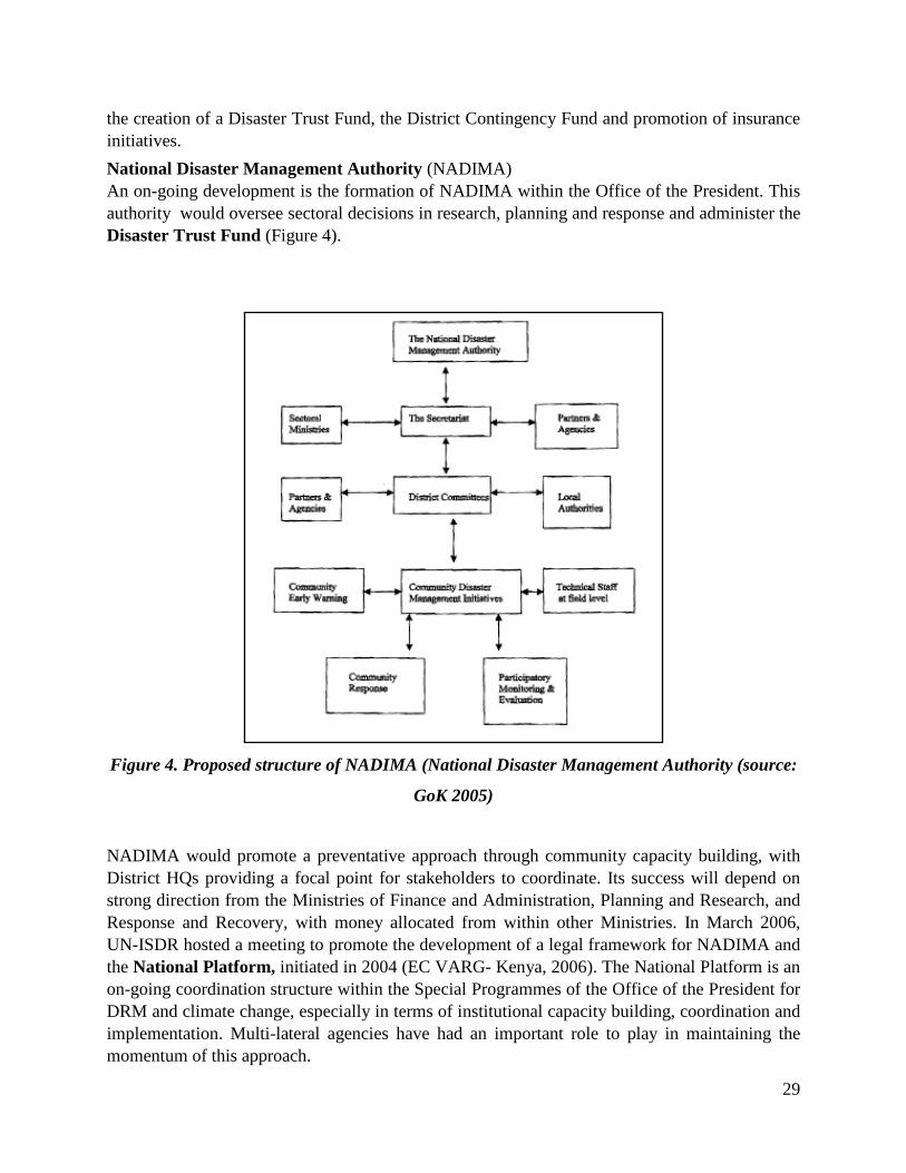
the creation of a Disaster Trust Fund, the District Contingency Fund and promotion of insurance initiatives. National Disaster Management Authority (NADIMA) An on-going development is the formation of NADIMA within the Office of the President. This authority would oversee sectoral decisions in research, planning and response and administer the Disaster Trust Fund (Figure 4).
Figure 4. Proposed structure of NADIMA (National Disaster Management Authority (source:
GoK 2005)
NADIMA would promote a preventative approach through community capacity building, with District HQs providing a focal point for stakeholders to coordinate. Its success will depend on strong direction from the Ministries of Finance and Administration, Planning and Research, and Response and Recovery, with money allocated from within other Ministries. In March 2006, UN-ISDR hosted a meeting to promote the development of a legal framework for NADIMA and the National Platform, initiated in 2004 (EC VARG- Kenya, 2006). The National Platform is an on-going coordination structure within the Special Programmes of the Office of the President for DRM and climate change, especially in terms of institutional capacity building, coordination and implementation. Multi-lateral agencies have had an important role to play in maintaining the momentum of this approach.

30
There are numerous examples of multilateral activities and projects focusing on DRM in Kenya. UNDP (with partnership from Government and other multi- lateral organisations) focuses on building both local and national disaster preparedness, prevention and capacity building through policy support, training and community based disaster mitigation, risk zoning and vulnerability assessment of extreme weather conditions. The UNDP-funded Drylands Development Centre is based in Nairobi. UNEP has been involved in the promotion of national understanding of the linkages between DRM, climate change, environment, poverty and sustainable development through the Division of Early Warning and Assessment and the Disaster Management Division(EC VARG, Kenya, 2006). These initiatives focus on national government policy development (e.g. development of Disaster Contingency plans with NDOC). The Disaster Management Division also works with external agencies such as UNDP, UN-ISDR and NGOs. A forum on Drought Risk and Development Policy was held in Kenya following a recommendation from the UN-ISDR Ad Hoc Discussion Group on Drought in coordination with UNDP/DDC/BCPR. The main recommendation of the forum was to launch an African Drought Risk and Development Network, which will advocate for action on drought risk management in Africa at sub-regional, regional and international level. Other regional actors include NEPAD, the African Union, IGAD Inter-Governmental Authority on Development sub-regional disaster management programmes and the African Development Bank (e.g. collaboration for the development of an Africa Regional Strategy for Disaster Risk Reduction in 2004 or the AU Special Emergency Assistance Fund). Climate Change adaptation in national policy Kenya has completed a country study on climate change, reported under the Climate Convention, and has committed to developing national programmes to address climate change. The government has completed the First National Communication to the UNFCCC and is currently working on the Second. The Ministry for Environment (NEMA) is responsible for coordinating national adaptation and climate change issues through a specially established Climate Change Secretariat, including national communications to UNFCCC and a point of contact for the CDM, land use linkages, energy systems and GHG emissions. The Inter-Ministerial Committee on Environment, which also includes NGOs and the private sector, has eight technical sub-committees on priority areas. For example, the National Climate Change Activities Coordination Committee, which is chaired by NEMA, plays an advisory role on GEF proposals and assists with IPCC Reports preparation. Climate change issues are relevant to the Kenyan National Environmental Action Plan 2003-2008 and the Environmental Action Plan for Arid and Semi-Arid Lands in Kenya (linked to the on-going Special Programme). They are also communicated in sustainable development terminology through the National Development Plan (to 2010), which has a chapter devoted to improved food security, agriculture and rural development and research and extension are to play a central role. Sustainable development is reflected in decentralised District Development Plans and help to assist environmental issues to be integrated into local development practice. Objectives include formulating measures to address underlying causes of desertification, such as

31
weak socio-economic factors, and to establish mechanisms to mitigate the effects of drought and food insecurity through a reduction in poverty and vulnerability. Other relevant government approaches include the Economic Recovery Strategy (until 2008), which is overseen by the Ministry of Planning. The greatest dilemma for the Ministry of Planning is how to integrate climate information in the national planning process, particularly because they lack the capacity and sometimes the tools to interpret the information, and as a result have historically been only concerned with short-term goals (Interview Ministry of Planning). This makes it difficult for climate change considerations to be seen as important to the development process and thus attract budgetary allocation. The costs of floods on the economy compared to mitigation are yet to be computed nationally for example. Together with the UNDP and UNEP, the Ministry of Planning is initiating a project on poverty reduction. The Water Resources Management Authority, established in 2003, considers the problem of water access as related to poor management, and address it through decentralization of water management. Part of the sector is now privatised and at least seven autonomous water management boards have been created to plan and regulate water use in different parts of the country. Water user associations are increasingly involved in management to try to ensure users effectively participate in decision-making on water resources. A national water management strategy exists, but this is primarily to account for irrigation as the main consumer (70 percent of the total water use), and the provision of a data service that has been running for six years. Other Ministries, such as Health and Tourism, consider themselves at the end of the chain of climate change impacts. The use of integrated climate information is low in the Ministry of Health and its primary approach focuses on dealing with the impact of poverty on health. The role of Kenyan development and adaptation in the climate change debate has been boosted by the activities of the research centres and networks in Nairobi, such as the Climate Network, African Centre for Technology Studies (ACTS), the University of Nairobi and CGIAR institutes among others. These cover research in livestock (e.g. the Dryland Husbandry Project with the Ministries of Agriculture and Livestock Development, University of Nairobi, OSSREA, EPOS, KEFRI), agricultural planning for climate change (e.g. new ICRISAT consortium with ASARECA) and institutional policy (e.g. University of Nairobi). The scientific community is involved with research on the ENSO phenomenon and rainfall characteristics in the region. Regional support on climate change issues also comes from the East African Community, IGAD, World Bank, NEPAD, African Union, African Development Bank, SADC, IPCC and other UN agencies. One example is the on-going GEF-funded programme exploring coping with drought and climate change (facilitated by the government, ICPAC, Kenyan research institutes and NGOs), which pilots the Adaptation Policy Framework to build successful adaptation approaches. The approach has included integrating results into the ASAL, policy regulation and development of economic incentives in different sectors.

32
Existing Mechanisms/Incentives For Integration Of Climate Change Adaptation In Arid Lands Several mechanisms and incentives exist or may be developed that have great potential for fostering integration of climate change adaptation into land use planning in arid lands and also, for strengthening coordination between collaborating institutions. These approaches, however, are dependent upon a region’s user-specific requirements, which may include timely Climate and hazard information, effective Communication of risk and planning tools, Coordination, Political momentum and institutional capacity, Grassroots capacity and community involvement and Financing adaptation (Kenya VARG Report,2006). Integration and improvement of information on climate and hazards has been spurred by occurrences of climate related disasters such as the 1997/98 El Niño weather-related disaster and the 2004-6 droughts and flooding. A number of research institutions exist, especially in Nairobi that foster the scientific understanding of short term forecasts and long term predictions of climate. These include ICPAC, KMD, Department of Meteorology at the University of Nairobi, and CGIAR component institutions. Of special mention is the role played by ILRI in the mapping of climate hazards and their associated impacts. A considerable number of staff of the aforementioned institutions, through their institutional collaborative ventures are posted on secondment between institutions, with a view to enhance both institutional and regional reputation alongside increasing skill and information exchange. A notable example of such beneficial association amongst collaborating institutions are the credible contributions to the climate science by ICPAC. Unlike in the past when there existed a disconnect between the climate scientists and end-users of climate products, communication of science on risk is being enhanced through collaborative initiatives between the scientific community and users. In Kenya, ICPAC communicates to policy makers early warning and seasonal weather predictions via Outlook Fora. This information is used by national disaster planning structures, together with information of local risk assessments in Government institutions, particularly for food security. ICPAC operates training workshops at multiple levels of governance, providing opportunities for capacity building and ensuring raised awareness of future priorities in DRM planning. Government Ministries have also engaged with users in policy forum and rural areas to improve understanding about the role of scientific forecasts in planning for impending risk. Examples include regular risk assessments of pastoral conditions and food availability by Ministries of Livestock and Agriculture, and the strategy by NEMA to improve understanding of long-term climate change implications by policy makers and local communities. Information from the KMD is provided by local radio stations to farmers. Research is published and made available to IPCC review, and consultancy projects have improved awareness of the impacts of future climate change on different sectors within Government. There are also existing mechanisms for the development of risk assessment tools and collation of information (e.g. climate models and forecast information is developed in different formats for different users by the KMD/ICPAC,

33
local level assessments are integrated into the KFSS and new international efforts with a role in Kenya e.g. Climate Change Adaptation in Africa programme by DFID and IDRC). Integration is being improved through new structures and policy that facilitate inter-agency liaison and development of national and regional partnership networks. There are a number of institutional structures and policies that have increased opportunities for coordination and partnership both within Government and outside-Government. The establishment of an Inter-Ministerial Committee for Climate Change by NEMA has established a mechanism for inter-agency liaison and brings together different sectors, especially in relation to UNFCCC commitments and GEF-funded initiatives (however, it has yet to make a significant impact on Government planning). The creation of a Kenyan National Disaster Policy and the process of development of a National Platform have offered opportunities to bring together experts from different sectors to coordinate strategy. For example, the consultation process has assisted external organisations in identifying appropriate entry points for assistance within government decision-making mechanisms. The National Disaster Policy recognises the importance of multiple levels of governance working across different timescales to deliver disaster planning, and this approach will need to become an essential legal component for government to mainstream climate change risks (e.g. UN agencies have been working with the Ministry of Planning). The Kenya Food Security Structure has responsibility for consideration of climate risks on DRM planning and response for food and livelihood security, and at district level District Steering Groups bring together agencies, communities and government. These have proved effective forums for the integration and improved coordination of planning and activities. The concentration of research centres in Nairobi has also contributed to regional science networks and partnership opportunities for coordination.

34
Table 3. Existing mechanisms and incentives that have helped, or may help, foster integration
• A strong network of research centres based in Nairobi and the region. • Collaborative initiatives that facilitate communication between scientists and users (e.g.
training workshops and specific forums via ICPAC and its regional network bring together specialists from different agencies and research centres for expertise and information sharing and the engagement of users in the development of risk assessment planning tools).
• Existing structures for information transfer and inter-agency coordination through the KFSS (between government, scientists, NGOs, donor agencies).
• The development of the 2nd
• The Inter-Ministerial Committee for Climate Change, promoted by NEMA, provides a mechanism for inter-ministerial liaison and international commitments create incentives for compliance in adaptation policy.
Kenyan National Communication to the UNFCCC offers a mechanism and incentive for cross-sectoral information sharing and Kenyan identification of priorities.
• The policy development of a National Platform creates opportunities and incentives for national ownership and improved coordination which is complementary to multilateral organisations’ international programmes on climate change adaptation and development.
• Implementation of the National Disaster Policy and the creation of an overarching national authority within government offer coordination and long-term oversight for mainstreaming DRR, plus possibilities for funding incentives such as a Disasters Trust Fund.
• Growing support for community-based participation and holistic approaches to disaster risk planning and capacity building (e.g. the Arid Land Resources Management Project within the Office of President).
• District Steering Groups provide decentralised identification of cross-sectoral priorities and motives for community partnership.
• Poverty reduction targets (associated with MDG and Kenya’s national economic development strategy incentive) create opportunities for vulnerability reduction and private sector involvement.
• The UN Global Environment Facility has provided an incentive for inter-agency partnership.
Source: Kenya VARG Report (2006)
35
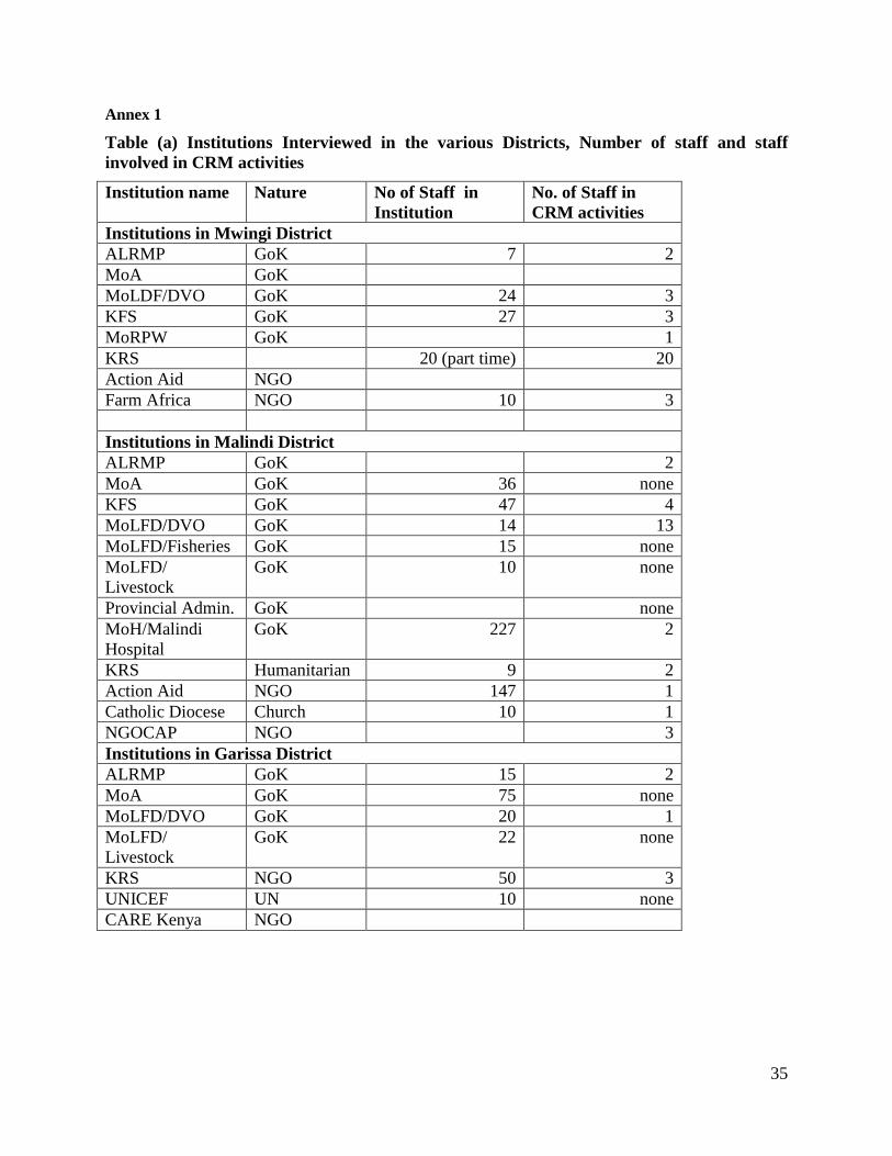
Annex 1
Table (a) Institutions Interviewed in the various Districts, Number of staff and staff involved in CRM activities
Institution name
Nature No of Staff in Institution
No. of Staff in CRM activities
Institutions in Mwingi District ALRMP GoK 7 2 MoA GoK MoLDF/DVO GoK 24 3 KFS GoK 27 3 MoRPW GoK 1 KRS 20 (part time) 20 Action Aid NGO Farm Africa NGO 10 3 Institutions in Malindi District ALRMP GoK 2 MoA GoK 36 none KFS GoK 47 4 MoLFD/DVO GoK 14 13 MoLFD/Fisheries GoK 15 none MoLFD/ Livestock
GoK 10 none
Provincial Admin. GoK none MoH/Malindi Hospital
GoK 227 2
KRS Humanitarian 9 2 Action Aid NGO 147 1 Catholic Diocese Church 10 1 NGOCAP NGO 3 Institutions in Garissa District ALRMP GoK 15 2 MoA GoK 75 none MoLFD/DVO GoK 20 1 MoLFD/ Livestock
GoK 22 none
KRS NGO 50 3 UNICEF UN 10 none CARE Kenya NGO

36
Annex 1 contd:
Institution name Nature No. of Staff in Institution
No. of Staff in CRM Activities
Institutions in Turkana District ALRMP GoK 20 13 MoA GoK 43 none CCF NGO 8 6 World Vision NGO 98 none Catholic Diocese FBO 200 none KRS Humanitarian 5 2 Institutions in Marsabit District MoA GoK 30 1 MoLFD/Livestock GoK 11 4 MoLFD/DVO GoK 19 2 KFS GoK 40 2 KARI GoK 72 1 Catholic Diocese FBO 12 3 PISP NGO 19 none CIFA Regional NGO 28 none