guide to maps valdÉs-salas castlefundacionvaldessalas.es/.../2016/06/...2015-ingles.pdf ·...
TRANSCRIPT

GUIDE TO MAPS
VALDÉS-SALAS CASTLE
Nothern Spain from the Al-Idrisi map (1154)
This document can be downloaded from
www.fundacionValdesSalas.es and www.aulaValdesSalas.es
This exhibition of maps in the Valdés-Salas Castle represents the
evolution of the European view of the world since the beginning of
the Primitive Pilgrim Route to Santiago (9th Century) until the
death of Fernando de Valdés (1568), Archbishop, General
Inquisitor and founder of the University of Oviedo.

1
Fernando Valdes, born in 1483 in this castle, lived in a time of
great change in society and in the view of the known world. During
his lifetime, the maps begin to serve multiple purposes, some of
them already traditional: management, city planning, the
resolution of legal disputes, merchant shipping, military strategy,
etc. The growing importance of maps during that time can be
illustrated by the estimates of maps available: in the period 1400-
1472 there were only a few hundreds of maps, in the period 1472-
1500 the figure was around 56,000 maps and in the period 1500 -
1600 there were millions of maps already available (The History of
Cartography, University of Chicago Press, available free of charge on the
Internet).
The time of Fernando de Valdés represents a turning point in the
convergence of cultures. In 1480, major world sailing communities
were separated by large expanses of unexplored sea and landmasses
with unknown surfaces areas and shapes. The usual European
sailing routes were limited to the North Atlantic, the Baltic and the
Mediterranean. In the late 15th Century, the voyages of the
Portuguese towards the East and the Spanish to the West, with the
discovery of America in 1492, connected separate worlds and
encouraged communication between civilizations such as had never
occurred before in history.
The discovery of America was the founding event of the scientific
revolution. It urged Europeans to break with the medieval period
and quickly search for new knowledge (not just geographically, but
in all fields of knowledge) to explore the unknown territories. The
maps were full of empty spaces, that to Europeans were begging to
be filled in, and so the first global empires and truly global trade
networks were established. These voyages of exploration and
conquest, with which today we are familiar, had never occurred
before, and changed the history of the world: from a history of

2
isolated peoples and cultures to a history of a single global society
[Harari, Yuval N. (2012), From Animals into Gods: a Brief History of
Humankind]
The maps in this exhibition fit into standard periods (The History of
Cartography, University of Chicago Press), although these
classifications overlap and have no clear limits:
- From the 8th Century to the early 12th Century.
This period is known as the Golden Age of ecclesiastical
mapmaking, given the rapid profusion of books and
manuscripts for the cathedral and monastic schools: Beatus
of Girona (ca. 975) and Saint-Sever (ca. 1050).
- From the early 12th Century to the late 13th Century.
This period is known as the 12th Century Renaissance. It is
characterized by the influence of Arabic and Greek classics
in Western Europe: Tabula Rogeriana of Al-Idrisi (1154)
and Hereford (1275).
- From the early 14th Century to the mid-15th Century.
Transitional period between the Middle Ages and the
Renaissance, with world maps that incorporate features of
both periods: Catalan of Cresques (1375), Circular Catalan
(1450) and Fra Mauro (1459).
- End of the 15th Century and the 16th Century.
A period of expansion for exploration and cartography:
Juan de la Cosa (1500), Miller (1519), Ribero (1529) and
Comocio (1560).
The maps have been selected according to their printing quality or
their availability in a facsimile edition, showing the evolution of
the European view of the world during this period. Many other
maps and related stories can be studied in more detail via the
computers and books which are at the disposal of visitors.

3
THE BEATUS MAPPAE MUNDI [1] and [2]
The book entitled "Commentary on the Apocalypse of Saint John",
written by the Benedictine abbot Beatus of Liebana, 8th Century,
was a well-known text in Medieval Christianity. Until the 13th
Century, there were many copies of this book, all of them
decorated with beautiful miniatures, and in some cases with a
world map heavy with religious significance. These copies are
usually referred to by the term ‘Beatus’.
The Beatus mappae mundi (in singular mappa mundi, from the Latin
mappa –tablecloth or napkin– and mundus – world) depict a
discoidal concept of the World, with geographical ideas based on
biblical archetypes. They provide a worldview, but give little
geographic insight. Their primary purpose is to instruct the faithful
about significant events in Christian history rather than to record
their exact locations. They are inspired by the cartographic concept
of Isidore of Seville’s diagrams, which describe a flat circular world,
divided into three parts. These represent the world divided into
three continents crossed by waterways in the form of a capital T
(associated with the cross of Christ) and surrounded by a ring
representing the ocean, the O; hence, the name of T-O maps.
The parts of the T are represented by the three major waterways
believed by medieval scholars to divide the three parts of the earth:
Tanais (the river Don) dividing Europe and Asia, the Nile dividing
Africa and Asia, and the Mediterranean Sea dividing Europe and
Africa. Each continent is the inheritance of one of the sons of
Noah: Asia is inhabited by Semitic people, descendants of Shem,
Africa by the descendants of Ham and Europe by the descendants
of Japheth.

4
T-O map from Isidore of Seville’s Etymologies (560-636).
This map is reproduced from the 15th Century printed version.
These maps are "oriented" in the sense that at the top is the East,
the direction to which Christian prayer is directed. In most cases,
the four cardinal points are provided in Latin:
- Septentrio: from the Latin ‘septem’ (seven), and a variant of the
Indo-European root 'ster' (star) changed to 'strio', referring to the
seven stars of the Great Bear. Another etymological explanation
interprets ‘trio -ōnis’ as plow-oxen, and therefore would refer to the
'seven plow-oxen' following the Roman belief that seven oxen
permanently pulled the celestial sphere, rotating around an axis
passing through the Pole Star.
- Meridies: from the Latin 'medius' (middle) and 'diēs' (day)
referring to the position of the sun at noon.
- Oriens: from Latin orĭens, -entis, active participle of orīri (appear,
birth), indicating the direction from which the sun rises.
- Occidens: from the Latin occĭdens, -entis, active participle of
occidĕre (fall), indicating the direction in which the Sun sets.

5
[1] BEATUS OF GIRONA (975)
The Girona Beatus is an illuminated manuscript, the work by
Abad Dominicus. Completed in 975, around 1078 it was sent to
the Cathedral of Girona. In what is perhaps the most fascinating
inscription, the names of the two illustrators are revealed: Ende,
painter and servant of God, and Emeterio, monk and priest. The
listing of the names in descending order of relevance was a
medieval tradition. Therefore, we can say that the more important
of the two illustrators was a woman, one of the few female artists
named in the Middle Ages, probably a nun or a noble.

6
[2] BEATUS OF SAINT-SEVER (11th Century, ca. 1050)
The Beatus of Saint Sever mappa mundi is undoubtedly the mappa
mundi which provides most geographical details. It was made
around 1050 in the Abbey of Saint Sever, located on the
pilgrimage route to Santiago, in Aquitaine (France). The Beatus
was copied by order of Gregorio de Muntaner, an abbot of Spanish
origin, between 1028 and 1072. With 270 names, it is considered
the richest in content and the most carefully executed of all the
Beatus mappaemundi. Currently, it is in the National Library of
France.

7
[3] MAPPA MUNDI OF AL-IDRISI (1154)
This is Konrad Miller's 1929 recreation of Muhammad Al-Idrisi's
Tabula Rogeriana from 1154.
Al-Idrisi (1100-1165) was born in Ceuta (Spain, North Africa),
then part of the Almoravid Empire. He was a member of the
Hammumid family, a descendent of the Prophet Muhammad. He
was educated in Cordoba and made several journeys before settling
in Palermo (Sicily), in the court of King Roger II of Sicily, where he
worked for eighteen years on the comments and illustrations that
accompany the maps. Written in Arabic, the mappa mundi
describes the Eurasian continent as a whole and the North part of
Africa.
In 1154, Al-Idrisi drew up a large world map known as Tabula
Rogeriana, accompanied by a book called Geography. The Book of
Roger or Kitab Ruyar shows the world divided into seven climatic
regions, giving the distances between the most popular cities and
describing the traditions, people, products and climate of the

8
known world. It is not a perfect historical source, because Al-Idrisi,
following the medieval tradition, based his knowledge on different
sources: besides direct visits to some places described, every time a
ship docked in Sicily, its crew and passengers were questioned
about the places they had visited.
The main inspiration of Al-Idrisi were two mapmakers of the pre-
Islamic era: Paulus Orosius, a Spaniard whose popular history,
written in the 5th century, included a volume of descriptive
geography; and Claudius Ptolemy, the greatest of the classical
geographers, whose Geography, written in the 2nd Century, had
been completely lost in Europe, but was preserved in the Muslim
world in an Arabic translation.
The map is south-oriented (the South is at the top of the map),
according to the Arab tradition. There are two possible
explanations for this orientation. Firstly, the first peoples
conquered by the Arabs were disciples of Zoroaster, for whom the
South was sacred. Secondly, many communities conquered and
converted to Islam in the 7th and 8th Centuries lived north of
Mecca, and so faced South during prayers.
As a curiosity, we can see that Great Britain has the shape of an
inverted teapot, and therefore south-oriented.

9
[4] HEREFORD MAPPA MUNDI (ca. 1285)
The world map of Hereford Cathedral (in the west of England near
the Welsh border) is an evolved form of the T-O maps. Such maps
do not necessarily imply that its creators believed the Earth was
flat. That the planet was spherical was known by the ancient
Greeks and Romans and the idea was not completely forgotten
during the Middle Ages. The circular representation was more a
conventional projection. This copy is the exact size of the original.
On the map there are around 500 illustrations, including about
420 views or symbols of cities and towns, 15 depictions of biblical
events, 33 depictions of plants, animals, birds and fish, 32 pictures
of the peoples of the earth and 5 scenes from classical mythology.
The names of Africa and Europe are transposed. The Hereford
map was included in the UNESCO Memory of the World Register
in 2007.
0 – At the center, Jerusalem. Above it, the crucifix.
1 – Paradise.
2 – The Ganges and its delta.
3 – The fabled island of Taphana (Sri Lanka or Sumatra).
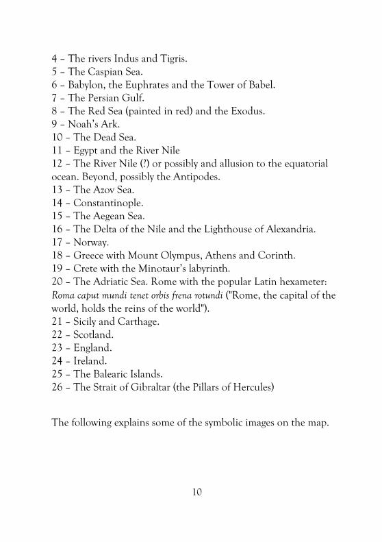
10
4 – The rivers Indus and Tigris.
5 – The Caspian Sea.
6 – Babylon, the Euphrates and the Tower of Babel.
7 – The Persian Gulf.
8 – The Red Sea (painted in red) and the Exodus.
9 – Noah’s Ark.
10 – The Dead Sea.
11 – Egypt and the River Nile
12 – The River Nile (?) or possibly and allusion to the equatorial
ocean. Beyond, possibly the Antipodes.
13 – The Azov Sea.
14 – Constantinople.
15 – The Aegean Sea.
16 – The Delta of the Nile and the Lighthouse of Alexandria.
17 – Norway.
18 – Greece with Mount Olympus, Athens and Corinth.
19 – Crete with the Minotaur’s labyrinth.
20 – The Adriatic Sea. Rome with the popular Latin hexameter:
Roma caput mundi tenet orbis frena rotundi ("Rome, the capital of the
world, holds the reins of the world").
21 – Sicily and Carthage.
22 – Scotland.
23 – England.
24 – Ireland.
25 – The Balearic Islands.
26 – The Strait of Gibraltar (the Pillars of Hercules)
The following explains some of the symbolic images on the map.

11
A. The Blemmyes, a war-like race
with no head, but with their
facial features in their chest.
Alexander the Great was
thought to have encountered
Blemmyes in his campaigns
and they are even mentioned
in Shakespeare’s Otello.
B. The Sciapods, a race of
people with one very large
foot that they used to shield
themselves from the sun.
Stories told how these
people moved extremely
quickly on their one leg.
C. The essedons, people that eat
the bodies of their parents,
thinking that this is better
than being eaten by worms.
On the right, the golden
fleece of the expedition of
Jason and the Argonauts.
D. The Cynocephali, men with
the heads of dogs and
barking voices, are
described as ‘barbarians’,
who can be tender one
minute, but agressive and
uncontrolled the next.

12
[5] EUROPEAN SECTION OF THE CATALAN ATLAS OF CRESQUES (1375), [6] CATALAN MAPPAMUNDI (ca. 1450)
At the end of the 13th Century in Europe, the Carta Pisana
ushered in a new practical form of cartography which was designed
for navigation and made possible by the widespread use of the
compass; hence North is at at the top of the map. These new maps
are known as portolan charts (from the Italian 'portolano', meaning
port or harbor), and focus on maritime shipping routes, the details
of the shore, the coastal relief and the winds.
The Catalan Atlas of Cresques (1375) is considered the finest of
the portolan charts. It represents the zenith of this medieval way of
making maps, which will dominate the 14th and 15th Centuries
and will be extended until the 18th Century, being already
contemporary, in the Renaissance, with more mathematical and
scientific mapping. This type of map is conceived as an atlas, a
visual encyclopedia containing text and images designed to
encompass all geographical, historical, cosmographic and human
knownledge.

13
This map represents the high point of the Majorca School, lead by
the Cresques family, Abraham and his son Jafuda, Majorcan Jewish
cartographers. They carried out their mapmaking work in the last
quarter of the 14th Century. This map was commissioned by Peter
IV of Aragon and is preserved in the National Library of Paris. The
complete atlas is a richly illuminated parchment containing
geographical and astronomical texts, perpetual calendars, etc. The
influence of Marco Polo’s travels is noticeable.
The map [5] is the European section of the map of 1375. In the
'Ocean Sea' all known islands and landmarks are depicted. Thus,
on the island of Tenerife, a white dot can be observed,
representing the Teide volcano. The delineation of the coastline of
the Mediterranean is very careful, which reflects the hegemony of
the Crown of Aragon in that period. One of the characteristics of
the Majorcan cartographic school is the presence of many flags and
legends with physical, economic and demographic data of interest.
The compass rose of this map is the first known cartographic
representation with 32 directions. It contains thirty-two directions
and the names of the eight principal winds, which reflects the
Cresques’s mastery of nautical instruments. This prototype of
thirty-two directions and eight winds has been preserved until
today. The first N-S line crosses the island of El Hierro,
incorporating the recovery of the tradition of Ptolemy.
In the lower left part of Africa, the empire of Mali is represented.
First, some tents and a rider appear, representing the desert
nomads. Then, the Emperor (Mansa) Moussa, considered as the
richest king of all time, is depicted with a gold nugget in his hand.
It is said that, on his pilgrimage to Mecca, he distributed so much
gold that he sank the price of gold for a decade in the East.

14
The names of the north and south are labeled in opposite
directions, an effect very noticeable in the circular mappa mundi
[6], of anonymous authorship. This orientation suggests that the
map was supposed to be placed on a table and examined by
walking around it. The most curious geographic feature is the
shape of Africa: on the limits of the Gulf of Guinea, a river or
strait connects the Atlantic Ocean to the Indian, and a large
landmass emerges to complete the base of the map. No name
appears for this landmass, and it is unclear if it is considered part
of Africa or another continent. The interest of this map lies in its
uncertain and eclectic identity: circular, with some religious and
legendary motifs, as well as certain Arab influences, it retains the
rigor of portolan charts.

15
[7] FRA MAURO’S WORLD MAP (ca. 1450)
Fra Mauro’s mappa mundi is one of the most beautiful and
important works in the history of cartography. Created by the
monk Fra Mauro in Venice, it represents a picture of the Earth
according to late medieval Christian beliefs. So it depicts the
known world at the time of the birth of Valdés-Salas. Venice was a
great maritime power, a crossroads of travel and art, between East
and West, and found itself at the forefront of international trade
and diplomacy. Hence, it was one of the great centres of medieval
and Renaissance mapmaking.
This map shows South at the top, rejecting Ptolemy and portolan’s
nothern orientation and the eastern orientation of medieval

16
mappa mundi. This jewel of medieval cartography is perhaps the
last attempt to combine the worldview of the T-O maps with
information retrieved from Ptolemaic Geography. Fra Mauro knew
about the map of Ptolemy and commented that it was inadequate
for many regions of the world, but acknowledged the validity of its
extension to the east by removing Jerusalem from the central
position it had occupied in previous maps. It is the first European
map depicting the islands of Japan, and also known for presenting
the Indian Ocean not as an inland sea but as a link to Asia.
The description of Africa is surprisingly accurate, especially if one
takes into consideration that, at that time, Portuguese explorers
had not gone beyond 12 degrees North. The first European to
sight the Cape of Good Hope would be the Portuguese
Bartholomeu Dias in 1488. Fra Mauro shows a circumnavigable
Africa, something unknown to the ancients, including Ptolemy.
One annotation on the map claims that ‘around 1420 a ship or
junk from India’ sailed around what Fra Mauro labels as the Cape
of Diab (Cape of Good Hope). Some historians suggest that he
knew of the voyages of Chinese admiral Zheng He, who may have
reached the cape before any European.
The map is now in the Biblioteca Marciana in Venice.

17
[8] JUAN DE LA COSA’S WORLD CHART (1500)
This chart is considered the earliest map of the Americas and also
the first 'Padrón Real' (the standard Spanish secret map, which was
used as a model for the maps and nautical charts used in all
Spanish ships during the 16th Century). It was stolen in Seville
and forgotten in Spain up to the death of the last owner in 1853,
the Baron of Walckenaer, Dutch ambassador in Paris. The Spanish
Admiralty Ministry purchased the document for display in the
Naval Museum of Madrid, where it is at present.
Juan de la Cosa was a sailor from Santoña (a port of Northern
Spain). He was the captain and owner of the Santa Maria (one of
the three ships which discovered America). He was commissioned
by Columbus and sailed with him, as master of his own ship, on
the first voyage of discovery. He also sailed on the second voyage,
and it was his responsibility to map the seas and discovered lands.
The world map of Juan de la Cosa is a portolan chart of the
Majorcan school, drawn on two joined pieces of vellum. On the
left hand side of the map, under the image of Saint Christopher, it
is signed by Juan de la Cosa and dated 1500.

18
America is represented using two styles. Firstly, the islands of
Cuba, La Española, Jamaica, Puerto Rico, the Bahamas and the
Lesser Antilles, are listed in detail and in light colors, like the Old
World, indicating better knowledge of this areas. Secondly, the
continent appears as a dark green blur, which seems to give an idea
of grandeur and enigmatic vastness.
The map of Juan de la Cosa represents Cuba as an island. This is
an interesting point because Columbus, anxious to prove he had
indeed reached Asia, obliged his pilots to confirm that Cuba was a
peninsula at the East of a great continent. At that time it was not
known whether there were one or two continents. Columbus
claimed that, among those landmasses, there was a strait by where
you could reach the Indies. In this, he remained faithful to the
Asian theory. On the map, Juan de la Cosa does not contradict
him. He offers no clear point of view, resorting to subterfuge: he
passes the responsibility to Christopher Columbus, painting a
picture of Saint Christopher separating North and South America.
In 1507, Martin Waldseemüller published the first map to name
America as a continent, based on the ideas of Amerigo Vespucci.
The map is what was called an atlas at that time. In addition to the
geographical aspects, it represents human beings, palaces, temples,
flags, etc. In Africa, it shows up to five kings or sultans of
Mauritania and the Tower of Babel; in Arabia, the biblical figure of
the Queen of Sheba; and near the word Asia, the Three Wise Men
on their way to Israel. In the northeast corner, the monsters Gog
and Magog are represented: one with a dog's head and the other
one without a head, eyes and mouth in his chest, being of a violent
and destructive nature (according to the prophecies of Ezekiel and
the Book of Revelation, they would come out of their isolation in
the times of the Antichrist to invade and devastate Christianity,
before the Judgment Day).

19
[9] MILLER ATLAS (ca. 1519)
The Miller atlas illustrates the years that changed the world on the
eve of Ferdinand Magellan’s voyage around the world. It was made
by the cartographers Lopo Homem (nobleman), Pedro and Jorge
Reinel (African Portuguese) and the miniaturist Antonio de
Holanda (Dutch).
This map is the graphic expression of Portuguese global strategy at
odds with Castilian strategy. Its strange conception of the oceans
surrounded by land suited the Portuguese around 1519, because it
demonstrated that it was not possible to sail from west to east. The
"secret" of the Atlas Miller is trying to counteract the idea of being
able to sail around the world, the project that, at exactly the same
time, was being prepared by Magellan. In a sense, this world map is
actually "false" (despite being true); it is a geopolitical fake, where
the Portuguese strategy faces is at odds with the Spanish one.
The Miller Atlas is a work of uncommon luxury whose target was
Leonor, the sister of Emperor Charles I, who was married to
Manuel I of Portugal. Their ultimate goal was to be observed by

20
Charles I and the Castilians, and it was really an instrument of
geostrategic, geopolitical and diplomatic misinformation.
The most astonishing fact is that, over several months in 1519, the
best cartographers of that time, Pedro Reinel and his son Jorge
Reinel, were involved in two opposing projects (in Lisbon, the
completion of the Miller Atlas, and in Seville, preparing the voyage
of Magellan), travelling back and forth across the Spanish-
Portuguese border. Based on their knowledge, the first
circumnavigation of the globe was prepared for the Crown of
Castile. And at about the same time, the Miller Atlas was being
prepared for the Crown of Portugal, both based on their
knowledge. At that time, only Portugal was able to make such an
impressive map.
[10] MAP OF DIOGO RIBERO (1529)
This is a reproduction of a map by Khol, a 19th Century German
geographer and writer. It represents the American part of the
original map of Diogo Ribero dated 1529.
Diogo Ribero was a Portuguese mapmaker who lived in Seville in
the service of Charles I. He was the successor of Sebastian Cabot
as Principal Pilot (Piloto Mayor) and therefore responsible for
maintaining the Royal Registers (Padrones Reales). In 1503, the
Royal House of Trade (Real Casa de Contratación de Indias) was
created to promote and regulate American commerce and
navigation. The position of Principal Pilot was created in 1508. He
was in charge of examining those who wish to study navigation,
and also of drawing maps and charts and the Padrón Real. The
Padrón Real (after 2nd August 1527 this was known as the Padrón
General) was the main Spanish official and secret map, which was
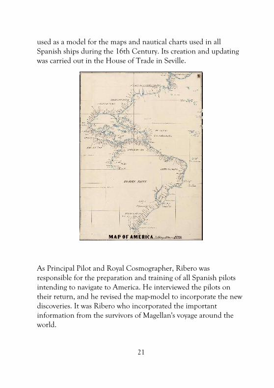
21
used as a model for the maps and nautical charts used in all
Spanish ships during the 16th Century. Its creation and updating
was carried out in the House of Trade in Seville.
As Principal Pilot and Royal Cosmographer, Ribero was
responsible for the preparation and training of all Spanish pilots
intending to navigate to America. He interviewed the pilots on
their return, and he revised the map-model to incorporate the new
discoveries. It was Ribero who incorporated the important
information from the survivors of Magellan's voyage around the
world.

22
[11] COMOCIO’S WORLD MAP (1560)
At the end of the life of Fernando de Valdés, who died in 1568,
the vision of the world was already quite similar to the one we
know today. To illustrate this vision of the world, we have selected
the Cosmographia Universalis of Comocio, dated 1560 (the copy
exhibited is dated 1581), a few years before the death of the
inquisitor. Giovanni Francesco Comocio (1501-1575) was an active
mapmaker in Venice between 1558 and 1575 and one of the most
important exponents of the Venetian School of Lafreri.
Europe, Asia, Africa and America were already depicted quite
accurately, but it would take several centuries to reach the
perfection of modern cartographic representations. The details of
the continents and the distances were far from reliable, as can be
seen in the case of the Iberian Peninsula. The landmasses were
deformed, as can be seen in South America, Africa or the hugely
inaccurate depiction of the Antarctic. But, broadly speaking, the
known world was already similar to the present one; the
convergence of civilizations had doubled the size of the known
world.

23
A few years after the drawing up of this map, after the death of
Fernando de Valdés, some important advances in cartography took
place. In 1569, Gerardus Mercator (1512-1594), Dutch
mathematician and cartographer, devised the Mercator projection,
the cylindrical projection with which we are familiar when we look
at a map even today. The following year, 1570, saw the publication
of the Theatrum Orbis Terrarum, created by Abraham Ortellius
(1527-1598), the Royal Cosmographer of Philip II, and which is
considered the first modern atlas.
“Today, maps are regarded primarily as locational or navigational tools … However, throughout history, maps have served a variety of purposes. In fact, ever since mankind first learned how to make graphic marks on rock up to 40,000 years ago, people have created maps as a way of conceptualizing themselves in relation to their environment. Thus, maps are as much about existence as they are about orientation … While other animals demarcate their territories, we are the only species capable of mapping ours”
Brotton, J. (2014), Great Maps.
References
Comellas, J.L. (1992), El mapa de Juan de la Cosa, Testimonio.
Harari, Yuval N. (2012), From Animals into Gods: a Brief History of
Humankind, CreateSpace Independent Publishing Platform.
Miranda, C., Beato de Liébana, Moleiro.
The History of Cartography, University of Chicago Press.
Thomaz, L.F et al. (2006), Atlas Miller, Moleiro.
Westrem, S.D. (2001), The Hereford Map, Brepols.
Websites: www.fglorente.org, www.themappamundi.co.uk.

24
ORIGINAL OR PRIMITIVE PILGRIM ROUTE TO SANTIAGO (814-2014)
The Original or Primitive Pilgrim Route to Santiago is the path
that the first pilgrim to Santiago de Compostela, Alfonso II, King
of Asturias, walked with his court. In the 9th Century, in order to
visit the newly discovered tomb of the Apostle, the Asturian king
initiated the pilgrimage to Compostela. He created, 1,200 years
ago, a route that strengthened the fledgling European identity,
renewing, upgrading and expanding the link between the paths
created by the peoples of northern Spain and Europe throughout
the millennia. The mural was created by José Legazpi in 2014 and
it is inspired by the Romanesque along the Camino Primitivo.
Image of Santiago
in the ‘Portico de
la Gloria’
(Santiago)
North gate and
Romanesque tower of
the Cathedral of Lugo
Church of
Vilar de Donas
(near Palas de
Rei)
Recreation of the Romanesque
facade of the Cathedral of
Santiago
Monastery of
Cornellana (apse and
Romanesque tower)
Recreation of Alfonso II’s
palace in Oviedo
Monastry
of Obona
Cross from
the testament
of Alfonso II

Ayto. Salas