gun river watershed management plan
TRANSCRIPT
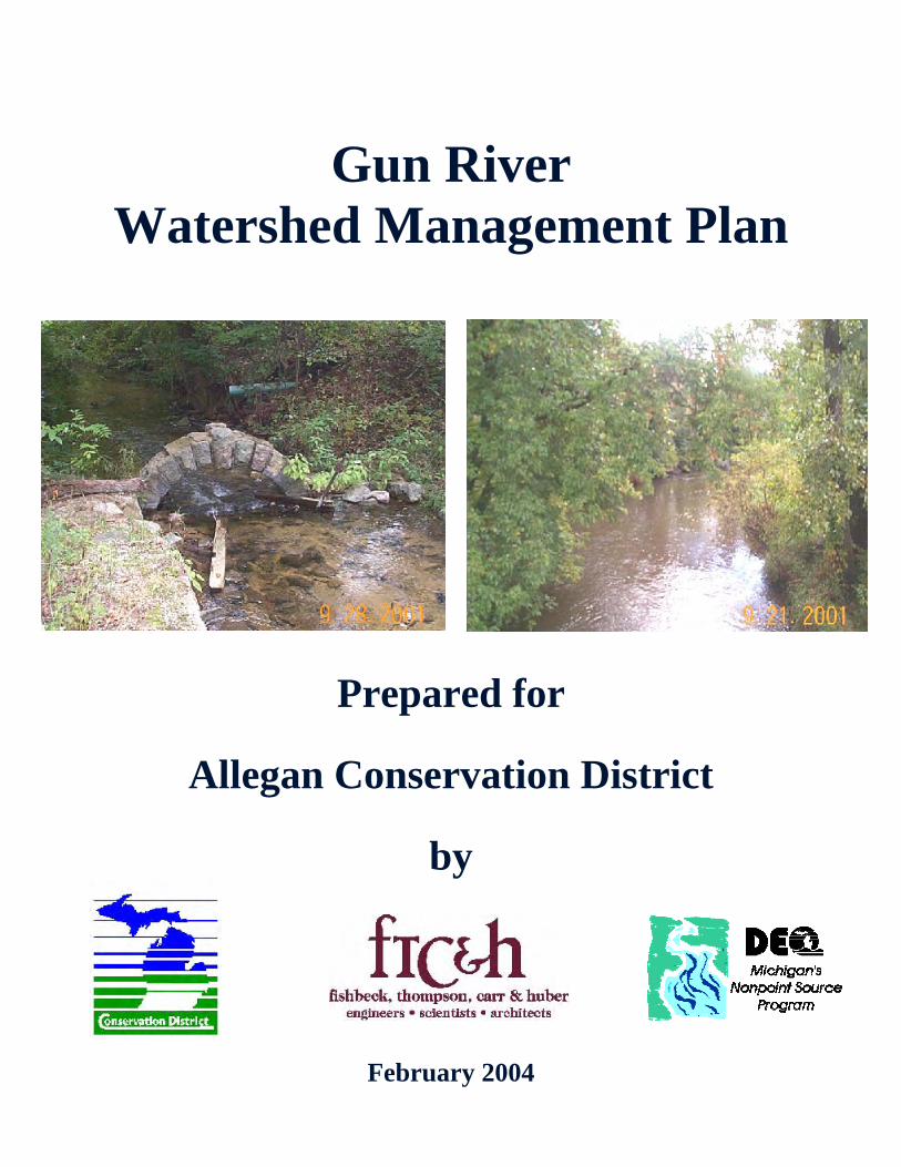
Gun River Watershed Management Plan
Prepared for
Allegan Conservation District
by
February 2004
FISHBECK, THOMPSON, CARR & HUBER, INC. Engineers Scientists Architects
1515 Arboretum Drive, SE, Grand Rapids, MI 49546 Telephone: 616-575-3824
GUN RIVER
WATERSHED MANAGEMENT PLAN
MDEQ TRACKING CODE: #2000-0164
FEBRUARY 2004 PROJECT NO. G01339
This project has been funded wholly or in part by the United States Environmental Protection Agency under assistance agreement (C9975474-01) to Allegan Conservation District, 2000-0164. The contents of the
document do not necessary reflect the views and policies of the Environment Protection Agency, nor does the mention of trade names or commercial products constitute endorsement or recommendation for use.
TABLE OF CONTENTS
J:\GDOC01\R01339\WMP\EPA\EPA_GUNRIVERWMP.DOC i
EXECUTIVE SUMMARY ........................................................................................................................1
CHAPTER 1 - WATERSHED DESCRIPTION........................................................................................5 1.0 Overview ....................................................................................................................................5 1.1 Geographic Scope .....................................................................................................................5 1.2 Topography................................................................................................................................5 1.3 Soils ...........................................................................................................................................6 1.4 Climate.......................................................................................................................................7 1.5 Land Use....................................................................................................................................7 1.6 Hydrology...................................................................................................................................8
1.6.1 Lakes ..........................................................................................................................9 1.6.2 Impoundments............................................................................................................9 1.6.3 Rivers, Streams, and County Drains........................................................................10 1.6.4 Groundwater.............................................................................................................10 1.6.5 Wetlands...................................................................................................................10
CHAPTER 2 - NATURAL FEATURES INVENTORY ...........................................................................11 2.0 Introduction ..............................................................................................................................11 2.1 Description of the Gun River Watershed .................................................................................11 2.2 Method of Study.......................................................................................................................12 2.3 Unique Natural Features..........................................................................................................12 2.4 Biological Surveys....................................................................................................................15 2.5 Fish Stocking Records .............................................................................................................19 2.6 Invasive Species ......................................................................................................................20 2.7 Presettlement Vegetation.........................................................................................................23 2.8 National Wetlands Inventory....................................................................................................23 2.9 Prime Farmland .......................................................................................................................24 2.10 Conclusion ...............................................................................................................................25
CHAPTER 3 - POLITICAL LANDSCAPE .............................................................................................26 3.0 Demographics..........................................................................................................................26 3.1 Community Profiles..................................................................................................................30 3.2 Government Officials ...............................................................................................................30
CHAPTER 4 - WATER QUALITY IN THE GUN RIVER WATERSHED...............................................32 4.0 Previous and Current Studies..................................................................................................32
4.0.1 Kalamazoo River Remedial and Preventive Action Plan .........................................32 4.0.2 Kalamazoo River/Lake Allegan TMDL .....................................................................33 4.0.3 Aquatic Survey of Gun Lake.....................................................................................34 4.0.4 Biological Survey of the Gun River ..........................................................................34 4.0.5 Fishery Studies in the Gun River Watershed ...........................................................35 4.0.6 Water Quality Sampling on the Gun River ...............................................................36
4.1 Watershed Inventory................................................................................................................43 4.1.1 Methodology.............................................................................................................43 4.1.2 Findings ....................................................................................................................44
4.2 Hydrologic and Hydraulic Analyses .........................................................................................45 4.2.1 Introduction...............................................................................................................45 4.2.2 Methodologies ..........................................................................................................46 4.2.3 Hydrologic Analysis ..................................................................................................46
4.2.3.1 Stream Protection ...........................................................................................49 4.2.4 Hydraulic Analysis ....................................................................................................53 4.2.5 Benefits of the Study ................................................................................................54 4.2.6 Conclusions of the Study..........................................................................................55 4.2.7 Steering Committee Input.........................................................................................56
4.3 Designated Uses......................................................................................................................56
TABLE OF CONTENTS
J:\GDOC01\R01339\WMP\EPA\EPA_GUNRIVERWMP.DOC ii
4.3.1 Agricultural Use ........................................................................................................57 4.3.2 Public Water Supply at Point of Intake.....................................................................57 4.3.3 Navigation.................................................................................................................57 4.3.4 Warmwater Fishery ..................................................................................................57 4.3.5 Coldwater Fishery ....................................................................................................57 4.3.6 Other Indigenous Aquatic Life and Wildlife ..............................................................58 4.3.7 Partial Body Contact Recreation ..............................................................................58 4.3.8 Total Body Contact Recreation ................................................................................58 4.3.9 Industrial Water Supply ............................................................................................58
4.4 Desired Uses ...........................................................................................................................59 4.4.1 Groundwater Protection for Drinking Water .............................................................59 4.4.2 Increase Recreational Opportunities........................................................................59 4.4.3 Preserve Open Space and Rural Character ............................................................59 4.4.4 Create a Gun River Trailway ....................................................................................60 4.4.5 Protect Prime Farmlands..........................................................................................60 4.4.6 Protect Unique Habitats for Endangered Species....................................................60 4.4.7 Encourage Wildlife Habitats .....................................................................................60
4.5 Sources and Causes of Pollutants and Impairments...............................................................61 4.5.1 Pollutants and Impairments......................................................................................61 4.5.2 Sources and Causes ................................................................................................61
CHAPTER 5 - CRITICAL AREAS AND NONPOINT SOURCE POLLUTION ......................................64 5.0 Critical Areas............................................................................................................................64 5.1 Description of Critical Areas.....................................................................................................64
5.1.1 Agricultural Critical Areas .........................................................................................64 5.1.2 Residential Critical Areas .........................................................................................66 5.1.3 Wetland Critical Area................................................................................................66 5.1.4 Recreational Critical Areas.......................................................................................67
5.2 Prioritization Process ...............................................................................................................68 5.2.1 Methodology.............................................................................................................68
5.3 BMPs for Nonpoint Source Pollution Categories.....................................................................69 5.3.1 Agricultural Nonpoint Source Pollution.....................................................................69 5.3.2 Streambank Erosion.................................................................................................75 5.3.3 Rill and Gully Erosion ...............................................................................................80 5.3.4 Tile Outlets ...............................................................................................................83 5.3.5 Road/Stream Crossings ...........................................................................................83 5.3.6 Trash and Debris......................................................................................................83 5.3.7 Other Sites and Construction Sites ..........................................................................86
CHAPTER 6 - COMMUNITY OUTREACH PLAN.................................................................................90 6.0 Key Audiences .........................................................................................................................90
6.0.1 Goals for the Gun River Watershed Community Outreach Plan..............................90 6.0.2 Overall Outreach Objectives ....................................................................................91
6.1 Overall Key Messages.............................................................................................................91 6.2 Outreach Tool Box ...................................................................................................................91
6.2.1 Township, City, and Village Officials ........................................................................92 6.2.1.1 Objectives .......................................................................................................92 6.2.1.2 Activities..........................................................................................................93
6.2.2 Agricultural Producers ..............................................................................................93 6.2.2.1 Objectives .......................................................................................................93 6.2.2.2 Activities..........................................................................................................94
6.2.3 Riparian Landowners/Homeowners .........................................................................95 6.2.3.1 Objectives .......................................................................................................95 6.2.3.2 Activities..........................................................................................................95
6.2.4 Local Governmental Units ........................................................................................97 6.2.4.1 Objectives .......................................................................................................97

TABLE OF CONTENTS
J:\GDOC01\R01339\WMP\EPA\EPA_GUNRIVERWMP.DOC iii
6.2.4.2 Activities..........................................................................................................97 6.2.5 Stakeholders.............................................................................................................98
6.2.5.1 Objectives .......................................................................................................98 6.2.5.2 Activities..........................................................................................................98
6.2.6 Lake Residents.........................................................................................................98 6.2.6.1 Objectives .......................................................................................................98 6.2.6.2 Activities..........................................................................................................98
6.3 Public Participation Process ..................................................................................................102
CHAPTER 7 - IMPLEMENTATION STRATEGIES.............................................................................104 7.0 Goals and Objectives for the Gun River Watershed..............................................................104 7.1 Water Quality Summary.........................................................................................................109 7.2 Recommendations for Implementation ..................................................................................120
7.2.1 Best Management Practices ..................................................................................120 7.2.2 Land Use Planning .................................................................................................131
7.3 Other Recommendations.......................................................................................................132 7.3.1 NPDES Phase II .....................................................................................................132 7.3.2 Wetland Restoration...............................................................................................133
7.4 Anticipated Pollution Reductions ...........................................................................................134 7.5 Desired Uses .........................................................................................................................137
CHAPTER 8 - EVALUATION METHODS...........................................................................................140 8.0 Evaluation Criteria and Monitoring.........................................................................................140
8.0.1 Best Management Practices ..................................................................................140 8.0.2 Land Use Planning Initiatives.................................................................................149 8.0.3 Criteria ....................................................................................................................155 8.0.4 Monitoring Plan ......................................................................................................157
8.1 Additional Planning and Implementation Project Evaluation .................................................159 8.1.1 Quarterly Reports ...................................................................................................159 8.1.2 Stakeholder Participation .......................................................................................159 8.1.3 Water Quality Monitoring........................................................................................160 8.1.4 Lessons Learned....................................................................................................161 8.1.5 Partners in Conducting Evaluations .......................................................................161
CHAPTER 9 - SUSTAINABILITY........................................................................................................162 9.0 Roles and Responsibilities In Project Implementation...........................................................162
9.0.1 Best Management Practices ..................................................................................162 9.0.2 Information and Education .....................................................................................165 9.0.3 Long-Term Project Goals .......................................................................................167
9.1 Analysis of Other Projects and Programs..............................................................................167 9.1.1 National Pollutant Discharge Elimination System Permit Program........................169 9.1.2 Michigan Groundwater Stewardship Program .......................................................169 9.1.3 Generally Accepted Agriculture Management Practices........................................169 9.1.4 Public Act 116 ........................................................................................................170 9.1.5 Drain Commissioner...............................................................................................170 9.1.6 Departments of State and Federal Government ....................................................170 9.1.7 Gun Plain Charter Township Planning Ordinance .................................................171 9.1.8 Friends of the Gun River ........................................................................................171
9.2 Funding and Resource Opportunities ....................................................................................171 9.2.1 Section 319 Implementation Fund (319) ................................................................171 9.2.2 EPA 5-Star Grant ...................................................................................................172 9.2.3 Michigan Volunteer Monitoring Grants...................................................................172 9.2.4 United States Fish and Wildlife Service (USFWS).................................................172 9.2.5 The Great Lakes Commission - Sediment and Erosion Control Project Grants ....172 9.2.6 Natural Resources Conservation Service Farm Bill Programs ..............................173 9.2.7 Other Sources of Funding and Resources.............................................................175

TABLE OF CONTENTS
J:\GDOC01\R01339\WMP\EPA\EPA_GUNRIVERWMP.DOC iv
CHAPTER 10 - RESOURCE LIBRARY..............................................................................................178
BIBLIOGRAPHY .................................................................................................................................180
GLOSSARY ........................................................................................................................................182
LIST OF CHARTS
Chart 4.1 Gun River Total Phosphorus .............................................................................................40 Chart 4.2 Gun River Dissolved Oxygen ............................................................................................41 Chart 4.3 Gun River Water Temperature ..........................................................................................42 Chart 4.4 Hydrographs for 100-Year Storm ......................................................................................48 Chart 4.5 Existing and Future 25-Year Flow Rates ..........................................................................50 Chart 4.6 Existing and Future 2-Year Flow Rates ............................................................................51 Chart 4.7 Release Rate as a Function of Curve Number .................................................................52
LIST OF TABLES
Chapter 1
Table 1.1 Hydrologic Soil Groups in the Gun River Watershed (USDA-SCS, 1987; USDA-SCS, 1990) ...................................................................................................................................7
Chapter 2
Table 2.1 Natural Features Present Within the Gun River Watershed .............................................13 Table 2.2 Biological Sampling Locations in the Gun River Watershed.............................................15 Table 2.3 Inventory of Plant and Bird Species Along the Gun River from 110th and 107th
Avenues.............................................................................................................................19 Table 2.4 Inventory of Invasive Plant Species Along the Gun River from 110th and 107th
Avenues.............................................................................................................................22 Table 2.5 Prime Farmland Soils in Allegan and Barry Counties, Michigan.......................................24
Chapter 3
Table 3.1 Acres and Population of the Gun River Watershed ..........................................................28 Table 3.2 Ethnic Diversity in the Gun River Watershed ....................................................................29 Table 3.3 Officials..............................................................................................................................30
Chapter 4
Table 4.1 MDNR General Survey and Trout Evaluation of the Gun River........................................35 Table 4.2 Water Quality Sampling Data ............................................................................................38 Table 4.3 Summary of Inventory Data in the Gun River Watershed.................................................44 Table 4.4 Hydrologic Model Results Future Land Use Conditions (25-Year) ...................................49 Table 4.5 Impairment and Threats to Designated Uses....................................................................58
Chapter 5
Table 5.1 Agriculture BMP Cost ........................................................................................................71 Table 5.2 Streambank Erosion Sites BMP Cost ...............................................................................76 Table 5.3 Rill and Gully Erosion ........................................................................................................81 Table 5.4 Tile Outlet BMP Costs .......................................................................................................84 Table 5.5 Road Stream Crossing BMP Costs ...................................................................................85 Table 5.6 Trash and Debris BMP Costs............................................................................................87 Table 5.7 Other Site BMP Costs .......................................................................................................88 Table 5.8 Construction BMP Costs ...................................................................................................88

TABLE OF CONTENTS
J:\GDOC01\R01339\WMP\EPA\EPA_GUNRIVERWMP.DOC v
Chapter 6
Table 6.1 Community Outreach Plan Products and Events............................................................100
Chapter 7
Table 7.1 Goals and Objectives for the Gun River Watershed .......................................................106 Table 7.2 Goals and Objectives for Desired Uses ..........................................................................108 Table 7.3 Agriculture .......................................................................................................................121 Table 7.4 Rill and Gully Erosion ......................................................................................................122 Table 7.5 Road/Stream Crossings ..................................................................................................123 Table 7.6 Streambank Erosion........................................................................................................124 Table 7.7 Tile Outlets ......................................................................................................................125 Table 7.8 Trash and Debris.............................................................................................................126 Table 7.9 Construction ....................................................................................................................128 Table 7.10 Other................................................................................................................................129 Table 7.11 Overall Sediment and Nutrient Reduction.......................................................................136 Table 7.12 Partners and Funding for Desired Uses..........................................................................138
Chapter 8
Table 8.1 Monitoring Plan................................................................................................................157
Chapter 9
Table 9.1 Water Quality Projects and Programs Pertaining to the Gun River Watershed..............167
LIST OF FIGURES
Figure 1 Location Map Figure 2 Base Map Figure 3 Topography Figure 4 Hydrologic Soil Groups Figure 5 Land Use Figure 6 Historic Location of the Gun River Figure 7 Presettlement Vegetation Map Figure 8 Frequency of Element Occurrence Natural Features Inventory Map Figure 9 National Wetlands Inventory Map Figure 10 Prime Farmland Soils Map Figure 11 Water Quality Sampling Sites Figure 12 Nonpoint Source Pollution Sites Figure 13 Locations of Hydrograph Results Figure 14 Critical Areas
LIST OF APPENDICES
Appendix 1 International Joint Commission Designated Use Impairments Appendix 2 Watershed Inventory and the MDEQ Watershed Survey Data Sheets Appendix 3 Pollutant Loading and Reduction Calculations
LIST OF ACRONYMS
319 Clean Water Act, Section 319 ACD Allegan Conservation District ACDC Allegan County Drain Commissioner ACHD Allegan County Health Department

TABLE OF CONTENTS
J:\GDOC01\R01339\WMP\EPA\EPA_GUNRIVERWMP.DOC vi
ACRC Allegan County Road Commission AFT American Farmland Trust BMP Best Management Practice CAFO Confined Animal Feeding Operation CMI State of Michigan s Clean Michigan Initiative CPA Conservation Priority Area CREP Conservation Reserve Enhancement Program CRP Conservation Reserve Program CSO Combined Sewer Overflow EBI Environmental Benefits Index EPA United States Environmental Protection Agency EQIP Environmental Quality Incentive Program FEMA Federal Emergency Management Agency FFA Future Farmers of America FPP Farmland Protection Program FSA USDA Farm Service Agency GIS Geographic Information System GLPA Gun Lake Protection Association GPS Global Positioning System I&E Information and Education LESA Land Evaluation and Site Assessment LIS Land Information Services MDA Michigan Department of Agriculture MDEQ Michigan Department of Environmental Quality MDNR Michigan Department of Natural Resources MDOT Michigan Department of Transportation MIRIS Michigan Resource Information System MSUE Michigan State University Extension MUCC Michigan United Conservation Clubs NPDES National Pollutant Discharge Elimination System NPS Nonpoint Source NRCS USDA Natural Resources Conservation Service NWI National Wetlands Inventory PCB Polychlorinated Biphenyls RC&D USDA Resource, Conservation, & Development SCS USDA Soil Conservation Service (now NRCS) SESC Soil Erosion and Sedimentation Control SWQD MDEQ Surface Water Quality Division TMDL Total Maximum Daily Load USDA United States Department of Agriculture USFWS United States Fish and Wildlife Service WHIP Wildlife Habitat Incentive Program WMP Watershed Management Plan WQS Water Quality Standards WRP Wetland Reserve Program

02/25/2004 J:\GDOC01\R01339\WMP\EPA\EPA_GUNRIVERWMP.DOC
1
EXECUTIVE SUMMARY
The Gun River Watershed (Watershed) encompasses an area of 73,272 acres in Allegan and Barry
Counties, Michigan. The Gun River flows from Gun Lake through agricultural land into the urbanizing area
of Otsego Township, Allegan County, where it joins the Kalamazoo River.
A Natural Features Inventory was completed for the Watershed using information obtained from Michigan
State University s Natural Features Inventory database, the Michigan Department of Environmental
Quality (MDEQ), and the Michigan Department of Natural Resources (MDNR). The entire Watershed is
located within the Michigan/Indiana Till Plains Ecoregion, which is characterized by irregular plains,
oak-hickory and beech-maple forests, cropland and pastures, and gray-brown podzolic soils. The
Watershed is a diverse area containing a variety of plant communities and land uses. The Watershed has
been significantly altered from its presettlement conditions, primarily due to agricultural development.
Many of the Watershed forests have been cleared and the wetlands drained. The Yankee Springs State
Recreation Area contains relatively undisturbed natural areas, which have documented densities of
endangered, threatened, and special concern plant and animal species.
The Gun River and its tributaries are impaired by nonpoint source (NPS) pollution. Previous studies have
identified pathogens, phosphorus, polychlorinated biphenyls s (PCBs), mercury, nutrients, and poor
macroinvertebrate communities as degrading the water quality in certain waterbodies within the
Watershed. Other significant water quality impairments include degraded indigenous aquatic habitat, a
decline of biotic diversity, and reduced fish populations caused by sedimentation and excessive nutrients.
Best Management Practices (BMPs) to address NPS pollutants present in the Watershed have been
identified and quantified to estimate costs of reducing impairments in the Watershed. Estimates of the
desired load reductions to meet water quality standards have been determined in designated areas and
all significant water quality problems have been addressed. A schedule for implementing the BMPs was
developed. The following goals have been developed for the Watershed:
Reduce soil erosion and sedimentation by 10% of the sediment loadings per year.
Reduce nutrients by 10% of the phosphorus loading, 5% of the nitrogen loading, and establish a Total
Maximum Daily Load (TMDL) in designated areas.
Stabilize stream flows to moderate hydrology and increase base flows.
Manage obstructions.
Prevent E. coli from entering surface waters and attain water quality standards for Total Body Contact
Recreation from May 1 to October 1 in Gun Lake.
Maintain the coldwater fishery.

02/25/2004 J:\GDOC01\R01339\WMP\EPA\EPA_GUNRIVERWMP.DOC
2
Reduce the potential for hydrocarbon contamination.
Minimize the spread of invasive and exotic species.
Minimize fragmentation of habitat.
Hydrologic and hydraulic analyses were performed for the Gun River in Allegan and Barry Counties as an
additional study component of the Gun River Watershed Management Plan (WMP). An understanding of
the hydrologic and hydraulic characteristics of the Watershed is consistent with the goal of reducing NPS
pollution. Conclusions from the Hydrologic and Hydraulic (H&H) Analysis of the Gun River are
summarized as follows:
Overall, the Gun River appears to be relatively stable due to the non-flashy nature of the
Watershed.
The hydrology of the Watershed is such that development upstream of Gun Lake will have minimal
impact on the Gun River due to the large amount of storage available in Gun Lake. Low, broad
hydrographs are characteristic of the discharge from Gun Lake (i.e., the upper watershed).
The most significant contribution to the Gun River downstream of Gun Lake is via three major
tributaries that enter at about midpoint along the Gun River. The large contribution of discharge from
Greggs Brook Drain, Orangeville Drain, and Fenner Creek will actually cause reverse flow in the
upper portion of the Gun River during flood events. However, the land use trend over the last
40 years (as indicated on land cover maps) has been from intense agricultural use toward more
fallow and open space, which would tend to result in lower runoff rates and volumes.
A storm water detention policy release rate restriction of 0.06 cfs per acre was determined to keep the
post development flow and water surface elevation at the same levels as predevelopment for a 25-
year flooding event.
Storm water runoff criteria that control larger flood event (25-year storm) are not effective for
controlling smaller channel forming flows (2-year storm). Therefore, separate design criteria are
needed to protect the tributary streams form new developments.
The most significant changes in land use between existing zoning and future land use plans are in the
lower portion of the Watershed in Otsego and Gun Plain Townships. However, urban sprawl is
occurring throughout the Watershed regardless of current zoning that indicates an agricultural use.

02/25/2004 J:\GDOC01\R01339\WMP\EPA\EPA_GUNRIVERWMP.DOC
3
The only structures that would be expected to overtop during the 100-year flood are the approaches
to the bridges at 9th Street and 106th Avenue. However, it is apparent from the water surface profiles
that the culverts at 116th and 118th Avenues cause the greatest rise in water surface elevations and
directly impact the predicted elevation of the floodplain upstream.
A Community Outreach Plan was developed to guide activities and focus appropriate attention on issues
that pertain to the Watershed. The activities enhanced public understanding of the project and
encouraged the early and continued participation in selecting, designing, and implementing the BMPs and
policies. The goals for the Community Outreach Plan are:
To build and retain high levels of stakeholder awareness and involvement in the Watershed so that
community values related to stewardship for the Gun River can be sustained.
To promote ongoing participation of watershed residents in activities that benefit the Watershed and
water quality.
To build awareness of Watershed residents responsibilities of how their individual actions and
activities affect water quality.
All of these recommendations will work toward restoring the designated uses of agriculture, navigation,
warmwater fishery, coldwater fishery, other indigenous aquatic life and wildlife, partial body contact
recreation, and total body contact recreation.
The evaluation of the results of the Watershed project will assess the methods and strategies of the
implementation of the WMP and its effect on water quality. Interim, measurable milestones for
determining whether the BMPs and other controls are being implemented are described. A set of criteria
that can be used to determine whether loading reductions are being achieved over time and progress is
being made toward attaining water quality standards was developed. A set of criteria was also developed
to determined whether this WMP needs to be revised if the BMPs are not making progress toward
meeting water quality standards. Included in the evaluation of the project is a monitoring component to
evaluate the effectiveness of the implementation efforts over time, using the previously established
criteria.
Sustainability of the goals of the Watershed project depends on the coordination of the numerous
programs and efforts of other groups and organizations associated with the Watershed. The high level of
involvement in the Kalamazoo River Watershed Remedial Action Plan and the Kalamazoo River TMDL
provides an indication of the high possibility of long-term sustainability of the Watershed project.

02/25/2004 J:\GDOC01\R01339\WMP\EPA\EPA_GUNRIVERWMP.DOC
4
The WMP is the result of a NPS pollution grant under the U.S. Environmental Protection Agency s (EPA)
Clean Water Act Section 319 initiative, in coordination with the MDEQ. The Watershed exhibits unique
hydrologic problems in addition to water quality, habitat, and soil erosion issues. The primary purpose of
this WMP is to improve cooperation between residents and local and state agencies in an effort to
protect, restore, and enhance the natural resources of the Watershed, the Kalamazoo River Watershed,
and ultimately, Lake Michigan.

02/25/2004 J:\GDOC01\R01339\WMP\EPA\EPA_GUNRIVERWMP.DOC
5
CHAPTER 1 - WATERSHED DESCRIPTION
1.0 OVERVIEW
The Gun River Watershed (Watershed) covers an area of 73,272 acres in Allegan and Barry Counties,
Michigan (Figure 1). The Gun River, formed by the outflow of Gun Lake, flows south through agricultural
and urbanizing areas before entering the Kalamazoo River in Otsego Township (Figure 2).
The Watershed is contained within the Michigan/Indiana Till Plains Ecoregion. The characteristics of this
particular ecoregion include cropland, pasture, woodlands, and forest. Irregular plains with a mix of
relatively level lands and rolling hills and valleys are vegetated with oak, hickory, beech, and maple. Soils
are predominately gray-brown, podzolic (Kalamazoo River Watershed Council, 1998).
1.1 GEOGRAPHIC SCOPE
The Watershed encompasses portions of Wayland, Martin, Gun Plain, and Otsego Townships in Allegan
County, and portions of Thornapple, Yankee Springs, Orangeville, and Prairieville Townships in Barry
County. The eastern half of the Village of Martin and the northeast section of the City of Plainwell (both
within Allegan County) are also within the Watershed (Figure 2).
The majority of Gun Lake lies in Barry County. The distance between the outlet at Gun Lake and the
mouth of the Gun River where it enters the Kalamazoo River is about 12 miles.
1.2 TOPOGRAPHY
The formation of the Kalamazoo River Basin (Basin) was mostly influenced by glacial movement. The
glaciers retreat deposited drift that forms the hills, valleys, rivers, and streams of the Basin. Soil erosion
and human manipulation of the land has changed the landscape in recent history, but glacial drift extends
to a depth of 400 feet in the Watershed. Rolling landscapes, gently rolling plains, wetlands, and open
water are glacial features that are present in the eastern portion of the Watershed (USDA, SCS, 1987).
The elevation ranges from 893 feet above see level at the northeastern boundary of the Watershed, to
671 feet above sea level at its mouth in Otsego Township (Figure 3). The land in the western portion of
the Watershed is nearly level or slightly undulating, and is mostly well to excessively drained. Runoff
varies with the degree of slope, which reaches 40% in the eastern portion of the Watershed (Duffy, 1991).

02/25/2004 J:\GDOC01\R01339\WMP\EPA\EPA_GUNRIVERWMP.DOC
6
According to the Lake Allegan/Kalamazoo River TMDL study (2000), the upper portion of the Watershed
has an average slope of 3.4%, the middle portion of the Watershed is slightly steeper with a 3.7%
average slope, and the lower portion has an average slope of 3.1%.
1.3 SOILS
The soils that predominate the Gun River floodplain are of the Glendora-Adrian-Granby association,
nearly level, poorly drained, and very poorly drained soils formed in the sandy and organic material.
These soils are typical in the floodplain, outwash plains, and till plains of this area.
The soils in the western portion of the Watershed are predominantly fine sands, sandy loams, and loamy
sands of the Chelsea-Ockley-Oshtemo association, generally poorly drained with slow surface runoff.
Sands, loamy sands, and muck soils are present in the eastern portion of the Watershed, resulting in poor
drainage in the Houghton and Adrian muck soils to well to excessive drainage in the Coloma, Boyer, and
Spinks loamy sand complexes. Residential development has disturbed much of the natural soils through
cutting and filling. Building site development in most of the Watershed is rated as fair to poor, based on
the high water table and the susceptibility of erosion in these soils (United States Department of
Agriculture (USDA), SCS, Barry County, 1990).
The majority of the soils in the Watershed are well suited to agriculture, capable of producing adequate
yields of corn and soybeans. The major crops in the Watershed are corn, soybeans, wheat, oats, and
alfalfa.
Total acres and percent of area represented for each hydrologic soil group in the Watershed are shown in
Table 1.1. The majority of the Watershed has high to moderate infiltration rates with high to moderate
transmission rates. Much of the land area has low runoff potential (Figure 4).

02/25/2004 J:\GDOC01\R01339\WMP\EPA\EPA_GUNRIVERWMP.DOC
7
Table 1.1 - Hydrologic Soil Groups in the Gun River Watershed (USDA-SCS, 1987; USDA-SCS, 1990)
Hydrologic Soil Group Acres in Allegan County
Acres in Barry County
Total Acres in Watershed
Percent in Watershed
A 11,361 14,852 26,214 36%
A/D 8,778 4,425 13,203 18%
B 16,147 6,319 22,466 31%
B/D 2,775 136 2,910 4%
C 1,971 234 2,204 3%
C/D 36 0
36 <1%
D 589 5,650 6,239 8%
TOTAL 41,615 31,657 73,272 100%
A - High infiltration rate, low runoff potential. Well drained to excessively drained sands or gravely sands. High rate of water transmission. B - Moderate infiltration rate. Moderately well to well drained. Moderately fine to medium coarse texture. Moderate rate of water transmission. C - Slow infiltration rate. Has layer that impedes downward movement of water. Moderately fine to fine texture. Slow rate of water transmission. D - Very slow infiltration rate, high runoff potential. Clays with high shrink/swell potential. Permanent high water table. Clay pan or clay layer at or near surface. Shallow over nearly impervious material. Very slow rate of water transmission. / = if drained/if natural.
1.4 CLIMATE
The climate of an area is a representation of the general weather conditions over a long period of time.
The Watershed experiences a typical Great Lakes area climate, much of which is influenced by lake
effect.
For this area, average annual precipitation is about 32 inches and average snowfall often
approaches 100 inches. The average temperature for the area in July is 72°F and 24°F in January. The
annual mean temperature is 49°F for the area. Allegan County records state that average daily
temperature in the area is 48.3°F. The average growing season is approximately 168 days (Kalamazoo
River Watershed Council, 1998).
Rainfall measured from the Kriged seasonal data, from April 1, 1998, to September 30, 1998, was in the
range of 17.3 inches to 19 inches (Kalamazoo River/Lake Allegan TMDL, 2000). Rainfall measured from
the Kriged average annual precipitation data, from 1950 to 1999, ranged from 31.1 inches to 32.7 inches.
The nearest weather station is located at Gull Lake, Kalamazoo County.
1.5 LAND USE
Agriculture is the predominant land use in the Watershed, however large portions of land in the eastern
part of the Watershed are included in the Barry State Game Area and the Yankee Springs Recreation
Area, which are, and will remain, as woodlands (Figure 5).

02/25/2004 J:\GDOC01\R01339\WMP\EPA\EPA_GUNRIVERWMP.DOC
8
The land use around Gun Lake is mostly residential. The northeast shore in the east basin is a marshy
area that has remained undeveloped.
The lower portion of the Watershed is estimated to have an average of 5% to 10% impervious cover,
mostly adjacent to the City of Otsego. The rest of the Watershed is estimated to have an average of
0% to 5% impervious cover.
The agricultural production in the area includes corn, soybeans, wheat, and oats. A large amount of
farmland is also used for pasturing and growing alfalfa. Apple orchards are scattered throughout the
Watershed. Farms raising cattle, for dairy and beef, and hogs are in the Watershed, as well as a few
poultry farms (Kalamazoo River Watershed Council, 1998).
Every township in the Watershed has different zoning ordinances, however, similarities do exist in the
types of zones and land use distribution. Light industrial sites are present in the Watershed even though
no areas are currently zoned for this land use. Agricultural zones contain the majority of homes in the
Watershed, and are classified as rural residential. Very few commercial zones have been defined at this
time.
The only major road is US-131, which traverses the western edge of Gun Plain Township in the
southwest section of the Watershed. Patterson Road is the boundary between Allegan and Barry
Counties. Marsh Road runs parallel to the Gun River on the south side for much of its length. Paved east-
west arterial roads include 112th Avenue and 124th Avenue.
The MDNR controls about 4 miles of the Gun Lake shoreline. The MDNR operates a park on the
peninsula dividing the two lake basins and provides visitors with excellent recreational opportunities such
as camping areas, boat launches, and a day use area. A public boat launch and access area is also
operated by the Allegan County Parks Department on the west basin. Boat rentals, through private
resorts, operate throughout the summer months to give even more recreation options to the lake users.
The adjacent Yankee Springs Recreation Area provides overnight camping and day use facilities on
1,000 acres within the Watershed (Duffy, 1991).
1.6 HYDROLOGY
Hydrology is the study of the distribution and movement of water both above and below the surface of a
land area. The flow regime and hydrology of the Gun River are explained in more detail in Chapter 4.

02/25/2004 J:\GDOC01\R01339\WMP\EPA\EPA_GUNRIVERWMP.DOC
9
1.6.1 LAKES
Gun Lake is the largest lake in the Watershed, located in the southwest corner of Yankee Springs
Township and the northwest corner of Orangeville Township in Barry County. Covering more than
4 square miles, approximately 2,680 acres, Gun Lake is a popular recreation destination of residents in
West Michigan. The lake is situated about 10 miles west of Hastings, 30 miles southeast of Grand
Rapids, and 30 miles northeast of Kalamazoo. The Lake has 17.8 miles of shoreline, with an additional
1.4 miles of island shoreline. Payne Lake, Long Lake, Hall Lake, Fawn Lake, and numerous small lakes
and ponds drain into Gun Lake. The outlet of Gun Lake is the Gun River.
The east and west basin of the lake have very different characteristics. The east basin has a marl bottom,
with a few small areas of peat. The maximum depth is 68 feet. Some areas have gravel present and
many of the submerged and emergent islands are surrounded by gravel bars and boulders. Areas of the
shoreline are very steep, and many bulkheads and seawalls along the shoreline were built in the early
years of development. Brush shelters were installed in the early 1950s to provide additional fisheries
habitat. The west portion of the lake is shallow, with a maximum depth of only 5 feet. The bottom is marl
and the shorelines are mostly sandy. Historically, this shoreline was wooded, but development of the
majority of the shoreline has significantly altered the vegetation, including the elimination of most of the
submerged and emergent vegetation (Duffy, 1991).
Good water quality has always been the attraction to Gun Lake for users from around the State of
Michigan. Water quality suffered in the past from bacterial contamination, but has vastly improved after
the installation of a sewer system in 1980 that services the Gun Lake community. Testing for dissolved
oxygen, temperature, pH, and alkalinity was completed in 1968 and 1989. A more detailed description of
the water quality analysis can be found in Chapter 4.
1.6.2 IMPOUNDMENTS
A dam just north of Patterson Road, built in 1905, maintains the lake levels. Recreational demands
resulted in higher than natural water levels. Before the construction of the dam, the lake was able to
contain and store storm water runoff. Consistently high artificial lake levels do not allow the lake to store
much rain water, therefore all of the runoff is released as it enters the lake, resulting in increased flooding
downstream.

02/25/2004 J:\GDOC01\R01339\WMP\EPA\EPA_GUNRIVERWMP.DOC
10
1.6.3 RIVERS, STREAMS, AND COUNTY DRAINS
The Gun River is approximately 12 miles long, originating from Gun Lake and flowing into the Kalamazoo
River in Otsego Township. The geological characteristics of the Watershed include many low lying areas
of wetlands and bogs. Many small- and medium-sized lakes are scattered throughout the Watershed as
remnants of its previously swampy conditions. Most of the drainage was created by settlers to the area in
the early 1900s. Tributaries to the Gun River constructed through county drainage projects include Gregg
Brooks Drain, Fenner Lake Drain, and Orangeville Drain. Approximately 162 miles of streams are located
in the Watershed. Gun River is a designated county drain and was straightened, widened, and deepened
in 1903 to increase the drainage of the area and expose the rich, organic soil for farming. The historical
meanders were mapped from old plat books, and more recently, aerial photographs. Changes in the
location of the Gun River are illustrated in Figure 6.
1.6.4 GROUNDWATER
Water flowing under the surface of the land, between spaces in soils, clay deposits, sand, and gravel is
called groundwater. The movement of groundwater is often toward surface water. Groundwater recharges
rivers, lakes, and streams with the cold, filtered water on which they often depend to maintain flow.
The water table throughout most of the Watershed is very shallow and perched aquifers are common.
The shallow water table maintains the Gun River s base flow, but also makes it necessary to drain soils
before construction or agriculture may be pursued.
1.6.5 WETLANDS
The Gun River, in pre-settlement conditions, meandered through thousands of acres of wetlands before
emptying into the Kalamazoo River. Today only a fraction of these wetlands remain. Nearly all of the
wetland floodplain has been drained to expose the rich organic soils that are a basis for the economy of
the Watershed. Pre-settlement vegetation is illustrated in Figure 7.
The conversion of wetlands to other land uses, especially in the Gun River floodplain, has dramatically
affected drainage patterns in the Watershed. The result has been flashy stream flows, flooding, and a
general loss of wildlife habitat. Many of the wetland areas that were drained could be restored by simply
breaking drain tiles or plugging ditches.

02/25/2004 J:\GDOC01\R01339\WMP\EPA\EPA_GUNRIVERWMP.DOC
11
CHAPTER 2 - NATURAL FEATURES INVENTORY
2.0 INTRODUCTION
A Natural Feature Inventory (NFI) is an important tool in planning for watershed development. It identifies
areas within a watershed with unique or rare features that warrant protection and preservation. An
accurate understanding of land use within a watershed will identify corridors or links between habitats and
allows planning that minimizes fragmentation of these communities. Intelligent land use planning requires
comprehensive knowledge of the natural features present within a watershed.
2.1 DESCRIPTION OF THE GUN RIVER WATERSHED
The entire Gun River Watershed (Watershed) is located within the Michigan/Indiana Till Plains Ecoregion.
Characteristics of this region include irregular plains (a mixture of relatively level lands and rolling hills and
valleys); oak, hickory, beech, and maple forests; cropland and pastures; and gray-brown podzolic soils.
The topography of the Watershed has been primarily influenced by glacial activity. The Watershed once
contained a great swamp that has been heavily drained and is now mainly used for row crops.
According to The Kalamazoo River: Beauty and the Beast (1998), six major types of native plant
communities can be found within the Kalamazoo River Watershed:
Dry southern hardwood forest Forests of dry upland sites with burr oak, black oak, or white ash
dominating.
Moist southern hardwood forest Forests that occur in moist soils and are dominated by beech
and sugar maple.
Wet lowland forest Forests characterized by willow and cottonwood, or silver maple
and ash.
Grassland-savanna complex Includes the combination of prairies, sedge meadows and
savannas, characterized as treeless or with scattered trees and
dominated by grasses or sedges, either wet or dry.
Marshes and emergent aquatic Treeless areas in which the water table is above the soil surface
communities during most of the growing season.
02/25/2004 J:\GDOC01\R01339\WMP\EPA\EPA_GUNRIVERWMP.DOC
12
Submerged aquatic communities Essentially lakes and ponds; the dominant plant species in these
communities are below or on the water surface.
2.2 METHOD OF STUDY
Information regarding the plant and animal communities within the Watershed was obtained from various
sources, including Michigan State University s (MSU) NFI database, the Michigan Department of
Environmental Quality (MDEQ), and the Michigan Department of Natural Resources (MDNR).
2.3 UNIQUE NATURAL FEATURES
MSU s NFI maintains a database of known occurrences of endangered, threatened, and special concern
plant and animal species throughout Michigan. An endangered species is any species that is in danger of
extinction throughout all or a significant part of its range. A threatened species is any species that is likely
to become an endangered species within the foreseeable future throughout all or a significant portion of
its range. Both endangered and threatened species are protected under Michigan s Endangered Species
Act (Part 365 of PA 451, 1994 Michigan Natural Resources and Environmental Protection Act).
Special concern species are not protected under the Endangered Species Act. These species are of
concern due to declining or relict populations in the state. If these species continue to decline, they would
be recommended for threatened or endangered status. The maintenance of self-sustaining populations of
special concern species is important in order to prevent the species from becoming endangered or
threatened in the future.
The overall frequency of an Element Occurrence (EO) throughout the Watershed is noted in Figure 8. An
EO is the physical piece of ground or water where an endangered, threatened, or a special concern plant
or animal species is known to occur. One to five EOs are noted in most sections throughout the
Watershed. Six to ten EOs are documented on the east side of Gun Lake, in the Yankee Springs State
Recreation Area. Eleven to fifteen EOs are noted in the vicinity of Fish Lake and at the eastern end of the
Watershed, north of 124th Avenue.
Table 2.1 lists the endangered, threatened, and special concern plant and animal species that have been
observed within the Watershed. Each line of the table corresponds to one location where a species was
observed.

02/25/2004 J:\GDOC01\R01339\WMP\EPA\EPA_GUNRIVERWMP.DOC
13
Table 2.1
Natural Features Present Within the Gun River Watershed
Scientific Name Common Name Status First Observations Last Observed Category
RALLUS ELEGANS KING RAIL E 1949 1949-12-04 Animal CLEMMYS GUTTATA SPOTTED TURTLE T 1991 1991-05-01 Animal TERRAPENE CAROLINA CAROLINA EASTERN BOX TURTLE SC 1996-05-02 1996-06-02 Animal FONTIGENS NICKLINIANA WATERCRESS SNAIL SC 1996 1996-05-13 Animal SISTRURUS CATENATUS ATENATUS EASTERN MASSASAUGA SC 1960 2000-17-11 Animal NOTROPIS ANOGENUS PUGNOSE SHINER SC 1946 1946-08-29 Animal TERRAPENE CAROLINA CAROLINA EASTERN BOX TURTLE SC 1995 1995-07-01 Animal ACRIS CREPITANS BLANCHARDI BLANCHARD'S CRICKET FROG SC 1952 1952-05-15 Animal BOUTELOUA CURTIPENDULA SIDE-OATS GRAMA GRASS T 1969 1980-08-19 Plant TERRAPENE CAROLINA CAROLINA EASTERN BOX TURTLE SC 1996 1996-07-16 Animal ACRIS CREPITANS BLANCHARDI BLANCHARD'S CRICKET FROG SC 1986 1997-07-15 Animal POTAMOGETON PULCHER SPOTTED PONDWEED T 1979 1985-08-01 Plant KUHNIA EUPATORIOIDES FALSE BONESET SC 1949 1964-08-19 Plant DRABA REPTANS CREEPING WHITLOW-GRASS T 1986 1989-06-09 Plant AGRIMONIA ROSTELLATA BEAKED AGRIMONY SC 1971 1971 Plant TERRAPENE CAROLINA CAROLINA EASTERN BOX TURTLE SC 1995 1995-06-26 Animal TERRAPENE CAROLINA CAROLINA EASTERN BOX TURTLE SC 1989 1989-05 Animal INCISALIA HENRICI HENRY'S ELFIN SC 1987 Animal HEMILEUCA MAIA BARRENS BUCKMOTH SC 1968 1996-05-13 Animal HELIANTHUS HIRSUTUS WHISKERED SUNFLOWER SC 1960 1960-07-21 Plant TERRAPENE CAROLINA CAROLINA EASTERN BOX TURTLE SC 1995 1996-09-29 Animal RALLUS ELEGANS KING RAIL E 1974 1983 Animal CIRCUS CYANEUS NORTHERN HARRIER SC Animal CACALIA PLANTAGINEA PRAIRIE INDIAN-PLANTAIN SC 1965 1981-08-01 Plant SCUTELLARIA PARVULA SMALL SKULLCAP T 1986 1986-06-17 Plant MORAINE GEOGRAPHICAL FEATURE Other TERRAPENE CAROLINA CAROLINA EASTERN BOX TURTLE SC 1992 1994-09-15 Animal HILLSIDE PRAIRIE HIGH PRAIRIE, MIDWEST TYPE 1980 1981-08-18 Community ACRIS CREPITANS BLANCHARDI BLANCHARD'S CRICKET FROG SC 1986 1992-05-20 Animal TERRAPENE CAROLINA CAROLINA EASTERN BOX TURTLE SC Animal BESSEYA BULLII KITTEN-TAILS T 1980 1991-05-29 Plant CLEMMYS GUTTATA SPOTTED TURTLE T 1968 1968-05-25 Animal ERYNNIS PERSIUS PERSIUS PERSIUS DUSKYWING T 1968 1971 Animal OECANTHUS LARICIS TAMARACK TREE CRICKET SC 2000 2000-08-21 Animal PRAIRIE FEN ALKALINE SHRUB/HERB FEN, MIDWEST TYPE 2000-06-09 2000-07-05 Community TERRAPENE CAROLINA CAROLINA EASTERN BOX TURTLE SC 2000-06-09 2000-06-09 Animal CACALIA PLANTAGINEA PRAIRIE INDIAN-PLANTAIN SC 2000-07-05 2000-07-05 Plant CACALIA PLANTAGINEA PRAIRIE INDIAN-PLANTAIN SC 1997-05-23 1997-05-23 Plant PAPAIPEMA SPECIOSISSIMA REGAL FERN BORER SC 2000-09-25 2000-09-25 Animal E = Endangered (legally protected) T = Threatened (legally protected) SC = Special Concern (rare or status uncertain; not legally protected) Source: Michigan State University s Natural Features Inventory Database
02/25/2004 J:\GDOC01\R01339\WMP\EPA\EPA_GUNRIVERWMP.DOC
14
The king rail is the only endangered animal that has been noted within the Watershed by the NFI, having
been observed at two locations. The king rail is a large, slender marsh bird with a long bill and long toes.
King rails arrive at Michigan marshes in mid-April, with pairs often returning to the same marsh in
consecutive years. They exhibit secretive behavior, but are often heard at night during courtship and the
incubation period (generally mid-April to mid-May). Nests are constructed in a clump or tussock above
water level and generally have a canopy and entrance ramp. King rail populations have declined
alarmingly in the past 30 years throughout major portions of its range. The decline is attributed to wetland
destruction and degradation and to high pesticide residues.
Two threatened animal species have been observed within the Watershed: spotted turtle (observed at
two locations) and Persius duskywing (a butterfly observed at one location). The spotted turtle is 3.5 to
5.4 inches long when an adult and is easily identified by the round yellow spots on its broad, smooth,
black or brownish black carapace. It requires clean, shallow, slow-moving bodies of water with muddy or
mucky bottoms and some aquatic and emergent vegetation. Spotted turtles primarily feed underwater, but
are also frequently found on land during mating and nesting seasons and during the summer. The
primary threats to this species are habitat destruction or degradation and illegal collection for the pet
trade.
Table 2.1 also notes that ten special concern animal species have been observed within the Watershed.
Most of these species, which includes insects, were only observed at one location. Two exceptions are
the eastern box turtle, which was observed at nine locations, and Blanchard s cricket frog, which was
observed at three locations.
According to the NFI, no endangered plant species have been observed within the Watershed. Five
threatened plant species have been encountered at single locations in the Watershed; four are prairie and
savanna species and one is an aquatic species. Additionally, four special concern plant species have
been observed in the Watershed. Prairie indian plantain was observed at three locations, while the other
special concern species were only observed at one location.
The NFI also noted the presence of two unique ecological communities within the Watershed. A prairie
fen is located adjacent to Horseshoe Lake, east of Fish Lake in Orangeville Township, Barry County. The
fen is located within the Yankee Springs State Recreation Area, and is therefore protected. Prairie fens
are geologically and biologically unique wetlands found only in the glaciated Midwest. Saturated peat in
the fen is maintained by a constant inflow of groundwater rich in calcium and magnesium from
surrounding glacial deposits. Groundwater often upwells through the peat and forms broad seeps or local
springs. The prairie fen is distinguished from other calcareous fens by tall grass prairie species.

02/25/2004 J:\GDOC01\R01339\WMP\EPA\EPA_GUNRIVERWMP.DOC
15
The second unique ecological community present within the Watershed is a Midwest type high prairie.
The prairie is located at the northern end of the Watershed in Thornapple Township, Barry County.
2.4 BIOLOGICAL SURVEYS
Several biological surveys have been completed by the MDEQ and MDNR within the Watershed.
Summaries of the surveys are presented below.
1. A Biological Survey of the Kalamazoo River and Selected Tributaries, June to September 1999
(MDEQ Surface Water Quality Division, November 2000).
This survey contains information specific to the Gun River. The report noted that macroinvertebrate
sampling and habitat evaluations were conducted at seven locations within the Watershed. Table 2.2
summarizes the sampling locations and the results of the survey.
Table 2.2 - Biological Sampling Locations in the Gun River Watershed
Sampling Location Habitat Evaluation Macroinvertebrate Community Rating
Lake Sixteen Outlet at 6th Street None Acceptable Greggs Brook Drain at 122nd Avenue None Acceptable Gun Lake Outlet at 122nd Avenue Poor, severely impaired Poor Orangeville Creek at Saddler Road Good, slightly impaired Acceptable Fenner Creek at 2nd Street Poor, severely impaired Poor Gun River at 7th Street Fair, moderately impaired Acceptable Gun River at 110th Avenue Fair, moderately impaired Acceptable
The Gun Lake outlet and the Fenner Creek locations were impaired due to channel manipulation to
support agricultural drainage. The lack of hard substrate materials and sedimentation and/or embedded
substrates were the most common detriments to habitat scores.
2. A Biological Survey of Gun River, Allegan County, Michigan (MDNR Surface Water Quality Division
Staff Report, December 1990).
02/25/2004 J:\GDOC01\R01339\WMP\EPA\EPA_GUNRIVERWMP.DOC
16
The MDNR completed a biological survey of the Gun River in July 1989. The objective of the survey was
to document the physical, chemical, and biological effects of the Gun Lake wastewater treatment plant
discharge and nonpoint source runoff to the Gun River. This data was compiled and compared to
previous surveys to evaluate the effects pollution has on the Watershed. Qualitative macroinvertebrate
sampling and surface water sampling were conducted at five locations along the Gun River between
Patterson Road and 10th Street. The results of the survey were compared to surveys conducted in 1977
and 1979. The report concluded that water chemistry was good in Gun River, with little change since
1980. Water chemistry was similar to that found in other suitable trout waters in Michigan.
The concentration of metals in sediment was slightly elevated at sampling locations downstream of Gun
Lake. The metal concentrations had increased from levels measured in an earlier survey. The Gun Lake
wastewater treatment plant may be releasing water with metals that have come from sources within their
service district.
Macroinvertebrate communities have declined since 1980 in the lower reaches of Gun River. The report
noted that high water levels in 1986 eroded streambanks. It is likely that the eroded soil was deposited
downstream, causing the decline in the macroinvertebrate communities.
3. Status of the Fishery Resource Report 91-2: Gun Lake (Duffy, 1991).
This report describes the physical characteristics of Gun Lake and summarizes the results of fish surveys
conducted from 1945 through 1989. The report indicates that the lake is separated into an east and a
west basin which differ significantly in depth and structure. The west basin is almost uniformly shallow,
with a maximum depth of 5 feet. Robbins Bay and Pickerel Cove, however, have maximum depths of 34
and 25 feet, respectively. The west basin has a marl bottom with sandy shorelines.
The east basin has variable depths that extend up to 68 feet. It has a marl bottom with a few small areas
of peat and some gravel. This basin contains numerous submerged and emergent islands which are
surrounded by gravel bars and boulders.
The report indicates that water quality in the lake is good. A sewage treatment plant, operated by the Gun
Lake Sewer Authority, serves all the residences and businesses around the lake. The treatment plant was
constructed in 1980. Most of the lakeshore is developed, with the exception of the marshy northeast
shore in the east basin and the land included in Yankee Springs State Recreation Area.
02/25/2004 J:\GDOC01\R01339\WMP\EPA\EPA_GUNRIVERWMP.DOC
17
Early records indicate that there were native populations of both muskellunge and walleye in Gun Lake. A
lake mapping crew noted in 1945 that they had seen pictures of record catches of walleye, pike, bass,
and muskellunge. The crew also reported seeing perch, bluegill, pike, muskellunge, largemouth and
smallmouth bass, and sunfish in anglers creels. Between 1921 and 1954, the lake was stocked yearly
with all or some of the following species: largemouth bass, smallmouth bass, bluegill, walleye, and yellow
perch. During this time period, the following species were also occasionally stocked: rainbow trout,
fathead minnow, emerald shiner, and sunfish. The lake was stocked with walleye yearly from 1973
through 1989, and with northern muskellunge in 1977 and from 1979 through 1983.
The status report stated that the fish populations were essentially the same in 1989 as they were in the
1940s. Twenty-three different species of fish were identified during a lake survey conducted in 1989. The
most prevalent species by total number and weight were largemouth bass, bluegill, and black crappie.
The report indicated that Gun Lake supports a good fishable population of walleye. The northern
muskellunge population has declined to a fraction of what existed prior to 1983, when stocking ceased.
The northern pike population, however, increased in the 1980s, resulting in a good fishery at Gun Lake.
Smallmouth and largemouth bass are very popular sport fish in Gun Lake. The average largemouth bass
collected in surveys has been between 7.3 and 11.8 inches long, with individuals up to 19 inches long.
Smallmouth bass have averaged between 5.9 to 10.8 inches in surveys, and individuals up to 20 inches
have been taken.
The report indicated that the yellow perch population did not appear to have changed significantly from
the populations surveyed in the early 1950s and 1960s. The lake also contains the following game
species: bluegill, rock bass, pumpkinseed sunfish, black crappies, black, brown, and yellow bullheads,
bowfin, longnose gar, and spotted gar.
The report noted that Gun Lake is heavily developed and receives substantial boating pressure. Boating
pressure has reduced the wild rice beds in the west basin to a fraction of their former size. A fair amount
of duck hunting occurs on the lake each fall.
4. Aquatic Survey of Gun Lake, Barry & Allegan Counties, Michigan (Krueger, 1997).
AAT Labs completed the aquatic survey for the Gun Lake Protective Association. Thirteen locations were
sampled in the lake basin and in associated drains in August 1997. Water samples were analyzed for
total phosphorus, nitrate nitrogen, temperature, dissolved oxygen, pH, conductivity and E. coli bacteria.
Vertical profiling was completed at two locations within the basin. Additional water samples were collected
from the Cuddy/Gardiner drain on August 28, 1997, and analyzed for E. coli.

02/25/2004 J:\GDOC01\R01339\WMP\EPA\EPA_GUNRIVERWMP.DOC
18
The report concluded that Gun Lake had very good dissolved oxygen levels. The observed oxygen
concentrations were adequate to support fish to a depth of 50 feet. Nitrate levels were also at acceptable
levels, however, an elevated nitrate concentration was observed at the drain leading into Robbins Bay
Channel at Patterson Road. The report indicated that this drain contained groundwater base flow.
Elevated nitrate concentrations were also observed in the channel on the north side of Robbins Bay.
Phosphorus levels were also acceptable with higher concentrations observed near the bottom of the
water column, indicating internal recycling of nutrients.
E. coli was present in samples collected from three of the locations on August 12, 1997, the drain leading
into Robbins Bay Channel at Patterson Road (1,000 count/100ml), the inlet from Fawn Lake
(600 count/100 ml), and the west side of Murphy s Point in the public swimming area (100 count/100ml).
The report contended that E. coli is entering the drains and lake from storm water runoff because E. coli
samples collected a day earlier, on August 11, 1997, during a rain event, contained even higher bacteria
levels. E. coli was also detected in water sampled on August 28, 1997, from seven locations in the
Cuddy/Gardiner drain.
5. Trout Survey, Gun River (MDNR, 2000).
This survey was conducted at several locations and confirmed the presence of brown trout and white
sucker. The average length of brown trout was 8.4 inches.
6. Species Inventory, Gun River between 110th and 107th Avenues, (Keto, 2001).
Mr. Dan Keto of the Kalamazoo Nature Center completed an informal survey of the plant and bird species
present along the Gun River between 110th and 107th Avenues. He conducted the survey by canoe on
May 6, 2001, between 2:30 p.m. and 4:30 p.m. Table 2.3 summarizes the species he observed on that
day. The noted plant species are commonly found in rich woods, forested wetlands, and scrub-shrub
wetlands. The bird species are generally common in wooded and wetland areas. The blue-winged
warbler prefers brushy meadows and secondary growth woodlands. The presence of the black-headed
grosbeak is unexpected. This western bird is rarely observed in Michigan.

02/25/2004 J:\GDOC01\R01339\WMP\EPA\EPA_GUNRIVERWMP.DOC
19
Table 2.3 - Inventory of Plant and Bird Species Along the Gun River from 110th and 107th Avenues Birds Wildflowers Trees Shrubs Great Blue Heron Tall Meadow Rue Common Hackberry Elderberry Wood Duck Wild Ginger Slippery Elm Red Osier Dogwood Mallard Wild Geranium Red Maple Dogwood Turkey Vulture Blue Violet Silver Maple Vibernum Mourning Dove Trillium Elm Serviceberry Black-billed Cuckoo Wild Leek Red Oak Honeysuckle Belted Kingfisher Nettle Sycamore Red-bellied Woodpecker Mayapple Basswood Downy Woodpecker Jack-in-the-Pulpit Wild Cherry Northern Flicker Skunk Cabbage Ash Eastern Phoebe False Solomon Seal Box Elder Blue Jay Wild Phlox (Sweet William) Walnut Black-capped Chickadee Daisy Fleabane Sandbar Weeping Willow Tufted Titmouse Equisetum (Horse Tail) Honey Locust White-breasted Nuthatch Sensitive Fern Cottonwood Blue-gray Gnatcatcher Avens Beech American Robin Spring Beauty Musclewood (Hornbeam) Gray Catbird Virginia Creeper Red-eyed Vireo Blue-winged Warbler Common Yellowthroat Northern Cardinal Rose-breasted Grosbeak Black-headed Grosbeak Indigo Bunting Rufous Sided Towhee Chipping Sparrow Song Sparrow Red-winged Blackbird Common Grackle Baltimore Oriole American Goldfinch Source: Mr. Dan Keto, Kalamazoo Nature Center, 2001.
2.5 FISH STOCKING RECORDS
The MDNR Fisheries Division records indicate that Gun Lake continues to be stocked annually with
walleye. In 1999, Gun River was stocked with brown trout at six locations between Old Route 131 and 9th
Street.

02/25/2004 J:\GDOC01\R01339\WMP\EPA\EPA_GUNRIVERWMP.DOC
20
2.6 INVASIVE SPECIES
1. Zebra Mussels
Zebra mussels were discovered in Gun Lake in 1998 (Michigan Sea Grant Inland Lakes Zebra Mussel
Infestation Monitoring Program Record, December 2001). Zebra mussels, Dreissena polymorpha, are
small, fingernail-sized, fresh water mollusks that were accidentally introduced to North America via ballast
water from transoceanic vessels. Since their introduction in the mid-1980s, they have spread rapidly to all
of the Great Lakes and an increasing number of inland waterways in the United States and Canada.
Zebra mussels colonize on surfaces, such as docks, boat hulls and intake pipes. In some cases, they
have completely covered the stems and leaves of aquatic plants. Their only known predators, some
diving ducks, freshwater drum, carp, and sturgeon, are not numerous enough to have a significant effect
on their population. Zebra mussels were likely introduced to Gun Lake from boats, other recreational
watercraft, and bait buckets.
2. Purple Loosestrife
Purple loosestrife (Lythrum salicaria) is an aggressive perennial plant native to Europe and Asia. It has
been found in wetlands and other moist habitats in Allegan and Barry Counties. Mature plants grow up to
7 feet tall and each produce 30 or more purple flower spikes. These bloom in late summer and can
produce over 2.5 million seeds per year. Once established, purple loosestrife frequently becomes the
dominant vegetation in a wetland by out-competing native plants. This, in turn, impacts wildlife species
that depend upon native wetland plant species for food and habitat. Declines in duck, geese, muskrat,
and mink populations have been attributed to the proliferation of purple loosestrife.
According to Michigan Sea Grant, purple loosestrife will unlikely be eradicated from Michigan. However,
methods have been developed to control its spread and lessen its influence upon wetland environments.
In habitats where just a few isolated plants exist or infestation is localized within a small area, they can be
dug up and all of the roots carefully removed. Flower stalks can be bagged, then cut off to prevent seed
formation or to remove seed heads. Other control measures must be used in conjunction with cutting in
order to reduce purple loosestrife populations.
Approved herbicides may be used to control dense stands of purple loosestrife. Herbicides, however, are
nonselective and will kill most vegetation that they contact.

02/25/2004 J:\GDOC01\R01339\WMP\EPA\EPA_GUNRIVERWMP.DOC
21
Methods of biological control have also been developed for purple loosestrife. Three plant feeding
beetles, Galerucella calmariensis, Galerucella pusilla, and Hylobius transversovittatus, selectively feed on
purple loosestrife, resulting in its demise. These insects have undergone extensive testing and have been
approved for use in Michigan.
3. Eurasian Watermilfoil
Eurasian watermilfoil (Myriophyllum spicatum) is an exotic submerged plant that grows rapidly and forms
a dense canopy on the water surface. It was introduced to North America between the late 1800s and the
early 1940s. It is similar to the native Northern watermilfoil, but can be distinguished by a few methods.
a. The Eurasian watermilfoil has 12 to 21 leaflet compared to 5 to 10 pairs of the Northern
watermilfoil.
b. Northern watermilfoil leaves tend to be stiff and bristly, while the Eurasian species is limp and
clings to the stem when out of the water.
Eurasian watermilfoil is able to reproduce from fragments and spread rapidly. The best defense is to
prevent invasion by cleaning boats and bait buckets to prevent transfer. Since watermilfoil is spread by
fragmentation, mechanical removal is not recommended. While it may reduce current populations,
mechanical harvesting usually exacerbates the problem by spreading fragments around the lake that are
capable of forming colonies in following years. Chemical and biologic controls are the only two methods
currently in practice that are mildly effective at controlling Eurasian watermilfoil. Unless systemic selective
herbicides are used, control can be expensive and must often be reapplied regularly. Systemic herbicides
such as fluridone, 2,4-D, and tryclopyr have shown some success at controlling Eurasian watermilfoil.
However, herbicides may cause damage to existing native plant species if they are applied incorrectly.
Biological control involves the introduction of a species that is either a predator or which affects the
organism s life cycle in such a way as to lead to its decline.
The native milfoil weevil (Euhrychiopsis lecontei) has been associated with natural declines in Eurasian
watermilfoil and has been tested in controlled field and tank experiments. The milfoil weevil feeds and
develops only on plants in the Myriophyllum genus and prefers Eurasian watermilfoil to the native
northern species. Today there are a number of lakes around Michigan that have experimented with weevil
control. The progress of the introduction of the milfoil weevil to Gun Lake has not been documented.

02/25/2004 J:\GDOC01\R01339\WMP\EPA\EPA_GUNRIVERWMP.DOC
22
4. Garlic Mustard
Garlic mustard (Alliaria petiolata) is native to Europe and was brought to North America by settlers for its
culinary and medicinal uses. It is a cool season biennial herb that first appears close to the ground with
small green rosettes. The second year, the plant grows to 3 feet tall and is stalked with triangular to heart
shaped leaves. Clusters of small white flowers develop into slender black seed pods in May. By late June,
most plants have died.
Garlic mustard outcompetes most native wildflowers by taking over light, moisture, nutrients, soil, and
space. Wildlife, which depend on the variety of native wildflowers, are driven out of the area. Some leaves
may be toxic to butterflies which lay their eggs on the plants, never to hatch.
Management of garlic mustard is a tedious and often unyielding task. Hand pulling of plants is possible for
light infestations, but the entire root system must be removed. It is rhizomous and new plants will emerge
from roots. For the same reason, herbicides are not always effective. The rhizomes spread widely and
herbicides do not always infiltrate to the root system. If herbicides are used, they should be used with
care to protect native plants which may repopulate the area. Cutting of plants at ground level before they
mature or with a bag over the plant if mature can prevent further spreading of seeds.
5. Other Invasive Plant Species
The non-native, highly invasive plant species listed in Table 2.4 have been observed in Allegan and/or
Barry Counties. These species invade natural habitats and replace native species.
Table 2.4 - Inventory of Invasive Plant Species Along the Gun River from 110th and 107th Avenues Scientific Name Common Name Characteristics
Alliaria petiolata Garlic mustard Herbaceous, common in disturbed ground, garlic odor Berberis thunbergii Japanese barberry Shrub with spiny stems Centaurea maculosa Spotted knapweed Herbaceous, common in old fields and disturbed
ground Lonicera x bella Bell s honeysuckle Shrub Potamogeton crispus Curly pondweed Aquatic perennial herb, pollution tolerant Source: Mr. Dan Keto, Kalamazoo Nature Center, 2001.
02/25/2004 J:\GDOC01\R01339\WMP\EPA\EPA_GUNRIVERWMP.DOC
23
2.7 PRESETTLEMENT VEGETATION
Figure 7 indicates the vegetative communities that were observed within the Watershed around 1800.
The presettlement vegetation data was digitized from the original mylar maps used in compiling
Presettlement Vegetation of Southwestern Michigan by Lawrence G. Brewer, Thomas W. Hodler, and
Henry A. Raup of Western Michigan University.
The presettlement vegetation map indicates that hardwood forest and savannah were the predominate
plant communities present within the Watershed, comprising approximately 66% of the Watershed s total
area.
Forested wetlands comprised approximately 19% of the Watershed. The forested wetlands were located
in the floodplains of the Gun River, its tributaries, and around Fish Lake. The remainder of the Watershed
contained unforested wetlands (5.7%), waterbodies (5.5%), pine-oak forest (3.2%), shrub-carr (less than
1%) and pine forest (less than 1%). Wetlands were present in approximately 25% of the Watershed.
2.8 NATIONAL WETLANDS INVENTORY
The National Wetlands Inventory (NWI) (Figure 9), notes the presence of various types of wetlands within
the Watershed. This map was prepared primarily by stereoscopic analysis of high altitude aerial
photographs. Wetlands were identified on the photographs based on vegetation, visible hydrology, and
geography. NWI maps are not typically field verified and therefore contain a margin of error. This map
was prepared in the mid-1980s.
The NWI map indicates that the Watershed contains approximately 86% uplands, 8% wetlands, and 6%
open water. Forested wetlands are the most common type of wetland present in the Watershed, covering
approximately 5.3 square miles. Emergent wetlands are the next most prevalent type, covering
1.9 square miles. Scrub shrub wetlands are present in approximately 1.2 square miles of the Watershed.
A comparison of the presettlement vegetation map and the NWI map indicates that over two-thirds of
presettlement wetlands have been converted to other uses within the Watershed.

02/25/2004 J:\GDOC01\R01339\WMP\EPA\EPA_GUNRIVERWMP.DOC
24
2.9 PRIME FARMLAND
The United States Department of Agriculture (USDA) Natural Resources Conservation Service (NRCS)
defines prime farmland as land with the best combination of physical and chemical characteristics for
producing crops. This land must be available for agricultural use in order to receive a prime farmland
designation. Prime farmland has the combination of soil properties, growing season, and moisture supply
needed to produce sustained high yields of crops in an economic manner if it is treated and managed
according to acceptable farming practices.
The USDA NRCS has compiled lists of prime farmland soils for Allegan and Barry Counties (USDA-SCS,
1987, USDA-SCS, 1990). Figure 10 notes the locations of prime farmland within the Watershed. The
majority of the prime farmland is located in Martin and Gun Plain Townships. The northern tip of the
Watershed also contains a concentration of prime farmland. The Watershed contains approximately
10,771 acres of prime farmland: 8,742 acres in Allegan County, and 2,027 acres in Barry County. The
acres and types of soils in each county are calculated in Table 2.5.
Table 2.5 - Prime Farmland Soils in Allegan and Barry Counties, Michigan Allegan County Prime Farmland Soils
Soil Mapping Symbol Soil Name Acres 8B Glynwood clay loam 32
12B Ockley loam 2,232
16B Capac loam* 771
17 Brookston loam* 66
19A Brady sandy loam 1,341
22A Matherton loam* 113
23 Sebewa loam* 1,135
27B Metea loamy fine sand 389
29 Cohoctah silt loam* 35
30 Colwood silt loam* 602
31B Tekenink loamy fine sand 112
33A Kibbie fine sandy loam 138
36 Corunna sandy loam* 115
41B Blount silt loam* 417
42B Metamora sandy loam* 237
45 Pewamo silt loam* 36
63B Riddles loam 35
65 Cohoctah silt loam* 467
75B Marlette-Capac loams 469
TOTAL
8,742

02/25/2004 J:\GDOC01\R01339\WMP\EPA\EPA_GUNRIVERWMP.DOC
25
Table 2.5 - Prime Farmland Soils in Allegan and Barry Counties, Michigan
Barry County Prime Farmland Soils Soil Mapping Symbol Soil Name Acres 7A Brady sandy loam 108
9B Capac fine sandy loam* 3
13 Colwood loam* 4
20B Tekenink fine sandy loam 4
22B Kalamazoo loam 441
24B Marlette loam 164
26B Matherton loam* 65
31B Oshtemo sandy loam 405
33 Parkhill loam* 2
36 Sebewa loam* 73
37B Selfridge loamy sand 4
47B Perrinton loam 13
50B Kibbie silt loam* 14
60A Schoolcraft loam 409
60B Schoolcraft loam 6
63B Elston sandy loam 164
67B Marlette-Oshtemo complex 148
TOTAL
2,027
* Where drained
The presettlement vegetation map indicates that most of the prime farmland areas formerly contained
hardwood forest/savanna and forested wetlands. The prime farmland areas contain a low frequency of
endangered, threatened, and special concern species.
2.10 CONCLUSION
The Watershed is a diverse watershed containing a variety of plant communities and land uses. The
Watershed has been significantly altered from its presettlement conditions, primarily due to agricultural
development. As a result, many of the Watershed s forests have been cleared and the wetlands drained.
Relatively undisturbed natural areas remain within the Watershed, including land east of Gun Lake and in
the vicinity of Fish Lake. These areas are located within the Yankee Springs State Recreation Area and
contain the highest documented density of endangered, threatened, and special concern plant and animal
species within the Watershed.

02/25/2004 J:\GDOC01\R01339\WMP\EPA\EPA_GUNRIVERWMP.DOC
26
CHAPTER 3 - POLITICAL LANDSCAPE
3.0 DEMOGRAPHICS
The U.S. Census, conducted in 2000, estimated the population and acreage of each governmental unit
within the Gun River Watershed (Watershed). Table 3.1 describes the demographics of the area and
calculates the population of the Watershed as having 12,642 residents. The Village of Martin, in the
western central portion of the Watershed, is an area of concentrated population. The southern end of the
Watershed, near the cities of Otsego and Plainwell, is also heavily populated. The Watershed lies in
Allegan and Barry Counties. The majority of the Watershed is included in the Allegan County Townships
of Gun Plain, Martin, and Wayland and the Barry County Townships of Orangeville, Yankee Springs, and
Thornapple. Small portions of Leighton, Watson, and Otsego Townships in Allegan County, and
Prairieville Township in Barry County are also included.
The total acreage of the Watershed, depicted in Table 3.1, shows a slightly greater acreage in Allegan
County, at 56.9% of the Watershed, than in Barry County, at 43.1% of the Watershed. The upper
reaches, including the majority of Gun Lake and its contributing area are in Barry County. The lower
reaches, including the Gun River outlet to the Kalamazoo River, are in Allegan County. Within Allegan
County, Martin Township holds 25.6% of the Watershed, Gun Plain Township has 19.4%, and Wayland
Township has 10.1%. The Village of Martin and Leighton Township have less than 1% of the Watershed.
Otsego Township has only 1.3% of the total Watershed, a total of 980 acres, in which the Gun River
enters the Kalamazoo River. Within Barry County, Orangeville Township contains 22.7% of the
Watershed and Yankee Springs Township has 15.7% of the Watershed, both of which contain parts of
Gun Lake. Thornapple Township contributes the uppermost 4.3% of the Watershed. Prairieville Township
contains just 0.5% of the Watershed.
Table 3.1 also illustrates the population concentration variations by governmental unit across the
Watershed. The percent population change in most areas, at an average of 14.5%, was close to the
13.1% national average, but was greater than the 6.9% growth rate for Michigan. Population change
ranged from a net loss of 6.9% of the population in Prairieville Township to a net gain of 41.7% in Yankee
Springs Township. The population in the United States as a whole is 79.6 people per square mile and
175.0 per square mile for the population in Michigan. The population in the Watershed falls in between at
111.8 people per square mile, with the largest concentrations being the Village of Martin at 574 people
per square mile. Gun Plain Township, Leighton Township, Otsego Township, Thornapple Township, and
Yankee Springs Township all have population densities greater than 100 people per square mile. Martin
Township, Watson Township, Wayland Township, Orangeville Township, and Prairieville Township all
have populations that are less than 100 people per square mile.

02/25/2004 J:\GDOC01\R01339\WMP\EPA\EPA_GUNRIVERWMP.DOC
27
Ethnic diversity is generally low in the Watershed, as shown in Table 3.2, where 97.02% of the population
is white. The largest minority is Hispanic or Latino, with approximately 231 residents throughout the
Watershed. Approximately 63 people classify themselves as American Indian or Alaska Native. Less than
half of one percent each is Asian, Black or African American, Hawaii Native or other Pacific Islander, or
other race. One percent of the population responded as being of mixed race. The population is nearly
evenly split between males and females, with slightly more males, especially in the less densely
populated areas.

02/25/2004 J:\GDOC01\R01339\WMP\EPA\EPA_GUNRIVERWMP.DOC
28
Table 3.1 - Acres and Population of the Gun River Watershed
Governmental Unit Total
Acres1 Acres in
Watershed2
Square Miles in
Watershed2
Govt. Unit % of
Watershed2
Watershed % of Govt.
Unit2
Population 1990
Census3
1990 Population per Square
Mile
Population 2000
Census3
2000 Population per Square
Mile % Change 1990-2000
Estimated 2000 Pop.
In Watershed
Allegan County 529,280 41,656 65.09 56.9% 7.9% 90,509 109.4 105,665 127.8 16.7% 8,316
Gun Plain Township 22,391 14,220 22.22 19.4% 63.5% 4,754 135.9 5,637 161.1 18.5% 3,580 Leighton Township 22,813 14 0.02 0.0% 0.1% 3,069 86.1 3,652 102.5 18.9% 2 Martin Township 22,590 18,772 29.25 25.6% 82.9% 2,487 70.5 2,514 71.2 1.1% 2,084 Martin Village 485 242 0.38 0.3% 50.0% N/A N/A 435 574.2 N/A 217 Otsego Township 21,926 980 1.53 1.3% 4.5% 4,780 139.5 4,854 141.7 1.5% 217 Watson Township 23,046 80 0.13 0.1% 0.3% 1,897 52.7 2,086 57.9 10.0% 7 Wayland Township 21,562 7,397 11.56 10.1% 34.3% 2,569 76.3 3,013 89.4 17.3% 1,034
Barry County 355,840 31,615 49.40 43.1% 8.9% 50,057 90.0 56,755 102.1 13.4% 5,043
Orangeville Township 22,835 16,625 25.98 22.7% 72.8% 2,880 80.7 3,321 93.1 15.3% 2,418 Prairieville Township 23,342 376 0.59 0.5% 1.6% 3,409 93.5 3,175 87.1 -6.9% 51 Thornapple Township 22,788 3,137 4.90 4.3% 13.8% 5,226 146.8 6,685 187.7 27.9% 920 Yankee Springs Township 22,931 11,478 17.93 15.7% 50.1% 2,977 83.1 4,219 117.8 41.7% 2,112
Total 226,708 73,271 114.49 N/A N/A 34,048 96.1 39,591 111.8 14.5% 12,642 (not including county populations)
(average)
1 - Western Michigan University GIS 2 - Adapted from Western Michigan University GIS 3 - U.S. Census

02/25/2004 J:\GDOC01\R01339\WMP\EPA\EPA_GUNRIVERWMP.DOC
29
Table No. 3.2 Ethnic Diversity in the Gun River Watershed
Governmental Unit 2000 Total Population1
Watershed % of Govt. Unit2
Watershed Population3 Male3 Female3 White3
Black or African American3
Amer. Indian & Alaska Native3 Asian3
Native Hawaiian &
Other Pacific
Islander3 Hispanic or
Latino3 Other Race3 One Race3 Two or More
Races3
Allegan County 105,665 7.9%
8,316 52,730 52,935 98,769 1,385 576 582 35 6,040
2,924 104,271 1,394
Gun Plain Township 5,637 63.5%
3,580 1,792 1,788 3,481 13 12 13 2
39
14 3,535 45 Leighton Township 3,652 0.1%
2
1
1
2
0
0
0
0
0
0
2
0
Martin Township 2,514 82.9%
2,084 1,043 1,040 2,016 3
7
13 0
44
23 2,063 21 Martin Village 435 50.0%
217 110 107 208 1
2
1
0
6
5
217 0
Otsego Township 4,584 4.5%
205 109 108 211 1
1
1
0
3
1
214 3
Watson Township 2,086 0.3%
7
4
3
7
0
0
0
0
0
0
7
0
Wayland Township 3,013 34.3%
1,034 541 493 997 4
15 3
0
23
8
1,028 6
Barry County 56,755 8.9%
5,043 28,334 28,421 55,276 139 263 153 5
831
281 56,117 638 Orangeville Township 3,321 72.8%
2,418 1,241 1,176 2,333 8
15 2
0
69
30 2,389 29 Prairieville Township 3,175 1.6%
51 26 26 50 0
0
0
0
1
0
50 1
Thornapple Township 6,685 13.8%
920 457 463 892 1
4
4
1
13
6
908 13 Yankee Springs Township 4,219 50.1%
2,112 1,056 1,056 2,056 6
8
4
1
33
10 2,083 29
Total (not including county population) 39,321 N/A
12,630 6,381 6,262 12,254 37 63 42 3
231
97 12,496 146
% of Watershed Population 50.52% 49.58% 97.02% 0.29%
0.50%
0.33%
0.02%
1.83%
0.76%
98.94% 1.16%
1 - 2000 Census 2 - Adapted from Western Michigan University GIS 3 - Township and Village populations are projected based on percentage of area in Watershed from U.S. Census

02/25/2004 J:\GDOC01\R01339\WMP\EPA\EPA_GUNRIVERWMP.DOC
30
3.1 COMMUNITY PROFILES
Agriculture is an important part of the community in the Watershed and much of the marshy areas have
been drained to reveal fertile soil. Located approximately halfway between the large cities of Kalamazoo
and Grand Rapids, Gun Lake is a retreat for many who work and reside in these cities. Recreation with
small watercraft is popular on the lake during summer months. Fishing and hunting also occur in the
Barry County State Game Area, located north of Gun Lake. Yankee Springs Recreational Area, also north
of Gun Lake, is a popular place for hiking, wildlife viewing, cross country skiing, and snowshoeing.
The school districts in the Watershed include Martin Public Schools, Otsego Public Schools, Plainwell
Public Schools, Wayland Public Schools, Hastings Area School District, and Thornapple Kellogg School
District. Opportunities for adult education also exists in most of these school districts.
3.2 GOVERNMENT OFFICIALS
Watershed management involves local stakeholders and decision-makers. Communication between all of
these representatives is essential to achieve the goals and objectives of the WMP. Table 3.3 lists the
federal, state, county, township, and village officials that have a vested interest in the Watershed. The
continued involvement of these individuals and agencies will contribute to the successful planning
process of this project.
Table No. 3.3 - Officials Name Phone Number
United States and Michigan Ms. Debbie Stabenow U.S. Senator 202-224-4822 Mr. Carl Levin U.S. Senator 202-224-6221 Mr. Peter Hoekstra U.S. Representative 2nd Congressional District 202-225-4401 Mr. Frederick Upton U.S. Representative 6th Congressional District 202-225-3761 Ms. Patricia Birkholz State Senate District 24 517-373-3447 Mr. Fulton Sheen State Representative District 88 for Allegan County 517-373-8728 Ms. Joanne Emmons State Senate District 23 for Barry County 517-373-3760 Ms. Mary Ann Middaugh State Representative District 80 for Allegan County 517-373-5940 Mr. Gary Newell State Representative District 87 for Barry County 517-373-0842
Allegan County Mr. Blaine Koops County Sheriff 269-673-0500 Ms. Joyce Watts County Clerk and Register of Deeds 269-673-0450 Ms. Sally Brooks County Treasurer 269-673-0260 Mr. Lynn Fleming Drain Commissioner 269-673-0440 Mr. Jeroen Wagendorp Land Information Services Department 269-673-0518 Mr. William Hinz Environmental Health Department 269-673-5411 Mr. Larry Johnson MSU Extension 269-678-0370 Ms. Mary Jones Resource Recovery 269-686-4562 Mr. Kevin Ricco Parks Commission and Tourist Council 269-673-0378 Mr. Lynn Fleming Public Works 269-673-0440

02/25/2004 J:\GDOC01\R01339\WMP\EPA\EPA_GUNRIVERWMP.DOC
31
Table No. 3.3 - Officials
Name Phone Number
Mr. William Nelson Road Commission 269-673-2184 Ms. AnneMarie Chavez Conservation District 269-673-8965
Local Elected Officials Ms. Shelly Edgerton Gun Plain Township, Supervisor 269-685-9471 Mr. Darwin VanderArk Leighton Township, Supervisor 269-891-2143 Mr. Terry Sturgis Martin Township, Supervisor 269-672-5027 Mr. Gale Dugan Otsego Township, Supervisor 269-694-9434 Ms. Cathy Pardee Watson Township, Supervisor 269-672-7254 Mr. Randy Marklevitz Wayland Township, Supervisor 269-792-6394 Mr. Gary Brinkhuis Village of Martin 269-672-5264
Barry County Mr. Stephen H. DeBoer County Sheriff 269-948-4805 Ms. Debbie S. Smith County Clerk 269-945-1285 Ms. Darla Burghdoff County Register of Deeds 269-945-1289 Ms. Susan VandeCar County Treasurer 269-945-1287 Mr. Tom Doyle Drain Commissioner 269-945-1385 Mr. Thomas W. Spencer Health Department 269-945-4304 Mr. David Shinavier Land Information Services/Mapping 269-945-1291 Ms. Janice Hartough MSU Extension 269-945-1388 Mr. James McManus Planning and Zoning 269-945-1290 Mr. Tom Doyle Public Works 269-945-1385 Mr. Norman Jack Lenz Road Commission 269-945-3449 Ms. Joanne Barnard Conservation District 269-948-8056
Local Elected Officials Mr. Lee Cook Orangeville Township, Supervisor 269-664-4522 Mr. Mark Doster Prairieville Township , Supervisor 269-623-2664 Mr. Donald E. Boysen Thornapple Township, Supervisor 269-795-7202 Mr. Al McCrumb Yankee Springs Township, Supervisor 269-795-9091

02/25/2004 J:\GDOC01\R01339\WMP\EPA\EPA_GUNRIVERWMP.DOC
32
CHAPTER 4 - WATER QUALITY IN THE GUN RIVER WATERSHED
Gun River and its tributaries have suffered impairments over the years due to human-based land use
activities. Biosurveys conducted by the Michigan Department of Environmental Quality (MDEQ) indicate
that habitats and biological communities in the Gun River Watershed (Watershed) are significantly
degraded due to nonpoint source (NPS) pollution. The MDEQ has listed the following waterbodies in the
Watershed on the 303(d) non-attainment list for not meeting designated uses and scheduled the due date
for establishing a Total Maximum Daily Load (TMDL).
Waterbody Impairment TMDL Year Gun Lake Pathogens 2011 Gun River Poor macroinvertebrate community 2011
Phosphorus 2011 Fenner Lake Polychlorinated biphenyls (PCBs) 2010
Mercury 2011
Nutrients 2000 Fish Lake Mercury 2011 Selkirk Lake Mercury 2011
The Gun River ranks as the third highest contributor of phosphorus loads to the Kalamazoo River/Lake
Allegan system as determined by the MDEQ s sampling results. Other significant water quality
impairments include degraded indigenous aquatic habitat, decline of biotic diversity, and reduced fish
populations caused by sedimentation and excessive nutrients.
4.0 PREVIOUS AND CURRENT STUDIES
Several previously conducted studies were reviewed in Chapter 2, focusing on the biological conditions
within the Watershed. Further discussion of these studies is included in this chapter to present water
quality parameters and the water chemistry conditions in the Watershed.
4.0.1 KALAMAZOO RIVER REMEDIAL AND PREVENTIVE ACTION PLAN
The Kalamazoo River was officially recognized as an Area of Concern (AOC) by the governments of
Canada and the United States in 1987. The lower portion of the Kalamazoo River was identified as an
AOC because of the presence of PCBs, discharged primarily from historic de-inking operations at local
paper mills.
02/25/2004 J:\GDOC01\R01339\WMP\EPA\EPA_GUNRIVERWMP.DOC
33
A Public Advisory Council (PAC) for the Kalamazoo River AOC drafted a Remedial Action Plan (RAP) as
required by the Great Lakes Water Quality Agreement for each AOC. The goals of the RAP are to restore
and protect the Kalamazoo River aquatic ecosystem and protect public health. The implementation of the
recommendations in the WMP will contribute toward reaching the overall goals of the Kalamazoo River
RAP.
Currently, eight use impairments are recognized in the Kalamazoo River AOC. The entire list can be
found in Appendix 1. Three problems on the list are shared in the Watershed; degradation of fish and
wildlife populations, degradation of the benthos, and loss of fish and wildlife habitat. The PAC has
declared these problems as plaguing the entire Watershed. For every problem, recommendations have
been made for the required actions to remedy the problems. Recommendations for restoring habitat and
increasing fish and wildlife populations include erosion control, sediment removal, and public education.
4.0.2 KALAMAZOO RIVER/LAKE ALLEGAN TMDL
Phosphorus concentration were measured in the Kalamazoo River and selected tributaries in 1998 by
MDEQ. The Lake Allegan/Kalamazoo River TMDL has identified the Gun River Watershed as the third
largest contributor of phosphorus loads to the Kalamazoo River. The Watershed is characterized as an
example of a predominantly agricultural area for the type of NPS pollution it receives. Additional modeling
determined the nonpoint source phosphorus loading predictions for the Gun River Watershed as 6,117
lbs/season (April 1 September 30, 1998) and 11,119 lbs/year (Kieser & Associates, 2001).
The Gun Lake Wastewater Treatment Plant s permitted point source load was 915 pounds of phosphorus
during the months of April to September 1998. The plant had an actual load of 63 pounds. The monthly
discharges of phosphorus from major point sources, including the Gun Lake Sewer & Water Authority can
be viewed at: http://www.kalamazooriver.net/cgi/ps_v2/intro.cgi.
Agriculture is the foremost land use in addition to the largest contributor of phosphorus loading in the
Watershed. The TMDL Implementation Committee invited three representatives of the agricultural areas
in Allegan, Calhoun, and Kalamazoo Counties to serve as stakeholders in a series of sessions. During
the sessions a series of Best Management Practice (BMP) recommendations from agricultural producers
for phosphorus reduction was synthesized.
Three key components to implementing reductions were formed; nutrient management, conservation
practices, and manure and fertilizer storage. Discussion on these components formulated a few key
concepts to reducing phosphorus delivery. One was the need for a systems approach on farms. Many of
the farmers
concerns about the environmental degradation effects that plague their production can be
remedied to result in lower phosphorus use and runoff. A second topic was the need for government
02/25/2004 J:\GDOC01\R01339\WMP\EPA\EPA_GUNRIVERWMP.DOC
34
supported conservation programs. Too often the technical assistance for implementing BMPs is not
available. A third concern was lack of funding for phosphorus reduction practices in addition to standard
BMPs. Many agricultural users are interested in limiting use of fertilizers to reduce total production cost at
the same time reducing phosphorus delivery. However, soil and manure testing is very expensive and
funding opportunities or agencies to perform these tests are limited. Finally, the stakeholder session
acknowledged the importance of the current 319 Watershed Project as a cost share opportunity and
recognized that the role of the watershed coordinator is extremely important as a contact and technical
assistant.
4.0.3 AQUATIC SURVEY OF GUN LAKE
A private water testing lab was hired in 1997 to conduct water quality sampling in Gun Lake. Samples
were focused on Gardiner Drain, where elevated E. coli levels were suspected. A total of 13 sites were
sampled. The parameters tested included total phosphorus, nitrogen as nitrate, temperature, dissolved
oxygen, pH, conductivity, and E. coli. Secchi disk readings ranged from 11 feet to 12 feet. Two public
swimming areas on the west and east side of Murphy s Point were tested for E. coli. Both samples were
below the Michigan minimum water quality standards of 300 count per 100 ml for total body contact,
measured at a slightly elevated level of 100 count per 100 ml, and 0 count per 100 ml, respectively
(Krueger, 1997). Additionally, vertical profiles of the lake were measured for all parameters except
conductivity and E. coli. Supplemental sampling include testing for E. coli at various locations along the
Cuddy and Gardiner Drains.
The results of the sampling indicated that the high concentration of phosphorus at the bottom of the lake
was caused by years of nutrients settling into the sediment. Nitrates were not at elevated levels and very
little changes in the nitrate levels occur throughout the water column. Dissolved oxygen levels were
sufficient to support fish to a depth of 50 feet. E. coli was tested during a rainfall, and then again the next
day when the rain had subsided. The E. coli levels were elevated during the rain event, indicating that
E. coli could be entering the drain from storm water runoff.
4.0.4 BIOLOGICAL SURVEY OF THE GUN RIVER
A biological survey and water quality sampling of the Gun River was conducted on July 26, 1989, by the
Michigan Departent of Natural Resources (MDNR). The water quality parameters tested included nitrite,
nitrate and nitrite, ammonia, Kj nitrogen, ortho phosphate, total phosphorus, SS, and turbidity. A
macroinvertebrate survey, sediment sampling for metals, and an assessment of the physical habitats
were also conducted. The water chemistry was considered to be suitable for trout habitat, having
changed little over the previous ten years. The increase in sedimentation, however, had significantly
impaired the macroinvertebrate communities.

02/25/2004 J:\GDOC01\R01339\WMP\EPA\EPA_GUNRIVERWMP.DOC
35
The MDEQ performed a biological survey on the Kalamazoo River and its tributaries in the summer of
1999. The tests conducted in the Watershed concluded that the water quality parameters were within the
normal ranges for streams in this ecoregion, however, rainfall was far below normal that summer, and the
study warned that the results were most likely understated. Sedimentation, however, mostly from channel
modification, was impairing the macroinvertebrate and fish communities.
4.0.5 FISHERY STUDIES IN THE GUN RIVER WATERSHED
The MDNR conducted a stream general survey and trout evaluation of the Gun River on September 13,
2000. The field crew used a Smith Root Intermediate Boom shocker to stun the fish, which enabled the
crew to collect and record information about the trout population. The crew surveyed areas in the
vicinities just downstream of 110th Avenue, downstream of 7th Street, and upstream of the Gun River
Conservation Club. The habitats of all three areas were described as having logs, some brush, a few
pools, and nice stump holes. The gradient of the stream was more pronounced near the Gun River
Conservation Club. Eel grass was very sparse in all areas. Very few minnows and sculpins were
observed. The water was clear at the time of the survey. Typical stream bottom consisted of 80% fine
sand (0.1 to 0.3 mm), 10% gravel, 8% silt, and 2% rock. Table 4.1 presents the information collected on
the trout population.
Table 4.1 - MDNR General Survey and Trout Evaluation of the Gun River
Species Number
Percent by
Number Weight
(lb.)
Percent by
Weight
Length range (in.)*
Average Length
(in.)
Percent legal
size ** Brown Trout
(boom shock 2.41 acres) 50 54.9 11.7 100 6 - 14 8.4 48 White Sucker
(boom shock 0.42 acres) 41 45.1 0 0 0 0 0 Total 91 100 11.7 100 - - -
* Note some fish may be measured to 0.1 inch, others to 1.0 inch group, e.g., 5 = 5.0 to 5.9 inches ** Percent legal or acceptable size for angling
A 1989 study of Gun Lake, conducted by the MDNR, concluded that the composition of the fish
population has not changed significantly in 50 years. The abundance of game species, however, has
varied over the years resulting in diverse management strategies for the Lake. Presently, the Lake
provides a good fishery for walleye and the northern pike fishery has been steadily improving. The
muskellunge population has declined to only a small fraction of the once popular fish. Bass anglers have
success with both smallmouth and largemouth bass. Panfish and perch are both average fisheries (Duffy,
1991).

02/25/2004 J:\GDOC01\R01339\WMP\EPA\EPA_GUNRIVERWMP.DOC
36
Management directions recommended in 1991 for Gun Lake still hold true today. Walleye fingerlings are
stocked annually and good habitat exists for their continued growth and reproduction. The report includes
tables of the species and relative abundance of fishes, mean length and age of fish, and a stocking
summary from 1921 to 1989 (Duffy, 1991).
A similar study occurred on Fish Lake, east of Orangeville in Barry County. The overall fish populations
are good, especially for bluegill, walleye, and northern pike. Stocking of walleye and brown trout was not
successful, and the MDNR published a report in 2000 that recommended stocking be discontinued. The
Lake is currently being managed as a self-sustaining warmwater fishery (Wesley, 2000).
4.0.6 WATER QUALITY SAMPLING ON THE GUN RIVER
The Gun River Watershed Steering Committee (Steering Committee) desired more information about the
quality of the water in the Watershed, which the previous studies could not provide. The Gun River Sewer
& Water Authority volunteered to conduct preliminary water quality sampling to determine what areas
might need further and more in-depth investigation. A commitment was also received from the Menasha
Corporation, a paperbound product plant in Otsego, to provide additional analysis on the water samples
collected. The purpose of the sampling was to get information about general ambient phosphorus
concentrations, which would provide an insight into the productivity of the system. The Sewer & Water
Authority agreed to run tests for phosphorus (ortho and total), suspended solids, and nitrite and nitrate.
Dissolved oxygen, temperature, and pH were measured in the field. A total of five locations were visited
once a month to collect the data. Menasha ran the same tests on the Greggs Brook Drain, Orangeville
Drain, and Fenner Creek Drain sampling locations to calibrate the results. Additional tests run by
Menasha included conductivity, nitrate, nitrite, and ammonia. The results of the testing were used to
inform the Steering Committee of potential problems in the Watershed, and to assist in determining the
critical areas in which to focus BMP implementation. The results of the sampling are compiled in
Table 4.2 and the sampling sites for all of these studies are depicted in Figure 11.
Suspended solids (SS) are any particulate matter that is carried in stream flow. These solids may be the
result of storm water runoff from urban or agricultural sources or from in-stream erosion. SS harm aquatic
life when levels become high enough to block light penetration, fill riffle areas, or cover spawning
grounds. The conditions created by SS promote bacterial growth and low dissolved oxygen levels, due to
increased water temperature and lack of photosynthesis that occurs when turbidity increases.
02/25/2004 J:\GDOC01\R01339\WMP\EPA\EPA_GUNRIVERWMP.DOC
37
Water quality parameters have not been established by the Environmental Protection Agency (EPA) for
allowable levels of SS. Although, TMDL have been applied to waterbodies. The allowable level for SS is
based on natural levels, the type of sediment being carried, and the impairment to aquatic life. The MDEQ
has not required a TMDL for SS for any waterbody in the state. Federal regulations require that effluent
being discharged into any lake or stream have a SS less than 30 mg/L. Fenner Creek Drain sampling
results had a SS range of 3 mg/L to 30.4 mg/L.
Phosphorus is only slightly toxic to aquatic life; however, the increased eutrophication that results,
weakens fisheries and causes impairments to recreational use. Phosphorus forms a strong organic bond
to clay particles thus making it a limiting nutrient in aquatic ecosystems. However, increased levels of SS
from agricultural runoff facilitates nutrient loading. Chart 4.1 illustrates the levels of phosphorus measured
at the sampling sites. Once in the water column, a pound of phosphorus can produce 500 pounds of
aquatic plants. When aquatic biomass becomes this high, the likelihood of a fish kill rapidly increases.
The Gun River is the third highest contributor of phosphorus in the greater Kalamazoo River Watershed,
which has a TMDL goal for total phosphorus of 0.06 mg/L. Lakes begin eutrophication when phosphorus
levels increase above 0.025 and rivers begin to suffer from dissolved oxygen depletion when levels are
above 0.1 mg/L. Levels of phosphorus in the sampling sites show a downward trend over the winter. This
could be due to decreased runoff and the subsidence of manure spreading outside of the growing
season. However, levels of total phosphorus are still too high to meet the Kalamazoo TMDL goal.
Game fish, especially brown trout, are highly sensitive to changes in temperature and will leave an area in
search of more suitable habitat when temperatures are as little as two degrees above or below their
optimum. Michigan Water Quality Standards suggest that temperatures for coldwater fisheries never
exceed 20°C and warmwater fishery temperatures never exceed 32°C. Coldwater fish species require
dissolved oxygen levels at or above 7 mg/L, and colder water temperatures allow higher dissolved
oxygen concentrations. Dissolved oxygen levels are shown in Chart 4.2. Warmer water temperatures also
enhance the toxic effects of cyanides, phenol, and zinc.
The designated uses of coldwater and warmwater fisheries were specified as being impaired in the
Watershed. Temperature data gathered over the 2 years of sampling (Chart 4.3) show water temperature
exceeding 20°C at the outlet of the lake, which is to be expected. Additional sampling sites downstream
are required to judge the level of impairment to the coldwater fishery.
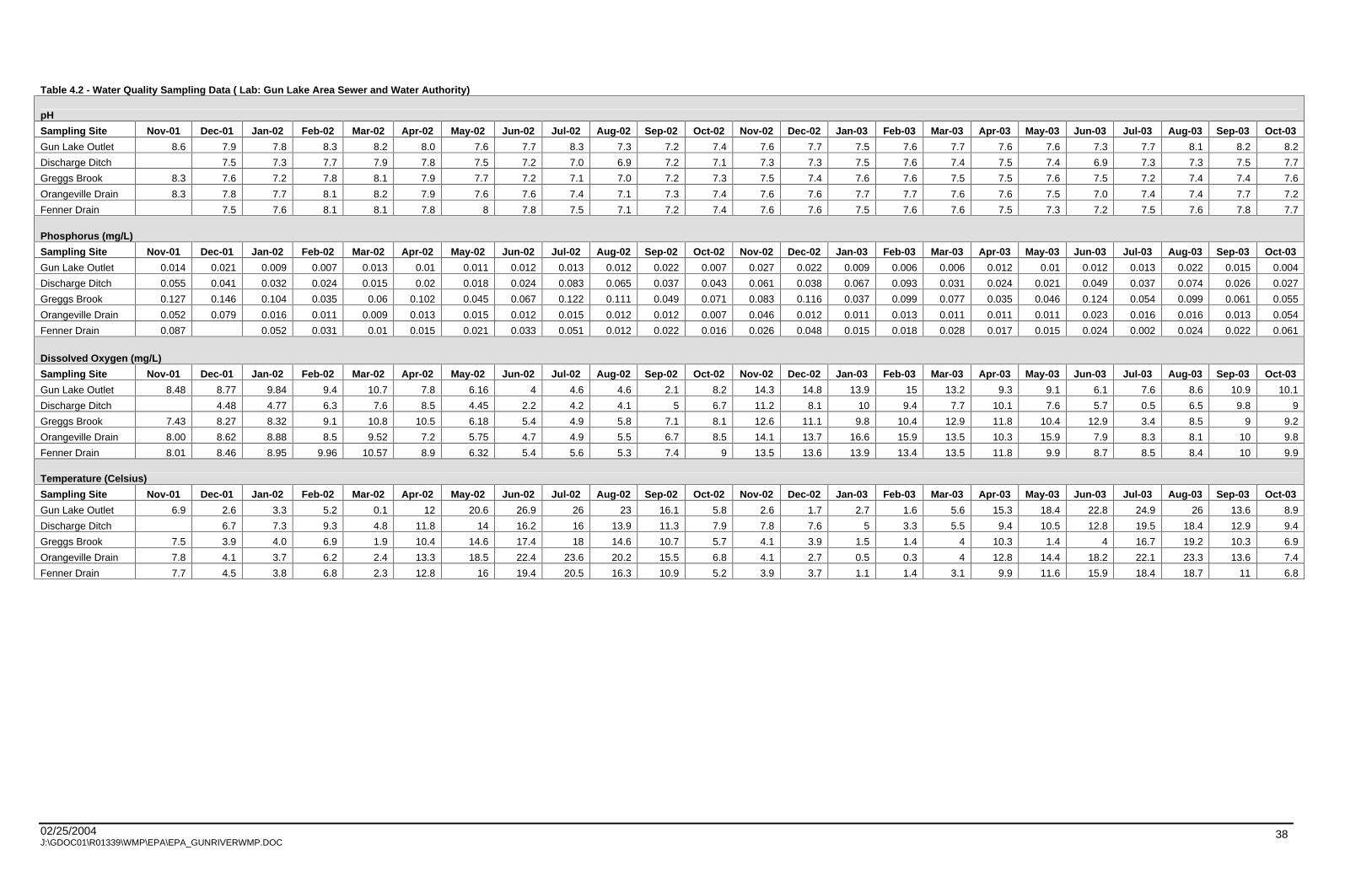
02/25/2004 J:\GDOC01\R01339\WMP\EPA\EPA_GUNRIVERWMP.DOC
38
Table 4.2 - Water Quality Sampling Data ( Lab: Gun Lake Area Sewer and Water Authority)
pH
Sampling Site Nov-01 Dec-01 Jan-02 Feb-02 Mar-02 Apr-02 May-02 Jun-02 Jul-02 Aug-02 Sep-02 Oct-02 Nov-02 Dec-02 Jan-03 Feb-03 Mar-03 Apr-03 May-03 Jun-03 Jul-03 Aug-03 Sep-03 Oct-03
Gun Lake Outlet 8.6 7.9 7.8 8.3 8.2 8.0 7.6 7.7 8.3 7.3 7.2 7.4 7.6 7.7 7.5 7.6 7.7 7.6 7.6 7.3 7.7 8.1 8.2 8.2
Discharge Ditch 7.5 7.3 7.7 7.9 7.8 7.5 7.2 7.0 6.9 7.2 7.1 7.3 7.3 7.5 7.6 7.4 7.5 7.4 6.9 7.3 7.3 7.5 7.7
Greggs Brook 8.3 7.6 7.2 7.8 8.1 7.9 7.7 7.2 7.1 7.0 7.2 7.3 7.5 7.4 7.6 7.6 7.5 7.5 7.6 7.5 7.2 7.4 7.4 7.6
Orangeville Drain 8.3 7.8 7.7 8.1 8.2 7.9 7.6 7.6 7.4 7.1 7.3 7.4 7.6 7.6 7.7 7.7 7.6 7.6 7.5 7.0 7.4 7.4 7.7 7.2
Fenner Drain 7.5 7.6 8.1 8.1 7.8 8 7.8 7.5 7.1 7.2 7.4 7.6 7.6 7.5 7.6 7.6 7.5 7.3 7.2 7.5 7.6 7.8 7.7
Phosphorus (mg/L)
Sampling Site Nov-01 Dec-01 Jan-02 Feb-02 Mar-02 Apr-02 May-02 Jun-02 Jul-02 Aug-02 Sep-02 Oct-02 Nov-02 Dec-02 Jan-03 Feb-03 Mar-03 Apr-03 May-03 Jun-03 Jul-03 Aug-03 Sep-03 Oct-03
Gun Lake Outlet 0.014 0.021 0.009 0.007 0.013 0.01 0.011 0.012 0.013 0.012 0.022 0.007 0.027 0.022 0.009 0.006 0.006 0.012 0.01 0.012 0.013 0.022 0.015 0.004
Discharge Ditch 0.055 0.041 0.032 0.024 0.015 0.02 0.018 0.024 0.083 0.065 0.037 0.043 0.061 0.038 0.067 0.093 0.031 0.024 0.021 0.049 0.037 0.074 0.026 0.027
Greggs Brook 0.127 0.146 0.104 0.035 0.06 0.102 0.045 0.067 0.122 0.111 0.049 0.071 0.083 0.116 0.037 0.099 0.077 0.035 0.046 0.124 0.054 0.099 0.061 0.055
Orangeville Drain 0.052 0.079 0.016 0.011 0.009 0.013 0.015 0.012 0.015 0.012 0.012 0.007 0.046 0.012 0.011 0.013 0.011 0.011 0.011 0.023 0.016 0.016 0.013 0.054
Fenner Drain 0.087 0.052 0.031 0.01 0.015 0.021 0.033 0.051 0.012 0.022 0.016 0.026 0.048 0.015 0.018 0.028 0.017 0.015 0.024 0.002 0.024 0.022 0.061
Dissolved Oxygen (mg/L)
Sampling Site Nov-01 Dec-01 Jan-02 Feb-02 Mar-02 Apr-02 May-02 Jun-02 Jul-02 Aug-02 Sep-02 Oct-02 Nov-02 Dec-02 Jan-03 Feb-03 Mar-03 Apr-03 May-03 Jun-03 Jul-03 Aug-03 Sep-03 Oct-03
Gun Lake Outlet 8.48 8.77 9.84 9.4 10.7 7.8 6.16 4 4.6 4.6 2.1 8.2 14.3 14.8 13.9 15 13.2 9.3 9.1 6.1 7.6 8.6 10.9 10.1
Discharge Ditch 4.48 4.77 6.3 7.6 8.5 4.45 2.2 4.2 4.1 5 6.7 11.2 8.1 10 9.4 7.7 10.1 7.6 5.7 0.5 6.5 9.8 9
Greggs Brook 7.43 8.27 8.32 9.1 10.8 10.5 6.18 5.4 4.9 5.8 7.1 8.1 12.6 11.1 9.8 10.4 12.9 11.8 10.4 12.9 3.4 8.5 9 9.2
Orangeville Drain 8.00 8.62 8.88 8.5 9.52 7.2 5.75 4.7 4.9 5.5 6.7 8.5 14.1 13.7 16.6 15.9 13.5 10.3 15.9 7.9 8.3 8.1 10 9.8
Fenner Drain 8.01 8.46 8.95 9.96 10.57 8.9 6.32 5.4 5.6 5.3 7.4 9 13.5 13.6 13.9 13.4 13.5 11.8 9.9 8.7 8.5 8.4 10 9.9
Temperature (Celsius)
Sampling Site Nov-01 Dec-01 Jan-02 Feb-02 Mar-02 Apr-02 May-02 Jun-02 Jul-02 Aug-02 Sep-02 Oct-02 Nov-02 Dec-02 Jan-03 Feb-03 Mar-03 Apr-03 May-03 Jun-03 Jul-03 Aug-03 Sep-03 Oct-03
Gun Lake Outlet 6.9 2.6 3.3 5.2 0.1 12 20.6 26.9 26 23 16.1 5.8 2.6 1.7 2.7 1.6 5.6 15.3 18.4 22.8 24.9 26 13.6 8.9
Discharge Ditch 6.7 7.3 9.3 4.8 11.8 14 16.2 16 13.9 11.3 7.9 7.8 7.6 5 3.3 5.5 9.4 10.5 12.8 19.5 18.4 12.9 9.4
Greggs Brook 7.5 3.9 4.0 6.9 1.9 10.4 14.6 17.4 18 14.6 10.7 5.7 4.1 3.9 1.5 1.4 4 10.3 1.4 4 16.7 19.2 10.3 6.9
Orangeville Drain 7.8 4.1 3.7 6.2 2.4 13.3 18.5 22.4 23.6 20.2 15.5 6.8 4.1 2.7 0.5 0.3 4 12.8 14.4 18.2 22.1 23.3 13.6 7.4
Fenner Drain 7.7 4.5 3.8 6.8 2.3 12.8 16 19.4 20.5 16.3 10.9 5.2 3.9 3.7 1.1 1.4 3.1 9.9 11.6 15.9 18.4 18.7 11 6.8

02/25/2004 J:\GDOC01\R01339\WMP\EPA\EPA_GUNRIVERWMP.DOC
39
Table 4.2 - Water Quality Sampling Data (Lab: Menasha)
pH Sampling Site Nov-01 Dec-01 Jan-02 Feb-02 Mar-02 Apr-02 May-02 Jun-02 Jul-02 Aug-02 Sep-02 Oct-02 Nov-02 Dec-02 Jan-03 Feb-03 Mar-03 Apr-03 May-03 Jun-03 Jul-03 Aug-03 Sep-03 Gun Lake Outlet 6.6 Greggs Brook 7.6 7.7 7.3 7.9 N/A 7.9 7.5 7.6 8.1 8.0 Orangeville Drain 7.8 7.7 8.0 8.0 N/A 7.9 7.7 8.2 8.3 8.3 Fenner Drain 7.6 7.6 7.7 7.9 N/A 7.9 7.7 7.8 8.2 8.1
Conductivity Sampling Site Nov-01 Dec-01 Jan-02 Feb-02 Mar-02 Apr-02 May-02 Jun-02 Jul-02 Aug-02 Sep-02 Oct-02 Nov-02 Dec-02 Jan-03 Feb-03 Mar-03 Apr-03 May-03 Jun-03 Jul-03 Aug-03 Gun Lake Outlet 330 Greggs Brook 610 630 590 600 N/A 590 610 570 560 580 Orangeville Drain 440 440 440 440 N/A 450 430 410 410 430 Fenner Drain 730 730 730 720 N/A 770 760 810 810 800
Nitrate (mg/L) Sampling Site Nov-01 Dec-01 Jan-02 Feb-02 Mar-02 Apr-02 May-02 Jun-02 Jul-02 Aug-02 Sep-02 Oct-02 Gun Lake Outlet 0.3 Greggs Brook 2.0 2.8 8.0 11.0 N/A N/A 3.1 2.1 1.1 2.4 Orangeville Drain 0.3 0.3 2.0 1.0 N/A N/A 0.2 0.3 0.2 0.2 Fenner Drain 2.7 3.9 13.0 11.0 N/A N/A 4.5 4.2 4.9 4.4
Nitrite (mg/L) Sampling Site Nov-01 Dec-01 Jan-02 Feb-02 Mar-02 Apr-02 May-02 Jun-02 Jul-02 Aug-02 Sep-02 Oct-02 Gun Lake Outlet 0.0039 Greggs Brook 0.0705 0.0330 0.0900 0.0800 N/A N/A 0.0900 0.1500 0.0600 0.0700 Orangeville Drain 0.0037 0.0040 0.0200 0.0200 N/A N/A 0.0100 0.0100 0.0100 0.0100 Fenner Drain 0.0328 0.0340 0.1100 0.1000 N/A N/A 0.0500 0.0600 0.0200 0.0400
Ammonia (mg/L) Sampling Site Nov-01 Dec-01 Jan-02 Feb-02 Mar-02 Apr-02 May-02 Jun-02 Jul-02 Aug-02 Sep-02 Oct-02 Gun Lake Outlet 0.167 Greggs Brook 0.414 0.375 0.360 0.230 N/A 0.140 0.280 0.350 0.140 0.450 Orangeville Drain 0.158 0.175 0.210 0.160 N/A 0.120 0.180 0.180 0.060 0.080 Fenner Drain 0.269 0.224 0.210 0.120 N/A 0.080 0.150 0.220 0.130 0.110
Ortho-P (mg/L) Sampling Site Nov-01 Dec-01 Jan-02 Feb-02 Mar-02 Apr-02 May-02 Jun-02 Jul-02 Aug-02 Sep-02 Oct-02 Gun Lake Outlet 0.023 Greggs Brook 0.066 0.080 0.040 0.060 N/A 0.020 0.030 0.060 0.050 0.100 Orangeville Drain 0.019 0.050 0.050 0.060 N/A 0.010 0.030 0.030 0.030 0.040 Fenner Drain 0.037 0.050 0.050 0.050 N/A 0.010 0.030 0.050 0.050 0.030
Total P (mg/L) Sampling Site Nov-01 Dec-01 Jan-02 Feb-02 Mar-02 Apr-02 May-02 Jun-02 Jul-02 Aug-02 Sep-02 Oct-02 Nov-02 Dec-02 Jan-03 Feb-03 Mar-03 Apr-03 May-03 Jun-03 Jul-03 Aug-03 Gun Lake Outlet 0.052 Greggs Brook 0.185 0.220 0.050 0.040 0.040 0.070 0.050 0.070 0.130 0.110 0.200 0.090 0.100 0.240 0.050 0.110 0.060 0.050 0.060 0.080 0.050 0.090 Orangeville Drain 0.135 0.050 0.020 0.010 0.020 0.090 0.020 0.020 0.030 0.020 0.090 0.020 0.020 0.020 0.020 0.030 0.020 0.020 0.020 0.020 0.030 0.020 Fenner Drain 0.578 0.120 0.070 0.040 0.030 0.080 0.040 0.040 0.040 0.030 0.080 0.020 0.030 0.100 0.030 0.040 0.040 0.030 0.020 0.030 0.030 0.030
Suspended Soilds (mg/L) Sampling Site Nov-01 Dec-01 Jan-02 Feb-02 Mar-02 Apr-02 May-02 Jun-02 Jul-02 Aug-02 Sep-02 Oct-02 Gun Lake Outlet 2.0 Greggs Brook 20.4 18.8 7.0 5.6 N/A 4.0 8.0 12.8 4.0 1.6 Orangeville Drain 0.4 3.6 2.0 1.2 N/A 3.0 4.0 2.4 4.0 1.0 Fenner Drain 25.6 30.4 16.0 10.8 N/A 3.0 8.0 16.0 5.0 4.0
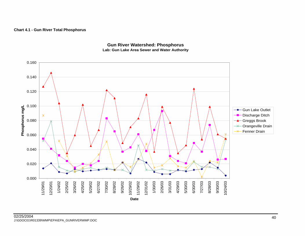
02/25/2004 J:\GDOC01\R01339\WMP\EPA\EPA_GUNRIVERWMP.DOC
40
Chart 4.1 - Gun River Total Phosphorus
Gun River Watershed: PhosphorusLab: Gun Lake Area Sewer and Water Authority
0.000
0.020
0.040
0.060
0.080
0.100
0.120
0.140
0.160
11/2
9/01
12/2
0/01
1/24
/02
2/25
/02
3/26
/02
4/25
/02
5/29
/02
6/27
/02
7/30
/02
8/28
/02
9/26
/02
10/2
9/02
11/2
9/02
12/3
1/02
1/30
/03
2/26
/03
3/31
/03
4/29
/03
5/30
/03
6/30
/03
7/27
/03
8/28
/03
9/30
/03
10/2
4/03
Date
Ph
osp
ho
rus
mg
/L
Gun Lake Outlet
Discharge Ditch
Greggs Brook
Orangeville Drain
Fenner Drain

02/25/2004 J:\GDOC01\R01339\WMP\EPA\EPA_GUNRIVERWMP.DOC
41
Chart 4.2 - Gun River Dissolved Oxygen
Gun River Watershed Dissolved OxygenLab: Gun Lake Areas Sewer and Water Authority
0.00
2.00
4.00
6.00
8.00
10.00
12.00
14.00
16.00
18.00
11/2
9/01
12/2
0/01
1/24
/02
2/25
/02
3/26
/02
4/25
/02
5/29
/02
6/27
/02
7/30
/02
8/28
/02
9/26
/02
10/2
9/02
11/2
9/02
12/3
1/02
1/30
/03
2/26
/03
3/31
/03
4/29
/03
5/30
/03
6/30
/03
7/27
/03
8/28
/03
9/30
/03
10/2
4/03
Date
Dis
solv
ed O
xygen
mg/L
Gun Lake Outlet
Discharge Ditch
Greggs Brook
Orangeville Drain
Fenner Drain

02/25/2004 J:\GDOC01\R01339\WMP\EPA\EPA_GUNRIVERWMP.DOC
42
Chart 4.3 - Gun River Water Temperature
Gun River Wateshed: Water TemperatureLab: Gun Lake Area Sewer and Water Authority
0.0
5.0
10.0
15.0
20.0
25.0
30.0
11/2
9/01
12/2
0/01
1/24
/02
2/25
/02
3/26
/02
4/25
/02
5/29
/02
6/27
/02
7/30
/02
8/28
/02
9/26
/02
10/2
9/02
11/2
9/02
12/3
1/02
1/30
/03
2/26
/03
3/31
/03
4/29
/03
5/30
/03
6/30
/03
7/27
/03
8/28
/03
9/30
/03
10/2
4/03
Date
Tem
per
ature
Deg
rees
Cel
sius
Gun Lake Outlet
Discharge Ditch
Greggs Brook
Orangeville Drain
Fenner Drain
02/25/2004 J:\GDOC01\R01339\WMP\EPA\EPA_GUNRIVERWMP.DOC
43
4.1 WATERSHED INVENTORY
4.1.1 METHODOLOGY
An assessment of the condition of the Watershed is most accurate when conducted by visual, in-the-field
observation. The Watershed was field inventoried to identify NPS pollution sites during the months of July
through November 2001. The Gun River was canoed from the Gun Lake dam to the southernmost bridge
at 107th Avenue, before the outlet to the Kalamazoo River. All tributaries to the Gun River were walked,
where shallow enough, heading upstream so as not to disturb the sediment and decrease visibility.
At each site where a pollution problem was evident, a data sheet was completed. Basic information was
recorded about the size of the stream, surrounding land use, buffers, and weather conditions. Seven
categories were described on the sheets: debris and trash, construction sites, stream crossings, rill and
gully erosion, tile outlets, streambank erosion, and other. Within each category, characteristics were
described, which could be used to group and rank these sites. Sample inventory forms are provided in
Appendix 2. Each site was recorded geographically with a Global Positioning System unit, when
available, or drawn on a map. A photograph was taken at each site.
The sites were numbered for field inventory using a code that consisted of four parts. The first part was
based on the EPA s Reach File 3 numbering system. Streams that were not numbered by the EPA were
given a number based on the major tributary it fed into plus an extension number. For example, a
unnumbered stream that flowed into reach number 867 could be numbered 8671. Unnumbered streams
were given extension numbers in a consecutive manner heading upstream. The second part of the site
number was the first three letters of the township. The third portion was the two digit section number. The
final part was a two digit number indicating the sequence in which the sites were investigated on that
reach. For example, the first site on reach 234 in Martin Township, Section 22, would be numbered
234MAR2201.
The data was verified and checked for inconsistencies, then converted to a DBF(IV) file and entered as a
point file into ArcView 3.2 Geographic Information System (GIS). Figure 12 displays the sites that were
identified as contributing NPS pollution as points on the map. The photographs of each site were linked to
the points. The data was sorted by category and ranked according to severity as recorded on the data
sheets.

02/25/2004 J:\GDOC01\R01339\WMP\EPA\EPA_GUNRIVERWMP.DOC
44
All the road/stream crossings were inventoried according to the MDEQ procedures. The standard MDEQ
stream crossing data sheets were used to document the physical and habitat conditions as well as
surrounding land use and cover on both the upstream and downstream sides of the road. Examples are
included in Appendix 2. Digital photographs were taken facing both upstream and downstream from the
crossings.
4.1.2 FINDINGS
Using the characteristics within each category, the sites were ranked by severity (Table 4.3). Multiple
characteristics could be recorded at each site. The most sites identified in a category in the Watershed
was streambank erosion, with a total of 54 sites. The majority of the sites had mostly bare banks. Stream
crossings were characterized with erosion at 42 sites. Problems were mainly due to degraded condition of
the structure, flow blockage, or embankment erosion. Many of the 33 sites in the debris category were log
jams, which blocked flow or diverted water to cause erosion. Two major types of problems were
associated with the 32 sites in the tile outlet category: erosion and discharge. The placement of the tile
outlet causes erosion if the outlet is too high causing splash pools and eddy currents. Some outlets were
discharging water with unnatural color and odor. The 23 sites in the rill or gully erosion category occurred
predominantly in agricultural areas. Some erosion was the result of improperly functioning culverts or
tiles, and many gullies were contributing large amounts of sediment.
Table 4.3 - Summary of Inventory Data in the Gun River Watershed Sources of Pollutants Characteristic Number
Total 54 Washout 13 Mostly bare bank 27
Streambank Erosion
> 100' 13 Total 42 Condition = poor 9 Condition = fair 11 Erosion = severe 10 Erosion = moderate 8
Crossings
Erosion = minor 12
Total 33 Extensive 5 Moderate 12
Debris
Slight 16 Total 32 Eroding 15 Discharge color 2
Tile Outlets
Discharge odor 2

02/25/2004 J:\GDOC01\R01339\WMP\EPA\EPA_GUNRIVERWMP.DOC
45
Table 4.3 - Summary of Inventory Data in the Gun River Watershed
Sources of Pollutants Characteristic Number
Total 27 Crop related 19 Livestock related 3
Upland Source
Residential related 3 Total 23 >10' long 16 >2' wide 10
Rill And Gully
>2' deep 8 Livestock Access Erosion 1
Construction sites 1 Zebra mussels 1 Hydrocarbons 2 Foamy water 1 Wetland destruction 1
Other
Unknown source 2
Other problems that could not be specifically included in any one category are summarized under the
Other category. Items in this category included construction sites that were not adequately controlling
for erosion and sedimentation under Part 91 Act 451, PA 1994. Present soil erosion and sedimentation
control (SESC) regulations requires the use of proper SESC management practices. Additional items in
the Other
category were leaking fuel tanks on irrigation pumps and the spread of exotic or invasive
species. More details about the location and description of these sites can be found in Chapter 5.
4.2 HYDROLOGIC AND HYDRAULIC ANALYSES
4.2.1 INTRODUCTION
Hydrologic and hydraulic analyses were performed for the Gun River in Allegan and Barry Counties as an
additional study component of the Gun River Watershed Management Plan. An understanding of the
hydrologic and hydraulic characteristics of the Gun River Watershed (Watershed) is consistent with the
goal of reducing nonpoint source pollution. The information provided by this study is related to nonpoint
source pollution issues in the following ways.
Determination of the 100-year floodplain will reduce the risk of new development locating not only
buildings, but septic systems and other potentially hazardous facilities where they may be inundated
by flood waters, thus causing health concerns and/or transport of the associated pathogens/toxics.

02/25/2004 J:\GDOC01\R01339\WMP\EPA\EPA_GUNRIVERWMP.DOC
46
Storm water design criteria adapted at the county level that incorporates stream protection volume for
all headwater streams based on numerous urban storm water studies and supported by the
conclusions of this analysis, will help maintain more stable channel forming flows and reduce the
amount of sediment deposited in the waters of the state from accelerated streambank erosion.
An understanding of the hydrology of a watershed, the hydraulics of a river or stream and the effects
that proposed land use changes and Best Management Practices (BMPs) may have on flow rates,
volumes, and velocities is directly related to surface water quality by virtue of maintaining the dynamic
equilibrium of the stream and preventing degradation of the water body.
4.2.2 METHODOLOGIES
Hydrologic analysis is performed using a computational model to determine storm water discharges from
individual subbasins for various frequency rainfall events. The software used for the hydrologic model is
the U.S. Army Corps of Engineers program HEC-HMS. This program computes subbasin hydrographs (a
relationship between flow rate and time for a particular rainfall event), which are used as inputs into a
hydraulic model to compute river hydrographs, flow velocities, and water surface elevations. The initial
analysis is completed based on current land use conditions in the Watershed. Storm water detention
alternatives to minimize negative impacts from projected future land use changes are also evaluated.
Hydraulic analysis is performed to predict flow rates, velocities, and water surface elevations in a river.
This analysis uses the U.S. Army Corps of Engineers computer program HEC-RAS. The recent release of
this computer program is able to model time varying flows. Instead of using steady state flow rates based
on peak hydrograph values from the hydrologic analysis, this version of the program takes the subbasin
hydrographs, as determined by HEC-HMS, and accurately combines and routes the hydrographs in a
downstream progression along the river system. The model is also able to account for available storage
in the floodplain.
4.2.3 HYDROLOGIC ANALYSIS
Overall, the Gun River appears to be a relatively stable channel due to the non-flashy nature of the
Watershed as a whole. Annual maintenance due to fallen trees and log jams is ongoing, but not found to
be excessive.
The upper portion of the Watershed, which drains into Gun Lake, is characterized by residential and
recreational uses. Future development in this area will have minimal impact on the Gun River because of
the storage available in Gun Lake. The middle portion of the Watershed is characterized by agricultural

02/25/2004 J:\GDOC01\R01339\WMP\EPA\EPA_GUNRIVERWMP.DOC
47
uses. Significant runoff volumes enter the Gun River by way of three major tributaries: Greggs Brook,
Orangeville Drain, and Fenner Creek. Peak flows from these three tributaries have been known to back
up into the upper portion. Here there has been a trend toward fallow/open land uses which should result
in lower flow rates. The lower portion of the Watershed in Otsego and Gun Plain Townships is
characterized by increasing urban development as indicated in future land use plans, although urban
sprawl is occurring throughout the watershed. This development could have a significant impact on the
amount of runoff entering the Gun River.
Hydrographs from three of the subbasins are compared in Chart 4.4 to highlight the differences in their
hydrologic response: Gun Lake basin (at Gun Lake Dam outlet), Fenner Creek, and Bellingham Drain.
Gun Lake basin is the largest of the 12 subbasins and therefore releases the largest volume of water. As
a result, the area under the hydrograph is the greatest for this subbasin. Storm water draining from the
Gun Lake basin is stored in Gun Lake and then released slowly due to the controlling effect of Gun Lake
Dam. The peak flows, therefore, occur later and storm water is released over a longer period of time. The
center of the Bellingham subbasin is closer to the Gun River than the center of Fenner Creek. Bellingham
therefore has a shorter time of concentration resulting in an earlier peak in the hydrograph. The water
draining from Bellingham is released more quickly than any of the other subbasins resulting in a higher
peak flow rate.

02/25/2004 J:\GDOC01\R01339\WMP\EPA\EPA_GUNRIVERWMP.DOC
48
Chart 4.4 - Hydrographs for 100-Year Storm
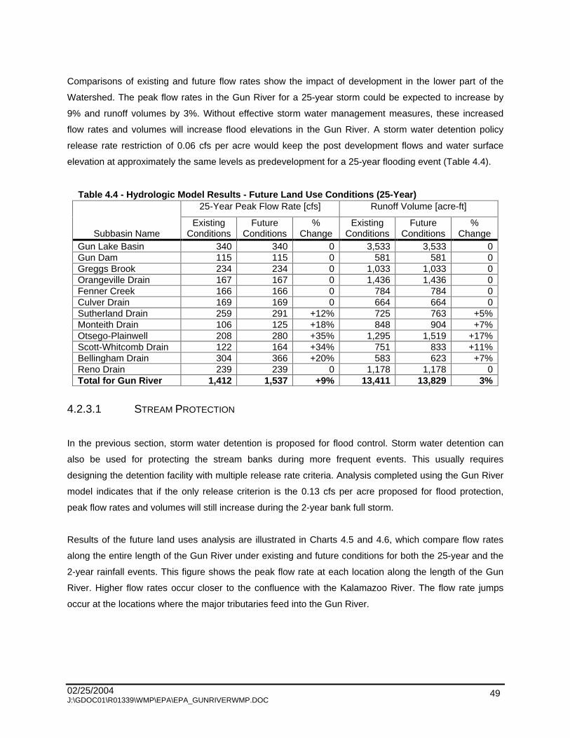
02/25/2004 J:\GDOC01\R01339\WMP\EPA\EPA_GUNRIVERWMP.DOC
49
Comparisons of existing and future flow rates show the impact of development in the lower part of the
Watershed. The peak flow rates in the Gun River for a 25-year storm could be expected to increase by
9% and runoff volumes by 3%. Without effective storm water management measures, these increased
flow rates and volumes will increase flood elevations in the Gun River. A storm water detention policy
release rate restriction of 0.06 cfs per acre would keep the post development flows and water surface
elevation at approximately the same levels as predevelopment for a 25-year flooding event (Table 4.4).
Table 4.4 - Hydrologic Model Results - Future Land Use Conditions (25-Year) 25-Year Peak Flow Rate [cfs] Runoff Volume [acre-ft]
Subbasin Name Existing
Conditions Future
Conditions %
Change Existing
Conditions Future
Conditions %
Change Gun Lake Basin 340
340
0
3,533
3,533
0
Gun Dam 115
115
0
581
581
0
Greggs Brook 234
234
0
1,033
1,033
0
Orangeville Drain 167
167
0
1,436
1,436
0
Fenner Creek 166
166
0
784
784
0
Culver Drain 169
169
0
664
664
0
Sutherland Drain 259
291
+12%
725
763
+5%
Monteith Drain 106
125
+18%
848
904
+7%
Otsego-Plainwell 208
280
+35%
1,295
1,519
+17%
Scott-Whitcomb Drain 122
164
+34%
751
833
+11%
Bellingham Drain 304
366
+20%
583
623
+7%
Reno Drain 239
239
0
1,178
1,178
0
Total for Gun River 1,412
1,537
+9%
13,411
13,829
3%
4.2.3.1 STREAM PROTECTION
In the previous section, storm water detention is proposed for flood control. Storm water detention can
also be used for protecting the stream banks during more frequent events. This usually requires
designing the detention facility with multiple release rate criteria. Analysis completed using the Gun River
model indicates that if the only release criterion is the 0.13 cfs per acre proposed for flood protection,
peak flow rates and volumes will still increase during the 2-year bank full storm.
Results of the future land uses analysis are illustrated in Charts 4.5 and 4.6, which compare flow rates
along the entire length of the Gun River under existing and future conditions for both the 25-year and the
2-year rainfall events. This figure shows the peak flow rate at each location along the length of the Gun
River. Higher flow rates occur closer to the confluence with the Kalamazoo River. The flow rate jumps
occur at the locations where the major tributaries feed into the Gun River.
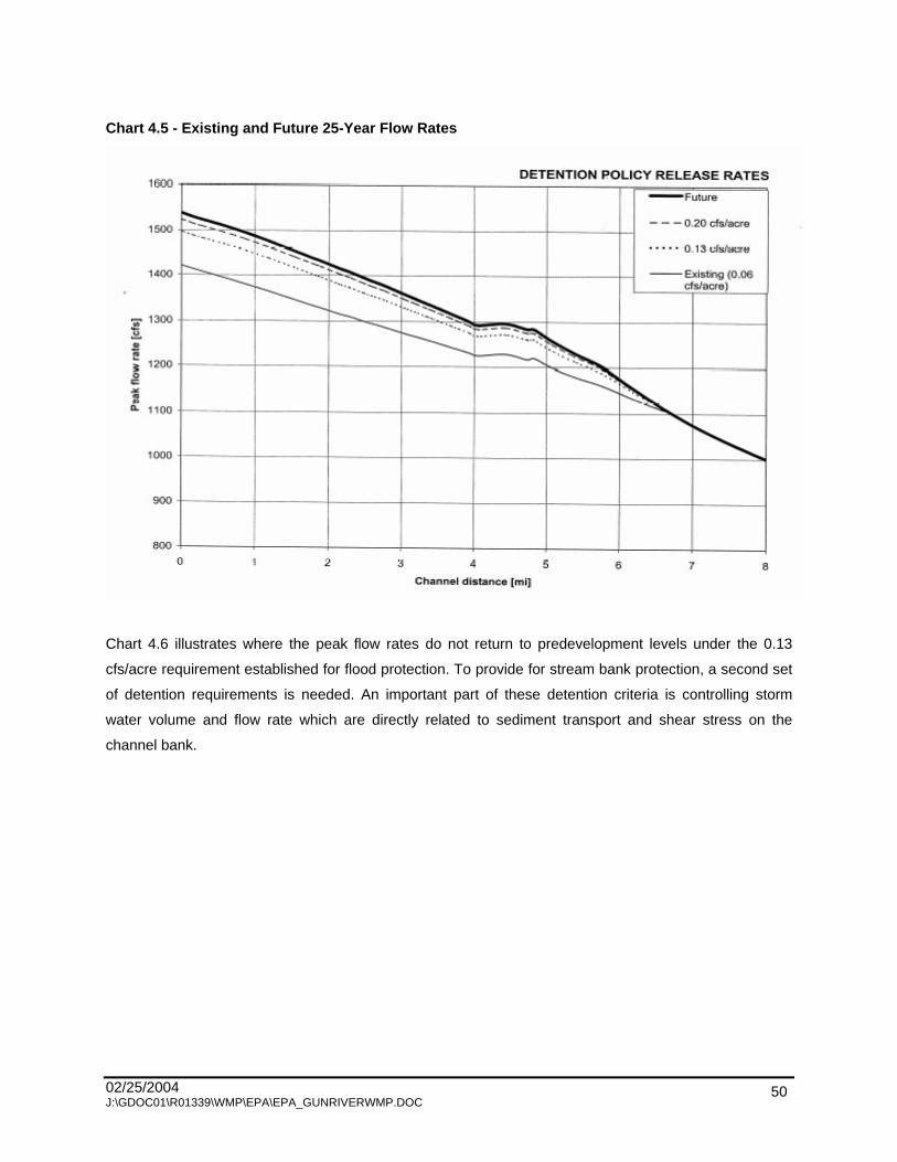
02/25/2004 J:\GDOC01\R01339\WMP\EPA\EPA_GUNRIVERWMP.DOC
50
Chart 4.5 - Existing and Future 25-Year Flow Rates
Chart 4.6 illustrates where the peak flow rates do not return to predevelopment levels under the 0.13
cfs/acre requirement established for flood protection. To provide for stream bank protection, a second set
of detention requirements is needed. An important part of these detention criteria is controlling storm
water volume and flow rate which are directly related to sediment transport and shear stress on the
channel bank.

02/25/2004 J:\GDOC01\R01339\WMP\EPA\EPA_GUNRIVERWMP.DOC
51
Chart 4.6 - Existing and Future 2-Year Flow Rates
Several methods have been proposed for establishing criteria for stream protection. One method is two
year control where the post-development peak discharge rates are held to the pre-development rates for
the two-year event. Some studies have indicated that this method may actually exacerbate erosion since
banks are exposed to erosive velocities for a longer duration. Another approach, where infiltration is not
feasible, is to design the detention facility to hold the 1 to 2 year event for a period of 24 hours (i.e. there
should be a 24-hour lag between the centriods of the inflow and outflow hydrographs). This extended
detention approach releases the runoff in such a gradual manner that critical erosive velocities would
seldom be exceeded in downstream channels.
FTC&H has done extensive detention basin modeling to establish release rate criteria for stream
protection. A stream protection release rate has been determined which, if used, will detain the 1.5- year
runoff for the required 24 hours. The results of this work has been used to establish storm water detention
rules for neighboring counties. A detailed description of this work can be found in Appendix 6 of the Gun
River Watershed Hydrologic and Hydraulic Study report.

02/25/2004 J:\GDOC01\R01339\WMP\EPA\EPA_GUNRIVERWMP.DOC
52
This release rate needed for stream protection is a function of the soil type in the drainage area and the
degree of imperviousness in the associated development. Release rates restrictions and required
detention storage volumes can be expressed in several ways and at several levels of detail. Chart 4.7
shows the release rate (in cfs/acre) and required storage volume (in ft3 /acre) as a function of the
developed Curve Number. An alternative to this gives the release rate as a function of the hydrologic soil
group and the number of impervious acres in the development. This approach applied to Allegan county
gives the following results:
Hydrologic soil group A: 0.026 cfs and 3,000 ft3 storage per impervious acre.
Hydrologic soil group B: 0.034 cfs and 4,000 ft3 storage per impervious acre.
Hydrologic soil group C: 0.051 cfs and 5,800 ft3 storage per impervious acre.
Hydrologic soil group D: 0.059 cfs and 5,800 ft3 storage per impervious acre.
Chart 4.7 - Release Rate as a Function of Curve Number
0.000
0.005
0.010
0.015
0.020
0.025
0.030
0.035
0.040
65 70 75 80 85 90 95
Curve Number
Rel
ease
rat
e [c
fs/a
cre]
0
500
1000
1500
2000
2500
3000
3500
4000
4500
5000
Sto
rag
e V
olu
me
[cft
/acr
e]
Release Rate
Storage Volume
A third method assumes that developments with A and B soils will use infiltration to reduce peak flows.
Using the lower release rate for soil groups C and D gives a value of 0.05 cfs per impervious acre along
with 5,800 ft3 of storage per impervious acre. It should be noted that runoff from the pervious portion of
02/25/2004 J:\GDOC01\R01339\WMP\EPA\EPA_GUNRIVERWMP.DOC
53
the development is still included in the volume recommendations above. This approach just uses the
number of impervious acres to predict the volume needed to detain runoff from the entire site.
All of these methods are fully explained in the Gun River Watershed Hydrologic and Hydraulic Study
report.
4.2.4 HYDRAULIC ANALYSIS
The hydraulic analysis provides predictions of river hydraulic characteristics (i.e., flow rates, water surface
elevations, velocities, etc.) during storm events. The calibrated model was used to predict the flow rates
and water surface elevations for the 2 -, 5-, 10-, 25-, 50-, and 100-year flood events. The peak flow rates,
maximum water surface elevations, average channel velocity, flow area, and water surface top width
computed for each of these events at the Gun River cross-sections surveyed in 1985 and 2001 were
tabulated. The results provided the flood profiles for the 10-year through 100-year rainfall frequencies and
the 100-year flood hazard zones for the Gun River.
Flooding is expected on the approaches at 9th Street and 106th Avenue during the 100-year event. This
has the potential of causing damage or increasing maintenance of these road surfaces. None of the other
publicly owned bridge or culvert crossings are predicted to be overtopped.
The Allegan County Land Information Services (LIS) department provided detailed maps of elevations
within the flood hazard zone to be used for future mapping and planning projects.
The road crossings that are expected to flood during a 100-year event are 9th Street and 106th Avenue
by 0.2 feet and 0.3 feet, respectively. In both cases the flows will pass over the approach road. The farm
lane south of 122nd Avenue also shows overtopping by 0.6 feet.
It is apparent from the water surface profiles that the culverts at 116th and 118th Avenues cause the
greatest rise in water surface elevations and directly impact the predicted elevation of the floodplain
upstream.

02/25/2004 J:\GDOC01\R01339\WMP\EPA\EPA_GUNRIVERWMP.DOC
54
4.2.5 BENEFITS OF THE STUDY
The primary benefit of this study is the following information provided through the analysis, which can be
used by decision makers in the Watershed.
In regard to county storm water design criteria, a storm water detention policy release rate restriction
of 0.06 cfs per acre was determined to keep the post development flows and water surface elevations
at the same levels as predevelopment for a 25-year flooding event. The analysis was completed for
development in Gun Plain and Otsego Townships and the City of Plainwell only, based on future land
use maps.
Follow up: Re-zoning for urban development us actively taking place in Martin Township. The Allegan
County Drain Commissioner is considering updates to county standards that call for a detention basin
release rate of 0.13 cfs/acre for a 100-year storm. A special policy statement for the Gun River
Watershed could be included.
Analysis performed assuming a 0.13 cfs acre detention basin release rate during a 25-year storm,
(based on anticipated Allegan County standards) indicated that peak flow rates and volumes increase
during a 2-year bankfull event. Therefore, stream protection volume requirements should also be
incorporated into the county s rules. One suggested method, for circumstances where infiltration is
not possible, is based on routing runoff from a 1.5-year storm through a detention basin and detaining
it for 24 hours.
Follow up: Draft rules of the Allegan County Drain Commissioner contain provisions for stream
protection volume.
The HEC-RAS model may be used to evaluate improvements to hydraulic structures, construction or
removal of levies (spoil banks), and other proposed scenarios. Base flows and peak flow rates for a
range of storm frequencies are provided for use in sizing hydraulic structures (bridges, culverts, and
weirs) in accordance with county drain and the Michigan Department of Environmental Quality
(MDEQ) requirements, or for sizing certain streambank stabilization or fish habitat structures.
Follow up: Specific scenarios have already been requested by local engineering firms, and the model
has been modified for use in these independent projects to evaluate the impact of various landform
changes on the system hydraulics. Results will be used to obtain regulatory permits for proposed
developments.

02/25/2004 J:\GDOC01\R01339\WMP\EPA\EPA_GUNRIVERWMP.DOC
55
The map of flood hazard zones may be integrated with the Allegan County LIS, and used to regulate
development within the floodplain. Maps are provided as Figures 8A-8F.
This work may be used to expedite regular participation in the Federal Emergency Management
Agency (FEMA) Flood Insurance Program for Otsego and Gun Plain Townships through a
partnership between Allegan County and FEMA. At a minimum, this information should be provided to
FEMA when Allegan and Barry Counties are scheduled for floodplain map updates as part of FEMA s
Floodplain Mapping Update Program.
4.2.6 CONCLUSIONS OF THE STUDY
Conclusions from the Hydrologic and Hydraulic (H&H) Analysis of the Gun River are be summarized as
follows:
Overall, the Gun River appears to be relatively stable due to the non-flashy nature of the
Watershed.
The hydrology of the Watershed is such that development upstream of Gun Lake will have minimal
impact of the Gun River due to the large amount of storage available in Gun Lake. Low, broad
hydrographs are characteristic of the discharge from Gun Lake (i.e., the upper watershed).
The most significant contribution to the Gun River downstream of Gun Lake is via three major
tributaries that enter at about midpoint along the Gun River. The large contribution of discharge from
Greggs Brook, Orangeville Drain, and Fenner Creek will actually cause reverse flow in the upper
portion of the Gun River during flood events. However, the land use trend over the last 40 years (as
indicated on land cover maps) has been from intense agricultural use toward more fallow and open
space, which would tend to result in lower runoff rates and volumes.
A storm water detention policy release rate restriction of 0.06 cfs per acre was determined to keep the
post development flow and water surface elevation at the same levels as predevelopment for a 25-
year flooding event.
Storm water runoff criteria that control larger flood event (25-year storm) are not effective for
controlling smaller channel forming flows (2-year storm). Therefore, separate design criteria are
needed to protect the tributary streams form new developments.

02/25/2004 J:\GDOC01\R01339\WMP\EPA\EPA_GUNRIVERWMP.DOC
56
The most significant changes in land use between existing zoning and future land use plans are in the
lower portion of the Watershed in Otsego and Gun Plain Townships. However, urban sprawl is
occurring throughout the Watershed regardless of current zoning that indicates an agricultural use.
The only structures that would be expected to overtop during the 100-year flood are the approaches
to the bridges at 9th Street and 106th Avenue. However, it is apparent from the water surface profiles
that the culverts at 116th and 118th Avenues cause the greatest rise in water surface elevations and
directly impact the predicted elevation of the floodplain upstream.
It is important that this effort on behalf of the Gun River not stop here if water resource goals are to be
met for both the Gun River and Lake Allegan, which has a Total Maximum Daily Load for phosphorous.
Implementation of low impact development techniques should be pursued along with quantitative storm
water design criteria for flood control, which is substantiated by the modeling performed during this study.
BMPs for water quality should be included in county storm water rules and township land use ordinances.
4.2.7 STEERING COMMITTEE INPUT
The Steering Committee has expressed a desire to do everything possible from a urban development
perspective. Examples include educating developers and city/township review officials in low impact
development techniques. Provisions to allow for low impact development storm water criteria could be
included in county storm water rules and township land use ordinances to maintain as close as possible
the pre-development hydrology of the site for water quality and stream protection. Provisions should also
allow for cleansing overbank or flood flows in the natural watercourses without increasing flooding.
4.3 DESIGNATED USES
The following eight designated uses have been identified by the State of Michigan for all waters of state to
meet.
Agricultural use
Public water supply at point of intake
Navigation
Warmwater fishery/coldwater fishery
Other indigenous aquatic life and wildlife
Partial body contact recreation
Total body contact recreation between May 1 and October 31
Industrial water supply

02/25/2004 J:\GDOC01\R01339\WMP\EPA\EPA_GUNRIVERWMP.DOC
57
These designated uses provide a starting point for discussion about the goals for the Watershed project.
The Steering Committee evaluated the MDEQ s designated uses for all surface waters and determined
the designated uses that were of concern to the Watershed. The following descriptions of all the
designated uses clarify their importance to the Watershed.
4.3.1 AGRICULTURAL USE
Surface waters must be a consistent and safe source for irrigation and livestock watering. Irrigation is
important in areas of the Watershed that have very well drained soils. Livestock producers in the
Watershed rely on water that is free of pathogens that could pose health risks to the livestock.
4.3.2 PUBLIC WATER SUPPLY AT POINT OF INTAKE
Municipal water supplies must have safe and adequate amounts of surface water. No surface water
intakes for municipal water supplies exist in the Watershed, therefore this designated use is not
addressed.
4.3.3 NAVIGATION
Reaches of waterways that are large enough for canoes or kayaks must maintain navigable conditions.
Recreational users should be able to enjoy a float down the Gun River without experiencing excessive log
jams, low footbridges, and other obstructions that impede navigation.
4.3.4 WARMWATER FISHERY
A warmwater fishery is generally considered to have summer temperatures between 60 and 70 degrees
Fahrenheit and is capable of supporting warmwater species, such as largemouth and smallmouth bass,
on a year-round basis. The MDNR has stocked both the Gun River and Gun Lake with varieties of fish for
many years to sustain and improve the fisheries in the area.
4.3.5 COLDWATER FISHERY
A coldwater fishery is considered to have summer temperatures below 60 degrees Fahrenheit and to be
able to support natural or stocked populations of brook trout. The MDNR has stocked the coldwater
reaches of the Gun River to sustain and improve the fisheries. A healthy riparian habitat is essential to
provide the needed shade to the streams to maintain lower temperatures.

02/25/2004 J:\GDOC01\R01339\WMP\EPA\EPA_GUNRIVERWMP.DOC
58
4.3.6 OTHER INDIGENOUS AQUATIC LIFE AND WILDLIFE
Aquatic plants and animals and other wildlife in the ecosystem should be considered in all management
strategies. A stable and healthy habitat supports populations of wildlife that provide the outdoor
recreational opportunities in the Watershed.
4.3.7 PARTIAL BODY CONTACT RECREATION
Water quality must meet standards of less than 1,000 count/100 mg of E. coli for recreational uses of
fishing and boating, where complete submersion in the water is unlikely, to be safe. The popularity of
fishing and boating in the Watershed necessitates the prevention of E. coli from entering the waterbodies.
E. coli levels in some agricultural areas have exceeded water quality standards.
4.3.8 TOTAL BODY CONTACT RECREATION
Water quality must meet standards of less than 300 count/100 mg of E. coli for areas to be safe for
swimming. Other impediment to total body contact recreation include nuisance aquatic vegetation and
algae blooms from excessive nutrient loadings to the Watershed.
4.3.9 INDUSTRIAL WATER SUPPLY
Industrial water supplies must have cool water with low turbidity. No surface water intakes for industrial
water supplies exist in the Watershed, therefore this designated use is not addressed.
Table 4.5 described the status of each designated use in the Gun River Watershed.
Table 4.5 - Impairments and Threats to Designated Uses Designated Uses Status of Designated Use
Agriculture Impaired by sediment, obstructions, E. coli, hydrology, and invasive and exotic species
Warmwater fishery Impaired by sediment, hydrology, temperature, and nutrients Coldwater fishery Impaired by sediment, nutrients, hydrology, and temperature
Other indigenous aquatic life and wild life Impaired by sediment, nutrients, hydrocarbons and other contaminants, invasive and exotic species, and habitat fragmentation
Partial body contact recreation Impaired by nutrients, obstructions, and E. coli

02/25/2004 J:\GDOC01\R01339\WMP\EPA\EPA_GUNRIVERWMP.DOC
59
Table 4.5 - Impairments and Threats to Designated Uses
Designated Uses Status of Designated Use Total body contact recreation Impaired by nutrients and E. coli Navigation Impaired by hydrology and obstructions Industrial supply Not a use Public water supply Not a use
4.4 DESIRED USES
The Steering Committee members identified desired uses, which are other ways in which the Watershed
is used and additional opportunities for the Watershed to provide in the future. These desired uses can be
implemented through community efforts and partnerships to gain support for and increase the
stewardship of the Watershed.
4.4.1 GROUNDWATER PROTECTION FOR DRINKING WATER
Most residents in the Watershed rely on private wells for drinking water. The Allegan County Health
Department has recorded high levels of nitrates in a few residential wells in the Watershed. Protection of
groundwater use for a private drinking water source is important to the residents in the Watershed.
4.4.2 INCREASE RECREATIONAL OPPORTUNITIES
Gun Lake is a popular destination for water sports in the summer months. Yankee Springs Recreation
Area is also popular for its trails, which outdoor enthusiasts can enjoy in all seasons. Canoeing is popular
along the lower reaches of the Gun River. Providing new, stabilized access points, one of which is barrier
free, would make canoeing safer and more enjoyable.
4.4.3 PRESERVE OPEN SPACE AND RURAL CHARACTER
Allegan and Barry Counties are experiencing rapid growth. Plans need to be put in place now to
determine the future state of these counties to manage the growth. Townships are investigating
techniques to preserve open space and maintain the rural character that makes them attractive to those
relocating to the area. Workshops and educational programs about tools that Townships can use to
manage growth should be organized and officials should be encouraged to attend.
02/25/2004 J:\GDOC01\R01339\WMP\EPA\EPA_GUNRIVERWMP.DOC
60
4.4.4 CREATE A GUN RIVER TRAILWAY
The Kalamazoo River Valley Trailway borders the Kalamazoo River, offering the public a place to walk,
run, or bike along the river bank. A trail along the Gun River could offer the same opportunities to the
Watershed community. Interpretive signs could be added at strategic locations to inform the users of the
interesting features of the area.
4.4.5 PROTECT PRIME FARMLANDS
The Watershed has been extensively drained in the past for agricultural use. The prime farmland soils in
this area have formed the solid base for the rural character of the Watershed, and the economic base
from which many earn their living. The Watershed is a key location for development, with easy access
from U.S. 131 and situated between the Cities of Grand Rapids and Kalamazoo. Community planners
need to put a value on this prime farmland and institute policies that will protect this land for future
generations.
4.4.6 PROTECT UNIQUE HABITATS FOR ENDANGERED SPECIES
Natural Features Inventory (NFI) of the Watershed identified areas where a threatened, endangered, or
special concern species or habitats have been found. These areas of element occurance are shown as
EO on Figure 8. The protection of these areas, most of which are in the Yankee Springs Recreation
Area, is important to maintain the integrity of diversity in the Watershed.
4.4.7 ENCOURAGE WILDLIFE HABITATS
Programs exist that can assist landowners and agencies to preserve and enhance habitats for wildlife.
Local decision-makers must be educated about these programs and have the tools available to promote
these programs and encourage landowners to participate. The United States Department of Agriculterure
(USDA) Conservation Reserve Program (CRP) will provide technical assistance and funding to restore
habitats on agricultural lands. The Southwest Michigan Land Conservancy can acquire land or negotiate
permanent easements to protect the land in the future. The Conservation Districts have access to many
programs that can be implemented on smaller, residential properties.

02/25/2004 J:\GDOC01\R01339\WMP\EPA\EPA_GUNRIVERWMP.DOC
61
4.5 SOURCES AND CAUSES OF POLLUTANTS AND IMPAIRMENTS
4.5.1 POLLUTANTS AND IMPAIRMENTS
The pollutants that are impairing the designated use of agriculture in the Watershed include sediment and
E. coli. Altered hydrology and invasive species are also impairing agricultural use. Navigation is impaired
by obstructions and altered hydrology. Sediment and nutrients are the pollutants impairing the designated
use of warm and coldwater fisheries. Altered hydrology and increased temperatures are also degrading
the fisheries habitat. The MDEQ biological survey conducted in 1999, as noted in Chapter 2, rated the
macroinvertebrate community at two locations as poor due to channel manipulation, sedimentation, and
embedded substrate. The Steering Committee determined that the designated use of other indigenous
aquatic life and wildlife is impaired by sediment and nutrients. Pollution from hydrocarbons and other
contaminants are also impairing the natural environment. Invasive species and the fragmentation of
habitats are harming wildlife populations. Partial and total body contact recreation are impaired in Gun
Lake and Gun River by excessive nutrients and E. coli. Partial body contact recreation on Gun River is
also impaired by obstructions and altered hydrology.
4.5.2 SOURCES AND CAUSES
The sources of pollutants and impairments were determined through the watershed inventory and
information from previous studies. The reduction of pollutants requires the knowledge of where the
pollution originates in order to apply the appropriate remedy. The causes of the sources of the pollutants
and impairments were determined through field observations and the analysis of the hydrology. The
identification of the causes of the sources of pollution direct the focus of the remediation efforts on the
condition that is creating the impairment to the designated use. This guidance ensures that the most
appropriate designs and effective control measures are implemented or installed.
The investigation of the Watershed found that sources of sediment entering the Gun River included
agricultural operations, road/stream crossings, rill and gully erosion, streambank erosion, livestock access
sites, erosion at tile outlets, and a few construction sites. The causes of the sources include conventional
tillage, lack of filter strips, undersized culverts with steep side slopes and degraded bridges, obstructions
in the stream channel, flashy flows, improperly installed tiles, and ineffective SESC measures. Estimated
sediment loss from agricultural areas was calculated using Michigan State University s RUSLE - Online
Soil Erosion Assessment Tool . The estimated soil loss from NPS sites was calculated using MDEQ s
Pollutants Controlled Calculation and Documentation for Section 319 Watershed Training Manual.
The

02/25/2004 J:\GDOC01\R01339\WMP\EPA\EPA_GUNRIVERWMP.DOC
62
total soil loss estimated for the Gun River and its tributaries was 43,554 tons/year, or 1.7 tons/acre/year.
The estimated soil delivery to the Gun River and its tributaries was 21,848 tons/year, or 0.08 tons/ac/year.
The suspected sources of sediment for Gun Lake is urban runoff from impervious surfaces and
landscaped shoreline properties.
Nutrients in the Gun River are originating from agricultural operations, residential lawns, and dumping of
yard wastes. Improper use and application of fertilizers on cropland and lawns cause excessive nutrients
to enter the waterways. The lack of composting and knowledge of how yard wastes add nutrients to
surface water results in illegal dumping of yard waste into streams. Estimated phosphorus and nitrogen
deliveries from agricultural areas and NPS sites were calculated using MDEQ s Pollutants Controlled
Calculation and Documentation for Section 319 Watershed Training Manual.
The total phosphorus
delivery estimated for the Gun River and its tributaries was 41,440 pounds/year, or 1.6 pounds/acre/year.
The Kalamazoo River/Lake Allegan TMDL predicted the annual phosphorus loading to the Gun River,
using a model, to be 11,119 pounds/year. The total nitrogen delivery estimated for the Gun River and its
tributaries was 82,891 pounds/year, or 3.2 pounds/acre/year.
Suspected sources of nutrients in Gun Lake include urban runoff from pet waste and populations of
geese.
The hydrology of the Watershed has been altered by the drainage networks and the changes of land uses
within the Watershed. The establishment of drains and traditional maintenance techniques of drain
improvements have changed the natural hydrology of the Gun River system. The conversion of wetlands
into other land uses and the increase of impervious surfaces in the Watershed result in greater volumes
of runoff and decreased infiltration of storm water.
Natural materials, such as trees and logs, are the most common sources of obstructions in the
Watershed. Discarded appliances, construction materials, and accumulations of trash are also obstructing
flow and navigation.
E. coli is spread through the feces of warm blooded-animals, and its detection often indicates that other
dangerous bacteria are present. Livestock with access to streams, large populations of wildlife, failing
septic systems, and inadequate manure storage facilities are sources of E. coli. The lack of fencing along
streams to keep out livestock allows waste to enter the stream. Poorly sited and maintained septic
systems and manure storage facilities also release E. coli. Leaching or overflowing manure storage areas
and improper land applications of manure can also add bacteria to the stream.

02/25/2004 J:\GDOC01\R01339\WMP\EPA\EPA_GUNRIVERWMP.DOC
63
Stream temperatures increase from surface runoff, low base flows, and lack of riparian habitat. Increases
in impervious surfaces in the Watershed cause an increase in surface runoff, especially from heated
surfaces, such as parking lots and rooftops. Excessive irrigation in the Watershed results in low base
flows in many areas. Removal and lack of preservation of stream side vegetation prevents a healthy
riparian habitat.
Hydrocarbons were observed entering the Gun River from irrigation pumps and other machinery along its
banks. Old, leaking, and inefficient machines allow petroleum by-products to enter the watercourse.
Boats, vehicles, and animals entering the Watershed from other areas have introduced invasive species.
Zebra mussels, purple loosestrife, and Eurasian watermilfoil have been found in the Watershed. The
spread of these invasive species is often caused by unstable or disturbed land being susceptible to the
invasion.
A more detailed description of the connection between the designated uses, pollutants, and impairments,
and sources and causes is provided in the Water Quality Statement included in the Chapter 7.

02/25/2004 J:\GDOC01\R01339\WMP\EPA\EPA_GUNRIVERWMP.DOC
64
CHAPTER 5 - CRITICAL AREAS AND NONPOINT SOURCE
POLLUTION
5.0 CRITICAL AREAS
After identifying major sources of pollution or impairments in the Gun River Watershed (Watershed), the
Steering Committee s focus was narrowed to the areas that contribute the majority of those sources.
Focusing on these Critical Areas prioritizes concerns and results in the greatest improvements for the
time and money invested into the project. These critical areas delineate the geographic limits where the
implementation of Best Management Practices (BMPs) will be targeted.
The Steering Committee identified the critical areas of the Watershed using information from the field
inventory, estimates of pollutant loads and deliveries, and the designated/desired uses of the Watershed.
The condition of the streams and sources of impairments were assessed through the field inventory.
Areas with active stream erosion, agricultural runoff, rill and gully erosion, tile outlet failure, road crossing
erosion, and excessive debris were discussed to rank their priority in the project. The severity of
impairments were cataloged into a database used to conclude what areas pose the greatest threat to the
health of the Watershed.
The estimates of the pollutant loads and delivery to the stream were based on the information from the
field inventory and calculated by subbasin. This information determined the soil delivery, in tons per year,
and the phosphorus and nitrogen content, in pounds per year, that each subbasin is currently
experiencing.
Based on the complex variety of land uses on diverse topography with many unique ecological features,
no one remediation plan can cover all contingencies encountered in the Watershed. As a result, the
critical areas are classified into four groups consisting of Agricultural, Residential, Wetland, and
Recreational Critical Areas. A map showing the location and type of every critical area can be found in
Figure 14.
5.1 DESCRIPTION OF CRITICAL AREAS
5.1.1 AGRICULTURAL CRITICAL AREAS
The agriculture critical area can be divided into two subgroups that each have a unique set of problems.
The first group is the conventionally tilled row areas. The major sources of concern in these areas are
02/25/2004 J:\GDOC01\R01339\WMP\EPA\EPA_GUNRIVERWMP.DOC
65
runoff and streambank erosion that result in excess amounts of sediment and nutrient loading. Most soils
in these areas have a low runoff potential, however, since they are drained through tile systems, peak
flows are rapid and sporadic. Bankfull flow levels are not uncommon to the drainage network, and as a
result, much of the vegetation has been removed from bank sides allowing for unstable conditions. Once
the bank sides become unstable, high flows cause soil detachment, slumping, and outlet failures.
Sediment removed from streambanks is usually deposited downstream causing culvert or drain blockage.
Blocked culverts and diminished channel capacity exacerbate existing conditions and accelerate erosion
downstream. Another source of impairment in this type of agricultural critical area is hydrocarbon
contamination from irrigation pumps. BMPs in conventionally tilled soils will focus on filter strips,
conservation tillage, cover crops, nutrient management, streambank stabilization, and irrigation pump
maintenance.
The second agriculture critical area includes muck soils. Farms in muck areas are characterized by very
flat topography in poorly drained areas with a high amount of moderately decomposed organic material.
To cope with high water tables, a network of tile drains were created in the early 1900s to speed the
drainage of these soils. Without the tile drainage this soil would not be suited for crops. Much of the muck
deposits in Allegan and Barry Counties are drained and in production as row crops, specialty crops, or
pasture land.
Problems associated with farming in muck soils are ponding, soil blowing, and phosphorus infiltration.
Since the water table in this low lying flat topography is very shallow, plugged tiles can quickly turn fields
into ponds. When ponding occurs the soils tend to slump, and washouts may occur along drain ditches.
Once dry, this soil has such a low organic strength that it can easily be blown away. Another major
concern has been the overuse of phosphorus fertilizer in these soils. Phosphorus typically is very readily
held in soils. However, overuse of phosphorus in muck, which is easily detached by water and wind, can
have detrimental effects when runoff or sediment finds its way into waterways. BMPs in the muck farming
areas will be implementing cover crops and windbreaks, removal of obstructions or undersized culverts
that are causing flooding, and nutrient management strategies.
Agriculture areas, the largest land use in the Watershed, contribute heavily to the impairments caused by
sediment and nutrients. The Orangeville Drain subbasin had the highest estimated soil loss of all the
subbasins, followed by the Sutherland Drain and Fenner Creek subbasins. These three subbasins have
been recommended as the highest priority agricultural areas in the Watershed. Additionally, a 1/4 mile
riparian strip parallel to the top of all streambanks has been identified as a critical area. All farms with
soils classified as muck are in the critical area since they are extensively drained and wind can blow
sediments for quite a distance.

02/25/2004 J:\GDOC01\R01339\WMP\EPA\EPA_GUNRIVERWMP.DOC
66
5.1.2 RESIDENTIAL CRITICAL AREAS
The second critical area category is residential riparian zones. The area encompassing all residential
areas within 200 feet from lake shorelines and the top of all streambanks and drainage ditches are
included into this critical area. Residential areas are also a large contributor to nutrients and are
suspected to be a main source of E. coli and other pathogens. Failing or inadequate septic systems are
the main sources. Drain fields located in the water table can carry nutrients and E. coli directly into
surface water. Septic tanks and fields may be at full capacity and leach nutrients into the ground or
surface water.
Secondary concerns associated with residential areas are impervious surface runoff, yard waste, and
habitat destruction. Unstable hydrology was ranked as the third highest priority impairments by the
Steering Committee. Reducing impervious surfaces in residential areas is paramount to managing
sporadic flows. Impervious surface runoff from roads and driveways servicing residential developments
may also contain hydrocarbons and heavy metals. Runoff from rooftops and parking lots not only contains
contaminates, but it has also been warmed by the sun and contributes to thermal pollution. Construction
sites need to have management practices that prevent erosion and sediment from entering streams and
drains. Yard waste piled on lake shorelines or in streambanks can blow, wash, or be carried by floods into
the water adding nutrients and pesticide contaminants. Nuisance populations of geese can quickly create
a problem in the summer months when they feed in lawns and gardens. Goose feces, up to four pounds
per goose per day, wash into lakes and streams and contribute to nutrient and pathogen impairments.
Nutrients, hydrology, pathogens, hydrocarbons, exotic species, and habitat fragmentation were all priority
impairments for the watershed, and are all contributed by residential areas. BMPs in residential critical
areas will focus on public education strategies, township planning ordinances, and increased testing for
E. coli in highly developed areas not being serviced by sewer systems.
5.1.3 WETLAND CRITICAL AREA
The sole reason to justify the expenditure of tax dollars on the channelization [of the Gun River] in the
first place was to render the basin fit for agriculture and to improve the health of people living in the
general area surrounding the basin
(O Meara, 1981). The previous statement is a very good argument
for the drain projects that have occurred in the Watershed. Kenneth O Meara collected quite a number of
accounts from presettlement visitors to the Watershed. They describe this area as a virtual jungle of mud,
mosquitoes, and dense impassible undergrowth. In 1787, the Northwest Ordinance charged settlers with
the call for rendering the wilderness tolerable to humans. Orders were followed by draining wetlands and
converting the land to agriculture.

02/25/2004 J:\GDOC01\R01339\WMP\EPA\EPA_GUNRIVERWMP.DOC
67
The rich soils in the Watershed are some of the best soils in the state for specialty crops of onions, beets,
and celery. To convert this prime farmland back to its original state would most likely cause hardship on
those that rely on the farmland. However, those farming have complained about the declining fish
populations and flooding that has inundated many crops and homes. This catch-22
has created a great
controversy for those that live in this complex drainage network. The best solution has to be one of
compromise.
The reason why drains create a problem for the Watershed is they work, and they work very well. A drain
is cut into wetland soil to lower the water table and to speed the transfer of water from the soil to the
stream channel. However, when the water runs off at greater volumes and speeds it causes higher peak
flows and decreases the infiltration into groundwater. The result is very damaging to the stream hydrology
and ecology.
Wetlands contain an abundance of wildlife both above and below the surface. The huge amount of
biomass in a wetland is capable of purifying outflow and storing water for a slower release to stream
channels and aquifers. Restoring wetlands also has a significant impact on improving fisheries, species
diversity, and water quality in the Watershed.
Restoring wetlands should only occur in areas that once were characterized by wetland vegetation, soils,
and hydrology. Constructing wetlands in upland areas is not nearly as beneficial as restoring a wetland in
its original location. Restoring a wetland is sometimes as simple as plugging drain tiles. Constructing a
wetland can be cost prohibitive. The most simple technique to identify prior wetlands is to map the soil
characteristics. Soils that were once inundated with water and have a high organic content are called
hydric soils. Figure 4 shows the presence of hydric soils in the Watershed.
Wetland critical areas, shown if Figure 14, are those that have hydric soils which are feasible to restore,
or have existing wetlands that need preservation. Fields that are problematical for growing crops due to
flooding or saturated soils are prime candidates for wetland restoration. The wetland and soils maps are
useful guides for planning restoration projects. BMPs in the wetland critical areas will focus on landowner
education programs, farmland preservation, and encouraging agricultural growers to enter more land into
conservation programs for restoration or preservation.
5.1.4 RECREATIONAL CRITICAL AREAS
The recreation critical areas include Gun Lake, Fish Lake, and a section of the Gun River that will be
designated as a recreation reach. Impairments to recreation in these areas are E. coli, nutrients,
hydrology, and obstructions.

02/25/2004 J:\GDOC01\R01339\WMP\EPA\EPA_GUNRIVERWMP.DOC
68
For many people living on the Gun River, canoeing and kayaking are important recreational activities that
are impaired by a number of pollutants. Trash, debris, and log jams have made many areas impassible by
boaters. Low flows are another problem that hinder canoes and kayaks from using some portions of the
Watershed. In these areas irrigation scheduling may become an important tool to restoring stable
hydrology and improving base flows. In some cases restoring a wetland would also provide adequate
flows to maintain year-round recreational use.
Pathogens and nutrients affect users of Gun Lake and the Gun River. Sufficient testing for E. coli has not
been complete for most of the Watershed, but it is suggested that more testing be completed in Cuddy
Drain and the Gun Lake Public Beach. Nutrients become a problem for boating and swimming when algal
blooms degrade water odor, aesthetics, and navigability. Nutrients also contribute to excess aquatic plant
growth and organic sedimentation.
Other impairments that may affect a water courses recreational capacity are invasive and exotic species
and any impairment that degrades fishery quality. These impairments have not been addressed by the
Steering Committee at this time, but may be included at a future date.
Recommended BMPs in the recreation critical area will concentrate on obstruction removal in designated
navigation areas, hydrology improvement, and the reduction of pathogens and nutrients.
5.2 PRIORITIZATION PROCESS
The prioritization of the designated uses and impairments of the designated uses was discussed during
the Steering Committee meetings on January 17 and February 21, 2002. Pollutants, impairments, and
threats to these designated uses were identified for this Watershed through reviewing past studies,
sharing local knowledge, and evaluating the results of the Watershed inventory.
5.2.1 METHODOLOGY
The Steering Committee met several times and decided that prioritizing uses would not reflect the
purpose of their efforts to protect water quality. All uses of the water resource are important. Some uses
are more prevalent than others depending on the subwatershed. For example, total body contact
recreation for Gun Lake is a high use, but total body contact recreation is not as high of a use for Gun
River in Martin Township. The Steering Committee decided to prioritize the impairments/pollutants with
respect to severity and scope. Prioritizing the impairments/pollutants provides a way to focus
implementation activities on the most severe problems within the Watershed.
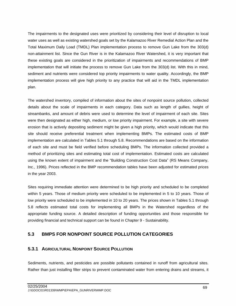
02/25/2004 J:\GDOC01\R01339\WMP\EPA\EPA_GUNRIVERWMP.DOC
69
The impairments to the designated uses were prioritized by considering their level of disruption to local
water uses as well as existing watershed goals set by the Kalamazoo River Remedial Action Plan and the
Total Maximum Daily Load (TMDL) Plan implementation process to remove Gun Lake from the 303(d)
non-attainment list. Since the Gun River is in the Kalamazoo River Watershed, it is very important that
these existing goals are considered in the prioritization of impairments and recommendations of BMP
implementation that will initiate the process to remove Gun Lake from the 303(d) list. With this in mind,
sediment and nutrients were considered top priority impairments to water quality. Accordingly, the BMP
implementation process will give high priority to any practice that will aid in the TMDL implementation
plan.
The watershed inventory, compiled of information about the sites of nonpoint source pollution, collected
details about the scale of impairments in each category. Data such as length of gullies, height of
streambanks, and amount of debris were used to determine the level of impairment of each site. Sites
were then designated as either high, medium, or low priority impairment. For example, a site with severe
erosion that is actively depositing sediment might be given a high priority, which would indicate that this
site should receive preferential treatment when implementing BMPs. The estimated costs of BMP
implementation are calculated in Tables 5.1 through 5.8. Recommendations are based on the information
of each site and must be field verified before scheduling BMPs. The information collected provided a
method of prioritizing sites and estimating total cost of implementation. Estimated costs are calculated
using the known extent of impairment and the Building Construction Cost Data (RS Means Company,
Inc., 1996). Prices reflected in the BMP recommendation tables have been adjusted for estimated prices
in the year 2003.
Sites requiring immediate attention were determined to be high priority and scheduled to be completed
within 5 years. Those of medium priority were scheduled to be implemented in 5 to 10 years. Those of
low priority were scheduled to be implemented in 10 to 20 years. The prices shown in Tables 5.1 through
5.8 reflects estimated total costs for implementing all BMPs in the Watershed regardless of the
appropriate funding source. A detailed description of funding opportunities and those responsible for
providing financial and technical support can be found in Chapter 9 - Sustainability.
5.3 BMPS FOR NONPOINT SOURCE POLLUTION CATEGORIES
5.3.1 AGRICULTURAL NONPOINT SOURCE POLLUTION
Sediments, nutrients, and pesticides are possible pollutants contained in runoff from agricultural sites.
Rather than just installing filter strips to prevent contaminated water from entering drains and streams, it

02/25/2004 J:\GDOC01\R01339\WMP\EPA\EPA_GUNRIVERWMP.DOC
70
would be more beneficial to prevent contamination at its source. Buffers will still be incorporated, but they
will not be the only BMP relied upon to meet the TMDL and Watershed goals (Table 5.1).
Agriculture NPS pollution is caused by rain or wind detaching loose soil particles and depositing them to
drains or streams. The permanent solution is to make the soil stable so that water and wind is unable to
transport material to waterways. Not only will this prevent water quality impairments, but it will also
provide sustainable agriculture practices to area growers.

02/25/2004 J:\GDOC01\R01339\WMP\EPA\EPA_GUNRIVERWMP.DOC
71
Table 5.1 - Agriculture BMP Cost
Site ID Description Water Color Water Odor Buffer
LU Left Bank
LU Right Bank Source Crop Tillage
Manure Usage
Type of Operation
Proposed Improvements
Estimated Unit Cost
Estimated Site Cost5 Priority Comments
59MAR0301 At 1298 Brown Rotten eggs N AG AG Both Conventional ? Dairy Windbreaks and cover crops1
$240/acre windbreak, $12/ac cover, and $58/ac rental
$3,432
H
1298 is 3' thick organic muck, brown/gray conglomerate with methane odor, between pastures
40MAR1201B 122nd Street. crossing Brown None 3'-10' AG AG Both Conventional None Conservation tillage2
BMPs and filter strip3
$10/acre till, $190/acre filter, $58/ac rental
$3,110
H
59MAR0303 East of long barns, 1,000' d/s from 124th
Cloudy None N AG AG Both Dairy Filter strip4 $190/acre filter, $58/ac rental $2,310
H
59MAR0301 At 595 outfall Cloudy None N AG AG Left bank Conventional None Conservation tillage2
BMPs and filter strip4
$10/acre till, $190/acre filter, $58/ac rental
$1,955
H 595 stagnant, plume into 59, 50' of duckweed up 595
40MAR3608B 2nd Street bridge north of Hooper Brown None Left bank Conventional None Conservation tillage2
BMPs and filter strip5
$10/acre till, $190/acre filter, $58/ac rental
$1,955
H
570MAR2703 Drain inlet east of crossing Cloudy None 3'-10' AG AG Right bank Conventional None Conservation tillage2
BMPs and filter strip6
$10/acre till, $190/acre filter, $58/ac rental
$1,955
H Cloudy/milky water coming from inlet drain.
570MAR2702 Drain inlet at bend in culvert drain
Cloudy None 3'-10' AG AG Right bank Conventional None Conservation tillage2
BMPs and filter strip7
$10/acre till, $190/acre filter, $58/ac rental
$1,955
H
Evidence of field runoff, picture No.8, water color change, milky water where drain enters
1059GUN1103 Clear None N AG AG Left bank Conventional Conservation tillage2
BMPs and filter strip8
$10/acre till, $190/acre filter, $58/ac rental
$1,955
H
Picture available, double culvert coming off field w/ little buffer
1059MAR2508 3rd field u/s from 2nd on left bank Brown Musty AG AG Left bank Conventional Windbreaks and
cover crops1
$240/acre windbreak, $12/ac cover, and $58/ac rental
$3,432
H
Dark soil field, small gullies, substrate very mucky, lots of aquatic plants & algae, diverse & prolific pop
59MAR1005 Next to cornfield up from 593
Brown None N AG AG Left bank Conventional / plow perp
Windbreaks and cover crops1
$240/acre windbreak, $12/ac cover, and $58/ac rental
$3,432
H
No buffer at all, some bare to stream, black soils, lots of aquatic vegetation
575WAY3502 By dairy on 4th Street ? None 1'-3' AG AG Right bank Grazing Dairy Agriculture BMPs 2,4 $18/yd fence $9,000
H Utility box falling in
40MAR3501 200' upstream from 2nd Street. bridge North of Hooper
Left bank Conservation tillage2
BMPs and filter strip8
$10/acre till, $190/acre filter, $58/ac rental
$1,955
H Drop inlet opening stable, but field eroding at inlet

02/25/2004 J:\GDOC01\R01339\WMP\EPA\EPA_GUNRIVERWMP.DOC
72
Table 5.1 - Agriculture BMP Cost
Site ID Description Water Color Water Odor Buffer
LU Left Bank
LU Right Bank Source Crop Tillage
Manure Usage
Type of Operation
Proposed Improvements
Estimated Unit Cost
Estimated Site Cost5 Priority Comments
40MAR1301B 120th Avenue crossing Clear AG Left bank Conventional None Conservation tillage2
BMPs and filter strip9
$10/acre till, $190/acre filter, $58/ac rental
$1,955
M
Left bank downstream road ditch contains field runoff of discolored water
40MAR3502A None Left bank Conventional None Conservation tillage2
BMPs and filter strip10
$10/acre Till, $190/acre filter, $58/ac rental
$1,955
M
40GUN0210A Bridge crossing 2nd Street Brown None >10' Right bank Conventional None
Conservation Tillage2
BMPs and Filter Strip11
$10/acre Till, $190/acre filter, $58/ac rental
$1,955
M
40MAR1402B 2nd Street crossing north of 118th. Brown None 3'-10' AG AG Conventional None Conservation tillage2
BMPs and filter strip8
$10/acre Till, $190/acre filter, $58/ac rental
$1,955
M Possible runoff from field
40MAR2605 Left bank Conventional Conservation tillage2
BMPs and filter strip8
$10/acre Till, $190/acre filter, $58/ac rental
$1,955
M Electric irrigation point
40GUN1001B 110th Avenue bridge
Brown None Y Left bank Conventional Conservation tillage BMPs2 $10/acre Till $800
M
Metal retaining wall on right bank, ditch enters from east and irrigation downstream
40MAR2302A None AG Road Left bank None Conservation tillage2
BMPs and filter strip8
$10/acre Till, $190/acre filter, $58/ac rental
$1,955
M
40MAR2603A None AG Road Left bank None Conservation tillage2
BMPs and filter strip8
$10/acre Till, $190/acre filter, $58/ac rental
$1,955
M
40ORA0601B Patterson Road crossing Green None 3'-10' Right bank None Filter strip3 $190/acre filter,
$58/ac rental $1,155
M
40GUN0103B 200' upstream in ditch adj. to corn Right bank None Filter strip4 $190/acre filter,
$58/ac rental $1,155
M
40GUN0103A 200' upstream in ditch adj. to corn Right bank None Conservation tillage2
BMPs and filter strip8
$10/acre Till, $190/acre filter, $58/ac rental
$1,955
M Corn field adjacent to ditch
RDGUN0101B Right bank None Filter strip4 $190/acre filter, $58/ac rental $1,155
M
403GUN1604B 600' upstream from Gun on 7th Street Brown None >10' Both None Filter strip4 $190/acre filter,
$58/ac rental $2,310
L

02/25/2004 J:\GDOC01\R01339\WMP\EPA\EPA_GUNRIVERWMP.DOC
73
Table 5.1 - Agriculture BMP Cost
Site ID Description Water Color Water Odor Buffer
LU Left Bank
LU Right Bank Source Crop Tillage
Manure Usage
Type of Operation
Proposed Improvements
Estimated Unit Cost
Estimated Site Cost5 Priority Comments
40GUN1801B 107th Street bridge Clear None Y Left bank Conservation tillage BMPs2 $10/acre Till $800
L
1Windbreak assumes 3.6 acres for a 40 acre square field. 2Conservation Tillage: No till or minimum till incorporated with well timed fertilizer and pesticide applications, average 40 acres at $10/acre. 3Filter strips: For estimations, a standard 1.5 acres for filter strips was assumed, $190/ac for establishment, $58/ac/year rental for 10 years. 4Agricultural BMPs: Use of cattle exclusion fences in waterways, average 500 yards, $18/yd. 5Estimated cost for establishment and 10-year rental payments.
High priority Medium priority Low priority
Total
$36,446
$19,905
$ 3,110
$59,461

02/25/2004 J:\GDOC01\R01339\WMP\EPA\EPA_GUNRIVERWMP.DOC
74
Conservation tillage, windbreaks, and cover crops are the recommended BMPs for preserving soil
erosion from wind transport and overland flow. Conservation tillage is a method of leaving crop residue on
the field over the winter until time of planting. Conservation tillage practices also include no till farming,
when seeds are drilled between the previous year s rows and the field is not tilled. Costs are lower to
farmers who use this method since less fuel is used in farm operations. In worst case scenarios,
additional pesticides may be necessary to prevent fungus and disease from insects that over-winter in
crop residue. In this case, a farmer could expect an increase of $10 per acre for implementing no-till
practices.
Cover crops are recommended for muck soils operations. Since these soils have such low organic
strength, they are very susceptible to wind erosion. Research completed by Mr. Richard Hardwood of the
Michigan State University Agriculture Engineering Department has shown that incorporating cover crops
into corn and soy rotations can add $100 to $150 per acre in production increases and input savings.
Cover crops decrease reliance on fertilizers and herbicides, increase habitat for beneficial insects and
birds, and add additional revenue if the farmer decides to harvest the cover crop and sell it as forage. A
no risk cover crop of clover has a cost of $12 per acre, which can be cost-shared through the Natural
Resource Conservation Service. Using a cover crop of rye or winter wheat is a more risky endeavor, but if
the crop is successful, it can be harvested and sold resulting in a net gain.
Windbreaks are suggested to slow wind velocity and to promote the settling out of soil particles. Trees
planted two or three rows thick with a row of shrubs beneath them provide an excellent windbreak.
Windbreak establishment can be very expensive, however the Stewardship Incentive Program and the
Conservation Reserve Program (CRP) may provide up to a 75% cost-share from approved Forestry
Management Plans. Typical cost for clearing land, planting, and maintenance have been reported at
$225/acre by the USDA Farm Service Agency. A 40-acre field would need about 3.6 acres of windbreak
to provide adequate protection. Addition benefits to windbreaks are significant decreases in pesticide drift
and airborne sediments, slight increases in irrigation efficiency, and improvement in wildlife corridor
structure.
Buffers or filter strips are also recommended in all agricultural fields identified in the critical areas. Filter
strips are simply strips of grass, trees, or shrubs that slow the flow of water and cause contaminants like
pesticides, nutrients, and sediments to collect in vegetation. Filter strips can quickly be established in the
interim time before windbreaks or other managerial BMPs can be implemented. Filter strips are eligible for
many state and federal programs that pay farmers a rent for lands being used as buffers. Typical rental
rates are 20% higher than the local average land rental rates, however, if Section 319 or CRP funds are
available, lease rates can be considerably higher to provide a greater incentive to farmers and
landowners. Currently, the average rental rate for southwest Michigan is $58 per acre.

02/25/2004 J:\GDOC01\R01339\WMP\EPA\EPA_GUNRIVERWMP.DOC
75
In addition to vegetative BMPs, the TMDL agriculture stakeholders committee has vehemently requested
additional programs to support nutrient management. Phosphorus runoff from row and muck crops is
severely impairing the Watershed, and the fastest method to deal with these inputs would be to eliminate
or significantly reduce phosphorus inputs into the Watershed. Many plans and programs are available to
farmers who wish to adopt a nutrient management policy, yet no funds are available for these programs.
Promotion and intensification of the Michigan State University Extension soil testing program is needed to
help offset the risk to reducing fertilizer applications.
5.3.2 STREAMBANK EROSION
Streambank erosion is another large contributor to sediment in the Watershed. When a stream or county
drain is channelized, streambank erosion often occurs as the stream attempts to return to its original path.
This streambank erosion is the cause of impairments to agriculture drainage and irrigation, fish habitat,
and macroinvertebrate communities. In addition to sedimentation, stream erosion could also be
responsible for a portion of the phosphorus (that is bound to soil particles) loading to the Kalamazoo River
Watershed.
Many techniques have been demonstrated to reduce streambank erosion. Hard structures, such as
riprap, can protect the toe of a streambank. Tree revetments, fascines, and live plantings are softer
methods that are generally preferred since they absorb energy from the stream rather than reflect it
downstream as riprap often does. Bioengineering, an integrated approach based in physics, chemistry,
and engineering principles that uses biological methods of control, can be very effective in establishing
long term and adaptable solutions to erosive problems. Bioengineered systems are designed using non-
destructive techniques that often have the ability to adapt to changing conditions over time. Materials can
usually be found locally or even onsite, reducing cost and incorporating native resources. In many cases
riprap and tree revetments provide a comparable, and in some cases, better habitat for fish and
invertebrates than natural streambanks. Sites, potential BMPs, and costs are given in Table 5.2. Each
site should be examined and the principles described in this section should be applied.
02/25/2004 J:\GDOC01\R01339\WMP\EPA\EPA_GUNRIVERWMP.DOC
76
Table 5.2 - Streambank Erosion Sites BMP Cost
Site ID Description Buffer LU Left LU Right Erosion Location
SE length
SE Height Severity Erosion*
Erosion Area ft2 Proposed Improvements Estimated Unit Cost
Estimated Total Cost Priority Comments
407GUN0103 N
Both >100' >6' Washout Entire bank 2,000
Bioengineering or tree revetment w/riprap
$4/foot - bioeng. $75/yd2 - riprap $15,800 H
200' of unstable banks on both sides, some road shoulder erosion, light vegetation
40GUN0201 Right bank >100' >6' Washout Entire bank 2,000
Bioengineering or tree revetment w/riprap
$4/foot - bioeng. $75/yd2 - riprap $15,800 H
40GUN1801C 107th Street Bridge Y
Left bank >100' 3'-6' Mostly bare
bank Entire bank 1,200
Bioengineering or tree revetment w/riprap
$4/foot - bioeng. $75/yd2 - riprap $15,800 H
1059GUN1101 N AG AG
Both >100' 3'-6' Mostly bare
bank Entire bank 1,200
Bioengineering or tree revetment w/riprap
$4/foot - bioeng. $75/yd2 - riprap $15,800 H
Bacterial sheet and lots of aquatic, plants, dark organic soil
1061ORA0901
West side next to Mullenhurst golf N Golf Idle
Both >100' 3'-6' Mostly bare
bank Entire bank
1,200 Bioengineering or tree revetment w/riprap
$4/foot - bioeng. $75/yd2 - riprap $15,800 H
Might be crossing from agricultural. land, golf course eroded drain
1071MAR1410 u/s from storage tank <1' AG AG
Left bank >100' >6' Mostly bare
bank Entire bank 2,000
Bioengineering or tree revetment w/riprap
$4/foot - bioeng. $75/yd2 - riprap $15,800 H
Very long stretch of eroded bank, short area OK, than another long stretch eroded
1059MAR2514 <1' AG AG
Right bank >100' >6' Mostly BARE
bank Entire bank 2,000
Bioengineering or tree revetment w/riprap
$4/foot - bioeng. $75/yd2 - riprap $15,800 H
571MAR2401
300 ft east of 2nd Street many point along bank AG Road
Right bank >100' >6' Mostly bare
bank Top of bank
2,000 Bioengineering $4/foot - bioeng. $800 H
408MAR3601B 100 ft. u/s from mouth 408 3'-10' AG AG
Right bank 26'-100' 3'-6' Washout Entire bank 600
Bioengineering or tree revetment w/riprap
$4/foot - bioeng. $75/yd2 - riprap $7,900 H
40MAR2308
Utility Utility
Left bank 26'-100' >6' Washout Entire bank
1,000
Backfill and drain w/bioengineering and riprap
$17.5/yd3 - fill, $4/foot bio, and $75/yd riprap $7,953 H Erosion under utility pole
RDWAY3401 Northwest corner 124th and 5th <1' AG Road
Both 26'-100' 3'-6' Mostly bare
bank Entire bank 600
Bioengineering or tree revetment w/riprap
$4/foot - bioeng. $75/yd2 - riprap $7,900 H
40MAR1301C 120th Avenue crossing AG
Right bank 26'-100' 3'-6' Mostly bare
bank Entire bank 600
Bioengineering or tree revetment w/riprap
$4/foot - bioeng. $75/yd2 - riprap $7,900 H
40GUN105 Left bank 26'-100' >6' Mostly bare
bank Entire bank 1,000
Bioengineering or tree revetment w/riprap
$4/foot - bioeng. $75/yd2 - riprap $7,900 H
40MAR2307 Y AG Woodland
Left bank 10'-25' >6' Washout Entire bank 250
Bioengineering or tree revetment w/riprap
$4/foot - bioeng. $75/yd2 - riprap $1,975 H
Erosion at irrigation point, old diesel-smelling fire engine used for pumping
40MAR2606 Left bank 10'-25' >6' Washout Entire bank
250
Backfill and drain w/bioengineering and riprap
$17.5/yd3 - fill, $4/foot bio, and $75/yd riprap $2,028 H Erosion threatens utility pole
403GUN1602B Road Road
Right bank >100' 3'-6' Washout 1,200
Bioengineering or tree revetment w/riprap
$4/foot - bioeng. $75/yd2 - riprap $15,800 H
40ORA0601C Patterson road crossing 3'-10'
Both <10' Washout Entire bank Bioengineering or tree revetment w/riprap
$4/foot - bioeng. $75/yd2 - riprap H
1060ORA1802 1st trib u/s from Patterson AG AG
Both 3'-6' Washout Entire bank Bioengineering or tree revetment w/riprap
$4/foot - bioeng. $75/yd2 - riprap H
40GUN0208 Right bank 10'-25' >6' Washout Entire bank 250
Bioengineering or tree revetment w/riprap
$4/foot - bioeng. $75/yd2 - riprap $1,975 H

02/25/2004 J:\GDOC01\R01339\WMP\EPA\EPA_GUNRIVERWMP.DOC
77
Table 5.2 - Streambank Erosion Sites BMP Cost
Site ID Description Buffer LU Left LU Right Erosion Location
SE length
SE Height Severity Erosion*
Erosion Area ft2 Proposed Improvements Estimated Unit Cost
Estimated Total Cost Priority Comments
40GUN0204 Right bank 10'-25' >6' Washout Entire bank
250 Bioengineering or tree revetment w/riprap
$4/foot - bioeng. $75/yd2 - riprap $1,975 H
40MAR2303 Left bank 10'-25' >6' Washout Entire bank 250
Bioengineering or tree revetment w/riprap
$4/foot - bioeng. $75/yd2 - riprap $1,975 H
1071MAR1002 By ag/woods AG Woodland
Both 10'-25' 3'-6' Mostly bare
bank Entire bank 150
Bioengineering or tree revetment w/riprap
$4/foot - bioeng. $75/yd2 - riprap $1,975 H
1058GUN1102 N AG AG
Both 10'-25' 3'-6' Mostly bare
bank Entire bank 150
Bioengineering or tree revetment w/riprap
$4/foot - bioeng. $75/yd2 - riprap $1,975 H
1071MAR1413
500' W of farm crossing, farm access road to N 1'-3' AG AG
Left bank 10'-25' 3'-6' Mostly bare bank Entire bank
150 Bioengineering or tree revetment w/riprap
$4/foot - bioeng. $75/yd2 - riprap $1,975 H
40MAR3606 Left bank 10'-25' 3'-6' Mostly bare
bank Entire bank 150
Bioengineering or tree revetment w/riprap
$4/foot - bioeng. $75/yd2 - riprap $1,975 H
5721MAR3602 off farm access road <1' AG AG
Right bank 10'-25' 3'-6' Mostly bare
bank Entire bank 150
Bioengineering or tree revetment w/riprap
$4/foot - bioeng. $75/yd2 - riprap $1,975 H Problem persists intermittently 500 ft
1058GUN1101 At meander N AG AG
Right bank 10'-25' 3'-6' Mostly bare
bank Entire bank 150
Bioengineering or tree revetment w/riprap
$4/foot - bioeng. $75/yd2 - riprap $1,975 H
40MAR2607 AG Road
Right bank 10'-25' >6' Mostly bare
bank Entire bank 250
Bioengineering or tree revetment w/riprap
$4/foot - bioeng. $75/yd2 - riprap $1,975 H Erosion at top of road grade
1071MAR1408 Near end of cornfield <1' AG AG
Right bank 10'-25' >6' Mostly bare
bank Entire bank 250
Bioengineering or tree revetment w/riprap
$4/foot - bioeng. $75/yd2 - riprap $1,975 H
Eroded and slumping, might be recovering but animal path still eroding it
1060ORA1801
East side Patterson road and 120th AG RES
Right bank 10'-25' >6' Mostly bare
bank Entire bank
250 Bioengineering or tree revetment w/riprap
$4/foot - bioeng. $75/yd2 - riprap $1,975 H
No buffer nutrients from field wash off. another 30' u/s pic #34
40GUN0207 3'-10'
Left bank 10'-25' >6' Mostly bare
bank Entire bank 250
Bioengineering or tree revetment w/riprap
$4/foot - bioeng. $75/yd2 - riprap $1,975 H LP gas and diesel irrigation upstream
1071MAR1504 500 ft u/s from 4th AG AG
Both 10'-25' >6' Mostly bare
bank Entire bank 250
Remove obstruction Bioengineering or tree revetment w/riprap
$4/foot - bioeng. $75/yd2 - riprap and $325/hour $2,625 H
Tree fell in (L) pushing water toward bank (R), pic avail
1058MAR2501
farm drain off 1059 going S, 30 ft. from 114th Avenue Road Road
Right bank 10'-25' >6' Some bare bank
Toe
250
Backfill and drain w/bioengineering and riprap
$17.5/yd3 - fill, $4/foot bio, and $75/yd riprap $2,028 H
Culvert comes in, making a right turn, erodes far bank which electric pole is on and falling in
1071MAR1405 d/s from fallen tree <1' AG AG
Left bank <10' 3'-6' Mostly bare
bank Entire bank 60
Bioengineering or tree revetment w/riprap
$4/foot - bioeng. $75/yd2 - riprap $790 H
lots of big limbs piled, washing out bank
1060ORA1804 >10' AG AG
Right bank <10' >6' Mostly bare
bank Entire bank 100
Bioengineering or tree revetment w/riprap
$4/foot - bioeng. $75/yd2 - riprap $790 H
1071MAR1503
400ft u/s 4th <1' AG AG
Right bank <10' >6' Mostly bare bank
Entire bank
100
Remove obstruction Bioengineering or tree revetment w/riprap
$4/foot - bioeng. $75/yd2 - riprap and $325/hour $1,115 H
Small tree fallen, creates gouging, picture No. 4
1076MAR2301 Just upstream from trailer <1' Road AG
Left bank <10' 3'-6' Some bare bank
Entire bank
60
Backfill and drain w/bioengineering and riprap
$17.5/yd3 - fill, $4/foot bio, and $75/yd riprap $843 H Utility box falling in
571MAR2402 500 ft e of 2nd AG Road
Left bank >100' >6' Some
bare/mostly Top of bank 2,000 Bioengineering $4/foot $800 M
No buff, washes off field, conventional tillage

02/25/2004 J:\GDOC01\R01339\WMP\EPA\EPA_GUNRIVERWMP.DOC
78
Table 5.2 - Streambank Erosion Sites BMP Cost
Site ID Description Buffer LU Left LU Right Erosion Location
SE length
SE Height Severity Erosion*
Erosion Area ft2 Proposed Improvements Estimated Unit Cost
Estimated Total Cost Priority Comments
bare
40GUN0103B
200' upstream in ditch adj. CORN
Right bank >100' 3'-6' Some bare
bank Entire bank
1,200 Bioengineering or tree revetment w/riprap
$4/foot - bioeng. $75/yd2 - riprap $15,800 M
407GUN0101
Along roadside 2nd street. across from farmhouse N AG Road
Both >100' >6' Some Bare bank High water
2,000 Bioengineering $4/foot $800 M
40MAR2302B
AG Road
Left bank >100' >6' Some Bare
BANK Entire bank
2,000 Bank Shaping and Bioengineering w/riprap
$5.5/yd3bank $4/foot bio, and $75/yd riprap $16,240 M
Bank slumping into river, corn up to top of bank
1071MAR1415 At end of woods >10' AG Woodland
Left bank 26'-100' 3'-6' Mostly bare
bank Entire bank 600
Bioengineering or tree revetment w/riprap
$4/foot - bioeng. $75/yd2 - riprap $7,900 M
Looks like it has been slowly eroding for years, might just erode at heaviest rains
1060ORA1803
AG AG
Both 26'-100' >6' Some
bare/mostly bare
Entire bank
1,000 Bank Shaping and Bioengineering w/riprap
$5.5/yd3bank $4/foot bio, and $75/yd riprap $8,813 M Slumping bank with concrete
1071MAR1407 Next to field, near large willows <1' AG AG
Right bank 26'-100' >6' Some bare bank Toe
1,000 Bank Shaping and Bioengineering w/riprap
$5.5/yd3bank $4/foot bio, and $75/yd riprap $8,120 M
Stream is meandering, exposing plastic conduit, which comes from top of bank
575MAR2601 At west side of 1st field on right 3'-10' AG AG
Left bank 10'-25' >6' Mostly bare
bank High water 250 Bioengineering $4/foot $100 M
Lots of shrubs and woody debris down center of drain
40GUN0104B Drainage ditch intersection
Left bank 10'-25' >6' Some bare
bank Entire bank 250 Bioengineering $4/foot $100 M
40MAR2603B AG Road
Left bank 10'-25' >6' Some bare
bank Entire bank 250 Bioengineering $4/foot $100 M
1071MAR1409 Rusted tank shell on S. side of drain <1' AG AG
Left bank 10'-25' >6' Some bare
bank Entire bank 250 Bioengineering $4/foot $100 M
40GUN1752C Left bank <10' >6' Washout Top of bank 100 Bioengineering $4/foot $40 M
59MAR1003 1'-3' AG AG
Left bank <10' 3'-6' Mostly bare
bank Top of bank 60 Bioengineering $4/foot $40 M
407GUN0102 100 yards south of bridge Y AG Road
Left bank <10' >6' Mostly bare
bank High water 100 Bioengineering $4/foot $40 M
1071MAR1404 Across from barn <1' AG AG
Left bank <10' >6' Some bare
bank Toe 100 riprap $75/yd2 $750 M
Looks like they tried to put a piece of plastic in to hold it, but plastic washing out
572MAR3601 Along farm road N AG Road
Left bank <10' 3'-6' Some bare
bank Top of bank 60 Bioengineering $4/foot $40 L
Lots of aquatic. plants, another 100 ft. u/s
40GUN1001C 110th Ave. Bridge Y
Left bank <10' >6' Some bare
bank Top of bank 100 Bioengineering $4/foot $40 L
Metal retaining wall at ditch enters from east and irrigation. downstream

02/25/2004 J:\GDOC01\R01339\WMP\EPA\EPA_GUNRIVERWMP.DOC
79
Cooperation with the county drain commissioners on work proposed for county drains is necessary. The
remedies must not interfere with the regular maintenance and cleaning of the drains. Generally, most
vegetative remedies, such as grasses and shrubs, are acceptable, but trees may interfere with drain
maintenance and roots too close to the edge may actually exacerbate erosion. Mixtures of rhizomatous
woody shrubs and herbaceous plants are ideal unless the goal is to reduce water temperature. Trees
should be maintained on the south and east sides of drains, so the canopy shades the water, which
keeps it cool, preserves habitat, and reduces algal growth. Responsibilities for maintenance of the
remedy is a concern as well. If additional plantings are recommended on a site that requires drain
maintenance, the additional costs would have to be passed on to the landowners. The landowners should
be allowed to decide if they are willing to absorb any costs associated with increased maintenance in
favor of having trees on or near the banks in the drain right-of-way.
Brush bundles and tree revetments incorporate the use of plant material to protect the bank in slow and
moderate flows, as well as reestablishing bank vegetation, which grows from the sediment that is
deposited in the crevasses. These remedies cost about $12 per yard since it is usually done with
vegetation found onsite and can be done with little equipment and labor. Live staking is done in late
autumn or early spring when the trees are dormant. These stakes will grow into short shrubby trees with
complex root systems as the growing season progresses. Tree revetments can be made of old Christmas
trees that have been anchored parallel to flow along the toe of the streambank. Once installed they direct
flow away from the bank and catch sediment, which will deposit and accumulate behind the revetment
and stabilize the bank. Many sites could benefit from this vegetative remedy to divert the flow rather than
provide extensive bank protection. Previous projects implementing this river restoration technique have
bid average costs of $220 per 100 feet of streambank.
Costs for hard methods of streambank stabilization are difficult to estimate since it is very site specific and
largely depends on the cost of site preparation. Riprap is the most common method of toe stabilization,
but it should be used sparingly and with much consideration. Riprap is excellent for diverting flow and
protecting banks, however, stream energy can be diverted downstream and only heighten erosion at
another site downstream. A detailed engineering study is essential for any projects the will be installing
riprap. Estimates for riprap for streambank erosion using D50 stone is $75/square foot, which includes the
delivery to the site. Riprap tends to be less cost effective and does not meet as many of the goals
outlined in this plan as the bioengineering techniques. Therefore, it should only be used where flow
velocities and direction will not sustain bioengineering.
In a number of cases in the Watershed, the stream is eroding the streambank as the watercourse is trying
to reestablish meanders. This type of erosion is a natural occurrence, nevertheless, in a channelized river
system, it will cause a great amount of sediment if not remedied. The BMP for eroding stream bends is to
02/25/2004 J:\GDOC01\R01339\WMP\EPA\EPA_GUNRIVERWMP.DOC
80
pull the bank back mechanically. In this way, the bank is physically removed before the stream carries it
as sediment during the next storm event. Typical costs for this BMP can be up to $6 per cubic yard of
bank removed plus the cost of bioengineering once the bank has been sloped.
5.3.3 RILL AND GULLY EROSION
Rill and gully erosion is generally found in agricultural areas where fields are tilled by conventional
methods and plowed next to the streambank where no filter strips exist. Rill and gully erosion is
responsible for impairments to fish habitat, irrigation, drainage, and aquatic habitats for invertebrates and
plants. Sediment carried in rill and gully erosion is also extremely high in phosphorus and other
contaminants associated with agricultural soil uses.
Typical BMPs include drop structures, weirs, and stone spillways. Sites, recommended BMPs, and costs
are listed in Table 5.3. All structures need adequate preparation to ensure the water flows where
intended. Natural Resource Conservation Service (NRCS) has installed many of these structures over the
years. Average costs per site are $1,500, assuming reasonable accessibility and using 4 inches to 12
inches of crushed limestone of various sizes. Geotextile vegetated chutes are designed for smaller sites
with less runoff.

02/25/2004 J:\GDOC01\R01339\WMP\EPA\EPA_GUNRIVERWMP.DOC
81
Table 5.3 - Rill and Gully Erosion
Site ID Description Land Use Buffer Height Width Depth Length Volume Proposed Improvements Estimated Cost/Site*
Estimated Total Cost** Priority Comments
1071MAR1501 100 yds. u/s from 4th
AG 3'-6' 2 8 10 160 Rock chute
$9.50/yd2 and $2/yd2
Grading $211 H Gully off field - conventional corn, picture Nos. 1 and 2.
1060ORA1806 Just up stream from 1st
AG >6' 4 2 12 96 Grassed waterway $2245/acre $4,490 H
Across from each other ground disturbed, cut trees off bank, moved soil on edge u/s 300 ft.
1059MAR2511 Toward curve in 1059
AG <1' >6' 3 2 15 90 Rock chute
$9.50/yd2 and $2/yd2
Grading $475 H
Log fell 20' further d/s backing up water, left bank slumping, gully off corn field red. Flow
59MAR1002 East of woods on west side of stream, field to S&N
AG 3'-10' 3'-6' 6 4 15 360
Berm and Tube with vegetated geogrid
$1,500/ berm and $20/yd2 geogrid $1,900 H
Gully on L w/trib. draining from field on right
1059MAR2503 At start of corn on right bank
AG 3'-10' >6' 2 3 20 120 Branch packing $25/foot $500 H
Gully at corner of field, goes over so that it's mostly buried
1059MAR2506 Halfway through field on left bank
AG >10' >6' 5 5 20 500 Rock chute
$9.50/yd2 and $2/yd2
Grading $1,056 H
Off 30-40 ac field w/ little slope, plus streambank erosion 100 ft. u/s same bank
1059MAR2513 U/S of curve
RES 3'-6' 6 3 20 360
Berm and tube with vegetated geogrid
$1,500/ berm and $20/yd2 geogrid $2,033 H
572MAR3604 Near end of 1st field
AG <1' <3' 3 1 25 75
Berm and tube with vegetated geogrid
$1,500/ berm and $20/yd2 geogrid $1,833 H
Gully off field, but drops sharply at bank, erodes 4' d/s
1059MAR2505 2nd field on left 100' in
AG >10' >6' 10 5 30 1500
Berm and tube with vegetated geogrid
$1,500/ berm and $20/yd2 geogrid $2,833 H Large gully off 30-40 acre soy bean field
RDGUN0101A Wood 3-6' 8 3 100 2400
Berm and tube with vegetated geogrid
$1,500/ berm and $20/yd2 geogrid $5,056 H
1071MAR1402 By driveway, behind metal building
AG N >6' 2 2 7 28 Rock chute
$9.50/yd2 and $2/yd2
Grading $148 M Attempts were made to fix erosion with cement blocks
572MAR3605 Almost to end of field
AG <1' >6' 3 2 8 48
Berm and tube with vegetated geogrid
$1,500/ berm and $20/yd2 geogrid $1,607 M Drains from field w/ sharp drop off
1059MAR2501 500ft U/S from 2nd
AG <1' >6' 3 2 8 48 Rock chute
$9.50/yd2 and $2/yd2
Grading $253 M
1071MAR1505 550 U/S from 4th
AG 3'-6' 2 2 10 40 Grassed waterway $2,245/acre $4,490 M Gully forming off field
1071MAR1001 South side of section 10 at exit of woods and another 100' U/S
AG <1' 3'-6' 2 1 12 24 Branch packing $25/foot $300 M Gully formed from runoff from field
575MAR0201 100 ft. S of blue house after turn in drain
AG 1'-3' >6' 1.5 2 15 45
Berm and tube with vegetated geogrid
$1,500/ berm and $20/yd2 geogrid $1,600 M Field slopes toward point
572MAR3602 100ft. u/s from farm rd.
AG 1'-3' <3' 2 1 25 50 Grassed waterway $2,245/acre $4,490 M
Goes into field 20 ft., rich organic soil, LOTS aq. plants
105MAR2509A 150FT U/S from 03
AG >10' >6' 2 3 25 150
Berm and tube with vegetated geogrid
$1,500/ berm and $20/yd2 geogrid $1,722 M
5721MAR3603 Off farm access rd. 100 ft. south of 114
AG <1' 3'-6' 1 1 40 40
Berm and tube with vegetated geogrid
$1,500/ berm and $20/yd2 geogrid $1,678 M
Gully runs along farm road then turns into drain
1059GUN1104 AG N 3'-6' 3 2 12 72 Grassed waterway $2,245/acre $4,490 L Picture available

02/25/2004 J:\GDOC01\R01339\WMP\EPA\EPA_GUNRIVERWMP.DOC
82
Table 5.3 - Rill and Gully Erosion
Site ID Description Land Use Buffer Height Width Depth Length Volume Proposed Improvements Estimated Cost/Site*
Estimated Total Cost** Priority Comments
5721MAR3601 Just off farm access road
AG <1' 3'-6' 2 2 2 8 Grassed waterway $2,245/acre $4,490 L Along access road by drain
1058GUN1103 AG N 3'-6' 2 1 8 16 Berm and tube with vegetated geogrid
$1500/ berm and $20/yd2 geogrid $1,571 L Picture available
1059MAR2515 AG <1' >6' 1 1 12 12 Grassed waterway $2,245/acre $4,490 L
*Grassed waterway average 2 acres **Cost are based on 1st year implementation. Future years are $58/year lease on conservation lands
High Priority Medium Priority Low Priority
Total
$20,387 $16,288 $15,041
$51,716

02/25/2004 J:\GDOC01\R01339\WMP\EPA\EPA_GUNRIVERWMP.DOC
83
5.3.4 TILE OUTLETS
Tile outlets should be upsized when constructed to plan for future capacity needs. Rodent guards should
always be included. The outlet should be lined with geotextile and stone should be placed in the trench.
Many sites in the Watershed are eroding where storm sewer outlets are eroding back into the
streambanks and causing gullies. Typical causes for these erosive forces are undersized tiles or outlets
so high that splash energy is creating splash pools and eddy currents. Catch basins and old tile lines
could be adding sediment to the stream system. Stabilizing a tile outlet has an average cost of $75 per
square foot of riprap and $12 per yard of bioengineering. Sites, recommendations, and cost totals are
shown in Table 5.4.
5.3.5 ROAD/STREAM CROSSINGS
Road crossings of the Gun River and its tributaries are a serious concern in the Watershed. In some
areas, culverts are undersized or blocked causing water to back up and flood upstream areas. When this
happens, erosion occurs around the road crossing. Undersized or blocked culverts can be replaced with
box culverts or bridges, however, in almost all cases the replacement of culverts and bridges is not
covered by grant programs. The most cost effective BMP for undersized culverts may be to stabilize the
hydrology in the Watershed and to prevent sediment from blocking culverts. Once other impairments
have been addressed, another detailed road/stream crossing inventory would be needed to evaluate the
condition of these sites. Additional concerns about navigation may also dictate the replacement of
undersized culverts that are not tall enough to allow passage of boaters. Site specific remedies are shown
in Table 5.5.
5.3.6 TRASH AND DEBRIS
Trash and debris not only create unsightly conditions, they also divert stream flow into the banks causing
erosion and drainage impairments. Trash hidden under murky waters also makes it difficult or dangerous
for recreational stream users. Removing log jams and heavy items from the stream bed can be a difficult
and expensive process since it must be done by hand. The removal of log jams should not be attempted
by volunteers since it gives rise to liability issues for the sponsoring agency. Funding for obstruction
removal can be found with 319 implementation grants, Adopt-A-Stream programs, and the Environmental
Protection Agency (EPA) 5-Star grant. Smaller projects, like trash clean-ups, can be tackled by volunteer
groups. Since most of the water courses in the Watershed are designated county drains, the drain
commissioner would be largely responsible for the removal of obstructions. A schedule of obstruction
removal, estimated costs, and responsible agencies is in Table 5.6.

02/25/2004 J:\GDOC01\R01339\WMP\EPA\EPA_GUNRIVERWMP.DOC
84
Table 5.4 - Tile Outlet BMP Costs
Site ID Description Buffer Width
Outlet Erosion
Outlet Diameter
Outlet Height
Erosion Area ft2
Proposed Improvements Estimated Unit Cost*
Estimated Total Cost Priority Comments
40MAR3603 pipe outlet from building (Hooper) Y 6" 0"-6" 10 Check Inlet / stabilize $75/yd2 and $150/hour Labor $1,350 H Possible floor drain from pole barn
572MAR3603 100 yds. u/s from farm rd. <1' Y 8" 0"-6" 10 Check Inlet / stabilize $75/yd2 and $150/hour Labor $1,350
H Outlet covered by aq. plants; inside- 3" tan colored algae, muck w/white film on top & dk. brown
59MAR0305 500 ft d/s from 124th 3'-10' Y 9" >36" 20 Outlet stabilization $75/yd2 and $150/hour Labor $2,250
H Digging out stream bottom
1059MAR2502 End of corn field u/s from 2nd 3'-10' Y 9" >36" 40 Outlet stabilization $75/yd2 and $150/hour Labor $3,900
H End of piece about to fall off bank
59WAY3401 Across from farm house N Y 6" 12"-36" 15 Outlet stabilization $75/yd2 and $150/hour Labor $2,025
H Slight erosion, no buffer on fields - lots of aquatic plants - eutrophic
105MAR2509B 150 FT u/s from 03 >10' N 8" 0"-6" N/A Replace pipe / repair bank
$30/ft - repair $75/yd2 - bank and $150/hour labor $1,530
H Two rusting through Tile outlet, one flowing - erosion, one not - smells musty & erosion
572MAR3606 Second field 1/2 way <1' Y 12" 12"-36" 15 Replace pipe / repair bank
$30/ft - repair $75/yd2 - bank and $150/hour labor $2,205
H Tile outlet rusted through, hanging bent into stream, water comes out hole, eroding bank
408MAR3601A 100 ft. u/s from mouth 408 3'-10' Y 0"-6" 15 Replace pipe / repair bank
$30/ft - repair $75/yd2 - bank and $150/hour labor $2,205
H Tile outlet rusted out, water comes out bottom, below is bac. sheet, iron bacteria, and aq. plants
1071MAR1406 U/S from fallen tree, just up from barn <1' Y 9" 12"-36" 20 Check inlet / stabilize $75/yd2 and $150/hour
Labor $2,250 M
not presently flowing, but 1/2 full of muck
1071MAR1403 Next to barn N N 12" 0"-6" N/A Extend outlet $30/foot - repair and $150/hour labor $780
M Tile outlet doesn't extend over stream, depositing lots of dark sediment on bank slope
1071MAR1401 Just upstream from 2nd St. bridge N Y 18" 12"-36" 20 Outlet stabilization $75/yd2 and $150/hour Labor $2,400
M
40GUN0207 3'-10' Y 4" 12"-36" 15 Outlet stabilization $75/yd2 and $150/hour Labor $2,025
M LP gas and diesel irrigation upstream
1059MAR2517 >10' Y 12" 12"-36" 10 Outlet stabilization $75/yd2 and $150/hour Labor $1,650
M
40GUN0203 Y 4-6" 12"-36" 10 Outlet stabilization $75/yd2 and $150/hour Labor $1,650
M Three tile outlets and irrigation point
407GUN0104 Y 6" 6"-12" 15 Outlet stabilization $75/yd2 and $150/hour Labor $2,025
M
40MAR3501 200' upstream from 2nd Street bridge north of Hooper
Y >36" N/A Riprap $75/yd2 $750
M Drop inlet opening stable, but field eroding at inlet
40GUN0209 N 10" >36" N/A Maintain $60/yr $60 L 40GUN0210B bridge crossing 2nd Street >10' N 8" >36" N/A Maintain $60/yr $60 L 40GUN0102 N 8" >36" N/A Maintain $60/yr $60 L 40GUN0101 N >36" N/A Maintain $60/yr $60 L
40MAR3602A N 12"-36" N/A Maintain $60/yr $60 L Tile outlet appears inactive 40MAR2602 N 12-14" 12"-36" N/A Maintain $60/yr $60 L
407GUN0105B 1'-3' N >12" 12"-36" N/A Maintain $60/yr $60 L 40MAR2304 N 8" 12"-36" N/A Maintain $60/yr $60 L 40MAR3607 N 12" 12"-36" N/A Maintain $60/yr $60 L
40MAR3503B N 12-14" 12"-36" N/A Maintain $60/yr $60 L 1071MAR1003 At curve in cornfield N 9" 6"-12" N/A Maintain $60/yr $60 L 403GUN1603 Midpoint along ditch at tile outlet 3'-10' N 6"-12" N/A Maintain $60/yr $60 L
40MAR3502B N 0"-6" N/A Maintain $60/yr $60
L Drop inlet or side inlet pipe for surface water, no flow
40MAR1201C 122nd Street crossing 3'-10' Y 8" 0"-6" 10 Outlet stabilization $75/yd2 and $150/hour Labor $1,350
L
40GUN0209 Y 6" 0"-6" 10 Outlet stabilization $75/yd2 and $150/hour Labor $1,350
L Two tile outlets side by side
1071MAR1502 350 ft from 4th u/s N 8" 12"-36" N/A Maintain $60/yr $60 L Erosion on bank around 2 to 6 outlets *Labor cost of $150 hour are added to account for any use of heavy equipment in addition to materials Medium Priority $13,530

02/25/2004 J:\GDOC01\R01339\WMP\EPA\EPA_GUNRIVERWMP.DOC
85
Table 5.5 - Road Stream Crossing BMP Costs
Site ID Description Erosion
Location* Condition Buffer Extent of Erosion
Proposed Improvements Estimated Unit Cost
Estimated Total Cost Priority Comments
407GUN0106 SB/EB/SD Poor SEVERE Replace Culvert $382/foot $9,168 H 406GUN1102 CO Fair 1'-3' SEVERE Riprap $75/yard2 $900 H
575MAR0202 124th Street west of 4th
CO Poor >10' SEVERE
Replace Culvert $382/foot $11,460 H
Concrete casing fell off, culver high, huge pool underneath
59MAR1101 120th Avenue EB Poor 1'-3' SEVERE Repair Culvert/Bridge $1125/foot $28,125 H
402GUN2101 Crossing 106th
ALL Good N SEVERE
Bioengineering and riprap repair
$4/foot - $75/yd2 - riprap $792 H
40ORA0601A Patterson Road crossing
SB/CO/SD Good 3'-10' SEVERE
Bioengineering and riprap repair
$4/foot - $75/yd2 - riprap $792 H
573MAR2601 Crossing 114th and 4th SB/EB Good <1' SEVERE Bioengineering $4/foot - tree revetment $384 H 1060ORA1701 9 Mile Road crossing EB Fair >10' RT. ONLY SEVERE Bioengineering $4/foot - $75/yd2 - riprap $792 H
1059MAR2501B At county line crosses Boysen Road north of 114th
EB Fair 3'-10' SEVERE
Bioengineering $4/foot - tree revetment $384 H
1060ORA1807 Crossing near farmhouse and corn storage SB Fair <1' SEVERE Bioengineering $4/foot - tree revetment $384 H 575WAY3501 By dairy on 4th Street EB Poor N MODERATE Replace Culvert $382/foot $9,550 H 571ORA1901 Boysen Road in woods EB Fair >10' MODERATE Bioengineering $4/foot - tree revetment $192 M
40MAR1301A 120th Avenue crossing
SB Poor MODERATE
Bioengineering and riprap repair
$4/foot - $75/yd2 - riprap $792 M
573MAR2701 5th Street 1/3 mi. north of 114th EB Fair <1' MODERATE Bioengineering $4/foot - tree revetment $192 M 577MAR0101 At end 577 bend SB <1' MODERATE Bioengineering $4/foot - tree revetment $192 M
59MAR0304A Livestock crossing
RB Poor N MODERATE
Bioengineering and riprap repair
$4/foot - $75/yd2 - riprap $792 M
4061GUN1101 1/4 mi east from section line 10/11 CO Good 3'-10' MODERATE Riprap $75/yd2 $600 M 1059MAR2516 2nd cross EB Fair <1' MODERATE Bioengineering $4/foot - tree revetment $192 M 407GUN0105A bridge crossing 2nd Street Fair 1'-3' MINOR Bioengineering $4/foot - tree revetment $192 M
570MAR2604 Crossing westridge on north cornfield, south of blue and tan house SB Poor 1'-3'
MINOR Replace Culvert $382/foot $9,168
M Vehicle crossing, gravel in stream bed 1057GUN1401 West of 3rd on Pierce Road / 106th Avenue Poor NONE Bioengineering $4/foot - tree revetment $192 M
1060ORA1805 Poor NONE
Replace Culvert $382/foot $9,168 M
Undersized culvert 3/4 full not right after storm. pic #39.
40GUN1101 Good MINOR
Bioengineering $4/foot - tree revetment $96 L
Upstream side blocked by debris, downstream open
403GUN1604A 600' upstream from Gun on 7th St. Good >10' MINOR Bioengineering $4/foot - tree revetment $96 L 40GUN1801A 107th St. Bridge Good Y MINOR Bioengineering $4/foot - tree revetment $96 L 40MAR2601 Crossing at 114th Ave. and 2nd St. Good MINOR Bioengineering $4/foot - tree revetment $96 L 40GUN1701 10th st bridge NONE Good MINOR Bioengineering $4/foot - tree revetment and $125/hr $96 L
40GUN1801 Bridge at Gun River Conservation Club, 11th St. NONE Good >10'
MINOR Bioengineering $4/foot - tree revetment $96
L
40GUN1001A 110th Ave. Bridge
Good Y MINOR
Bioengineering $4/foot - tree revetment and $125/hr $96 L
Metal retaining wall at br. ditch enters from east and irrig. downstream
40MAR2301 116th Ave. bridge at 2nd St. CI Good MINOR Riprap $75/yd2 $450 L
570MAR2605 crossing at big tan house
SB Good 1'-3' MINOR
Bioengineering $4/foot - tree revetment $96 L
Single culvert, lg rocks on both banks E of crossing, pics
40GUN1702B SB Fair MINOR Bioengineering $4/foot - tree revetment $96 L 40MAR2604 Trib. crossing on 2nd St. Good NONE Clean and Maintain $8.5/yd3 cleaning and $150/hour $201 L Rust colored water coming from culverts 40MAR1401 118th St. crossing Good NONE Clean and Maintain $8.5/yd3 cleaning and $150/hour $201 L 40MAR1402A 2nd st crossing n of 118th Fair 3'-10' NONE Clean and Maintain $8.5/yd3 cleaning and $150/hour $201 L 1920s bridge 40MAR1201A 122nd st crossing Good 3'-10' NONE Clean and Maintain $8.5/yd3 cleaning and $150/hour $201 L Triple culvert 40MAR3601 Good NONE Clean and Maintain $8.5/yd3 cleaning and $150/hour $201 L 40OST2401 n farmer st / 106th street bridge Good NONE Clean and Maintain $8.5/yd3 cleaning and $150/hour $201 L 40ORA0602A gun river wier Good NONE Clean and Maintain $8.5/yd3 cleaning and $150/hour $201 L 403GUN1602A Good NONE Clean and Maintain $8.5/yd3 cleaning and $150/hour $201 L 40GUN1703 9th st bridge None Good NONE Clean and Maintain $8.5/yd3 cleaning and $150/hour $201 L 40MAR3608A 2nd St. bridge N. of Hooper Fair NONE Clean and Maintain $8.5/yd3 cleaning and $150/hour $201 L

02/25/2004 J:\GDOC01\R01339\WMP\EPA\EPA_GUNRIVERWMP.DOC
86
Long-term educational efforts about the impacts of litter and debris in the streams will increase the
stewardship of the Watershed and encourage residents to recognize the value of their water resources. A
volunteer clean-up grant should be sought to involve local residents in stewardship activities. Community
involvement not only promotes respect for and interest in the Watershed, but also provides an
enthusiastic workforce. Local match for the grant can include the use of canoes, dump trucks, landfill
tipping fees (especially if tires are included) and communication radios for safety. It is important to inform
volunteers of safety concerns and have release of liability forms for them to sign.
5.3.7 OTHER SITES AND CONSTRUCTION SITES
Other pollutants were found in the Watershed that did not fit into the established categories and were
collected under the other category. Most of these sites identified excessive algal growth or water quality
concerns like odor, color, and foaminess. These would have to be evaluated on a site-by-site basis to
determine the costs for removal or finding the source of the excessive nutrients entering the streams. A
list of sites and basic recommendations are listed in Table 5.7.
One construction site was identified during the Watershed inventory as contributing NPS pollution to the
Watershed (Table 5.8). Additional sites will be added to the list if found.
Inventory sites on Gun Lake require a different approach for BMPs. As described previously, a buffer
around Gun Lake of 200 feet is incorporated into the Watershed s critical areas. The main impairments to
Gun Lake s desired uses are pathogens, nutrients, and invasive, and exotic species. The best way to
address these concerns is not through structural or vegetative BMPs, but through information and
education of riparian populations.
Previous studies done by the Michigan Department of Natural Resources (MDNR) and a private water
quality consultant have identified a number of practices for riparian landowners that will enhance the Gun
Lake recreation potential.
Burn leaves, brush, and garbage away from the lake.
Compost leaves or rake them away from the lake and bag for removal.
Use lake-safe fertilizers on lawns, if necessary, with no phosphorus and slow release nitrogen.
Use lake water to water lawn and gardens.
Preserve natural vegetation along shoreline.
Use phosphate free detergents in and around the house.
Remove aquatic weeds by hand, not herbicides.
Protect wetlands adjacent to the lake.

02/25/2004 J:\GDOC01\R01339\WMP\EPA\EPA_GUNRIVERWMP.DOC
87
Table 5.6 - Trash and Debris BMP Costs
Site ID Description BUFFER Land Use Left Land Use Right Amount Proposed Improvements Estimated Cost/Site Estimated Total Cost Priority COMMENTS
1071MAR1508 Across from white house Woodland Woodland Extensive
Obstruction removal - dam $150/hr $1,200 H Owners built dam with rocks and concrete, probably w/o
permit, 15' wide, 3' tall 59MAR0302 W of barn/north of 595 AG AG Extensive Obstruction removal - ext. $4/ft $400 H Heavy overgrowth and fallen trees for over 100' 570MAR2606 West end of section 26 >10' AG AG Extensive Obstruction removal - ext. $4/ft $1,600 H Numerous trees and branches, approx. 400'
574ORA0701 West of intersection Wildwood and Rook RES Road Extensive Obstruction removal - ext.,
volunteer clean-up $4/ft $460 H Lumber, tree, u/s fridge, TV, and deer ribcage, clogged
driveway culvert
570MAR2701 Just upstream from 26/27 section line >10' Idle AG Moderate Obstruction removal - ext.,
volunteer clean-up $4/ft $460 H Lots of logs down, brushy shrubs in stream, some barbed
wire left bank
59MAR1004 Across from 592, 50' north of 592 and further u/s 1'-3' Woodland AG Moderate Obstruction removal - mod. $4/ft $200 H Branches/trees in stream causing erosion
1060ORA1809 Near end of woods >10' Woodland Woodland Moderate Obstruction removal - mod. $4/ft $200 H Bunch of fallen trees - diverting water into bank 570MAR2603 350 upstream of power lines 1'-3' AG AG Moderate Obstruction removal - mod. $4/ft $200 H Fallen trees created sandbar 1059MAR2507 Just upstream from AG crossing Moderate Obstruction removal - mod. $4/ft $200 H Lots of trees down, just u/s from crossing
571MAR2401 300 feet east of 2nd Street AG Road Moderate
Obstruction removal - mod. $4/ft $200 H Road runoff eroding bank, little buffer, opposite bank no
buffer, trees dumped on bank
1059MAR2509 At town line drain - Fallen tree AG AG Moderate
Obstruction removal - mod. $4/ft $200 H Tree down, branches caught causing drain to snake
around, erosion on both banks 1071MAR1414 In woods >10' Woodland Woodland Slight Obstruction removal - slight $4/ft $40 H Logs down causing stream to divert 40GUN1702A Slight Volunteer clean-up $60/day $60 H Car battery/toilet 59WAY3402 126th Street at dip in road >10' Woodland Woodland Extensive Obstruction removal - ext. $4/ft $400 M Lots of fallen trees 1071MAR1507 By white house RES Woodland Extensive Obstruction removal - ext. $4/ft $400 M Tiles on large bank falling in 40GUN0104A Drainage ditch intersection Moderate Obstruction removal - mod. $4/ft $200 M Log jam, portage point
59MAR1001 Halfway between 2nd and 121st in fields, plus further up <1' AG AG Moderate Obstruction removal - mod. $4/ft $200 M Lots of fallen trees
1057GUN1501 Just off Marsh Road N AG AG Slight
Obstruction removal - slight $4/ft $40 M 15 ft. metal pipe, rusted through & laying across stream,
little erosion 1059MAR2512 Just u/s from large bend <1' AG AG Slight Obstruction removal - slight $4/ft $40 M Huge tree lying across bank, threatens to fall in 1071MAR1506 West side of cornfield by woods AG Woodland Slight Obstruction removal - slight $4/ft $40 M Log jam
1060ORA1808 Border ag/woods AG AG Slight Obstruction removal - slight, volunteer clean-up
$4/ft - obstruction $60/day - volunteers $100 M Barbed wire/electric fence across stream, pallets in water
1071MAR1411 By 3rd field going West <1' AG AG Slight Obstruction removal - slight, volunteer clean-up
$4/ft - obstruction $60/day - volunteers $100 M Palette, Styrofoam, fallen tree
40MAR3602B Y Moderate Volunteer clean-up 2 days $60/day $120 M Barrel, steel debris (fencing), etc. 40MAR2305 Moderate Volunteer clean-up 2 days $60/day $120 M Farm debris 40MAR3605 Tributary intersection Y Woodland Woodland Slight Volunteer clean-up $60/day $60 M Two tires, bucket
1059MAR2501A At county line crosses Boysen Road north of 114th 3'-10' AG AG Slight Volunteer clean-up $60/day $60 M Air conditioner
40MAR3503A Slight Volunteer clean-up $60/day $60 M Metal barrel and wooden stairs
5702MAR2101 Across and u/s from new houses N AG RES Slight
Volunteer clean-up $60/day $60 M Some concrete in river, lots of trash 20 ft. from bank, tires,
car, appliances 1060ORA1810 About 100 yds u/s of Saddler Road >10' Woodland Woodland Slight Volunteer clean-up $60/day $60 M Some trash - tires, siding, etc. 2 pieces diverting stream 570MAR2602 At 1st town going u/s from 2nd street 3'-10' AG AG Slight Obstruction removal - slight $4/ft $40 L Lots of shrubs/small trees and threw in at curve 1059GUN1102 N AG AG Slight Volunteer clean-up $60/day $60 L Lots of debris - bricks on bank & irrigation pipe 570MAR2601 At north side of 1st field on right bank 3'-10' AG AG Slight Volunteer clean-up $60/day $60 L Lots of shrubs and woody debris down culvert 1071MAR1412 15' east of farm crossing <1' AG AG Slight Volunteer clean-up $60/day $60 L Rocks/manmade deposits
High Priority $5,420
Medium Priority $2,060
Low Priority $220
Total $7,700

02/25/2004 J:\GDOC01\R01339\WMP\EPA\EPA_GUNRIVERWMP.DOC
88
Table 5.7 - Other Site BMP Costs
Site ID Description Color Water Odor Buffer Land Use Left Site
Land Use Right Side Proposed Improvements
Estimated Unit Cost*
Estimated Site Cost Priority Comments
1060ORA1802 1st Trib. U/S from Patterson No water None AG AG Filter strip $190/acre and $58/year lease $628
H 200 ft, no buffer, sandy soils
40GUN0205 Cloudy None N AG AG Filter strip
$190/acre and $58/year lease $628
H
Grazing right up to bank, eutrophic
GL03 Clear None N Turf management BMPs $175/plot $1,750
H Lawns mowed to edge, autumn leaves on bank &
in lake
59MAR0303 East of long barns, 1,000' d/s from 124th
Clear None N Wetland RES Wetland restoration
$2,530/acre restoration $1,265
H Owners turned wetland into wet lawn
40GUN1704 9th Street bridge
Clear None N Golf IDLE Filter strip crossing Improvement
$78/acre $1,200/crossing $1,770
H Possible agriculture crossing, golf course, eroded drain, picture 19
GL04 Cloudy Musty Road RES Check for septic failure, turf management BMPs, roadside filter strips $78-$2,530/acre $1,910
H Unsure of source, but water is cloudy & pungent musty odor
4031GUN1601 On 7th, road ditch to side street, all along roadside Solar or Electric Irrigation
$3,800/pump and controls $3,800
M Diesel irrigation point
GL02 Clear None N Filter strip
$190/acre and $58/year lease $628
M Foamy water, picture available
1067YAN1701 Cobb Lake Road crossing Maintain site $60/year $60
L Irrigation point, electric on pad
1061ORA0901 West side next to Mullenhurst golf Clear None N Monitor $60/year $60
L Zebra mussels, picture available *Cost are based on 1st year implementation. Future years are $58/year lease on conservation lands. *Estimates assume 3 acres for filter strips and half acre residential plots
High Priority Medium Priority Low Priority
Total
$7,951 $4,428
$120
$12,499
Table 5.8 - Construction BMP Costs
Site ID Description County Township Section QTR
1 QTR
2 Color Buffer CONSTRUCTION
TYPE Erosion Control
Measures Sediment Control
Measures Extent Recommended
BMP Estimated Cost/Unit
Estimated Costs Comments
GLORA0901 New development Barry Orangeville 9 NW NW Clear N RES Not Installed Not adequate Slight Sediment trap / mulching
$500 acre/mulch $1.75 ft/ silt fence $1,525.
Picture avail, large piles of dirt a few feet from lake w/ small silt fence, 4 such sites around Gun Lake
Total for all sites $1,525.
02/25/2004 J:\GDOC01\R01339\WMP\EPA\EPA_GUNRIVERWMP.DOC
89
Other recommendations for riparian land owners:
Remove all signs of vegetation from boats and trailers before leaving access.
Thoroughly wash boat and trailer with bleach and hot water before moving to another water body or
leave boat dry docked for 7 to 10 days.
Do not feed geese or other waterfowl.
Remove pet or waterfowl waste from lawn.
Be knowledgeable and aware of exotic species transport to prevent further spread throughout the
watershed.
The following management goals were set forth in the MDNR study in 1991. Enhancing the sport fishery
in Gun Lake could be accomplished by implementing the following recommendations:
Conduct full fisheries surveys every 10 years.
Muskellunge stocking should not be resumed.
Continue the cooperative rearing agreement for walleyes with the Gun Lake Protection Association
(GLPA).
Evaluate the possible natural reproduction of walleye.
Encourage GLPA to pursue boating regulations for the lake, such as slow or no-wake periods for
early evening to early morning.
02/25/2004 J:\GDOC01\R01339\WMP\EPA\EPA_GUNRIVERWMP.DOC
90
CHAPTER 6 - COMMUNITY OUTREACH PLAN
The Community Outreach Plan (Outreach Plan) was developed to guide watershed activities and focus
appropriate attention on issues formulated by the Steering Committee during the planning process.
Stakeholders in other watershed project areas were contacted for advice about their own successes with
various methods of outreach. The strategies outlined in the Outreach Plan are designed to be the
foundation of an outreach effort that can continue to be modified as issues and opportunities emerge. The
Steering Committee developed a broad framework which includes goals, objectives, overall messages,
and elements that connect all aspects of outreach activities. Key audiences are defined and specific
actions for each audience are described in this chapter. Products and events resulting from implementing
the Outreach Plan are summarized in Table 6.1.
6.0 KEY AUDIENCES
Township, city, and village officials
Agricultural producers
Riparian landowners/homeowners
County government officials (drain commissioner, road commission, soil erosion enforcement agency)
Stakeholders
Lake residents-Gun Lake and other small lakes
6.0.1 GOALS FOR THE GUN RIVER WATERSHED COMMUNITY OUTREACH PLAN
Build and retain high levels of stakeholder awareness and involvement in the Watershed project so that
community values related to stewardship for the Gun River can be sustained.
Promote ongoing participation of Watershed residents in activities which benefit the Watershed and water
quality.
Build awareness of watershed residents responsibility for how their individual practices and activities
affect water quality that flows across their land.

02/25/2004 J:\GDOC01\R01339\WMP\EPA\EPA_GUNRIVERWMP.DOC
91
6.0.2 OVERALL OUTREACH OBJECTIVES
To build and retain community awareness of the following issues: watershed recognition, understanding
of how water quality can be degraded, and knowledge of watershed-friendly land use practices.
To encourage the adoption of BMPs that protect and/or improve water quality and flow regime of the Gun
River.
To maintain existing partnerships and identify additional partnerships to increase awareness of and
involvement in the Watershed.
To raise awareness that wetlands are beneficial to protecting water quality and are valuable ecosystems
for wildlife.
To encourage local officials to use the Watershed Management Plan (WMP) as a tool for land-use
planning in their townships.
6.1 OVERALL KEY MESSAGES
Protecting the Gun River is protecting property values.
Wetlands are wonderful.
6.2 OUTREACH TOOL BOX
The tool box contains communications materials that are essential to the success of the community
outreach efforts.
Gun River Watershed Project Logo - A Gun River Project logo has been created to connect
communications about watershed activities to the project and to increase awareness.
02/25/2004 J:\GDOC01\R01339\WMP\EPA\EPA_GUNRIVERWMP.DOC
92
General Information Brochure - A simple, self-mailer brochure containing general information about the
Watershed (definition, goals, practices) will be developed. The brochure will include the logo, contact
information, and relevant graphics. The brochure should be easy to read and be eye-catching.
Website - The Watershed website serves as an educational and informational tool for the public to learn
about the watershed project in one convenient place. The web site should be linked to appropriate sites to
expand the potential audience.
Newsletter - A two- to four-page newsletter to be distributed to stakeholders. The newsletter will include
updates about project activities, partners, ways for others to become involved, and timely information (i.e.,
spring could highlight proper lawn fertilization procedures).
Gun River Watershed Signage - Create signs (12- by 24-inch) featuring the Watershed Logo or other
distinctive watershed oriented symbol such as the Kalamazoo River/Lake Allegan Watershed logo which
indicates that YOU ARE In the Watershed. Signage will also be placed at indicated sites with Best
Management Practices (BMPs). The signs will raise awareness of stakeholders
geographical connection
to the Watershed and will make the progress and accomplishments of the Watershed project more visible
to the public.
Enviroscape Model - Purchase an EnviroScape model for use at events, schools, and libraries to
demonstrate watershed concepts, and raise awareness of the Watershed.
Gun River Watershed Permanent Display - Develop a permanent display about the Watershed that can
be hosted on a rotating basis at local libraries and schools.
Gun River Watershed Seal/Certificate - Develop a certificate or seal for the Watershed to be given to
local units, producers, and residents who adopt practices outlined in the WMP.
6.2.1 TOWNSHIP, CITY, AND VILLAGE OFFICIALS
6.2.1.1 OBJECTIVES
To foster a sense of ownership and investment in the Watershed project among area officials and
planning commissions.
To increase understanding and support of low impact development techniques to protect water quality.

02/25/2004 J:\GDOC01\R01339\WMP\EPA\EPA_GUNRIVERWMP.DOC
93
To raise awareness of conservation easements and Purchase of Development Rights (PDR) as options
to preserve open lands, farmland, wetlands, and high quality upland areas in the Watershed.
To encourage using the WMP as a tool for land-use planning decisions, and the development of model
ordinances that protect water quality.
6.2.1.2 ACTIVITIES
Develop Appropriate Technical Information in a useable format (maps, reports, electronic media) to
support water quality protective ordinances and land-use planning strategies. This information includes
the Hydrologic and Hydraulic Analysis model results where appropriate. Develop a modified scoring
process similar to the Land Evaluation and Site Assessment (LESA) method for determining appropriate
land use. The process would incorporate the technical information compiled in this WMP. Prepare maps
using existing data that would consist of overlays on a township scale that depict storm water
management areas, BMP areas, and flood management areas.
Workshop - Host relevant workshop/tour for local government officials to highlight land use planning
strategies to protect water quality. Host a workshop or short course designed to assist local units of
government with the use of the WMP for land use decision making.
Citizen Planner Course - In partnership with Michigan State University Extension (MSUE) - Allegan
present a Citizen Planner Course for Allegan County and Barry County residents/township officials to
encourage using watershed management strategies in land-use planning activities and raise awareness
of watershed issues. Specifically include a discussion about how local officials can use a WMP for the
aforementioned purpose.
Gun River Watershed Certificate/Seal - Award certificate/seal to individuals who regularly attend
steering committee meetings, complete the watershed short course, and/or implement BMPs.
6.2.2 AGRICULTURAL PRODUCERS
6.2.2.1 OBJECTIVES
To increase the amount of agricultural producers that plant windbreaks, filter strips, grassed waterways,
and utilize residue management.

02/25/2004 J:\GDOC01\R01339\WMP\EPA\EPA_GUNRIVERWMP.DOC
94
To increase the amount of producers using a comprehensive nutrient management plan and to decrease
the amount of producers that allow their livestock access to surface water.
To increase awareness about benefits and availability of conservation easements and farmland
preservation programs.
To increase the attendance of agricultural producers at workshops, presentations, and training sessions
on land use practices that benefit water quality.
6.2.2.2 ACTIVITIES
Articles in Specialty Publications - Educational and informational articles to appear in county specific
publications that target this audience (such as Farm Service Agency, MSUE newsletters). Articles would
highlight services to agricultural producers to assist them in implementing BMPs.
Develop Partnerships with Agricultural Service Providers - Develop partnerships with equipment
dealers, grain elevators, and feed stores. Distributing information through information stands at these
businesses to farmers about fertilizers, soil testing, and nutrient management during the spring.
Show Participation - Participate in area events such as the Allegan County Fair, events at Kellogg
Biological Station, and other events that feature agricultural education opportunities. Representatives will
set up a booth or host a presentation at the event with relevant project information including the logo,
brochure, newsletters, and watershed maps.
Comprehensive Nutrient Management Field Day - Coordinate with Michigan Department of Agriculture
and MSUE to host a field day to highlight current nutrient management practices and opportunities for
assistance.
Comprehensive Nutrient Management Planning - Promote the development of Comprehensive Nutrient
Management Plans for watershed livestock producers through information dissemination and workshops.
Utilize the Progressive Planning process to encourage high rates of participation by the agricultural
community. Partner with MSUE, MAEAP, MDA and Farm Bureau to implement Progressive Planning as
a step-wise process to work towards CNMPs.
Partner with the Michigan Agriculture Environmental Assurance Program (MAEAP) - To increase
awareness of this program and assistance available to producers.

02/25/2004 J:\GDOC01\R01339\WMP\EPA\EPA_GUNRIVERWMP.DOC
95
Promote And Provide Information About New Farm Bill Programs that have technical and financial
assistance for BMPs that protect water quality. Anticipated programs include the Environmental Quality
Assistance Program (EQIP), Wildlife Habitat Incentive Program (WHIP), Wetland Reserve (WRP), and
Conservation Reserve Programs (CRPs).
Partner with the Michigan Farm Alliance and the Southwest Michigan Land Conservancy to promote
Conservation Easement and Purchase of Development Rights. Host workshop about easements, PA116,
Purchase of Development Rights, and other land preservation options. Highlight benefits to landowner
and township residents.
Host workshop about low impact development and the benefits to neighboring landowners. May combine
topic with conservation easement workshop. This event would target large acreage landowners.
6.2.3 RIPARIAN LANDOWNERS/HOMEOWNERS
6.2.3.1 OBJECTIVES
To increase awareness and adoption of water quality protective lawn care, and yard maintenance
practices, especially for riparian land owners.
To highlight the benefit of wetlands for wildlife, to reduce flooding, and protect water quality.
To increase awareness of the value of the Gun River to local quality of life.
6.2.3.2 ACTIVITIES
Gun River Clean-Up Day - Host a Clean-Up Day to pick up trash and litter in and near the Gun River.
Involve local Boy Scout, Girl Scouts, alternative high schools, and other groups to participate. Record
event with digital camera and display pictures on website to demonstrate community involvement.
Event Participation - Host a booth at the Plainwell Island Festival and the Allegan County Fair to raise
awareness about the Watershed project. Have watershed display and host a demonstration with the
EnviroScape model.
Homeowner Demonstration Site - Develop a demonstration site that highlights shoreline/streambank
friendly landscaping practices that also protect water quality. Record progress with digital camera and

02/25/2004 J:\GDOC01\R01339\WMP\EPA\EPA_GUNRIVERWMP.DOC
96
display pictures on website and at the booth. This site could also be part of a watershed tour during the
implementation phase of the Watershed project.
History of the Gun River - Prepare a short history of the Gun River to be published in local papers to
demonstrate its importance to the community and raise awareness of the value of the Gun River to local
quality of life.
Develop a Partnership with Local Libraries and Schools to host the watershed display and general
brochures on a rotating basis. Also have a copy of the WMP available in local libraries.
Develop a Student Stream Monitoring Program for area schools. Provide technical assistance and
support for program. Coordinate efforts with the Allegan County Math and Science Center. Select
accessible sites on the Gun River or its tributaries. Provide a watershed sign to participating schools.
Develop a Soil Testing Program (lawns and gardens) - Working with area schools and MSUE -
develop a program to have students collect a soil sample from their lawns and have the sample brought
to school. Have soil analyzed by MSUE and results sent to students. Teachers and students would review
results and discuss needed actions. Include information about non-phosphorus fertilizer sources and
good lawn care practices. Distribute existing information, such as is available from the TMDL Turfgrass
Committee and MSUE Turf Tips, about lawn care and soil testing.
Newsletters, Articles - Include information about low or non-phosphorus fertilizers for lawns and
promote soil testing. Highlight student activities as a way to encourage these activities.
Gun River Watershed Certificate/Seal - Award - Certificate to residents who soil test and follow lawn
care guidelines.
Wetland Brochure and Wetland Tour - Develop a brochure about wetlands in the Watershed. Host a
tour of local wetlands and highlight the importance of wetlands for wildlife and protecting water quality,
and demonstrate wetlands as areas to retain storm water to reduce flooding.
Citizen Planner Course - Encourage local residents to attend Citizen Planner Course to raise awareness
about land-use decision making process and how to incorporate new techniques for protecting open
space, low impact development.
Shoreline Landscaping Demonstration Workshop - Host a workshop at the shoreline native plant
landscaping demonstration site at Kellogg Biological Station and have experts discuss how to apply
techniques in the Gun River Watershed. Also highlight the Landscaping for Water Quality Brochures.

02/25/2004 J:\GDOC01\R01339\WMP\EPA\EPA_GUNRIVERWMP.DOC
97
Partner with the Kalamazoo River/Lake Allegan TMDL project to host a Kanoe Kazoo
event on the Gun
River. This would be a Kanoe Kazoo tributary trip with a Gun River clean-up component.
6.2.4 LOCAL GOVERNMENTAL UNITS
6.2.4.1 OBJECTIVES
To raise awareness of BMPs that could be implemented to reduce erosion.
To increase coordination between agencies to maximize benefits of available programs and protect water
quality.
6.2.4.2 ACTIVITIES
Coordinate Meetings - Host working group meetings with agencies to discuss ways to incorporate BMPs
in construction projects and opportunities for the agencies to apply for cost-share programs.
Demonstration Sites - Develop demonstration sites that highlight the effectiveness of BMPs in protecting
water quality and the benefits of these practices in reducing costs to the agency in decreased
maintenance.
Watershed Tour - Host a watershed tour to highlight project activities and show new techniques for
streambank stabilization. Focus on practices installed on, in, or near county drains.
Promote Awareness of the Watershed Management Plan and the technical information available in
this plan about the Watershed, hydrologic, and hydraulic studies.
Watershed Sign - Use Watershed signs to highlight installed BMPs.
Citizen Planner Course - Encourage local units to attend Citizen Planner Course to raise awareness
about the land-use decision making process and how to incorporate new techniques for protecting open
space, low impact development.
Wetland Brochure and Wetland Tour - Develop a brochure about wetlands in the Watershed. Host a
tour of local wetlands and highlight the importance of wetlands for wildlife and protecting water quality,
and demonstrate wetlands as areas to retain storm water to reduce flooding.

02/25/2004 J:\GDOC01\R01339\WMP\EPA\EPA_GUNRIVERWMP.DOC
98
6.2.5 STAKEHOLDERS
6.2.5.1 OBJECTIVES
To increase the level of participation among stakeholders through increased meeting attendance and
regular attendance.
To keep stakeholders involved in protecting water quality even after the grant ends.
6.2.5.2 ACTIVITIES
Develop a Watershed Organization - Develop a Friends of the Gun River to monitor activities that
affect water quality, environmental issues, and recreational uses. This organization could also create an
Adopt-A-Stream program.
Project Website - Announce meeting dates on the project website and have the website address visible
on project literature.
Meeting Mailings - Maintain and expand stakeholder mailing list to be used for communication about
meetings and project status.
6.2.6 LAKE RESIDENTS
6.2.6.1 OBJECTIVES
To increase awareness and adoption of water quality protective lawn care, and yard maintenance
practices, especially for lakeshore land owners.
To increase awareness of the value of the Gun River to local quality of life.
6.2.6.2 ACTIVITIES
Develop Partnerships with Lake Associations - Develop a list of lake associations, contacts, meeting
dates, and newsletters.

02/25/2004 J:\GDOC01\R01339\WMP\EPA\EPA_GUNRIVERWMP.DOC
99
Newsletters, Articles - Include information about low or non-phosphorus fertilizers for lawns and
promote soil testing. Target publications such as the Gun Laker Magazine.
Develop a Soil Testing Program (lawns and gardens) - Working with area schools and MSUE -
develop a program to have students collect a soil sample from their lawns and have the sample brought
to school. Have soil analyzed by MSU and results sent to students. Teachers and students would review
results and discuss needed actions. Include information about non-phosphorus fertilizer sources and
good lawn care practices. Distribute existing information about lawn care and soil testing.
Develop a Volunteer Monitoring Program for Gun Lake (and others) - The lake associations would be
the focal point for this program and would work with the health department to provide assistance with
monitoring lake water quality.
Gun River Watershed Certificate/Seal - Award certificate to residents who soil test and follow lawn care
guidelines.
Post Informational Signs About Invasive Species and the importance of cleaning your boat and bait
bucket to prevent their spread.
Wetland Brochure and Wetland Tour - Develop a brochure about wetlands in the Watershed. Host a
tour of local wetlands and highlight the importance of wetlands for wildlife and protecting water quality,
and demonstrate wetlands as areas to retain storm water to reduce flooding.

02/25/2004 J:\GDOC01\R01339\WMP\EPA\EPA_GUNRIVERWMP.DOC
100
Table 6.1 - Community Outreach Plan Products and Events
Item or Activity Audience Lead Agency Completed Estimated
Cost
Gun River Watershed logo All ACD, Steering, and Partners
Yes N/A
General information brochure1 All ACD, Steering, and
Partners No $650
Lawn care brochure
Riparian landowners, homeowners, stakeholders, and lake residents
ACD, Steering, and Partners No $450
Agricultural brochure Agricultural producers
ACD, Steering, and Partners No $450
Land-use brochure Township, city, village, and government officials
ACD, Steering, and Partners
No $450
Landscaping for water quality brochure
CES and MDEQ ACD, Steering, and Partners
Yes N/A
Wetlands are Wonderful brochure All ACD, Steering, and
Partners No $450
Website All Volunteers No $50
Township maps for land use2
Township, city, village, and government officials
FTC&H, Allegan land information office, ACD
No Contractual
Checklist for land evaluation2
Township, city, village, and government officials
Consultant, ACD No Contractual
Newsletter1 All ACD, Steering, and Partners No $650
Gun River Watershed signs3
All ACD, Steering, and Partners No $250 (each)
Gun River Watershed certificates/seal All ACD, Steering, and
Partners No $100
Gun River Watershed display All ACD, Steering, and
Partners No $2,700
EnviroScape model
Riparian landowners, homeowners, stakeholders, and lake residents
ACD, Steering, and Partners
No $2,000
Citizen planner course
Riparian landowners, lake residents, township, city village, and government officials
MSU Extension-Allegan
No $500
Allegan County Fair and Plainwell Island City festival All ACD, Steering, and
Partners Continuing $450
Workshops, field day and watershed tour and wetland tour
Selected audiences ACD, Steering, and Partners
No $400 (Tour)
Comprehensive easements/PDR workshop
Township officials, large acreage landowners
Michigan farm alliance, SWMLC, ACD
No $500

02/25/2004 J:\GDOC01\R01339\WMP\EPA\EPA_GUNRIVERWMP.DOC
101
Table 6.1 - Community Outreach Plan Products and Events
Item or Activity Audience Lead Agency Completed Estimated
Cost
Low impact development workshop
All may have multiple workshops focused on specific audience
ACD, Steering, and Partners No $600
Shoreline landscaping demonstration
Riparian landowners and lake residents
ACD and MSUE Kellogg Biological Station
No $500
Kanoe Kalamazoo (canoe event)
Riparian landowners, stakeholders and local units
ACD, MSUE Kellogg Biological Station, Kalamazoo River Watershed project, Downstreamers
No $300
Comprehensive nutrient management field day
Agricultural producers
ACD, Steering, and Partners
No $200
Student stream monitoring program
Riparian landowners homeowners, stakeholders, and lake residents
ACD, Allegan Math and Science Center No $200
Student lawn/garden soil testing/care program
Riparian landowners homeowners, stakeholders, and lake residents
ACD, MSUE Kellogg Biological Station, Allegan Math and Science Center
No $500
Watershed organization-"Friends of the Gun River" All Steering and
Partners No $200
Articles in specialty publications Selected Steering and
Partners No $100 (each)
Volunteer monitoring/Adopt-A-Stream for Gun River4 Riparian landowners ACD, MDEQ,
WMEAC Continuing $200
Volunteer monitoring program for Gun Lake4 Lake residents Lake Association No $300
(for mailing)
Develop partnerships with local organizations Selected ACD and Steering No
Steering Committee meetings5
All ACD No $60/Meeting
1 - Costs include printing and postage for 500 items, assumes in-house design 2 - Costs are included under the contractual budget category 3 - Volume discounts may lower price 4 - Cost of mailing information to raise awareness of program 5 - Meeting space
It should be noted that the Outreach Plan outlines a dynamic process that will require adjustments as
implementation moves forward. The Outreach Plan is a starting point that provides a guide for outreach
actions. Many topics such as low impact development are continuing to propose new more effective
techniques. Other water quality projects are occurring in the Kalamazoo River Watershed and provide
opportunities to develop new partnerships and host joint workshops/events. The stakeholders in the
Watershed will have the flexibility to suggest adjustments in the Outreach Plan and take advantage of
future opportunities.
02/25/2004 J:\GDOC01\R01339\WMP\EPA\EPA_GUNRIVERWMP.DOC
102
6.3 PUBLIC PARTICIPATION PROCESS
The Gun River Watershed Project began with a concerned citizen who formed a small group of
like-minded individuals, they held clean-ups and canoeing events, attended other water quality initiative
meetings, and demonstrated a commitment to improving water quality in the Gun River.
The Allegan Conservation District submitted a Section 319 Grant Proposal on behalf of the concerned
citizens. The MDEQ funded the project in June 2001. The resulting planning project included public
participation by forming a Steering Committee to provide direction for the project.
A stakeholder mailing list was developed based on information provided by the original group, the drain
commissioner, and interested parties. Fourteen Steering Committee meetings and four small group
technical meetings were held. Countless one-on-one discussions were held with individual stakeholders.
Meetings were held prior the grant start date and are anticipated to continue periodically after the
planning project ends.
Information about the project was disseminated several ways, through update letters, project newsletters,
and articles in other publications. These publications include the Penasee Globe, Gun Laker Magazine,
Farm Service Agency Newsletter, Michigan State University Extension Newsletter, Gun River Watershed
website (now part of the Allegan Conservation District Website at allegancd.org), Allegan Conservation
District newsletter, and Allegan County News. Project information was displayed at events such as the
Allegan County Fair, and the Plainwell City Island Festival.
In the winter and spring of 2002, in partnership with the Gun River Watershed Project, MSUE held
Phase I meetings in Martin Township. The Phase I meetings were for agricultural livestock producers to
explain the new requirements and processes for manure management. These were held as two small
group meetings in Martin Township to address this issue. In addition, as part of the Kalamazoo River
Lake Allegan TMDL agricultural BMP selection/monitoring process, a small group meeting of agricultural
producers was held to discuss various BMPs, obstacles to implementation, what practices are viewed by
producers as cost-effective, and how to measure the results of BMP implementation.
Steering Committee and Stakeholders
The Steering Committee and involved stakeholders were an integral part of project. Through their various
areas of expertise, members have discussed and evaluated a planning process to develop a guide for
improving water quality in the Watershed. To date, the following participants have been involved in the

02/25/2004 J:\GDOC01\R01339\WMP\EPA\EPA_GUNRIVERWMP.DOC
103
watershed planning process. Fishbeck, Thompson, Carr & Huber, Inc. (FTC&H) was the consultant for
the project to provide technical support and to develop the plan and H&H study.
Mr. Don Brown Kalamazoo Environmental Council
Mr. Doug Carter MSUE Kellogg Biological Station
Ms. AnneMarie Chavez Allegan Conservation District
Mr. Carl Collier Allegan Conservation District
Mr. Duane Denniston Resident
Mr. Dennis DeYoung Resident
Mr. Thomas Dunn City of Otsego
Mr. Tom Doyle Barry County Drain Commissioner
Mr. Lynn Fleming Allegan County Drain Commissioner
Ms. Jane Herbert MSUE Kellogg Biological Station
Mr. Gregory Jaynes Resident
Ms. Ruth Jaynes Resident
Ms. Julia Kirkwood MDEQ
Mr. Ron Kopka Gun Plain Township Trustee
Mr. Glenn Leep Martin Township
Mr. Wes Leep Resident
Mr. Cary Mannaberg Resident
Ms. Jenny Molloy MDEQ
Mr. Robert H. Monroe Gun Lake Sewer Authority
Mr. William Nelson Allegan County Road Commission
Ms. E. Wendy Ogilvie FTC&H
Ms. Diane Hornbrook FTC&H
Ms. Claire Schwartz, P.E. FTC&H
Mr. William Semeyn USDA Natural Resources Conservation Service
Mr. Dave Vande Bunte Resident
Dr. Jereon Wagendorp Land and Information Services Allegan County and Resident
Mr. Jay Wesley Michigan Department of Natural Resources
Mr. Skip Whitney Gun Plain Township Supervisor
Mr. Paul Wylie Michigan State University Extension

02/25/2004 J:\GDOC01\R01339\WMP\EPA\EPA_GUNRIVERWMP.DOC
104
CHAPTER 7 - IMPLEMENTATION STRATEGIES
7.0 GOALS AND OBJECTIVES FOR THE GUN RIVER WATERSHED
The implementation of this Watershed Management Plan (WMP) requires a combination of strategies that
include community outreach/education, construction/installation of Best Management Practices (BMPs) to
prevent or correct degradation of water quality due to nonpoint sources (NPS), and institutional
management - land use planning ordinances protective of water quality. The goals of the Watershed
community to improve water quality to meet designated uses will not be realized without this multi-faceted
approach. The Gun River Watershed (Watershed) encompasses diverse communities that may require
different areas of emphasis to meet local needs while coordinating their efforts with neighboring
jurisdictions.
The foundation for all change is to raise awareness about the problem, about the solution, and to gain
consensus on how to move from discussion of the issues to measurable results. The specific outreach
steps, audience, and objectives are presented in Chapter 6. The next two steps, construction of BMPs
and land use planning, will be described in this chapter.
BMPs are designed to prevent or reduce NPS pollution. Degraded water quality in the Watershed is a
clear indication that installing BMPs is essential to solving this issue especially within the next ten years
or less.
Land use planning strategies at the township, city, and village level will offer longer-term institutional
management for the prevention of additional impact to water quality through human activities. Local units
within the Watershed have a diverse range of demographics. For example, Wayland and Gun Plain
Townships have experienced population growth between 17% and 28% (1990 to 2000) and Martin
Township experienced 9% to 1.9% growth in the same time period. Population shifts, current land use
patterns, and natural features vary throughout the Watershed, which means that different areas within the
Watershed may require different strategies to address water quality issues. Part of the implementation
process will include tailoring the overall watershed management strategies to meet the specific needs of
local stakeholders.
The Steering Committee defined the goals and objectives for the Watershed at a working meeting on
April 25, 2002. A summary of the impairments to the designated uses was presented to the committee.
The committee members also examined the inventory results to determine which pollutants were most
abundant and what impact those pollutants had in the Watershed. The committee members were
assigned the task of completing a worksheet to determine the goals and objectives that would address

02/25/2004 J:\GDOC01\R01339\WMP\EPA\EPA_GUNRIVERWMP.DOC
105
the impairments. Once the goals were established, the committee formulated specific objectives to meet
each of the goals. The objectives were further identified in categories of either BMPs or Land Use
Planning. The goals and objectives are included in Table 7.1.
The community and the Steering Committee expressed concerns over many other conditions in the
Watershed that were not directly related to water quality. Table 7.2 describes the goals and objectives
that were developed for the desired uses.

02/25/2004 J:\GDOC01\R01339\WMP\EPA\EPA_GUNRIVERWMP.DOC
106
Table 7.1 - Goals and Objectives for the Gun River Watershed
Pollutants and Impairments To Designated Uses Goal Objectives
SEDIMENT High - Agriculture High - Warmwater Fishery High - Coldwater Fishery High - Indigenous Aquatic Life and Wildlife
Reduce soil erosion and sedimentation by 10% of the loadings every year
Best Management Practices Use more preventative measures rather than remediation efforts. Increase use and quality of filter strips and windbreaks. Encourage farmers to use cover crops and promote no-till farming. Review SESC inspections and enforcement procedures. Encourage farmers to request and implement Highly Erodible Land (HEL) conservation plans on HEL land through the Natural Resources Conservation Service.
Land Use Planning Improve storm water management techniques through ordinances or site design criteria. Develop model ordinances or other mechanisms for high risk erosion areas, shoreline setbacks, greenbelts, slope protection, open space, and storm water management. Apply open space and conservation easements to areas with high erosion potential, not suitable for other land uses, to protect venerable slopes. Implement low impact development strategies. Develop overlay maps that show areas with high potential storm water runoff where construction techniques that allow more infiltration of storm water to reduce high discharge runoff and the resulting erosion should be applied.
NUTRIENTS High - Indigenous Aquatic Life and Wildlife High -Total Body Contact Recreation (Gun Lake) Medium - Total Partial Body Contact Recreation (Gun River) Medium - Total Partial Body Contact Recreation (Gun Lake) Medium - Total Body Contact Recreation (Gun River) Low - Warmwater Fishery Low - Coldwater Fishery
Reduce phosphorus by 10% of the loadings and nitrogen by 5% of the loadings every year and establish TMDLs in designated areas
Best Management Practices Use systems approach on farms with conservation planning and comprehensive nutrient management plans. Increase technical support and funding opportunities for implementing conservation programs. Educate homeowners and lawn care companies to use less fertilizers on lawns. Address residential septic systems. Educate homeowners about composting to reduce dumping of leaves and yard waste into streams.
Land Use Planning Examine wildlife management strategies near surface waters. Develop model ordinances or other mechanisms for residential fertilizer use, yard waste disposal options, septic tanks, slope protection, shoreline setbacks, greenbelts, soil erosion, and storm water management. Implement low impact development strategies that include promotion of low impact landscaping in residential areas (plants that do not require fertilizer). Develop overlay maps that show where shoreline (streambank, lakeshore, drain easement) areas are located to reduce use of phosphorus fertilizer. Conduct septic system inspections.
HYDROLOGY High - Navigation High - Coldwater Fishery Medium - Agriculture Medium - Warmwater Fishery Medium - Partial Body Contact Recreation
Stabilize stream flows to moderate hydrology and increase base flows
Best Management Practices Use peak flow rates and water surface elevations from hydrologic analysis as basis for in-stream modifications.
Land Use Planning Integrate map of flood prone areas with Allegan County LIS to regulate development within floodplain. Use hydrologic analysis to expedite regular participation in the FEMA Flood Insurance Program.

02/25/2004 J:\GDOC01\R01339\WMP\EPA\EPA_GUNRIVERWMP.DOC
107
Table 7.1 - Goals and Objectives for the Gun River Watershed
Pollutants and Impairments To Designated Uses Goal Objectives
Encourage storm water detention policy that allows no more than 0.06 cfs/acre of development to be discharged to the Gun River. Implement low impact development techniques and qualitative storm water design criteria. Include innovative storm water management practices in county storm water rules and township land use ordinances. Apply conservation, farmland, and open space easements for infiltration and storm water storage areas to reduce the volume and velocity of storm runoff. Develop model ordinances or other mechanisms for floodplain management, high risk erosion areas, shoreline setbacks, greenbelts, storm water management, farmland and open space preservation, and wetland protection.
OBSTRUCTIONS High - Agriculture High - Navigation High - Partial Body Contact Recreation
Manage obstructions Best Management Practices Clear obstruction in areas that are blocking flow and causing flooding on agricultural lands. Clear obstruction for navigation and recreation or keep obstructions for habitat where appropriate.
E. COLI High - Agriculture High - Partial Body Contact Recreation (Gun Lake) High - Total Body Contact Recreation (Gun Lake) Low (s) - Partial Body Contact Recreation (Gun River) Low (s) - Total Body Contact Recreation (Gun River)
Prevent E. coli from entering surface waters and attain water quality standards for Total Body Contact Recreation from May 1 to October 1 in Gun Lake
Best Management Practices Encourage testing and selective monitoring for E. coli in high risk areas. Create volunteer monitoring program.
Land Use Planning Develop model ordinances or other mechanisms for shoreline setbacks, green belts, slope protection, storm water management, and wetland protection.
TEMPERATURE High - Coldwater Fishery Medium - Warmwater Fishery
Maintain coldwater fishery Best Management Practices Encourage drain maintenance projects to remove trees on only the north and west sides of drain to provide shade for stream.
Land Use Planning Adopt site design criteria that minimize impervious surfaces, promote infiltration to increase base flow, and maintain riparian corridors, according to low impact development principles. Develop model ordinances or other mechanisms for shoreline setbacks, greenbelts, slope protection, storm water management, and wetland protection.
HYDROCARBONS AND OTHER CONTAMINANTS Low - Other Indigenous Aquatic Life and Wildlife
Reduce potential for hydrocarbon contamination
Best Management Practices Improve efficiency and maintenance on irrigation pumps. Evaluate the use of electric or solar powered pumps. Assess fuel storage facilities through Farm*A*Syst program.
Land Use Planning Improve storm water management to reduce runoff.
INVASIVE AND EXOTIC SPECIES Medium - Other Indigenous Aquatic Life and Wildlife Low - Agriculture
Minimize spread of invasive and exotic species
Best Management Practices Investigate effective techniques to control Eurasian watermilfoil, purple loosestrife, and zebra mussels.

02/25/2004 J:\GDOC01\R01339\WMP\EPA\EPA_GUNRIVERWMP.DOC
108
Table 7.1 - Goals and Objectives for the Gun River Watershed
Pollutants and Impairments To Designated Uses Goal Objectives
HABITAT FRAGMENTATION Low - Other Indigenous Aquatic Life and Wildlife
Minimize habitat fragmentation Best Management Practices Encourage riparian buffers through proper drain maintenance.
Land Use Planning Encourage riparian buffers through buffer ordinances. Encourage responsible land use planning through adoption of low impact development techniques and education of local officials. Develop model ordinances or other mechanisms for greenbelts, farmland and open space protection, and wetland protection. Promote conservation, farmland, and open space easements to protect habitat.
High = High Priority Impairment Medium = Medium Priority Impairment Low = Low Priority Impairment (S) = Suspected
Table 7.2 - Goals and Objectives for Desired Uses Desired Use Goals Objectives
Groundwater use as private drinking water source Ensure safe and reliable groundwater for drinking water use
Reduce nitrogen inputs to groundwater by implementing nutrient management programs.
Increase recreational opportunities Add public access sites in the Gun River Watershed
Create at least one barrier free site for access to the Gun River for canoeing or kayaking.
Preserve open space and rural character Use planning techniques to manage growth
Conduct workshops and educational programs about planning tools that Townships can use to manage growth.
Create a Gun River Trailway Build a trail along Gun River for recreational and informational use
Follow example of the Kalamazoo River Valley Trailway, including interpretive signs, to provide the same opportunities to the Gun River Watershed communities.
Protect prime farmlands Protect prime farmland and agricultural way of life for future generation.
Protect prime farmland with land use planning ordinances, policies, and tax incentives.
Protect unique habitats for endangered species Maintain diversity in Watershed Protect habitats with resource-based land use planning policies and educate the public about the unique resources.
Encourage wildlife habitats Assist land owners in enhancing properties for wildlife habitats
Inform the public about the many opportunities available for wildlife habitat establishment and protection.
02/25/2004 J:\GDOC01\R01339\WMP\EPA\EPA_GUNRIVERWMP.DOC
109
7.1 WATER QUALITY SUMMARY
The water quality of the river, lakes, and streams in the Watershed is afflicted by NPS pollution. The Gun
River is a tributary to the Kalamazoo River, which has been placed on the MDEQ s 303(d) non-attainment
list of impaired waters. Identified pollutants include phosphorus, of which the Gun River is the third
highest contributor to the Kalamazoo River/Lake Allegan system. Biological surveys conducted by the
MDEQ found area in the Watershed with poor macroinvertebrate communities due to excessive
sedimentation. A portion of the Gun River near its mouth is identified as a coldwater fishery, supporting a
trout habitat that has been sustained with annual fish stocking by the MDNR. Land use activities that
increase storm water runoff intensify NPS pollution problems in the Watershed. The following summary
links the problem sites and sources that are impairing the water quality to the goals and objectives of
restoring the designated uses of the Watershed. The impairments are listed in order of highest to lowest
priority in the Watershed.
Pollutant/Impairment:
Sediment
Impairment to Designated Uses:
Sediment is a high priority impairment to agriculture, warmwater fishery, coldwater fishery, and other
indigenous aquatic life and wildlife. Sediment can interfere with the efficient functioning of irrigation
systems. Excess sediment covers riffles, destroys spawning habitat, and causes turbidity.
Sources:
Sediment comes from both upland and in-stream sources. Cropland, construction sites, gullies, and
stream crossings were identified as sources.
Causes:
Conventional tillage practices that leave soil exposed to water and wind erosion cause erosion. Exposed
soil erodes from construction sites where proper SESC practices are not installed or maintained. Active
gully erosion on fields without filter strips or stabilized outlets adds sediment to the stream. Unrestricted
livestock and vehicle access to the stream causes streambank erosion.
Goals:
Reduce soil erosion and sedimentation by 10% of the loadings every year.

02/25/2004 J:\GDOC01\R01339\WMP\EPA\EPA_GUNRIVERWMP.DOC
110
Objectives:
Best Management Practices
Use more prevention measures than remediation efforts.
Increase use and quality of filter strips and windbreaks.
Encourage farmers to use cover crops and promote no-till farming.
Encourage farmers to request and implement Highly Erodible Land (HEL) conservation plans on HEL
land through the Natural Resources Conservation Service.
Review SESC inspection and enforcement procedures.
Land Use Planning
Improve storm water management techniques through ordinances and site design criteria.
Develop model ordinances or other mechanisms for high risk erosion areas, shoreline setbacks,
greenbelts, slope protection, open space, and storm water management.
Apply open space and conservation easements to areas with high erosion potential, not suitable for
other land uses, to protect venerable slopes.
Implement low impact development strategies.
Develop overlay maps that show areas with high potential storm water runoff where construction
techniques that allow more infiltration of storm water to reduce high discharge runoff and the resulting
erosion should be applied.
Pollutant/Impairment:
Nutrients
Impairments to Designated Uses:
Nutrients are high priority impairments to total body contact recreation in Gun Lake. They are medium
priority impairments to partial and total body contact recreation in the Gun River and partial body contact
recreation in Gun Lake. Nutrients are low priority impairments to warm and coldwater fisheries. Excess
nutrients, such as phosphorus and nitrogen, cause eutrophication, a cycle which depletes oxygen and
increases plant growth to an extent where many species cannot survive. Algae grows at a rapid rate due
to the excess nutrients. The algae settles on slow moving stream bottoms as it dies and forms a thick
layer of organic matter. The decomposition process depletes oxygen, causing anoxic conditions which
creates methane. The process destroys the balance of water chemistry and food webs. Several
waterbodies in the Watershed are on the 303(d) non-attainment list to develop a TMDL for phosphorous.
02/25/2004 J:\GDOC01\R01339\WMP\EPA\EPA_GUNRIVERWMP.DOC
111
Sources:
Nutrients in fertilizers used in agricultural applications, residential applications, and landscaping enter the
watercourses in storm water runoff. Nutrients concentrated in human and animal wastes are introduced
into surface waters through leaking manure storage area, failing septic systems, and direct discharges or
runoff. Large concentrations of wildlife, such as geese, can also be sources of nutrients. Yard waste,
especially leaves and grass clippings, dumped in the waterways decompose quickly into available
nitrogen and organic matter, adding to the nutrient levels.
Causes:
Improper fertilizer and manure application and storage allow nutrients to enter surface water and
groundwater. Septic system failures and direct discharges have been a problem in Gun Lake, but the
creation of the Gun Lake Sewer and Water Authority has made great strides to the resolution of this
cause. Populations of waterfowl in and around Gun Lake have not been shown to cause a significant
amount of nutrient loading at their current population levels, but are a potential cause of excessive
nutrients. Yard wastes piled on the banks of the Gun River and the shores of Gun Lake blow directly into
the water adding nutrients.
Goal:
Reduce phosphorus by 10% and nitrogen by 5% of the loadings every year and establish TMDLs in
designated areas.
Objectives:
Best Management Practices
Use systems approach on farms with conservation planning and comprehensive nutrient
management.
Increase technical support and funding opportunities for implementing conservation programs.
Educate homeowners and lawn care companies to use less fertilizers on lawns.
Address residential septic systems.
Educate homeowners about composting to reduce dumping of leaves and yard waste into streams.
Conduct septic system inspections.

02/25/2004 J:\GDOC01\R01339\WMP\EPA\EPA_GUNRIVERWMP.DOC
112
Land Use Planning
Examine wildlife management strategies near surface water.
Develop model ordinances or other mechanisms for residential fertilizer use, yard waste disposal
options, septic tanks, slope protection, shoreline setbacks, greenbelts, soil erosion, and storm water
management.
Implement low impact development strategies that include promotion of low impact landscaping in
residential areas (plants that do not require fertilizer).
Develop overlay maps that show where shoreline (streambank, lakeshore, drain easement) areas are
located to reduce use of phosphorus fertilizer.
Pollutant/Impairment:
Hydrology
Impairment to Designated Uses:
Hydrology is a high priority impairment to navigation and coldwater fishery. It is a medium priority
impairment to agriculture, warmwater fishery, and partial body contact recreation in the Gun River.
Changes in flow affect water levels and the rate of water movement. Flashy flows, signified by swift
moving high water shortly after a rain and very low levels during dry periods, can be the result of
increased artificial drainage. Changes in land use can increase flooding, erosion, and sedimentation.
Sources:
Alteration of drainage patterns and changes in land use affect the natural hydrology of a stream.
Causes:
Establishment and improvements of drains, elimination of wetlands, and increases of impervious surfaces
destabilize hydrology.

02/25/2004 J:\GDOC01\R01339\WMP\EPA\EPA_GUNRIVERWMP.DOC
113
Goal:
Stabilize stream flows to moderate hydrology and increase base flows.
Objective:
Best Management Practices
Use peak flow rates and water surface elevations provided by hydrologic analysis as the basis for any
in-stream modifications.
Land Use Planning
Integrate map of flood prone areas with the Allegan County LIS to regulate development within the
floodplain.
Use hydrologic analysis to expedite regular participation in the FEMA Flood Insurance Program for
Otsego and Gun Plain Townships through a partnership between Allegan County and FEMA.
Encourage storm water detention policy that allows no more than 0.06 cfs/acre of development to be
discharged to the Gun River.
Implement low impact development techniques and quantitative storm water design criteria.
Include innovative storm water management practices in county storm water rules and township land
use ordinances.
Apply conservation, farmland, and open space easements for infiltration and storm water storage
areas to reduce the volume and velocity of storm runoff.
Develop model ordinances or other mechanisms for floodplain management, high risk erosion areas,
shoreline setbacks, greenbelts, storm water management, farmland and open space preservation,
and wetland protection.

02/25/2004 J:\GDOC01\R01339\WMP\EPA\EPA_GUNRIVERWMP.DOC
114
Pollutant/Impairment:
Obstructions
Impairment to Designated Uses:
Obstructions are high level impairments to agriculture, navigation, and partial body contact recreation in
the Gun River. Obstructions in the Watershed include log jams, trash, appliances, and a bathtub. Debris
in the stream diverts flows, causing streambank erosion and changes to the channel morphology.
Sources:
Organic sources, such as fallen trees and branches, either fall from the streambanks or are washed down
during high flows. Trash, appliances, and tires are intentionally dumped in the stream or can also be
washed down in high flows.
Causes:
Streambank erosion causes trees to fall in the Gun River. Illegal dumping and lack of enforcement
perpetuate the problem of trash in the Gun River.
Goal:
Manage obstructions.
Objectives:
Best Management Practices
Clear obstructions in areas that are blocking flow and causing flooding on agricultural lands.
Clear obstructions for navigation and recreation or keep obstructions for habitat where appropriate.
Pollutant/Impairment:
E. coli
02/25/2004 J:\GDOC01\R01339\WMP\EPA\EPA_GUNRIVERWMP.DOC
115
Impairment to Designated Uses:
E. coli can cause serious illnesses in humans and animals, and has been a documented problem in Gun
Lake. It is a high priority impairment to agriculture and partial and total body contact recreation in Gun
Lake. E. coli has not been adequately tested for in the Gun River and is therefore a low priority
impairment to partial and total body contact recreation. The health risks this bacteria poses necessitates
its inclusion in this plan to prevent E. coli from becoming a significant problem.
Sources:
E. coli is found in the digestive system of warm-blooded animals and is spread through feces. The
detection of E. coli often indicates that other dangerous types of bacteria might be present. E. coli cannot
live for long periods of time outside of a host body, therefore, when found in surface Watershed, the
source must be relatively close. Potential sources include livestock in the stream, wildlife, septic systems,
and manure storage areas.
Causes:
Unlimited access to streams allows livestock and wildlife to spread bacteria. Leaking, poorly sited and
maintained, and undersized septic systems allow E. coli to enter waterbodies. Leaching or overflowing
manure storage areas and improper land application of manure can also add bacteria to the streams.
Goal:
Prevent E. coli from entering surface waters and attain water quality standards for total body contact
recreation from May 1 to October 1 in Gun Lake.
Objectives:
Best Management Practices
Encourage testing and selective monitoring in high risk areas.
Create volunteer monitoring program.
02/25/2004 J:\GDOC01\R01339\WMP\EPA\EPA_GUNRIVERWMP.DOC
116
Land Use Planning
Develop model ordinances or other mechanisms for shoreline setbacks, green belts, slope protection,
storm water management, and wetland protection.
Pollutant/Impairment:
Temperature
Impairment to Designated Uses:
Temperature is considered a high priority impairment to the coldwater fishery and a medium priority
impairment to the warmwater fishery. Temperature is significant to coldwater fisheries. Coldwater fish
species require water temperatures to remain below a certain temperature during summer months.
Sources:
Surface runoff, especially near parking lots and heavily paved areas, contributes warmwater to streams.
Low base flows prolong exposure to summer heat and solar radiation. Lack of streamside vegetation
exposes the water to be heated by the sun.
Causes:
Increases in impervious surfaces reduces infiltration, causing increases in temperatures and the water.
Excessive irrigation causes low flows which increase temperatures. Destruction of streamside vegetation
eliminates shading from the sun.
Goal:
Maintain coldwater fishery.
Objective:
Best Management Practices
Encourage drain maintenance projects to only remove trees on north and west side of drains to
provide shade for stream.
02/25/2004 J:\GDOC01\R01339\WMP\EPA\EPA_GUNRIVERWMP.DOC
117
Land Use Planning
Adopt site design criteria that minimize impervious surfaces, promote infiltration to increase base
flow, and maintain riparian corridors, according to low impact development principles.
Develop model ordinances or other mechanisms for shoreline setbacks, greenbelts, slope protection,
storm water management, and wetland protection.
Pollutant/Impairment:
Hydrocarbons and Other Contaminants
Impairment to Designated Uses:
Hydrocarbons and other contaminants are low level impairments to indigenous aquatic life and wildlife.
These contaminants affect fish and macroinvertebrate populations and may travel great distances
downstream. Petroleum products interrupt the balance of the ecosystem by adding toxins and other
substances to the water.
Sources:
Irrigation pumps and other machinery along the banks of the streams and leak fuel and oils.
Causes:
Old, inefficient, leaking, or faulty pumps and machines release petroleum by-products into the Gun River.
Goal:
Reduce potential for hydrocarbon contamination.
Objective:
Best Management Practices
Improve efficiency and maintenance of irrigation pumps.
Evaluate the use of electric or solar powered pumps.
Assess fuel storage facilities through Farm*A*Syst programs.

02/25/2004 J:\GDOC01\R01339\WMP\EPA\EPA_GUNRIVERWMP.DOC
118
Land Use Planning
Improve storm water management to reduce runoff.
Pollutant/Impairment:
Invasive Species
Impairment to Designated Uses:
Invasive species are a medium level priority impairment to indigenous aquatic life and wildlife and are a
low priority to agriculture. Invasive species, specifically zebra mussels, purple loosestrife, and Eurasian
watermilfoil have been found in Gun Lake. Garlic mustard is a nuisance in riparian forest communities.
Sources:
Invasive species are spread by physical transport, such as on boats and cars, or through environmental
sources such as wind, birds, and other animals.
Causes:
Unstable or disturbed areas are more susceptible to invasion than healthy ecosystems. Lack of
knowledge about invasive species often spreads them unintentionally.
Goal:
Minimize spread of invasive and exotic species.
Objectives:
Best Management Practices
Investigate effective techniques to control Eurasian watermilfoil, purple loosestrife, and zebra
mussels.
02/25/2004 J:\GDOC01\R01339\WMP\EPA\EPA_GUNRIVERWMP.DOC
119
Pollutant/Impairment:
Fragmentation of Habitat
Impairment to Designated Uses:
Fragmentation of habitat is a low level priority to indigenous aquatic life and wildlife. The areas around
Gun Lake as well as to the southwest of the Watershed are developing rapidly, taking large tracts of
forest and cropland out of the ecosystems. Many species are reliant on large tracts of territory and/or
migration corridors. Land use changes downsize these areas and wildlife may be forced onto fringe lands.
This can lead to conditions where wildlife take on new niches that may conflict with new land uses. Fringe
species may now have access to forest communities that cannot compete, destroying populations.
Sources:
Development of large tracts of land are disrupting continuous area of habitat.
Causes:
Lack of planning for controlled growth causes haphazard development to occur in the Watershed.
Goal:
Minimize habitat fragmentation.
Objectives:
Best Management Practices
Encourage riparian buffers through proper drain maintenance.
Land Use Planning
Encourage riparian buffers through buffer ordinances.
Encourage responsible land use planning through adoption of low impact development techniques
and education of local officials.

02/25/2004 J:\GDOC01\R01339\WMP\EPA\EPA_GUNRIVERWMP.DOC
120
Develop model ordinances or other mechanisms for greenbelts, farmland and open space protection,
and wetland protection.
Promote conservation, farmland, and open space easements to protect habitat.
7.2 RECOMMENDATIONS FOR IMPLEMENTATION
7.2.1 BEST MANAGEMENT PRACTICES
The implementation of BMPs are required to address nonpoint sources and improve water quality. Other
strategies are community outreach/education and institutional management (land use planning,
conservation easements). BMPs address the physical sources of water quality impairments and therefore
are an important part of the overall NPS pollution reduction strategy.
The implementation of BMPs requires the coordination of landowners, agencies, organizations, and
partners. The Implementation Strategy, Tables 7.3
7.10, serves as the guide for determining the
location and frequency of practice implementation. The implementation schedules for all BMPs are
included for each impairment. Descriptions of the technical assistance, estimated costs, and possible
financial assistance are also included in the tables.

02/25/2004 J:\GDOC01\R01339\WMP\EPA\EPA_GUNRIVERWMP.DOC
121
Table 7.3 - Agriculture
Implementation Schedule
BMPs Technical Assistance Unit Costs Amount Total Cost
Financial Assistance
High Priority 0 to 5 Years
Medium Priority 5 to 10 Years
Low Priority 10 to 20 Years
Conservation Tillage Conservation District, NRCS
230 hours
$10
ac/yr 1440 ac $14,400
USDA Great Lakes Basin Program for SESC
$5,600 $7,200 $800
$190
ac est. 34.5 ac. (over 10 yrs)
$6,555
USDA Programs, Pheasants Forever
$2,850 $3,135 $570 Filter Strips Conservation District, NRCS
170 hours $58
ac/yr rental
34.5 ac. (over 10 yrs)
$2,001 USDA Programs, Pheasants Forever
$14,964 $9,570 $1,740
Fence Conservation District, NRCS
50 hours
$6
yd 500 yd $3,000
USDA Programs
$3,000 $ - $ -
Cover crops Conservation District, NRCS
76 hours
$12
ac 120 ac $1,440
USDA Great Lakes Basin Program for SESC
$1,440 $ - $ -
Windbreak Conservation District, NRCS
53 hours
$240
ac 10.8 ac $2,592
USDA Great Lakes Basin Program for SESC
$2,592 $ - $ -
Pollutant: Sediment and nutrients Sources: Agricultural operations Causes: Conventional tillage, plowing too close to stream, unlimited livestock
access, lack of cover crops, lack of streamside vegetation
$29,988
TOTAL $30,446
$19,905
$3,110
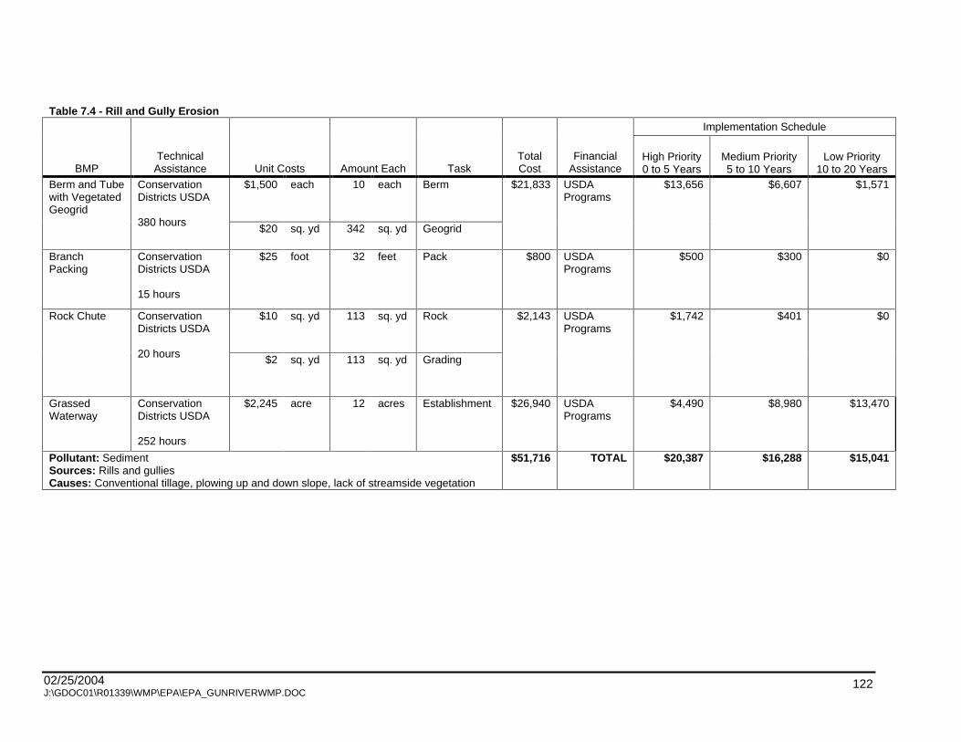
02/25/2004 J:\GDOC01\R01339\WMP\EPA\EPA_GUNRIVERWMP.DOC
122
Table 7.4 - Rill and Gully Erosion
Implementation Schedule
BMP Technical Assistance Unit Costs Amount Each Task
Total Cost
Financial Assistance
High Priority 0 to 5 Years
Medium Priority 5 to 10 Years
Low Priority 10 to 20 Years
$1,500
each 10 each Berm Berm and Tube
with Vegetated Geogrid
Conservation Districts USDA
380 hours $20
sq. yd 342 sq. yd Geogrid
$21,833
USDA Programs
$13,656
$6,607
$1,571
Branch Packing
Conservation Districts USDA
15 hours
$25
foot 32 feet Pack $800
USDA Programs
$500
$300
$0
$10
sq. yd 113 sq. yd Rock Rock Chute Conservation Districts USDA
20 hours $2 sq. yd 113 sq. yd Grading
$2,143
USDA Programs
$1,742
$401
$0
Grassed Waterway
Conservation Districts USDA
252 hours
$2,245
acre 12 acres Establishment $26,940
USDA Programs
$4,490
$8,980
$13,470
Pollutant: Sediment Sources: Rills and gullies Causes: Conventional tillage, plowing up and down slope, lack of streamside vegetation
$51,716 TOTAL $20,387 $16,288 $15,041

02/25/2004 J:\GDOC01\R01339\WMP\EPA\EPA_GUNRIVERWMP.DOC
123
Table 7.5 - Road/Stream Crossings
Implementation Schedule
BMPs Technical
Assistance Unit Costs Amount Total Cost
Financial Assistance
High Priority 0 to 5 years
Medium Priority 5 to 10 Years
Low Priority 10 to 20 Years
Replace Culvert Road Commission
190 hours
$382 foot 5 sites $48,514
Road Commission $30,178 $18,336 -
Riprap Road Commission
30 hours
$75 sq. yard 3 sites $1,950
Road Commission $900 $600 $450
Repair Culvert/Bridge Road Commission
40 hours
$1,125 foot 1 sites $28,125
Road Commission $28,125 $0 -
$4 foot Bioengineering/Riprap Road Commission, Conservation Districts, Drain Commissioner
40 hours
$75 sq. yard
4 sites $3,168
Road Commission $1,584 $1,584 -
Bioengineering Road Commission, Conservation Districts, Drain Commissioner
190 hours
$4 foot 19 sites $3,960
Road Commission $1,944 $1,152 $864
Monitor and maintenance
Road Commission, Conservation Districts, Drain Commissioner
80 hours
$201 each 10 sites $2,010
Road Commission - - $2,010
Pollutant: Sediment Sources: Road/stream crossings Causes: Degraded bridges and culverts, culverts too short, steep side slopes,
undersized culverts, lack of maintenance
$87,727 TOTAL 62,731 21,672 3,324

02/25/2004 J:\GDOC01\R01339\WMP\EPA\EPA_GUNRIVERWMP.DOC
124
Table 7.6 - Streambank Erosion
Implementation Schedule
BMPs Technical Assistance Unit Costs Task Amount Total Cost
Financial Assistance High Priority
0 to 5 Years Medium Priority
5 to 10 years Low Priority
10 to 20 Years
$4
foot Bioengineering Bioengineering or
tree revetment w/riprap
Conservation District Drain Commissioner NRCS
310 hours $75
yard Riprap
31 sites $210,930
NOAA Community-Based Restoration Program (April, 18 mos., 1:1 match ) Trout Unlimited
$187,230 $23,700 -
$18
cubic yard
Excavation
$4
foot Bioengineering
Backfill and drain w/bioengineering
Conservation District Drain Commissioner NRCS
40 hours $75
sq. yd Riprap
4 sites $12,850
Drainage Districts
$12,850 - -
Riprap Conservation District Drain Commissioner NRCS
10 hours
$75
sq. yd Riprap 1 site $750
Drainage Districts
$750 - -
Bioengineering Trout Unlimited Michigan DNR
120 hours
$4
foot Bioengineering 12 sites $3,000
NOAA/Trout Unlimited Partnerships
$800 $2,120 $80
$325
hour Labor
$4
foot Bioengineering
Obstruction Removal and Bank Repair
Trout Unlimited Michigan DNR
20 hours $75
sq. yd Riprap
2 site $3,740
NOAA/Trout Unlimited Partnerships
$3,740 - -
$6
cubic yard
Excavation
$4
foot Bioengineering
Bank Shaping Conservation District Drain Commissioner NRCS
138 hours $75
sq. yd Riprap
3 site $33,173
NOAA/Trout Unlimited Partnerships
- $33,173 -
Pollutant: Sediment Sources: Streambank erosion Causes: High flows, obstructions, lack of streamside vegetation
$264,443
TOTAL $205,370 $58,993 $80

02/25/2004 J:\GDOC01\R01339\WMP\EPA\EPA_GUNRIVERWMP.DOC
125
Table 7.7 - Tile Outlets
Implementation Schedule
BMPs Technical Assistance Unit Costs Task Amount Total Cost
Financial Assistance
High Priority 0 to 5 Years
Medium Priority 5 to 10 Years
Low Priority 10 to 20 Years
$75
sq. yard
Riprap Check Inlet / Stabilize
Conservation District NRCS
114 hours $150
hour Labor
3 sites $4,950
USDA Programs $2,700 $2,250 -
$30
foot extension Extend Outlet Conservation District NRCS
38 hours $150
hour Labor
1 site $780
USDA Programs - $780 -
Maintenance Conservation District NRCS
280 housr
$60
year Labor 14 sites $840
USDA Programs - - $840
$75
sq. yard
Riprap Outlet Stabilization Conservation District NRCS
380 hours $150
hour Labor
10 sites $20,625
USDA Programs $8,175 $9,750 $2,700
$30
foot repair
$75
sq. yard
Riprap
Replace Pipe / Repair Bank
Conservation District NRCS
114 hours
$150
hour Labor
3 sites $5,940
USDA Programs $5,940 - -
Riprap Conservation District NRCS
38 hours
$1,388
each Riprap 1 sites $750
USDA Programs - $750 -
Pollutant: Sediment Sources: Tile outlets Causes: Improperly installed tile, high flows, tile too short, outlet not maintained
$33,885
TOTAL $16,815 $13,530 $3,540

02/25/2004 J:\GDOC01\R01339\WMP\EPA\EPA_GUNRIVERWMP.DOC
126
Table 7.8 - Trash and Debris
Implementation Schedule
BMPs Technical Assistance Unit Costs Task Amount Total Cost
Financial Assistance
High Priority 0 to 5 Years
Medium Priority 5 to 10 Years
Low Priority 10 to 20 Years
Obstruction removal - dam
Drain commissioner Landowner Trout unlimited
38 hours
$150 hour Labor and Heavy equipment
1 site $1,200 Trout Unlimited MDNR
$1,200 - -
Obstruction removal - extensive
Drain commissioner NRCS
80 hours
$4 foot Labor and heavy equipment
4 site $2,800 Drainage Districts $2,000 $800 -
Obstruction removal - ext., volunteer clean-up
Conservation district Townships Drain commissioner JTPA
20 hours
$60 day Labor and heavy equipment
2 site $920 Volunteer Clean-up Grant (June, 4 months, 25% match) www.michigan.gov/deq/water/surfacewater/nps/grants
$920 - -
Obstruction removal - mod.
Conservation district Drain commissioner Friends of the Gun River Townships
80 hours
$4 foot Labor and heavy equipment
8 site $1,600 Volunteer Clean-up Grant (June, 4 months, 25% match) www.michigan.gov/deq/water/surfacewater/nps/grants
$1,200 $400 -
Obstruction removal - slight
Conservation district Friends of the Gun River JTPA AISD Townships
50 hours
$4 foot Labor and heavy equipment
5 site $200 Volunteer Clean-up Grant (June, 4 months, 25% match) www.michigan.gov/deq/water/surfacewater/nps/grants
$40 $120 $40

02/25/2004 J:\GDOC01\R01339\WMP\EPA\EPA_GUNRIVERWMP.DOC
127
Table 7.8 - Trash and Debris
Implementation Schedule
BMPs Technical Assistance Unit Costs Task Amount Total Cost
Financial Assistance
High Priority 0 to 5 Years
Medium Priority 5 to 10 Years
Low Priority 10 to 20 Years
$4
foot Labor and
heavy equipment
Obstruction removal - slight, volunteer clean-up
Conservation district Friends of the Gun River AISD Townships
20 hours
$60
day Management
2 site $200 Volunteer Clean-up Grant (June, 4 months, 25% match) www.michigan.gov/deq/water/surfacewater/nps/grants
- $200 -
Volunteer clean-up, 1 day
Conservation district Friends of the Gun River AISD Townships
90 hours
$60
day Management 9 site $540 Volunteer Clean-up Grant (June, 4 months, 25% match) www.michigan.gov/deq/water/surfacewater/nps/grants
$60 $300 $180
Volunteer clean-up, 2 days
Conservation district Friends of the Gun River AISD Townships
20 hours
$60
day Management 2 site $240 Volunteer Clean-up Grant (June, 4 months, 25% match) www.michigan.gov/deq/water/surfacewater/nps/grants
- $240 -
Pollutant: Sediment, heavy metals, hydrocarbons, petroleum by-products Sources: Trash and debris Causes: Obstructions, illegal dumping, lack of stewardship
$7,700 TOTAL $5,420 $2,060 $220

02/25/2004 J:\GDOC01\R01339\WMP\EPA\EPA_GUNRIVERWMP.DOC
128
Table 7.9 - Construction
Implementation Schedule
BMP Technical
Assistance Unit Costs Task Amount Each Total Cost Financial
Assistance
High Priority 0 to 5 Years
Medium Priority 5 to 10 Years
Low Priority 10 to 20 Years
$500 acre Mulch 2.0 acres Soil Erosion and Sediment Control
MTS, Townships, and Drain Commissioner
20 hours $2 foot Silt Fence 300.0 feet
$1,525
Townships $1,525
- -
Pollutant: Various Sources: Construction Causes: Upland agricultural practices, degraded road crossings, altered hydrology, illegal
dumping, obstructions, lack of SESC
$1,525 TOTAL $1,525 - -

02/25/2004 J:\GDOC01\R01339\WMP\EPA\EPA_GUNRIVERWMP.DOC
129
Table 7.10 - Other
Implementation Schedule
BMP Technical Assistance Unit Costs Task Amount Each Total Cost
Financial Assistance
High Priority 0 to 5 years
Medium Priority
5 to 10 Years
Low Priority 10 to 20 Years
$190
acre Establishment 3.0 acres Filter strip Conservation
districts, NRCS
15 hours $58
acre Lease 3.0 acres
$1,884
USDA programs $1,256
$628 -
Turf management
MSU Extension
N/A hours
$175
plot Nutrient budgeting
10.0 Plots $1,750
USDA programs $1,750
- -
$190
acre Establishment 3.0 acres
$58
acre Lease 3.0 acres
Filter strip and crossings
Conservation districts, NRCS, drain commissioners
65 hours
$1,200
each Crossing 1.0 each
$1,770
USDA programs $1,770
- -
Check for septic failure, turf management BMPs, roadside filter strips
County health depts. MSU extension
N/A hours
$78-2530 acre Various 1.0 site $1,910
HB 4625 - sewer infrastructure improvements
$1,910
- -
Invasive species
Gun Lake Association
N/A hours
Unknown Research Gun Lake
unknown Michigan Great Lakes Protection Fund (due April, 1-3 years, no match required) MDNR Michigan Lakes and Streams Association (in-kind services)
- $25,000 -

02/25/2004 J:\GDOC01\R01339\WMP\EPA\EPA_GUNRIVERWMP.DOC
130
Table 7.10 - Other
Implementation Schedule
BMP Technical Assistance Unit Costs Task Amount Each Total Cost
Financial Assistance
High Priority 0 to 5 years
Medium Priority
5 to 10 Years
Low Priority 10 to 20 Years
Solar irrigation pump
Conservation districts MSU Extension
10 hours
$3,800
each Research and
installation 1.0 pump $3,800 The Charles A. and
Anne Morrow Lindbergh Foundation (June, 1 year, no match required) www.lindberghfoundation.org
- $10,580 -
Monitor and maintain
Conservation districts MSU Extension
20 hours
$60
year Various 2.0 sites $120 N/A - - $120
Wetland restoration
U.S. Fish and Wildlife Service
75 hours
$2,530
acre Restoration 0.5 acres $1,265 North American Wetlands Conservation Fund (December, 2 years, 1:1 match) http://birdhabitat.fws.gov/NAWCA/grants.htm
$1,265
- -
Pollutant: Various Sources: Various Causes: Various
$12,499 TOTAL $7,951
$36,208
$120
Note: Hours based on actual 2-year implementation project, does not include time for engineering or permit review. Hours not included in total cost of the project. Hours will vary from those shown due to specific site factors.

02/25/2004 J:\GDOC01\R01339\WMP\EPA\EPA_GUNRIVERWMP.DOC
131
7.2.2 LAND USE PLANNING
Institutional management steps to improve water quality range from the adoption of conservation
easements and farmland preservation to the development of model ordinances that recognize additional
requirements in sensitive areas (setbacks, slope protection) and low impact development techniques
such as reducing impervious surfaces to increase infiltration. These tools allow for long-term preventive
measures that account for changes in land use. BMPs can be installed, but when the land use changes,
that BMP may no longer address the problem or may be removed. Institutional management can bridge
the gap between needing to address physical sources impacting water quality BMPs and a community s
desire to meet future land use needs.
Currently, no townships in the Watershed have a comprehensive ordinance designed to protect water
quality. Township ordinances have the greatest potential for future protection of resources in the
Watershed. Open areas, including forest, wetlands, and farmlands, are essential for stable hydrology,
wildlife habitat, and the reduction of inputs of pollutants.
Watershed communities can view institutional management strategies as a palette of choices to paint the
picture that best fits local desires and needs. The process to review the status of key watershed
communities will be part of the education/outreach strategy to raise awareness of water quality issues
and gain consensus for the solutions. The WMP and H&H study will be used as a basis for land use
planning tools to adopt measures that protect water quality. These tools will consist of these elements:
Overlay maps on a township scale based on existing information that provide overlay districts
highlighting sensitive areas (as defined by the township for water quality) that will assist planners with
land use decisions and site considerations (setbacks, slope protection).
Improved storm water management techniques through ordinances or site design criteria that
minimize impervious surfaces, reduce runoff, promote infiltration to increase base flow, and maintain
riparian corridors, according to low impact development principles.
Encourage storm water detention policy that allows no more than 0.06 cfs/acre of development to be
discharged to the Gun River.
Model ordinances for water quality protection (floodplain management, high risk erosion area
protection, setbacks, green belts, wetland protection, and storm water management, for example.)

02/25/2004 J:\GDOC01\R01339\WMP\EPA\EPA_GUNRIVERWMP.DOC
132
Conservation easements, open space, farmland protection to protect high quality areas, preserve
rural character, and provide areas for infiltration and storage (open space and wetlands).
Implementation of Low Impact Development techniques. Storm water infiltration areas instead of
detention, rain gardens, impervious surface reduction through site design and filter strips, vegetation
buffers along waterbodies (lakes, streams, rivers, and drains.)
An examination of wildlife management strategies near surface water.
Septic systems inspections.
Integration of maps of flood prone areas with Allegan County LIS to regulate development.
Use of Hydrologic analysis to expedite regular participation in the FEMA Flood Insurance Program.
Education programs are also needed to increase stewardship and awareness of for those living in the
Watershed. Providing regulations and ordinances for development is much more effective if the public
has an understanding of why these guidelines exist. A detailed explanation of information and educational
strategies are outlined in Chapter 6.
7.3 OTHER RECOMMENDATIONS
7.3.1 NPDES PHASE II
Sediment has been identified as the major pollutant in the Watershed. Focusing on sedimentation BMPs
can have the desired outcome for restoring stream habitat as well as meeting TMDL goals for phosphorus
reduction in the Kalamazoo River and to remove Gun Lake from the 303(d) list. Public Act 451, Part 91,
established local SESC measures. As of March 10, 2002, a Part 91 (SESC) permit is required during
construction or earthmoving activities for all sites of 1 acre or more or within 500 feet of a water body.
Public Act 451, Part 31, stated the regulations for the Phase II of the National Pollutant Discharge
Elimination System (NPDES). Phase II regulations require sites of 1 acre or greater, with a potential for
discharging to a water of the state, to have a storm water operator and daily logs of the operation, but no
NPDES permit is required. All sites of 5 acres or more are required to have both an SESC permit and an
NPDES permit and to follow the other provisions in the Permit by Rule. The enforcement of these rules by
the appointed county enforcing agency is imperative in the lakefront and southern regions of the
watershed, where development is occurring rapidly.

02/25/2004 J:\GDOC01\R01339\WMP\EPA\EPA_GUNRIVERWMP.DOC
133
7.3.2 WETLAND RESTORATION
The determination of wetland restoration sites depends considerably on the presence of hydric soils.
Areas where hydric soils are present were historically wet, and the soils are more likely to have suitable
chemical and physical properties for wetlands than upland soils. Where wetlands have been eliminated
by artificial drainage, restoration may be as simple as plugging a ditch or breaking a tile that drains the
wetland area. Studies have shown that wetlands constructed in historically upland areas are not as
successful and do not have the functional capacity of restored wetlands, therefore, hydric soils should be
sought. The most amenable areas are usually agricultural fields that remain wet during the spring planting
season or frequently flood during the growing season. Other idle fields or pasture areas are also good
possibilities.
Programs are available to landowners wishing to restore wetlands on their property. The most common
programs for agricultural land are the Wetland Reserve Program (WRP) and the Conservation Reserve
Program (CRP). Each of these programs provides technical assistance and other resources toward
wetland restoration. Varying amounts of soil rental rates are paid to the landowner in each of these
programs for taking their land out of production. The programs are implemented on a site-by-site basis
and administered by the USDA NRCS and/or the FSA.
The Michigan Wildlife Conservancy and United States Fish and Wildlife Service (USFWS) are also active
in restoring wetlands for wildlife throughout the state. Generally, the landowner bears no cost and the
land does not have to be in agriculture to be eligible.
Wetlands do not have to be historically located in an area to have land use benefits. Constructed
wetlands can be used to filter water from urban runoff, storm sewers, or combined sewer overflows.
Wetland plants extract excess nutrients and heavy metals out of the water, and though it is not always
necessary, harvesting these plants, especially in more polluted waters, can be a way to remove the
nutrients and metals from the system. Two well known success stories of this process are the Tollgate
Wetlands in Lansing and the Inkster Wetlands near Detroit.
Wetland mitigation may be an option. The MDEQ may issue a permit in special circumstances to allow a
wetland to be destroyed under the stipulation that for every acre of wetland destroyed, two acres of
wetland must be constructed or restored. The new wetlands are called mitigated wetlands, and
contractors normally pay landowners well for the construction of these wetlands. Mitigated wetlands may
also be banked. These wetlands are constructed or restored in advance of losses through the MDEQ
regulatory program and sold or used as needed.

02/25/2004 J:\GDOC01\R01339\WMP\EPA\EPA_GUNRIVERWMP.DOC
134
7.4 ANTICIPATED POLLUTION REDUCTIONS
The estimated load reductions for sediment and nutrients have been determined using the best available
information. The load reductions are estimated for agricultural sources and NPS sites that were
previously described in Chapter 4. The BMPs selected to address those sources and sites were
determined to be the most feasible and cost effective for this Watershed.
Sediment and Nutrient Loadings and Reductions
The systems of BMPs that have been identified to be implemented in the Watershed to achieve the
estimated load reductions were determined from the information collected during the Watershed inventory
and previous studies. Certain assumption had to be made to use the Michigan State University s Revised
Universal Soil Loss Equation (RUSLE) Online Soil Erosion Assessment Tool and the MDEQ s Pollutants
Controlled Calculation and Documentation for Section 319 Watershed Training Manual to estimate the
sediment and nutrient loading and reductions in the Watershed. All of the calculations were computed at
the sub-district levels that were delineated for the Hydrological and Hydraulic Analysis (Figure 3). The
following assumptions and methodologies were used:
The contributing area of the agricultural land was estimated within each sub-district using land use
maps.
Soil types within each sub-district were evaluated separately and the results were weighted to obtain
a single soil loss value for each sub-district.
The major soil types of the those agricultural areas were categorized using the USDA Soil Survey of
Allegan County and Barry County. Each soil type has an associated range of slopes. The median of
each range was used for each soil type.
The Before Treatment (existing) crop rotation and tillage conditions were assumed, based on certain
soil types, rotations, and tillage practices, as described in Appendix 3.
The After Treatment (after BMP implementation) crop rotation and tillage conditions were assumed
based on the soil types and rotations, as described in Appendix 3, and the conservation tillage
practices recommended in this WMP (Tables 7.3 7.10).
Areas of conservation tillage and filter strips were obtained from Tables 7.3 through 7.10.
02/25/2004 J:\GDOC01\R01339\WMP\EPA\EPA_GUNRIVERWMP.DOC
135
A weighted average, based on the areas of conservation tillage and filter strips, was used to
determine the soil loss After Treatment.
The complete methodology and associated assumptions are described in Appendix 3. The inventory
conducted in the Watershed during the planning phase collected sufficient information to calculate the
pollutants reduced at the sites, rather than relying on estimates of pollutant removals from other studies.
These calculations enabled the evaluation of the specific recommendations in the WMP and prioritization
of the remediation efforts on a sub-district level.
Table 7.11 provides a summary of the calculations of the estimates of sediment and nutrient loadings and
reductions in the sub-districts of the Watershed. The numbers, themselves, do not give a completely
accurate representation of the tons of sediment or pounds of nutrients delivered to the stream, but rather
can be used to prioritize the sub-districts by their relative loadings to the Gun River, since the
assumptions and methodologies were consistently applied to all the sub-districts.

02/25/2004 J:\GDOC01\R01339\WMP\EPA\EPA_GUNRIVERWMP.DOC
136
Table 7.11 - Overall Sediment and Nutrient Reduction
Sub District
Before Sediment Delivery (tons/yr)
After Sediment Delivery (tons/yr)
Total Sediment Reduction (tons/yr)
Before Phosphorous
Content (lbs/yr)
Before Nitrogen Content (lbs/yr)
After Phosphorous
Content (lbs/yr)
After Nitrogen Content (lbs/yr)
Total Phosphorous
Reduction (lbs/yr)
Total Nitrogen
Reduction (lbs/yr)
Gregg's Brook 2234 2117 117 5896 11828 5622 11297 273 531 Orangeville Drain 4680 4586 94 7383 14767 7266 14545 116 222 Fenner Creek 2470 2419 51 4135 8242 4059 8101 77 140 Reno Drain 1163 1151 12 2913 5813 2895 5776 18 37 Culver Drain 4695 4181 515 6618 13258 5938 11966 681 1292 Sutherland Drain 1440 1246 194 3595 7178 3135 6349 460 830 Monteith Drain 1763 1755 8 3109 6218 3099 6198 10 20 Along US-131 506 506 0 947 1894 947 1894 0 0 Bellingham Drain 1032 834 198 2563 5115 2114 4294 449 821 Otsego Plainwell 790 762 28 1503 3007 1458 2921 46 86 Scott Whitcomb 1076 1046 30 2777 5569 2713 5448 64 122 Gun River Corridor 46 0 46 69 138 0 0 69 138
Total 21848 20602 1246 41440 82891 39246 78790 2194 4101
This Table summarizes the Overall or "Total" (Agricultural Fields and NPS Pollution Sites) Sediment and Nutrient Reductions.
Before Sediment Delivery = Existing Sediment Loading, Before any BMPs have been implemented.
After Sediment Delivery = Sediment Loading, After BMPs have been implemented.
Total Sediment Reduction = Reduction in Sediment Loading as a result of BMP Implementation. Delivery Ratio was Factored into Agricultural Fields portion of Total Sediment Reduction.
Before Phosphorous Content = Existing Phosphorous Loading, Before any BMPs have been implemented.
Before Nitrogen Content = Existing Nitrogen Loading, Before any BMPs have been implemented.
After Phosphorous Content = Phosphorous Loading, After BMPs have been implemented.
After Nitrogen Content = Nitrogen Loading, After BMPs have been implemented.
Total Phosphorous Reduction = Reduction in Phosphorous Loading as a result of BMP implementation.
Total Nitrogen Reduction = Reduction in Nitrogen Loading as a result of BMP implementation.

02/25/2004 J:\GDOC01\R01339\WMP\EPA\EPA_GUNRIVERWMP.DOC
137
Pollutant reductions for phosphorus and nitrogen are based on the amount of sediment delivered, thus
the calculations are dependent on the accuracy of the data collected at the site pertaining to soil loss.
These were rough field measurements, following suggested ranges of measurements to tally on the data
collection sheets. The results, therefore, are purely estimates of the pollutant removal capability of the
BMPs installed. Site specific measurements and calculations would yield much more realistic numbers.
The estimates were calculated for recommended agricultural practices and other NPS sites in the
Watershed.
The implementation of the land use planning initiative are expected to result in no net increase of
pollutants to the Gun River.
As stated in Chapter 4, the Kalamazoo River/Lake Allegan TMDL study reported the seasonal nonpoint
source phosphorus loading predictions for the Gun River Watershed as 6,117 lbs/season and the annual
loading prediction as 11,119 lbs/year. The estimated phosphorus loading calculated in this WMP was
41,440 lbs/yr. This discrepancy could be a result of the numerous sinks where phosphorus could be held
and not entering the Gun River. The TMDL for the Kalamazoo River/Lake Allegan set a goal of reducing
the phosphorus loading by 37.5% for the entire area. Using that goal as a baseline for the Gun River
Watershed, phosphorous loading reduction goals should be 15,540 lbs/yr. The calculations, however, for
the phosphorus reductions in the Watershed from implementing all of the recommended BMPs result in
only 2,194 lbs/year. These calculations were based on a number of variables and assumptions that differ
from the model for the TMDL study, thus predictions are bound to vary. The assumptions and
methodology of the reduction calculations can be review in Appendix 3.
Many combinations of BMPs, including agricultural, urban, structural and managerial, can be
implemented to realize pollutant reduction goals. The most effective combination will be the one that is
most feasible for the stakeholders based on cost, acceptability and sustainability. Local, national, and
global efforts are continuing to identify pollutant removal effectiveness of BMPs and estimated pollutant
reductions expected from implementing BMPs. Not all of the answers to the question of which practices
will meet the pollutant reduction goals are included in this WMP due to lack of data for the practices and
site-specific conditions. However, best available information has been referenced to estimate phosphorus
reduction predictions in the interest of determining a path to pollutant reductions appropriate to the
Watershed.
7.5 DESIRED USES
The desired uses for the Watershed will need to be evaluated individually to assess the compatibility of
the desired use to the overall goals of the Watershed. Table 7.12 identifies the potential partners and

02/25/2004 J:\GDOC01\R01339\WMP\EPA\EPA_GUNRIVERWMP.DOC
138
funding opportunities that could assist in the realization of the desired uses, should the Steering
Committee agree to pursue them.

02/25/2004 J:\GDOC01\R01339\WMP\EPA\EPA_GUNRIVERWMP.DOC
139
Table 7.12 - Partners and Funding for Desired Uses
Desired Uses Potential Partners Funding Opportunities Groundwater protection for drinking water
Health Departments County Wellhead Protection Program County LIS Department MSU Extension
Michigan Groundwater Stewardship Program
Increased recreation opportunities
MDNR Kalamazoo Downstreamers County Drain Commissioners Riparian residents Trout Unlimited
MDNR Recreational Grants Trout Unlimited
Preserved open space and rural character
Southwest Michigan Land Conservancy Watershed residents Township officials The Nature Conservancy
Southwest Michigan Land Conservancy USDA CRP
Federal or state protection of the Gun River
MDNR US EPA Riparian residents
Gun River Trailway Kalamazoo River Valley Trailway group Riparian residents Local schools Sauk Trails RC&D
MDNR Recreational Grants
Protected prime farmlands USDA NRCS, FSA Conservation Districts Farmers MDA Township officials
Michigan Farmland Trust USDA NRCS CRP PA 116
Protected unique habitats for endangered species
Watershed residents MDNR Natural Heritage Program Township officials
Southwest Michigan Land Conservancy
Restored wildlife habitats Michigan Wildlife Conservancy County Drain Commissioners Township officials Pheasants Forever
Michigan Wildlife Conservancy

02/25/2004 J:\GDOC01\R01339\WMP\EPA\EPA_GUNRIVERWMP.DOC
140
CHAPTER 8 - EVALUATION METHODS
8.0 EVALUATION CRITERIA AND MONITORING
An evaluation of the implementation of the Watershed Management Plan (WMP) will provide the Steering
Committee an opportunity to assess the effectiveness of the activities that have been implemented to
achieve the goals set forth in the WMP. Interim, measurable milestones were described for each Best
Management Practice (BMP) and land use planning initiative recommended in Chapter 7. This chapter
will describe the set of criteria, based on the milestones developed, that will be used to determine if the
pollutant reductions are being achieved over time and if substantial progress is being made toward
attaining water quality standards. Criteria will also be established to determine whether the WMP needs
to be revised if the pollution reductions are not being achieved or progress is not being made toward
attaining water quality standards. A monitoring component is also described to evaluate the effectiveness
of the implementation efforts over time, based on the criteria.
The evaluation criteria provides an indication of how BMPs and land use planning initiatives can be
measured to evaluate success. Some criteria are more appropriate for measuring progress on a
watershed basis, such as a public awareness surveys and fishery surveys. Other criteria are more
appropriate for specific sites or small tributaries, such as pollutant reduction calculations or student
monitoring results. Through this evaluation process, communities and agencies will be better informed
about public response and success of the project, what improvements are necessary to the project, and
which BMPs and land use planning initiatives to continue as part of the project. The success of the BMPs
and land use planning initiatives, collectively and over time, is assumed to have a positive impact on the
water quality, even though these evaluation criteria are not directly tied to water quality measurements.
8.0.1 BEST MANAGEMENT PRACTICES
Sediment
Milestones for achieving the goal of reducing soil erosion and sedimentation were based on the
implementation of BMPs with the following objectives:
Objective:
Use more preventative measures rather than remediation efforts.
Milestones:

02/25/2004 J:\GDOC01\R01339\WMP\EPA\EPA_GUNRIVERWMP.DOC
141
Exclude livestock from all waterways within 5 years
Install 90% of berm and tube structures within 10 years
Install all branch packing structures within 10 years
Install all rock chute structures within 10 years
Install 50% of grassed waterways within 10 years
Complete all check inlet and stabilization structures within 10 years
Stabilize 90% of the outlets within 10 years
Complete extended outlet within 10 years
Conduct monitoring and maintenance on all sites within 20 years
Maintain all sites within 20 years
Objective:
Increase use and quality of filter strips and windbreaks.
Milestones:
Install 90% of filter strips and crossings within 5 years.
Install all windbreaks within 5 years.
Install all filter strips within 10 years.
Objective:
Encourage farmers to use cover crops and promote no-till farming.
Milestones:
Implement all cover crop practices within 5 years.
Implement 90% of conservation tillage practices within 5 years.
Objective:
Review SESC inspections and enforcement procedures.
Milestones:
Increase effectiveness of inspections within 10 years.
Promote attendance of road commission and drain commissioner s employees at yearly
MDEQ SESC training sessions.

02/25/2004 J:\GDOC01\R01339\WMP\EPA\EPA_GUNRIVERWMP.DOC
142
Criteria:
Increase in time between dredging of Gun River and its tributaries.
Increase in Water Quality Rating in MDEQ biological surveys.
Number of BMPs implemented to reduce sediment.
Comparison of before and after photographs of BMPs installed to reduce sediment.
Monitoring:
Review of drain commissioner s maintenance schedules.
MDEQ biological surveys.
USDA yearly status reviews.
Allegan Conservation District s annual report on the Gun River Watershed.
Pollutant reduction calculations.
Cost/benefit comparison of BMPs and pollutants reduced
Nutrients
Milestones for achieving the goals of reducing phosphorus loading and establishing TMDLs in designated
areas were based on the implementation of BMPs with the following objectives:
Objectives
Use systems approach on farms with conservation planning and comprehensive nutrient
management plans.
Milestones:
50% agricultural producers participate in the progressive planning process in 5 years.
75% agricultural producers complete progressive planning (site review and two plans) in
10 years.
100% agricultural producers completed the progressive planning process and/or have a
CNMP developed in 15 years.
02/25/2004 J:\GDOC01\R01339\WMP\EPA\EPA_GUNRIVERWMP.DOC
143
Objectives:
Increase technical support and funding opportunities for implementing agricultural conservation
programs.
Milestones:
Increase landowners participation in agricultural programs by 10% within 5 years.
Objectives:
Educate homeowners and lawn care companies to use less fertilizers on lawns.
Milestones:
Distribute educational materials to all sites within 5 years.
Provide education about turf management within 5 years.
Objectives:
Address residential septic systems.
Milestones:
Identify failing systems through inspections within 5 years.
Objectives:
Educate homeowners about composting to reduce dumping of yard waste into streams.
Milestones:
Initiate volunteer clean-ups to remove trash and debris within 5 years.
Criteria:
Increase in Water Quality Rating in MDEQ biological surveys.
Number of BMPs implemented to reduce nutrients.
Increase in number of volunteers for cleanups.
Comparison of before and after photographs of BMPs installed to reduce nutrients.
Monitoring:
MDEQ biological surveys.
USDA yearly status reviews.

02/25/2004 J:\GDOC01\R01339\WMP\EPA\EPA_GUNRIVERWMP.DOC
144
Allegan Conservation District s annual report on the Gun River Watershed.
Evaluations of volunteer cleanup days.
Pollutant reduction calculations.
Cost/benefit comparison of BMPs and pollutants reduced.
County health departments annual reports.
Hydrology
Milestones for achieving the goal of stabilizing stream flows to moderate hydrology and increasing base
flows were based on the implementation of best management practices with the following objectives:
Objective:
Use peak flow rates and water surface elevations from hydrologic analysis as basis for in-stream
modification.
Milestones:
Implement 90% of bioengineering improvements by within 5 years.
Remove all obstructions within 5 years.
Replace pipes and repairs banks within 5 years.
Implement 80% of bioengineering improvements within 10 years.
Install 80% of specified riprap within 10 years.
Complete bank shaping within 10 years.
Repair culverts and bridges within 10 years.
Install all bioengineering and riprap within 20 years.
Implement all bioengineering improvements within 20 years.
Criteria:
Reduction of peak flow rates shown on hydrographs
Monitoring
Hydrologic Analysis
Allegan Conservation District s annual report on the Gun River Watershed

02/25/2004 J:\GDOC01\R01339\WMP\EPA\EPA_GUNRIVERWMP.DOC
145
Obstructions
Milestones for achieving the goal of managing obstructions were based on the implementation of BMPs
with the following objectives:
Objective:
Clear obstruction in areas that are blocking flow and causing flooding on agricultural lands.
Milestones:
Remove 75% of specified obstructions within 5 years
Remove all specified obstructions within 10 years
Replace all specified culverts within 20 years
Objective:
Clear obstruction for navigation and recreation or keep obstructions for habitat where appropriate.
Milestones:
Remove all obstructions for navigation within 5 years
Criteria:
Comparison of before and after photographs of obstructions.
Monitoring
Stream inventory.
Allegan Conservation District s annual report on the Gun River Watershed.
E. coli
Milestones for achieving the goal of preventing E. coli from entering surface waters and meeting water
quality standards were based on the implementation of best management practices with the following
objectives:

02/25/2004 J:\GDOC01\R01339\WMP\EPA\EPA_GUNRIVERWMP.DOC
146
Objective:
Encourage testing and selective monitoring for E. coli in high risk areas.
Milestones:
Initiate sustainable monitoring program for high risk areas within 5 years.
Objective:
Create volunteer monitoring program.
Milestones:
Initiate sustainable volunteer monitoring program within 5 years.
Criteria:
Water Quality Standards being met for partial body contact recreation (1,000 counts/ 100ml) in all
waterbodies.
Water Quality Standards being met for total body contact recreation (130 count/100 ml) in Gun Lake.
Monitoring:
Water quality monitoring for E. coli
Allegan Conservation District s annual report on the Gun River Watershed
Temperature
Milestones for achieving the goal of maintaining a coldwater fishery were based on the implementation of
BMPs with the following objectives:
Objective
Encourage drain maintenance projects to remove trees on only the north and west sides of drain to
provide shade for stream.
Milestones:
Riparian corridors intact on 50% of drain projects.

02/25/2004 J:\GDOC01\R01339\WMP\EPA\EPA_GUNRIVERWMP.DOC
147
Criteria:
Observed recommended tree removal strategy on drains.
Maintenance of coldwater temperatures.
Increase of coldwater species of fish.
Increase in Water Quality Rating in MDEQ biological surveys.
Monitoring:
Annual drain inspections.
MDEQ biological surveys
Allegan Conservation District s annual report on the Gun River Watershed.
Hydrocarbons and Other Contaminants
Milestones for achieving the goal of reducing the potential for hydrocarbon contamination were based on
the implementation of BMPs with the following objectives:
Objective:
Improve efficiency and maintenance on irrigation pumps.
Milestones:
Improve pumps within 10 years.
Objective:
Evaluate the use of electric or solar powered pumps.
Milestones:
Installation of 10 solar powered pumps within 10 years.
Objective:
Assess fuel storage facilities through Farm*A*Syst program.
Milestones:
Conduct 20 Farm*A*Syst surveys within 5 years.
02/25/2004 J:\GDOC01\R01339\WMP\EPA\EPA_GUNRIVERWMP.DOC
148
Criteria:
Number of higher efficiency pumps installed or old pumps repaired.
Number of solar powered pumps installed.
Number of Farm*A*Syst surveys conducted.
Monitoring:
Annual drain inspections.
Allegan Conservation District s annual report on the Gun River Watershed.
Invasive and Exotic Species
Milestones for achieving the goal of minimizing the spread of invasive and exotic species were based on
the implementation of BMPs with the following objectives:
Objective:
Investigate effective techniques to control Eurasian watermilfoil, purple loosestrife, and zebra
mussels.
Milestones:
Propose strategy to control invasive species on Gun Lake within 10 years.
Criteria:
Decreased observations of invasive species.
Monitoring:
Natural features inventory on Gun Lake.
MDEQ biological surveys.
Allegan Conservation District s annual report on the Gun River Watershed.

02/25/2004 J:\GDOC01\R01339\WMP\EPA\EPA_GUNRIVERWMP.DOC
149
Habitat Fragmentation
Milestones for achieving the goal of minimizing habitat fragmentation were based on the implementation
of BMPs with the following objectives:
Objective:
Encourage riparian buffers through proper drain maintenance.
Milestones:
Riparian buffers maintained on county drains within 10 years.
Criteria:
Observed recommended tree removal strategy on drains.
Increase in acres of continuous habitat.
Monitoring:
Annual drain inspections.
Land use and cover analysis.
Allegan Conservation District s annual report on the Gun River Watershed.
8.0.2 LAND USE PLANNING INITIATIVES
Sediment
Milestones for achieving the goal of reducing soil erosion and sedimentation were based on the
implementation of land use planning initiatives with the following objectives:
Objective:
Encourage farmers to request and implement Highly Erodible Land (HEL) conservation plans through
the Natural Resources Conservation Service.
Milestones:
Develop HEL plans with 5 landowners within 5 years.
02/25/2004 J:\GDOC01\R01339\WMP\EPA\EPA_GUNRIVERWMP.DOC
150
Objective:
Apply open space and conservation easements to areas with high erosion potential, not suitable for
other land uses, to protect vulnerable slopes.
Milestones:
Identify areas where conservation easements could be applied in the watershed within 5
years.
Secure open space and conservation easements in 25% of identified areas within 10 years.
Objective:
Develop overlay maps that show areas with high potential storm water runoff where construction
techniques that allow more infiltration of storm water to reduce high discharge runoff and the resulting
erosion should be applied.
Milestones:
Develop overlay maps within 5 years.
Criteria:
Number of HEL conservation plans.
Number of conservation easements.
Use of overlay maps in local planning.
Monitoring:
USDA yearly progress reports.
Land Conservancy annual report.
Allegan Conservation District s annual report on the Gun River Watershed.
Nutrients
Milestones for achieving the goals of reducing phosphorus loading and establishing TMDLs in designated
areas were based on the implementation of land use planning initiatives with the following objectives:
Objective:
Examine wildlife management strategies near surface waters.

02/25/2004 J:\GDOC01\R01339\WMP\EPA\EPA_GUNRIVERWMP.DOC
151
Milestones:
Identify gaps or inconsistencies of wildlife strategies near surface waters within 5 years.
Objective:
Implement low impact development strategies that include promotion of low impact landscaping in
residential areas (plants that do not require fertilizer).
Milestones:
Develop low impact development strategies, based on Landscaping for Water Quality,
within 5 years.
Objective:
Develop overlay maps that show where shoreline (streambank, lakeshore, drain easement) areas are
located to reduce use of phosphorus fertilizer.
Milestones:
Develop overlay maps within 5 years.
Objective:
Conduct septic system inspections.
Milestones:
Develop septic system inspection schedule, in cooperation with the Allegan County Health
Department, within 5 years.
Criteria:
Recommendations of wildlife strategies.
Increased use of low impact residential landscaping.
Use of overlay maps in local planning.
Identification of failing or faulty septic systems.
Monitoring:
MDNR annual report.
Landscaping company surveys.
Allegan Conservation District s annual report on the Gun River Watershed.
Health department annual reports.
02/25/2004 J:\GDOC01\R01339\WMP\EPA\EPA_GUNRIVERWMP.DOC
152
Hydrology
Milestones for achieving the goal of stabilizing stream flows to moderate hydrology and increasing base
flows were based on the implementation of land use planning initiatives with the following objectives:
Objective:
Integrate map of floodprone areas with Allegan County LIS to regulate development within floodplain.
Milestones:
Work with Allegan County LIS to create floodplain map within 5 years.
Objective:
Use hydrologic analysis to expedite regular participation in the FEMA Flood Insurance Program.
Milestones:
Enroll two townships in the FEMA Flood Insurance Program within 5 years.
Objective:
Encourage storm water detention policy that allows no more than 0.06 cfs/acre of development to be
discharged to the Gun River.
Milestones:
Amend current storm water detention policy, in the Gun River Watershed, within 5 years.
Objective:
Implement qualitative storm water design criteria.
Milestones:
Implement qualitative storm water design criteria within 5 years.
Objective:
Promote conservation, farmland, and open space easements for infiltration and storm water storage
areas to reduce the volume and velocity of storm runoff.
Milestones:
Identify areas where conservation, farmland, and open space easements for infiltration and
storm water storage areas could be applied in the watershed within 5 years.

02/25/2004 J:\GDOC01\R01339\WMP\EPA\EPA_GUNRIVERWMP.DOC
153
Secure easements in 25% of identified areas within 10 years.
Criteria:
Availability of floodplain maps for Gun River Watershed.
Participation in FEMA Floodplain Insurance Program.
Changes in storm water detention policy and design criteria.
Number of easements secured.
Monitoring:
Allegan County LIS Annual Report.
FEMA reports.
Allegan Conservation District s annual report on the Gun River Watershed.
Land Conservancy Annual Report.
Habitat Fragmentation
Milestones for achieving the goal of minimizing habitat fragmentation were based on the implementation
of land use planning initiatives with the following objectives:
Objective:
Promote conservation, farmland, and open space easements to protect habitat.
Milestones:
Identify areas where conservation, farmland, and open space easements for habitat
protection could be applied in the watershed within 5 years.
Secure easements in 25% of identified areas within 10 years.
Criteria:
Number of easements secured
Monitoring:
Land Conservancy Annual Report.
Allegan Conservation District s annual report on the Gun River Watershed.

02/25/2004 J:\GDOC01\R01339\WMP\EPA\EPA_GUNRIVERWMP.DOC
154
Sediment, Hydrology, Hydrocarbons and Other Contaminants
Milestones for achieving the goal of reducing the potential for hydrocarbon contamination were based on
the implementation of land use planning initiatives with the following objectives:
Objective:
Improve storm water management techniques through ordinances or site design criteria to reduce
runoff. Include innovative storm water management practices in county storm water rules and
township land use ordinances.
Milestones:
Develop ordinance or criteria to improve storm water management within 5 years.
Integrate innovative storm water management practices in rules and ordinances with 5 years.
Objective:
Implement low impact development strategies that encourage responsible land use planning, reduce
the amount of impervious surfaces, promote infiltration to increase base flow, and maintain riparian
corridors.
Milestones:
Develop low impact development strategies within 5 years.
Criteria:
Changes in storm water detention policy and design criteria
Impervious cover calculations
Monitoring:
Allegan Conservation District s annual report on the Gun River Watershed.
02/25/2004 J:\GDOC01\R01339\WMP\EPA\EPA_GUNRIVERWMP.DOC
155
Model Ordinances
The development of model ordinances will assist in meeting the objectives and milestones to determine if
the pollutant reductions are being achieved over time and if substantial progress is being made toward
attaining water quality standards. The following suggestions for model ordinances to be developed are
prioritized in the order of the most desirable for addressing many of the water quality concerns:
Greenbelts
Storm water management
Shoreline setbacks/riparian buffers
Slope protection
Wetland protection
Open space preservation
Farmland preservation
High risk erosion areas
Residential fertilizer use
Yard waste disposal options
Septic tank maintenance and operation
Floodplain management
8.0.3 CRITERIA
The set of criteria developed to determine whether the WMP plan needs to be revised is based on the
milestones, stated above for BMPs and Land Use Planning Initiatives, and the water quality changes. The
WMP would need to be revised if the milestones are not being met in a timely manner or the goals seem
unattainable, even with efficient implementation of the BMPs and Land Use Planning Initiatives.
The WMP should be revised if work toward achieving the following milestones during the implementation
of the BMPs is not progressing in the specified timeframes:
Exclude livestock from waterways, install windbreaks and 90% of filter strips and crossings,
implement cover crop practices and 90% of conservation tillage practices, and complete
2 comprehensive nutrient management plans in Watershed within 5 years.
Increase landowners participation in agricultural programs by 10% within 5 years.
Conduct 20 Farm*A*Syst surveys within 5 years.

02/25/2004 J:\GDOC01\R01339\WMP\EPA\EPA_GUNRIVERWMP.DOC
156
Initiate sustainable monitoring program for high risk areas and volunteer monitoring program within
5 years.
Provide education about turf management and distribute educational materials to all sites within 5
years.
Initiate volunteer clean-ups to remove trash and debris within 5 years.
Replace pipes and repairs banks within 5 years.
Install all branch packing structures, all rock chute structures, all check inlet and stabilization
structures; complete bank shaping, extended outlets, 90% of berm and tube structures, 50% of
grassed waterways, and stabilize 90% of the outlets within 10 years.
Remove all specified obstructions within 10 years.
Improve pumps and install 10 solar powered pumps within 10 years.
Propose strategy to control invasive species on Gun Lake within 10 years.
Riparian buffers maintained on county drains within 10 years.
Repair and/or replace all specified culverts and bridges within 20 years.
Install all bioengineering and riprap within 20 years.
The WMP should be revised if work toward achieving the following milestones during the implementation
of the Land Use Planning Initiatives is not progressing in the specified timeframes:
Develop low impact development strategies, with strategies for residential areas based on
Landscaping for Water Quality , within 5 years.
Develop ordinance or criteria to improve storm water management, integrate innovative storm water
management practices in rules and ordinances, implement qualitative storm water design criteria, and
amend current storm water detention policy, in the Gun River Watershed, with 5 years.
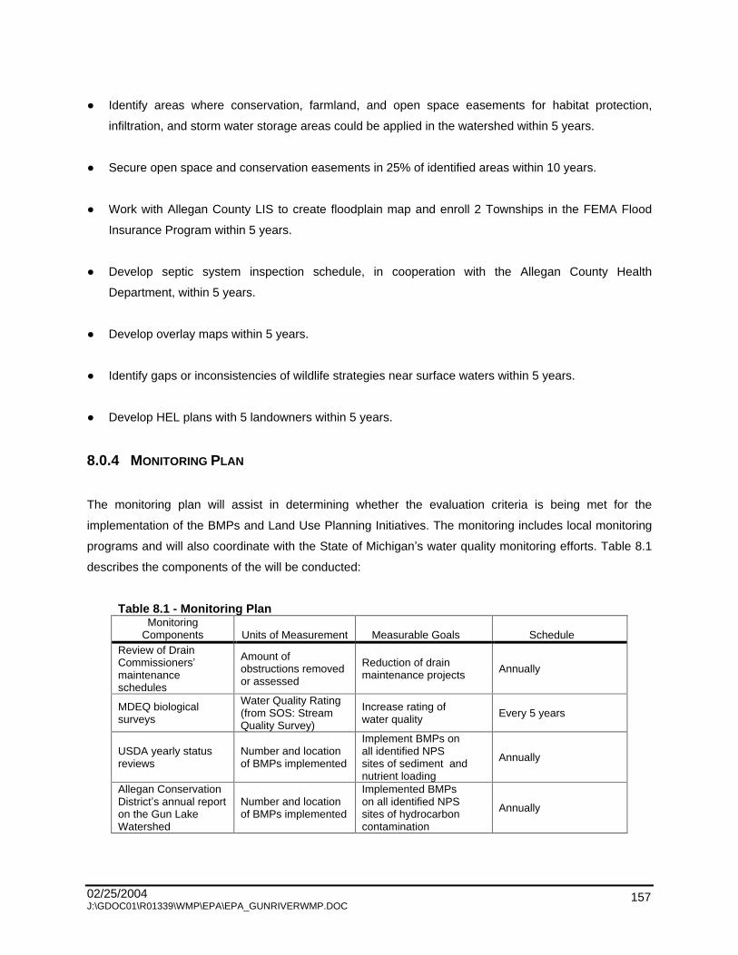
02/25/2004 J:\GDOC01\R01339\WMP\EPA\EPA_GUNRIVERWMP.DOC
157
Identify areas where conservation, farmland, and open space easements for habitat protection,
infiltration, and storm water storage areas could be applied in the watershed within 5 years.
Secure open space and conservation easements in 25% of identified areas within 10 years.
Work with Allegan County LIS to create floodplain map and enroll 2 Townships in the FEMA Flood
Insurance Program within 5 years.
Develop septic system inspection schedule, in cooperation with the Allegan County Health
Department, within 5 years.
Develop overlay maps within 5 years.
Identify gaps or inconsistencies of wildlife strategies near surface waters within 5 years.
Develop HEL plans with 5 landowners within 5 years.
8.0.4 MONITORING PLAN
The monitoring plan will assist in determining whether the evaluation criteria is being met for the
implementation of the BMPs and Land Use Planning Initiatives. The monitoring includes local monitoring
programs and will also coordinate with the State of Michigan s water quality monitoring efforts. Table 8.1
describes the components of the will be conducted:
Table 8.1 - Monitoring Plan Monitoring
Components Units of Measurement Measurable Goals Schedule Review of Drain Commissioners maintenance schedules
Amount of obstructions removed or assessed
Reduction of drain maintenance projects Annually
MDEQ biological surveys
Water Quality Rating (from SOS: Stream Quality Survey)
Increase rating of water quality Every 5 years
USDA yearly status reviews
Number and location of BMPs implemented
Implement BMPs on all identified NPS sites of sediment and nutrient loading
Annually
Allegan Conservation District s annual report on the Gun Lake Watershed
Number and location of BMPs implemented
Implemented BMPs on all identified NPS sites of hydrocarbon contamination
Annually

02/25/2004 J:\GDOC01\R01339\WMP\EPA\EPA_GUNRIVERWMP.DOC
158
Table 8.1 - Monitoring Plan
Monitoring Components Units of Measurement Measurable Goals Schedule
Pollutant reduction calculations
Tons of sediment and pound of nutrients prevented from entering surface water
Reduce sediment by 10% of sediment loading per year Reduce nutrients by 10% of phosphorus loading and by 5% of nitrogen loading pre year
After each system of BMPs is implemented
Cost/benefit comparison of BMPs and pollutants reduced
Cost of BMP implementation and pollutant load reduction. Cost and health risk of eliminating source of E. coli and pollutant load reduction
Economic impact of pollutant load reduced outweighs cost of BMP implementation. Health risk reduction of E. coli reduced outweighs cost of BMP implementation
After each system of BMPs is implemented and all costs are incurred
Evaluations of volunteer clean-up days
Number of volunteers Increase of volunteers at each clean-up day
After each clean-up day
Hydrologic Analysis Peak flows shown on hydrographs
Reduce peak flows on hydrographs by limiting impervious cover, minimizing channelization of streams, and restoring wetlands
Every 2 years
Stream Inventory Before and after photographs
Portfolio of photographs with supporting documentation
Annually
Water quality monitoring for E. coli
Number and location of sources eliminated
Eliminate discharge from all identified E. coli contributing sites and meet water quality standards for partial body contact recreation (1,000 count/100 ml) in all water bodies in the watershed and total body contact recreation (130 count/100 ml) in Gun Lake
To be determined
Annual drain inspections
Before and after photographs
Portfolio of photographs with supporting documentation
Annually
Natural features inventory on Gun Lake
Habitat evaluation. Populations of invasive species
Increase ratings for stream cover. Decrease observations of invasive species
Every 3 years
Land use and cover analysis
Amount of impervious cover by subwatershed
Changing development rules to limit amounts of impervious cover in developments
Every 5 years
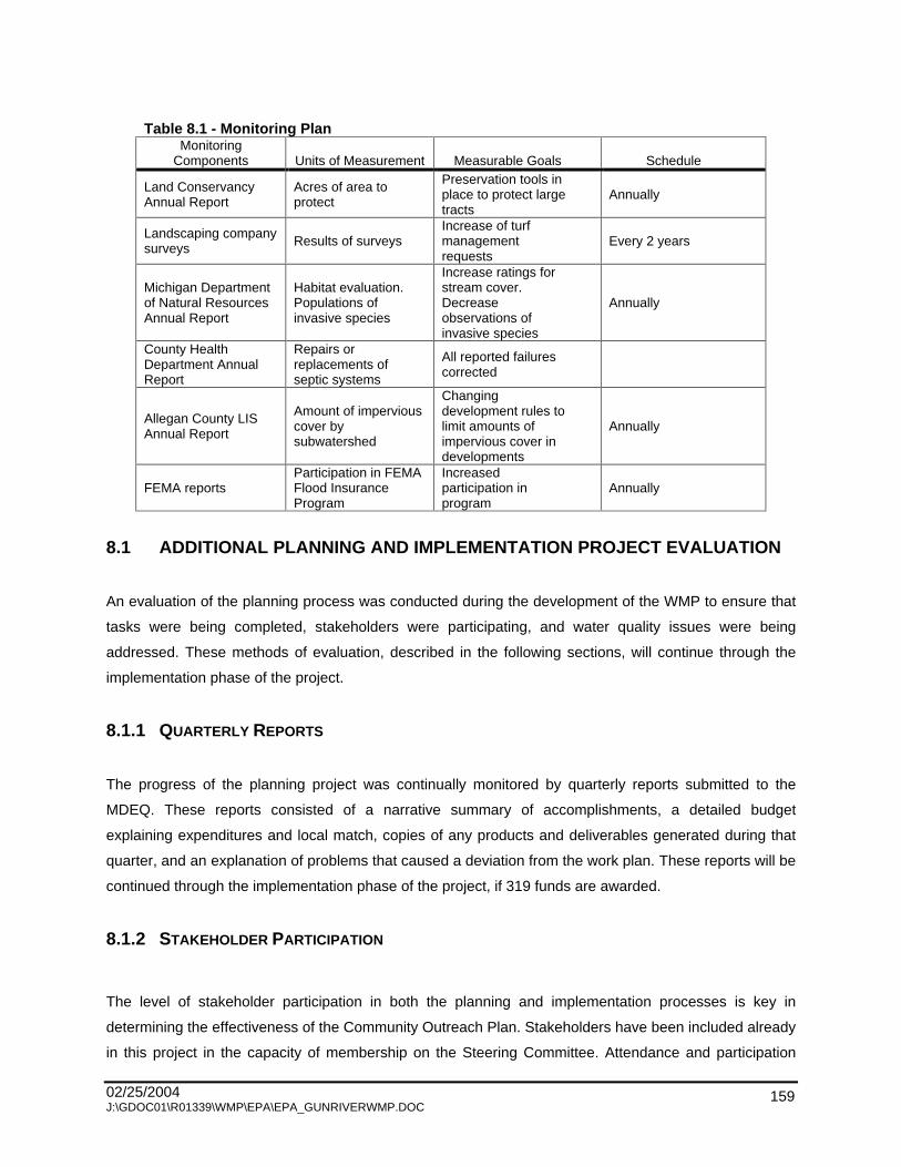
02/25/2004 J:\GDOC01\R01339\WMP\EPA\EPA_GUNRIVERWMP.DOC
159
Table 8.1 - Monitoring Plan
Monitoring Components Units of Measurement Measurable Goals Schedule
Land Conservancy Annual Report
Acres of area to protect
Preservation tools in place to protect large tracts
Annually
Landscaping company surveys Results of surveys
Increase of turf management requests
Every 2 years
Michigan Department of Natural Resources Annual Report
Habitat evaluation. Populations of invasive species
Increase ratings for stream cover. Decrease observations of invasive species
Annually
County Health Department Annual Report
Repairs or replacements of septic systems
All reported failures corrected
Allegan County LIS Annual Report
Amount of impervious cover by subwatershed
Changing development rules to limit amounts of impervious cover in developments
Annually
FEMA reports Participation in FEMA Flood Insurance Program
Increased participation in program
Annually
8.1 ADDITIONAL PLANNING AND IMPLEMENTATION PROJECT EVALUATION
An evaluation of the planning process was conducted during the development of the WMP to ensure that
tasks were being completed, stakeholders were participating, and water quality issues were being
addressed. These methods of evaluation, described in the following sections, will continue through the
implementation phase of the project.
8.1.1 QUARTERLY REPORTS
The progress of the planning project was continually monitored by quarterly reports submitted to the
MDEQ. These reports consisted of a narrative summary of accomplishments, a detailed budget
explaining expenditures and local match, copies of any products and deliverables generated during that
quarter, and an explanation of problems that caused a deviation from the work plan. These reports will be
continued through the implementation phase of the project, if 319 funds are awarded.
8.1.2 STAKEHOLDER PARTICIPATION
The level of stakeholder participation in both the planning and implementation processes is key in
determining the effectiveness of the Community Outreach Plan. Stakeholders have been included already
in this project in the capacity of membership on the Steering Committee. Attendance and participation

02/25/2004 J:\GDOC01\R01339\WMP\EPA\EPA_GUNRIVERWMP.DOC
160
throughout this process has been recorded and will be used to determine the number of committed
members and the diversity of the stakeholders represented. In addition, public meetings have been held
for stakeholder input and education. Attendance at these meetings has been recorded. The informational
and educational measures taken to publicize the project during the planning phase will be reviewed for
their effectiveness.
Stakeholder participation in educational workshops as well as the success in implementing the proposed
BMPs will further measure the participation of stakeholders. The number of workshop participants should
be compared to the number of public meeting participants during the planning phase to measure the
change in interest.
8.1.3 WATER QUALITY MONITORING
A baseline survey of water quality was implemented in the planning phase of this project. The survey is
an analysis of three components of the water; the physical, the chemical, and the biological.
Physical - temperature, conductivity
Chemical - pH, nitrogen, phosphorous, bio-chemical oxygen demand (BOD), dissolved oxygen
Biological - macroinvertebrates
The physical and chemical monitoring occurred at five pre-designated sites at a monthly interval. The
monitoring began in November 2001. This baseline evaluation of water quality was performed under the
coordination of the Gun Lake Sewer and Water Authority staff with additional analysis being performed by
Menasha Corporation.
A volunteer monitoring group of students will perform biological monitoring of macroinvertebrates. This
will be coordinated by the Allegan County Math and Science Center.
At the conclusion of the implementation phase of this project, the water quality monitoring will continue
through the Allegan County Math and Science Center program. The results can be used to track the
improvements to water quality.

02/25/2004 J:\GDOC01\R01339\WMP\EPA\EPA_GUNRIVERWMP.DOC
161
8.1.4 LESSONS LEARNED
Reporting on lessons learned is one of the most important sections in any project evaluation, because it
takes into account not only the specific project s successes and shortfalls, but also indicates the
improvements that could be made for future projects.
8.1.5 PARTNERS IN CONDUCTING EVALUATIONS
Each member of the various committees has shown interest in improving water quality in the Watershed,
and has made a valuable contribution. Many of these members will continue to serve as vital players
during the implementation phase. Strong interest has been shown in sustaining the Steering Committee,
with commitments to meet at least quarterly. The Technical Committee will meet more often to oversee
much of the structural and vegetative implementation process. The Information and Education Committee
has proven to be a team which is effective in delivering messages to the community and fostering
stewardship, a very important part of the Watershed project. While the committees provide much of the
structure and organization of the Watershed project, it is what happens on the ground that ultimately
matters most. All the committee members take what they have learned back to their organization, but
many have more specific roles to play.
The ACD will take the lead in involving landowners in implementing BMPs on their land. Other partners
will include the MDEQ for permitting and technical advising, as well as the NRCS for design assistance.
The county drain commissioners will take the lead on improvements to designated county drains. The
Southwest Michigan Land Conservancy, Ducks Unlimited, and other non-profit organizations will assist
with conservation and preservation efforts.
The townships are responsible for enacting ordinances that help meet the goals of their community. Many
ordinances and rules promote good practices. The townships must not only instruct their citizens, but
must act in a manner that demonstrates their concern for resource protection.
The most important partners are the members of the Watershed community itself. Those who live, work,
recreate, and simply enjoy its wildlife all shape the future of the Watershed. They are the stewards of the
land, water, and air.
The educational community, consisting of the public school system and private schools are partners in
educating both children and adults in the community. They are also proponents of responsible research
and gaining understanding of the world around us. Public schools will be conducting water quality
monitoring of the Watershed.

02/25/2004 J:\GDOC01\R01339\WMP\EPA\EPA_GUNRIVERWMP.DOC
162
CHAPTER 9 - SUSTAINABILITY
Members of the Steering Committee provided information about many of the numerous organizations,
programs, and ordinances that are working toward improving water quality in the greater Kalamazoo
River Watershed. Building on these existing programs, the Steering Committee hopes to meet the goals
of this Watershed Management Plan (WMP) and coordinate efforts with the Kalamazoo River Watershed
project to accomplish the goals set forth in the Total Maximum Daily Load (TMDL) program. Long-term
sustainability is possible for restoring this Watershed due to the high level of involvement in preserving
and protecting the unique resource of Gun Lake and the Gun River.
The prevailing goal of this plan it to collaborate efforts of local stakeholders to bring about changes in
activities that impact water quality and the way lakes and streams are managed. It will be important to
identify and support current programs and organizations that have already gained momentum since the
Kalamazoo RAP was created. Partnerships with these existing efforts in TMDL programs will be critical
for the success of the management plan. Since Watershed goals can best be met with the coordination of
water quality enhancement activities, it will be essential that citizens, business, and community
organizations lead the effort.
9.0 ROLES AND RESPONSIBILITIES IN PROJECT IMPLEMENTATION
the Best Management Practices and information and education strategies will require a sustaining effort
into the future to meet the goals of this WMP. A list of partners was generated during the Steering
Committee meetings while discussing impairments to designated uses. To ensure that work is completed
efficiently, tasks must be delgated to the appropriate agency or individuals that have the expertise and
resources to accomplish assigned task. Tasks in the implementation plans have short-term, intermediate,
and long-term goals and objectives. Therefore, this project is designed to be dynamic to change as new
agendas arise or project goals change. Currently, three areas are included in this plan that need
implementation strategies: BMPs, Information and Education, and Long-Term Project Goals.
9.0.1 BEST MANAGEMENT PRACTICES
The implementation of BMPs will undoubtedly be the most financially intensive task of the WMP. A
sincere cooperative effort of the following groups and agencies will be required to obtain the necessary
funds and resources to fulfill the goals and objectives of this project since they are a timescale of
implementation over the next 20 years.

02/25/2004 J:\GDOC01\R01339\WMP\EPA\EPA_GUNRIVERWMP.DOC
163
Drain Commissioners
The bulk of effort and responsibility for in-stream BMP implementation will fall to the Allegan County Drain
Commissioner (ACDC). The Gun River has been straightened, deepened, and channelized since being
designated a county drain in the early 1900s. Therefore, the ACDC will be responsible for any efforts to
install BMPs that may affect the drainage of properties of the county drain network. This will include the
planting of trees, plugging tiles to restore wetlands, buffer strips, bank shaping, and all erosion control
structures. However, any practice that will require a budget greater than $2,500 per mile of stream, will
require a special tax assessment that must be paid by the property owners. Therefore, public information
and education strategies are critical to gain support for these projects that will mandate a tax assessment
for beautification and restoration projects.
Conservation Districts
Conservation districts historically have been responsible for public outreach and technical assistance for
projects and programs that protect soil and water quality. Their role in the WMP will be the same, only a
higher level of involvement will be expected for efforts located inside the Watershed. Currently the
Allegan Conservation District has played a critical role in the organization of a Steering Committee, the
development of the I&E Strategy, and project evaluation.
The ACD has already built a strong relationship with landowners and agricultural producers in the
watershed. The ACD will also be responsible for garnering support for new projects that may require
assessment taxes or changes in the publics habits. This project s sustainability will depend on the
Conservation District s resources to continue education efforts and to supply technical assistance for
BMP implementation to ensure the momentum of the project.
Road Commissions
At this time, a total of 41 road crossings in the Watershed have been surveyed. Of these sites, 31 are in
need of repair or replacement, and more road crossings still need to be inventoried. Cooperation with the
Allegan County Road Commission (ACRC) is vital to achieve the goals of the Watershed plan. The
hydrologic and hydraulic studies have determined that a number of culverts, either blocked or
inadequately sized, are causing flooding and erosion. Consequently the ACRC will be responsible for the
repair or replacement of these culverts or bridges. The ACD will work with the ACRC to see that these
changes are in line with the project goals and objectives and are accomplished with the smallest impact
to water quality.

02/25/2004 J:\GDOC01\R01339\WMP\EPA\EPA_GUNRIVERWMP.DOC
164
United States Department of Agriculture
The USDA Service Center houses the Natural Resource Conservation Service (NRCS) and the Farm
Service Agency (FSA). Programs offered by the NRCS and FSA are listed below in Section 9.3. The
WMP depends upon USDA programs to provide technical and financial assistance to landowners and
farmers who wish to develop and implement practices that will promote water quality and limit soil
erosion. Given that one of the WMP s main goals is to reduce sediment and nutrients entering the Gun
River, cooperation with the agricultural areas are very important to the successful completion of the plan.
Michigan State University Extension (MSU Extension)
Staff at the MSU Extension have resources to perform a variety of soil tests. These tests have been
readily used by farmers to recommend proper amounts of fertilizers. Free tests are also done by fertilizer
suppliers. The agriculture stakeholders suggested that MSU Extension educate fertilizer dealers about
interpreting their own results and making recommendations that reflect crop nutrient management plans
that coincide with the TMDL goals.
Enforcing Agencies for Soil Erosion and Sedimentation Control
To ensure that managerial BMPs are being followed, construction site inspectors must have a working
knowledge of any changes in township ordinances that will arise after the implementation of this WMP.
Enforcing agents must be able to explain the reasons for code changes and alternatives to obsolete site
management practices that endangered water quality.
Landowners
Many of sites for BMP implementation are on private property. Since implementation of these structural or
vegetative BMPs is on a volunteer basis, the success will chiefly rely on the public information and
education strategy.

02/25/2004 J:\GDOC01\R01339\WMP\EPA\EPA_GUNRIVERWMP.DOC
165
Conservation Organizations
Conservation organizations already have access to a great number of enthusiastic men and women
ready to volunteer time to the enhancement of outdoor recreational activities. One example of this
enthusiasm comes from the Muskegon River Watershed Project. Trout Unlimited had a volunteer work
day planned for a Saturday morning where they expected roughly 20 individuals to attend. However, the
watershed coordinators found themselves running for extra hotdogs three times for the almost 200 people
that arrived over the course of the day. If the Watershed has this kind of public outpouring, a volunteer
stream restoration day would have a tremendous affect on the quality of recreation in the Gun River.
9.0.2 INFORMATION AND EDUCATION
Conservation Districts
As stated earlier, the Conservation District s essential role in the WMP will be public information and
education. To ensure the long-term sustainability of the project, the public must be involved and
supportive of its goals and objectives. The Conservation District plans to maintain awareness and
involvement of stakeholders in the Watershed project through a variety of outreach programs detailed in
Chapter 6. Key roles played by the Conservation District will be the production of newsletters and
informational brochures. These types of outreach programs increase the visibility of the Watershed and
facilitate the public s recognition that the Gun River is a great resource for their communities. In addition
to printed materials, the conservation district staff will be available for technical guidance for implementing
erosion and sedimentation control structures and practices.
United States Department of Agriculture
The USDA has offices in Hastings and Allegan for servicing their respective counties. For anyone wishing
to enroll property into conservation management programs, they must sign up at their county office.
Landowners should be encouraged to visit, and the USDA offices should likewise use their resources to
inform and educate the public about services that are available through the NRCS and the FSA. The
USDA also offers a plethora of agriculture related information media including brochures, newsletters,
and displays for a reduced cost for its clients.

02/25/2004 J:\GDOC01\R01339\WMP\EPA\EPA_GUNRIVERWMP.DOC
166
MSU Extension
As an educational facility, the MSU Extension should play an active role in public education. The
extension has highly qualified field personnel that can perform soil testing and recommend the proper rate
applications of fertilizers and herbicides. The agriculture stakeholders of the Kalamazoo TMDL
Implementation Plan have requested that the MSU Extension educate fertilizer suppliers about the TMDL
and how to properly recommend phosphorus application rates. In addition to field services, the
MSU Extension has an online directory of publications about land stewardship practices to protect the
environment and productivity of the land.
Publications: Gun Laker Magazine and Wayland Globe
The Gun Laker Magazine and Wayland Globe are both highly visible publications in the Watershed. Both
have already run articles about the current WMP, and it is hoped that they will continue their support for
this project. Agricultural publications could also be solicited for support in reducing phosphorus and
sediment inputs from field runoff or wind erosion.
Groundwater Stewardship Program: Farm*A*Syst, Home*A*Syst, and Field*A*Syst
The MDA administers a program for farmers that provides technical support in reducing contaminants and
improving groundwater usage efficiency. The program has now spread to surface waters in groundwater
protection zones and provides up to 90% of the implementation cost of agricultural BMPs. Homeowners
and farmers both can enlist in this voluntary and confidential program that helps identify risks to
groundwater safety in the home or on the farm.
Lake Associations and Boards
Lake associations and lake boards are often the only link between township ordinances and temporary
lake residents. Many of the riparian landowners and renters do not have knowledge of local ordinances or
any projects, like this WMP, that are occurring when they are away. For that reason, lake associations or
boards must take a proactive approach to community riparian involvement. Associations need to
distribute informative literature, host educational meetings that are interesting to the greater public, and
become active themselves in this Watershed project.

02/25/2004 J:\GDOC01\R01339\WMP\EPA\EPA_GUNRIVERWMP.DOC
167
9.0.3 LONG-TERM PROJECT GOALS
Changing management strategies requires a very long review process, public approval, and
implementation time for restructuring and supervising changes. Consequently, changing township
ordinances and land use planning has been identified as a long-term project goal.
Townships and Planning Commissions
A formal review of existing ordinances and how they fit into the management plan is needed before any
planning can proceed. Once the current policies have been assessed, the community needs can be
identified. At this point all stakeholders need to be identified and brought into the planning process. All
involved must state their needs and how they will fit into the TMDL and WMP. The goal is that a
comprehensive model ordinance will be developed for townships in the Watershed to use. This ordinance
should continue to use this plan and the TMDL Implementation Plan as a tool for land use planning that
contains specifications for storm water, acceptable land uses, conservation measures, and other
strategies to preserve open land and water quality.
It will also be the townships responsibility to sustain the momentum of community support for this project.
They can do this by using the Gun River as the feature for their community that deserves recognition.
This can be accomplished through hosting watershed celebrations or by designating sections of the
riparian corridor as township or county parks.
Michigan Township Services
Michigan Townships Services is a private corporation that is contracted by the County Enforcing Agency
to inspect soil erosion and sedimentation control permitees. Their services provide an excellent means of
information gathering for townships about the status of project implementation and compliance.
Presentations at township committee meetings could offer needed information to officials about additional
needs for control of sediment.
9.1 ANALYSIS OF OTHER PROJECTS AND PROGRAMS
A number of ongoing projects in the Kalamazoo River Watershed have surfaced in response to the
implementation of the Kalamazoo RAP. Table 9.1 shows a number the water quality protection and
enhancement projects in the basin. There are many lessons to learn by studying the successes and
failures of the ongoing projects in the Watershed. Some of these projects are summarized below.

02/25/2004 J:\GDOC01\R01339\WMP\EPA\EPA_GUNRIVERWMP.DOC
168
Table No. 9.1 - Water Quality Projects and Programs Pertaining to the Gun River Watershed
Project or Program Sponsoring Organizations Primary Purpose Geographic Scope Time Frame
Kalamazoo River Watershed Council
Remedial Action Plan, education, communication, advocacy, technical assistance
Kalamazoo River Watershed
Ongoing
Watershed Information Management Project
Western Michigan University GEM, City of Kalamazoo, Kalamazoo County Environmental Health
Set up regional center to collect, maintain, and disseminate environmental quality data
Regional
Ongoing
Wellhead Protection Programs
City of Otsego Protect groundwater City of Otsego Ongoing
GIS Watershed Atlases Western Michigan University GIS Research Center
Create GIS atlas of land use, soils, wetlands, etc. for land use planning and natural resources protection
Kalamazoo River Watershed in Allegan, Barry, and Kalamazoo Counties Ongoing
Farm Bill Programs for natural resource protection on agricultural lands
Natural Resource Conservation Service and Conservation Districts
Conservation planning and implementation on agricultural lands
Household Hazardous Waste Collection
Allegan County Health Department
Collection and disposal of household hazardous waste
Most areas of Allegan County
Ongoing
Michigan State University Extension programs
Michigan State University Education, technical assistance for agriculture, and groundwater protection
Michigan
Ongoing
Michigan Department of Environmental Quality NPS Program
Michigan Department of Environmental Quality
Technical assistance, watershed planning assistance, regulatory assistance, and grant funding
Michigan
Ongoing
Michigan Groundwater Stewardship Program
Michigan Department of Agriculture, Michigan State University
Farm*A*Syst, Field*A*Syst, closing abandoned wells, emergency plans/tubes, BMP cost-share
Allegan and Barry Counties
Ongoing
NPDES Program Michigan Department of Environmental Quality
Permits, regulatory framework for some point source discharges
Michigan
Ongoing
Local Government development permitting
Local units of government Land use decisions and regulations, site plan reviews
Cities and townships Ongoing
Part 91 Program, (NREPA, PA 451, 1994 as amended)
Counties, cities, or public agencies as enforcing agents
Soil erosion control from construction activities
Michigan Ongoing

02/25/2004 J:\GDOC01\R01339\WMP\EPA\EPA_GUNRIVERWMP.DOC
169
9.1.1 NATIONAL POLLUTANT DISCHARGE ELIMINATION SYSTEM PERMIT PROGRAM
Created in the Clean Water Act of 1972, the National Pollutant Discharge Elimination System (NPDES)
was designed to work with industry to implement the best available technology into wastewater treatment
facilities. Industrial or commercial operations that discharge any pollutants to a water body are required to
obtain a permit from the MDEQ. The permit is typically active for 5 years and specifies the treatment
levels necessary for the permitee. Once the permit has expired, the industrial standards are reviewed and
a new permit is issued under the stipulation that the permits specified technologies are implemented into
the water treatment systems. Currently, one NPDES permit has been issued for industrial discharge and
one for storm water discharge in the Watershed.
9.1.2 MICHIGAN GROUNDWATER STEWARDSHIP PROGRAM
Farm*A*Syst is a voluntary and confidential program that works with farmers to identify potential risks of
groundwater contamination on their farm. A groundwater technician completes a worksheet with the
farmer and helps identify ways to reduce the risk of groundwater contamination from such things as
fertilizers, animal wastes, pesticides, petroleum products, and other chemicals. An additional project is
the creation of emergency plans, which map the farm, including storage facilities and escape routes.
These are then placed in a weatherproof tube on a telephone pole in front of the farm. In the event of a
fire, these plans will be used by firefighters to locate dangerous chemicals.
Field*A*Syst is another voluntary and confidential program offered to farmers. Technical assistance for
soil testing and agricultural BMPs is provided free of charge to all enrolled in the program. Cost sharing is
available for demonstration projects.
The Abandoned Well Closures program identifies areas on farms that are a groundwater contamination
threat. Abandoned well heads may become infiltration points for nitrogen and pesticide to enter
groundwater. Those participating in the program can obtain free literature, technical assistance, and cost
sharing up to 90% for the closure of abandoned wells.
9.1.3 GENERALLY ACCEPTED AGRICULTURE MANAGEMENT PRACTICES
In July 2002, the Generally Accepted Agriculture Management Practices (GAAMPS) were finalized. Any
farm operation that abides by these GAAMPS will not be found as a public nuisance. The design of this
bill (PA 93) was meant to protect farmers from nuisance lawsuits. Large scale farm operations should be
MDA certified as compliant for this litigation protection. The added benefit to the Watershed is that
farmers are given this incentive to operate in an environmentally sound manner.
02/25/2004 J:\GDOC01\R01339\WMP\EPA\EPA_GUNRIVERWMP.DOC
170
9.1.4 PUBLIC ACT 116
Public Act 116 (PA 116) is a state public act which gives tax incentives for purchasing development
rights. In order for land to qualify, it must be suitable for farming, be adjacent to protected farmland, or be
in an area which local government wishes to protect as farmland. Local units of government can submit
an application for a grant to pay for the conservation easement.
9.1.5 DRAIN COMMISSIONER
The county drain commissioners assist with water activities that are associated with designated drains.
They are responsible for drain improvements and keeping the integrity and appropriate function of the
drains intact. The Gun River and many of its tributaries are designated county drains, therefore the ACDC
should be an included partner in any in-stream projects.
9.1.6 DEPARTMENTS OF STATE AND FEDERAL GOVERNMENT
The following agencies provide technical and financial assistance to many projects. Often projects must
meet certain rules or need specific permits. The following departments should be contacted if questions
arise about permit requirements.
United States Department of Agriculture - Farm Service Agency (FSA)
United States Department of Agriculture - Natural Resource Conservation Service (NRCS)
Michigan Department of Transportation (MDOT)
Michigan Department of Agriculture (MDA)
Michigan Department of Environmental Quality (MDEQ)
Michigan Department Natural Resources (MDNR)

02/25/2004 J:\GDOC01\R01339\WMP\EPA\EPA_GUNRIVERWMP.DOC
171
9.1.7 GUN PLAIN CHARTER TOWNSHIP PLANNING ORDINANCE
Section 12.1 of the Gun Plain Charter Township Planning Ordinance proposes a Greenbelt Overlay
District to the Gun River and Gun Lake areas inside Gun Plain Township. Although the ordinance has
not passed public approval, the ideas specified therein are good models for other townships to consider.
The Greenbelt Overlay recognizes areas within the township s riparian zones that need special
consideration for zoning requirements. Some example proposals are listed below:
Native protective strip of 75 feet for watercourses and 25 feet for lakes.
No dwelling or structure on lands subject to flooding.
No storage of hazardous substances within 150 feet of high water line.
Septic system setbacks of 150 from high water mark.
9.1.8 FRIENDS OF THE GUN RIVER
Currently, this group has no formal statement of its goal and objectives, however, a growing movement in
the Watershed is expressing a strong desire to move this group into the formalization stage. Examples of
this group s accomplishments are two highly productive river clean-up projects. Other goals are
newsletters, committee meetings, further clean-up projects, and a formalized members list.
9.2 FUNDING AND RESOURCE OPPORTUNITIES
At this time, funding for the State s Clean Michigan Initiative (CMI) has been delayed. To best ensure the
sustainability of this project, it is important to diversify funding options. Below are many examples of
funding and resource sources that the Gun River is eligible to receive.
9.2.1 SECTION 319 IMPLEMENTATION FUND (319)
Section 319 Implementation Funds derive their name from Section 319 of the Federal Clean Water Act of
1972. Section 319 funds are a component for implementing a WMP that supplies funding for projects that
are in the planning stage or are in need of monies to support non-physical improvements. Since 319
funds are granted by the federal government, they have been more stable than the CMI program. The
WMP will still rely on 319 funds for part of the budget for I&E programs, site planning, township ordinance
changes, and implementing managerial BMPs.
02/25/2004 J:\GDOC01\R01339\WMP\EPA\EPA_GUNRIVERWMP.DOC
172
9.2.2 EPA 5-STAR GRANT
The EPA 5-Star Grant involves 5 entities; students, conservation corps, corporations, landowners, and
government agencies, who provide environmental education through projects that restore streambanks
and wetlands. The program provides challenge grants, technical support, and opportunities for
information exchange to enable community-based restoration projects. The grants are typically small,
around $10,000, but they are accessible to the general public and are flexible to meet the grantees
needs. In most cases, a school would be able to get this grant for environmental education programs.
These programs are very important for project sustainability since they are creating stewardship in the
communities young people at an impressionable age.
9.2.3 MICHIGAN VOLUNTEER MONITORING GRANTS
Another source for the evaluation of the project could be the Michigan Volunteer Monitoring Grant made
available by the MDEQ. These grants supply watershed committees or local governments with matching
funds for the purchase and maintenance of stream monitoring programs. Training time should also be
committed for background information and quality assurance guidelines for sampling protocol.
9.2.4 UNITED STATES FISH AND WILDLIFE SERVICE (USFWS)
The Watershed is home to the rare and elusive king rail, a migratory wetland bird species. This bird and
many other species depend on the Watershed for wetland areas for habitat, mating grounds, and foraging
areas. As wetlands disappear, so do many of the related species that cannot adapt to life outside the
wetland. The USFWS supports large and small wetland projects and the Gun River may be given
preferential treatment since it is home to the king rail. Grants are 1:1 matching funds up to 1 million
dollars for wetland and bird habitat restoration projects.
9.2.5 THE GREAT LAKES COMMISSION - SEDIMENT AND EROSION CONTROL PROJECT
GRANTS
The Great Lakes Commission in cooperation with the EPA Region V and the NRCS are providing small
sedimentation and erosion control grants to local authorities in the Great Lakes Areas of Concern. The
Kalamazoo River Watershed, which includes the Gun River is one of Michigan s 43 Areas of Concern and
is eligible for one of these grants. Eligible projects must be specific with a clear goal that can have
evaluated results for the reduction of sediment and erosion. The Great Lakes Commission publishes
reports in an annual newsletter called Keeping It On the Land.
02/25/2004 J:\GDOC01\R01339\WMP\EPA\EPA_GUNRIVERWMP.DOC
173
9.2.6 NATURAL RESOURCES CONSERVATION SERVICE FARM BILL PROGRAMS
Wetland Reserve Program
The Wetland Reserve Program is run by the USDA. It provides easements for restoring wetlands in
agricultural land. Financial incentives, free technical support, and cost sharing are provided. The
retirement of the land must be for a minimum of 10 years, but 30-year and permanent easements are also
offered in which the USDA pays a much greater amount of the cost of restoration and price of the land.
The landowner controls access to the land and may use it for recreational activities such as hunting and
fishing. Other options may be negotiated in the contract.
Conservation Reserve Program
The CRP was created in 1985 as part of the Food Security Act. The producer enters into a long-term
contract. In the CRP, the land is set aside and a permanent cover is established. In return, the farmer
receives and annual per acre rent and up to half the cost of establishing cover on land that has recently
been farmed and is highly erodible or environmentally sensitive. Additional acts in 1990 and 1996 have
allowed continued enrollment and expanded the scope from reducing soil erosion to include habitat
conservation. Participants may sign up at any time to perform the following practices on their land. A
typical agricultural land rent in southwest Lower Michigan is around $35 per acre. The CRP program
gives an added 20% bonus for land used in any of the below measures:
Filter Strips
Riparian Buffers
Shelterbelts, Field Windbreaks, and Living Snow Fences
Grass Waterways
Shallow Water Areas for Wildlife
Salt-Tolerant Vegetation
Certain Approved Public Wellhead Protection Areas

02/25/2004 J:\GDOC01\R01339\WMP\EPA\EPA_GUNRIVERWMP.DOC
174
Today, the Environmental Benefits Index (EBI) is used to prioritize land offered for enrollment. Scores are
based on a cost factor, plus six environmental factors, as follows.
Wildlife
Water Quality
Erosion
Enduring Benefits
Air Quality Benefits from Reduced Wind Erosion
State or National Conservation Priority Areas (CPAs)
The Great Lakes, along with Long Island Sound, the Chesapeake Bay, the Longleaf Pine region, and the
Prairie Pothole region comprise the national CPAs.
Environmental Quality Incentives Program (EQIP)
Another provision funded by USDA and created in the Food Security Act of 1985 is the EQIP. The
voluntary EQIP makes enrolled land eligible for flexible grants for conservation practices. EQIP may pay
up to 75% of the cost of conservation practice implementation. Some practices eligible for funding are:
Comprehensive nutrient management plans
Irrigation improvements
Conversion to less water intensive crops
Improved water storage measures
Groundwater recharge measures or banking
Other programs that result in a net savings in groundwater or surface water resources
Wildlife Habitat Incentives Program (WHIP)
WHIP is another voluntary conservation program that encourages the protection or creation of high
quality wildlife habitat that supports populations of locally significant wildlife. The USDA provides
landowners with technical support and financial assistance to develop habitat areas on their property.
Interested landowners must contact the state conservationist for enrollment into the WHIP. If accepted,
the NRCS and FSA will work with the landowner to develop a 5- to 10-year cost-share plan.

02/25/2004 J:\GDOC01\R01339\WMP\EPA\EPA_GUNRIVERWMP.DOC
175
Farmland Protection Program (FPP)
The FPP, conducted by the NRCS and FSA is a voluntary program that helps farmers keep their land in
agriculture. The program funds state and local governments, conservancies, and other non-government
organizations to purchase conservation easements. The agreements are typically 30 years and priority is
given to lands with perpetual easements. Organizations or governments that are eligible for funding can
receive 50% of the fair market value for the property in question. Eligibility requirements are:
Contains prime, unique, or other productive soil or historical or archaeological resources;
Be included in a pending offer from a state, tribal, or local government or non-governmental
organization s farmland protection program;
Be privately owned;
Be covered by a conservation plan for any highly erodible land;
Be large enough to sustain agricultural production;
Be able to be converted to non-agricultural uses in the existing deed;
Be accessible to markets for what the land produces; and
Be surrounded by parcels of land that can support long-term agricultural production.
9.2.7 OTHER SOURCES OF FUNDING AND RESOURCES
Nature Conservancy
The Nature Conservancy is a well known and very selective conservation organization. They identify
exemplary sections of land from across the world that are unique and threatened. They are also an
advocacy group and promote educational activities and projects which help conserve unique natural
heritage sites. To learn more about the Nature Conservancy, go to http://nature.org/.
Student Volunteer Stream Monitoring
The Allegan County Math and Science Center currently is operating a student stream monitoring program
for Allegan and Wayland Public Schools. Grants are available through 319 and CMI for funding the
programs implementation. Student groups are sustainable even if grant monies are no longer available.

02/25/2004 J:\GDOC01\R01339\WMP\EPA\EPA_GUNRIVERWMP.DOC
176
Michigan Audubon Society
The Audubon Society is an organization that has been working to conserve habitats in the United States
for over 100 years. John James Audubon described and painted birds. The Michigan Audubon Society is
Michigan s oldest conservation organization, conceived in 1904. They have sanctuaries and nature
centers, as well as other outreach and educational material that is available throughout the state. See
their website for more information: http://www.michiganaudubon.org/index.html.
Michigan United Conservation Clubs (MUCC)
The MUCC has a membership that is interested in acting locally to conserve natural resources and use
them wisely. They are an advocacy group and lobby in the State of Michigan. More information is
available at http://www.mucc.org/.
American Farmland Trust (AFT)
The AFT works toward sustainable agriculture by working with communities and landowners. More
information is available at http://www.farmland.org/.
Innovative Farmers
The Innovative Farmers is a group of agricultural producers interested in new sustainable practices and
techniques which are environmentally and financially sound. They work as a community, sharing
resources, to develop demonstration projects that use innovative techniques. It is farmer-based research
that can be shared with other Innovative Farmers groups and applied in other areas.
Michigan State University Extension (MSUE)
MSUE utilizes the resources of Michigan State University and works on community outreach, especially
with agriculture and families. MSUE offers a wide variety of technical assistance and employs individuals
with high levels of expertise in their area of concentration to meet specific needs of producers. They are
also involved with research to better the services and technology available.
4-H
The 4-H club is the youth education branch of the Cooperative Extension Service, and in Michigan, 4-H is
associated with MSUE.

02/25/2004 J:\GDOC01\R01339\WMP\EPA\EPA_GUNRIVERWMP.DOC
177
Future Farmers of America (FFA)
The FFA involves youth in farming activities and teaches them skills they will need to be farmers,
including soil identification and livestock care. There is an opportunity to involve them in implementation
of BMPs on farms in the Watershed.
Boy and Girl Scouts
The Boy Scouts of America and the Girl Scouts of the USA involve many boys and girls, respectively, in
the Watershed with personal growth and community stewardship. Boy and Girl Scouts work on
community and natural resource projects. They learn through service and the collaboration of the
Watershed project and these groups would have mutual benefits.
The highest honor a Boy Scout can earn is becoming an Eagle Scout. Strict requirements must be met for
this prestigious award, one of which is to design and implement a project that benefits the community.
Many Eagle Scouts do their projects in association with natural resource awareness, such as building
boardwalks at wetlands or interpretive trails at nature centers. Many opportunities exist in the Watershed
project to work with an Eagle Scout candidate to help him achieve his goals and improve the Watershed.

02/25/2004 J:\GDOC01\R01339\WMP\EPA\EPA_GUNRIVERWMP.DOC
178
CHAPTER 10 - RESOURCE LIBRARY
Many resources were available for use in the creation of this document. A collection of the materials and
literature pertaining to the Gun River Watershed is housed at the ACD and is available for public use. The
following list includes the documents currently in the resource library. The list will be periodically updated
with additions:
Federal, State, and Municipal Manuals and Handbooks
FSA. The 13th Sign-Up. 1994. http://www.fsa.usda.gov/dafp/cepd/12crplogo/page29.htm
Hardwood, Richard. 1993. Improving Nitrogen Utilization with Rotation and Cover Crops. SARE, E2692.
1993. http://www.msue.msu.edu/misanet/papers/E2692_sare08-9.htm
Michigan Department of Natural Resources, Surface Water Quality Division. 1991. Agricultural Best
Management Practices Manual for NPS Program.
Michigan Department of Natural Resources. 2000. Trout Survey, Gun River, September 13, 2000.
US Census Bureau, 2000.
USDA, Soil Conservation Service. 1990. Soil Survey of Barry County, Michigan. Lansing, Michigan.
USDA, Soil Conservation Service. 1982. Resource Inventory, Allegan County, Michigan.
USDA, Soil Conservation Service. 1983. Water Quality Field Guide. Publication SCS-TP-160.
USDA, Soil Conservation Service. 1985. Natural Resource Inventory Data. Allegan County.
USDA, Soil Conservation Service. 1987. Soil Survey of Allegan County, Michigan. Lansing, Michigan.
Reports and Study Literature
Duffy, Joan. 1991. Gun Lake. Michigan Department of Natural Resources, Status of the Fishery Resource
Report 1991-2. http://www.dnr.state.mi.us/www/ifr/ifrlibra/Status/Waterbody/91-2.htm

02/25/2004 J:\GDOC01\R01339\WMP\EPA\EPA_GUNRIVERWMP.DOC
179
Kalamazoo River Watershed Council. 1998. The Kalamazoo River: Beauty and the Beast. Remedial and
Preventive Action Plan for the Kalamazoo River Watershed AOC.
Keto, Dan. 2001. Species Inventory, Gun River between 110th and 107th Avenues.
Krueger, Thomas J. 1997. Aquatic Survey of Gun Lake, Barry and Allegan Counties, Michigan, AAT
Labs, Inc.
Non-Point Source Modeling of Phosphorus Loads in the Kalamazoo River/Lake Allegan Watershed for a
TMDL. http://www.kalamazooriver.net/tmdl/docs/docs.htm
USDA and Michigan Department of Natural Resources. 1997. A Water and Land Resource Plan for the
Kalamazoo-Black-Paw Paw Rivers Basin. Citizens Advisory Council, County Task Forces.
Warbach, John, Ph. D. and Mark A. Wyckoff, AICP. 1995. Growth Management Tools & Techniques.
Publication of the Michigan Coastal Management Program, Michigan Department of Natural Resources.
Wesley, Jay K. 2000. Fish Lake. Michigan Department of Natural Resources, Status of the Fishery
Resource Report 2000-13, (Barry County T2N, R10W, Sec. 16, 21).
http://www.dnr.state.mi.us/www/ifr/ifrlibra/Status/waterbody/00-13.htm

02/25/2004 J:\GDOC01\R01339\WMP\EPA\EPA_GUNRIVERWMP.DOC
180
BIBLIOGRAPHY
Brewer, Lawrence G., Thomas W. Hodler, and Henry A. Raup. Presettlement Vegetation of Southwestern
Michigan, Western Michigan University.
Duffy, Joan. 1991. Gun Lake. Michigan Department of Natural Resources, Status of the Fishery
Resources Report 1991-2.
Kalamazoo River/Lake Allegan TMDL Implementation Committee. 2002. Water Quality Improvement
(Implementation) Plan for the Kalamazoo River Watershed and Lake Allegan Through a Phosphorus
Total Maximum Daily Load (TMDL) Process. July 28, 2002. 98 pp.
Kalamazoo River Watershed Council. 1998. The Kalamazoo River: Beauty and the Beast. Remedial and
Preventive Action Plan for the Kalamazoo River AOC.
Kieser & Associates.2001 Non-Point Source Modeling of Phosphorus Loads in the Kalamazoo River/Lake
Allegan Watershed for Total Maximum Daily Load. Prepared for the Kalamazoo Conservation District,
April 2001. 59 pp.
Keto, Dan. 2001. Species Inventory, Gun River between 110th and 107th Avenues.
Krueger, Thomas J. 1997. Aquatic Survey of Gun Lake, Barry and Allegan Counties, Michigan, AAT
Labs, Inc.
Michigan Department of Environmental Quality, Surface Water Quality Division. 2000. A Biological Survey
of the Kalamazoo River and Selected Tributaries, June-September 1999. MI/DEQ/SWQ-00/090.
Michigan Department of Natural Resources, Surface Water Quality Division, 1990. A Biological Survey of
the Gun River, Allegan County, Michigan, July 26, 1989. MI/DNR/SWQ-90/136.
Michigan Department of Natural Resources. 2000. Trout Survey, Gun River, September 13, 2000.
Michigan State University s Revised Universal Soil Loss Equation (RUSLE) Online Soil Erosion
Assessment Tool (www.iwr.msu.edu/rusle/soil_loss.htm)
Non-Point Source Modeling of Phosphorus Loads in the Kalamazoo River/Lake Allegan Watershed for a
TMDL, 2000. http://www.kalamazooriver.net/tmdl/docs/docs.htm

02/25/2004 J:\GDOC01\R01339\WMP\EPA\EPA_GUNRIVERWMP.DOC
181
O Meara, Kenneth, 1981. Personal Communication to the Allegan County Drain Commissioner.
RS Means Company, Inc., 1996. Building Construction Cost Data. Construction Publishers &
Consultants.
USDA, Soil Conservation Service. 1990. Soil Survey of Barry County, Michigan. Lansing, Michigan.
USDA, Soil Conservation Service. 1987. Soil Survey of Allegan County, Michigan. Lansing, Michigan.
Wesley, Jay K. 2000. Fish Lake. Michigan Department of Natural Resources, Status of the Fishery
Resource Report 2000-13, Barry County (T2N, R10W, Section 16, 21).
www.farmland.org
www.kalamazooriver.net
www.kalamazooriver.net/cgi/ps_vz/intro.cgi
www.michiganaudubon.org
www.msue.msu.edu/misanet/papers
www.mucc.org
www.naturenearby.org

02/25/2004 J:\GDOC01\R01339\WMP\EPA\EPA_GUNRIVERWMP.DOC
182
GLOSSARY
Area of Concern - one of the 42 regions designated by the International Joint Commission which
adversely contributes to the Great Lakes or St. Lawrence River.
Anthropogenic - caused or produced by humans.
Attenuation (hydrograph) - the reduction of the slope of a hydrograph, whereby the flow is extended
over a longer period of time.
Base Flow - the part of the stream flow that is not due to direct runoff from precipitation; it is usually
supported by water draining from natural storage in groundwater bodies, lakes, or wetlands.
Benthic - referring to the stream or lake bottom.
Best Management Practice (BMP) - structural devices or nonstructural practices that are designed to
prevent pollutants from entering storm water flows, to direct the flow of storm water, or to treat polluted
storm water flows.
Clean Michigan Initiative (CMI) - a bond approved by Michigan voters in 1998, which designates $165
million for structural and managerial enhancements which improve water quality in Michigan.
Clean Water Act 303(d) Non-attainment List - a list that must be produced by each state every 2 years,
of waterbodies that do not meet water quality standards.
Coldwater Fishery - summer temperatures must not exceed that which are able to sustain trout, with
optimum temperatures between 50°F and 60oF for coldwater and 60° F and 70oF for coolwater fisheries.
Confluence - the point at which two or more watercourses intersect.
Conservation - the use of a resource within the limits, which are set.
Critical Area - that part of the watershed that is contributing or has the potential to contribute a majority
of the pollutants and is having the most significant impacts on the waterbody.
Culvert - a covered channel or a large diameter pipe that directs water flow below the ground level.

02/25/2004 J:\GDOC01\R01339\WMP\EPA\EPA_GUNRIVERWMP.DOC
183
Designated Use - one of the seven uses designated by the State of Michigan which every surface water
in Michigan must meet.
Desired Use - uses that are determined important by local stakeholders that do not fall into the
categories designated by the State of Michigan.
Detention Basin - a storm water structure in which part of the runoff is detained, and the remainder is
contained in a permanent pool.
Discharge - a release or flow of storm water or surface water, usually expressed as cubic feet per
second.
Dissolved Oxygen - the amount of gaseous oxygen (O2) dissolved in an aqueous solution (water).
Drain - a reach which has been placed under the jurisdiction of a county drain commissioner.
E. coli (Escherichia coli) - bacterium used as an indicator of the presence of waste from humans and
other warm-blooded animals.
Eutrophication - the process of enrichment of waterbodies by nutrients, which may lead to increased
growth of algae or rooted plants. Process can be natural or accelerated by human activity (cultural
eutrophication).
Filter Strip - a grassed area adjacent to a waterbody which is used to filter NPS pollution.
Flashy Flow - a river or stream which reacts dramatically to storm events, producing high fast flows
during and immediately following a storm event.
Floodplain - the area in a river valley covered with soil deposited by floods.
GIS - a system that analyzes and models data in a spatial context and displays digitally recreated map
layers.
Geotextile - fabric which is used in soil erosion control for the purpose of retaining soil until vegetation is
established.

02/25/2004 J:\GDOC01\R01339\WMP\EPA\EPA_GUNRIVERWMP.DOC
184
Glaciolacustrine - of an ancient lakebed formed by glaciers, having fine grained texture sediment which
results from ground debris in glacial meltwater.
Groundwater - the subsurface water supply in the saturated zone below the water table.
Gully Erosion - severe erosion in which trenches are cut to a depth greater than 30 centimeters (1 foot).
Headwaters - the origin and upper reaches of a river or stream.
Hydraulic Model - prediction of the behavior of flows within a channel.
Hydric Soil - a wetland soil, characterized by high moisture, low oxygen, and low redox potential, the
ability to exchange electrons.
Hydrograph - a chart which shows the relationship between flow and time, used to assess the behavior
of the watershed.
Hydrologic Model - prediction of the behavior of overland flows and their reaction to storm events.
Hydrologic soil group - a classification of the infiltration rates of soils types.
Imperviousness - the amount of surfaces through which little or no water will move. Impervious areas
include paved parking lots and roof tops.
Infiltration - the penetration of water through the ground surface into subsurface soil or the penetration of
water from the soil into sewer or other pipes through defective joints, connections, or manhole walls.
Land Cover - classifications based on aerial imagery which shows the type of vegetation and structures,
including classification of forest types and other vegetative classifications.
Land Use - classification of the practices which occur on the land, such as residential or recreational
park.
Macroinvertebrate - animals without vertebrae that are large enough to be seen without a microscope,
such as many insect larvae and crawfish.

02/25/2004 J:\GDOC01\R01339\WMP\EPA\EPA_GUNRIVERWMP.DOC
185
Nitrogen - a colorless, odorless, gaseous element that constitutes about four-fifths of the volume of the
atmosphere and is present in combined forms in animal and vegetable tissues, especially in proteins.
Used chiefly in the manufacture of ammonia, nitric acid, cyanide, explosives, fertilizers, and dyes (as a
cooling agent). Also an essential nutrient needed by healthy plants. An element that at certain levels can
cause excessive algae and aquatic weed growth.
NPS Pollution - pollution that is not traceable to one particular source and is occurring at locations
scattered throughout the drainage basin; typical sources include erosion, agricultural activities, and urban
runoff.
Open Space - agricultural land, greenbelt, parks, golf courses, and other areas in which human
structures are minimal or nonexistent.
Phosphorus - a necessary element for bones, nerves, and embryos; its compounds are used in matches
and phosphate fertilizers. Also, an essential nutrient needed by healthy plants. An element that at certain
levels can cause excessive algae and aquatic weed growth.
Point Source - any discernible, confined, and discrete conveyance, including but not limited to any pipe,
ditch, channel, tunnel, conduit, well, discrete fissure, container, concentrated animal feeding operation, or
vessel or other floating craft, from which pollutants are or may be discharged.
Pollutant - any substance of such character and in such quantities that when it reaches a body of water,
oil, or air, it contributes to the degradation or impairment of its usefulness or renders it offensive.
Preservation - restrictions on all consumptive use of a resource.
Reach - a segment of a river or stream. The EPA s Reach File Version 3.0 lists over 3.2 million reaches
across the United States and its territories. Each reach is given an identifying number according to its
location and watershed.
Retention - capturing storm water and slowly releasing it through infiltration into the ground.
Rill Erosion - erosion consisting of a series of small channels eroded into the soil by surface runoff.
Riprap - a permanent cover of rock used to stabilize streambanks, provide in-stream channel stability,
and provide a stabilized outlet below concentrated flows.

02/25/2004 J:\GDOC01\R01339\WMP\EPA\EPA_GUNRIVERWMP.DOC
186
Riparian - shore area of a lake or bank of a river or stream.
Road/Stream Crossing - where a road crosses over a stream, normally a bridge or a culvert.
Sediment - soil that is transported by air and water and deposited on the stream bottom.
Stakeholder - any organization, governmental entity, or individual that has a stake in or may be affected
by a given approach to environmental regulation, pollution prevention, or energy conservation.
Storm Water Runoff - surface water movement resulting from a storm event, snow melt runoff, or
surface runoff and drainage.
Subcatchment - smaller drainage area within a watershed or river/stream basin.
Sustainable - the principle that the needs of the present should be met without compromising the ability
of future generations to meet their own needs.
Tile - a semi pervious pipe that facilitates drainage from the soil to surface waters.
Toe of Streambank - the bottom of the streambank where the bank meets the streambed.
Warmwater Fishery - waterbodies able to maintain fish populations of bass, pike, walleye, or panfish.
Waters of the State - a water body under jurisdiction of the state, normally defined as having the ability
to float a log.
Watershed - the geographical region within which water drains into a particular river, stream, or body of
water. Watershed boundaries are defined by the ridges separating watersheds.