gutulia national park - miljodirektoratet.no · welcome to gutulia gutulia national park is...
TRANSCRIPT
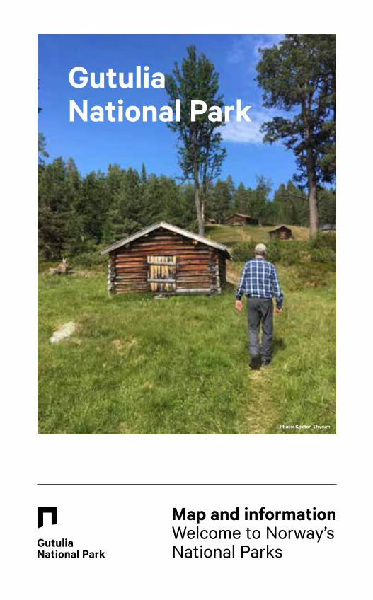
Gutulia National Park
Map and informationWelcome to Norway’s National Parks
Photo: Kirsten Thyrum
Welcome to Gutulia
Gutulia National Park is characterised by silvery grey dry pines and scattered spruces, with mountain farms reminiscent of days gone by. The entire national park is situated at altitudes of between 615 and 949 metres a.s.l. The highest point is the extensive rounded mountain ridge of Gutulivola. The slopes of Gutulia are like a rolling ocean of ancient forest, which has become a rare habitat type in Norway today. The trees are unusually large and some are many hundreds of years old. The pine and spruce trees have survived many generations of man. Some spruce trees are over 300 years old, and the oldest pine trees are more than 400 years old. The summit area of the mountain is treeless, while the flanks of the mountain are characterised by open pine forest.
The second highest point in the national park is Baklivola, in the far north of the national park. Between Gutulivola and Baklivola, the valley stretches towards the lake of Valsjøen, which offers excellent fishing. Together with the main river of Gutua,
lake Gutulisjøen forms the boundary of the national park to the west and south.
At the southeastern end of Gutulisjøen is the beautiful mountain farm of Gutulisetra. The farmhouse, rocky outcrops and pasture make up a landscape of great historical value. Many animals and plants are associated with grazing and mountain farm life. The open landscape would quickly become overgrown if the grazing land, outlying areas and mountain pastures were abandoned. Today, only domestic reindeer graze at Gutulia. The mountain pastures are mown to preserve the distinctive character and biodiversity of the landscape.
The national park is easily accessible. From the parking area at Gutulisjøen, it is just under an hour’s walk along a nature trail leading to the national park. As the national park covers an area of just 23km2, you can see virtually the whole of the park from Gutulivola at 949 m a.s.l.
Gutulia National Park is located in Engerdal municipality, close to the Swedish border. The national park was established in 1968 to protect one of the last remaining areas of virgin forest in Norway. In Norway’s smallest national park, you can experience ancient forest and historic mountain farms and pastures known as ‘setervoller’.

View from Gutulivola.
Hiking companions at the entrance to the national park.
Phot
o: J
an N
ordv
ålen
Phot
o: ta
igap
hoto
.se
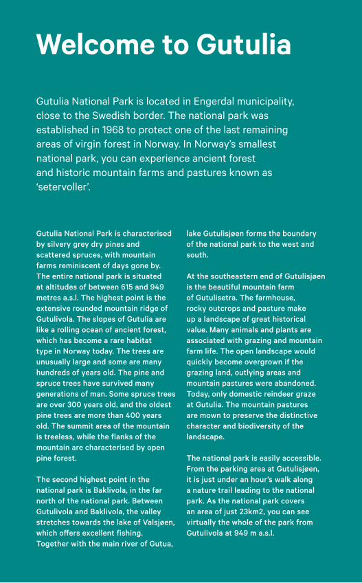
HikingFrom Gutulisetra, you can follow the nature and experience trail, with over 20 posts, which passes many of the sights in the area. Here, you will find the giant spruce known as Storgrana, wolf lichen, animals that live in the area and various cultural artefacts. The rest of the national park has no made paths, which allows you to set off on your own journey of discovery through ancient and rich natural forest.
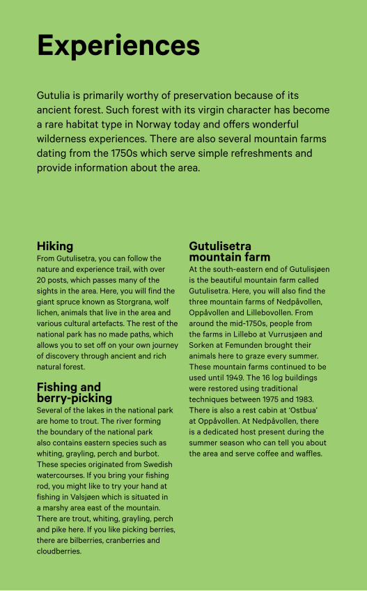
Fishing and berry-pickingSeveral of the lakes in the national park are home to trout. The river forming the boundary of the national park also contains eastern species such as whiting, grayling, perch and burbot. These species originated from Swedish watercourses. If you bring your fishing rod, you might like to try your hand at fishing in Valsjøen which is situated in a marshy area east of the mountain. There are trout, whiting, grayling, perch and pike here. If you like picking berries, there are bilberries, cranberries and cloudberries.
Gutulisetra mountain farmAt the south-eastern end of Gutulisjøen is the beautiful mountain farm called Gutulisetra. Here, you will also find the three mountain farms of Nedpåvollen, Oppåvollen and Lillebovollen. From around the mid-1750s, people from the farms in Lillebo at Vurrusjøen and Sorken at Femunden brought their animals here to graze every summer. These mountain farms continued to be used until 1949. The 16 log buildings were restored using traditional techniques between 1975 and 1983. There is also a rest cabin at ‘Ostbua’ at Oppåvollen. At Nedpåvollen, there is a dedicated host present during the summer season who can tell you about the area and serve coffee and waffles.
Gutulia is primarily worthy of preservation because of its ancient forest. Such forest with its virgin character has become a rare habitat type in Norway today and offers wonderful wilderness experiences. There are also several mountain farms dating from the 1750s which serve simple refreshments and provide information about the area.
Experiences
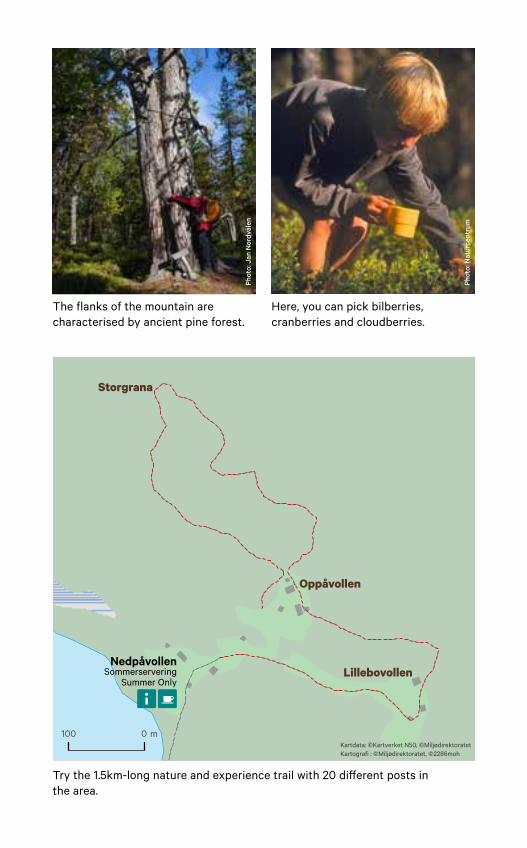
100 0 m
Storgrana
Oppåvollen
LillebovollenNedpåvollen
SommerserveringSummer Only
Kartdata: ©Kartverket N50, ©Miljødirektoratet Kartografi : ©Miljødirektoratet, ©2286moh
Ò
The flanks of the mountain are characterised by ancient pine forest.
Try the 1.5km-long nature and experience trail with 20 different posts in the area.
Here, you can pick bilberries, cranberries and cloudberries.
Phot
o: N
atur
cent
rum
Phot
o: J
an N
ordv
ålen
Facts & information
Where is Gutulia National Park?
In the municipality of Engerdal in the county of Hedmark.
How do I get there? National highway (Rv.) 217/26 to Femundsenden. County road (Fv.) 654 and forest road leading to the parking area at Gutulisjøen. The marked nature trail from the entry gate along Gutulisjøen is 3km/around 45 min.
Planning your trip www.ut.no
Management and supervision
The National Park Board for Femundsmarka and Gutulia e-mail: [email protected] www.nasjonalparkstyre.no/femundsmarka
Norwegian Nature Inspectorate www.naturoppsyn.no
Protected areas nearby Långfjället Nature Reserve (Sweden)Femundsmarka National Park
Tourist information Engerdal Turistkontor, tel. (+47) 941 86 951
More information Engerdal fjellstyre, tel. (+47) 62 45 91 77, www.engerdal-fjellstyre.no www.norgesnasjonalparker.no www.femundengerdal.no
Gutulia National Park is Norway’s smallest national park. It was established in 1968 and covers an area of 23km2.
Prin
t: Sk
ipne
s Ko
mm
unik
asjo
n
M-1
094
| 201
8
Flora and fauna
AnimalsWild reindeer were eradicated in around 1880, but domestic reindeer continue to graze throughout the national park.
Mammals you might catch a glimpse of include elk, roe deer, foxes, pine marten, mink, beaver and otter. Brown bears are present in the area around Gutulia. The distribution of females is limited to the eastern parts of Hedmark close to the border with Sweden and forms the core habitat of the brown bear.
BirdsAround 100 species of bird have been observed in the national park area. Willow ptarmigan, Siberian jay and western capercaillie are resident in the national park throughout the year. Common mountain forest species such as brambling, tree pipit and willow warblers make up around half of the small bird population.
Common redstart, redwing and dunnock thrive in the pine forest. Common reed buntings roost in damp locations such as around the lower part of the Gutulisetra mountain farm. East of Gutulisetra lies Valsjøen and several other smaller lakes and marshy areas. Here, ducks and waders such as common greenshankand wood sandpiper can be found. The whining sound of the females can be
heard above Gutulisjøen in the summer, and if you have a view over the lake and luck on your side, you might even see osprey fishing.
PlantsGrass-cutting and grazing helps to keep large leafy plants in check that would otherwise outcompete smaller species for nutrients and sunshine. The wide variety of flowers provides food for many different species of insects. A number of insects are adapted to special species of plants. The insects will also be threatened if the host plants disappear. A decline in insects means less food for birds, which also decrease in number. Grass-cutting and grazing are therefore important for species richness.
The richest areas are those along river banks and around springs in areas of spruce forest. These areas are home to tall herb vegetation with mountain species such as Thalictrum alpinum, Bartsia alpina and Viola biflora. Common species in the east such as ghost orchid, Pedicularis sceptrum-carolinum and Carex globularis also occur. Species such as Agrostis capillaris, Anthoxanthum odoratum and Luzula multiflora subsp. frigida are also present around Gutulisetra, indicating that livestock have grazed here in the past.
Gutulia is home to exciting bird and animal life. During the summer, birds that have flown all the way from Africa to breed in Gutulia chirp and sing. The national park provides grazing for domestic reindeer and bears occasionally visit the area. Many species of plants also grow here.
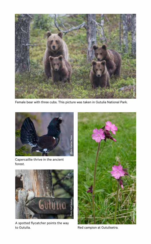
Female bear with three cubs. This picture was taken in Gutulia National Park.
Red campion at Gutulisetra.
Capercaillie thrive in the ancient forest.
Phot
o: K
jell
Isak
sen
Phot
o: K
jart
an T
rana
Phot
o: K
jell
Isak
sen
A spotted flycatcher points the way to Gutulia.
Phot
o: K
jell
Isak
sen
The areas to the east of Femunden have long been used for hunting and fishing. The Sami have used the area for reindeer grazing since the 1600s. The forest at Gutulia has been able to develop freely with few exceptions. Forest fires have been a natural part of the dynamic of the forest for several centuries. Charred tree stumps and other remains of forest fires can still be seen today. These fires have influenced the distribution of tree species in the area.
Mountain farmingFrom 1750 until 1949, three farms used Gutulisetra during the summer. There are now 16 restored mountain farm buildings in the national park. ‘Ostehu-set’ at Oppåvollen is open to visitors and coffee and waffles are served at Nedpåvollen.
Southern Sami reindeer herding Reindeer herding is a small industry in national terms, but to the Sami and in a local context it is vital for the economy, employment and culture. Reindeer herding is vital to the existence of the local community which is maintaining the language and traditions of the Southern Sami. Groups of herders gather the reindeer together in communal flocks in specific areas and work together to manage them. These management groups are known as ‘sijte’ in the Southern Sami language. Svahken sijte is now the southernmost Sami reindeer grazing district in Norway. Alongside modern technical aids, lassos and dogs are still important tools for herders in Svahken sijte. Reindeer can be seen all year round at Gutulia, as grazing takes place during all seasons in the national park.
Phot
o: ta
igap
hoto
.se
History and culture
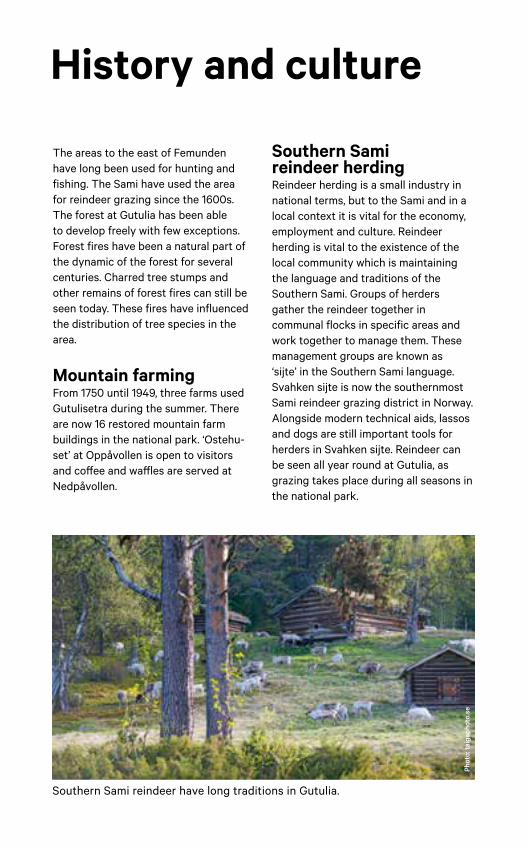
Southern Sami reindeer have long traditions in Gutulia.
Welcome to the national park! There’s plenty of room for all of us, provided we show consideration to the people and animals around us. The national parks represent the best of Norwegian nature. The protection they are afforded helps to take good care of the landscape and the diverse fauna and flora. This ensures that the landscape will still be there for us to enjoy in the future.
Welcome, please take care of our nature
Right to roam (Allemannsretten). You can go wherever you like on foot or on skis. Stop for a rest wherever you like. You are free to pitch a tent provided you are more than 150 metres from an inhabited house or cabin. In Gutulia, you are free to pick berries, fungi and ordinary plants. It is important to show consideration for plant and animal life, particularly during the nesting and breeding seasons.
Cultural artefacts. There are many old mountain farm buildings in the area that have been restored using traditional building techniques. There are also several animal graves, as well as the remains of a Stone Age settlement. Please be considerate and exercise caution when in the vicinity of these.
Rubbish. Remember to tidy up after yourself and take your rubbish home.
Fires. Fires are prohibited between 15 April and 15 September. Nevertheless, fires are permitted in cases where it is obvious that there is no fire risk. At Gutulia, it is the forest itself that
is being protected and consequently there is extra reason to be careful. Be considerate of nature when collecting wood.
Hunting and fishing. You can fish as you would normally in mountain areas elsewhere if you have a fishing permit. The use of live fish as bait is prohibited. In addition, you must not move live fish or take wet fishing equipment from one watercourse to another. Elk hunting is only permitted during the elk hunting season.
Dogs in the national park. You are welcome to bring your dog on your trip with you. All dogs must be kept on a lead between 1 April and 20 August. You are obliged to show consideration towards game, grazing animals and other people all year round. Reindeer are particularly vulnerable during late winter.
Access by motor vehicle is generally prohibited in the national park.
Good planning makes for a good trip!
0 1 2 3 Kilometer Kartdata: ©Kartverket N50, ©Miljødirektoratet Kartografi : ©Miljødirektoratet
Nor
way
Swed
en
Nor
way
Swed
en
GutuliaNational Park
FemundsmarkaNational Park
LångfjälletNature Reserve
BredåsenNature Reserve
Volaberget ogKvemskjølen
Nature Reserve
"
Grövelsjön
"Gutulisetra
SommerserveringSummer only
ElgådalenGutu
SøndreElgådalen
Småsjø-vollen
Bekkdalssætra
Gammal-dalen
Valdalengård
Storsätern
Valdalsbygget
Fjellgutu- sjøen
Gutulisjøen
Storjyltingen
Hisjön
Storhån
Guttan
Grövlan
Vala
Valsjøen
Stormikkel-tjønna
Gutulitjønna
Gutua
Gunnar- sjøen
#Litlsjøberget1082m
#Sorkvola1012m
#Jyltingsvola874m
#Orrknollen815m
#Gutulivola949m
#Baklivola
987m
B e k k e d a l e n
J y l t i n g s- b r e n n a
Skäråsen
Köldyllen
Gjoten
221
221
654
1059
Drevsjø
Elgå
IdreSweden
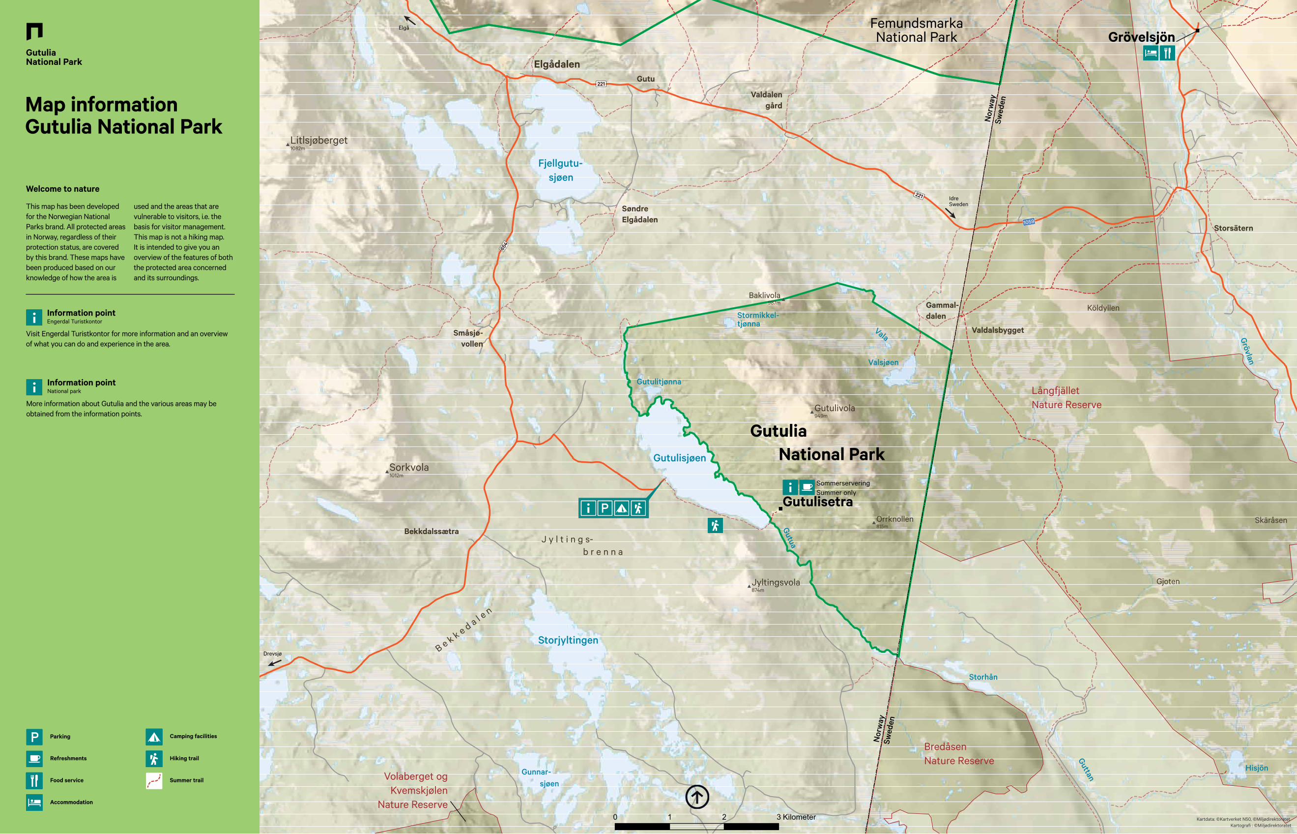
Map information Gutulia National Park
This map has been developed for the Norwegian National Parks brand. All protected areas in Norway, regardless of their protection status, are covered by this brand. These maps have been produced based on our knowledge of how the area is
used and the areas that are vulnerable to visitors, i.e. the basis for visitor management. This map is not a hiking map. It is intended to give you an overview of the features of both the protected area concerned and its surroundings.
Welcome to nature
More information about Gutulia and the various areas may be obtained from the information points.
Information point National park
Visit Engerdal Turistkontor for more information and an overview of what you can do and experience in the area.
Information pointEngerdal Turistkontor
Summer trail
Hiking trail
Parking
Refreshments
Accommodation
Camping facilities
Food service