gwpd 15—obtaining permission to install, maintain, or ... · pdf file1. form 9-1483,...
TRANSCRIPT
GWPD 15—Obtaining permission to install, maintain, or use a well on private property
VERSION: 2010.1
PURPOSE: To describe a procedure for properly obtaining permission to install, maintain, or use a well on private property, for activities such as geophysical explorations, water-level monitoring, and collection of water samples.
U.S. Geological Survey (USGS) policy for access to private lands is governed by Chapter 500.11 in the Survey Manual. It is USGS policy to obtain written permission before drilling, collecting groundwater samples, maintaining a contin-uous recorder, or making a groundwater-level measurement on private property, restricted public property, and leased Federal land. Test drilling and data collection preferably should be confined to public lands (Federal, State, county, or munici-pally owned) when the location will serve as well as one on privately owned land. However, if the information needed can be obtained only at a site on private property, that site may be used if permission to drill test wells, sample, or operate obser-vation wells is obtained in advance.
Materials and Instruments
1. Form 9-1483, Well Drilling/Sampling Agreement
2. Permission to Collect Water Samples form
3. Form 9-3106, Well Transfer Agreement
4. Site location map
5. Field notebook
6. Pencil or pen, blue or black ink. Strikethrough, date, and initial errors; no erasures
Data Accuracy and Limitations When public land is not suitable, the use of private prop-
erty is permitted if, prior to drilling, sampling, or data collec-tion operations, a signed agreement for access to and installa-tion, maintenance, and use of the test hole or observation well is obtained from the property owner.
Assumptions
1. Needed information can be collected only at a site on private property.
2. The person requesting permission to install, maintain, or use a well on private property is familiar with Office of Ground Water Technical Memorandum 2003.03 and associated policies.
3. The requestor is also familiar with State law require-ments to notify the local One Call Center (in some States referred to as, “call before you dig”) before blasting, bor-ing, digging, drilling, trenching, or other earth moving operations.
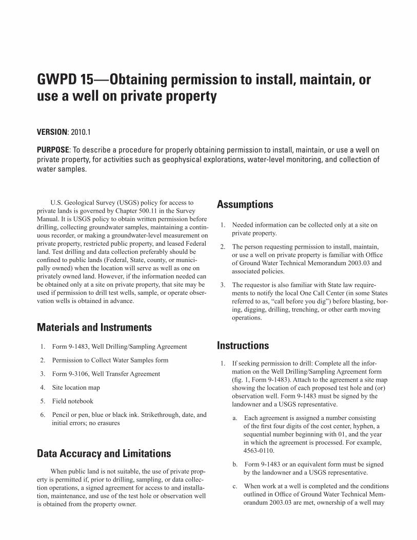
Instructions1. If seeking permission to drill: Complete all the infor-
mation on the Well Drilling/Sampling Agreement form (fig. 1, Form 9-1483). Attach to the agreement a site map showing the location of each proposed test hole and (or) observation well. Form 9-1483 must be signed by the landowner and a USGS representative.
a. Each agreement is assigned a number consisting of the first four digits of the cost center, hyphen, a sequential number beginning with 01, and the year in which the agreement is processed. For example, 4563-0110.
b. Form 9-1483 or an equivalent form must be signed by the landowner and a USGS representative.
c. When work at a well is completed and the conditions outlined in Office of Ground Water Technical Mem-orandum 2003.03 are met, ownership of a well may
124 Groundwater Technical Procedures of the U.S. Geological Survey
Figure 1. Well Drilling/Sampling Agreement Form 9-1483.
USGS Center Director:
Notary Seal:
Figure 1. Well Drilling/Sampling Agreement, Form 9-1483.
GWPD 15—Obtaining permission to install, maintain, or use a well on private property 125
Figure 1. Well Drilling/Sampling Agreement Form 9-1483.—Continued
Notary Seal:
USGS Center Director:
Figure 1. Well Drilling/Sampling Agreement, Form 9-1483.—Continued
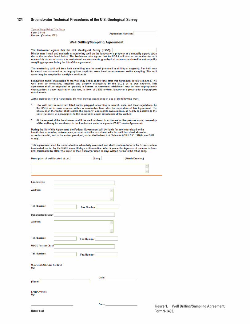
be transferred back to the landowner. Form 9-3106 (fig. 2, Well Transfer Agreement) provides for trans-fer of well ownership. Form 9-3106 must be signed by the landowner and a USGS representative.
2. If seeking permission to collect water samples from a well: Experience has shown that oral permission to collect water samples is easier to obtain, but written per-mission provides stronger legal protection. Form 9-1483 includes permission for the USGS to take water-quality samples from a well being drilled. However, if an exist-ing well is used instead of drilling a well, use of the Permission to Collect Water Samples form (fig. 3) is warranted. Strong consideration should be used to incor-porate this form even when Form 9-1483 is in place. Figure 2 or an equivalent form must be signed by the permitter (landowner) and a USGS representative.
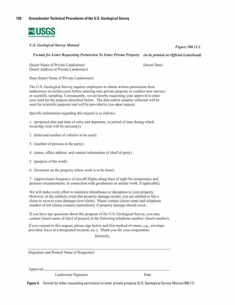
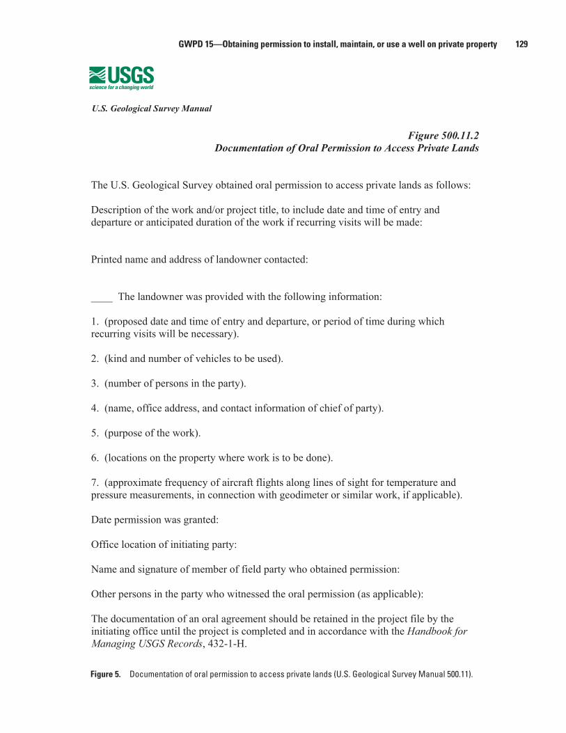
3. If seeking permission to maintain a continuous recorder or make a groundwater-level measurement on private property, restricted public property, or leased Federal land: The USGS preferred business practice is that permission for this activity be obtained in writing using Form 9-1483 or equivalent. Long-standing oral agree-ments and oral agreements made in situations where obtaining written permission would be prohibitive can be documented by using the form shown in figure 4 (Format for Letter Requesting Permission To Enter Private Prop-erty) or by obtaining the information included in figure 5 (Documentation of Oral Permission to Access Private Lands) and documenting the oral permission as soon as possible.
126 Groundwater Technical Procedures of the U.S. Geological Survey
Figure 2. Transfer of well ownership.Figure 2. Well Transfer Agreement form for transfer of well ownership.
GWPD 15—Obtaining permission to install, maintain, or use a well on private property 127
Signature, Permitter Date
Signature, U.S. Geological Survey
At the following telephone number
I can contact
Date
Local address
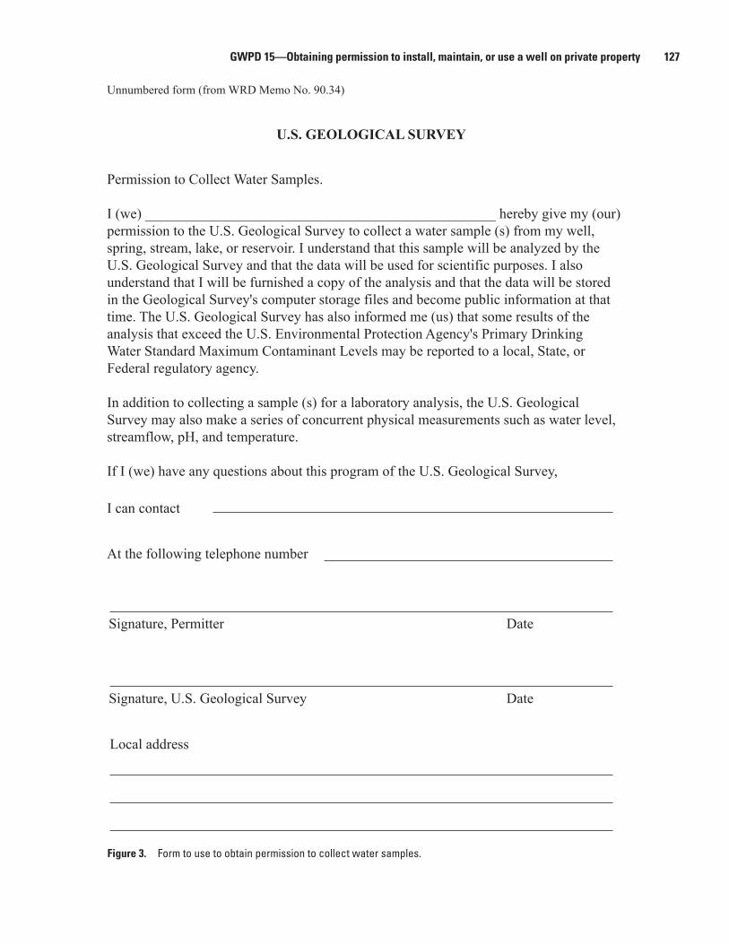
U.S. GEOLOGICAL SURVEY
Figure 3. Permission to collect water samples.
Unnumbered form (from WRD Memo No. 90.34)
U.S. GEOLOGICAL SURVEY
Permission to Collect Water Samples.
I (we) _________________________________________________ hereby give my (our) permission to the U.S. Geological Survey to collect a water sample (s) from my well, spring, stream, lake, or reservoir. I understand that this sample will be analyzed by the U.S. Geological Survey and that the data will be used for scientific purposes. I also understand that I will be furnished a copy of the analysis and that the data will be stored in the Geological Survey's computer storage files and become public information at that time. The U.S. Geological Survey has also informed me (us) that some results of the analysis that exceed the U.S. Environmental Protection Agency's Primary Drinking Water Standard Maximum Contaminant Levels may be reported to a local, State, or Federal regulatory agency.
In addition to collecting a sample (s) for a laboratory analysis, the U.S. Geological Survey may also make a series of concurrent physical measurements such as water level, streamflow, pH, and temperature.
If I (we) have any questions about this program of the U.S. Geological Survey,
Figure 3. Form to use to obtain permission to collect water samples.
128 Groundwater Technical Procedures of the U.S. Geological Survey
U.S. Geological Survey Manual Figure 500.11.1
Format for Letter Requesting Permission To Enter Private Property (to be printed on Official Letterhead)
(Insert Name of Private Landowner) (Insert Date) (Insert Address of Private Landowner)
Dear (Insert Name of Private Landowner):
The U.S. Geological Survey requires employees to obtain written permission from landowners in certain cases before entering onto private property to conduct new surveys or scientific sampling. Consequently, we are hereby requesting your approval to enter your land for the purpose described below. The data and/or samples collected will be used for scientific purposes and will be provided to you upon request.
Specific information regarding this request is as follows:
1. (proposed date and time of entry and departure, or period of time during which recurring visits will be necessary).
2. (kind and number of vehicles to be used).
3. (number of persons in the party).
4. (name, office address, and contact information of chief of party).
5. (purpose of the work).
6. (locations on the property where work is to be done).
7. (approximate frequency of aircraft flights along lines of sight for temperature and pressure measurements, in connection with geodimeter or similar work, if applicable).
We will make every effort to minimize disturbance or disruption to your property. However, in the unlikely event that property damage results, you are entitled to file a claim to recover your damages (tort claim). Please contact (insert name and telephone number of tort claims contact) immediately if property damage should occur.
If you have any questions about this program of the U.S. Geological Survey, you may contact (insert name of chief of project) at the following telephone number: (insert number).
If you consent to this request, please sign below and (list method of return, e.g., envelope provided, leave at a designated location, etc.). Thank you for your cooperation.
Sincerely,
(Signature and Printed Name of Requestor)
Approval:Landowner Signature Date
Figure 4. Permission to enter private property, Survey Manual 500.11.1.Figure 4. Format for letter requesting permission to enter private property (U.S. Geological Survey Manual 500.11).
GWPD 15—Obtaining permission to install, maintain, or use a well on private property 129
Figure 500.11.2 Documentation of Oral Permission to Access Private Lands
The U.S. Geological Survey obtained oral permission to access private lands as follows:
Description of the work and/or project title, to include date and time of entry and departure or anticipated duration of the work if recurring visits will be made:
Printed name and address of landowner contacted:
____ The landowner was provided with the following information:
1. (proposed date and time of entry and departure, or period of time during which recurring visits will be necessary).
2. (kind and number of vehicles to be used).
3. (number of persons in the party).
4. (name, office address, and contact information of chief of party).
5. (purpose of the work).
6. (locations on the property where work is to be done).
7. (approximate frequency of aircraft flights along lines of sight for temperature and pressure measurements, in connection with geodimeter or similar work, if applicable).
Date permission was granted:
Office location of initiating party:
Name and signature of member of field party who obtained permission:
Other persons in the party who witnessed the oral permission (as applicable):
The documentation of an oral agreement should be retained in the project file by the initiating office until the project is completed and in accordance with the Handbook for Managing USGS Records, 432-1-H.
Figure 5. Documentation of oral permission to access private lands, Survey Manual 500.11.2.
U.S. Geological Survey Manual
Figure 5. Documentation of oral permission to access private lands (U.S. Geological Survey Manual 500.11).
130 Groundwater Technical Procedures of the U.S. Geological Survey
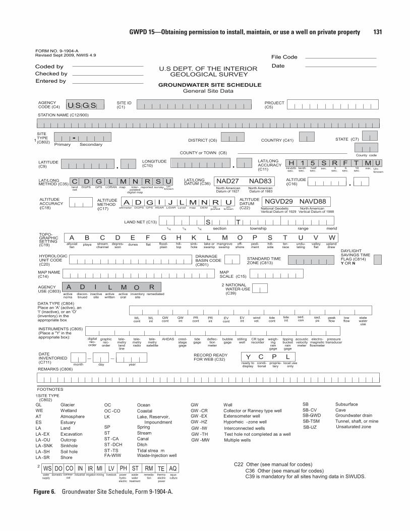
Data RecordingPermission details are recorded on the associated forms.
The original form is kept in the office, and a copy is included in the well folder that is brought to the field.
The Agency Use Code (C803) on the Groundwater Site Schedule (Form 9-1904-A; fig. 6) should be used to indicate the type of agreement in place. If the well is not owned by the USGS, use codes A, L, or M when coding the site in the National Water Information System. For further information, refer to USGS Water Resources Discipline Policy Memoran-dum 2009.02.
Agency use code (C803)
Short description Long description
A Active - no/na Active data collection site with un-documented or unneeded landowner agreement
L Active - Written Active data collection site with writ-ten landowner agreement (Form 9-1483)
M Active - Oral Active data collection site with memo documenting oral landowner agree-ment
Reference
U.S. Geological Survey, 2003, Agreement forms for gaging station and observation well installations and transfers: Office of Ground Water Technical Memorandum 2003.03, accessed December 17, 2010, at http://water.usgs.gov/admin/memo/GW/gw03.03.html.
U.S. Geological Survey, 2008, U.S. Geological Survey Manual 500.11—Obtaining permission for access to private lands, accessed December 17, 2010, at http://www.usgs.gov/ usgs-manual/500/500-11.html.
U.S. Geological Survey, 2009, Maintaining an auditable record of USGS discontinued water monitoring station liabilities: Water Resources Discipline Policy Memoran-dum No. 2009.02, accessed at http://water.usgs.gov/admin/memo/policy/wrdpolicy09.02.pdf.
GWPD 15—Obtaining permission to install, maintain, or use a well on private property 131
H
Coded by
FORM NO. 9-1904-ARevised Sept 2009, NWIS 4.9
Checked byEntered by
AGENCYCODE (C4)
SITE ID(C1)
STATION NAME (C12/900)
LATITUDE(C9)
LONGITUDE(C10)
LAT/LONGACCURACY(C11) Hndrth
sec.
LAT/LONG DATUM (C36)
LAT/LONGMETHOD (C35)
alluvialfan
activeno/na
inactivesite
inventorysite
playa
month day year
streamchannel
digitalrec-
order
North AmericanDatum of 1927
North AmericanDatum of 1983
graphicrec-
order
tele-metrylandline
tele-metryradio
tele-metry
satellite
crest-stagegage
tidegage
stillingwell
deflec-tion
meter
bubblegage
CR typerecorder
weigh-ingrain
gage
tippingbucket
raingage
acousticvelocitymeter
electro-magneticflowmeter
AHDAS
depres-sion
dunes flat flood-plain
hill-top
sink-hole
lake orswamp
mangroveswamp
off-shore
pedi-ment
hill-side
ter-race
undu-lating
tenthsec.
halfsec.
sec. 3sec.
10sec.
5sec.
valleyflat
uplanddraw
DGPS GPS LORAN map
min.
survey un-known
section township range
County code
merid1/4 1/4 1/4
DISTRICT (C6) STATE (C7)
COUNTY or TOWN (C8)
LAND NET (C13)
MAP NAME(C14)
AGENCYUSE (C803)
MAPSCALE (C15)
REMARKS (C806)
FOOTNOTES
INSTRUMENTS (C805)(Place a "Y' in theappropriate box):
DRAINAGEBASIN CODE(C801)
TOPO-GRAPHICSETTING(C19)
DATEINVENTORIED(C711)
SITETYPE(C802)
ALTITUDEMETHOD(C17)
ALTITUDE(C16)
ALTITUDEACCURACY(C18)
HYDROLOGICUNIT CODE(C20)
ALTITUDEDATUM(C22)
PROJECT(C5)
File Code
DateU.S DEPT. OF THE INTERIORGEOLOGICAL SURVEY
U S G S
GROUNDWATER SITE SCHEDULEGeneral Site Data
D G L N UM
R
TS
A B C D
NAD27 NAD83
E F G H K
A I O
condi-tional
proprie-tary
local useonly
RECORD READYFOR WEB (C32)
DAYLIGHT SAVINGS TIME FLAG (C814)Y OR N
C P L
L M O P S T U V W
1
National GeodeticVertical Datum of 1929
North American Vertical Datum of 1988
NGVD29 NAVD88
1
COUNTRY (C41)
STANDARD TIMEZONE (C813)
SITE TYPE (C802)
M5 RS TF1
watersupply
domestic commer-cial
industrial irrigation mining livestock powerhydro-electric
wastewater
treatment
WS DO CO IN IR MI LV PH STremedia-
tionthermo-electricpower
aqua-culture
RM TE AQ
R Sinter-
polateddigital map
reported
pressuretransducer
UUn-known
DATA TYPE (C804)Place an 'A' (active), an'I' (inactive), or an 'O'(inventory) in theappropriate box WL
contWLint
QWcont
QWint
PRcont
EVcont
EVint
windvel.
tidecont
tideint
sed.con
sed.ps
peakflow
lowflow
statewateruse
Clandnet
C39 is mandatory for all sites having data in SWUDS.
Yready todisplay
GL Glacier WE Wetland AT Atmosphere ES Estuary LA Land LA -EX ExcavationLA -OU Outcrop LA -SNK Sinkhole LA -SH Soil hole LA -SR Shore
OC Ocean OC -CO Coastal LK Lake, Reservoir,
Impoundment
SP Spring ST Stream ST -CA Canal ST -DCH Ditch ST -TS Tidal strea m
GW Well GW -CR Collector or Ranney type well
GW -IW Interconnected wells GW -TH Test hole not completed as a wellGW -MW Multiple wells
GW -EX Extensometer well GW -HZ Hyporheic -zone well
-Primary Secondary
2
FA-WIW Waste-Injection well
C36 Other (see manual for codes)C22 Other (see manual for codes)
IfSAR
JIDGPSaltimeter GPS Level map re-
portedun-
known
DA G L R UM NDEMLiDAR
NATIONALWATER-USE(C39)
2Ddiscon-tinued
L Mactivewritten
activeoral
remediated
SB Subsurface SB-CV Cave
SB-GWD- Groundwater drain SB-TSM Tunnel, shaft, or mine
Unsaturated zone SB-UZ
Figure 1. Ground-Water Site Inventory Form 9-1904-A.Figure 6. Groundwater Site Schedule, Form 9-1904-A.
132 Groundwater Technical Procedures of the U.S. Geological Survey
anode standbyemer.supply
drain geo-thermal
seismic heatreservoir
mine obser-vation
oil orgas
recharge repres-surize
test unused with-drawal/return
with-drawal
waste des-troyed
USE OFSITE(C23)
SECOND-ARY USEOF SITE(C301) (Seeuse of site)
TERTIARYUSE OFSITE(C302) (Seeuse of site)
SECOND-ARY USEOF WATER(C25) (see use of water)
TERTIARY USE OF WATER (C26)(see use of water)
A C D E G H M O P R S T U V W X Z
airline analog calibratedairline
esti-mated
pressuregage
calibratedpress. gage
geophysi-cal logs
mano-meter
non-rec.gage
reported steeltape
electrictape
calibratedelec. tape
other
METHOD OF WATER-LEVELMEASUREMENT(C239) A B C G H L M N R S T V Z
dry recentlyflowing
flowing nearbyflowing
nearbyrecentlyflowing
injectorsite
injectorsite
monitor
measure-ment
discontinued
plugged obstruc-tion
pumping recentlypumped
nearbypumping
nearbyrecentlypumped
foreignsub-
stance
welldes-
troyed
affected bysurfacewater
other
SITE STATUSFOR WATERLEVEL (C238)
D E F G H I J NM O P R S T V W X Z
air-rotary bored oraugered
cabletool
dug hydraulicrotary
jetted air per-cussion
reverserotary
trenching driven drive wash other
METHOD OFCONSTRUCTION (C65)
A B C D H J P R T V W Z
aircond.
bottling comm-ercial
de-water
power fire domes-tic
irri-gation
indus-trial
(cooling)
mining medi-cinal
indus-trial
publicsupply
aqua-culture
recrea-tions
stock insti-tutional
unused desalin-ation
other
USE OF WATER(C24)
A B C D E F H I J K M N P Q R S T U Y Z
2 - Groundwater Site Schedule
fieldchecked
poorlocation
minimaldata
un-checked
DATA RELIABILITY (C3) C L M U
bentonite clay cementgrout
none other
TYPE OFSEAL(C67)
B C G N Z
unconfinedsingle
unconfinedmultiple
confinedsingle
confinedmultiple
mixed
AQUIFERTYPE(C713)
U N C M X
porousconcrete
gravelw/perf.
gravelscreen
horiz.gallery
openend
perf orslotted
screen sandpoint
walled openhole
other
TYPE OFFINISH (C66) C F G H O P S T W X Z
othergov't
driller geol-ogist
logs memory owner otherreported
reportingagency
other
SOURCEOF DEPTHDATA (C29)
A D G L M O R S Z
air-liftpump
bailed compres-sed air
jetted none pumped surged other
A B C J N P S Z
chem-icals
dry ice explo-sives
defloc-culent
hydro-frac-turing
mech-anical
otherC D E F H M Z
SOURCE OF DATA (C64)
NAME OF CONTRACTOR(C63)
SOURCE OF WATER-LEVEL DATA (C244) A
C O N S
D G L M O R S Z
month day yearDATE OF FIRST CONSTRUCTION (C21)
month day year
DATE WATER-LEVEL MEASURED (C235)
month day year
PRIMARYAQUIFER (C714)
HOURS OF DEVELOPMENT (C70)
BOTTOM OF SEAL (C68) METHOD OF DEVELOPMENT (C69)
SPECIAL TREATMENT (C71)
RECORD TYPE (C754) RECORD SEQUENCE NO. (C723)
WATER LEVEL (C237/241/242)
TIME (C709)
HOLEDEPTH(C27)
WELLDEPTH(C28)
GENERAL SITE DATA
WATER-LEVEL DATA
CONSTRUCTION DATA
othergov't
driller'slog
geol-ogist
memory owner otherreported
reportingagency
other
DATE OF COMPLETEDCONSTRUCTION (C60)
othergov't
driller geol-ogist
logs memory owner otherreported
reportingagency
other
A D G L M O R S Z
PERSON MAKINGMEASUREMENT (C246)(WATER LEVEL PARTY)
MEASURING AGENCY (C247)(SOURCE)
Y C P LRECORD READY FOR WEB (C858)
WATER-LEVELACCURACY (C276) 0 1 2 9
WATER-LEVEL TYPE CODE (C243) L M S
MP SEQUENCE NO. (C248)(Mandatory if WL type=M)
A Batmos.
pressuretide
stage
Ftrans-ducer
land surface
meas. pt.
vertical datum
foot tenth hun-dredth
not tonearest
foot
WATER-LEVELDATUM (C245)(Mandatory if WL type=S)
NGVD29 NAVD88 National Geodetic
Vertical Datum 0f 1929North American
Vertical Datum 0f 1988 Other (See manual for codes)
NATIONALAQUIFER (C715)
Cice
Oobserved
geophysi-cal logs
Ssonic
condi-tional
proprie-tary
local useonly
ready todisplay
EQUIP ID (C249)(20 char) ________________________________________________
REMARKS (C267)(256 char) ______________________________________________________________________________________
______________________________________________________________________________________
Ddiffer-entialGPS
E Pacoustic
pulse
GWPD 15—Obtaining permission to install, maintain, or use a well on private property 133
CONSTRUCTION HOLE DATA (3 sets shown)
CONSTRUCTION CASING DATA (4 sets shown)
FOOTNOTE:
4
4
4
4
C S N G
Groundwater Site Schedule - 3
B C D G H I M P R S T U W Z
RECORD TYPE (C756)
RECORD TYPE (C758)
RECORD SEQUENCE NO. (C724)
RECORD SEQUENCE NO. (C724)
RECORD SEQUENCE NO. (C725)
RECORD SEQUENCE NO. (C724)
CASING MATERIAL (C80)
CASING MATERIAL (C80)
CASING MATERIAL (C80)
CASING MATERIAL CODES
CASING THICKNESS (C81)
CASING THICKNESS (C81)
CASING THICKNESS (C81)
DEPTH TO BOTTOM OFINTERVAL (C74)
DEPTH TO TOP OFINTERVAL (C73)
DEPTH TO TOP OFCASING (C77)
DEPTH TO TOP OFCASING (C77)
DEPTH TO TOP OFCASING (C77)
DEPTH TO BOTTOM OFCASING (C78)
DEPTH TO BOTTOM OFCASING (C78)
DEPTH TO BOTTOM OFCASING (C78)
DIAMETER OF INTERVAL (C75)
DEPTH TO BOTTOM OFINTERVAL (C74)
DEPTH TO TOP OFINTERVAL (C73)
DIAMETER OF INTERVAL (C75)
DIAMETER OF CASING (C79)
DIAMETER OF CASING (C79)
DIAMETER OF CASING (C79)
DEPTH TO BOTTOM OFINTERVAL (C74)
DEPTH TO TOP OFINTERVAL (C73)
DIAMETER OF INTERVAL (C75)
SEQUENCE NO. OF PARENT RECORD (C59)
SEQUENCE NO. OF PARENT RECORD (C59)
brick concrete copper galv. iron
wroughtiron
othermetal
PVC orplastic
rock orstone
steel tile coatedsteel
wood othermat.
Aabs
EPTFE
F Fiber- glass
Fiber-glassplastic
J Fiber-glassepoxy
KPVC
thread-ed
L glass
NPVCglued
Q FEP
Vstain-lesssteel
X Ysteel
carbon steel
galva- nized
4 6
stain-less304
stain-less316
H O L E
RECORD SEQUENCE NO. (C725) SEQUENCE NO. OF PARENT RECORD (C59)
SEQUENCE NO. OF PARENT RECORD (C59)RECORD SEQUENCE NO. (C725)
4 CASING MATERIAL (C80) CASING THICKNESS (C81)
DEPTH TO TOP OFCASING (C77)
DEPTH TO BOTTOM OFCASING (C78)
DIAMETER OF CASING (C79)
SEQUENCE NO. OF PARENT RECORD (C59)RECORD SEQUENCE NO. (C725)
134 Groundwater Technical Procedures of the U.S. Geological Survey
CONSTRUCTION OPENINGS DATA (3 sets shown)
FOOTNOTES:
CONSTRUCTION MEASURING POINT DATA
5
5
5
5
6
6
O P E N
M P N T
B C G I M P R S T Z
F L M P R S T W X Z
4 - Groundwater Site Schedule
RECORD TYPE (C760) RECORD SEQUENCE NO. (C726)
LENGTH OF OPENING(C89)
TYPE OF OPENING(C85)
6 TYPE OF OPENING(C85)
6 TYPE OF OPENING(C85)
LENGTH OF OPENING(C89)
LENGTH OF OPENING(C89)
RECORDTYPE(C766)
RECORDSEQUENCENO. (C728)
BEGINNINGDATE(C321)
month day year
M.P. REMARKS (C324)
M.P. HEIGHT (C323)
ENDINGDATE(C322)
RECORD SEQUENCE NO. (C726)
RECORD SEQUENCE NO. (C726)
DEPTH TO BOTTOM OFINTERVAL (C84)
DEPTH TO TOP OFINTERVAL (C83)
DIAMETER OF INTERVAL (C87)
MATERIAL TYPE (C86)
MATERIAL TYPE (C86)
MATERIAL TYPE (C86)
TYPE OF MATERIAL CODES FOROPEN SECTIONS
TYPE OF OPENINGS CODES
WIDTH OF OPENING(C88)
WIDTH OF OPENING(C88)
DEPTH TO BOTTOM OFINTERVAL (C84)
DEPTH TO BOTTOM OFINTERVAL (C84)
DEPTH TO TOP OFINTERVAL (C83)
DEPTH TO TOP OFINTERVAL (C83)
DIAMETER OF INTERVAL (C87)
WIDTH OF OPENING(C88)
DIAMETER OF INTERVAL (C87)
SEQUENCE NO. OF PARENT RECORD (C59)
brass or
bronze
concrete PTFE othermetal
PVC stain-lesssteel
steel tile other
fracturedrock
louvered orshutter-type
mesh screen
perforated,porous or
slotted
wire-woundscreen
screen(unk.)
sandpoint
screen
walled orshored
openhole
other
AABS
D E F H J K L N Q V W X Y 4 6ceramic fiber-
glass galv. iron
fiber-glassplastic
wroughtiron
fiber-glassepoxy
PVC thread-
ed
glass PVC glued
FEP brick mem-brane
steelcarbon
steelgalva-nized
stain-less304
stain-less316
ALTITUDE OFMEASURINGPOINT (C325)
ALTITUDE ACCURACY(C327)
ALTITUDE METHOD(C326)
ALTITUDE DATUM(C328)
Y C P LRECORD READY FOR WEB (C857)
condi-tional
proprie-tary
local useonly
ready todisplay
GWPD 15—Obtaining permission to install, maintain, or use a well on private property 135
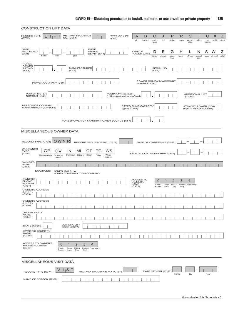
CONSTRUCTION LIFT DATA
MISCELLANEOUS OWNER DATA
A B
D E G H L N W Z
C J P R S T U Z
O W N R
L I F T
Groundwater Site Schedule - 5
RECORD TYPE(C752)
OWNER'SNAME(C161)
RECORD TYPE (C768)
RECORD SEQUENCENO. (C254)
RECORD SEQUENCE NO. (C718)
TYPE OF POWER (C45)
POWER COMPANY ACCOUNTNUMBER (C51)
PUMPINTAKEDEPTH (C44)
DATERECORDED(C38)
MANUFACTURER(C48)
HORSE-POWERRATING (C46)
ADDITIONAL LIFT (C255)
PUMP RATING (C53)(million gallons/units of fuel)
RATED PUMP CAPACITY(gpm) (C268)
DATE OF OWNERSHIP (C159)
JONES, RALPH A.JONES CONSTRUCTION COMPANY
EXAMPLES:
POWER COMPANY (C50)
POWER METERNUMBER (C52)
PERSON OR COMPANYMAINTAINING PUMP (C54)
HORSEPOWER OF STANDBY POWER SOURCE (C57)
STANDBY POWER (C56)(see TYPE OF POWER)
SERIAL NO.(C49)
TYPE OF LIFT(C43)
diesel electric gaso-line
hand LP gas naturalgas
windmill other
centri-fugal
bucketair jet piston rotary submer-sible
turbine un-known
other
month day year
WU OWNERTYPE(C350)
WSOTINIndividual Water
SupplierOther
OWNER'SPHONENUMBER(C351)
ACCESS TOOWNER'SNAME(C352)
0 21 3 4P ublic
AccessC oop-erator
US G SOnly
DistrictOnly
P roprietary
OWNER'S ADDRESS(LINE 1)(C353)
OWNER'S ADDRESS(LINE 2)(C354)
OWNER'S CITYNAME(C355)
STATE (C356) OWNER'S ZIPCODE (C357)
OWNER'S COUNTRYNAME(C358)
ACCESS TO OWNER'SPHONE/ADDRESS(C359)
0 21 3 4P ublic
AccessC oop-erator
US G SOnly
DistrictOnly
P roprietary
MISCELLANEOUS VISIT DATA
V I S T DATE OF VISIT (C187)RECORD SEQUENCE NO. (C737)RECORD TYPE (C774)
NAME OF PERSON (C188)
month day year
CP GVCorporation
Govern-
ment
END DATE OF OWNERSHIP (C374)
Xno lift
S solar
MIMilitary
TGTribal
136 Groundwater Technical Procedures of the U.S. Geological Survey
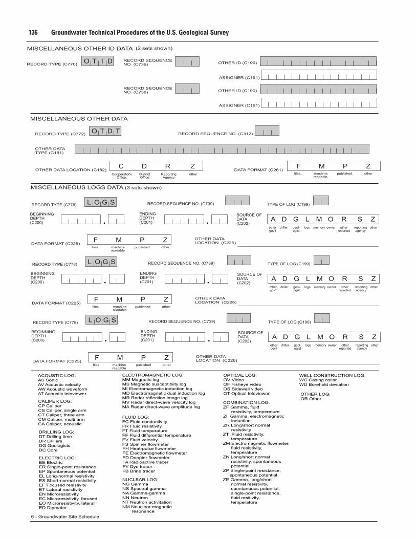
MISCELLANEOUS LOGS DATA (3 sets shown)
L O G S
A GD L M O R S Z
6 - Groundwater Site Schedule
othergov't
driller geol-ogist
logs memory owner otherreported
reportingagency
other
RECORD TYPE (C778) RECORD SEQUENCE NO. (C739)
ENDINGDEPTH(C201)
SOURCE OFDATA(C202)
BEGINNINGDEPTH(C200)
MISCELLANEOUS OTHER DATA
ZPMFZRDC
O T D TRECORD TYPE (C772)
OTHER DATATYPE (C181)
DATA FORMAT (C261)OTHER DATA LOCATION (C182)
RECORD SEQUENCE NO. (C312)
Cooperator'sOffice,
DistrictOffice
ReportingAgency
other files, published,machinereadable,
other
TYPE OF LOG (C199)
ZPMFDATA FORMAT (C225)
files publishedmachinereadable
other
OTHER DATALOCATION (C226)
L O G S
A GD L M O R S Zothergov't
driller geol-ogist
logs memory owner otherreported
reportingagency
other
RECORD TYPE (C778) RECORD SEQUENCE NO. (C739)
ENDINGDEPTH(C201)
SOURCE OFDATA(C202)
BEGINNINGDEPTH(C200)
TYPE OF LOG (C199)
ZPMFDATA FORMAT (C225)
files publishedmachinereadable
other
OTHER DATALOCATION (C226)
ACOUSTIC LOG:AS SonicAV Acoustic velocityAW Acoustic waveformAT Acoustic televiewer
CALIPER LOG:CP CaliperCS Caliper, single armCT Caliper, three armCM Caliper, multi armCA Caliper, acoustic
DRILLING LOG:DT Drilling timeDR DrillersDG GeologistsDC Core
ELECTRIC LOG:EE ElectricER Single-point resistanceEP Spontaneous potentialEL Long-normal resistivityES Short-normal resistivityEF Focused resistivityET Lateral resistivityEN MicroresistivityEC Microresistivity, forusedEO Microresistivity, lateralED Dipmeter
FLUID LOG:FC Fluid conductivityFR Fluid resistivityFT Fluid temperatureFF Fluid differential temperatureFV Fluid velocityFS Spinner flowmeterFH Heat-pulse flowmeterFE Electromagnetic flowmeterFD Doppler flowmeterFA Radioactive tracerFY Dye tracerFB Brine tracer
NUCLEAR LOG:NG GammaNS Spectral gammaNA Gamma-gammaNN NeutronNT Neutron activitationNM Neuclear magnetic resonance
OPTICAL LOG:OV VideoOF Fisheye videoOS Sidewall videoOT Optical televiewer
COMBINATION LOG:ZF Gamma, fluid resistivity, temperatureZI Gamma, electromagnetic inductionZR Long/short normal resistivityZT Fluid resistivity, temperatureZM Electromagnetic flowmeter, fluid resistivity, temperatureZN Long/short normal resistivity, spontaneous potentialZP Single-point resistance, spontaneous potentialZE Gamma, long/short normal resistivity, spontaneous potential, single-point resistance, fluid resitivity, temperature
OTHER LOG:OR Other
ELECTROMAGNETIC LOG:MM Magnetic logMS Magnetic susceptibiity logMI Electromagnetic induction logMD Electromagnetic dual induction logMR Radar reflection image logMV Radar direct-wave velocity logMA Radar direct-wave amplitude log
WELL CONSTRUCTION LOG:WC Casing collarWD Borehold deviation
MISCELLANEOUS OTHER ID DATA
O T I D RECORD SEQUENCENO. (C736) OTHER ID (C190)
ASSIGNER (C191)
RECORD TYPE (C770)
RECORD SEQUENCENO. (C736) OTHER ID (C190)
ASSIGNER (C191)
(2 sets shown)

GWPD 15—Obtaining permission to install, maintain, or use a well on private property 137
MISCELLANEOUS NETWORK DATA (3 types shown)
MISCELLANEOUS REMARKS DATA (4 types shown)
Subsequent entries may be used to continue the remark. Miscellaneous remarks field is limited to 256 characters.
FOOTNOTES:
7
7
7
7
8
8
8
8
8
8
8
A B C D E F G H I J LK M N P Z
A B C D F I M O Q S Z 2 3 4W 5 X
1 32 4
C ME U Z
Q W
W L
W D
N E T W
N E T W
N E T W
R M K S
Groundwater Site Schedule - 7
RECORD TYPE(C780)
RECORD TYPE(C780)
RECORD SEQUENCENO. (C730)
RECORD SEQUENCENO. (C730)
RECORD SEQUENCE NO. (C311) DATE OF REMARK (C184)
TYPE OF NETWORK(C706)
TYPE OF NETWORK(C706)
waterlevel
waterquality
pumpageor with-drawals
BEGINNINGYEAR (C115)
ENDINGYEAR (C116)
BEGINNINGYEAR (C115)
ENDINGYEAR (C116)
RECORD TYPE(C780)
RECORD TYPE(C788)
REMARKS (C185)
RECORD SEQUENCENO. (C730)
TYPE OF NETWORK(C706)
METHOD OFCOLLECTION(C133)
BEGINNINGYEAR (C115)
ENDINGYEAR (C116)
TYPE OF ANALYSIS(C120)
SOURCEAGENCY (C117)
SOURCEAGENCY (C117)
FREQUENCY OFCOLLECTION (C118)
FREQUENCY OF COLLECTIONCODES
NETWORK SITE CODES
FREQUENCY OFCOLLECTION (C118)
FREQUENCY OFCOLLECTION (C118)
ANALYZINGAGENCY (C307)
PRIMARYNETWORKSITE (C257)
PRIMARYNETWORKSITE (C257)
PRIMARYNETWORKSITE (C257)
SECONDARYNETWORKSITE (C708)
SECONDARYNETWORKSITE (C708)
SECONDARYNETWORK SITE (C708)
SOURCEAGENCY (C117)
month day year
physicalproper-
ties
commonions
traceelements
pesti-cides
calcu-lated
esti-mated
meter-ed
un-known
national,
annually bimonthly
continu-ously
daily semi-monthly
intermittent
monthly one-timeonly
quarter-ly
semi-annually
weekly other bi-annually
every 3years
every 4years
every 5years
every 10years
district, project, co-operator,
other
nutri-ents
sanitaryanalysis
codesD&B
codesB&E
codesB&C
codesB&F
codesD&E
codesC,D&E
all or most
codesB&C&radio-active
codesB,C&A
other
R M K S RECORD SEQUENCE NO. (C311) DATE OF REMARK (C184)RECORD TYPE(C788)
REMARKS (C185)month day year
Subsequent entries may be used to continue the remark. Miscellaneous remarks field is limited to 256 characters.
138 Groundwater Technical Procedures of the U.S. Geological Survey
SITE LOCATION SKETCH AND DIRECTIONS
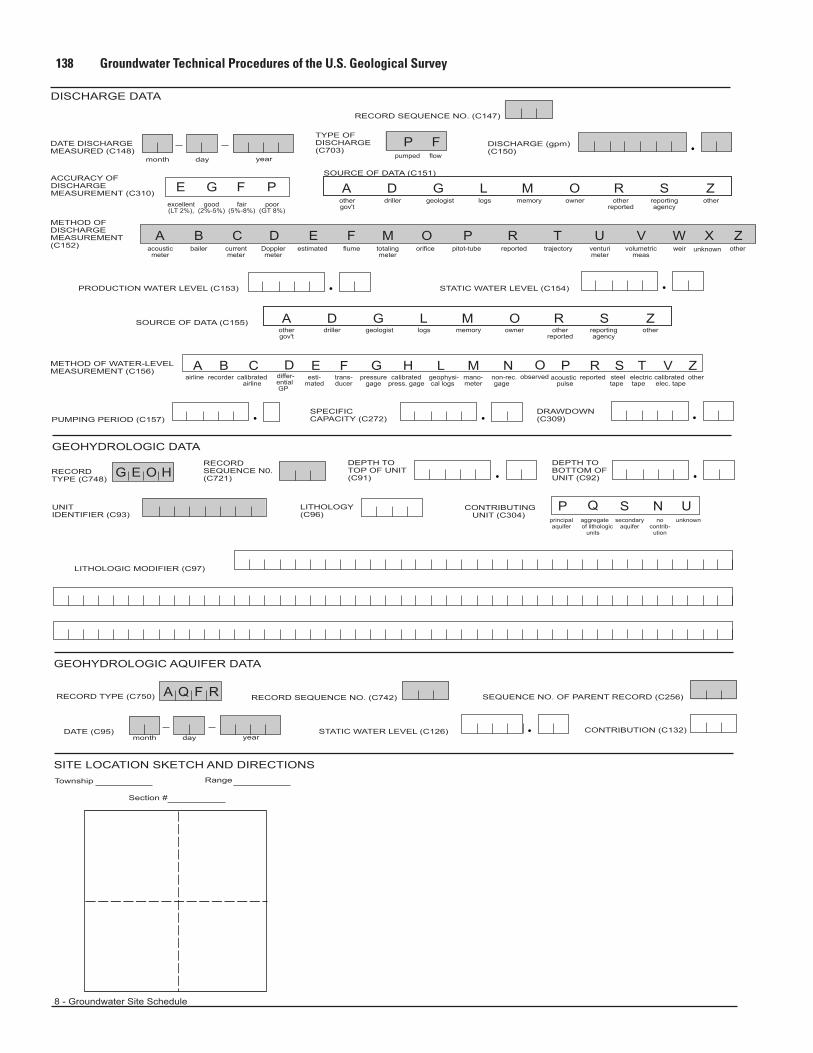
GEOHYDROLOGIC AQUIFER DATA
GEOHYDROLOGIC DATA
DISCHARGE DATA
G E O H
A Q F R
A D G L M O R S Z
A
A B C D E F M O P R T U V W Z
A B C E G H L M N R TS
SP N U
V Z
D G L M O R S Z
8 - Groundwater Site Schedule
airline recorder calibratedairline
esti-mated
pressuregage
calibratedpress. gage
geophysi-cal logs
mano-meter
non-rec.gage
reported steeltape
electrictape
calibratedelec. tape
other
othergov't
acousticmeter
bailer currentmeter
Dopplermeter
estimated flume totalingmeter
orifice pitot-tube reported trajectory venturimeter
volumetricmeas
weir other
driller geologist logs memory owner otherreported
reportingagency
principalaquifer
secondaryaquifer
nocontrib-
ution
unknown
other
othergov't
driller geologist logs memory owner otherreported
reportingagency
other
RECORDTYPE (C748)
RECORD TYPE (C750)
RECORDSEQUENCE N0.(C721)
DEPTH TOTOP OF UNIT(C91)
DEPTH TOBOTTOM OFUNIT (C92)
LITHOLOGY(C96)
CONTRIBUTING UNIT (C304)
CONTRIBUTION (C132)
UNITIDENTIFIER (C93)
LITHOLOGIC MODIFIER (C97)
Township
month day year
month day year
DATE (C95)
Section #
Range
PUMPING PERIOD (C157)SPECIFICCAPACITY (C272)
DATE DISCHARGEMEASURED (C148)
TYPE OFDISCHARGE(C703)
DISCHARGE (gpm)(C150)
RECORD SEQUENCE NO. (C147)
RECORD SEQUENCE NO. (C742) SEQUENCE NO. OF PARENT RECORD (C256)
ACCURACY OF DISCHARGEMEASUREMENT (C310)
SOURCE OF DATA (C155)
PRODUCTION WATER LEVEL (C153) STATIC WATER LEVEL (C154)
STATIC WATER LEVEL (C126)
METHOD OFDISCHARGEMEASUREMENT(C152)
METHOD OF WATER-LEVELMEASUREMENT (C156)
DRAWDOWN(C309)
SOURCE OF DATA (C151)
excellent(LT 2%),
good(2%-5%)
fair(5%-8%)
poor(GT 8%)
E G F P
Xunknown
ODobserved
Ftrans-ducer
differ-ential GP
Q aggregate
of lithologic units
P Fpumped flow
Pacoustic
pulse