hallsteads, dove holes, buxton - … shovel test... · document title: hallstead, d ove h oles, b...
TRANSCRIPT

Hallsteads, Dove Holes, Buxton
Derbyshire
Archaeological Test Pit Evaluation Report
Oxford Archaeology North
August 2013
Issue No: 1430OA North Job No: L10633CgMs LtdNGR: SK 07857823

Document Title: HALLSTEAD , DOVE HOLES, BUXTON
Document Type: Archaeological Test Pit Evaluation Report
Client Name: CgMs Consulting Ltd
Issue Number: 1430/2013OA Job Number: L10633Site Code: DH13
National Grid Reference:
Prepared by: Andrew FruddAidan Parker
Position: Supervisor/Lithics SpecialistDate: July 2013
Checked by: Fraser Brown Signed…………………….Position: Project Manager Date: August 2013
Approved by: Alan Lupton Signed…………………….Position: Operations ManagerDate: August 2013
Oxford Archaeology North © Oxford Archaeology Ltd (2013)Mill 3, Moor Lane Mills Janus House Moor Lane Osney MeadLancaster Oxford LA1 1QD OX2 0ESt: (0044) 01524 541000 t: (0044) 01865 263800 f: (0044) 01524 848606 f: (0044) 01865 793496
w: www.oxfordarch.co.uke: [email protected]
Oxford Archaeology Limited is a Registered Charity No: 285627
Disclaimer:This document has been prepared for the titled project or named part thereof and should not be relied upon or used for any other project without an independent check being carried out as to its suitability and prior written authority of Oxford Archaeology being obtained. Oxford Archaeology accepts no responsibility or liability for the consequences of this document being used for a purpose other than the purposes for which it was commissioned. Any person/party using or relying on the document for such other purposes agrees, and will by such use or reliance be taken to confirm their agreement to indemnify Oxford Archaeology for all loss or damage resulting therefrom. Oxford Archaeology accepts no responsibility or liability for this document to any party other than the person/party by whom it was commissioned.

Hallsteads, Dove Holes, Buxton, Archaeological Test Pit Evaluation 1
CONTENTS
CONTENTS...............................................................................................................................................1
SUMMARY ...............................................................................................................................................3
ACKNOWLEDGEMENTS ..............................................................................................................................4
1 BACKGROUND .....................................................................................................................................5
1.1 Circumstances of the Project.....................................................................................................51.2 Planning Background.................................................................................................................51.3 Archaeological Background.......................................................................................................61.4 Oxford Archaeology North........................................................................................................7
2 METHODOLOGY ..................................................................................................................................8
2.1 Fieldwork Methodology............................................................................................................82.2 Lithic Assessment Methodology................................................................................................8
3 RESULTS..........................................................................................................................................10
3.1 Test Pits....................................................................................................................................103.2 Stratigraphy..............................................................................................................................113.3 Lithic Assessment....................................................................................................................13
REFERENCES.........................................................................................................................................16
I LLUSTRATIONS ......................................................................................................................................17
APPENDIX 1 – WRITTEN SCHEME OF INVESTIGATION ................................................................................18
APPENDIX 2 – STRATIGRAPHIC RESULTS..................................................................................................24
APPENDIX 3 – LITHIC ASSESSMENT RESULTS...........................................................................................33
For the use of CgMs Ltd © OA North August 2013
Hallsteads, Dove Holes, Buxton, Archaeological Test Pit Evaluation 2
SUMMARY
Oxford Archaeology North were commissioned by CgMs Ltd, acting on behalf of Mr Robert Critchlow, to undertake a test pit evaluation of approximately 3.2ha of land to the north-east of Dove Holes, Buxton. The work was requested by Steve Baker (Development Control Archaeologist for High Peak Borough Council), in response to an outline planning application (HPK/2012/0542) to develop the site for new housing. It is intended that the results of this exercise will inform the scope of further investigation and mitigation works, to be secured by an appropriately worded planning condition.
The principal objective of the test pit survey was to determine the presence or absence of features or lithic artefacts at the site, given the close proximity of the Bull Ring Henge Scheduled Monument (SM 305997), which lies several hundred metres to the south. The fieldwork was completed between the 15th and the 19th of July 2013 and comprised the excavation of 277 hand-excavated shovel test pits, which were sieved on site for the retrieval of lithic artefacts. Naturally-occurring, angular, shattered chert was almost ubiquitous. Struck lithic artefacts (usually made from local chert or an agate-type material) were recovered, in low frequencies, from 118 of the 277 test pits, distributed widely over the development area. Some of the test pits, predominantly those located in the west and south-west of the area, contained slightly higher-frequencies of worked material than was generally present, which may suggest more intensive activity is focussed in this part of the site. Three pits, in close proximity to each other in the southern part of the site, each contained a struck piece of, what is possibly, Aran pitchstone. Occasional pieces of worked flint, a material that is not native to the local geology, were also recovered from several of the test pits.
The presence of the lithic artefacts provides evidence for human activity in this area, probably in the Mesolithic or Early Neolithic periods, which could pre-date the Bull Ring Henge, at least in its final form. The precise nature and intensity of the activity cannot be determined from the information presently available, although settlement cannot be ruled out. The presence of exotic lithic material at the site, particularly the possible pitchstone, is of some interest, as, if this is indeed pitchstone, it represents a southerly outlier of the presently-known distribution of this material.
For the use of CgMs Ltd © OA North August 2013

Hallsteads, Dove Holes, Buxton, Archaeological Test Pit Evaluation 3
ACKNOWLEDGEMENTS
The fieldwork was carried out by Aidan Parker and supervised by Andrew Frudd, who also wrote this report. The lithics were assessed by Aidan Parker and the figures were compiled by Mark Tidmarsh and Anna Hodgkinson. The project was managed by Simon Mortimer (CgMs), management for OA North was undertaken by Fraser Brown, who also edited this report.
For the use of CgMs Ltd © OA North August 2013

Hallsteads, Dove Holes, Buxton, Archaeological Test Pit Evaluation 4
1 BACKGROUND
1.1 CIRCUMSTANCES OF THE PROJECT
1.1.1 Oxford Archaeology North (OA North) produced an archaeological Written Scheme of Investigation (WSI; Appendix 1) at the request of CgMs Ltd, acting on behalf of Mr Robert Critchlow. It detailed the intended methodology to be employed for an initial phase of evaluation of an area of land at Dove Holes, Buxton (Fig 1), which is subject to an outline planning application (HPK/2012/0542) for new housing. The evaluation methodology is detailed in Section 2; in summary this comprised the excavation of 277 shovel test pits, on a 10m-spaced grid over the site, in order to test for the presence absence of archaeological features or worked lithic materials. This was requested (Section 1.2) because of the close proximity of the Bull Ring Henge Scheduled Monument (SM 305997. The results from this exercise will inform It is intended that the results of this exercise will inform the scope of further investigation and mitigation works, to be secured by an appropriately worded planning condition.. This report presents the results of the initial evaluation.
1.1.2 The application site comprises a roughly triangular-shaped area of some 3.2 ha (Fig 2), located on the north-eastern side of Dove Holes, to the rear of properties fronting Hallsteads. The site is bordered by The Meadows residential development to the south and, to the north, by Black Brook. It lies immediately adjacent to the site of a former quarry, and the former line of the Peak Forest Tramway, which lies in a cutting to the east. A public footpath runs across the site. This area is noted on the Historic Environment Record as one of historic importance, because of its proximity to elements of the eighteenth-century Peak Forest Tramway and the prehistoric Bull Ring henge (Section 1.3).
1.1.3 The site lies on the edge of the Carboniferous Limestone, to the west lie gritstones of the Carboniferous Millstone Grit series. The solid geology underlying the site comprises the limestone of the Monsal Dale Beds of the Dinantian (Carboniferous Limestone Series; Geological Survey of Great Britain (England and Wales), Sheet 99, 1:50,000 Series).
1.2 PLANNING BACKGROUND
1.2.1 The advice provided by Steve Baker (Development Control Archaeologist for High Peak Borough Council) in relation to Application HPK/2012/0542, dated 27th March 2013, was that the site has:
considerable archaeological potential due to its proximity to the Bull Ring henge monument at Dove Holes. This prehistoric earthwork – one of only two in the Peak District – is a scheduled monument (SM 23282) and lies 230m south of the application boundary. Henge monuments are thought to have provided a ritual and community focus for scattered and seasonally mobile prehistoric communities, and tend, therefore, to be associated with concentrations of other prehistoric monuments, sites and find spots in the vicinity. The shallow upland valley, within which Dove Holes lies, may have been an important routeway in prehistory – later reflected in the route of the Buxton-Melandra Roman road, and, indeed, the modern A6 - with burial monuments known from Cow Low and Lady Low to the west and Bee Low to the east, and significant late Mesolithic and early Neolithic archaeology recently excavated at Waterswallows Lane, 2km to the south of
For the use of CgMs Ltd © OA North August 2013

Hallsteads, Dove Holes, Buxton, Archaeological Test Pit Evaluation 5
the proposal site.
Aside from potential for below-ground archaeology, the site borders on a quarry, bridge and cutting (HER 29932, 29931 and 29957) associated with the Peak Forest Tramway, dating from the late-eighteenth century. Development of the site could cause both direct and indirect (setting) impacts to these assets.
1.2.2 This letter goes on to state that it is a requirement of the National Planning Policy Framework (NPPF; DCLG 2012; para 128) that:
applicants establish the significance of heritage assets within a development site, and to assess the impact of the development proposals upon those assets. Because the application does not contain any such heritage assessment it does not meet the information requirements of NPPF para 128 and should not, therefore, be granted consent in its current form.
1.2.3 In order to bring the application in line with NPPF para 128, it was recommended that the following work be carried out:
• an archaeological field evaluation of the site, at the pre-application stage, comprising a combination of trial trenching and test pitting – to test for buried archaeological features and lithic material within the site;
• a ‘Heritage Statement’ that will report on the results of the field evaluation and also include an assessment of the Peak Forest Tramway remains, on or adjacent to the site, and of the proposed impacts to these assets.
1.3 ARCHAEOLOGICAL BACKGROUND
1.3.1 As the site lies in close proximity to the Bull Ring henge, it has a high archaeological potential. Other such henge monuments, for example Arbor Low – also in Derbyshire, are known to be surrounded by scatters of worked lithic material, indicating fairly intensive use of the surrounding landscapes in prehistory (Evans and Seaborne 2001).
1.3.2 The Bull Ring, is a Class II henge, with an external diameter of 93m by 90m, and comprises a bank and internal ditch surrounding an oval area, measuring 53m from north to south by 46m from east to west. Today, the steep-sided rock-cut ditch varies between 8m and 12m wide and between 0.5m and 1m deep. Partial excavations carried out by Alcock (1950) in 1949, demonstrated that, originally, it measured 5m to 6.5m wide and was between 1.2m and 2.1m deep. The surrounding bank is presently around 1m high, although it would have originally been higher when first constructed. There are opposing entrances to the north and the south of the bank, where 0.9m-wide causeways cross the ditch. Some 20m to the south-west of the henge, is a probable oval barrow, with a bowl barrow superimposed on its western end. Alcock's excavations retrieved several flint flakes and the rim from a food vessel, and an excavation in 1984 (Barnett 1988) also produced numerous flint flakes, a sherd of Roman pottery, and post-medieval material associated with evidence for ploughing. Magnetometry and resistivity survey was carried out within the monument in 2000 (Martin 2001), although the results were, overall, a little disappointing, doing little to further elucidate the form of the henge or identify any internal features.
1.3.3 In advance of the construction of The Meadows housing estate, in the area immediately
For the use of CgMs Ltd © OA North August 2013

Hallsteads, Dove Holes, Buxton, Archaeological Test Pit Evaluation 6
adjacent and to the south of the present application area, an archaeological evaluation was undertaken by Arcus (1997 a and b). This included topographical, magnetometry and resistivity survey, and the monitoring of the mechanical cleaning of one field, and the examination and recording of any archaeological features present within it. The latter produced a single struck flint and identified no archaeological features. Several features were recorded by the topographical survey, including areas of medieval/post-medieval ridge and furrow and pits and dumps considered to derive from post-medieval quarrying activity. No anomalies of archaeological origin were detected by the magnetometry survey. The resistivity survey detected several linear anomalies, as well as discrete anomalies that often corresponded with the surface features recorded by the topographical survey.
1.4 OXFORD ARCHAEOLOGY NORTH
1.4.1 Oxford Archaeology North (OA North) has considerable experience of the archaeological investigation of sites of all periods, having undertaken a great number of small and large scale projects throughout northern England, including Derbyshire, during the past 30 years. OA North is an Institute of Field Archaeologists (IfA) registered organisation, number 17, and all its members of staff operate subject to the IfA Code of Conduct. A rigorous approach is taken towards health and safety and our staff are CSCS accredited. OA North are insured for third party liability and carry Public, Employers' and Professional indemnity.
For the use of CgMs Ltd © OA North August 2013

Hallsteads, Dove Holes, Buxton, Archaeological Test Pit Evaluation 7
2 METHODOLOGY
2.1 FIELDWORK METHODOLOGY
2.1.1 The evaluation comprised a shovel pit survey over the entire site, apart from a quarry, in the north-east of the site, and discrete areas, which were covered in spoil heaps or other dumped material (Fig 2). Mr Critchlow, who owns the southern extent of the site, had indicated that much of his land was formerly used as a construction compound for the residential development to the south and has previously been stripped of topsoil and stoned up. Test pits identified the compound (Fig 2), and this area was defined and excluded from the survey, as it could not practicably be sampled, due to the compacted nature of the stone surfacing used to construct it. A sewer that crosses site, was not identified, apart from, tentatively, where it conjoined with the compound (Fig 2). Provision had been made to excavate 316 shovel pits, distributed evenly over the site on a 10m grid – however, in the event it was only possible/necessary to excavate 277 test pits (Fig 2; Appendix 2)
2.1.2 All aspects of the evaluation were conducted in accordance with the Institute for Archaeologists’ Code of Conduct, Standard and Guidance for Field Evaluation (IfA 2008). Evaluation techniques were selected to cause the minimum amount of destruction and complied with all relevant health and safety regulations. All of those working on site were made aware of the significance and history of the site.
2.1.3 The shovel pit testing was undertaken because the site is grass-covered, and, as such, there are no soil-exposures that might reveal artefacts in the topsoil. A grid was established over the site by means of DGPS instrument survey. At 10m intervals across the grid, small shovel pits (0.25m by 0.25m in size) were excavated to a maximum depth of 0.30m (Fig 2; Appendix 2), typically representing the size of a sod of earth lifted by a shovel/spade blade.
2.1.4 The sod was broken up and examined by eye for lithics and other artefacts and all the arisings were passed through a coarse (10mm) hand sieve. Those shovel pits that produced artefacts were located using a survey-grade DGPS, and the artefacts were bagged and labelled by pit and retained for subsequent analysis. In practice, as there was a large amount of naturally-occurring chert present at the site, which precluded the rapid and confident identification of struck lithic material in the field, all potentially-worked lithic pieces were collected for subsequent close study and discrimination (Section 2.2). No archaeological features were identified within the pits, so no stratigraphic recording took place beyond logging the nature and form of the apparent ploughsoils, subsoils and natural geology (Section 3; Appendix 2). Each pit was reinstated by backfilling it with the excavated soil, replacing the sod and trampling it down.
2.2 LITHIC ASSESSMENT METHODOLOGY
2.2.1 An initial rapid overview of the lithic material retrieved from the test pits suggested that the majority of the recovered chert was of local natural origin, although some worked pieces of chert, flint and other material were also present. In order to quickly distinguish
For the use of CgMs Ltd © OA North August 2013

Hallsteads, Dove Holes, Buxton, Archaeological Test Pit Evaluation 8
the worked material from the angular and blocky unworked or plough-shattered chert, the lithic material from each test pit was laid out and searched for any regular pieces or chunks that showed potential flake scars on their principal faces. In practice, it was found that potential struck lithic pieces were easy to identify by eye, due to their more regular morphology. Any potential struck lithics were then washed and examined macroscopically for the presence of technological features such as conchoidal fractures, dorsal face scars, bulbs of percussion, platforms and associated platform preparation in order to confirm their identification. Each piece was then assigned to a category within a basic classification system and recorded in spreadsheet format (Appendix 3). Lithic frequencies were then plotted onto a site plan (Fig 2), in order to inform on any potential areas of concentrated activity. The results are discussed in Section 3.3.
For the use of CgMs Ltd © OA North August 2013

Hallsteads, Dove Holes, Buxton, Archaeological Test Pit Evaluation 9
3 RESULTS
3.1 TEST PITS
3.1.1 Some 277 of the 316 originally-proposed test pits were excavated (Fig 2) For various reasons, 39 could not be excavated. Of the test pits that could not be excavated, TP016 and TP017 lay beyond the southern boundary of the field, the former in a garden and the latter in the tarmac footpath. Test pits TP084 and TP099 lay beyond the eastern boundary of the field. Test pits TP154 and TP165 were not excavated as they coincided with the position of modern spoil heaps. Test pit TP064 was above a concrete slab, thought to be associated with a sewer that is known to run through the site. Nine test pits (TP16-7, TP10-12, TP27-9 and TP41) were not excavated as they lay within the area of a former compound, identified by test pits TP015 and TP038-40, and indicated by the extent of Topsoil 4 (Section 3.2.1). Twenty-three test pits (TP241-2, TP249-51, TP255-9, TP263-6, TP270-2, TP276-7, TP282, TP287, TP292 and TP297) lay within the area of a disused quarry, in the north-east of the site (Plate 1).
Plate 1: North-facing view of the quarry
3.1.2 The results of the lithic assessment are discussed in detail within Section 3.3.3. In terms of the distribution of the lithic material, the vast majority of this was recovered from the topsoils (Section 3.2.1), although some material was also recovered from the subsoils (Section 3.2.2). This could, however, reflect an inherent methodological bias, as the depth of the topsoils meant that the subsoils were not always sampled in every test pit, and, where sampled, they were not always sampled to their full depth.
For the use of CgMs Ltd © OA North August 2013

Hallsteads, Dove Holes, Buxton, Archaeological Test Pit Evaluation 10
3.1.3 The test pits (118) containing some lithic material had a very wide distribution over the site (Fig 2). The 159 test pits that contained no lithic material had a similarly wide distribution, but there was some clustering of negative results in the extreme south-west, extreme north and in the east of the site. Conversely, those test pits that contained the greatest number of flints appeared to concentrate in a south-east/north-west orientated band, towards the south-west of the site. This was centred on TP076, TH090 and TP104-5, which all produced more than six pieces of flint each.
3.1.4 The shovel test pit survey successfully sampled all viable areas of the site that have the potential to contain archaeological activity. Generally, the patterning within the lithic distribution seems to exhibit a coherent structure, which suggests that it has valid spatial integrity (ie the lithic pieces are, potentially, largely in situ, rather than having been widely dispersed by site deformation processes or imported, for instance, in topsoil etc). If this lithic distribution is accepted, as a proxy for prehistoric activity, then it indicates potentially-significant areas of this, particularly in, but not necessarily restricted to, an area towards the south-western part of the site.
3.2 STRATIGRAPHY
3.2.1 The detailed descriptions of each test pit are presented, in tabular form, within Appendix 2. A generally representative stratigraphic sequence is depicted in Plate 1. There were four topsoil deposits (Topsoil 1-4) recorded across the site, which probably represent variations in the same generic deposit, representing slightly different land uses in the past. It is possible that these variations to topsoil composition may be due to levelling and ploughing of spoil heaps, although this cannot be correlated with the observed lithic distribution, so, if this has occurred, there may have been little or no impact on any sub-surface cultural deposits that may be present. Topsoils 1 and 2 two occurred in the majority of the test pits, and Topsoils 3 and 4 were more localised in their distribution.
Topsoil 1: was a dark brownish-grey, friable, silty clay. This occupied the western side of the site.
Topsoil 2: was a mid-dark greyish-brown, firm-friable, silty clay. This occupied the eastern part of the site.
Topsoil 3: was a mid yellowish-brown, friable silty clay with a high concentration of stone. This was present across a c 40m2 area, at the northern end of the site.
Topsoil 4: was a dark brownish-grey, silty clay with approximately 50% stone. This extended over the area of the former compound and did not occur elsewhere on the site.
3.2.2 There was also variation in the composition of the subsoils, with four distinct types of subsoil (Subsoil 1-4) being identified in different parts of the site. This variation probably relates to differences in the underlying geology, from which the subsoils were most likely derived, but, as the underlying geological deposits were not commonly exposed within the shallow shovel test pits, this can only presently be surmised.
Subsoil 1: was a firm dark blue/grey clay with yellow mottles. This occurred in the north
For the use of CgMs Ltd © OA North August 2013
Hallsteads, Dove Holes, Buxton, Archaeological Test Pit Evaluation 11
of the site, the south of the site, and in a west/east band, in the central part of the site.
Subsoil 2: was a mid yellow-brown silty clay. This had a patchy distribution over the southern half of the site.
Subsoil 3: was a mid grey-brown sandy clay. This occurred in a c 40m2 area, in the south-western part of the site.
Subsoil 4: was a firm light yellow-brown silty clay. This occurred in two discrete areas, one possibly relating to the sewer (Fig 2), in the central southern part of the site, and one in an area c 40m2, in the east of the central part of the site.
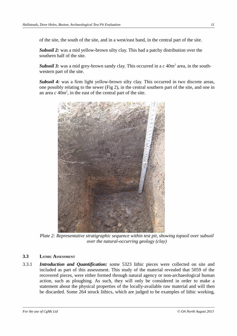
Plate 2: Representative stratigraphic sequence within test pit, showing topsoil over subsoil over the natural-occurring geology (clay)
3.3 LITHIC ASSESSMENT
3.3.1 Introduction and Quantification: some 5323 lithic pieces were collected on site and included as part of this assessment. This study of the material revealed that 5059 of the recovered pieces, were either formed through natural agency or non-archaeological human action, such as ploughing. As such, they will only be considered in order to make a statement about the physical properties of the locally-available raw material and will then be discarded. Some 264 struck lithics, which are judged to be examples of lithic working,
For the use of CgMs Ltd © OA North August 2013

Hallsteads, Dove Holes, Buxton, Archaeological Test Pit Evaluation 12
have been included in the results presented in this report (Appendix 3). These were distributed through 118 of the 277 test pits, with much of this material occurring in pits located in the south-western corner of the field (Fig 2). This report presents the preliminary quantification and assessment of the struck lithic material including its technological and chronological traits.
3.3.2 Of the 264 worked lithic pieces (Table 1), blades and flakes are the most frequently occurring types, with total counts of 99 and 89 respectively (Appendix 3). The remaining material is divided primarily between angular chunks that show signs of working, cores and related technological pieces and potentially retouched pieces or pieces possibly showing evidence for utilisation.
Classification Total
Blades (including broken and blade-like flakes) 101
Chunks 46
Cores (including fragments) 7
Core trimming 4
Flakes (including broken) 90
Flaked chunk 5
Retouched 2
Utilised/Worn edge 9
Table 1: Broad counts for main classifications
3.3.3 Results: the majority (approximately 90%) of the material recovered comprised chert, which is unsurprising, as this is present within the local geology. Smaller quantities of an agate-type material also occurred in an unworked form, and limestone was occasionally collected. Chert and then agate were the most commonly-utilised materials for tool manufacture (Appendix 3), although worked examples of an orange ‘pebble-type’ flint and a ‘glassy’ material, resembling Scottish pitchstone, were also retrieved in small quantities.
3.3.4 Based on colour, the chert can be divided into two main types: a black chert and a grey chert. Within this general colour scheme each main type can be sub-divided by differences in hue of the main colour and this is likely to reflect the varied lithiological conditions within any one seam of parent material. Both the grey and black chert are fine to medium grained, with a dull lustre. However, the black material tends to have a greater size range and number of inclusions than the grey. Both types are heavily flawed, with linear planes of weakness resulting in an irregular, blocky, tabular morphology for the majority of pieces. Cortex was minimal but, when present, tended to be thick and coarse on its outer surface, indicating that material has been derived from local bedrock sources.
3.3.5 Regarding the assessment of this particular assemblage, it is important, initially, to clarify the difficulties inherent in identifying truly worked lithics from those shattered by other means eg frost or plough-strike. Whilst worked lithic material is unquestionably present on the site, some confusion between naturally-formed and struck pieces is possible, due to uncertainties regarding taphonomy – the fact that the material was recovered from a,
For the use of CgMs Ltd © OA North August 2013

Hallsteads, Dove Holes, Buxton, Archaeological Test Pit Evaluation 13
secondary, topsoil environment – and the local prevalence of geological chert.
3.3.6 The largest portion of the worked material falls into the ‘blade’ category, and the bulk of the assessed assemblage supports a primary focus on the production of long thin blades (between 20-40mm, with an average width of 5mm). The two cores and five potential core fragments recovered are cylindrical in nature and the scarring on them shows distinct narrow blade removals. The core from test pit TP076 is a particularly good complete example of such, showing evidence for opposed platform working. Similarly the plunging overshot removals from test pits TP273 and TP293, identified as core trimming flakes, also show scarring from blade removals, on their dorsal faces. At their distal ends, this scarring can be seen repeated around the whole of the piece, as if removed from another cylindrical-shaped blade core. These two represent half of the total core maintenance pieces identified. The blade count is slightly higher than one would expect, but this may be due to the previously stated (Section 3.3.5) difficulties in identifying the worked material. Notwithstanding this, however, the presence of definite blade-core technology is strongly indicative of a blade-orientated focus for the lithic working.
3.3.7 The unmodified flake debitage of the assemblage was equally divided between pieces of between 10-25mm and larger flakes of between 25-50mm, with nearly half their number again appearing as incomplete or broken flakes. The morphology of the chert material is not one that lends itself to flaking easily, although a lot of the chunks and other angular pieces often featured negative flake scars on them, showing that several attempts to work the material had been made. Either this material was discarded as unsuitable or the chunks represent larger pieces that shattered whilst working rendering them unusable. It is possible that such removals were the initial stages of reduction in the ultimate production of blades.
3.3.8 A small number of possibly utilised pieces were recovered. Primarily, these fell into the blade category. While only two pieces (from TP037 and TP275) bore evidence for potential retouch, nine others showed signs of potential edge use. The possibility that this use wear could actually have derived from plough damage must be entertained, but the bulk of these pieces came from test pits within the areas where there was, generally, a higher concentration of worked lithic pieces. For this reason their authenticity seems likely.
3.3.9 Conclusion: despite some difficulty in unequivocally identifying every individual instance of lithic working (Section 3.3.5), overall, there is compelling evidence for lithic working taking place at the site. Despite only a small-sized assemblage having been recovered and assessed, this suggests that this activity took place between the Late Mesolithic and Early Neolithic periods, and, as such, it potentially pre-dates the construction of the Bull Ring henge monument. Although it is presently difficult to extrapolate any detailed information regarding the character and purpose of the evidenced prehistoric activity, the presence of quantities of struck lithic material, including ‘foreign’ materials, such as the pebble flint and the pitchstone-like glassy material, and the fact that, (possibly) subsequently, a henge monument was constructed in close proximity to the site, may suggest that it was of some significance.
For the use of CgMs Ltd © OA North August 2013

Hallsteads, Dove Holes, Buxton, Archaeological Test Pit Evaluation 14
REFERENCES
Alcock, L, 1950 The henge monument of the Bull Ring, Dove Holes, Derbyshire. Proc Prehist Soc, 16, 81-86
Barnatt, J, 1988 Excavations at the Bull Ring Henge, Dove Holes, Derbyshire, Derbyshire Archaeol J, 108, 5-20
Brown, D H, 2007 Archaeological archives a guide to best practice in creation, compilation, transfer and curation, Archaeological Archives Forum
Department for Communities and Local Government (DCLG), 2012 National Planning Policy Framework, London
Derbyshire Museum Collections, 2005 Acquisition and disposal policy, unpubl doc
Edmonds, M and Seaborne, T, 2001 Prehistory in the Peak, Tempus Publishing, Stroud
Institute for Archaeologists, 2008 Standard and Guidance for Archaeological Field Evaluation, Reading
Martin, L, 2001 The Bull Ring, Dove Holes, Derbyshire. Report on geophysical survey, unpubl rep
For the use of CgMs Ltd © OA North August 2013

Hallsteads, Dove Holes, Buxton, Archaeological Test Pit Evaluation 15
ILLUSTRATIONS
FIGURES
Figure 1: Site location
Figure 2: Showing the extent of the site, the excavated and unexcavated test pits, and the relative frequency of struck lithics
PLATES
Plate 1: North-facing view of the quarry
Plate 2: Representative stratigraphic sequence within test pit, showing topsoil over subsoil over the natural-occurring geology (clay)
For the use of CgMs Ltd © OA North August 2013


Hallsteads, Dove Holes, Buxton, Archaeological Test Pit Evaluation 16
APPENDIX 1 – WRITTEN SCHEME OF INVESTIGATION
BACKGROUND
CIRCUMSTANCES OF PROJECT
Oxford Archaeology North (OA North) have produced this archaeological Written Scheme of Investigation (WSI) at the request of CgMs Ltd, acting on behalf of Mr Robert Critchlow. It details the intended methodology to be employed for an initial phase of evaluation of an area of land at Dove Holes, Buxton (Figs 1), which is subject to an outline planning application (HPK/2012/0542) for new housing. The results from this exercise will inform a decision-making process on the need for further evaluation/mitigation and the timing of this, in terms of the planning process.
The application site comprises a roughly triangular-shaped area of some 3.2 ha (Fig 2), located on the north-eastern side of Dove Holes, to the rear of properties fronting Hallsteads. The site is bordered by The Meadows residential development to the south and, to the north, by Black Brook. It lies immediately adjacent to a designated local wildlife site (Ridgeclose Rocks), which is part of the site of a former quarry, and adjacent to the former line of the Peak Forest Tramway, which lies in a cutting to the east. A public footpath runs across the site. This area is noted on the Historic Environment Record as one of historic importance, because of its proximity to elements of the eighteenth-century Peak Forest Tramway and the prehistoric Bull Ring henge (Section 1.3).
The site lies on the edge of the Carboniferous Limestone, to the west lie gritstones of the Carboniferous Millstone Grit series. The solid geology underlying the site comprises the limestone of the Monsal Dale Beds of the Dinantian (Carboniferous Limestone Series; Geological Survey of Great Britain (England and Wales), Sheet 99, 1:50,000 Series).
PLANNING BACKGROUND
The advice provided by Steve Baker (Development Control Archaeologist for High Peak Borough Council) in relation to Application HPK/2012/0542, dated 27th March 2013, was that the site has:
considerable archaeological potential due to its proximity to the Bull Ring henge monument at Dove Holes. This prehistoric earthwork – one of only two in the Peak District – is a scheduled monument (SM 23282) and lies 230m south of the application boundary. Henge monuments are thought to have provided a ritual and community focus for scattered and seasonally mobile prehistoric communities, and tend, therefore, to be associated with concentrations of other prehistoric monuments, sites and find spots in the vicinity. The shallow upland valley, within which Dove Holes lies, may have been an important routeway in prehistory – later reflected in the route of the Buxton-Melandra Roman road, and, indeed, the modern A6 - with burial monuments known from Cow Low and Lady Low to the west and Bee Low to the east, and significant late Mesolithic and early Neolithic archaeology recently excavated at Waterswallows Lane, 2km to the south of the proposal site.
Aside from potential for below-ground archaeology, the site borders on a quarry, bridge and cutting (HER 29932, 29931 and 29957) associated with the Peak Forest Tramway, dating from the late-eighteenth century. Development of the site could cause both direct and indirect (setting) impacts to these assets.
This letter goes on to state that it is a requirement of the National Planning Policy Framework (NPPF; DCLG 2012; para 128) that:
applicants establish the significance of heritage assets within a development site, and to assess the impact of the development proposals upon those assets. Because the application does not contain any such heritage
For the use of CgMs Ltd © OA North August 2013

Hallsteads, Dove Holes, Buxton, Archaeological Test Pit Evaluation 17
assessment it does not meet the information requirements of NPPF para 128 and should not, therefore, be granted consent in its current form.
In order to bring the application in line with NPPF para 128, it was recommended that the following work be carried out:
• an archaeological field evaluation of the site, at the pre-application stage, comprising a combination of trial trenching and test pitting – to test for buried archaeological features and lithic material within the site;
• a ‘Heritage Statement’ that will report on the results of the field evaluation and also include an assessment of the Peak Forest Tramway remains, on or adjacent to the site, and of the proposed impacts to these assets.
Until this additional information has been submitted, and a re-consultation on this application taken place, a holding objection will be maintained by High Peak Borough Council, due to non-compliance with NPPF para 128.
ARCHAEOLOGICAL BACKGROUND
As the site lies in close proximity to the Bull Ring henge, it has a high archaeological potential. Other such henge monuments, for example Arbour Low – also in Derbyshire, are known to be surrounded by scatters of worked lithic material, indicating fairly intensive use of the surrounding landscapes in prehistory (Evans and Seaborne 2001).
The Bull Ring, is a Class II henge, with an external diameter of 93m by 90m, and comprises a bank and internal ditch surrounding an oval area, measuring 53m from north to south by 46m from east to west. Today, the steep-sided rock-cut ditch varies between 8m and 12m wide and between 0.5m and 1m deep. Partial excavations carried out by Alcock (1950) in 1949, demonstrated that, originally, it measured 5m to 6.5m wide and was between 1.2m and 2.1m deep. The surrounding bank is presently around 1m high, although it would have originally been higher when first constructed. There are opposing entrances to the north and the south of the bank, where 0.9m-wide causeways cross the ditch. Some 20m to the south-west of the henge, is a probable oval barrow, with a bowl barrow superimposed on its western end. Alcock's excavations retrieved several flint flakes and the rim from a food vessel, and an excavation in 1984 (Barnett 1988) also produced numerous flint flakes, a sherd of Roman pottery, and post-medieval material associated with evidence for ploughing. The monument was subjected to magnetometry and resistivity survey in 2000 (Martin 2001), although the results were, overall, a little disappointing, doing little to further elucidate the form of the henge or identify any internal features.
In advance of the construction of The Meadows housing estate, in the area immediately adjacent and to the south of the present application area, an archaeological evaluation was undertaken by Arcus (1997 a and b). This included topographical, magnetometry and resistivity survey, and the monitoring of the mechanical cleaning of one field, and the examination and recording of any archaeological features present within it. The latter produced a single struck flint and identified no archaeological features. Several features were recorded by the topographical survey, including areas of medieval/post-medieval ridge and furrow and pits and dumps considered to derive from post-medieval quarrying activity. No anomalies of archaeological origin were detected by the magnetometry survey. The resistivity survey detected several linear anomalies, as well as discrete anomalies that often corresponded with the surface features recorded by the topographical survey.
OXFORD ARCHAEOLOGY NORTH (OA NORTH)
OA North has considerable experience of the archaeological investigation of sites of all periods, having undertaken a great number of small and large scale projects throughout northern England, including Derbyshire, during the past 30 years. OA North is an Institute of Field Archaeologists (IfA) registered organisation, number 17, and all its members of staff operate subject to the IfA Code of Conduct. A rigorous
For the use of CgMs Ltd © OA North August 2013

Hallsteads, Dove Holes, Buxton, Archaeological Test Pit Evaluation 18
approach is taken towards health and safety and our staff are CSCS accredited. OA North are insured for third party liability and carry Public, Employers and Professional indemnity.
AIMS AND OBJECTIVES
PROJECT AIMS
The evaluation of the site (Fig 2) will aim to inform on the presence and significance of any archaeological remains within the site that may be impacted upon by the development. It will seek to disseminate its results to stakeholders.
The proposed shovel pitting methodology (Section 3.1.1-6), will, principally, aim to retrieve artefacts occurring within the topsoil or subsoil, and record their relative frequency and spatial distribution, but it will also potentially identify subsurface archaeological features. The evaluation will attempt to establish the presence, absence, extent, character, date and significance of any archaeological artefact scatters within the site, and to determine their broad stratigraphic provenance and whether they are associated with any apparent features.
REPORT, ARCHIVE PRODUCTION AND DISSEMINATION
The archaeological work will result in a report, which can be incorporated in the requested Heritage Statement, and will include:
• A site location plan, related to the national grid;
• A front cover/frontispiece which includes the planning application number and the national grid reference of the site;
• The dates on which the fieldwork was undertaken;
• A concise, non-technical summary of the results of the evaluation;
• A description of the methodology employed, work undertaken and the results obtained;
• Plans, at an appropriate scale, showing the location and position of deposits and finds located;
• Relevant photographs;
• A list of, and dates for, any finds recovered and a description and interpretation of the deposits identified.
An archive will be prepared in accordance with the recommendations in Brown (2007). Arrangements will be made for its long term storage and deposition with Buxton Museum and Art Gallery. A single bound copy of the report will be submitted to the Derbyshire HER along with a pdf copy on CD.
In the event that any finds are recovered, the transfer of the ownership of finds will be made to a local or relevant specialist museum, assuming the landowner gives their approval. In this case Buxton Museum and Art Gallery is the preferred repository, their accession number is DERSB:2013.12. The museum’s requirements for the transfer and storage of finds will be discussed before the project commences and this will be in accordance with the Acquisition and Disposal Policy (Derbyshire Museum Collections 2005). The County Historic Environment Service will be notified, in writing, of the arrangements made.
An online OASIS form at http://www.oasis.ac.uk/ will, also be completed as part of the project. This will be on the understanding that this information will be made available through the above website, unless otherwise agreed..
For the use of CgMs Ltd © OA North August 2013

Hallsteads, Dove Holes, Buxton, Archaeological Test Pit Evaluation 19
METHOD STATEMENT
FIELDWORK
The evaluation, proposed by this WSI, will comprise a shovel pit survey over the entire site – as appropriate (Fig 2). Mr Critchlow, who owns the southern extent of the site, has indicated that much of his land was formerly used a construction compound for the residential development to the south and has previously been stripped of topsoil and stoned up. He has also drawn attention to the easement for a sewer that crosses the northern extent of the site. Further details of the sewer easement will be sought prior to commencement of work on site. Provision has been made to excavate 320 shovel pits, distributed evenly over the site on a 10m grid – however, if it is clear that significant elements within the site have no potential for significant material to be present within the topsoil/subsoil these zones will be defined and eliminated from the scope of the works on site.
All aspects of the evaluation will be conducted in accordance with the Institute for Archaeologists’ Code of Conduct, Standard and Guidance for Field Evaluation. Evaluation techniques will be selected to cause the minimum amount of destruction and will comply with all relevant health and safety regulations. All of those working on site will be made aware of the significance and history of the site.
Shovel pit testing is undertaken when the ground is grass covered as is typical for pasture land, and when there are no soil-exposures that might reveal artefacts in the topsoil. A grid will be established over the site by means of DGPS instrument survey. At 10m intervals across the grid, small shovel pits (0.25m by 0.25m in size) will be excavated to a maximum depth of 0.30m, typically representing the size of a sod of earth lifted by a shovel/spade blade. The sod will be broken up and examined by eye for lithics and other artefacts and will be passed through a coarse hand sieve. Those shovel pits that produce artefacts will be located using a survey-grade DGPS, and the artefacts will be bagged and labelled by pit and retained for subsequent analysis. Post-medieval ceramics are typically dispersed across plough soil as a process of night soiling and their presence is not an indicator of an archaeological site; consequently these will not be retained and shovel pits containing with them will not be surveyed unless there are also earlier artefacts. The reinstatement of each pit will involve backfilling the excavated soil, replacing the sod and trampling it down. If any archaeological features are encountered, these will be recorded, to the extent that it is possible within the confines of the shovel pit, and the shovel pit will be three-dimensionally located.
Finds recovery and sampling programmes will be in accordance with current best practice (following IfA and other specialist guidelines). All artefacts and ecofacts will be treated in accordance with OA North standard practice, which is cognisant of IfA and UKIC Guidelines. In general this will mean that (where appropriate or safe to do so) finds are washed, dried, marked, bagged and packed in stable conditions; no attempt at conservation will be made unless special circumstances require prompt action. In such a case guidance and/or expertise will be sought from a suitably qualified conservator. OA North will assess the finds for conservation after fieldwork has been completed, but the cost of conservation must be born by the client.
Any human remains discovered will be left in situ, covered and protected. CgMs and the local Coroner will be informed immediately if a burial is discovered.
Any gold and silver artefacts recovered during the course of the excavation will be removed to a safe place and reported to CgMs and the local Coroner according to the procedures relating to the Treasure Act, 1996/7
REPORTING
A report on the shovel pit exercise will be integrated with the Heritage Statement, which will be prepared by CgMs – this will briefly characterise the lithic material in overview. The locations of the shovel pits will be superimposed onto base OS mapping. All artefacts from the test pits will be analysed and the date range of each will be assessed and correlated back to the locational information and will be combined within a GIS. The three-dimensional co-ordinates of the pits will be sorted according to period and the distribution of artefacts for each of the main periods will be displayed. Any significant grouping of artefacts within a limited date range
For the use of CgMs Ltd © OA North August 2013

Hallsteads, Dove Holes, Buxton, Archaeological Test Pit Evaluation 20
may be an indicator of an archaeological site.
HEALTH AND SAFETY
OA North recognises its responsibilities with regard to health and safety, and will establish safe working practices in accordance with current legislation. OA North provides a Health and Safety Statement for all projects and maintains a Health and Safety policy. All site procedures are in accordance with the guidance set out in the Health and Safety Manual compiled by the Standing Conference of Archaeological Unit Managers (1991) and OA North’s own health and safety guidance documentation. OA North’s site staff are CSCS accredited and senior staff are qualified First Aiders. All staff are issued with Personal Protective Equipment and each team with a telephone and a first aid kit. OA North will liaise with all parties to ensure all site specific health and safety regulations are met. A risk assessment will be completed in advance of any on-site works.
RESOURCES AND PROGRAMMING
STAFF AND TIMETABLE PROPOSALS
Simon Mortimer of CgMs will be responsible for the overall management of the project Management for OA North will be undertaken by Fraser Brown (OA North Senior Project Manager).
The shovel pitting survey will be undertaken by two OA North fieldworkers of appropriate experience and expertise. It is expected that this can be completed in one five-day week.
The assessment of any finds will be undertaken following the completion of fieldwork. The project archive will be compiled and an archive report will be produced, following the completion of the fieldwork and the assessment of the finds. Assessment of any finds from the excavation will be undertaken by OA North's in-house artefact specialists or an appropriate external specialist should this be required.
Normally OA North staff work a 37.5 hours week, Monday to Friday, though adjustments to hours may be made to maximise daylight working time in winter and to meet travel requirements.
PROJECT MONITORING
PROCEDURE
Fieldwork will be monitored for the Local Planning Authority by Derbyshire County Council's Heritage Environment Service (DCCHES), to whom reasonable access to the work and archive will be afforded and with whom OA North (via CgMs) will maintain close liaison throughout the fieldwork and reporting stages of the evaluation.
OA North will immediately backfill any shovel pits investigated, on the understanding that they will not need to be inspected by DCCHES.
The involvement of DCCHES will be acknowledged in any report or publication generated by this project.
REFERENCES
Alcock, L, 1950 The henge monument of the Bull Ring, Dove Holes, Derbyshire. Proc Prehist Soc, 16, 81-86
Barnatt, J, 1988 Excavations at the Bull Ring Henge, Dove Holes, Derbyshire, Derbyshire Archaeol J, 108, 5-20
For the use of CgMs Ltd © OA North August 2013

Hallsteads, Dove Holes, Buxton, Archaeological Test Pit Evaluation 21
Brown, D H, 2007 Archaeological archives a guide to best practice in creation, compilation, transfer and curation, Archaeological Archives Forum
Department for Communities and Local Government (DCLG), 2012 National Planning Policy Framework, London
Derbyshire Museum Collections, 2005 Acquisition and disposal policy, unpubl doc
Edmonds, M and Seaborne, T, 2001 Prehistory in the Peak, Tempus Publishing, Stroud
Martin, L, 2001 The Bull Ring, Dove Holes, Derbyshire. Report on geophysical survey, unpubl rep
For the use of CgMs Ltd © OA North August 2013
Hallsteads, Dove Holes, Buxton, Archaeological Test Pit Evaluation 22
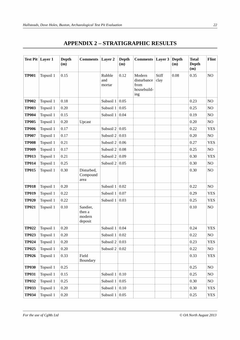
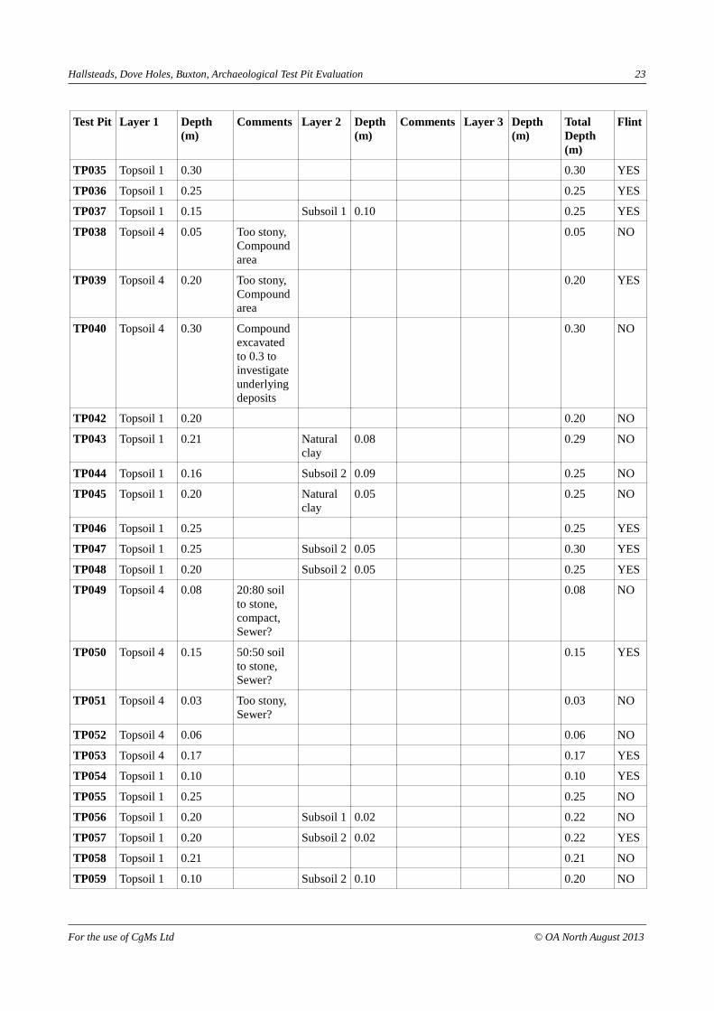
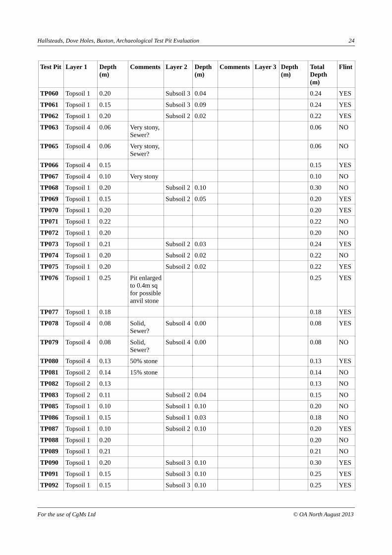
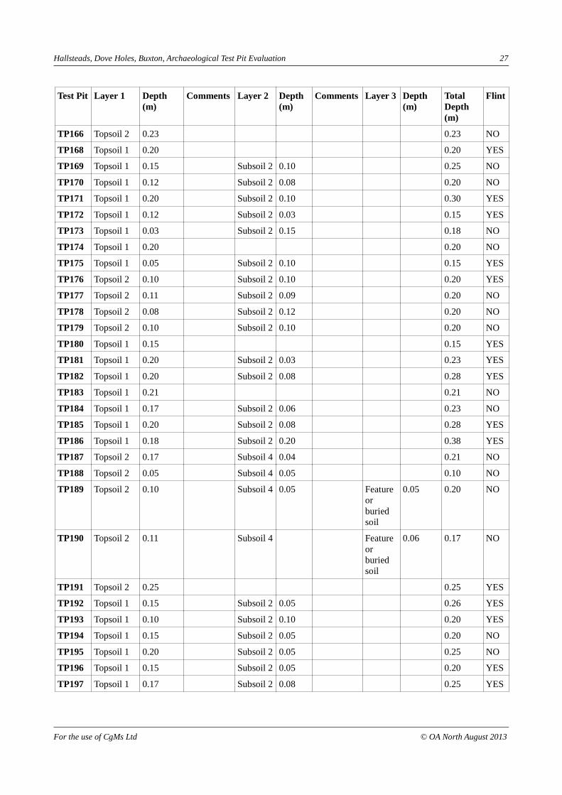
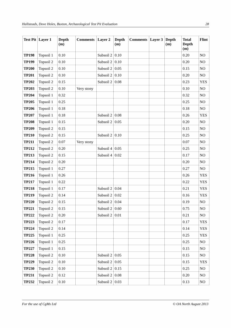
APPENDIX 2 – STRATIGRAPHIC RESULTS
Test Pit Layer 1 Depth (m)
Comments Layer 2 Depth (m)
Comments Layer 3 Depth (m)
Total Depth (m)
Flint
TP001 Topsoil 1 0.15 Rubble and mortar
0.12 Modern disturbance fromhousebuild-ing
Stiff clay
0.08 0.35 NO
TP002 Topsoil 1 0.18 Subsoil 1 0.05 0.23 NO
TP003 Topsoil 1 0.20 Subsoil 1 0.05 0.25 NO
TP004 Topsoil 1 0.15 Subsoil 1 0.04 0.19 NO
TP005 Topsoil 1 0.20 Upcast 0.20 NO
TP006 Topsoil 1 0.17 Subsoil 2 0.05 0.22 YES
TP007 Topsoil 1 0.17 Subsoil 2 0.03 0.20 NO
TP008 Topsoil 1 0.21 Subsoil 2 0.06 0.27 YES
TP009 Topsoil 1 0.17 Subsoil 2 0.08 0.25 NO
TP013 Topsoil 1 0.21 Subsoil 2 0.09 0.30 YES
TP014 Topsoil 1 0.25 Subsoil 2 0.05 0.30 NO
TP015 Topsoil 1 0.30 Disturbed, Compound area
0.30 NO
TP018 Topsoil 1 0.20 Subsoil 1 0.02 0.22 NO
TP019 Topsoil 1 0.22 Subsoil 1 0.07 0.29 YES
TP020 Topsoil 1 0.22 Subsoil 1 0.03 0.25 YES
TP021 Topsoil 1 0.10 Sandier, then a modern deposit
0.10 NO
TP022 Topsoil 1 0.20 Subsoil 1 0.04 0.24 YES
TP023 Topsoil 1 0.20 Subsoil 1 0.02 0.22 NO
TP024 Topsoil 1 0.20 Subsoil 2 0.03 0.23 YES
TP025 Topsoil 1 0.20 Subsoil 2 0.02 0.22 NO
TP026 Topsoil 1 0.33 Field Boundary
0.33 YES
TP030 Topsoil 1 0.25 0.25 NO
TP031 Topsoil 1 0.15 Subsoil 1 0.10 0.25 NO
TP032 Topsoil 1 0.25 Subsoil 1 0.05 0.30 NO
TP033 Topsoil 1 0.20 Subsoil 1 0.10 0.30 YES
TP034 Topsoil 1 0.20 Subsoil 1 0.05 0.25 YES
For the use of CgMs Ltd © OA North August 2013
Hallsteads, Dove Holes, Buxton, Archaeological Test Pit Evaluation 23
Test Pit Layer 1 Depth (m)
Comments Layer 2 Depth (m)
Comments Layer 3 Depth (m)
Total Depth (m)
Flint
TP035 Topsoil 1 0.30 0.30 YES
TP036 Topsoil 1 0.25 0.25 YES
TP037 Topsoil 1 0.15 Subsoil 1 0.10 0.25 YES
TP038 Topsoil 4 0.05 Too stony, Compound area
0.05 NO
TP039 Topsoil 4 0.20 Too stony, Compound area
0.20 YES
TP040 Topsoil 4 0.30 Compound excavated to 0.3 to investigate underlying deposits
0.30 NO
TP042 Topsoil 1 0.20 0.20 NO
TP043 Topsoil 1 0.21 Natural clay
0.08 0.29 NO
TP044 Topsoil 1 0.16 Subsoil 2 0.09 0.25 NO
TP045 Topsoil 1 0.20 Natural clay
0.05 0.25 NO
TP046 Topsoil 1 0.25 0.25 YES
TP047 Topsoil 1 0.25 Subsoil 2 0.05 0.30 YES
TP048 Topsoil 1 0.20 Subsoil 2 0.05 0.25 YES
TP049 Topsoil 4 0.08 20:80 soil to stone, compact, Sewer?
0.08 NO
TP050 Topsoil 4 0.15 50:50 soil to stone, Sewer?
0.15 YES
TP051 Topsoil 4 0.03 Too stony, Sewer?
0.03 NO
TP052 Topsoil 4 0.06 0.06 NO
TP053 Topsoil 4 0.17 0.17 YES
TP054 Topsoil 1 0.10 0.10 YES
TP055 Topsoil 1 0.25 0.25 NO
TP056 Topsoil 1 0.20 Subsoil 1 0.02 0.22 NO
TP057 Topsoil 1 0.20 Subsoil 2 0.02 0.22 YES
TP058 Topsoil 1 0.21 0.21 NO
TP059 Topsoil 1 0.10 Subsoil 2 0.10 0.20 NO
For the use of CgMs Ltd © OA North August 2013
Hallsteads, Dove Holes, Buxton, Archaeological Test Pit Evaluation 24
Test Pit Layer 1 Depth (m)
Comments Layer 2 Depth (m)
Comments Layer 3 Depth (m)
Total Depth (m)
Flint
TP060 Topsoil 1 0.20 Subsoil 3 0.04 0.24 YES
TP061 Topsoil 1 0.15 Subsoil 3 0.09 0.24 YES
TP062 Topsoil 1 0.20 Subsoil 2 0.02 0.22 YES
TP063 Topsoil 4 0.06 Very stony, Sewer?
0.06 NO
TP065 Topsoil 4 0.06 Very stony, Sewer?
0.06 NO
TP066 Topsoil 4 0.15 0.15 YES
TP067 Topsoil 4 0.10 Very stony 0.10 NO
TP068 Topsoil 1 0.20 Subsoil 2 0.10 0.30 NO
TP069 Topsoil 1 0.15 Subsoil 2 0.05 0.20 YES
TP070 Topsoil 1 0.20 0.20 YES
TP071 Topsoil 1 0.22 0.22 NO
TP072 Topsoil 1 0.20 0.20 NO
TP073 Topsoil 1 0.21 Subsoil 2 0.03 0.24 YES
TP074 Topsoil 1 0.20 Subsoil 2 0.02 0.22 NO
TP075 Topsoil 1 0.20 Subsoil 2 0.02 0.22 YES
TP076 Topsoil 1 0.25 Pit enlarged to 0.4m sq for possible anvil stone
0.25 YES
TP077 Topsoil 1 0.18 0.18 YES
TP078 Topsoil 4 0.08 Solid, Sewer?
Subsoil 4 0.00 0.08 YES
TP079 Topsoil 4 0.08 Solid, Sewer?
Subsoil 4 0.00 0.08 NO
TP080 Topsoil 4 0.13 50% stone 0.13 YES
TP081 Topsoil 2 0.14 15% stone 0.14 NO
TP082 Topsoil 2 0.13 0.13 NO
TP083 Topsoil 2 0.11 Subsoil 2 0.04 0.15 NO
TP085 Topsoil 1 0.10 Subsoil 1 0.10 0.20 NO
TP086 Topsoil 1 0.15 Subsoil 1 0.03 0.18 NO
TP087 Topsoil 1 0.10 Subsoil 2 0.10 0.20 YES
TP088 Topsoil 1 0.20 0.20 NO
TP089 Topsoil 1 0.21 0.21 NO
TP090 Topsoil 1 0.20 Subsoil 3 0.10 0.30 YES
TP091 Topsoil 1 0.15 Subsoil 3 0.10 0.25 YES
TP092 Topsoil 1 0.15 Subsoil 3 0.10 0.25 YES
For the use of CgMs Ltd © OA North August 2013

Hallsteads, Dove Holes, Buxton, Archaeological Test Pit Evaluation 25
Test Pit Layer 1 Depth (m)
Comments Layer 2 Depth (m)
Comments Layer 3 Depth (m)
Total Depth (m)
Flint
TP093 Topsoil 1 0.10 Subsoil 2 0.10 0.20 NO
TP094 Topsoil 1 0.02 Subsoil 2 0.05 0.07 NO
TP095 Topsoil 1 0.10 0.10 YES
TP096 Topsoil 2 0.10 Subsoil 2 0.10 0.20 YES
TP097 Topsoil 2 0.10 Subsoil 2 0.10 0.20 NO
TP098 Topsoil 2 0.10 Subsoil 2 0.15 0.25 NO
TP100 Topsoil 1 0.15 0.15 NO
TP101 Topsoil 1 0.17 Subsoil 1 0.02 0.19 YES
TP102 Topsoil 1 0.18 Subsoil 1 0.02 0.20 NO
TP103 Topsoil 1 0.15 Subsoil 2 0.05 0.20 YES
TP104 Topsoil 1 0.15 Subsoil 2 0.10 0.25 YES
TP105 Topsoil 1 0.15 Subsoil 2 0.05 0.20 YES
TP106 Topsoil 1 0.25 0.25 YES
TP107 Topsoil 1 0.15 Subsoil 2 0.50 0.65 NO
TP108 Topsoil 1 0.15 Subsoil 2 0.05 0.20 NO
TP109 Topsoil 1 0.05 Subsoil 2 0.05 NO
TP110 Topsoil 1 0.15 Very stony 0.15 YES
TP111 Topsoil 2 0.15 Very stony 0.15 NO
TP112 Topsoil 2 0.15 Subsoil 2 0.02 0.17 NO
TP113 Topsoil 2 0.05 Subsoil 2 0.15 0.20 NO
TP114 Topsoil 2 0.30 0.30 YES
TP115 Topsoil 1 0.20 0.20 NO
TP116 Topsoil 1 0.20 Subsoil 1 0.03 0.23 YES
TP117 Topsoil 1 0.22 0.22 YES
TP118 Topsoil 1 0.20 0.20 NO
TP119 Topsoil 1 0.18 Subsoil 1 0.06 0.24 NO
TP120 Topsoil 1 0.15 Subsoil 1 0.10 0.25 YES
TP121 Topsoil 1 0.17 Subsoil 1 0.08 0.25 YES
TP122 Topsoil 1 0.05 0.05 NO
TP123 Topsoil 1 0.05 Subsoil 1 0.10 0.15 YES
TP124 Topsoil 1 0.20 0.20 NO
TP125 Topsoil 2 0.12 Subsoil 2 0.02 0.14 YES
TP126 Subsoil 2 0.12 No topsoil 0.12 YES
TP127 Topsoil 2 0.10 0.10 YES
TP128 Topsoil 2 0.21 0.21 NO
For the use of CgMs Ltd © OA North August 2013

Hallsteads, Dove Holes, Buxton, Archaeological Test Pit Evaluation 26
Test Pit Layer 1 Depth (m)
Comments Layer 2 Depth (m)
Comments Layer 3 Depth (m)
Total Depth (m)
Flint
TP129 Topsoil 1 0.25 0.25 YES
TP130 Topsoil 1 0.19 Subsoil 1 0.05 0.24 NO
TP131 Topsoil 1 0.17 Subsoil 1 0.05 0.22 YES
TP132 Topsoil 1 0.16 Subsoil 1 0.05 0.21 YES
TP133 Topsoil 1 0.20 Subsoil 1 0.06 0.26 NO
TP134 Topsoil 1 0.21 0.21 NO
TP135 Soil/rubble 0.38 0.38 NO
TP136 Topsoil 1 0.02 Subsoil 1 0.16 Very stony 0.18 YES
TP137 Topsoil 1 0.02 Subsoil 1 0.15 0.17 YES
TP138 Topsoil 1 0.13 Subsoil 2 0.02 0.15 NO
TP139 Topsoil 2 0.14 Very stony 0.14 NO
TP141 Topsoil 2 0.29 0.29 NO
TP142 Topsoil 1 0.20 0.20 YES
TP143 Topsoil 1 0.13 Subsoil 1 0.16 0.29 NO
TP144 Topsoil 1 0.14 Subsoil 1 0.10 0.24 YES
TP145 Topsoil 1 0.08 Subsoil 1 0.15 0.23 YES
TP146 Topsoil 1 0.25 0.25 NO
TP147 Topsoil 1 0.10 Subsoil 1 0.10 0.20 YES
TP148 Topsoil 1 0.11 Subsoil 1 0.09 0.20 YES
TP149 Topsoil 1 0.02 Solid Subsoil 1 0.03 Solid 0.05 YES
TP150 Topsoil 1 0.02 Subsoil 1 0.03 0.05 YES
TP151 Topsoil 1 0.15 Subsoil 2 0.05 0.20 NO
TP152 Topsoil 2 0.05 Subsoil 2 0.15 0.20 YES
TP153 Topsoil 2 0.14 0.14 YES
TP155 Topsoil 1 0.18 Subsoil 2 0.04 0.22 NO
TP156 Topsoil 1 0.20 Subsoil 2 0.08 0.28 YES
TP157 Topsoil 1 0.15 Subsoil 2 0.04 0.19 YES
TP158 Topsoil 1 0.14 Very stony 0.14 NO
TP159 Topsoil 1 0.20 Extended to observe a large stone
0.20 NO
TP160 Topsoil 1 0.20 Subsoil 2 0.04 0.24 NO
TP161 Topsoil 1 0.01 Subsoil 2 0.11 0.12 NO
TP162 Topsoil 1 0.01 Subsoil 2 0.17 0.18 NO
TP163 Topsoil 1 0.25 0.25 NO
TP164 Topsoil 2 0.07 Subsoil 4 0.05 0.12 NO
For the use of CgMs Ltd © OA North August 2013
Hallsteads, Dove Holes, Buxton, Archaeological Test Pit Evaluation 27
Test Pit Layer 1 Depth (m)
Comments Layer 2 Depth (m)
Comments Layer 3 Depth (m)
Total Depth (m)
Flint
TP166 Topsoil 2 0.23 0.23 NO
TP168 Topsoil 1 0.20 0.20 YES
TP169 Topsoil 1 0.15 Subsoil 2 0.10 0.25 NO
TP170 Topsoil 1 0.12 Subsoil 2 0.08 0.20 NO
TP171 Topsoil 1 0.20 Subsoil 2 0.10 0.30 YES
TP172 Topsoil 1 0.12 Subsoil 2 0.03 0.15 YES
TP173 Topsoil 1 0.03 Subsoil 2 0.15 0.18 NO
TP174 Topsoil 1 0.20 0.20 NO
TP175 Topsoil 1 0.05 Subsoil 2 0.10 0.15 YES
TP176 Topsoil 2 0.10 Subsoil 2 0.10 0.20 YES
TP177 Topsoil 2 0.11 Subsoil 2 0.09 0.20 NO
TP178 Topsoil 2 0.08 Subsoil 2 0.12 0.20 NO
TP179 Topsoil 2 0.10 Subsoil 2 0.10 0.20 NO
TP180 Topsoil 1 0.15 0.15 YES
TP181 Topsoil 1 0.20 Subsoil 2 0.03 0.23 YES
TP182 Topsoil 1 0.20 Subsoil 2 0.08 0.28 YES
TP183 Topsoil 1 0.21 0.21 NO
TP184 Topsoil 1 0.17 Subsoil 2 0.06 0.23 NO
TP185 Topsoil 1 0.20 Subsoil 2 0.08 0.28 YES
TP186 Topsoil 1 0.18 Subsoil 2 0.20 0.38 YES
TP187 Topsoil 2 0.17 Subsoil 4 0.04 0.21 NO
TP188 Topsoil 2 0.05 Subsoil 4 0.05 0.10 NO
TP189 Topsoil 2 0.10 Subsoil 4 0.05 Feature or buried soil
0.05 0.20 NO
TP190 Topsoil 2 0.11 Subsoil 4 Feature or buried soil
0.06 0.17 NO
TP191 Topsoil 2 0.25 0.25 YES
TP192 Topsoil 1 0.15 Subsoil 2 0.05 0.26 YES
TP193 Topsoil 1 0.10 Subsoil 2 0.10 0.20 YES
TP194 Topsoil 1 0.15 Subsoil 2 0.05 0.20 NO
TP195 Topsoil 1 0.20 Subsoil 2 0.05 0.25 NO
TP196 Topsoil 1 0.15 Subsoil 2 0.05 0.20 YES
TP197 Topsoil 1 0.17 Subsoil 2 0.08 0.25 YES
For the use of CgMs Ltd © OA North August 2013
Hallsteads, Dove Holes, Buxton, Archaeological Test Pit Evaluation 28
Test Pit Layer 1 Depth (m)
Comments Layer 2 Depth (m)
Comments Layer 3 Depth (m)
Total Depth (m)
Flint
TP198 Topsoil 1 0.10 Subsoil 2 0.10 0.20 NO
TP199 Topsoil 2 0.10 Subsoil 2 0.10 0.20 NO
TP200 Topsoil 2 0.10 Subsoil 2 0.05 0.15 NO
TP201 Topsoil 2 0.10 Subsoil 2 0.10 0.20 NO
TP202 Topsoil 2 0.15 Subsoil 2 0.08 0.23 YES
TP203 Topsoil 2 0.10 Very stony 0.10 NO
TP204 Topsoil 1 0.32 0.32 NO
TP205 Topsoil 1 0.25 0.25 NO
TP206 Topsoil 1 0.18 0.18 NO
TP207 Topsoil 1 0.18 Subsoil 2 0.08 0.26 YES
TP208 Topsoil 1 0.15 Subsoil 2 0.05 0.20 NO
TP209 Topsoil 2 0.15 0.15 NO
TP210 Topsoil 2 0.15 Subsoil 2 0.10 0.25 NO
TP211 Topsoil 2 0.07 Very stony 0.07 NO
TP212 Topsoil 2 0.20 Subsoil 4 0.05 0.25 NO
TP213 Topsoil 2 0.15 Subsoil 4 0.02 0.17 NO
TP214 Topsoil 2 0.20 0.20 NO
TP215 Topsoil 1 0.27 0.27 NO
TP216 Topsoil 1 0.26 0.26 YES
TP217 Topsoil 1 0.22 0.22 YES
TP218 Topsoil 1 0.17 Subsoil 2 0.04 0.21 YES
TP219 Topsoil 2 0.14 Subsoil 2 0.02 0.16 YES
TP220 Topsoil 2 0.15 Subsoil 2 0.04 0.19 NO
TP221 Topsoil 2 0.15 Subsoil 2 0.60 0.75 NO
TP222 Topsoil 2 0.20 Subsoil 2 0.01 0.21 NO
TP223 Topsoil 2 0.17 0.17 YES
TP224 Topsoil 2 0.14 0.14 YES
TP225 Topsoil 1 0.25 0.25 YES
TP226 Topsoil 1 0.25 0.25 NO
TP227 Topsoil 1 0.15 0.15 NO
TP228 Topsoil 2 0.10 Subsoil 2 0.05 0.15 NO
TP229 Topsoil 2 0.10 Subsoil 2 0.05 0.15 YES
TP230 Topsoil 2 0.10 Subsoil 2 0.15 0.25 NO
TP231 Topsoil 2 0.12 Subsoil 2 0.08 0.20 NO
TP232 Topsoil 2 0.10 Subsoil 2 0.03 0.13 NO
For the use of CgMs Ltd © OA North August 2013

Hallsteads, Dove Holes, Buxton, Archaeological Test Pit Evaluation 29
Test Pit Layer 1 Depth (m)
Comments Layer 2 Depth (m)
Comments Layer 3 Depth (m)
Total Depth (m)
Flint
TP233 Topsoil 2 0.10 Very stony 0.10 NO
TP234 Topsoil 1 0.20 0.20 YES
TP235 Topsoil 1 0.18 0.18 NO
TP236 Topsoil 1 0.23 0.23 YES
TP237 Topsoil 2 0.14 Very stony 0.14 YES
TP238 Topsoil 2 0.20 Subsoil 2 0.02 0.22 NO
TP239 Topsoil 2 0.22 0.22 YES
TP240 Topsoil 2 0.28 0.28 NO
TP243 Topsoil 1 0.12 0.00 YES
TP244 Topsoil 1 0.15 Very stony 0.15 YES
TP245 Topsoil 1 0.20 0.20 NO
TP246 Topsoil 2 0.20 0.20 NO
TP247 Topsoil 2 0.15 Subsoil 1 0.10 0.25 NO
TP248 Topsoil 2 0.15 Subsoil 1 0.10 0.25 NO
TP252 Topsoil 1 0.05 Rubble Subsoil 1 0.10 0.15 YES
TP253 Topsoil 1 0.05 Subsoil 1 0.10 0.15 NO
TP254 Topsoil 2 0.05 Subsoil 1 0.15 0.20 YES
TP260 Topsoil 1 0.01 Subsoil 1 0.16 0.17 NO
TP261 Topsoil 1 0.01 Subsoil 1 0.18 0.19 NO
TP262 Spoil Heap 0.10 0.10 NO
TP267 Topsoil 1 0.01 Subsoil 1 0.17 0.18 YES
TP268 Subsoil 1 0.15 0.15 NO
TP269 Topsoil 2 0.20 0.20 YES
TP273 Topsoil 1 0.25 Subsoil 1 0.05 0.30 YES
TP274 Topsoil 3 0.30 0.30 YES
TP275 Topsoil 3 0.20 Very stony 0.20 YES
TP278 Topsoil 1 0.23 0.23 NO
TP279 Topsoil 3 0.15 Levelling 0.15 YES
TP280 Topsoil 3 0.14 Levelling 0.14 NO
TP281 Topsoil 3 0.15 0.15 NO
TP283 Topsoil 3 0.15 Rubble 0.15 YES
TP284 Topsoil 3 0.15 Rubble 0.15 NO
TP285 Topsoil 3 0.15 Rubble 0.15 NO
TP286 Topsoil 3 0.10 Rubble 0.10 YES
TP288 Topsoil 3 0.12 Very stony and yellow
0.12 YES
For the use of CgMs Ltd © OA North August 2013

Hallsteads, Dove Holes, Buxton, Archaeological Test Pit Evaluation 30
Test Pit Layer 1 Depth (m)
Comments Layer 2 Depth (m)
Comments Layer 3 Depth (m)
Total Depth (m)
Flint
TP289 Topsoil 3 0.10 Very stony and yellow
0.10 NO
TP290 Topsoil 3 0.11 Very stony and yellow
0.11 NO
TP291 Topsoil 3 0.13 Very stony and yellow
0.13 NO
TP293 Topsoil 3 0.10 0.10 YES
TP294 Topsoil 3 0.15 0.15 NO
TP295 Topsoil 3 0.10 0.10 YES
TP296 Topsoil 3 0.15 0.15 NO
TP298 Topsoil 2 0.20 0.20 NO
TP299 Topsoil 3 0.10 Very stony 0.10 NO
TP300 Topsoil 3 0.10 Very stony 0.10 YES
TP301 Topsoil 2 0.25 0.25 NO
TP302 Topsoil 2 0.10 Subsoil 1 0.04 0.14 NO
TP303 Topsoil 2 0.10 Subsoil 1 0.02 0.12 NO
TP304 Topsoil 2 0.13 0.13 YES
TP305 Topsoil 2 0.10 0.10 NO
TP306 Topsoil 3 0.05 Very stony 0.05 NO
TP307 Topsoil 2 0.10 Very stony 0.10 NO
TP308 Topsoil 2 0.15 Very stony 0.15 YES
TP309 Topsoil 2 0.10 Very stony 0.10 YES
TP310 Topsoil 2 0.10 Very stony 0.10 NO
TP311 Topsoil 2 0.10 Very stony 0.10 NO
TP312 Topsoil 2 0.10 Very stony 0.10 NO
TP313 Topsoil 2 0.10 Very stony 0.10 NO
TP314 Topsoil 2 0.10 0.10 NO
TP315 Topsoil 2 0.10 0.10 NO
TP316 Topsoil 2 0.25 0.25 NO
For the use of CgMs Ltd © OA North August 2013

Hallsteads, Dove Holes, Buxton, Archaeological Test Pit Evaluation 31
APPENDIX 3 – LITHIC ASSESSMENT RESULTS
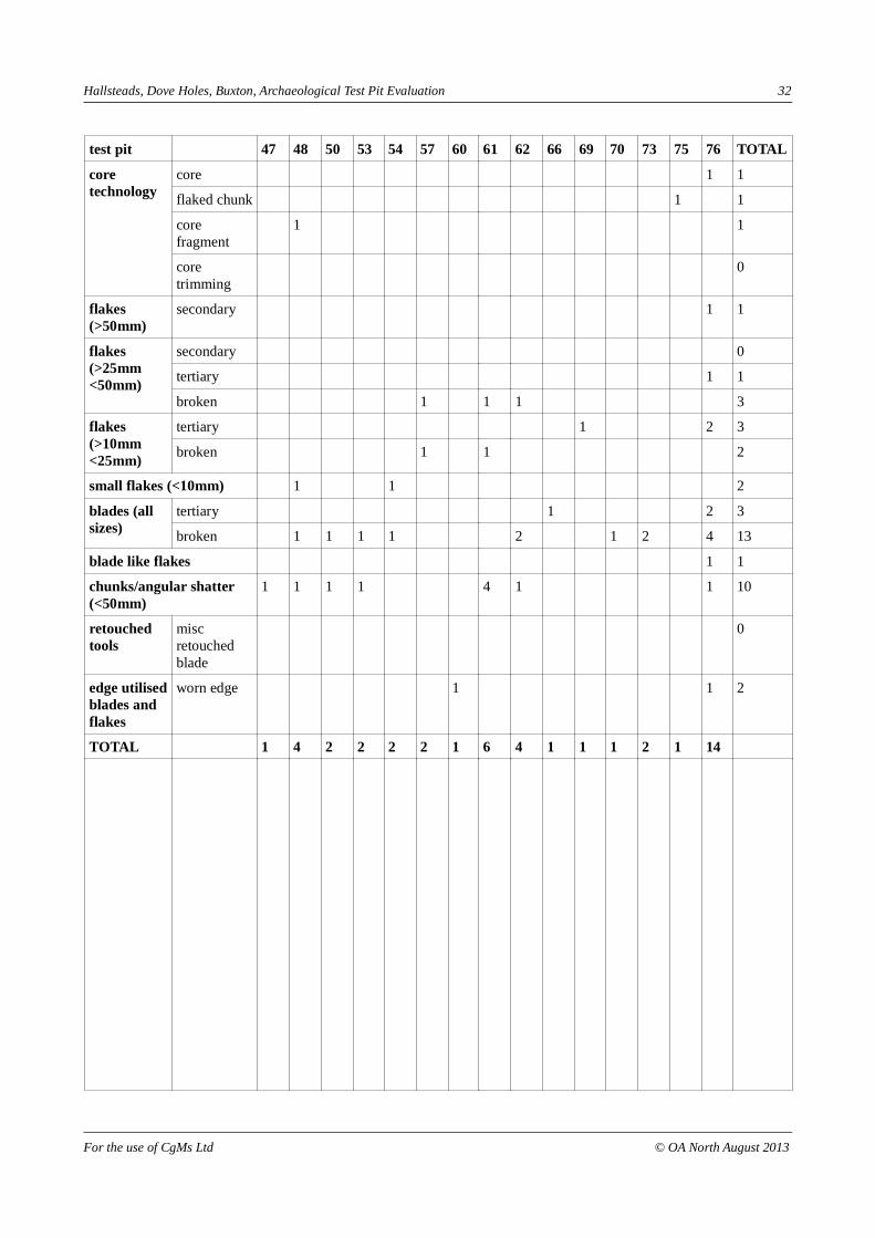
test pit 6 8 13 19 20 22 24 26 33 34 35 36 37 39 46 TOTAL
core technology
core 0
flaked chunk 0
core fragment
1 1
core trimming
0
flakes (>50mm)
secondary 0
flakes (>25mm <50mm)
secondary 0
tertiary 0
broken 1 1
flakes (>10mm <25mm)
tertiary 1 1 1 1 4
broken 2 1 2 5
small flakes (<10mm) 0
blades (all sizes)
tertiary 1 1
broken 1 1 1 1 4
blade like flakes 0
chunks/angular shatter (<50mm)
1 2 1 4
retouched tools
misc retouched blade
1 1
edge utilised blades and flakes
worn edge 1 1 2
TOTAL 1 1 3 1 3 2 1 2 1 1 2 2 1 1 1
For the use of CgMs Ltd © OA North August 2013
Hallsteads, Dove Holes, Buxton, Archaeological Test Pit Evaluation 32
test pit 47 48 50 53 54 57 60 61 62 66 69 70 73 75 76 TOTAL
core technology
core 1 1
flaked chunk 1 1
core fragment
1 1
core trimming
0
flakes (>50mm)
secondary 1 1
flakes (>25mm <50mm)
secondary 0
tertiary 1 1
broken 1 1 1 3
flakes (>10mm <25mm)
tertiary 1 2 3
broken 1 1 2
small flakes (<10mm) 1 1 2
blades (all sizes)
tertiary 1 2 3
broken 1 1 1 1 2 1 2 4 13
blade like flakes 1 1
chunks/angular shatter (<50mm)
1 1 1 1 4 1 1 10
retouched tools
misc retouched blade
0
edge utilised blades and flakes
worn edge 1 1 2
TOTAL 1 4 2 2 2 2 1 6 4 1 1 1 2 1 14
For the use of CgMs Ltd © OA North August 2013

Hallsteads, Dove Holes, Buxton, Archaeological Test Pit Evaluation 33
test pit 77 78 80 87 90 91 92 95 96 101 103 104 105 106 110 TOTAL
core technology
core 0
flaked chunk 0
core fragment
1 1
core trimming
0
flakes (>50mm)
secondary 0
flakes (>25mm <50mm)
secondary 1 1
tertiary 1 1 2 1 5
broken 2 1 5 8
flakes (>10mm <25mm)
tertiary 1 1 1 1 1 2 1 8
broken 1 1 1 3 6
small flakes (<10mm) 0
blades (all sizes)
tertiary 1 1 2 4
broken 1 2 2 2 3 10
blade like flakes 0
chunks/angular shatter (<50mm)
1 2 2 1 2 3 7 18
retouched tools
misc retouched blade
0
edge utilised blades and flakes
worn edge 1 1 2
TOTAL 2 1 1 4 9 6 1 1 4 1 6 9 15 2 1
For the use of CgMs Ltd © OA North August 2013

Hallsteads, Dove Holes, Buxton, Archaeological Test Pit Evaluation 34
test pit 114 116 117 120 121 123 125 126 127 129 131 132 136 137 142 TOTAL
core technology
core 0
flaked chunk 0
core fragment
0
core trimming
0
flakes (>50mm)
secondary 0
flakes (>25mm <50mm)
secondary 0
tertiary 1 1 2
broken 1 1 2
flakes (>10mm <25mm)
tertiary 1 1 1 3
broken 1 1
small flakes (<10mm) 0
blades (all sizes)
tertiary 1 2 1 1 5
broken 1 1 3 1 3 1 1 11
blade like flakes 0
chunks/angular shatter (<50mm)
1 1 1 3
retouched tools
misc retouched blade
0
edge utilised blades and flakes
worn edge 1 1
TOTAL 1 1 1 3 3 1 5 2 2 1 2 3 1 1 1
For the use of CgMs Ltd © OA North August 2013

Hallsteads, Dove Holes, Buxton, Archaeological Test Pit Evaluation 35
test pit 144 145 147 148 149 150 152 153 156 157 164 168 171 172 175 TOTAL
core technology
core 1 1
flaked chunk 1 1
core fragment
1 1
core trimming
0
flakes (>50mm)
secondary 0
flakes (>25mm <50mm)
secondary 0
tertiary 1 1 1 3
broken 0
flakes (>10mm <25mm)
tertiary 1 2 3
broken 1 1
small flakes (<10mm) 0
blades (all sizes)
tertiary 3 1 1 1 1 7
broken 1 3 1 1 1 1 8
blade like flakes 1 1
chunks/angular shatter (<50mm)
1 1
retouched tools
misc retouched blade
0
edge utilised blades and flakes
worn edge 1 1 2
TOTAL 2 3 6 1 1 1 2 1 3 1 1 2 2 2 1
For the use of CgMs Ltd © OA North August 2013

Hallsteads, Dove Holes, Buxton, Archaeological Test Pit Evaluation 36
test pit 180 181 182 185 186 191 192 193 196 197 202 207 216 217 218 TOTAL
core technology
core 0
flaked chunk 1 1
core fragment
0
core trimming
0
flakes (>50mm)
secondary 1 1
flakes (>25mm <50mm)
secondary 0
tertiary 1 1
broken 1 1 2
flakes (>10mm <25mm)
tertiary 1 1
broken 1 1 2
small flakes (<10mm) 0
blades (all sizes)
tertiary 2 2 1 5
broken 1 3 1 1 1 1 1 6 15
blade like flakes 0
chunks/angular shatter (<50mm)
3 1 4
retouched tools
misc retouched blade
0
edge utilised blades and flakes
worn edge 0
TOTAL 3 3 3 1 2 2 2 1 1 1 1 2 8 1 1
For the use of CgMs Ltd © OA North August 2013

Hallsteads, Dove Holes, Buxton, Archaeological Test Pit Evaluation 37
test pit 219 223 224 225 229 234 236 237 239 243 244 252 254 267 269 TOTAL
core technology
core 0
flaked chunk 1 1
core fragment
1 1
core trimming
1 1
flakes (>50mm)
secondary 0
flakes (>25mm <50mm)
secondary 0
tertiary 1 1 1 2 2 7
broken 0
flakes (>10mm <25mm)
tertiary 1 3 4
broken 1 1 2
small flakes (<10mm) 0
blades (all sizes)
tertiary 1 1 2
broken 1 1 1 1 4
blade like flakes 0
chunks/angular shatter (<50mm)
1 1
retouched tools
misc retouched blade
0
edge utilised blades and flakes
worn edge 0
TOTAL 1 1 1 2 1 1 1 1 1 2 6 1 2 1 1
For the use of CgMs Ltd © OA North August 2013
Hallsteads, Dove Holes, Buxton, Archaeological Test Pit Evaluation 38
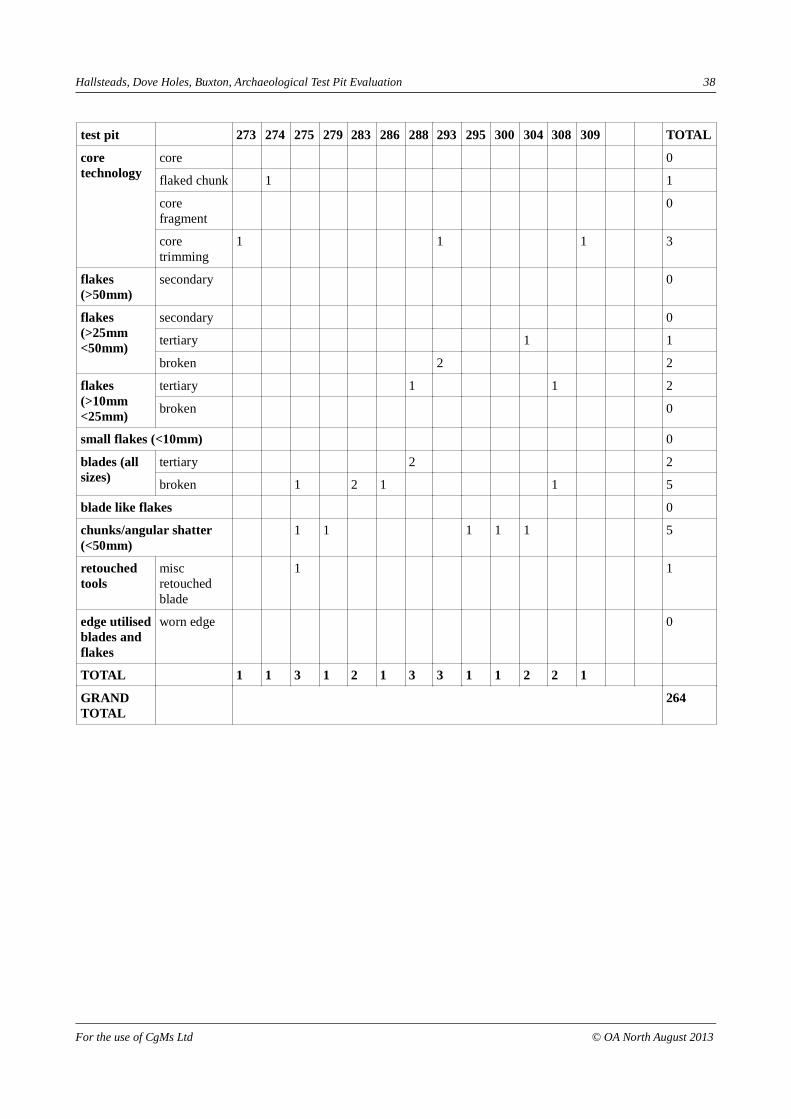
test pit 273 274 275 279 283 286 288 293 295 300 304 308 309 TOTAL
core technology
core 0
flaked chunk 1 1
core fragment
0
core trimming
1 1 1 3
flakes (>50mm)
secondary 0
flakes (>25mm <50mm)
secondary 0
tertiary 1 1
broken 2 2
flakes (>10mm <25mm)
tertiary 1 1 2
broken 0
small flakes (<10mm) 0
blades (all sizes)
tertiary 2 2
broken 1 2 1 1 5
blade like flakes 0
chunks/angular shatter (<50mm)
1 1 1 1 1 5
retouched tools
misc retouched blade
1 1
edge utilised blades and flakes
worn edge 0
TOTAL 1 1 3 1 2 1 3 3 1 1 2 2 1
GRANDTOTAL
264
For the use of CgMs Ltd © OA North August 2013