hand book - transportation · hand book freight demand modeling and data improvement handbook...
TRANSCRIPT
HAN
D B
OO
KFreight Demand Modeling
and Data Improvement HANDBOOK
December 2017

Image Sources: FLKR, Public Domain, Metro
Notice
This document is disseminated under the sponsorship of the U.S. Department of Transportation in the interest of information exchange. The U.S. Government assumes no liability for the use of the information contained in this document.
The U.S. Government does not endorse products or manufacturers. Trademarks or manufacturers’ names appear in this report only because they are considered essential to the objective of the document.
Quality Assurance Statement
The Federal Highway Administration (FHWA) provides high-quality information to serve Government, industry, and the public in a manner that promotes public understanding. Standards and policies are used to ensure and maximize the quality, objectivity, utility, and integrity of its information. The FHWA periodically reviews quality issues and adjusts its programs and processes to ensure continuous quality improvement.
Technical Report Documentation Page
1. Report No. FHWA-HOP-18-018
2. Government Accession No.
3. Recipient’s Catalog No.
4. Title and Subtitle Freight Demand Modeling and Data Improvement Implementation Handbook
5. Report DateDecember 2017
6. Performing Organizations Code
7. Authors Ron Schaefer, Monica Worth, Jonathan Heilman,
Nicholas Kehoe
8. Performing Organization Report No.
9. Performing Organization Name and AddressLeidos11251 Roger Bacon Drive Reston, VA 20190
10. Work Unit No. (TRAIS)
11. Contract or Grant No. Contract No. DTFH61-11-D-00015-5010
12. Sponsoring Agency Name and AddressU.S. Department of Transportation Federal Highway AdministrationOffice of Freight Management and Operations1200 New Jersey Avenue, SEWashington, DC 20590
13. Type of Report and Period Covered
14. Sponsoring Agency Code HOP
15. Supplementary Notes
16. AbstractThe SHRP2 C20: Freight Demand Modeling and Data Improvement Strategic Plan provides a framework for making further improvements to freight data sets and freight modeling practices to advance the integration of freight considerations into the planning process. This handbook provides information about better freight data and modeling tools through examples and pilot projects for State DOTs and MPOs to improve freight-related decisionmaking. It gives an overview of the projects funded by the SHRP2 Implementation Assistance Program (IAP) and highlights how these implementations address issues faced by freight planners.
17. Key Words Freight Modeling, Freight Data
18. Distribution Statement No restrictions.
19. Security Classif. (of this report) Unclassified
20. Security Classif. (of this page) Unclassified
21. No of Pages 60
22. Price N/A
Form DOT F 1700.7 (8-72) Reproduction of completed page authorized.

S H R P 2 C 2 0 – F R E I G H T D E M A N D M O D E L I N G A N D D A T A H A N D B O O K
iii
Table of Contents
Chapter 1. Background ...........................................................................1
Freight Demand Modeling and Data Improvement Strategic Plan ............ 1
Handbook Users and Purpose .......................................................................... 2
Data and Modeling Best Practices—An Overview .......................................... 2
Decisionmaking Needs and Gaps .................................................................... 8
Implementation Assistance Program Overview ..........................................12
Pilot Projects and Case Study Overview ........................................................13
Chapter 2. Data Innovations ................................................................15
Principles and Cconsiderations for Local Data Collection..........................16
Capital District Transportation Committee—New York ...............................17
Delaware Valley Regional Planning Commission—Pennsylvania ..............19
Florida Department of Transportation ...........................................................23
Mid-America Regional Council—Missouri .....................................................25
South Dakota Department of Transportation ...............................................27
Washington State Department of Transportation ......................................30
Winston-Salem Metropolitan Planning Organization—North Carolina .....31
Chapter 3. Modeling Innovations.........................................................35
Principles and Considerations for Freight Modeling Improvement ...........36
Maricopa Association of Governments—Arizona ........................................36
Maryland State Highway Administration and Baltimore Metropolitan Council ......................................................................38
Metro—Oregon ...................................................................................................40
Wisconsin Department of Transportation .....................................................43
Chapter 4. Conclusions .........................................................................47
Principles and Considerations for Data and Modeling ................................47
Issues and Lessons Learned ..........................................................................48

Photo: FLKR, Public Domain, Metro

1
S H R P 2 C 2 0 – F R E I G H T D E M A N D M O D E L I N G A N D D A T A H A N D B O O K
Chapter 1. BackgroundFreight transportation in the United States has been a topic of growing interest to policy makers, State departments of transportation (DOTs), metropolitan planning organizations (MPOs), and varied stakeholders. While Federal emphasis on freight has been expanded by the Moving Ahead for Progress in the 21st Century (MAP-21) Act and the Fixing America’s Surface Transportation (FAST) Act, States and MPOs see freight as vital to supporting economic development. The overarching policy challenge for transportation agencies is to make informed investments in transportation infrastructure that support efficient freight mobility and access. To support economic development, long-range transportation plans and transportation improvement programs need to address freight. This need to better integrate freight with transportation planning recognizes the importance of goods movement, economic performance, and meeting consumer needs. Freight planning requires effective communication and coordination with the private sector (e.g., shippers, carriers, industry). It also requires close coordination with local government with respect to economic development and land use considerations. Although there has been increased emphasis on freight, accurate and timely freight data and forecasting still remain formidable challenges with substantial opportunity for improvement.
The second Strategic Highway Research Program, known commonly as SHRP2, was created by Congress as a component of the Safe, Accountable, Flexible, Efficient Transportation Equity Act: A Legacy for Users (SAFETEA-LU) of 2005. This legislation established four focus areas (see Table 1) to support research designed to improve highway safety, rehabilitate aging infrastructure, and reduce congestion. MAP-21 authorized additional funding to support implementation activities.
Table 1. Strategic Highway Research Program 2 focus areas.
Area Focus
Safety Prevent or reduce the severity of highway crashes by understanding driver behavior.
RenewalAddress the aging infrastructure through rapid design and construction methods that cause minimal disruption and produce long-lived facilities.
Reliability Reduce congestion through incident reduction, management, response, and mitigation.
CapacityIntegrate mobility, economic, environmental, and community needs in the planning and designing of transportation capacity.
Freight Demand Modeling and Data Improvement Strategic Plan
The SHRP2 C20: Freight Demand Modeling and Data Improvement Strategic Plan was developed as part of the Capacity focus area. This research initiative provides the strategic framework for making further advances in the areas of freight data collection, use and for accelerating innovative breakthroughs with the aim of integrating freight considerations into the planning process with confidence. It offers a road map that will lead to improved freight data sets and freight modeling practices. The plan outlines an organizational approach to help identify freight modeling and data priority needs, spur innovative ideas, and result in breakthrough solutions for wide application.

2
S H R P 2 C 2 0 – F R E I G H T D E M A N D M O D E L I N G A N D D A T A H A N D B O O K
Efficient freight is essential to national, State, and local transportation infrastructure planning and our economic well-being. Transportation investments are capital intensive and represent long-term commitments. Understanding and forecasting freight flows is critical to planning for future transportation capacity, operation, preservation, safety and security, as well as energy and economic investment needs.
It is important that transportation planners possess both the tools and the skills to forecast freight demand and to analyze scenarios and investment alternatives as part of the overall transportation analysis. Travel demand forecasting, however, has historically been oriented toward passenger transportation. Passenger-oriented forecasting models draw on economic and demographic variables that are insufficient and sometimes irrelevant for estimating future freight demand, which is shaped by a much wider range of factors as a result of a complex logistics chain. The goal of the SHRP2 C20 program is to create better freight data and models that enable State, regional, and local planners to better predict trends in freight movement and make more informed project investment decisions.
Handbook Users and Purpose
This handbook provides information about better freight data and modeling tools through examples and pilot projects for State DOTs and MPOs to improve freight-related decisionmaking. It gives an overview of the projects funded by the SHRP2 Implementation Assistance Program (IAP) and highlights how these implementations address issues faced by freight planners. The primary audience for this product is practitioners—mainly those at State DOTs and MPOs. However, this handbook also recognizes that State DOTs and MPOs have different needs and capabilities; therefore, there is no “one size fits all” approach to freight planning—no one data or model solution that will satisfy the needs of all planning agencies.
By contrast, this handbook is designed to provide an overview of the data and tools available to practitioners across the spectrum of user types. These solutions range from the inexpensive and easily implementable to complex and analysis-rich options. The handbook is organized around the two subject areas of data and modeling tools and provides an overview of the options, benefits, and challenges of the tools identified. The subject matter draws from the original SHRP2 C20 Freight Demand Modeling and Data Improvement Strategic Plan, as well as the IAP projects, which serve as the foundation for the experience-based lessons learned and best practices guidance.
Data and Modeling Best Practices—An Overview
The common, underlying objective of data and model use is to analyze and document baseline conditions related to freight movement and to estimate future activity based on metrics involving economic activity, demographic changes, employment by economic sector, supply and demand of raw materials and finished products by consumers and industries, commodity flows, and other factors. Different tools and data are used by practitioners for different geographic scales, depending on the issues and scale of needs. This section lays out those identified practices that most accurately address these metrics and offer potential innovations for future practices. The identified best practices:
▪ Provide a baseline assessment of models and data.
▪ Identify potentially innovative approaches to better understand goods movement in a variety of contexts for a variety of users.
▪ Provide a springboard for better data and model development in the future.
The underlying methodology for most tools used in freight planning and forecasting includes using resources to:

3
S H R P 2 C 2 0 – F R E I G H T D E M A N D M O D E L I N G A N D D A T A H A N D B O O K
1. Document existing demographic and employment conditions and characteristics of freight transportation (including tonnage, geographic origins and destinations, and mode of transport).
2. Estimate future measures of freight transportation for these same parameters (tonnage, origins, destinations, modes of transport) based on changes in population and employment; establishment, growth, and dissolution of firms; productivity improvements by industry; and other economic drivers.
Depending on the geographic scale, the ultimate objective of freight planning and forecasting is to forecast freight activity and its effects on local or regional conditions related to economic activity, traffic congestion, air quality, and other impacts. Freight planners must select appropriate methods based on their needs, capabilities, data sources, and the usefulness of the expected outcomes.
Depending on the type of planning being completed, the factors have varying levels of sensitivity. For example, a study to determine the need for an intermodal facility is more sensitive to data related to mode than an analysis of warehousing and distribution facilities. The sensitivity of these factors to data has been taken into account within these best practices, which makes them more robust than methods that use existing data and perform analyses.
Overview of National Data Best Practices
The data used in the freight planning and forecasting processes are predominantly drawn from public resources. Although national data sets are generally the most complete and accessible, they lack the detail required for regional or local freight analysis, although they are continually improving. Local data sources provide a more comprehensive scale for these analyses, but some of the data requires expensive, ongoing updates.
Although these sources are the best in terms of current general practices, insufficient and inferior-quality local data remains a critical challenge in the development of freight models. The principal data for predicting freight transportation demand are the commodity flows by truck, rail, and water and through border and marine ports available from the Federal Highway Administration (FHWA) in the 2012 Commodity Flow Survey. In addition, the FHWA Freight Analysis Framework (FAF) estimates commodity flows (tonnage and value) within, to, and from States and select regions by mode as well as freight movements among major metropolitan areas, States, regions, and international gateways.
One of the most commonly used databases for statewide analysis of freight movements is the commercial Transearch database developed by IHS Global Insight. Transearch estimates freight flows (i.e., commodity tonnage) by truck (i.e., for-hire truckload, for-hire less than truckload, and private truck), rail carload, rail-truck intermodal, water, and air at the county, business economic area, State, or Province level. The Transearch database is a proprietary source of detailed freight data available for purchase that includes assumptions (undisclosed) to estimate and forecast movements.
Some research relies on smaller freight data sets compiled by facility operators and owners, data collected by public and private entities, and data collected as part of a customized survey. Sources for these data sets range from the Waterborne Commerce and Vessel Statistics database to the U.S. Census Bureau’s County Business Patterns and Economic Census databases to mail-out–mail-back surveys of freight shippers. Unfortunately, many of the data sources and databases available for statewide or MPO-level freight planning have considerable limitations as they focus on certain modes or commodities and are available at different geographic levels. Consequently, combining or integrating the data sources into a comprehensive, coherent, and consistent database is a challenging task.
4
S H R P 2 C 2 0 – F R E I G H T D E M A N D M O D E L I N G A N D D A T A H A N D B O O K
Several new data best practices have emerged in recent years. These include real-time traffic information for all vehicles, including trucks, from HERE, INRIX, and the American Transportation Research Institute (ATRI). These identify where and when traffic congestion occurs and provides information about traffic conditions and incidents that could cause delays. By analyzing and processing real-time commercial vehicle probe data, users can identify highway system chokepoints, time of day congestion, and congestion speeds to use in conducting assessments of truck travel times, lost productivity, and vehicle ranges based on truck driver Federal hours of service regulations.
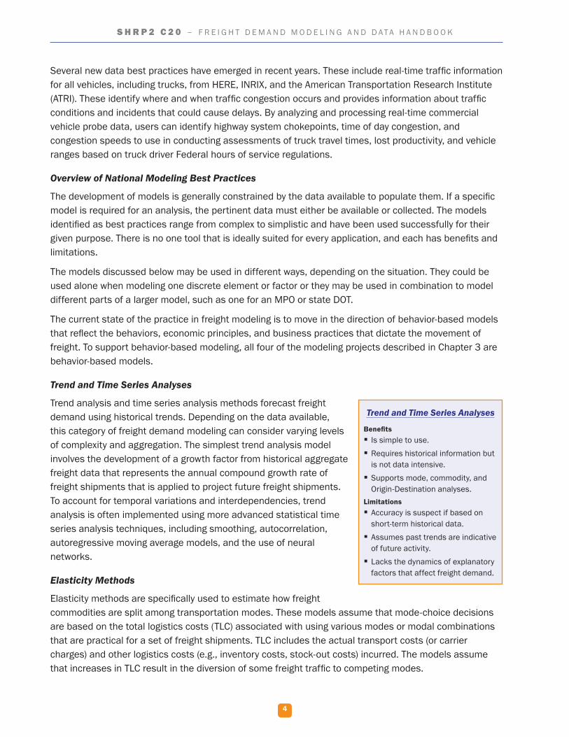
Overview of National Modeling Best Practices
The development of models is generally constrained by the data available to populate them. If a specific model is required for an analysis, the pertinent data must either be available or collected. The models identified as best practices range from complex to simplistic and have been used successfully for their given purpose. There is no one tool that is ideally suited for every application, and each has benefits and limitations.
The models discussed below may be used in different ways, depending on the situation. They could be used alone when modeling one discrete element or factor or they may be used in combination to model different parts of a larger model, such as one for an MPO or state DOT.
The current state of the practice in freight modeling is to move in the direction of behavior-based models that reflect the behaviors, economic principles, and business practices that dictate the movement of freight. To support behavior-based modeling, all four of the modeling projects described in Chapter 3 are behavior-based models.
Trend and Time Series Analyses
Trend analysis and time series analysis methods forecast freight demand using historical trends. Depending on the data available, this category of freight demand modeling can consider varying levels of complexity and aggregation. The simplest trend analysis model involves the development of a growth factor from historical aggregate freight data that represents the annual compound growth rate of freight shipments that is applied to project future freight shipments. To account for temporal variations and interdependencies, trend analysis is often implemented using more advanced statistical time series analysis techniques, including smoothing, autocorrelation, autoregressive moving average models, and the use of neural networks.
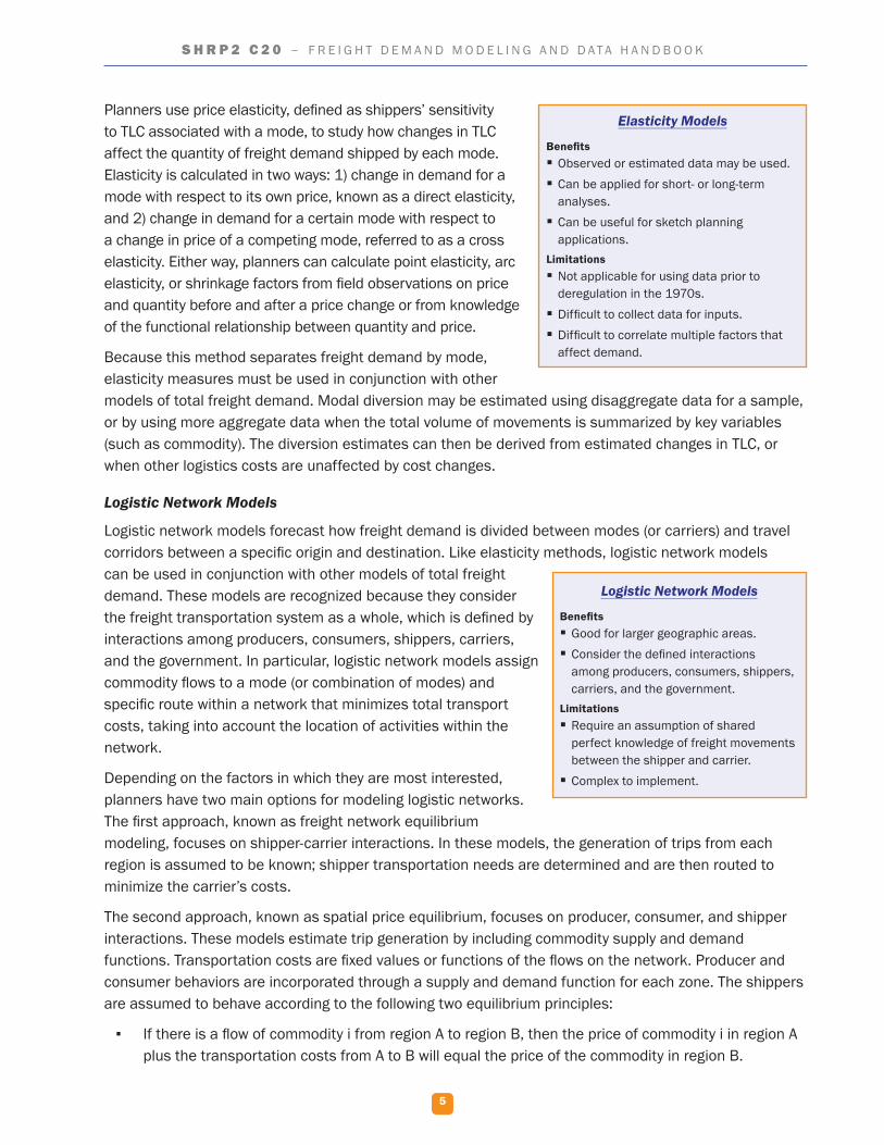
Elasticity Methods
Elasticity methods are specifically used to estimate how freight commodities are split among transportation modes. These models assume that mode-choice decisions are based on the total logistics costs (TLC) associated with using various modes or modal combinations that are practical for a set of freight shipments. TLC includes the actual transport costs (or carrier charges) and other logistics costs (e.g., inventory costs, stock-out costs) incurred. The models assume that increases in TLC result in the diversion of some freight traffic to competing modes.
Trend and Time Series Analyses
Benefits � Is simple to use. � Requires historical information but is not data intensive.
� Supports mode, commodity, and Origin-Destination analyses.
Limitations � Accuracy is suspect if based on short-term historical data.
� Assumes past trends are indicative of future activity.
� Lacks the dynamics of explanatory factors that affect freight demand.
5
S H R P 2 C 2 0 – F R E I G H T D E M A N D M O D E L I N G A N D D A T A H A N D B O O K
Planners use price elasticity, defined as shippers’ sensitivity to TLC associated with a mode, to study how changes in TLC affect the quantity of freight demand shipped by each mode. Elasticity is calculated in two ways: 1) change in demand for a mode with respect to its own price, known as a direct elasticity, and 2) change in demand for a certain mode with respect to a change in price of a competing mode, referred to as a cross elasticity. Either way, planners can calculate point elasticity, arc elasticity, or shrinkage factors from field observations on price and quantity before and after a price change or from knowledge of the functional relationship between quantity and price.
Because this method separates freight demand by mode, elasticity measures must be used in conjunction with other models of total freight demand. Modal diversion may be estimated using disaggregate data for a sample, or by using more aggregate data when the total volume of movements is summarized by key variables (such as commodity). The diversion estimates can then be derived from estimated changes in TLC, or when other logistics costs are unaffected by cost changes.
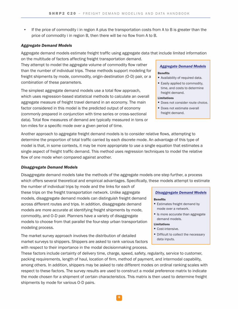
Logistic Network Models
Logistic network models forecast how freight demand is divided between modes (or carriers) and travel corridors between a specific origin and destination. Like elasticity methods, logistic network models can be used in conjunction with other models of total freight demand. These models are recognized because they consider the freight transportation system as a whole, which is defined by interactions among producers, consumers, shippers, carriers, and the government. In particular, logistic network models assign commodity flows to a mode (or combination of modes) and specific route within a network that minimizes total transport costs, taking into account the location of activities within the network.
Depending on the factors in which they are most interested, planners have two main options for modeling logistic networks. The first approach, known as freight network equilibrium modeling, focuses on shipper-carrier interactions. In these models, the generation of trips from each region is assumed to be known; shipper transportation needs are determined and are then routed to minimize the carrier’s costs.
The second approach, known as spatial price equilibrium, focuses on producer, consumer, and shipper interactions. These models estimate trip generation by including commodity supply and demand functions. Transportation costs are fixed values or functions of the flows on the network. Producer and consumer behaviors are incorporated through a supply and demand function for each zone. The shippers are assumed to behave according to the following two equilibrium principles:
▪ If there is a flow of commodity i from region A to region B, then the price of commodity i in region A plus the transportation costs from A to B will equal the price of the commodity in region B.
Elasticity Models
Benefits � Observed or estimated data may be used. � Can be applied for short- or long-term analyses.
� Can be useful for sketch planning applications.
Limitations � Not applicable for using data prior to deregulation in the 1970s.
� Difficult to collect data for inputs. � Difficult to correlate multiple factors that affect demand.
Logistic Network Models
Benefits � Good for larger geographic areas. � Consider the defined interactions among producers, consumers, shippers, carriers, and the government.
Limitations � Require an assumption of shared perfect knowledge of freight movements between the shipper and carrier.
� Complex to implement.
6
S H R P 2 C 2 0 – F R E I G H T D E M A N D M O D E L I N G A N D D A T A H A N D B O O K
▪ If the price of commodity i in region A plus the transportation costs from A to B is greater than the price of commodity i in region B, then there will be no flow from A to B.
Aggregate Demand Models
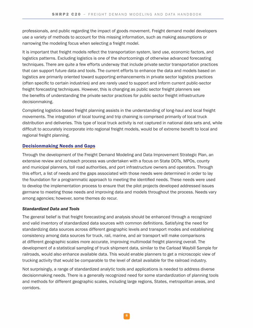
Aggregate demand models estimate freight traffic using aggregate data that include limited information on the multitude of factors affecting freight transportation demand. They attempt to model the aggregate volume of commodity flow rather than the number of individual trips. These methods support modeling for freight shipments by mode, commodity, origin-destination (O-D) pair, or a combination of these parameters.
The simplest aggregate demand models use a total flow approach, which uses regression-based statistical methods to calculate an overall aggregate measure of freight travel demand in an economy. The main factor considered in this model is the predicted output of economy (commonly prepared in conjunction with time series or cross-sectional data). Total flow measures of demand are typically measured in tons or ton-miles for a specific mode over a given period of time.
Another approach to aggregate freight demand models is to consider relative flows, attempting to determine the proportion of total traffic carried by each discrete mode. An advantage of this type of model is that, in some contexts, it may be more appropriate to use a single equation that estimates a single aspect of freight traffic demand. This method uses regression techniques to model the relative flow of one mode when compared against another.
Disaggregate Demand Models
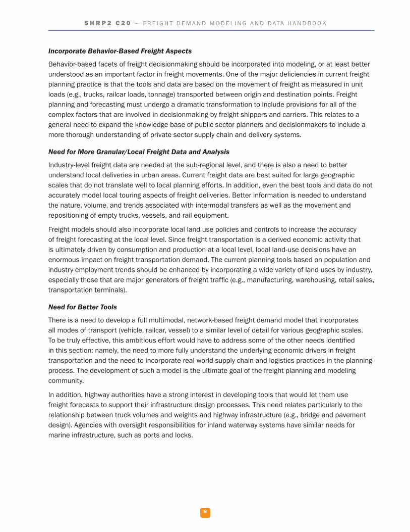
Disaggregate demand models take the methods of the aggregate models one step further, a process which offers several theoretical and empirical advantages. Specifically, these models attempt to estimate the number of individual trips by mode and the links for each of these trips on the freight transportation network. Unlike aggregate models, disaggregate demand models can distinguish freight demand across different routes and trips. In addition, disaggregate demand models are more accurate at identifying freight shipments by mode, commodity, and O-D pair. Planners have a variety of disaggregate models to choose from that parallel the four-step urban transportation modeling process.
The market survey approach involves the distribution of detailed market surveys to shippers. Shippers are asked to rank various factors with respect to their importance in the modal decisionmaking process. These factors include certainty of delivery time, charge, speed, safety, regularity, service to customer, packing requirements, length of haul, location of firm, method of payment, and intermodal capability, among others. In addition, shippers may be asked to rate different modes on ordinal ranking scales with respect to these factors. The survey results are used to construct a modal preference matrix to indicate the mode chosen for a shipment of certain characteristics. This matrix is then used to determine freight shipments by mode for various O-D pairs.
Aggregate Demand Models
Benefits � Availability of required data. � Easily applied to commodity, time, and costs to determine freight demand.
Limitations � Does not consider route choice. � Does not estimate overall freight demand.
Disaggregate Demand Models
Benefits � Estimates freight demand by mode over a network.
� Is more accurate than aggregate demand models.
Limitations � Cost-intensive. � Difficult to collect the necessary data inputs.

7
S H R P 2 C 2 0 – F R E I G H T D E M A N D M O D E L I N G A N D D A T A H A N D B O O K
Alternatively, the behavioral mode split model predicts freight demand by focusing on the mode choice decisions made by the manager of the receiving or shipping firm. The advantage of this approach is that choice is observed at the most disaggregate level possible; namely, with respect to individual shipments dispatched by individual firms. In contrast to the market survey approach, these models are estimated using revealed choices without depending on the shipper explaining how he or she chooses a mode. Behavioral mode split models are based on the assumption that the shipper is concerned with maximizing utility (i.e., satisfaction) with respect to the various explanatory variables that affect the mode choice decisionmaking process. These decisions incorporate mode characteristics, consignment characteristics, firm characteristics, and shipper characteristics.
A third inventory-based approach attempts to integrate the mode choice and production decisions made by a shipper. Variables related to production, such as shipment size, mode choice, and frequency of shipments, are treated as internal decisions. The rationale of the inventory approach is that freight in transit can be considered to be, in effect, an inventory of goods on wheels, similar to goods in process in the factory. The model predicts the expected total annual variable cost of hauling the commodity.
Input–Output Models
Input–output models are the simplest and, consequently, least descriptive methods for forecasting freight demand. They are used primarily in sketch planning applications, regional planning studies at an aggregate level, and when data are extremely scarce.
Input–output analysis involves using economic input and output indicators to determine the levels of economic activity that may drive freight transportation demand. Inputs (e.g., capital, labor, land) are entered into an input–output analysis matrix to determine the various economic outputs. These may include the quantity of goods and services produced by type, geographic location, and temporal frame; the demand for goods and services by type, geographic location, and temporal frame; and other such measures of economic output. The outputs are converted into estimates of freight transportation demand that would satisfy the demand for goods and services.
Summary and Implications
Freight demand is characterized by a variety of factors including, quantity, geographic scale, time period, source, transportation mode, and commodity. It is intrinsically interrelated with regional, national, and international economic and demographic characteristics, operational factors and logistics, infrastructure, public policy and regulations, technology, and environmental factors, all of which have varying data sets that are incomplete or contain inaccuracies, or both.
Forecasting and understanding the movement of goods, regardless of geographic scope, requires assembling information from a variety of data sources. Despite the current data deficiencies, several best practice modeling methods and techniques have been developed and successfully applied within a variety of planning processes. Nevertheless, the lack of useful freight forecasting data has several serious implications. One of which is that freight forecasters are often hindered by data deficiencies and, thus, they cannot completely analyze complex freight supply chains. This limits the development of forecasting models that answer the questions asked by today’s elected officials, transportation
Input-Output Models
Benefits � Simple and quick to implement.
Limitations � Is not comprehensive.
8
S H R P 2 C 2 0 – F R E I G H T D E M A N D M O D E L I N G A N D D A T A H A N D B O O K
professionals, and public regarding the impact of goods movement. Freight demand model developers use a variety of methods to account for this missing information, such as making assumptions or narrowing the modeling focus when selecting a freight model.
It is important that freight models reflect the transportation system, land use, economic factors, and logistics patterns. Excluding logistics is one of the shortcomings of otherwise advanced forecasting techniques. There are quite a few efforts underway that include private sector transportation practices that can support future data and tools. The current efforts to enhance the data and models based on logistics are primarily oriented toward supporting enhancements in private sector logistics practices (often specific to certain industries) and are rarely used to support and inform current public-sector freight forecasting techniques. However, this is changing as public sector freight planners see the benefits of understanding the private sector practices for public sector freight infrastructure decisionmaking.
Completing logistics-based freight planning assists in the understanding of long-haul and local freight movements. The integration of local touring and trip chaining is comprised primarily of local truck distribution and deliveries. This type of local truck activity is not captured in national data sets and, while difficult to accurately incorporate into regional freight models, would be of extreme benefit to local and regional freight planning.
Decisionmaking Needs and Gaps
Through the development of the Freight Demand Modeling and Data Improvement Strategic Plan, an extensive review and outreach process was undertaken with a focus on State DOTs, MPOs, county and municipal planners, toll road authorities, and port infrastructure owners and operators. Through this effort, a list of needs and the gaps associated with those needs were determined in order to lay the foundation for a programmatic approach to meeting the identified needs. These needs were used to develop the implementation process to ensure that the pilot projects developed addressed issues germane to meeting those needs and improving data and models throughout the process. Needs vary among agencies; however, some themes do recur.
Standardized Data and Tools
The general belief is that freight forecasting and analysis should be enhanced through a recognized and valid inventory of standardized data sources with common definitions. Satisfying the need for standardizing data sources across different geographic levels and transport modes and establishing consistency among data sources for truck, rail, marine, and air transport will make comparisons at different geographic scales more accurate, improving multimodal freight planning overall. The development of a statistical sampling of truck shipment data, similar to the Carload Waybill Sample for railroads, would also enhance available data. This would enable planners to get a microscopic view of trucking activity that would be comparable to the level of detail available for the railroad industry.
Not surprisingly, a range of standardized analytic tools and applications is needed to address diverse decisionmaking needs. There is a generally recognized need for some standardization of planning tools and methods for different geographic scales, including large regions, States, metropolitan areas, and corridors.
9
S H R P 2 C 2 0 – F R E I G H T D E M A N D M O D E L I N G A N D D A T A H A N D B O O K
Incorporate Behavior-Based Freight Aspects
Behavior-based facets of freight decisionmaking should be incorporated into modeling, or at least better understood as an important factor in freight movements. One of the major deficiencies in current freight planning practice is that the tools and data are based on the movement of freight as measured in unit loads (e.g., trucks, railcar loads, tonnage) transported between origin and destination points. Freight planning and forecasting must undergo a dramatic transformation to include provisions for all of the complex factors that are involved in decisionmaking by freight shippers and carriers. This relates to a general need to expand the knowledge base of public sector planners and decisionmakers to include a more thorough understanding of private sector supply chain and delivery systems.
Need for More Granular/Local Freight Data and Analysis
Industry-level freight data are needed at the sub-regional level, and there is also a need to better understand local deliveries in urban areas. Current freight data are best suited for large geographic scales that do not translate well to local planning efforts. In addition, even the best tools and data do not accurately model local touring aspects of freight deliveries. Better information is needed to understand the nature, volume, and trends associated with intermodal transfers as well as the movement and repositioning of empty trucks, vessels, and rail equipment.
Freight models should also incorporate local land use policies and controls to increase the accuracy of freight forecasting at the local level. Since freight transportation is a derived economic activity that is ultimately driven by consumption and production at a local level, local land-use decisions have an enormous impact on freight transportation demand. The current planning tools based on population and industry employment trends should be enhanced by incorporating a wide variety of land uses by industry, especially those that are major generators of freight traffic (e.g., manufacturing, warehousing, retail sales, transportation terminals).
Need for Better Tools
There is a need to develop a full multimodal, network-based freight demand model that incorporates all modes of transport (vehicle, railcar, vessel) to a similar level of detail for various geographic scales. To be truly effective, this ambitious effort would have to address some of the other needs identified in this section: namely, the need to more fully understand the underlying economic drivers in freight transportation and the need to incorporate real-world supply chain and logistics practices in the planning process. The development of such a model is the ultimate goal of the freight planning and modeling community.
In addition, highway authorities have a strong interest in developing tools that would let them use freight forecasts to support their infrastructure design processes. This need relates particularly to the relationship between truck volumes and weights and highway infrastructure (e.g., bridge and pavement design). Agencies with oversight responsibilities for inland waterway systems have similar needs for marine infrastructure, such as ports and locks.
10
S H R P 2 C 2 0 – F R E I G H T D E M A N D M O D E L I N G A N D D A T A H A N D B O O K
Need to Tie Freight to Economics
There is a need to better understand the correlation between freight activity and various economic influences such as fuel price, currency valuation, and macroeconomic trends. One of the major challenges facing many public agencies is their inability to accurately predict important changes in freight transportation activity that result from external influences and underlying economic forces. In addition, the subjective influence of passenger traffic on shipper and carrier efficiency and decisions related to routing, mode choice, and time-of-day freight shipments needs to be more clearly understood. Conversely, decisions in industries involved in freight transportation (e.g., manufacturing, trucking, warehousing), such as site selection, production schedules, and mode choice produce economic and demographic impacts that need to be quantified.
Of great interest are benefit-cost analysis tools that go beyond traditional financial measures by including other direct and indirect benefits and costs (public and private). Tools would include metrics to assess environmental and economic development policy initiatives on a comparable basis with standard financial measures. More effective methodologies are also needed to apply freight forecasts to funding and finance analyses, such as revenue projections. These types of tools are of great interest to toll road authorities, owners, and operators of freight infrastructure such as port terminals, whose future needs and financial stability are tied to the ability of the owners and operators to develop accurate forecasts of demand by mode and commodity.
Need for Enhanced Freight Planning Skills and Outreach
Stakeholders consistently emphasized the importance of a concentrated effort to develop the requisite knowledge and skills to support freight analysis. The factors that drive freight transportation demand are complex and require an understanding of a wide range of topics, such as economics, political science, demographics, transportation planning, engineering, finance, information technology, and organizational skills. This need for knowledge and skills also relates to the need to understand the goals and objectives of shippers and carriers in the private sector and planners in the public sector. Bridging the gaps between the needs of the public and private sectors would help facilitate more effective planning and forecasting.
Intelligent Transportation Systems and Big Data
Intelligent transportation system (ITS) resources and related vehicle-based technologies, such as global positioning system (GPS) and connected/automated vehicles should be used to generate data to support freight planning and modeling. Technology provides large volumes of complex and variable data that require advanced techniques and technologies to capture, store, distribute, manage, and analyze the information.
Visualization
The need for enhanced visualization tools for public outreach related to the freight planning process is important to communicate results. Visualization tools provide a powerful means of communicating complex concepts and data.
Freight Decisionmaking Gaps
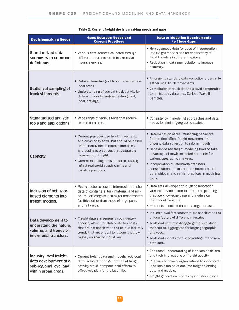
Table 2 shows the decisionmaking needs, the gaps between the needs and the current modeling and data practices, and the data and modeling requirements that will close the gaps. Articulating the capabilities of the current state-of-the-art models and data sets and comparing them with the needs of decisionmakers sets the stage for identifying the modeling and data needs to fill the gaps. These needs are the foundation for the actions incorporated in the Strategic Plan.
11
S H R P 2 C 2 0 – F R E I G H T D E M A N D M O D E L I N G A N D D A T A H A N D B O O K
Table 2. Current freight decisionmaking needs and gaps.
Decisionmaking Needs Gaps Between Needs and Current Practices
Data or Modeling Requirements to Close Gaps
Standardized data sources with common definitions.
� Various data sources collected through different programs result in extensive inconsistencies.
� Homogeneous data for ease of incorporation into freight models and for consistency of freight models in different regions.
� Reduction in data manipulation to improve accuracy.
Statistical sampling of truck shipments.
� Detailed knowledge of truck movements in local areas.
� Understanding of current truck activity by different industry segments (long-haul, local, drayage).
� An ongoing standard data-collection program to gather local truck movements.
� Compilation of truck data to a level comparable to rail industry data (i.e., Carload Waybill Sample).
Standardized analytic tools and applications.
� Wide range of various tools that require unique data sets.
� Consistency in modeling approaches and data needs for similar geographic scales.
Capacity.
� Current practices use truck movements and commodity flows, but should be based on the behaviors, economic principles, and business practices that dictate the movement of freight.
� Current modeling tools do not accurately reflect real world supply chains and logistics practices.
� Determination of the influencing behavioral factors that affect freight movement and ongoing data collection to inform models.
� Behavior-based freight modeling tools to take advantage of newly collected data sets for various geographic analyses.
� Incorporation of intermodal transfers, consolidation and distribution practices, and other shipper and carrier practices in modeling tools.
Inclusion of behavior-based elements into freight models.
� Public sector access to intermodal transfer data of containers, bulk material, and roll-on–roll-off cargo is lacking for most transfer facilities other than those of large ports and rail yards.
� Data sets developed through collaboration with the private sector to inform the planning practice knowledge base and models on intermodal transfers.
� Protocols to collect data on a regular basis.
Data development to understand the nature, volume, and trends of intermodal transfers.
� Freight data are generally not industry-specific, which translates into forecasts that are not sensitive to the unique industry trends that are critical to regions that rely heavily on specific industries.
� Industry-level forecasts that are sensitive to the unique factors of different industries.
� Tools and data at a disaggregated level (local) that can be aggregated for larger geographic analyses.
� Tools and models to take advantage of the new data sets.
Industry-level freight data development at a sub-regional level and within urban areas.
� Current freight data and models lack local detail related to the generation of freight activity, which hampers local efforts to effectively plan for the last mile.
� Enhanced understanding of land use decisions and their implications on freight activity.
� Resources for local organizations to incorporate land-use considerations into freight planning data and models.
� Freight generation models by industry classes.
12
S H R P 2 C 2 0 – F R E I G H T D E M A N D M O D E L I N G A N D D A T A H A N D B O O K
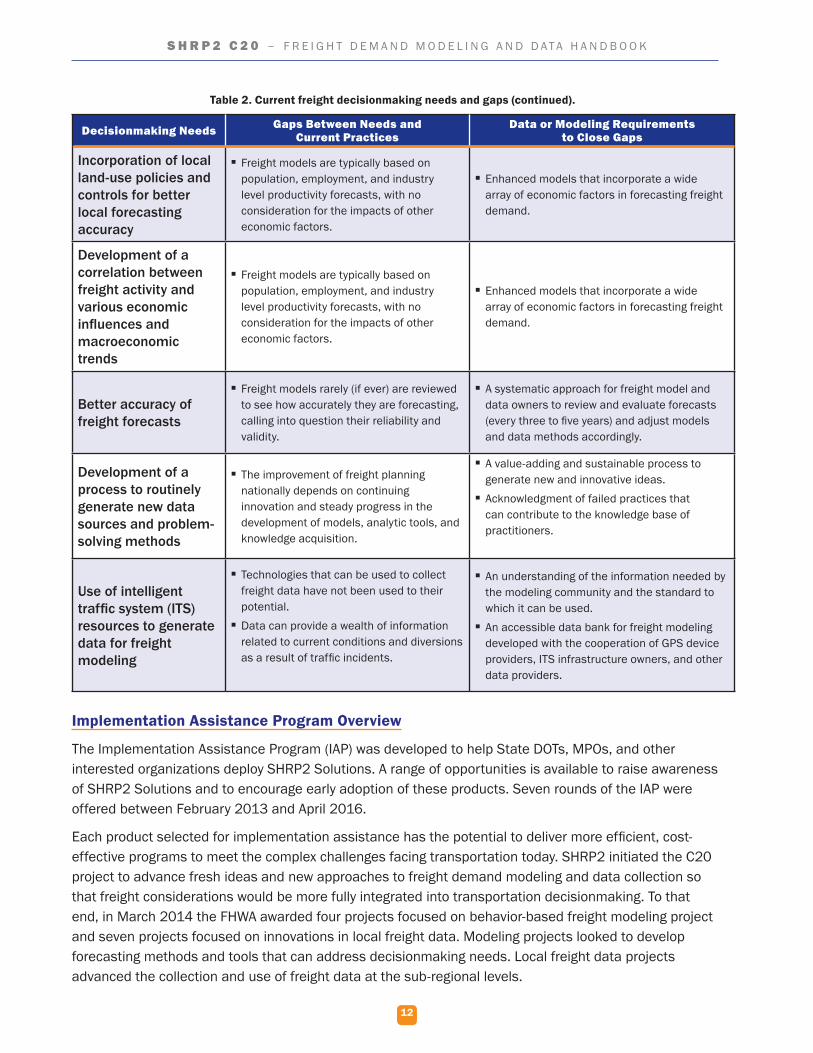
Decisionmaking Needs Gaps Between Needs and Current Practices
Data or Modeling Requirements to Close Gaps
Incorporation of local land-use policies and controls for better local forecasting accuracy
� Freight models are typically based on population, employment, and industry level productivity forecasts, with no consideration for the impacts of other economic factors.
� Enhanced models that incorporate a wide array of economic factors in forecasting freight demand.
Development of a correlation between freight activity and various economic influences and macroeconomic trends
� Freight models are typically based on population, employment, and industry level productivity forecasts, with no consideration for the impacts of other economic factors.
� Enhanced models that incorporate a wide array of economic factors in forecasting freight demand.
Better accuracy of freight forecasts
� Freight models rarely (if ever) are reviewed to see how accurately they are forecasting, calling into question their reliability and validity.
� A systematic approach for freight model and data owners to review and evaluate forecasts (every three to five years) and adjust models and data methods accordingly.
Development of a process to routinely generate new data sources and problem-solving methods
� The improvement of freight planning nationally depends on continuing innovation and steady progress in the development of models, analytic tools, and knowledge acquisition.
� A value-adding and sustainable process to generate new and innovative ideas.
� Acknowledgment of failed practices that can contribute to the knowledge base of practitioners.
Use of intelligent traffic system (ITS) resources to generate data for freight modeling
� Technologies that can be used to collect freight data have not been used to their potential.
� Data can provide a wealth of information related to current conditions and diversions as a result of traffic incidents.
� An understanding of the information needed by the modeling community and the standard to which it can be used.
� An accessible data bank for freight modeling developed with the cooperation of GPS device providers, ITS infrastructure owners, and other data providers.
Implementation Assistance Program Overview
The Implementation Assistance Program (IAP) was developed to help State DOTs, MPOs, and other interested organizations deploy SHRP2 Solutions. A range of opportunities is available to raise awareness of SHRP2 Solutions and to encourage early adoption of these products. Seven rounds of the IAP were offered between February 2013 and April 2016.
Each product selected for implementation assistance has the potential to deliver more efficient, cost-effective programs to meet the complex challenges facing transportation today. SHRP2 initiated the C20 project to advance fresh ideas and new approaches to freight demand modeling and data collection so that freight considerations would be more fully integrated into transportation decisionmaking. To that end, in March 2014 the FHWA awarded four projects focused on behavior-based freight modeling project and seven projects focused on innovations in local freight data. Modeling projects looked to develop forecasting methods and tools that can address decisionmaking needs. Local freight data projects advanced the collection and use of freight data at the sub-regional levels.
Table 2. Current freight decisionmaking needs and gaps (continued).
13
S H R P 2 C 2 0 – F R E I G H T D E M A N D M O D E L I N G A N D D A T A H A N D B O O K
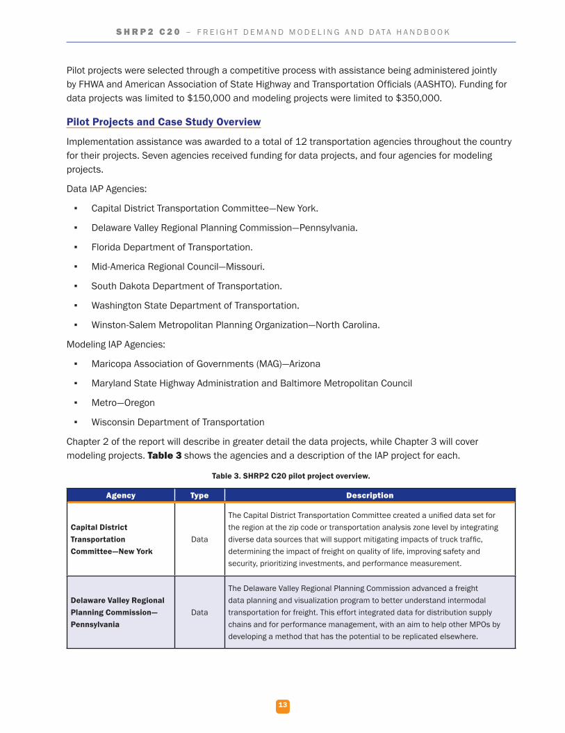
Pilot projects were selected through a competitive process with assistance being administered jointly by FHWA and American Association of State Highway and Transportation Officials (AASHTO). Funding for data projects was limited to $150,000 and modeling projects were limited to $350,000.
Pilot Projects and Case Study Overview
Implementation assistance was awarded to a total of 12 transportation agencies throughout the country for their projects. Seven agencies received funding for data projects, and four agencies for modeling projects.
Data IAP Agencies:
▪ Capital District Transportation Committee—New York.
▪ Delaware Valley Regional Planning Commission—Pennsylvania.
▪ Florida Department of Transportation.
▪ Mid-America Regional Council—Missouri.
▪ South Dakota Department of Transportation.
▪ Washington State Department of Transportation.
▪ Winston-Salem Metropolitan Planning Organization—North Carolina.
Modeling IAP Agencies:
▪ Maricopa Association of Governments (MAG)—Arizona
▪ Maryland State Highway Administration and Baltimore Metropolitan Council
▪ Metro—Oregon
▪ Wisconsin Department of Transportation
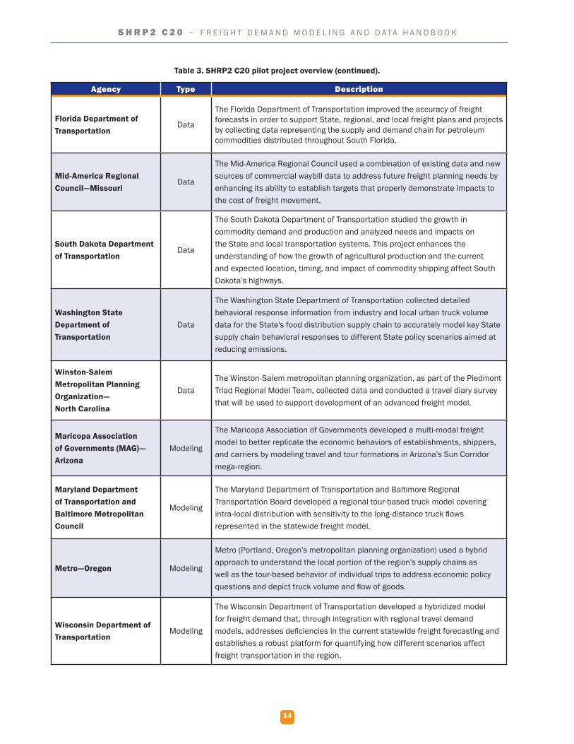
Chapter 2 of the report will describe in greater detail the data projects, while Chapter 3 will cover modeling projects. Table 3 shows the agencies and a description of the IAP project for each.
Table 3. SHRP2 C20 pilot project overview.
Agency Type Description
Capital District Transportation Committee—New York
Data
The Capital District Transportation Committee created a unified data set for the region at the zip code or transportation analysis zone level by integrating diverse data sources that will support mitigating impacts of truck traffic, determining the impact of freight on quality of life, improving safety and security, prioritizing investments, and performance measurement.
Delaware Valley Regional Planning Commission—Pennsylvania
Data
The Delaware Valley Regional Planning Commission advanced a freight data planning and visualization program to better understand intermodal transportation for freight. This effort integrated data for distribution supply chains and for performance management, with an aim to help other MPOs by developing a method that has the potential to be replicated elsewhere.
14
S H R P 2 C 2 0 – F R E I G H T D E M A N D M O D E L I N G A N D D A T A H A N D B O O K
Agency Type Description
Florida Department of Transportation
Data
The Florida Department of Transportation improved the accuracy of freight forecasts in order to support State, regional, and local freight plans and projects by collecting data representing the supply and demand chain for petroleum commodities distributed throughout South Florida.
Mid-America Regional Council—Missouri
Data
The Mid-America Regional Council used a combination of existing data and new sources of commercial waybill data to address future freight planning needs by enhancing its ability to establish targets that properly demonstrate impacts to the cost of freight movement.
South Dakota Department of Transportation
Data
The South Dakota Department of Transportation studied the growth in commodity demand and production and analyzed needs and impacts on the State and local transportation systems. This project enhances the understanding of how the growth of agricultural production and the current and expected location, timing, and impact of commodity shipping affect South Dakota’s highways.
Washington State Department of Transportation
Data
The Washington State Department of Transportation collected detailed behavioral response information from industry and local urban truck volume data for the State's food distribution supply chain to accurately model key State supply chain behavioral responses to different State policy scenarios aimed at reducing emissions.
Winston-Salem Metropolitan Planning Organization— North Carolina
DataThe Winston-Salem metropolitan planning organization, as part of the Piedmont Triad Regional Model Team, collected data and conducted a travel diary survey that will be used to support development of an advanced freight model.
Maricopa Association of Governments (MAG)—Arizona
Modeling
The Maricopa Association of Governments developed a multi-modal freight model to better replicate the economic behaviors of establishments, shippers, and carriers by modeling travel and tour formations in Arizona’s Sun Corridor mega-region.
Maryland Department of Transportation and Baltimore Metropolitan Council
Modeling
The Maryland Department of Transportation and Baltimore Regional Transportation Board developed a regional tour-based truck model covering intra-local distribution with sensitivity to the long-distance truck flows represented in the statewide freight model.
Metro—Oregon Modeling
Metro (Portland, Oregon’s metropolitan planning organization) used a hybrid approach to understand the local portion of the region’s supply chains as well as the tour-based behavior of individual trips to address economic policy questions and depict truck volume and flow of goods.
Wisconsin Department of Transportation
Modeling
The Wisconsin Department of Transportation developed a hybridized model for freight demand that, through integration with regional travel demand models, addresses deficiencies in the current statewide freight forecasting and establishes a robust platform for quantifying how different scenarios affect freight transportation in the region.
Table 3. SHRP2 C20 pilot project overview (continued).
15
S H R P 2 C 2 0 – F R E I G H T D E M A N D M O D E L I N G A N D D A T A H A N D B O O K
Chapter 2. Data InnovationsThere were seven SHRP2 C20 projects related to data improvement as part of the Implementation Assistance Program (IAP). The seven participants include:
▪ Capital District Transportation Committee—New York.
▪ Delaware Valley Regional Planning Commission—Pennsylvania.
▪ Florida Department of Transportation.
▪ Mid-America Regional Council—Missouri.
▪ South Dakota Department of Transportation.
▪ Washington State Department of Transportation.
▪ Winston-Salem Metropolitan Planning Organization—North Carolina.
Each implementer has a unique desired need, approach, and outcome. The concepts and innovations developed by the implementers provide potential building blocks for tackling freight planning issues at multiple scales, and each summary provides the challenges and benefits that may assist others in implementing similar data improvement approaches.
The innovations associated with the data projects are described below. They have been organized to assist the users of this handbook in determining the applicability to their needs quickly. This provides an overview of the project with some detail to provide the appropriate level of information for determining the appropriateness of the method. More detail is provided in the individual case studies prepared for each project. Detailed project reports prepared by each project team can be consulted for in-depth discussion of each project. More information about these projects can be found on the SHRP2 C20 website.1
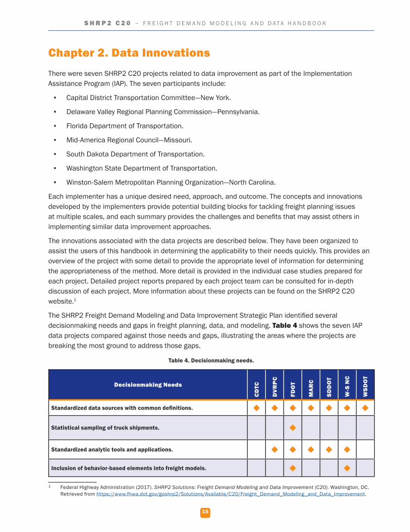
The SHRP2 Freight Demand Modeling and Data Improvement Strategic Plan identified several decisionmaking needs and gaps in freight planning, data, and modeling. Table 4 shows the seven IAP data projects compared against those needs and gaps, illustrating the areas where the projects are breaking the most ground to address those gaps.
Table 4. Decisionmaking needs.
Decisionmaking Needs
CD
TC
DV
RP
C
FDO
T
MA
RC
SDD
OT
W-S
NC
WSD
OT
Standardized data sources with common definitions.
Statistical sampling of truck shipments.
Standardized analytic tools and applications.
Inclusion of behavior-based elements into freight models.
1 Federal Highway Administration (2017). SHRP2 Solutions: Freight Demand Modeling and Data Improvement (C20). Washington, DC. Retrieved from https://www.fhwa.dot.gov/goshrp2/Solutions/Available/C20/Freight_Demand_Modeling_and_Data_Improvement.
16
S H R P 2 C 2 0 – F R E I G H T D E M A N D M O D E L I N G A N D D A T A H A N D B O O K
Decisionmaking Needs
CD
TC
DV
RP
C
FDO
T
MA
RC
SDD
OT
W-S
NC
WSD
OT
Data development to understand the nature, volume, and trends of intermodal transfers.
Industry-level freight data development at a sub-regional level and within urban areas.
Incorporation of local land use policies and controls for better local forecasting accuracy.
Development of a correlation between freight activity and various economic influences and macroeconomic trends.
Better accuracy of freight forecasts.
Development of a process to routinely generate new data sources and problem solving methods.
CDTC: Capital District Transportation Committee. DVRPC: Delaware Valley Regional Planning Commission. FDOT: Florida Department of Transportation. ITS: intelligent transportation systems. MARC: Mid-America Regional Council. SDDOT: South Dakota Department of Transportation. W-S NC: Winston-Salem, North Carolina. WSDOT: Washington State Department of Transportation.
Principles and Considerations for Local Data Collection
Although each data collection project was unique, each project involved the collection and use of new data, allowing several general principles to emerge from the research. Three of these general principles are addressed below.
Development of a Regional Freight Stakeholder Group
Nearly every project in the group of seven included the establishment or use of an existing freight stakeholder group. These groups performed many tasks, including project oversight and providing expert level input on specific issues. The early development of a freight stakeholder group will benefit any new freight data development project. Additionally, the stakeholders will lend weight and importance to any data development effort. They will likely be influential in obtaining assistance from agencies and companies that are requested to participate in the effort in some capacity.
Administering Surveys to Local Freight Producers and Consumers
Many of the data projects involved large data collection efforts that were dependent on surveys to gain input from freight-related businesses and others. Poorly designed or deployed surveys produce notoriously poor response rates. The experiences of the seven data projects contain lessons that can maximize the return on any surveys conducted and maximize the data collected.
Developing New Data Sources
The data projects clearly show that developing new data sources is a time-consuming and difficult task. Freight data is often fragmented and uncoordinated. Much of it was developed for purposes other than freight analysis and so contains data standards that vary widely and may make transformation of the
Table 4. Decisionmaking needs (continued).
17
S H R P 2 C 2 0 – F R E I G H T D E M A N D M O D E L I N G A N D D A T A H A N D B O O K
data into usable freight information difficult. For these reasons, choose data sources wisely. Prioritize data sources that can be most readily transformed into usable information and used for the greatest number of analyses and purposes. Keep, however, a list of alternate data sources as well. A preferred source may turn out to be more difficult to use than originally thought and an alternate source may be needed.
Capital District Transportation Committee—New York
Project Overview/Need
Located in Albany, New York, the Capital District Transportation Committee (CDTC) is the designated metropolitan planning organization (MPO) for the Albany-Schenectady-Troy, New York, metropolitan area. Surrounded by major highway, rail, and maritime routes, this region serves as a transportation crossroads to many industries and is home to several major freight generators. CDTC desired to collect, integrate, and maintain a variety of freight-related data from multiple sources to use for its planning purposes. As previously discussed, data collected for freight planning often has one or more problems including: fragmentation, inconsistencies in geographic coverage, lack of disaggregated data, and lack of shipper-specific information. The purpose of this project was to identify existing freight data at the national, State, and local levels as well as to develop new data sources from partner providers. CDTC then designed a business process to integrate all the data and keep it continually updated.
Data Innovations to Meet Need
CDTC developed a geographic information system (GIS)-based dynamic freight database as a central location to house freight-related data that the agency can use for future freight planning activities. The database contains data that has already been processed and integrated and is usable for any level of aggregation.
Existing datasets that were collected and integrated into the database included:
Table 5. Capital District Transportation Committee data.
Data Source
Commodity Flow Survey (CFS) Data USDOT/BTS
Employment Data (ZIP Code Business Patterns) US Bureau of Labor Statistics
Freight Analysis Framework OD Data USDOT/FHWA
Smart Location Data EPA
511 NY Data Feed NYSDOT
Capital Region Updated Network Data (with Volume) CDTC
Census of Vehicles USDOT
Economic Data NYS GIS Clearinghouse
E-ZPass Data NYSTA
HERE Travel Time Data FHWA
18
S H R P 2 C 2 0 – F R E I G H T D E M A N D M O D E L I N G A N D D A T A H A N D B O O K
Data Source
IHS Global Insights TRANSEARCH CDTC
MIST Speed and Volume Data CDTC / NYSDOT
Oversize/Overweight Permitting Data NYSDOT
Truck Crash Data NYSDMV
Truck Traffic Counts NYSDOT
Weigh-In-Motion (WIM) Data NYSDOT
BTS: Bureau of Transportation Statistics. CDTC: Capital District Transportation Committee. EPA: Environmental Protection Agency. FHWA: Federal Highway Administration. NYS GIS Clearinghouse: New York State Geographic Information System Clearinghouse. NYSDMV: New York State Department of Motor Vehicles. NYSDOT: New York State Department of Transportation. NYSTA: New York State Thruway Authority. USDOT: United States Department of Transportation.
The project team also collected new data to integrate into the database:
▪ To collect truck trip data, the project team conducted interviews with freight stakeholders in the area and received GPS data of the firms’ truck trips. This data often required the team to sign non-disclosure agreements.
▪ To get a better understanding of the business practices of freight stakeholders in the region, the project team conducted interviews with manufacturers, retailers, supermarkets, and transportation service providers.
The new data was used to develop several models to describe goods movement in the region, including models focused on freight generation, freight trip generation, and service trip generation.
Lessons Learned/Transferable Lessons
CDTC’s effort yielded several lessons that can be applied to similar future projects.
▪ The majority of the datasets are confidential, requiring extensive dialog with owners to ensure sharing. This is true of data from public agencies and especially true when collecting data from private shippers and freight stakeholders. Non-disclosure agreements were required in this project.
▪ Databases vary in units of measure, aggregation methods, and other factors. It takes a long time to clean and process the data before it can be released. Identifying sources and beginning the process of acquiring the data early is important.
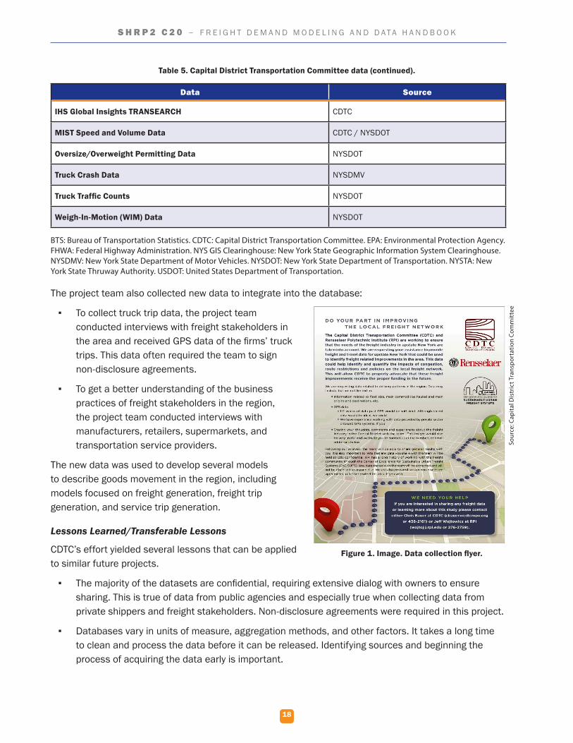
Figure 1. Image. Data collection flyer.
Sour
ce: C
apita
l Dis
tric
t Tra
nspo
rtat
ion
Com
mit
tee
Table 5. Capital District Transportation Committee data (continued).
19
S H R P 2 C 2 0 – F R E I G H T D E M A N D M O D E L I N G A N D D A T A H A N D B O O K
▪ The creation of a central database with usable, processed data is essential to maximize the usefulness of the data. New studies and research are easier with immediately usable data. Data is always changing and must continually be refreshed. An established business process to update data is an important aspect of having usable data.
Next Steps for Research
The development of additional datasets is the next step needed. The central database allows this new data to be added as it is developed.
Delaware Valley Regional Planning Commission—Pennsylvania
Project Overview/Need
Delaware Valley Regional Planning Commission (DVRPC) serves as the MPO for Philadelphia and its nine surrounding counties. DVRPC had previously founded the Delaware Valley Goods Movement Task Force (DVGMTF) to guide and provide input to freight planning in the region. In 2013 DVRPC released PhillyFreightFinder, a centralized data clearinghouse and corresponding online mapping application. DVRPC is constantly seeking to improve the tool and identified several improvements to make as part of the SHRP2 process.
Data Innovations to Meet Need
Through this project, DVRPC updated and improved its core datasets, updated the interactive web-based mapping tool, and developed a complete set of open source documentation and generic templates to enable other agencies to create and implement a similar freight data clearinghouse and website for their regions. To complete this project, the project team:
▪ Identified and evaluated data sources.
▪ Developed methods to combine datasets.
▪ Automated the data importing and integration.
▪ Established a standard portfolio of core freight datasets that support freight planning, operations, and project prioritization for both the public and private sectors.
All data collected during this project were integrated into DVRPC’s PhillyFreightFinder to provide a comprehensive product used by a variety of freight stakeholders, including the general public, municipal officials, economic development agencies, and private industry partners.
The first project task was to revise the freight network within PhillyFreightFinder for consistency with new datasets. Once the network was revised, the following new datasets were acquired, cleaned, and added to the database. Table 6 through Table 9 highlight this data.
20
S H R P 2 C 2 0 – F R E I G H T D E M A N D M O D E L I N G A N D D A T A H A N D B O O K
Table 6. Freight activity data.
Data Source
Classification Counts Delaware Valley Regional Planning Commission
Weigh-in-motion Truck Counts Pennsylvania Department of Transportation
Port Gate Turn Counts Terminal Owner/Operators
Annual Vessel Report Maritime Exchange
Train Counts Class I Railroads
Table 7. Freight economic data.
Data Source
National Establishment Time-Series (NETS) Walls & Associates
County Business Patterns U.S. Census Bureau
Freight Finder IHS Global Insight
Table 8. Commodity flow data.
Data Source
Freight Analysis Framework FHWA
TRANSEARCH IHS Global Insight
Table 9. Performance measurement data.
Data Source
Public Use Waybill Data Surface Transportation Board
USA Trade Online U.S. Census Bureau
U.S. Energy Information Administration (EIA) Company Level Imports U.S. EIA
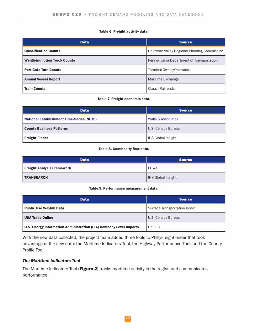
With the new data collected, the project team added three tools to PhillyFreightFinder that took advantage of the new data: the Maritime Indicators Tool, the Highway Performance Tool, and the County Profile Tool.
The Maritime Indicators Tool
The Maritime Indicators Tool (Figure 2) tracks maritime activity in the region and communicates performance.
21
S H R P 2 C 2 0 – F R E I G H T D E M A N D M O D E L I N G A N D D A T A H A N D B O O K
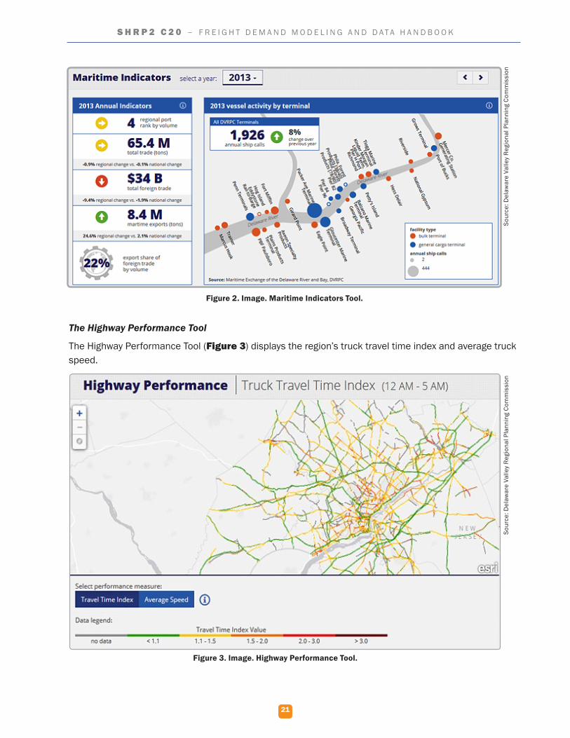
The Highway Performance Tool
The Highway Performance Tool (Figure 3) displays the region’s truck travel time index and average truck speed.
Figure 2. Image. Maritime Indicators Tool.
Figure 3. Image. Highway Performance Tool.
Sour
ce: D
elaw
are
Valle
y Re
gion
al P
lann
ing
Com
mis
sion
Sour
ce: D
elaw
are
Valle
y Re
gion
al P
lann
ing
Com
mis
sion
22
S H R P 2 C 2 0 – F R E I G H T D E M A N D M O D E L I N G A N D D A T A H A N D B O O K
The County Profile Tool
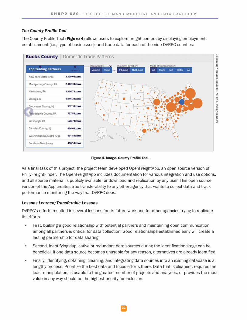
The County Profile Tool (Figure 4) allows users to explore freight centers by displaying employment, establishment (i.e., type of businesses), and trade data for each of the nine DVRPC counties.
As a final task of this project, the project team developed OpenFreightApp, an open source version of PhillyFreightFinder. The OpenFreightApp includes documentation for various integration and use options, and all source material is publicly available for download and replication by any user. This open source version of the App creates true transferability to any other agency that wants to collect data and track performance monitoring the way that DVRPC does.
Lessons Learned/Transferable Lessons
DVRPC’s efforts resulted in several lessons for its future work and for other agencies trying to replicate its efforts.
▪ First, building a good relationship with potential partners and maintaining open communication among all partners is critical for data collection. Good relationships established early will create a lasting partnership for data sharing.
▪ Second, identifying duplicative or redundant data sources during the identification stage can be beneficial. If one data source becomes unusable for any reason, alternatives are already identified.
▪ Finally, identifying, obtaining, cleaning, and integrating data sources into an existing database is a lengthy process. Prioritize the best data and focus efforts there. Data that is cleanest, requires the least manipulation, is usable to the greatest number of projects and analyses, or provides the most value in any way should be the highest priority for inclusion.
Figure 4. Image. County Profile Tool.
Sour
ce: D
elaw
are
Valle
y Re
gion
al P
lann
ing
Com
mis
sion
23
S H R P 2 C 2 0 – F R E I G H T D E M A N D M O D E L I N G A N D D A T A H A N D B O O K
Next Steps for Research
The project positioned DVRPC to pursue a number of future activities.
▪ DVRPC is holding additional meetings with local planning partners and other users to discuss the enhanced application and potential uses for the tool.
▪ PhillyFreightFinder’s effectiveness depends upon updates to the data it provides. The DVRPC project team established a plan to regularly refresh its datasets and will review publicly available data annually. Automation developed to parse and import data during the project will also help minimize the level of effort required to keep the information current.
▪ The application will be improved with the addition of other data types. DVRPC plans to add additional characteristics that help describe the freight facilities in greater depth. The team also intends to add rail freight activity and county-level import/export flows.
▪ The freight network will be improved by consolidating primary freight and regional model networks data into one system with truck counts and NPMRDS travel time. The consolidated network is expected to aid in the development, calibration, and use of a freight model for the region.
Florida Department of Transportation
Project Overview/Need
Petroleum from Port Everglades accounts for nearly 20 percent of all energy consumption in Florida, and represents all petroleum products (e.g., crude oil, gasoline, diesel, propane, etc.) consumed in the four counties surrounding the port. While Port Everglades tracks the volume of petroleum transported in and out of the port, it does not document the delivery locations. In addition, the Florida Department of Transportation (FDOT) often uses vehicle detection sensors to classify vehicles by length, but this classification data provides little information on the type of commodity being transported, including petroleum. Additional data on the makeup of traffic, routes used by petroleum shipments, and petroleum delivery locations would allow FDOT to better plan for enhanced freight mobility.
Data Innovations to Meet Need
FDOT District 4 combined emerging technologies for automated vehicle recognition and conventional data sources to better understand the supply and demand chain for petroleum in South Florida. The project team conducted a literature review to identify emerging devices and technologies that can automatically detect and classify tanker trucks and tanker rail cars. Through this effort, the project team identified 15 potential detection technologies. Of the 15, four were determined to have the highest potential for meeting the project’s needs:
▪ Video image processing.
▪ Laser scanner/light detection and ranging (LiDAR).
▪ License plate recognition.
▪ Transponders.
After weighing the benefits and drawbacks of each technology, the project team selected video image processing and license plate recognition for field testing.
24
S H R P 2 C 2 0 – F R E I G H T D E M A N D M O D E L I N G A N D D A T A H A N D B O O K
The project team felt that LiDAR technology has high potential, but the technology needs further improvement before it would be viable for detecting tanker trucks. The use of transponders was feasible; however, maintaining cooperation and coordination between the various entities providing the transponder data could be difficult during the course of the study.
Results of the field tests shed light on the application of each technology for large-scale deployments. License plate recognition posed many challenges. License plates can be obstructed by things like weather and other vehicles. Different States have different license plate standards that can make positive recognition difficult. Also, due to the interstate nature of freight, a national license plate database and multistate cooperation is required. Consequently, these problems prevented the project team from identifying the registration locations and delivery locations for many tanker trucks using license plate recognition technology.
Video analysis proved to be the most effective detection method for the project’s purpose. The project team had 46 hours of field video analyzed through video image processing. While the video image processing algorithms and procedures are proprietary and were not available to the project team to review, the team found the results to be of good quality.
The project team also conducted a petroleum flow analysis to document petroleum delivery routes and locations. For this analysis, the project team used fuel tax records to plot the distribution of petroleum products on varying geographic scales, developing estimates on the number of truck trips in each micro analysis zone for use in travel demand modeling. Analyzing truck probe data allowed the project team to identify 807 trip chains from two months of data. Data on these trip chains were prepared in the form of a GIS shapefile that included trip-level information such as trip length, trip time, and origin/destination land use description. Finally, driver surveys provided additional validation to the analyses.
Lessons Learned/Transferable Lessons
Outreach and coordination was a significant focus of this project. Through close coordination between the project’s steering committee and the regional partners, the project demonstrated that collaboration between public and private sector stakeholders resulted in an overall better understanding of the individual segments of the petroleum transport community, including shippers, carriers, and customers of the supply and demand chain.
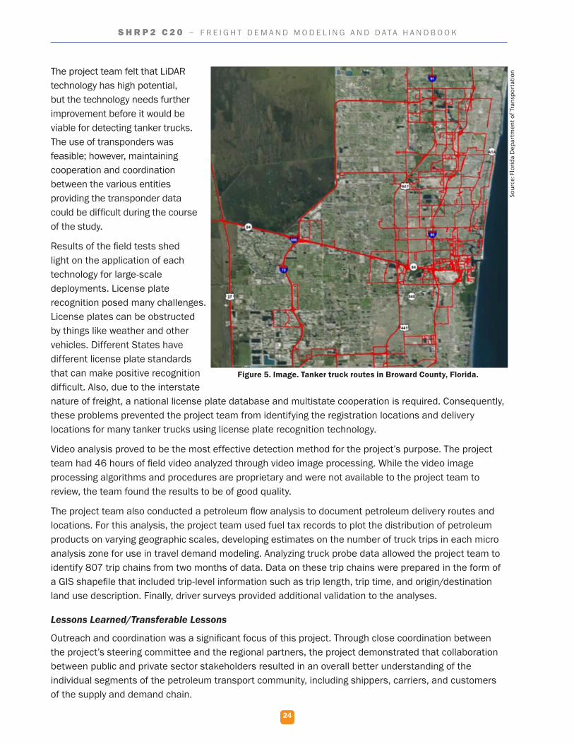
Figure 5. Image. Tanker truck routes in Broward County, Florida.
Sour
ce: F
lorid
a D
epar
tmen
t of T
rans
port
atio
n
25
S H R P 2 C 2 0 – F R E I G H T D E M A N D M O D E L I N G A N D D A T A H A N D B O O K
This project conducted a thorough review of emerging technologies to classify tanker trucks and tank rail cars, evaluated each to determine which of the technologies had the highest potential for success, and tested two technologies. Findings from the deployment show that video image processing and license plate recognition can support the data collection process for tanker trucks and tanker rail cars. Of the two, video image processing was better suited to the project’s requirements. Improvements are still needed, however, before these technologies can be successfully deployed on a large scale for this purpose.
Next Steps for Research
The project team has identified several potential opportunities to advance research in the area of automated freight data collection and to enhance FDOT’s ability to plan for freight. One characteristic of the video image processing algorithms is that accuracy is often improved by a larger data sample size; obtaining additional video from around the State would continue to improve video image processing capabilities. Collecting more recent fuel tax data from Florida Department of Revenue would allow FDOT to fill the identified data gaps and better document the petroleum origin-destination pattern in the region.
Mid-America Regional Council—Missouri
Project Overview/Need
When congestion delays a freight shipment, the extra labor cost incurred due to the delay is either passed on to the consumer or absorbed by the freight carrier. To date, however, the specific link between freight shipment costs and congestion has not been detailed. As such, it is difficult to understand the direct economic impacts of congestion on freight carriers and other related businesses.
Data Innovations to Meet Need
The availability of new datasets, such as FHWA’s National Performance Management Research Data Set (NPMRDS) and the private sector Real-time Freight Intelligence (RTFI) commercial freight waybill dataset, allows researchers to begin to calculate the impact of congestion on cost of freight movement. Together, these datasets provide detailed and specific cost information on freight shipments as well as average travel times along major highways. This project developed an analytical approach to identify common commodities and shipment routes originating in the MARC region, extracted pertinent information from freight waybill data, and calculated performance measures for selected shipment routes to understand how highway congestion affects freight shipment costs.
The NPMRDS data is large and not unified. To most efficiently extract performance data from the NPMRDS data for origin and destination pairs, the project team received access to the Regional Integrated Transportation Information System (RITIS) of the University of Maryland’s Center for Advanced Transportation Technology (CATT) laboratory. RITIS provided the project team with a tool pre-loaded with all relevant NPMRDS data and allowed for easy route entry and performance measurement calculations. The project team next used RITIS to complete a performance summary analysis and develop a congestion profile for each route. The performance measures selected from the RITIS analysis were buffer index, planning time index, travel time index, average travel time, and average speed.
Findings from this project indicate some correlation between congestion and freight shipment costs as shown in Table 10. The project also identified potential improvements that will more clearly identify the link between congestion and cost.
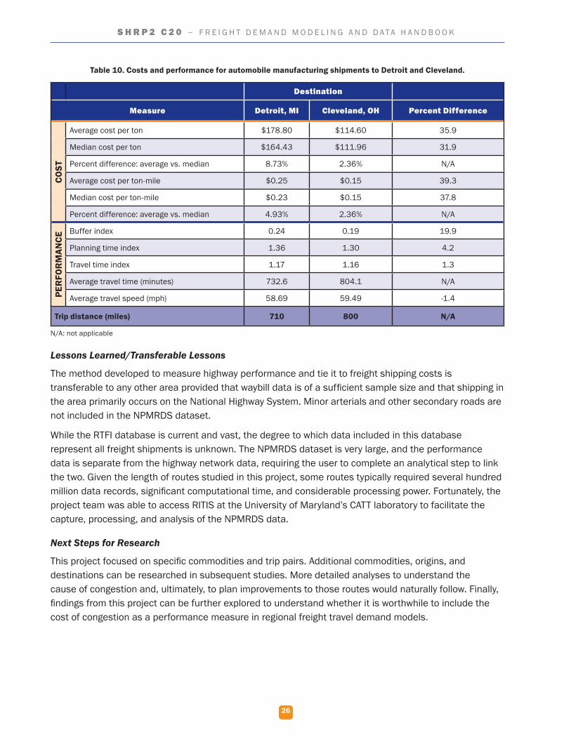
26
S H R P 2 C 2 0 – F R E I G H T D E M A N D M O D E L I N G A N D D A T A H A N D B O O K
Table 10. Costs and performance for automobile manufacturing shipments to Detroit and Cleveland.
Destination
Measure Detroit, MI Cleveland, OH Percent Difference
CO
ST
Average cost per ton $178.80 $114.60 35.9
Median cost per ton $164.43 $111.96 31.9
Percent difference: average vs. median 8.73% 2.36% N/A
Average cost per ton-mile $0.25 $0.15 39.3
Median cost per ton-mile $0.23 $0.15 37.8
Percent difference: average vs. median 4.93% 2.36% N/A
PER
FOR
MAN
CE Buffer index 0.24 0.19 19.9
Planning time index 1.36 1.30 4.2
Travel time index 1.17 1.16 1.3
Average travel time (minutes) 732.6 804.1 N/A
Average travel speed (mph) 58.69 59.49 -1.4
Trip distance (miles) 710 800 N/A
N/A: not applicable
Lessons Learned/Transferable Lessons
The method developed to measure highway performance and tie it to freight shipping costs is transferable to any other area provided that waybill data is of a sufficient sample size and that shipping in the area primarily occurs on the National Highway System. Minor arterials and other secondary roads are not included in the NPMRDS dataset.
While the RTFI database is current and vast, the degree to which data included in this database represent all freight shipments is unknown. The NPMRDS dataset is very large, and the performance data is separate from the highway network data, requiring the user to complete an analytical step to link the two. Given the length of routes studied in this project, some routes typically required several hundred million data records, significant computational time, and considerable processing power. Fortunately, the project team was able to access RITIS at the University of Maryland’s CATT laboratory to facilitate the capture, processing, and analysis of the NPMRDS data.
Next Steps for Research
This project focused on specific commodities and trip pairs. Additional commodities, origins, and destinations can be researched in subsequent studies. More detailed analyses to understand the cause of congestion and, ultimately, to plan improvements to those routes would naturally follow. Finally, findings from this project can be further explored to understand whether it is worthwhile to include the cost of congestion as a performance measure in regional freight travel demand models.
27
S H R P 2 C 2 0 – F R E I G H T D E M A N D M O D E L I N G A N D D A T A H A N D B O O K
South Dakota Department of Transportation
Project Overview/Need
The agriculture industry has a $20.9 billion impact on the South Dakota economy. To ensure that agricultural products can be moved efficiently to market, the South Dakota Department of Transportation (SDDOT) routinely makes infrastructure investments. SDDOT, however, does not use agriculture production data to assist in making these investment decisions. Given the significance of the agriculture industry in the State and corresponding volume of related goods moved throughout the State, it is important to understand the impact of agricultural production and trends on the transportation system.
Data Innovations to Meet Need
The objective of this project was to demonstrate the feasibility and utility of collecting and combining agricultural data with existing transportation data sources to inform transportation planning decisions. Production and trends should be able to help identify those locations that are most critical to agricultural freight transportation.
The project began with stakeholder interviews, with the interviewees equally split between those with an agricultural focus and those with a transportation focus. Using the interviews as an input, the project team defined data requirements for the agricultural data. The agricultural data sources settled on as being desirable and reliable included:
▪ United States Department of Agriculture’s (USDA) National Agricultural Statistics Service (NASS).
▪ Economic Research Service (ERS).
▪ Agricultural Marketing Service (AMS).
The USDA’s NASS provides statistics across an array of agricultural topics, such as crops, livestock, related commodities, and processed products. The NASS also offers a geospatial data product, the Cropland Data Layer (CDL), which is generated annually to provide a geo-referenced, crop-specific land data layer. On the whole, the NASS provides fully robust information for common crops. In addition, the USDA’s ERS offers a number of data sets and tools focused on crop and livestock production, including forecasts. Finally, the AMS provides access to data on agricultural-related topics such as standards and inspection, prices, volumes, transportation, and weather impacts.
To conduct the demonstration project, the project team first synthesized the agriculture and transportation data. The main data sources for this effort were the USDA NASS crop data GIS dataset on the land uses made by farmers in a calendar year and State and local transportation infrastructure data. The two data types were overlaid to determine expected crop yield, access to State highways or rail yards, and percentage of paved roadway miles per township within the demonstration area.
Next, the trip calculations were developed to understand the movement of goods within the study area. Crop yields were converted into truck trips using equivalent single axle loads (ESALs) and estimated per township and per quarter (for a baseline year of 2014). The USDA ERS forecast includes crop acres, crop yields, and crop uses up to the year 2024. Together, this information was combined with historical trends available from USDA’s NASS to forecast ESALs per township, per quarter in 2024.
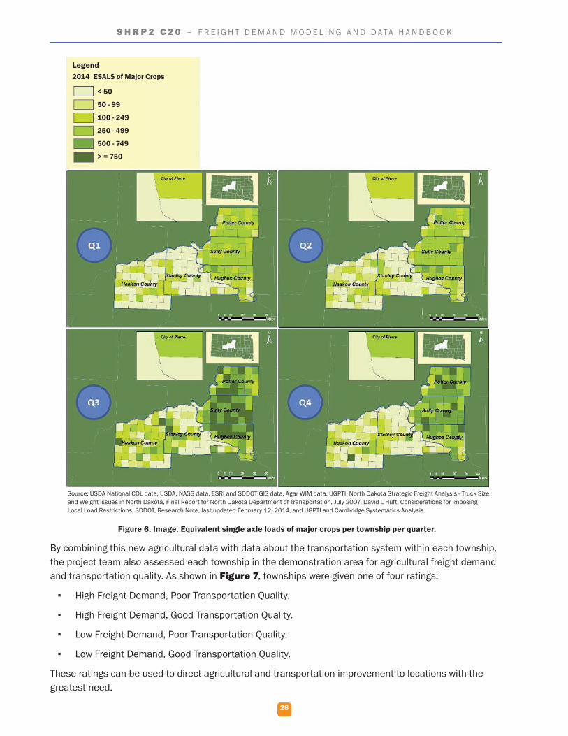
28
S H R P 2 C 2 0 – F R E I G H T D E M A N D M O D E L I N G A N D D A T A H A N D B O O K
Figure 6. Image. Equivalent single axle loads of major crops per township per quarter.
By combining this new agricultural data with data about the transportation system within each township, the project team also assessed each township in the demonstration area for agricultural freight demand and transportation quality. As shown in Figure 7, townships were given one of four ratings:
▪ High Freight Demand, Poor Transportation Quality.
▪ High Freight Demand, Good Transportation Quality.
▪ Low Freight Demand, Poor Transportation Quality.
▪ Low Freight Demand, Good Transportation Quality.
These ratings can be used to direct agricultural and transportation improvement to locations with the greatest need.
Source: USDA National CDL data, USDA, NASS data, ESRI and SDDOT GIS data, Agar WIM data, UGPTI, North Dakota Strategic Freight Analysis - Truck Size and Weight Issues in North Dakota, Final Report for North Dakota Department of Transportation, July 2007, David L Huft, Considerations for Imposing Local Load Restrictions, SDDOT, Research Note, last updated February 12, 2014, and UGPTI and Cambridge Systematics Analysis.
Legend2014 ESALS of Major Crops
< 50
50 - 99
100 - 249
250 - 499
500 - 749
> = 750
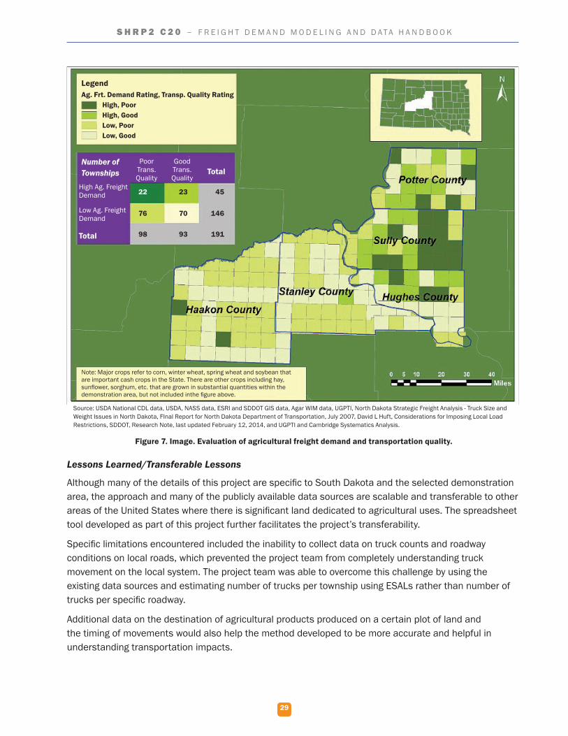
29
S H R P 2 C 2 0 – F R E I G H T D E M A N D M O D E L I N G A N D D A T A H A N D B O O K
Figure 7. Image. Evaluation of agricultural freight demand and transportation quality.
Lessons Learned/Transferable Lessons
Although many of the details of this project are specific to South Dakota and the selected demonstration area, the approach and many of the publicly available data sources are scalable and transferable to other areas of the United States where there is significant land dedicated to agricultural uses. The spreadsheet tool developed as part of this project further facilitates the project’s transferability.
Specific limitations encountered included the inability to collect data on truck counts and roadway conditions on local roads, which prevented the project team from completely understanding truck movement on the local system. The project team was able to overcome this challenge by using the existing data sources and estimating number of trucks per township using ESALs rather than number of trucks per specific roadway.
Additional data on the destination of agricultural products produced on a certain plot of land and the timing of movements would also help the method developed to be more accurate and helpful in understanding transportation impacts.
Source: USDA National CDL data, USDA, NASS data, ESRI and SDDOT GIS data, Agar WIM data, UGPTI, North Dakota Strategic Freight Analysis - Truck Size and Weight Issues in North Dakota, FInal Report for North Dakota Department of Transportation, July 2007, David L Huft, Considerations for Imposing Local Load Restrictions, SDDOT, Research Note, last updated February 12, 2014, and UGPTI and Cambridge Systematics Analysis.
Note: Major crops refer to corn, winter wheat, spring wheat and soybean that are important cash crops in the State. There are other crops including hay, sunflower, sorghum, etc. that are grown in substantial quantities within the demonstration area, but not included inthe figure above.
LegendAg. Frt. Demand Rating, Transp. Quality Rating
High, PoorHigh, GoodLow, PoorLow, Good
Number of Townships
High Ag. Freight Demand
Low Ag. Freight Demand
Total
Poor Trans. Quality
Good Trans. Quality
Total
22 23 45
70 146
93 191
76
98

30
S H R P 2 C 2 0 – F R E I G H T D E M A N D M O D E L I N G A N D D A T A H A N D B O O K
Next Steps for Research
The data gaps for the local transportation system identified through this project have spurred future action items for SDDOT. SDDOT is now pursuing options to strengthen data collection at the local level as well as monitor other innovative data sources that could provide coverage on the local transportation system.
Washington State Department of Transportation
Project Overview/Need
Within the transportation sector, several opportunities exist to reduce greenhouse gas emissions, including converting from traditional to alternative fuels and installing diesel retrofits, emission treatment technologies, or idle reduction devices. However, planners traditionally had little insight into how State policy scenarios aimed at reducing freight emissions would affect the freight system. This study aimed to collect both qualitative and quantitative data from two of the State’s major supply chains: wheat production and food delivery. The ultimate goal was to apply the resulting insights into actionable methods to reduce carbon pollution in Washington State, as directed by the governor’s Executive Order 14-04 from April 2014.
Data Innovations to Meet Need
A literature review was conducted to identify key actors within the supply chains and provide insight into the data collection plan. The illustrations in Figure 8 show the typical food distribution supply chains for wheat and other foods.
Figure 8. Diagram. Typical Washington State wheat supply and food distribution chains.
Qualitative interviews were conducted to understand the wheat- and food-related supply chain responses to market conditions and potential policy changes aimed at reducing freight emissions. Surveys were developed to explore hypothetical policy and market scenarios focused on financial incentives/disincentives for alternative fuels, changes in fuel costs, and changes to alternative fuel technologies. Finally, truck counts were conducted at grocery stores in the Puget Sound area to understand truck behavior at the user end of the food supply chain.
Source: Washington State Department of Transportation
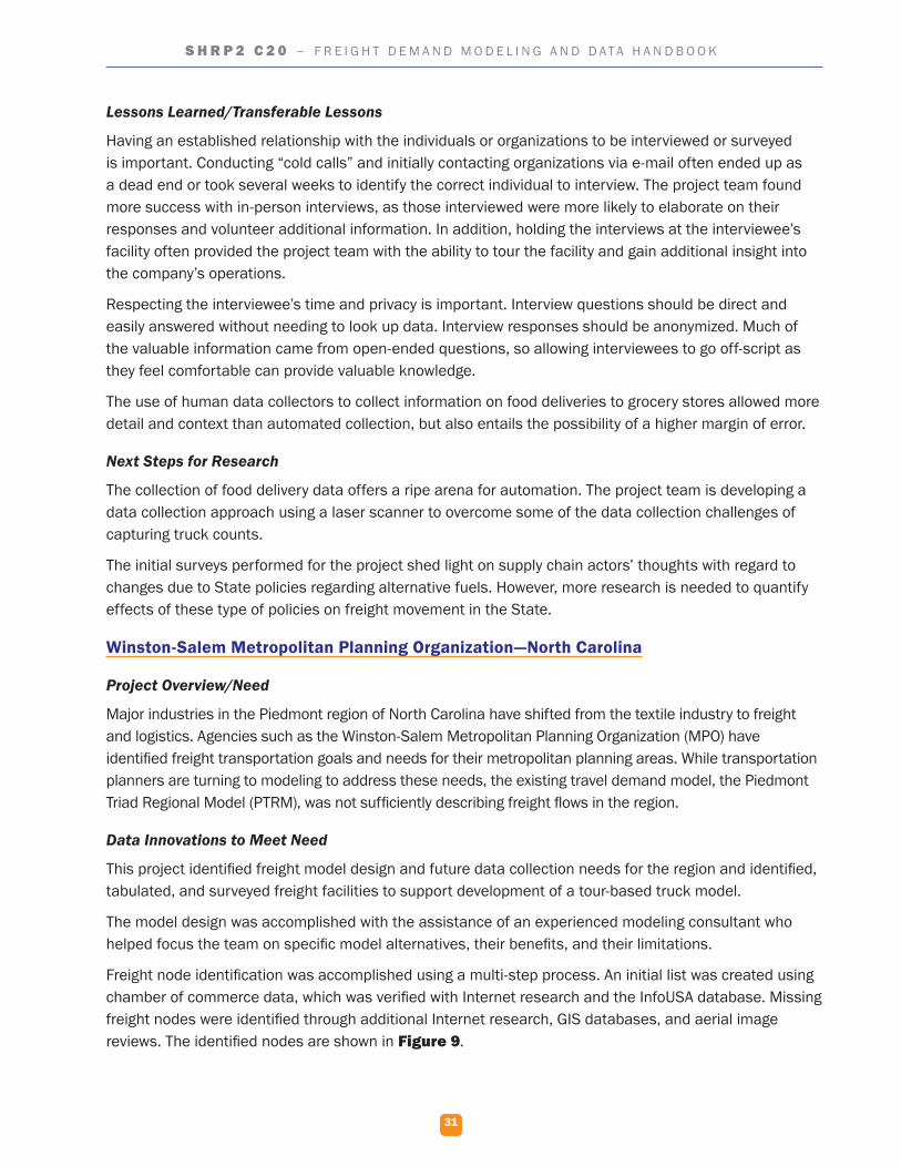
31
S H R P 2 C 2 0 – F R E I G H T D E M A N D M O D E L I N G A N D D A T A H A N D B O O K
Lessons Learned/Transferable Lessons
Having an established relationship with the individuals or organizations to be interviewed or surveyed is important. Conducting “cold calls” and initially contacting organizations via e-mail often ended up as a dead end or took several weeks to identify the correct individual to interview. The project team found more success with in-person interviews, as those interviewed were more likely to elaborate on their responses and volunteer additional information. In addition, holding the interviews at the interviewee’s facility often provided the project team with the ability to tour the facility and gain additional insight into the company’s operations.
Respecting the interviewee’s time and privacy is important. Interview questions should be direct and easily answered without needing to look up data. Interview responses should be anonymized. Much of the valuable information came from open-ended questions, so allowing interviewees to go off-script as they feel comfortable can provide valuable knowledge.
The use of human data collectors to collect information on food deliveries to grocery stores allowed more detail and context than automated collection, but also entails the possibility of a higher margin of error.
Next Steps for Research
The collection of food delivery data offers a ripe arena for automation. The project team is developing a data collection approach using a laser scanner to overcome some of the data collection challenges of capturing truck counts.
The initial surveys performed for the project shed light on supply chain actors’ thoughts with regard to changes due to State policies regarding alternative fuels. However, more research is needed to quantify effects of these type of policies on freight movement in the State.
Winston-Salem Metropolitan Planning Organization—North Carolina
Project Overview/Need
Major industries in the Piedmont region of North Carolina have shifted from the textile industry to freight and logistics. Agencies such as the Winston-Salem Metropolitan Planning Organization (MPO) have identified freight transportation goals and needs for their metropolitan planning areas. While transportation planners are turning to modeling to address these needs, the existing travel demand model, the Piedmont Triad Regional Model (PTRM), was not sufficiently describing freight flows in the region.
Data Innovations to Meet Need
This project identified freight model design and future data collection needs for the region and identified, tabulated, and surveyed freight facilities to support development of a tour-based truck model.
The model design was accomplished with the assistance of an experienced modeling consultant who helped focus the team on specific model alternatives, their benefits, and their limitations.
Freight node identification was accomplished using a multi-step process. An initial list was created using chamber of commerce data, which was verified with Internet research and the InfoUSA database. Missing freight nodes were identified through additional Internet research, GIS databases, and aerial image reviews. The identified nodes are shown in Figure 9.
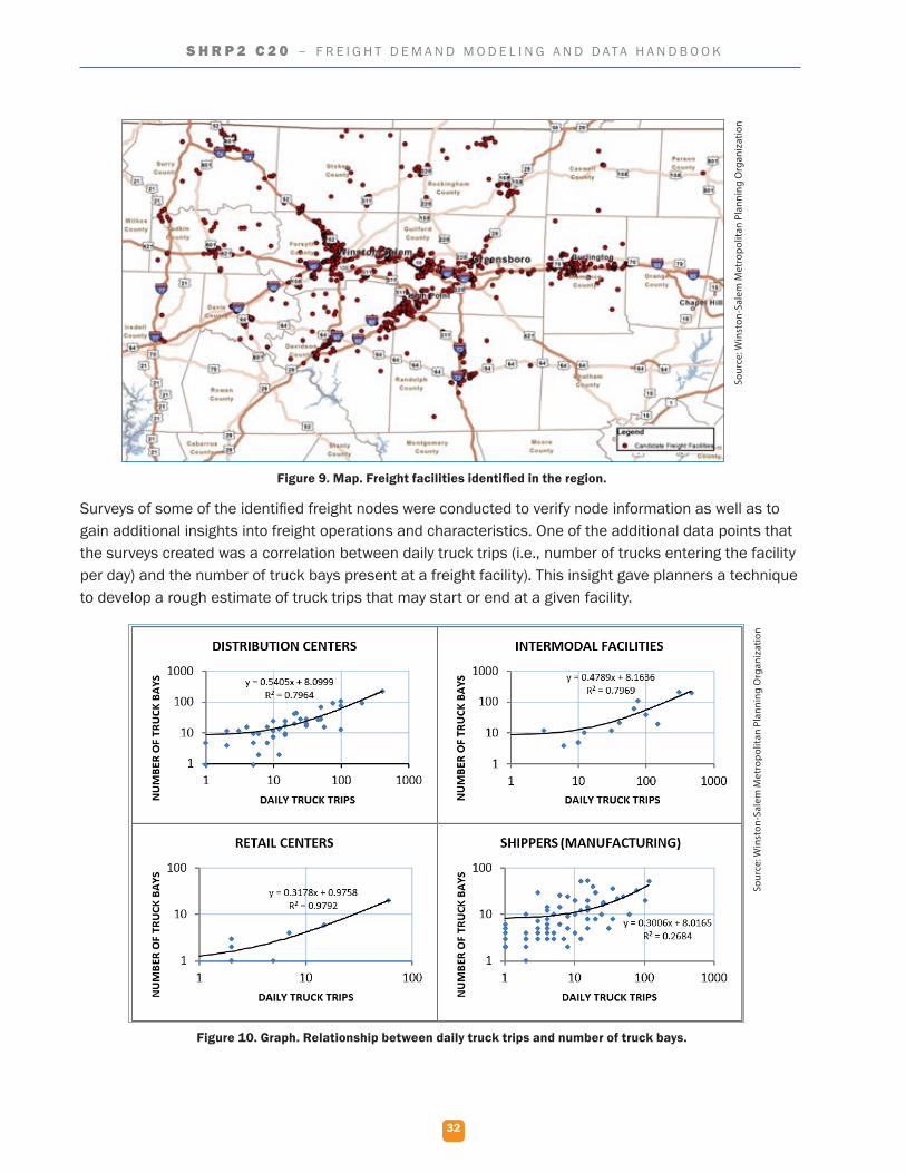
32
S H R P 2 C 2 0 – F R E I G H T D E M A N D M O D E L I N G A N D D A T A H A N D B O O K
Figure 9. Map. Freight facilities identified in the region.
Surveys of some of the identified freight nodes were conducted to verify node information as well as to gain additional insights into freight operations and characteristics. One of the additional data points that the surveys created was a correlation between daily truck trips (i.e., number of trucks entering the facility per day) and the number of truck bays present at a freight facility). This insight gave planners a technique to develop a rough estimate of truck trips that may start or end at a given facility.
Figure 10. Graph. Relationship between daily truck trips and number of truck bays.
Sour
ce: W
inst
on-S
alem
Met
ropo
litan
Pla
nnin
g O
rgan
izat
ion
Sour
ce: W
inst
on-S
alem
Met
ropo
litan
Pla
nnin
g O
rgan
izat
ion
33
S H R P 2 C 2 0 – F R E I G H T D E M A N D M O D E L I N G A N D D A T A H A N D B O O K
The final model development step in this project was the recommendation of a set of data fields for a future phase of modeling. These data fields were informed by interviews with three MPOs well known for their advanced efforts in freight modeling: Atlanta Regional Commission (ARC), the San Diego Association of Governments (SANDAG) and the Maricopa Association of Governments (MAG). Recommended data fields include:
Type Data Fields
Facility � Location (street address, should be filled in before survey is delivered to establishment). � Industry classification. � Number of employees (absolute number and full-time equivalents). � Main commodities shipped or main services provided. � Number of vehicles by type. � Number of truck deliveries or service visits received on an average day (such as delivery of raw materials, parcel service, trash truck, etc.).
Travel � Departure location (establishment, home, other) and time. � Vehicle type. � Cargo loaded at time of departure (commodities and approximate quantity). � For every stop, the driver should note:
o Arrival time.o Stop location (street address).o Stop purpose (unload cargo, load cargo, provide service, refueling, lunch, etc.).o Stop duration.
Lessons Learned/Transferable Lessons
The key lesson learned through this project is the caution that must be taken when relying on a single dataset. The initial approach to populating the freight node database relied on freight facilities listed in the chamber of commerce data available from each of the 11 counties in the Piedmont Triad region. The project team was able to increase the number of records in the database by nearly 50 percent from the initial iteration because it expanded its search to include additional data sources.
The project team learned several lessons with regard to the data collection process. Initial survey efforts fell far short of expectations. It was often difficult to reach the facility’s contact on the initial phone call, and several follow-up phone calls were typically required to reach the appropriate individual. The project team made modifications to the survey process to improve the response rate by revising the survey to include only the most valuable information and, where possible, pre-populating the survey for each freight facility. Instead of attempting to schedule a time and date for the survey, the project team visited each facility unannounced, making contact with personnel at the site to determine if an appropriate individual was available to complete the survey. If an appropriate person was not available, the project team left a self-addressed and stamped envelope along with the pre-populated survey for the appropriate individual to fill out and return to the project team.
Next Steps for Research
Creation of a regional freight model includes several clearly defined steps. The next step in the process is the actual creation of the freight model. The third and final step will be the collection of additional local freight data to refine the model.

Photo: Pixabay
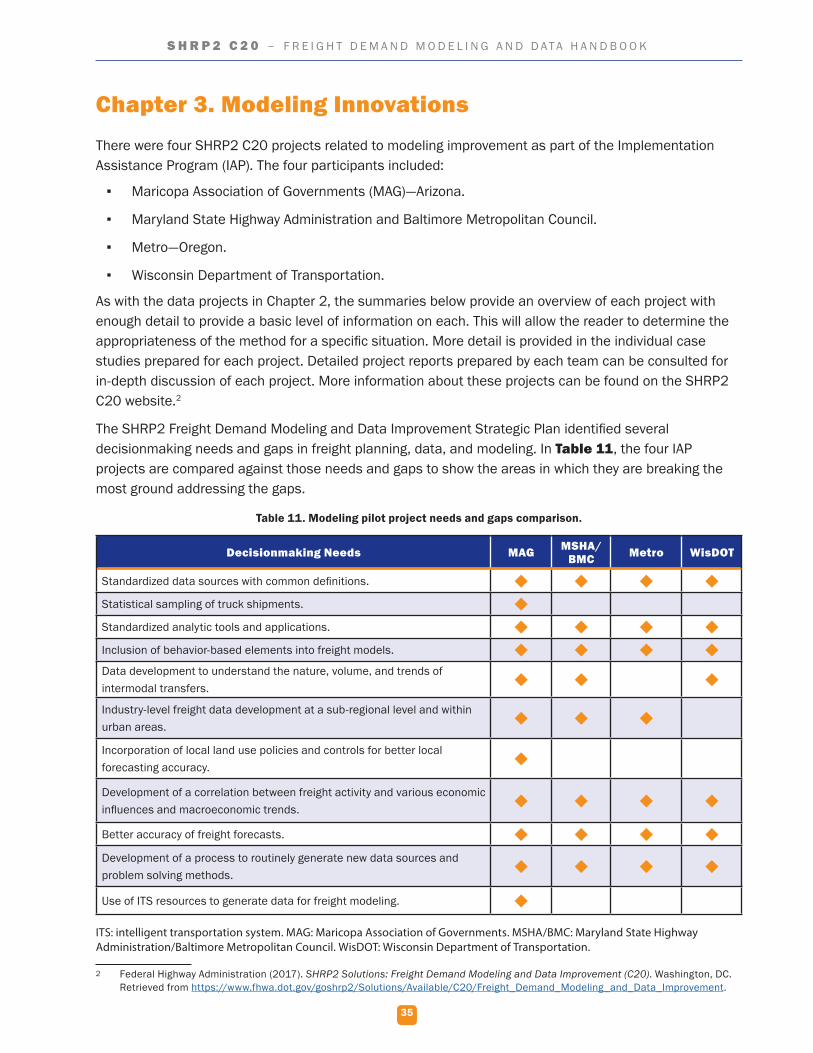
35
S H R P 2 C 2 0 – F R E I G H T D E M A N D M O D E L I N G A N D D A T A H A N D B O O K
Chapter 3. Modeling InnovationsThere were four SHRP2 C20 projects related to modeling improvement as part of the Implementation Assistance Program (IAP). The four participants included:
▪ Maricopa Association of Governments (MAG)—Arizona.
▪ Maryland State Highway Administration and Baltimore Metropolitan Council.
▪ Metro—Oregon.
▪ Wisconsin Department of Transportation.
As with the data projects in Chapter 2, the summaries below provide an overview of each project with enough detail to provide a basic level of information on each. This will allow the reader to determine the appropriateness of the method for a specific situation. More detail is provided in the individual case studies prepared for each project. Detailed project reports prepared by each team can be consulted for in-depth discussion of each project. More information about these projects can be found on the SHRP2 C20 website.2
The SHRP2 Freight Demand Modeling and Data Improvement Strategic Plan identified several decisionmaking needs and gaps in freight planning, data, and modeling. In Table 11, the four IAP projects are compared against those needs and gaps to show the areas in which they are breaking the most ground addressing the gaps.
Table 11. Modeling pilot project needs and gaps comparison.
Decisionmaking Needs MAG MSHA/BMC Metro WisDOT
Standardized data sources with common definitions. Statistical sampling of truck shipments. Standardized analytic tools and applications. Inclusion of behavior-based elements into freight models. Data development to understand the nature, volume, and trends of intermodal transfers.
Industry-level freight data development at a sub-regional level and within urban areas.
Incorporation of local land use policies and controls for better local forecasting accuracy.
Development of a correlation between freight activity and various economic influences and macroeconomic trends.
Better accuracy of freight forecasts. Development of a process to routinely generate new data sources and problem solving methods.
Use of ITS resources to generate data for freight modeling.
ITS: intelligent transportation system. MAG: Maricopa Association of Governments. MSHA/BMC: Maryland State Highway Administration/Baltimore Metropolitan Council. WisDOT: Wisconsin Department of Transportation.
2 Federal Highway Administration (2017). SHRP2 Solutions: Freight Demand Modeling and Data Improvement (C20). Washington, DC. Retrieved from https://www.fhwa.dot.gov/goshrp2/Solutions/Available/C20/Freight_Demand_Modeling_and_Data_Improvement.
36
S H R P 2 C 2 0 – F R E I G H T D E M A N D M O D E L I N G A N D D A T A H A N D B O O K
Principles and Considerations for Freight Modeling Improvement
Although each modeling project was unique in the way that it looked to develop forecasting methods and tools to address decisionmaking needs, several general principles emerged from the research.
Behavior-Based Modeling
Behavior-based aspects of freight decisionmaking are being incorporated into models. These improvements allow the model to more accurately portray the complex factors that are involved in decisionmaking by freight shippers and carriers.
Use of an Open Format Code
Models of all the projects were developed using an open source programming language that is the basis used by other States and metropolitan planning organizations (MPOs). Use of this platform allows improvements made to the model to be available to all other modelers. They also utilized available public freight data sets along with more localized data compiled specifically for use within the model. Data sources for localized freight movement may need to be updated into the model as they become available.
Collection of Establishment Data
The collection of local establishment data can be difficult even with strong support from partners and a robust data collection outreach process. Agencies should be ready to use all available methods to collect local data because no one method will produce enough. Paper surveys and trip diaries, smartphone apps, vehicle monitoring data, site visits, and other methods should all be considered for use.
Development of Localized Modeling
Most projects included the development of an integrated freight model that is able to provide supporting data and information on a more refined basis. The models consider local freight movements and the ability to identify commodity types, volumes, and routes as well as existing infrastructure issues (e.g., congestion, conditions, safety) and project priorities within a region.
Providing Training Materials
Many of the projects developed freight model guides and provided either on-site training sessions and/or written documentation to educate users in the function and maintenance of the models. This training helped to ensure the success of the model as well as set the stage for future improvements to refine it.
Maricopa Association of Governments—Arizona
Project Overview/Need
The Arizona Sun Corridor megaregion encompasses portions of five counties that comprise the metropolitan areas served by the Maricopa Association of Governments (MAG) and the Pima Association of Governments (PAG). This megaregion is home to approximately 8 out of every 10 Arizonans, and it includes one of the busiest freight ports on the United States-Mexico border. There was a need to develop a freight model that accurately depicts freight shipment behavior for the region.
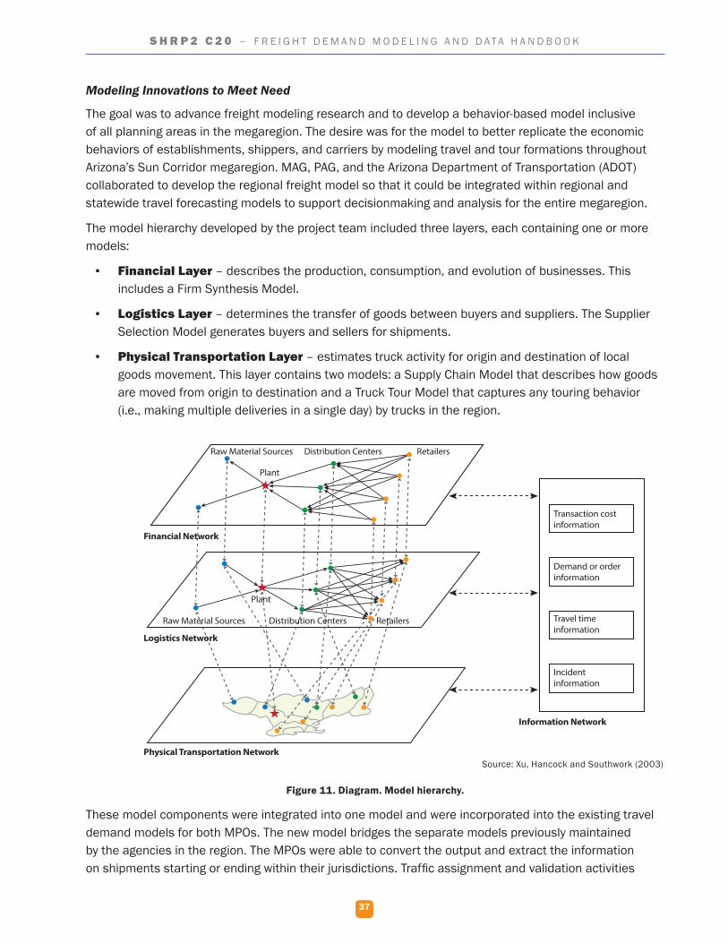
37
S H R P 2 C 2 0 – F R E I G H T D E M A N D M O D E L I N G A N D D A T A H A N D B O O K
Modeling Innovations to Meet Need
The goal was to advance freight modeling research and to develop a behavior-based model inclusive of all planning areas in the megaregion. The desire was for the model to better replicate the economic behaviors of establishments, shippers, and carriers by modeling travel and tour formations throughout Arizona’s Sun Corridor megaregion. MAG, PAG, and the Arizona Department of Transportation (ADOT) collaborated to develop the regional freight model so that it could be integrated within regional and statewide travel forecasting models to support decisionmaking and analysis for the entire megaregion.
The model hierarchy developed by the project team included three layers, each containing one or more models:
▪ Financial Layer – describes the production, consumption, and evolution of businesses. This includes a Firm Synthesis Model.
▪ Logistics Layer – determines the transfer of goods between buyers and suppliers. The Supplier Selection Model generates buyers and sellers for shipments.
▪ Physical Transportation Layer – estimates truck activity for origin and destination of local goods movement. This layer contains two models: a Supply Chain Model that describes how goods are moved from origin to destination and a Truck Tour Model that captures any touring behavior (i.e., making multiple deliveries in a single day) by trucks in the region.
Figure 11. Diagram. Model hierarchy.
These model components were integrated into one model and were incorporated into the existing travel demand models for both MPOs. The new model bridges the separate models previously maintained by the agencies in the region. The MPOs were able to convert the output and extract the information on shipments starting or ending within their jurisdictions. Traffic assignment and validation activities
Source: Xu, Hancock and Southwork (2003)
Raw Material Sources Distribution Centers Retailers
Plant
Plant
Raw Material Sources Distribution Centers Retailers
Transaction cost information
Demand or order information
Travel time information
Incident information
Information Network
Physical Transportation Network
Logistics Network
Financial Network
38
S H R P 2 C 2 0 – F R E I G H T D E M A N D M O D E L I N G A N D D A T A H A N D B O O K
were then completed by each MPO. Many industry partners prefer to keep information on what is being shipped where and when proprietary to maintain their competitive edge. A benefit of this project is that the team developed modeling methods based on sound economic principles. Rather than the MPOs borrowing data or developing a basic estimate for extrapolation to future model years, the project team developed a Firm Synthesis Model that uses an established match algorithm and that can estimate changes in firm growth and dissolution over time and space.
Lessons Learned/Transferable Lessons
The majority of the work accomplished was not region-specific, and it could be replicated by other agencies with comparable data access and resources. The project team shared several lessons learned during the process of developing this model:
▪ Ensure strong project management with staffing redundancies. This large project involved many people, so staff management was important, as was depth of expertise to fill in for any staff lost to turnover.
▪ Maintain an emphasis on team coordination. A multi-part modeling project requires ongoing coordination.
▪ Develop a clear process for quality assurance and quality control. Model parts developed by different people must eventually integrate seamlessly. Quality assurance and quality control activities ensure this integration.
▪ Utilize visualization to support quality control and communications. Errors are often more easily spotted visually.
▪ Consider data licensing requirements before data acquisition. Licenses can be expensive and data restrictions may limit the ability to use the data in new or unique ways.
▪ Ensure adequate resources for model development. A large modeling project is expensive and staff-intensive.
Next Steps in Research
MAG plans to continue to refine the model by advancing the stop identification algorithms in truck GPS data, incorporating land-use, economic models, forecasting and other criteria, and completing light truck data collection to improve the model’s accuracy for that vehicle class. The project team believes that the new behavior-based freight model will give the overall region more flexibility to test different policy and planning scenarios than traditional travel models.
Maryland Department of Transportation and Baltimore Metropolitan Council
Project Overview/Need
The Baltimore-Washington metropolitan region is heavily congested and has many major freight facilities with limited infrastructure expansion options. Given these constraints, it is critical for planners at the Maryland Department of Transportation State Highway Administration (MDOT SHA), Baltimore Region Transportation Board (BRTB), and the Baltimore Metropolitan Council (BMC) to understand how freight is moving into, out of, and within the region.
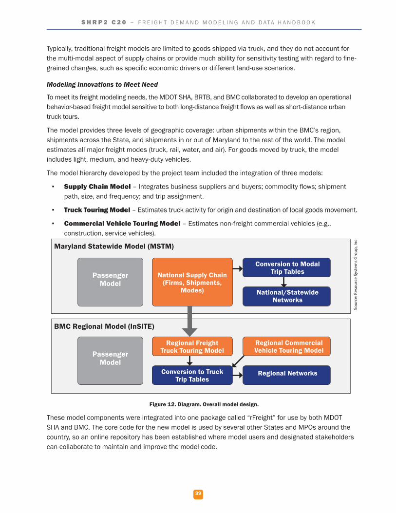
39
S H R P 2 C 2 0 – F R E I G H T D E M A N D M O D E L I N G A N D D A T A H A N D B O O K
Typically, traditional freight models are limited to goods shipped via truck, and they do not account for the multi-modal aspect of supply chains or provide much ability for sensitivity testing with regard to fine-grained changes, such as specific economic drivers or different land-use scenarios.
Modeling Innovations to Meet Need
To meet its freight modeling needs, the MDOT SHA, BRTB, and BMC collaborated to develop an operational behavior-based freight model sensitive to both long-distance freight flows as well as short-distance urban truck tours.
The model provides three levels of geographic coverage: urban shipments within the BMC’s region, shipments across the State, and shipments in or out of Maryland to the rest of the world. The model estimates all major freight modes (truck, rail, water, and air). For goods moved by truck, the model includes light, medium, and heavy-duty vehicles.
The model hierarchy developed by the project team included the integration of three models:
▪ Supply Chain Model – Integrates business suppliers and buyers; commodity flows; shipment path, size, and frequency; and trip assignment.
▪ Truck Touring Model – Estimates truck activity for origin and destination of local goods movement.
▪ Commercial Vehicle Touring Model – Estimates non-freight commercial vehicles (e.g., construction, service vehicles).
Figure 12. Diagram. Overall model design.
These model components were integrated into one package called “rFreight” for use by both MDOT SHA and BMC. The core code for the new model is used by several other States and MPOs around the country, so an online repository has been established where model users and designated stakeholders can collaborate to maintain and improve the model code.
Maryland Statewide Model (MSTM)
BMC Regional Model (InSITE)
Passenger Model
Passenger Model
National Supply Chain (Firms, Shipments,
Modes)
Regional Freight Truck Touring Model
Conversion to Truck Trip Tables
Conversion to Modal Trip Tables
Regional Commercial Vehicle Touring Model
National/Statewide Networks
Regional Networks
Sour
ce: R
esou
rce
Syst
ems
Gro
up, I
nc.
40
S H R P 2 C 2 0 – F R E I G H T D E M A N D M O D E L I N G A N D D A T A H A N D B O O K
On-site training activities and manuals were provided to guide the MDOT SHA and BMC in the first five years of model use. A Freight Model System Plan guide was provided with four topics:
▪ Application code maintenance.
▪ Validation and model input data collection.
▪ Behavioral data collection.
▪ Supply chain economic sensitivity.
Lessons Learned/Transferable Lessons
While many of the project activities sought to tailor the model to Maryland, other States and MPOs are now using the core model developed. Agencies can replicate the activities completed within this project to tailor and implement a similar behavior-based freight demand model if they have or can obtain the data required to calibrate and validate it.
Complex modeling projects such as this require open communication and ongoing high-level management of the effort. Management and communication keep the multiple parts working in sync.
Having all the relevant model information (i.e., a documented, organized set of folders of data, files, analysis outputs, and scripts) in a single location is a useful resource to accompany the model and facilitate future model updates.
Next Steps in Research
The team intends to run scenarios to gauge the model’s sensitivity to local and State freight issues based on feedback from local freight stakeholders. The team intends to integrate it with the U.S. Environmental Protection Agency’s Motor Vehicle Emission Simulator (MOVES) 2014 model. The model will be used to conduct analysis in several areas, including bottleneck evaluation, the impact of trucks on roadway capacity, temporal analysis of truck trips, and project prioritization.
Metro—Oregon
Project Overview/Need
Located in the Pacific Northwest, Metro serves as the Portland, Oregon, metropolitan planning organization (MPO). Metro initiated a commodity-flow truck model for the region in 1996 and has since improved and updated the plan four times. The MPO became increasingly interested in improving model capabilities by increasing the model’s range of responses to network conditions and costs, depicting the flow of goods by commodity type, and improving its value as a tool in supporting regional policy evaluation. The objective of the project was to develop and implement a behavior-based freight model for the region. The project team anticipated that this model would:
▪ Help stakeholders evaluate regional economic policies.
▪ Depict a broad range of responses to network conditions and costs.
▪ Depict both truck volumes by vehicle type and flow of goods by commodity type on the network.
▪ Include freight trucks as well as service and parcel trucks.
41
S H R P 2 C 2 0 – F R E I G H T D E M A N D M O D E L I N G A N D D A T A H A N D B O O K
Modeling Innovations to Meet Need
To begin the project, Metro developed an “establishment survey” to collect behavioral freight data that focused on travel across four counties in Metro’s modeling area. The survey was distributed to non-freight service providers (e.g., construction contractors) and firms associated with short-distance light- and medium-truck goods movement. The survey was available as either a paper-based form or a smartphone application. GPS data for truck trips was also provided by local distribution businesses and supplemented by commercial GPS data from data vendors. Because the establishment survey collected the required data, the model allows planners to estimate the movement of service vehicles separately from typical freight vehicles.
Figure 13. Image. Paper and smartphone survey examples.
The project team designed a model framework integrating the new freight model with the existing passenger travel demand model. The overall model consists of three sub-models:
▪ Supply Chain Model – integrates business suppliers and buyers; commodity flows; shipment path, size, and frequency; and trip assignment.
▪ Truck Touring Model – estimates truck activity for origin and destination of local goods movement.
▪ Commercial Vehicle Touring Model – estimates non-freight commercial vehicles (e.g., construction, service vehicles).
Sour
ce: M
etro
42
S H R P 2 C 2 0 – F R E I G H T D E M A N D M O D E L I N G A N D D A T A H A N D B O O K
Figure 14. Diagram. Model design framework.
Specific Lessons Learned/Transferable Lessons
The project developed a freight flow model for a region encompassing two MPOs (Metro and the Southwest Washington Regional Transportation Council) and produced detailed truck and freight forecasts that will support decisionmaking both within the two MPOs as well as in neighboring cities and smaller municipalities throughout the region. The project team shared a number of lessons learned during the process of developing this model:
▪ Establishment survey recruitment was more difficult than expected. Even with robust outreach, the team did not meet the original sample size target.
▪ The smartphone application for data collection provided high-quality data, but presented challenges. The requirements for registration, for seven days of data, and concerns about distracted driving likely limited participation.
▪ Vehicle monitoring system (GPS) data was useful as behavioral data; however, this data often requires cleaning and standardization.
▪ Companies were willing to share vehicle data. This is an improvement over previous experiences where companies were hesitant to share data they believe to be proprietary.
Next Steps in Research
The Metro project team has identified several next steps it wishes to complete with its new model:
▪ Conducting further research to identify time-sensitive shipments (e.g., certain factory and construction site deliveries, some food shipments) and modify the freight model to enable tracking them.
Source: Metro
Metro Travel Demand Model
Freight Model
Passenger Model
Passenger Vehicle Trip Tables
Firm Synthesis
Synthetic Firms
Commercial Services Touring Model
Assignment to Regional Highway
Network
National Supply Chain Model
Freight Truck Touring Model
Shipments
Truck Trip Lists Truck Trip Tables
Existing Component New Component Output
43
S H R P 2 C 2 0 – F R E I G H T D E M A N D M O D E L I N G A N D D A T A H A N D B O O K
▪ Improving long-haul mode choice by introducing additional attributes on the supply chain network.
▪ Assigning additional modes to the local freight network (e.g., direct rail shipments to local businesses; trains into, out from, and through the region) to enable analysis of rail/highway conflicts.
Wisconsin Department of Transportation
Project Overview/Need
In 2013, the Wisconsin Department of Transportation (WisDOT) began updating its statewide travel demand model. WisDOT was interested in identifying how a more advanced freight model could support transportation planning and decisionmaking, and what benefits could be derived if future updates to the freight component of the model were behavior-based rather than trip-based. A main objective of this project was to determine the utility of behavioral-based freight modeling in Wisconsin when compared to traditional, trip-based freight modeling. Other objectives were to:
▪ Address deficiencies in WisDOT’s current statewide freight forecasting practice.
▪ Represent characteristics of firms, shipments, supply chains, and distribution channels.
▪ Describe trip chaining with a single truck tour making multiple stops for delivery of goods.
Secondary objectives for this project were to:
▪ Improve and expand WisDOT knowledge on freight activity in the State.
▪ Standardize analysis through tools and models.
▪ Serve as a channel to discuss freight-related policies, needs, and issues with the State’s freight stakeholders.
Modeling Innovations to Meet Need
As a foundation for the new behavioral-based model, the team used a model previously developed for the Chicago region through an FHWA Broad Agency Announcement (BAA) program. The model consisted of three components as listed below and shown in Figure 15:
▪ Supply Chain and Logistics-Based Freight Model – long-haul movements.
▪ Tour-Based Truck Model – short-haul local movements.
▪ Service-Sector Model – non-freight carrying movements (e.g., construction/delivery vehicles).
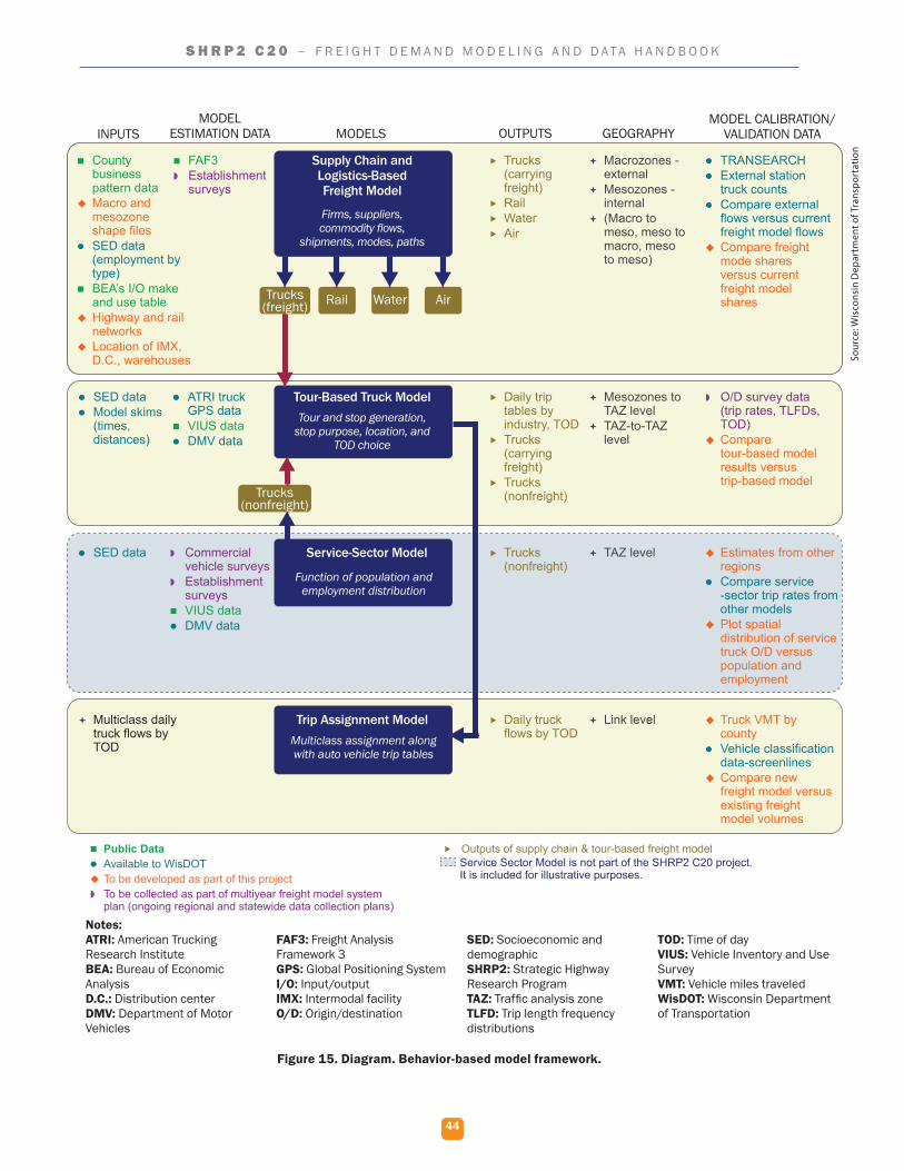
44
S H R P 2 C 2 0 – F R E I G H T D E M A N D M O D E L I N G A N D D A T A H A N D B O O K
Figure 15. Diagram. Behavior-based model framework.
INPUTSMODEL
ESTIMATION DATA MODELS
Supply Chain and Logistics-Based Freight Model
Tour-Based Truck Model
Firms, suppliers, commodity flows,
shipments, modes, paths
Tour and stop generation, stop purpose, location, and
TOD choice
Service-Sector Model
Function of population and employment distribution
OUTPUTS GEOGRAPHYMODEL CALIBRATION/
VALIDATION DATA
County business pattern data
Macro and mesozone shape files
SED data (employment by type)
BEA’s I/O make and use table
Highway and rail networks
Location of IMX, D.C., warehouses
SED data Model skims
(times, distances)
ATRI truck GPS data
VIUS data DMV data
Commercial vehicle surveys
Establishment surveys
VIUS data DMV data
SED data
FAF3 Establishment
surveys
Trucks (carrying freight)
Rail Water Air
Macrozones - external
Mesozones - internal
(Macro to meso, meso to macro, meso to meso)
TRANSEARCH External station
truck counts Compare external
flows versus current freight model flows
Compare freight mode shares versus current freight model shares
Daily trip tables by industry, TOD
Trucks (carrying freight)
Trucks (nonfreight)
Mesozones to TAZ level
TAZ-to-TAZ level
O/D survey data (trip rates, TLFDs, TOD)
Compare tour-based model results versus trip-based model
Trucks (nonfreight)
TAZ level Estimates from other regions
Compare service -sector trip rates from other models
Plot spatial distribution of service truck O/D versus population and employment
Trip Assignment ModelMulticlass assignment along with auto vehicle trip tables
Multiclass daily truck flows by TOD
Daily truck flows by TOD
Link level Truck VMT by county
Vehicle classification data-screenlines
Compare new freight model versus existing freight model volumes
Trucks (freight)
Trucks (nonfreight)
Rail Water Air
Public Data Available to WisDOT To be developed as part of this project To be collected as part of multiyear freight model system plan (ongoing regional and statewide data collection plans)
Outputs of supply chain & tour-based freight model Service Sector Model is not part of the SHRP2 C20 project. It is included for illustrative purposes.
Notes:ATRI: American Trucking Research InstituteBEA: Bureau of Economic AnalysisD.C.: Distribution centerDMV: Department of Motor Vehicles
FAF3: Freight Analysis Framework 3GPS: Global Positioning SystemI/O: Input/outputIMX: Intermodal facilityO/D: Origin/destination
SED: Socioeconomic and demographicSHRP2: Strategic Highway Research Program TAZ: Traffic analysis zoneTLFD: Trip length frequency distributions
TOD: Time of day VIUS: Vehicle Inventory and Use Survey VMT: Vehicle miles traveledWisDOT: Wisconsin Department of Transportation
Sour
ce: W
isco
nsin
Dep
artm
ent o
f Tra
nspo
rtat
ion
45
S H R P 2 C 2 0 – F R E I G H T D E M A N D M O D E L I N G A N D D A T A H A N D B O O K
Since WisDOT only sought to allocate firms to the county level, the supply chain model did not account for sub-county trips. In addition, the project team found that, in this implementation, the addition of a truck touring model increases daily truck trips less than 4 percent. They determined that the value added by including the truck touring model in the Wisconsin application was not worth the effort it took for the necessary origin and destination conversion from commodity type to truck trips. As such, the truck touring model was not used in the final implementation of this project.
The project team developed six scenarios to compare the proof-of-concept with the traditional freight model component:
1. Enactment of truck size and weight increase legislation.
2. Introduction of a fulfillment center.
3. Reintroduction of an intermodal rail terminal.
4. Construction of a rail-truck trans-load facility serving a large trucking company.
5. Construction of a new distribution center.
6. Abandonment of a rail line in northern Wisconsin.
The project team evaluated each scenario using the behavior-based model developed and the existing trip-based statewide model.
Lessons Learned/Transferable Lessons
As a result of this effort, the project team was able to develop an operational, behavior-based freight model and compare both the new and existing models in six real-world scenarios to determine the effectiveness of each model. Outcomes of this comparison showed WisDOT that behavior-based models excel at evaluating mode shifts given a change in transportation system intermodalism, but that these models, as currently implemented, do not provide much advantage over traditional models in evaluating changes in truck volume.
Updates to the BAA behavior-based freight model code for this project had a positive impact for other agencies that want to use the same code. The output of this project includes updated code that can be more easily passed to another agency wishing to develop and implement behavior-based freight models.
In addition to the above, the WisDOT team shared the following specific lessons, based on the process and outcomes of this project:
▪ Allow sufficient time and resources to personalize and adapt a model, even if using an off-the-shelf solution. Changes were required to both the supply chain model and the truck touring model, despite their successful use in Chicago.
▪ Benchmark new models against existing models to evaluate the benefits of making a shift. Existing models may offer superior results in specific situations.
▪ Engage the MPO and local partners throughout the model development process.
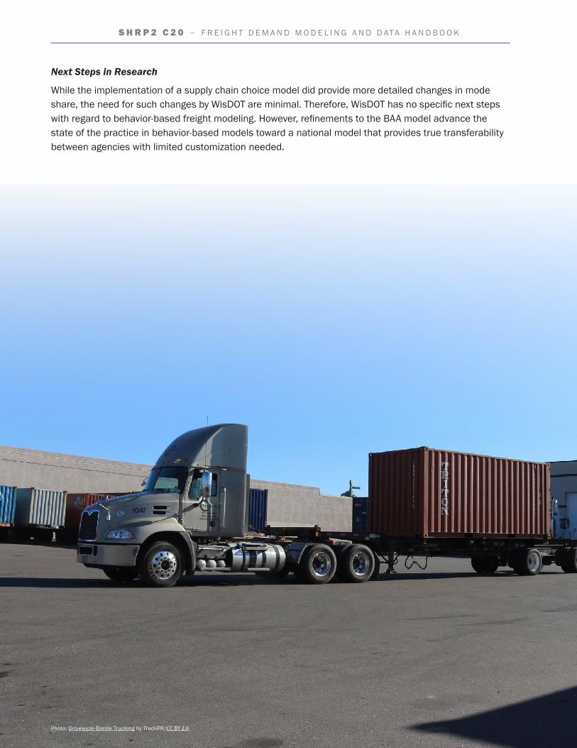
46
S H R P 2 C 2 0 – F R E I G H T D E M A N D M O D E L I N G A N D D A T A H A N D B O O K
Next Steps in Research
While the implementation of a supply chain choice model did provide more detailed changes in mode share, the need for such changes by WisDOT are minimal. Therefore, WisDOT has no specific next steps with regard to behavior-based freight modeling. However, refinements to the BAA model advance the state of the practice in behavior-based models toward a national model that provides true transferability between agencies with limited customization needed.
Photo: Drivewyze-Barole Trucking by TruckPR/CC BY 2.0.
47
S H R P 2 C 2 0 – F R E I G H T D E M A N D M O D E L I N G A N D D A T A H A N D B O O K
Chapter 4. ConclusionsAs data development and modeling continue to push forward, foundational lessons from past work should be used to inform new efforts. This chapter summarizes principles and considerations that are general and foundational, the individual issues that the projects encountered, and the specific lessons learned that can be applied to similar future efforts.
Principles and Considerations for Data and Modeling
Future projects in freight data and modeling should use the foundational principles and considerations discovered or emphasized in the 11 Implementation Assistance Program (IAP) projects. Those principles and considerations are summarized below.
▪ Developing a Regional Freight Stakeholder Group. Nearly every project in the group of seven included the establishment or use of an existing freight stakeholder groups. These groups performed many tasks, including project oversight and providing expert level input on specific issues. The early development of a freight stakeholder groups will benefit any new freight data development project. Additionally, the stakeholders will lend weight and importance to any data development effort. They will likely be influential in obtaining assistance from agencies and companies that are requested to participate in the effort in some capacity.
▪ Administering Surveys to Local Freight Producers and Consumers. Many of the data projects involved large data collection efforts that were dependent on surveys to gain input from freight-related businesses and others. Poorly designed or deployed surveys produce notoriously poor response rates. The experiences of the seven data projects contain lessons that can maximize the return on any surveys conducted and maximize the data collected.
▪ Developing New Data Sources. The data projects clearly show that developing new data sources is a time-consuming and difficult task. Freight data is often fragmented and uncoordinated. Much of it was developed for purposes other than freight analysis and so contains data standards that vary widely and may make transformation of the data into usable freight information difficult. For these reasons, choose data sources wisely. Prioritize data sources that can be most readily transformed into usable information and used for the greatest number of analyses and purposes. Keep, however, a list of alternate data sources, as well. A preferred source may turn out to be more difficult to use than originally thought, and an alternate source may be needed.
▪ Incorporating Behavior-based Modeling. Behavior-based aspects of freight decisionmaking are being incorporated into models. These improvements allow the model to more accurately portray the complex factors that are involved in decisionmaking by freight shippers and carriers.
▪ Using an Open Format Code. Models of all the projects were developed utilizing an open source programming language that is the basis used by other States and MPO’s. Use of this platform allows improvements made to the model to be available to all other modelers. They also utilized available public freight data sets along with more localized data compiled specifically for use within the model. Data sources for localized freight movement may need to be updated into the model as they become available.
48
S H R P 2 C 2 0 – F R E I G H T D E M A N D M O D E L I N G A N D D A T A H A N D B O O K
▪ Collecting Establishment Data. The collection of local establishment data can be difficult even with strong support from partners and a robust data collection outreach process. Agencies should be ready to use all available methods to collect local data because not any one method will produce enough data. Paper surveys and trip diaries, smartphone apps, vehicle monitoring data, site visits, and any other methods should all be considered for use.
▪ Developing Localized Modeling. Most projects included the development of an integrated freight model that is able to provide supporting data and information on a more refined basis. The models consider local freight movements and the ability to identify commodity types, volumes, routes, as well as, existing infrastructure issues, (e.g., congestion, conditions, safety) and project priorities within a region.
▪ Providing Training Materials. Many of the projects developed freight model guides and provided either on-site training sessions and/or written documentation to educate users in the function and maintenance of the models. This training helped to ensure the success of the model, as well as set the stage for future improvements to refine the model.
Issues and Lessons learned
Each IAP project faced its own issues, the understanding of which will be helpful to those agencies that would like to incorporate these practices in their own freight planning activities. Some of the issues, challenges, lessons learned, and benefits for each proof of concept are summarized in Table 12. Users can reference this table and ascertain the applicability of the data or model issues and benefits to their projects.
Table 12. Pilot project issues and benefits.
Agency Issues/Challenges Lessons Learned/Benefits
Capital District Transportation Committee—New York
� Majority of the datasets are confidential, requiring extensive dialog to ensure sharing.
� Each agency follows its own units of measure, aggregation methods, and variables while preparing data.
� Some databases need more time to be cleaned and processed before being released.
� Conducting outreach activities provided opportunities to build relationships with the freight community.
� It takes a long time to complete the data collection process. Identifying sources and beginning the process of acquiring the data early is important.
� Data was available to use at all levels of aggregation, including national, interstate, and zip code.
Delaware Valley Regional Planning Commission—Pennsylvania
� Some data items initially identified turned out to be either too difficult to obtain or limited in coverage.
� Personnel changes at partner organizations slowed the acquisition of some datasets.
� Due to the proprietary nature of the shipping and logistics industry, commodity flow data typically represents estimates or samples of the shipments and varies in geographic resolution.
� Obtain formal agreements with partner organizations to minimize the impacts of staff turnover and get advice on potential data/data sources and benefit from their shared experience.
� Explore alternative data sources and/or alternative data to obtain desired data.
� Having an open-source product results in the creation of new data sets, users (e.g., Travel Demand Modeling Group), and uses for the data (e.g., commodity flow studies, estimating delay impacts on revenue, costs, air quality, etc.).

49
S H R P 2 C 2 0 – F R E I G H T D E M A N D M O D E L I N G A N D D A T A H A N D B O O K
Agency Issues/Challenges Lessons Learned/Benefits
Florida Department of Transportation
� Fuel tax data was incomplete for a large portion of records.
� Acquiring data from private vendors was difficult to validate due to proprietary technology.
� Information sharing and video data was difficult to obtain.
� GPS data, driver surveys, and tax records enhanced modeling and simulation tools.
� With continued improvements, video image processing and license plate recognition are promising technologies to support data collection.
� Work to maintain the commitment of partners and stakeholders throughout the project to avoid lost investment.
Mid-America Regional Council—Missouri
� Immense data sets required sifting through hundreds of millions of records and consumed resources.
� Agencies hoping to use freight waybill data should have an understanding of the logistics industry before drawing conclusions directly from the data.
� Due to available data, congestion analysis included only congestion occurring on the NHS and did not include minor arterials and other secondary roadways.
� A comprehensive scan of other teams’ research with respect to data sources, methods of extracting and using the data, data limitations and proxy data sources, and outcomes can provide insight into potential issues when advancing the state of the knowledge or developing new methods of analysis.
� Supporting financial resources should be packaged with the research so it can be readily and easily used by practitioners.
� The level of effort needed to work with large datasets should not be underestimated.
South Dakota Department of Transportation
� Truck counts and roadway conditions for the local transportation system were not available, preventing complete understanding of local truck movement.
� Local and county road use for agricultural production was not well understood (e.g., how much production stays on the farm versus transported, timing of agricultural movements, granularity of data collection and analysis).
� Several publicly available and national agricultural data sources can be used as inputs into the transportation planning process.
� The illustrative decision support tool allows agencies to more explore “what if” scenarios using modeling estimates rather than waiting for data collection and analysis.
� Additional data regarding truck movement on the local transportation system would further enhance the new methodology.
� It is possible to combine transportation and agriculture datasets to develop a systematic approach that assists in making local transportation investment decisions.
Washington State Department of Transportation
� There were a variety of independent truck owners/operators serving many farms and relying on rural and county roads.
� It was difficult to get interviews and survey data from local businesses.
� Automated technologies could not reliably collect truck counts and trip generation data.
� Survey responses can be improved by establishing relationships with local businesses and organizations.
� Human spotters can collect truck count and trip generation metrics when automated data collection technologies are impractical.
� The project provided metrics on two major supply chains (wheat production and food delivery) enabling scenario planning under a variety of potential future conditions.
Table 12. Pilot project issues and benefits (continued).
50
S H R P 2 C 2 0 – F R E I G H T D E M A N D M O D E L I N G A N D D A T A H A N D B O O K
Agency Issues/Challenges Lessons Learned/Benefits
Winston-Salem Metropolitan Planning Organization—North Carolina
� Incomplete freight node information from initial data source needed to be supplemented with additional publicly available sources and aerial imagery.
� Freight facility information was sometimes less accurate and contained errors or omissions.
� The initial survey administration plan netted very few responses so a modified/adjusted collection process was developed to improve response rate.
� Wherever possible, pre-populate survey information.
� Administering the surveys in-person yielded the highest response rate.
� Freight facility visits can be used to identify and correct errors.
� Surveys should only include the most valuable information.
� The project resulted in improved collaboration between the public and private sector in the region for future data updates.
Maricopa Association of Governments (MAG)—Arizona
� Using the framework at a nationwide scale requires some aggregation in order to deal with computational issues. Performing analysis at a sub-area scale might require more detailed data.
� Obtaining establishment data from industry partners is often challenging. Many industry partners prefer to keep information on what is being shipped where and when proprietary to maintain their competitive edge.
� The majority of the work accomplished was not region-specific and could be replicated by other agencies with comparable data access and resources.
� Data licenses can be expensive and data restrictions may limit the ability to use the data in new or unique ways.
� The new model can provide insight into supply chain decisions, including distribution channels, models, and shipment sizes.
Maryland Department of Transportation and Baltimore Metropolitan Council
� Some data took longer than expected to obtain and assimilate into the model. Resolving various data issues (e.g., missing data, various granularity of data) in bringing together the various data sources took longer than expected.
� There was a lack of local data to use for answering specific and local questions.
� Establishment survey responses did not meet the sample size target.
� Agencies can replicate the activities completed within this project to tailor and implement a similar behavior-based freight demand model.
� Smartphone apps can be useful for data collection but may have limited participation.
� Having all the relevant information (i.e., a documented, organized set of folders of data, files, analysis outputs, and scripts) in a single location is a useful resource to accompany the model and facilitate future model updates.
Metro—Oregon
� Even with a robust data collection plan and insight from industry insiders, there was difficulty collecting freight behavior data through an establishment survey due to low participation rate from industry in the region.
� Smartphone application for data collection can provide high quality data, but there are challenges, such as potential for driver distraction.
� It was difficult to analyze non-truck freight modes.
� The new model added a more accurate depiction of trucks on the network by including a component focusing on service vehicles and will allow planners to estimate the movement of these vehicles separately from typical freight vehicles.
� The model development approach should be adapted as early as possible to the expected types of data to prevent issues with scope and schedule.
� Data collection for models of this type can be a significant effort due to the many types and sources of data; identify and include strategies for integrating data from disparate sources and in varying formats during the planning stages.
Table 12. Pilot project issues and benefits (continued).
51
S H R P 2 C 2 0 – F R E I G H T D E M A N D M O D E L I N G A N D D A T A H A N D B O O K
Agency Issues/Challenges Lessons Learned/Benefits
Wisconsin Department of Transportation
� The model took longer than expected to adapt to Wisconsin.
� Even off-the-shelf model solutions require significant time to customize for the region.
� New models can and should be benchmarked against existing models and techniques to evaluate their effectiveness.
Table 12. Pilot project issues and benefits (continued).
Source: Thinkstock
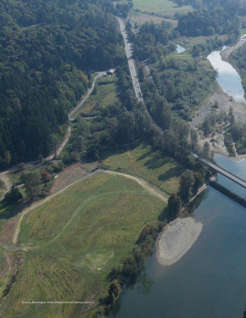
Source: Washington State Department of Transportation
54
S H R P 2 C 2 0 – F R E I G H T D E M A N D M O D E L I N G A N D D A T A H A N D B O O K
S T R AT E G I C H I G H WAY R E S E A R C H P R O G R A MU.S. Department of Transportation Federal Highway Administration
American Association of State Highway and Transportation Officials – Transportation Research Board
For More InformationJeffrey PurdyFHWA – Office of Freight Management and OperationsPhone: 202-366-6993E-mail: [email protected]
The second Strategic Highway Research Program (SHRP2) is a partnership of the Federal Highway Administration (FHWA), the American Association of State Highway and Transportation Officials (AASHTO), and the Transportation Research Board (TRB). TRB completed the research, and now FHWA and AASHTO are jointly implementing the resulting SHRP2 Solutions that will help the transportation community enhance productivity, boost efficiency, increase safety, and improve the reliability of the Nation’s highway system.
FHWA-HOP-18-018
December 2017
Learn more about the SHRP2 program, its Capacity focus area, and Freight Demand Modeling and Data Improvement (C20) products at www.fhwa.dot.gov/GoSHRP2/