handover of geotechnical as- built data · 2019-07-05 · handover of geotechnical as-built data...
TRANSCRIPT
Handover of Geotechnical As-Built Data
Guidance Document
October 2017
Highways England

377247 001 3 http://pims01/pims/llisapi.dll?func=ll&objaction=overview&objid=2117317465 Mott MacDonald
Mott MacDonald 10 Temple Back Bristol BS1 6FL United Kingdom T +44 (0)117 906 9500
mottmac.com
Highways England Handover of Geotechnical As-
Built Data
Guidance Document
October 2017
Mott MacDonald Limited. Registered in England and Wales no. 1243967. Registered office: Mott MacDonald House, 8-10 Sydenham Road, Croydon CR0 2EE, United Kingdom
Highways England

Mott MacDonald | Handover of Geotechnical As-Built Data Guidance Document
377247 | 001 | 3 | October 2017 Handover of Geotechnical As-Built Data – Guidance Document
Issue and Revision Record
Revision Date Originator Checker Approver Description
1 October 2017
T Bird C Power T Spink First Issue
2 October 2017
T Bird
C Power
T Spink T Spink Revision for issue to HE
3 October 2017
T Bird
C Power
T Spink T Spink Revision to include input from Verity Smith (Atkins) on SGM section
Document reference: 377247 | 001 | 3
Information class: Standard
This document is issued for the party which commissioned it and for specific purposes connected with the above-
captioned project only. It should not be relied upon by any other party or used for any other purpose.
We accept no responsibility for the consequences of this document being relied upon by any other party, or being
used for any other purpose, or containing any error or omission which is due to an error or omission in data supplied
to us by other parties.
This document contains confidential information and proprietary intellectual property. It should not be shown to other
parties without consent from us and from the party which commissioned it.
This report has been pr epared sol el y for use by the party which commissi oned it (the ‘Client’) i n connecti on with the capti oned proj ect. It should not be used for any other purpose. N o person other than the Client or any party who has expressl y agreed ter ms of r eliance with us ( the ‘Reci pient(s)’) may rel y on the content, i nformati on or any vi ews expressed i n the repor t. We accept no duty of care, res ponsi bility or liability to any other r eci pient of thi s document. This r eport is confi denti al and contains pr opri etar y intell ectual property.
No representati on, warranty or under taki ng, expr ess or i mplied, is made and no responsi bility or liability is accepted by us to any party other than the Cli ent or any Reci pient(s), as to the accuracy or completeness of the i nformati on contai ned i n this r eport. For the avoidance of doubt this r eport does not in any way purport to i nclude any legal , insur ance or fi nanci al advice or opi nion.
We disclai m all and any liability whether arising i n tort or contrac t or other wise which it might otherwise have to any party other than the Cli ent or the Reci pient(s), in r espect of this report , or any infor mation attri buted to i t.
We accept no r esponsibility for any error or omission i n the r eport which is due to an error or omission i n data, infor mation or statements supplied to us by other par ties incl udi ng the client (‘D ata’). We have not i ndependentl y verified such D ata and have assumed it to be accurate, complete, reli abl e and current as of the date of such infor mation.
Forecasts presented i n this document were pr epared usi ng Data and the report is dependent or based on D ata. Inevitabl y, some of the assumptions used to develop the for ecasts will not be realised and unantici pated events and circumstances may occur. C onsequentl y M ott MacDonal d does not guarant ee or warr ant the concl usi ons contained i n the repor t as there are li kel y to be differ ences between the for ecas ts and the ac tual results and those di ffer ences may be material. Whil e we consi der that the infor mation and opini ons gi ven i n this r eport are sound all parti es must rel y on their own skill and j udgement when making use of it .
Under no circumstances may this report or any extr act or summar y ther eof be used in connection wi th any public or pri vate securities offering i ncluding any rel ated memorandum or prospectus for any securities offering or stock exchange listing or announcement.
Mott MacDonald | Handover of Geotechnical As-Built Data Guidance Document
377247 | 001 | 3 | October 2017 Handover of Geotechnical As-Built Data – Guidance Document
Contents
1 Introduction 1
1.1 Purpose of the document 1
1.2 Process diagrams 1
1.3 Roles and responsibilities 2
1.4 Preparatory tasks 2
1.4.1 Determination of Delivery Partner role 3
1.4.2 Request for HAGDMS user rights 3
1.4.3 Determination of HAGDMS Area rights 3
1.5 Support and Training 4
1.6 Glossary 4
2 Set up and validation of a project in HAGDMS 5
2.1 Is the Project set up in HAGDMS? 5
2.2 Are the Project details correct? 5
2.3 Correct the Project details 6
2.4 Set up the Project in HAGDMS 6
2.5 Is the project associated with any irrelevant information? 7
2.6 Request removal of links to any irrelevant information (other than Reports) 7
2.7 Remove links to any irrelevant Reports 7
2.8 Does the Project include all of the existing available Reports? 8
2.9 Is all the available GI factual data uploaded to HAGDMS in AGS format? 8
2.10 Is the AGS data available? 8
2.11 Upload AGS data to HAGDMS 8
2.12 Are the unattached, relevant Reports uploaded to HAGDMS 9
2.13 Create the Report record on HAGDMS 9
2.14 Are the reports available in electronic format? 9
2.15 Prepare electronic format copy of Report for upload to HAGDMS 9
2.16 Scan the paper format copy of the Report 10
2.17 Attach the Report to the Project 10
2.18 Project set up and validated in HAGDMS 10
3 Completion and validation of feedback and as-built documentation 11
3.1 Update HAGDMS Project Details 11
3.2 Complete Geotechnical Feedback Report (GFR) in accordance with HD22 11
3.3 Complete As-Built Drawings 11
3.4 Prepare drawing set for upload and submit to HAGDMS support 12
3.5 Upload any additional created AGS data to the Report 13
3.6 Produce packaged report file for upload to HAGDMS 13
3.7 Upload signed Geotechnical Certificate 13
Mott MacDonald | Handover of Geotechnical As-Built Data Guidance Document
377247 | 001 | 3 | October 2017 Handover of Geotechnical As-Built Data – Guidance Document
3.8 Link the uploaded Drawing Set(s) and GFR to the Project on HAGDMS 13
4 Recording of residual hazard information 15
4.1 Sources of information on ground related hazards 15
4.2 Ensure reports make clear reference to the hazards using standard terminology 15
4.3 Select applicable hazard related topics 15
4.4 Have all hazards been addressed by the scheme? 16
4.5 Recording residual hazards in GAD 16
4.6 Recording addressed hazards in GAD 17
4.7 Recording non-routine maintenance requirements 18
4.8 Provide summary of relevant residual hazard information to HE Geotechnical Advisor 18
4.9 Provide summary of relevant hazard information to relevant GMLE(s) 18
5 GAD modifications to reflect as-built situation 19
5.1 GAD Overview 19
5.1.1 Determine and agree sources of Scheme Geotechnical Asset Information 19
5.1.2 Is HAGDMS mapping available for the area of the scheme? 19
5.2 Entry of Geotechnical Asset Data where mapping exists on HAGDMS 21
5.2.1 Determine and agree approach for GAD data entry 21
5.2.2 GAD data entry (swim lanes 2 and 3). 22
5.3 Entry of Geotechnical Asset Data where mapping does not exist on HAGDMS 25
5.3.1 GAD data entry (swim lane 1) 25
5.4 Recording residual defects in Special Geotechnical Measures 28
5.5 Recording non-routine maintenance requirements 29
5.6 Summary of modified GAD data 29
5.7 Validation and approval of data on HAGDMS 30
Appendices 32
A. Process Diagrams 33
B. Special Geotechnical Measure Types 40
Mott MacDonald | Handover of Geotechnical As-Built Data Guidance Document
377247 | 001 | 3 | October 2017 Handover of Geotechnical As-Built Data – Guidance Document 1
1 Introduction
1.1 Purpose of the document
Many schemes undertaken on the Strategic Road Network (SRN) managed and operated by
Highways England (HE) result in construction of, or modification to, Geotechnical Assets.
These additions and modifications are reflected in the as-built information for a scheme. This
information will include reports produced in accordance with HD22 geotechnical certification
procedures; as-built drawings; AGS data associated with ground investigations undertaken, and
modifications to the Geotechnical Asset Database (GAD).
As the current asset management information system, the Highways Agency Geotechnical Data
Management System (HAGDMS) records the current inventory and condition of the
Geotechnical Assets of the SRN. When a scheme either adds new assets, or modifies existing
assets, there is a requirement for the as-built information on these changes to be updated within
HAGDMS. This document sets out the means by which these changes can be carried out.
This document covers:
• The preparatory steps required to facilitate the transfer of as-built information into
HAGDMS
• The process, with user guidance, for:
o ensuring that scheme details are correctly recorded
o ensuring that all relevant reports documenting the scheme development are
correctly referenced and held on HAGDMS
o ensuring that all relevant ground investigation data (in AGS format) are
correctly referenced and held on HAGDMS
o preparation and upload of the Geotechnical Feedback Report (GFR), produced
in accordance with HD22: ‘Managing Geotechnical Risk’, to HAGDMS
o preparation and upload of as-built drawings to HAGDMS
o ensuring that ground-related hazards that impacted on the scheme are correctly
recorded
o updating the information held in the Geotechnical Asset Database (GAD) of
HAGDMS to reflect the addition of new Geotechnical Assets, or the modification
of existing ones
o ensuring that any Special Geotechnical Measures (SGMs) installed as part of
the scheme are correctly recorded on HAGDMS
1.2 Process diagrams
The processes set out in this document are described in a series of flow diagrams in
Appendix A. The reference numbers on these diagrams relate to section numbers in the
document, to allow the outline process to be supported by detailed user guidance.
The process diagrams in Appendix A are as follows:
• Figure 1 Set up and validation of a project in HAGDMS
• Figure 2 Completion and validation of as-built documentation
• Figure 3 Recording of residual hazard information
• Figure 4 Overview of GAD modifications to reflect as-built situation
• Figure 5 Detail of GAD modifications to reflect as-built situation
Mott MacDonald | Handover of Geotechnical As-Built Data Guidance Document
377247 | 001 | 3 | October 2017 Handover of Geotechnical As-Built Data – Guidance Document 2
Figure 1 to Figure 4 are split into a series of “swim lanes” which relate to which role undertakes
a particular action within the process. These roles are described in Section 1.3.
Figure 5 is split into a series of “swim lanes” which relate to the different types of GAD
modifications that are required depending on the specifics of the scheme.
1.3 Roles and responsibilities
The roles that are required to complete the as-built data handback process are set out in
Table 1 below. Contact details for the named roles can be found through Contacts functionality
of HAGDMS.
Table 1: Roles and responsibilities in the as-built data handback process
Role Name Role Description Responsibilities
Delivery Partner Named individual(s) within the organisation that delivered the scheme for HE or within the Provider organisation1 for the HE Maintenance Area within which the scheme lies
This role carries out the majority of the as-built data handback tasks
Geotechnical Maintenance Liaison Engineer (GMLE)2
Named individual within the Provider organisation for the HE Maintenance Area within which the scheme lies
Agreeing the specifics of how user/Area rights will be applied in the process
Approval of geotechnical asset data associated with the HE Maintenance Area including data passed to them as part of the handback process.
HAGDMS Support Technical support team for the HAGDMS
Technical and engineering support to the as-build data handback process
Highways England Administrator HAGDMS administrator for Highways England
Modification of project details on HAGDMS
Highways England Geotechnical Advisor (GA)3
HE Geotechnical Advisor for the HE Maintenance Area within which the scheme lies.
Confirmation of availability of documents relating to the scheme
Overview of geotechnical elements of the handback process
Highways England Project Sponsor
HE Project Sponsor for the scheme
Overview of the as-built data handback process
Notes
1 The Provider may be a Maintenance Service Provider (MSP) under an Asset Support Contract (ASC) or the Asset
Delivery Team under an Asset Delivery (AD) contract.
2 The Geotechnical Maintenance Liaison Engineering (GMLE) is the role as defined within HD41/15: Maintenance of
Highway Geotechnical Assets, responsible for operational management activities within the Provider organisation.
3 The Highways England Geotechnical Advisor (GA) is the role as defined within HD41/15: Maintenance of Highway
Geotechnical Assets, responsible for overview of the asset performance and agreement of management strategy and
plans.
1.4 Preparatory tasks
Prior to commencement of the as-built data handback process set out in this document, a series
of preparatory tasks must be completed, as set out below.
Mott MacDonald | Handover of Geotechnical As-Built Data Guidance Document
377247 | 001 | 3 | October 2017 Handover of Geotechnical As-Built Data – Guidance Document 3
1.4.1 Determination of Delivery Partner role
As described in Table 1, the Delivery Partner role carries out the majority of the as-built data
handback tasks. It is highly recommended that this role is undertaken by the organisation that
was responsible for the construction of the scheme (either acting as the contractor or the
designer) and hence prepared the as-built information for the completed scheme. However, the
HE Asset Data Management Manual (ADMM), does allow for this role to be undertaken by the
Provider organisation for the HE Maintenance Area within which the scheme lies. In such
cases, close liaison between the Delivery Partner and the Provider will be of critical importance.
Prior to the commencement of the as-built data handback process the Delivery Partner role
must be determined between the parties to the scheme, and agreed with the HE Geotechnical
Advisor and Project Sponsor for the scheme. This may be as defined within the contract for the
scheme.
1.4.2 Request for HAGDMS user rights
Once the Delivery Partner role has been agreed, a named individual (or individuals) must be set
up with appropriate user rights in HAGDMS. Even if the individual(s) are already HAGDMS
users, they may not have the appropriate rights required to carry out the Delivery Partner tasks.
A request for appropriate access should be made to the HAGDMS Support Team
([email protected]). This request should state that access is required for an as-built data
handback task and should state the name of the HE Geotechnical Adviser for the scheme.
1.4.3 Determination of HAGDMS Area rights
As will be described in Section 5, the majority of tasks within the as-built data handback process
relate to the Geotechnical Asset Database of HAGDMS. This section of the system operates
around an Area-based security model, such that named users can only edit data for the HE
Maintenance Area within which they work, under either an ASC or AD operating model.
In order for the Delivery Partner to undertake the GAD related tasks within their role, they must
have edit level rights to the Area within which the scheme sits. This can be achieved in one of
two ways:
1. The Delivery Partner is given access to the actual HE Maintenance Area within which the
scheme sits. This method is simplest, but does mean that it will be theoretically possible for
the Delivery Partner to edit any GAD data in that Area (including for locations outside of the
scheme extents). A level of trust is required between the Delivery Partner and the GMLE for
the HE Maintenance Area for this method to be used. The HAGDMS Support Team must
have confirmation from the GMLE that a Delivery Partner can be given access rights for
this method before it can progress
2. The Geotechnical Assets of the scheme area can be moved to a temporary HE Maintenance
Area for the period of the as-built data handback activities. On completion of the tasks, the
assets can be moved back into the HE Maintenance Area in which they geographically sit.
This method is considerably more involved that method 1, and should not be used as a
preference.
The methodology to be used should be agreed with Highways England and the Provider’s
GMLE. Transfer of earthwork data to and from a temporary Area and provision of necessary
user rights can be arranged by the HAGDMS support team on the basis of the agreed
methodology.

Mott MacDonald | Handover of Geotechnical As-Built Data Guidance Document
377247 | 001 | 3 | October 2017 Handover of Geotechnical As-Built Data – Guidance Document 4
Should the Delivery Partner or the GMLE for the Area in which the scheme sits wish to discuss
further the methods outlined above, prior to making a decision on how to proceed, the HAGDMS
Support Team would be very happy to provide assistance.
1.5 Support and Training
Technical support for HAGDMS is available from: [email protected]
Specific engineering support for the as-built data handback process is also available through
the HAGDMS support team. Training in the processes detailed in this document can be
provided on application. All requests for support must come via the HAGDMS support team, to
ensure they can be dealt with effectively.
1.6 Glossary
AD Asset Delivery
ADMM Asset Data Management Manual
AGS Format Non-proprietary electronic data transfer format for ground
investigation data, developed and supported by the Association of
Geotechnical and Geo-environmental Specialists
ASC Asset Support Contract
GA Geotechnical Advisory
GAD Geotechnical Asset Database
Geotechnical asset The man-made or natural earthworks below the road pavement
layers and the adjacent land beside the road
GFR Geotechnical Feedback Report, a requirement of the HD22/08
standard (Managing Geotechnical Risk, DMRB 4.1.2)
GMLE Geotechnical Maintenance Liaison Engineer
HAGDMS Highways Agency Geotechnical Data Management System, the
asset management information system for Geotechnical Asset
information currently utilised by Highways England
Project Construct within HAGDMS for the storage of information relating to a
particular geotechnical scheme.
Provider Organisation undertaking the role as either the Maintenance Service
Provider under the ASC operating model or Asset Delivery Team
under the Asset Delivery operating model.
SGM Special Geotechnical Measure. Measure taken to improve the
resilience to geotechnical failure relative to that of a conventional
geotechnical asset and/or mitigate a known geotechnical hazard
SRN Strategic Road Network
Mott MacDonald | Handover of Geotechnical As-Built Data Guidance Document
377247 | 001 | 3 | October 2017 Handover of Geotechnical As-Built Data – Guidance Document 5
2 Set up and validation of a project in
HAGDMS
This section describes the process of setting up and/or verifying the setup of a project on
HAGDMS and association of relevant documents and other data. It should be read in
conjunction with Figure 1 in Appendix A. A project is an HAGDMS construct for the storage of
information relating to a particular geotechnical scheme.
2.1 Is the Project set up in HAGDMS?
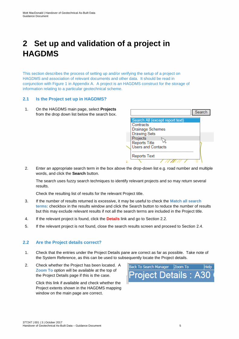
1. On the HAGDMS main page, select Projects
from the drop down list below the search box.
2. Enter an appropriate search term in the box above the drop-down list e.g. road number and multiple
words, and click the Search button.
The search uses fuzzy search techniques to identify relevant projects and so may return several
results.
Check the resulting list of results for the relevant Project title.
3. If the number of results returned is excessive, it may be useful to check the Match all search
terms: checkbox in the results window and click the Search button to reduce the number of results
but this may exclude relevant results if not all the search terms are included in the Project title.
4. If the relevant project is found, click the Details link and go to Section 2.2.
5. If the relevant project is not found, close the search results screen and proceed to Section 2.4.
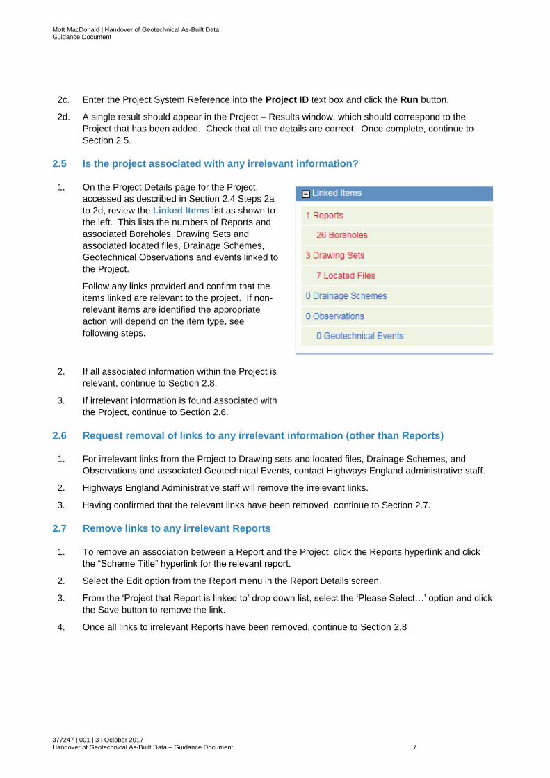
2.2 Are the Project details correct?
1. Check that the entries under the Project Details pane are correct as far as possible. Take note of
the System Reference, as this can be used to subsequently locate the Project details.
2. Check whether the Project has been located. A
Zoom To option will be available at the top of
the Project Details page if this is the case.
Click this link if available and check whether the
Project extents shown in the HAGDMS mapping
window on the main page are correct.

Mott MacDonald | Handover of Geotechnical As-Built Data Guidance Document
377247 | 001 | 3 | October 2017 Handover of Geotechnical As-Built Data – Guidance Document 6
3. If the Project details are correct, and the Project is located with the correct extents, return to the
Project Details window and proceed to Section 2.5
4. If the Project Details are incorrect, the Project is not located or the Project extents are incorrect, go
to Section 2.3.
2.3 Correct the Project details
1. If the Project Details are incorrect, the Project is not located or the Project extents are incorrect,
provide any relevant details to the HAGDMS Support team at [email protected] with the
relevant details including the System Reference of the Project.
2. Continue to Section 2.5.
2.4 Set up the Project in HAGDMS
1. Provide the following details, where known to Highways England administrative staff via the Project
Sponsor for them to set up the Project:
● Delivery Partner’s Project Reference
● Project Title including road number where relevant
● Highways Engand PIN
● Project Type, one of:
– Dualling Scheme
– Highway Improvement Scheme
– Local Network Management Scheme
– New Structure Scheme
– Pilot Scheme
– Section 278 Agreement Scheme
– Smart Motorways
– Structure Replacement Scheme
● Area/DBFO/Region
● Client’s Representative
● Contractor
● Contractor’s Designer
● Start date
● Planned finish date
● Actual finish date (if known)
● Any relevant keywords that could help someone searching for the project (for example ‘rock reinforcement’ or ‘widened embankment’)
● Any general remarks relating to the scheme
● Geographical extents of the Project as OS grid references defining a rectangle bounding the Project area. These should be pairs of OS grid eastings and northings that define the South West and North East corners of the project area.
2. Obtain the HAGDMS Project System Reference from Highways England following creation of the
Project and confirm that the details have been entered correctly. The details can be checked as
follows:
2a. Select the Projects > Search option from the HAGDMS main page.
2b. Click the Projects link.
Mott MacDonald | Handover of Geotechnical As-Built Data Guidance Document
377247 | 001 | 3 | October 2017 Handover of Geotechnical As-Built Data – Guidance Document 7
2c. Enter the Project System Reference into the Project ID text box and click the Run button.
2d. A single result should appear in the Project – Results window, which should correspond to the
Project that has been added. Check that all the details are correct. Once complete, continue to
Section 2.5.
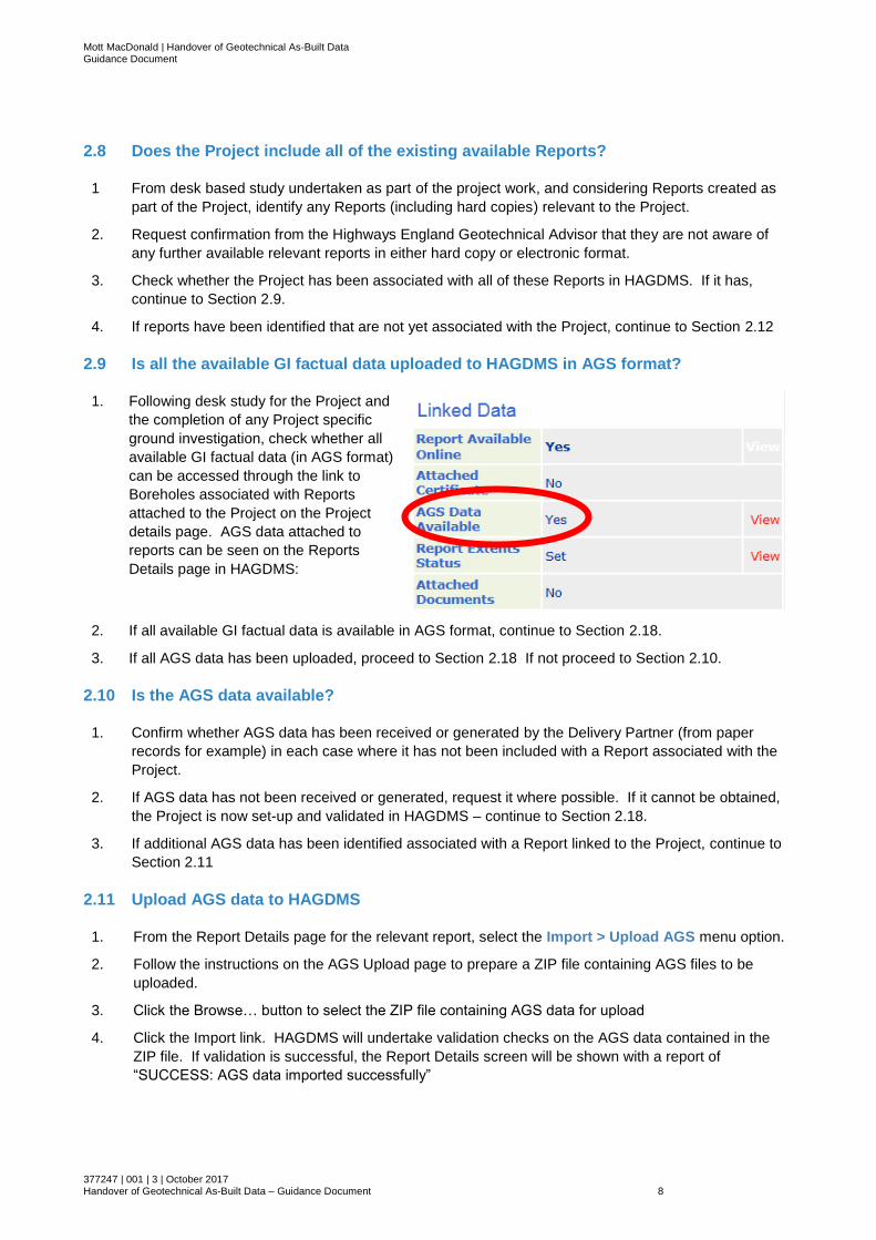
2.5 Is the project associated with any irrelevant information?
1. On the Project Details page for the Project,
accessed as described in Section 2.4 Steps 2a
to 2d, review the Linked Items list as shown to
the left. This lists the numbers of Reports and
associated Boreholes, Drawing Sets and
associated located files, Drainage Schemes,
Geotechnical Observations and events linked to
the Project.
Follow any links provided and confirm that the
items linked are relevant to the project. If non-
relevant items are identified the appropriate
action will depend on the item type, see
following steps.
2. If all associated information within the Project is
relevant, continue to Section 2.8.
3. If irrelevant information is found associated with
the Project, continue to Section 2.6.
2.6 Request removal of links to any irrelevant information (other than Reports)
1. For irrelevant links from the Project to Drawing sets and located files, Drainage Schemes, and
Observations and associated Geotechnical Events, contact Highways England administrative staff.
2. Highways England Administrative staff will remove the irrelevant links.
3. Having confirmed that the relevant links have been removed, continue to Section 2.7.
2.7 Remove links to any irrelevant Reports
1. To remove an association between a Report and the Project, click the Reports hyperlink and click
the “Scheme Title” hyperlink for the relevant report.
2. Select the Edit option from the Report menu in the Report Details screen.
3. From the ‘Project that Report is linked to’ drop down list, select the ‘Please Select…’ option and click
the Save button to remove the link.
4. Once all links to irrelevant Reports have been removed, continue to Section 2.8
Mott MacDonald | Handover of Geotechnical As-Built Data Guidance Document
377247 | 001 | 3 | October 2017 Handover of Geotechnical As-Built Data – Guidance Document 8
2.8 Does the Project include all of the existing available Reports?
1 From desk based study undertaken as part of the project work, and considering Reports created as
part of the Project, identify any Reports (including hard copies) relevant to the Project.
2. Request confirmation from the Highways England Geotechnical Advisor that they are not aware of
any further available relevant reports in either hard copy or electronic format.
3. Check whether the Project has been associated with all of these Reports in HAGDMS. If it has,
continue to Section 2.9.
4. If reports have been identified that are not yet associated with the Project, continue to Section 2.12
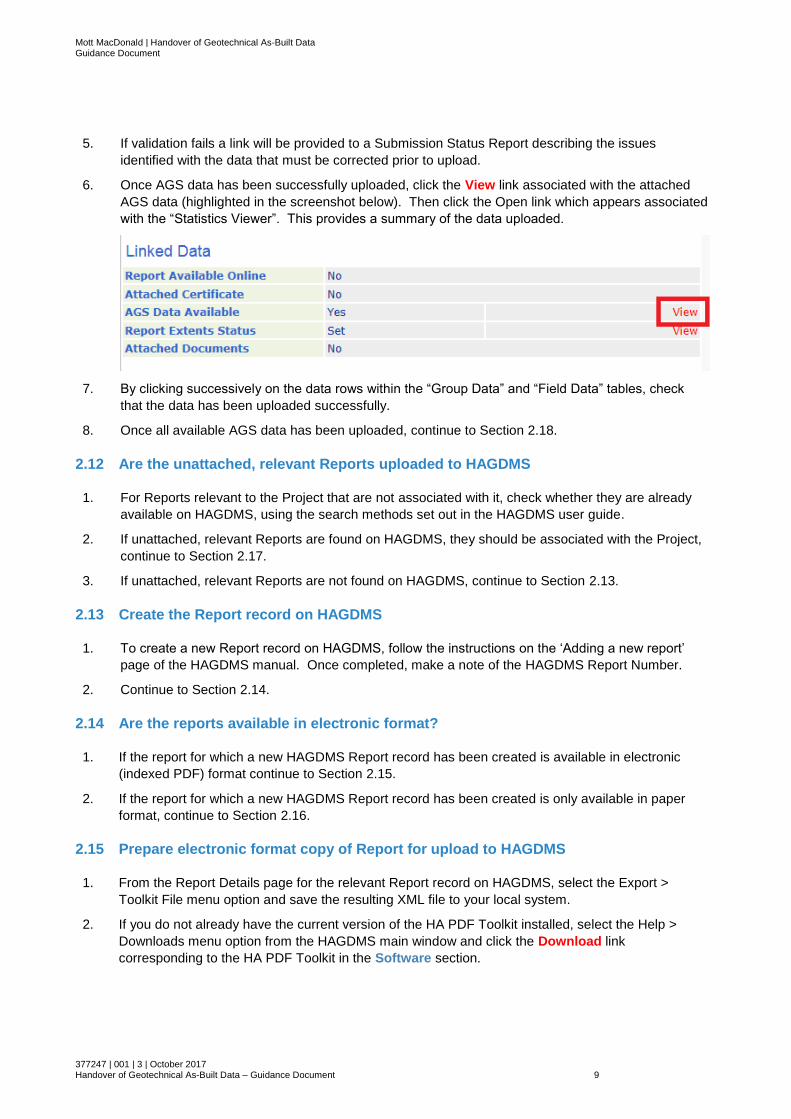
2.9 Is all the available GI factual data uploaded to HAGDMS in AGS format?
1. Following desk study for the Project and
the completion of any Project specific
ground investigation, check whether all
available GI factual data (in AGS format)
can be accessed through the link to
Boreholes associated with Reports
attached to the Project on the Project
details page. AGS data attached to
reports can be seen on the Reports
Details page in HAGDMS:
2. If all available GI factual data is available in AGS format, continue to Section 2.18.
3. If all AGS data has been uploaded, proceed to Section 2.18 If not proceed to Section 2.10.
2.10 Is the AGS data available?
1. Confirm whether AGS data has been received or generated by the Delivery Partner (from paper
records for example) in each case where it has not been included with a Report associated with the
Project.
2. If AGS data has not been received or generated, request it where possible. If it cannot be obtained,
the Project is now set-up and validated in HAGDMS – continue to Section 2.18.
3. If additional AGS data has been identified associated with a Report linked to the Project, continue to
Section 2.11
2.11 Upload AGS data to HAGDMS
1. From the Report Details page for the relevant report, select the Import > Upload AGS menu option.
2. Follow the instructions on the AGS Upload page to prepare a ZIP file containing AGS files to be
uploaded.
3. Click the Browse… button to select the ZIP file containing AGS data for upload
4. Click the Import link. HAGDMS will undertake validation checks on the AGS data contained in the
ZIP file. If validation is successful, the Report Details screen will be shown with a report of
“SUCCESS: AGS data imported successfully”
Mott MacDonald | Handover of Geotechnical As-Built Data Guidance Document
377247 | 001 | 3 | October 2017 Handover of Geotechnical As-Built Data – Guidance Document 9
5. If validation fails a link will be provided to a Submission Status Report describing the issues
identified with the data that must be corrected prior to upload.
6. Once AGS data has been successfully uploaded, click the View link associated with the attached
AGS data (highlighted in the screenshot below). Then click the Open link which appears associated
with the “Statistics Viewer”. This provides a summary of the data uploaded.
7. By clicking successively on the data rows within the “Group Data” and “Field Data” tables, check
that the data has been uploaded successfully.
8. Once all available AGS data has been uploaded, continue to Section 2.18.
2.12 Are the unattached, relevant Reports uploaded to HAGDMS
1. For Reports relevant to the Project that are not associated with it, check whether they are already
available on HAGDMS, using the search methods set out in the HAGDMS user guide.
2. If unattached, relevant Reports are found on HAGDMS, they should be associated with the Project,
continue to Section 2.17.
3. If unattached, relevant Reports are not found on HAGDMS, continue to Section 2.13.
2.13 Create the Report record on HAGDMS
1. To create a new Report record on HAGDMS, follow the instructions on the ‘Adding a new report’
page of the HAGDMS manual. Once completed, make a note of the HAGDMS Report Number.
2. Continue to Section 2.14.
2.14 Are the reports available in electronic format?
1. If the report for which a new HAGDMS Report record has been created is available in electronic
(indexed PDF) format continue to Section 2.15.
2. If the report for which a new HAGDMS Report record has been created is only available in paper
format, continue to Section 2.16.
2.15 Prepare electronic format copy of Report for upload to HAGDMS
1. From the Report Details page for the relevant Report record on HAGDMS, select the Export >
Toolkit File menu option and save the resulting XML file to your local system.
2. If you do not already have the current version of the HA PDF Toolkit installed, select the Help >
Downloads menu option from the HAGDMS main window and click the Download link
corresponding to the HA PDF Toolkit in the Software section.
Mott MacDonald | Handover of Geotechnical As-Built Data Guidance Document
377247 | 001 | 3 | October 2017 Handover of Geotechnical As-Built Data – Guidance Document 10
3. Install the HA PDF Toolkit and Follow the instructions in its user manual to create a report package
file
4. Issue the Report package file to the Highways England administrative staff who will upload it to
HAGDMS.
5. Once the upload is complete, continue to Section 2.17.
2.16 Scan the paper format copy of the Report
1. If a paper format copy of the report is available, provide a copy to the HE administration team for
scanning. Then once the scanned file has been received, proceed to Section 2.15.
2.17 Attach the Report to the Project
1. The created Report can now be attached to the project. Follow the instructions under ‘Method A’ on
the ‘Linking data to a Project’ page of the HAGDMS help manual to link the Report to the Project.
2. Continue to Section 2.9.
2.18 Project set up and validated in HAGDMS
1. The Project is now set up and validated in HAGDMS.
2. Continue to Section 3.
Mott MacDonald | Handover of Geotechnical As-Built Data Guidance Document
377247 | 001 | 3 | October 2017 Handover of Geotechnical As-Built Data – Guidance Document 11
3 Completion and validation of feedback
and as-built documentation
This section describes the completion and upload to HAGDMS of feedback and as-built
information, including the Geotechnical Feedback Report and as-built drawings. It should be
read in conjunction with Figure 2 in Appendix A.
3.1 Update HAGDMS Project Details
1. Provide relevant details for the updating of the Project Details page, accessed as described in
Section 2.4, to the HAGDMS Support team at [email protected] including the System
Reference of the Project.
Full details should be available at this stage including the majority of those listed in Section 2.4 Step
1 including updated location details where appropriate.
2. The HAGDMS Support team will update the project details as instructed. These should be checked
and any errors notified back to the HAGDMS Support team for correction if required.
3. Once the Project Details are correctly updated, continue to Section 3.2.
3.2 Complete Geotechnical Feedback Report (GFR) in accordance with HD22
1. Prepare a Geotechnical Feedback Report in accordance with the requirements of HD22 ‘Managing
Geotechnical Risk’.
2. As described in Section 2.13, create a Report record corresponding to the Geotechnical Feedback
Report on HAGDMS. Include the generated HAGDMS Report Number clearly in the Geotechnical
Feedback report if possible (may not be applicable if the GFR has already been completed, and the
process is being applied retrospectively).
3. From the Report Details page, select the Certificate > Generate option from the menu to download
the Geotechnical Certificate for submission with the report to Highways England.
4. Issue the Geotechnical Feedback Report and Geotechnical Certificate to the Highways England
Geotechnical Adviser for the Project.
5. The Highways England Geotechnical Adviser will review the Geotechnical Feedback Report and
respond in accordance with HD22.
6. On receipt of a countersigned Geotechnical Certificate following the HD22 review process, continue
to Section 3.3.
3.3 Complete As-Built Drawings
1. Produce as-built drawings in accordance with the contract requirements and create PDF copies for inclusion with the Geotechnical Feedback Report.
2. Continue to Section 3.4.

Mott MacDonald | Handover of Geotechnical As-Built Data Guidance Document
377247 | 001 | 3 | October 2017 Handover of Geotechnical As-Built Data – Guidance Document 12
3.4 Prepare drawing set for upload and submit to HAGDMS support
1. Geotechnical and drainage related drawing sets are prepared and submitted following
the process in ‘Appendix E – HADDMS Drawing Records Specification’ of the Drainage
Data Formats guidance. This can be is downloaded from the ‘HADDMS – Drainage
Records Specification’ section of the HAGDMS Downloads page, accessed from the
Help > Downloads menu option from the HAGDMS main screen. All references to
HADDMS and the drainage asset within the guidance are equally relevant to HAGDMS
and the geotechnical asset.
The guidance should be read in conjunction with the ‘Index Spreadsheet for Located &
Georeferenced files’, also available from the HAGDMS Downloads page. Key points
are as follows:
• All relevant geotechnical drawing records are to be compiled, indexed, and
submitted in the structure and format described in the specification.
• It is expected that all relevant as built drawings will be available in native
electronic format and can be exported directly to PDF, so that scanning will not
be required.
• Drawings are structured as a series of File Sets within a Drawing Set. It is
anticipated that a single Drawing Set will be used for drawings related to a
given scheme.
• A Drawing Set Index and File Set Index must be included with each Drawing
Set and File Set respectively. These are to be generated using the template
available and exported in .CSV format.
• The required index data for these indices is listed in the specification it is
anticipated that:
o The Drawing Set category will be “Geotechnics”
o The Drawing Set Title will be the scheme title
o The import action will be “new”, unless drawings are submitted in
batches at different stages of the scheme.
• Drawing Set references to be used for the scheme should be agreed with the
Provider for the relevant Maintenance Area to ensure that they do not conflict
with any other planned uploads to HADDMS
• Where Drawing Sets are being added using the “new” action, any Drawing Set
with the same Drawing Set reference will be completely overwritten. It is
therefore recommended that a search of HAGDMS is made for existing
Drawing Sets, prior to assigning a Drawing Set reference:
o Select the Search > Search Categories menu option from the
HAGDMS main screen
o Click the Drawing Sets link
o Click the link to the Drawing Sets search
o Select relevant details – for example Area, Road and Record Type and
click the ‘Run’ button.
• It is recommended that georeferenced drawings are provided as described in
Section E6 of the HADDMS Drawing Records Specification.
Mott MacDonald | Handover of Geotechnical As-Built Data Guidance Document
377247 | 001 | 3 | October 2017 Handover of Geotechnical As-Built Data – Guidance Document 13
• In any event the corresponding area covered by each drawing is defined by a
rectangle, denoted using minimum and maximum Ordnance Survey (OS)
eastings and northings in the File Index, to define the south west and north
east corners of the rectangle described in the drawing
• Georeferenced drawings must be georeferenced to OS Grid.
• If drawings cover more than one Maintenance Area or DBFO, data for each
Area or DBFO must be submitted separately. Drawing Sets should be split
between the Areas or DBFOs rather than a single Drawing Set being
submitted twice. If there is only a small overlap between Areas (<10% of the
number of drawings in the set), a single Drawing Set can be submitted
associated with the Area or DBFO that most of the drawings relate to.
Submitted data must be submitted on DVD or USB external hard disk as appropriate
and a single Drawing Set must not span multiple DVDs.
Submissions must be sent by Special Delivery or courier to the HAGDMS Support
team at the address given in the specification.
2. The HAGDMS Support team will upload the drawing set to HAGDMS.
3. Continue to Section 3.5.
3.5 Upload any additional created AGS data to the Report
1. If any AGS data has been created not already linked with another relevant Report,
upload the data as described in Section 2.11.
2. Where AGS data tables have been added to an existing AGS data file, for example by
digitising additional data, a combined AGS file comprising the full data set should be
added to the new Report for which it has been produced.
3. Continue to Section 3.6.
3.6 Produce packaged report file for upload to HAGDMS
1. Produce and submit a packaged report file for the GFR using the HAGDMS PDF
Toolkit as described in Section 2.15. Pass to the HE Admin team.
2. HE Admin team upload GFR to HAGDMS.
3. Continue to Section 3.8.
3.7 Upload signed Geotechnical Certificate
1. The signed Geotechnical Certificate prepared in Section 3.2 can now be uploaded to
the HAGDMS Report record. From the Report Details page for the GFR on HAGDMS,
select Certificate > Upload, and follow the instructions to upload the signed certificate.
2. Continue to Section 3.8
3.8 Link the uploaded Drawing Set(s) and GFR to the Project on HAGDMS
1. Once the drawing set(s) and GFR have been uploaded to HAGDMS, confirm that the
uploaded files appear as expected. If not, inform the HAGDMS Support Team.
Mott MacDonald | Handover of Geotechnical As-Built Data Guidance Document
377247 | 001 | 3 | October 2017 Handover of Geotechnical As-Built Data – Guidance Document 14
2. If the uploaded files are as expected, the GFR to the Project in accordance with
Section 2.17.
Drawing sets can be attached to the project using ‘Method B’ on the ‘Linking data to a
project’ page of the HAGDMS help manual.
3. Continue to Section 4.
Mott MacDonald | Handover of Geotechnical As-Built Data Guidance Document
377247 | 001 | 3 | October 2017 Handover of Geotechnical As-Built Data – Guidance Document 15
4 Recording of residual hazard information
This section describes the process for communication of information regarding mitigated and
residual ground related hazards encountered either during investigation or construction. It
should be read in conjunction with Figure 3 in Appendix A.
4.1 Sources of information on ground related hazards
Information on ground related hazards can come from:
● Hazards encountered during the investigation phase of a scheme, recorded in one or more
of the Ground Investigation Report (GIR), Geotechnical Design Report (GDR) or
Geotechnical Feedback Report (GFR) depending on the timing of the investigation within the
scheme development,
● Hazards encountered during construction and recorded in the Geotechnical Feedback
Report (GFR).
4.2 Ensure reports make clear reference to the hazards using standard
terminology
1. The HAGDMS topic search functionality indexes reports based on the presence of a
list of key words associated with particular topics. Of particular relevance in this case
are the geotechnical Hazard topics, which currently include:
● Compressible ground
● Dissolution features
● Groundwater flooding
● Landfill sites
● Mining (coal, non-coal and quarrying)
● Soil & groundwater chemistry
● Soil landslides
● Rock landslides, and
● Shrink swell
2. As required in HD22/08, details of any residual hazards should be included in the
Geotechnical Feedback Report in the sections relevant to the affected part of the
scheme, as well as Sections 14.0 and 15.0 as appropriate.
3. Once HAGDMS records have been created for the relevant Reports as described in
Section 3, continue to Section 4.3.
4.3 Select applicable hazard related topics
In connection with the topic search as described in Section 4.2 above, individual topics can be
indicated as being relevant to Report records. Whilst this does not currently affect the order of
results in the topic search the assessed relevance or otherwise to the selected topic is indicated
in the results. To associate a topic with a report:
Mott MacDonald | Handover of Geotechnical As-Built Data Guidance Document
377247 | 001 | 3 | October 2017 Handover of Geotechnical As-Built Data – Guidance Document 16
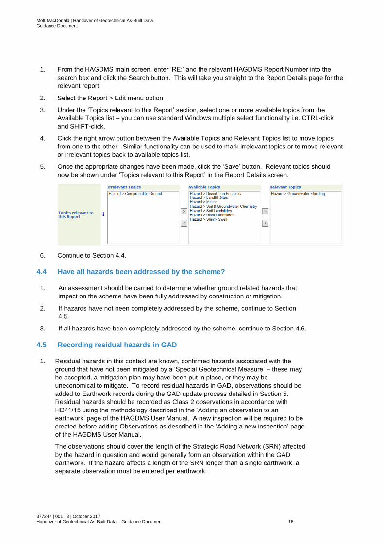
1. From the HAGDMS main screen, enter ‘RE:’ and the relevant HAGDMS Report Number into the
search box and click the Search button. This will take you straight to the Report Details page for the
relevant report.
2. Select the Report > Edit menu option
3. Under the ‘Topics relevant to this Report’ section, select one or more available topics from the
Available Topics list – you can use standard Windows multiple select functionality i.e. CTRL-click
and SHIFT-click.
4. Click the right arrow button between the Available Topics and Relevant Topics list to move topics
from one to the other. Similar functionality can be used to mark irrelevant topics or to move relevant
or irrelevant topics back to available topics list.
5. Once the appropriate changes have been made, click the ‘Save’ button. Relevant topics should
now be shown under ‘Topics relevant to this Report’ in the Report Details screen.
6. Continue to Section 4.4.
4.4 Have all hazards been addressed by the scheme?
1. An assessment should be carried to determine whether ground related hazards that
impact on the scheme have been fully addressed by construction or mitigation.
2. If hazards have not been completely addressed by the scheme, continue to Section
4.5.
3. If all hazards have been completely addressed by the scheme, continue to Section 4.6.
4.5 Recording residual hazards in GAD
1. Residual hazards in this context are known, confirmed hazards associated with the
ground that have not been mitigated by a ‘Special Geotechnical Measure’ – these may
be accepted, a mitigation plan may have been put in place, or they may be
uneconomical to mitigate. To record residual hazards in GAD, observations should be
added to Earthwork records during the GAD update process detailed in Section 5.
Residual hazards should be recorded as Class 2 observations in accordance with
HD41/15 using the methodology described in the ‘Adding an observation to an
earthwork’ page of the HAGDMS User Manual. A new inspection will be required to be
created before adding Observations as described in the ‘Adding a new inspection’ page
of the HAGDMS User Manual.
The observations should cover the length of the Strategic Road Network (SRN) affected
by the hazard in question and would generally form an observation within the GAD
earthwork. If the hazard affects a length of the SRN longer than a single earthwork, a
separate observation must be entered per earthwork.
Mott MacDonald | Handover of Geotechnical As-Built Data Guidance Document
377247 | 001 | 3 | October 2017 Handover of Geotechnical As-Built Data – Guidance Document 17
The Location Index used for the observation(s) should correspond with the definitions
given in HD41/15 and should be representative of the most critical area of the highway
estate or third-party property affected by the hazard. The Subsequent (or 5 year) Class
and Location Index are likely to be the same as those for the current condition, but if
development of a minor or major defect is expected, an appropriate selection should be
made.
A detailed description of the hazard, using the standard terminology listed in Section
4.2(1) should be included, particularly as observation descriptions are also searched by
the topic search functionality. Any relevant characteristics should also be ticked in the
GAD observation if available.
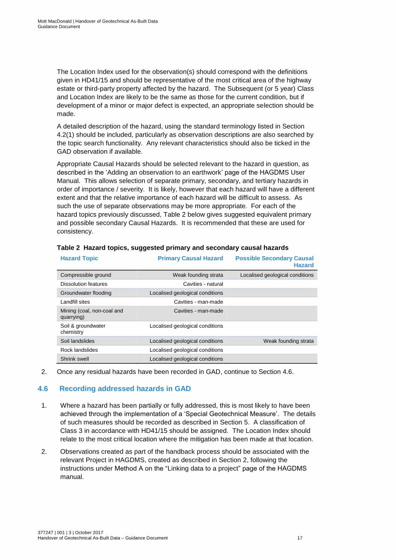
Appropriate Causal Hazards should be selected relevant to the hazard in question, as
described in the ‘Adding an observation to an earthwork’ page of the HAGDMS User
Manual. This allows selection of separate primary, secondary, and tertiary hazards in
order of importance / severity. It is likely, however that each hazard will have a different
extent and that the relative importance of each hazard will be difficult to assess. As
such the use of separate observations may be more appropriate. For each of the
hazard topics previously discussed, Table 2 below gives suggested equivalent primary
and possible secondary Causal Hazards. It is recommended that these are used for
consistency.
Table 2 Hazard topics, suggested primary and secondary causal hazards
Hazard Topic Primary Causal Hazard Possible Secondary Causal Hazard
Compressible ground Weak founding strata Localised geological conditions
Dissolution features Cavities - natural
Groundwater flooding Localised geological conditions
Landfill sites Cavities - man-made
Mining (coal, non-coal and quarrying)
Cavities - man-made
Soil & groundwater chemistry
Localised geological conditions
Soil landslides Localised geological conditions Weak founding strata
Rock landslides Localised geological conditions
Shrink swell Localised geological conditions
2. Once any residual hazards have been recorded in GAD, continue to Section 4.6.
4.6 Recording addressed hazards in GAD
1. Where a hazard has been partially or fully addressed, this is most likely to have been
achieved through the implementation of a ‘Special Geotechnical Measure’. The details
of such measures should be recorded as described in Section 5. A classification of
Class 3 in accordance with HD41/15 should be assigned. The Location Index should
relate to the most critical location where the mitigation has been made at that location.
2. Observations created as part of the handback process should be associated with the
relevant Project in HAGDMS, created as described in Section 2, following the
instructions under Method A on the “Linking data to a project” page of the HAGDMS
manual.
Mott MacDonald | Handover of Geotechnical As-Built Data Guidance Document
377247 | 001 | 3 | October 2017 Handover of Geotechnical As-Built Data – Guidance Document 18
3. Once relevant observations for addressed hazards have been entered in GAD,
continue to Section 4.7.
4.7 Recording non-routine maintenance requirements
1. Any non-routine maintenance requirements associate with the ‘Special Geotechnical
Measures’ or residual hazards should be recorded in GAD as described in Section 5.
2. Once these have been entered, continue to Section 4.8.
4.8 Provide summary of relevant residual hazard information to HE
Geotechnical Advisor
1. In order to ensure transmission of any residual hazards identified and maintenance
requirements to the Provider for the Maintenance Area, highlight any relevant
information that has been included in the GFR or on HAGDMS to the Provider such
that relevant information any asset management requirements can be included in their
Geotechnical Asset Management Plan (GeoAMP) as required by HD41/15. This could
practically be achieved by production of a table referencing sections of the
geotechnical reporting and Observations and Earthworks in GAD as appropriate.
Information to be transmitted should be issued to the HE Geotechnical Advisor.
2. Continue to Section 4.9.
4.9 Provide summary of relevant hazard information to relevant GMLE(s)
1. The HE Geotechnical Advisor should pass on the summary information on residual
hazards to the Geotechnical Maintenance Liaison Engineer (GMLE) in the HE Area
within which the scheme sits. Should a scheme span more than one Area, more than
one GMLE may need to be passed this information.
2. Outwith this data handback process, the GMLE(s) should review the relevant hazard
information provided to them by the HE Geotechnical Adviser, and incorporate hazards
as appropriate into their asset management planning, documented in the GeoAMP
(Geotechnical Asset Management Plan).
3. Continue to Section 5.

Mott MacDonald | Handover of Geotechnical As-Built Data Guidance Document
377247 | 001 | 3 | October 2017 Handover of Geotechnical As-Built Data – Guidance Document 19
5 GAD modifications to reflect as-built
situation
This section describes the update of the HAGDMS Geotechnical Asset Database (GAD) with
new asset data following completion of a scheme. Section 5.1 presents a summary of the
general process with subsequent sections providing details on the various possible methods to
be used. It should be read in conjunction with Figure 4 and Figure 5 in Appendix A.
5.1 GAD Overview
5.1.1 Determine and agree sources of Scheme Geotechnical Asset Information
1. Access to earthworks following construction, particularly in the case of online schemes,
for example Smart Motorways projects, can be difficult and carry a high level of health
and safety risk. As-built construction records, which should be accurate and
representative of the constructed assets, provide a useful source of asset data relating
to earthwork and feature locations, planted vegetation, drainage provision, earthwork
geometry and details of Special Geotechnical Measures (SGMs). Results of ground
investigation associated with the scheme, and information reported in the Geotechnical
Feedback Report regarding the sources of fill used within the scheme should allow
appropriate in situ and embankment geology codes to be confirmed.
If they have been confirmed during sign-off of the scheme, BIM models or 3D CAD
models for the scheme should allow slope angle and length data to be reliably
determined at all locations along the scheme, particularly where an earthwork is
present. Where there is uncertainty regarding data quality, or where the earthwork
assets are readily accessible, confirmation of slope angles and lengths in the field
using conventional survey techniques may be appropriate. Alternatively, and in all
cases, the use of remote sensing techniques such as LiDAR could be considered,
particularly as substantial vegetation is unlikely to have developed in the time between
construction of new assets or modifications to existing assets, improving the reliability
of interpretation of ground surface levels.
2. The source or sources of scheme geotechnical data to be used should be agreed with
the HE Geotechnical Advisor.
3. Continue to Section 5.1.2.
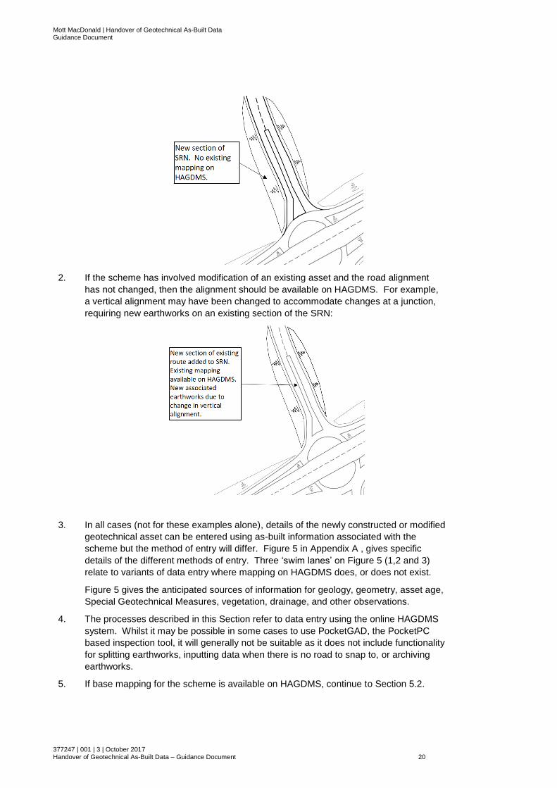
5.1.2 Is HAGDMS mapping available for the area of the scheme?
1. If the scheme has involved construction associated with a new section of road, away
from the previously existing highway network, base mapping for the new road
alignment is unlikely to be available on HAGDMS for some time. See the schematic
below for an example of this case:
Mott MacDonald | Handover of Geotechnical As-Built Data Guidance Document
377247 | 001 | 3 | October 2017 Handover of Geotechnical As-Built Data – Guidance Document 20
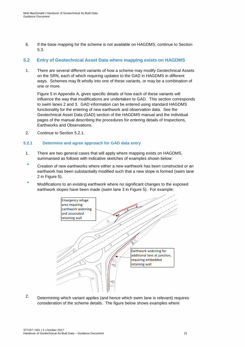
2. If the scheme has involved modification of an existing asset and the road alignment
has not changed, then the alignment should be available on HAGDMS. For example,
a vertical alignment may have been changed to accommodate changes at a junction,
requiring new earthworks on an existing section of the SRN:
3. In all cases (not for these examples alone), details of the newly constructed or modified
geotechnical asset can be entered using as-built information associated with the
scheme but the method of entry will differ. Figure 5 in Appendix A , gives specific
details of the different methods of entry. Three ‘swim lanes’ on Figure 5 (1,2 and 3)
relate to variants of data entry where mapping on HAGDMS does, or does not exist.
Figure 5 gives the anticipated sources of information for geology, geometry, asset age,
Special Geotechnical Measures, vegetation, drainage, and other observations.
4. The processes described in this Section refer to data entry using the online HAGDMS
system. Whilst it may be possible in some cases to use PocketGAD, the PocketPC
based inspection tool, it will generally not be suitable as it does not include functionality
for splitting earthworks, inputting data when there is no road to snap to, or archiving
earthworks.
5. If base mapping for the scheme is available on HAGDMS, continue to Section 5.2.
Mott MacDonald | Handover of Geotechnical As-Built Data Guidance Document
377247 | 001 | 3 | October 2017 Handover of Geotechnical As-Built Data – Guidance Document 21
6. If the base mapping for the scheme is not available on HAGDMS, continue to Section
5.3.
5.2 Entry of Geotechnical Asset Data where mapping exists on HAGDMS
1. There are several different variants of how a scheme may modify Geotechnical Assets
on the SRN, each of which requiring updates to the GAD in HAGDMS in different
ways. Schemes may fit wholly into one of these variants, or may be a combination of
one or more.
Figure 5 in Appendix A, gives specific details of how each of these variants will
influence the way that modifications are undertaken to GAD. This section corresponds
to swim lanes 2 and 3. GAD information can be entered using standard HAGDMS
functionality for the entering of new earthwork and observation data. See the
Geotechnical Asset Data (GAD) section of the HAGDMS manual and the individual
pages of the manual describing the procedures for entering details of Inspections,
Earthworks and Observations.
2. Continue to Section 5.2.1.
5.2.1 Determine and agree approach for GAD data entry
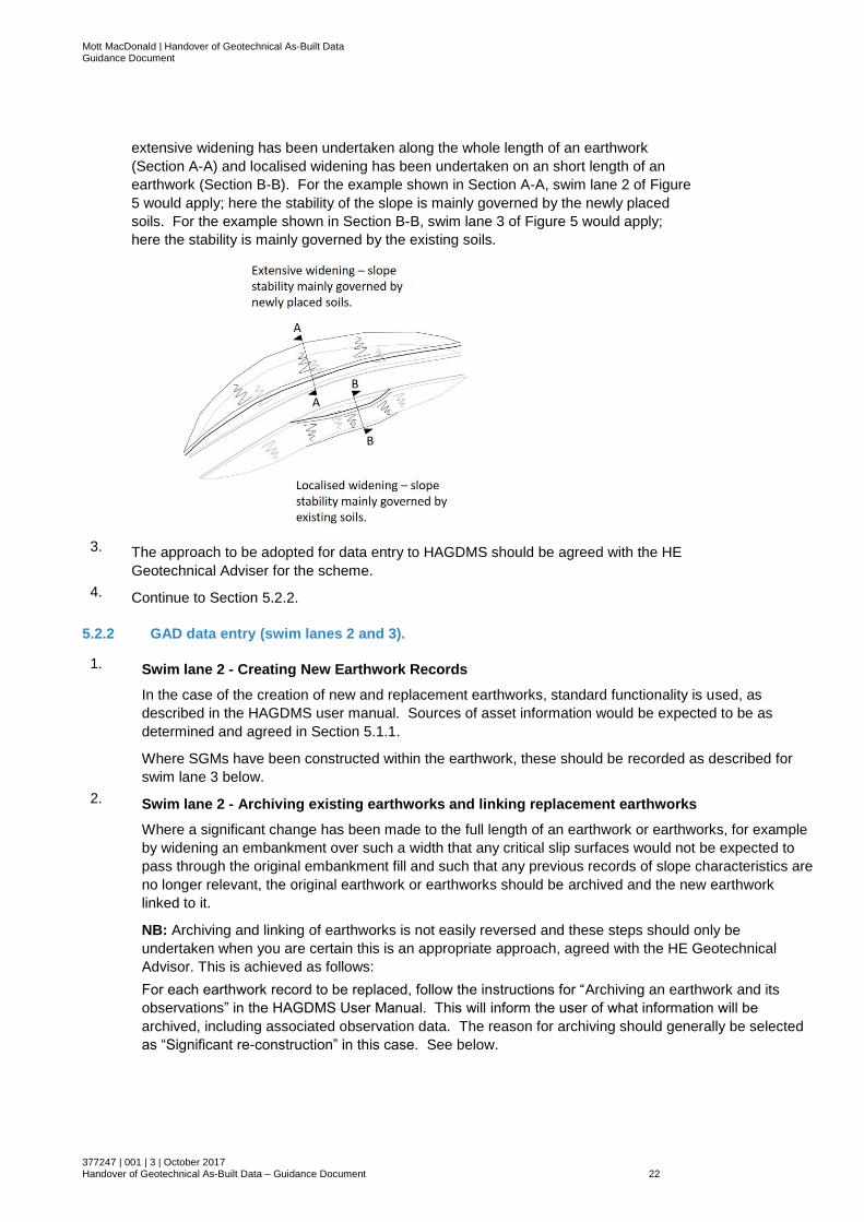
1. There are two general cases that will apply where mapping exists on HAGDMS,
summarised as follows with indicative sketches of examples shown below:
● Creation of new earthworks where either a new earthwork has been constructed or an
earthwork has been substantially modified such that a new slope is formed (swim lane
2 in Figure 5).
● Modifications to an existing earthwork where no significant changes to the exposed
earthwork slopes have been made (swim lane 3 in Figure 5). For example:
2. Determining which variant applies (and hence which swim lane is relevant) requires
consideration of the scheme details. The figure below shows examples where
Mott MacDonald | Handover of Geotechnical As-Built Data Guidance Document
377247 | 001 | 3 | October 2017 Handover of Geotechnical As-Built Data – Guidance Document 22
extensive widening has been undertaken along the whole length of an earthwork
(Section A-A) and localised widening has been undertaken on an short length of an
earthwork (Section B-B). For the example shown in Section A-A, swim lane 2 of Figure
5 would apply; here the stability of the slope is mainly governed by the newly placed
soils. For the example shown in Section B-B, swim lane 3 of Figure 5 would apply;
here the stability is mainly governed by the existing soils.
3. The approach to be adopted for data entry to HAGDMS should be agreed with the HE
Geotechnical Adviser for the scheme.
4. Continue to Section 5.2.2.
5.2.2 GAD data entry (swim lanes 2 and 3).
1. Swim lane 2 - Creating New Earthwork Records
In the case of the creation of new and replacement earthworks, standard functionality is used, as
described in the HAGDMS user manual. Sources of asset information would be expected to be as
determined and agreed in Section 5.1.1.
Where SGMs have been constructed within the earthwork, these should be recorded as described for
swim lane 3 below.
2. Swim lane 2 - Archiving existing earthworks and linking replacement earthworks
Where a significant change has been made to the full length of an earthwork or earthworks, for example
by widening an embankment over such a width that any critical slip surfaces would not be expected to
pass through the original embankment fill and such that any previous records of slope characteristics are
no longer relevant, the original earthwork or earthworks should be archived and the new earthwork
linked to it.
NB: Archiving and linking of earthworks is not easily reversed and these steps should only be
undertaken when you are certain this is an appropriate approach, agreed with the HE Geotechnical
Advisor. This is achieved as follows:
For each earthwork record to be replaced, follow the instructions for “Archiving an earthwork and its
observations” in the HAGDMS User Manual. This will inform the user of what information will be
archived, including associated observation data. The reason for archiving should generally be selected
as “Significant re-construction” in this case. See below.

Mott MacDonald | Handover of Geotechnical As-Built Data Guidance Document
377247 | 001 | 3 | October 2017 Handover of Geotechnical As-Built Data – Guidance Document 23
NB: Before archiving an earthwork which you subsequently wish to replace with a new earthwork, make
a note of the Earthwork number, in the format 1_A1_12345.
Create a new earthwork over the appropriate length as described for swim lane 2.
Follow the instructions for “Linking an earthwork to archived earthworks” in the HAGDMS User Manual to
form links between the new and original earthworks. The earthwork linkage will be shown on both the
new and archived earthworks in the “Associated Earthworks” section of the Earthwork Details page, see
below.
The archived earthwork will be designated as the “parent” earthwork and the new earthwork will be the
“child”. The reason for the association will automatically be set to “Archived earthwork replaced”.
3. Swimlane 3 – localised modification of earthworks
Where a modification is made to an earthwork with an existing record in GAD over part of its length, the
modification should be recorded as an observation associated with the earthwork. Such modifications
will generally fall within the “Special Geotechnical Measures” group of ticked characteristics on the
Observation Details screen, see below. Of note, an additional characteristic is available to be ticked
indicating a defect associated with an SGM (not expected to be the case on a newly completed
scheme). Also, a drop-down list allows the vertical extent of an SGM to be selected as either 25%, 50%,
75% or 100% of the earthwork height.
Highways England Task 594 defines a list of 72 types of SGM, each allocated a four-letter code, or quad
code. A list of categories, sub-categories, and types of SGM including their quad codes is included in
Table 3 in Appendix B. Information regarding SGM’s and other modifications should be recorded as
follows:
● Record as an unclassified observation unless a defect is present affecting the full length of the SGM or
modification. Where defects are present over part or all of the length of the modification, see the Section
below. In general it is expected that defects in modifications will have been addressed during
construction. The HE Geotechnical Advisor must be informed of any remaining defects.
● Slope geometry, as slope angle, length and bearing should be recorded at the start and end of the
modification. Additional slope sections should be included as separate observations to define any
significant changes in slope geometry along the length of the modification. The slope geometry used
should relate to the section of soil or rock slope, not including retaining structures. Where a retaining
wall or similar supports the full height of the earthwork, leaving a level verge, this may result in a zero
height point within a significant earthwork which under normal circumstances would form the end of the
earthwork (as per the rules set out in HD41/15). This rule can be ignored in this instance, and a zero
height within the earthworks extents is acceptable. Often, a small angle of slope above the retaining wall
may exist, and should be measured and recorded. The methodology for recording such sections should
Mott MacDonald | Handover of Geotechnical As-Built Data Guidance Document
377247 | 001 | 3 | October 2017 Handover of Geotechnical As-Built Data – Guidance Document 24
be agreed with the Provider for the relevant Maintenance Area, to ensure a consistent approach with
how such features are recorded elsewhere in their Area.
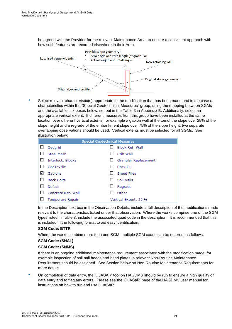
● Select relevant characteristic(s) appropriate to the modification that has been made and in the case of
characteristics within the “Special Geotechnical Measures” group, using the mapping between SGMs
and the available tick boxes below, set out in the Table 3 in Appendix B. Additionally, select an
appropriate vertical extent. If different measures from this group have been installed at the same
location over different vertical extents, for example a gabion wall at the toe of the slope over 25% of the
slope height and a regrade of the embankment slope over 75% of the slope height, two separate
overlapping observations should be used. Vertical extents must be selected for all SGMs. See
illustration below:
In the Description text box in the Observation Details, include a full description of the modifications made
relevant to the characteristics ticked under that observation. Where the works comprise one of the SGM
types listed in Table 3, include the associated quad code in the description. It is recommended that this
is included in the following format to aid easy identification:
SGM Code: BTTR
Where the works combine more than one SGM, multiple SGM codes can be entered, as follows:
SGM Code: (SNAL)
SGM Code: (SNMS)
If there is an ongoing additional maintenance requirement associated with the modification made, for
example inspection of soil nail heads and head plates, a relevant Non-Routine Maintenance
Requirement should be assigned. See Section below on Non-Routine Maintenance Requirements for
more details.
● On completion of data entry, the ‘QuASAR’ tool on HAGDMS should be run to ensure a high quality of
data entry and to flag any errors. Please see the ‘QuASaR’ page of the HAGDMS user manual for
instructions on how to run and use QuASaR.
Mott MacDonald | Handover of Geotechnical As-Built Data Guidance Document
377247 | 001 | 3 | October 2017 Handover of Geotechnical As-Built Data – Guidance Document 25
4. Once GAD data entry is complete, continue to Section 5.4
5.3 Entry of Geotechnical Asset Data where mapping does not exist on
HAGDMS
1. There are several different variants of how a scheme may modify Geotechnical Assets
on the SRN, each of which requiring updates to the GAD in HAGDMS in different
ways. Schemes may fit wholly into one of these variants, or may be a combination of
one or more.
Figure 5 in Appendix A, gives specific details of how each of these variants will
influence the way that modifications are undertaken to GAD. This section corresponds
to swim lane 1. GAD information can be entered using standard HAGDMS
functionality for the entering of new earthwork and observation data. See the
Geotechnical Asset Data (GAD) section of the HAGDMS manual and the individual
pages of the manual describing the procedures for entering details of Inspections,
Earthworks and Observations.
2. Continue to Section 5.3.1.
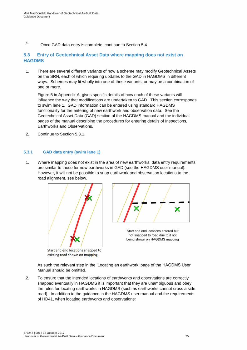
5.3.1 GAD data entry (swim lane 1)
1. Where mapping does not exist in the area of new earthworks, data entry requirements
are similar to those for new earthworks in GAD (see the HAGDMS user manual).
However, it will not be possible to snap earthwork and observation locations to the
road alignment, see below.
As such the relevant step in the ‘Locating an earthwork’ page of the HAGDMS User
Manual should be omitted.
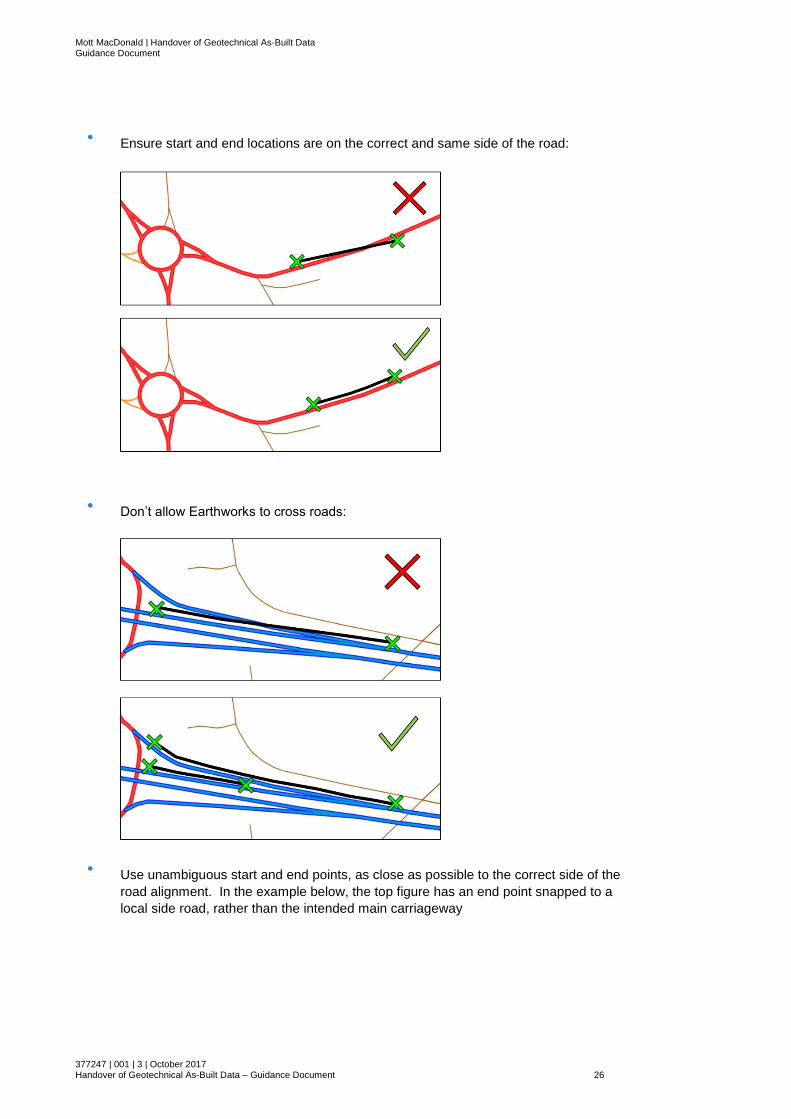
2. To ensure that the intended locations of earthworks and observations are correctly
snapped eventually in HAGDMS it is important that they are unambiguous and obey
the rules for locating earthworks in HAGDMS (such as earthworks cannot cross a side
road). In addition to the guidance in the HAGDMS user manual and the requirements
of HD41, when locating earthworks and observations:
Start and end locations entered but
not snapped to road due to it not
being shown on HAGDMS mapping
Mott MacDonald | Handover of Geotechnical As-Built Data Guidance Document
377247 | 001 | 3 | October 2017 Handover of Geotechnical As-Built Data – Guidance Document 26
● Ensure start and end locations are on the correct and same side of the road:
● Don’t allow Earthworks to cross roads:
● Use unambiguous start and end points, as close as possible to the correct side of the
road alignment. In the example below, the top figure has an end point snapped to a
local side road, rather than the intended main carriageway

Mott MacDonald | Handover of Geotechnical As-Built Data Guidance Document
377247 | 001 | 3 | October 2017 Handover of Geotechnical As-Built Data – Guidance Document 27
● Make sure Observations are located within the extents of the relevant Earthwork
3. Non-snapped earthworks can be found using standard search functionality accessed
from the GAD > Search menu option and the Earthwork Search link on the
subsequent ‘Search – GAD’ screen. Similarly, non-snapped observations can be
found using the Observations Search link from the same page. The results of these
searches include Ordnance Survey Eastings and Northings for the starts and ends of
Earthworks and Observations as well as other summary data and these should be
checked against the intended locations obtained through the methods described in
Section 5.1.1. This is particularly important as snapping of the earthworks and
observations to the mapping once available may be carried out by a third party without
knowledge of the scheme. This is expected to be the HAGDMS support team following
a data refresh.
Mott MacDonald | Handover of Geotechnical As-Built Data Guidance Document
377247 | 001 | 3 | October 2017 Handover of Geotechnical As-Built Data – Guidance Document 28
4. On completion of data entry, the ‘QuASAR’ tool on HAGDMS should be run to ensure
a high quality of data entry and to flag any errors. Please see the ‘QuASaR’ page of
the HAGDMS user manual for instructions on how to run and use QuASaR.
5. Once GAD data entry is complete, continue to Section 5.4
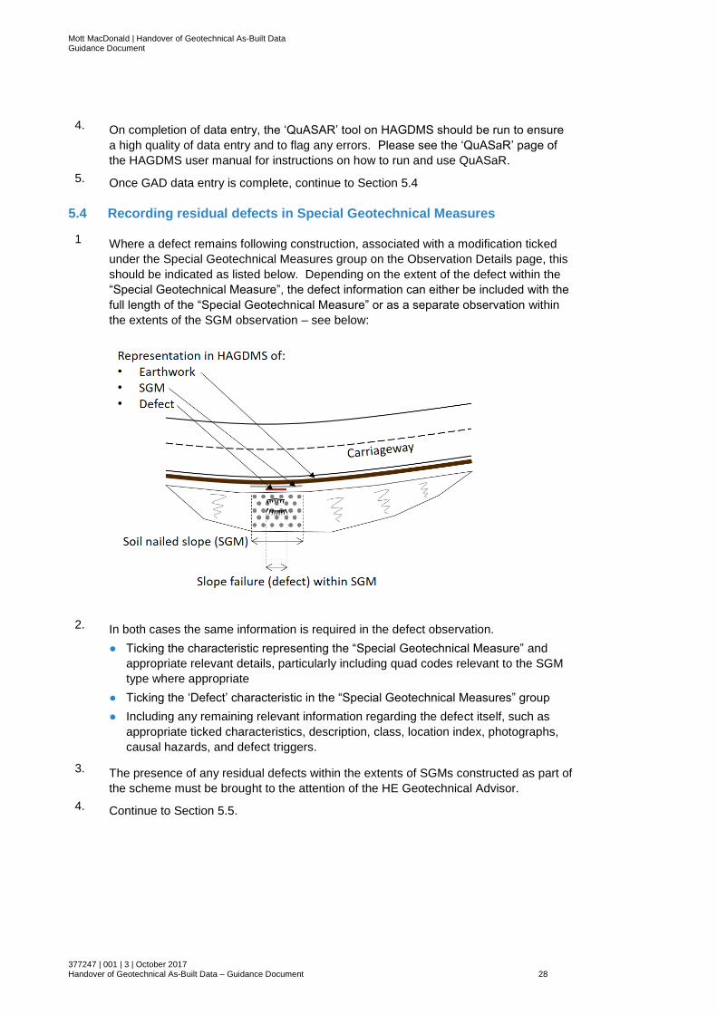
5.4 Recording residual defects in Special Geotechnical Measures
1 Where a defect remains following construction, associated with a modification ticked
under the Special Geotechnical Measures group on the Observation Details page, this
should be indicated as listed below. Depending on the extent of the defect within the
“Special Geotechnical Measure”, the defect information can either be included with the
full length of the “Special Geotechnical Measure” or as a separate observation within
the extents of the SGM observation – see below:
2. In both cases the same information is required in the defect observation.
● Ticking the characteristic representing the “Special Geotechnical Measure” and
appropriate relevant details, particularly including quad codes relevant to the SGM
type where appropriate
● Ticking the ‘Defect’ characteristic in the “Special Geotechnical Measures” group
● Including any remaining relevant information regarding the defect itself, such as
appropriate ticked characteristics, description, class, location index, photographs,
causal hazards, and defect triggers.
3. The presence of any residual defects within the extents of SGMs constructed as part of
the scheme must be brought to the attention of the HE Geotechnical Advisor.
4. Continue to Section 5.5.

Mott MacDonald | Handover of Geotechnical As-Built Data Guidance Document
377247 | 001 | 3 | October 2017 Handover of Geotechnical As-Built Data – Guidance Document 29
5.5 Recording non-routine maintenance requirements
1. Recent additions to GAD functionality allow non-routine maintenance requirements to
be assigned to observations within GAD. These are entered into the relevant section
of the Observation Details page as shown below:
2. A requirement can be selected from the drop-down list and an ‘Other’ option is
available. The details of the requirement should be entered in the relevant text box
and a frequency should be selected of between 1 and 9 weeks, months, or years from
the relevant pair of drop-down lists. It is recommended that the “to be confirmed”
checkbox is ticked as this will require the receiving GMLE approving the data to review
the requirement before approval. Attachments should be included with the observation
where relevant providing further detail, for example the locations of instruments,
required equipment and initial readings.
3. Continue to Section 5.6
5.6 Summary of modified GAD data
1. To ensure that the scope of earthwork and observation snapping required is clear and
to allow for cross-checking that all relevant information has been included, it is
recommended that tables are produced providing a summary of relevant Earthwork
and Observation details associated with the scheme. The data for these tables can be
generated by use of the Earthwork Search and Observations Search functions
available on HAGDMS. These tables should include the following:
Earthworks
● Earthwork Number
● Area/DBFO
● Road
● Principal Inspection Form reference if relevant
● Earthwork Type (Embankment / Cutting / Bund Front / Bund Back / At Grade)
● In situ Geology
● Embankment Geology
● Year of Construction
● Earthwork Length (m)
● Number of associated observations
● Presence or otherwise of ground anchors
● Presence or otherwise of rock slopes
● Start OS Easting
Mott MacDonald | Handover of Geotechnical As-Built Data Guidance Document
377247 | 001 | 3 | October 2017 Handover of Geotechnical As-Built Data – Guidance Document 30
● Start OS Northing
● End OS Easting
● End OS Northing
Observations
● Observation ID
● Associated Earthwork Number
● Area/DBFO
● Road
● Class Now
● Location Index Now
● Class 5 Year
● Location Index 5 Year
● HD41 Feature Grade (Maximum of Initial and Subsequent Feature Grade)
● Observation Length (m)
● Start OS Easting
● Start OS Northing
● End OS Easting
● End OS Northing
● Description
● Non-Routine Maintenance Requirements
2. On completion, this information should be passed to the HE Geotechnical Advisor for the scheme and the HAGDMS Support team (to inform the ‘snapping’ of GAD data to the SRN when the road based mapping has been added to HAGDMS). There will often be a time lag between data entry and availability of the updated mapping, during which time the parties to the data handback process are likely to have moved on. Hence, the snapping activity will be carried out by the HAGDMS Support Team.
3. The HE Geotechnical Advisor will pass the information to the relevant Provider GMLE.
4. Continue to Section 5.7.
5.7 Validation and approval of data on HAGDMS
1. For schemes where no mapping is available currently on HAGDMS (swim lane 1), the data will sit in HAGDMS, though not on the map, until the HAGDMS mapping is updated (following updated mapping being available from the Ordnance Survey).
2. Once mapping has been updated to include the new part of the SRN, the HAGDMS Support team will snap the previously entered GAD data to the new road.
3. Irrespective of whether GAD data has been updated via swim lanes 1, 2 or 3, prior to
approving entered GAD data, the receiving GMLE shall run the QuASaR (Quality
Assurance: Surveys and Reporting) tool in HAGDMS on the entered data.
The checks can be limited to a specific Area and Road, and to Preliminary data.
Where earthworks and observations have been snapped to the mapping, and are
visible on the HAGDMS mapping screen, they can be selected prior to running
QuASaR to limit checks to those earthworks and observations.

Mott MacDonald | Handover of Geotechnical As-Built Data Guidance Document
377247 | 001 | 3 | October 2017 Handover of Geotechnical As-Built Data – Guidance Document 31
Where data has been entered but not snapped to the mapping (swim lane 1), QuASaR
can only be run for the entire Area and the road to which the GAD data has been
assigned. In this case, any errors flags will have to be checked to ensure that they
relate to earthworks that have been entered as part of this data handback exercise.
4. This final approval completes the process for GAD modifications to reflect the as-built
situation.

Mott MacDonald | Handover of Geotechnical As-Built Data Guidance Document
377247 | 001 | 3 | October 2017 Handover of Geotechnical As-Built Data – Guidance Document 32
Appendices
A. Process Diagrams 33
B. Special Geotechnical Measure Types 40
Mott MacDonald | Handover of Geotechnical As-Built Data Guidance Document
377247 | 001 | 3 | October 2017 Handover of Geotechnical As-Built Data – Guidance Document 33
A. Process Diagrams

Mott MacDonald | Handover of Geotechnical As-Built Data Guidance Document
377247 | 001 | 3 | October 2017 Handover of Geotechnical As-Built Data – Guidance Document 34
Figure 1 Set up and validation of a project in HAGDMS
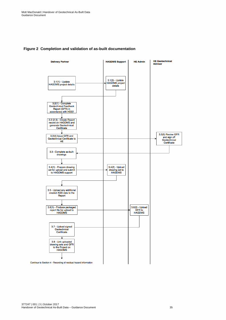
Mott MacDonald | Handover of Geotechnical As-Built Data Guidance Document
377247 | 001 | 3 | October 2017 Handover of Geotechnical As-Built Data – Guidance Document 35
Figure 2 Completion and validation of as-built documentation
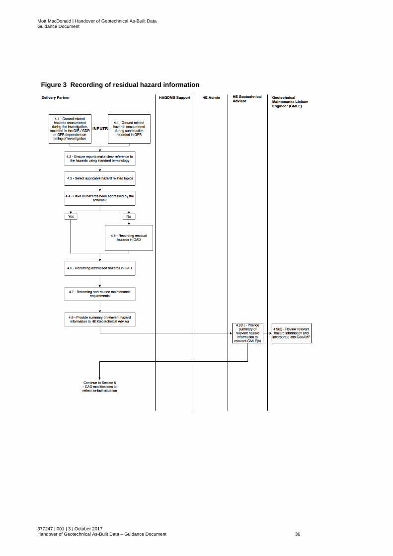
Mott MacDonald | Handover of Geotechnical As-Built Data Guidance Document
377247 | 001 | 3 | October 2017 Handover of Geotechnical As-Built Data – Guidance Document 36
Figure 3 Recording of residual hazard information
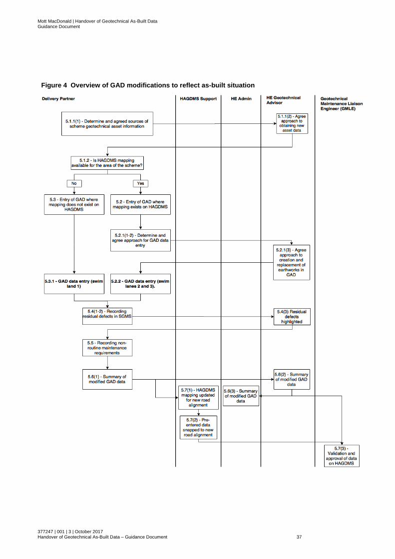
Mott MacDonald | Handover of Geotechnical As-Built Data Guidance Document
377247 | 001 | 3 | October 2017 Handover of Geotechnical As-Built Data – Guidance Document 37
Figure 4 Overview of GAD modifications to reflect as-built situation
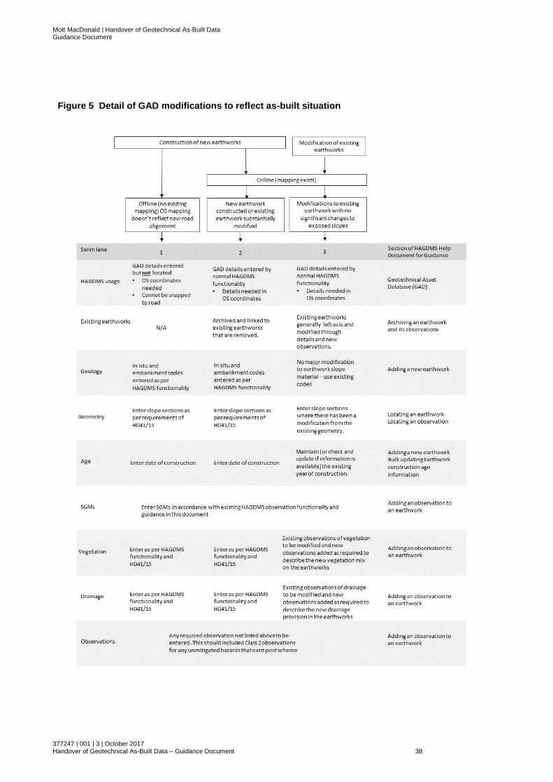
Mott MacDonald | Handover of Geotechnical As-Built Data Guidance Document
377247 | 001 | 3 | October 2017 Handover of Geotechnical As-Built Data – Guidance Document 38
Figure 5 Detail of GAD modifications to reflect as-built situation

Mott MacDonald | Handover of Geotechnical As-Built Data Guidance Document
377247 | 001 | 3 | October 2017 Handover of Geotechnical As-Built Data – Guidance Document 39

Mott MacDonald | Handover of Geotechnical As-Built Data Guidance Document
377247 | 001 | 3 | October 2017 Handover of Geotechnical As-Built Data – Guidance Document 40
B. Special Geotechnical Measure Types
Table 3: Special Geotechnical Measures (SGM) Types and Quad Codes
SGM Category
SGM Sub-Category SGM Type & Quad Code HAGDMS Observation tick box to select (in SGM section)
Drainage Drainage
Basal Drainage (BSDR) Other (not supported by drainage observations)
Counterfort Drain (CFDR) Record a drainage observation
Crest Drain (CSDR) Record a drainage observation
Cut off Drain (CODR) Record a drainage observation
Filter Drain (FILT) Record a drainage observation
Fin Drain (FIND) Record a drainage observation
Frost Blanket (FRBL) Other (not supported by drainage observations)
Herringbone Drainage (HBDR) Record a drainage observation
Horizontal Drains (HRZD) Other (not supported by drainage observations)
Internal Drainage (INTD) Other (not supported by drainage observations)
Rock Ribs (RIBS) Other (not supported by drainage observations)
Sealed Drainage (SEAL) Other (not supported by drainage observations)
Slope Drain (SLDR) Record a drainage observation
Soakaway (SOAK) Other (not supported by drainage observations)
Syphon Well (SYWL) Other (not supported by drainage observations)
Toe Drain (TODR) Record a drainage observation
Earthworks
Ground Improvement
Band Drains (BNDR) Other
Concrete Columns (CONL) Other
Dynamic Compaction (DYMC) Other
Grout Injection (GROT) Other
Lime Slurry Injection (LMSL) Other
Sand Wicks / Drains (SDWK) Other
Stone Columns (STCL) Other
Surcharging / Pre-loading (SRCH) Other
Vertical Drains (VERT) Other
Material Modification (Soil Mixing)
Cement Stabilisation (CEMM) Other
Fibre Reinforcement (FBRN) Other
Lime Piles (LMPL) Other
Lime Stabilisation (LMST) Other
Material Replacement
Lightweight Fill (LGHT) Other
Rock Fill (ROCF) Rock Fill
Tyre Bales (TYRB) Other
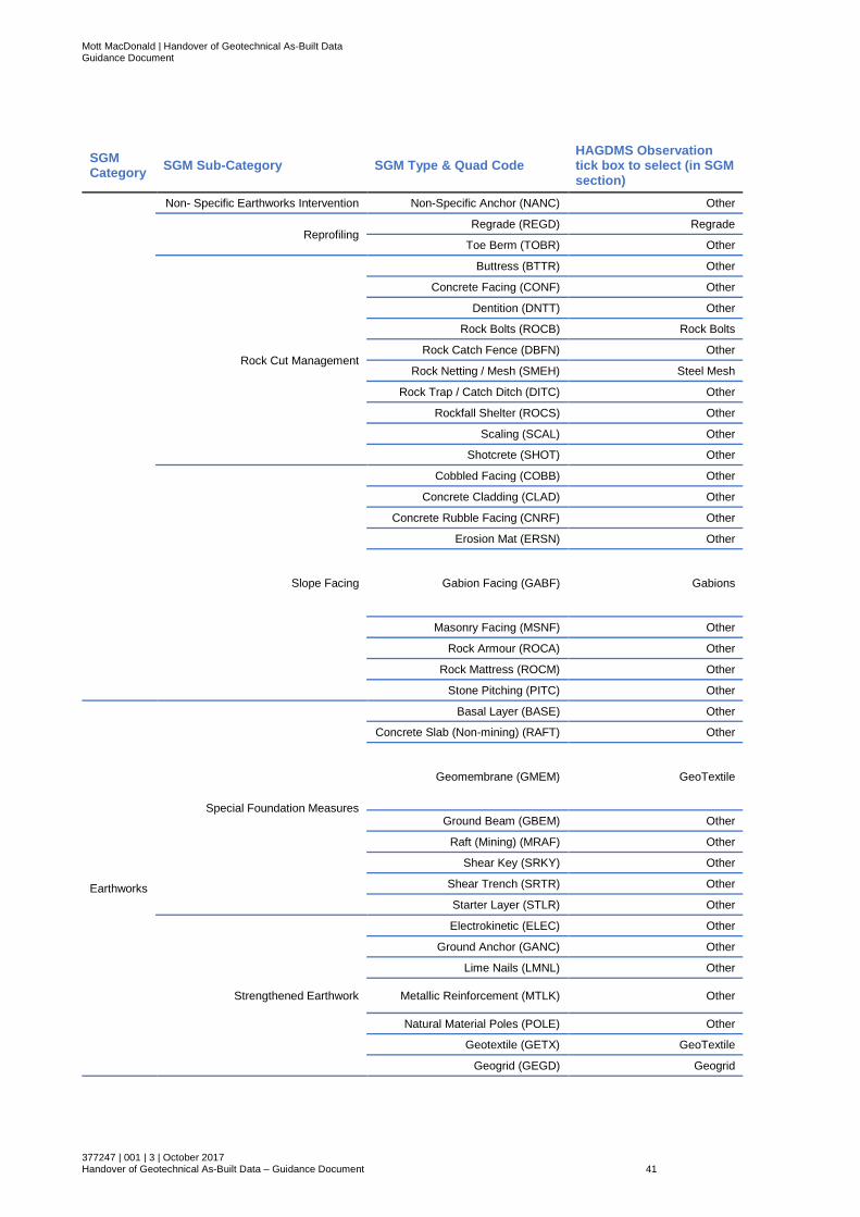
Mott MacDonald | Handover of Geotechnical As-Built Data Guidance Document
377247 | 001 | 3 | October 2017 Handover of Geotechnical As-Built Data – Guidance Document 41
SGM Category
SGM Sub-Category SGM Type & Quad Code HAGDMS Observation tick box to select (in SGM section)
Non- Specific Earthworks Intervention Non-Specific Anchor (NANC) Other
Reprofiling Regrade (REGD) Regrade
Toe Berm (TOBR) Other
Rock Cut Management
Buttress (BTTR) Other
Concrete Facing (CONF) Other
Dentition (DNTT) Other
Rock Bolts (ROCB) Rock Bolts
Rock Catch Fence (DBFN) Other
Rock Netting / Mesh (SMEH) Steel Mesh
Rock Trap / Catch Ditch (DITC) Other
Rockfall Shelter (ROCS) Other
Scaling (SCAL) Other
Shotcrete (SHOT) Other
Slope Facing
Cobbled Facing (COBB) Other
Concrete Cladding (CLAD) Other
Concrete Rubble Facing (CNRF) Other
Erosion Mat (ERSN) Other
Gabion Facing (GABF) Gabions
Masonry Facing (MSNF) Other
Rock Armour (ROCA) Other
Rock Mattress (ROCM) Other
Stone Pitching (PITC) Other
Earthworks
Special Foundation Measures
Basal Layer (BASE) Other
Concrete Slab (Non-mining) (RAFT) Other
Geomembrane (GMEM) GeoTextile
Ground Beam (GBEM) Other
Raft (Mining) (MRAF) Other
Shear Key (SRKY) Other
Shear Trench (SRTR) Other
Starter Layer (STLR) Other
Strengthened Earthwork
Electrokinetic (ELEC) Other
Ground Anchor (GANC) Other
Lime Nails (LMNL) Other
Metallic Reinforcement (MTLK) Other
Natural Material Poles (POLE) Other
Geotextile (GETX) GeoTextile
Geogrid (GEGD) Geogrid

Mott MacDonald | Handover of Geotechnical As-Built Data Guidance Document
377247 | 001 | 3 | October 2017 Handover of Geotechnical As-Built Data – Guidance Document 42
SGM Category
SGM Sub-Category SGM Type & Quad Code HAGDMS Observation tick box to select (in SGM section)
Shear Dowel (SRDW) Other
Soil Nail Mesh (SNMS) Steel Mesh
Soil Nails (SNAL) Soil Nails
Structures
Piles
Anchored Sheet Pile Wall (ASHP) Sheet Piles
Anchored Bored Pile Wall (ABPW) Other
Anchor Pile (ANPL) Other
Concrete Driven Piles (CNPL) Other
Contiguous Bored Pile Wall (CBPW)
Other
Dowel Piles (DOWP) Other
Inclined Piles (INCP) Other
King Post Wall (KPWL) Other
King Sheet Pile Wall (KSPW) Sheet Piles
Non-Specific Bored Pile Wall (NSBP)
Other
Non-Specific Pile Wall (NSPW) Other
Micro Piles (MCRP) Other
PVC Pile Wall (PVCS) Sheet Piles
Secant Bored Pile Wall (SCPW) Other
Sheet Pile Wall (SHPL) Sheet Piles
Spaced Bored Pile Wall (SBPW) Other
Helical Pile (HELI) Other
Retaining Walls
Block Wall (BLCW) Block Ret. Wall
Concrete Sandbag Wall (CNSB) Other
Crib Wall (CRIB) Crib wall
Gabion Wall (GABN) Gabions
Masonry Wall (BKRW) Block Ret. Wall
Non-Specific Retaining Wall (NSRW)
Other
Mass Concrete Wall (CNCW) Concrete Ret. Wall
Stone Wall (STNW) Other
Tied Wall (TDWL) Other
Timber Boards (TIMB) Other
Source: Atkins, 2017

Mott MacDonald | Handover of Geotechnical As-Built Data Guidance Document
377247 | 001 | 3 | October 2017 Handover of Geotechnical As-Built Data – Guidance Document 43
mottmac.com