have we deciphered the canning? discovery of the … oldest sedimentary deposits recorded in the...
TRANSCRIPT

Have we Deciphered the Canning? Discovery of the Ungani Oil Field.
Peter Edwards & Eric Streitberg
Buru Energy, Perth, Australia
Email: [email protected]; [email protected]
The 2011 discovery of the Ungani oil field by Buru Energy has driven a far-reaching change in
perceptions of the prospectivity of the Canning Basin of Western Australia. Previously the basin
had been portrayed as ‘difficult’, with a number of potential and even promising petroleum systems
that had not lived up to expectations.
Ungani 1 was intended as a follow-up to the 1967 Yulleroo gas discovery, 30 km to the west, which
tested gas from the Lowermost Carboniferous Laurel Formation. That discovery was ignored at the
time, in part because there was no market for gas in Western Australia. Although located within the
same fault terrace on the southern margin of the Fitzroy Trough, the targeted tight sands of the
Laurel Formation were absent at Ungani 1. Instead, the well intersected a Lower Carboniferous or
latest Devonian pervasively dolomitised limestone over 140 m thick, of which the upper 57 m is oil
bearing. The oil has an API gravity of approximately 37°API, with DST tests yielding up to 1,647
bpd on a 12.7 mm (32/64 inch) choke with a flowing well head pressure of 124 kPa (18 psi).
Quantifying the extent and production parameters of the reservoir and even understanding its
geologic setting remain problematic with the current dataset, thereby placing large uncertainties on
estimations of recoverable oil reserves. Consequently it is unclear what the long term implications
of Ungani might be for the basin. Nevertheless the discovery seems likely to revitalise exploration
in the basin, and in particular the search for the next field on the trend.
KEYWORDS: Ungani oil field; Canning Basin; dolomitisation; Western Australia hydrocarbons
Abstract Submission 86
Reference Number 179

1. INTRODUCTION
In late 2011 Buru Energy and its partner Mitsubishi Corporation announced an oil flow from the
Ungani 1 well. This signified the first potentially commercial hydrocarbon discovery in the
Canning Basin since 1990, and the first significant onshore discovery in Western Australia for 10
years. Coming after decades of largely unsuccessful exploration by numerous operators, ranging
from poorly funded entrepreneurs to major corporations, the find has stimulated a resurgence of
interest in the region.
The Ungani crude is of premium quality, with recoverable reserves estimated at between 0.5 and 20
million barrels. This wide range is due to the unusual nature (for Australia) of the reservoir section
and to ambiguities in structural configuration. Uncertainties in reservoir character were addressed
with an extended production test, and trap geometry will be clarified by future acquisition of a 3D
seismic dataset. Significant challenges have been encountered in planning a full scale development
of the field including the crude export system and land access. Nevertheless, Ungani undoubtedly
represents an important economic resource for the region and possibly for the State as a whole.
Coming relatively late in the exploration record, the Ungani discovery challenges accepted oil-patch
wisdom that larger fields in a basin tend to be discovered early. There have been some 250
exploratory wells, over one hundred and fifty thousand line kilometres of seismic acquisition and
generations of technical analysis which, until Ungani, identified just a handful of small oilfields in
the Canning Basin with total production of less than three million barrels.
An explanation may lie in the relatively unsophisticated technology used in the early stages of
exploration within the basin, coupled with overly ambitious expectations which virtually guaranteed
a cycle of disappointment, discouragement and diminished activity. Notwithstanding a prolonged
exploration history, the sheer size and complexity of the basin remain daunting despite recognition
that all the factors necessary for one or more productive hydrocarbon systems are present (Goldstein
1989; Cadman et al. 1993). Even within the last decade, Carlsen and Ghori (2005) could maintain
that “The Canning Basin may be the least explored of Palaeozoic basins of the world with proven
petroleum systems. Lack of information continues to contribute to the perception of low
prospectivity…”
The strategy of Buru (and its predecessor, ARC Energy) has been one of progressive focus,
narrowing from a fresh basin-wide analysis to definition of high-potential play concepts and
acreage fairways, and appraisal of specific prospects. In this process, the company has had a
number of advantages over its earlier counterparts:
• Access to a plentiful archive of prior exploration data, in part inherited from successive
operators in the basin but greatly infilled and expanded by government agencies. Within
this material is a concise record of what did not work, as well as what almost (or indeed in
some cases should have) pointed the way to a successful outcome.
• An industry climate of disinterest, allowing substantial acreage acquisition in the basin at
relatively low entry and commitment investment levels.

• Changing economic conditions which ensured that (1) relatively small oil discoveries could
be economically developed, and (2) gas discoveries could, under the right circumstances, be
commercially viable in their own right.
• A belated recognition of the so-called unconventional potential of a number of specific
geologic formations in the basin. This new exploration environment gave different
emphasis to the exploration agenda, offering directions and opportunities that were not
available in the past.
Further success in the Ungani trend will depend on a thorough understanding of the field’s geologic
setting, and the interaction of hydrocarbon system dynamics with local structural, stratigraphic and
diagenetic factors. At this point it is unclear what the long term implications of Ungani might be in
relation to the additional potential in the basin, however the discovery has undoubtedly advanced
the industry’s long term mission to ‘decipher the Canning’.
Figure 1. Tectonic elements of the Fitzroy Trough, Canning Basin, overlain on surface topography. Small oil fields on the northern flank of the Trough, discovered during the 1980s, are currently shut in after decades of production.
2. GEOLOGIC SETTING
The Canning Basin, covering over 430,000 square kilometres in the north of Western Australia, is
one of Australia’s largest onshore sedimentary basins. It was initiated in the early Paleozoic as a
broad epicratonic sag, now divided into two major northwest-southeast trending units: the
connected system of Fitzroy Trough and Gregory Sub-basin, and the Kidson Sub-basin (Hocking et
al 2008). These older basins are for the most part concealed beneath widespread Permian and
Mesozoic strata.

The Fitzroy-Gregory structural system is estimated to contain up to 16 km of predominantly
Ordovician, Devonian and Permo-Carboniferous sedimentary rocks, and is divided by the Jones
Arch into the Fitzroy Trough in the northwest and Gregory Sub-Basin in the southeast. The overall
trend is the product of a major cycle of thermal uplift and instability followed by rift subsidence
during a period of regional Upper Devonian extensional tectonism. This episode left the Kidson
Sub-basin more or less undisturbed.
The southern Fitzroy Trough margin (the SFTM) comprises a series of downward-stepping terraces,
separating the Broome Platform from the main depocentre. The Ungani structure lies within the
most basinward of these platform margin terranes - a complex zone generally referred to as the
Jurgurra Terrace (Figure 1).
The oldest sedimentary deposits recorded in the basin are Ordovician to Silurian clastic and
carbonate facies, representing early Palaeozoic sag-basin fill (Figure 2). A significant thickness of
salt overlies these units in the Kidson Sub-basin to the south, but is absent through dissolution and
withdrawal on the platform areas between the Kidson and Fitzroy Trough depocentres. Although
some halokinetic structures are known from the SFTM, the extent of salt originally present in the
Fitzroy Trough and immediately adjacent areas is obscure due to the multiphase structural
deformation of a substantial thickness of younger deposits.
The margins of the Fitzroy-Gregory structural system incorporate a number of discrete depocentres
of mid to late Devonian age. Local age gaps and disconformities in this stratigraphic section
indicate a period of crustal instability, however during the latest Devonian the generally tensional
tectonic regime evolved into a recognisable NW-SE rift system. During this phase the Fitzroy
Trough developed as a deep marine embayment rimmed by carbonate-dominated shallow marine
shelves along the Jurgurra and Dampier Terraces, and around the Lennard Shelf on the northern
side of the trough. Deep water marine shales of the earlier Givetian to Frasnian Gogo Formation
and equivalents, deposited in local areas of subsidence, were overlain by widespread sub-littoral to
mid-ramp marine deltaic units of the Clanmeyer-Luluigui association representing rapid
accumulation of siliciclastic material in a more open marine environment.
Pull-apart of the SFTM terrace-graben system continued into the Early Carboniferous, with episodic
growth along the bounding fault and hinge lines throughout the Tournaisian and Visean evidenced
by substantial thickness and facies variation in the both the Laurel Formation (here taken to include
all the members of the Fairfield Group, and to be essentially equivalent to that unit) and the
following Anderson Formation, respectively.
In this environment the maximum flooding events of the lower Tournaisian resulted in deposition of
thick anoxic argillaceous sediments of the Lower Clastics member of the Laurel Formation.
Although there is abundant organic material in this member, dilution due to high sedimentation
rates has generally limited the total organic carbon (TOC) content to between 0.5% and 1.5%.
Nevertheless, the regional potential for better source rocks within the Laurel Formation remains
uncertain, with TOC levels likely underestimated due to sampling bias. In this unit rich organic
fractions often occur as finely laminated argillaceous elements distributed through the section.
Furthermore a more optimistic view of the oil and gas generation potential of the Laurel Formation
seems justified by the presence of small oil fields on the Lennard Shelf, along the northern margin
of the Trough (Crostella 1998; Jonasson 2001) and by the ubiquitous appearance of gas in wells
which penetrate the system.
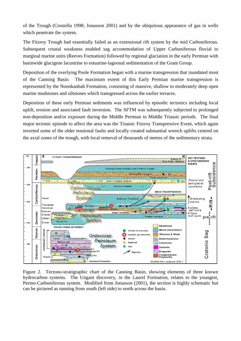
The Fitzroy Trough had essentially failed as an extensional rift system by the mid Carboniferous.
Subsequent crustal weakness enabled sag accommodation of Upper Carboniferous fluvial to
marginal marine units (Reeves Formation) followed by regional glaciation in the early Permian with
basinwide glacigene lacustrine to estuarine-lagoonal sedimentation of the Grant Group.
Deposition of the overlying Poole Formation began with a marine transgression that inundated most
of the Canning Basin. The maximum extent of this Early Permian marine transgression is
represented by the Noonkanbah Formation, consisting of massive, shallow to moderately deep open
marine mudstones and siltstones which transgressed across the earlier terraces.
Deposition of these early Permian sediments was influenced by episodic tectonics including local
uplift, erosion and associated fault inversion. The SFTM was subsequently subjected to prolonged
non-deposition and/or exposure during the Middle Permian to Middle Triassic periods. The final
major tectonic episode to affect the area was the Triassic Fitzroy Transpressive Event, which again
inverted some of the older tensional faults and locally created substantial wrench uplifts centred on
the axial zones of the trough, with local removal of thousands of metres of the sedimentary strata.
Figure 2. Tectono-stratigraphic chart of the Canning Basin, showing elements of three known hydrocarbon systems. The Ungani discovery, in the Laurel Formation, relates to the youngest, Permo-Carboniferous system. Modified from Jonasson (2001), the section is highly schematic but can be pictured as running from south (left side) to north across the basin.

3. DISCOVERY WELL
Coordinated geological studies of the Canning Basin began in 1941, when government agencies
began systematic mapping and integration of data collected by small oil companies which had been
active since the 1920s. In spite of several phases of intense activity in succeeding decades, the area
of the Jurgurra and northern Dampier Terraces, covering over 5000 sq km, had until recently only
six well tests which were mostly drilled for stratigraphic information (Table 1).
WELL YEAR OPERATOR OBJECTIVE
Barlee 1 1956 WAPET Stratigraphic
Yulleroo 1 1967 Gewerksshaft Elwerath Stratigraphic
Logue 1 1972 WAPET Devonian carbonates
Cow Bore 1 1983 Gulf Devonian carbonates
East Crab Creek 1 1984 Gulf Devonian carbonates
Mahe 1 1997 Sterling Permian clastics (Grant Fm)
Table 1: Pre-2008 Exploratory Wells on the Jurgurra and northern Dampier Terraces
In 2008 ARC Energy drilled Yulleroo 2 to appraise wet gas flows and favourable geochemical
results from the Laurel Formation in Yulleroo 1. As in Yulleroo 1, Yulleroo 2 encountered a thick
gas-charged sandy and silty argillaceous section in the Lower Clastic member of the Laurel
Formation, however full evaluation of the section was curtailed at a total depth of 3740 m by
mechanical and other operational problems. In late 2010, Buru Energy re-entered Yulleroo 2 to
conduct a reservoir stimulation of the Laurel Formation tight gas section. Despite equipment
limitations which imposed a sub-optimal stimulation design, the operation was successful in that it
produced strong, if unstabilised, flows of gas and condensate.
Ungani 1 was drilled by Buru in late 2011 in Exploration Permit EP391 some 30 km ESE of the
Yulleroo structure. The well was located on a large four-way dip closed anticline on the Jurgurra
Terrace, with the primary objective being a siliciclastic section within the Tournaisian Laurel
Formation as encountered in the Yulleroo field. It was anticipated that reservoir parameters would
be somewhat better than seen at Yulleroo owing to the shallower depth to the target, coupled with
modest uplift (and corresponding limits to maximum burial depth) during the period of the Fitzroy
Transpression (Figure 2).
In the event, the target Laurel Formation was encountered approximately 45 m deep to prediction,
and the entire Laurel Formation was substantially condensed relative to the equivalent section in the
Yulleroo wells. Oil shows and associated elevated mud gas readings were observed in the
overlying Grant and Anderson Formations from approximately 950 m Measured Depth (MD), and
into the top of the Laurel Formation at 1869 mMD. At 2156 mMD, the well encountered a massive
dolomite unit with strong oil shows. After drilling 142 m of dolomite, the well penetrated a 105 m
thick argillaceous section, followed by a limestone-dominated section to 3524 mMD, at which point
a red-brown siliciclastic section was encountered (Figure 3) before reaching a total depth of 3593
mMD.

Figure 3. Generalised stratigraphy of Ungani 2, with detail of the ‘Ungani Dolomite’, 2227-2457 mMD (Measured Depth). The reservoir section was intersected some 450 m NNE of the discovery well, Ungani 1, which had a less complete log suite but penetrated deeper in the section as indicated by the inset at the bottom of the stratigraphic column.
During subsequent conditioning of the hole to facilitate logging, the drill string became stuck and
consequently parted, with the top of the fish at 2216 mMD. Ensuing attempts to obtain wireline
logs, particularly over the interval of hydrocarbon shows in the dolomites of the (presumed) Laurel

Formation, were unsuccessful. The well was then sidetracked below a casing shoe at 1993 mMD,
to a depth of 2324 mMD.
Substantial fluid losses into the dolomite formation which had occurred in the original well bore
were ameliorated to some degree by careful control of drilling mud properties in the sidetrack. At
the same time, equally good hydrocarbon indications were recorded. However wireline logs over
this section again could not be obtained due to shale washouts and severe ledge effects at the top of
the dolomite. Logs were eventually obtained by running LWD tools on drill pipe. Substantial
invasion of the reservoir by drilling fluid during these protracted operations has been a major
problem for ongoing petrophysical analysis.
Despite these problems a potential oil column was indicated in the dolomite section, which in the
absence of a definitive age dating has been informally named the ‘Ungani Dolomite’. Initially it
was inferred that the entire dolomite could be oil-bearing, but further analysis suggests an effective
free water level at around 2214 mMD separating an upper, potentially oil productive zone of
approximately 57 m gross thickness from a lower zone with only residual hydrocarbon saturation.
In light of deteriorating hole conditions, the well was completed with a slotted liner over the
interpreted reservoir section in order to conduct an immediate cased hole test of the flow potential
of the reservoir and to determine the composition of the reservoir fluids. After initial swabbing,
natural flow of light oil (API gravity ~37 degrees) with no significant gas was quickly established.
With the oil were varying but minor amounts of completion fluid, filtrate and lost circulation
material (LCM) from the approximately 3000 barrels of drilling mud and LCM lost to the formation
during drilling operations. The well was flowed for a total of 8 hours at varying choke sizes with a
peak rate of 1,647 bpd on a 12.7 mm (32/64 inch) choke with a flowing well head pressure of 124
kPa (18 psi). The well was then shut-in with the well head pressure stable at 2965 kPa (430 psi).
Ungani 1 was suspended and an appraisal well, Ungani 2, was drilled from the same well pad.
Ungani 2 was deviated to the NNE along the key seismic line control to test the oil-bearing zone
near the free water level projected onto the mapped structural closure. At some 450m lateral
distance from Ungani 1 the well intersected the top of the Ungani Dolomite high to prediction,
within a few metres of the Ungani 1 depth. In addition, the Ungani Dolomite in Ungani 2 is thicker
than expected at 220 m. Otherwise, general lithology and hydrocarbon shows are similar to Ungani
1. Two conventional cores of 63 m and 27 m were attempted but in each case recovery was less
than 10%. In total 7.4 m of core was acquired, and this was supplemented by 19 mechanical
sidewall cores recovered from 41 attempted in the dolomite zone. The low recovery rate raises
questions as to whether samples are representative of the unit as a whole as presumably the more
cohesive parts, with potentially poorer reservoir characteristics, are over-represented in the
recovered material.
4. DEVONIAN CARBONATES OF THE CANNING BASIN
Despite predictions of a Yulleroo-like clastic-dominated Laurel Formation section, the presence of
massive carbonates in Ungani 1 was not wholly unexpected. Carbonates of this general age are
well known from outcrop in the Lennard Shelf, immediately north of the Fitzroy Trough, as well as
from prior well intersections along the SFTM – albeit in structural settings which are on, or closer

to, platform areas than Ungani. Furthermore seismic correlations on which the prediction was
based, particularly from the Yulleroo wells, are tenuous at best below the Permian section.
In a dynamic structural environment at the edge of a developing rift, stratigraphic facies are likely
to be highly dependent on local variations in water depth, sediment influx and accommodation
space, as well as on the productivity of existing carbonate-producing biota under contemporaneous
climatic conditions.
Upper Devonian carbonate outcrops of the northern Canning Basin are widely regarded as an
exemplary record of the evolving marine ecology of the period (Southgate et al, 1993; Playford et
al. 2009; Copp 2000). While finer details of the stratigraphic inter-relationships remain ambiguous,
these authors define two second-order carbonate-dominated sequences from the Middle to Upper
Devonian – a Givetian to Frasnian sequence (the Pillara cycle), overlain by a Famennian sequence
(the Nullara cycle). These are in turn overlain by a latest Famennian to Tournaisian mixed
siliciclastic and carbonate ramp complex (the Laurel Formation, here taken as synonymous with the
‘Fairfield Group’), representing the last in a basic three-fold chronostratigraphic division of the
marine succession during the main phase of rifting of the Fitzroy Trough.
The Late Devonian, as a period of successive global extinction events, has been the subject of
intense worldwide scrutiny. Two of the most widely recognised events are potentially associated
with the transitions between the Canning Basin depositional units noted above: the
‘Frasnian/Famennian Mass Extinction’ (F/F event) and the ‘Devonian/Carboniferous Mass
Extinction’ (D/C event) – also termed the ‘Hangenberg Event’ (McGee 1996; Sandberg et al. 2002).
Discussion on causes has focused on orbitally forced climatic changes (House 2002) or, for the F/F
event, a possible cometary impact cluster (McGee 1996). The D/C event, in particular, appears to
have triggered an abrupt eustatic sea level fall followed by a more protracted and multifaceted
glacial episode.
If these correlations are valid, the consequences of two global events for Canning Basin carbonate
systems were profound. In both cases frame- and reef-building organisms were effectively removed
from the geologic record in this basin. During the Pillara-Nullara (F/F) transition the hiatus was
relatively short and the reef complexes were renewed, though with different reef builders. In turn
the Nullara microbial reef-building community suffered an even more severe ecologic breakdown,
being supplanted by a cool-water tolerant bryozoan, crinoidal and microbialite assemblage with
distinctly different growth habits (Wood 2004; Playford et al. 2009).
Away from condensed platform areas the Devonian/Carboniferous boundary was a time of
extremely rapid sedimentation across the Fitzroy Trough. In this part of the succession
biostratigraphic resolution is largely dependent on palynology as age-diagnostic conodont and
ammonoid fossils are rare (Jones & Young 1993; Playford et al 2009). The distinctive miospore
Retispora lepidophyta is used as an indicator of the latest Famennian, which includes the so-called
D/C event arguably as a definitive separator between the Nullara and Laurel/Fairfield depositional
cycles. The appearance of the Grandispora spiculifera assemblage marks the accepted Devonian-
Carboniferous boundary, some 2‒4 MY after the extinction event itself. The biozonation and
chronology of the Devonian-Carboniferous transition are summarised by Copp (2011) and
Seyedmehdi (2011).
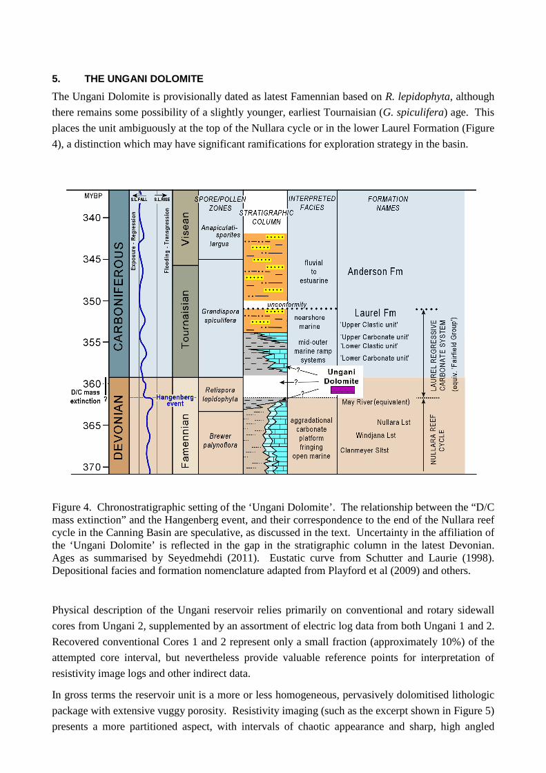
5. THE UNGANI DOLOMITE
The Ungani Dolomite is provisionally dated as latest Famennian based on R. lepidophyta, although
there remains some possibility of a slightly younger, earliest Tournaisian (G. spiculifera) age. This
places the unit ambiguously at the top of the Nullara cycle or in the lower Laurel Formation (Figure
4), a distinction which may have significant ramifications for exploration strategy in the basin.
Figure 4. Chronostratigraphic setting of the ‘Ungani Dolomite’. The relationship between the “D/C mass extinction” and the Hangenberg event, and their correspondence to the end of the Nullara reef cycle in the Canning Basin are speculative, as discussed in the text. Uncertainty in the affiliation of the ‘Ungani Dolomite’ is reflected in the gap in the stratigraphic column in the latest Devonian. Ages as summarised by Seyedmehdi (2011). Eustatic curve from Schutter and Laurie (1998). Depositional facies and formation nomenclature adapted from Playford et al (2009) and others.
Physical description of the Ungani reservoir relies primarily on conventional and rotary sidewall
cores from Ungani 2, supplemented by an assortment of electric log data from both Ungani 1 and 2.
Recovered conventional Cores 1 and 2 represent only a small fraction (approximately 10%) of the
attempted core interval, but nevertheless provide valuable reference points for interpretation of
resistivity image logs and other indirect data.
In gross terms the reservoir unit is a more or less homogeneous, pervasively dolomitised lithologic
package with extensive vuggy porosity. Resistivity imaging (such as the excerpt shown in Figure 5)
presents a more partitioned aspect, with intervals of chaotic appearance and sharp, high angled

texture interspersed with more regularly bedded shallow-dipping zones. The chaotic zones show
evidence of irregular vuggy porosity at a range of scales from large, almost cave-like voids down to
the resolution limit of the imaging tools. Fractures can be identified in places but are not consistent
features.
The core pieces, presumably from the more competent parts of the cored intervals, include clast-
and matrix-supported breccias comprising crinoidal rudstone and microbial boundstone fragments
in a matrix of crinoidal floatstone-rudstone. Ungani 2, Core 2 (2327.8 ‒ 2354.8mMD, recovery
9.7%) is interpreted as a lower energy deposit, possibly the background sedimentation to episodic
debris flows identified in Core 1 (2241.3 ‒ 2305.7mMD, recovery 8.15%). The reservoir unit was
likely deposited in a mid- to outer ramp environment with an overall waning in energy levels,
culminating in low-energy suspension deposits represented by the overlying sealing shale.
All conventional and sidewall cores from Ungani 2 over the interval 2228 m to 2355 mMD are
completely dolomitised. The dolomite is coarsely crystalline and is similar to the extensive Upper
Devonian dolomite of the Barbwire Terrace (Wallace, 1990). Visible porosity within the samples is
largely mouldic (after bioclasts) or fracture-related porosity, but some primary porosity is also
present. The mouldic porosity was almost certainly produced during the later stages of a major
dolomitisation event, as a consequence of the volume reduction that occurs during the conversion of
limestone to dolomite.
The diagenesis can be divided into two distinct phases: (1) An early phase dominated by replacive
dolomitisation and planar dolomite cement and, (2) A later phase characterized by quartz, kaolinite
and saddle dolomite cements. Saddle dolomite is only present in the deepest samples (Core 2,
below 2328 m). There is weak evidence that stylolitization began before dolomitisation
commenced, suggesting some early phase dolomitisation during burial.
In addition to porosity production during the later stages of replacement dolomitisation, there was a
significant porosity-producing event during the later stages of planar dolomite precipitation. The
porosity event is marked by dolomite dissolution, brecciation and fracturing, and was immediately
followed by precipitation of bright luminescent planar dolomite. Iron sulphide precipitation appears
to be approximately contemporaneous with this porosity producing event, indicating that H2S may
have been responsible for dolomite dissolution.
The ‘Ungani Dolomite’ is bounded top and bottom by relatively thin claystone units, and upper and
lower adjoining limestone beds which show no obvious dolomitisation effects. Such inconsistent
appearance of dolomite in the Upper Devonian to lowermost Carboniferous section is characteristic
of the Canning Basin. Devonian carbonates in SFTM wells such as Crab Creek 1, East Crab Creek
1 and Cow Bore 1 are partly dolomitised, whereas the overlying Tournaisian interbedded dolomite-
limestone-siliciclastic facies are only lightly affected. This suggests that either there were partial
lithofacies barriers to later dolomitising fluids or that different dolomitising processes were active.
Seyedmehdi (2011) interpreted the equivalent dolomitised interval on the Lennard Shelf as having
been formed by reflux dolomitisation, which similarly did not affect the entire carbonate
succession.

Figure 5. Detail of XRMI and GVR electric log images from the reservoir section of Ungani 2. Depth interval indicated in Figure 3 XRMI panels display higher resolution but are segmented due to sensor pad separation. Calculated stratigraphic dips are 10 ‒ 20 degrees, west to northwest.
At Ungani the stratigraphic isolation of the dolomitised interval indicates that the containing shales
may have acted as a diagenetic trap, directing magnesium-rich fluids into the bedded limestone.
Such a mechanism is documented in the Lennard Shelf Mississippi Valley Type mineral belt, where

robust boundaries between argillaceous clastic and carbonate lithologies have constrained
hydrothermal fluids migrating through aquifers and permeable fault systems (Dorling et al., 1998).
Ultra-violet microscopy reveals no visible fluorescent hydrocarbon inclusions within the any of the
porosity occlusions (planar dolomite, saddle dolomite, quartz cements), thereby indicating that
hydrocarbon influx was a relatively late diagenetic event. Two distinctly different types of
hydrocarbons are present in the pore space; non-fluorescent opaque bitumen and fluorescent non-
opaque fluid hydrocarbons.
6. THE UNGANI OIL
The Ungani oil is a 37 degree API gravity paraffinic crude with a pour point of 12 degrees C, with a
Gas-Oil Ratio (GOR) of less than 10 ft3/bbl. The gas chromatogram of the whole oil is
characterised by a unimodal n-alkane distribution with a maximum at C15. The oil has high wax
content with the n-alkanes extending out to C34. There is a slight odd-carbon number preference in
the C15 to C19 n-alkanes. A depletion in the low-molecular-weight hydrocarbons (<C12) is evidence
for minor water washing, although there appears to be no significant alteration by processes such as
bio-degradation, in-field mixing or contamination with other hydrocarbon sources during migration.
A relatively low pristane-phytane ratio (1.45) is indicative of a source rock deposited in somewhat
oxic conditions. Biomarker distributions indicate derivation from primarily marine algal material
with some contribution from terrigenous sources. These factors are consistent with a marine
depositional environment, most likely proximal to an estuary or bay setting. Aromatic maturity
parameters indicate hydrocarbon generation in the early to peak oil window.
The n-alkane distribution and biomarker signature of the Ungani oil is similar to those of the
Sundown and Meda crude oils, which are inferred to have been sourced from the Laurel Formation
(Home Energy 1985; Kennard et al. 1994; Edwards & Zumberge 2005).
7. VOLUMETRIC ASSESSMENT
The Ungani prospect was mapped on the basis of regular but loosely spaced seismic lines with a
grid density of about 2x4 km (Figure 6). The lines are of vintages ranging from 1973 to 2010, and
although the combined data set is of fair to good quality overall, the two or three lines that cross the
Ungani structure are inconsistent in frequency and phase content. Consequently there is
considerable uncertainty as to the form and internal geometry of the oil accumulation.
In general terms the structure is an east ‒ west trending anticline with four-way dip at the reservoir
level. The southern margin is truncated by a compound east-west fault system, with smaller faults
having an interpreted NNW – ESE orientation cutting across the central part of the anticline (Figure
7). The underlying tectonic style of the structure is difficult to determine due to the lack of seismic
control, although closure appears to have been established during transpressive stresses of the
Lower Triassic Fitzroy event.

Figure 6. Depth structure map, Ungani oil field and surrounds. Top of ‘Ungani Dolomite’ unit.
Figure 7. Seismic line BYS10-21, PSDM processing, with the positions of Ungani 1 and Ungani 2 marked. Line location shown on Figure 6.

In the absence of adequate structural control, a key indicator of both reservoir parameters and
accessible hydrocarbon volumes has been production performance under a test program involving
both Ungani 1 and 2 wells. Both wells have been compromised to some extent by having been
completed for production prior to the recognition of the nature of the reservoir, and consequently
not being set up to optimise long term production rates. The oil-bearing interval in Ungani 1 has no
effective isolation from the underlying water zone, and the base of the Ungani 2 completion is close
to the oil/water contact. Consequently the wells were expected to produce water relatively early on
in their productive life, and planning was initiated to ensure future production well design
maximises oil production and defers water production for as long as possible.
Production testing during 2012 yielded a total of 76,609 bbl of oil from the two wells. Limited
storage and trucking facilities restricted normal daily production to less than 1000 bbl although rates
in excess of 1500 BPD were achieved on test.
Analysis of the test results leads to a number of favourable conclusions. Pressures recorded during
drawdown, build-up and interference tests indicate excellent horizontal permeability between the
wells. Calculations of ‘observed oil’, representing only that which is directly accessible by the
wells under test, suggest an in-place volume of around 20MMbbl. Clearly this is only an order of
magnitude estimate, subject to change when more is known about the trap geometry, internal
configuration and productive capacity of the reservoir. Of particular significance in the latter
category is the potential for additions from primary porosity – not included in the present
calculations due to the relative brevity of the test program.
Results also suggest that, in common with other fields with high quality reservoirs, horizontal
production wells drilled along the top of the reservoir for up to 2000 metres will be capable of high
oil production rates at low water cuts for extended periods. It is therefore expected that the Ungani
oil field will be able to be developed with two to four horizontal wells.
8. IMPLICATIONS FOR BASIN PROSPECTIVITY
The discovery of the Ungani oil field has unquestionably raised the profile of the Canning Basin as
having the potential to add substantial hydrocarbon resources on a national, if not global scale.
Preliminary evaluation of the find raises the prospect that Buru has uncovered a new and possibly
extensive oil system on the terraced southern margin of the Fitzroy Trough. Significant factors for
consideration in future exploration of this system are:
• The reservoir is a massive carbonate of Late Devonian to earliest Carboniferous age. While
precise stratigraphic correlation is unclear at this point due to limited palynologic resolution,
it is believed that the carbonate package dates from the latest Devonian, postdating a
worldwide extinction event which ended a phase of reef aggradation by frame-building
organisms. Climatic cooling associated with the event ensured that when carbonate
deposition was re-established it followed a distinctive crinoidal and microbial-dominated
ramp and mound pattern, potentially identifiable on seismic data and in physical samples.

• At Ungani the reservoir unit is pervasively dolomitised, with vuggy to cavernous porosity
providing excellent horizontal permeability. A range of dolomitisation processes has been
identified in core samples, of which burial diagenesis appears to have been the most
significant for creation of present day porosity. Other Canning Basin carbonates of similar
age have exhibited different types of dolomitisation, with varying degrees of replacement
and consequent effects on reservoir parameters through porosity enhancement and/or
occlusion. Understanding the controls on the progression of dolomitisation in different
geologic settings will be key to identifying and prioritising targets for future exploration in
the basin.
• Analysis of the Ungani oil indicates close ties with crude from Sundown and other fields on
the Lennard Shelf which are considered to be sourced from within the Laurel Formation.
On the basis of rather extensive if patchy geochemical analyses, this unit has historically
been classified as a fair source at best, with a tendency towards gas rather then liquids
generation. The presence of a substantial volume of low GOR crude at Ungani
demonstrates that a richer Laurel Formation source, near optimal thermal maturity for oil, is
present within the migration catchment of the structure. The implication that oil currently in
the reservoir may represent only a fraction of a larger field, greatly reduced in recent times
by leakage and/or partial flushing, can only reinforce such a conclusion. Establishing the
present areal and depth distribution of this inferred oil source is another key objective to
facilitate effective follow-up of the discovery.
• The Ungani oil field presents an opportunity to utilise innovative production technologies to
minimise the effective footprint of operational activities. These would be based particularly
around horizontal completion practices from central pads, which appear ideally suited for
optimal development of the Ungani reservoir.
Initial conclusions such as these will need thorough review as more information becomes available.
At this stage the fields’ overall contribution to ultimate production from the Canning, and hence its
implication for future prospectivity of the basin, is uncertain due to inadequate data on size and
production characteristics. Consequently improving the understanding of field parameters,
especially through imaging by modern 3D seismic techniques, is recognised as a priority for Buru.
This in turn will require careful planning and consultation to achieve consensus with Traditional
Owner groups and other stakeholders to ensure that the heritage and environmental values of the
region are preserved.
For the present, though, the most far reaching contribution of the Ungani discovery may be its
compelling validation that the Canning Basin is under-explored, imperfectly understood, and
seriously under-estimated as a major hydrocarbon resource.

9. REFERENCES
CADMAN, S. J., PAIN, L., VUCKOVIC, V. & POIDEVIN, S. R., 1993. Canning Basin, W.A. Bureau of Resource Sciences, Australian Petroleum Accumulations Report 9.
CARLSEN, G. M. & GHORI, K. A. R,. 2005. Canning Basin and global Palaeozoic petroleum systems – a review. The APPEA Journal 45, 359-364.
COPP, I. A., 2000. Subsurface facies analysis of Devonian Reef complexes Lennard Shelf, Canning Basin Western Australia. Geological Survey of Western Australia Report 58.
COPP, I. A., 2011. Late Devonian (Famennian) facies of the outer Lennard Shelf, Canning Basin, Western Australia – a preliminary study. Geological Survey of Western Australia Record 2011/5.
CROSTELLA, A., 1998. A review of oil occurrences within the Lennard Shelf, Canning Basin, Western Australia. Geological Survey of Western Australia Report 56.
DÖRLING, S. L., GROVES, D. I. & MUHLING, P., 1998. Lennard Shelf Mississippi Valley-type (MVT) Pb-Zn deposits, Western Australia. AGSO Journal of Australian Geology & Geophysics 17, 115-120.
EDWARDS, D. S. & ZUMBERGE, J. E., 2005. Oils of Western Australia II, regional petroleum geochemistry and correlation of crude oils and condensates from Western Australia and Papua New Guinea. Geoscience Australia Report, cat. 37512.
GOLDSTEIN, B. J., 1989. Waxings and wanings in stratigraphy, play concepts and prospectivity in the Canning Basin. The APEA Journal 29, 466-508.
HOCKING, R. M., PLAYFORD, P.E., HAINES, P. W. & MORY, A. J., 2008. Paleozoic Geology of the Canning Basin – a field guide. Geological Survey of Western Australia Record 2008/18.
HOME ENERGY, 1985. EP 129R1 Geochemistry study. Geological Survey of Western Australia, statutory petroleum exploration report R1 A20 (unpublished).
HOUSE, M. R., 2002. Strength, timing, setting and cause of mid-Paleozoic extinctions. Palaeogeography, Palaeoclimatology, Palaeoecology 181, 5-25.
JONASSON, K. E., 2001. Western Australia atlas of petroleum fields, onshore Canning Basin. Petroleum Division, Department of Mineral and Petroleum Resources. Volume 2, Part 1.
JONES, P. J., & YOUNG, G. C., 1993. Summary of Phanerozoic biostratigraphy and paleontology of the Canning Basin (Lennard Shelf), Canning Basin Project, Stage 1, Lennard Shelf. Australian Geological Survey Organisation Record 1993/4.
KENNARD, J. M., JACKSON, M. J., ROMINE, K. K., SHAW, R. D. & SOUTHGATE, P. N., 1994. Depositional sequences and associated petroleum systems of the Canning Basin, WA. In: Purcell, P. G. & Purcell, R. R. (eds), The sedimentary basins of Western Australia. Proceedings of West Australian Basins Symposium, Petroleum Exploration Society of Australia, Perth, 657-676.
MCGHEE, G. R., 1996. The Late Devonian mass extinction: The Frasnian/Famennian crisis. New York, Columbia University Press.
PLAYFORD, P. E., HOCKING, R. M. & COCKBAIN, A. E., 2009. Devonian reef complexes of the Canning Basin. Geological Survey of Western Australia Bulletin 145.
SANDBERG, C. A., MORROW, J. R. & ZIEGLER, W., 2002. Late Devonian sea-level changes, catastrophic events, and mass extinctions. Geological Society of America Special Paper 356.
SCHUTTER, S. R., & LAURIE, J. R., 1998. In SRK Consulting: Canning Basin Project, 1998, Enclosure 3. Geological Survey of Western Australia, statutory petroleum exploration report S6353 R1 A5 (unpublished).
SEYEDMEHDI, Z., 2011. Depositional history and reservoir characterisation of the latest Devonian-Early Carboniferous Fairfield Group, northwestern Lennard Shelf, Canning Basin, Western Australia. PhD Thesis, School of Earth and Environment, University of Western Australia.
SOUTHGATE, P. N., KENNARD, J. M., JACKSON, M. J., O’BRIEN, P. E. & SEXTON, M. J., 1993. Reciprocal lowstand clastic and highstand carbonate sedimentation, subsurface Devonian reef complex, Canning Basin, Western Australia. In: Loucks, R. G., & Sarg, J. F. eds. Carbonate sequence stratigraphy: recent developments and applications, AAPG Memoir 57, 157-179.
WALLACE, G. E., 1990. Origin of dolomitization on the Barbwire Terrace, Canning Basin, Western Australia. Sedimentology 37, 105-122.
WOOD, R., 2004. Paleoecology of a post-extinction reef: Famennian (Late Devonian) of the Canning Basin, north-western Australia. Paleontology, 47, part 2. 415-445.