h.c. larsen and r.a. duncan - ocean drilling program€¦ · duncan, r.a., larsen, h.c., allan,...
TRANSCRIPT

Duncan, R.A., Larsen, H.C., Allan, J.F., et al., 1996Proceedings of the Ocean Drilling Program, Initial Reports, Vol. 163
1. INTRODUCTION: LEG 163 BACKGROUND AND OBJECTIVES1
H.C. Larsen2 and R.A. Duncan3
Ocean Drilling Program (ODP) Leg 163 is the second of two drill-ing legs to the Southeast Greenland margin. Together with Leg 152(Larsen, Saunders, Clift, et al., 1994) this program addresses the na-ture of rifting and breakup at this rifted continental margin and in par-ticular assesses the impact of the Iceland mantle plume on breakupand early seafloor spreading. These investigations build on earlierDeep Sea Drilling Project (DSDP) and ODP drilling (Leg 81—Rob-erts, Schnitker, et al, 1984; Leg 104—Eldholm, Thiede, Taylor, etal., 1989) and form part of a larger geological and geophysical mar-gin study (Larsen, 1995).
The strategy for drilling and the detailed background and objec-tives have been outlined by Larsen, Saunders, Clift, et al. (1994). Inthis introduction we only briefly summarize the main strategy andobjectives, the geophysical database, and the most important findingsof Leg 152 and their implications for the detailed planning of Leg163.
DRILLING AREA AND STRATEGY
The Southeast Greenland margin is a type example of a volcanicrifted margin. The margin is characterized by a broad seaward-dip-ping reflector sequence (SDRS) that onlaps continental (mainly Pre-cambrian) crust to the west and terminates eastward in oceanic crustof early Tertiary age (Figs. 1, 2).
In the Northeast Atlantic, seafloor-spreading Anomalies 24N-24R are the oldest identified pair of anomalies (Talwani andEldholm, 1977; Srivastava and Tapscott, 1986; Larsen, 1988).Anomaly 24N is developed off Southeast Greenland as a double-peaked anomaly (24A and 24B in Fig. 1) reflecting the three shortpositive events C24n.l through C24n.3 (Cande and Kent, 1992) andthe relatively high spreading rates during this interval (approximately3 cm/yr half-rate; Larsen, 1980).
The minimum age of the Southeast Greenland SDRS is con-strained by the seaward occurrence of well-developed seafloor-spreading anomalies (Fig. 1; Larsen and Jakobsdóttir, 1988). In thenorth, close to the Faeroe-Iceland-Greenland Ridge, the SDRS ex-tends seaward to seafloor of Chron C22n-C21n age (49-47 Ma).However, most of the Southeast Greenland SDRS is found landwardof seafloor spreading Anomaly 24A/24B and thus is older thanC24n.l (53 Ma; Cande and Kent, 1992). Weak and semilinear mag-netic anomalies present over the main SDRS may represent either
low-amplitude anomalies older than C24n (e.g., C25n-C27n, 56-61Ma) or short magnetic events within C24r (the cryptochrons of Candeand Kent, 1992; see also discussion in "Summary" chapter, Larsen,Saunders, Clift, et al , 1994).
Evidence for significant magmatism and tectonism during break-up is not restricted to the offshore areas. A coast-parallel dike swarmand associated seaward flexuring of the crust are present from theLeg 163 EG66 transect northward. Within this zone are gabbroic andsyenitic intrusions (Fig. 1; Myers, 1980; Myers et al., 1993) locallyassociated with basaltic lavas overlying thin sediments (for reviewsee Larsen, 1980; Nielsen et al., 1981; Brooks and Nielsen, 1982).Farther north a much more extensive and thicker flood basalt prov-ince is preserved (Fig. 1; Larsen et al., 1989). Comprehensive studiesof the onshore region are being conducted in parallel with ODP drill-ing and will be augmented in 1996 with a mainly marine program ofdeep crustal seismic imaging that includes the region of the ODPtransects (Larsen, 1995; Larsen et al., 1995). In particular, ODP drill-ing and field geological studies will aim at correlating the on- and off-shore parts of the crustal flexure zone and the volcanic stratigraphywithin the two areas.
Drilling was positioned along two margin transects, located distal(Legs 152 and 163) and proximal (Leg 163) to the Iceland plume cen-ter (the track of which is recorded by the Faeroe-Iceland-GreenlandRidge). The respective transects were named EG63 and EG66, refer-ring to their approximate latitude (Fig. 3). At each transect drillingwas targeted at the prerift crust, the breakup unconformity and earli-est volcanism, the transition from initial continental volcanism toocean crust volcanism, and, most seaward, a reference hole in steady-state spreading crust. This drilling strategy was designed (Larsen etal., 1991) with two primary objectives: (1) investigation of the devel-opment with time along each transect will tell us about the progres-sive weakening of the continental crust and the associated magmaticdevelopment and (2) the study of magmatic development and themagma source at different offsets from the Iceland plume will enableus to evaluate possible radial zonation in the original plume structure.Additional reference points for the second objective are provided byearlier DSDP Leg 81 drilling at the Hatton Bank margin (most distalsouthern offset; Joron et al., 1984) and ODP Leg 104 drilling at theV0ring margin (intermediate northern offset; Viereck et al., 1988; seealso Larsen, Saunders, Clift, et al., 1994).
GEOPHYSICAL DATABASE
'Duncan, R.A., Larsen, H.C, Allan, J.F., et al., 1996. Proc. ODP, Init. Repts., 163:College Station, TX (Ocean Drilling Program).
2Danish Lithosphere Center, 0ster Volgade 10, DK-1350 K0benhavn, [email protected]
'College of Oceanic and Atmospheric Sciences, Oregon State University, Oceanog-raphy Administration Building 104, Corvallis, OR 97331-5503, [email protected]
Legs 152 and 163 are based on a large set of seismic data over theSoutheast Greenland margin (Fig. 3). The database comprises threedifferent sets of seismic data: (1) regional to detailed grids of shallow,high-resolution multichannel seismic (MCS) data (Larsen et al.,1994); (2) regional grid of deep 7-s two-way traveltime (TWT) MCSdata; and (3) deep 14-s TWT MCS data (Larsen et al., 1995). In ad-dition, aeromagnetic and regional marine gravity data exist (for moreextensive review and references see Larsen, 1990; Larsen, Saunders,Clift, et al., 1994).

H.C. LARSEN, R.A. DUNCAN
45° W 37°
Continental basement
^ - x ] Archean
f " 7 ^ \ l Caledonian
Continent-oceboundary
Figure 1. Geological map (modified from Larsen, 1990). The subaerially erupted basalts show flood basalt structure landward of the inferred continent-oceanboundary (COB) and SDRS structure seaward of the COB. The part of northwestern Iceland that shows SDRS-like structure is included. Note that the spreadinghistory of the Iceland Plateau north of the Faeroe-Iceland-Greenland Ridge (FIGR) is different from that south of the ridge. In the young crust north of theFIGR, the typical SDRS structure is not continuously present and extends to a depth of only about 2 km. However, below the ridge itself, the SDRS may attaina thickness of 10 km (Larsen and Jakobsdóttir, 1988).

INTRODUCTION: BACKGROUND AND OBJECTIVES
1 -
ë 2-
I 3j
4 -
0.5-
NW
Site 989Quaternary SE
25 km
Seaward-dipping reflector sequencesp i l l OceanicJ volcanic succession
NW Site 989 Possible faulting Site 917 Site 916 Site 915
Site 990
Site 914SE
Tectonic breakupunconformity
P re-basaltbasement and
prerift sedimentsMagmatic breakup
unconformity
Figure 2. Interpreted cross section along the EG63 transect showing major units. Note that the tectonic breakup unconformity and the development from conti-nental to oceanic volcanism are separated by a ~l-km-thick, highly variable continental volcanic succession (picrites to dacites). Apart from an initial picriticsequence, the oceanic succession is believed to be quite uniform throughout the entire SDRS (depleted Iceland-type tholeiites). The inferred continent-oceanboundary (COB) is shown at the estimated source region for the lower part of the oceanic succession. As shown on the enlarged section in the lower panel, thecontinental succession of lavas comprises the Lower (LS) and Middle Series (MS), and the oceanic succession of lavas comprises the Upper Series (US) andyounger lavas throughout the SDRS.
LEG 152 RESULTS AND IMPLICATIONSFOR LEG 163
A number of important observations made during Leg 152 drillinginto the Southeast Greenland SDRS significantly affected the de-tailed planning of Leg 163 (Fig. 2): (1) highly tilted to subverticalprerift sediments occur below the inner part of the SDRS; (2) an ear-ly, continentally hosted and contaminated basaltic to andesitic volca-nism of 61-62 Ma age (Sinton et al., 1994) overlies these sediments;(3) the upper limit of these lower lavas is a sharp transition—possiblya hiatus—into picritic to tholeiitic lavas followed by basalts of a rath-er uniform composition that resemble depleted tholeiites from Ice-land and appear to make up the main part of the SDRS; and (4) allrecovered igneous units were erupted subaerially. Thus, Leg 152 con-firmed that the SDRS is a wedge of predominantly basaltic materialextruded subaerially in accord with the model for crustal accretion inIceland (Pálmason, 1986) and with the interpretation of seismic data(Mutter et al., 1982; Larsen and Jakobsdóttir, 1988).
The Leg 152 findings imply that the transition from continental tooceanic crust takes place below the inner part of the SDRS. Duringformation of this continent to ocean transition, prerift sediments weredeposited in a basin of unknown width and later in a zone close to thefinal line of breakup, and they were subjected to faulting, uplift, anderosion prior to volcanism (see also Larsen, Saunders, Clift, et al.,1994).
The Leg 152 data are deficient in a number of aspects. These in-clude a lack of suitable material for age determination of the oceanicsuccession (i.e., the main part of the SDRS), noncontinuous samplingof the transition from initial picritic to depleted tholeiitic volcanismwithin the oceanic succession, and nonrecovery of the oldest part ofthe continental succession (Fig. 2). In addition, the prerift sedimentswere poorly sampled because of their subvertical orientation (i.e., es-sentially bed-parallel coring), and they have been too strongly meta-morphosed to yield any age-diagnostic fossils or palynomorphs.
Leg 163 was planned to overcome these deficiencies within thesouthern EG63 transect, as well as to sample the breakup and earlyseafloor-spreading volcanism in a more proximal position to the pro-posed Iceland hotspot track, along the northern EG66 transect. Thefaint signature of the Iceland plume in the Leg 152 rocks suggests thata stronger plume imprint could be present at this location closer to theformer plume axis, which, if true, would indicate a radial zonationwithin the original plume structure.
Integration of observations from drilling, field geology, and geo-physics on crustal structure and deformation, timing of volcanism,and the involvement of Iceland plume material in the breakup processeventually will enable a critical review of current models of plumestructure and the impact of mantle plumes on the process of conti-nental breakup (e.g., Mutter et al., 1988; White and McKenzie, 1989;Richards et al., 1989; Campbell and Griffiths, 1990; Coffin andEldholm, 1992; Kent et al., 1992; Holbrook and Keleman, 1993).
H.C. LARSEN, R.A. DUNCAN
45° W 37 29
• Previous DSDP and ODP sitesO ODP Leg 163 sites
•<I>• Proposed Leg 163 site, not drilled
70N
66'
Greenland
Site 990I
Site 989914-91;
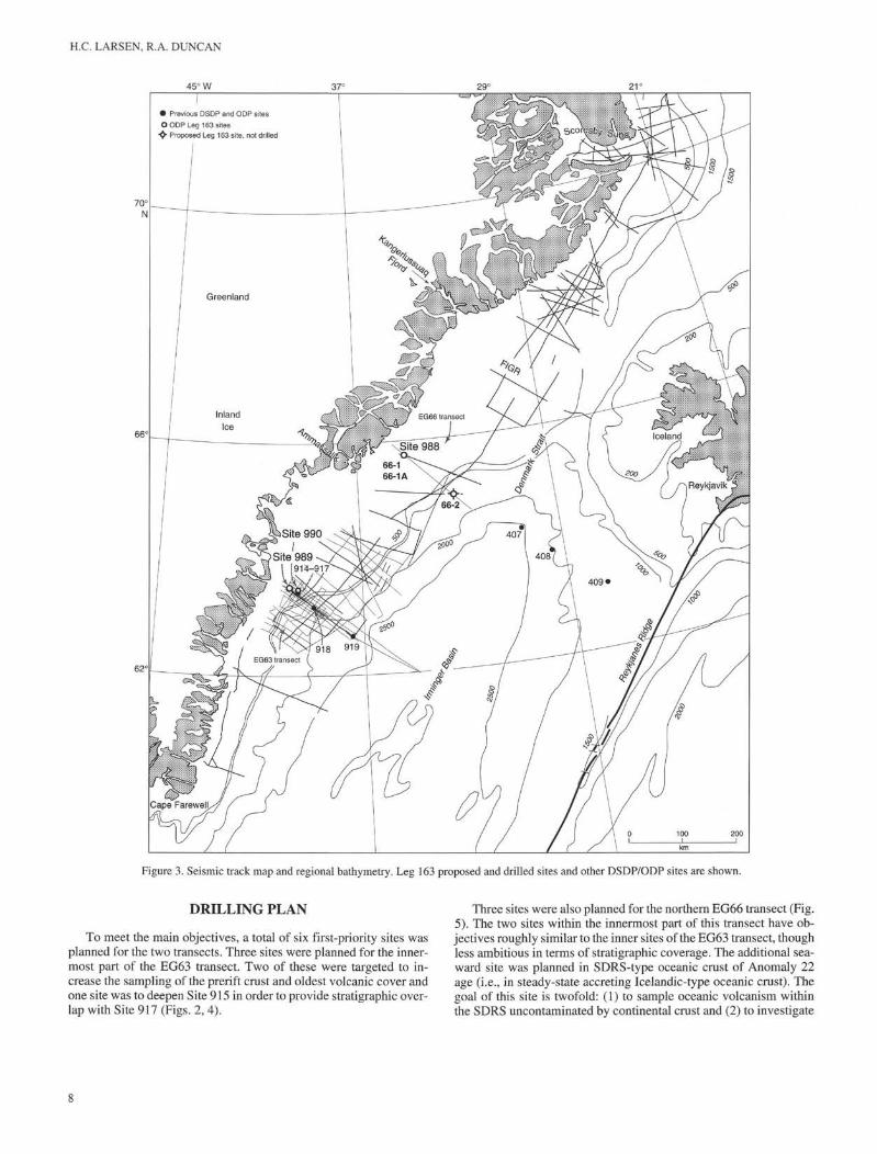
Figure 3. Seismic track map and regional bathymetry. Leg 163 proposed and drilled sites and other DSDP/ODP sites are shown.
DRILLING PLAN
To meet the main objectives, a total of six first-priority sites wasplanned for the two transects. Three sites were planned for the inner-most part of the EG63 transect. Two of these were targeted to in-crease the sampling of the prerift crust and oldest volcanic cover andone site was to deepen Site 915 in order to provide stratigraphic over-lap with Site 917 (Figs. 2, 4).
Three sites were also planned for the northern EG66 transect (Fig.5). The two sites within the innermost part of this transect have ob-jectives roughly similar to the inner sites of the EG63 transect, thoughless ambitious in terms of stratigraphic coverage. The additional sea-ward site was planned in SDRS-type oceanic crust of Anomaly 22age (i.e., in steady-state accreting Icelandic-type oceanic crust). Thegoal of this site is twofold: (1) to sample oceanic volcanism withinthe SDRS uncontaminated by continental crust and (2) to investigate
INTRODUCTION: BACKGROUND AND OBJECTIVES
any increased (or decreased) presence of a plume component withtime along the EG66 transect.
CHANGES IN THE DRILLING PLAN IMPOSEDBY DRILLING PROBLEMS AND WEATHER
A drilling accident and damage to the ship sustained during ex-treme storm conditions reduced the scientific drilling operations dur-ing Leg 163 to less than one-half of the planned program.
Recoil from a break in the drill pipe on 10 September 1995 dam-aged the top drive assembly after only one day of drilling at the first,shallow-water site (see "Operations" section, "Site 988" chapter, thisvolume). A port call to Reykjavik, Iceland, was made for the neces-sary repairs. Permission to drill in water depths shallower than 300 m(proposed Sites EG66-1 and EG66-1A; Figs. 3, 5) was temporarilywithdrawn by ODP, pending review of safety procedures and deliv-ery of supplementary drilling hardware. Operations therefore re-sumed at the deeper water sites along the southern EG63 transect on16 September. Drilling progressed, though with interruptions be-cause of heavy seas and icebergs drifting across the drill sites, until29 September.
Extreme hurricane conditions built rapidly through the night of 29September to the following morning (see "Operations" section, "Site990" chapter, this volume). At times the north-northeast wind ex-ceeded 100 kt, and it remained at hurricane force for at least 12 hr. Bythe morning of 30 September the ship was being battered by short-period, 60-70-ft-high waves and was unable to maintain positionwithout risking severe damage. The ship's bridge took water througha broken window, which caused both radars to fail and threatened toflood the computers of the dynamic-positioning system. Severalthrusters were mechanically damaged or became inoperable becauseof flooding. In spite of reduced maneuverability the ship was able tomaintain heading in the wind and sea while it was being forced southat a speed of up to 4 kt. While drifting in this manner, there was anincreased potential of colliding with icebergs. When the storm abatedto gale force on 1 October, the ship was turned to the south and thetransit to Halifax, Nova Scotia, for repair was started.
At this point, the two co-chief scientists were informed that a thor-ough examination of the ship's structure and systems was neededafter this calamity. This eliminated Reykjavik as a destination fortemporary repair and thereby ruled out the possibility of further drill-ing operations during Leg 163. As a result of these force majeureevents, only three of the planned six sites were drilled.
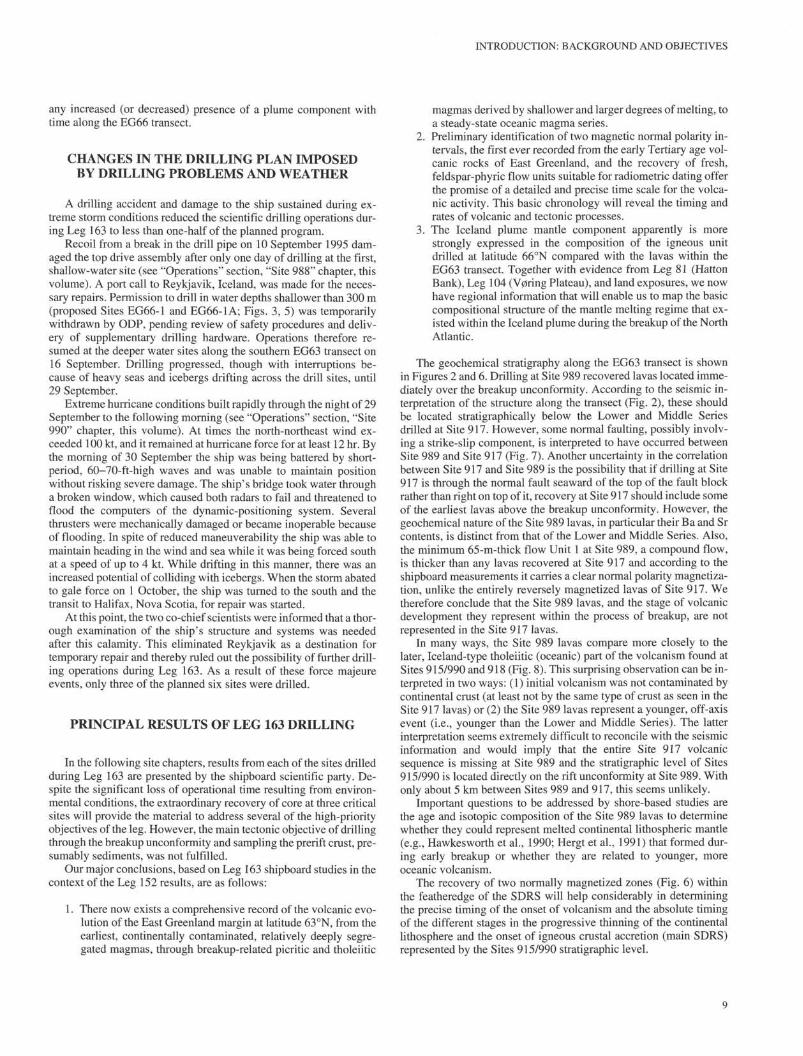
PRINCIPAL RESULTS OF LEG 163 DRILLING
In the following site chapters, results from each of the sites drilledduring Leg 163 are presented by the shipboard scientific party. De-spite the significant loss of operational time resulting from environ-mental conditions, the extraordinary recovery of core at three criticalsites will provide the material to address several of the high-priorityobjectives of the leg. However, the main tectonic objective of drillingthrough the breakup unconformity and sampling the prerift crust, pre-sumably sediments, was not fulfilled.
Our major conclusions, based on Leg 163 shipboard studies in thecontext of the Leg 152 results, are as follows:
1. There now exists a comprehensive record of the volcanic evo-lution of the East Greenland margin at latitude 63 °N, from theearliest, continentally contaminated, relatively deeply segre-gated magmas, through breakup-related picritic and tholeiitic
magmas derived by shallower and larger degrees of melting, toa steady-state oceanic magma series.
2. Preliminary identification of two magnetic normal polarity in-tervals, the first ever recorded from the early Tertiary age vol-canic rocks of East Greenland, and the recovery of fresh,feldspar-phyric flow units suitable for radiometric dating offerthe promise of a detailed and precise time scale for the volca-nic activity. This basic chronology will reveal the timing andrates of volcanic and tectonic processes.
3. The Iceland plume mantle component apparently is morestrongly expressed in the composition of the igneous unitdrilled at latitude 66°N compared with the lavas within theEG63 transect. Together with evidence from Leg 81 (HattonBank), Leg 104 (V0ring Plateau), and land exposures, we nowhave regional information that will enable us to map the basiccompositional structure of the mantle melting regime that ex-isted within the Iceland plume during the breakup of the NorthAtlantic.
The geochemical stratigraphy along the EG63 transect is shownin Figures 2 and 6. Drilling at Site 989 recovered lavas located imme-diately over the breakup unconformity. According to the seismic in-terpretation of the structure along the transect (Fig. 2), these shouldbe located stratigraphically below the Lower and Middle Seriesdrilled at Site 917. However, some normal faulting, possibly involv-ing a strike-slip component, is interpreted to have occurred betweenSite 989 and Site 917 (Fig. 7). Another uncertainty in the correlationbetween Site 917 and Site 989 is the possibility that if drilling at Site917 is through the normal fault seaward of the top of the fault blockrather than right on top of it, recovery at Site 917 should include someof the earliest lavas above the breakup unconformity. However, thegeochemical nature of the Site 989 lavas, in particular their Ba and Srcontents, is distinct from that of the Lower and Middle Series. Also,the minimum 65-m-thick flow Unit 1 at Site 989, a compound flow,is thicker than any lavas recovered at Site 917 and according to theshipboard measurements it carries a clear normal polarity magnetiza-tion, unlike the entirely reversely magnetized lavas of Site 917. Wetherefore conclude that the Site 989 lavas, and the stage of volcanicdevelopment they represent within the process of breakup, are notrepresented in the Site 917 lavas.
In many ways, the Site 989 lavas compare more closely to thelater, Iceland-type tholeiitic (oceanic) part of the volcanism found atSites 915/990 and 918 (Fig. 8). This surprising observation can be in-terpreted in two ways: (1) initial volcanism was not contaminated bycontinental crust (at least not by the same type of crust as seen in theSite 917 lavas) or (2) the Site 989 lavas represent a younger, off-axisevent (i.e., younger than the Lower and Middle Series). The latterinterpretation seems extremely difficult to reconcile with the seismicinformation and would imply that the entire Site 917 volcanicsequence is missing at Site 989 and the stratigraphic level of Sites915/990 is located directly on the rift unconformity at Site 989. Withonly about 5 km between Sites 989 and 917, this seems unlikely.
Important questions to be addressed by shore-based studies arethe age and isotopic composition of the Site 989 lavas to determinewhether they could represent melted continental lithospheric mantle(e.g., Hawkesworth et al., 1990; Hergt et al, 1991) that formed dur-ing early breakup or whether they are related to younger, moreoceanic volcanism.
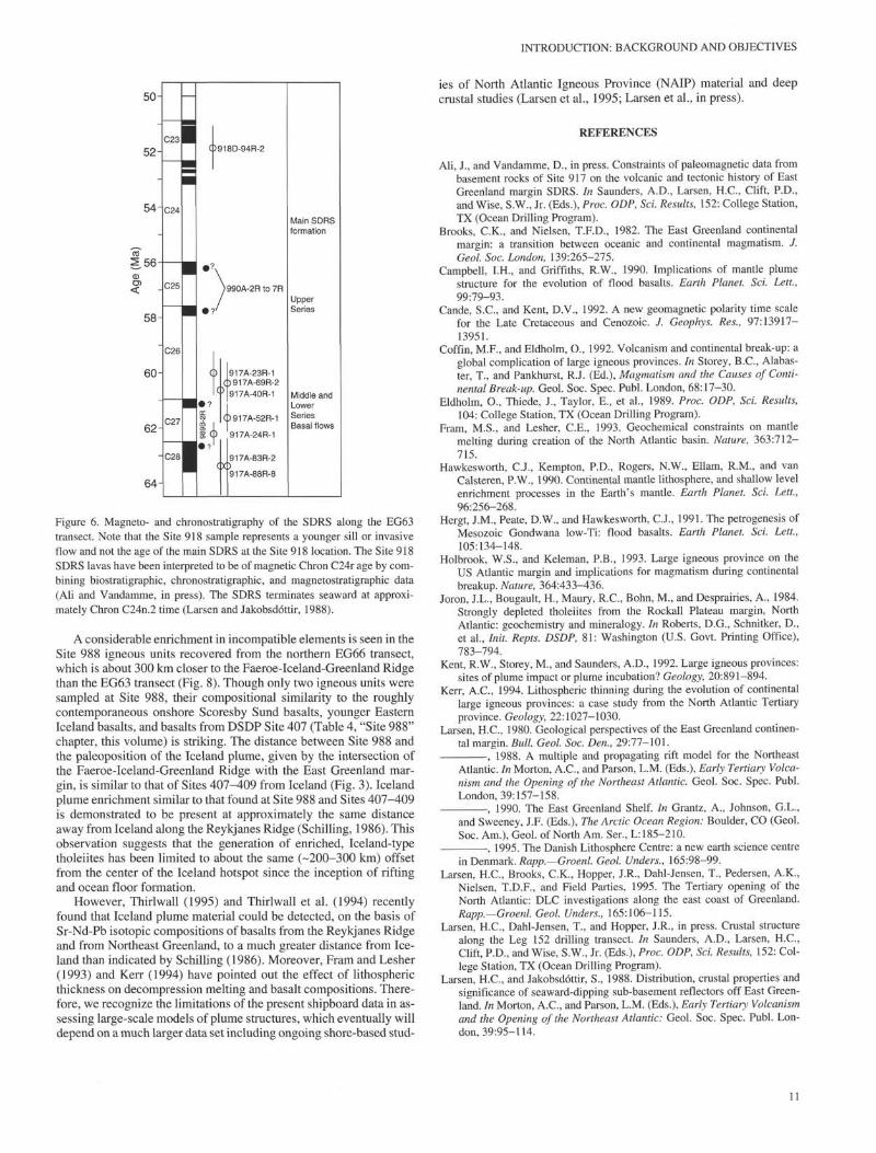
The recovery of two normally magnetized zones (Fig. 6) withinthe featheredge of the SDRS will help considerably in determiningthe precise timing of the onset of volcanism and the absolute timingof the different stages in the progressive thinning of the continentallithosphere and the onset of igneous crustal accretion (main SDRS)represented by the Sites 915/990 stratigraphic level.

H.C. LARSEN, R.A. DUNCAN
Site Site989 990
500 1000 1500 2000SP
2500
α>b+—>0)
rav
TI
5
2
3-
• : . •• • •• . • • • • . • . ; - " • • • • .
. . . ; • • • \ • • ' • • •••• : . • • . •918
S
. . . . . . . . . • . •.• • • . . .
• : • • • • • ; ' . • • • • • • - • ;
•jgy•^g :;; "*•5?v '•*
• . . • ••• • • . . . . ; . . • . • . . . • • • . ^ • • • • • , , . . : • . , • • .
1 •1 • • ••• • • , • • : . • 1 • • • . • •:•- •••• •: •• •: : ' . . . . . . . . ' r > S ‰ i s S y ^
Depth-migrated section
Continentalbasement
NW 1:3
Figure 4. Regional seismic Line GGU81-08 and interpretation along the EG63 transect.
Site 988EG66-1 M.EG66-1A 1000 1500 2000 1500 1000 500
• . . , . . . . . . . , . . . . . . . . . . . . , : . : . . • . . . . .
÷ _ _ '.
NW
Figure 5. Spliced composite and inteΦretation of regional seismic Lines GGU82-01 and GGU82-02/2A along the EG66 transect. The line is spliced together
(break in data) from the two regional lines through the inner and outer sites, respectively.
10
INTRODUCTION: BACKGROUND AND OBJECTIVES
50-
64-
Figure 6. Magneto- and chronostratigraphy of the SDRS along the EG63transect. Note that the Site 918 sample represents a younger sill or invasiveflow and not the age of the main SDRS at the Site 918 location. The Site 918SDRS lavas have been interpreted to be of magnetic Chron C24r age by com-bining biostratigraphic, chronostratigraphic, and magnetostratigraphic data(Ali and Vandamme, in press). The SDRS terminates seaward at approxi-mately Chron C24n.2 time (Larsen and Jakobsdóttir, 1988).
A considerable enrichment in incompatible elements is seen in theSite 988 igneous units recovered from the northern EG66 transect,which is about 300 km closer to the Faeroe-Iceland-Greenland Ridgethan the EG63 transect (Fig. 8). Though only two igneous units weresampled at Site 988, their compositional similarity to the roughlycontemporaneous onshore Scoresby Sund basalts, younger EasternIceland basalts, and basalts from DSDP Site 407 (Table 4, "Site 988"chapter, this volume) is striking. The distance between Site 988 andthe paleoposition of the Iceland plume, given by the intersection ofthe Faeroe-Iceland-Greenland Ridge with the East Greenland mar-gin, is similar to that of Sites 407-409 from Iceland (Fig. 3). Icelandplume enrichment similar to that found at Site 988 and Sites 407-409is demonstrated to be present at approximately the same distanceaway from Iceland along the Reykjanes Ridge (Schilling, 1986). Thisobservation suggests that the generation of enriched, Iceland-typetholeiites has been limited to about the same (-200-300 km) offsetfrom the center of the Iceland hotspot since the inception of riftingand ocean floor formation.
However, Thirlwall (1995) and Thirlwall et al. (1994) recentlyfound that Iceland plume material could be detected, on the basis ofSr-Nd-Pb isotopic compositions of basalts from the Reykjanes Ridgeand from Northeast Greenland, to a much greater distance from Ice-land than indicated by Schilling (1986). Moreover, Fram and Lesher(1993) and Kerr (1994) have pointed out the effect of lithosphericthickness on decompression melting and basalt compositions. There-fore, we recognize the limitations of the present shipboard data in as-sessing large-scale models of plume structures, which eventually willdepend on a much larger data set including ongoing shore-based stud-
ies of North Atlantic Igneous Province (NAIP) material and deepcrustal studies (Larsen et al., 1995; Larsen et al., in press).
REFERENCES
Ali, J., and Vandamme, D., in press. Constraints of paleomagnetic data frombasement rocks of Site 917 on the volcanic and tectonic history of EastGreenland margin SDRS. In Saunders, A.D., Larsen, H.C., Clift, P.D.,and Wise, S.W., Jr. (Eds.), Proc. ODP, Sci. Results, 152: College Station,TX (Ocean Drilling Program).
Brooks, C.K., and Nielsen, T.F.D., 1982. The East Greenland continentalmargin: a transition between oceanic and continental magmatism. J.Geol. Soc. London, 139:265-275.
Campbell, I.H., and Griffiths, R.W., 1990. Implications of mantle plumestructure for the evolution of flood basalts. Earth Planet. Sci. Lett.,99:79-93.
Cande, S.C., and Kent, D.V., 1992. A new geomagnetic polarity time scalefor the Late Cretaceous and Cenozoic. J. Geophys. Res., 97:13917-13951.
Coffin, M.F., and Eldholm, O., 1992. Volcanism and continental break-up: aglobal complication of large igneous provinces. In Storey, B.C., Alabas-ter, T., and Pankhurst, R.J. (Ed.), Magmatism and the Causes of Conti-nental Break-up. Geol. Soc. Spec. Publ. London, 68:17-30.
Eldholm, O., Thiede, J., Taylor, E., et al., 1989. Proc. ODP, Sci. Results,104: College Station, TX (Ocean Drilling Program).
Fram, M.S., and Lesher, C.E., 1993. Geochemical constraints on mantlemelting during creation of the North Atlantic basin. Nature, 363:712-715.
Hawkesworth, C.J., Kempton, P.D., Rogers, N.W., Ellam, R.M., and vanCalsteren, P.W., 1990. Continental mantle lithosphere, and shallow levelenrichment processes in the Earth's mantle. Earth Planet. Sci. Lett.,96:256-268.
Hergt, J.M., Peate, D.W., and Hawkesworth, C.J., 1991. The petrogenesis ofMesozoic Gondwana low-Ti: flood basalts. Earth Planet. Sci. Lett.,105:134-148.
Holbrook, W.S., and Keleman, P.B., 1993. Large igneous province on theUS Atlantic margin and implications for magmatism during continentalbreakup. Nature, 364:433-436.
Joron, J.L., Bougault, H., Maury, R.C., Bohn, M., and Desprairies, A., 1984.Strongly depleted tholeiites from the Rockall Plateau margin, NorthAtlantic: geochemistry and mineralogy. In Roberts, D.G., Schnitker, D.,et al., Init. Repts. DSDP, 81: Washington (U.S. Govt. Printing Office),783-794.
Kent, R.W., Storey, M., and Saunders, A.D., 1992. Large igneous provinces:sites of plume impact or plume incubation? Geology, 20:891-894.
Kerr, A.C., 1994. Lithospheric thinning during the evolution of continentallarge igneous provinces: a case study from the North Atlantic Tertiaryprovince. Geology, 22:1027-1030.
Larsen, H.C., 1980. Geological perspectives of the East Greenland continen-tal margin. Bull. Geol. Soc. Den., 29:77-101.
, 1988. A multiple and propagating rift model for the NortheastAtlantic. In Morton, A.C., and Parson, L.M. (Eds.), Early Tertiary Volca-nism and the Opening of the Northeast Atlantic. Geol. Soc. Spec. Publ.London, 39:157-158.
-, 1990. The East Greenland Shelf, in Grantz, A., Johnson, G.L.,and Sweeney, J.F. (Eds.), The Arctic Ocean Region: Boulder, CO (Geol.Soc. Am.), Geol. of North Am. Ser., L:185-210.
-, 1995. The Danish Lithosphere Centre: a new earth science centrein Denmark. Rapp.—Groenl. Geol. Unders., 165:98-99.
Larsen, H.C., Brooks, C.K., Hopper, J.R., Dahl-Jensen, T., Pedersen, A.K.,Nielsen, T.D.F., and Field Parties, 1995. The Tertiary opening of theNorth Atlantic: DLC investigations along the east coast of Greenland.Rapp.—Groenl. Geol. Unders., 165:106-115.
Larsen, H.C., Dahl-Jensen, T., and Hopper, J.R., in press. Crustal structurealong the Leg 152 drilling transect. In Saunders, A.D., Larsen, H.C.,Clift, P.D., and Wise, S.W., Jr. (Eds.), Proc. ODP, Sci. Results, 152: Col-lege Station, TX (Ocean Drilling Program).
Larsen, H.C., and Jakobsdóttir, S., 1988. Distribution, crustal properties andsignificance of seaward-dipping sub-basement reflectors off East Green-land. In Morton, A.C., and Parson, L.M. (Eds.), Early Tertiary Volcanismand the Opening of the Northeast Atlantic: Geol. Soc. Spec. Publ. Lon-don, 39:95-114.
11

H.C. LARSEN, R.A. DUNCAN
Larsen, H.C, Saunders, A.D., Clift, P.D., et al., 1994. Proc. ODP, Init.Repts., 152: College Station, TX (Ocean Drilling Program).
Larsen, H.C, Saunders, A.D., Larsen, L.M., Lykke-Andersen, H., Leg 152Scientific Party, Marcussen, C, and Clausen, L., 1994. ODP activities onthe South-East Greenland margin: Leg 152 drilling and continued sitesurveying. Rapp.—Groenl. Geol. Unders., 160:75-81.
Larsen, H.C, Sawyer, D.S., and the NARM-DPG, 1991. North Atlanticrifted margins detailed planning group report. JOIDES J., 3:24-26.
Larsen, L.M., Watt, W.S., and Watt, M., 1989. Geology and petrology of theLower Tertiary plateau basalts of the Scoresby Sund region, East Green-land. Bull— Groenl. Geol. Unders., 157:1-164.
Mutter, J.C, Buck, W.R., and Zehnder, CM., 1988. Convective partial melt-ing, 1. A model for the formation of thick basaltic sequences during theinitiation of spreading. /. Geophys. Res., 93:1031-1048.
Mutter, J.C, Talwani, M., and Stoffa, P.L., 1982. Origin of seaward-dippingreflectors in oceanic crust off the Norwegian margin by "subaerial sea-floor spreading." Geology, 10:353-357.
Myers, J.S., 1980. Structure of the coastal dyke swarm and associated plu-tonic intrusions of East Greenland. Earth Planet. Sci. Lett., 46:407-418.
Myers, J.S., Gill, R.C.O., Rex, D.C., and Charnley, N.R., 1993. The KapGustav Holm Tertiary Plutonic Centre, East Greenland. J. Geol. Soc.London, 150:259-276.
Nielsen, T.F.D., Soper, NJ., Brooks, C.K., Faller, A.M., Higgins, A.C, andMatthews, D.W., 1981. The pre-basaltic sediments and the lower basaltsat Kangerdlugssuaq, East Greenland: their stratigraphy, lithology, Paleo-magnetism and petrology. Medd. Groenl., Geosci., 6:1-25.
Pálmason, G., 1986. Model of crustal formation in Iceland, and applicationto submarine mid-ocean ridges. In Vogt, P.R., and Tucholke, B.E. (Eds.),The Western North Atlantic Region: Boulder, CO (Geol. Soc. Am.),Geol. of North Am. Ser., M:87-98.
Richards, M.A., Duncan, R.A., and Courtillot, V.E., 1989. Flood basalts andhot-spot tracks: plume heads and tails. Science, 246:103-107.
Roberts, D.G., Schnitker, D., et al., 1984. Init. Repts. DSDP, 81: Washington(U.S. Govt. Printing Office).
Schilling, J.-G., 1986. Geochemical and isotopic variation along the Mid-Atlantic Ridge axis from 79°N to 0°N. In Vogt, P.R., and Tucholke, B.E.(Eds.), The Western North Atlantic Region: Boulder, CO (Geol. Soc.Am.), Geol. of North Am. Ser., M: 137-156.
Sinton, C.W., Larsen, H.C, and Duncan, R.A., 1994. The timing of the vol-canism at the southeast Greenland Margin, ODP Leg 152. Eos, 75:607.
Srivastava, S.P., and Tapscott, CR., 1986. Plate kinematics of the NorthAtlantic. In Vogt, P.R., and Tucholke, B.E. (Eds.), The Western NorthAtlantic Region: Boulder, CO (Geol. Soc. Am.), Geol. North Am. Ser.,M:379-404.
Talwani, M., and Eldholm, O., 1977. Evolution of the Norwegian-GreenlandSea. Geol. Soc. Am. Bull, 88:969-999.
Thirlwall, M.F., 1995. Generation of Pb isotopic characteristics of the Ice-land plume. J. Geol. Soc. London, 152:991-996.
Thirlwall, M.F., Upton, B.G.J., and Jenkins, C, 1994. Interaction betweencontinental lithosphere and the Iceland plume: Sr-Nd-Pb isotopegeochemistry of Tertiary basalts, NE Greenland. J. Petrol., 35:839-879.
Viereck, L.G., Taylor, P.N., Parson, L.M., Morton, A.C, Hertogen, J., Gib-son, I.L., and the ODP Leg 104 Scientific Party, 1988. Origin of thePalaeogene V0ring Plateau volcanic sequence. In Morton, A.C, and Par-son, L.M. (Eds.), Early Tertiary Volcanism and the Opening of theNortheast Atlantic. Geol. Soc. Spec. Publ. London, 39:69-83.
White, R., and McKenzie, D., 1989. Magmatism at rift zones: the generationof volcanic continental margins and flood basalts. /. Geophys. Res.,94:7685-7729.
Ms 163IR-101
Site 989 Site 990500
• • • . ' . • • • • : • : • •
|EG92J4 ^ J .2.5 @ 4 km/s f * 1:2.5 \ 2 0 ° | L
Figure 7. Seismic Line EG92-24 and interpretation along the inner EG63 transect.
12

INTRODUCTION: BACKGROUND AND OBJECTIVES
100
50
j
j
i 10
Site 988 988A-1R-2
988A-3R-3
988A-4R-1
EasternM\\ Iceland basalt
Scoresby Sundbasalt
100
CDcco^ 10
Q.
ccCO
0.1100
CD
£ 10
GL
iCO
0.1
Site 989
__ Site 917Lower Series
0 989A-1R-4
• 989A-3R-6
1 989B-1R-4
• 989B-2R-1
A 989B-6R-2
989B-10R-2
v 989B-10R-7
T 989B-12R-1
•
Site 918
Site 9 9 0 α 990A5R-4• 990A-6R-1
- 990A-9R-3
• 990A-20R-2
Site 918 Site 915
RbBa K Nb CeSr P Zr Ti Y
Figure 8. Normalized minor element and trace-element patterns of the SDRS
along the EG63 (Sites 915, 917, 918, 989, and 990) and EG66 transects (Site
988). Note the different vertical scale for the Site 988 plot.
13