height restriction ordinance
TRANSCRIPT
ALAMANCE COUNTY HEIGHT RESTRICTION ORDINANCE
Originally adopted by THE BOARD OF COUNTY COMMISSIONERS
January 21,1985
Last Amended by THE BOARD OF COUNTY COMMISSIONERS
December 19, 2016
1
ARTICLE ONE: AUTHORITY AND ENACTMENT CLAUSE
AN ORDINANCE REGULATING AND RESTRICTING THE HEIGHT OF STRUCTURES AND OBJECTS OF
NATURAL GROWTH, AND OTHERWISE REGULATING THE USE OF PROPERTY AFFECTING AIR
TRAFFIC, IN THE VICINITY OF THE BURLINGTON-ALAMANCE REGIONAL AIRPORT BY CREATING
THE APPROPRIATE ZONES AND ESTABLISHING THE BOUNDARIES THEREOF; PROVIDING FOR
CHANGES IN THE RESTRICTIONS AND BOUNDARIES OF SUCH ZONES; DEFINING CERTAIN TERMS
USED HEREIN; REFERRING TO THE BURLINGTON-ALAMANCE REGIONAL AIRPORT HEIGHT
RESTRICTION DISTRICT MAP WHICH IS INCORPORATED IN AND MADE A PART OF THIS
ORDINANCE; PROVIDING FOR ENFORCEMENT; ESTABLISHING A BOARD OF APPEALS; AND
IMPOSING PENALTIES.
1.1 WHEREAS, Chapter 63, Article 4, of the Laws of the State of North Carolina
authorize political subdivisions of the State of North Carolina to adopt, administer, and
enforce under the police power airport zoning regulations; and
1.2 WHEREAS,the Board finds that obstruction to air navigation have the potential
for endangering the lives and property of users of the Burlington-Alamance Regional
Airport, and property or occupants of land in its vicinity; that an obstruction may affect
existing and future instrument approach minimums of the Burlington-Alamance
Regional Airport; and that obstructions may reduce the size of areas available for the
landing, take-off, and maneuvering of aircraft, thus tending to destroy or impair the
utility of the Burlington-Alamance Regional Airport and the public investment therein.
Accordingly, it is declared:
1. That the creation or establishment of an obstruction has the potential of being a
public nuisance and may injure the region served by the Burlington-Alamance
Regional Airport;
2. That it is necessary in the interest of the public health, public safety and general
welfare that the creation or establishment of obstructions that are a hazard to
air navigation be prevented; and
3. That the prevention of these obstructions should be accomplished, to the extent
legally possible, by the exercise of the police power without compensation.
1.3 It is further declared that the prevention of the creation, or establishment or
hazards to air navigation, the elimination, removal, alteration or mitigation of hazards to
air navigation, or marking and lighting of obstructions are public purposes for which a
political subdivision may raise and expend public funds and acquire land or interests in
land.
1.4 NOW, THEREFORE BE IT ORDAINED BY THE BOARD OF COUNTY COMMISSIONERS OF ALAMANCE COUNTY, NORTH CAROLINA, AS FOLLOWS:
2
ARTICLE TWO: ESTABLISHMENT OF AIRPORT DISTRICTS
2. AIRPORT DISTRICTS. For the purpose of this ordinance, a portion of Alamance County is hereby divided into an Airport District. The purpose of this Ordinance is to regulate the height of objects in the vicinity of the airport to assure compatibility with aviation activity and maintain clear zones and approach zones in accordance with Federal Aviation Administration requirements.
2.1 ESTABLISHMENTOF THE DISTRICT MAP.
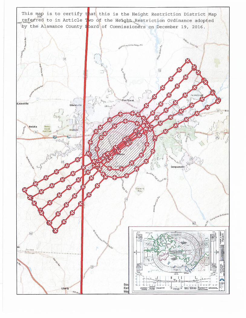
(A) Alamance County is hereby divided into a district, as shown on the Height Restriction District Map which, together with all explanatory matter thereon, is hereby adopted by reference and declared to be part of this Ordinance.
(B) An official copy of the Height Restriction District Map of Alamance County shall be filed in the Offices of the County Clerk. This map shall bear the seal of Alamance County under the following words: "This is to certify that this is the Height Restriction District Map referred to in Article Two of the Height Restriction Ordinance adopted by the Alamance County Board of Commissioners on December 19, 2016".
2.2 INTERPRETATION OF DISTRICT BOUNDARIES. Where uncertainty exists with respect to the boundary of any district shown on the Official District Map the following rules shall govern:
(A) Where any district boundary is indicated on the district map as following approximately the County boundary line or the corporate limits line of any incorporated place within the County, then such County boundary line or corporate limits line shall be construed to be such district boundary.
(B) Unless otherwise indicated, the district boundaries follow natural features such as marsh edges and stream banks.
(C) Where indicated, district boundaries are parallel to the center lines of streets, highways or railroads, or the rights-of-way of same; property lines; streams or other bodies of water; or said lines extended at such distance therefore as indicated on the district map. If no distance is given, such distance shall be determined by the use of the scale on said district map.
(D) Where district boundary lines are so indicated that they approximately follow property or lot lines, such property or lot lines shall be construed to be such boundary lines.
3
(E) Where a district boundary line divides a parcel or lot, the location or any such district boundary line, unless indicated by dimensions shown on the district map, shall be determined by the use of the scale on said district map.
2.3 AIRPORT DISTRICTS. This district is established for two purposes: (1) to minimize safety, noise and light conflicts between airport users and property owners in the area; (2) to adequately protect valuable public facilities upon which large amounts of public monies have already been spent. Protection will be accomplished to the extent legally possible by the exercise of the police power without compensation.
2.4 DEFINITIONS. As used in this Ordinance, unless the context otherwise requires:
(A) Airport. Means the Burlington-Alamance Regional Airport.
(B) Airport Authority: The Burlington-Alamance Airport Authority and its agents, a governing body charged with administering the operations of the Burlington-Alamance Regional Airport.
(C) Airport Elevation. Means the established elevation of the highest point on the usable landing area, (616.1' mean sea level - MSL).
(D) Approach Surface: An inclined plan longitudinally centered along the extended runway centerline, sloping outward and upward from the end of the primary surface. In plan the perimeter of the approach surface coincides with the perimeter of the approach zone.
(E) Approach Zone: The approach zone is an area beneath the approach surface as forth in Section 2.3.2 of this ordinance.
(F) Airport Hazard. Means any overhead powerline, not constructed, operated and maintained according to standard engineering practices in general use which interferes with radio communication or navigation between a publicly owned airport and aircraft approaching or leaving same, or any structure of tree or use of land which obstructs the airspace required for the landing or takeoff of aircraft.
(G) Airport Reference Point. Means the point established as the approximate geographic center of the airport landing area and so designated.
(H) Board of Adjustment. A board made up of five members appointed by the County Board of Commissioners in accordance with N.C.G.S. 63-33 with the powers and duties set forth in Chapter 63, Article 4 of the North Carolina General Statutes.
4
(I) Conical Surface: A surface extending from the periphery of the horizontal surface at a slope of 20 feet outward for each foot upward (20:1) for a horizontal distance of 4,000 feet.
(J) Conical Zone: The conical zone is an area beneath the conical surface as forth in Section 2.3.2 of this ordinance.
(K) Hazard to Air Navigation: an obstruction determined to have a substantial adverse effect on the safe and efficient utilization of the navigable airspace.
(L) Height: For the purpose of determining the height limits in all zones set forth in this Ordinance and shown on the zoning map, the datum shall be mean sea level elevation unless otherwise specified.
(M) Horizontal Surface (Burlington Safety Surface): A circular horizontal plane 100 feet above the airport elevation established by swinging arcs of 10,000 feet radii from the end of the primary surface of each runway end centerline and connecting the adjacent arcs by drawing lines tangent to those arcs. The horizontal zone does not include the approach and transitional zones.
(N) Horizontal Zone: The horizontal zone is an area beneath the horizontal surface as forth in Section 2.3.2 of this ordinance.
(O) Landing Area. Means the area of the Airport used for the landing, takeoff or taxiing of aircraft.
(P) Non-Conforming Use. Means any structure or tree which is lawfully in existence at the time the regulation is adopted and does not then meet the provisions of this regulation, or an amendment thereto.
(Q) Obstruction. Any structure, growth, or other object, including a mobile object, which exceeds a limiting height set forth in this Ordinance.
(R) Person. Means an individual, firm, partnership, corporation, company, association, joint stock association or body politic, and includes a trustee, receiver, assignee, administrator, executor guardian, or other representative.
(S) Precision Instrument Runway: A runway end having instrument capabilities utilizing air navigation with horizontal and vertical approach guidance.
5
(T) Primary Surface. A surface longitudinally centered on a runway. When the runway has a specially prepared hard surface, the primary surface extends 200 feet beyond each end of that runway; when the runway has no specially prepared hard surface, or planned hard surface, the primary surface ends at each end of that runway. The width of the primary surface is set forth in Section 2.3.2 of this Ordinance. The elevation of any point on the primary surface is the same as the elevation of the nearest point on the runway centerline.
(U) Runway: A defined area on an airport prepared for landing and takeoff of aircraft along its length. The planned usable runway length for the Airport is 7,000 feet. The runway end is the physical end of the hardsurface, having a defined coordinate and elevation as noted on the Height Restriction Zoning Plan Map.
(V) Structure: Means an object constructed, or installed by man, including, but without limitation, buildings, towers, smokestacks, and overhead transmission lines.
(W) Transitional Surfaces: Surfaces extending outward at 90-degree angles to the runway centerline at a slope of seven feet horizontally for each foot vertically (7:1) to a point intersecting with the horizontal and conical surfaces.
(X) Transitional Zones: The transitional zones are areas beneath the transitional surfaces as forth in Section 2.3.2 of this ordinance.
(V) Tree: Means any object of natural growth.
2.5 AIRPORT ZONE HEIGHT LIMITATIONS. Except as otherwise provided in this Ordinance, no structure shall be erected, altered or maintained, and no trees shall be allowed to grow in any zone created by this Ordinance to a height in excess of the applicable height limitation herein established for each zone in question as follows:
(A) Approach Zone(s)
a. Runway 6 & 24 Precision Instrument Runway End (APA): Slopes 50 feet outward for each foot upward (50:1) beginning at the end of and at the same elevation as the primary surfaces and extending to a horizontal distance of 10,000 feet along the extended runway centerline; thence slopes upward 40 feet horizontally for each foot
6
vertically (40:1) to an additional horizontal distance of 40,000 feet along the extended runway centerline.
b. Runway 6 - Precision Instrument Approach Zone: The inner edge of this approach zone coincides with the width of the primary surface and is 1,000 feet wide. The approach zone expands outward uniformly to a width of 16,000 feet at a horizontal distance of 50,000 feet from the primary surface. Its centerline is the continuation of the centerline of the runway.
c. Runway 24 - Precision Instrument Approach Zone: The inner edge of this approach zone coincides with the width of the primary surface and is 1,000 feet wide. The approach zone expands outward uniformly to a width of 16,000 feet at a horizontal distance of 50,000 feet from the primary surface. Its centerline is the continuation of the centerline of the runway.
(B) Transitional Zones (APT): Slopes seven feet outward for each foot upward (7:1) at 90-degree angle from the primary and approach surfaces to a point intersecting the horizontal or conical surface. The transitional surface symmetric to the sides of the runway slopes seven feet outward for each foot upward (7:1) at an elevation same as the primary surface. The transitional surface symmetric to the sides of the precision approach surface slopes seven feet outward for each foot upward (7:1) beginning at the sides of and the same elevation as the approach surface and extending a horizontal distance of 5,000 feet measured at 90-degree angles to the extended runway centerline.
(C) Horizontal Zone (APH): Established at 100 feet above the airport elevation, or 716.1 feet above mean sea level.
(D) Conical Zone (APC): Slopes 20 feet outward for each foot upward for a lateral distance of 4,000 feet beginning at the periphery of the horizontal zone and extending to an elevation of 916.1 feet above mean sea level.
2.6 HEIGHT RESTRICTIONS. Except as otherwise provided or as necessary to airport operations, no structure or tree shall be constructed altered, maintained, or allowed to grow in any airspace zone created in Section 2.3.2 so as to project above any of the imaginary airspace surfaces described. Where an area is covered by more than one height limitation, the more restrictive limitations shall prevail.
2.7 USE RESTRICTIONS. Notwithstanding any other provisions of this Ordinance, no use may be made of land or water within any zone established by this Ordinance
7
in such a manner as to create electrical interference with navigational signals or radio communication between the Airport and aircraft, make it difficult for pilots to distinguish between airport lights and others, result in glare in the eyes of pilots using the Airport, impair visibility in the vicinity of the Airport, create bird strike hazards or otherwise endanger or interfere with the landing, taking-off, or maneuvering of aircraft intending to use Airport.
(A) The Burlington-Alamance Regional Airport Authority shall have the right to remove underbrush, trees and other obstacles in the pathways of said runways, so as to prevent interference with the slopes hereinabove set out, and no buildings or other structures shall be constructed of a height so as to interfere with such slopes.
2.8 NON-CONFORMING USES.
(A) Regulations not Retroactive. The regulations prescribed by this Ordinance shall not be construed to require the removal, lowering, or other changes or alteration of any structure or tree not conforming to the regulations as of the effective date of this Ordinance, or otherwise interfere with the continuance of any non-conforming use. Nothing herein contained shall require change in the construction, alteration, or intended use of any structure, the construction or alteration if which was begun prior to the effective date of this Ordinance, and which is diligently prosecuted.
(B) Marking and Lighting. Notwithstanding the preceding provision of this Section, the owner of any non-conforming structure or tree is hereby required to permit the installation, operation, and maintenance thereon so such markers and lights as shall be deemed necessary by the Director, Building Inspection Department to indicate to the operators of aircraft in the vicinity of the Burlington-Alamance Regional Airport, the presence of such airport obstruction. Such markers and lights shall be installed, operated, and maintained at the expense of the Burlington-Alamance Regional Authority.
8
ARTICLE THREE: CONSTRUCTION PERMITS
3. PERMITS. The Director, Building Inspection Department shall not issue a building permit within the Airport Approach Zone "APA", Airport Horizontal Zone "APH" or Airport Transitional Zone "APT" area until it has been determined that the proposal upon which he is requested to act is in compliance with the terms of these regulations.
Except as specifically provided in (A), (B), and (C) hereunder, no structure shall be erected or otherwise established, and no tree shall be planted which violates any zone hereby created unless a permit therefore shall have been applied for and granted. Each application permit shall indicate the purpose for which the permit is desired, with sufficient particularity to permit it to be determined whether the resulting use, structure, or tree would conform to the regulations herein prescribed. If such determination is in the affirmative, the permit shall be granted. No permit for a use inconsistent with the provisions of this Ordinance shall be granted unless a variance has been approved in accordance with Section 3.3.
(A) In the area lying within the limits of the horizontal zone (APH) and conical zone (APC), no permit shall be required for any tree or structure less than seventy-five feet (75') of vertical height above the ground, except when, because of terrain, land contour, or topographic features, such tree or structure would extend above the height limits prescribed for such zones.
(B) In areas lying within the limits of the approach zones (Precision Instrument Runway Approach Zone), but at a horizontal distance of not less than 4,200 feet from each end of the runway, no permit shall be required for any tree or structure less than seventy-five feet of vertical height above the ground, except when, because of terrain, land contour, or topographic features, such tree or structure would extend above the height limits prescribed for such zones.
(C) In the areas lying within the limits of the transition zones (APT), no permit shall be required for any tree or structure less than seventy-five feet (75') above the ground, except when such tree or structure because of terrain, land contour, or topographic features, would extend above the height limit prescribed for such transition zones.
Nothing contained in any of the foregoing exceptions, shall be construed as permitting or intending to permit any construction, alteration of any structure, or growth of any tree in excess of any of the height limits established by this Ordinance except as set forth in Section 3.3.
3.1 EXISTING USES. No permit shall be granted that would allow the establishment or creation of an airport hazard or permit a non-conforming use, structure, or
9
tree to be made or become higher, or become a greater hazard to air navigation, than it was on the effective date of this Ordinance or any amendments thereto or than it is when the application for a permit is made. Except as indicated, all applications for such a permit shall be granted.
3.2 NON-CONFORMING USES ABANDONED OR DESTROYED. Whenever the Director, Building Inspection Department determines that a non-conforming structure or tree has been abandoned or more than 80 percent torn down, physically deteriorated, or decayed, no permit shall be granted that would allow such structure or tree to exceed the applicable height limit or otherwise deviate from the Height Restriction Ordinance.
3.3 VARIANCES. Any person desiring to erect or increase the height of any structure, or permit the growth of any tree, or use property, not in accordance with the regulations prescribed in this Ordinance, may apply to the Board of Adjustment for a variance from such regulations. The application for variance shall be accompanied by a determination from the Federal Aviation Administration (FAA) as to the effect of the proposal on the operation of air navigation facilities and the safe, efficient use of navigable airspace. Such variances shall be allowed where it is duly found that a literal application or enforcement of the regulations will result in unnecessary hardship and relief granted, will not be contrary to the public interest, will not create a hazard to air navigation, will do substantial justice, and will be in accordance with the spirit of this Ordinance. Additionally, no application for variance to the requirements of this Ordinance may be considered by the Board of Adjustment unless a copy of the application has been furnished to the Director, Building Inspection Department; Chairman of the Burlington-Alamance Regional Airport, the FAA and N.C. Dept. Division of Aviation for advice as to the aeronautical effects of the variance. If the above organizations do not respond to the application within fifteen (15) days after receipt, the Board of Adjustment may act on its own to grant or deny said application.
3.4 OBSTRUCTION MARKING AND LIGHTING. Any permit or variance granted may, if such action is deemed advisable to effectuate the purpose of this Ordinance and be reasonable in the circumstances, be so conditioned as to require the owner of the structure or tree in question to install, operate and maintain at the owner's expense such markers and lights as may be necessary to indicate to pilots the presence of an airport hazard. If deemed proper by the Board of Adjustment this condition may be modified to require the owner to permit the BurlingtonAlamance Regional Airport at its own expense, to install, operate or maintain the necessary markings and lights.
3.5 DENIAL OF PERMIT. The Board of Adjustment shall deny approval of a construction permit only if it finds that the proposed construction does not
10
comply with the provisions of this Ordinance.
3.6 RIGHTS ATIACHING TO CONSTRUCTION PERMITS.
(A) Changes in the Height Restriction Ordinance which become effective after an application for a construction permit has been filed but before the permit has been granted will not apply to the pending application unless the Ordinance provides otherwise.
(B) The expectation that a construction permit could be obtained does not create any rights that prevent change of the Height Restriction Ordinance. A change in the Height Restriction Ordinance which becomes effective after a construction permit has been granted will not affect the builder's right to begin or complete construction in accordance with the permit.
(C) A construction permit is assignable but an assignment does not discharge any assignor from any obligation owned to the local government in connection with the construction, unless the Alamance County Board of Commissioners consent to the discharge of the obligation.
3.7 EXPIRATION OF CONSTRUCTION PERMIT. Any permit approved under the provisions of this Ordinance shall become invalid one (1) calendar year from the date of its issue unless:
(A) Otherwise specified by the permit;
(B) Construction is commencing in accordance with the approved permit.
(C) The Director for the Building Inspection Department may grant one (1) extension for a period of one (1) calendar year upon request of the applicant.
ARTICLE FOUR: ADMINISTRATION, ENFORCEMENT APPEAL, COMPLAINTS AND REMEDIES
4.1 PURPOSE. This Article establishes an official responsible for the administration and enforcement of this Ordinance; specifies the powers of the agency; sets forth procedures for the filing of construction applications and the issuance of permits including the establishment of time limits; establishes the foundation and procedures for the appeal of the rulings made under this Ordinance; and sets forth remedies and penalties for violation.
11
4.2 ENFORCEMENT. It shall be the duty of the Director, Building Inspection Department to administer and enforce the regulations prescribed herein. Applications for permits and variances shall be made to the Director, Building Inspection department upon a form published for the purpose. Applications required by this Ordinance to be submitted to the Director, Building Inspection Department shall be promptly considered and granted or denied. Application for action by the Board of Adjustment shall be forthwith transmitted by the Director, Building Inspection Department. Further this ordinance may be enforced in the General Court of Justice of North Carolina by injunction and order for abatement upon application of the County of Alamance as permitted by North Carolina General Statues 63-35 and 153A-123 or any successor statute permitting such enforcement.
4.2 BOARD OF ADJUSTMENT.
(A) There is hereby created a Board of Adjustment to have and exercise the following powers: (1) to hear and decide appeals from any order, requirement, decision, or determination made by the Director, Building Inspection Department, in the enforcement of this Ordinance; (2) to hear and decide special exceptions to the terms of this Ordinance upon which such Board of Adjustment under such regulations may be required to pass; and (3) to hear and decide specific variances.
(B) The Board of Adjustment shall consist of five members and shall be appointed and serve in accordance with North Carolina General Statue 63-33 or successor statue.
(C) The Board of Adjustment shall adopt rules for its governance and in harmony with the provisions of this Ordinance. Meetings of the Board of Adjustment shall be held at the call of the Chairperson and at such other times as the Board of Adjustment may determine. The Chairperson or, in the absence of the Chairperson, the Acting Chairperson may administer oaths and compel the attendance of witnesses. All hearings of the Board of Adjustment shall be public and comply with the North Carolina Open Meetings Law. The Board of Adjustment shall keep minutes of its proceedings showing the vote of each member upon each question; or if absent or failing to vote, indicating such fact, and shall keep records of its examinations and other official action, all of which shall immediately be filed in the office of the Board of Adjustment and on due cause shown.
(D) The Board of Adjustment shall make written findings of facts and conclusions of laws giving the facts upon which it acted and its legal conclusions from such facts in reversing, affirming, or modifying any
12
order, requirement, decision, or determination which comes before it under the provisions of this Ordinance.
(E) The concurring vote of a majority of the members of the Board of Adjustment shall be sufficient to reverse any order, requirement, decision, or determination of the Director, Building Inspection Department or to decide in favor of the applicant on any matter upon which it is required to pass under this Ordinance, or to effect variation to this Ordinance.
4.3 APPEALS.
(A) Appeals to the Board of Adjustment may be taken by any person aggrieved, or by any officer, department, Board, or Bureau of the political subdivision affected, by any decision of the administrative agency.
(B) All appeals hereunder must be taken within a reasonable time as provided by the rules of the Board of Adjustment, by filing with the Director, Building Inspection Department a notice of appeal specifying the grounds thereof. The Director, Building Inspection Department shall forthwith transmit to the Board of Adjustment all the papers constituting the record upon which the action appealed from was taken.
(C) An appeal shall stay all proceedings in furtherance of the action appealed from unless the Director, Building Inspection Department, certifies to the Board of Adjustment, after the notice of appeal has been filed with it, that by reason of the facts stated in the certificate a stay would in the opinion of the Director, Building Inspection Department, cause imminent peril to life or property. In such case, proceedings shall not be stayed otherwise than by a restraining order which may be granted by the Board or by a court of record on application, and on nature to the Agency from which the appeal is taken and on due cause shown.
(D) The Board of Adjustment shall fix a reasonable time for hearing appeals, give public notice and due notice to the parties in interest, and decide the same within a reasonable time. Upon the hearing, any party may appear in person or by agent or by attorney.
(E) The Board of Adjustment may, in conformity with the provisions of this Ordinance, reverse or affirm, in whole or in part, or modify the order, requirement, decision, or determination appealed from and may make such order, requirement, decision, or determination as may be appropriate under the circumstances.
13
4.4 JUDICIAL REVIEW. Decisions of the Board of Adjustment are reviewable by the Superior Court by proceedings in the nature of certiorari. Appeals shall be preferred within the time prescribed by the North Carolina General Statutes.
4.5 PENALTIES. Each violation of this Ordinance or of any regulation, order, or ruling
promulgated hereunder shall constitute a misdemeanor and be punishable by a
fine of not more than fifty dollars ($50.00) or imprisonment for not more than thirty (30) days or both; and each day a violation continues to exist shall
constitute a separate offense.
ARTICLE FIVE: AMENDMENTS
5.1 Where there exists a conflict between any of the regulations or limitations
prescribed in this Ordinance and any other regulations applicable to the same area, whether the conflict be with respect to the height of structures or trees,
and the use of land, or any other matter, the more stringent limitation or requirement shall govern and prevail.
5.2 Severability. If any of the provisions of this Ordinance or the application thereof to any person or circumstances are held invalid, such invalidity shall not affect other provisions or applications of the Ordinance which can be given effect
without the invalid provision or application, and to this end, the provisions of this Ordinance are declared to be severable.
5.3 Effective Date. WHEREAS, the immediate operation of the provisions of this Ordinance is necessary for the preservation of the public health, public safety,
and general welfare, and this Ordinance shall be in full force and effect from and after its passage by the Alamance County Board of Commissioners.
This Ordinance shall be effective on and after December 19, 2016.
* * * * * * * *
Adopted by the Alamance County Board of Commissioners this 19 day of December, 2016.
ALAMANCE COUNTY BOARD OF COMMISSIONERS
Chair
14
Commissioner
Commissioner
Commissioner
15
This TQ~Pis to certifyu~~r ref~tred to in Article
ouipl )l orllag u
by the Alamance County
a: " j,,
.!?,,,)' 5 £ I
\ \
on Gu 1Uo1d
" - - •fl n";; T - .,,:- -- - - - - - - - ..... _ _ _ _ ..:rolpli"- _
1-'
So Esr
~\- s111,,,.., Ma Ll~er/