heighting fundamentals and ellipsoidal height system · heighting fundamentals and ellipsoidal...
TRANSCRIPT

PGSC Height Datum Workshop, Suva, November, 2016
Heighting Fundamentals and Ellipsoidal
Height System
Nicholas Brown
GNSS Operations and National Geodesy Team Leader

PGSC Height Datum Workshop, Suva, November, 2016
Part 1: Introduction to Height Systems

PGSC Height Datum Workshop, Suva, November, 2016
Height Systems – Introduction
• One dimensional coordinate system used to define the
distance of a point from a reference surface along a well
defined path
• Complex description because there are a number of
reference surfaces and a number of well defined paths
• Two types of height systems:
1. Physical – based on Earth’s gravity field and measured
along the curved plumbline (e.g. orthometric heights)
2. Geometric – not based on gravity field (e.g. GNSS
ellipsoidal heights)
• Purpose: become more aware of the different reference
surfaces and different paths

PGSC Height Datum Workshop, Suva, November, 2016
Height Systems – Introduction
• Traditionally people prefer to know their height relative to sea
level (physical height surface):
• Water flow for drainage systems
• Height of buildings above a flooding river
• Satellite positioning systems (GNSS and remote sensing)
determine heights relative to the ellipsoid (geometric)
• These height systems aren’t aligned, but can be connected
(e.g. using geoid models)
• It is important to understand how these systems are different
and how data from these systems can be used together
PGSC Height Datum Workshop, Suva, November, 2016
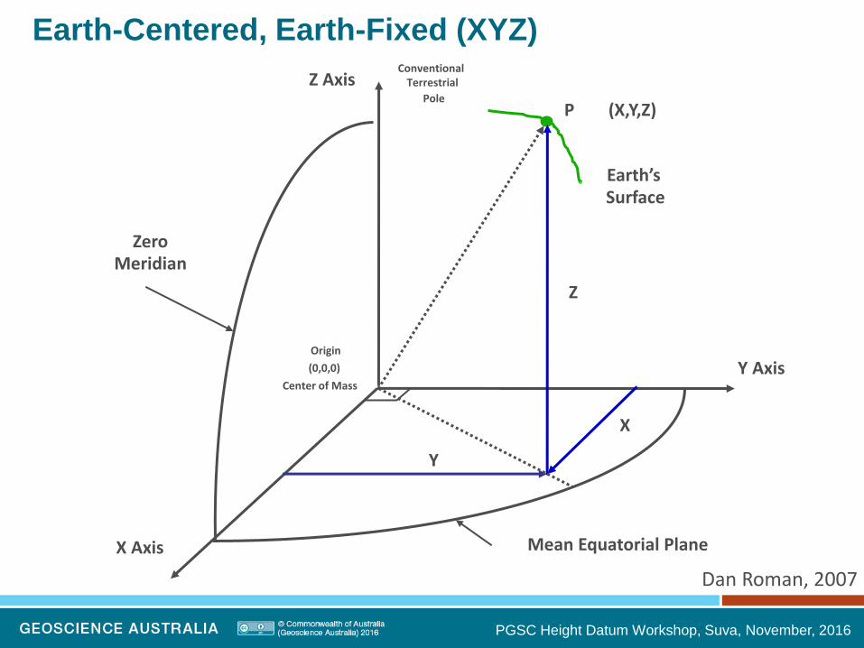
Z Axis
X Axis
Y Axis
(X,Y,Z)
Earth’s Surface
Zero Meridian
Mean Equatorial Plane
P
Origin
(0,0,0)
Center of Mass
X
Y
Z
Conventional Terrestrial
Pole
Dan Roman, 2007
Earth-Centered, Earth-Fixed (XYZ)
PGSC Height Datum Workshop, Suva, November, 2016
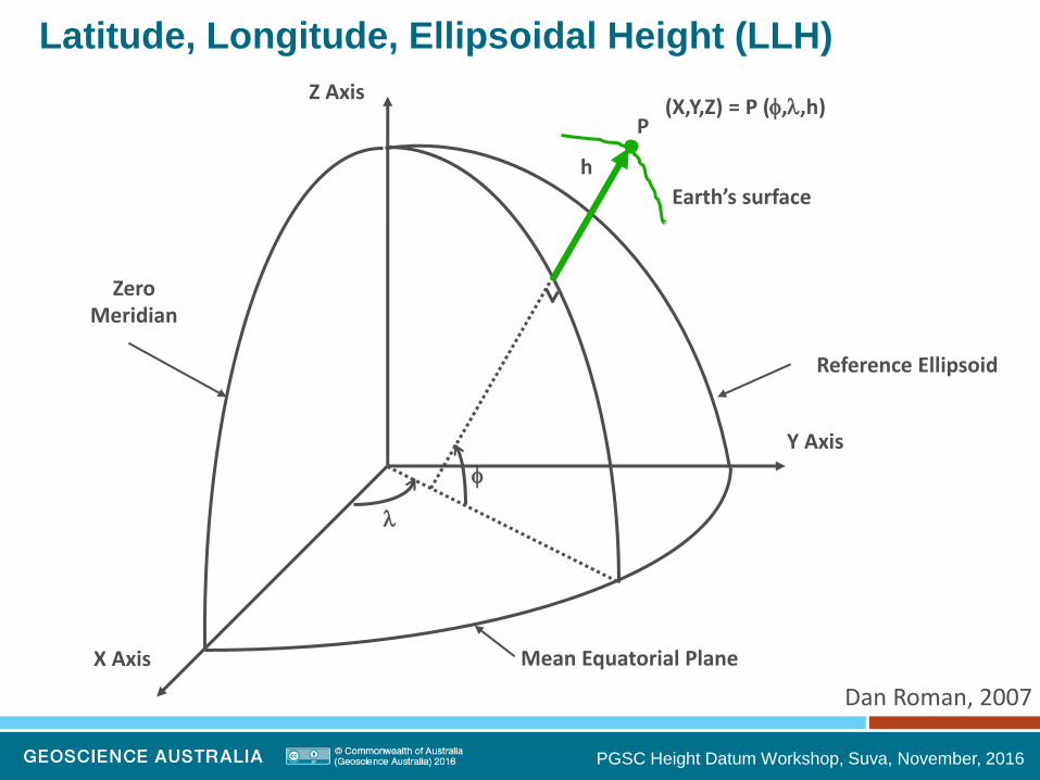
Z Axis
X Axis
Y Axis
(X,Y,Z) = P (,,h)
h
Earth’s surface
Zero Meridian
Mean Equatorial Plane
Reference Ellipsoid
P
Latitude, Longitude, Ellipsoidal Height (LLH)
Dan Roman, 2007

PGSC Height Datum Workshop, Suva, November, 2016
Geometric Height System
Ellipsoid
simplified mathematical
representation of the Earth’s
shape.
Not a surface on which water
always flows downhill
Not an ideal working surface for
a national height datum
Reference surface for GNSS
Good surface to collect data in
and store data in

PGSC Height Datum Workshop, Suva, November, 2016
Geometric Reference Systems
• Geodetic Reference System 1980 (GRS80) ellipsoid is a best
fit to the of the Earth’s gravity field on a global scale
• It’s not the only geometric reference system
Jekeli - 2006

PGSC Height Datum Workshop, Suva, November, 2016
Physical Height Systems
It is actually the force of
gravity that governs
fluid flow, not height.
Using a geometric
height system, fluids
can appear to flow up
hill.
DynaNet User Guide (Fraser, in draft)
orthometric
height ellipsoid
height
Terrain
Surface on which most
observations are made

PGSC Height Datum Workshop, Suva, November, 2016
Physical Height Systems
DynaNet User Guide (Fraser, in draft)
orthometric
height ellipsoid
height
Geoid
Surface of equal
gravitational potential
Due to the uneven
distribution of the Earth’s
mass, the geoid surface is
irregular
The direction of gravity is
perpendicular to the geoid at
a point and is the “vertical”
or “plumbline”
Traditional surveying
instruments are sensitive to
the geoid and gravity

PGSC Height Datum Workshop, Suva, November, 2016
Physical Height Systems
DynaNet User Guide (Fraser, in draft)
orthometric
height ellipsoid
height
Sea Level
MSL is an approximation to the geoid
Sea level (SL) varies due to tides,
currents, climate change etc.
Deviation between SL and geoid is
the “sea surface topography”

PGSC Height Datum Workshop, Suva, November, 2016
Physical Height System – tidal
• Heights Measured Above Local Mean Sea Level
• Should be based on 18.6 year period to account for all
significant tidal periods
• Averages out nearly all meteorological, hydrological, and
oceanographic variability
• Levelling is used to determine relationship between bench
marks and tide gauges
Dan Roman, 2007

PGSC Height Datum Workshop, Suva, November, 2016
MHHW MHW
MLLW Chart Datum?
Physical Height System – tidal
ellipsoid
geoid

PGSC Height Datum Workshop, Suva, November, 2016
Mean Dynamic Topography (MSS – geoid)

PGSC Height Datum Workshop, Suva, November, 2016
Part 2: Observing & Computing Ellipsoidal Heights

PGSC Height Datum Workshop, Suva, November, 2016
Observing and computing ellipsoidal heights
Ellipsoidal heights are generally measured using GNSS
Observed data sent to GA (RINEX files) and processed
Weekly solutions in the form:
Kiribati Tonga Tuvalu
TUVA XYZ -6307543.7852 88455.1443 -939277.7039
TUVA LLH 179 11 47.5924 -8 -31 -31.0356 38.3938

PGSC Height Datum Workshop, Suva, November, 2016
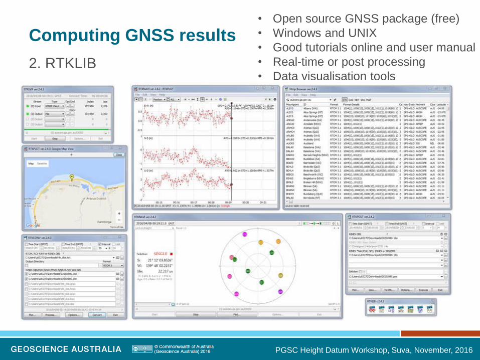
Computing GNSS results
Many options including AUSPOS, RTKLIB, BERNESE
1. AUSPOS
PGSC Height Datum Workshop, Suva, November, 2016
Computing GNSS results
2. RTKLIB
• Open source GNSS package (free)
• Windows and UNIX
• Good tutorials online and user manual
• Real-time or post processing
• Data visualisation tools

PGSC Height Datum Workshop, Suva, November, 2016
Computing GNSS results
3. BERNESE
• GNSS processing software
• Network processing
• Rigorously handles covariance in the data
• Used by Geoscience Australia to process APREF solutions
(650+ sites) daily and weekly
• Output in SINEX files and made available on GA ftp server

PGSC Height Datum Workshop, Suva, November, 2016 DynaNet User Guide (Fraser, in draft)
• Geometric relationship
• Geoid height (H) is not orthometric
• Difference between geoid height and
orthometric height is at mm level in most
cases
• GNSS derived geoid heights are useful
because they are more closely aligned
to sea level
• Need to be aware of the uncertainty in
the geoid model (cm level)

PGSC Height Datum Workshop, Suva, November, 2016
Earth Geopotential Model 2008

PGSC Height Datum Workshop, Suva, November, 2016
Example: Tuvalu GNSS CORS
Converting from ellipsoid height to above geoid height
H = h – N
H = above geoid height
h = ellipsoid height
N = geoid to ellipsoid separation (using a model)
H = 38.380 – 34.839
H = 3.541 m

PGSC Height Datum Workshop, Suva, November, 2016
The Australian Height Datum
(AHD) is the vertical reference
datum for heights in Australia
AHD is an onshore realisation of
mean sea level
Normal - orthometric surface
i.e. based on normal gravity
Mean sea level value observed
at 30 tide gauges from 1966-
1968 set to 0.000 m AHD
~300,000 km of levelling has
been performed to transfer
heights relative to mean sea
level across the country
Australian Height Datum
AHD tide gauge

PGSC Height Datum Workshop, Suva, November, 2016
Geoid height vs. Mean Sea Level (MSL)
Ellipsoid
Geoid
Geoid to
Ellipsoid
Separation
~0.5 m ~0.5 m
Approx. AHD height
Ellipsoidal
height

PGSC Height Datum Workshop, Suva, November, 2016
The cause of the offset
JPL
The mass of water in southern and northern
Australia is almost the same, however, the density
is not.
The warmer / less dense water off the coast of
northern Australia (red) is approximately one metre
higher than the cooler/denser water off the coast of
southern Australia (yellow).
Therefore, the AHD is about 0.5 m above the geoid
in northern Australia and roughly 0.5 m below the
geoid in southern Australia.
PGSC Height Datum Workshop, Suva, November, 2016
Part 3: Adjustment of Data
PGSC Height Datum Workshop, Suva, November, 2016
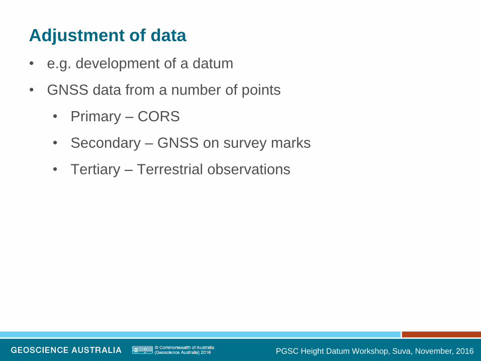
Adjustment of data
• e.g. development of a datum
• GNSS data from a number of points
• Primary – CORS
• Secondary – GNSS on survey marks
• Tertiary – Terrestrial observations

PGSC Height Datum Workshop, Suva, November, 2016
Adjustment of data

PGSC Height Datum Workshop, Suva, November, 2016

PGSC Height Datum Workshop, Suva, November, 2016
Adjusting ellipsoidal heights
• Network adjustment
• In Australia we are performing a 3D adjustment
• New datum (GDA2020)
• 3D adjustment using national archive of survey data
• Rigorous adjustment of all data constrained to these CORS
using least squares
• ~300,000 stations and ~2 million measurements
• Output is coordinates (and datum) which more closely aligned
to global satellite systems (e.g. GPS) and global reference
frame (ITRF).

PGSC Height Datum Workshop, Suva, November, 2016
Part 4: Combining data from geometric and
physical height systems

PGSC Height Datum Workshop, Suva, November, 2016
UAV / Drone example
PGSC Height Datum Workshop, Suva, November, 2016
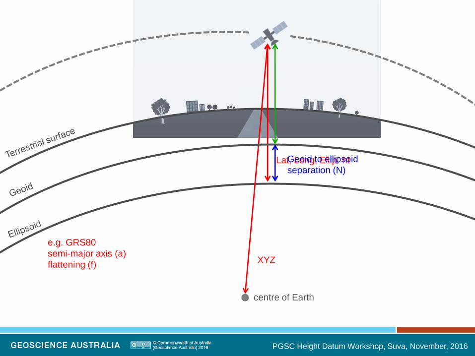
centre of Earth
XYZ
Lat, Long, Ellip. ht
e.g. GRS80
semi-major axis (a)
flattening (f)
Geoid to ellipsoid
separation (N)

PGSC Height Datum Workshop, Suva, November, 2016
centre of Earth

PGSC Height Datum Workshop, Suva, November, 2016
Sea Level Monitoring Example
GNSS data combined with levelling data and tide gauge data

PGSC Height Datum Workshop, Suva, November, 2016
Sea Level Monitoring Example
DynaNet User Guide (Fraser, in draft)
orthometric
height ellipsoid
height

PGSC Height Datum Workshop, Suva, November, 2016
Aligning datums
1. Choose a geometric vertical reference system (e.g. GRS80)
• Ellipsoidal based – maintain data in this form
2. Choose a geoid
• Make sure it is aligned with the ellipsoid chosen
• There are multiple versions of WGS84 and EGM2008
3. Understand the connection between working surfaces (e.g.
tidal, local height datums) and the geometric and physical
reference systems chosen in 1 and 2.

PGSC Height Datum Workshop, Suva, November, 2016
Australian example
1. Geometric height system (GDA2020 based on GRS80)
2. Physical height system
• Global gravity model (EGM2008) with local gravity data
• Fitted to Australian Height Datum (AHD)
3. Relationship to Mean Sea Level
• AHD is MSL from 1966-68

PGSC Height Datum Workshop, Suva, November, 2016
Conclusions (1)
• The increasing use of geometric GNSS techniques
encourages countries to develop a method to convert
between geometric and physical height systems
• Physical heights have traditionally been obtained using
terrestrial optical levelling techniques ... but in a world of
GNSS, “uphill-and-downhill”, and direction of gravity, remain
important for many users of height systems
• Standard optical levelling is expensive, laborious and time-
consuming... in addition, it is difficult in remote and
mountainous areas and the systematic errors grow very
quickly over large distances (allowable misclose, need for
orthometric corrections)

PGSC Height Datum Workshop, Suva, November, 2016
Conclusions (2)
• On the other hand, ellipsoidal heights from GNSS can be
obtained quickly and inexpensively, and converted to physical
heights using geoid models (e.g. EGM2008)
• High expectations of continued improvement in determination
of global and regional geoid models (e.g. EGM2008 has a
uncertainty of 10 cm at best (Pavlis 2008))
• To transition to using GNSS to derive physical heights we
need to ensure we have accurate geoid models with rigorous
uncertainty

PGSC Height Datum Workshop, Suva, November, 2016
Conclusions (3)
• The gravity field model information derived from CHAMP,
GRACE and GOCE has advantages such as global
consistency, high accuracy geoid height, etc ... although over
wavelengths of 100km or more
• Fine resolution geoid information can be derived from the
processing of airborne, terrestrial and ship gravity data
• The challenge is how to best integrate this data to develop a
geoid model with uncertainties that meet user requirements
(e.g. 1 cm, 3 cm, 5 cm?)

PGSC Height Datum Workshop, Suva, November, 2016
Discussion / Questions
Discuss the heighting requirements of Pacific Island nations
• What heighting data is available?
• What needs to be done to make the data ready?
• What can we do to help?
• …

PGSC Height Datum Workshop, Suva, November, 2016
GNSS on tide gauges

PGSC Height Datum Workshop, Suva, November, 2016
HC HA
HAC hAB + hBC
Observed difference in orthometric height, H, depends on the leveling route.
A C
B Topography
hAB
h = local leveled differences
= hBC
H = relative orthometric heights
Dan Roman, 2007
Levelled height vs. orthometric height

PGSC Height Datum Workshop, Suva, November, 2016
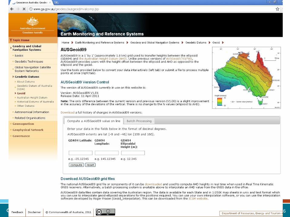
AUSGeoid Converting GPS heights to AHD heights

PGSC Height Datum Workshop, Suva, November, 2016
The Australian Height Datum
(AHD) is the reference surface
for heights in Australia
AHD is an onshore realisation
of mean sea level
Orthometric surface
i.e. based on gravity
Mean sea level value
observed at 30 tide gauges
from 1966-1968 set to 0.000 m
AHD
Over 200,000 km of levelling
was performed to transfer
heights relative to mean sea
level across the country
What is the AHD?
AHD tide gauge

PGSC Height Datum Workshop, Suva, November, 2016
GNSS receivers are now one of the most popular ways to capture
positioning data
GNSS DOES NOT provide heights relative to mean sea level / AHD
GNSS receivers provide you with a height above the ellipsoid
The problem
Ellipsoid
PGSC Height Datum Workshop, Suva, November, 2016
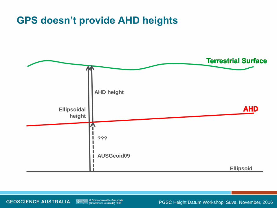
GPS doesn’t provide AHD heights
Ellipsoid
AHD height
Ellipsoidal
height
???
AUSGeoid09

PGSC Height Datum Workshop, Suva, November, 2016
Previous AUSGeoid models
Ellipsoid
Geoid
Geoid to
Ellipsoid
Separation
0.5 m 0.5 m
Approx. AHD height
Ellipsoidal
height
PGSC Height Datum Workshop, Suva, November, 2016
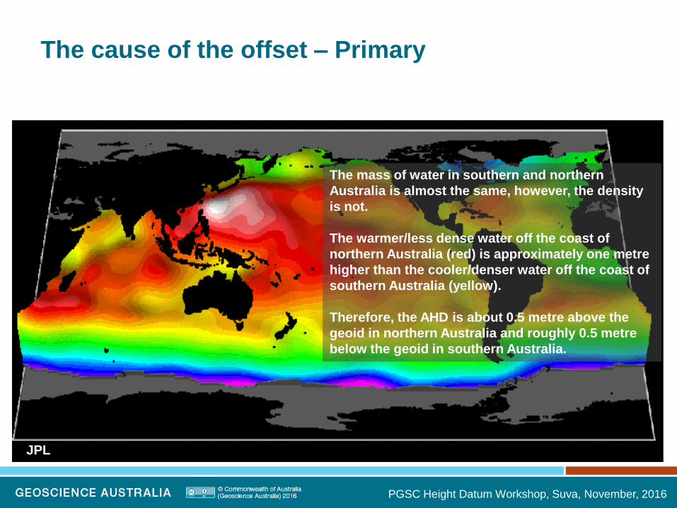
The cause of the offset – Primary
JPL
The mass of water in southern and northern
Australia is almost the same, however, the density
is not.
The warmer/less dense water off the coast of
northern Australia (red) is approximately one metre
higher than the cooler/denser water off the coast of
southern Australia (yellow).
Therefore, the AHD is about 0.5 metre above the
geoid in northern Australia and roughly 0.5 metre
below the geoid in southern Australia.

PGSC Height Datum Workshop, Suva, November, 2016
The cause of the offset – Secondary
removing the trend in x
and y reveals secondary
sources
1. quality of the, mainly
third-order, spirit
levelling
observations
2. neglect of observed
gravity corrections to
the spirit-levelling
observations.
3. GNSS heighting
errors caused by
metadata errors.

PGSC Height Datum Workshop, Suva, November, 2016
AUSGeoid09: similar yet different
Ellipsoid
Geoid
Geoid to
Ellipsoid
Separation
0.5 m 0.5 m
AHD height
Ellipsoidal
height
AUSGeoid09:
AHD to
Ellipsoid
Separation

PGSC Height Datum Workshop, Suva, November, 2016
AUSGeoid09 is gravimetric + geometric
The gravimetric and geometric (AHD to geoid offset) components
are combined into a single national grid of ~2 km resolution.
Ellipsoid
Geoid
Gravimetric
Geometric
Terrestrial Surface
AHD

PGSC Height Datum Workshop, Suva, November, 2016
Gravimetric Component
Work undertaken by Will Featherstone from Curtin University
Spherical harmonic synthesis of
• Earth Geopotential Model 2008 (EGM2008)
• 1.3 million points from Geoscience Australia’s land gravity
database

PGSC Height Datum Workshop, Suva, November, 2016
Gravimetric Component
Major improvements from
GRACE data
Removed long wavelength
anomalies
Removed some terrain
modelling errors of
AUSGeoid98 in
mountainous regions using
new version of 9” DEM
Claessens et al, Newton’s Bulletin, 2009
Comparing AUSGeoid98 and
AUSGeoid09 gravimetric models

PGSC Height Datum Workshop, Suva, November, 2016
Offset between AHD and the
gravimetric geoid
Offset between gravimetric
geoid and AHD computed at
6871 pts across Australia.
Linear Least Squares
Interpolation used to compute
the gravimetric geoid to AHD
Offset at 1’ interval across
Australia.

PGSC Height Datum Workshop, Suva, November, 2016
AUSGeoid09
Figure depicts the offset between
the ellipsoid and AHD
CAUSE:
AHD is based on gravity
Ellipsoid is purely mathematical
The higher mass value in NE
Australia causes larger geoid
values than in SW Australia.
Caused by crust thickness, crust
type, magma distribution etc.
PGSC Height Datum Workshop, Suva, November, 2016

PGSC Height Datum Workshop, Suva, November, 2016
Misfit of AUSGeoid09
units: mm

PGSC Height Datum Workshop, Suva, November, 2016
New Version of AUSGeoid
Introduction of rigorous uncertainty
•Current version has no uncertainty associated with it.
•Difficult to quantify the accuracy of the AHD and gravimetric
geoid.
•Philosophy will be to adopt some of the points in the AHD as a
reference standard with zero uncertainty.
•Attempt to quantify the uncertainty associated with the
gravimetric geoid.
•Compute rigorous uncertainty in accordance with the “Guide to
Uncertainty on Measurement”.
PGSC Height Datum Workshop, Suva, November, 2016
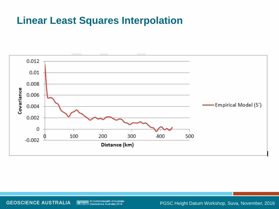
Linear Least Squares Interpolation

PGSC Height Datum Workshop, Suva, November, 2016
Linear Least Squares Interpolation

PGSC Height Datum Workshop, Suva, November, 2016
Exponential Model (geometric component)
units (m)

PGSC Height Datum Workshop, Suva, November, 2016
Exponential Model (Uncertainty – 1 sigma)
units (m)

PGSC Height Datum Workshop, Suva, November, 2016
Linear Least Squares Interpolation
PGSC Height Datum Workshop, Suva, November, 2016
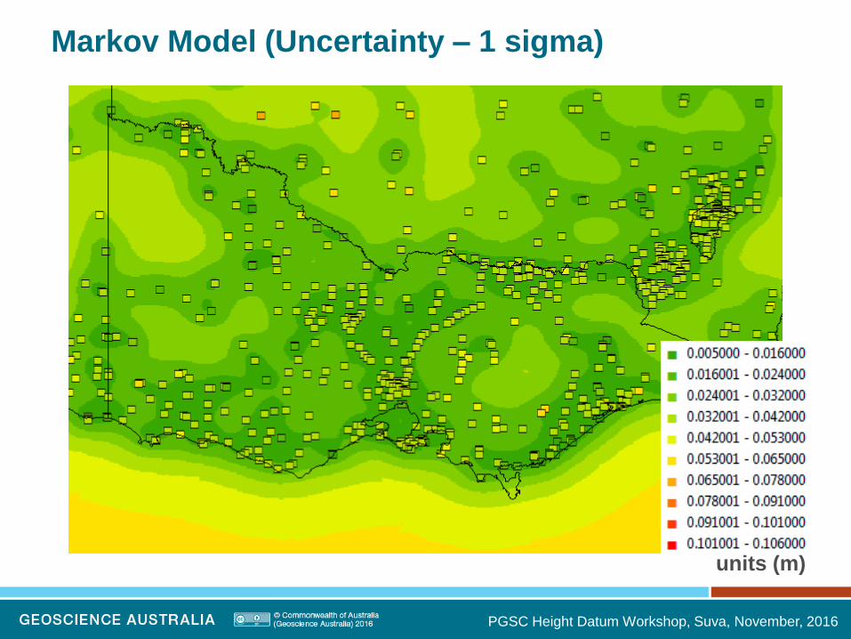
Markov Model (Uncertainty – 1 sigma)
units (m)

PGSC Height Datum Workshop, Suva, November, 2016
AUSGeoid Update

PGSC Height Datum Workshop, Suva, November, 2016
Current Status
AUSGeoid2020_BETAV0.6 is available
• 4854 collocated GNSS+AHD data provided
• ~20% provided with uncertainty
• Computes uncertainty for geometric component
• Propagation of uncertainty of ellipsoidal height and AHD height
• Gravimetric model is still AGQG2009
• Uncertainty of 0.036 m everywhere
Insert slideshow title here
<insert/header&footer/footer>

PGSC Height Datum Workshop, Suva, November, 2016 Insert slideshow title here
<insert/header&footer/footer>
AUSGeoid2020 BETAV0.6
Units (m)

PGSC Height Datum Workshop, Suva, November, 2016
Multiple Gaussian Function Model
Insert slideshow title here
<insert/header&footer/footer>
• This analytical model is the best fit to the empirical data

PGSC Height Datum Workshop, Suva, November, 2016 Insert slideshow title here
<insert/header&footer/footer>
PU supplied by jurisdiction / 12 rt k from JP Uncertainty (m) (1 std dev)

PGSC Height Datum Workshop, Suva, November, 2016 Insert slideshow title here
<insert/header&footer/footer>
Only AHD JP zero PU all AHD zero PU
Only AHD JP zero PU vs all AHD zero PU Uncertainty (m) (1 std dev)

PGSC Height Datum Workshop, Suva, November, 2016
Detrended offset between AHD and gravimetric geoid
removing the trend
reveals:
1. Poor quality of
AHD
2. GNSS heighting
errors caused by
metadata errors
3. Issues in
AGQG2009
units (m)
Based on data used in AUSGeoid2020 V0.6 and AGQG2009
Residuals bigger than 15 cm shown with +
PGSC Height Datum Workshop, Suva, November, 2016
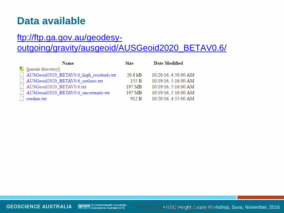
Data available
ftp://ftp.ga.gov.au/geodesy-
outgoing/gravity/ausgeoid/AUSGeoid2020_BETAV0.6/
Insert slideshow title here
<insert/header&footer/footer>

PGSC Height Datum Workshop, Suva, November, 2016 Insert slideshow title here
<insert/header&footer/footer>

PGSC Height Datum Workshop, Suva, November, 2016
AHD Reference Standard
Australian National Levelling Network Junction Points (primary and supplementary)
• ANLN JPs have zero Positional Uncertainty (PU).
• Survey Uncertainty (SU) and Relative Uncertainty (RU) can be used to evaluate or specify the uncertainty of survey control marks relative to any AHD mark.
• However, PU can only be evaluated for those marks with a well understood connection to the ANLN.

Phone: +61 2 6249 9111
Web: www.ga.gov.au
Email: [email protected]
Address: Cnr Jerrabomberra Avenue and Hindmarsh Drive, Symonston ACT 2609
Postal Address: GPO Box 378, Canberra ACT 2601