herring governance report herring network institutions and
TRANSCRIPT

World Maritime UniversityThe Maritime Commons: Digital Repository of the WorldMaritime University
HERRING Project Reports
5-2014
HERRING Governance Report Herring networkinstitutions and governanceHarry V. StrehlowThunen Institute of Baltic Sea Fisheries
Dariusz P. FeyNational MarIne FIsherIes Research Institute, [email protected]
Adam M. LejkNational MarIne FIsherIes Research Institute
Friederike LempeThunen Institute of Baltic Sea Fisheries
Henrik NilssonWorld Maritime University, [email protected]
See next page for additional authors
Follow this and additional works at: http://commons.wmu.se/herring
Part of the International and Area Studies Commons, and the Natural Resources Managementand Policy Commons
This Report Open Access is brought to you courtesy of Maritime Commons. Open Access items may be downloaded for non-commercial, fair useacademic purposes. No items may be hosted on another server or web site without express written permission from the World Maritime University. Formore information, please contact [email protected].
Recommended CitationStrehlow, Harry V.; Fey, Dariusz P.; Lejk, Adam M.; Lempe, Friederike; Nilsson, Henrik; Psuty, Iwona; and Szymanek, Lena,"HERRING Governance Report Herring network institutions and governance" (2014). HERRING. 2.http://commons.wmu.se/herring/2

AuthorsHarry V. Strehlow, Dariusz P. Fey, Adam M. Lejk, Friederike Lempe, Henrik Nilsson, Iwona Psuty, and LenaSzymanek
This report open access is available at The Maritime Commons: Digital Repository of the World Maritime University:http://commons.wmu.se/herring/2

T h e C o a s t a l U n i o n G e r m a n yD i e K ü s t e n U n i o n D e u t s c h l a n d
2 0 1 4 - 0 5C O A S T L I N EW E B
H. V. Strehlow, D. Fey, A. Lejk, F. Lempe, H. Nilsson,I. Psuty & L. Szymanek
HERRING Governance ReportHerring network institutions and governance
EUCC-D


Coastline Web 05 (2014)
HERRING Governance Report
Herring network institutions and governance
Authors:
H. V. Strehlow, D. Fey, A. Lejk, F. Lempe, H. Nilsson I. Psuty & L. Szymanek
Rostock, Gdynia, Malmö 2014
ISSN 2193-4177 ISBN 978-3-939206-13-2

This report was developed in the project HERRING - Joint cross-border actions for the sustainable management of natural resource (2012-2014). The international project HERRING seeks to improve the sustainable and holistic management of herring fish in the South Baltic region, a major ecosystem resource, and with it both the reproductive capacity of the species and the success of future sustainable herring fisheries.
More information about HERRING can be found on the project website: www.baltic-herring.eu. Partners: EUCC – The Coastal Union Germany
Thünen-Institute of Baltic Sea Fisheries, Germany
National Marine Fisheries Research Institute, Poland
World Maritime University, Sweden
and further 8 associated partners (from Germany, Poland, Sweden and Lithuania)
Funding: EU South Baltic Cross-border Co-Operation Programme 2007-2013
Imprint
Cover picture: Greifswald Bay (Picture: Franziska Stoll)
Coastline Web is published by: EUCC – Die Küsten Union Deutschland e.V. Seestr. 15, 18119 Rostock, Germany [email protected]
Coastline Web is available online under http://www.eucc-d.de/. The responsibility for the content of this report lies solely with the authors.

EUCC – Die Küsten Union Deutschland e.V. Coastline Web 05 (2014) Selected Monographs in Marine and Coastal Science ISSN 2193-4177, ISBN 978-3-939206-13-2
- HERRING - Joint cross-border actions for the sustainable management
of natural resource
Governance Report Herring network institutions and governance

Content Coastal Case Study Report: The Greifswald Bay, Germany 1. Introduction to the Case Study………………………………………………………… 3 2. Institutional framework and organizational settings…………………………………... 3 3. Data collection and methodology………………………………………………….….. 15 4. Research design for the German Coastal Case Study ‘Greifswald Bay’………….…... 18 5. Conclusion………………………………………………………………………..…… 33 6. References…………………………………………………………………….….…… 34 Coastal Case Study Report: The Vistula Lagoon 1. Introduction to the Case Study and general approach….……………………………… 37 2. Data collection and methodology ……………………………………………………... 45 3. Institutional framework and organizational settings………………………………….. 48 4. Coastal resource management discourse……………………………….…………….. 73 5. Conclusion…………………………………………………………………………… 89 6. References……………………………………………………………………………. 90 Annex 1………………………………………………………………………………… 92 Annex 2…………………………………………………………………………………. 96 Coastal Case Study Report: Hanö Bay and Blekinge Archipelago 1. Introduction…………………………………………………………………………… 99 2. Data collection and methodology……………………………………………………... 101 3. Institutional framework and organizational settings………………………………….. 101 4. Coastal resource management discourse……………………………………………… 107 5. Conclusion……………………………………………………………………………. 119 6. References……………………………………………………………………………... 120

Coastline Web 05 (2014) 3
Coastal Case Study Report: The Greifswald Bay, Germany
1. Introduction to the Case Study The German case study area of Greifswald Bay (GWB) is a semi-enclosed inner coastal water, formed by the mainland of Mecklenburg-Western Pomerania and the island of Rügen. GWB covers an area of approximately 514 km and is characterized by a mean depth of 5.8 m with a maximum depth of 13.6 m. GWB is considered the main spawning area of western Baltic spring spawning herring (WBSS), which is also an important target species of the commercial fisheries in this region. In recent years, catches and spawning stock biomass of WBSS herring have declined. Moreover, despite a sufficient number of spawners, recruitment has declined considerably within the last decade, while reasons for this alarming decrease remain unknown. At the same time, human use and spatial demands in GWB are increasing. Consequently, anthropogenic impacts are changing the physical and biological environment, which may have negative effects on the spawning habitat and thus the success of egg and larvae development. During the spawning season from March through May herring migrates into the coastal waters to attach its eggs to underwater plants in the shallow littoral zone. It is assumed that there is natal homing in population of WBSS herring, highlighting the importance of individual and small-scale spawning sites for the overall population. Herring is one of the target species of the German fishery securing income opportunities early in the year in particular for the small-scale coastal fishery. The HERRING project is based on the idea that the coastal spawning grounds are key for a more sustainable management of the natural resource herring. Hence, the aim of the project is to develop more holistic management plans and strategy options for these areas that can be recommended to regional and international stakeholders. The three case studies in Poland, Germany and Sweden not only focus on the ecological parameters determining the quality of spawning areas and how they are affected by the various human activities, but also analyze the existing coastal and fishery management legislations regulating use and protection of coastal areas.
2. Institutional framework and organizational settings The successful implementation of marine ecosystem-based management requires an improved understanding of existing governance structures, including gaps and overlaps resulting from fragmented management (Ekstrom, Young, Gaines, Gordon, & McCay, 2009). Challenges rise when coordinating policies the way that they do not adversely constrain other policies. The increasing complexity of management systems and institutional arrangements aggravates the policy-making process. During the last decades a myriad of diverging claims on maritime and coastal areas have emerged that are still challenging the context for joint coordination and problem-solving on different political scales. The traditional usages like shipping, fishery, tourism and nature protection are complemented by the establishment of special protected areas, wind farms and disputes about fracking or the construction of a new gas and stream power plant. The number of stakeholders pursuing any kind of interest in this area or those that are provided with a formal political mandate in regard to the protection or the use of the Greifswald Bay (Greifswalder Bodden, GWB) has steadily increased. Consequently, tensions between different stakeholder interests and pressure on scarce natural resources are rising. The formal political system comprises institutional settings for fishery, nature conservation, spatial planning, mining and shipping that are subject to different jurisdictional

4 Strehlow et al.
provisions. In the following chapters only those institutions and jurisdictions that have a relevance regarding the use and the protection of coastal zones are described, starting with the institutional framework for fishery.
2.1 Institutional framework of fishery Table 1: Fishing authorities on different political levels in Mecklenburg-Western Pomerania/ Germany
Political Level Administrative bodies Laws and formal competencies EU-Level Directorate-General for Maritime
Affaires (DG MARE) Common Fishery Policy
Integrated Maritime Policy
Federal government of Germany
Federal Ministry of Food and Agriculture (BMEL)
Federal Institute of Agriculture and Nutrition
State/ Land State Ministry of Agriculture, Nature Conservation and Consumer Protection [Highest regional fishing authority]
State Fishery Law
State Research Institute for Fishery
State Office for Agriculture, Food Safety and Fishery [High fishing authority]
Coastal Fishery Law
Region Fisheries supervisory authority Freshwater Fishing Law
Fishing Licence Law Community level Elected head of the administration of the Landkreis (Landrat/Landrätin) and community mayors [Lower nature conservation authority]
2.1.1 Fisheries management on EU level Within the European Union, the Directorate-General for Maritime Affaires (DG MARE) is responsible for the implementation of the Common Fishery Policy (CFP) and the Integrated Maritime Policy. It is commissioned among others with conservation, control, market measures, structural actions and international relations relating to fisheries (EC 2013). There is a range of different EU-regulations in place for the management of commercial fish stocks e.g. herring, cod, sprat, salmon and plaice. Herring stocks are managed primarily by setting fishing quotas and total allowable catches (TACs). A specific management plan is still not implemented. While TACs are in place to manage the adult spawning stock biomass that has shown a slight increase since it was at its lowest level in 2011, the recruitment has strikingly decreased during the last years (ICES 2013). The precise reasons for the downward trend are still not known, but may be found in the complexity of the interplay between different ecosystem parameters. Changes in the physical and biological conditions of spawning areas are often subject to direct or indirect anthropogenic impacts. The preservation and improvement of spawning and nursery grounds combined with an adequate management concept is one of the most important measures to ensure the durable existence and wellbeing of the spring spawning herring stock. Especially dense seaweed meadows and other submerged macrophytes are preferentially used as spawning substrate. This submerged vegetation has decreased during the last decades. That is why fishery management that is based solely on the basis of

Coastline Web 05 (2014) 5
quotas and TACs fails to take into account the vital and functional importance of spawning areas for stock recruitment. This is especially important for GWB as there is a verifiable regular correlation between the yearly production of herring larvae in the area and the abundance of one and two years old juvenile herring in the entire western Baltic Sea (Hammer et al. 2009: 30). It is for this reason that fishery management should include spawning areas in their management considerations to avoid a worsening of stock recruitment. A special multi annual management plan for herring can emphasize on the sustainable preservation of its spawning areas.
2.1.2 The State Fishery Law and the Coastal Fisheries Law The state fishery law (Landesfischereigesetz, LFischG M-V) was passed in 2006 and constitutes the legal basis for the Coastal Fisheries Law (Küstenfischereiverordnung, KüFVO M-V) that is now under revision. The latter provides the legal regulations for the coastal fisheries in Mecklenburg-Western Pomerania (M-V). It is applicable in the German coastal territorial sea (from the water baseline up to 12 nm). There are clear regulations determined regarding species and gear restrictions, minimum landing sizes as well as closed seasons and areas (LUMV, 2006 §3 - §5). Additional there are spawning areas designated where fishing activity is banned between 1 April and 31 May each year in order to ensure the smooth spawning activity of different vulnerable fish species. This regulation is obviously adopted only for pike and pikeperch, but is not suitable for protecting herring stock recruitment as spawning time has already started much earlier and major identified herring spawning areas are not even mentioned. There is a fishing ban exclusively for threatened fish species that are particularly protected through the EU’s FFH Directive (LUMV, 2006 §3).
2.2 Institutional framework for nature conservation
Table 2: Environmental authorities on different political levels in Mecklenburg-Western Pomerania/ Germany
Poltical Level Administrative bodies Laws and formal competencies UN-Level Agenda 21 of the United Nations
Conference on Environment & Development in Rio de Janeiro
EU-Level 1. NATURA 2000 Directives (Flora-Fauna and Habitat Directive 92/43/EEC and Bird Protection Directive 2009/147/EC) 2. Marine Strategy Framework Directive (2008/56/EC) 3. Water Framework Directive (2000/60/EC)
Federal government of Germany
German Ministry of Environment, Nature Conservation and Nuclear Safety (BMU) with the Federal Agency of Nature Conservation (BfN) and the Federal Environmental Office (UBA)
1. German Nature Conservation Act (BNatSchG) 2. Federal Water Resource Law (WHG) 3. German Species Protection Act (BArtSchV) 4. Federal Immission Protection Law (BImSchG) 5. National Strategy for Sustainability
State/ Land
State Ministry of Agriculture, Environment and Consumer Protection [Highest regional nature conservation authority]
State Water Resource Law (LWaG) Nature Conservation Execution Law (NatSchAG M-V) Expert Landscape Programmme (GLP) Regulation of the Landscape conservation area of the Greifswald Bay (2008)

6 Strehlow et al.
State Office of Agriculture, Nature Conservation and Geology [High nature conservation authority]
Expert Landscape Structure Plan
Region
Regional Agencies for Agriculture and Environment [Authority for nature conservation]
FFH-Management Plan Voluntary agreement on nature conservation, water sports and recreational fishing in the GWB and Strelasund
Department of the national parks and offices of biosphere reserve [Administration of large conservation areas]
Regulation of the Southeast Rügen Biosphere Reserve
Community level Elected head of administrative district (Landrat/Landrätin) and community mayors of the independent cities (kreisfreie Städte) [Lower nature conservation authority]
Communal landscape plan Green ordinance plan
Head officials and community mayors
2.2.1 The German National Strategy for Sustainability In 2002 the Federal German government passed the National Strategy for Sustainability (Nationale Nachhaltigkeitsstrategie) and published a progress report in 2012. One chapter of the report deals with the pressure on oceans, coastal waters and coastal zones due to immensely increased anthropogenic use. The designation of 10 marine Natura 2000 areas – four in the North Sea, six in the Baltic Sea – is seen as a first step to meet the goals stated with regard to marine and coastal nature protection (Federal German Government 2012). The strategy strives to set up sustainability as a priority goal in the new CFP (Federal German Government 2012). It is stated that the pollution of the sea due to shipping has been reduced in a satisfactory way according to the MARPOL Agreement (Federal German Government 2012). Furthermore, the strategy refers to the Water Framework Directive (2000/60/EC), the Marine Framework Directive (2008/56/EC) and the Directive on the assessment and management of flood risks (2007/60/EC). All of these directives support the ecological integrity of surface and ground water, coastal waters and oceans (Federal German Government 2012) and may thus have a positive impact with regard to sustain coastal spawning areas in the GWB.
2.2.2 Natura 2000 Natura 2000 is a coherent ecological network of protected terrestrial and marine areas within the EU. These areas enjoy a particular conservation status through the European Habitats Directive (92/43/EEC) and the European Birds Directive (2009/147/EC). The overarching goal is to ensure a transboundary protection of endemic wildlife, endemic plants and their habitats. In Germany Natura 2000 became legally binding when its statutory provisions were transposed into the Federal Nature Conservation Act (BNatSchG) in 1998 and later on in its amendments from 2002 and 2007. Terrestrial nature conservation as well as marine nature conservation along the coast up to 12 nautical miles are the responsibility of the state and thus belong to the political mandate of the highest regional nature conservation authority in M-V. The GWB, parts of the Strelasund and the northern top of Usedom were classified as ‘sites of community importance’ as it is stated in the demands of the European Habitats Directive (FFH area coda DE 1747-301). Therefore a special FFH Management Plan was developed to determine the protective purposes and conservation goals in the GWB.
2.2.3 The FFH-Management Plan The FFH management plan of the Greifswald Bay comprises 55970 ha marine and 4249 ha terrestrial area. Until June 2014 there have been 30 different natural habitat types (Lebensraumtypen) and 16

Coastline Web 05 (2014) 7
FFH species identified that are explicitly protected through annex I and annex II of the FFH directive (LUNG, 2014, p. 2). The maps of the FFH management plan disclose ‘shallow huge estuaries and bays’ (EU-Code 1160) as one of the largest natural habitat that is found in the GWB. Referring to a best-case scenario these habitats should be characterized by high diversity in macrophytes. The deepest growth limit of submerged vegetation in the GWB lies around 2.5 - 3 meters in the southern part and 4 meters in the northern part (Ifaö 2005 according to StaluVP, 2011, p. 110). The most widespread plant community in this habitat is Myriophyllum spicatum (Eurasian watermilfoil) and/or Potamogeton pectinatus (fennel pondweed) (without charales), Najas marina (spiny naiad), Zostera marina (common eelgrass) and Ruppia cirrhosa (spiral ditchgrass)/ Ruppia maritime (ditch-grass) (MariLim 2009 according to StaluVP, 2011, p. 110). Especially Zostera marina, Furcellaria fastigiata and Fucus vesiculosus serve as important and excellent spawning substrate for herring eggs (Scalbell, 1988, p. 28ff; Klinkhardt, 1996, p. 101). The high eutrophication rate, especially caused by the extensive nutrient discharge into surface waters from agricultural cropland, is held responsible for having negative impacts on the density and the species diversity of macrophytes in the GWB. It could be observed, and empirically studied that macrophytes drastically decrease during the last decades (Hammer, Zimmermann, von Dorrien, Stepputtis, & Oeberst, 2009, p. 45f; Munkes, 2005, p. 10). In deeper water regions of the GWB macrophytes have disappeared to a large extent. For this reason the habitat preservation status was classified as ‘unfavorable’ (StaluVP, 2011, p. 110). There are also other marine FFH habitat types like, for example, ‘estuaries’ (EU-Code 1130) that have a potential function as spawning and nursery grounds for herring in the GWB. Most of these marine habitats are in an unfavorable, or even bad, ecological state. Several causes provoking habitat deterioration are mentioned e.g., interventions in the morphologic structure of estuaries (deepening of fairways), embankment, speed boat traffic, shore degradation through angling activities, the construction of harbor facilities, straightening of rivers as well as nutrient discharge into the surface water (StaluVP, 2011, p. 103f).
2.2.4 The ‘Voluntary agreement on nature conservation, water sports and recreational fishing in the GWB and Strelasund’ An essential tool for implementing measures resulting from the FFH Management Plan was the joint development of voluntary agreements with different private and public actors as well as with resource user groups. As a result, the ‘Voluntary agreement on nature conservation, water sports and recreational fishing in the GWB and Strelasund’ was established in 2004 and is based on a consensus between different resource users. The agreement was initiated by the WWF and involved different associations promoting water sport activities like sailing, canoeing, rowing, wind and kite surfing as well as recreational fishing. Furthermore, environmental associations and authorities were consulted during the negotiation process. A consensus, combining nature conservation goals with the sustainable and thus temporarily restricted use of certain areas, was compiled. The agreement is now regularly monitored with the aim of raising the consciousness of users to avoid disturbing and destructive effects on habitats.
2.2.5 The Marine Strategy Framework Directive One important European law for protecting the marine environment is the Marine Strategy Framework Directive, 2008/56/EC (MSFD) which was adopted by the European Commission in June 2008 as the environmental pillar of the European Union’s Integrated Maritime Policy. The MSFD aims to achieve a good environmental status of the EU’s marine waters by 2020 through the application of an ecosystem-based approach to the management of human activities having an impact on the marine environment (EC 2008: (8)). The Directive emphasises that the pressure on natural marine resources and the demand for marine ecological services are often too high and that the Community needs to

8 Strehlow et al.
reduce its impact on marine waters regardless of where these effects occur (EC 2008: Art. 1 (3)). At the same time the Directive promotes the integration of environmental considerations into relevant policy areas (EC 2008: (3)) as well as the active involvement of the general public in the establishment, implementation and updating of marine strategies (EC 2008: (36)). For fishery management to be compatible with the Directive’s aims it is stated that measures to regulate fishing activities can be taken in the context of the CFP to ensure the conservation and sustainable exploitation of fisheries resources. These measures may include the full closure of fisheries in certain areas to enable the integrity, structure and functioning of ecosystems to be maintained or restored and, where appropriate, in order to safeguard, inter alia, spawning, nursery and feeding grounds (EC 2008: (39)). In October 2011, the MSFD was transposed into German federal legislation and passed by the German Bundestag. After defining the meaning of a “Good Environmental Status” and setting up environmental goals, a monitoring programme was developed and further implemented in July 2014. A programme of measurement is to be completed by the end of 2015 (BLMP, 2009, p. 6). The MSFD promotes an ecosystem-based approach to the management of marine resources and is therefore of very high importance concerning reliable and effective herring spawning area management in the GWB and elsewhere, as ecosystem coherence and the consideration of cumulative effects are explicitly emphasized. Moreover, the integration of environmental concerns into different other policies, such as the CAP, the Common Agricultural Policy and other relevant Community policies may strengthen a sustainable area management with binding regularities ensuring a high WBSSH stock recruitment.
2.2.6 The Water Framework Directive 2000/60/EC The Water Framework Directive (WFD) was adopted in 2000 by the European Parliament and the Council to establish a framework for Community action in the field of water policy. It requires the EU Member States (MS) to achieve a good qualitative and quantitative status of all water bodies (including marine waters up to one nautical mile) by 2015. The directive promotes the aim to establish a ‘good status’ for all ground and surface waters like rivers, lakes, transitional waters, and coastal waters in the EU. The assessment of the ecological and chemical status of coastal waters includes the following criteria (EC, 2000):
x Biological quality elements (e.g. fish, benthic invertebrates, aquatic flora, abundance and biomass of phytoplankton)
x Hydromorphological quality elements (e.g. depth variations, structure and substrate of the coastal bed)
x Physiochemical quality elements (e.g. transparency, thermal and oxygenation conditions, salinity, nutrient conditions)
x Specific pollutants (all priority substances being discharged into the body of the water and substances being discharged in significant quantities into the body of the water).
The implementation of the WFD is coordinated by the Ministry of Agriculture, Nature Conservation and Geology (LUNG M-V, Landesministerium für Umwelt, Naturschutz und Geologie M-V). This authority was responsible for setting up a river basin management plan and measurement programmes that were published in 2008. It has the task of regularly informing the European Commission about progress in implementation etc. In 2008, the LUNG concluded that almost all surface water and coastal waters in M-V have failed the criteria for a ‘good ecological status’, whereas most of them achieved a ‘good chemical status’. The GWB, most of its inflows and the Strelasund were reported as being in an unsatisfying condition, not complying with the requirements of the directive. The reduction of diffuse and selective nutrient discharge from the catchment area is mentioned as a

Coastline Web 05 (2014) 9
substantive measure to improve the ecological status of the coastal waters and marine ecosystems (Bachor & Weber, 2008, pp. 28-30). Therefore, the management must be coherent and should take into consideration the whole catchment area and not only parts of it. The state M-V has already signalled that it needs more time to realise the environmental goals for the Warnow River and the Peene river according to the WFD and the appropriated management plan. About 4 km3 per year drain from the Oder, the Ziese, the Ryck and the Peene rivers into the GWB, whereas the last has the largest catchment area. Most of the surface waters do not have a ‘good status’ because of deficits in the biological quality requirements. In this regard there is a special focus on the reduction of nutrient discharge. Currently 3359 tons of nitrate are discharged into the GWB annually (LUNG 2003). This may have serious negative impacts on herring spawning habitats and egg and larval development.
2.2.7 The Federal Water Resource Law (Wasserhaushaltsgesetz, WHG) The purpose of the Federal Water Resource Law (WHG) is to protect all water resources by means of sustainable water resource management. This includes surface and groundwater resources as well as coastal waters and the territorial sea (BMJV, 2009: §3). The WHG emphasises the realisation of the aims promoted by the EU’s MSFD (BMJV, 2009: §45b). Detrimental anthropogenic interferences into marine ecosystems must be avoided or reduced until an environmentally acceptable level is reached. Particularly the direct and diffuse discharge of nutrients are mentioned as a major challenge that has to be dealt with in the future. The WHG provides the set-up of riparian buffer strips. These strips serve to maintain and improve the ecological function of surface and groundwater bodies by storing water, ensuring water runoff and reducing discharges. The WHG has foreseen a buffer strip of at least five metres, but allows the state governments to enact different regulations (BMJV, 2009: §38). Within these buffer strips the German Fertiliser Ordinance is applicable. In most of the German states a width of between 5 and 10 metres is required. Also the application of fertiliser and pesticides is regulated by each state government. In December 2007 the minimum distance to the water body when using fertiliser and pesticides on cropland was reduced from seven metres to three metres in M-V. Under certain conditions the buffer strip may be even reduced temporarily up to only one metre (LUMV, 2008c: Sixth part §81 (3)). As buffer strips ensure at least a certain amount of nutrient retention their ecological function might be undermined. As long as surface and groundwater bodies still do not achieve a good environmental status according to the goals of the WFD this ‘progress’ might be critically questioned.
2.2.8 Federal Nature Conservation Law (Bundesnaturschutzgesetz, BNatSchG) The Federal Nature Conservation Law (BNatSchG) was passed in 1977 and has undergone several revision processes during the last years. As a major piece of legislation to conserve nature and landscapes, their functionality and services, it covers all territorial and coastal areas in Germany. In terms of the protection of marine areas it aims at their sustainable preservation and their integration into a coherent network of marine protected areas that are foreseen by the MSFD (BMJV, 2010: §56 (2)). Furthermore, article 30 of the BNatSchG declares that certain ecosystem components that have a particular function as habitat are to be legally protected. This includes seaweed and other submerged macrophytes as well as species-rich gravel, coarse sand or coquina bottom substrate in marine and coastal areas. This is of great importance as herring preferentially spawn on dense submerged vegetation. If submerged, aquatic vegetation, such as macrophytes, is destroyed by natural or anthropogenic impacts, spawning conditions may deteriorate impacting stock recruitment. This is particular relevant, since the GWB has seen a severe decrease of submerged vegetation from over 90% to less than 10% during the last decades. These numbers vary considerable in the literature, as until now no reliable marine vegetation assessment has been carried out. Since 1990 the southeastern part of Rügen has gained the legal protection status of a biosphere reserve that is described in § 25 of the federal nature conservation law (BMJV, 2010: §25). Biosphere reserves

10 Strehlow et al.
are particularly dedicated to the protection and maintenance of natural and cultural landscapes. According to a different degree in human influences and uses biosphere reserves are divided into core areas, buffer zones and transition areas. The core area has the same legal protection status as nature reserves (Naturschutzgebiete) or landscape conservation areas (Landschaftsschutzgebiete) have. Buffer zones serve to conserve genetic, biological and structural diversity. Dependent on their worthiness they are protected as a national park or nature reserve. Areas within the transition area that are worthy of protection should be legally protected (MAB 1996: 6). Parts of the coastal waters of the GWB fall within this protective framework. Additionally the area on both sides of the Peene estuary and nearby the two islands of Struck and Ruden are protected as nature reserve encompassing 7824 hectare. This nature reserve is one of the oldest in Germany and is characterised by its salt meadows that are used as resting habitats for a variety of waders (120 breeding and 250 migrating bird species observed). In the shallow waters around the two islands and along the coastline grows Potamogeton pectinatus (fennel pondweed), Ruppia cirrhosa (spiral ditch-grass), Zannichellia palustris (horned pondweed), and Charophyceae (charales). Seaweed meadows occur in deeper water. These areas are likely to be of great importance for herring spawning activities and hence serve as nursery grounds for herring larvae (HAMMER et al 2009: 49f). All actions and interferences that destroy, damage or change the nature reserve or parts of it are prohibited (BMJV, 2010: §23). Almost the same area (the eastern coastline of the municipality of Lubmin, the Freesendorfer Haken and the Spandower Hakener Wiek as well as the two islands of Struck and Ruden) are additionally protected as a nature park (BMJV, 2010: §27). Nature parks are often nature reserves or landscape conservation areas at the same time. The entire GWB and all of its shore areas enjoy the protective status of a landscape conservation area through the federal nature conservation law (BMJV, 2010: §26). These areas are legally designated to maintain, develop and re-establish ecosystem services and ecosystem functionality. Different protective provisions are made within the overall nature conservation law concerning the GWB. In many cases protective statuses are even overlapping (e.g. nature reserve with nature parks, landscape conservation areas and FFH regulations).
2.3 Institutional framework for spatial planning Dependent on the spatial dimension of the area that has to be planned or re-planned, there are different political levels foreseen. Accordingly, institutional competencies, spatial scales as well as the depth and sharpness of the plans are different. There is a hierarchical procedure prescribing that the subordinated planning level must not contradict the planning effort of its superior authority, whereas the latter has to appropriately take into account the concerns and interest of the subordinated levels.
Table 3: Spatial planning authorities on different political levels in Mecklenburg-Western Pomerania/ Germany
Political Level Administrative bodies Laws and formal competencies EU-Level European Commission European Spatial Development Perspective
(ESDP) EU recommendation 2002/413/EC concerning the implementation of Integrated Coastal Zone Management in Europe
Federal government of Germany
Ministry of Transport, Building and Urban Development with the Federal Office of Civil Engineering and Spatial Planning
Federal Spatial Planning Act (ROG) Regulation on Spatial Planning in the German Exclusive Economic Zone of the Baltic Sea from 2009 National Strategy of the Federal German Government for an Integrated Coastal Zone Management (informal, legally-non-binding instrument)
Federal Institute for Shipping and Hydrography (Bundesinstitut für Seeschifffahrt und Hydrographie)

Coastline Web 05 (2014) 11
Ministerial conference for spatial planning composed of the national minister for spatial planning and the ministers of the state departments
Guidelines and Strategies for Spatial Planning in Germany
State/ Land State Ministry of Energy, Infrastructure and State Development of Mecklenburg-Western Pomerania
State Development Programme (LEP)
Region Department of Spatial Planning and Regional Development Western Pomerania with the Regional Planning Unit (Amt für Raumordnung und Landesplanung Vorpommern mit dem regionalen Planungsverband)
Regional Spatial Development Programme (RREP)
Community level Elected community mayors Land-use Plan and Building Plan
2.3.1 The European Spatial Development Perspective The European Spatial Development Perspective (ESDP) is a document, which was approved in 1999 by the informal council of EU ministers responsible for spatial planning.. It is a legally non-binding document forming a policy framework intending to strengthen an integrated approach in European spatial planning. It recognises the threat to the marine environment due to the discharge of nutrients and harmful substances. A coherent and integrated marine management is proposed as a political option to sustain and enhance ecosystem health (EC, 1999, p. 33).
2.3.2 The Federal Spatial Planning Act and the Regulation on Spatial Planning in the German Exclusive Economic Zone of the Baltic Sea The Federal Spatial Planning Act sets a framework for the functioning of the spatial planning in Germany. Nowadays, spatial planning encompasses not only terrestrial areas, but also marine areas that are increasingly subject to the divergent spatial claims of different user groups. The Federal Institute for Shipping and Hydrography developed a maritime spatial plan to define areas of economic and scientific uses in order to guarantee the facility and safety of shipping and to ensure environmental sustainability in the German exclusive economic zone. Its overarching aim is to negotiate between different users of the sea. The regulation on spatial planning in the German exclusive economic zone of the Baltic Sea that was passed in 2009 has a strong environmental focus. It proposes the integration of an ecosystem-based approach into the EU’s Common Fishery Policy. Furthermore different forms of anthropogenic use (e.g. off-shore electricity generation, transfer of cables and pipelines, fishing activities) have to comply with environmental standards. The regulation explicitly supports the aims of the MSFD and the Baltic Sea Action Plan (BSAP) of the Helsinki Commission that strive to re-establish the good ecological status of the Baltic Sea.
2.3.3 The ministerial conference for spatial planning and the guidelines and strategies for spatial development in Germany The ministerial conference for spatial planning is a committee that consists of the 16 state ministry representatives for spatial planning and the federal minister responsible. They are responsible for the development of guidelines for spatial development and the joint coordination and planning of cross-border projects. The three German states Mecklenburg-Western Pomerania, Schleswig-Holstein and Lower Saxony bordering the Baltic Sea or the North Sea have the power to regulate marine spatial planning up to 12 nautical miles, whereas the federal German government is provided with the responsibility in the exclusive economic zone. In 2013, the ministerial conference for spatial planning passed guidelines and strategies for spatial development in Germany. This report emphasises the role

12 Strehlow et al.
of a comprehensive, holistic and anticipatory spatial planning as an important tool for balancing and integrating conflicting demands (MKRO, 2013, pp. 16-17).
2.3.4 The National Strategy for an Integrated Coastal Zone Management The contribution of a holistic spatial planning lies in its cross-cutting and supra-local powers to negotiate between different claims of usage, development potentials and protection interests (BMU 2006). In this context the National Strategy for an Integrated Coastal Zone Management in Germany that was passed in 2006 is seen as a milestone toward the sustainable development and preservation of coastal zones. Integrated Coastal Zone Management (ICZM) is an informal planning approach that tries to integrate conflicting interests into maritime spatial planning by means of strong stakeholder participation and transfer of experience. This national strategy is based upon the EU’s recommendation 2002/413/EC concerning the implementation of integrated coastal zone management in Europe.
2.3.5 The State Development Plan for Mecklenburg-Western Pomerania In August 2005 the State Ministry of Labour, Construction and Spatial Planning (AMMV) (nowadays the State Ministry of Energy, Infrastructure and State Development) passed the legally binding State Development Programme (Landesraumentwicklungsprogramm, LEP) that is now being revised. The programme is a cross-cutting planning instrument that strives for balancing different anthropogenic usages. For the first time coastal marine areas were included in the programme. Furthermore the plan defines certain ‘priority areas’ (Vorranggebiete) and ‘reserved areas’ (Vorbehaltsgebiete) for different uses. Priority areas are areas being designated for exclusively one particular kind of usage that excludes other usages in the same area if they are not compatible (BMJV, 2008: Section 2 §8 (7) No.1)). ( On the other hand, reserved areas consider one determined usage as priority usage when evaluating other usages (BMJV, 2008: Section 2 §8 (7) No.2). Regarding the economic, social and ecological situation of Mecklenburg-Western Pomerania, the creation and the maintenance of jobs are given high priority in any evaluation process (AMMV, 2005, p. 13). . The increasing pressure on coastal zones is stressed while ICZM is emphasised as an important tool to coordinate diverging usages (AMMV, 2005, p. 16 and 67). Coordination is needed when considering:
¾ Areas suitable for wind energy generation ¾ Pipelines and cable trays ¾ Areas for nature conservation ¾ Tourism ¾ Resource extraction ¾ Securing the safety and facility of shipping ¾ Sustaining cultural heritage ¾ Sustaining and development of fishery ¾ Conflict avoidant arrangements of aquaculture facilities ¾ Defense ¾ Conflict avoidant ocean dumpy
This implies the replacement of a sectorial management perspective in favour of a holistic reflected management involving all relevant stakeholders, societal groups, policy departments and administrative units at different political levels. Spatial planning at state level has a very important role regarding the balancing process (AMMV, 2005, p. 67).

Coastline Web 05 (2014) 13
Furthermore, the importance of the Baltic Sea as a traditional fishing ground is recognised. One objective is to ensure commercial fishery in the Baltic Sea, thus ensuring that the main fishing grounds are kept free from usages that disturb or exclude fishery. The spawning grounds in shallow water along the coast and further away in particular are to be protected (AMMV, 2005, p. 68). In addition to the sustainable management of fish stocks, the LEP underlines the importance of taking appropriate measures to ensure the existence of coastal fishery itself. Fishery as one of the main usages of marine waters is still not integrated in marine spatial planning Hence, the integration of reserved areas for fishery is envisaged in the upcoming LEP (AMMV, 2005, p. 52). The designation of reserved areas for fishery was not realised until now, because of the lack of cooperation from those fishermen who insist on claiming the entire sea as an important catch area. For this reason, the State Ministry for Development decided not to take into account fishing grounds, but to see spawning and nursery areas as playing an important role for stock recruitment, and hence for the preservation of coastal fishery in Mecklenburg-Western Pomerania. It is obviously, that the LEP puts a strong focus on the preservation of coastal fishery as one important economic sector. In autumn 2013 the first public hearings were held to hear all the objections brought forward by bodies representing the public interest and the public in general. In marine priority areas for nature and landscape conservation, contradicting usages are to be excluded. Coastal areas serve in a particular way as areas for (aquatic) bird migration, rest and hibernation. Equally, coastal areas are of great importance as habitats for aquatic fauna and flora. The designation of areas with priority in nature conservation is thought to sustain biodiversity and population density (AMMV, 2005, p. 43). Until now, herring spawning and nursery grounds in the GWB do not have any legal status in spatial planning, even if it is assumed that these areas are of a very great importance for herring stock recruitment.
2.3.6 The Regional Spatial Development Programmes The State Development Programme constitutes the basis for the Regional Spatial Development Programmes (Regionale Raumentwicklungsprogramme, RREP). In Mecklenburg-Western Pomerania there are four different Regional Planning Units (Planungsverbände in Westmecklenburg, Central-Mecklenburg with Rostock, Western-Pomerania and Mecklenburg Lake District) that implement the legal requirements of the State Development Programme and integrate their own development targets on a regional scale (EMMV, 2014). The RREP in Western-Pomerania was passed in 2010 and consists of a text part, a map (scale 1:100.000), an environmental report and documentation that contains all the different considerations brought forward from stakeholders during the public hearing (Abwägungsdokumentation). The programme addresses regional problems, e.g. a steady decrease in population challenging the communal supply of public infrastructure. It emphasises the importance of effective nature conservation and constant economic development. The efficiency of agriculture has to be ensured and supported by the development of new technologies, always taking environmental concerns into account. The discharge of nutrients into rivers and lakes especially has to be reduced (RPVVP, 2010, p. 69) to achieve the targets claimed in the WFD and the WHG (RPVVP, 2010, p. 62). Aquaculture is required the development of environmental-friendly production and a steady reduction of stressing discharge. Coastal areas and surface waters shall remain barrier free to allow fish to move up and down. It is stated that resource extraction, energy generation, the expansion of fairways or shoreline buildings and boat traffic have to take fishery concerns into account (RPVVP, 2010, p. 73). The environmental report is an integral part of the RREP and summarises all relevant projects (e.g. highway expansion, wind farms, areas of permanent resource extraction, flood prevention measures) and evaluates those for their possible environmental impacts with reference to plan approval procedures that have been already carried out prior to project permission. Western-Pomerania is divided administratively into two districts – Western-Pomerania Rügen and Western-Pomerania Greifswald. The former encompasses 106 municipalities, while the latter has 144

14 Strehlow et al.
municipalities to administer with altogether 465,722 inhabitants. At the municipal level – the lowest planning unit – each municipality has implemented land-use plans (Flächennutzungspläne) and building plans (Bebauungspläne). These have to achieve the regional planning goals and specify municipal needs and ideas. The municipal area and thus administrative responsibility ends at the landward water baseline that separates territorial waters from coastal waters and conforms with the mean spring low water. Exceptions are re-municipalised areas of water, e.g. marinas that are also the responsibility of the municipality. Hence, municipalities may also have an impact on spawning habitats as those facilities are established in shallow coastal waters. Furthermore, municipalities are in charge of developing a land-use plan and thus, determine agricultural or industrial land use within the municipal area. Expanding industry e.g. new power plants as planned on the shoreline of Lubmin might have a serious impact on spawning grounds through the discharge of waste heat into the GWB.
2.4 Institutional framework for mining and resource extraction The administrative structure of the mining authorities in Mecklenburg-Western Pomerania is organised at two different political levels. The Ministry of Energy, Infrastructure and State Development of Mecklenburg-Western Pomerania is the highest regional mining authority, whereas the mining authority in Stralsund is the high mining authority. The former acts according to the Federal Mining Law, whereas the latter executes supervision and control of all the mining activities in terrestrial areas of Mecklenburg-Western Pomerania as well as in the Baltic Sea. At the same time, the Stralsund mining authority is the appeals authority and authority responsible for planning approvals related to mining or energy generation. It handles all mining authorisations and technical working procedure plans. In the southwest of the GWB, near the island of Koos, there is a marine priority area for resource extraction. This deposit of sand and gravel is used for commercial exploitation. But the technical working procedure plan has still not been submitted to the mining authority of Stralsund by the investor who has expressed an interest.
Table 4: Mining authorities on different political levels in Mecklenburg-Western Pomerania/ Germany
Political Level Administrative bodies Laws and formal competencies State/ Land State Ministry of Energy,
Infrastructure and State Development of Mecklenburg-Western Pomerania [Highest regional mining authority]
Federal Mining Law (BBergG) German Energy Act (EnWG)
Mining authority Stralsund [High regional mining authority]
2.5 Institutional framework of the water and shipping administration The water and shipping administration is organised into three different political levels. The Water and Shipping Office in Stralsund has the responsibility for maintaining all shipping and transport routes in the coastal waters of the Baltic Sea up to 12 nautical miles from Kühlungsborn to the German-Polish border. This also includes the shipping routes in the GWB that are especially important for the supply of the shipyard in Stralsund and the industrial ports of Wolgast, Greifswald, Ladebow, Vierow and Lauterbach. Additionally, a growing number of shipping companies offer tourist boat trips along the coastline or in the harbour. The trips around the islands Vilm, Ruden and Oie especially are attracting more and more people who want to watch recently settled grey seals. Furthermore, there are many bigger and smaller marinas serving as ports for sailors. The Water and Shipping Office is responsible for maintaining the federal shipping routes. This involves regular dredging of the shipping routes. This operation may have impacts on herring roe and spawning habitats due to resuspension of sediments. Federal waterway legislation specifies in Article 5 that the traffic on federal shipping routes in nature

Coastline Web 05 (2014) 15
protection areas and national parks, that are protected through Articles 23 and 24 of federal nature conservation legislation, may be regulated, restricted or forbidden in consultation between the Federal Ministry of Transport, Building and Urban Development and the Federal Agency for Nature Conservation (BMJV, 2013 : §5). The construction, reconstruction or removal of shipping routes requires planning approval. This procedure must consider public and private concerns as well as environmental compatibility (BMJV, 2013 : §13 and §14). The approval authority responsible is the Water and Shipping Directorate.
Table 5: Water and shipping administration on different political levels in Mecklenburg-Western Pomerania/ Germany
Political Level Administrative bodies Laws and formal competencies Federal government of Germany
Ministry of Transport, Building and Urban Development with the Federal Office of Civil Engineering and Spatial Planning
Federal Water Way Law (WaStrG) Federal Maritime Responsibilities Act (SeeAufG)
Federal Office for Shipping and Hydrography (BSH)
State/ Land Water and Shipping Directorate Nord in Kiel (there are 7 in Germany)
Region Water and Shipping Office Stralsund (WSA) (there are 39 in Germany)
3. Data collection and methodology The successful implementation of marine ecosystem-based management requires an improved understanding of existing governance structures, including an analysis of gaps and overlaps resulting from fragmented management (Ekstrom et al., 2009). Many empirical studies are revealing pervasive and difficult cross-scale and cross-level interaction in managing natural resources. The failure to adequately consider the scale and the cross scale-dynamics in human-environment systems, has led many times to unsustainable policy outcomes (Cash et al., 2006). One of the main challenges is to coordinate policies in such way that they do not adversely constrain other policies. The increasing complexity of management systems and institutional arrangements aggravates the policy-making process. Our research aims to dissolve this complexity and to present and summarize the existing formal governance structures. Strikingly, sometimes even stakeholders were not aware of the ‘mechanisms’ underlying the policy process and the distribution of certain responsibilities. Furthermore, the study puts a strong focus on the different stakeholders’ perspectives in regard to the sustainable use and protection of coastal areas. The research design is based on a combination of several methods that are summarized in the following table:
Table 6: Major research methods
Institutional and policy analysis 1. Analysis of formal governance structures and the institutional framework (Literature review)
2. Evaluation of policy discourses (prevailing newspaper articles, position papers etc.)
Qualitative research 1. Semi-structured interviews
16 Strehlow et al.
2. Social network analysis (combination of qualitative and quantitative evaluation methods)
3. Participatory observation 4. Initiation of a thematic round table discussion and a
transnational stakeholder workshop
3.1 Institutional and policy analysis In a first step the formal institutional framework (polity) that underlies the policy process for fishery, nature conservation, spatial planning, resource extraction and shipping was analyzed. These policies are assumed to have a major role regulating resource use and protection in coastal areas of the Greifswald Bay. We theorize that the institutional framework has a huge (but not solely) influence on the stakeholders’ behavior and thus the course of the policy-making process. Under discourse analytical aspects we analyze the main legislations and policy contents (policies) on different political scales that apparently have an influence on the positive or negative development of coastal areas. Combining this step with the prior analysis of the institutional framework, helps to disclose institutional ambiguities and ‘implementation errors’. Furthermore, public (media) discourses was included to facilitate an image of social acceptance and policy intermediation. Additionally, processes of policy and interest formation (politics) are assessed through the documentary evaluation of stakeholder engagement and participation during (political) negotiations (e.g. formal participation during plan approval procedures, public participation in regard to the Marine Strategy Framework Directive or the forthcoming State Development Programme of Mecklenburg-Western Pomerania etc.).
3.2 Qualitative research (Interviews, Social network maps) The second part of the research was based on a mixture of different qualitative research methods. However, a major focus lay on the realization of stakeholder interviews and the visualization of social network maps. The aim is to gain a deeper understanding of the governance structures that support or constrain a sustainable spawning and coastal area management. The descriptive analysis of the institutional framework was therefore complemented with empirical findings from the interviews. That way, ‘insider’-knowledge was gained from stakeholders that are directly or indirectly involved in policy-making and implementation processes. In addition to political representatives, non-state actors were equally interrogated and included into the survey.
Interview guideline and interviews To enable a comparison between the three case studies similar methods were applied. For this purpose, an interview guideline was developed by the German project partners and sent out to the Polish and Swedish project partners in January 2013. The interview guideline targeted to answer the following research questions:
Table 7: Major issues treated in the questionnaire
1. Who are the different actors and institutions that have direct or indirect influence on the protection and the use of coastal (spawning and nursery) areas?
2. What are the interests and objectives of the identified actors in the area of the coastal case study?
3. How is policy making realized in regard to the sustainable protection and use of coastal areas? Are there perceived institutional ambiguities in the policy making process?
4. How do network structures that underlies the policy making process in the multi-level

Coastline Web 05 (2014) 17
governance system look like? What is the structures’ impact in policy content and conflict solving?
5. How is (political) influence distributed among the different actors? 6. In which way may stakeholders improve their co-operation? 7. In which way may effectiveness and legitimacy of the policy-making process as well as
participation in decision-making be improved from a stakeholders’ perspective? The questionnaire was divided into four parts. In the first part, interviewees were questioned about personal data and competencies. The second part dealt with stakeholders’ attitudes regarding sustainable spawning area management in the case study. Further, the interviewees were asked to identify influential stakeholders in regard to the protection and use of coastal areas. Next, they had to estimate their own influence. Another focus was on the perception of major problems, institutional ambiguities and conflict potential between different user and interest groups. Interview partners should envision additional measures supporting sustainable spawning area management. In a third step, network data were raised. Therefore, the respondent was asked to fill out a contact matrix listing all stakeholders to whom regularly professional contact existed. They further should specify, how often and why this person or institution was contacted. Additionally, the interviewees were asked to evaluate this contact and to explain whether the contact was single or both-sided. On the basis of those data, network maps were visualized and analyzed with the open source software Gephi. The last part of the interview was to discuss stakeholders’ own perceptions of a sustainable development of the coastal area.
Social network analysis Social network analysis (SNA) is getting more and more common to assess environmental governance. In our study we wanted to find out, how structural network characteristics influence the policy-making process regarding the sustainable use and the protection of coastal areas. Besides the consideration of the characteristic structures of the entire network and its functioning, we emphasized the assessment of individual networks to understand in which way certain actors may use their structural position to influence the natural resource governance process. Stakeholders that occupy a certain central position in a social network are able to exert influence over others in the network. They have a clear competitive advantage to access valuable information or scarce resources within the network (Burt, 1992). In this part of the study, we wanted to identify the influential and prestigious actors that support or constrain a sustainable coastal management in the Greifswald Bay, and the interests they are pursuing. By identifying stakeholders that act as “bottle-necks” or “knowledge brokers” in the policy-making process, it becomes easier to address these stakeholders to raise awareness and overcome institutional fragmentation. Furthermore, we wanted to prove consistency of statements in the interviews matching them with the network map structure. Contradictions may disclose discrepancies of perception leading to an over- or underestimation of the own influence or the influence of other stakeholders in the network. Additionally, a social network map reveals actors or groups within the network that are peripheral in policy-making even then, if they have a certain interest in or impact on coastal resources in the case study area. If major stakeholder interests are not considered in the governance process, it seems necessary to raise the question about the legitimacy of certain policy outcomes failing stakeholder inclusion and adequate representation. In the following table 8 there are different quantitative network measures listed that help to understand network functioning and inherent structural characteristics:

18 Strehlow et al.
Table 8: Different centrality measures
Measure Average network density The ratio of the number of ties per node to the number of possible ties. The
density measures the overall connectivity of all the stakeholders in a social network and thus reflects e.g. a high or low level of interaction, communication or resource flows within the network.
Degree centrality The degree centrality is defined as the number of ties incident upon a node. Thus, it simply counts the number of ties an actor has. Having many contacts to stakeholders in the network and being chosen as a contact by other stakeholders has been proved to have positive effects on the actor’s influence and power in many social settings (L. Newman & Dale, 2004).
Eigenvector centrality The eigenvector centrality measures the influence of a stakeholder in the network taking into account that not all connections are equal. The concept assigns relative scores to all stakeholders and assumes that connections to people who are themselves influential will lend a person more influence than connections to less influential people (M. E. J. Newman, 2008).
Betweenness centrality The betweenness centrality is the degree to what extent an individual stakeholder connects other stakeholders in the network that would otherwise not be linked. Thus, it quantifies the number of times a node bridges along the shortest path between two other nodes. It serves as a measure for control of a stakeholder on the communication process and the flow of information or scarce resources in the network.
Closeness centrality Reflects the “reachability” of a node in the network. Central actors tend to have a lower closeness centrality as average network distances to other nodes are shorter. Thus, the efforts to get into touch with other stakeholders and to access valuable information or resources are not so high.
Centrality measures are some of the most fundamental and frequently used measures of network structures. These measures address the question whether a certain stakeholder is central and/or influential within the social network (M. E. J. Newman, 2008). When asking the interviewees to name their regularly professional contacts, they should also evaluate the relationship from their own perception. Most of the interviewees had been impressible honest and open in characterizing conflictive relations to other stakeholders in the same network. As a result, we could identify a range of negative ties within the governance network. In contrast to positive ties, negative ties are characterized by difficulties, a lack of cooperation, conflicts and contestation among the stakeholders. Negative ties were evident within the formal policy network structures as well as they were mentioned to be existent between stakeholders that were not formally integrated in the policy-making process. Positive or collaborative network ties are characterized by complementarity and collaboration. In our study, we assessed conflicts, divergent values and trust between stakeholders or stakeholder groups to assess the ‘effectiveness’ of existing governance structures.
4. Research design for the German Coastal Case Study ‘Greifswald Bay’ Complementary to the results of the institutional and policy analysis presented in the beginning of this report, we now focus on the empirical research. The underlying objective was to understand governance structures that support or constrain a sustainable spawning and coastal area management. This analysis does not solely focus on the analytical description of the formal structures underlying the different policy contexts but includes a broader understanding of these structures from a stakeholder’s perspective. In addition to the realization of a representative number of semi-structured expert interviews, several stakeholder meetings were attended to reiterate findings and enhance interview data (Table 9):

Coastline Web 05 (2014) 19
Table 9: Observatory participation in stakeholder meetings
1. Four hearing dates of a plan approval procedure on behalf of a gas and stream power plant on the shoreline of the Greifswald Bay near Lubmin (27.5.2013 – 6.6.2013)
2. General assembly of the State Association for Cutter and Coastal Fishery (31.5.2013) 3. Informal meeting of fishery association representatives, fishery research representatives and
policy makers on behalf of the implementation of the European Marine Framework Directive in Hamburg (21.5.2013)
4. Participatory observation in the dialogue forum “Aquaculture” (4.9.2013)
Furthermore, the HERRING project had foreseen a stakeholder round table discussion that was realized 3-4. September, 2013 in Stralsund. Almost twenty representatives from different fishery and angling associations, representatives from fishery and nature conservation authorities as well as one representative from the mining authority and one from the regional spatial planning authority participated in the round table. In addition several fishery and social scientists attended the discussion and gave some background information. During the round table various participatory methods were applied (e.g. ranking of anthropogenic impacts and network drawing).
4.1 Practical implementation of the interviews In total 35 qualitative semi-structured interviews with governmental and non-governmental actors were conducted. Interview partners were selected according to having different mandates and responsibilities concerning resource governance in the Greifswald Bay. Many of them were representatives of public institutions adhering to different institutional regulations. In Greifswald Bay, there are a lot of non-governmental stakeholder groups pursuing different interests regarding the use and the protection of this area. Important associations were fishery and angling associations, nature conservation and touristic associations, as well as industry associations or commercial enterprises.
Table 10: Interview partner with number of total interviews
Fishery authorities & affiliated research institutions
State Ministry of Agriculture, Nature Conservation and Consumer Protection (1) State Office for Agriculture, Food Safety and Fishery (2) Fisch- und Umwelt e.V. (1)
Fishery and angling associations and fishing industry
State Association of the Cutter and Small Scale Fisheries (1) Fishery cooperative (1) German Fishing Association (1) Fish Industry Federation (1)
Nature conservation authorities Federal Agency of Nature Conservation (1) State Ministry of Agriculture, Environment and Consumer Protection (1)
State Office of Agriculture, Nature Conservation and Geology (2)
Regional Agencies for Agriculture and Environment (1) Offices of Biosphere Reserve Southeastern Rügen (1) Lower nature conservation authority (3)
Nature conservation associations (WWF)
WWF Baltic Sea Office (1) WWF International Hamburg Marine Conservation department (1)

20 Strehlow et al.
Environmental consulting offices Institute for Applied Ecosystem Research (2) Private consulting office (1)
Spatial planning authorities Federal Institute for Shipping and Hydyrography (1) State Ministry of Energy, Infrastructure and State Development of Mecklenburg-Western Pomerania (1) Department of Spatial Planning and Regional Development Western Pomerania with the Regional Planning Unit (1)
Mining and extraction authorities Mining Authority Stralsund (1)
Scientific research institutions or other associations
Thünen-Institute of Baltic Sea Fisheries (4) University of Rostock, Department for Fishery Biology (1)
Agricultural authorities State Ministry for Agriculture, Nature Conservation and Consumer protection (1)
Agriculture association and agricultural consulting office
Farmers Association of Northern Western Pomerania (1) Centre of Agricultural Advice Service (1) Water- and Soil Association ‘Barthe Küste’ (1)
The first two interviews were realized in December 2012 and served as pretest interviews. Qualitative data collection was completed in December 2013. Almost all interviewees (except two persons) agreed that the interview was recorded. The duration of the interview varied between 40 minutes and 2 hours 46 minutes. All audio files were transcribed and coded. The evaluation and analysis of the interview data and notes was realized with atlas.ti. To define different codes, we followed an inductive approach. Thus, the analytical framework was constructed out of the empirical data set during the continuing evaluation process. These codes were used to identify specific patterns and phenomenon (following Kuckartz, 2010). This way, relevant semantic phases and statements in the text were assigned to a fact, a thematic or a valuing code. The systematic, methodical evaluation was based on Grounded Theory. This method is not used to proof existing theories but to generate and discover theories out of the empirical data set (Kuckartz, 2010, p. 60). Different codes were defined and used to identify patterns of awareness, conflicts between stakeholders, institutional ambiguities, policy options and interaction and communication structures. In the following table 11 the major thematic groups are described including several sub-categories of codes:
Table 11: Major thematic groups encompassing several sub-categories of codes
x Awareness in regard to a sustainable spawning ground management x Perception of negative effects on spawning areas x Institutional ambiguities & problems x Conflicts between different stakeholder interests x Influence & power structures x Interaction and network data x Options for improvements and policy options
With the assignment of codes, the recognition of certain patterns and phenomenon can be systematized and facilitated. Thus, theories can be generated, as well as existing theories tested.
4.2 Results and discussion of the interviews The diversity of stakeholders representing a variety of different political mandates and interests, the inclusion of non-state actors, as well as the high number of realized expert interviews were reasons to assume a high degree of research objectivity and inter-subjectivity. Regular discussion of research

Coastline Web 05 (2014) 21
findings with other scientists, stakeholders and evaluation of, e.g. documents and newspaper articles supported the research process. The statements of the interviews were anonymized. Only manifest patterns were described – statements that returned in at least two different interviews. If a statement was based on a single expert opinion, it was highlighted as such.
4.2.1 Stakeholder awareness In the following discussion, we want to emphasize the general awareness of different stakeholder groups in regard to a spawning area management. We therefore asked, whether respondents saw a need for an additional (spawning) area management in Greifswald Bay. Furthermore, we want to summarize different policy options and ideas from stakeholders how to improve coastal spawning grounds. Strikingly stakeholders had various divergent objectives regarding the use and protection of coastal zones in Greifswald Bay. Bottom line was that there was no common understanding of herring spawning grounds and habitat degradation. For further analysis the interview data was pooled into five different stakeholder groups according to their professional affiliation and their specific interests:
1. Fishery (including all fishery authorities & affiliated research institutions, fishery and angling associations as well as fishing industry BUT NOT the Thünen-Insitute of Baltic Sea Fisheries),
2. Nature conservation (nature conservation authorities, nature conservation associations and environmental consulting offices)
3. Spatial planning (spatial planning authorities) 4. Science (scientific research institutions or other associations and the Thünen-Insitute of Baltic
Sea Fisheries)
5. Mining and extraction authorities The interviews with the agricultural authorities and associations as well as with the agricultural consulting office were realized in December 2013. The analysis of these interviews could not be completed until the delivering date of the report.
Awareness of the fishery in regard to a sustainable spawning area management Most representatives from the fishery claim traditional rights to fishing and spawning grounds, as coastal fishery existed for hundreds of years in Greifswald Bay. As they did not consider the fishery being responsible or guilty for fish stock or spawning area deterioration, any initiatives pushing the establishment of an additional protective status regarding spawning or nursery areas in Greifswald Bay was rejected. Furthermore, the fishery referred to different legislations that are already in place regulating the use and the protection of Greifswald Bay. Thus, an initiative preserving herring spawning grounds was, in their eyes, unnecessary and moreover, not realizable as spawning grounds were considered to vary from year to year and could not always be clearly distinguished. Besides, regularly surveillance may not be guaranteed. Environmental impact studies were estimated to be an adequate instrument in plan approval procedures evidencing negative effects on marine ecosystems. Herein, fishery representatives see it as their task to effectively communicate fishery concerns during hearings and dates of public participation taking place when deciding over huge projects to come (e.g. pipeline construction, gas and steam power plant). On the one hand, these procedures were positively evaluated to avoid detrimental impacts on fish. But on the other hand, executive fishery authorities that have to deal with the elaboration of these objections were stating that the amount of daily work and the lack of valid and readily available environmental data often prevented their own possibilities for actions.

22 Strehlow et al.
The quota-based management and the setting of total allowable catches was recognized as an adequate mean to sufficiently administer the development of the herring stock, even when often being critically questioned by the fishery that requests a certain stability in regard to fishing quotas and fishing effort. Interviewed fishery cooperatives and their members considered themselves to fish in a sustainable way. Furthermore, they argued that the total number of active fishermen had largely decreased during the last ten years, since the fishery sector was not profitable anymore and thus, lost its attraction to the younger generation. Hence, the argumentation was that the remaining fishing activities in Greifswald Bay could not lead to a situation of overfishing. Referring to in general low total allowable catch quotas and the resulting decreased fishing capacity, they contested the need for a further spawning ground management. This view was corroborated by their annual experience observing vast amounts of mature herring arriving in Greifswald Bay for spawning. They complained that their traditional knowledge was ignored by fishery science and critically questioned scientific results and policy advice. In general, they could not understand why quotas were ‘dramatically’ lowered during the last years when on the other hand they were ‘observing with their own eyes’ dense aggregations of mature herring in Greifswald Bay. Especially fishery authorities argued that due to limited financial and human resources a certain ‘priority setting’ was required. Because of herring not being classified as a threatened species, they could not put much focus on it as was the case for, e.g. Baltic whitefish. At the same time, fishery authorities were spending considerable efforts to push the economic survival of the coastal fishery in Mecklenburg-Western Pomerania, which generated about 45% of their yearly income from herring catches. Thus, the constant debates on annual quota restrictions led to existential revolts and generated defensive behavior of the gillnet fishery. In their opinion the herring stock was still in a good status. The awareness of the fishery in regard to a sustainable area management was relatively low, whereas the fear of further nature conservation regulations and restrictions on fishery was high. One representative from the German fish industry association explained that especially regional fishermen should have a very own interest in keeping spawning and nursery grounds in a good health, as it was their revenue base. On the contrary, the fish industry was not at all dependent on a single fishing area. He explained that, if the status of spawning or fishing grounds deteriorated due to environmental degradation, fish industry might easily evade this area and search for more productive and worthwhile regions. Same would be the case, if for political reasons environmental restrictions inhibited fishing activities over a long-term period. Fishing industry representatives thought themselves safe to always get fish from wherever in the world, as long as they are willing to pay. One fishery representative underlined that it would be important in a first step to quantify natural and anthropogenic impacts on spawning and nursery grounds. This assessment might lead to the identification of negative and positive drivers influencing spawning grounds and hence, represent a better basis for decision-making.
Awareness of scientists in regard to a sustainable spawning area management In general, scientists had a high awareness concerning the importance of Greifswald Bay as herring spawning ground. Hence, they uniformly supported further enhancement of ecosystem health and spawning area protection. A range of different pre-conditions and ideas how to realize these matters were mentioned. Scientists put a very strong focus on the expansion of basic research, to better understand key issues in marine ecosystem functioning. They highlighted that there was not enough knowledge to evaluate the spawning ground conditions supporting or impeding successful egg and larvae development. Amongst others, this included questions in which way, for example, spawning substrate, drift or rising water temperatures influenced early stages of development. They required a lot of more work done on those and other basic research questions that have to be treated when at least trying to develop further management strategies for spawning and nursery grounds. Until now, important herring spawning areas in Greifswald Bay are neither defined nor mapped. This basis, combined with an extensive

Coastline Web 05 (2014) 23
spatiotemporal monitoring, would be urgently needed to identify important and vulnerable spawning areas. Valid results could be brought forward in official statements, e.g. in plan approval procedures to avoid negative effects on herring stock recruitment. Therefore, a high financial support of basic research was essential. However, the knowledge base to generate scientific explanation regarding ecosystem interactions and impacts, influencing fish stocks and spawning grounds, was relatively low. Consequently, it was advised to currently minimize potential negative impacts to the ecosystem. Scientists complained that political decisions often did not take into account uncertainty. According to their opinion, the precautionary approach was often ignored. Scientists noticed a substantial gap between science and policy. They noticed that there was no mediating instance that transferred scientific knowledge in a comprehensible way to decision-makers. This cleavage led to a situation where political decisions were made but not founded on valid, comprehensible research. On the other hand, political decision-makers criticized that they often lacked scientific research data and results. This gap needs to be closed to strengthen a sustainable resource and environmental management. Almost all stakeholders from scientific institutions identified eutrophication, due to nutrient discharge from agriculture, as major concern negatively impacting herring spawning areas. The resulting increased turbidity may lead to the further degradation of submerged vegetation used as spawning substrate. Subsequently, the reduction of nutrient discharge may lead to an obvious recuperation of the submerged vegetation in Greifswald Bay. Also in the light of the Water Framework Directive and the Marine Strategy Framework Directive this was one of the most political favored targets. Furthermore, many stakeholders from scientific institutions supported stricter environmental legislations regarding obvious detrimental effects on coastal waters and spawning grounds. Following a precautionary approach, all areas in Greifswald Bay with submerged vegetation were mentioned as essential and potential spawning and nursery grounds, even if there were seasonal and spatial fluctuations. The prioritization of certain areas to the detriment of other areas may be counterproductive, as the contribution of one single spawning area to the spawning success was not predictable. Nonetheless, the assessment of major spawning grounds, even if a spatial and seasonal variability had to be admitted, might help to improve the knowledge base of ecosystem functioning and stock recruitment. Taking into account a high decline of submerged vegetation during the last decades, considerable effort should be dedicated to sustaining and increasing the horizontal and vertical expansion of submerged vegetation. Presently, the management of the herring stock is solely based on total allowable catches (TACs) and the distribution of regional quotas. Respondents emphasized that these two management components ought to be extended through a specific area management that puts a special focus on the preservation of essential habitat structures. This proposal was justified with the statement that successful recruitment was independent of the number of mature herring coming to Greifswald Bay each year. Fishery scientists argued that the reproduction rate of the stock had significantly decreased during the last years. The successful development of the spawned eggs seemed to be a significant “bottleneck” in recruitment. The reasons for a decrease in stock recruitment might be a result of spawning habitat degradation but might also result from the complex interplay of natural and anthropogenic impacts. Not all fishery scientists supported the idea of an additional spawning ground management. Scientists emphasize that strengthening basic research might lead to a better understanding of ecosystem variables and contribute to the enhancement of spawning area health. Without this knowledge, a ‘management approach’, supporting a range of political strategies or policy options might be insufficient or even have detrimental effects. Therefore, under a situation of uncertainty a precautionary approach should be consistently applied in environmental decision-making. Other fishery scientists argued that a mere TAC and quota management was appropriate and reasonable, as long as fishing pressure and quotas were moderate.

24 Strehlow et al.
Another management option that was proposed by a fishery scientist was to implement a spawning time closure to increase survival rates of mature female herring during a certain period to increase reproduction. Furthermore, not only scientists, but also representatives from nature conservation, supported the idea to establish ‘gillnet-free corridors’ in GWB during migration. This could ensure that herring have spawned before capture. Since herring roe is a much sought after commodity there was little acceptance by the fishery. As Greifswald Bay is one of the major spawning grounds for WBSS herring, the area and its important ecological function should be highlighted as such in the coastal fishery law. This would also benefit the regional coastal fishery. Scientists refrained from total closures per se, but emphasized a precautionary approach, as long as obvious detrimental impacts can be excluded.
Awareness of spatial planning authorities in regard to sustainable spawning area management The formal assignment of herring spawning areas in Greifswald Bay as reserved areas was favored by almost all of the different stakeholder groups, but especially by representatives from spatial planning authorities. This would ensure an institutionalized protection status of spawning areas, in case of competing and detrimental resource usage. It was proposed that in the course of the interminsterial coordination for the forthcoming State Development Program in Mecklenburg-Western Pomerania the State Ministry of Fishery emphasized the assignment of important spawning areas in Greifswald Bay as reserved areas. Without granting this legal provision to spawning areas in Greifswald Bay, it is more difficult to enforce sustainable protection targets. Therefore, spatial planning authorities need a valid database for decision making. A stronger cooperation with the fishery in Mecklenburg-Western Pomerania was broadly welcomed by spatial planning authorities. The importance of basic research regarding herring spawning habitats was equally mentioned.
Nature conservation and environmental consulting offices The positions of different representatives from nature conservation and those from environmental consulting offices were similar to those of spatial planning authorities. Interviewed representatives had a high awareness of the important function of Greifswald Bay as herring spawning habitat. Representatives from nature conservation and environmental consulting offices favored an extended and stricter protection of spawning areas in Greifswald Bay. This could be realized through the establishment of zero-use zones, or at least core zones, where detrimental activities are entirely excluded. Interviewees also supported the establishment of ‘corridors’ to facilitate the migration of mature herring during spawning time and rejected the increasing business with herring roe. It was argued that the introduction of zero-use zones may lead to the reestablishment of intact food web structures and thus undisturbed ecosystem functioning. The development of alternative fishing gears was seen as a possibility to reduce detrimental impacts of the fishery on the ecosystem (e.g. sea bird bycatch). Some representatives of nature conservation authorities argued that future conservation goals should not only concentrate on red listed species, but also on those that are still in a better ecological status, like the spring spawning herring of the western Baltic. Nutrient discharge into surface and ground water bodies was emphasized as one of the most detrimental impacts on coastal ecosystems and spawning grounds. A significant reduction, was pointed out, may only be achieved in cooperation with agricultural and farmers associations. At the same time agriculture, fishery, nature conservation and water administration bodies should work on an agreement of conjoint targets. Especially the re-enlargement of the riparian buffer strips that theoretically serve to reduce direct nutrient load into surface water bodies was seen as an important measure to enhance water quality. Furthermore, the improvement of the physical structure of the

Coastline Web 05 (2014) 25
watercourse was stressed to ensure a better nutrient retention. The current system of subsidies was seen as introducing the wrong incentives regarding sustainable resource governance in particularly choice of crops and cultivation strategies. Furthermore, representatives from nature conservation, as well as from environmental consulting offices, stressed the importance of basic research to further understand ecosystem interactions. The lack of knowledge was seen as an impediment to develop and implement successful management strategies or policy options. In this case, the precautionary approach should be the preferred ‘management’ solution in policy-making. Until now, it was not applied in a satisfying way. District representatives from lower nature conservation authorities emphasized not to have any ‘formal’ responsibility concerning marine ecosystems of Greifswald Bay. Their formal responsibility ends at the inland water base line and includes merely municipalized areas like small harbors or jetties. Their awareness of having an indirect impact through the assignment of agricultural and industrial land in land use plans was very low. This was explained being limited in personal and financial capacity.
Awareness of the mining and extraction authority in regard to sustainable spawning area management The following statements were based on only one expert interview and a later conversation in the course of a round table discussion. The regional mining authority frequently was the leading authority in plan approval procedures concerning terrestrial and marine resource exploitation. Based on its experience with various stakeholders it stated that Greifswald Bay was often mentioned as an important spawning area and fishing ground. At least the remaining submerged aquatic vegetation, valuable biotope structures but also spawning grounds itself were considered in required documents and environmental (compatibility) studies. Additional requirements by the authority focused on whether and to what extent a project caused turbidity and how this affected ecosystem components. Furthermore, it was the task of, e.g. the fishery or the nature conservation authorities to bring forward their concerns in regard of a project. According to the representative this task was fulfilled in an adequate way. Moreover, the announcements of public hearings regularly invited all stakeholders to participate. Decisions were then based within the existing legal framework (e.g. the Federal Nature Conservation Law, the Coastal Fishery Law or spatial plans). Thus, the mining authority had only little jurisdiction. During scooping and hearing dates trade-offs were often made on the basis of ‘political requirements and preferences’. Stakeholders’ interests that were not adequately communicated to the responsible plan approval authority may not be considered. The mining authority normally invited even more stakeholders and stakeholder groups to scooping and public hearing dates than formally required.
Summary of stakeholders’ thoughts in regard to the improvement of spawning areas in GWB In the following table the different thoughts in regard to the improvement of spawning areas are summarized.
Table 12: Thoughts to improve spawning areas in the Greifswald Bay
x Broaden basic research on ecosystem functioning and herring spawning habitats x Mapping of spawning areas combined with a long-term monitoring x Strengthen science-policy interface x Applying precautionary approach in policy-making when dealing with uncertainty x Significant reduction of direct and indirect nutrient discharge in surface and ground water
bodies x Stricter environmental legislations and regulations

26 Strehlow et al.
x Establishment of a specific (spawning) area management in Greifswald Bay complementing the current TAC and quota management approach
x Establishment of an effort management system temporary redistributing fishing pressure x Establishment of ‘corridors’ without any gillnets during the main migration period x Protection of herring spawning areas in the Greifswald Bay in the coastal fishery law x Assignment of herring spawning areas in Greifswald Bay as Reserved Areas in the
forthcoming State Development Program x Stronger cooperation between fishery and spatial planning x General quantification of natural and anthropogenic impacts on spawning and nursery
grounds x Implementation of zero-use zones or core zone without any usages to reestablish natural
ecosystem functioning x Agriculture, fishery, nature conservation and water administration bodies should work on an
agreement of conjoint targets x Re-enlargement of the riparian buffer strips to enhance nutrient retention x Improvement of the physical structure of the watercourse to enhance nutrient retention x Catch crop cultivation instead of monoculture subsidization to sustain soils and to prevent soil
erosion x Promotion of certified fish
4.2.2 Negative effects on herring spawning areas from a stakeholder perspective Interview partners were asked to list different impacts that in their opinion negatively affected spawning areas in Greifswald Bay. In general, the answers were quite diversified even among the same stakeholder groups. The analysis was carried out for the following groups: fishery, nature conservation, science and consulting offices. The argumentation seemed to be mostly dominated by assumptions than by own acknowledged expertise. There was no common perspective on what constituted natural or anthropogenic impacts. Almost all stakeholders avoided mentioning any negative impacts that might somehow be connected to their own activities or interests in the area.
Fishery Representatives from fishery authorities as well as from fishery associations strongly accentuated their ‘innocence’ when asked for negative impacts on spawning grounds or marine ecosystem of Greifswald Bay. Words like ‘innocence’ and ‘guiltiness’ characterized the statements and gave the impression that those answers arose from a defensive position. The awareness of possible negative effects was relatively low. Instead the ecological situation in the Greifswald Bay was described as good and improving. In regard to WBSS herring, they argued that each year schools of herring aggregated to spawn in Greifswald Bay. Thus, there was no reason to worry about spawning areas. Two representatives from a fishery authority acknowledged the international importance of the spawning areas for herring and dissuaded from further efforts to construct a new gas and steam power plant on the shoreline of Greifswald Bay. In an official statement, they emphasized that especially the water withdrawal may have serious impacts on the early development stages of fish and on its required food sources, as large amounts of zooplankton would be deprived from the ecosystem. Thus, a long-term effect negatively affecting the fish fauna and its nutrition base was more than likely. Furthermore, they pointed out the risk that the reproduction success of herring may be negatively and cumulative environmental effects were hard to predict. Additional detrimental effects on the fish fauna were expected. Even if some fishery representatives saw negative impacts in the settlement of new industrial plants, many of them mentioned positive effects on the perch population and the entire fish biodiversity. A situation they had experienced during the ‘80s, when the nuclear power plant in Lubmin discharged large quantities of warm water into Greifswald Bay.

Coastline Web 05 (2014) 27
The construction of the GASPROM pipeline was not seen as critically endangering herring spawning areas in Greifswald Bay. Short-term impairments of the fishery were monetarily compensated. Representatives from the fishery lobby insisted on not being guilty for any damage of the marine ecosystem of Greifswald Bay. Instead they pointed out ‘immutable’ causes and consequences, such as for example climate change that was influencing water temperature regimes. Furthermore, they argued that a sustainable marine management needed to include an adequate management of the cormorant population. Fishery representatives were angry about the initial assessment of the Baltic Sea in the course of the implementation of the Marine Framework Strategy Directive. In their perception the fishery was evaluated as one of the most harmful factors in the marine environment while other usage forms were neglected.
Nature conservation authorities and associations Representatives from nature conservation authorities and associations were not that optimistically in regard to the environmental status of Greifswald Bay. Their major concern was the continued discharge of nutrients from agricultural land leading to the further eutrophication of coastal waters. Eutrophication was evaluated as the main reason for marine ecosystem degradation and the steady decrease of the submerged aquatic vegetation in Greifswald Bay. Although there was a slight improvement and reduction of detrimental discharges, it will take decades to achieve at least mesotrophic water quality conditions. Climate change could even complicate and slow down progresses. Especially dredging of shipping routes was pointed out as harmful activity seriously impacting marine ecosystem health and spawning areas in Greifswald Bay. Turbidity may lead to the degradation of submerged vegetation that essentially serves as spawning substrate. Sediments may cover spawn and as a result cause egg mortality. Furthermore, dredging may lead to resuspension of phosphorus stored in sediments. Three representatives from lower nature conservation authorities explained that especially in regard to nutrient reduction and fertilizer application, they saw no further reduction potential. Other representatives saw more potential for future amelioration. Some environmental representatives also mentioned that the expansion of the touristic infrastructure and the increasing offer of fun sport activities may have significant influence on spawning areas in Greifswald Bay.
Scientists Scientists shared the view that especially eutrophication and the discharge of huge amounts of nutrients caused heavy damage to the submerged aquatic vegetation and thus to herring spawning areas in Greifswald Bay. They strongly emphasized that small-scale impacts may have large-scale consequences. Until now, scientists had no detailed knowledge about single spawning areas and their contribution to stock recruitment. Respondents were concerned about neglecting the precautionary approach in decision-making, in case that the consequence of a certain project or activity may not exactly be predicted. Two scientists argued that it was quite complicated and virtually impossible to point out single causes negatively influencing spawning areas, as ecosystem interactions were complex and fuzzy. For example, changing water temperatures had direct physiological impacts on egg development while at the same time influencing patterns of predation. According to their opinion, it was important to be aware of all the different factors impacting stock recruitment before starting to rank different influences. Yearly fluctuations were the result of the complex interplay. According to time series, it could be stated that an important bottleneck for the survival of larvae was already during egg development. As long as main spawning areas were still not exactly identified and mapped and as long as there was so much uncertainty in regard to herring spawning ecology, it was very difficult to develop an adequate management. Most scientists did not support a general closure of all areas for

28 Strehlow et al.
certain usages like touristic activities but encouraged the careful and sustainable resource use in areas that were known as being ecological valuable. If all of the areas with high ecological function were identified, the protection could be better justified and defended against other usage claims. Ignorance and pseudo-expertise was evaluated as crucial dangerous for a sustainable management of the herring stock and its spawning areas. Scientists strongly criticized the dispersion of wrong and unproven information that was distributed as scientific expertise. If this was taken up as policy advice in decision-making heavy environmental damage may be the result. There was also critic among scientists themselves. A regular and reliable monitoring of herring spawn in Greifswald Bay was still not implemented. Hence, until now, negative effect cascades could not be precisely predicted. Even spawning and nursery grounds were not reliable identified. A hastily developed management without that knowledge was estimated as dangerous. Until now, scientists struggled to get further research on herring supported. According to them, Herring seemed not to be recognized as important research object.
Consulting offices Representatives from consulting offices pointed out that especially dredging in marine areas and so caused turbidity could have serious impacts on spawning areas and egg development.
Agricultural authorities and associations While the fishery strongly denied having any negative impacts on spawning grounds or on the ecosystem of Greifswald Bay as a whole, agricultural associations admitted some negative impact due to unavoidable nutrient discharge in coastal and surface waters.
Summary of the negative effects on herring spawning areas from a stakeholder’s perspective The following table lists all the answers. Main responses were highlighted. Answers varied broadly within the same group and between the different stakeholder groups.

Coastline Web 05 (2014) 29
Table 13: Negative effects on herring spawning areas from stakeholders’ perspective
Negative effects on herring spawning areas from a stakeholders perspective
Fishery
Nature conservation Science
Consulting offices
Power plants and industry 3 2
1 Temperature increase 1 2 3 1 Temperature fluctuations
1
Cooling water inflow
2 Cooling water withdrawal 3
Industrial waste water 2 Dredging in marine areas 2 2
2
Turbidity
3 1 4 Upgrading of shipping routes 2 3
1
Ocean dumping 2 1
1 Construction of pipelines 1 3
conditioned macrophyte degradation 1 1 conditioned spawn degradation 1 2
1 Loss of spawning substrate 1
Salt inflow 1 Fishery
1
1
Shipping 1 1
1 Eutrophication 1 6 3
conditioned macrophyte degradation
1 1 conditioned spawn degradation
2 1
Exploitation of gravel and sand 2 2
discharge of heavy metals like mercury 1 motorized boat and shipping traffic 2 3
Touristic infrastructure like sailing, kiting, surfing, kayaking e.g. 2 3
Cumulative effects
1 1 Climate change 3 1
Sea bird population eating spawn 2 1 Cormorant population 3
Insufficient food supply or larvae 1
Dispersion of wrong or unproven knowledge
2
precipitous measure program or spawning area management
2
4.3 CCS Social network analysis and description A high level of agreement among network actors about goals and actions, a shared understanding of values and norms as well as mutual trust will facilitate effective network governance and lead to a greater likelihood of effective policy outcomes (Robins, Bates, & Pattison, 2011). In our case study, interest conflicts concerning the use and the protection of coastal zones were polarizing stakeholders.

30 Strehlow et al.
Even if many of the stakeholders in the assessed network seemed to be very good connected to each other (the overall graph density lies almost at 18%), negative ties in many cases hindered effective cooperation. On the other hand, many stakeholders wished to broaden the dialogue, but nevertheless were not very optimistic that a better mutual communication could be achieved. In general, it was conspicuous that almost all stakeholders knew each other quite good from previous contacts. Some of the stakeholders openly expressed their disapproval of other stakeholders in the network. The same stakeholders evaluated the dialogue, if there was one, as unequal and provocative. Opinions and judgments about other stakeholders were largely consolidated. At the same time respondents had a consolidated expectation of how certain other stakeholders would behave. Vice versa, the respondent’s behavior was largely determined by previous experiences with certain stakeholders in the network.
4.4 Results and discussion of the network maps
Degree centrality The first network map displays the degree centrality counting how many ties a stakeholder had. Stakeholders that had many connections to other stakeholder within the network could have a better starting position to get information or to spread information in the network.
Fig. 1: Degree Centrality Map
The social network map (Fig. 1) shows that especially formal authorities on different political levels are very good connected to their specific superordinated or subordinated authorities. Based upon this, we can state that the vertical (means hierarchical) interaction and exchange between institutions on different political levels is much higher than the horizontal coordination on the same political level. Thus, the picture is a reflection of the formal political process. Furthermore, the integration of non-state actors is displayed in the map. Fishery associations and fishery co-operatives are especially integrated through the State Office for Agriculture, Food Safety and Fishery (Lallf) and the State Ministry of Agriculture, Nature Conservation and Consumer Protection (LM Fischerei). The LM Fischerei seems to have a quite connecting role whether these are other formal fishery authorities or non-state fishery or angling associations and cooperatives. The contact to the fishermen is mainly realized by the fishery co-operatives and the coastal fishery association (LV KuK), which is the lobby

Coastline Web 05 (2014) 31
for the coastal fishermen in Mecklenburg-Western Pomerania. It is striking that the different fishery authorities and associations are displayed closely together in the network. On the left side of the picture these are: Lallf, LV KuK, LM Fischerei, the fishery co-operative (FGS Freest) as well as the state research institute for fishery (LFA). Thus, the intra-group cooperation within the fishery is higher than in any other stakeholder group. The Lallf is shown as one of the most central actors in the network. Altogether it is the actor that maintains more contacts to other stakeholders in the network than anybody else (outdegree centrality = 23). Furthermore, it is quite often mentioned as a contact institution for others in the network (indegree centrality = 17). Noteworthy is that the Lallf not only maintains contacts to other fishery authorities or associations, but that it has contacts to a whole range of different actors from other formal institutions (e.g. nature conservation, spatial planning) and thus serves as a kind of ‘intersection’ between different policy fields. It formally represents all fishing interests and concerns toward third parties, e.g. in plan approval procedures. When observing fishery stakeholder meetings, it was obvious that opinions and judgments raised by representatives of the fishery office were picked up by other participants and brought up again in discussions sometimes even using the same wording. These representatives were highly acknowledged by other representatives from the fishery. In general, the impression was made that fishery authorities and fishery associations were working closely together, informing each other about news, inviting each other to meetings and appreciating each other.
Betweenness centrality In the next network map (Fig. 2) the betweenness centrality is displayed. It measures to what extent a stakeholder connects other stakeholders in the network that otherwise would not be linked. Thus, it discloses ‘bottlenecks’ and ‘brokers’ in the network that can strategically use their position in the network to control communication processes and the flow of information or scarce resources in the network. Quite often they ‘serve’ as a bridge between different stakeholder groups. Furthermore, are these stakeholders central in including or excluding certain other stakeholders in policy or decision making.
Fig. 2: Betweenness Centrality Map

32 Strehlow et al.
The regional Agency for Agriculture and Environment (Stalu), the Lallf, as well as the Department of Spatial Planning and Regional Development Western Pomerania (ROA VP) and the WWF have the highest betweenness centrality in the governance network and thus take up an important role in connecting different actors to each other. To a large extent communication and information flow is processed through these institutions. The Lallf that is already the stakeholder with the highest degree centrality seemingly serves as a strong actor in a first step gathering and in a second step representing fishery interests in the political system and towards third parties. Thus, it has a ‘connecting role’ between different stakeholder groups on different political scales whether nature conservation, spatial planning and scientific institutions. Nevertheless, the Stalu has the highest betweenness centrality in the network and is thus the actor that to a very high degree connects different state and non-state actors to each other. The Stalu is formally responsible for coastal waters up to 12 nm and is thus on a regional level the executive authority. It is furthermore responsible for, e.g. the assignment of Natura 2000 areas and the implementation of these directives. For this purpose, it elaborates FFH-management plans and initiates broad stakeholder participation in the plan approval. Thus, it concentrates stakeholders with a diversity of interests and integrates them into policy making. Furthermore, the ROA VP has a very high betweeness centrality what might result from its formal task to ‘integrate’ different spatial claims into spatial development or land use plans. Therefore, this institution is depending on a strong interaction with other formal political institutions or local interest groups that want their interests to be institutionalized in spatial planning. The task of the ROA VP is to find a balance between spatial interests. With maintaining many contacts to other stakeholders, it is more probable that different interests are adequately represented in spatial planning and thus legitimacy in policy making strengthened. Hence, this institution may be regarded as a ‘bridge’ between different stakeholder interests. Representatives from spatial planning authorities underline the importance of institutionalizing different spatial claims (e.g. nature conservation, fishery areas, agricultural land use, traffic routes) as otherwise the enforcement of certain spatial usages is more difficult when balancing different other claims.
Eigenvector centrality In the following graph (Fig. 3) the eigenvector centrality is shown for each node in the network. The eigenvector centrality takes into account that there are more or less important stakeholders in the network and assigns higher values to nodes that are connected to important stakeholders. A stakeholder that is, e.g. linked to a lot of stakeholders that are not central in the network is less influential than a stakeholder that has only a few contacts, but to very central and important stakeholders.

Coastline Web 05 (2014) 33
Fig. 3: Eigenvector Centrality Map
The actors with the highest eigenvector centrality are the Lallf, the State Office of Agriculture, Nature Conservation and Geology (LUNG), the Stalu, the Federal Agency for Nature Conservation (BfN) and environmental consulting offices (Gutachterbüros). It is obviously that especially independent consulting offices try to develop and maintain their connection to potential investors and important institutions. Furthermore, especially non-state actors, e.g. the angling and coastal fishery association (LAV and LV KuK) and the WWF have a high eigenvector centrality and a strong interest in being connected to influential policy-making institutions.
5. Conclusion In a first step, the formal governance structures and their effects in regard to the use and the protection of Greifswald Bay were described. Furthermore, semi-structured interviews with stakeholders helped to understand their specific interests in regard to a sustainable spawning area management. A social network analysis was realized to learn about stakeholder interactions and communication in the policy process. The report increases the understanding of institutional factors that impede or facilitate sustainable coastal resource governance and provides an insight into the engagement and importance of stakeholders in the policy-making process. There are no regulations (fisheries, nature conservation, marine spatial planning) regarding and at the same time explicitly protecting herring spawning grounds in Greifswald Bay. Furthermore, different responsible stakeholders, with often contrasting values and interests, regulate the different usage claims. These stakeholders have very different expectations and interests concerning the sustainable use and protection of spawning sites. The awareness of the importance of herring spawning areas in Greifswald Bay was different between and within stakeholder groups. While almost all representatives from the fishery acknowledged that the protection of spawning areas in Greifswald Bay were unnecessary, some representatives from nature conservation and fishery sciences emphasized the need to improve ecosystem health including further efforts in sustaining and improving spawning areas in Greifswald Bay. Our empirical analysis

34 Strehlow et al.
revealed that especially the awareness of central fishery stakeholders to improve spawning area quality and ecosystem health in Greifswald Bay was relatively low. Thereby one major concern of the fishery was the fear of potential new restrictions, in particularly zero-use zones. Stakeholders mentioned a systematic assessment of spawning sites as a prerequisite for informed decision-making and sound planning processes. This included the expansion of the knowledge base to quantify natural and anthropogenic impacts. In most cases these data and information are still missing. The importance of basics research to further understand ecosystem interactions was emphasized. The empirical and social network analysis revealed that there was a substantial science-policy gap. In particularly political stakeholders criticized the restricted access to scientific data. Scientific institutions were peripheral in the governance network suggesting that there was no interface between politics and science. Eutrophication was identified as one of the most detrimental impact on coastal ecosystems and spawning grounds. Other negative effects often mentioned by stakeholders included: (1) marine traffic and tourism, (2) dredging of shipping routes and, (3) climate change. According to the social network analysis central and influential actors in the network map should be adequately addressed and involved in strategy implementation. Inquiries within the HERRING project revealed that stakeholders were apparently well connected; yet nearly all wished to improve collaboration and cooperation. The assignment of herring spawning areas as Reserved Areas in marine spatial planning was seen as a way to maintain and improve spawning grounds.
6. References AMMV. (2005). Landesraumentwicklungsprogramm Mecklenburg-Vorpommern. In:
http://www.google.de/url?sa=t&rct=j&q=&esrc=s&source=web&cd=4&sqi=2&ved=0CDUQFjAD&url=http%3A%2F%2Fservice.mvnet.de%2F_php%2Fdownload.php%3Fdatei_id%3D1689&ei=b_20VJz9G4T4yQO314HIBg&usg=AFQjCNFMmlYC34TtEedQkX8Ip6Fhogtlrw&bvm=bv.83339334,d.d24
Bachor, A., & Weber, M. v. (2008). Aktuelle Bewertung der Gewässergüte und Bewirtschaftungziele für den Greifswalder Bodden. Güstrow: Landesamt für Umwelt, Naturschutz und Geologie Mecklenburg-Vorpommern.
BLMP. (2009). Umsetzung der Meeresstrategie-Rahmenrichtlinie. Richtlinie 20008/56/EG zur Schaffung eines Ordnungsrahmens für Maßnahmen der Gemeinschaft im Bereich der Meeresumwelt (Meeresstrategie-Rahmenrichtlinie).
BMJV. (2006): Verordnung über die Anwendung von Düngemitteln, Bodenhilfsstoffen, Kultursubstraten und Pflanzenhilfsmitteln nach den Grundsätzen der guten fachlichen Praxis beim Düngen (Düngeverordnung - DüV). In: www.gesetze-im-internet.de/bundesrecht/d_v/gesamt.pdf
BMJV. (2008). Raumordnungsgesetz (ROG). In: http://www.google.de/url?sa=t&rct=j&q=&esrc=s&source=web&cd=1&ved=0CCAQFjAA&url=http%3A%2F%2Fwww.gesetze-im-internet.de%2Fbundesrecht%2Frog_2008%2Fgesamt.pdf&ei=KIjCU8nRBqzV4QSAlICgDw&usg=AFQjCNHv6D4BGkuPk0yNh_4eOJZw40MdOw&bvm=bv.70810081,d.bGE
BMJV. (2009). Gesetz zur Ordnung des Wasserhaushalts (Wasserhaushaltsgesetz - WHG). In: http://www.google.de/url?sa=t&rct=j&q=&esrc=s&source=web&cd=1&sqi=2&ved=0CCAQFjAA&url=http%3A%2F%2Fwww.gesetze-im-internet.de%2Fbundesrecht%2Fwhg_2009%2Fgesamt.pdf&ei=bLXPU5-jAqaO4gSfpoDYBA&usg=AFQjCNG1e_b4foc0FYmlawng9P_n14aAYA&bvm=bv.71667212,d.bGE
BMJV. (2013 ). Bundeswasserstraßengesetz (WaStrG). In: http://www.google.de/url?sa=t&rct=j&q=&esrc=s&source=web&cd=1&ved=0CCMQFjAA&url=http%3A%2F%2Fwww.gesetze-im-internet.de%2Fbundesrecht%2Fwastrg%2Fgesamt.pdf&ei=ovy0VJXlFoP4UqLFgcAE&usg=AFQjCNGpvndOBsPeNEXP9ecjLsYC4M1djw&bvm=bv.83339334,d.d24
Coastline Web 05 (2014) 35
Burt, R. (1992). Structural Holes: The Social Structure of Competition. : Harvard University Press, Cambridge MA.
Cash, D. W., Adger, W. N., Berkes, F., Garden, P., Lebel, L., Olsson, P., . . . Young, O. (2006). Scale and Cross-Scale Dynamics: Governance and Information in a Multilevel World. Ecology and Society, 11(2).
EC. (1999). ESDP European Spatial Development Perspective. Towards balanced and sustainable development of the territory of the European Union.
EC (2000): Directive 2000/60/EC of the European Parliament and of the Council of 23 October 2000 establishing a framework for Community action in the field of water policy.
EC (2002): Recommendation of the European Parliament and of the Council of 30 May 2002 concerning the implementation of Integrated Coastal Zone Management in Europe (2002/413/EC)
EC (2008): Directive 2008/56/EC of the European Parliament and of the Council of 17 June 2008 stablishing a framework for community action in the field of marine environmental policy (Marine Strategy Framework Directive).
Ekstrom, J. A., Young, O. R., Gaines, S. D., Gordon, M., & McCay, B. (2009). A tool to navigate overlaps in fragmented ocean governance.
EMMV. (2014, 08.07.2014). Regionale Raumentwicklungsprogramme Retrieved 17.12.2014, from http://www.regierung-mv.de/cms2/Regierungsportal_prod/Regierungsportal/de/vm/Themen/Landes-_und_Regionalentwicklung/Regionale_Raumentwicklungsprogramme/index.jsp
Hammer, C., Zimmermann, C., von Dorrien, C., Stepputtis, D., & Oeberst, R. (2009). Begutachtung der Relevanz der Auswirkung des Kühlwassers des geplanten Steinkohlekraftwerks in Lubmin auf die fischereilich genutzten marinen Fischbestände der westlichen Ostsee (Hering, Dorsch, Flunder, Scholle, Hornhecht). Endbericht für das Ministerium für Landwirtschaft, Umwelt und Verbraucherschutz Mecklenburg-Vorpommern, vertreten durch das Staatliche Amt für Umwelt- und Naturschutz Stralsund (STAUN Stralsund) (pp. 278). Rostock: Johann-Heinrich von Thünen-Institut, Bundesforschungsinstitut für Ländliche Räume, Wald und Fischerei/Institut für Ostseefischerei
Klinkhardt, M. (1996). Der Hering. Spektrum Akademischer Verlag, Heidelberg, Berlin, Oxford. Kuckartz, U. (2010). Einführung in die computergestützte Analyse qualitativer Daten (Vol. 3., updated edition).
Wiesbaden: VS Verlag für Sozialwissenschaften. LUMV. (2006). Verordnung zur Ausübung der Fischerei in den Küstengewässern (Küstenfischereiverordnung -
KüFVO M-V) In: http://www.google.de/url?sa=t&rct=j&q=&esrc=s&source=web&cd=2&sqi=2&ved=0CCgQFjAB&url=http%3A%2F%2Fwww.anglerverein-oberwarnow.de%2Fimages%2FPDF%2Fmv_kuestenfischereiverordnung.pdf&ei=JP20VJCAG8PyUMeqgvAI&usg=AFQjCNGMAG4T54tAUbxCSB9yee6rGC4tyw&bvm=bv.83339334,d.d24
LUNG. (2014). Gebiete von Gemeinschaftlicher Bedeutung (GGB) nach der Fauna-Flora-Habitatrichtlinie (FFH-RL) in Mecklenburg-Vorpommern.
MKRO. (2013). Leitbilder und Handlungsstrategien für die Raumentwicklung in Deutschland 2013 (MKRO-Beschluss vom 03.06.2013).
Munkes, B. (2005). Seagrass systems. Stability of seagrass systems against anthropogenic impacts. Doctoral thesis, Christian-Albrechts-University, Kiel.
Newman, L., & Dale, A. (2004). Network Structure, Diversity, and Proactive Resilience Building: a Response to Tompkins and Adger Ecology and Society, 10.
Newman, M. E. J. (2008). Mathematics of networks. In L. E. Blume & S. N. Durlauf (Eds.), The New Palgrave Encyclopedia of Economics (Vol. 2). Basingstoke Palgrave Macmillan.
Robins, G., Bates, L., & Pattison, P. (2011). NETWORK GOVERNANCE AND ENVIRONMENTAL MANAGEMENT: CONFLICT AND COOPERATION. Public Administration, 89(4), 1293-1313. doi: 10.1111/j.1467-9299.2010.01884.x
RPVVP. (2010). Regionales Raumentwicklungsprogramm Vorpommern. In: http://www.rpv-vorpommern.de/regionalplanung/rrep-vp-2010.html
Scabell, J. (1988). Der Rügensche Frühjahrshering. Das Laichgeschehen. Doctoral thesis, Wilhelm-Pieck-University, Rostock.
StaluVP. (2011). Managementplan für das FFH-Gebiet DE 1747-301. Greifswalder Bodden, Teile des Strelasundes und Nordspitze Usedom.

36 Strehlow et al.
This case study report was prepared by Friederike Lempe and Harry V. Strehlow; Thünen Institute of Baltic Sea Fisheries, Germany. Friederike Lempe Thuenen Institute of Baltic Sea Fisheries Alter Hafen Süd 2 18069 Rostock [email protected]

Coastline Web 05 (2014) 37
Coastal Case Study Report: The Vistula Lagoon
1. Introduction to the Case Study and general approach
1.1 Vistula Lagoon – selected facts The Vistula Lagoon stretches from the mouth of the Vistula River in the Gulf of Gdańsk eastward to the Kaliningrad Oblast, which is part of the Russian Federation, and it is also the border between the European Union and the Russian Federation. The lagoon is separated from the Gulf of Gdańsk by the sandy Vistula Spit, the southern part of which is 55 km long, and the northern part of which is 11 km long. The surface area of the lagoon is 838 km2, of which 328 km2 lies within Polish administrative borders (39% of the lagoon's surface area), while 510 km2 is under Russian control (61%). The total length of the Vistula Lagoon is approximately 90.7 km, and the width ranges from 2 to 11 km. The maximum depth in the Polish part of the lagoon, excluding dredged fairways, is 5.2 m at a mean depth of 2.4 m (Łomniewski 1975, Żmudziński, and Szarejko 1954). Marine water flows into the lagoon only through the Strait of Baltiysk (also Pilawa Strait), which is outside of Polish borders. The largest rivers flowing into the Vistula Lagoon are the Pregoła, Pasłęka, Elbląg, and Nogat (Photo 1). The Vistula Lagoon is a brackish basin because of the high input of inland waters, and salinity fluctuates from 0.1 to 4.9 PSU. The southwestern part of the lagoon is almost entirely unaffected by inflows of saline water (Chubarenko and Margoński 2008, Łomniewski 1975, Żmudziński and Szarejko 1954). Such variety means that many fish species, both marine and freshwater, inhabit lagoon waters. Intensive mixing in the lagoon creates favorable conditions for primary production, and, consequently, the development of consumer assemblages on the trophic pyramid. This means that the lagoon provides spawning grounds for typically marine species, such as herring, Clupea harengus, Linnaeus (1716) as well as different freshwater species, including pikeperch, Sander lucioperca (Linnaeus, 1758), common bream, Abramis brama (Linnaeus, 1758); roach, Rutilus rutilus (Linnaeus, 1758); and perch, Perca fluviatilis (Linnaeus, 1758). Observations of the Vistula Lagoon confirmed that this basin supports over forty fish species from various ecotypes. The mixing of freshwater and marine water inflows causes high environmental stress for the organisms that inhabit this basin. Along with the anthropogenic pressure exerted by fisheries and pollution, the fish assemblages in these transitional waters are believed to be sensitive to changes. Vistula Lagoon fisheries currently target several fish species, the most valuable of which include pikeperch, bream, eel, perch, and herring (Wilkońska and Psuty 2008, Psuty and Wilkońska 2009, Psuty 2010). The total reported catch from the Vistula Lagoon in 2012 it exceeded 2.6 thousand tons and in 2013 was nearly 2.3 thousand tons. The dominant species was herring with shares of 82.5% and 75.5%, respectively, in 2012 and 2013 (MIR 2013, 2014). The lack of thermal stratification and shallow depths means that there is no typical division into pelagic and benthic zones. One of the characteristic features of the lagoon is that it warms up very quickly in spring. The trophic status of the lagoon currently oscillates between polytrophy and eutrophy. Significant quantities of nutrients are deposited in the sediments, which are re-suspended in the water column by wind action nearly continually (Chubarenko and Margoński 2008).

38 Strehlow et al.
Photo. 1. View on the Vistula Lagoon from the Elbląg Bay (Photo. Iwona Psuty).
Today's Vistula Lagoon and its hydrological regime have existed for just under a century, which means that the fish assemblages inhabiting it were formed relatively recently. The Vistula Spit, which lies between the Baltic Sea and the lagoon, which prior to World War II was known in German as the Frisches Haff, has changed position at least several times as the result of natural formation processes (Długokęcki 1995). Until the early twentieth century, the lagoon was nearly exclusively a freshwater basin with high inflow dynamics supplied by the waters of the Vistula and Pregolya rivers. However, because of repeated flooding in Gdańsk, in 1895 Vistula River waters were channeled directly into the Gulf of Gdańsk through the Wisła Śmiała Canal, and then in 1914 the Nogat River, which is a branch of the Vistula River, was cut off definitively from the main flow by a system of locks. From that moment, the volume of water flowing there decreased from 8 to 9 km3 to 0.7 km3 annually (Lazarenko and Majewski 1971). This initiated revolutionary changes in the aquatic ecosystem of the lagoon such as increased salinity and altered water circulation, which are of great consequence to living organisms, including fish assemblages (Willer 1925, Pliński 2005). The construction of the navigable Pregolya Channel, through which shipping traffic was directed from Königsberg (today's Kaliningrad) to the waters of the Gulf of Gdańsk, had a slightly lesser impact on the whole lagoon. The deepened fairway was shielded from the waters of the lagoon by a system of artificial dikes which shifted the flow of waters from the Pregolya River.
1.2 Administrative jurisdiction in the Vistula Lagoon The location of the Vistula Lagoon determines the conditions for exploiting its waters. Until 1945, the Vistula Lagoon was located in Germany, but after World War II it was divided between Poland and the USSR. According to the most recent Polish administrative divisions, the waters and shores of the lagoon are under the administrative jurisdiction of the Pomerania and Warmia and Mazury voivodeships (Fig. 1). Additionally, the border between Poland and the Kaliningrad Oblast, which is part of the Russian Federation, runs through the northeastern part of the lagoon. This is also the border between the European Union and the Russian Federation.

Coastline Web 05 (2014) 39
Fig 1. Administrative and geographical location of Vistula Lagoon in Poland (source: NMFRI).
The Pomerania Voivodeship is the eighth largest in Poland with a surface area of 18,310 km2 that comprises 5.9 % of Polish territory (GUS 2013). The voivodeship comprises 16 districts, 25 smaller urban administrative communes, 81 smaller rural administrative communes and 17 smaller urban-rural administrative communes. The population of the voivodeship is 2,295,811, which is 6.0 % of the total Polish population. Population density per km2 is 125 people (sixth most densely populated in Poland). A high percentage of the population (65.1 %) resides in urban areas (as of 31 December 2013; UStat 2014f), the largest of which are Gdańsk, Gdynia, Sopot, and Słupsk. The Warmia and Mazury Voivodeship occupies a surface area of 24,173 km2, which is 7.7 % of Polish territory, making this district the fourth largest in Poland (GUS 2013). It comprises 19 districts, 16 smaller urban administrative communes, 67 smaller rural administrative communes 33 smaller urban-rural administrative communes. The population of the Warmia and Mazury Voivodeship is approximately 1,444,915, which is 3.8 % of the total Polish population. Population density per 1 km2 is 60 people, which is the second to the last least densely populated area in the country. Of this population, 59.3 % inhabit urban areas (as of 31 December 2013; UStat 2014g). The most important urban centers are Olsztyn and Elbląg. Six smaller administrative districts (communes) are located along the shores of the Polish part of the Vistula Lagoon, two, Sztutowo and Krynica Morska, are in the Pomerania Voivodeship and are bordered to the north by the waters of the lagoon. The four other smaller administrative communes, Elbląg, Tolkmicko, Frombork, and Braniewo, are located in the Warmia and Mazury Voivodeship and comprise the southern shore of the lagoon (GUS 2013).

40 Strehlow et al.
1.3 Social determinants of the Vistula Lagoon region The socioeconomic conditions of Vistula Lagoon communities are linked inexorably with the manner and intensity of lagoon exploitation. According to the most recent data (as of 31 December 2013), the unemployment rate in the Pomerania Voivodeship is 13.4% (UStat 2014f), while that for the Warmia and Mazury Voivodeship is 21.7% (UStat 2014g), which places it among the regions with the highest unemployment rates in Poland. This has been the situation for a number of years, and small administrative districts with higher unemployment rates are clearly clustered within the vicinity of the Vistula Lagoon (Fig. 2).
Fig. 2. Unemployment rate in particular districts of Pomerania and Warmia and Mazury voivodeships (as at 31.12.2013, source: NMFRI, GUS www.stat.gov.pl).
The socioeconomic situation varies among the communes located immediately adjacent to and near the Vistula Lagoon (Table 1, Fig. 3a, b), and among them the highest unemployment rate was noted in Braniewo Commune at 19.6 %, while the lowest was noted in Tolkmicko urban-rual Commune at 13.2 %. The latter figure can be explained by the proximity of the large urban agglomeration of Elbląg. Small enterprises and family-run businesses dominate in the municipalities near the lagoon, while there are no large industrial enterprises in the area, with the exception of the MASFROST S-ka z o. o [Ltd.]. fruit and vegetable processing factory in Tolkmicko.

Coastline Web 05 (2014) 41
Fig. 3 a, b. Unemployment rate (a) and population (b) of communes located in Nowy Dwór Gdański, Malbork, Sztum, Elbląg and Braniewo districts (as at 31.12.2013, source: NMFRI, GUS www.stat.gov.pl).
A
B

42 Strehlow et al.
Intensifying industrial development in this region is impossible because of environmental impact limitations imposed by the area's inclusion in the Natura 2000 network as well as by the requirement to preserve historic architectural monuments. This is why the region's largest employers are local schools, hospitals, and municipal enterprises. Women in this region comprise more than half of the unemployed as they find it more difficult to find employment in a dynamic job market, especially after long periods of childbearing and rearing during which they were not employed outside the home. The chronically unemployed are usually those with the lowest levels of education who reside primarily in rural areas. It is noteworthy that inhabitants of the communes in the vicinity of the lagoon have made efforts to obtain European Union funding (Table 1), which could lead to higher employment rates.
Table 1. Selected indexes describing the socioeconomic conditions in communes in the immediate vicinity of the Vistula Lagoon as of 31 December 2013 (source: UStat 2014 a-e)
Parameter
Elbląg District Braniewo District Nowy Dwór Gd. District
Elbląg (rual
commune)
Tolkmicko (urban-rual commune)
Frombork (urban-rual commune)
Braniewo (rual
commune)
Sztutowo (rual
commune)
Krynica Morska (urban
commune)
Surface area (km2) 192 208 124 307 112 116
Forestation (%) 9.5 25.1 22.4 25.4 16.1 14.6
Population per 1 km2 38 33 30 20 33 12
Total population 7 208 6 840 3 744 6 261 3 650 1 351
Number of women per 100 men 95 100 103 95 102 108
Dependency ratio [non-working age population per 100 persons of working age]
50,8 55.6 51,3 51.4 54.7 55.1
Percentage of registered unemployed among working-age population
Total 15.0 13.2 18.2 19.6 15.2 14.4
Women 50.9 50.3 48.4 49.3 54.2 46.4
Men 49.1 49.7 51.6 50.7 45.8 53.6
National enterprises in the REGON register
Total 612 557 271 288 493 469
Agricultural sector 47 53 18 64 29 41
Industrial sector 120 100 22 26 57 15
High capacity tourist accommodation facilities 1 4 3 - 28 59
Funding in municipality budget revenues for financing and co-financing EU projects in 2013 (millions of PLN)
0.4 3.2 1.9 1.2 5.2 3.9
Population using water supply (%) 89.5 86.3 93.7 60.4 94.2 99.1
Population using municipal sewage system (%) 27.8 60.9 64.8 43.7 70.5 94.0

Coastline Web 05 (2014) 43
One alarming phenomenon is the low percentage of the population using the municipal sewage system: the lowest usage was noted in Elbląg rual Commune at 27.8 %, followed by that in Braniewo rual Commune. In the other municipalities, this figure fluctuated at about 60 to 70 %, with the exception of Krynica Morska, where more than 90 % of the inhabitants used the municipal sewage system (Table 1). Clearly, the communes in which sewage remains an issue are located along the southern shore of the Polish part of the Vistula Lagoon. The first mechanical sewage treatment plant in a community adjacent to the lagoon did not open until 1988, and Elbląg, the largest city in the Polish part of the lagoon, did not finish construction on its mechanical-biological sewage treatment plant until 1992. Communal waste waters remain an issue today, especially in summer in the resort areas located on the Vistula Spit, because sewage treatment solutions have yet to be fully implemented. This is reflected in the high numbers of fecal coliforms in these waters that have been confirmed by monitoring performed by the Border Sanitary and Epidemiological Station in Elbląg. The economies of some regions are based largely on services for the tourism sector. The number of high-capacity tourist accommodation facilities (Table 1) indicates that the most important tourist areas are in the communes of Sztutowo and Krynica Morska. Various food services and accommodations in private homes, hotels, bed-and-breakfast inns, and camp sites offer tourists a variety of standards to choose from. Suchacz, where the construction of a small yacht harbor and essential infrastructure was recently completed, is a good example of how the tourism potential of the Vistula Lagoon coastal areas can be exploited alternatively to the fisheries. Additionally, the coastal ferry connections available in summer among Krynica Morska, Tolkmicko, Elbląg, and Frombork not only offer convenient transport among these cities, they are also a pleasant way for tourists to pass the time on the lagoon waters. The unique natural resources and beauty of the region are also tourist attractions and two of the main “products” this region has on offer. The Vistula Lagoon is part of the Natura 2000 network of protected regions. Based on Council Directive 79/409/EEC on the conservation of wild birds, the European ranking Vistula Lagoon Special Protected Area (SPA; PLB 280010) was designated, and includes Polish territorial marine waters and adjacent areas located in the Pomerania and Warmia-Mazury voivodeships with a combined surface area of 33,665.7 ha. Based on Council Directive 92/43/EEC on the conservation of natural habitats and of wild fauna and flora, the Vistula Lagoon and Vistula Spit Special Area of Conservation (SAC; PLH 280007) was designated and subsequently approved by the European Commission; this area includes the Vistula Lagoon SPA and is enlarged by the inclusion of the Vistula Spit and part of the Staropruski Coast Important Plant Area (IPA; PL069) with a surface area of approximately 41,000 ha. Two landscape parks, the “Wysoczyzny Elbląskiej” and the “Mierzeja Wiślana”, have been established in the vicinity of the Vistula Lagoon. Eight ports and fishery harbors, at which vessels licensed to fish lagoon waters are based, are currently operational in the Vistula Lagoon. Five fishing harbors are under the administrative jurisdiction of the Warmia and Mazury Voivodeship – Nowa Pasłęka, Frombork, Tolkmicko, Suchacz, and Kamienica Elbląska, while three are under that of the Pomerania Voivodeship – Kąty Rybackie, Krynica Morska, and the town of Piaski (Fig. 4). Currently, all of the ports and fishing bases are managed by the Director of the Maritime Office in Gdynia. Field units of the Regional Maritime Fisheries Inspectorate in Gdynia are based at the ports in Kąty Rybackie and Frombork and are responsible for supervising Vistula Lagoon fisheries. The ports in Krynica Morska and Tolkmicko have been renovated and additional infrastructure has been constructed as part of the Żuławy Loop project to develop water tourism. Additionally, the coastline has been restored and infrastructure constructed in Kąty Rybackie as part of the Operational Program “Sustainable development of the fisheries sector and coastal fishing areas 2007 - 2013” (Photo. 2).

44 Strehlow et al.
Fig. 4. Location of fishery bases on the Polish part of Vistula Lagoon. Dashed line indicate Polish-Russian border (Iwona Psuty).
The continued development of traditional fisheries in the Vistula Lagoon is supported by two Fisheries Local Action Groups: the “Zalew Wiślany” group focuses on communes located in the southern part of the lagoon, while the “Rybacka Brać Mierzei” group focuses on the communes located along the lagoon's northern shores. The tasks of these groups is to take action against the marginalization of areas that are dependent on the fisheries, as well as to promote these areas, support environmental conservation measures, protect historic and cultural resources, and motivate and integrate local communities. The local fisheries groups are responsible for implementing local strategies for the development of fisheries areas. Exhibitions on the history of the fisheries and boat building on the Vistula Lagoon are open to the public at the Vistula Lagoon Museum in Kąty Rybackie, which is a branch of the Central Maritime Museum in Gdańsk.
Photo. 2. Fishery base in Kąty Rybackie (Photo. Adam M. Lejk).

Coastline Web 05 (2014) 45
2. Data collection and methodology Identifying the appropriate nodes and institutions comprising the multi-level management system and those responsible for the sustainable exploitation and conservation of the Vistula Lagoon coastal areas was performed on two levels. The first comprised an analysis of the existing formal governance structures and the institutional framework based on official reports and expertise. The second level comprised interviews with stakeholders, social network analysis, and conclusions drawn from a round table discussion. Based on the results obtained, an attempt was undertaken to organize existing mechanisms and structures for the sustainable management of areas of particular natural interest and to present them in a comprehensible manner. The principles of grounded theory, which postulate that community reality is best understood by the actors engaged in it, are useful tools for qualitative field studies (Glaser & Strauss 1967, Charmaz 2009). This theory rejects the traditional functionalist approach in which the researcher analyzes community using a previously developed theoretical model, because he or she accepts that this only serves to verify a given theory. Applying grounded theory in practice permits generating descriptions of community processes based on one's own experiences, including interviews and document analyses.
2.1 Institutional and policy analysis The institutional framework of the Vistula Lagoon basin was analyzed in relation to fishery, nature conservation, spatial planning, shipping, and, additionally, resource extraction. A range of regulations describing access conditions to the basin and a hierarchy of the various institutions in the decision process exist for each of these five areas of lagoon exploitation. Current applicable laws and regulations of the Ministry of the Environment, the Ministry of Transport, Construction and Maritime Economy, the Ministry of Agriculture and Rural Development, and the Ministry of the Interior were analyzed. Additionally, ordinances of directors of governmental bodies operating at various administrative tiers in the areas of politics, environmental protection, and fisheries and maritime area management in the Pomerania and Warmia-Mazury voivodeships were analyzed. Current and proposed strategic programs for socioeconomic development in both voivodeships were taken into consideration. These nodes present similar, although often conflicting, goals regarding the exploitation and conservation of coastal areas. This is why, from the point of view of managing basins that are of significant natural value, it is so important to verify and challenge binding regulations. This will facilitate making important decisions quickly in emergency situations.
2.2 Qualitative research
Interview guideline: With the aim of identifying the factors that either facilitate or impede co-operation among various nodes and stakeholders in the management of spawning grounds and the Vistula Lagoon coastal zone in the context of existing multi-tiered management structures, a survey was conducted using the sociological interview technique. Each respondent answered a standardized questionnaire that was based on the one used by the German partners who are co-ordinating Component 4 of the Herring Project. The questions in the questionnaire reflected the management conditions in Poland and permitted obtaining pertinent information (Table 2). The descriptive part of the questionnaire permitted us to verify our knowledge of the current management model. The results of the study are supplemented by an illustration of the linkages among the various stakeholders. The questionnaire (Annex 1) comprises four separate sections:
1. personal questionnaire to provide basic information about the respondents (four questions); 2. management strategies to promote sustainability in coastal areas and spawning grounds –
respondents were asked about their knowledge of the types of fish spawning conservation

46 Strehlow et al.
measures in force in the Vistula Lagoon and of the laws and regulations that have the greatest impact on the exploitation and conservation of the lagoon. Additionally, this part of the questionnaire raised the topic of the actors addressed by this case study and the impact they have on the environment, spawning and coastal area management (12 questions);
3. analysis of the network of linkages among nodes (SNA) – respondents were asked to name all nodes with which they maintain regular, professional contact in association with Vistula Lagoon management and to report on the frequency of, the reasons for, and the character of these contacts (i.e., single-sided, double-sided) and to rate these contacts in general (positive, neutral, negative) (five questions);
4. round-table discussion – respondents were invited to identify possibilities or directions that should support the sustainable management of the Vistula Lagoon and spawning grounds (two questions).
Table 2. The structure of the questionnaire was to facilitate obtaining answers to the following questions
1. Who are the different actors and institutions influencing the protection and use of coastal (spawning and nursery) areas?
2. How is political influence distributed among the different actors and which institutional arrangements are underlying? What are the interests and targets of the identified actors?
3. How do policy network structures in the multi-level governance system look like?
4. How does the decision-making process look like? Are there difficulties in coordination?
5. Are there any informal/external influences on the decision-making process?
6. Do you see any gaps for potential future collaboration between actors regarding improved sustainable management practices?
7. How do you envision improved collaboration and knowledge exchange?
8. How could criterions on “good governance” (effectiveness, legitimacy and participation) in regard to a sustainable development of coastal areas be realized? Are there any existing linkages already?
Interviews: The individual interview questionnaire method is based on mutual communication, so it permits observations to be made, and, thus, is not limited simply to prompting and recording respondents' answers. Interpersonal contact and the surroundings in which interviews are conducted can impact processes of mutual communication, and, consequently, information gathering (Sołoma 2002). Informing the respondents about the purpose of the study and the research issues permitted standardizing the manner in which respondents replied and eliminated problems later when analyzing the results. Direct contact with the respondents also allowed correcting responses that were inadequate to the questions posed. Based on earlier experiences and expertise, nodes representing governmental, local governmental, and non-governmental institutions were identified, and then invitations were extended to them to participate in the survey. This was done by sending facsimiles to the directors and presidents of the designated institutions along with a sample questionnaire to permit participants to prepare for the interview. Participants were either the person directly responsible for making decisions in a given institution or a competent person delegated by him or her. Next, the respondents contacted the interviewer by telephone or e-mail, and a meeting was arranged. Stakeholders were also chosen using snowball sampling in which potential respondents are recruited by other respondents.
Coastline Web 05 (2014) 47
Invitations to participate in the survey were sent to a total of eighteen institutions, as follows: ¾ Regional Maritime Fisheries Inspectorate in Gdynia; ¾ Wysoczyzny Elbląskiej Landscape Park; ¾ Mierzeja Wiślana Landscape Park; ¾ Polish Angling Association Unit in Elbląg; ¾ Polish Border Guard Field Unit in Elbląg; ¾ Maritime Office in Gdynia; ¾ Maritime Office Local Branch in Elbląg; ¾ Regional Directorate for Environmental Protection in Gdańsk; ¾ Regional Directorate for Environmental Protection in Olsztyn; ¾ Association of the Vistula Lagoon Communes; ¾ Office of the Tolkmicko Town; ¾ Office of the Krynica Morska Town; ¾ Voivodeship Inspectorate of Environmental Protection in Olsztyn; ¾ Voivodeship Inspectorate of Environmental Protection in Gdańsk; ¾ Regional Water Management Authority in Gdańsk; ¾ Provincial Land Melioration and Water Units Board Żuławy; ¾ Fisheries Local Action Group “Zalew Wiślany”; ¾ Fisheries Local Action Group “Rybacka Brać Mierzei”;
Responses explaining reasons for declining to participate were received from two institutions. The Polish Border Guard Field Unit in Elbląg and the Voivodeship Inspectorate of Environmental Protection in Gdańsk sent e-mails. In each of these two cases, the stakeholders explained that they were unable to participate in the survey because of the divergent areas of interest at the institutions where they were employed. The survey questionnaire was administered in person during a planned meeting. The data and information gathered during the interview was confidential and used only for the research aims of the HERRING project. The time allotted for the interview was one hour. The location where the interviews were conducted was chosen by the participants, and was, in all instances, the respondents' places of employment. The interviews were not recorded as this could have created an uncomfortable atmosphere in which the responses given might not have been completely honest. After each interview, the results were immediately and scrupulously archived electronically. In order to ensure the confidentiality of the respondents, the answers will impersonalized.
Social network analysis: Social network analysis (SNA) is a modern technique that is becoming an increasingly popular tool that permits researching complicated, multi-faceted, and multi-level relational structures among various node types. The specifics of the social network analysis method are founded primarily on differing research perspectives, the explanatory power of which lies not in the properties of the nodes studies, but rather, and primarily, in the relationships among them. The SNA method permits analyzing networks at the level of the entire network, at that of its parts, and even at that of individual nodes. This method permits identifying those stakeholders who might constitute a bottle-neck in shaping policy and in information flow among interested parties. Additionally, it permits identifying network integrator or peripheral nodes, as well as central and isolated nodes in the network.

48 Strehlow et al.
The graphic illustration of the results of the questionnaire survey, which aided in identifying and analyzing the multi-tiered network of mutual linkages among organizations and institutions involved with various aspects of political life, fisheries management, environmental protection, and administrations issuing decisions impacting herring spawning grounds and nurseries in the Vistula Lagoon, was created using the freeware program Gephi Software 0.8.2 (www.gephi.org). The evaluation of the results of the network analysis was based on testing the values of centrality measures, which indicate how central and influential a given stakeholder is within the social network. Four measures of centrality were identified: degree, betweenness, closeness, and eigenvector, and SNA will be analyzed based on assessments of degree centrality and betweenness centrality (Table 3).
Table 3. Characteristic of applied centrality measures in the Social Network Analysis of Vistula Lagoon Coastal Case Study.
Parameter Description
Degree centrality The degree centrality is defined as the number of ties incident upon a node. Thus it simply counts the number of ties an actor has. Having many contacts to stakeholders in the network and being chosen as a contact by other stakeholders has been proved to have positive effects on the actor’s influence and power in many social settings.
Betweenness centrality The betweenness centrality is the degree to what extant an individual stakeholder connects other stakeholders in the network that would otherwise not be linked. Thus it quantifies the number of times a node bridges along the shortest path between two other nodes. It serves as a measure for control of a stakeholder on the communication process and the flow of information or scarce resources in the network.
During the interview, respondents were asked to list nodes with which they had regular contact. Initially, the respondents found it difficult to sort the various categories of nodes they come into contact with in matters regarding the Vistula Lagoon. When this happened, the interviewer re-framed the question. In most instances, the respondents openly named their contacts, and classifying them as either single-sided or double-sided was not problematic. However, respondents were cautious in their overall assessments of their contacts, and when they were uncertain, they preferred to give a neutral rather than a negative evaluation.
3. Institutional framework and organizational settings The current administrative subdivision of Poland is a three-tiered system that has been in place since 1 January 1999. It was created as part of administrative reform set forth in the law of 5 June 1998 on regional government (Journal of Laws 1998 no. 9 item 576), which established the following administrative units: tier I – voivodeships (16), tier II – counties (380), and tier III – municipalities (2479) (CSO 2013 as of 01.01.2013). The numbers in parentheses refer to the total number of these units in Poland. According to this law, public administration in the voivodeships is executed by national and local governmental administrative bodies. Under current law in the Republic of Poland, the office of the voivodeship is the regional body for government administration in voivodeships and is the executive of integrated government administration in voivodeships. The current organizational and legal positions of the voivodes are regulated by the law of 23 January 2009 on voivodes and government administration in the voivodeships (Journal of Laws of 2009 no. 31, item 206). Local administrations in the voivodeships are subordinate to the respective offices of the marshal and the executives of these – the marshals of the voivodeships.
Coastline Web 05 (2014) 49
The non-integrated administrative bodies are local government administrative bodies subordinate to corresponding ministries or central government administrative bodies, as well as to other national organizational units within the voivodeships. Enactments of these bodies can only come into force through legislation if the nature of them is of a nationwide or territorial scope of activity that exceeds the area of a single voivodeship. Even though the Vistula Lagoon is a coastal water basin, it is classified as internal Polish marine waters. Consequently, the management of this basin is subordinate to the corresponding regulations that apply to open marine waters located in Polish territorial seas, exclusive economic zone, marine ports and harbors, and seashore zone. The list of institutions that influence the management of the Polish part of the Vistula Lagoon includes a range of bodies that have both national and local legislative powers, bodies that manage and monitor private and public institutions, supplemental bodies that issue opinions in their fields of expertise, and non-governmental organizations that actively participate in local community life. Cooperation among the various institutions follows strictly defined procedures (Fig. 5). Since Polish accession to the European Union, the European Commission has supervised all of these bodies. Subsequent sections present lists of the most important laws and regulations regarding the management of the Vistula Lagoon area at the various political levels.
1. Ministries: - Ministry of the Environment - Ministry of Infrastructure and Development - Ministry of Agriculture and Rual Development - Ministry of the Interior
2. Administrative bodies for management and monitoring: - National Water Management Authority in Warsaw - General Directorate for Environmental Protection in Warsaw - Chief Inspectorate of Environmental Protection in Warsaw
2.1. Regional bodies of government administrative management and monitoring - Regional Maritime Fisheries Inspectorate in Gdynia - Maritime Office in Gdynia - Regional Directorate for Environment Protection in Gdańsk - Regional Directorate for Environment Protection in Olsztyn - Regional Water Management Authority in Gdańsk - Voivodeship Inspectorate of Environmental Protection in Gdańsk - Voivodeship Inspectorate of Environmental Protection in Olsztyn
3. Regional administrative bodies: - Office of the Marshal of Pomerania Voivodeship in Gdańsk - Office of the Marshal of Warmia and Mazury Voivodeship in Olsztyn
4. Bodies subordinate to regional governments: - Fisheries Local Action Group „Zalew Wiślany” - Fisheries Local Action Group „Rybacka Brać Mierzei” - Local governments

50 Strehlow et al.
- Provincial Land Melioration and Water Units Board of Pomerania Voivodeship - Provincial Land Melioration and Water Units Board in Olsztyn - Provincial Land Melioration and Water Units Board Żuławy - Wysoczyzny Elbląskiej Landscape Park - Mierzeja Wiślana Landscape Park
5. National advisory bodies: - National Marine Fisheries Research Institute in Gdynia - Inland Fisheries Institute in Olsztyn - Maritime Institute in Gdańsk
6. Non-governmental Organizations (NGOs): - WWF, Gaja, Kuling, Greenpeace, Drapolicz - Vistula Lagoon Fishermen Association - Polish Angling Association Unit in Elbląg - Association of Fishermen of Sea - Association "Fisherman" in Tolkmicko - Marine Stewardship Council

Coastline Web 05 (2014) 51
Fig.
5. O
rgan
izat
iona
l cha
rt of
inst
itutio
nal n
etw
ork
influ
enci
ng th
e m
anag
emen
t of t
he P
olis
h pa
rt of
the
Vis
tula
Lag
oon;
solid
line
indi
cate
s bod
ies i
ssui
ng e
nact
men
ts; d
ashe
d lin
e in
dica
tes c
oope
ratin
g bo
dies
; red
das
hed
fram
e in
dica
tes t
he a
dvis
ory
bodi
es li
sted
. (A
dam
Lej
k)
52 Strehlow et al.
3.1 Institutional framework of fishery Fisheries management in Poland is under responsibility of the Department of Fisheries of the Ministry of Agriculture and Rual Development (Table 4). The Department of Fisheries directly supervises the work of three Regional Maritime Fisheries Inspectorate in Gdynia, Słupsk and Szczecin. They cover their management of the entire Polish coast. Vistula Lagoon is under jurisdiction of Regional Maritime Fisheries Inspectorate in Gdynia. The Regional Inspector of Marine Fisheries in Gdynia is the non-integrated government administrative body subordinate directly to the minister responsible for fisheries and is appointed by him or her. The responsibilities of the regional inspector are set forth in the law of 19 February 2004 on fisheries, ch. 3, art. 50-62 (Journal of Laws of 2004 no. 62, item 574), which authorize the inspector to issue independent decisions and regulations. A second important document authorizing the actions of inspectors is the law of 21 November 2008 on civil service, ch. 7, art. 85-105 (Journal of Laws of 2008 no. 227, item 1505), which specifies the principles for access to the civil service, and the principles of its organizational structure, functioning, and development. The organizational structure of the RMFI in Gdynia comprises the Regional Inspector and the Deputy Regional Inspector who are responsible for managing two divisions – the Fisheries Inspectorate Division and the Marine Fisheries Division. The first division is responsible for, among other things, supervising and monitoring fishing vessels in the Polish exclusive economic zone and in coastal waters and supporting field offices in their monitoring activities in ports and fishing harbors. The responsibility of the second division is to supervise fishing in coastal waters, internal marine waters, and the Vistula Lagoon. This division has five field units, with two administering the Vistula Lagoon from Frombork and Sztutowo; the other three units are in Władysławowo, Hel, and Gdynia. The inspectors are responsible for supervising the execution of the fisheries, enforcing regulations among commercial and recreational fishers, supervising stocking programs, fighting poaching, supervising research catches and other forms of exploitation and management. Additionally, they are responsible for documenting fishing vessel scrapping, conducting the collection and preliminary verification of fishing logs that are delivered to Fisheries Monitoring Center in Gdynia, and supervising the activities of bodies purchasing, transporting, and processing marine organisms. The official adviser to the RMFI in Gdynia is the National Marine Fisheries Research Institute. The classification of the Vistula Lagoon as internal Polish marine waters means that the conditions for fishing in this basin are under the jurisdiction of the regulations in the Law on Fisheries of 19 February 2004, (Journal of Laws no. 62, item 574). According to this law, fishing vessels which have fishing licenses and special fishing permits are allowed to fish in this region. Special fishing permits are issued by the Regional Maritime Fisheries Inspectorate in Gdynia, and they are valid for one calendar year. Vessel captains who wish to fish in subsequent years must apply for special fishing permits by 31 October of the preceding year. Each special fishing permit stipulates the permanent number of gears that can be used, e.g., 24 sets of fishing gear. A set can comprise gear with a maximum length of 120 meters regardless of whether it is a fyke net or a gillnet. The maximum permissible number of sets of fishing gears in the Polish part of the Vistula Lagoon was designated in the beginning of 2009 at 1,680 sets. The lateral distance between sets of fishing gear must be no less than 120 m (between two sets of fyke nets placed in one line), while the frontal distance between two sets of fyke nets cannot be less than 300 m. Fishing vessel owners in the Vistula Lagoon are physical persons conducting individually-owned businesses. Many vessels are the property of two people; this is because of changes in the way fisheries are conducted in the Vistula Lagoon that were implemented while adapting Polish regulations to the requirements of the European Union. In place of the previous limit on the number of fishers licensed to work in fisheries, the licenses and special fishing permits mentioned above which define the vessel owner and the person authorized to fish as opposed to a physical person working as a fisher

Coastline Web 05 (2014) 53
were introduced in 2004. In conducting his or her business, every vessel employs the necessary crew and organizes his or her own fish sales. In 1995, the Directors of the Maritime Offices in Gdynia, Słupsk and in Szczecin introduced the requirement of submitting statements regarding the size of catches made. This was sanctioned by the Act of 18 January 1996 on marine fisheries (Journal of Laws of 1996 no. 34, item 145), and the Act of 19 February 2004 on fishery (Journal of Laws no. 62, item 574), which set forth detailed requirements regarding monthly catch reports, and since then these are forwarded to the Fisheries Monitoring Center in Gdynia (FMC).
Table 4. Fishery authorities on different political levels in relation to the Polish part of Vistula Lagoon.
Political level Administrative bodies Laws and formal competencies EU tier Directorate-General for Maritime
Affairs (DG MARE) Common Fishery Policy Integrated Maritime Policy
Transnational Polish-Russian Joint Commission
Agreement of 5 July 1995 – agreement between the governments of the Republic of Poland and the Russian Federation on mutual relations and cooperation in fisheries management
National Sejm and Senate (Two Houses of Polish Parliament)
Law on Fisheries of 19 February 2004 (Journal of Laws no. 62, item 574) Law of 5 December 2008 on the organization of the fish market (Journal of Laws no. 34, item 168) Law of 3 April 2009 on supporting sustainable development in the fisheries sector with funding from the European Fisheries Fund (Journal of Laws no. 72, item 619)
Governmental Department of Fisheries of the Ministry of Agriculture and Rural Development
Regulation of the Minister of Agriculture and Rural Development of 24 September 2004 on headquarters and field jurisdiction for regional marine fisheries inspectors (Journal of Laws no. 223, item 2267) Regulation of the Minister of Agriculture and Rural Development of 21 April 2005 on monetary penalties for violations of fisheries regulations (Journal of Laws no. 76, item 671 of 2 May 2005 with amendments) Regulation of the Minister of Agriculture and Rural Development of 16 July 2002 on specific conditions for practicing marine fisheries (Journal of Laws no. 121, item 1038) Regulation of the Minister of Agriculture and Rural Development of 27 April 2010 on changing regulations regarding minimum sizes and closed seasons for marine organisms and specific conditions for conducting marine fisheries (Journal of Laws no. 71, item 460) Regulation of the Minister of Agriculture and Rural Development of 11 June 2010 on changing regulations on fishing and breeding, rearing, and catching other organisms inhabiting waters (Journal of Laws no. 104, item 654) Regulation of the Minister of Agriculture and Rural Development of 12 April 2011 on changing regulations

54 Strehlow et al.
on detailed modes and conditions for sport and recreational fishing and forms for sport fishing permits (Journal of Laws no. 87, item 490) Regulation of the Minister of Agriculture and Rural Development of 23 December 2011 on the mode and conditions for exploiting the total fisheries quota (Journal of Laws no. 282, item 1653)
Regional Regional Maritime Fisheries Inspectorate in Gdynia
Decree no. 2 of the Regional Maritime Fisheries Inspector in Gdynia of 26 August 2004 on fisheries conservation, organization of fishing, and labeling fishing gear in the Vistula Lagoon (Journal of Laws of the Pomerania Voivodeship no. 111, item 1965 with amendments) Annual Enactment of the Regional Maritime Fisheries Inspector in Gdynia on designating marine organisms included in overall fishing quotas in a given calendar year in the Vistula Lagoon and how this quota is divided
¾ The Directorate-General for Maritime Affairs (DG MARE) is the European Commission body responsible for implementing the Common Fishery Policy and the Integrated Maritime Policy. This institution is involved with all aspects of maritime and fisheries policy, including, among others, the conservation and monitoring of fish resources, market devices, and activities regarding structural and international relations in the fisheries sector. DG MARE assesses, develops, and implements the Common Fishery Policy, the aim of which is to ensure the sustainable exploitation of fisheries resources and to support an integrated approach to all areas of marine policy. An additional task of the directorate is to support the development of the European maritime economy potential and to ensure the safe, reliable delivery of foodstuffs of marine origin, sustainable fisheries, the good condition of the seas, and the well-being of coastal communities within the implementation of the Integrated Maritime Policy;
¾ The agreement on mutual cooperation regarding fisheries between the governments of the Republic of Poland and the Russian Federation was entered into on 5 June 1995. It renewed the obligation for both sides to meet annually under the auspices of the Polish-Russian Joint Commission for fisheries. The first bilateral meeting at the ministerial level took place in 1952, and the first agreement concerned fishery gear issues, minimum mesh sizes, and fish landing size. It was concluded that a ban on trawling with small mesh sizes should be implemented since this threatened juvenile fish. At the second meeting in 1958, the most important issue was determined to be sustaining pikeperch and bream catches. In 1960, it was decided that total allowable catch limits (TAC) for these two species should be set at the level suggested by Polish and Russian scientists. Meetings were held every two years except between 1988 and 1993. During this period of rapid socioeconomic change in Poland, contact was suspended with the Russian Kaliningrad district (following the collapse of the Soviet Union in 1992). A new treaty based on prior cooperation was signed in 1993, and it was agreed that the tradition of biannual meetings would be continued. By the end of 2013, thirteen sessions of the joint commission had been held. The goals of the these meetings included the sustainable management of resources in this basin, the mutual exchange of information on the characteristics of the exploited pikeperch and bream stocks, and jointly determining the total allowable catch for these two species;
¾ The law on fisheries of 19 February 2004 (Journal of Laws no. 62, item 574) specifies the scope of tasks, the powers of authorities, the procedures for granting authorizations to fish, and the sustainable exploitation of the fisheries, including the conservation of living marine resources and monitoring and supervising fishing and the marketing of fisheries products. These regulations apply to Polish and foreign vessel owners practicing marine fisheries with

Coastline Web 05 (2014) 55
these vessels within the territory of the Republic of Poland, in the Polish exclusive economic zone, and outside Polish maritime areas; foreign vessels practicing marine fisheries in Polish maritime areas and involved in sales and processing of marine organisms in Polish maritime areas; physical persons, legal persons, or organizational units without legal personality which execute catches of marine organisms for research purposes, training, or sport and recreation, perform stocking, breeding or rearing of fish and other marine organisms;
¾ The law of 5 December 2008 on the organization of the fish market (Journal of Laws no. 34, item 168) specifies the tasks and jurisdiction of bodies and organizational units within the scope of the organization of the fish market; requirements regarding fish products coming onto the market; the mode and form of monitoring within the scope of the organization of the fish market; the mode of granting recognition to and the operational principles of producer organizations and their associations and inter-branch organizations;
¾ The law of 3 April 2009 on supporting sustainable development in the fisheries sector with funding from the European Fisheries Fund (Journal of Laws no. 72, item 619) specifies the tasks and jurisdiction of bodies within the scope of supporting the sustainable development of the fisheries sector using funding from the European Fisheries Fund (Council Regulation (EC) no. 1198/2006 of 27 July 2006) and specifies the conditions and mode for granting, payments, and returning financial assistance for the realization of measures within priority axes;
¾ The Regulation of the Minister of Agriculture and Rural Development of 24 September 2004 on headquarters and field jurisdiction for regional marine fisheries inspectors (Journal of Laws no. 223, item 2267) specifies the territorial jurisdiction of the Regional Maritime Fisheries Inspectorate in Gdynia, according to which the RMFI in Gdynia administers the territory of the Pomerania and Warmia and Mazury voivodeships, and its jurisdiction includes the territory and the Polish exclusive economic zone that extends from the eastern Polish border to the meridian of 17° 40' 30" east longitude, which encompasses 40 ports and fishing harbors;
¾ The Regulation of the Minister of Agriculture and Rural Development of 21 April 2005 on monetary penalties for violations of fisheries regulations (Journal of Laws no. 76, item 671 of 02.05.2005 with amendments) specifies monetary penalties for, among other violations, fishing without a license or special fishing permit, logging false data in monthly catch reports, catching or holding aboard fishing vessels marine organisms that are legally protected, fishing in closed areas, exceeding allowable catches, deploying or possessing aboard vessels illegal fishing gears;
¾ The Regulation of the Minister of Agriculture and Rural Development of 16 July 2002 on specific conditions for practicing marine fisheries (Journal of Laws no. 121, item 1038), specifies requirements for employing selective sieves in eel fyke nets during the period from 1 May to 31 December annually;
¾ The Regulation of the Minister of Agriculture and Rural Development of 27 April 2010 on changing regulations regarding minimum sizes and closed seasons for marine organisms and specific conditions for conducting marine fisheries (Journal of Laws no. 71, item 460) governs regulations regarding implementing closed seasons for European eel (from 15 June – 15 August) and implements a unified protected size for European eel (50 cm) in Polish territorial seas;
¾ The Regulation of the Minister of Agriculture and Rural Development of 11 June 2010 on changing regulations on fishing and breeding, rearing, and catching other organisms inhabiting waters (Journal of Laws no. 104, item 654) introduces amendments to the regulation of the Minister of Agriculture and Rural Development of 12 November 2001 and implements a new regulation regarding the minimum bar length (20 mm) in gears used in catches of European eel;

56 Strehlow et al.
¾ The Regulation of the Minister of Agriculture and Rural Development of 12 April 2011 on changing regulations on detailed modes and conditions for sport and recreational fishing and forms for sport fishing permits (Journal of Laws no. 87, item 490) specifies the quantity of fish that a person fishing can catch in one day for salmon, sea trout, pikeperch, pike, rainbow trout, eel, tench, garfish, cod, bream, and herring;
¾ The Regulation of the Minister of Agriculture and Rural Development of 23 December 2011 on the mode and conditions for exploiting the total fisheries quota (Journal of Laws no. 282, item 1653) specifies the mode and conditions for exploiting the total fisheries quota of designated marine organisms in the Polish exclusive economic zone, territorial seas, the Puck Bay, the Gulf of Gdańsk, and in basins located outside of Polish maritime areas. This document regulates the herring catch quota size for fisheries in the Vistula Lagoon, which is 7.68% of the total herring catch quota for the “central herring stock” assigned to Poland ; however, it cannot exceed 1,500 tons. Until 2013, the so-called “Olympic system” was used in herring catches, but work is currently being done to change the principles of the individual herring catch quota assigned to individual fishing vessels;
¾ Decree no. 2 of the Regional Maritime Fisheries Inspector in Gdynia of 26 August 2004 on fisheries conservation, organization of fishing, and labeling fishing gear in the Vistula Lagoon (Journal of Laws of the Pomerania Voivodeship no. 111, item 1965 with amendments);
¾ Decree no. 1 of the Regional Maritime Fisheries Inspector in Gdynia of 18 December 2013 pertains to designating the marine organisms included in the total catch quota in 2014 in the Vistula Lagoon and the modes and conditions for dividing this quota (Journal of Laws of the Pomerania Voivodeship, item 4674), (Journal of Laws of the Warmia and Mazury Voivodeship, item 3706);
In summation, these regulations address, among other issues, the following:
¾ limiting fishing effort – number of vessels, maximum number of fishing gear per vessel, length of net sets and fyke nets;
¾ designating minimum protected fish size and the associated minimum mesh size in gillnets; ¾ requiring the installation of protective sieves in the last chamber of fyke nets from 1 May to
31 December; ¾ limiting regions in which small-mesh gillnets (perch-roach nets) can be used; ¾ designating gear-free zones in waters known as mass fish migration corridors (Fig. 5); ¾ designating spawning grounds and river mouths (Pasłęka, Bauda, Narusa) protected areas
(Fig. 6); ¾ designating closed seasons for pike, pikeperch, bream, sea trout, salmon, and eel; ¾ catch limits or Total Allowable Catch (TAC) for bream and pikeperch set by the Polish-
Russian Joint Commission for Vistula Lagoon Fisheries; ¾ Total Allowable Catch (TAC) for herring;

Coastline Web 05 (2014) 57
Fig. 6. Location of shipping routes, port fairways and protected area of fish mass migration closed to fisheries on the Polish part of Vistula Lagoon (Iwona Psuty).
Fig. 7. Location of protected spawning areas and river mouths protected areas on the Polish part of Vistula Lagoon (Iwona Psuty).
3.2 Institutional framework of nature conservation Polish and international laws of an ecological character that address the range and modes of land use in the Vistula Lagoon basin and specify actions to be taken in the event of threats to the natural environment are applied in the management of the Vistula Lagoon and its basin. This is important for the creation of special conservation areas and in coastal zone management (Table 5).

58 Strehlow et al.
Pursuant to the law of 3 October 2008 on disseminating information about the environment and its conservation, public participation in environmental conservation, and environmental impact assessments (Journal of Laws no. 199, item 1227, with amendments), the General Directorate for Environmental Protection in Warsaw was established and is led by the General Director for Environmental Protection. This institution is directly subordinate to the Republic of Poland's Minister of the Environment. This body operates pursuant to the regulation of the President of the Council of Ministers of 12 November 2008 on granting institutional status to the General Directorate for Environmental Protection (Journal of Laws no. 202, item 1250). It is responsible for implementing environmental conservation policy within the following scope: managing environmental conservation, including, among others, Natura 2000 areas and monitoring investment processes. The General Director for Environmental Protection appoints and dismisses the 16 regional directors for environmental conservation who are responsible for their respective voivodeships, as well as fulfilling the role of the supervisory body with regards to them. The Vistula Lagoon basin lies a region administrated by the Regional Directorate for Environmental Protection in Gdańsk and the Regional Directorate for Environmental Protection in Olsztyn. The Regional Directorate for Environmental Protection in Gdańsk functions pursuant to the regulation of the Minister of the Environment of 10 November 2008 on granting institutional status to the Regional Directorate for Environmental Protection in Gdańsk (Journal of Laws no. 202, item 1253). This government administrative office operates throughout the Pomerania Voivodeship. The Regional Directorate for Environmental Protection in Olsztyn functions pursuant to the regulation of the Minister of the Environment of 10 November 2008 on granting institutional status to the Regional Directorate for Environmental Protection in Olsztyn (Journal of Laws no. 202, item 1260). This government administrative office operates throughout the Warmia and Mazury Voivodeship. The primary documents upon which both institutions fulfill their responsibilities are the law of 16 April 2004 on environmental conservation (Journal of Laws of 2004 no. 92, item 880) and the law of 13 April 2007 on preventing the destruction of the environment and restoring it (Journal of Laws 2007 no. 75, item 493). The tasks of the Regional Directorates for Environmental Protection in Gdańsk and in Olsztyn include preparing opinions and positions on draft legislation and other documents produced by other departments and governmental bodies participating in implementing environmental policy for nature conservation and monitoring investment processes, including performing strategic environmental assessments and investigations of transboundary impacts on the environment. This body is also responsible for compiling proposals for programs to protect endangered species of flora, fauna, and fungi, and performing tasks associated with developing lists of Natura 2000 areas. It also implements tasks regarding the prevention and restoration of environmental damage. It is also responsible for managing information about the natural environment, and registering organizations in a national register under the Eco-Management and Audit Scheme (EMAS). The institution responsible for monitoring compliance with environmental protection regulations, monitoring the state of the environment, and taking measures to counteract extraordinary environmental threats is the Inspectorate of Environmental Protection. This organization is led by the Chief Inspector of Environmental Protection, who is the central governmental administrative body subordinate to the President of the Council of Ministers. Pursuant to the law of 20 July 1991 on the Inspectorate of Environmental Protection (Journal of Laws of 2007 no. 44, item 287 with amendments), the law of 27 April 2001 on environmental protection law (Journal of Laws of 2008 no. 25, item 150, with amendments), and the law of 23 January 2009 on voivodes and government administration in the voivodeships (Journal of Laws no. 31, item 206 with amendments) Voivodeship Inspectorates of Environmental Protection are operational in both Gdańsk and Olsztyn. Additionally are supported by a Local Branch in Elbląg. They are immediately subordinate to the respective Voivodes. The Inspectorate of Environmental Protection is tasked with performing monitoring and observations of the natural environment and changes occurring in it, including, among others,

Coastline Web 05 (2014) 59
monitoring the purity of rivers and lakes, enforcing compliance with environmental protection regulations, restoring the environment to its natural state, organizing and coordinating the work of the State Environmental Monitoring Programme. Pursuant to the law of 14 March 1985 on the State Sanitary Inspection (Journal of Laws of 2006 no. 122, item 851 with amendments) and the law of 15 April 2011 on medical activity (Journal of Laws of 2011, no. 112, item 654), there are Voivodeship Sanitary-Epidemiological Stations in Gdańsk and Olsztyn, which are responsible for supervising, among other tasks, environmental hygiene, and hygiene in places of work, relaxation, and recreation. These stations are directly subordinate to the respective Voivodes. Their tasks also include, among others, monitoring water quality at recreational swimming areas located in the Vistula Lagoon.
Table 5. Environmental authorities on different political levels in relation to the Polish part of Vistula Lagoon.
Political level Administrative bodies Laws and formal competencies UN-Level Agenda 21 of the United Nations Conference on
Environment & Development in Rio de Janeiro EU-Level European Commission NATURA 2000 Directives (Flora-Fauna and
Habitat Directive (92/43/EEC) and Bird Protection Directive (2009/147/EC) Water Framework Directive (2000/60/EC) Marine Strategy Framework Directive (2008/56/EC)
National Sejm and Senate (Two Houses of Polish Parliament)
Law of 18 July 2001 on water (Journal of Laws 2001 no. 115 item 1229) Law of 16 April 2004 on environmental protection (Journal of Laws of 2004 no. 92, item 880) Law of 27 April 2001 on environmental protection law (Journal of Laws of 2008 no. 25, item 150, with amendments) Law of 3 October 2008 on disseminating information about the environment and its conservation, public participation in environmental conservation, and environmental impact assessments (Journal of Laws 2008 no. 199 item 1227 with amendments) Law of 12 September 2002 on port waste and cargo residue removal facilities (Journal of Laws 2002 no. 166, item 1361) Law of 16 March 1995 on preventing vessel pollution (Journal of Laws 1995 no. 47, item 243) Law of 14 March 1985 on the State Sanitary Inspectorate (Journal of Laws 1985 no. 12, item 49) Law of 15 April 2011 on medical activity (Journal of Laws of 2011, no. 112, item 654) NATURA 2000 Directives (Flora-Fauna and
Govermental General Directorate for Environmental Protection in Warsaw
Regional Regional Directorate for Environmental Protection in Gdańsk
Regional Directorate for Environmental Protection in Olsztyn

60 Strehlow et al.
Habitat Directive (92/43/EEC) and Bird Protection Directive (2009/147/EC) Law of 16 April 2004 on environmental protection (Journal of Laws of 2004 no. 92, item 880) Law of 27 April 2001 environmental protection law (Journal of Laws of 2008 no. 25, item 150, with amendments) Law of 3 October 2008 on disseminating information about the environment and its conservation, public participation in environmental conservation, and environmental impact assessments (Journal of Laws 2008 no. 199, item 1227 with amendments) Law of 13 April 2007 on the prevention and restoration of environmental damage (Journal of Laws no. 79, item 493 and of 2008 no. 138, item 865
Governmental Chief Inspectorate of Environmnetal Protection in Warsaw
State Environmental Monitoring Programme Law of 13 April 2007 the prevention and restoration of environmental damage (Journal of Laws no. 79, item 493 and of 2008 no. 138, item 865 Law of 20 July 1991 on the Inspectorate of Environmental Protection (Journal of Laws of 2007 no. 44, item 287 with amendments) Law of 26 July 2000 on fertilizers and fertilization (Journal of Laws 2000 no. 8,9 item 991) Law of 14 March 1985 on the State Sanitary Inspectorate (Journal of Laws 1985 no. 12, item 49) Law of 15 April 2011 on medical activity (Journal of Laws of 2011, no. 112, item 654)
Voivodeship level Voivodeship Inspectorate of Environmental Protection in Gdańsk Voivodeship Inspectorate of Environmental Protection in Olsztyn Voivodeship Inspectorate of Environmental Protection in Olsztyn, Local Branch in Elbląg Voivodeship Sanitary-Epidemiological Station in Gdańsk Voivodeship Sanitary-Epidemiological Station in Olsztyn
Community level Community Waste water management Solid waste management
¾ Agenda 21 of the United Nations Conference on Environment & Development in Rio de Janeiro is an action plan focusing on the sustainable development of humankind and the protection of natural resources. It was developed at the UN Conference on Environment and Development (UNCED) in Rio de Janeiro, Brazil in June 1992. This document envisions action at the global, national, and local tiers in an effort to co-ordinate measures to solve global problems of ecology and policy development. It applies to all areas of life in which humans impact the environment. Chapter 17 of the convention addresses issues of protecting the oceans, seas, and coastal zone areas and the rational exploitation and development of the living resources of the seas and oceans;
Coastline Web 05 (2014) 61
¾ Pursuant to The law of 16 April 2004 on environmental protection, ch. 2, art. 25-39 (Journal of Laws of 2004 no. 92, item 880) on Natura 2000 protected areas, the following directives are binding in Poland:
o Directive European Parliament and Council 2009/147/EC of 30 November 2009 on the protection of wild birds (Birds Directive) pursuant to which areas of special bird protection are designated (bird areas);
o Council Directive 92/43/EEC of 21 May 1992 on protecting natural habitats and wild flora and fauna (Habitat Directive), pursuant to which special protected areas are designated for other animal species, plant species, and habitat types (habitat areas);
¾ The Water Framework Directive (WFD) - Directive 2000/60/EC the aim of which is to organize and coordinate existing European legislation pertaining to water. The main goal of the WFD is to achieve “good water status” by 2015 and to ensure current and future generations access to good quality water and to ensure the exploitation of waters by, among others, industry and agriculture while also ensuring that the natural environment is preserved and protected. Transposing the regulations of the WFD into Polish law was accomplished primarily by the law on water (Journal of Laws 2001 no. 115, item1229 with amendments) and its implementation acts. Additionally, the RDW was also transposed through the environmental protection law (Journal of Laws 2001 no. 62, item 627 with amendments) and the law on public water supply and waste water disposal (Journal of Laws 2001 no. 72, item 747 with amendments) and its implementation acts;
¾ The Marine Strategy Framework Directive (MSFD) is European Parliament and Council Directive 2008/56/CE of 17 June 2008 that designates an action framework for the EU in the arena of marine environmental policy. This document sets forth common principles, based on which member states, in cooperation with other member states and third-party countries are to develop strategies for achieving good environmental status in the marine waters for which they are responsible. The directive sets forth an action framework and common goals for the protection and conservation of the marine environment until 2020. In order to achieve these common goals, member countries will have to evaluate the problems in maritime areas under their jurisdiction and then develop and implement in each area comprehensive plans for managing and monitoring their application. The aim of this strategy is to ensure the protection and renewal of European marine ecosystems and to lead to the sustainable, ecological exploitation of the marine environment;
¾ The law of 18 July 2001 on water (Journal of Laws 2001 no. 115, item 1229) sets forth regulations pertaining to the management of waters in accordance with sustainable development and particularly with regard to the protection of aquatic resources and the exploitation of waters and the management of water resources. The law defines the classification of water categories. The law prescribes that waters, both surface and underground, should be managed with sustainable and holistic approaches taking into account their quantities and qualities. Additionally, water management should incorporate the principles of common interest and should be implemented with consideration of all interested entities including public administrations, water users, and representatives of local communities;
¾ The law of 16 April 2004 on environmental protection (Journal of Laws of 2004 no. 92, item 880) sets forth aims, principles, and measures for conserving nature (animate and inanimate) and landscapes. The law designates the aims of nature conservation and the bodies and institutions tasked with conserving and protecting nature and the forms of nature conservation (national parks, nature preserves, landscape parks, protected landscape areas, Natura 2000 areas, natural monuments, documentation sites, ecological sites, nature-landscape complexes,

62 Strehlow et al.
the conservation of plant, animal, and fungus species, nature sites located in international border areas), and also describes the operation principles for each;
¾ The law of 27 April 2001 on environmental protection (Journal of Laws of 2008 no. 25, item 150, with amendments) specifies the principles of environmental protection and the conditions for exploiting resources taking into consideration the requirements of sustainable development, and particularly the principles for establishing conditions for conserving environmental resources, conditions for releasing substances or energy into the environment, the costs of exploiting the environment, the obligations of administrative bodies and responsibilities and sanctions;
¾ The law of 3 October 2008 on disseminating information about the environment and its conservation, public participation in environmental conservation, and environmental impact assessments (Journal of Laws 2008 no. 199, item 1227 with amendments) which specifies the principles and procedures in matters of disseminating information pertaining to the environment and its protection, environmental impact assessments, transboundary environmental impacts, and the principles of public participation in environmental protection;
¾ The law of 26 July 2000 on fertilizers and fertilization (Journal of Laws 2000 no. 89, item 991) which specifies the rules for the use of fertilizers in order to prevent injury to people, animals, and the environment that could result from the transport, storage, and use of fertilizers and agrochemical services in agriculture;
¾ The law of 20 July 1991 on the Inspectorate of Environmental Protection (Journal of Laws of 2007 no. 44, item 287 with amendments) which specifies the tasks of the bodies within the scope of monitoring compliance with environmental protection regulations and testing and assessing the state of the environment;
¾ The law of 13 April 2007 on the prevention and restoration of environmental damage (Journal of Laws no. 79, item 493 and of 2008 no. 138, item 865) which designates responsibility for preventing environmental damage and restoring environmental damage. The regulations in the law are applicable in instances of imminent threats to the environment or damage caused by any entity exploiting the environment if these concern protected species or protected natural habitats. The regulations also identify which types of activity pose environmental risks. The regulations in the law are applicable to imminent threats to the environment or damage to the environment caused by diffuse emissions originating from many sources when it is possible to confirm a causal link between an imminent environmental threat or environmental damage and the activities of an entity exploiting the environment;
¾ The law of 12 September 2002 on port waste and cargo residue removal facilities (Journal of Laws 2002 no. 166, item 1361) specifies principles for handling vessel waste and cargo residues in ports and harbors, in particular it sets forth the responsibilities of port and harbor management for ensuring access to port waste and cargo residue removal facilities. Additionally, it regulates the preparation and approval of plans for managing waste and cargo residues from vessels, provides guidelines for the supervision by maritime authorities of compliance with the law. It also specifies the rules for determining fees for maintenance and operation costs of port waste and cargo residue removal facilities;
¾ The law of 16 March 1995 on preventing vessel pollution (Journal of Laws 1995 no. 47, item 243) specifies that in order to prevent sea pollution associated with the practice of shipping or carrying out other activities by maritime vessels, the provisions of the MARPOL Convention, the Convention on Dumping, and the provisions of the Helsinki Convention, 1992 in the Baltic Sea are applicable;
¾ The law of 15 April 2011 on medical activity (Journal of Laws of 2011, no. 112, item 654), specifies principles for the execution of medical activities, the functioning of non-entrepreneurial entities engaged in medical activities. It sets forth the principles for conducting

Coastline Web 05 (2014) 63
a register of entities engaged in medical activities, standard working times for therapeutic entity employees, the principles for the supervision of the execution of medical activity and entities performing medical activities;
¾ The law of 14 March 1985 on the State Sanitary Inspectorate (Journal of Laws 1985 no. 12, item 49 with amendments) specifies the scope of tasks the Inspectorate is responsible for in order to protect human health from adverse impacts of environmental damages and environmental nuisances, prevention of diseases, including infectious and work-related diseases;
¾ State Environmental Monitoring is a system for measuring, assessing, and forecasting the state of the environment and collecting, processing, and disseminating the results of studies and assessing the various elements of the environment. It was created pursuant to the law of 14 March 1985 on the State Sanitary Inspectorate (Journal of Laws 1985 no. 12, item 49 with amendments);
¾ Waste water management includes areas specified in the law of 27 April 2001 on water (Journal of Laws 2001 no. 115, item 1229) and the law of 7 June 2001 on public water supply and waste water disposal (Journal of Laws 2001 no. 72, item 747). The provisions in these laws and regulations strictly define the exploitation and production of waters and waste water disposal. The Regulation of the Minister of the Environment of 18 November 2014 on the conditions that must be met for waste water disposal into waters or soils, and with regard to substances those are particularly harmful to the aquatic environment (Journal of Laws 2014, item 1800). Waste water management is a priority in the European Union, and it aims to reduce the consumption of water and to rationalize the management of waste water;
¾ Waste management is a series of actions to prevent waste, reduce the amounts of waste, reduce negative impacts, and ensure high levels of waste recovery. The legal basis is the law of 27 April 2001 on waste (Journal of Laws 2001 no. 62, item 628) which specifies rules for handling wastes in a manner that protects human life, health and the environment in accordance with sustainable development principles, particularly the principles of waste prevention and reduction and of preventing negative impacts on the environment, as well as the recovery or disposal of waste. Additionally, the law of 13 September 1996 on maintaining cleanliness and order in municipalities (Journal of Laws no. 236, item 2008) specifies the responsibilities of municipalities and property owners regarding the maintenance of cleanliness and order, and the conditions for authorizing service providers within the scope of the law's regulations. The law of 13 March 2013 on the management of packaging and packaging waste (Journal of Laws 2013, item 888) specifies the requirements for packaging placed on the market, the principles for organizing packaging recovery, rules for handling packaging and packaging waste, and the rules for determining and collecting product fees;
3.3 Institutional framework of spatial planning Managing such a vast area as the Vistula Lagoon basin requires comprehensive action within the scope of spatial planning and planning its role in the future (Table 6). Since the administrator of the Vistula Lagoon is the Maritime Office in Gdynia, it is responsible for the “maritime” zone of the basin by virtue of the law of 21 March 1991 on the maritime areas of the Republic of Poland and maritime administration (Journal of Laws of 2003 no. 153, item 1502, with amendments). The Integrated Maritime Policy (EU) sets forth tasks in this area, and in accordance with the principles of transparency in maritime spatial planning, interested parties also participate. Spatial planning in marine areas must take into equal consideration the proper state of ecosystems and economic interests. Additionally, it is to prevent conflict and facilitate cooperation among the various economic sectors including fisheries, tourism, mineral extraction, and environmental protection. Part of the work the

64 Strehlow et al.
Maritime Office in Gdynia has performed to date includes participation in the international projects PlanCoast, PartiSEAPate and BaltSeaPlan, the aims of which are to develop a cooperative approach to maritime spatial planning issues and to develop an institutional framework concept and a management model that would facilitate decision making by responsible institutions. In November 14, 2013 the Directors of Maritime Offices in Gdynia, Szczecin and in Słupsk signed an agreement on cooperation in the development of following documents: “Study of the determinants of Polish Marine Areas spatial planning” and “Spatial planning of Polish Marine Areas”. The result will be drawn up one coherent spatial plan. Currently, works on plan are being developed. The part of the work is in the public consultation phase. The first order of business is to create a strategic plan. The subsequent stage will see the development of plans for internal marine waters and hot spots, which are areas that are particularly susceptible to anthropogenic pressure. In the final stage, the minister responsible for maritime management and the minister responsible for regional development will consult with the minister responsible for fisheries, and through regulations, will determine the required range of plans for maritime spatial management in internal waters, territorial seas, and the exclusive economic zone. The preparation of spatial management plans for the Vistula Lagoon basin is at a more advanced stage. Their development has been delegated to the various local governments surrounding the Vistula Lagoon, and will be based on various instruments.
Table 6. Spatial planning authorities on different political levels in relation to the Polish part of Vistula Lagoon.
Political level Administrative bodies Laws and formal competencies EU-Level European Commisson European Spatial Developement Perspective (non-
binding) Directive 2014/89/EU of the European Parliament and of the Council of 23 July 2014 establishing a framework for maritime spatial planning
National Sejm and Senate (Two Houses of Polish Parliament)
Law of 27 March 2003 on planning and spatial management (Journal of Laws 2003 no. 80, item 717) Law of 3 October 2008 on disseminating information about the environment and its conservation, public participation in environmental conservation, and environmental impact assessments (Journal of Laws 2008 no. 199, item 1227 with amendments)
Governmental Ministry of Transport, Construction and Maritime Economy
Regulation of Minster of Transport, Construction, and Maritime Economy and the Minister of Regional Development of 5 August 2013 on the management of spatial planning in Polish maritime areas (Journal of Laws 2013, item 1051)
Regional Maritime Office in Gdynia Agreement of 14 November 2013 between the Directors of Maritime Offices in Gdynia, Szczecin and in Słupsk on cooperation in the development of documents “Study of the determinants of Polish Marine Areas spatial planning” and “Spatial planning of Polish Marine Areas”
Maritime Office in Gdynia, Local Branch in Elbląg Regional Directorate for Environmental Protection in Gdańsk
Law of 3 October 2008 on disseminating information about the environment and its conservation, public participation in environmental conservation, and environmental impact assessments (Journal of Laws 2008 no. 199, item 1227 with amendments)
Regional Directorate for Environmental Protection in Olsztyn
Voivodeship level
Pomerania Voivodeship Office in Gdańsk
Development Strategies for the Pomerania Voivodeship until 2020

Coastline Web 05 (2014) 65
Voivodeship level
Warmia and Mazury Voivodeship Office in Olsztyn
Socioeconomic development strategies for the Warmia and Mazury Voivodeship until 2020
Local govenrmental/ Marshal level of Pomerania Voivodeship
Mierzeja Wiślana Landscape Park Resolution no. 148/VII/11 of the Sejmik of the Pomerania Voivodeship of 27 April 2011 on the Mierzeja Wiślana Landscape Park (Journal of Laws of the Pomerania Voivodeship no. 66, item 1463)
Local govenrmental / Marshal level of Warmia and Mazury Voivodeship
Wysoczyzny Elbląskiej Landscape Park
Regulation no. 8 Warmia and Mazury Voivode of 26 January 2006 on the Wysoczyzny Elbląskiej Landscape Park (Journal of Laws Warmia and Mazury Voivodeship no. 20, item 505)
Community level
Community
Local Spatial Management Plans Studies of the conditions and directions of spatial management Zoning and land use decisions
Municipality
¾ European Spatial Development Perspective (ESDP) is a document on perspectives for the
development and management of European Union territory compiled with the wide participation of member states, and includes the areas of associated countries. This document was approved in Potsdam in 1999, and while it is non-binding, it does play an important influential role in shaping opinion. The ESDP is a framework for sectoral policy strategies that impact the spatial development of member states, and is based on three main principles: the sustainable and polycentric development of urban systems; renewed relationships between cities and rural areas that ensure equal access to knowledge and infrastructure and sustainable development; the intelligent management and conservation of natural and cultural goods;
¾ Directive 2014/89/EU of the European Parliament and of the Council of 23 July 2014 establishing a framework for maritime spatial planning aimed at promoting sustainable development in the maritime economy, sustainable development of marine areas and sustainable use of marine resources;
¾ The law of 27 March 2003 on planning and spatial management (Journal of Laws 2003 no. 80, item 717) specifies the principles for local governments and government administrative bodies to shape spatial policy, the range of and procedures for allocating land for particular purposes and determining the rules for their management and development – with spatial order and sustainable development as the foundations for these actions;
¾ The law of 3 October 2008 on disseminating information about the environment and its conservation, public participation in environmental conservation, and environmental impact assessments (Journal of Laws 2008 no. 199, item 1227 with amendments) which specifies the principles and procedures in matters of disseminating information pertaining to the environment and its protection, environmental impact assessments, transboundary environmental impacts, and the principles of public participation in environmental protection;
¾ Agreement of 14 November 2013 between the Directors of Maritime Offices in Gdynia, Szczecin and in Słupsk on cooperation in the development of documents “Study of the determinants of Polish Marine Areas spatial planning” and “Spatial planning of Polish Marine Areas”. This document points to the establishment of a single coherent project of spatial development plan for Polish Marine Areas in the part relating to the exclusive economic zone (EEZ) and the territorial sea, internal waters of the Gulf of Gdańsk and other marine waters listed in the document.
¾ Development Strategies for the Pomerania Voivodeship until 2020 is a document (Annex no. 1) approved by resolution no. 458/XXII/12 of the Sejmik of the Pomerania Voivodeship of 24

66 Strehlow et al.
September 2012. The strategy is a tool for creating development by steering available financial and regulatory instruments and includes only those tasks for which the Pomerania Voivodeship government and its partners have actual influence. While creating this document, the authors took into consideration the particular developmental conditions in different parts of the voivodeship, thus indicating that not all developmental challenges are of the same character or qualitative weight in all areas. Additionally, they took into consideration trends and overall, European conditions. This document sets forth three strategic aims of a global character, i.e., a modern economy, active citizens, and attractive space;
¾ Socioeconomic development strategies for the Warmia and Mazury Voivodeship until 2020 is a document approved by resolution no. XXXIV/474/05 of the Sejmik of the Warmia and Mazury Voivodeship of 31 August 2005. The strategy sets forth three priorities which broadly include the entirety of socioeconomic phenomenon, including that in relation to the natural environment, i.e., a competitive economy, an open society, a network of modern infrastructure. Each priority includes a range of strategic aims that are to improve life and development in the region;
¾ Resolution no. 148/VII/11 of the Sejmik of the Pomerania Voivodeship of 27 April 2011 on the Mierzeja Wiślana Landscape Park (Journal of Laws of the Pomerania Voivodeship no. 66, item 1463) prohibits new construction within 100 m of river banks, lakes, or other water bodies, with the exceptions of facilities for aquatic tourism, water management, or fishing, and prohibits locating buildings within 200 m of seashore cliffs, or in the immediate coastal zone;
¾ Regulation no. 8 of the Warmia and Mazury Voivode of 26 January regarding the Wysoczyzny Elbląskiej Landscape Park (Journal of Laws of the Warmia and Mazury Voivodeship no. 20, item 505), prohibits new construction within 100 m of river banks, lakes, or other water bodies, with the exceptions of facilities for aquatic tourism, water management, or fishing, and prohibits locating buildings within 200 m of seashore cliffs, or in the immediate coastal zone;
¾ Local spatial management plans are a form of local law adopted through municipal council resolutions which state intended uses, zoning, land development, and the distribution of public works. This document sets forth generally applicable regulations within a given area that form the basis for administrative decisions. Local plans can also change the zoning of agricultural or forested lands to non-agricultural and non-forestry uses. Local spatial management plans cannot extend beyond the administrative borders of given communes, but they can apply to only parts of an area. More than one local plan can be in effect within a commune; however, the plan boundaries may not overlap. Local spatial management plans are approved by municipal or city councils and are announced by the voivode in the Voivodeship Journal of Laws (of the Pomerania and Warmia and Mazury voivodeships, respectively). As of November 2008, pursuant to the law of 3 October 2008 on disseminating information about the environment and its conservation, public participation in environmental conservation, and environmental impact assessments (Journal of Laws 2008 no. 199, item 1227 with amendments) studies conducted by commune of the conditions and directions for spatial management must also include strategic environmental impact assessments;
¾ Studies of the conditions and directions of spatial planning is the primary document used to steer the creation of municipal spatial planning and local zoning rules. It is not a local legal act, and thus lacks generally applicable regulations, and it cannot be used to make administrative decisions. This document is an internal directive which is applicable within the system of commune bodies. It applies to mayors and city presidents when they are developing local spatial management plans, and is used when coordinating these plans. These studies also serve to illustrate economic and spatial development perspectives, with the objective being to determine current socioeconomic conditions and development in municipalities thus providing

Coastline Web 05 (2014) 67
insight into objective developmental conditions and setting guidelines for spatial development and spatial policies. As of November 2008, pursuant to the law of 3 October 2008 on disseminating information about the environment and its conservation, public participation in environmental conservation, and environmental impact assessments (Journal of Laws 2008 no. 199, item 1227 with amendments) studies conducted by municipalities of the conditions and directions for spatial management must also include strategic environmental impact assessments;
¾ Zoning and land use decisions are spatial planning tools. The aim of such decisions is to determine whether a proposed project disrupts spatial order. Such decisions determine the conditions for changes to land by building construction or other types of construction, and are issued only in areas where there is no local spatial management plans in force. There are two types of decision: a decision on the location of public projects, and decisions regarding construction conditions. The local government body issuing decisions concerning construction and land zoning is the mayor or city president of the area in which the project is to be executed;
3.4 Institutional framework of resource extraction The Vistula Lagoon basin is not an area that is rich in mineral deposits, and no extraction activities are performed in this region. Consequently, there is no threat of contamination from petroleum substances. The one example of an activity that borders on extraction and which can impact the aquatic ecosystem of the Vistula Lagoon and potentially herring spawning grounds is the harvesting of common reed (Phragmites australis (Cav.) Trin. ex Steud) in the coastal zone in winter. Permits for reed harvesting are only issued for the southern coast of the Vistula Lagoon near the towns of Suchacz, Tolkmicko, and Frombork. The northwest shore of the lagoon is located within the Mierzeja Wiślana Landscape Park, and harvesting reeds is strictly prohibited. Reed harvesting is permitted after obtaining a water permit issued by the respective district office in accordance with the law of 18 July 2001 on water (Journal of Laws 2001 no. 115, item 1229). In certain instances, it is also necessary to have an expert assessment of the impact the undertaking will have on Natura 2000 areas pursuant to the law of 16 April 2004 on environmental protection (Journal of Laws of 2004 no. 92, item 880) and the law of 3 October 2008 on disseminating information about the environment and its conservation, public participation in environmental conservation, and environmental impact assessments (Journal of Laws 2008 no. 199, item 1227 with amendments). Based on these documents, the director of the Maritime Office in Gdynia, pursuant to the law of 21 March 1991 on the maritime areas of the Republic of Poland and maritime administration (Journal of Laws of 2003 no. 153, item 1502, with amendments) and the law of 21 August 1997 on real estate management (Journal of Laws 1997 no. 115, item 741) declares the condition for making a given plot accessible (leasing) in the coastal zone.
3.5 Institutional framework of water and shipping administration The administrator of the Vistula Lagoon is the director of the Maritime Office in Gdynia, whose rights and obligations to supervise the proper use of lagoon waters are authorized by law (Table 7). The Maritime Office in Gdynia was established under the regulations the Minister of Transport and Maritime Economy of October 7, 1991 (Journal of Laws no. 98, item 438 with amendments). Simultaneously, these regulations provided for establishing maritime offices on the Polish coast in Słupsk and Szczecin. Additionally, since 1999, a local branch of the Maritime Office in Gdynia has been operating in Elbląg. Maritime Offices are the field maritime administrations of the Republic of Poland and currently are subordinate to the Ministry of Infrastructure and Development.

68 Strehlow et al.
The director of the Maritime Office in Gdynia acts within the jurisdiction set forth in the statute of the Maritime Office in Gdynia, which is an annex to enactment no. 13 of the Minister of the Interior of 21 March 2011 (Journal of Laws no. 3, item 17) and the Organizational Rules of the Maritime Office in Gdynia introduced with internal decree no. 17 of the Director of the Maritime Office in Gdynia of 8 July 2011. Within the scope of his or her jurisdiction, the director can impose monetary penalties for violations of regulations in the law of 24 August 2001 – code of procedures for misdemeanors (Journal of Laws of 2008 no. 133, item 848, with amendments). The law of 21 March 1991 on the maritime areas of the Republic of Poland and maritime administration (Journal of Laws of 2003 no. 153, item 1502, with amendments) specifies territorial scopes of activity, and for the Maritime Office in Gdynia this includes internal marine waters, territorial seas, the exclusive economic zone, marine ports and harbors, and the seashore zone from the eastern Polish border to the meridian of 17° 40' 30" east longitude. The harbor offices in the ports of Gdynia, Gdańsk, Hel, and Władysławowo are under his or her authority. The Director of Maritime Office in Gdynia has legislative powers. As an organizational unit, he or she can issue independent decisions and regulations within the area under his or her jurisdiction; these are published in the voivodeship journals of laws respectively to the territorial scope of the enactment, i.e., in the Journal of Laws of the Pomerania Voivodeship or the Journal of Laws of the Warmia and Mazury Voivodeship. The maritime administration bodies are responsible for realizing tasks related to the exploitation of the sea in the maritime areas of the Republic of Poland, i.e., internal marine waters, territorial seas, the exclusive economic zone, marine ports and harbors, and the seashore zone. They are also responsible for the following: ensuring maritime safety; seaport protection; the designation, construction, and exploitation of maritime routes; implementing measures to ensure safety during the study, exploration, and exploitation of seabed mineral resources; marine environmental protection. They can also create local spatial management plans for internal marine waters, territorial seas, and the exclusive economic zone. In the execution of their duties, the maritime administration bodies cooperate with other bodies and institutions such as local governments, the Polish Navy and the Polish Border Guard, the Ministry of Internal Affairs, the National Labor Inspectorate, the Office of Electronic Communications, Polish Customs, the Police, and the Maritime Search and Rescue Service (SAR). Simultaneously, they are responsible for developing international cooperation in the fields of maritime safety, the use of sea routes and ports, as well as protection of the marine environment. The institution responsible for managing internal waters is the National Water Management Authority in Warsaw established on 1 July 2006 pursuant to the law of 18 July 2001 on water (Journal of Laws 2001 no. 115, item 1229). It is headed by the president of the national board of directors and operates pursuant to the regulation of the President of the Council of Ministers of 27 June 2006 on granting institutional status to the National Council of Water Management (Journal of Laws no. 108, item 774). The institution reports directly to the Minister of the Environment of Poland. The President of the National Water Management Authority is the central body of government administration responsible for water management and use. He or she is responsible for, among other things, implementing tasks related to water management, developing a national water and waste water plan, developing proposals for the management of river basins, developing proposals for flood control and to counteract the effects of drought on Polish territory. The National of Water Management Authority supervises seven field branches in Gdańsk, Poznań, Wrocław, Kraków, Gliwice, Szczecin, and Warsaw, which includes activities throughout Poland. The Regional Water Management Authority in Gdańsk (RWMA) is a governmental administrative body that is independently subordinate in matters pertaining to water management to the National Council of Water Management. It acts pursuant to the regulation of the President of the Council of Ministers of 27 June 2006 on the borders of river catchments and water regions (Journal of Laws no. 126, item 878) and on the statute granted by the Minister of the Environment in decree no. 86 of 22 December

Coastline Web 05 (2014) 69
2006 as amended by decree no. 24 of 9 May 2012 (ME Journal of Laws, item 24) in the form of a legal state budgetary unit subordinate to the President of the National Water Management Authority. The area administered by the RWMA in Gdańsk comprises the water regions of the lower Vistula River including the Vistula Lagoon and the rivers supplying it. The main task of the Regional Water Management Authority in Gdańsk is to manage the waters within the catchment area it is responsible for to ensure that the public drinking water supply is of sufficient quantity and quality, to protect waters from pollution, to protect against floods and droughts, to provide water for industry, navigation and hydropower, and to administer rivers and channels on behalf of the Polish Treasury. It is also charged with monitoring the status of plans and programs related to water management and water use, enforcing compliance with the terms of contracts, providing maintenance for waters and water facilities, enforcing compliance with conditions applicable in protected zones and areas and those for levees and in areas of imminent flooding. The Provincial Land Melioration and Water Units Board of the Pomerania Voivodeship in Gdańsk operates pursuant to the law of 18 July 2001 on water (Journal of Laws 2001 no. 115, item 1229) and to resolution no. 90/IX/99 of 28 June 1999 of the Sejmik of the Pomerania Voivodeship. It is a local government budgetary unit of the voivodeship, and is subordinate to the Board of the Pomerania Voivodeship. The Provincial Land Melioration and Water Units Board in Olsztyn also operates pursuant to the law of 18 July 2001 on water (Journal of Laws 2001 no. 115, item 1229) and resolution no. 576/02 of 27 August 2002 of the Sejmik of the Warmia and Mazury Voivodeship. The Provincial Land Melioration and Water Units Board Żuławy, headquartered in Elbląg, was created pursuant to resolution no. XL/575/02 of 7 August 2002 of the Sejmik of the Warmia and Mazury Voivodeship. The tasks of these bodies include maintaining inland surface waters, maintaining and operating water management facilities, such as pump, canals, and levees throughout the Pomerania and the Warmia and Mazury voivodeships.
Table 7. Water and shipping administration on different political levels in relation to the Polish part of Vistula Lagoon.
Political level Administrative bodies Laws and formal competencies National Sejm and Senate (Two Houses of
Polish Parliament)
Law of 21 March 1991 on the maritime areas of the Republic of Poland and maritime administration (Journal of Laws of 2003 no. 153, item 1502, with amendments) Law of 12 October 1990 on the protection of national borders (Journal of Laws of 2009 no. 12, item 67 with amendments) Law of 20 December 1996 on ports and fishing harbors(Journal of Laws 1997 no. 9, item 44) Law of 18 July 2001 on water (Journal of Laws 2001 no. 115, item 1229)
Governmental Ministry of Transport, Construction, and Maritime Economy
Regulation of the Minister of Transport and Maritime Economy of 7 October 1991 on establishing maritime offices, designating headquarter location, and regional scope of duties for directors of maritime offices (Journal of Laws no. 98, item 438 with amendments)
Ministry of Infrastructure Decree no. 13 of the Minister of Infrastructure of 21 March 2011 on granting institutional status to the Maritime Office in Gdynia (MO Journal of Laws 29.03.2011 no. 3, item 17)
Ministry of Environment Decree of the Minister of the Environment no. 24 of 9 May 2012 changing the decree on granting institutional status to the Regional Water

70 Strehlow et al.
Management Authority in Gdańsk. (ME Journal of Laws item 24)
Council of Ministers Regulation of the Council of Ministers of 23 December 2002 on the borders between inland waters, surface waters, and internal marine waters and territorial seas (Journal of Laws of 2002 no. 239, item 2035) Regulation of the President of the Council of Ministers of 27 June 2006 on the borders of river catchments and water regions (Journal of Laws no. 126, item 878)
Regional Maritime Office in Gdynia
Statue of the Maritime Office in Gdynia, which is an annex do enactment no. 13 of the Minister of Infrastructure of 21 March 2011 (MO Journal of Laws 29 March 2011 no. 3, item 17) Organizational Regulation of the Maritime Office in Gdynia introducing internal decree no. 17 of the Director of the Maritime Office in Gdynia of 8 July 2011
Maritime Office in Gdynia, Local Branch in Elbląg
Regional Water Management Authority in Gdańsk
Statute of the Regional Water Management Authority in Gdańsk which is an annex to the decree of the Minister of the Environment no. 24 of 9 May 2012 changing the decree on granting institutional status to the Regional Water Management Authority in Gdańsk (ME Journal of Laws, item 24) Water Management Planning Polish Water and Environmental Program
Local govenrmental / Marshal level of Pomeranian Voivodeship
Provincial Land Melioration and Water Units Board of Pomerania Voivodeship
Statue of Provincial Land Melioration and Water Units Board of Pomerania Voivodeship – Annex no. 1 to Resolution no. 595/XXIV/08 of the Sejmik of the Pomerania Voivodeship of 28 July 2008
Local govenrmental / Marshal level of Warmia and Mazury Voivodeship
Provincial Land Melioration and Water Units Board in Olsztyn
Statue of Provincial Land Melioration and Water Units Board in Olsztyn – Annex to the Resolution no. XLIV/855/10 of the Sejmik of the Warmia and Mazury Voivodeship of 26 October 2010 r
Provincial Land Melioration and Water Units Board Żuławy
Statue of Provincial Land Melioration and Water Units Board Żuławy – Annex to the Resolution Resolution no. XLIV/854/10 of the Sejmik of the Warmia and Mazury Voivodeship of 26 October 2010 r
Community level
Communes Law of 20 December 1996 on ports and fishing harbors (Journal of Laws 1997 no. 9, item 44)
Port Authority in Elbląg Sp. z o.o [Ltd.]
Regulations for waterfronts administered by the Port Authority
¾ The law of 21 March 1991 on the maritime areas of the Republic of Poland and maritime
administration (Journal of Laws of 2003 no. 153, item 1502, with amendments) specifies the legal status of the Republic of Poland's maritime areas, the coastal zone, and maritime administrative bodies and their jurisdictions. Additionally, it sets forth principles for water use when planning projects, performing scientific research, exploiting mineral resources, and developing tourism. It also sets guidelines for developing and implementing spatial management plans for internal marine waters, territorial seas, and the exclusive economic

Coastline Web 05 (2014) 71
zone. The regulations in the law define the division of waters as internal marine waters, territorial seas, and the exclusive economic zone (EEZ);
¾ The law of 12 October 1990 on the protection of national borders (Journal of Laws of 2009 no. 12, item 67 with amendments) defines the borders of Poland on the land, in internal marine waters, in territorial seas, and in airspace. It also specifies the conditions for movement in border areas;
¾ The law of 20 December 1996 on ports and fishing harbors (Journal of Laws 1997 no. 9, item 44) specifies the principles for creating bodies to govern sea ports and harbors, their organization, and functioning. Additionally, this document regulates the management of real estate in sea ports and harbors, divides maritime administrative jurisdiction from the activities of local governments;
¾ Regulation of the Minister of Transport and Maritime Economy of 7 October 1991 on establishing maritime offices, designating headquarter location, and regional scope of duties for directors of maritime offices (Journal of Laws no. 98, item 438 with amendments) specifies the number of maritime offices and the location of their headquarters (Gdynia, Słupsk, Szczecin) and their territorial scope of activities, which, in the case of the Maritime Office in Gdynia, includes internal marine waters, territorial seas, and the exclusive economic zone, sea ports and harbors, and the seashore zone from the eastern border of Poland to the meridian of 17° 40' 30" east longitude;
¾ Regulation of the Council of Ministers of 23 December 2002 on the borders between inland waters, surface waters, and internal marine waters and territorial seas (Journal of Laws of 2002 no. 239, item 2035) specifies the borders between inland surface waters and internal marine waters and territorial sea waters;
¾ Regulation of the President of the Council of Ministers of 27 June 2006 on the borders of river catchments and water regions (Journal of Laws no. 126, item 878) specifies how to determine river basin borders and how to allocate groundwater reservoirs and coastal waters to relevant river basins and water regions. Additionally, it designates regional water management boards and the water regions included in the territorial scopes of their activity, and the headquarters of the different water management boards and how to determine the borders of water regions;
¾ Decree no. 13 of the Minister of the Interior of 21 March 2011 on granting institutional status to the Maritime Office in Gdynia (MO Journal of Laws 29.03.2011 no. 3, item 17) specifies the structure of the body's functioning and its jurisdiction;
¾ Organizational Regulation of the Maritime Office in Gdynia was introduced by internal decree no. 17 of the Director Maritime Office in Gdynia of 8 July 2011;
¾ Decree of the Minister of the Environment no. 24 of 9 May 2012 amended the decree on granting institutional status to the Regional Water Management Authority in Gdańsk (ME Journal of Laws, item 24) and specifies the statute of the Regional Water Management Authority in Gdańsk;
¾ Water Management Planning (WMP) is the primary planning document for the management of waters in every European Union member state. It contains a description of the characteristic traits of each river basin area and includes the following: lists of surface water bodies, their types, and reference conditions; list of groundwater bodies; lists of protected areas. It also includes lists of environmental objectives established for water bodies and protected areas, and lists of the authorities responsible for the management of river basin waters. The document also contains information on current procedures for obtaining information and source documentation. The WMP contains lists of other detailed programs and management plans for different river basins with regard to catchment areas, economic sectors, issues or water types, together with a discussion of the content of these programs and plans;

72 Strehlow et al.
¾ Together with the WMP for river basin management, the Water and Environmental Program of the Country is one of the key planning documents for water management, and it is also the implementation of one of the requirements set forth in the Water Framework Directive. The program designates actions to undertake to improve or maintain good environmental status in specific areas of the basin. All activities have been identified, collected, and compiled for each body of water. In addition, the program takes into account all the requirements of the Water Framework Directive, and divides them into primary and supplementary measures. Primary measures are obligatory activities stemming from plans and programs that have already been implemented and those mandated by national or European Union law within the scope of conserving or restoring good status to waters and water-dependent ecosystems that have been directed to realization in nearly all water regions throughout the country. Supplementary measures are those aimed at obtaining prescribed environmental targets. These include, among others, legal, administrative, and economic measures essential for ensuring the optimal implementation of necessary measures, good practice principles, agreements for environmental use, and technical, research and development, and demonstration and education undertakings;
¾ Statue of Provincial Land Melioration and Water Units Board of Pomerania Voivodeship – annex no. 1 to resolution no. 595/XXIV/08 of the Sejmik of the Pomerania Voivodeship of 28 July 2008;
¾ Statue of Provincial Land Melioration and Water Units Board in Olsztyn – annex to resolution no. XLIV/855/10 of the Sejmik of the Warmia and Mazury Voivodeship of 26 October 2010;
¾ Statue of Provincial Land Melioration and Water Units Board Żuławy in Elbląg – annex to resolution no. XLIV/854/10 of the Sejmik of the Warmia and Mazury Voivodeship of 26 October 2010;
¾ Regulations for using the waterfront that is administered by the Port Authority in Elbląg Sp. z o. o. [Ltd.] regulating access conditions, use, and safety in the port;
3.6 Discussion of the institutional framework The preceding list of the institutional framework of the fisheries, nature conservation, spatial planning, resource extraction, and water and shipping administration demonstrates there are a wide variety of available mechanisms functioning for the management of the Vistula Lagoon basin. The majority of the documents are cooperative within the scope of various institutional frameworks and political levels and are complementary. Each law is supplemented with numerous regulations, which render meaning and the role the laws play more precise. Additionally, the managing or monitoring institutions can issue their own regulations specific to a prescribed area of activity. The range of activities of the different institutions covers all aspects of the usage of the basin and the Vistula Lagoon itself. The precise wording of the range of responsibilities and the division of tasks means that the individual institutions only act within their own jurisdiction. On the one hand, this disciplines the activities of the stakeholders, but on the other it limits plasticity and the possibility of adapting to new situations. Further, this can give rise to a lack of cooperation among stakeholders and also lead to bottlenecks in decision making process. The direct supervision of the government administration over many institutions facilitates information flow among regional bodies. Problems can arise in the flow of information among institutions at the regional or voivodeship levels. In the case of the Vistula Lagoon, the administrative division of the basin between the Pomerania and Warmia and Mazury voivodeships could be disadvantageous. Differences in the development strategies of the two voivodeships and concepts for managing the Vistula Lagoon could cause its potential to be under-utilized. This situation could be remedied through the agreement among the

Coastline Web 05 (2014) 73
marshals of the Pomerania, Kujavia and Pomerania, and Warmia and Mazury voivodeships regarding cooperation in developing local agriculture, traditional foods, and tourism that was signed on 5 August 2013. These regions want to employ mutual cooperation to obtain European funding for scientific research, education, and promotion and for further projects in these economic sectors. Additionally, the division of the Vistula Lagoon between two countries – Poland and the Russian Federation, could generate conflict among those exploiting this basin. The artificial division this basin has a negative impact on its management, which can be reflected in the state of its environment.
4. Coastal resource management discourse The respondents (Table 8), with whom the research was conducted represented a wide range of positions held, including, among others, the regional nature conservator, directors of institutions, senior marine fisheries inspector, deputy mayor, office manager, senior specialist for Natura 2000 areas, specialist for aquatic ecosystems and Natura 2000 areas, specialist for nature conservation, director of the Department of Water Planning, Management, and Conservation, environmental protection inspector, and director of the department of monitoring. The range of responsibilities of these respondents included the following: monitoring marine fisheries in the Vistula Lagoon; nature preserves; supervising Natura 2000 areas; supervising the protection of flora, fauna, and fungus species; local government activities; supervising administration of associations; monitoring Vistula Lagoon waters under the auspices of State Environmental Monitoring; respecting environmental requirements in spatial planning; managing and monitoring recreational fisheries in the Vistula Lagoon basin. The duration of employment of those surveyed ranged from one to 13 years, with one exception in which the respondent reported to have held his/her position for more than 21 years. The length of time for individual interviews proposed in the introduction was achieved in only two instances, while with all other respondents it was exceeded and ranged from 1h 15 min to 2h 30 min. The mean interview length was 1h 30 min.
Table 8. Interview partners with number of total interviews in the brackets
Authorities Name
Fishery authorities Regional Maritime Fisheries Inspectorate in Gdynia (1)
Non-governmental Organisations
Polish Angling Association Unit in Elbląg (1) Fisheries Local Action Group Zalew Wiślany (1) Fisheries Local Action Group Rybacka Brać Mierzei (1)
Nature conservation authorities
Voivodeship Inspectorate of Environmental Protection in Olsztyn (Delegacy in Elbląg) (1)
Regional Directorate of Environmental Protection in Gdańsk (1) Regional Directorate of Environmental Protection in Olsztyn (1) Mierzeja Wiślana Landscape Park (1) Wysoczyzny Elbląskiej Landscape Park (1)
Maritime and shipping administration
Maritime Office in Gdynia (1) Maritime Office Delegacy in Elbląg (1)
Local government authorities Office of the Tolkmicko Town (1) Water management authorities Regional Water Management Authority in Gdańsk (1)

74 Strehlow et al.
Round Table discussion: The HERRING Project Round Table Discussion was held in Frombork on October 21-22. Eighteen representatives from the Maritime Office in Gdynia and a Local Branch of MO in Elbląg, the Regional Directorate for Environmental Protection in Gdańsk, the Local Fisheries Action Group “Zalew Wiślany”, the Regional Maritime Fisheries Inspectorate in Gdynia, the Vistula Lagoon Fishermen Association, the Association of Fishermen of Sea, the Polish Angling Association Unit in Elbląg, Wysoczyzny Elbląskiej Landscape Park, and other fishers and scientists participated in the meeting, which was organized as two independent thematic panels focusing on the current environmental status of the Vistula Lagoon, human uses, and the multi-tiered institutional organizational structure that influences the management of this basin. The draft of the organizational scheme and the list of main actors was discussed, as were the results of the survey conducted, the potential problems mentioned by respondents, and the results of social network analysis.
4.1 Actors perspective on spawning ground management Based on the data available, four institutions were identified which have the greatest influence in shaping how the natural resources of the Polish part of the Vistula Lagoon are managed, with a particular emphasis on spawning grounds, while also preserving gradation in terms of the roles the individual institutions play. These are:
1. Maritime Office in Gdynia with Local Branch in Elbląg as the Vistula Lagoon administrator; 2. Regional Maritime Fisheries Inspectorate in Gdynia as the body that monitors the fisheries of
the Vistula Lagoon; 3. Voivodeship Inspectorate of Environmental Protection in Olsztyn with a Local Branch in
Elbląg as the body that monitors water quality in the Vistula Lagoon basin; 4. Regional Water Management Authority in Gdańsk which is responsible for managing the
inland parts of the Vistula Lagoon basin; 5. Regional Directorate for Environmental Protection in Gdańsk and in Olsztyn, as the bodies
responsible for managing environmental protection; Among the institutions mentioned above, the one which is most focused on spawning ground management is the Regional Maritime Fisheries Inspectorate in Gdynia. This institution, in close cooperation with the Maritime Office in Gdynia, is responsible for all activities linked with the execution, regulation, and monitoring of fisheries in the Vistula Lagoon. The other actors perform accessory tasks which, in a comprehensive sense, provide tools to effectively manage the entire Vistula Lagoon basin, including spawning grounds of fish species that are significant for this region and the basin. In addition to governmental institutions, local governments also must play roles in the multi-tiered management structure in accordance with the maxim of “think globally, act locally.” Their capacity for shaping the environment through conservation at the lowest management levels should not be underestimated. Local administrations are responsible for raising the ecological awareness of local communities through the promotion of appropriate behaviors and activities. An additional advantage of local governments is the possibility of engaging directly with local communities outside of the confines of administrative machinery. Scientific institutions, which also have a role to play in shaping the management of the natural resources of the Vistula Lagoon, are charged with conducting research and delivering current information regarding the environmental status of the basin. These data provide a foundation for managing exploited fish stocks. and also for imposing drastic limitations regarding the exploitation of the basin.

Coastline Web 05 (2014) 75
In addition to the stakeholder categories mentioned above, non-governmental organizations (NGOs) operate under their own initiative on behalf of selected public interests in a not-for-profit mode. Their role in the process of creating legislation is frequently marginalized; however, they are becoming increasingly influential in shaping public opinion at local community levels. Additionally, NGOs often initiate ecology-oriented projects in the public interest. Communication among the principle actors is a very important issue, and the frequency of contacts among interested bodies is one example of how this is evaluated. An equally important issue is the quality of communication, which can be affected by the length of time required for information to pass among actors, and, consequently, the time required to issue administrative decisions.
4.2 Discussion of the interviews B1: Coastal zone management - what does that mean for you? According to the respondents, coastal zone management comprises all activities in areas adjacent to the basin, all tasks associated with respective infrastructure development, and the exploitation of natural resources. This is understood as knowledge of the current state of the coastal zone, potential problems or threats, and proposed solutions. According to the respondents, this is supervising the agenda through research and fisheries catches within the Vistula Lagoon area. This includes commercial and recreational fisheries, as well as issuing the documents required to execute these activities. Management is also viewed as responsible for implementing new regulations and enforcing existing regulations. Coastal zone management also includes the regulatory role with regard to access to exploitation and biological diversity in the context of habitat conservation. It also includes planning activities in accordance with spatial management plans, and possible impacts on the environment. According to the respondents, proper management requires observing the development of various activities, including, among others, shipping, tourism, construction, and coastal fisheries, and then determining the conditions for these to function without negatively impacting the coastal zone. Attempts should be made to describe precisely which functions given areas should serve, and, further, which tasks should be conducted in which particular parts of these areas taking into consideration all the stakeholders concerned (i.e., tourism, hotels, entrepreneurs). This is more than the thinking of one institution since stakeholders want to realize various aspects of life in one area. This approach to management is able to accommodate all stakeholders. One of the respondents proposed designating separate areas exclusively for industry and tourism with other areas under strict nature conservation. Another respondent indicated that a management plan should include assistance for fishers to adapt to newly imposed conditions. Yet another respondent expressed the opinion that coastal zone management is poor in Poland.
B2: What does spawning area management mean for you? According to the respondents, spawning grounds are managed by actively protecting these areas, determining their spatial range, implementing closed seasons for different fish species, and monitoring the proper deployment and legality of fishing gears (to prevent poaching). Additionally, the proper management of these areas includes ensuring that fish are not disturbed during the spawning season, and that recreation in these areas is rational. As far as is feasible, the fishing community should be involved, for example, in designating spawning grounds. Managing a basin such as the lagoon also requires cooperation with recreational fishers, as well as the collection of anonymous reports regarding poaching gears. Information collected regarding poaching permits determining the intensity of spawning at a particular spawning ground, and, over the course of years, the status of the spawning ground. Areas of spawning grounds should be taken into consideration in project proposals and include their impact year round. One respondent reported that his/her institution is only concerned with spawning grounds when compiling environmental impact reports for proposed projects and when creating spatial plans for

76 Strehlow et al.
coastal municipalities. Also one respondent observed that while ecological awareness among the local community is on the rise, it is a slow process.
B3: Which stakeholders have the greatest influence regarding the use of coastal areas in the Vistula Lagoon region? According to the respondents, the key institutions influencing the use of the Vistula Lagoon are the Maritime Office in Gdynia, the Regional Directorates for Environmental Protection in Gdańsk and Olsztyn, the Regional Maritime Fisheries Inspectorate in Gdynia, the Polish Border Guard, local governments, fishers, recreational fishers, and tourists. Additionally, one respondent listed the Russian side, which impacts shipping in the Vistula Lagoon by restricting passage through the Strait of Baltiysk. One respondent said that nature, which imparts the Vistula Lagoon with its character, played a large regulatory role. In two instances, the respondents indicated that the institutions they represented played influential roles. Two contradictory responses pertaining to the possibility of using the Vistula Lagoon for shipping were recorded.
B4: Which stakeholders have the greatest influence regarding the protection of coastal areas in the Vistula Lagoon region? Six respondents indicated that the Maritime Office in Gdynia and local governments are the most influential in the process of the coastal areas of the Vistula Lagoon. Four respondents said that the Regional Directorates for Environmental Protection in Gdańsk and Olsztyn and local communities were the most influential. Two respondents listed fishers, the Provincial Land Melioration and Water Units Board of the Pomeranian Voivodeship in Gdańsk and the Provincial Land Melioration and Water Units Board in Olsztyn as the most influential. One respondent replied that scientific institutions were the most influential (i.e., the National Marine Fisheries Research Institute in Gdynia, the Inland Fisheries Institute in Olsztyn, and the Maritime Institute in Gdańsk), along with the Voivodeship Inspectorates of Environmental Protection in Gdańsk and in Olsztyn, the Port Authority in Elbląg Sp. z o. o. [Ltd.], the Regional Water Management Authority in Gdańsk, the Regional Maritime Fisheries Inspectorate in Gdynia, the Polish Border Guard, and the Russian Federation. Two respondents indicated that the institutions they represented were the most influential.
B4.1: Is there anyone who is focused on spawning areas on the Vistula Lagoon? Nine of the respondents indicated that the institution with primary responsibility for spawning grounds in this basin is the Regional Maritime Fisheries Inspectorate in Gdynia. Three respondents mentioned scientific institutions, and one stated it was the Maritime Office in Gdynia, the Polish Angling Association Unit in Elbląg, the police, the Polish National Fisheries Guard, the Social Fisheries Guard, the Polish Border Guard, and the Regional Directorates for Environmental Protection in Gdańsk and in Olsztyn. Three respondents replied that no institution was responsible (!), while one responded that the institution he/she represented focused on spawning grounds.
B5: In which way do these stakeholders influence Vistula Lagoon coastal zone management and are there special stakeholders particularly influencing spawning area management? In response to this question, the respondents concluded that all of the institutions mentioned above act within their respective areas of responsibility and in accordance with legislation and implementation provisions. Thanks to these, their activities do not lead to the destruction of the most important segment of any fish species population – the spawning stock. Examples follow: - the Regional Maritime Fisheries Inspectorate in Gdynia – supervises spawning grounds and enforces
closed seasons; - the Ministry of Agriculture and Rual Development – designates annual herring catch limits; - scientific institutions – evaluate the quality of spawning grounds and their current status;

Coastline Web 05 (2014) 77
- the police, the Polish National Fisheries Guard, the Social Fisheries Guard, the Polish Border Guard – monitor and enforce compliance with the law not only during intense spawning periods but also throughout the year;
- the Director of the Maritime Office – commissions environmental impact reports, reviews proposed projects, regulates closed seasons and areas associated with spawning grounds; - the Regional Water Management Authority in Gdansk – maintains waterways in canals and rivers
- the Voivodeship Inspectorate of Environmental Protection in Olsztyn – monitors water quality; - the Regional Directorates for Environmental Protection in Gdańsk and Olsztyn – assist in developing
management plans for Natura 2000 sites; - drainage boards – determine the rate at which and the quantity of surface water that flows into the
Vistula Lagoon; - local governments – enforce regulations in respective jurisdictions, administrate at the local level,
maintain infrastructure, spatial management plans, initiate ideas; - society – must comply with applicable rules and regulations;
Three respondents declined to answer, while one respondent spoke about the institution which he/she represented. B5.1: May you please mention positive and negative effects of stakeholders’ activities in the area? Positive effects: Regional Maritime Fisheries Inspectorate in Gdynia: - cooperates with the Polish Border Guard during periods of ice cover on the Vistula Lagoon through the use of their hovercraft; - informs fishing vessels are authorized to fish in a given year; - has current information on the situation in the field; - limits poaching; - monitors fisheries; Police, Polish National Fisheries Guard, Social Fisheries Guard, Polish Border Guard: - participate on monitoring activities in coastal areas; - monitor vehicles to verify if they have fish caught through poaching; - cooperate in monitoring fish trade; Scientific institutions: - informing interested bodies regarding current status of fish spawning; - provide comprehensive information regarding the status of the ichthyofauna; Maritime Office in Gdynia: - secures financing for the realization of conservation projects in Natura 2000 areas; - cooperates with various partners; - rebuilds ports and yacht harbors; - commissions environmental assessments to obtain current data to facilitate decision making regarding canal construction across the Vistula Spit; - supervises sailing vessels; - enforcing regulations in international agreements for the conservation of marine waters;

78 Strehlow et al.
Voivodeship Inspectorate of Environmental Protection in Olsztyn: - monitoring water quality in the Vistula Lagoon; Regional Water Management Authority in Gdańsk: - regulates traffic on waterways leading to the Vistula Lagoon; Local governments: - realization of tasks associated with the Żuławy Loop project; - constructing wastewater systems in the municipalities of Tolkmicko, Braniewo, and Frombork;
Negative effects: Maritime Office in Gdynia: - issuing permits for harvesting reeds, the consequences of which for the environment are not fully understood; - issues associated with the maintenance and renovation of fairways and seawalls; - forced spending of EU money on investments that are not necessary; - insufficient quality monitoring of projects I the seashore zone; local governments: - lack of spatial management planning; - issuing permits for realizing projects without adequate consideration; drainage boards: - river regulation results in faster flows of water into the Vistula Lagoon along with pollution; society: - inappropriate use of wastewater treatment facilities – overloading the Tolkmicko treatment facility with technological wastewaters; - is responsible for the overall state of the natural environment; In five instances, the respondents were unable to specify negative examples citing that the institutions mentioned exhibit great interest in the Vistula Lagoon.
B6: Which laws and regulations have the greatest influence regarding the use and the protection of coastal areas in the Vistula Lagoon region? Are there specific regulations for spawning and nursery of coastal fish? The respondents cited the following documents. The number in parentheses refers to the number of respondents who mentioned a given document. - regulations and decrees of the Regional Maritime Fisheries Inspectorate in Gdynia, which issues commercial and recreational fisheries regulations for the Vistula Lagoon (2); - decrees of the director of the Maritime Office (2); - the law of 18 July 2001 on water (Journal of Laws 2001 no. 115, item 1229) (6); - the law of 21 March 1991 on the maritime areas of the Republic of Poland and maritime administration (Journal of Laws of 2003 no. 153, item 1502, with amendments) (6); - the law of 16 April 2004 on environmental protection (Journal of Laws of 2004 no. 92, item 880) (4); - the law of 19 February 2004 on fisheries (Journal of Laws of 2004 no. 62, item 574) (3); - the law of 27 April 2001 on environmental protection law (Journal of Laws of 2008 no. 25, item 150, with amendments) (6); - plans for conservation tasks for Natura 2000 areas based on protected elements (4); - Spatial management plans for municipalities adjacent to the Vistula Lagoon (1);

Coastline Web 05 (2014) 79
- Water and Environmental Program of the Country (3); - Water Management Planning (WMP) (2); - decree of the director of the Regional Maritime Fisheries Inspectorate in Gdynia - the law of 3 October 2008 on disseminating information about the environment and its conservation, public participation in environmental conservation, and environmental impact assessments (Journal of Laws 2008 no. 199, item 1227 with amendments) (3); - the law of 16 March 1995 on preventing vessel pollution (Journal of Laws 1995 no. 47, item 243) (1); - the law of 20 December 1996 on ports and fishing harbors (Journal of Laws 1997 no. 9, item 44) (1); - the law of 20 July 1991 on the Inspectorate of Environmental Protection (Journal of Laws of 2007 no. 44, item 287 with amendments) (1); - the law of 13 April 2007 on the prevention and restoration of environmental damage (Journal of Laws no. 79, item 493 and of 2008 no. 138, item 865) (1); - the law of 12 September 2002 on port waste and cargo residue removal facilities (Journal of Laws 2002 no. 166, item 1361) (1); - the law of 18 April 1985 on inland fisheries (Journal of Laws 1985 no. 21, item 91) (1); - Resolution no. 148/VII/11 of the Sejmik of the Pomerania Voivodeship of 27 April 2011 on the Mierzeja Wiślana Landscape Park (Journal of Laws of the Pomerania Voivodeship no. 66, item 1463) (1); - Regulation no. 8 Warmia and Mazury Voivode of 26 January 2006 on the Wysoczyzny Elbląskiej Landscape Park (Journal of Laws Warmia and Mazury Voivodeship no. 20, item 505) (1);
B7: What are the main problems in current practices regarding Vistula Lagoon coastal zone management and particular spawning area management? In answering this question, the respondents cited the following problems: - the vastness of the area to be monitored, impossible to conduct observations from shore; - a lack of integrated information flow regarding spatial management plans; - discrepancies in marine and inland water regulations regarding closed seasons and minimum landing lengths, which is problematic in transitional basins; - poaching in the mouths of rivers flowing into the Vistula Lagoon is also a problem; - the lack of an integrated fisheries exploitation plan for Vistula Lagoon waters; - no verification if current protected areas are still fulfill their functions; - quality of water that impacts the quality of spawning grounds and the environments the fish inhabit; - diversity of institutions with overlapping interests in the Vistula Lagoon area which result in conflicts of interest; - the division of the Vistula Lagoon between two countries; - the cormorant colony in Kąty Rybackie; - the division of the Vistula Lagoon between two voivodeships; - declines in the profitability of Vistula Lagoon fisheries; - regional unemployment;
B8: What might be additional measures that support sustainable Vistula Lagoon spawning area management? In answering this question the respondents mentioned the following propositions: - continual funding for the realization of tasks and operating equipment;
80 Strehlow et al.
- cohesive legal regulations for the same fish species in marine and inland waters; - legal regulations making key information exchange obligatory among various bodies; - unifying regulations for transitional waters when those in force for marine and inland waters overlap; - adapting existing regulations following community consultation; - creating fisheries management plans taking into consideration nature conservation; - cohesive planning systems for regions and for designating the direction of development. Communities must be given opportunities for generating income, not just fish and tourism. Attempts should be made to attract foreign capital to these areas; - improved information access to foster improved community understanding of the management of protected areas, and to take the lead in this matter from abroad. It is also recommended to learn about how local governments abroad govern and to use their experiences; - introduce strict requirements for cooperation among institutions within the field of sustainable development of areas adjacent to the Vistula Lagoon; - increase funding of scientific research and the dissemination of results; - monitoring the quality of treated wastewaters;
B9: What is your personal area of responsibility in this field? The responsibilities of the respondents participating in the survey included the following: - implementing permits for exemptions from species protection; - managing nature preserves; - determining environmental conditions of proposed projects and spatial planning; - coordinating the functioning of Natura 2000 protected areas; - monitoring fisheries in the Vistula Lagoon, including monitoring of fish trade sites; - protection of fish migrating between marine and inland waters; - enforcing Polish Angling Association member compliance with current regulations; - coordinating projects for plans to preserve Natura 2000 areas; - administrate the ecological conditions of terrain adjacent to the Vistula Lagoon; - implementing the water monitoring program of the State Environmental Monitoring Program in the Vistula Lagoon; - conservation of the marine environment; - broker the transfer of funding to beneficiaries for the protection of the environment;
B10: Do you consider yourself as influential? To what extent. The respondents provided the following answers to this question: Respondent 1. Yes. I have complete trust in my superiors. Respondent 2. Yes, with regard to the natural elements mentioned above. Respondent 3. Yes, I have direct influence on the conservation of ichthyofauna resources because I am a member of the Polish National Fisheries Guard. Respondent 4. No. Respondent 5. Yes. I try to ensure that conservation plans are created as “living” documents, and not the kind that gets shelved. I promote discussion and reaching a consensus, and not a rotten compromise. Respondent 6. To a minimal degree based on my participation in local community life.

Coastline Web 05 (2014) 81
Respondent 7. Only minimally in my role of informing the community about the possibility of receiving financial support. Respondent 8. No. I only follow developments. Respondent 9. No. Respondent 10. Yes, I am involved in raising community awareness and in changing its view of the southern shores of the Vistula Lagoon. Respondent 11. Yes, I have an impact on environmental quality in the Vistula Lagoon and its basin through monitoring and preventative measures. Respondent 12. Yes, I deliver “tools” for lagoon management planning. Respondent 13. Yes, but only slightly. The small extent I influence the urban development near the Vistula Lagoon. During the field work I control the quality of rivers and streams which flow into the the Vistula Lagoon.
D1: What possibilities to support sustainable Vistula Lagoon coastal area management do you see for yourself? How could you/ your organisation further support sustainable development in coastal areas? Where do you see potential and what would you change? The following proposals were put forward by the respondents: - supporting activities to raise ecological awareness in local communities with the aim of integrating throughout the Vistula Lagoon basin; - attempting to employ a horizontal approach to all aspects of environmental protection; - attempting to create a strategic document (fisheries plan) that would indicate directions for change in Vistula Lagoon management; simultaneously, legal regulations must be created which will facilitate implementing various decisions; - cooperating among the bodies acting in inland and marine areas, and the possibility of developing joint proposals for conservation measures in areas where these waters intersect; - unifying legal regulations on fishing and fisheries, with a specific focus on closed seasons and minimum landing lengths for fishes in marine and inland waters; - providing a legal framework for cooperation among the institutions which operate in the Vistula Lagoon area; contact for substantive aims is currently satisfactory; - attempting to reconcile environmental conservation plans with fisheries management in the Vistula Lagoon; - attempting to facilitate better cooperation in fisheries management and environmental conservation with the Russian side; - providing assistance to local communities that are adapting to new economic conditions; support should be long term since local governments are not rich enough nor do they have much room to maneuver. Other regions can be examples of this kind of support, and a good solution is to create cooperation within the framework of partner cities; - promoting fisheries culture through the continuation of festivals such as Dzień Rybaka (English – Fisher Day) in Kąty Rybackie and the Święto Śledzia (English – Herring Festival) in Frombork. Additionally, meetings, conferences, and information in the media and on the Internet should all be organized;
D2: We are going to organize a workshop about Vistula Lagoon coastal and spawning area management. The major stakeholders are invited to join this event. Do you have any ideas, what subjects we should discuss in any case? During discussion, the respondents proposed the following workshop topics: - the issue of limiting the cormorant colony in Kąty Rybackie;

82 Strehlow et al.
- limiting fisheries pressure in the Vistula Lagoon (controlling the number of vessels with access to the fisheries); - how to sustainably manage the fisheries using documents (fisheries plans); - supervising management strategies for water and wastewaters in areas adjacent to the Vistula Lagoon since they have a direct impact on the implementation of the Water Framework Directive; - designating directions for the development of the Vistula Lagoon and adjacent areas that will sustain the area's natural potential and after the implementation of Natura 2000 areas; - detailing regulations to combat pollution (activity schemes, cooperation among various institutions) in areas where marine and inland waters intersect; - ideas from local residents for the development of the Vistula Lagoon area once plans for Natura 2000 conservation areas have been implemented; - comprehensively defining the current state of and issues associated with the Vistula Lagoon with, including developing measures to resolve them;
4.3 CCS Social network analysis The data collected during the survey interviews was used to analyze the network of connections among the various institutions associated with the management of the Vistula Lagoon. The respondents listed 75 entities at various institutional levels associated with public administration and non-governmental organizations. Degree centrality (Fig. 8) and betweenness centrality (Fig. 9) graphs were created from the survey results to illustrate Vistula Lagoon social network maps. The open-source Gephi Software 0.8.2 application (www.gephi.org) was used to create these graphs. The degree centrality parameter was analyzed to rank the actors according to the greatest number of single and bi-lateral contacts with various entities, and the following 13 actors were distinguished: the Regional Water Management Authority in Gdańsk (32 contacts), the Elbląg Branch of the Voivodeship Inspectorate of Environmental Protection in Olsztyn (23), the Mierzeja Wiślana Landscape Park (23), the Regional Maritime Fisheries Inspectorate in Gdynia (21), the Elbląg Branch of the Maritime Office in Gdynia (20), the Regional Directorate for Environmental Protection in Olsztyn (18), the Office of the Tolkmicko Town (18), the Regional Directorate for Environmental Protection in Gdańsk (17), the Maritime Office in Gdynia (16), the Elbląg Unit of the Polish Angling Association (15), the “Zalew Wiślany” Fisheries Local Action Group (15), the “Rybacka Brać Mierzei” Fisheries Local Action Group (11). This is evidence that these stakeholders enjoy a certain degree of prestige since they maintain frequent contacts with other stakeholders. Additionally, these entities also have the greatest influence on issuing administrative decisions that can impact herring spawning and nursery grounds in the Vistula Lagoon. The central area of the social network map is occupied by the Maritime Office in Gdynia, which confirms its leading position in the administrative structure of the Vistula Lagoon. The large number of contacts among these actors is evidence that their actions are multifaceted and that they represent a potential strength in the decision making process. Another parameter used to asses degree centrality is that of indegree, which refers to the number of contacts directed towards a specific stakeholder within the social network, and is a measure of the popularity of a given actor. The second parameter is that of outdegree, which refers to the number of contacts a given stakeholder has with other actors in the network. This is a measure of the gregariousness of a given actor. Among all of the entities, the Maritime Office in Gdynia had the highest indegree value (at 8), which confirms its important role in the network. It was followed by the Regional Directorate for Environmental Protection in Olsztyn (7), the Regional Directorate for Environmental Protection in Gdańsk (5), and the Regional Maritime Fisheries Inspectorate in Gdynia (5). The Regional Water Management Authority in Gdańsk (30), the Elbląg Branch of the
Coastline Web 05 (2014) 83
Voivodeship Inspectorate of Environmental Protection in Olsztyn, (21), the Elbląg Branch of the Maritime Office in Gdynia (18) had the highest outdegree values. The analysis of the betweenness centrality parameter indicated that the most important communication links among the actors were the Regional Water Management Authority in Gdańsk, the Mierzeja Wiślana Landscape Park, the Elbląg Branch of the Voivodeship Inspectorate of Environmental Protection in Olsztyn, the Regional Maritime Fisheries Inspectorate in Gdynia, the Elbląg branch of the Maritime Office in Gdynia. These entities can be distribution centers for essential information, but they can also be dangerous “bottle necks” in the network. The following institutions were in second place: both Local Fisheries Action Groups, the Regional Directorate for Environmental Protection in Gdańsk and Olsztyn, the Elbląg Unit of the Polish Angling Association, and the Maritime Office in Gdynia.

84 Strehlow et al.
Fig.
8. V
isua
lizat
ion
of th
e so
cial
net
wor
k m
ap o
f or
gani
zatio
ns a
nd i
nstit
utio
ns r
espo
nsib
le f
or t
he
man
agem
ent
of t
he P
olis
h pa
rt of
the
Vis
tula
La
goon
ex
pres
sed
as
degr
ee
cent
ralit
y.
For
expl
anat
ions
of t
he a
bbre
viat
ions
use
d in
the
tabl
e se
e A
nnex
2.

Coastline Web 05 (2014) 85
Fig.
9.
Vis
ualiz
atio
n of
the
soc
ial
netw
ork
map
of
orga
niza
tions
an
d in
stitu
tions
re
spon
sibl
e fo
r th
e m
anag
emen
t of
the
Polis
h pa
rt of
the
Vis
tula
Lag
oon
expr
esse
d as
bet
wee
nnes
s ce
ntra
lity.
For
exp
lana
tions
of
the
abbr
evia
tions
use
d in
the
tabl
e se
e A
nnex
2.

86 Strehlow et al.
4.4 Discussion of the network map The analysis of the available source materials permitted identifying the respective entities and institutions comprising the multi-tiered management system responsible for the sustainable exploitation and conservation of the Polish part of the Vistula Lagoon. The results of the survey questionnaire and the analysis of the network of contacts among the various entities permitted verifying the actual responsibilities of the designated entities and the cooperation mechanisms among them. Network analysis permitted identifying seven main players, which are currently the most significant in managing the coastal zones and spawning grounds of the Vistula Lagoon; namely, these are the Maritime Office in Gdynia with Local Branch in Elbląg, the Regional Maritime Fisheries Inspectorate in Gdynia, the Elbląg Local Branch of the Voivodeship Inspectorate of Environmental Protection in Olsztyn, the Regional Directorates for Environment Protection in Gdańsk and in Olsztyn, and the Regional Water Management Authority in Gdańsk. A positive surprise was the high position of the Elbląg branch of the Polish Angling Association. Although it does not operate directly in the Vistula Lagoon, it does play an active role in all activities aimed at improving the management of its basin. Also noteworthy is the central concentration of the scientific institutions in their advisory roles, which can have a real impact on the shape of the Vistula Lagoon management model; their value cannot be overestimated. Their location at the limits of the two FLAGs could indicate that, at present, they have nearly no opportunity to influence new trends in the development of the Vistula Lagoon. One troublesome aspect could be the marginalization of local governments, which results in the impression that the developmental potential of municipalities is being ignored. Local governments located on the southern side of the Vistula Lagoon, which stake their development on exploiting the lagoon, are more active. The two diagrams generally depict a clear division of the institutions managing the Vistula Lagoon between the two voivodeships (to the left the Pomerania Voivodeship and to the right the Warmia and Mazury Voivodeship). Inflexible administrative division is not a good solution when developing the principles of a management model for a basin such as the Vistula Lagoon. Unfortunately, despite official assurances of mutual cooperation among various institutions, frequently problems arise from a lack of cooperation; this was confirmed by the survey conducted. The future of the Vistula Lagoon environment and, consequently, herring spawning, are dependent on a cooperative development strategy for the entire region. Fisheries and the development of tourism are the most frequently mentioned principle factors that could have a negative impact on the environment of the Vistula Lagoon. Simultaneously, the lack of sufficient knowledge on the impact they have on the lagoon means that discussions are largely based on the subjective opinions of representatives of each of the various sides who are defending their own interests. The perspectives for developing the fisheries of the Vistula Lagoon are inextricably linked with socioeconomic conditions, the state of fish resources, and trends in environmental conservation. The administrative position of the Vistula Lagoon could, in future, determine the directions in which adjacent areas are developed economically and how the lagoon is exploited. The unemployment rate in the Warmia and Mazury Voivodeship is the highest in Poland. Employment opportunities are few because the region is not industrialized, and the attractiveness of the Vistula Lagoon area means that development is almost exclusively limited to the tourism sector and fisheries. While employment in the tourism sector will certainly increase, it is uncertain with regard to Vistula Lagoon fisheries. The Polish-Russian Joint Commission for Vistula Lagoon Fisheries imposes catch limits (TAC) on the main fish species caught (160 tons of bream and 100 tons of pikeperch in 2013), and catches of other species in the lagoon are barely profitable because of low market prices and the lack of processing facilities.

Coastline Web 05 (2014) 87
Since there are few permanent employment opportunities in other sectors, residents of lagoon communities are leaving successively to find employment in larger, well developed urban areas. The prevalent vacation model in Poland is one of little activity, and this, combined with the relatively short summer season, currently limits exploiting this area for tourism. One way of developing tourism outside of the summer season could be to promote the historic and cultural heritage of the region and entice visitors to spend their vacations actively. Along with the development of information resources, the region will become more attractive to tourists and perhaps will also develop into a true family destination. As Polish society becomes progressively more affluent, and technological progress means that activities such as sailing, fishing, surfing, etc. become increasingly independent of the season of the year and meteorological conditions, the period of tourist activities will grow significantly longer. The development of port and fishing harbor infrastructure (thanks, in part, to funding from the Operational Program Sustainable Development of the Fisheries Sector and Coastal Fishing Areas 2007–2013 and through the realization of the Żuławy Loop project for the development of water tourism) will allow promoting aquatic sports and other forms of tourism on the water routes in the Vistula Delta and in the Vistula Lagoon. Thanks to these undertakings, a network of marinas and harbors and other infrastructure necessary for aquatic sports will stretch along the Polish coast from the Puck Bay to the Vistula Lagoon. Vistula Lagoon fisheries are currently focused on three fish species: catches of herring in spring, and targeted catches of pikeperch and bream. Eel, which was previously the economic pillar of family fishing enterprises in the lagoon, is noted far less frequently. The state of resources and current catch limits of the species mentioned above could determine a possible restructuring in the developmental strategy for lagoon fisheries. Other factors could be relations with the Russian Federation, which is the co-manager of the basin, environmental protection regulations, and fisheries economics. One solution to low catch limits is to steer changes in consumer preferences towards less popular, but currently more abundant, fish species, thus increasing demand for them. The “Zalew Wiślany” and “Rybacka Brać Mierzei” Fisheries Local Action Groups were founded to popularize fisheries traditions and the consumption of fish products. In addition to legislative restrictions, the development of fisheries could be affected by any type of project that interferes directly with the basin, for example, plans to dig a canal across the Polish part of the Vistula Spit. The detailed environmental impact assessment that has been done is only a prognosis. If this project is realized, fisheries could be suspended in an area along the northern coast of the Vistula Lagoon, and other limitations could be imposed by increased vessel traffic. It is also possible that spawning grounds and nursery areas of economically important fish species to Vistula Lagoon fisheries will be negatively impacted. The Vistula Lagoon together with adjacent areas is, above all, an area rich in natural attractions, inhabited by what is in European terms a unique fauna and flora connected with an aquatic environment. The creation of two protected areas linked to the network of Natura 2000 areas, that is the Vistula Lagoon Special Protected Area (PLB 280010) and the Vistula Lagoon and Vistula Spit Special Area of Conservation (PLH 280007), is intended to guarantee their preservation for future generations. Together they cover an area of more than 70,000 hectares. The purpose of effective management of Natura 2000 areas is to protect natural habitats and the habitats of species that are key for the maintenance of Europe’s natural heritage, taking into account social, economic, and cultural demands. An essential element in the planning process is community communication during the preparation of plans to protect these areas. These documents are being prepared presently. The proposals contained in them may lead to the introduction of restrictions in relation to possible ways of exploiting natural resources by the fisheries and tourism. In addition, possible restrictions could provoke conflicts between the fisheries and the development of active tourism, on one hand, and guidelines for environmental protection, on the other. The emergence of various forms of natural protection (Natura 2000 areas, the Mierzeja Wiślana Landscape Park, the Wysoczyzny Elbląskiej Landscape Park) could generate income from tourism connected with observing nature (for example, bird watching); however it may also lead to limits on

88 Strehlow et al.
access to the natural resources of the Vistula Lagoon. As a result, the main users of this basin – fishers – will have to accommodate themselves to new conditions. The legal force of proposals relating to the objects of protection contained in the management plans will be of key importance for the further development of the areas adjacent to the lagoon, particularly in relation to fisheries. Presently, attempts to foresee trends before the publication of the contents of these documents can only be of a theoretical nature.
Informal processes Managing such a large water basin as the Vistula Lagoon, despite the existence of many legal regulations permitting its proper administration, demands that many interest groups comprising those using the basin and its surroundings be taken into consideration. The appropriate procedure in cases where there are conflicts involves identifying those conflicts and attempting to solve the existing problem. Conflicts often involve fishers, ecologists, and recreational fishers, because each of these groups uses the ichthyofauna resources of the lagoon in its own exclusively appropriate way, simultaneously rejecting all other possibilities. In the case of the Vistula Lagoon, a current dispute between fishers and recreational fishers involves the deployment of fishing gears by fishers in the spring period around the mouths of the Nogat and the Wisła Królewiecka (administered by the Elbląg Unit of the Polish Angling Association). These are not included within the protected area, and every year fish travel to them from the Vistula Lagoon to spawn. On the other hand, fishers question the effectiveness of fish protection measures undertaken by the Fisheries Guard and recreational fisher in the rivers and canals flowing into the lagoon. False information in the field of ecology promulgated by NGOs and a lack of knowledge in the field of fisheries, present fisheries as a human activity that has a negative overall impact on the environment and on aquatic ecosystems. In support of their views, supporters mention over-fishing, and unintended by-catches of birds, mammals, protected fish species, and negative changes in fish assemblages caused by fishing. Fishers’ protests are treated as an expression of an attempt to protect special interests, which are in contradiction to the interest of society as a whole. One effect is that society is warned against buying and consuming many species of fish caught by the fisheries. One effect of weak understanding of ecology on the part of ornithological organizations is the development of the largest great cormorant, Phalacrocorax carbo sinensis (Blumenbach, 1798), breeding colony in Europe, in Kąty Rybackie on the Vistula Spit. This is where more than half of the cormorant breeding population in Poland is located. The Kąty Rybackie cormorant colony began to grow rapidly in the early 1990s, and by 1998 it numbered 6,337 pairs (Goc et al. 2003), while by 2005-2006 this number had increased to 11,500 pairs (M. Goc, personal communication). No other colony in Europe has previously numbered so many pairs of cormorants. The rapid increase in the abundance of the breeding colony of great cormorants in Kąty Rybackie is one of the important biological factors affecting the Vistula Lagoon ecosystem. The birds in this colony feed in both the Vistula Lagoon and in the Gulf of Gdańsk. It is estimated that annually during the breeding season 65% of feeding flights are undertaken in the direction of the Vistula Lagoon, while the remaining 35% are taken to the Gulf of Gdańsk (Bzoma et al. 2003). The projected strategy for managing the population of great cormorants in Poland does not assume a reduction in the size of the cormorant population, pointing to its positive influence on the ecosystem. Informal conflicts between fisher associations and scientific institutions are peculiar. Scientific research conducted by authorized institutes is undertaken throughout the year. The length of time spent on research depends on ice cover, which makes research fishing impossible. Objections are often made concerning the illegality of conducting research fishing in periods and areas that are inaccessible to fishers. There are cases of slanderous accusations against fishers, that they offer boats for charter for scientific purposes but conduct illegal commercial fishing under that cover. Fishers’ aversion to scientists can be explained by a general human jealousy of others. It also results from poor expierience

Coastline Web 05 (2014) 89
of the earlier cooperation between fishermen and scientists determining in low confidence level between them. The fishers themselves lose most in this conflict, because the results of scientific research might help solve or elucidate certain questions connected with the optimal development of fisheries in the Vistula lagoon. One can observe conflicts at the local government level between ecology and tourist development in connection with investments that could interfere with the natural environment of the Vistula Lagoon and its surroundings (for example, the construction of a beach in Kadyny and Suchacz, the implementation of the Żuławy Loop – the development of water tourism project, which envisages creating a chain of ports, fishing harbors, and moorings, thus making possible water sports and other forms of tourism on the waters of the Vistula Delta and the Vistula Lagoon). One cause of this state of affairs is the lack of precise spatial management plans, which have been approved by the appropriate institutions, on the part of municipalities. Pressures from local governments to implement plans connected with the development of “water” tourism, which aim to vitalize the region, could bring about the opposite effect to that intended. Equally intense attempts by Elbląg authorities to revitalize the port in Elbląg and achieve for it the status of a sea port are connected with substantial interference in the natural environment. This project involves the digging of a canal through the Vistula Spit, making possible free access to the waters of Gulf of Gdańsk, and simultaneously making such access independent of the authorities of the Russian Federation. An environmental impact assessment has already been done, and, at present, the project is awaiting financing. In a large measure, this is a matter of political ambition, and does not necessarily have any economic justification. The implementation of projects in the Vistula Lagoon and in adjacent areas is dependent largely on actions undertaken by the joint manager of the lagoon – the Kaliningrad oblast. Cooperation, for reasons that go beyond the region, has often been difficult. Because of different administrative procedures in Poland and Russia, and because Poland is a member of the EU, there have been many obstacles to regional cooperation. One example of this conflict are the constant “misunderstandings” relating to the use by Polish vessels of passage via the Strait of Baltiysk, and to the possibility of tourists’ moving freely by water from Elbląg and the ports of the Vistula Lagoon to Kaliningrad. The fact that the border that passes through the Vistula Lagoon has the status of an external border of the European Union is not without significance. A friendly step toward making trans-border cooperation easier, including the development of common projects and plans, tourist paths, events that take in both countries, and shared scientific research, is the agreement between Poland and Russia relating to Local Border Movement, which permits regular border crossings by inhabitants of the border zone.
5. Conclusion When summarizing the analyses of the multi-tiered management system of the Vistula Lagoon, which was based on identifying the entities and institutions responsible for the sustainable exploitation and conservation of the basin along with its adjacent coastal areas, several conclusions and reflections arose that can be discussed further.
1. The current organizational structure of the network of institutions that are influential in the Polish part of the Vistula Lagoon, theoretically appears to be very efficient and functional. This structure includes basin administrative bodies, institutions responsible for supervising the fisheries, and other entities involved in managing the waters of the catchment area and nature conservation. In theory, independent institutions execute tasks within the field of their responsibilities and disseminate the results of these activities. In reality, the flow of information is insufficient, especially when a decision is made by an individual institution, which can lead to irreversible consequences, for example, in the field of nature conservation. Perhaps an appropriate measure would be to implement legal regulations requiring the consistent flow of key information among the various bodies.

90 Strehlow et al.
2. There is a lack of full awareness among individual institutions regarding legal frameworks that are not directly applicable to the activities of a given institution. For example, representatives of local governments are not aware of the existence and functioning of protected fishing districts. This complicates significantly the implementation of the integrated management of the Vistula Lagoon.
3. The respondents noted the limited communication among local governments and organizations located on the northern and southern shores of the Vistula Lagoon. The lack of information flow was observed regarding the spatial management plans of municipalities located adjacent to the Vistula Lagoon.
4. A positive aspect is the growing ecological awareness of local communities pertaining to the Vistula Lagoon, which was clearly emphasized by respondents during the interviews. Residents are attempting to utilize newly acquired knowledge in accordance with European tendencies to earn income from pro-ecological ventures such as running agricultural tourism or organizing recreational activities for visitors like angling and sailing. To what degree this is taken advantage of in the strategic development of the lagoon region depends on the local governments and the authorities of both voivodeships. Additionally, the question is raised whether or not the trends observed will be reflected directly in the improved material status of local area residents.
5. Increasing awareness is noted among local governments regarding the overall potential that lies in the waters of the Vistula Lagoon and adjacent areas both with regard to the development of aquatic tourism and in the promotion of the ecological heritage of the region. Simultaneously, the interviews indicated that the consciousness of local governments, institutions, and organizations regarding the significance of the Vistula Lagoon for herring spawning in the southern Baltic Sea is low.
6. References Bzoma, S., Goc, M., Brylski, T., Stempniewicz, L. & Iliszko, L. (2003): Seasonal changes and intra-colony
differentiation in the exploitation of two feeding grounds by Great Cormorants Phalacrocorax carbo sinesis breeding at Kąty Rybackie (N Poland). Vogelwelt 124, Suppl.: 175-181.
Charmaz K. (2009): Teoria ugruntowana. Praktyczny przewodnik po analizie jakościowej [The gounded theory. Practical guideline for qualitative research]. Wydawnictwo Naukowe PWN, Warszawa, 260p.
Chubarenko, B. & Margoński, P. (2008): The Vistula Lagoon. In: Ecology of Baltic coastal waters. Ecological Studies 197. Eds: U. Schiewer, Springer-Verlag, Berlin, Heidelberg. pp. 167-195.
Długokęcki, W. (1995). Mierzeja Wiślana od XIII do połowy XV wieku (1454 r.) [The Vistula Spit since XIII to mid XV century (1454)]. Rozprawy i monografie, Tom 217, Wydawnictwo Uniwersytetu Gdańskiego, Gdańsk, 219p.
Glaser B. & Strauss A. (1967): The Discovery of Grounded Theory: Strategies for Qualitative Research, Aldine Translation, Chicago, 271p.
Goc, M., Iliszko, L., Brylski, T., Chełkowska, N. & Filcek, J. (2003): Daily, seasonal and interseasonal variation in timing of foraging flights at the Great Cormorant Phalacrocorax carbo sinensis breeding colony at Kąty Rybackie (N Poland). Vogelwelt 124, Suppl.: 197-203.
GUS (2013): Rocznik statystyczny województw 2013 [Statistical yearbook of the regions – Poland]. Główny Urząd Statystyczny, Warszawa, 694p.
MIR (2013): Morska gospodarka rybna w 2012 roku [Marine fishery economy in 2012]. Morski Instytut Rybacki - Państwowy Instytut Badawczy, Zakład Ekonomiki Rybackiej, 28p.
MIR (2014): Morska gospodarka rybna w 2013 roku [Marine fishery economy in 2013]. Morski Instytut Rybacki - Państwowy Instytut Badawczy, Zakład Ekonomiki Rybackiej, 28p.
Lazarenko, N.N. & Majewski, A. (1971): Hydrometeorogical regime of the Vistula Lagoon. Hydrometeoizdat, Leningrad (in Russian).

Coastline Web 05 (2014) 91
Łomniewski, K. (1975): Zalew Wiślany [The Vistula Lagoon]. In: Morze Bałtyckie [The Baltic Sea]. Eds: K. Łomniewski, W. Mańkowski, J. Zaleski. Państwowe Wydawnictwo Naukowe, Warszawa, 507p.
UStat (2014a): Krynica Morska, gmina miejska, powiat nowodworski. Statystyczne vademecum samorządowca 2012 [Krynica Morska, rual commune, Nowy Dwór Gdański District. Statistical handbook of Local Government 2012]. Urząd Statystyczny w Gdańsku, 4p.
UStat (2014b): Sztutowo, gmina wiejska, powiat nowodworski. Statystyczne vademecum samorządowca 2012 [Sztutowo, rual commune, Nowy Dwór Gdański District. Statistical handbook of Local Government 2012]. Urząd Statystyczny w Gdańsku, 4p.
UStat (2014c): Elbląg, gmina wiejska, powiat elbląski. Statystyczne vademecum samorządowca 2012. [Elbląg, rual commune, Elbląg Gdański District. Statistical handbook of Local Government 2012]. Urząd Statystyczny w Olsztynie, 4p.
UStat (2014d): Tolkmicko, gmina miejsko-wiejska, powiat elbląski. Statystyczne vademecum samorządowca 2012 [Tolmicko, urban-rual commune, Elbląg District. Statistical handbook of Local Government 2012]. Urząd Statystyczny w Olsztynie, 4p.
UStat (2014e): Frombork, gmina wiejska, powiat braniewski. Statystyczne vademecum samorządowca 2012 [Frombork, rual commune, Braniewo District. Statistical handbook of Local Government 2012]. Urząd Statystyczny w Olsztynie, 4p.
UStat (2014f): Raport o sytuacji społeczno-gospodarczej województwa pomorskiego w 2012 r. [Report of the socio-economic situation of pomorskie voivodship in 2012]. W: M. Buńko (Red.), Urząd Statystyczny w Gdańsku, 96p.
UStat (2014g): Raport o sytuacji społeczno-gospodarczej województwa warmińsko-mazurskiego w 2012 r [Report of the socio-economic situation of warmińsko-mazurskie voivodship in 2012]. W: M. Lorek (Red.), Urząd Statystyczny w Olsztynie, 100p.
Pliński, M. (2005): The hydrobiological characteristics of the Polish part of the Vistula Lagoon: a review. Oceanological and Hydrobiological Studies, 34, Supplement 3: 287-294.
Psuty I. & Wilkońska H. (2009): The stability of fish assemblages under unstable conditions: A ten-year series from the Polish part of the Vistula Lagoon. Archives of Polish Fisheries 17: 65-76.
Psuty I. (2010): Natural, social, economical and political influences on fisheries: A review of the transitional area of the Polish waters of the Vistula Lagoon. Marine Pollution Bulletin 61: 162-177.
Sołoma L. (2002): Metody i techniki badań socjologicznych. Wybrane zagadnienia [Methods and techniques of sociological research. Selected issues]. Wydawnictwo Uniwersytetu Warmińsko-Mazurskiego w Olsztynie, Olsztyn, 210p.
Wilkońska H. & Psuty I. (2008): Using a side-selective fyke net barrier to research fish assemblages in the transitional and transboundary waters of the Vistula Lagoon, southern Baltic. Journal of Applied Ichthyology 24: 650-657.
Willer, A. 1925. Studien uber das Frische Haffs. I. Die allgemeinen hydrographischen und biologischen Verhaltnisse des Frischen Haffes. Zeitschr. f. Fischerei, Bd XXIII H.3, Neudamm und Berlin (in German).
Żmudziński, L. & Szarejko, D. (1954): Badania hydrograficzno-biologiczne Zalewu Wislanego [Hydrographic and biological investigations in the Vistula Lagoon]. Prace Morskiego Instytutu Rybackiego w Gdyni. 8: 283-307 (in Polish).
This case study report was prepared by Adam M. Lejk1, Iwona Psuty2, Dariusz Fey3, Lena Szymanek3; 1Department of Logistics and Monitoring, 2Department of Fisheries Resources, 3Department of Fisheries Oceanography and Marine Ecology, National Marine Fisheries Research Institute, Poland. Adam M. Lejk Department of Logistics and Monitoring ul. Kołłątaja 1 81-332, Gdynia, Poland [email protected]

92 Strehlow et al.
ANNEX I Interview questionnaire
Herring – Joint Cross-Border Actions For the
Sustainable Management Of Natural Resources
Assessing Governance Structures and Policy Implementation Regulating the Use
And The Protection Of Herring Stocks Spawning And Nursery Areas In The Southern Baltic Sea
Objective: Coastal areas in the South Baltic provide important spawning and nursery habitats for the Baltic Herring. Just in these areas natural and anthropogenic pressure has steadily increased during the last years. A great number of actors with different backgrounds in policy, management, nature conservation and fishery are demanding for specific options with regard to the use and the protection of these ecological extremely vulnerable areas. But until now a holistic, integrated approach towards the sustainable management of spawning grounds is still missing. Within the project we will strive to identify the relevant stakeholders and institutions embedded in the multi-level governance system and seemingly bearing responsibility in regard to the sustainable use and protection of coastal areas. The questionnaire shall help to answer the following questions:
1. Who are the different actors and institutions influencing the protection and use of coastal (spawning and nursery) areas? How is (political) influence distributed among the different actors and which institutional arrangements are underlying? What are the interests and targets of the identified actors?
2. How do policy network structures in the multi-level governance system look like? How does the decision-making process look like? Are there difficulties in coordination? Are there any informal/ external influences on the decision-making process?
3. Do you see any gaps for potential future collaboration between actors regarding improved sustainable management practices? How do you envision improved collaboration and knowledge exchange?
4. How could criterions on “good governance” (effectiveness, legitimacy and participation) in regard to a sustainable development of coastal areas be realized? Are there any existing linkages already?

Coastline Web 05 (2014) 93
PARTNERS:
Thünen-Institut of Baltic Sea Fisheries EUCC – The Coastal Union Germany
NMFIR - National Marine Fisheries Research Institute, Gdynia, Poland
WMU - World Maritime University Sweden
and further 8 associated partners (from DE, PL, SE and Lithuania)
FUNDING:
EU South Baltic Cross-Border Co-Operation Programme 2007-2013. The project started in June 2012
and ends in December 2014.
INFORMATION ABOUT THE TREATMENT OF DATA:
This questionnaire is completely anonymous. The data and information revealed by respondents will
not be treated on an individual basis, but for statistical purposes only. If explicitly requested,
the author will consider making the final results of the study available to interested respondents.
NAME OF SCIENTIST: NAME OF ASSISTANT: DATE AND PLACE OF INTERVIEW: TIME OF INTERVIEW: NOTES:

94 Strehlow et al.
Interview Guideline A) Personal details of the interviewee A1: Name A2: Authority/ Organisation A3: Position/ Area of responsibility A4: Since when? B) Coastal Zone Management B1: Coastal zone management - what does that mean for you?
B2: What does spawning area management mean for you?
B3: Which stakeholders have the greatest influence regarding the use of coastal areas in the Vistula
Lagoon region?
B4: Which stakeholders have the greatest influence regarding the protection of coastal areas in the Vistula
Lagoon region?
B4.1: Is there anyone who is focused on spawning areas on the Vistula Lagoon?
B5: In which way do these stakeholders influence Vistula Lagoon coastal zone management and are there
special stakeholders particularly influencing spawning area management?
[If this question is not already answered through a previous one: B5.1: May you please mention
positive and negative effects of stakeholders’ activities in the area?]
B6: Which laws and regulations have the greatest influence regarding the use and the protection of coastal
areas in the Vistula Lagoon region? Are there specific regulations for spawning and nursery of coastal
fish?
B7: What are the main problems in current practices regarding Vistula Lagoon coastal zone management
and particular spawning area management?
B8: What might be additional measures that support sustainable Vistula Lagoon spawning area
management?
B9: What is your personal area of responsibility in this field?
B10: Do you consider yourself as influential? To what extent.

Coastline Web 05 (2014) 95
C) Network Analysis The content of this table is necessary for network analysis. To shorten the query it may be helpful to use the table on the last page for each respondent.
Stakeholder Frequency of contact Why? Evaluation of the
contact Relation
C1: May you please mention all the stakeholders, which whom you have regularly professional contact?
C2: How often do you have contact?
C3: Why do you have contact?
C4: How do you evaluate the contact?
C5: Is the contact single-sided?
Stakeholder 1
Stakeholder 2
…
D) Final discussion
D1: What possibilities to support sustainable Vistula Lagoon coastal area management do you see for
yourself? How could you/ your organisation further support sustainable development in coastal areas?
Where do you see potential and what would you change?
D2: We are going to organize a workshop about Vistula Lagoon coastal and spawning area management.
The major stakeholders are invited to join this event. Do you have any ideas, what subjects we should
discuss in any case?

96 Strehlow et al.
ANNEX II Table of abbreviations Stakeholder Abbreviation Office of the Marshal of Warmia and Mazury Voivodeship in Olsztyn MarshalOff_OL
Ministry of Agriculture and Rual Developement MinARD
Polish Angling Association Unit in Elbląg PZW EL
National Marine Fisheries Research Institute in Gdynia NMFRI
Inland Fisheries Institute in Olsztyn IFI
Office of Elbląg Commune (rual commune) ELCommR
Office of Braniewo Commune (rual commune) BRCommR
Office of Braniewo Commune (urban commune) BRCommU
Office of Frombork Commune FROComm
Office of Tolkmicko Commune TOLComm
Office of Gronowo Elbląskie Commune GREComm
Office of Płoskinia Commune PŁComm
Office of Markusy Commune MARComm
Office of the Marshal of Pemeranian Voivideship in Gdańsk MarshalOff_GD
Mierzeja Wiślana Landscape Park LP Mierzeja Wiślana
Office of Nowy Dwór Gdański District NDGDistr
Office of Krynica Morska Commune KMComm
Office of Stegna Commune STGComm
Office of Sztutowo Commune SZTComm
Office of Nowy Dwór Gdański Commune NDGComm
Office of Ostaszewo Commune OSTComm
Office of Cedry Wielkie Commune CWComm
Vistula Lagoon Fishermen Association VLFishAssoc
Association of Fishermen of the Sea AssocFishSea
Maritime Office in Gdynia Maritime Office in Gdynia
Polish Border Guard PLBGuard
University of Gdańsk UG
Voivodeship Veterinary Inspectorate in Olsztyn VVI Ol
Polish National Fisheries Guard PLFishGuard
Police Police
Fisheries Guard of Kaliningrad Region RUFishGuard
Elbląg Forest District ELForestD
Maritime Institute in Gdańsk IMor
Wysoczyzny Elbląskiej Landscape Park LP Wysoczyzny Elbląskiej
Regional Directorate for Environmental Protection in Gdańsk RDOŚ Gd
Salwinia Ekoklub Salwinia

Coastline Web 05 (2014) 97
Stakeholder Abbreviation
WWF WWF
Association of Migratory Birds Observers “Drapolicz” Drapolicz
Forest Guard of Elbląg ELForestGuard
Fire Station Fire Station
General Directorate for Environmental Protection in Warsaw GDOŚ
Office of Braniewo District BRDistr
Fisheries Local Action Group “Zalew Wiślany” FLAG ZW
Office of Elbląg District ELDistr
Office of Elbląg ELC
Regional Maritime Fisheries Inspectorate in Gdynia RMFI Gdynia
Maritime Office in Gdynia, Local Branch in Elbląg MODelELB
Regional Water Management Authority in Gdańsk RWMA_Gd
Pomeranian Voivodeship Office in Gdańsk POMV_GD
Regional Directorate for Environmental Protection in Olsztyn RDOŚ Ol Provincial Land Melioration and Water Units Board of Pomeranian Voivodeship in Gdańsk
PLMWB Gdańsk
Provincial Land Melioration and Water Units Board Żuławy PLMWB Żuławy
Voivodeship Inspectorate of Environmental Protection in Olsztyn, Delegacy in Elbląg VIEPDelEB
Chief Inspectorate of Environmental Protection in Warsaw GIOŚ
Provincial Land Melioration and Water Units Board in Olsztyn PLMWB Olsztyn
Polish Geological Institute - National Research Institute PIG
Institute of Meteorology and Water Management - National Research Institute IMGW Gdynia
Gaja Gaja
Port Authority in Elbląg PortEL
Ministry of the Environment MinEnv
National Water Management Authority in Warsaw NWMA Waw
Border Sanitary and Epidemiological Station in Elbląg BSan-EpiS_EL
Polish Angling Association Unit in Elbląg PZW EL
Voivodeship Plant Health and Seed Inspection in Olsztyn VPHSI Ol
Inland Waterways Authority in Gdańsk IWA GD
Voivodeship Inspectorate of Environmental Protection in Olsztyn VIEP Ol
Voivodeship Inspectorate of Environmental Protection in Gdańsk VIEP Gd
Office of Nowe Miasto Lubawskie District NMLDistr
Office of Iława District IŁDistr
Office of Bartoszyce District BARTDistr
Office of Lidzbark Warmiński District LWDistr
Warmia and Mazury Voivodeship Office in Olsztyn WMV_OL
District Sanitary-Epidemiological Station in Elbląg San-EpiS_EL
SAR Tolkmicko SAR
Office of Milejewo Commune MilComm

98 Strehlow et al.
Strehlow et al. 99
Coastal Case Study Report: Hanö Bay and Blekinge Archipelago
1. Introduction The environmental status of the Baltic Sea in general and the deteriorating state of the Hanö bay in particular illustrates the challenges that management of the Baltic Sea is facing. Coastal areas are of particular concern as they serve as important reproduction areas for many marine species including the herring. At the same time coastal areas are also subject to heavy exploitation from an increased number of human activities, both on land and at sea. Herring is one of the most important species in the Baltic Sea ecosystem and is also a valuable natural resource from a socio economic point of view. The archipelago of Blekinge is historically known for being an important spawning and reproduction area for herring and many of the settlements along the coast have relied on the economic and social benefits that fisheries, including herring, have generated. The link between a well-managed coastal natural resource like the herring and the development of local coastal communities is therefore most important if living and progressive coastal areas are to be maintained in the future. A fundamental step towards well-managed coastal natural resources is the identification of the resources and its geographical location. In a second step priorities for how these areas should be used need to be developed to ensure a sustainable usage. In the case of herring spawning areas in the Hanö bay very few studies have been made to identify where the areas are and which of them that contributes mostly to the reproduction of the stock. There is a general belief that the herring spawn all along the coast but no long term monitoring programme is in place that can confirm this. Thus, monitoring of the stock is carried out through landing quotas rather than through geographical management of the spawning areas. Hanö bay has recently been subject to a thorough environmental investigation lead by the Swedish Agency for Marine and Water Management (Swam, 2013). Observations of a large decline in fish abundance in coastal waters, wounds on fish and brown smelly water in coastal areas lead the regional authorities in Skåne and Blekinge to appeal to the government for an investigation about possible reasons behind the observations. The investigation focused on four main topics, water quality, fish and fisheries, ecosystem effects and hazardous substances and was finalized in 2013. None of the investigated topics could solely explain the observations previously pointed out and the investigation concludes by suggesting a new environmental monitoring programme for Hanö bay, additional support to the regional monitoring programmes, establishment of a monitoring programme focusing on follow up on the health status of wild fish populations including a sampling programme for wounded fish.
1.2 Purpose of the report The purpose of this report is to describe the management structure of coastal waters in the given case study area and identify possible gaps in the management of herring spawning and nursery grounds. Key issues to investigate include inter alia: Who are the different actors and institutions influencing the protection and use of coastal (spawning and nursery) areas? How is influence distributed among different actors and which are the interests and targets of the identified actors? Finally suggestions and recommendations will be given for improved the management of herring spawning areas.

100 Coastline Web 05 (2014)
1.3 The Hanö bay The Swedish case study area covers the southern coast of Blekinge province and the eastern coast of Skåne province. These two areas constitute the northern and eastern border of the Hanö bay which extends southwards down to the northern part of the Danish island Bornholm. The south coast of Blekinge is characterised by its archipelago with numerous islets and skerries spread out from the very eastern part (Karlskrona archipelago) to the very western part. The east coast of Skåne is mostly characterised by sandy beaches and wetlands. Inland from the coast in both Skåne and Blekinge the landscape is to a large extent dominated by agriculture. The deepest areas of the bay are found north of Bornholm where maximum depth exceeds 60 m. Salinity varies from approx. 7,5ppm in the surface water to approx. 13 ppm in the deeper areas (Watercouncil for western Hanö bay, 2014).
Hanö bay with the Swedish case study area. Source: County Administrative Board
1.4 Environmental investigation of Hanö bay In 2012 the County Administrative Board of Skåne together with the Region Skåne wrote an appeal to the Swedish government concerning the deteriorating environmental status of Hanö bay. Observations of decreased abundance of fish along the coast, brown smelly coastal water and an increased frequency of wounds on fish were some of the reasons behind the appeal. The government acknowledged the problems and tasked the Swedish Agency for Marine and Water Management to conduct an investigation of plausible causes to these symptoms. Three public hearings in Gothenburg, Åhus and Simrishamn were held in order to get input from the public about observations from the area. They gathered approximately 80 people each from various different sectors and organisations such as fisheries, local and regional authorities, politicians and scientist. Based on these hearings in depth analysis was made on a number of topics which had been pointed out as possible contributing factors to the degrading state of the Hanö bay. In October 2013 the Swedish Agency for Marine and Water Management presented its findings in a final report (Hanöbuktsutredningen 2013). They had looked particularly at four different fields; Hazardous substances, Water quality, Fish and Fisheries and Ecosystem services. None of these fields could alone be pointed out as a cause of the observed problems. Hazardous substances come from different sources and are monitored through a so called recipient control. No particular substance could be confirmed to have caused the observed problems. Concerning the water quality the investigation points out that large levels of organic material in the

Strehlow et al. 101
largest river in the area, Helge river, may have had an impact on the coastal waters around the river mouth and may also explain what was observed as brown coastal water. Less fish abundance in coastal areas cannot be confirmed by the investigation but it does show that cod landed in the area is thin and signs are shown of weak reproduction capacity. Ultimately, according to monitoring data of the ecosystem in the south Baltic Sea some negative trends were observed such as decreased abundance of benthic organisms. This is however valid not only for the Hanö bay but for the entire south Baltic Sea.
2. Data collection and methodology The content of this report is based on interviews, seminars, public hearings as well as a literature study. Interviews were held with stakeholders - public, private and non-profit organizations – mainly located around Hanö bay. A questionnaire was developed by the Thunen institute within the Herring project prior to the interviews in order for all project partners to have a common approach to the interviewees. In connection with the special investigation carried out by the Swedish Agency for Marine and Water Management two public hearings were also organized in order to get input from the public and, during the second hearing, present preliminary results of the investigation. This provided useful input to this report. In addition, a seminar about the development of marine spatial plans in Sweden was also organized by the same organization. The seminar presented an overview of the current status of human activities and ecological values in Swedish marine waters as well as the intended structure of the new marine spatial plans. This, too, provided very useful input to this report.
3. Institutional framework and organizational settings The most important legally binding convention in respect to management and usage of the sea is the United Nations Convention on the Law of the Sea, often named the “Constitution for the Oceans” (UNCLOS). The convention was adopted on 10 December 1982 and entered into force on 16 November 1994. As of February 2013, 165 states in the world were parties to the convention. A basal concern of the convention has been to balance the interest of states in their multiple capacities against one another, and this has partly been achieved by means of a system for delineating and attributing state territory at sea. This system comprises six main territorial entities: 1. The baseline: an idealized line that demarcates the seaward limit of the land territory and which by default corresponds to the official low-water mark (so-called “normal baselines”). In indented coastlines and in the presence of islands and embayments “straight baselines” might be defined that cut across coastal waters; 2. Internal waters: all water bodies landward of the baseline, over which the coastal state enjoys full sovereign rights; 3. The territorial sea: the seawaters extending to a maximum of 12 nautical miles (nm) from the baseline, over which coastal states enjoy sovereign rights provided the right of innocent passage of ships is observed; 4. The exclusive economic zone (EEZ): the seawaters extending from the outer limits of the territorial sea and to a maximum of 200 nm from the baseline, over which coastal states enjoy jurisdictional rights pertaining to use and conservation of all marine resources; 5.The contiguous zone: the seawaters comprised between 12 and 24 nm from the baseline, where coastal states enjoy jurisdictional rights pertaining to the enforcement of regulations pertaining to customs, tax, immigration, health and underwater heritage; and 6. The continental shelf: the underwater natural prolongation of the land territory, comprising seabed and subsoil up to the outer limits of the continental margin or to 200 nm from the baseline. Sweden is party to the UNCLOS as of 2004.

102 Coastline Web 05 (2014)
Shoreline protection Provisions regulating shoreline protection in Sweden were established in 1950. The main purpose of the new regulations was to safeguard public access to coastal areas but also to conserve healthy environmental living conditions for animals and plants on land as well as in the water. The geographical coverage of shoreline protection extends 100 meters from the shoreline into the water as well as on land. The County Administrative Board can however extend this general coverage to include 300 meters in both directions (Naturvårdsverket & Boverket, 2010). The protection includes all shorelines along the sea, lakes and streams and also the underwater environment. Within these areas it is not allowed to carry out certain types of activities such as the construction of buildings or excavate in preparation for construction. This general rule is however connected with a range of exceptions for which one can apply for exemption. Until July 2009 it was the responsibility of the County Administrative Boards to evaluate and decide on approval of exemptions. This then changed and it is now the responsibility of the municipalities. In certain cases, when the area within which the exemption is applied for in addition to the shoreline protection also is protected by other regulations e.g. Natura 2000, then it is still the responsibility of the County Administrative Board to decide on approval for exemptions. It is worth noting that even if exemption is given for construction within an area of shoreline protection, a free passage route of at least some ten meters must always be kept open for the public between the shoreline and the construction site. The route should be wide enough for the public to walk unhindered along the shore.
3.1 Institutional framework of fishery As of July 2011 Sweden has a new national authority responsible for management of fisheries – Swedish Agency for Marine and Water Management (Swam). It operates under the ministry of Environment and succeeds the National Board of Fisheries which functioned under the ministry of Agriculture. Swam is responsible for the control of all fish that is caught, landed, imported, exported and transported in Sweden. At sea, fisheries control is the responsibility of the coast guard. On a regional level the County Administrative Boards (national representative in the county) works to re-establish and preserve healthy fish populations by supporting different types of projects and distributing national and EU funding. The County Administrative Boards also coordinate and conduct fish sampling in the county to monitor the development of fish populations. It is also the authority that is responsible for the regional development of leisure fisheries. The national fisheries policies of the member states in EU are subordinate to the common fisheries policy of EU (CFP) and the member states are thereby obliged to follow the CFP. Member states may however adopt national regulations to complement and implement the CFP as long as they do not conflict with the CFP (SOU, 2010:42). This transfer of legislative authority to the EU is in principle complete with respect to fishing in the EEZ, member states solely holding the right to legislate on matters concerning fishing vessels flying the member state’s own flag. With respect to the territorial sea, individual member states are only entitled to adopt special resources protection and management measures provided these are non-discriminatory towards other member states. The EU has not adopted any specific measures for the same area, the measures are in line with the objectives of the EU and are not less stringent than the applicable EU regulations and there are no specific agreements concerning fisheries in the area (Carnerio, G. 2013).
3.2 Institutional framework of nature conservation The overarching rights and obligations of states concerning the protection and preservation of the marine environment are contained in Part XII of the UNCLOS. Alongside the right to exploit resources within their jurisdictions, states also carry duties relative to environmental conservation and

Strehlow et al. 103
restoration. Such duties are in part to be carried out through the adoption of policies and legislation at national, regional and global levels to control the various causes of marine environmental degradation (Carneiro, G. 2013). The 1971 Ramsar Convention in turn has as its main purpose the establishment of a framework for states to afford special protection to wetlands and their resources. It does so by designating so-called “Ramsar sites” and promoting the concept of “wise use”, defined as "the maintenance of their ecological character, achieved through the implementation of ecosystem approaches, within the context of sustainable development". Of the close to 2,100 Ramsar sites so far declared, three are located in the area around Hanö bay namely the Blekinge archipelago, the Helge river and the Mörrumsån/Pukavik bay. On a Baltic Sea region level one of the most important instruments for nature conservation is the Helsinki convention on the protection of the marine environment of the Baltic Sea area, which entered into force on 17 January 2000. It states that all parties to the convention, i.e. all 9 countries surrounding the Baltic Sea, shall take all appropriate legislative, administrative or other relevant measures to prevent and eliminate pollution in order to promote the ecological restoration of the Baltic Sea Area (Helsinki convention, Art 3). In addition an action plan has also been developed - the HELCOM Baltic Sea Action Plan – with the aim to restore the good ecological status of the Baltic marine environment by 2021. The action plan corresponds to the EU Baltic Sea strategy which is the first macro-regional strategy in Europe within which saving the sea is one of three prioritised area. Relevant EU directives include the Water and the Marine Strategy Framework Directives (2008/56 EC and 2000/60 EC), as well as the Birds and the Habitats Directives (2009/147 EC and 92/43 EEC) These latter two, aimed respectively at protecting all naturally-occurring species of wild birds and at conserving natural habitats for the sake of preserving biological diversity, provide the framework for designating nature conservation areas that together form the EU-wide Natura 2000 network. A 2005 ruling of the European Court of Justice established that application of the Habitats Directive extends beyond the limits of the territorial sea to encompass all areas over which member states exercise sovereignty, this necessarily including the EEZ (Carneiro, G. 2013). The WFD and MSFD have a similar structure and implementation mechanism, key distinctions lying 1) in their domain of application – internal waters, including groundwater and coastal waters up to 1 nm from the coastline in the case of the former, and all marine waters from the coastline up to the outer limit of the EEZ in the case of the latter; and 2) in the fact that the WFD assesses ecological and chemical status separately, whereas the MSFD only considers an aggregate measure of environmental status. Within their respective domain of application both directives require states to adopt measures enabling good environmental status to be reached by 2015 and 2020 for the WFD and the MSFD, respectively. Implementation proceeds along 6-year programming cycles involving environmental status assessment and definition of good-environmental status; establishment of monitoring programmes; elaboration of programmes of measures and its implementation; and follow-up, reporting and review. At the national level the main legal instrument pertaining to nature conservation in Sweden is the Environmental code (Law 1998:808). It merges regulations from 16 previous environmental laws into a consolidated code with the aim to foster a sustainable development for current and future generations. The Environmental Protection Agency is the main national authority with responsibility to implement environmental policies in accordance with the environmental code. At the county level the County Administrative Board is the main actor with responsibility for nature conservation. It is a national authority which grants licences for different kinds of activities as well as conducting environmental monitoring programmes.

104 Coastline Web 05 (2014)
3.3 Institutional framework of spatial planning Worldwide, the first plan that regulated the use of marine areas was developed in Australia in the mid 80-s but the breakthrough in Europe only took place in the recent decade (Lawrence et al. 2002). In Sweden, Maritime spatial planning (MSP) is a relatively new concept and until 2014 there was no national legislation pertaining to spatial planning of sea areas. Spatial planning in Sweden has its foundation in the Planning and Building act (Law 2010:900) which spells out the responsibilities of different state organs, the generic procedures to be observed, the hierarchy of planning instruments and measures that can be adopted and the minimum technical requirements for new constructions. Sweden has no planning on national level that sets a framework for spatial planning on regional and local level. However the state can influence the spatial planning by pointing out national goals and state interests. Most of the spatial planning in Sweden is instead done on a local level where the municipalities have the responsibility to plan land and water usage within their territories. This includes not only the land area but also the territorial sea which extends 12 NM (approx. 22km) into the sea from the baseline. Municipalities are obliged to have a comprehensive plan that outlines the political vision how the municipality should develop. In addition, municipalities are also entitled to develop and decide on legally binding detailed development plans that set out precise instructions regarding land use in specific locations. In 2009 an investigation about maritime spatial planning was initiated by the Swedish government. It generated two reports which lay the foundation for further development of MSP in Sweden; Kunskap på djupet 2011 and Planering på djupet 2012 (SOU 2010:91 and 2011:56). Based on the finding in the investigation a promemoria was sent to the government in 2013 proposing a new system for planning and preserving the sea. The proposal was adopted by the parliament in June 2014 and as of September 2014 the new law for maritime spatial planning is being implemented. The new law allows the state to develop spatial plans for Swedish sea areas starting 1 nautical mile from the base line and extends to the outermost limit of the EEZ. It is the Swedish Agency for Marine and Water Management that has the overall responsibility to develop the plans but it will be done in close cooperation with coastal municipalities and the County Administrative Boards. Three plans will be developed for the Swedish sea area; one for the Bay of Bothnia, one for the Baltic Sea and one for the west coast. Accordingly three county Administrative Boards have been commissioned with the task to lead and coordinate the work in each of these areas i.e. Three County Administrative Boards (West Norrland, Kalmar and West Götaland) have been commissioned to take on a coordinating role for the development of the plans. All three plans will depart from an ecosystem approach, that is the plans should strive to conserve natural values and see to that natural resources are not over exploited. Coastal areas in Sweden are regulated through the shoreline protection premises that were established in the 1950s. The purpose of this regulation was to safeguard public access to coastal areas but also to conserve healthy living conditions for animals and plants on land as well as in the water. The shoreline protection extends 100 meters from the shoreline into the water but also on to land 100 meters. This distance can however be extended by the County Administrative Board to 300 meters in both directions (Strandskydd, 2010). Within the shoreline protection area it is prohibited to carry out certain types of activities such as construction of buildings or excavate in preparation for construction. This general rule is however connected with at range of exceptions for which one can apply for exemption. Until July 2009 the County Administrative Board was responsible for approving and deciding on approval of exemptions. It then changed and it is now the responsibility of the municipalities. In certain cases, when the area within which the exception is applied for in addition to the shoreline protection also is protected by other regulations e.g. Natura 2000, then it is still the responsibility of the County Administrative Board to decide on approval for exemptions. Worth mentioning is that even if exemption is given for construction within an area of shoreline protection a free passage route of at least ten metres must always be kept between the construction and the shore to allow open access for the public to the shore.

Strehlow et al. 105
Image shows the three suggested areas for which marine spatial plans are to be developed. Source: Swedish Agency for Marine and Water Management
Map showing area for commercial fisheries (blue), spawning area (yellow), nursery habitat (green). Source: Swedish Agency for Marine and Water Management

106 Coastline Web 05 (2014)
3.4 Institutional framework of resource extraction Extraction of sand and gravel from the seafloor is done for a variety of purposes including beach nourishment, construction and land reclamation. Although more expensive per tonne, sand extracted from the sea bottom has a rounder and smoother shape than sand extracted from land. Due to this, less cement and water is needed when producing concrete, which in turn, helps keeping the price of the concrete at a similar level to that produced with sand extracted from the land. In Sweden extraction of sand and gravel from the sea has been done to very limited extent during the past 20 years. It is the national authority Geological Survey of Sweden that is responsible for administration and licensing of the extraction of marine aggregates in the territorial water. They must however, according to the Act of the Continental Shelf consult several authorities that may be affected before granting any licences. It includes inter alia the Swedish Agency for Marine and Water Management and the Environmental Protection Agency. Beyond the territorial waters, in the exclusive economic zone, it is the responsibility of the government to grant licencing for sand and gravel extraction. Since 1992 the Swedish Act of the Continental Shelf requires an environmental impact assessment to be done in connection with any application for extraction of marine aggregates (Lauwaert, B. 2009). One on-going example of sand and gravel extraction is currently taking place outside the south coast of Skåne, in the marine waters of Ystad municipality. The municipality has been granted a licence from the Geological Survey of Sweden to extract 340 000 m3 sand and gravel from the sea floor over a period of ten years (SGU 440-1632/2010). The material will be used for beach nourishment in the areas of Löderups strandbad and Ystad Sandskog.Extraction of sand and gravel from the seafloor is done for a variety of purposes including beach nourishment, construction and land reclamation. Although more expensive per tonne, sand extracted from the sea bottom has a rounder and smoother shape than sand extracted from land. Due to this, less cement and water is needed when producing concrete, which in turn, helps keeping the price of the concrete at a similar level to that produced with sand extracted from the land.
3.5 Institutional framework of water and shipping administration A fundamental right of states originating from international customary law is the freedom of navigation, defined in the LOSC Art. 90 as every state’s right “to sail ships flying its flag on the high seas.” Rooted in the principle of freedom of the high seas, it resonated during much of the history of maritime transport with the notion of freedom from regulation. If for many centuries, or even millennia this remained largely an uncontested and virtually absolute premise – to the extent of exempting all but the shipowner of responsibilities for the fate of any maritime enterprise – the last two centuries has witnessed the progressive encroachment of this freedom by ever growing rights of appropriation over maritime territories by coastal states legitimised mainly by international treaty law. This “rise of the coastal state in the law of the sea” (Gold, 1979) has resulted in a current legal regime for maritime transportation that attempts to balance these two opposing rights: that of navigation by flag states, and that of appropriation by coastal states (Carneiro, G. 2013) The two main bodies overlooking international regulations on shipping are the UN agencies International Maritime Organisation (IMO) and the International Labour Organisation (ILO). The IMO is a global standard-setting authority for safety, security and environmental performance of international shipping. It’s main objective is to develop a regulatory framework for shipping that is fair, effective and universally implemented. The work of ILO, with respect to the maritime industry, is mainly related to regulation of labour conditions for people working at sea in general and on board vessels in particular. At regional level the EU and HELCOM are two important standard-setting and regulatory organs. Both have generally refrained from creating new rules different from those of the IMO, and instead

Strehlow et al. 107
focused their efforts on ensuring regional compliance with the international regulatory regime. A salient exception in recent years was the EU’s imposition of an accelerated regime – relative to IMO’s proposed calendar - for the phase-out of single-hulled tanker vessels following the Erika and Prestige accidents. Within its transport policy the EU is also active in the areas of multi-modal integration and the regulation of competition and state-aid to the shipping and port sectors. On a national level, individual states have responsibilities both towards vessels flying their flag and towards vessel calling at national ports. One of the essential principles of freedom of the seas is that a ship must fly the flag of a single state and that it is subject to the jurisdiction of that state (Brown 1994 in Mansell 2009). Thus flag state control includes enforcing regulations on e.g. documentation of safety and pollution prevention documents on the vessels registered in the country. Port state control refers to inspection of foreign ships in national ports to ensure that the condition of the ship and its equipment comply with the requirements of international regulations. In Sweden three main national authorities are working with shipping administration; the Swedish Transport agency, the Swedish Transport administration and the Swedish Maritime Administration. The transport agency works to achieve safe and environmentally adapted transportations on railway, air, shipping and roads. They are also commissioned to develop regulations ,licence granting and enforcing transport regulations. The transport agency is also responsible for the the Swedish ship register where all vessels and leisure boats larger than 12 meters need to be registered. The transport administration is responsible for the long term development of transportation on rail, air, road and at sea. They are also responsible for construction, operation and maintenance of national roads and railways. In addition the transport administration is also the authority in charge of examining national support to the Swedish shipping sector. The Maritime Administration is responsible for providing safe, environmentally friendly and effective transportation routes at sea and to give service to those who are using these. They are working both towards the shipping sector, the ports and the public.
4. Coastal resource management discourse
4.1 Actors perspective on spawning ground management Municipalities play an important role in the management of coastal areas including the sea out to the border of the territorial sea. The Hanö bay is bordered by 7 coastal municipalities, 4 in the county of Blekinge (Karlshamn, Ronneby, Karlskrona and Sölvesborg) and 3 in the county of Skåne (Bromölla, Kristianstad and Simrishamn). This section will focus on the management on local level and give an overview on how the municipalities have treated their marine areas in their planning.
4.2 Discussion of the interviews Ten questions were asked to the interviewees concerning management of the coastal zone. Some of the questions and answers are described below.
What does coastal zone management mean to you? The response to this question varied widely and had somewhat different focuses. Some were concentrated on the planning aspect – meaning that coastal management is first and foremost related to spatial planning of the cooperation between stakeholders on different levels and sectors – whereas others were more focused on the environmental aspect and that the purpose of coastal management is to protect the natural resources and use them in a sustainable way. Looking at the definition of integrated coastal zone management from EU it shows that both these aspects are included; In the directive for establishing a framework for maritime spatial planning and integrated coastal zone management it is defined as a tool for the integrated management of all policy processes affecting the coastal zone, addressing land-sea interactions of coastal activities in a

108 Coastline Web 05 (2014)
coordinated way with a view to ensuring the sustainable development of coastal and marine areas. It ensures that management or development decisions are taken coherently across sectors.
What does spawning area management mean for you? Most interviewees responded in a similar, general, way to this question i.e. that spawning area management is related to protection of the spawning area in terms of limitations in physical disturbances. Some responses however meant that it was related to restrictions in landings and that closed seasons would be a tool for spawning area management.
Which stakeholders have the greatest influence regarding the use of coastal areas in the region? All respondents meant that the County administrative board (in this case of both Skåne and Blekinge) were the stakeholders with the greatest influence when it comes to the usage of coastal areas in the case study area. The county administrative board is responsible for the environmental monitoring of coastal areas. Only a few mentioned the municipality although the municipality is responsible for the spatial planning in the coastal area out to 12NM from the baseline.
Which stakeholders have the greatest influence regarding the protection of coastal areas in the region? Also regarding the protection of coastal areas the majority of the respondents thought it was the County Administrative Board who had the largest influence.
In which way do these stakeholders influence coastal zone management and are there special stakeholders particularly influencing spawning area management? The main tool pointed out by the respondents for the County Administrative Board to protect coastal areas, was their mandate to grant or decline permissions to new activities. The County Administrative Board, being the regional representative of the state in the county is for example the institution that grants permission to establishment of new area 2000 areas.
Which laws and regulations have the greatest influence regarding the use and the protection of coastal areas in the region? Are there specific regulations for spawning and nursery of coastal fish? On a national level the Swedish environmental code was pointed out as the most influential law in this regard. On an EU level the Marine strategy framework directive and the Water framework directive were mentioned as the most influential. The Swedish environmental code came into force in 1999 and then replaced 16 other laws. Its main purpose is to ensure a sustainable development for current and future generations.
What are the main problems in current practices regarding coastal zone management and particular spawning area management? Several reasons were pointed out here including lack of agreements between involved stakeholders, to many wills striving for different aims, lack of knowledge on spawning grounds and slow decision making processes. As shown in the network analysis of this report there are indeed several different stakeholders involved in the management of coastal areas, with different mandates and different aims. Still no particular mandate is given to any of the stakeholders when it comes to spatial management of spawning areas.

Strehlow et al. 109
What might be additional measures that support sustainable spawning area management? Collection of more data. The data that exists today is not sufficient for taking appropriate decisions on how the management of spawning areas should be done. To sum up the answers collected during the interviews a few remarks can be done. The issue of what coastal zone management is according to the respondents varied widely and is probably related to the different workplaces the respondents represent as well as their professional background. Two major categories were seen i.e. those supporting the idea that coastal zone management is primarily a planning tool used to decide on and allocate different activities to different areas and those who supported the idea that it is primarily a strategy for protection of the environment and a way to sustainably use the resources in coastal areas. It should be mentioned though that none of the responses were only of one or the other categories only but ideas from both fields were found in all answers. However most answers had a stronger emphasis of one of the two approaches than just an equal balance between both of them. Another remark worth pointing out is the perceived influence of the County Administrative Board on the management of coastal zones and coastal spawning areas. Almost all respondents mentioned this stakeholder as the most influential, including the County Administrative Board itself. It is true that the official mandate of the County Administrative Board is extensive in this respect as they are responsible for environmental monitoring and granting permissions to the establishment of new activities but often this is done in cooperation with other stakeholders such as the municipalities. Also, the responsibility of spatial planning in the coastal water out to the border of the territorial sea lies with the municipality which wasn’t pointed out in any of the answers. It is also worth noting that the programme for integrated coastal fish monitoring was not mentioned during any of the interviews.
4.3 CCS Social network analysis Herring spawning areas are affected by a number of factors and the responsibility of managing these areas is not solely attributed to one organisation. Water quality, fish reproduction, fish outtake, spatial planning are all factors that influence the spawning grounds and are managed by different agencies. Public organisations on local, regional and national level have the official mandate to manage, monitor and regulate most of the factors influencing the spawning areas but several other organisations or associations of organisations influence the management as well. This chapter describes the main organisations involved in direct and indirect management and influence of management of the spawning areas as well as their official mandate.
Environmental Protection Agency (EPA) The Swedish Environmental Protection Agency (EPA) has the overall responsibility to implement the environmental policy in the country and make sure that the environmental code is followed. It is also the agency that is responsible for the coordination, follow up and evaluation of the work with the Swedish environmental goals where several authorities work together. The EPA is also responsible for developing new knowledge and information which can be used for decision making support and to further develop the Swedish environmental policy. Moreover the Swedish EPA is also responsible for the national environmental monitoring programme which serves to detect major changes and deviations in the ecosystem. The environmental monitoring programme is divided into ten different areas where one is dedicated to the coast and sea. This area is in contrast to the other areas in the monitoring programme managed by the Swedish Agency for Marine Water and Management who shares the responsibility with the EPA. The Coast and Sea monitoring programme is, in turn, divided into sub programmes that are relevant in respect to the spawning areas different. These are described further below under the section of Swedish Agency for Marine Water and Management.

110 Coastline Web 05 (2014)
Swedish Agency for Marine and Water Management (Swam) The Swedish Agency for Marine and Water Management (Swam) was established in 2011 with the aim to establish a coordinated management of both freshwater and marine environmental issues. The new authority took over activities that previously were the responsibility of the Fisheries board (abolished in 2011) and the Environmental Protection Agency. Its mandate is to create a sustainable development of the sea, lakes and rivers and streams.
Image: Division of responsibilities between the Swedish Agency for Marine and Water Management and the Swedish Environmental Protection Agency in the environmental monitoring programme Coast and Sea. Source: Swedish Agency for Marine and Water Management
Strehlow et al. 111
With respect to coastal spawning areas Swam conducts an environmental monitoring programme with a sub programme called Integrated Monitoring of Coastal Fish. The purpose of the programme is to document the composition of the permanent coastal fish populations as well as to document the health status and reproduction capacity for perch (Perca fluviatilis) and eelpout (Zoarces viviparous), as an indication on levels of environmental toxins. The programme is furthermore divided into two additional sub programmes monitoring the health of coastal fish as well as the population, where the former is the responsibility of the EPA and the later of Swam. Sampling is done in four reference areas annually. One of the reference areas, Torhamn, is located in Karlskrona in the Hanö bay.
County Administrative Board The County Administrative Board is the regional representative of the state in a county. The Hanö bay is bordered by two County Administrative Boards i.e. Skåne and Blekinge. The main responsibility of a County Administrative Board is wide and includes issues such as information collection, coordination of activities in the county, granting permits for different kinds of activities in the environmental field and spatial planning and management of subsidies to the agricultural sector. With respect to fisheries management the County Administrative Board has the regional responsibility to develop the fisheries sector. This includes ensuring the national fisheries policy is implemented in the county as well as taking initiatives to further develop the regional industry. With the adoption of the Water Framework Directive Sweden appointed five County Administrative Boards to become water authorities with the responsibility to coordinate the work with the implementation of the framework. Thereby the County Administrative Boards took on the responsibility to monitor the water quality, quantity and biology in their respective county. Geographically the responsibility covers all waters on land as well as the coastal waters out to one nautical mile beyond the baseline.
Municipalities Sweden is divided into 290 municipalities out of which 81 are bordering the sea. According to the Planning and Building Act municipalities are responsible for the spatial planning on land as well as in the territorial sea i.e. 12 nautical miles from the baseline. Municipal planning monopoly in Sweden dates back to 1987 when the planning and building act was introduced in the legislation. Previously the detailed plans were developed and approved by the County Administrative Board. All municipalities are required to have a comprehensive plan and a detailed plan over the entire area of the municipality. Comprehensive plans are non-binding plans that serve as guiding and support documents for how to use the land and water area within the municipality. It can be seen as a vision of how the spatial usage of the municipality should be developed in the future. The detailed plans are legally binding plans between the municipality and the land owners. The plan describes what is allowed and not allowed to be done within a certain area. Only the municipality can decide to develop and adopt a detailed plan. 7 coastal municipalities border the Hanö bay; Simrishamn, Kristianstad and Bromölla within the region of Skåne and Sölvesborg, Karlshamn, Ronneby and Karlskrona within the region of Blekinge. All the municipalities bordering the Hanö bay have included the sea area in their comprehensive plans but the level of detailed planning and use of the coastal and sea area varies however between them. Below maps from the comprehensive plans of the municipalities are shown. The intention is not to give a detailed description of what has been included in the different plans but to show to what extent the municipalities have included the sea areas in their comprehensive plans.

112 Coastline Web 05 (2014)
Image: Hanö bay with municipal borders extending into the sea. Dashed line shows the territorial border. Source: County Administrative Board, http://www.viss.lansstyrelsen.se/
Simrishamn
Image: Comprehensive plan of Simrishamn. FA:2 refers to national interest for shipping, L:Y3 National interest commercial fisheries, L:Y2 National interest commercial fisheries. The red area refers to military exercise area. Source: Municipality of Simrishamn, http://www.simrishamn.se/sv/bygga_bo/planer/oversiktsplaner

Strehlow et al. 113
Kristianstad
Image: Comprehensive plan of Kristianstad municipality showing national interest. Source: Municipality of Kristianstad, http://www.kristianstad.se/op2013
National interest coastal zone
Navigational route Port and commercial fisheries

114 Coastline Web 05 (2014)
Sölvesborg
Image: Comprehensive plan Sölvesborg. E4 and E5 refers to prioritized area for energy production, FY Commercial fisheries, Fr2 Fish reproduction area, Vö Open sea. Source: Municipality of Sölvesborg, http://www.solvesborg.se/oversiktsplan

Strehlow et al. 115
Karlshamn
Image: Comprehensive plan of Karlshamn Source: Municipality of Karlshamn, http://www.karlshamn.se/sv/Karlshamn/Bo/Bygg--bo/Planering/Oversiktsplanering/Oversiktsplan-2030/

116 Coastline Web 05 (2014)
Ronneby
Image: Comprehensive plan of Ronneby. Source: Municipality of Ronneby, http://www.ronneby.se/sv/bygga-bo-miljo/planarbete/oversiktsplan/

Strehlow et al. 117
Karlskrona
Image: Comprehensive plan of Karlskrona. Source: Municipality of Karlskrona, http://www.karlskrona.se/sv/Bostad--miljo/Planer/Oversiktsplan/
Armed forces There are two military regiments located in the coastal municipalities along the Hanö bay; the south Scania regiment located in Revinge and the Marine Base located in Karlskrona. Both regiments carry out activities in the waters of Hanö bay. The marine base has dedicated areas for training and exercises in the area and the south Scania regiment has a land based training field close to the coast which also includes parts of the coastal waters.
Coastal Water Associations Any actor pursuing water related activities or activities that may be harmful to the environment are according to the environmental code obliged to monitor the effect of their activities on the environment, be it a private enterprise or a public organization. In several cases, including the area around the Hanö bay, many organizations have come together in so called Coastal Water Associations (Kustvattenvårdsförbund) to jointly carry out the monitoring. The operational activities are usually outsourced to a consultant company which does the sampling and compiles the result. The associations usually include the major industries in the area, coastal municipalities and the county administrative
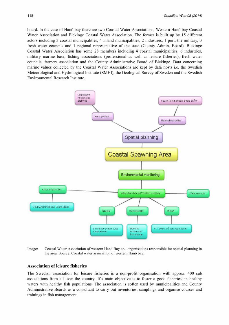
118 Coastline Web 05 (2014)
board. In the case of Hanö bay there are two Coastal Water Associations; Western Hanö bay Coastal Water Association and Blekinge Coastal Water Association. The former is built up by 15 different actors including 3 coastal municipalities, 4 inland municipalities, 2 industries, 1 port, the military, 3 fresh water councils and 1 regional representative of the state (County Admin. Board). Blekinge Coastal Water Association has some 28 members including 4 coastal municipalities, 6 industries, military marine base, fishing associations (professional as well as leisure fisheries), fresh water councils, farmers association and the County Administrative Board of Blekinge. Data concerning marine values collected by the Coastal Water Associations are kept by data hosts i.e. the Swedish Meteorological and Hydrological Institute (SMHI), the Geological Survey of Sweden and the Swedish Environmental Research Institute.
Image: Coastal Water Association of western Hanö Bay and organisations responsible for spatial planning in the area. Source: Coastal water association of western Hanö bay.
Association of leisure fisheries The Swedish association for leisure fisheries is a non-profit organisation with approx. 400 sub associations from all over the country. It’s main objective is to foster a good fisheries, in healthy waters with healthy fish populations. The association is soften used by municipalities and County Administrative Boards as a consultant to carry out inventories, samplings and organise courses and trainings in fish management.
Strehlow et al. 119
South Baltic Flag The South Baltic Flag is a cooperation between four municipalities along the west coast of Hanö bay (Simrishamn, Ystad, Sölvesborg and Kristianstad). The Flag Association (Fisheries Local Action Group) was developed in response to the EU fisheries policy and has as one of its main objectives to increase the cooperation between fisheries and local development. Today there are approx. fourteen Flag associations in Sweden and 200 in Europe. The South Baltic Flag develops the coastal fisheries by supporting and initiating new projects that increases the integration of fisheries into other sectors and industries in the region. It also carries out advocacy to raise the awareness about regional fisheries in the region of western Hanö bay and EU.
4.4 Discussion of the network maps Coming back to one of the questions posed in the beginning of this report - Who are the different actors and institutions influencing the protection and use of coastal (spawning and nursery) areas – a description of the different actors has been done above. It is however difficult to estimate the level of influence that different actors have on the management of spawning and nursery grounds as these areas are not clearly identified along the coast of Hanö bay and there is no official monitoring or management programme that specifically covers these areas. The few studies that have been made to identify the spawning areas have usually been done by, or on behalf of, either Swam or the County Administrative Boards. Thus it could be argued that these organizations have a larger influence on the management of the spawning grounds than other actors. On the other hand side the studies are so few and not part of any long term monitoring programme that it is not possible to say if they have had any real impact on the management of the areas. The military can be seen as an influential actor when it comes to the protection of some of the thought spawning areas as they have impeded the establishment of an off-shore wind farm that is planned to be constructed in an area where herring spawning has been identified. The municipalities have the mandate to physically plan the territorial sea but few have done so for their entire sea area. Municipalities also often pointed out the lack of resources to conduct any inventories of the marine waters which could constitute the base for a marine spatial plan.
5. Conclusion Sweden like any other EU country has through the marine strategy framework directive committed itself to reach a good environmental status in all its marine waters by 2020 (Swam, 2012). Initial steps were taken in 2012 by making an assessment of the current state of the Swedish marine waters as well as a socio-economic analysis of the usage of the sea. The assessment states that the methodology used for monitoring of coastal fish populations is adequate but that the frequency and geographical coverage of the monitoring is too low to be able to apply the results to non-monitored areas. Particularly the Swedish seawaters in the south Baltic Sea lack monitoring of coastal fish stock and it is not possible to assess how alterations in coastal areas may affect species that use coastal waters for reproduction. Furthermore the assessment also states that a much needed complement to the current environmental monitoring would be monitoring of fish larvae as well as an inventory of important habitats for coastal fish species. In the development of the Swedish marine spatial plans a report was recently released describing the current situation in Swedish marine waters (Swam, 2014). Also this assessment states that there is currently only sufficient knowledge to point out 12 spawning areas in Swedish marine waters. None of these are located in Hanö bay. The lack of identification of herring spawning areas, a monitoring programme for spawning areas and an authority with the specific mandate to monitor spawning areas are probably the biggest challenges
120 Coastline Web 05 (2014)
to be addressed to improve management of herring spawning areas. The first step, to identification of the spawning areas, are suggested to be included in the new marine spatial plans that currently are being developed. Furthermore, a deeper understanding and awareness raising about the link between well managed coastal resources and socio-economic development in coastal communities is also likely to benefit the management of coastal spawning areas.
6. References Council regulation (EC) No. 2371/2002 of 20 December 2002 on the conservation and sustainable exploitation
of fisheries resources under the CFP. Carneiro, G. and Nilsson H. 2013. The Sound Water – Humans and Nature in perspective.Malmö. EC Directive 2000/60/EC, Water Framework Directive. EC Directive 2008/56/EC, Marine Strategy Framework Directive. EC Directive 2009/147/EC ,Bird Directive. EC Directive 92/43 EEC, Habitat Directive. Geological Survey of Sweden (SGU). Decision 440- 1632/2010. Gold, E., 1979 The rise of the coastal state in the law of the sea. In: International law of the sea and marine
affairs: a bibliography. Martinus Nijhoff publishers. Helsinki Convention on the Protection of the Marine Environment of the Baltic Sea Area, 1992. Law 2010:900 Plan och bygglagen. Planning and building act of Sweden. Law 1998:808 Miljöbalken. Environmental code of Sweden. Lawrence et al. 2002; Great Barrier Reef Marine park authority 2004; Day 2002. In The key to governing the
fragile Baltic Sea. Zaucha, Jacek. 2014. Lauwaert, B., Unger, S., Jarrah, J. Rowson, K., 20009. Summary assessment of sand and gravel extraction in the
OSPAR maritime area. OSPAR convention. Mansell, J. 2009. Flag state responsibility. Historical development and contemporary issues. Berlin: Springer. Naturvårdsverket & Boverket, Strandskydd. 2010. Stockholm: Naturvårdsverket & Boverket Ramsar. org accessed in Oct 2014. http://ramsar.org Swedish Agency for Marine and Water Management, 2013. Hanöbukten - Interrimrapport.
(Hanöbayinvestigation – Interrimreport). Swedish Environmental Protection Agency & National Board of Housing Building and Planning, Utvidgat
Strandskydd – En vägledning till underlag och beslut, 2010. Stockholm. Swedish Government Official Reports, SOU 2010:42. Med fiskevård i fokus – en ny fiskevårdslag. Betänkande
av Fiskelagsutredningen. 2010. Stockholm. SFS 2004:660 (Swedish Statue book), Ordinance on management of aquatic environemental quality. SFS 2010:1341 (Swedish Statue book), Ordinance on the marine environment. SFS 1998:1341 (Swedish Statue book), Ordinance on protected areas according to the environmental code. SFS 2007:845 (Swedish Statue book), Species protection ordinance. SFS 1994:1009 (Swedish Statue book) Sjölag, SOU 2010: 91Planering på djupet – fysiks planering av havet SOU 2011:56 Kunskap på djupet – kunskapsunderlag för havsplanering Sveriges vattenorganisationer. http://www.vattenorganisationer.se/blekingekvlvf Accessed in October 2014 Swedish Agency for Ocean and Water Management, 2012. God havsmiljö 2020 Swedish Agency for Ocean and Water Management, 2014. Havsplanering – Nuläge 2014 United Nations Convention on the Law of the Sea, 1982. Watercouncil for western Hanö bay. http://www.hanobukten.org/v_hanobukten.htm. Accessed in October 2014.

Strehlow et al. 121
This case study report was prepared by Henrik Nilsson; World Maritime University, Sweden. Henrik Nilsson World Maritime University Citadellevägen 29 S-211 18 Malmö Sweden [email protected]