hickory landscape master plan creative horizons plans... · hickory landscape master plan...
TRANSCRIPT

Hickory Landscape Master Plan
"Creative Horizons" (1996)
Table of Contents
Acknowledgements Introduction to Landscape Master Plan History of Hickory Gateways and Corridors: Concepts and Guidelines Specific Corridor Areas Recommendations / Concepts
Tate Boulevard: Gateway and Highway Overlay District Fourth Street SW: Residential and Commercial Gateway and Corridor South Center Street NC Highway 127 Median LenoirRhyne Boulevard: Corridor and Tate Boulevard Gateway Water Tower Area US Highway 321 from US 70 to MDI Site Interstate 40 Interchange at LenoirRhyne Boulevard Eight Street NE Extension to Armory Downtown Central Business District: Entryway Downtown Central Business District Problem Definition, Medians, Parking Lot Design Standards New Interstate 40 Interchange
Landscape Quality Level Recommendations Relative to Land Use Categories Soils: Concepts Relative to Plant Installations and Maintenance
Soil Types in Hickory Design Criteria for Landscaping the City of Hickory
Recommended Plant Materials Plant Sources
Irrigation Master Plan for City Wide Utilization Landscape Lighting Recommendations Project Process Charts Financial Summary

Acknowledgements
This Master Plan Study was begun in December 1995, and was concluded in February 1997. The following staff of the FWA Group participated in the preparation of this report:
Harry D. Sherrill, Principal Edward E. Evans, Director of Landscape Design Veronica Westendorff, ASLA Kelly Pendleton, ASLA Gwen Cook, ASLA Neil Taylor, Associate ASLA Andrew MacDougall
This study also included information and guidance from the Community Appearance Commission; Chairperson for 199596 was Jan Smithson; Chairperson for 199697 is Martha Younts. The City Manager's office, Brian Hiatt, Assistant Manager, and Gary McGee, Manager. Bob Tumey, City Horticulturalist, was also instrumental in the accomplishment of this study.
City council during the term of this study were:
Mayor, William R. McDonald III since 1981 City Council:
Alderman: Jeff Cline, Ward 1 Alderman: Bruce Meisner, Ward 2 Alderman: Larson H. Moore, Ward 3 Alderwoman: Z. Ann Hoyle, Ward 4 Alderwoman: Sally M. Fox, Ward 5 Alderwoman: Pat M. Moss, Ward 6
City Manager: B. Gary McGee (704) 3237412 fax (704) 3237550
Asst. City Manager: Brian Hiatt (704) 3237412 Horticulturalist: Bob Tumey (704) 3237585
fax (704) 3237403 Public Service Director: Graham Gilley (704) 3237585
fax (704) 3237403 Barbara (704) 3237427 Lisa Drum (704) 3237589
City Clerk/Public Information Officer Patty Williams Director of Human Resources Warren Wood City Attorney: John M. Crane III Staff Attorney: Vicki McGee Quality Director: Dot Williams Risk Manager: Karl Smink (704) 3237442
fax (704) 3237550 City Engineers: Chuck Henson (704) 3237416
John Furmage (704) 3237416 GIS Marcie Sigmon (704) 3237400 Head of Planning Tom Carr (704) 3237400 NCDOT Reuben Chandler
Reese Deese 9820101 Joe Lamb 7398309

Joseph Qubaim (919) 2504016 Piedmont Natural Gas Doug Wilson Sewer & Water Gene Haynes (704) 3237500 Duke Power Terry Wald Hickory Community Appearance Commission
Martha Yount, Chairperson Bernice Mitchell Terry Lawrence Sue Pitman Jan Smithson Patty Shell Skipper Smith
J. R. Steigerwald (704) 3237422 Vaughn & Bradshaw Surveyors
P.O. Box 2861 Hickory, NC 28603 (704) 3227445 Fax (704) 3227048

Introduction to Landscape Master Plan
Conceptually, the Landscape Master Plan strives to include elements of the natural environment in the setting, yet is predominantly based on the use of plant material in an ornamental sense. Mankind has always altered its surroundings in various ways, as Landscape Historian J.B. Jackson states, "The landscape at any one time is a reflection of the culture which built it."
The City of Hickory is an a wonderful and exciting point in its history, where an involved citizenship and staff are ready to establish the guidelines for new growth and rejuvenate the older areas. Hickory is unique in its character and setting as a "Gateway to the Mountains" as well as a trade and commerce hub. The emerging landscape character will need to respond to its uniqueness, its functional demands and its goal to become an unquestionably beautiful place.
The landscape design concepts presented here were developed over a period of time through a process that synthesized the contributions of the City of Hickory Staff, the Community Appearance Commission, City Council and input from other community groups. The Landscape Architects wove these contributions together with horticulture expertise, material availability and suitability, as well as a practical knowledge of implementation and maintenance capabilities.
The plan zone in which Hickory is located allows the use of many evergreen plants including trees, large hollies, shrubs, even some which offer good seasonal bloom. Hardy evergreen plants are ideal for the sunny, windy and even freezing conditions found along the developed areas. Hickory's image can and should include a lot of evergreen and semievergreen presence to set it apart from other cities.
In order for the most visible lawns to remain as healthy as possible, a strong, 12 month maintenance program including liming, fertilization, weed control, over seeding and irrigation should be implemented. Since much of the ground surface will be lawn, this is a very important issue, and one with numerous rewards.
Irrigation for plants, trees and lawns in high value areas guarantees the best living conditions. Many cities with similar water management needs for large areas are switching to the radio and computer managed systems as recommended in this report. They allow more flexibility in controlling water applications.
A ground maintenance program is critically importing in that it provides both the finishing touches to any newly planted project as well as insuring the best growth conditions for all plant materials and lawns. Budgeted programs for fertilizers and other horticultural products, manpower and equipment need to be planned early so that the necessary resources are on hand as the maintenance tasks increase.
Union Square is an important part of Hickory's history

This plaque is located in Union Square

History of Hickory
The City of Hickory has an amazing history of growth and vitality based on hard work and the establishment of trade and industry. In the 126 years since it was incorporated, Hickory has gone from being a stop on the road in the mountains to becoming an industrial and cultural center.
The landscape has always been a reflection of the importance of a site and the wealth of the community. Since its early days, large maturing shade trees and open green spaces have marked Hickory as an important stop along the Railroad. As early as 1890, rows of street trees, especially along Union Square, told travelers and trades alike that Hickory was a vital place, one they should visit.
Today, Hickory continues to expand and faces the challenge of keeping up with its new growth. As stated before, the landscape should reflect the importance and vitality of the city. Street trees and special plantings at entryways, gateways and points of interest follow in the footsteps of Hickory's past. This Landscape Master Plan book represents Hickory's efforts to continue what their ancestors began. It establishes the guidelines for landscape work as required and approved by the City of Hickory, with goals for the next 10 years of development mapped out.
Historical views of Union Square

Historical Time Line 1779 Hickory is a "wide place in the road" (Freeze p. 265) on the stagecoach road between the
mountains and Charleston. 17841800 Hickory Tavern was established. Legends say the name comes from the large tree which
shaded the building. 1849 Horseford Toll Bridge built across the Catawba River. This was a vital link to the
mountain trade. 1860 Western NC Railroad bypasses Newton to continue along the ridge line south of the
Catawba River to Hickory. 1870 Grid pattern of streets established by W. P. Ivey
Hickory is incorporated as Hickory Tavern Township 1873 Mountain wagon trade is heavy 1874 First official election is held 1878 Industrial growth begins along railroad tracks, approximately 1 mile west of depot
beginning with Piedmont Wagon Company 1880 Southern Railroad takes over the tracks. (Richmond to Danville line) 1881 Law passed that only brick can be used when building near the railroad station due to the
numerous fires which have plagued that area of the city. 1890 Trees planted on Union Square. Importance of the Railroad to Hickory is reflected in the
landscaped grounds. 1900 Furniture factories established in Hickory 1904 7 acres of land purchased by the city government for the first public park. 1908 A comprehensive plan for numbering streets and avenues of Hickory is created. 19181940 "NonFarm Boom" in Hickory, the development of textile, hosiery and furniture industry in
Hickory begins to grow. 1937 Hickory Municipal Airport built by Works Progress Administration. 1940 First urban renewal projects begin in Hickory.
Bibliography / Sources
Carolina Room of the Elbert Ivey Memorial Library. Evelyn Rhodes, Janey Deal and Corkie Miller.
Freeze, Gary R. The Catawbans: Crafters of a North Carolina County. Catawba County Historical Association, Newton, NC, 1995. pgs. 265308.
Mohney, Kirk and Laura A. W. Phillips. From Tavern to Town: The Architectural History of Hickory, North Carolina. City of Hickory Historic Properties Commission, Hickory Landmarks Society, Inc., Hickory, NC 1988.
Halma, Sidney (editor) Catawba County: An Architectural History. Catawba County Historical Association. Danning Co. Virginia Beach, VA. 1991. pgs. 194199.

Gateways and Corridors: Concepts and Guidelines
With trade and commerce playing such an important role in the history and development of Hickory, it is only natural that the entryways, gateways and corridors of Hickory be given special design attention. The entry into the City provides the visitor's first and strongest impression of Hickory, it is a reflection of the city's citizens and businesses. To maximize impact, attractive views should be concentrated in this area.
Gateways should be located at major intersections around Hickory where traffic flow in and out of the city is the greatest. The confluence of Lenoir Rhyne Boulevard with Interstate 40 and Highway 321 at the Catawba River are examples of entryways. These areas need to "pop", to show what a growing and progressive city Hickory is. Large, broad plantings that sweep around the entryway and open it up visually can create a sense of space and grandeur that reflect the new growth in Hickory.
Entry spaces need to have clean geometric forms that are free from detractors like overhead utilities. By locating utilities to the back of the rightofway and planting large maturing trees in front of these, an open appearance can be maintained in entryway intersections. Groupings of small flowering or evergreen trees in front of the larger trees add more seasonal interest and depth to the entryway. This increased the visual impact to the vehicle passengers as they move quickly along the roadway and differentiates between corridor and entryway.
These entryways also need to be friendly spaces that give off a sense of welcoming. Sidewalks, accent lighting and smaller, more detailed plantings of shrubs, ground covers and annuals can accomplish this. Keep in mind that any planting in these areas need to be in large masses and have high contrast in texture, color, form and size in order to be noticeable in traffic. Entryways much be big, bold and maintained at a higher level than corridors.
Gateway Design Characteristics
• circular theme • utilities located at the back or site or buried • large maturing trees with smaller trees and/or shrubs in front of them • signage • lighting • seasonal color • additional maintenance required
Planting and signage can be combined to create a strong entry.

Successful interchange planting along I77
Different textures, sizes and heights in a planting create greater interest
Corridors are the main routes of traffic into and out of the city. Patterns of shade and sunlight, openness and enclosure are most effective in these areas. These patterns help to carry traffic through areas in a more pleasant and relaxing manner. Different levels of landscape and maintenance will be required depending on the size, width, traffic load, and surrounding land uses.
New corridors should be reviewed during the planning process and should meet the landscape criteria as set forth in this document upon its completion. The same criteria applies to existing corridors which are proposed to be enlarged. Existing corridors where there are no current long term plans to make changes are the most difficult areas to bring up to design standards, but will have the most immediate effect on the appearance of Hickory.
Design criteria for corridors should include using the appropriate street trees for the area, spaced 40 60' on center for large maturing trees and 20 30' on center for small maturing trees. All utilities should be located on the same side of the street to keep the amount of "visual clutter" to a minimum. Where possible, locate utilities to the back of the right of ways and for all new or updated corridors, utilities should be buried.
To achieve a high quality, genteel effect, keep to the same species tree or pattern of trees in each corridor. While a monoculture is by no means desirable, too many species mixed together creates a hodgepodge effect that is more distracting than pleasant. Groupings of trees used in a repetitious pattern is also effective. For example, a corridor can be lines with large maturing maples for three blocks, then a grouping of crape myrtles clustered around an important intersection could be used for excitement and variety.
Corridor Design Characteristics
• street trees appropriate to corridor conditions (i.e. utility locations, RightofWay, medians, etc.) • use of shrubs and/or seasonal color at stopping points • predominately turf for lower maintenance

The careful use of a monoculture provides visual continuity to this corridor.
Corridor of mature trees in Charlotte, NC
For maximum results plant 12 14' trees for corridors

Tate Boulevard Gateway
Concepts:
1. To create an eyecatching gateway onto Tate Boulevard at Fairgrove Church Road. 2. Provide large maturing shade trees at 40' intervals in a circular pattern around the intersection. Plant an
inner circle of flowering trees at 20' intervals. 3. Provide turning ramps for both directions from Fairgrove Church Road to Tate Boulevard and from Tate
Boulevard to Fairgrove Church Road.
View looking west at intersection of Tate Boulevard and Fairgrove Church Road
Redesigned intersection is more attractive and more functional.
Context Map
Turning ramps make the intersection safer.
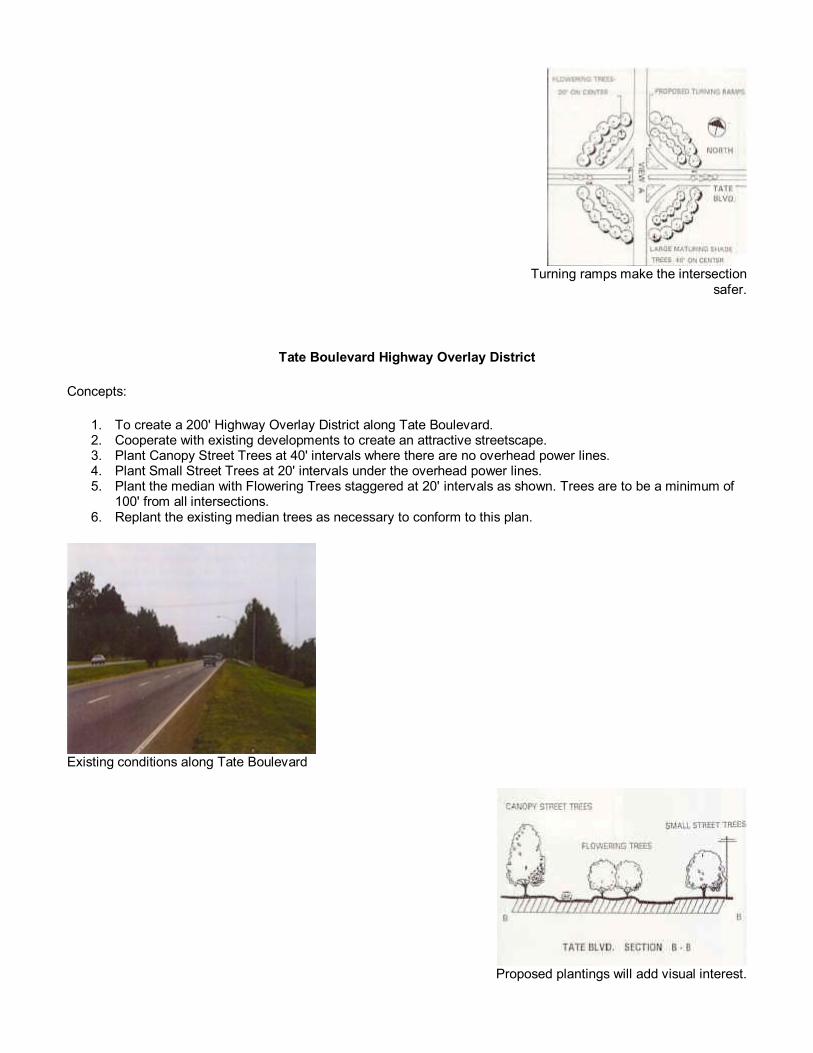
Tate Boulevard Highway Overlay District
Concepts:
1. To create a 200' Highway Overlay District along Tate Boulevard. 2. Cooperate with existing developments to create an attractive streetscape. 3. Plant Canopy Street Trees at 40' intervals where there are no overhead power lines. 4. Plant Small Street Trees at 20' intervals under the overhead power lines. 5. Plant the median with Flowering Trees staggered at 20' intervals as shown. Trees are to be a minimum of
100' from all intersections. 6. Replant the existing median trees as necessary to conform to this plan.
Existing conditions along Tate Boulevard
Proposed plantings will add visual interest.

Context map
Recommended planting plan

Fourth Street Residential
Concepts:
1. Consolidate overhead power, telephone, and streetlights to one side of the street. 2. Eliminate any existing tree lawns between sidewalks and road. 3. Repair sidewalks and curb and gutter as needed. 4. Provide large maturing shade trees at 40' intervals on the side of street without overhead lines. 5. More frequent human scaled light poles and limbed up trees provide greater security in residential areas.
Existing view looking southwest down Fourth Street (View C)

Recommendations for Fourth Street residential areas
Street level view of proposed changes
Fourth Street Commercial Gateway
Concepts:
1. Consolidate power, telephone, and street lights to east side of the street. 2. Bury telephone and other utilities where possible, and remove poles on west side of street. 3. Provide curb and gutter to handle storm drainage. 4. Consolidate parking in Right of Way by reducing paved area to 65' parking bays. 5. Use large maturing shade trees to define corridor without blocking visibility to commercial uses. 6. Break up long expanses of paving with medians for tree planting. 7. Human scale, shade are used to enhance the environment.

Context Map
Existing store fronts (View B)

Fourth Street Gateway Recommendations
Proposed changes for commercial areas
Fourth Street Commercial Corridor
Concepts:
1. Consolidate overhead power, telephone, and street lights to east side of the street. 2. Bury telephone and other utilities where possible and remove poles from west side of the street. 3. Provide curb and gutter to handle storm drainage. 4. Consolidate parking in Right of Way by reducing paved area to 65' parking bays. 5. Use large maturing shade trees in open road areas or narrower canopy trees in areas with spreading
restrictions to define corridor without blocking visibility to commercial uses.

6. Break up long expanses of paving with medians for tree planting. 7. Human scale, shade are used to enhance the environment.
Context map
Existing view looking north along Fourth Street View A

Fourth Street corridor recommendations
Street level view of proposed changes

South Center Street
Overall Concepts:
1. Consolidate overhead power, telephone, and street lights to one side of the street. 2. Bury telephone and other utilities where possible, and remove excess utility poles. 3. Provide curb and gutter to handle storm drainage and to control traffic. 4. Use large maturing shade trees to define corridor without blocking visibility to commercial uses. Limb up
trees to provide clear sight lines. 5. The combination of human scale trees and a reduction of paved areas provide an enhanced outdoor
environment. 6. Clear, grade and establish lawn on vacant lot. Provide a catch basin that connects to storm sewer system
to prevent sediment and storm water from running over the sidewalk. Provide street trees appropriate to the site conditions along the property frontage.
7. Provide curb and gutter to handle storm drainage.
Context map
Residential Concepts:
1. Consolidate overhead power, telephone and street lights to one side of the street. 2. Eliminate any existing tree lawns between sidewalks and road which are too small for trees and are difficult
to maintain. 3. Repair sidewalks and curb and gutter as needed. 4. Acquire rightofway or cooperative agreement with property owner to plant new trees. 5. Provide large maturing trees at 40' intervals on the side of the street without overhead lines. If overhead
lines are in conflict, use small maturing trees at 30' on center. 6. More frequent human scaled light poles and limbedup trees provide greater security in residential areas.

7. Increase the level of maintenance so that the perception is that of a clean, neat and respected neighborhood.
Existing vacant lot
Proposed street plantings

NC Highway 127 Median
Concepts:
1. To soften the landscape along this corridor between 2nd Ave. N.E. and 1st Ave. S.E. by planting the medians.
2. Use plantings within the medians that are tolerant of urban conditions and have low maintenance requirements.
3. Irrigation to medians is recommended to support plantings.
Context map
Existing view of medians

Recommended planting areas
Medians after proposed changes

LenoirRhyne Boulevard Corridor
Concepts:
1. To develop this highway corridor as a major gateway into the City. 2. Create a 150' Highway Overlay District along LenoirRhyne Boulevard, to set a standard for a continuous
streetscape along both the undeveloped and developed properties. 3. Plant Canopy Street Trees at 40' intervals where there are not restrictions with overhead power lines. 4. Plant Flowering Street Trees at 20' intervals where there are restrictions with overhead power lines. 5. Create a Street Tree Ordinance to guide to development of currently undeveloped areas. 6. Cooperate with the existing developments to create an attractive streetscape along the entire corridor. 7. Complement the landscaping of the I40 Interchange with the plantings along this corridor.
Context map
Existing view of LenoirRhyne Boulevard (View A)

Recommended planting plan
Street level view of proposed plantings (View A)
LenoirRhyne Tate Boulevard Gateway
Concepts:
1. To create a gateway into Hickory from Lenoir Rhyne Boulevard to Tate Boulevard. 2. Provide large maturing shade trees at 40' intervals in a circular pattern around the intersection. Plant an
inner circle of flowering trees at 20' intervals. 3. Provide turning ramps for both directions from Lenoir Rhyne Boulevard to Tate Blvd. and from Tate Blvd. to
Lenoir Rhyne Blvd. 4. Maintain the planting around the existing Hickory sign to keep the sign visible. 5. Additional rightofway or grading easement may be required for the proposed turning lanes.

Existing gateway to Hickory
Context map
Recommendations for redesigned intersection

Proposed gateway creates a better sense of arrival.

Water Tower Area
Concepts:
1. To create a more aesthetically pleasing streetscape at the water tower. 2. Provide canopy street trees along both sides of the street at 40' intervals and plant flowering trees at 20'
intervals in the islands. 3. Create an area of color with a bed of flowering shrubs and perennials.
Context map
Existing view of water tower area

Street level view of proposed plantings
Recommended planting plan

US Highway 321 Guidelines
Concepts:
1. Highway 321 is a major traffic corridor and continues to serve as the connector to the mountains. Therefore, the entries to Hwy. 321 from I40 and the Catawba River are very important. These areas should be planted to create major entry statements.
2. A Highway Overlay District should be created to influence existing development first through voluntary action, and later through the building permit process. Several existing companies, including Siecor, already have made significant contributions to the landscape along this corridor.
3. Appropriate tree plantings, per a Tree Ordinance, should be planted along the existing RightofWays of Hwy 321. Where overhead utilities exist, use narrow or small flowering trees, and where the area is unobstructed, use large maturing trees. A design of the corridor should be created that used a mix of trees that of complimentary to each other while providing repetition and consistency.
4. Wherever possible, consolidate utility lines to one side of the road. The Community Appearance Commission should recommend legislation requiring all new development to bury utilities.
5. For yet to be developed areas such as the area from the new MDI site to the bridge over the Catawba River, the tree ordinance and building permit process should be used to obtain the desired plantings along the rightofway.
Context map

Recommendations for redesigned intersection
Existing view of Highway 321 and 13th Street intersection


Plantings by existing businesses like Siecor make a large impact to the quality of Hwy 321
Highway 321

I40 Interchange at Lenoir Rhyne Boulevard
Concepts:
1. Traffic volume and visible traffic congestion both indicate that the I40 interchange will be redesigned to handle more volume in the near future. This redesign should also include significant landscape plantings, signage, lighting and other features to emphasize its significance as a major entryway to the City.
2. A Highway Overlay District is needed to influence the existing development that has grown without any guidelines in place. Tree plantings with the cooperation of private land owners is needed adjacent to the rightofway.
3. A Tree Ordinance should be created for yet to be developed property. 4. Improve the design and image of the area within 1/2 mile on all sides of the interchange.

Lenoir Rhyne at I40 Interchange
Trees line this interchange exit for visual impact.
Monuments make strong entryways.

Eighth Street N.E. Extension to Armory
Concepts:
1. To develop guidelines for a Landscape Corridor along the 8th Street N.E. Extension. 2. Work with NCDOT in the planning stages to assure that a percentage of their total construction budget is
designated for landscaping. Propose that staggered rows of Canopy Street Trees, 2 1/2 3" caliper, be planted 60' on the center along both sides of the right of way with the initial construction.
3. Develop a Tree Ordinance to set Street Tree guidelines for the future development of the existing vacant properties.
4. Propose underground utilities along this corridor. 5. Provide screening to reduce visibility and noise to existing residential areas. Use a mix of evergreen plants,
varying heights, textures, density and color.
Context Map

Recommended planting plan

Downtown Entryway at Second Avenue
Concepts:
1. Improve entry image by removing concrete and gravel subbase from medians greater than 2' in width, filling with topsoil and planting with groundcover and daylilies.
2. Provide irrigation to plant materials in medians. 3. Plant low shrubs (less than 3' height) and small flowering trees in large median areas. Keep trees limbed
up to a 6' height to allow easy pedestrian traffic and clear sight lines for vehicular traffic. 4. In the absence of overhead power lines and utility lines, large maturing canopy trees can be planted along
the streets in downtown. This is contingent on sufficient root space being provided.
Context Map
Existing medians on Second Avenue

Street level view of proposed changes

Downtown Central Business District
Problem Definition
Concepts:
1. Maintain visibility of storefronts. Do not allow plant growths to block views. 2. Plants should include a variety of textures, foliage, bloom color, and height differentiation to keep interest
and spatial separation. Remove dangerous plants which could cause injury. 3. Lighting should be redesigned and fixtures selected to complement architecture. 4. Vehicular and pedestrian safety and visibility endangered by plantblocked views.
Context map
Storefronts screened by plant growth

Redesigned planting bed adds color while opening views to storefronts
Downtown Central Business District
Concepts:
1. Utilize recommendations from a professional Arborist regarding care and maintenance of existing trees in the lawn of the Central Business District.
2. Remove existing material and boulders from planters in the main walk and plaza. Excavate and check for adequate drainage and provide irrigation. Fill planters with potting soil and plant with low shrubs and seasonal annuals.
3. Plant materials should vary in texture, color and height in order to create an interesting arrangement that enhances the Downtown.
4. Limit the size and quantity of annual beds. These areas would be great as AdoptaSpot beds with the City and/or CAC prescribing the types of plants to be used.
5. Keep visibility to storefronts free from obstructions. 6. Replace existing light fixtures with ones more appropriate to the historical nature of the architecture. 7. Improve the look of the public restrooms by the bus stop by removing the coniferous evergreens and
replacing these with small ornamental trees. This will provide greater safety through increased visibility at the human scale while softening and screening the edges of the building.
8. Repair or replace warped or uneven pavements, particularly the cobblestone on the concrete base. Replace with brick or concrete pavers, or poured in place concrete.
Context map

Existing view of Union Square
Crosssectional view of proposed improvements
Downtown Central Business District Traffic Medians
Concepts:
1. Remove existing plants. Amend soil, and add additional potting soil. Replant medians with shrub species which will not exceed 3' height. For long term planning, budget to replace these shrubs approximately every 10 years for improved health and aesthetics.
2. Limb up existing trees to improve visibility for pedestrian and vehicular traffic. Prune out dead and crossing branches to improve health of trees.
Recommended planting plan

Tall median plantings are hazardous to vehicular and pedestrian traffic
Existing downtown pedestrian crossing
Parking Lot Design Design Standards
Concepts
1. Parking decks occur in areas where real estate is both high in value and limited parking spaces are available.
2. They are usually in downtown areas among existing buildings. 3. They are within easy walking distance of demand for public parking. Pedestrian and safety are important. 4. Security and accessibility are keys to successful use of the parking lots.

5. Streetscape elements should be continued along the perimeter of parking decks. Street trees, sidewalks, lighting and design details.
6. The architectural design of the parking deck shall blend in with the surrounding. The design of the street level should screen the parking from the street and provide visual interest to the pedestrian.
7. Plantings should harmonize with others in the area. 8. Parking decks should be setback a minimum of 12' from the street rightofway. And meet all yard
requirements for the district. The setback will include a 5' planting strip and a minimum 7' wide sidewalk. 9. The planting strip shall be planted with urban street trees or small street trees at a rate of 1 tree per 30' of
street frontage. 10. The first parking level and any additional level with handicapped parking spaces should have a minimum 9'
clearance. 11. All loading storage and trash facilities should be screened from the street and all pedestrian circulation
areas. 12. It would be ideal if the ground level contained retail space which would provide pedestrian activity, security,
and harmonize with surrounding retail uses.
Poor parking garage design

Creative parking garage design
These parking garages are all examples of attractive design. In each case an effort was made to accent the positive features (usually the architecture), while screening the negative ones (the cars). The result is a contiguous,
sometimes seamless, element in the landscape.

New I40 Interchange
Concepts:
1. This interchange is currently being designed by NCDOT. Additional design work should include significant landscape plantings, signage, lighting and other features to emphasize its significance as a major gateway to the City.
2. A Highway Overlay District is needed to influence new development that will grow along this new interchange. The rightofway should be established at 20' from edge of pavement to allow enough planting space to make an impact.
3. A Tree Ordinance should be created for undeveloped property. 4. Improve the design and image of the interstate within 1/2 mile of the interchange.
Context map
Recommended planting plan

Examples of immature interchange planting masses
Note the large planting beds

Landscape Quality Level Recommendations Relative to Land Use Categories
This matrix delineates our recommendations for legislation, ordinances, or guidelines for landscape development.
The requirements for the level of landscape quality how much is to be planted, where, and what general type of planting is recommended is indexed with various land uses.
For example, where we expect users to care the most, plant the heaviest density of the best quality plants, and care the most for plants, at their own residence, our recommendations are minimal.
On the other hand, historically the public desires the best quality and extent of plantings in the uptown areas, at transportation centers, and in commercial areas. The guidelines for these areas are the most extensive.
In industrial and utility areas the guidelines call for a quality image along the street frontage and in the office or employee break areas, therefore not restricting the internal, heavy use areas of the property.

Soils: Concepts Relative to Plant Installation and Maintenance
Soil Types in Hickory
The most predominant soils in the Hickory area belong to the Cecil and Pacolet series. These soils are located on gently sloping uplands and both consist of shallow layers of sandy loam over a red clay subsoil. They are acidic soils with good drainage capabilities. However, they are low in organic content. Planting in these soils will require mixing the existing soils with a planting mix as specified in the tree planting details. These soils and the less predominant soils of the area are described below in more detail.
Cecil Series CmB2, CmC2, CmD2, CnB2, CnC2, CnE3
The Cecil series is a well drained brown sandy loam. The surface is approximately 7" thick with a deep subsurface of red clay. This is an acidic soil with moderate drainage capabilities and moderate shrink swell potential.
Pacelot Series PaF, PcD, BcC, PeE
The Pacelot series is a well drained gravelly sandy loam. The surface is about 6" thick with a red clay subsoil. This is an acidic soil with moderate drainage capabilities and modern shrink swell potential.
Appling Series AsB, AsC2, AsE2
The Appling series is a well drained brown sandy loam. The surface is approximately 8" thick with a subsurface of yellow/brown clay. This is an acidic soil with moderate drainage capabilities and moderate shrink swell potential.
Hiwassee Series HsB2, HsC2, HsD2, Hse, HwB2, HwC2
The Hiwassee series is a well drained red brown loam. The surface is approximately 6" thick with a subsurface of firm red clay. This is an acidic soil with moderate drainage capabilities and moderate shrink swell potential.
Congaree Cy
This soil lies along the river beds. It is a well drained brown loam soil. This is a good farming soil and has good topsoil characteristics.
Wehadkee Wd
This soil is located in floodplain areas. It is a poorly drained brown sandy loam.
Leveled Clayey Land Lc
This consists of areas that have been altered so that the original soils cannot be recognized. On site examination is needed to determine the characteristics of this soil.
Chewacla Cw
This soil lies along the river beds. It is a poorly drained brown loam flood plain soil. This soil has good topsoil characteristics.


Design Criteria for Landscaping the City of Hickory
The purpose of this section is to define the criteria for identifying landscape materials that the City of Hickory can use to implement the designs in this Master Plan. Quality landscaping will enhance both existing developments as well as future growth. It will also help develop a sense of unity throughout the City.
In implementing the designs in this master plan, the City of Hickory should use top quality plant materials. All plants should be nursery grown stock to meet or exceed the American Standards for Nursery Stock by the American Association of Nurserymen, Inc. They should also conform to the following guidelines.
DECIDUOUS TREES Trees should conform to branching caliper and height specifications of the A.A.N.. They shall have a single straight leader and shall be well shaped.
EVERGREEN TREES Evergreen trees should have an internode no greater than 18" and shall be uniformly well shaped.
MULTISTEM TREES These trees should be evaluated according to their height, quality of the branches, and should also have an attractive branching habit and 35 trunk stems.
SHRUBS All shrubs should be dense uniform and vigorous.
GENERAL All plant materials should be free of insect and disease. They should be unconditionally guaranteed for one year. When installed all trees and shrubs should be mulched with 4" of pine bark or hardwood mulch.
PLANTING IMPLEMENTATION Plants should be installed during the prime planting season. The planting season for the Hickory areas extends from Oct. 1st to May 1st of the following year.
PLANT CLASSIFICATION All recommended plantings are classified by their suggested use:
Type Classification M Canopy Street Trees N Urban Street Trees O Small Street Trees P Small Flowering Trees Q Large Flowering Trees R Street Trees for Screening S1 Large Urban Shrubs S2 Small Urban Shrubs

Top quality plant materials ensure an attractive landscape for years to come.
Larger plant materials at installation create a stronger impact.

Type S1 Large Urban Shrubs
1. Shrubs with an average height greater than 3'. 2. These shrubs are planted to establish a screen between streets and parking lots or other less attractive site
elements. 3. Shrubs should have a minimum height of 36" and be in a minimum of a 3 gallon container at the time of
planting.
Type R Street Trees for Screening
1. Trees with an average height over 6' and with dense foliage. 2. These trees are planted to establish an effective screen between the street and less attractive site
elements or to screen residential areas from busy streets. 3. Trees should have a minimum caliper of 2" and a minimum height of 8' 10' at the time of planting.
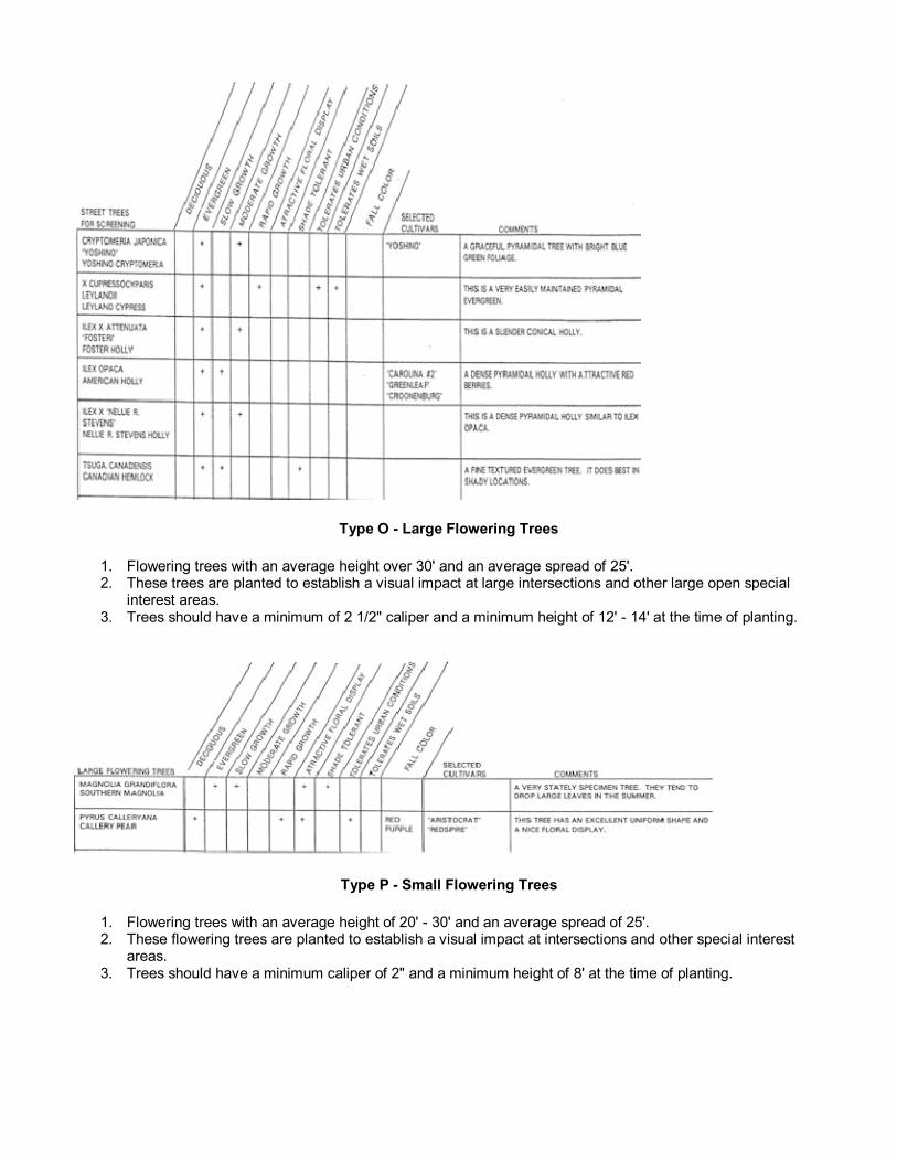
Type O Large Flowering Trees
1. Flowering trees with an average height over 30' and an average spread of 25'. 2. These trees are planted to establish a visual impact at large intersections and other large open special
interest areas. 3. Trees should have a minimum of 2 1/2" caliper and a minimum height of 12' 14' at the time of planting.
Type P Small Flowering Trees
1. Flowering trees with an average height of 20' 30' and an average spread of 25'. 2. These flowering trees are planted to establish a visual impact at intersections and other special interest
areas. 3. Trees should have a minimum caliper of 2" and a minimum height of 8' at the time of planting.

Type N Urban Street Trees
1. Trees with an average height of 50' and an average spread of 25'. 2. These columnar trees are planted to establish a unified streetscape in urban areas where there are size
restrictions due to buildings along the streets. 3. Trees should have a minimum caliper of 2 1/2" and a minimum height of 12' 14' at the time of planting.
Type 0 Small Street Trees

1. Trees with an average height of 20' 30' and an average spread of 25'. 2. These trees are planted to establish a unified streetscape in areas where there are obstructions from
overhead power lines. 3. Trees should have a minimum caliper of 2" and a minimum height of 8' 10' at the time of planting.
Type S2 Small Urban Shrubs
1. Shrubs with an average height of less than 3'. 2. These shrubs are to be planted in urban street medians, to create texture and add interest to the urban
landscape. 3. Shrubs should be a minimum of 18 24" and be in a minimum of a 3 gallon container at the time of
planting.

Type M Canopy Street Trees
1. Trees with an average height of 50' 75' and an average spread of 40'. 2. These trees are planted to establish a unified streetscape in areas where there are no obstructions on
either side. Open road conditions. 3. Trees should have a minimum caliper of 2 1/2" and a minimum height of 12' 14' at the time of planting.

Plant Sources
TREES AND SHRUBS
1. Boyd Coffey and Sons Nurseries Route 7, Box 282 Lenoir, NC 28645 7047589063
2. Buffalo Creek Nursery Route 5, Box 389 Lenoir, NC 28645 18004420443
3. Janes Nursery Route 8 Box 370B Lenoir, NC 28645 7047545274
4. M. J. Fitzgerald Nursery Inc. 3890 Simpson Creek Road Morganton, NC 28655 7044373107
5. Pender Nursery P. O. Box 155 Garner, NC 27529 18009421648
6. Piedmont Carolina Nursery 1867 Sandy Ridge Road Colfax, NC 27235 19109934114
7. Quaker Meadows Nursery 2310 McConnaughy Lane Morganton, NC 28655 7044372063
8. Select Trees P. O. Box 6671 Athens, Georgia 30604 7067699879
9. Shady Grove Plantation and Nursery 3030 Charleston Rd., S.W. Orangeburg, S.C. 291159636 18005345683
10. Worthington Farms Route 1, Box 575 Greenville, NC 27834 9197563827
PERENNIALS
11. Dogwood Nursery and Greenhouse 107 Dogwood Drive Morganton, NC 28655
12. Hallmans Greenhouse and Nursery Route 2 Box 776 Conover, NC 28618 7042562312
13. Hefner's Nursery Route 4 Box 250 Conover, NC 28613 7042565271


Irrigation Master Plan for City Wide Utilization
An irrigation system provides an underground, automatic, controlled supply of water for lawns and plants to promote and assist their growth. University tests have proven its effectiveness in reducing plant stress and required maintenance, all while improving appearance. Irrigation is a support system, used only in areas of high visual value.
Each installation typically uses a separate water meter, to avoid sewerage charge, a backflow preventor, to prevent contamination of potable water supply, and a controller to regulate location, time of day, frequency, and duration of spray. Also included are sensors which shut the spray off at freezing temperatures, and during rain storms. Lawns and shrub beds use popup spray heads which supply the water to the necessary areas.
The management of a vast citywide network is made easy by specially designed controllers, such as RainBird's Maxicom System. These systems can also operate lighting and other devices in conjunction with irrigation controllers on each site. Across the nation, many cities have discovered the benefits of utilizing a telephonecellular or radio controlled central irrigation control system for the management of public property systems. This enables one manager to monitor and control watering throughout the city without physically having to be on each site.
The lush, colorful landscape, product of a well designed irrigation system

Landscape Lighting Recommendations
Coordination of landscape plantings and lighting design is important because it:
• Allows planning of overhead line routes relative to street tree plantings. • Allows planning for the optimum placement of trees and lighting poles in parking lots. • Prevents future conflicts as trees grow, affecting light placement and overhead line viability.
Lighting intensities (usually measured in footcandles) vary relative to highway category, traffic volume, intersection and crossstreet locations, and in the distance from light source. Highway Lighting Standards are utilized by the design engineers, placing higher light levels where security, safety, and decision making events are important. Accent lighting for entry statements, signage, and the illumination of special features can be utilized as a design tool to enhance landscape plantings.
Change can be effected when existing streets and highway corridors are upgraded; then overhead lines could be relocated and lighting revised to incorporate new landscape plantings as a part of road widening, redesign, and upgrade projects. Use of RightofWay easement agreements, coordinated design reviews, and interest by the Community Appearance Commission in the design process, as coordinated through the appropriate city department can be effective means of obtaining change.
Postcard shows original light fixtures used in Hickory
Appropriate lighting is needed for safety as well as design impact.

Project Process Charts
The master plan here contains "Gantt Charts" which serve to illustrate the process through which a particular project moves from preliminary master planning to reviews, to implementation.
This computer "modeling" of the process allows changes to be made in dates, scope of work, and length of tasks while continuing to illustrate the timeline for the project from start to finish. The computer chart facilitates changes while solving the completion dates' timetables for the planners.
These were assembled based on a start time of January 1996 and the earliest possible completion time. Projects can also be scheduled based on a tabulation of staff size available.
Because these charts would not translate well to WWW format, following are timelines from those charts. Actual charts are available at Julian Whitener Municipal Building.
Duration Start Finish Uptown Area 289d 2/5/96 3/21/97 Obtain Site Information 50d 2/5/96 4/15/96 Preliminary Master Planning 5d 2/15/96 2/21/96 Design 20d 2/22/96 3/20/96 Preliminary Master Planning 7d 3/19/96 3/27/96 Design 7d 3/28/96 4/5/96 Workshops 1d 4/9/96 4/9/96 Workshops 1d 4/10/96 4/10/96 Preliminary Utilities/Railroad/NCDOT Review 1d 4/11/96 4/11/96 Design 15d 4/12/96 5/2/96 Workshop Reviews 1d 5/3/96 5/3/96 Workshop Reviews 1d 5/6/96 5/6/96 Design 10d 5/7/96 5/20/96 Review by Utilities 30d 5/21/96 7/1/96 Review by Railroad / NCDOT 60d 5/21/96 8/13/96 Design 10d 8/14/96 8/27/96 Present Design to CAC 1d 8/28/96 8/28/96 Review/Approval of Design by City 8d 8/28/96 9/9/96 Complete Design 5d 9/10/96 9/16/96 Select/Purchase Planting Materials 20d 9/17/96 10/14/96 Demolition/Construction Phase 1 25d 10/8/96 11/11/96 Install Phase 1 28d 10/15/96 11/21/96 Demolition/Construction Phase 2 42d 1/6/97 3/4/97 Install Phase 2 35d 2/3/97 3/21/97 Complete landscape installation 0d 3/21/97 3/21/97
Master Planning
Duration Start Finish Master Planning 342d 1/29/96 5/29/97 Preliminary Master Planning Design 43d 1/29/96 3/27/96 Master Planning Design 68d 3/28/96 7/2/96 Workshops 1d 7/3/96 7/3/96 Workshops 1d 7/5/96 7/5/96 Master Planning Design 5d 7/8/96 7/12/96 Workshop Reviews 1d 7/15/96 7/15/96 Workshop Reviews 1d 7/16/96 7/16/96 Master Planning Design 5d 7/17/96 7/23/96 Review by Utilities 30d 7/24/96 9/4/96 Review by Railroad / NCDOT 60d 7/24/96 10/16/96

Present Master Planning Design to CAC 1d 8/27/96 8/27/96 Present Master Planning Design to City 15d 8/15/96 9/5/96 Master Planning Design 60d 10/17/96 1/13/97 Workshops 1d 1/14/97 1/14/97 Design 5d 1/15/97 1/21/97 Present Master Planning Design to CAC 1d 1/28/97 1/28/97 Review/Approval of M. Planning Design by City 15d 1/22/97 2/11/97 Complete Master Planning Documents 60d 2/12/97 5/7/97 Print Documents 15d 5/8/97 5/28/97 Issue Master Planning Documents 1d 5/29/97 5/29/97 Complete Master Planning 0d 5/29/97 5/29/97
Tate Boulevard
Duration Start Finish Tate Boulevard 294d 4/16/96 6/9/97 Obtain Site Information 15d 4/16/96 5/6/96 Design 30d 5/7/96 6/17/96 Preliminary Utilities/NCDOT Review 30d 6/18/96 7/30/96 Design 15d 7/31/96 8/20/96 Workshops 1d 8/21/96 8/21/96 Design 15d 8/22/96 9/12/96 Utilities Review 30d 9/13/96 10/24/96 NCDOT Review 60d 9/13/96 12/6/96 Design 10d 12/9/96 12/20/96 Present design to CAC 1d 1/28/97 1/28/97 Review/Approval of Design by City 32d 12/23/96 2/6/97 Complete Design 5d 2/7/97 2/13/97 Purchase Planting Material 25d 2/14/97 3/20/97 Install 60d 3/17/97 6/9/97 Complete Landscape Installation 0d 6/9/97 6/9/97
4th Street SW from Hwy 70 to Main Street
Duration Start Finish 4th St SW 199d 5/7/96 2/14/97 Obtain site information 10d 5/7/96 5/20/96 Design 10d 5/21/96 6/3/96 Preliminary Utilities/NCDOT Review 30d 6/4/96 7/16/96 Design 10d 7/17/96 7/30/96 Workshops 1d 7/31/96 7/31/96 Design 5d 8/1/96 8/7/96 Utilities Review 30d 8/8/96 9/19/96 NCDOT Review 60d 8/8/96 10/31/96 Design 10d 11/1/96 11/14/96 Present Design to CAC 1d 11/26/96 11/26/96 Review/Approval of Design by City 5d 11/27/96 12/4/96 Complete Design 5d 12/5/96 12/11/96 Purchase Planting Materials 15d 12/12/96 1/3/97 Install 30d 1/6/97 2/14/97 Complete Landscape Installation 0d 2/14/97 2/14/97
South Center Street from Hwy 70 to 1st Street

Duration Start Finish South Center Street 419d 5/21/96 1/9/98 Obtain Site Information 15d 5/21/96 6/10/96 Design 15d 6/11/96 7/1/96 Preliminary Utilities/NCDOT Review 30d 7/2/96 8/13/96 Design 10d 8/14/96 8/17/96 Workshops 1d 8/28/96 8/28/96 Design 5d 8/29/96 9/5/96 Utilities Review 30d 9/6/96 10/17/19 NCDOT Review 30d 9/6/96 10/17/96 Design 10d 10/18/96 10/31/96 Present Design to CAC 1d 11/26/96 11/26/96 Review/Approval of Design by City 15d 11/6/96 11/26/96 Complete Design 5d 11/27/96 12/4/96 Purchase Planting Materials 15d 9/24/97 10/14/97 Install 60d 10/15/97 1/9/98 Complete Landscape Installation 0d 1/9/98 1/9/98
Hwy 127 from 1st St to Carolina Park
Duration Start Finish Hwy 127 366d 6/11/96 11/13/97 Obtain Site Information 15d 6/11/96 7/1/96 Design 10d 7/2/96 7/16/96 Preliminary Review Utilities/NCDOT 30d 7/17/96 8/27/96 Workshops 1d 8/28/96 8/28/96 Design 5d 8/29/96 9/5/96 Review by Utilities 30d 9/6/96 10/17/96 Review by NCDOT 60d 9/6/96 11/29/96 Design 5d 12/2/96 12/6/96 Present Design to CAC 1d 12/23/96 12/23/96 Review/Approval of Design by City 15d 12/9/96 12/30/96 Complete Design 5d 12/21/96 1/7/97 Purchase Planting Materials 15d 9/1/97 9/19/97 Install 30d 10/3/97 11/13/97 Complete Landscape Installation 0d 11/13/97 11/13/97
LenoirRhyne Boulevard
Duration Start Finish LenoirRhyne Blvd 484d 7/2/96 5/22/98 Obtain Site Information 15d 7/2/96 7/23/96 Design 30d 7/24/96 9/4/96 Preliminary Review Utilities/NCDOT 30d 9/5/96 10/16/96 Design 10d 10/17/96 10/30/96 Workshops 1d 10/31/96 10/31/96 Design 5d 11/1/96 11/7/96 Review by Utilities 30d 11/8/96 12/20/96 Review by NCDOT 60d 11/8/96 2/4/97 Design 10d 2/5/97 2/18/97 Present Design to CAC 1d 2/25/97 2/25/97 Review/Approval of Design by City 11d 2/19/97 3/5/97 Complete Design 5d 3/6/97 3/12/97 Purchase Planting Material 30d 2/9/98 3/20/98 Install 60d 3/2/98 5/22/98 Complete Landscape Installation 0d 5/22/98 5/22/98

Water Tower Area
Duration Start Finish Water Tower Area 767d 7/24/96 7/20/99 Obtain Site Information 15d 7/24/96 8/13/96 Design 15d 9/12/96 10/2/96 Workshops 1d 10/3/96 10/3/96 Design 5d 10/4/96 10/10/96 Review by Utilities 5d 10/11/96 10/17/96 Design 5d 10/18/96 10/12/96 Present Design to CAC 1d 10/29/96 10/29/96 Review/Approval of Design by City 10d 10/25/96 11/7/96 Complete Design 5d 11/8/96 11/14/96 Purchase Planting Material 15d 2/11/98 3/3/98 Install 30d 3/4/98 4/14/98 Complete Landscape Installation 326d 4/15/98 7/20/99
Hwy 321 from Hwy 70 to Clement Blvd
Duration Start Finish Hwy 321 326d 4/15/98 7/20/99 Obtain Site Information 45d 4/15/98 6/16/98 Design 60d 6/17/98 9/10/98 Preliminary Utilities/NCDOT Review 30d 9/11/98 10/22/98 Workshops 1d 10/23/98 10/23/98 Design 30d 10/26/98 12/4/98 Review by Utilities 30d 12/7/98 1/19/99 Review by NCDOT 60d 12/7/98 3/2/99 Design 35d 3/3/99 4/20/99 Present Design to CAC 1d 4/21/99 4/21/99 Review/Approval of Design by City 10d 4/21/99 5/4/99 Complete Design 25d 5/5/99 6/8/99 Purchase Planting Material 30d 6/9/99 7/20/99 Install 60d 10/2/99 12/24/99 Complete Landscape Installation 0d 12/24/99 12/24/99 Potential Phases 555d 10/17/96 12/16/99
Hwy 321 from Clement Blvd to MDI Site
Duration Start Finish Hwy 321 501d 6/17/98 5/23/00 Obtain Site Information 15d 6/17/98 7/8/98 Project Design 30d 7/9/98 8/19/98 Preliminary Utilities/NCDOT Review 30d 8/20/98 10/1/98 Project Design 15d 10/2/98 10/22/98 Workshops 1d 10/23/98 10/23/98 Project Design 25d 10/26/98 11/27/98 Utilities Review 30d 11/30/98 1/12/99 NCDOT Review 60d 11/30/98 2/23/99 Design 20d 2/24/99 3/23/99 Present Design to CAC 1d 3/24/99 3/24/99 Review/Approval of Design by City 30d 3/24/99 5/4/99 Complete Design 20d 5/5/99 6/1/99 Advertise Project 15d 6/2/99 6/22/99 Bid Project 15d 6/23/99 7/13/99

Award Project 15d 7/14/99 8/3/99 Select Planting Material 30d 8/4/99 9/14/99 Install 180d 9/15/99 5/23/00 Complete Landscape Installation 0d 5/23/00 5/23/00
8th Street Extension
Duration Start Finish 8th Street Extension 401d 7/30/98 2/15/00 Obtain Site Information 15d 7/30/98 8/19/98 Design 60d 8/20/98 11/12/98 Preliminary Utilities/NCDOT Review 30d 11/13/98 12/24/98 Workshops 1d 12/28/98 12/28/98 Design 30d 12/29/98 2/9/99 Utilities Review 30d 2/10/99 3/23/99 NCDOT Review 60d 3/24/99 6/15/99 Design 35d 6/16/99 8/3/99 Present Design to CAC 1d 8/24/99 8/24/99 Review/Approval of Design by City 10d 8/25/99 9/7/99 Complete Design 25d 9/8/99 10/12/99 Purchase Planting Material 30d 10/13/99 11/23/99 Install 60d 11/24/99 2/15/00 Complete Landscape Installation 0d 2/15/00 2/15/00
Uptown Area
Duration Start Finish Uptown Area 289d 2/5/96 3/21/97 Obtain Site Information 50d 2/5/96 4/15/96 Preliminary Master Planning 5d 2/15/96 2/21/96 Design 20d 2/22/96 3/20/96 Preliminary Master Planning 7d 3/19/96 3/27/96 Design 7d 3/28/96 4/5/96 Workshops 1d 4/9/96 4/9/96 Workshops 1d 4/10/96 4/10/96 Preliminary Utilities/Railroad/NCDOT Review 1d 4/11/96 4/11/96 Design 15d 4/12/96 5/2/96 Workshop Reviews 1d 5/2/96 5/3/96 Workshop Reviews 1d 5/6/96 5/6/96 Design 10d 5/7/96 5/20/96 Review by Utilities 30d 5/21/96 7/1/96 Review by Railroad/NCDOT 60d 5/21/96 8/13/96 Design 10d 8/14/96 8/27/96 Present Design to CAC 1d 8/28/96 8/28/96 Review/Approval of Design by City 8d 8/28/96 9/9/96 Complete Design 5d 9/10/96 9/16/96 Select/Purchase Planting Materials 20d 9/17/96 10/14/96 Demolition/Construction Phase I 25d 10/8/96 11/11/96 Install Phase I 28d 10/15/96 11/21/96 Demolition/Construction Phase 2 42d 1/6/97 3/4/97 Install Phase 2 35d 2/3/97 3/21/97 Complete Landscape Installation 0d 3/21/97 3/21/97
New I40 Interchange near LenoirRhyne Blvd
Duration Start Finish

New I40 Interchange 506d 7/9/98 6/20/00 Obtain Site Information 15d 7/9/98 7/19/98 Project Design 35d 7/30/98 9/17/98 Preliminary Utilities/NCDOT Review 30d 9/18/98 10/29/98 Project Design 15d 10/30/98 11/19/98 Workshops 1d 11/20/98 11/20/98 Project Design 25d 11/23/98 12/28/98 Review by Utilities 30d 12/29/98 2/9/99 Review by NCDOT 60d 12/29/98 3/23/99 Design 20d 3/24/99 4/20/99 Present Design to CAC 1d 4/21/99 4/21/99 Review/Approval of Design by City 30d 4/21/99 6/1/99 Complete Design 20d 6/2/99 6/29/99 Advertise Project 15d 6/30/99 7/20/99 Bid Project 15d 7/21/99 8/10/99 Award Project 15d 8/11/99 8/31/99 Selecting Planting Material 30d 9/1/99 10/12/99 Install 180d 10/13/99 6/20/00 Complete Landscape Installation 0d 6/20/00 6/20/00

Financial Summary
The consultant team's recommendations followed the direction of the Appearance Commission and city staff in the selection of these 12 projects for emphasis in this study. The objective of this Master Plan is to serve as a guideline for development of these projects in a planned, organized manner to a high level of quality.
The chart of cost estimates is based on our best professional judgment in 1996 of project scope, cost, and complexity.
The list of funding alternatives is a compilation of various cities' and agencies' actual funding sources in nearby North Carolina regions.
Comprehensive Landscape Plan and Guidelines Budget Ranges
Project Phases Plant Materials Total (if Contracted)
1 Municipal Parking Lot $ 26,000.00 $ 75,000.00 2 Uptown Area 87,000.00 250,000.00 3 Tate Boulevard 250,000.00 715,000.00 4 4th Street 52,500.00 151,000.00 5 South Center Street 52,500.00 151,000.00 6 NC Hwy 127 35,000.00 100,000.00 7 LenoirRhyne Blvd 250,000.00 790,000.00 8 2nd Ave./Water Tower 50,000.00 143,000.00 9 US Hwy 321 325,000.00 928,000.00 10 US Hwy 321 out to MDI 250,000.00 715,000.00 11 New I40 Interchange 105,000.00 302,000.00 12 8th Street Extension 158,000.00 450,000.00
TOTAL 2,058,000.00 5,959,000.00
*NOTE: These projects are not listed in any order of priority.
Typical construction detail
Funding for Landscape Projects How other municipalities and institutions accomplish budget planning.

Project Basis: New projects Repair projects Maintenance Budgets
Include landscape* in project's required budget, and do not allow it to be cut. Usually a percentage of budget or ratio to square footage. (i.e. $1.00/square foot) used in commercial projects. *Plants, lighting, irrigation, signage, site furniture, annual flowers, first years maintenance
City Ordinance Basis: Tree Ordinance Parking Lot Ordinance Landscape Ordinance
As builder or develop acquires building permit: They are required to install plants along right of way and internally. City cost: Inspections and plan approval by trained staff.
Bond Issues for specific projects Voters agree to find specific projects for city's image improvement Examples: World's Fair Cities, Olympic Venues
Special Tax Based Issues: License Fees
Property Tax A percentage of property tax set aside for public improvements. License Plate Fees (Vanity Plates) spent on landscape enhancements.
RevenueBased Users' Fees
Percentage of parking revenue spent for site improvement Percentage of user fees returned to upgrade site
State and Federal Grants and Funds ISTEA SBA Grants Tree City/Arborist Grants
Corporate and Individual Gifts Donations of AdoptaSpots, Memorials, and adopted corridor areas
Planting in progress