high flying approach to line of site analysis cuts telecoms infrastructure costs
DESCRIPTION
Wayne Sander, Technical Director, Environment & Advisory at Aurecon, discusses a revolutionary approach to the delivery of telecommunications infrastructure that can reduce costs by 60 per cent in comparison to traditional methods.TRANSCRIPT
50 Consulting Matters Our industry
High flying approach to Line of Site analysis cuts telecoms infrastructure costsEmerging technologies are rapidly changing the way we communicate and conduct business, with telecommunications infrastructure becoming increasingly important. Network operators want to deliver mobile and wireless telecommunications infrastructure quickly and economically to meet ever growing user demands.
Large scale national telecommunications projects can require anywhere up to 2,000 base stations, each one needing a point to point link into the wider network via a microwave transmission dish. As such, these sites must be located where Line of Sight (LOS) has been verified allowing the site to transmit and receive data from the network without interference from obstructions such as trees, terrain or infrastructure.
Traditional LOS method
Typically, to determine the suitability of a particular location for a telecommunications tower, an Elevated Work Platform (EWP) is hired and transported to a site to test the line of sight. The EWP is used to shoot to an existing tower, a blimp or a second elevated work platform to ascertain whether there are any obstructions.
Limitations of this method include:
• A lack of availability of EWPs in some regions;
• Access issues, such as difficult terrain, gaining the required permissions and wet weather conditions, can cause delays;
• Lack of suitably qualified LOS companies in the country to cater to large projects;
• Mobilisation can be slow due to the time needed to set up the equipment and relocate it to another site;
• There are often lengthy delays between acquisition and reporting;
• Concerns over accuracy and reliability of data; and
• Safety and maintenance issues including breakdown, bogging and hydraulic failures.
Undertaking this work in remote locations poses further cost and time challenges.
A cost-effective alternative
LIDAR (Light Detection and Ranging) is an alternative to traditional methods that has significant benefits for network operators. Light aircraft, fitted with this technology, capture data by laser and are capable of mapping ground and non-ground data over a path of up to 1,500 metres in width.
The laser has the capability of striking the same point on the ground four times over, each providing return data capable of determining the height of the ground but also the nature of the strike. That is, the laser is capable of deciphering whether the strike is ground, building, tree or water. The technology has been developed to a point where a species of plant can be identified. As the plane travels at speeds in excess of 250 km/h, more than 30 path profiles can be captured in a single day compared to approximately two paths per day using EWPs.
While it is not a new technology (LIDAR has been fully developed worldwide for atmospheric research and meteorology), the benefits of its use on large scale projects have only been realised through the efforts of Aurecon’s Geographic Information Systems (GIS) and telecommunications teams.
Even though LIDAR cannot capture data through cloud or fog, with its high speed data capture, it can capitalise on clear weather windows by capturing data over a large area. LIDAR doesn’t rely on light and is equally efficient in capturing data at night, a time when clearer conditions are often present.
Other advantages of LIDAR over traditional methods include:
• Quicker mobilisation to regional areas than relocation of EWPs. LIDAR planes can operate from any local air strip;
• Earlier provision of reports than traditional LOS methods allow. Typically, 30 reports could be issued within two weeks of capture. Traditional path checks via an EWP would typically take three weeks to capture and another two weeks to compile reports;
• Significant cost efficiencies on large scale data captures due to time efficiencies;
• Wide path capture allows relocation of site anywhere within the data path without the need to re-verify LOS; and
• LIDAR is a well-established industry with operators in all capital cities capable of working anywhere in the state.
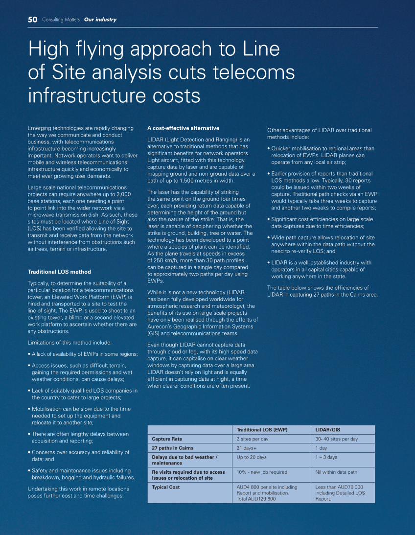
The table below shows the efficiencies of LIDAR in capturing 27 paths in the Cairns area.
Traditional LOS (EWP) LIDAR/GIS
Capture Rate 2 sites per day 30- 40 sites per day
27 paths in Cairns 21 days+ 1 day
Delays due to bad weather / maintenance
Up to 20 days 1 – 3 days
Re visits required due to access issues or relocation of site
10% - new job required Nil within data path
Typical Cost AUD4 800 per site including Report and mobilisation.Total AUD129 600
Less than AUD70 000 including Detailed LOS Report.

Consulting Matters 51Our industry
Creating meaningful outputs using GIS
The outcome of a flight is a file consisting of billions of points of data which can then be imported in to ArcGIS system and used to build Detailed Elevated Models (DEMs).
Algorithms are incorporated to depict Fresnel Zone (FZ), the area around the proposed microwave path that must be clear of obstruction to allow property connectivity. Individual trees, including the identification of species, can be picked up from LIDAR data and mapped or monitored for FZ intrusion.
The data can be overlaid on other GIS layers including cadastre, land-use and height zones. This allows the modelling of the path against future obstructions including development to approved height zones and projected tree growth by species.
The GIS-centred approach also facilitates integration between transmission and radio frequency coverage planning processes. Viewshed and inter-visibility analysis on regional detailed elevation models allows rapid identification of alternative candidate sites and fatal flaws based on land-use, tenure, accessibility, and so on.
Looking ahead
The adoption of this technology is providing real time and cost benefits over traditional LOS techniques. While work for LOS checks via EWPs still remains the most cost efficient method for projects requiring few paths, LIDAR’s effectiveness and accuracy will ensure that its role in the telecommunications market will expand as strict budget and time deadlines apply. LIDAR is also utilised to capture accurate topographical and vegetation information for new road, rail and pipeline projects.
Wayne SanderAurecon