high-resolution data of the iceland basin geomagnetic excursion
TRANSCRIPT
etters 251 (2006) 18–32www.elsevier.com/locate/epsl
Earth and Planetary Science L
High-resolution data of the Iceland Basin geomagnetic excursionfrom ODP sites 1063 and 983: Existence of intense flux
patches during the excursion?
Mads Faurschou Knudsen ⁎, Conall Mac Niocaill, Gideon M. Henderson
Department of Earth Sciences, University of Oxford, Parks Road, Oxford, OX1 3PR, United Kingdom
Received 7 April 2006; received in revised form 11 August 2006; accepted 17 August 2006
Available onli ne 2 October 2006Editor: H. Elderfield
Abstract
Based on discrete samples, we report new high-resolution records of the ∼ 185 kyr Iceland Basin (IB) geomagnetic excursionfrom Ocean Drilling Project (ODP) Site 1063 on the Bermuda Rise (sedimentation rate 32 cm kyr−1) and from ODP Site 983 in thefar North Atlantic (sedimentation rate 18 cm kyr−1). Two records from Holes 1063A and 1063B are very consistent, and providethe highest resolution of the detailed field behaviour during the IB excursion obtained so far. Inclination records from Holes 983Band 983C in the far North Atlantic are also very consistent, whereas declination anomalies deviate more notably. The pseudo-Thellier (PT) technique was applied along with more conventional palaeointensity proxies (NRM/ARM and NRM/κ) to recoverrelative palaeointensity (RPI) estimates from Hole 1063A and Hole 983B. As expected, these proxies indicate that the fieldintensity generally dropped at both sites during the IB excursion, but also that the history of RPI from the two sites is different.
VGPs from Site 1063 indicate that the field at this location experienced some stop-and-go behaviour between patches of intensevertical flux over North America and the tip of South America, areas which coincide fairly well with patches of preferredtransitional VGP clustering from reversals and zones of high seismic velocity in the lower mantle. Changes in RPI at this locationwere generally gradual, possibly due to the proximity of these flux patches, and the first period of VGP-clustering over NorthAmerica was accompanied by a conspicuous increase in RPI. VGPs from Site 983 track along a different path, and the associatedRPI changes are very abrupt and completely synchronous with the onset and termination of the excursion. The differing VGP pathsfrom Sites 1063 and 983 indicate that the global field structure during the IB excursion was not dominated by a single dipole.© 2006 Elsevier B.V. All rights reserved.
Keywords: Geomagnetic excursions; Iceland Basin excursion; Preferred VGP longitudes; Patches of vertical flux; Geomagnetic field structure
1. Introduction
Compilations of palaeomagnetic records have estab-lished that geomagnetic excursions (defined as periods
⁎ Corresponding author. Tel.: +44 0 1865 282 117; fax: +44 0 1865272 072.
E-mail address: [email protected] (M.F. Knudsen).
0012-821X/$ - see front matter © 2006 Elsevier B.V. All rights reserved.doi:10.1016/j.epsl.2006.08.016
when the virtual geomagnetic poles (VGPs) deviatemore than 45° from the geographic poles) are anintrinsic part of Earth's magnetic field behaviour. Up to12 such excursions have been proposed for the intervalsince the last full geomagnetic reversal 780,000 yrs ago[1]. The duration of such geomagnetic excursions is notwell-defined, but estimates of Brunhes-aged excursionsrange from 1000 to 3000 yrs [2,3] to as long as
19M.F. Knudsen et al. / Earth and Planetary Science Letters 251 (2006) 18–32
10,000 yrs [4]. Constraining the duration of these eventsis important because it has been suggested that excur-sions arise when the field reverses polarity in the liquidouter core, and subsequently returns to the originalpolarity state before the field reversal propagates to thesolid inner core [5]. Field changes in the outer core aredominated by convection with timescales of ∼ 500 yrs,whereas field changes in the inner core are dictated bydiffusion with a timescale of ∼ 3000 yrs [6].
Geomagnetic excursions and full polarity reversalshave recently been the focus of increasing attention,since they play a key role in the study of the funda-mental processes controlling field generation in Earth'sinterior (e.g. [5,7–10]). Despite increasing efforts,which include integration of palaeomagnetic observa-tions and numerical simulations (e.g. [11,12]), questionsregarding the fundamental character of geomagnetic
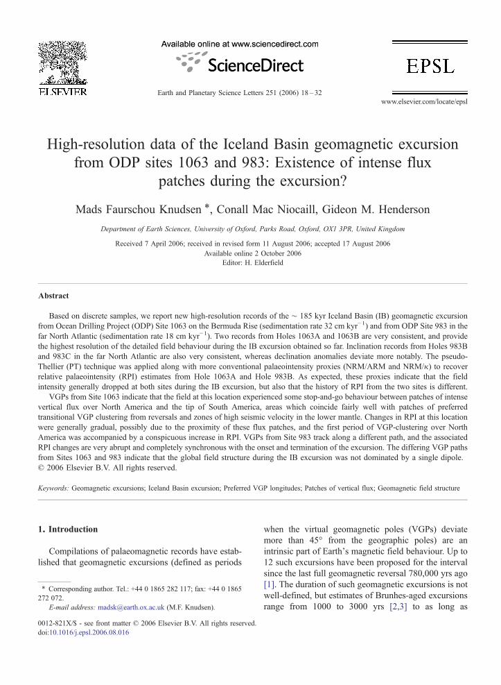
Fig. 1. Location of ODP Site 1063 (33.7°N, 57.6
excursions still remain unanswered. For example, it isstill unknown whether the field structure during ex-cursions is predominantly dipolar or non-dipolar. Onehindrance in this pursuit is the scarcity of reliable, high-resolution records of geomagnetic excursions. Theresolution and fidelity of the records are often in-sufficient to resolve the detailed field behaviour duringthe excursions. Other problems relate to difficulties incorrelating records from different regions, not tomention records from the same area, and to the factthat many excursions are missing in most sedimentrecords. Generally, a relatively high sedimentation rate(preferably above 10 cm kyr−1) is required to faithfullycapture the rapidly changing field during an excursion[13], and sedimentary environments often fail to docu-ment excursions due to smoothing of the magneticsignal. Lavas provide a more reliable record of the
°W) and ODP Site 983 (60.4°N, 23.6°W).
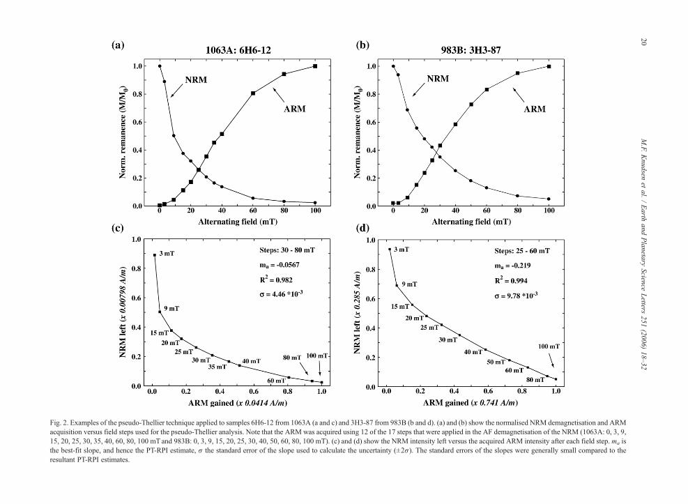
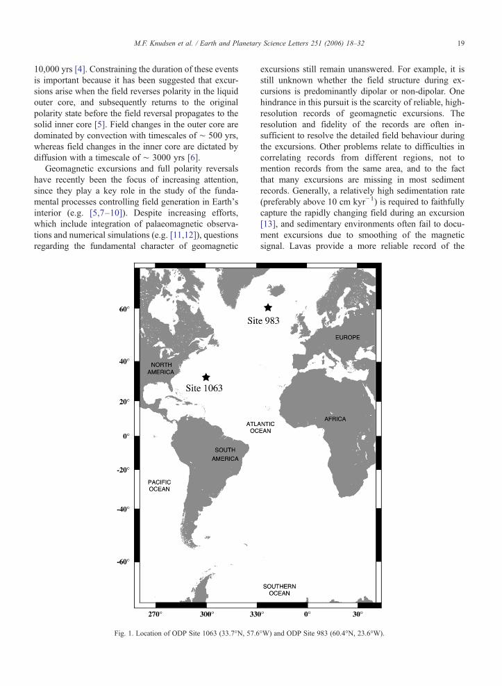
Fig. 2. Examples of the pseudo-Thellier technique applied to samples 6H6-12 from 1063A (a and c) and 3H3-87 from 983B (b and d). (a) and (b) show the normalised NRM demagnetisation and ARMacquisition versus field steps used for the pseudo-Thellier analysis. Note that the ARM was acquired using 12 of the 17 steps that were applied in the AF demagnetisation of the NRM (1063A: 0, 3, 9,15, 20, 25, 30, 35, 40, 60, 80, 100 mT and 983B: 0, 3, 9, 15, 20, 25, 30, 40, 50, 60, 80, 100 mT). (c) and (d) show the NRM intensity left versus the acquired ARM intensity after each field step. ma isthe best-fit slope, and hence the PT-RPI estimate, σ the standard error of the slope used to calculate the uncertainty (±2σ). The standard errors of the slopes were generally small compared to theresultant PT-RPI estimates.
20M.F.
Knudsen
etal.
/Earth
andPlanetary
ScienceLetters
251(2006)
18–32
21M.F. Knudsen et al. / Earth and Planetary Science Letters 251 (2006) 18–32
magnetic field than sediments, but the temporal reso-lution is discontinuous and often very sparse.
The Iceland Basin (IB) excursion was named after ageomagnetic excursion observed in U-channel data fromODPSite 983 in theNorth Atlantic, and it was constrained
Fig. 3. Typical examples of vector endpoint diagrams. Solid (open) symbols reDiagrams from Hole 1063A, (d–f) from Hole 1063B, (g–j) from Hole 983Bwithin the excursion intervals.
to the interval 186–189 kyr by δ18O tuning [14,15].Despite being one of the best documented excursions inthe literature (e.g. [16–20,4,21]), very few high-resolutionrecords of the IB excursion exist. In this study we presentnew high-resolution records of the rapidly changing field
present projection of the vector onto a horizontal (vertical) plane. (a–c), and (k–l) from Hole 983C. Diagrams b, e, h, and l are from samples
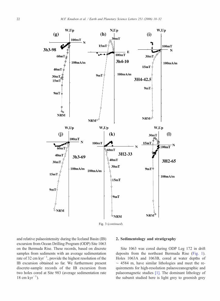
Fig. 3 (continued).
22 M.F. Knudsen et al. / Earth and Planetary Science Letters 251 (2006) 18–32
and relative palaeointensity during the Iceland Basin (IB)excursion from Ocean Drilling Program (ODP) Site 1063on the Bermuda Rise. These records, based on discretesamples from sediments with an average sedimentationrate of 32 cm kyr−1, provide the highest resolution of theIB excursion obtained so far. We furthermore presentdiscrete-sample records of the IB excursion fromtwo holes cored at Site 983 (average sedimentation rate18 cm kyr−1).
2. Sedimentology and stratigraphy
Site 1063 was cored during ODP Leg 172 in driftdeposits from the northeast Bermuda Rise (Fig. 1).Holes 1063A and 1063B, cored at water depths of∼ 4584 m, have similar lithologies and meet the re-quirements for high-resolution palaeoceanographic andpalaeomagnetic studies [1]. The dominant lithology ofthe subunit studied here is light grey to greenish grey
23M.F. Knudsen et al. / Earth and Planetary Science Letters 251 (2006) 18–32
clay with varying proportions of silt and carbonate- andsiliceous-bearing nannofossils. The predominance ofclay at Site 1063 is in accordance with the Bermuda Risebeing shaped by advection of fine-grained, abyssalsediments onto the plateau by deep bottom currents [22].Shipboard long-core and U-channel palaeomagneticdata suggest that up to 11 Brunhes-aged excursions wererecorded at Site 1063, indicating that these sedimentsare reliable recorders of the palaeomagnetic field [1].
Site 983, ODP Leg 162, was located on the GardarDrift south of Iceland (Fig. 1). Holes 983B and 983Cwere cored at water depths of ∼ 1985 m on the easternflank of the Reykjanes Ridge. The sediments at Site 983are predominantly composed of rapidly accumulated,fine-grained terrigenous particles with minor amounts ofcarbonate and biosilica. The high content of volcanic,terrigenous material from Iceland makes these sedi-ments very suitable for palaeomagnetic studies, asdocumented in several earlier publications [14,15,23].
2.1. Chronologies and sedimentation rates
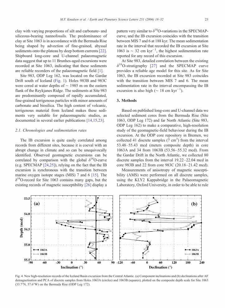
The IB excursion is quite easily correlated amongrecords from different sites, because it is coeval with anabrupt change in climate and so can be unequivocallyidentified. Observed geomagnetic excursions can becorrelated by comparison with the global δ18O-curve(e.g. SPECMAP [24,25]), relying on the fact that the IBexcursion is synchronous with the transition betweenmarine oxygen isotope stages (MIS) 7 and 6 [15]. Theδ18O-record for Site 1063 contains many gaps, but theexisting records of magnetic susceptibility [26] display a
Fig. 4. New high-resolution records of the Iceland Basin excursion from the Cedemagnetisation and PCA of discrete samples from Holes 1063A (circles) an(33.7°N, 57.6°W) on the Bermuda Rise (ODP Leg 172).
pattern very similar to δ18O-variations in the SPECMAP-curve, and the IB excursion coincides with the transitionbetweenMIS 7 and 6 at 188 kyr. The mean sedimentationrate in the interval that recorded the IB excursion at Site1063 is ∼ 32 cm kyr−1, the highest sedimentation ratereported for any record of this excursion.
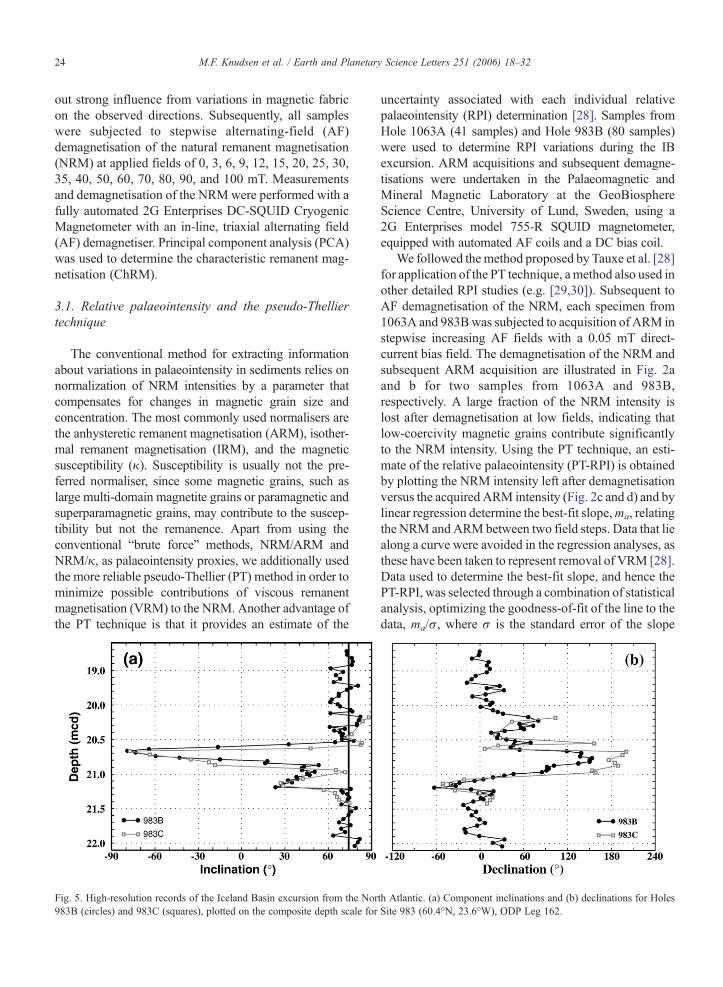
At Site 983, detailed correlation between the existingδ18O-stratigraphy [27] and the SPECMAP curveprovides a reliable age model for this site. As for Site1063, the IB excursion recorded at Site 983 coincideswith the transition between MIS 7 and 6. The meansedimentation rate in the interval encompassing the IBexcursion is also high (∼ 18 cm kyr−1).
3. Methods
Based on published long-core and U-channel data weselected sediment cores from the Bermuda Rise (Site1063, ODP Leg 172) and far North Atlantic (Site 983,ODP Leg 162) to make a comparative, high-resolutionstudy of the geomagnetic-field behaviour during the IBexcursion. At the ODP core repository in Bremen, wecollected 41 discrete samples (7 cm3) from the interval53.48–55.43 mcd (meters composite depth) in core1063A and 34 from 1063B (53.56–55.32 mcd). Fromthe Gardar Drift in the North Atlantic, we collected 80discrete samples from the interval 19.22–22.04 mcd incore 983B and 22 from core 983C (20.18–21.42 mcd).
Measurements of anisotropy of magnetic suscepti-bility (AMS) were performed on all discrete samples,using the KLY2 Kappabridge in the PalaeomagneticLaboratory, Oxford University, in order to be able to rule
ntral Atlantic. (a) Component inclinations and (b) declinations after AFd 1063B (squares), plotted on the composite depth scale for Site 1063
24 M.F. Knudsen et al. / Earth and Planetary Science Letters 251 (2006) 18–32
out strong influence from variations in magnetic fabricon the observed directions. Subsequently, all sampleswere subjected to stepwise alternating-field (AF)demagnetisation of the natural remanent magnetisation(NRM) at applied fields of 0, 3, 6, 9, 12, 15, 20, 25, 30,35, 40, 50, 60, 70, 80, 90, and 100 mT. Measurementsand demagnetisation of the NRMwere performed with afully automated 2G Enterprises DC-SQUID CryogenicMagnetometer with an in-line, triaxial alternating field(AF) demagnetiser. Principal component analysis (PCA)was used to determine the characteristic remanent mag-netisation (ChRM).
3.1. Relative palaeointensity and the pseudo-Thelliertechnique
The conventional method for extracting informationabout variations in palaeointensity in sediments relies onnormalization of NRM intensities by a parameter thatcompensates for changes in magnetic grain size andconcentration. The most commonly used normalisers arethe anhysteretic remanent magnetisation (ARM), isother-mal remanent magnetisation (IRM), and the magneticsusceptibility (κ). Susceptibility is usually not the pre-ferred normaliser, since some magnetic grains, such aslarge multi-domain magnetite grains or paramagnetic andsuperparamagnetic grains, may contribute to the suscep-tibility but not the remanence. Apart from using theconventional “brute force” methods, NRM/ARM andNRM/κ, as palaeointensity proxies, we additionally usedthe more reliable pseudo-Thellier (PT) method in order tominimize possible contributions of viscous remanentmagnetisation (VRM) to the NRM. Another advantage ofthe PT technique is that it provides an estimate of the
Fig. 5. High-resolution records of the Iceland Basin excursion from the Nor983B (circles) and 983C (squares), plotted on the composite depth scale for
uncertainty associated with each individual relativepalaeointensity (RPI) determination [28]. Samples fromHole 1063A (41 samples) and Hole 983B (80 samples)were used to determine RPI variations during the IBexcursion. ARM acquisitions and subsequent demagne-tisations were undertaken in the Palaeomagnetic andMineral Magnetic Laboratory at the GeoBiosphereScience Centre, University of Lund, Sweden, using a2G Enterprises model 755-R SQUID magnetometer,equipped with automated AF coils and a DC bias coil.
We followed the method proposed by Tauxe et al. [28]for application of the PT technique, amethod also used inother detailed RPI studies (e.g. [29,30]). Subsequent toAF demagnetisation of the NRM, each specimen from1063A and 983Bwas subjected to acquisition of ARM instepwise increasing AF fields with a 0.05 mT direct-current bias field. The demagnetisation of the NRM andsubsequent ARM acquisition are illustrated in Fig. 2aand b for two samples from 1063A and 983B,respectively. A large fraction of the NRM intensity islost after demagnetisation at low fields, indicating thatlow-coercivity magnetic grains contribute significantlyto the NRM intensity. Using the PT technique, an esti-mate of the relative palaeointensity (PT-RPI) is obtainedby plotting the NRM intensity left after demagnetisationversus the acquired ARM intensity (Fig. 2c and d) and bylinear regression determine the best-fit slope,ma, relatingthe NRM andARMbetween two field steps. Data that liealong a curve were avoided in the regression analyses, asthese have been taken to represent removal of VRM [28].Data used to determine the best-fit slope, and hence thePT-RPI, was selected through a combination of statisticalanalysis, optimizing the goodness-of-fit of the line to thedata, ma/σ, where σ is the standard error of the slope
th Atlantic. (a) Component inclinations and (b) declinations for HolesSite 983 (60.4°N, 23.6°W), ODP Leg 162.
25M.F. Knudsen et al. / Earth and Planetary Science Letters 251 (2006) 18–32
[28,31], and an attempt to use as large a portion of theNRM as possible without including contributions fromVRM. Based on maximizing ma/σ and including aminimum of 4 data points, data from intervals 30–80 mTand 25–60 mT were found to give the optimal fittingregression line for samples from 1063A and 983B,respectively. The uncertainty associated with eachindividual PT-RPI estimate is given by ±2σ [28].
The ARM acquired at 100 mTAF was demagnetisedin order to compute the conventional NRM/ARMpalaeointensity proxy. For samples from 1063A(983B), values of NRM/ARM were computed afterdemagnetisation at 25 and 30 mT (25 and 40 mT), sincethis proved sufficient to eliminate the steep secondaryoverprint associated with the drilling process (Fig. 3).Finally, the values of NRM25 mT/κ were computed forall samples from 1063A and 983B.
4. Results
The AMSmeasurements reveal that anisotropy of themagnetic fabric is negligible throughout the cores. Or-thogonal projections of progressive AF demagnetisation
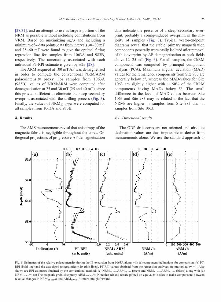
Fig. 6. Estimates of the relative palaeointensity during the IB excursion fromRPI (bold line) and the associated uncertainties ±2σ (thin lines). PT-RPI vashown are RPI estimates obtained by the conventional methods (c) NRM25 m
NRM25 mT/κ. (e) The magnetic grain-size proxy ARM100 mT/κ. Note that (d)relative changes in NRM25 mT/κ and ARM100 mT/κ more straightforward.
data indicate the presence of a steep secondary over-print, probably a coring-induced overprint, in the ma-jority of samples (Fig. 3). Typical vector-endpointdiagrams reveal that the stable, primary magnetisationcomponents generally were easily isolated after removalof this overprint by AF demagnetisation at peak fieldsabove 12–25 mT (Fig. 3). For all samples, the ChRMcomponent was computed by principal componentanalysis (PCA). Maximum angular deviation (MAD)values for the remanence components from Site 983 aregenerally below 5°, whereas the MAD-values for Site1063 are slightly higher with ∼ 50% of the ChRMcomponents having MADs below 5°. The smalldifference in the level of MAD-values between Site1063 and Site 983 may be related to the fact that theNRMs are higher in samples from Site 983 than insamples from Site 1063.
4.1. Directional results
The ODP drill cores are not oriented and absolutedeclination values are thus impossible to derive frommeasurements alone. We use the standard approach to
1063A along with (a) component inclinations for comparison. (b) PT-lues obtained from the regression analyses are multiplied by −1. AlsoT/ARM25 mT (grey) and NRM30 mT/ARM30 mT (black) along with (d)and (e) are plotted on equivalent scales to make comparisons between
26 M.F. Knudsen et al. / Earth and Planetary Science Letters 251 (2006) 18–32
overcome this by reorienting core-segments untildeclinations from samples not included in the excursioninterval average to a declination of 0°.
The inclinations (Fig. 4a) and declinations (Fig. 4b)from Holes 1063A and 1063B on the Bermuda Rise areplotted on the composite depth scale for Site 1063 (seeSupplementary data). The slight misalignment of thecurves from 1063A and 1063B probably arises fromsubtle differences in the depth models for the two holes.Alternatively, but less likely, this misalignment couldarise from local differences in palaeomagnetic lock-indepth, as observed in sediment cores from Salerno Gulf,Italy [32]. While the two inclination curves are verysimilar (Fig. 4a), declinations differ more notably(Fig. 4b). The disagreement between the two declinationrecords is most pronounced during the high-inclinationintervals, especially the lower of the two (54.5–55.0mcd)where misalignment cannot account for the differencesobserved, when declination is expected to become lessreliably determined. Both inclination curves from Site1063 show that the inclination increases to∼ 80° before itrapidly drops to negative values around −30°. After thisnegative trough, the inclination rapidly swings back to
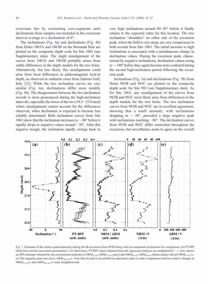
Fig. 7. Estimates of the relative palaeointensity during the IB excursion from 9(bold line) and the associated uncertainties ±2σ (thin lines). PT-RPI values oare RPI estimates obtained by the conventional methods (c) NRM25 mT/ARM25
(e) The magnetic grain-size proxy ARM100 mT/κ. Note that (d) and (e) are plotteNRM25 mT/κ and ARM100 mT/κ more straightforward.
very high inclinations around 80–85° before it finallyreturns to the expected value for this location. The twoinclination “shoulders” on either side of the excursionpeak,where the field is very steep, are very conspicuous inboth records from Site 1063. The initial increase to highinclinations is associated with a simultaneous change indeclination values. During the excursion peak, charac-terised by negative inclinations, declination values swingto∼ 180° before they again becomemore scattered duringthe second high-inclination period following the excur-sion peak.
Inclinations (Fig. 5a) and declinations (Fig. 5b) fromHoles 983B and 983C are plotted on the compositedepth scale for Site 983 (see Supplementary data). Asfor Site 1063, any misalignment of the curves from983B and 983C most likely arise from differences in thedepth models for the two holes. The two inclinationcurves from 983B and 983C are in excellent agreement,showing that a small anomaly, with inclinationsdropping to ∼ 30°, preceded a large negative peakwith inclinations reaching −80°. The declination curvesfrom 983B and 983C differ somewhat throughout theexcursion, but nevertheless seem to agree on the overall
83B along with (a) component inclinations for comparison. (b) PT-RPIbtained from the regression analyses are multiplied by −1. Also shown
mT (grey) and NRM40 mT/ARM40 mT (black) along with (d) NRM25 mT/κ.d on equivalent scales to make comparisons between relative changes in
27M.F. Knudsen et al. / Earth and Planetary Science Letters 251 (2006) 18–32
trends during the excursion. Directions obtained fromdiscrete samples in this study agree very well withdirections derived from earlier U-channel measurementsfrom the same holes [15].
Based on correlation between existing age modelsand the intervals encompassing the directional anoma-lies, the estimated age of the IB excursion is 185–188 kyrat Site 1063 and 186–189 kyr at Site 983. When theinclination shoulders from Site 1063 are included in theinterval encompassing the excursion (which is correct asthe VGP latitudes generally are below 45°) the estimatedduration of IB excursion is∼ 3 kyr, which is very similarto the duration estimated from Site 983.
4.2. Relative palaeointensity estimates
PT-RPI estimates from 1063A are shown in Fig. 6balong with the associated uncertainty (±2σ), whereasthe conventional palaeointensity proxies, NRM/ARM(NRM25 mT/ARM25 mT and NRM30 mT/ARM30 mT) andNRM25 mT/κ, are shown in Fig. 6c and d. It is reassuringthat the three different palaeointensity proxies produce
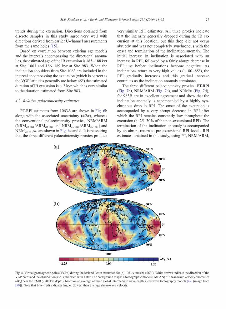
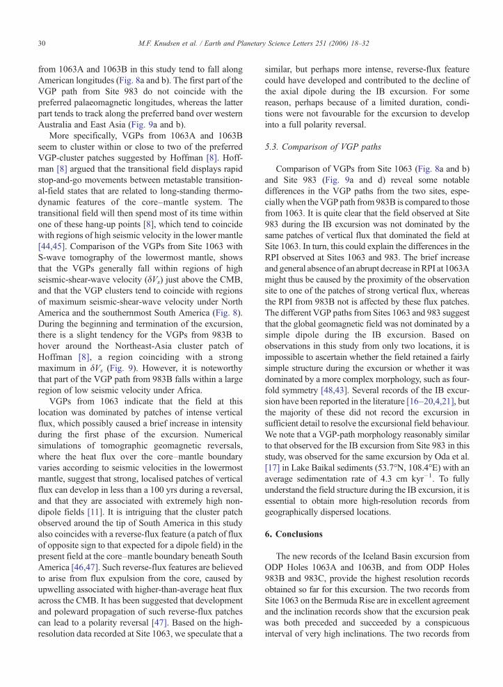
Fig. 8. Virtual geomagnetic poles (VGPs) during the Iceland Basin excursionVGP paths and the observation site is indicated with a star. The background m(δVs) near the CMB (2800 km depth), based on an average of three global inte[50]). Note that blue (red) indicates higher (lower) than average shear-wave
very similar RPI estimates. All three proxies indicatethat the intensity generally dropped during the IB ex-cursion at this location, but this drop did not occurabruptly and was not completely synchronous with theonset and termination of the inclination anomaly. Theinitial increase in inclination is associated with anincrease in RPI, followed by a fairly abrupt decrease inRPI just before inclinations become negative. Asinclinations return to very high values (∼ 80–85°), theRPI gradually increases and this gradual increasecontinues as the inclination anomaly terminates.
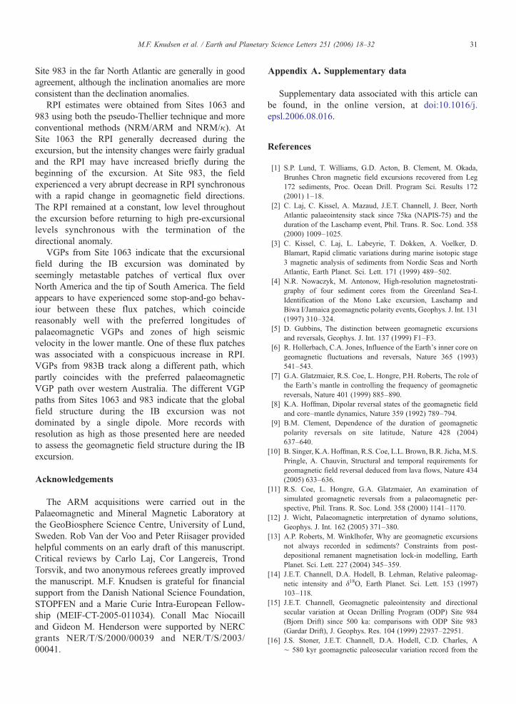
The three different palaeointensity proxies, PT-RPI(Fig. 7b), NRM/ARM (Fig. 7c), and NRM/κ (Fig. 7d),for 983B are in excellent agreement and show that theinclination anomaly is accompanied by a highly syn-chronous drop in RPI. The onset of the excursion isaccompanied by a very abrupt decrease in RPI afterwhich the RPI remains constantly low throughout theexcursion (∼ 25–30% of the non-excursional RPI). Thetermination of the inclination anomaly is accompaniedby an abrupt return to pre-excursional RPI levels. RPIestimates obtained in this study, using PT, NRM/ARM,
for (a) 1063A and (b) 1063B. White arrows indicate the direction of theap is a tomographic model (SMEAN) of shear-wave velocity anomaliesrmediate wavelength shear-wave tomography models [49] (image fromvelocity.
28 M.F. Knudsen et al. / Earth and Planetary Science Letters 251 (2006) 18–32
and NRM/κ as palaeointensity proxies, are in accordwith the RPI estimates obtained by Channell [15], whoreport mean NRM/IRM from U-channels from 983Band 983C.
In both sections 1063A and 983B, we find that RPIestimates obtained using the “brute force” NRM/ARM-method are higher than those obtained with the PTtechnique. Tauxe et al. [28] observed the same offset andinterpreted this as a result of a pervasive VRM biassingthe brute force estimates systematically. However, con-trary to the observations of Tauxe et al. [28], we find thatthe degree of offset between the two methods is fairlyconstant, implying that the NRM/ARM and PT methodsprovide similar RPI estimates. Other studies indicate asimilar agreement between brute force methods and thePT method [29,30], but generally this may not be thecase if large variations in the coercivity spectra arepresent within the studied section.
Despite application of different palaeointensity prox-ies, several studies indicate that it may be difficult to
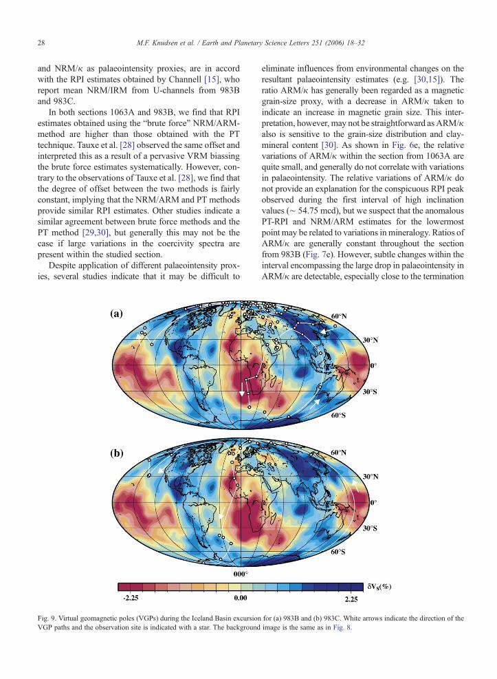
Fig. 9. Virtual geomagnetic poles (VGPs) during the Iceland Basin excursionVGP paths and the observation site is indicated with a star. The background
eliminate influences from environmental changes on theresultant palaeointensity estimates (e.g. [30,15]). Theratio ARM/κ has generally been regarded as a magneticgrain-size proxy, with a decrease in ARM/κ taken toindicate an increase in magnetic grain size. This inter-pretation, however, may not be straightforward asARM/κalso is sensitive to the grain-size distribution and clay-mineral content [30]. As shown in Fig. 6e, the relativevariations of ARM/κ within the section from 1063A arequite small, and generally do not correlate with variationsin palaeointensity. The relative variations of ARM/κ donot provide an explanation for the conspicuous RPI peakobserved during the first interval of high inclinationvalues (∼ 54.75 mcd), but we suspect that the anomalousPT-RPI and NRM/ARM estimates for the lowermostpoint may be related to variations in mineralogy. Ratios ofARM/κ are generally constant throughout the sectionfrom 983B (Fig. 7e). However, subtle changes within theinterval encompassing the large drop in palaeointensity inARM/κ are detectable, especially close to the termination
for (a) 983B and (b) 983C. White arrows indicate the direction of theimage is the same as in Fig. 8.
29M.F. Knudsen et al. / Earth and Planetary Science Letters 251 (2006) 18–32
of the excursion. Given that the small shift in ARM/κfrom pre-excursional levels (∼ 300 A/m) to post-excursional levels (∼ 400 A/m), similar to the changesobserved during the excursion, do not appear tosystematically influence the RPI estimates, it seemsunlikely that mineralogical changes caused the observeddrop in RPI. This is supported by the very high degree ofsynchronicity between both the onset and termination ofthe directional anomaly, recorded in both 983B and 983C,and the observed drop in palaeointensity.
5. Discussion
High-resolution records of geomagnetic excursions,such as those from ODP Sites 1063 and 983, renderinvestigations into the behaviour and structure of theexcursional field possible. The two new records fromSite 1063 present an ideal opportunity to study thebehaviour of the geomagnetic field during the IB excur-sion, because the excursional field is recorded at higherresolution than in any previous record and becauseinclination and declination data from the two cores arevery consistent.
5.1. VGPs from sites 1063 and 983
The VGP paths from Holes 1063A and 1063B(Fig. 8a and b) are in excellent agreement. During thefirst phase of the IB excursion, VGPs from 1063A and1063B tend to cluster around the eastern part of NorthAmerica and the North Atlantic. During this phase ofintense downwardly directed field in the Bermuda Risearea, which lasted for∼ 1000 yrs, the VGPs plot close tothe observation site. Interestingly, all three palaeointen-sity proxies indicate an increase in RPI during this initialphase. Somewhat similarly, the field intensity before orjust after completion of a reversal has been observed totemporarily overshoot the normal value for full polarityby up to 50% [33–35]. The first phase is followed by aperiod of very rapid field changes after which the VGPsare found to cluster around the southern tip of SouthAmerica. Prior to this apparent jump in VGP position,the RPI decreases to a minimum before increasingslightly during the period where the VGPs linger aroundthe tip of South America. This clustering of VGPs in thesouthern hemisphere is followed by another period ofvery rapid field change during which the VGPs return tothe area around the eastern part of North America (notethat the interval between samples, during which theperiods of rapid field change take place, is as small as1.5 cm). Here they remain for ∼ 1000 yrs before finallyreturning to higher latitudes as the excursion ends. The
second period of rapid field change coincides with an-other minimum in RPI, which from this point increasesgradually towards and beyond the termination of theexcursion.
VGP paths from Holes 983B and 983C (Fig. 9a andb) do not agree as well as the VGP paths from Site 1063,mainly because of differences in declination during theexcursion. However, both VGP paths seem to agree onthe overall trend during the excursion. The first part ofthe IB excursion is defined by an abrupt change fromnormal field directions to VGPs plotting off the Califor-nian coast in the eastern Pacific. Subsequently, theVGPs from 983B cross the Pacific, continue throughAsia and Africa to complete a very well-defined coun-terclockwise loop around the rim of the Indian ocean,before returning through Asia to high latitudes as theexcursion ends. The VGP path for 983C is much lesswell-defined than the path for 983B. Subsequent to theinitiation of the excursion, defined by VGPs plotting inthe eastern Pacific, the VGPs from 983C track down theAtlantic and western part of Africa to the South Atlantic,where they briefly seem to cluster, before returningabruptly to high northern latitudes via Northeast Asia.The VGP paths observed in this study are generally verysimilar to the VGP paths observed in the U-channelrecords by Channell [15]. The initiation of the excursionis accompanied by a synchronous and very abrupt dropin RPI, which remains at a constant, low level through-out the excursion before abruptly returning to pre-excursional levels as the VGPs return to high northernlatitudes. It is noteworthy that the return to pre-ex-cursional RPI levels is less abrupt than the dropobserved at the onset of the excursion.
5.2. Existence of intense patches of vertical flux
It has been suggested that transitional VGPs asso-ciated with polarity reversals preferentially lie withintwo nearly antipodal bands, one passing through theAmericas and the other through western Australia andeastern Asia [36,37]. This suggestion was contested inseveral subsequent studies [38–40], but detailed statis-tical analyses later indicated that intermediate VGPsfrom reversals, and possibly also excursions, tend to fallalong American and Austral-Asian longitudes, roughlyconsistent with the original observations from sedimentrecords [41,42]. This issue, which remains a subject ofstrong debate within the palaeomagnetic community, isimportant since presence of persistent non-axisymmetriccomponents in transitional fields would imply that thecore and mantle are dynamically coupled [41,43]. It istherefore noteworthy that most of the excursional VGPs
30 M.F. Knudsen et al. / Earth and Planetary Science Letters 251 (2006) 18–32
from 1063A and 1063B in this study tend to fall alongAmerican longitudes (Fig. 8a and b). The first part of theVGP path from Site 983 do not coincide with thepreferred palaeomagnetic longitudes, whereas the latterpart tends to track along the preferred band over westernAustralia and East Asia (Fig. 9a and b).
More specifically, VGPs from 1063A and 1063Bseem to cluster within or close to two of the preferredVGP-cluster patches suggested by Hoffman [8]. Hoff-man [8] argued that the transitional field displays rapidstop-and-go movements between metastable transition-al-field states that are related to long-standing thermo-dynamic features of the core–mantle system. Thetransitional field will then spend most of its time withinone of these hang-up points [8], which tend to coincidewith regions of high seismic velocity in the lower mantle[44,45]. Comparison of the VGPs from Site 1063 withS-wave tomography of the lowermost mantle, showsthat the VGPs generally fall within regions of highseismic-shear-wave velocity (δVs) just above the CMB,and that the VGP clusters tend to coincide with regionsof maximum seismic-shear-wave velocity under NorthAmerica and the southernmost South America (Fig. 8).During the beginning and termination of the excursion,there is a slight tendency for the VGPs from 983B tohover around the Northeast-Asia cluster patch ofHoffman [8], a region coinciding with a strongmaximum in δVs (Fig. 9). However, it is noteworthythat part of the VGP path from 983B falls within a largeregion of low seismic velocity under Africa.
VGPs from 1063 indicate that the field at thislocation was dominated by patches of intense verticalflux, which possibly caused a brief increase in intensityduring the first phase of the excursion. Numericalsimulations of tomographic geomagnetic reversals,where the heat flux over the core–mantle boundaryvaries according to seismic velocities in the lowermostmantle, suggest that strong, localised patches of verticalflux can develop in less than a 100 yrs during a reversal,and that they are associated with extremely high non-dipole fields [11]. It is intriguing that the cluster patchobserved around the tip of South America in this studyalso coincides with a reverse-flux feature (a patch of fluxof opposite sign to that expected for a dipole field) in thepresent field at the core–mantle boundary beneath SouthAmerica [46,47]. Such reverse-flux features are believedto arise from flux expulsion from the core, caused byupwelling associated with higher-than-average heat fluxacross the CMB. It has been suggested that developmentand poleward propagation of such reverse-flux patchescan lead to a polarity reversal [47]. Based on the high-resolution data recorded at Site 1063, we speculate that a
similar, but perhaps more intense, reverse-flux featurecould have developed and contributed to the decline ofthe axial dipole during the IB excursion. For somereason, perhaps because of a limited duration, condi-tions were not favourable for the excursion to developinto a full polarity reversal.
5.3. Comparison of VGP paths
Comparison of VGPs from Site 1063 (Fig. 8a and b)and Site 983 (Fig. 9a and d) reveal some notabledifferences in the VGP paths from the two sites, espe-cially when theVGP path from 983B is compared to thosefrom 1063. It is quite clear that the field observed at Site983 during the IB excursion was not dominated by thesame patches of vertical flux that dominated the field atSite 1063. In turn, this could explain the differences in theRPI observed at Sites 1063 and 983. The brief increaseand general absence of an abrupt decrease inRPI at 1063Amight thus be caused by the proximity of the observationsite to one of the patches of strong vertical flux, whereasthe RPI from 983B not is affected by these flux patches.The different VGP paths from Sites 1063 and 983 suggestthat the global geomagnetic field was not dominated by asimple dipole during the IB excursion. Based onobservations in this study from only two locations, it isimpossible to ascertain whether the field retained a fairlysimple structure during the excursion or whether it wasdominated by a more complex morphology, such as four-fold symmetry [48,43]. Several records of the IB excur-sion have been reported in the literature [16–20,4,21], butthe majority of these did not record the excursion insufficient detail to resolve the excursional field behaviour.We note that a VGP-path morphology reasonably similarto that observed for the IB excursion from Site 983 in thisstudy, was observed for the same excursion by Oda et al.[17] in Lake Baikal sediments (53.7°N, 108.4°E) with anaverage sedimentation rate of 4.3 cm kyr−1. To fullyunderstand the field structure during the IB excursion, it isessential to obtain more high-resolution records fromgeographically dispersed locations.
6. Conclusions
The new records of the Iceland Basin excursion fromODP Holes 1063A and 1063B, and from ODP Holes983B and 983C, provide the highest resolution recordsobtained so far for this excursion. The two records fromSite 1063 on the Bermuda Rise are in excellent agreementand the inclination records show that the excursion peakwas both preceded and succeeded by a conspicuousinterval of very high inclinations. The two records from
31M.F. Knudsen et al. / Earth and Planetary Science Letters 251 (2006) 18–32
Site 983 in the far North Atlantic are generally in goodagreement, although the inclination anomalies are moreconsistent than the declination anomalies.
RPI estimates were obtained from Sites 1063 and983 using both the pseudo-Thellier technique and moreconventional methods (NRM/ARM and NRM/κ). AtSite 1063 the RPI generally decreased during theexcursion, but the intensity changes were fairly gradualand the RPI may have increased briefly during thebeginning of the excursion. At Site 983, the fieldexperienced a very abrupt decrease in RPI synchronouswith a rapid change in geomagnetic field directions.The RPI remained at a constant, low level throughoutthe excursion before returning to high pre-excursionallevels synchronous with the termination of thedirectional anomaly.
VGPs from Site 1063 indicate that the excursionalfield during the IB excursion was dominated byseemingly metastable patches of vertical flux overNorth America and the tip of South America. The fieldappears to have experienced some stop-and-go behav-iour between these flux patches, which coincidereasonably well with the preferred longitudes ofpalaeomagnetic VGPs and zones of high seismicvelocity in the lower mantle. One of these flux patcheswas associated with a conspicuous increase in RPI.VGPs from 983B track along a different path, whichpartly coincides with the preferred palaeomagneticVGP path over western Australia. The different VGPpaths from Sites 1063 and 983 indicate that the globalfield structure during the IB excursion was notdominated by a single dipole. More records withresolution as high as those presented here are neededto assess the geomagnetic field structure during the IBexcursion.
Acknowledgements
The ARM acquisitions were carried out in thePalaeomagnetic and Mineral Magnetic Laboratory atthe GeoBiosphere Science Centre, University of Lund,Sweden. Rob Van der Voo and Peter Riisager providedhelpful comments on an early draft of this manuscript.Critical reviews by Carlo Laj, Cor Langereis, TrondTorsvik, and two anonymous referees greatly improvedthe manuscript. M.F. Knudsen is grateful for financialsupport from the Danish National Science Foundation,STOPFEN and a Marie Curie Intra-European Fellow-ship (MEIF-CT-2005-011034). Conall Mac Niocailland Gideon M. Henderson were supported by NERCgrants NER/T/S/2000/00039 and NER/T/S/2003/00041.
Appendix A. Supplementary data
Supplementary data associated with this article canbe found, in the online version, at doi:10.1016/j.epsl.2006.08.016.
References
[1] S.P. Lund, T. Williams, G.D. Acton, B. Clement, M. Okada,Brunhes Chron magnetic field excursions recovered from Leg172 sediments, Proc. Ocean Drill. Program Sci. Results 172(2001) 1–18.
[2] C. Laj, C. Kissel, A. Mazaud, J.E.T. Channell, J. Beer, NorthAtlantic palaeointensity stack since 75ka (NAPIS-75) and theduration of the Laschamp event, Phil. Trans. R. Soc. Lond. 358(2000) 1009–1025.
[3] C. Kissel, C. Laj, L. Labeyrie, T. Dokken, A. Voelker, D.Blamart, Rapid climatic variations during marine isotopic stage3 magnetic analysis of sediments from Nordic Seas and NorthAtlantic, Earth Planet. Sci. Lett. 171 (1999) 489–502.
[4] N.R. Nowaczyk, M. Antonow, High-resolution magnetostrati-graphy of four sediment cores from the Greenland Sea-I.Identification of the Mono Lake excursion, Laschamp andBiwa I/Jamaica geomagnetic polarity events, Geophys. J. Int. 131(1997) 310–324.
[5] D. Gubbins, The distinction between geomagnetic excursionsand reversals, Geophys. J. Int. 137 (1999) F1–F3.
[6] R. Hollerbach, C.A. Jones, Influence of the Earth's inner core ongeomagnetic fluctuations and reversals, Nature 365 (1993)541–543.
[7] G.A. Glatzmaier, R.S. Coe, L. Hongre, P.H. Roberts, The role ofthe Earth's mantle in controlling the frequency of geomagneticreversals, Nature 401 (1999) 885–890.
[8] K.A. Hoffman, Dipolar reversal states of the geomagnetic fieldand core–mantle dynamics, Nature 359 (1992) 789–794.
[9] B.M. Clement, Dependence of the duration of geomagneticpolarity reversals on site latitude, Nature 428 (2004)637–640.
[10] B. Singer, K.A. Hoffman, R.S. Coe, L.L. Brown, B.R. Jicha, M.S.Pringle, A. Chauvin, Structural and temporal requirements forgeomagnetic field reversal deduced from lava flows, Nature 434(2005) 633–636.
[11] R.S. Coe, L. Hongre, G.A. Glatzmaier, An examination ofsimulated geomagnetic reversals from a palaeomagnetic per-spective, Phil. Trans. R. Soc. Lond. 358 (2000) 1141–1170.
[12] J. Wicht, Palaeomagnetic interpretation of dynamo solutions,Geophys. J. Int. 162 (2005) 371–380.
[13] A.P. Roberts, M. Winklhofer, Why are geomagnetic excursionsnot always recorded in sediments? Constraints from post-depositional remanent magnetisation lock-in modelling, EarthPlanet. Sci. Lett. 227 (2004) 345–359.
[14] J.E.T. Channell, D.A. Hodell, B. Lehman, Relative paleomag-netic intensity and δ18O, Earth Planet. Sci. Lett. 153 (1997)103–118.
[15] J.E.T. Channell, Geomagnetic paleointensity and directionalsecular variation at Ocean Drilling Program (ODP) Site 984(Bjorn Drift) since 500 ka: comparisons with ODP Site 983(Gardar Drift), J. Geophys. Res. 104 (1999) 22937–22951.
[16] J.S. Stoner, J.E.T. Channell, D.A. Hodell, C.D. Charles, A∼ 580 kyr geomagnetic paleosecular variation record from the
32 M.F. Knudsen et al. / Earth and Planetary Science Letters 251 (2006) 18–32
sub-Antarctic South Atlantic (Ocean Drilling Program Site 1089),J. Geophys. Res. 108 (B5) (2003) doi:10.1029/2001JB001390.
[17] H. Oda, K. Nakamura, K. Ikehara, T. Nakano, M. Nishimura, O.Khlystov, Paleomagnetic record from Academician Ridge, LakeBaikal: a reversal excursion at the base of marine oxygen isotopestage 6, Earth Planet. Sci. Lett. 202 (2002) 117–132.
[18] A.P. Roberts, B. Lehmann, R.J. Weeks, K.L. Verosub, C. Laj,Relative paleointensity of the geomagnetic field over the last200,000 years from ODP Sites 883 and 884, North Pacific Ocean,Earth Planet. Sci. Lett. 152 (1997) 11–23.
[19] B. Lehmann, C. Laj, C. Kissel, A. Mazaud, M. Paterne, L.Labeyrie, Relative changes of the geomagnetic field intensityduring the last 280 kyear from piston cores in the Açores area,Phys. Earth Planet. Inter. 93 (1996) 269–284.
[20] R.J. Weeks, C. Laj, L. Endignoux, A. Mazaud, L. Labeyrie, A.P.Roberts, C. Kissel, E. Blanchard, Normalised natural remanentmagnetisation intensity during the last 240000 years in pistoncores from the central North Atlantic Ocean: geomagnetic fieldintensity or environmental signal? Phys. Earth Planet. Inter. 87(1995) 213–229.
[21] T. Yamazaki, N. Ioka, Long-term secular variation of thegeomagnetic field during the last 200 kyr recorded in sedimentcores from the western equatorial pacific, Earth Planet. Sci. Lett.128 (1994) 527–544.
[22] E.P. Laine, W.D. Gardner, M.J. Richardson, M.A. Kominz,Abyssal currents and advection of resuspended sediment alongthe northeastern Bermuda Rise, Mar. Geol. 119 (1994) 159–171.
[23] J.E.T. Channell, A. Mazaud, P. Sullivan, S. Turner, M.E. Raymo,Geomagnetic excursions and paleointensities in the MatuyamaChron at Ocean Drilling Program Sites 983 and 984 (IcelandBasin), J. Geophys. Res. 107 (2002) EPM1–EPM11.
[24] J. Imbrie, J.D. Hays, D.G. Martinson, A. McIntyre, A.C. Mix, J.J.Morley, W.L. Prell, N.G. Pisias, N.J. Shackleton, in: A.L. Berger,et al., (Eds.), Milankovitch and Climate, Part I, Reidel, TheNetherlands, 1984, pp. 269–305.
[25] D.G. Martinson, N.G. Pisias, J.D. Hays, J. Imbrie, T.C. Moore Jr.,N.J. Shacketon, Age dating and the orbital theory of the ice ages:development of a high-resolution 0 to 300,000-year chronos-tratigraphy, Q. Res. 27 (1987) 1–29.
[26] Shipboard Scientific Party (Site 1063), Proc. Ocean DrillingProgram, Initial Rep. 172 (1998) 251–308.
[27] Shipboard Scientific Party (Site 983), Proc. Ocean DrillingProgram, Scientific Results 162 (1999) CD-ROM.
[28] L. Tauxe, T. Pick, Y.S. Kok, Relative paleointensity in sediments:a pseudo-Thellier approach, Geophys. Res. Lett. 22 (1995)2885–2888.
[29] I. Snowball, P. Sandgren, Geomagnetic field intensity changes inSweden between 9000 and 450 cal BP: extending the record of“archaeomagnetic jerks” by means of lake sediments and thepseudo-Thellier technique, Earth Planet. Sci. Lett. 227 (2004)361–376.
[30] P.P. Kruiver, Y.S. Kok, M.J. Dekkers, C.G. Langereis, C. Laj, Apseudo-Thellier relative palaeointensity record, and rock mag-netic and geochemical parameters in relation to climate duringthe last 276 kyr in the Azores region, Geophys. J. Int. 136 (1999)757–770.
[31] R.S. Coe, S. Grommé, E.A. Mankinen, Geomagnetic paleoin-tensities from radiocarbon-dated lava floes on Hawaii and the
question of the Pacific nondipole low, J. Geophys. Res. 83 (1978)1740–1756.
[32] L. Sagnotti, F. Budillon, J. Dinares-Turell, M. Iorio, P. Macri,Evidence for a variable paleomagnetic lock-in depth in theHolocene sequence from the Salerno Gulf (Italy): Implicationsfor “high-resolution” paleomagnetic dating, Geochem. Geophys.Geosyst. 3 (2005) doi:10.1029/2005GC001043.
[33] M. Prévot, E.A. Mankinen, C.S. Coe, R.S. Grommé, How thegeomagnetic field vector reverses polarity, Nature 316 (1985)230.
[34] M. Prévot, E. Mankinen, C. Coe, R.S. Grommé, The SteensMountain (Oregon) geomagnetic polarity transition. 2. Fieldintensity and discussion of reversal models, J. Geophys. Res. 90(1985) 10417–10448.
[35] S.W. Bogue, R.T. Merrill, The character of the field duringreversals, Annu. Rev. Earth Planet. Sci. 20 (1992) 181–219.
[36] B.M. Clement, Geographical distribution of transitional VGP's:evidence for nonzonal equatorial symmetry during theMatuyama–Brunhes geomagnetic reversal, Earth Planet. Sci.Lett. 104 (1991) 48–58.
[37] C. Laj, A. Mazaud, R. Weeks, M. Fuller, E. Herrero-Bervera,Geomagnetic reversal paths, Nature 351 (1991) 447.
[38] G.D. Egbert, Sampling bias in VGP longitudes, Geophys. Res.Lett. 19 (1992) 2353–2356.
[39] J.-P. Valet, P. Tucholka, V. Courtillot, L. Meynadier, Paleomag-netic constraints on the geometry of the geomagnetic field duringreversals, Nature 356 (1992) 400–407.
[40] C.G. Langereis, A.A.M. van Hoof, P. Rochette, Longitudinalconfinement of geomagnetic reversal paths as a possiblesedimentary artefact, Nature 358 (1992) 226–230.
[41] J.J. Love, Paleomagnetic volcanic data and geometric regularityof reversals and excursions, J. Geophys. Res. 103 (B6) (1998)12435–12452.
[42] J.J. Love, Statistical assessment of preferred transitional VGPlongitudes based on palaeomagnetic lava data, Geophys. J. Int.140 (1) (2000) 211–221.
[43] D. Gubbins, J.J. Love, Preferred VGP paths during geomagneticpolarity reversals: symmetry considerations, Geophys. Res. Lett.25 (1998) 1079–1082.
[44] A.M. Dziewonski, J. Woodhouse, Global images of the Earth'sinterior, Science 236 (1987) 37–48.
[45] B. Romanowicz, 3D structure of the Earth's lower mantle, C.R.Geosci. 335 (2003) 23–35.
[46] J. Bloxham, D. Gubbins, The secular variation of the Earth'smagnetic field, Nature 317 (1985) 777–781.
[47] D. Gubbins, Mechanism for geomagnetic polarity reversals,Nature 326 (1987) 167–169.
[48] D. Gubbins, G. Sarson, Geomagnetic reversal transition pathsfrom a kinematic dynamo model, Nature 368 (1994) 51–55.
[49] T.W. Becker, L. Boschi, A comparison of tomographic andgeodynamic mantle models, Geochem. Geophys. Geosyst. 3(2002) doi:10.1029/2001GC000168.
[50] K. Burke, T.H. Torsvik, Derivation of large igneous provinces ofthe past 200 million years from long-term heterogeneities in thedeep mantle, Earth Planet. Sci. Lett. 227 (2004) 531–538.