higher national diploma (hnd) in surveying and … · (iii) a minimum of one year post-national...
TRANSCRIPT

1
NATIONAL BOARD FOR TECHNICAL EDUCATION
HIGHER NATIONAL DIPLOMA (HND)
IN
SURVEYING AND GEOINFORMATICS
CURRICULUM AND COURSE SPECIFICATIONS
2006
PLOT 'B' BIDA ROAD, PM.B. 2239, KADUNA - NIGERIA

2
1.0 CERTIFICATE AND TITLE OF THE PROGRAMME:
The Certificate to be awarded and the programme title shall read: "NATIONAL DIPLOMA (ND) IN SURVEYING AND GEO-
INFORMATICS" and "HIGHER NATIONAL DIPLOMA (HND) SURVEYING AND GEO-INFORMATICS" respectively. A transcript
showing all the courses taken and grades obtained shall be issued together with the certificate.
2.0 GOALS AND OBJECTIVES:
2.1 National Diploma Programmes:
The National Diploma Programme in Surveying and Geo-Informatics is aimed at producing diplomates that can demonstrate sound
understanding of the methods and instruments used in Geo-Informatics. On the completion of this programme, the diplomate should be able
to:
1. Interpret spatial measurements from various sources;
2. Operate Geo-Informatics instruments;
3. Carry out cadastral survey to define boundaries of land;
4. Apply the basic principles of surveying and method in Geo-Informatics;
5. Interpret imageries;
6. Compile maps at various scales from imageries; and
7. Carry out cartographic processes for presentation of Geo-Informatics.
2.2 Higher National Diploma Programme:
The Higher National Diploma Programme in Surveying and Geo-Informatics is aimed at producing diplomates with a good mastery of the
methods and instrumentation used in Geo-Informatics. On completion of this programme, the student should be able to:
(i) Operate various Geo-Informatics equipment;
(ii) Use land administration procedures in various cadastral system
(iii) Carry out engineering surveys for physical developments such as roads, railways, dams, pipelines, large industrial sites,
utilities, etc.
(iv) Carry out geodetic and topographical surveys for controlling all survey works and for geo-informatics production;
(v) To acquire spatial data using photogrammetric and remote-sensing techniques.
(vi) Carry out Cartographic process for Geo-Information production;

3
(vii) Carry out hydrographic survey;
(viii) Apply the basic principles of management in solving, at appropriate level, management and supervisory problems related
to Geo-Informatics environment.
(ix) Apply geo-information technology in environmental mapping, monitoring and protection; and
(x) Manipulate a geographic information system for geo-information production.
3.0 ENTRY REQUIREMENTS:
3.1 National Diploma Programme:
Applicants with the following qualifications may be considered for admission into the National Diploma Programme by direct entry:
(i) SSCE or its equivalents with credit passes in Mathematics and Physics and any other two subjects from the following: Statistics,
Further Mathematics, Chemistry, Technical Drawing, Basic Surveying, Geography, Economics, Biology/Agricultural Science and at
least a pass in English Language at not more than two sittings.
(ii) Four credit passes in relevant subjects as stated in (i) above obtained at the final examination of an NBTE recognised preliminary
ND Programme offered in Polytechnic or similar post-secondary technical institution.
OR
(iii) NTC in Building Trades in relevant subjects as stated in (i) above
3.2 Higher National Diploma Programme:
Applicants with all the following qualifications may be considered for admission in the Higher National Diploma Programme by direct entry:
(i) The entry requirements or the National Diploma Programme in 3.1 above.
(ii) National Diploma in Surveying and Geo-Informatics with a minimum of lower credit pass; and
(iii) A minimum of one year Post-National Diploma cognate work experience in the field of Surveying and Geo-Informatics.

4
4.0 CURRICULUM:
4.1 The curriculum of all ND and HND programmes consists of four components
These are:
(i) General Studies/Education
(ii) Foundation Courses
(iii) Professional Courses
(iv) Supervised Industrial Work Experience Scheme (SIWES)
4.2 The General Education component shall include courses in Art and Humanities English Language, Communication, History.
These are compulsory. Mathematics and Science (for non-science based programmes) Social Studies - Citizenship (the Nigerian
Constitution) Political Science, Sociology, Philosophy, Geography, Entrepreneurship, Philosophy of Science and Sociology are compulsory.
The General Education component shall account for not more than 15% of total contact hours for the programmes
4.3 Physical and Health Education (one semester credit only).
4.4 Foundation Courses include courses in Economics, Mathematics, Pure Sciences technical drawing, descriptive geometry, statistics, etc.
The number of hours will vary with the programme and may account for about 10 - 15% of the total contact hours.
4.5 Professional Courses are courses which give the student the theory and practical skills he needs to practice his field of calling at the
technician/technologist level. These may account for between 60 - 70% of the contact hours depending on programme.
4.6 Supervised Industrial Work Experience Scheme (SIWES) shall be taken during the long vacation following the end of the second
semester of the first year. See details
5.0 CURRICULUM STRUCTURE:
5.1 ND Programme:
The structure of the ND programme consists of four semesters of classroom, laboratory and workshop activities in the college - and a
semester (3-4 months) of supervised industrial work experience scheme (SIWES). Each semester shall be of 17 weeks duration made up

5
as follows: 15 contact weeks of teaching, i.e. lecture, recitation, and practical exercises, etc.; and 2 weeks for tests, quizzes, examinations
and registration. SIWES shall take place at the end of the second semester of the first year.
5.2 HND Programme:
The structure of the programme is similar to that of the ND save that the SIWES at the end of the first year is not compulsory.
6.0 ACCREDITATION:
Each programme offered either at the ND or HND level shall be accredited by the NBTE before the diplomates can be awarded either of the
diploma certificates. Details about the process of accreditating a programme for the award of the ND or HND are available from the
Executive Secretary, Programme Department, National Board for Technical Education, Plot B, Bida Road, P.M.B. 2239, Kaduna,
Nigeria.
7.0 CONDITIONS FOR THE AWARD OF THE ND/HND:
Institutions offering accredited programmes will award the National Diploma to candidates who successfully completed the programme after
passing prescribed coursework, examinations, diploma project and the supervised industrial work experience. Such candidates should have
completed a minimum of between 72 - 80 semester credit units depending on the programme.
8.0 GUIDANCE NOTES FOR TEACHERS TEACHING THE PROGRAMME:
8.1 The new curriculum is drawn in unit courses. This is in keeping with the provisions of the National Policy on Education which stress the
need to introduce the semester credit units which will enable a student who so wish to transfer the units already completed in an institution of
similar standard from which he is transferring.
8.2 Undesigning the units, the principle of the modular system by product has been adopted; thus making each of the professional modules,
when completed provides the student with technician operative skills, which can be used for employment our poses.
8.3 As the success of the credit unit system depends on the articulation of programmes between the institutions and industry, the curriculum
content has been written in behavioural objectives, so that it is clear to all, the expected performance of the student who successfully
completed some of the courses or the diplomates of the programme. There is a slight departure in the presentation of the performance based
curriculum which requires the conditions under which the performance expected to be carried out and the criteria for the acceptable levels
of performance.

6
It is a deliberate attempt to further involve the staff of the department teaching the programme to write their own curriculum stating the
conditions existing in their institution under which the performance can take place and to follow that with the criteria for determining an
acceptable level of performance. Departmental submission on the final curriculum may be vetted by the Academic Board of the institution.
Our aim is to continue to see to it that a solid internal evaluation system exists in each institution for ensuring minimum standard and quality
of education in the programmes offered throughout the polytechnic system.
8.4 The teaching of the theory and practical work should, as much as possible, be integrated. Practical exercises, especially those in professional
courses and laboratory work should not be taught in isolation from the theory. For each courses, there should be a balance of theory to
practice in the ratio of 50:50 or 60:40 or the reverse.
9.0 GUIDELINES ON SIWES PROGRAMME:
For the smooth operation of the SIWES the following guidelines shall apply:
9.1 Responsibility for Placement of Students
(a) Institutions offering the ND programme shall arrange to place the students in industry. By April 30th of each year, six copies of the
master list showing where each student has been placed shall be submitted to the Executive Secretary, NBTE which shall, in turn,
authenticate the list and forward it to the Industrial Training Fund, Jos.
(b) The Placement Officer discuss and agree with industry on the following:
(i) A task inventory of what the students should be expected to experience during the period of attachment. It may be wise to
adopt the one already approved for each field.
(ii) The industry-based supervisor of the students during the period, likewise the institution based supervisor.
(iii) The evaluation of the student during the period. It should be noted that the final grading of the student during the period
of attachment should be weighted more on the evaluation by his industry-based supervisor.

7
9.2 Evaluation of Students During the SIWES
In the evaluation of the student, congnisance should be taken of the following items:
(a) Punctuality
(b) Attendance
(c) General Attitude to Work
(d) Respect for Authority
(e) Interest in the field/technical area
(f) Technical competence as a potential technician in his field.
9.3 Grading of SIWES
To ensure uniformity of grading scales, the institution should ensure that the uniform grading of students' work which has been agreed to by
all Polytechnics is adopted.
9.4 The Institution Based Supervisor
The Institution-based supervisor should initial the log book during each visit. This will enable him to check and determine to what extent the
objectives of the scheme are being met and to assist students having any problems regarding the specific assignments given to them by their
industry-based supervisor.
9.5 Frequency of Visit
Institution should ensure that students placed on attachment are visited within one month of their placement. Other visits shall be arranged so
that:
(1) There is another visit six weeks after the first visit, and
(2) A final visit in the last month of the attachment.

8
9.6 Stipend for Students in SIWES
The rate of stipend payable shall be determined from time to time by the Federal Government after due consultation with the Federal Ministry
of Education, the Industrial Training Fund and the NBTE'
9.7 SIWES As a Component of the Curriculum
The completion of SIWES is important in the final determination of whether the student is successful in the programme or not. Failure in the
SIWES is an indication that the student has not shown sufficient interest in the field or has no potential to become a skilled technician in his
field. The SIWES should be graded on a fail or pass basis. Where a student has satisfied all other requirements but failed SIWES, he may
only be allowed to repeat another four months SIWES at his own expense.
National Board for Technical Education,
Kaduna.

9
HIGHER NATIONAL DIPLOMA IN SURVEYING AND GEO-INFORMATICS
YEAR ONE:
Semester One
Code No Course L T P CU CH Pre-requisite
SUG 301 Cadasral Surveying IV 1 0 2 3 3
SUG 303 Survey Instrument 1 0 2 3 3
SUG 305 Geodetic Surveying I 2 0 2 4 4
SUG 307 Topographical Surveying 1 0 2 3 3
SUG 309 Physics III (Electro-Magnetism;
Terrestrial and Planimetry
Physics)
2 0 2 4 4
MTH 311 Mathematics I 2 0 0 2 2
GIT 301 Element of Photogrammetry 2 0 2 4 4
GNS 302 Communication Skills III 2 0 0 2 2
SUG 311 Fundamentals of Computer 2 0 3 5 5
Total 15 0 15 30 30

10
Semester Two
Code No Course L T P CU CH Pre-requisite
SUG 302 Astronomy III 1 0 3 4 4 SUG
SUG 304 Engineering Surveying 2 0 3 5 5 SUG
SUG 306 Geodetic Surveying II 2 0 2 4 4 SUG
SUG 308 Adjustment Computation I 2 0 2 4 4 -
SUG 310 Physics IV (Physical Optics;
Atomic & Nuclear Physics)
2 0 2 4 4 SUG
MTH 312 Mathematics II 2 0 0 2 2 MTH 111
SUG 312 Computer Applications 1 0 2 3 3 SUG 311
GIT 304 Principles of Geoinformatics 1 0 2 3 3 -
Total 13 0 16 29 29

11
YEAR TWO:
Semester One.
Code No Course L T P CU CH Pre-requisite
SUG 401 Cadastral Surveying V 2 0 0 2 2
SUG 403 Hydrographic Surveying 1 0 2 2 3
SUG 405 Adjustment Computation II 2 0 2 4 4
GIT 401 Analytical & Digital
Photogrammetry
2 0 3 5 5
GIT 403 Digital Mapping 2 0 3 5 5
GIT 405 Automated Surveying 2 0 3 5 5
GIT 407 Geographic Information System
Tools
2 0 3 5 5
GIT
GNS
Total 13 0 16 29 29

12
Semester Two
Code No Course L T P CU CH Pre-requisite
SUG 402 Management in Surveying 2 0 0 2 2
GIT 402 Digital Cartography 2 0 3 5 5
SUG 404 Elements of Environmental
Studies
2 0 3 5 5
SUG 406 French for beginners 2 0 0 2 2
GNS 320
GNS 321
Outline History of Africa
International Relations & Elements of Nigerian Law
2
2
0
0
0
0
2
2
2
2
SUG 214 Final Projects 0 2 6 4 8
Total 12 2 12 26 26

13
CADASTRAL AND GEODETIC SURVEYING COURSES
(SUG 301, 401, 307, AND 308)

14
CADASTRAL SURVEYING IV
PROGRAMME: HIGHER NATIONAL DIPLOMA (ND) SURVEYING AND GEOINFORMATICS
COURSE: Cadastral Surveying IV
COURSE CODE: SUG 301
CONTACT HOURS: 60 Hours
Course Specification: Theoretical Contents Practical Content
General Objective: 1.0 Understand the Principle and regulations
governing the demarcation and survey of
boundaries.
General Objective:
WEEK Specific Learning Objective Teachers Activities Learning
Resources
Specific Learning Objective Teachers Activities Learning
Resources
Demarcation and Surveys of
Boundaries.
1.1 Carry out the
demarcation of
cadastral boundary in
accordance with the
regulations.
1.2 Explain the principle
governing the creation
of boundaries of each
property.
1.3 Set out boundaries to
any given
specifications, e.g.
contiguous boundaries.
1.4 Carry out the survey of
the boundary, using
Geoinformatics
methods.
1.1 Set out boundaries to
any give specifications
e.g. contiguous
boundaries.
1.2 Carryout the survey of
the boundary using
Geoinformatics
methods.
1.3 Use computational
means to detect errors in
observation or
computation of traverse.
1.4 Carryout actual field
measurements to
confirm the detected
observational errors.
1.5 Carryout surveys of
judgments boundary.
1.6 Calculate scale fees for
clients.

15
General Objective: 2.0 Know how to detect gross errors in traverse.
General Objective:
WEEK Specific Learning Objective Teachers Activities Learning
Resources
Specific Learning Objective Teachers Activities Learning
Resources
Error detection in Traverses.
2.1 Detect gross traverse
errors due to
misplacement of N
and E.
2.2 Detect gross traverse
errors due to
transposition of N and
E.
2.3 Detect gross traverse
errors resulting from
use of a wrong distance.
2.4 Detect gross traverse
errors resulting from
use of an erroneous
bearing.
2.5 Detect gross field
observation error in one
distance measurement.
2.6 Detect gross field
observation error in an
angular measurement.
2.7 Carry out actual field
measurements to
confirm
the detected errors.

16
General Objective: 3.0 Know the procedure to be followed in dispute
surveys.
General Objective:
WEEK Specific Learning Objective Teachers Activities Learning
Resources
Specific Learning Objective Teachers Activities Learning
Resources
Land Dispute Surveys.
3.1 Explain the legal
implications in land
dispute surveys.
3.2 Explain the various
requirements of dispute
surveys as regards
assembly and
examination of
representatives of
disputing parties;
impartiality of the
surveyor and security.
3.3 Carry out surveys of
disputed boundaries.
3.4 Carry out surveys of
judgments boundary.
General Objective: 4 .0 Understand the process of Registration of and
professional conduct of surveyors.
General Objective:
WEEK Specific Learning Objective Teachers Activities Learning
Resources
Specific Learning Objective Teachers Activities Learning
Resources
Professional Conduct of
Surveyors.
4.1 Define the various legal
terms.
4.2 Explain the roles of the

17
surveyors' council and
the its committees.
4.3 Explain the surveyors'
qualifications.
4.4 Calculate scale of fees
for clients.
4.5 Explain the roles and
duties of the surveyors.
4.6 Explain the survey co-
ordination act and its
amendments.

18
CADASTRAL SURVEYING V
PROGRAMME: HIGHER NATIONAL DIPLOMA (ND) SURVEYING AND GEOINFORMATICS
COURSE: Cadastral Surveying V
COURSE CODE: SUG 401
CONTACT HOURS: 60 Hours
Course Specification: Theoretical Contents Practical Content
General Objective: 1.0 Understand the Nigeria Land Tenure systems.
General Objective:
WEEK Specific Learning Objective Teachers Activities Learning
Resources
Specific Learning Objective Teachers Activities Learning
Resources
Nigeria Land Tenure Systems.
1.1 Trace the historical
background to the
various land tenure laws
of Nigeria.
1.2 Interpret the laws and
regulations governing
land tenure.
1.3 Define the basic terms
used in connection with
land tenure.
1.4 Interpret the land use
decree, 1978.
Nil
General Objective: 2.0 Know the various land registration systems. General Objective:
WEEK Specific Learning Objective Teachers Activities Learning
Resources
Specific Learning Objective Teachers Activities Learning
Resources
Land Registration Systems.
2.1 Trace the historical
background to the land

19
registration systems in
Nigeria.
2.2 List the various types of
registration systems in
common use world-
wide.
2.3 Outline the mode of
operation of each of the
registration systems
conveyance, deeds, title.
2.4 Describe in detail the
Torrents title
registration system as
applicable in various
parts of the world.
2.5 Compare the various
registration systems in
common use.
2.6 Explain the functions of
the land registries.
General Objective: 3.0 Understand the methods of land
administration in Nigeria.
General Objective:
WEEK Specific Learning Objective Teachers Activities Learning
Resources
Specific Learning Objective Teachers Activities Learning
Resources
Land Administration in
Nigeria.
3.1 Trace the historical
background to the land
administration laws of
Nigeria.
3.2 Explain the procedure

20
to be adopted for the
acquisition of land for
public, private and other
purposes.
3.3 Explain the role of site
boards.
3.4 Determine the amount
and form of
compensation payable
in the event of loss of
right.
3.5 Define terms used in
connection with land
administration e.g.
statutory right of
occupancy, customary
right of occupancy,
way-leaves and vested
lands.
3.6 Explain how the control
of settlements and
protection of venerated
areas is effected.
General Objective: 4.0 Know the modes of keeping survey records by
the survey organization.
General Objective:
WEEK Specific Learning Objective Teachers Activities Learning
Resources
Specific Learning Objective Teachers Activities Learning
Resources
Modes of Keeping Survey
Records.
4.1 Explain the numbering
systems of cadastral

21
beacons.
4.2 Distinguish between the
methods of keeping co-
ordinate lists for
property beacons and
corner beacons.
4.3 Keep co-ordinate
registers.
4.4 Define the role of
intelligence charts.
4.5 Explain the mode of
preservation of
intelligence charts.
4.6 Prepare and keep
beacon descriptions.
4.7 Explain the mode of
preserving beacon
description records.
4.8 Interpret the content of
the survey file.
4.9 Explain the mode of
keeping survey files.
General Objective: 5.0 Know how to interpret the Town Planning
Law as it affects the surveyor.
General Objective:
WEEK Specific Learning Objective Teachers Activities Learning
Resources
Specific Learning Objective Teachers Activities Learning
Resources
Urban and Regional Law
5.1 Trace the historical
background to the
Nigerian, Urban and
Regional Planning Law.

22
5.2 Define the basic terms
used in planning law.
5.3 Explain the role of the
planning authority.
5.4 Outline those aspects of
the planning law which
affect the surveyor e.g.
planning proposals,
clearance and approval,
building-line, and master
plans.

23
GEODETIC SURVEYING I
PROGRAMME: HIGHER NATIONAL DIPLOMA (ND) SURVEYING AND GEOINFORMATICS
COURSE: Geodetic Surveying I
COURSE CODE: SUG 307
CONTACT HOURS: 60 Hours
Course Specification: Theoretical Contents Practical Content
General Objective: 1.0 Understand the characteristics of and
relationships between the three geodetic
surfaces and the basis of geodetic computation.
General Objective:
WEEK Specific Learning Objective Teachers Activities Learning
Resources
Specific Learning Objective Teachers Activities Learning
Resources
Geodetic Computation
1.1 Identify the three basic
geodetic surfaces - the
earth's surface, the
geoid and the reference
ellipsoid.
1.2 Describe the main
characteristics of the
three surfaces and their
relationships to each
other.
1.3 Explain what is meant
by deviation of the
`vertical'.
1.4 Illustrate the basis of
geodetic computation -
computation on the
ellipsoid and on
projections of the
spheroid.
1.1 Carryout first-order
geodetic leveling.
1.2 Carryout the
determination of heights
of intersected and
resected points from
vertical angles.

24
General Objective: 2.0 Know the need for a geodetic framework and
the various forms it can take and the orders
of precision.
General Objective:
WEEK Specific Learning Objective Teachers Activities Learning
Resources
Specific Learning Objective Teachers Activities Learning
Resources
Geodetic Framework.
2.1 State the objects of a
geodetic framework.
2.2 Explain the
classification of
geodetic framework
surveys into different
orders of accuracy.
2.3 Outline the respective
accuracy criteria.
2.4 Describe the several
forms which the
geodetic framework
may take.
2.5 Explain their relative
utility and merits.
2.6 Explain the system of
classification and
enumeration of geodetic
framework surveys
adopted in Nigeria.
2.7 Describe the general
layout of the Nigeria
national geodetic
framework.
2.8 Outline its historical
evolution.
25
General Objective: 3.0 Understand the objects and underlying
principles of geodetic height measurement.
General Objective:
WEEK Specific Learning Objective Teachers Activities Learning
Resources
Specific Learning Objective Teachers Activities Learning
Resources
Geodetic Height Measurement
3.1 State the objects of
height measurement in
geodesy.
3.2 Identify various types of
height systems-
dynamic, orthometric
and normal height
systems.
3.3 Distinguish between
geoidal heights and
ellispsoidal heights.
3.4 Compare the different
methods of determining
geodetic heights by
spirit/electronic
levelling, theodolite
vertical angels, from
satellite observations,
by hydrostatic levelling.
General Objective: Understand the principles and practice of geodetic
levelling (spirit/electronic levelling).
General Objective:
WEEK Specific Learning Objective Teachers Activities Learning
Resources
Specific Learning Objective Teachers Activities Learning
Resources
Geodetic Levelling
4.1 Distinguish between the
different classes of

26
geodetic levelling.
4.2 Enumerate their
respective accuracy
criteria.
4.3 Explain the principles
involved in laying out a
geodetic levelling
network - use of tidal
stations, density of net,
factors affecting
location of level lines
(accessibility), stability,
preservation, utility of
benchmarks).
4.4 Describe the various
sources of systematic
errors in geodetic
levelling.
4.5 Evaluate the methods
adopted to minimize their effect.
4.6 Describe the methods of
single and double levelling.
4.7 Identify their relative
merits.
4.8 Justify the Federal
Survey procedure of
first order geodetic
levelling.
4.9 Explain how to effect
`river-crossings' by
spirit levelling.

27
4.10 Carryout first order
geodetic levelling.
General Objective: 5.0 Understand the principles and practice of
Geodetic heights from theodolite vertical
angles.
General Objective:
WEEK Specific Learning Objective Teachers Activities Learning
Resources
Specific Learning Objective Teachers Activities Learning
Resources
Geodetic Heights from
Theodolite Angle.
5.1 Demonstrate the
mathematical basis of
determining the
difference in geodetic
height between two
stations from reciprocal
vertical angles.
5.2 Evaluate for the effects
of refraction on vertical
angles.
5.3 Correct for the effects
of refraction on vertical
angles.
5.4 Evaluate the effects of
diurnal changes in
refraction on vertical
angles.
5.5 Identify optimal times
of observation for
vertical angles.
5.6 Describe the observing
procedure.

28
5.7 Carry out the
determination of heights
of intersected and
resected points from
vertical angles.
5.8 Explain how to effect
'river crossings' of
geodetic levels using
theodolite vertical
angles.

29
GEODETIC SURVEYING II
PROGRAMME: HIGHER NATIONAL DIPLOMA (ND) SURVEYING AND GEOINFORMATICS
COURSE: Geodetic Surveying II COURSE CODE: SUG 308 CONTACT HOURS: 60 Hours
Course Specification: Theoretical Contents Practical Content
General Objective: 1.0 Understand the principles of laying out
secondary triangulation and how to
reconnoitre, design and beacon a secondary
triangulation network.
General Objective:
WEEK Specific Learning Objective Teachers Activities Learning
Resources
Specific Learning Objective Teachers Activities Learning
Resources
Secondary Triangulation
1.1 Describe the principles
of design of secondary
triangulation types and
strengths of figures;
lengths of lines;
connections to primary
control; scale and
azimuth control; use of
intersected, resected,
and eccentric points; use
of towers and tall
buildings.
1.2 Carry out the
reconnaissance and final
design of a secondary
triangulation network.
1.3 Emplace secondary
triangulation beacons in
different types of
ground.
1.1 Carryout the
reconnaissance and final
design of a secondary
triangulation network.
1.2 Emplace, number,
describe and preserve
secondary triangulation
beacons.
1.3 Observe secondary
traverses with particular
reference to:
a. Connections to primary
control.
b. Observation of
horizontal angles.
c. Measurement of
distances using EDM.
d. Azimuth control.
e. Heighting by:
(i) vertical angles
(ii) vertical angles

30
1.4 Number beacons in 1.3
above.
1.5 Describe beacons in 1.3
above.
1.6 Preserve beacons in 1.3
above.
1.7 Describe the different
types of opaque and
luminous signals
suitable for secondary
triangulation and how to
erect and use them.
1.4 Layout of typical
township control
networks based:-
(i) purely on traverse.
(ii) triangulation-cum-
traverse.
1.5 Re-establish township
beacons which have
been disturbed or
destroyed.
1.6 Compute NTM or UTM
coordinates of:
(i) Secondary
triangulation
(ii) Secondary traverse
(iii) Township control
networks.
1.7 Determine the heights of
primary traverse station
by:
(i) Spirit and digital
leveling
(ii) Vertical angles
(trigonometric height)
(iii) Total station
(iv) GPS
1.8 Carryout trilateration
using:
(i) Total station, and
(ii) EDM

31
General Objective: 2.0 Know the accuracy criteria and how to
observe secondary triangulation.
General Objective:
WEEK Specific Learning Objective Teachers Activities Learning
Resources
Specific Learning Objective Teachers Activities Learning
Resources
Accuracy Criteria
2.1 State the accuracy
requirements for
horizontal angles in
secondary triangulation.
2.2 Describe the different
systems of observing
horizontal angles
method of rounds,
method of directions,
method of angles,
Schreiber's method,
broken rounds.
2.3 State the requirements
regarding the numbers
of pointing, sets,
measures and zeros
when
observing horizontal
angles.
2.4 Identify the optimal
observing conditions
and time of day for
observing horizontal and
vertical angles.
2.5 Verify the positions of
primary stations to

32
which connection is
being made.
2.6 Observe resected,
intersected and eccentric
stations.
General Objective: 2.0 Know the accuracy criteria for secondary
traverses and how to carryout reconnaissance
beacon and observe them.
General Objective:
WEEK Specific Learning Objective Teachers Activities Learning
Resources
Specific Learning Objective Teachers Activities Learning
Resources
Accuracy for Secondary
Traverses
3.1 State the accuracy
criteria for secondary
(EDM) traverses with
special reference to
Federal Survey
specifications.
3.2 Identify the factors
influencing the location
of secondary traverses
and the siting of their
permanent stations.
3.3 Observe secondary
traverses, with particular
reference to (a)
connections to primary
control (b) observation
of horizontal angles (c)
measurement of traverse
distances using EDM (d)

33
azimuth control (e)
heighting by (i)
spirit/electronic levelling
(ii) vertical angles.
General Objective: 4.0 Know how to design and
survey township control networks.
General Objective:
WEEK Specific Learning Objective Teachers Activities Learning
Resources
Specific Learning Objective Teachers Activities Learning
Resources
Township Control Networks
4.1 State the objects of
township control
surveys and their
influence on the layout
of the control network.
4.2 Layout typical township
control networks based
purely on traverse.
4.3 Layout typical
triangulation-cum-
traverse township
networks.
4.4 Identify the relative
merits of traverse and
triangulation for
township control.
4.5 State the factors
affecting the siting of
township control
stations.
4.6 Describe the types of
beacons and the system
of enumeration used for

34
township control.
4.7 Connect surveys to the
national framework.
4.8 Describe the methods of
making such
Connections.
4.9 Justify the accuracy
criteria for township
control surveys.
4.10 Describe the observing
procedures for (a)
township traverses (b)
township triangulation
(c) heighting by (i)
spirit/electronic levelling
(ii) vertical angles.
4.11 Describe the
(obsolescent) systems of
`township co-ordinates'.
4.12 Explain the current
methods of converting
(old) township co-
ordinates to UTM co-
ordinates.
4.13 List the various records
to be maintained in
respect of township
control systems.
4.14 Describe the steps taken
to preserve township
control beacons.
4.15 Re-establish township
beacons which have

35
been disturbed or
destroyed.
General Objective: 5.0 Understand the mathematical basis of survey
Projections with particular reference to
the transverse mercator projection.
General Objective:
WEEK Specific Learning Objective Teachers Activities Learning
Resources
Specific Learning Objective Teachers Activities Learning
Resources
5.1 Explain the basic
principles of plane
projections of the
sphere-scale factor,
orthomorphism,
convergence, arc-to-chord
corrections.
5.2 Describe the
distinguishing features of
the Transverse Mercator
projections and use of the
formulae for converting
geographical co-ordinates
to grip and vice-versa,
point scale factor, line
scale factor and (t-T)
corrections.
5.3 Describe the UTM
system.
General Objective: 6.0 Understand the basis of computing surveys in
UTM co-ordinates.
General Objective:
WEEK Specific Learning Objective Teachers Activities Learning
Resources
Specific Learning Objective Teachers Activities Learning
Resources

36
Computing Surveys in UTM
Co-ordinates
6.1 Compute convergence
using the basic
formulae.
6.2 Obtain UTM bearings.
6.3 Compute (t-T)
corrections using the
basic formulae and
tabulated parameters for
the Clarks 1880
spheroid.
6.4 Deduce plane grid
angles from observed
angles.
6.5 Convert geographical
coordinates to UTM co-
ordinates and vice-versa
using the basic formulae
and tabulated
parameters for the
Clarke 1880 spheroid.
6.6 Compute scale
corrections for long
lines using the formulae
for line scale factor and
tabulated point scale
factors.
6.7 Justify the stage-by-
stage procedure for
computation in UTM
co-ordinates of
(a) secondary

37
triangulation
(b) secondary traverse
(c) township control
networks.
General Objective: 7 .0 Know how to lay out primary triangulation
and its accuracy criteria and special
requirements.
General Objective:
WEEK Specific Learning Objective Teachers Activities Learning
Resources
Specific Learning Objective Teachers Activities Learning
Resources
Lay Out Primary
Triangulation
7.1 Compare the two main
types of triangulation
network-continuous net
and chains.
7.2 State the different types
of triangulation figures
and criteria for well-
conditioned figures.
7.3 Determine the factors
affecting the lengths and
locations of primary
triangulation lines and
the siting of primary
stations.
7.4 Describe the types of
beacons and signals
used in primary
triangulation.
7.5 Explain the need for

38
towers in primary
triangulation and the
main types used.
7.6 Enumerate the
requirements as to the
accuracy and spacing of
measurements to control
the scale of new primary
triangulation scheme.
7.7 Explain the need for
Laplace stations in
primary triangulation
and their accuracy and
spacing requirements.
7.8 Specify the accuracy
criteria for horizontal
angles in primary
triangulation.
7.9 Describe the
refinements in
instrumentation and
observing procedures needed.
7.10 Undertake the field
checks used to verify the
reliability of horizontal
angle-preliminary
station, figural and
Laplace azimuth
closures.
General Objective: 8.0 Know the factors governing the location of
primary traverses and their accuracy criteria
and special requirements.
General Objective:

39
WEEK Specific Learning Objective Teachers Activities Learning
Resources
Specific Learning Objective Teachers Activities Learning
Resources
Location of Primary
Traverses
8.1 Analyse the impact of
modern instruments on
the nature and location
of primary traverses and
their importance in the
primary framework.
8.2 Determine the factors
affecting the length and
location of primary
traverse legs, the siting
of permanent stations
and the use of observing
towers.
8.3 Specify the accuracy
criteria for traverse
distance measurements.
8.4 Analyse the
requirements for
accuracy and spacing of
Laplace azimuths.
8.5 Specify the accuracy
criteria (including
allowable misclosures
between azimuth) for
horizontal angles and
the refinements in
instrumentation and
observing procedure

40
needed.
8.6 Undertake the field
checks used to test the
reliability of horizontal
angles. 8.7 Enumerate the Federal
Surveys specifications
for primary traverse with
particular reference to:
length of traverse legs;
beaconing, enumeration,
description and
preservation of
permanent
stations; use of towers;
types of signals;
horizontal angles; azimuth
control; traverse
distances; heighting.
8.8 Describe the methods
used to determine the
heights of primary
traverse stations by
spirit/electronic levelling
(i) vertical angles
(ii) total station,
(iii) GPS.
General Objective: 9.0 Know how to lay out and observe
trilateration. General Objective:
WEEK Specific Learning Objective Teachers Activities Learning
Resources
Specific Learning Objective Teachers Activities Learning
Resources

41
Lay Out and Observe
Trilateration
9.1 Describe the type of
network best suited to
trilateration.
9.2 Compare the strength of
a trilateration net with
that of a triangulation or
traverse net.
9.3 Describe the field
procedure for observing
trilateration.
9.4 Carry out trilateration
using total station or
EDM.
General Objective: 10.0 Understand the mathematical basis of
computation on the spheroid.
General Objective:
WEEK Specific Learning Objective Teachers Activities Learning
Resources
Specific Learning Objective Teachers Activities Learning
Resources
Computation on the Ellipse
10.1 Justify the use of the
ellipse as the reference
surface for geodetic
computation.
10.2 Explain the terms:
meridian ellipse, semi-
major axis, semi-minor
axis, eccentricity,
flattening.
10.3 List the ellipsoid in

42
current use together with
their principal
parameters.
10.4 Define geodetic and
astronomical latitude,
longitude and azimuth.
10.5 Distinguish between
geodetic and
astronomical latitude,
longitude and azimuth.
10.6 Deduce the Laplace
azimuth equation.
10.7 Explain its significance.
10.8 Show that the area of the
meridian ellipse is ab.
10.9 Deduce expressions for
the values of the radii of
curvature of the
ellipsoid (i) in the plane
of the meridian ellipse
(ii) at right angles to this
plane.
10.10 Deduce an expression
for the radius of
curvature of the
ellipsoid at a given point
on the ellipsoid.
10.11 Deduce an expression
for the radius of
curvature of the
ellipsoid at any azimuth
(Euler's theorem).
10.12 Deduce expressions for

43
distances along a
meridian and along a
parallel.
10.13 Deduce the expressions
for the lengths of the
normal section and the
geodetic on the
spheroid.
10.14 Deduce Legendre's
theorem relating the
angles of a spherical
triangle to those of a
plane triangle having the
same sides.
10.15 Deduce Delby's heorem
giving the convergence
of the meridians
between the ends of a
line.
10.16 Evaluate the corrections
needed to reduce
observed angles to
ellipsoid angles.
10.17 Deduce the expressions
for convergence,
difference longitude and
difference latitude which
together constitute the
Gauss Mid-Latitude
(Topographical)
Formula.
10.18 Explain the form and
utility of other formulae
for geodetic position and
44
reverse azimuth.
10.19 Explain the form and
utility of various
formulae for the `reverse
computation' (mutual
distance and azimuth for
two points of known
geodetic positions) e.g.
the Topographical
formula, the USC and
GS formula.
General Objective: 11.0 Know the basis of computing primary
triangulation, traverse and trilateration on the
spheroid.
General Objective:
WEEK Specific Learning Objective Teachers Activities Learning
Resources
Specific Learning Objective Teachers Activities Learning
Resources
Computation of Primary
Triangulation, Traverse and
Trilateration:
11.1 Solve the spheroidal
triangle using
Legendre's theorem
when one side and three
angles are known.
11.2 Compute geodetic
positions for successive
traverse stations or
through a `route' in a
traingulation or
trilateration net using the
Mid-Latitude formula

45
with Laplace-adjusted
spheroidal angles.
11.3 Compute mutual
distance and azimuth of
successive stations using
one of the `reverse'
formula e.g. the
topographical formulae.
General Objective: 12.0 Know the relative merits of
triangulation, traverse and trilateration for
primary framework purposes.
General Objective:
WEEK Specific Learning Objective Teachers Activities Learning
Resources
Specific Learning Objective Teachers Activities Learning
Resources
Relative merits of
triangulation, traverse and
trilateration.
12.1 Analyse the feasibility
of triangulation and
traverse in different
types of terrain and
ground cover.
12.2 Compare the results in
12.1 above.
12.3 Compare the
organisational, logistic
and equipping
requirements of primary
triangulation, traverse
and trilateration.
12.4 Compare the accuracy,

46
accessibility and utility
of primary control
established by
triangulation, traverse
and trilateration
respectively.
12.5 Assess the relative
importance of
triangulation, traverse
and trilateration in
modern framework
surveys in various
countries.

47
ENGINEERING AND TOPOGRAPHICAL SURVEYING
(SUG 306 AND 309)
ENGINEERING SURVEYING
PROGRAMME: HIGHER NATIONAL DIPLOMA (ND) SURVEYING AND GEOINFORMATICS
COURSE: Engineering Surveying COURSE CODE: SUG 306 CONTACT HOURS: 45 Hours
Course Specification: Theoretical Contents Practical Content
General Objective: 1.0 Understand the principles of setting out
compound and reverse curves.
General Objective:
WEEK Specific Learning Objective Teachers Activities Learning
Resources
Specific Learning Objective Teachers Activities Learning
Resources
Setting out of Compound and 1.1 Set out reverse curves.

48
Reverse Curves
1.1 Describe the
characteristics of
compound curves
consisting of two or
more circular curves.
1.2 Explain the use of
formulae to compute
setting out data.
1.3 Compute data needed to
set out reverse curves.
1.4 Set out reverse curves
using 1.3 above.
1.2 Set out composite i.e.
curves consisting of
circular and transition
curves.
1.3 Design a vertical curve
and set out data given
length of curve,
gradients of the
interesting slopes and
the reduced level of at
least one known point.
1.4 In site surveys, set out
specified levels from
control levels and
establish a permanent
survey control system on
completion of the major
construction.
1.5 Use relevant
Geoinformatics
instruments for:-
(i) Route selection
(ii) As-built surveys etc.
1.6 Transfer azimuth and
height from surface
underground and vice-
versa.
1.7 Survey mine passages
using traverse methods.
1.8 Use any of the survey
methods to monitor
horizontal deformations.
1.9 Use precise leveling in
measuring vertical

49
deformations.
1.10 Establish micro-geodetic
control systems e.g.
tunnel surveys of precise
large structures (radio
telescopes, particle
accelerators, large ships,
etc.).
General Objective: 2.0 Know the principles and methods of setting out
transition curves.
General Objective:
WEEK Specific Learning Objective Teachers Activities Learning
Resources
Specific Learning Objective Teachers Activities Learning
Resources
Transition Curves
2.1 Explain how the need
for transition curves
arises.
2.2 Describe the geometric
characteristics of
transition curves.
2.3 Explain the use of
formulae to compute
setting-out data.
2.4 Set out composite
curves i.e. curves
consisting of circular
and transition curves.
2.5 Calculate chainage from
the initial point to the
end of a route
consisting of various
types of curves.

50
General Objective: 3.0 Understand the principles of design and
setting out of vertical curves.
General Objective:
WEEK Specific Learning Objective Teachers Activities Learning
Resources
Specific Learning Objective Teachers Activities Learning
Resources
Vertical Curves
3.1 Explain the purposes of
vertical curves.
3.2 List the types of curves
used.
3.3 Identify the principal
factors governing the
length of vertical curves
3.4 State the properties of
the parabola as the
curve normally adopted
for vertical curves.
3.5 Derive formulae for
computing data for a
vertical curve.
3.6 Describe methods of
setting out vertical
curves.
3.7 Design a vertical curve
and set out data given
length of the curve,
gradients of the
intersecting slopes and
the reduced level of at
least one known point
General Objective: 4.0 Know the principles and methods of
construction site surveys.
General Objective:

51
WEEK Specific Learning Objective Teachers Activities Learning
Resources
Specific Learning Objective Teachers Activities Learning
Resources
Site Surveys
4.1 Establish rectangular
grid control for
construction site
surveys.
4.2 Describe other forms of
control suitable for
construction site
surveys.
4.3 Explain suitable self-
checking setting out
methods for large
construction sites with
many large structures.
4.4 Set out specified levels
from control levels.
4.5 Establish a permanent
survey control system
on completion of the
major construction.
4.6 Explain how to
overcome specific
setting out problems
due to impediments,
destruction of control
beacons, water
obstacles, etc.
General Objective: 5.0 Understand the application of modern
instrumentation and techniques in engineering
General Objective:

52
surveys.
WEEK Specific Learning Objective Teachers Activities Learning
Resources
Specific Learning Objective Teachers Activities Learning
Resources
Engineering Surveys
5.1 Use modern survey
instruments in setting
out and surveying route
and structures.
5.2 Carry out the
application of
photogrammetry in
route selection,
earthwork calculations,
measurement of
deformations of
structures, as - built
surveys, etc.
5.3 Explain the uses and
advantages of digital
ground models in route
surveys.
5.4 Carry out some
applications of micro-
computers in
engineering surveys e.g.
in curve design and
setting out, computing
setting out data for large
structures, creation of
digital terrain models
etc.

53
General Objective: 6.0 Understand the principles and methods of
mining surveys.
General Objective:
WEEK Specific Learning Objective Teachers Activities Learning
Resources
Specific Learning Objective Teachers Activities Learning
Resources
Principles and Methods of
Mining Surveys
6.1 Explain the essential
differences between
surface and
underground surveys.
6.2 Explain the technique of
transferring bearings
and coordinates from a
surface baseline to an
underground base line.
6.3 Use gyro-theodolite in
mining surveys.
6.4 Describe the methods of
transferring height from
the surface to
underground.
6.5 Survey mine passages
using traverse methods.
General Objective: 7.0 Understand the methods of surveying
underground installations such as pipelines,
cables, conduits, channels, etc.
General Objective:
WEEK Specific Learning Objective Teachers Activities Learning
Resources
Specific Learning Objective Teachers Activities Learning
Resources
Underground Installations
7.1 Explain the need for

54
surveying underground
installations.
7.2 Describe the methods of
locating underground
installations e.g. by
using detector
instruments.
7.3 Describe the method of
surveying underground
installations applying
normal surface methods
e.g. traversing with
radiation and offsets.
General Objective: 8.0 Understand the principles of measurement of
deformations and small movements with
particular reference to monitoring the
movements of dams.
General Objective:
WEEK Specific Learning Objective Teachers Activities Learning
Resources
Specific Learning Objective Teachers Activities Learning
Resources
Measurement of deformations
and Small Movements
8.1 Explain the differences
between deformations

55
and small movements
of structure.
8.2 Explain why
measurement of
deformations should be
carried out e.g. monitor
the deformation of
dams.
8.3 Describe methods to be
adopted in establishing
control for
measurement of
deformations.
8.4 Describe survey
methods for monitoring
horizontal
deformations.
8.5 Use precise levelling in
measuring vertical
deformations.
8.6 Describe the application
of photogrammetry in
the measurement of
deformations.
General Objective: 9.0 Understand the principles and methods of
engineering geodesy.
General Objective:
WEEK Specific Learning Objective Teachers Activities Learning
Resources
Specific Learning Objective Teachers Activities Learning
Resources
Engineering Geodesy

56
9.1 Explain the scope of
engineering geodesy
(precise engineering
surveys).
9.2 Identify the
distinguishing features
of engineering geodesy
- geodetic accuracy but
limited extent, precise
centering, use of
precision instruments.
9.3 Specify the accuracy
requirements of
engineering geodesy
and the instrumentation
and observational
procedures to achieve
them.
9.4 Describe special
computational methods
used in precise
engineering surveys.
9.5 Outline typical
procedures for
establishing micro-
geodetic control
systems e.g. for tunnel
surveys, surveys of
precise large structures
(radio telescopes,
particle accelerators,
large ships, etc) and
subsequent setting-out
procedures

57
TOPOGRAPHICAL SURVEYING
PROGRAMME: HIGHER NATIONAL DIPLOMA (ND) SURVEYING AND GEOINFORMATICS
COURSE: Topographical Surveying COURSE CODE: SUG 309 CONTACT HOURS: 45 Hours
Course Specification: Theoretical Contents Practical Content
General Objective: 1.0 Know further methods of making contour
surveys using digital equipment.
General Objective:
WEEK Specific Learning Objective Teachers Activities Learning
Resources
Specific Learning Objective Teachers Activities Learning
Resources
Digital Tachometry.
1.1 Carryout topographical
surveys at various scales

58
1.1 Explain the use of
reduction tacheometers
for contour surveys.
1.2 Carry out contour
surveys using digital
tacheometers.
1.3 Explain the scope of
Digital tacheometry.
1.4 Carry out topographical
surveys at various
scales using
tacheometers.
using digital
tachometers.
1.2 Fix photo-points suitable
for medium and small-
scale mapping e.g. using
EDM rays, theodolite
resection, altimetric
heights, trigonometric
heights and GPS.
1.3 Use Geoinformatics
equipment map revision.
1.4 Carryout DTM exercise
using available DTM
software.
General Objective: 2.0 Know the methods of heighting by altimetry.
General Objective:
WEEK Specific Learning Objective Teachers Activities Learning
Resources
Specific Learning Objective Teachers Activities Learning
Resources
Heighting by Altimetry
2.1 Explain the need for
heighting by altimetry.
2.2 Outline the general
principles of economy
of this method.
2.3 Explain the methods of
heighting by altimetry
single based, double
base, multiple base, leap
frog, etc.
2.4 List the corrections to
be applied to barometric
observations in all the

59
methods of altimetry.
2.5 Carry out barometric
observations for
meteorological factor.
2.6 Reduce barometric
observations for
meteorological factors.
2.7 Explain the application
of aneroid barometric
heights in small-scale
surveys and as height
control in air mapping.
2.8 State the accuracy
attainable in all the
methods of barometric
heighting.
General Objective: 3.0 Know the methods of photo-pointing for
medium and small scale mapping.
General Objective:
WEEK Specific Learning Objective Teachers Activities Learning
Resources
Specific Learning Objective Teachers Activities Learning
Resources
Photo-Pointing
3.1 Identify examples of
appropriate photo-
points for medium and
small-scale mapping.

60
3.2 Describe the photo-
points.
3.3 Fix photo-points
suitable for medium and
small-scale mapping
e.g. using EDM rays,
theodolite resection,
altimetric heights,
trigonometric heights,
and GPS.
General Objective: 4.0 Know the methods of map revision by ground
methods.
General Objective:
WEEK Specific Learning Objective Teachers Activities Learning
Resources
Specific Learning Objective Teachers Activities Learning
Resources
Map Revision by Ground
Methods.
4.1 Evaluate the need for
map revision.
4.2 Explain ground
methods of revising
township mapping, e.g.
using plane tabling,
chain survey methods,
compass rays, etc.
4.3 Explain ground
methods for revising
medium and small scale
mapping using compass
traverse, stadia traverse
with compass
theodolite, EDM

61
tacheometry, etc.
General Objective: 5.0 Know the methods of map revision from air
photographs.
General Objective:
WEEK Specific Learning Objective Teachers Activities Learning
Resources
Specific Learning Objective Teachers Activities Learning
Resources
Map Revision from Air
Photographs
5.1 Explain how to use the
sketch master for map
revision.
5.2 Explain the process of
revising maps using
Geoinformatics
equipment.
5.3 Use Geoinformatics
equipment for map
revision.
5.4 Describe methods of
map revision using with
proportional dividers.

62
HYDROGRAPHIC SURVEYING AND ASTRONOMY
(SUG 403 AND 303)
HYDROGRAPHIC SURVEYING
PROGRAMME: HIGHER NATIONAL DIPLOMA (ND) SURVEYING AND GEOINFORMATICS
COURSE: Hydrographic Surveying COURSE CODE: SUG 403 CONTACT HOURS: 45 Hours
Course Specification: Theoretical Contents Practical Content
General Objective: 1.0 Understand the basic problem and need for
hydrographic surveys.
General Objective:
WEEK Specific Learning Objective Teachers Activities Learning
Resources
Specific Learning Objective Teachers Activities Learning
Resources

63
Need for Hydrographic
Surveys
1.1 State the basic problems
in surveying the land
hidden under water.
1.2 Explain the essence of
hydrographic surveying.
1.3 Explain the various
phases of work
involved in a typical
hydrographical
operation.
1.1 Use the echo-sounder in
depth measurement.
1.2 Operate automatic
recorders.
1.3 Use cableways in
current measurement.
1.4 Monitor the rate of
sedimentation of a
reservoir.
General Objective: 2.0 Know the various methods of
establishing horizontal control for water
bodies.
General Objective:
WEEK Specific Learning Objective Teachers Activities Learning
Resources
Specific Learning Objective Teachers Activities Learning
Resources
Horizontal Control for Water
Bodies
2.1 Describe methods of
establishing control for
water bodies by
traversing, triangulation
and trilateration.
2.2 Explain methods of
computation,
adjustment and plotting
of the control
framework in UTM co-
ordinates.

64
General Objective: 3.0 Know the various methods of fixing plan
positions afloat.
General Objective:
WEEK Specific Learning Objective Teachers Activities Learning
Resources
Specific Learning Objective Teachers Activities Learning
Resources
Fixing Plain Positions Afloat
3.1 Describe, with diagram,
the plotting of fixes
observed with sextant.
3.2 Compute the three-point
problem
given the angles
observed with
sextant.
3.3 Explain the method of
fixing with theodolites
set up ashore.
3.4 Describe with diagram
the method for
obtaining distance by
angle of depression
below a sea horizon.
3.5 Describe the formulae
for 3.4 above.
3.6 Explain the method of
fixing by tautwire.
3.7 Describe the method of
fixing with distance
lines.
3.8 Describe the fixing
procedure by radar.
3.9 Draw the hyperbolic

65
curves, indicating the
fixings by lambda.
3.10 Construct the constant
angle lattices.
3.11 Describe the satellite-fix
systems with the aid of
a diagram.
3.12 Use acoustic beacons.
3.13 Describe the effects of
sky noise on electronic
fixing.
General Objective: 4.0 Know the various methods of measuring depths. General Objective:
WEEK Specific Learning Objective Teachers Activities Learning
Resources
Specific Learning Objective Teachers Activities Learning
Resources
Depth Measurements
4.1 Describe the methods of
depth measurement by
using the leadline and
sounding pole.
4.2 Use the echo-sounder in
depths measurement.
4.3 Describe different types
of echo-sounders.
4.4 Describe how to
calibrate echo-sounders.
4.5 List the accuracies
attainable with various
methods of depth
measurements.
4.6 List causes of false

66
echoes and how they
can be avoided.
4.7 Explain the methods of
sweeping and diving to
supplement soundings
to detect pinnacle
obstructions dangerous
to navigation.
General Objective: 5.0 Understand the tidal phenomenon and
determination of mean sea level.
General Objective:
WEEK Specific Learning Objective Teachers Activities Learning
Resources
Specific Learning Objective Teachers Activities Learning
Resources
Tidal Phenomenon and Mean
Sea Level.
5.1 Describe the relevance
of tide to hydrographic
surveying.
5.2 Prove mathematically
that the tide generated
by the forces of moon
and sun varies inversely
as the cube of the
distance from the earth.
5.3 Draw suitable diagrams
to elaborate the
equilibrium theory of
the tide.
5.4 Construct tide curves
graphically by suitably
combining some pure
trigonometrical curves.

67
5.5 Show how fourier series
is adopted for the
analysis and prediction
of tides.
5.6 Extract necessary
information from tide
tables.
5.7 Compare the suitability
of tide poles and
automatic tide guages.
5.8 Explain the methods of
determination of means
sea level from
continuous tidal
observation for a
number of years, say 19
years.
General Objective: 6.0 Know the methods of staff guage measurements.
General Objective:
WEEK Specific Learning Objective Teachers Activities Learning
Resources
Specific Learning Objective Teachers Activities Learning
Resources
Staff Guage Measurements
6.1 Describe the uses of
staff guage.

68
6.2 Explain the necessity of
multiple staff guages.
6.3 Operate automatic
recorders.
6.4 Explain the reduction of
water level to either
land levelling datum
(M.S.L.) or tidal datum.
General Objective: 7.0 Know how to measure currents and flow rates.
General Objective:
WEEK Specific Learning Objective Teachers Activities Learning
Resources
Specific Learning Objective Teachers Activities Learning
Resources
Currents and Flow Rates
7.1 Describe the working
principle of the current
meter.
7.2 Explain the necessity of
a rating curve.
7.3 Use a cableway in
current measurements.
7.4 Describe other methods
of flow measurements.
7.5 Mention factors
affecting discharge
measurements.
General Objective: 8.0 Know the various applications of hydrography.
General Objective:
WEEK Specific Learning Objective Teachers Activities Learning
Resources
Specific Learning Objective Teachers Activities Learning
Resources

69
Application of Hydrography
8.1 Explain the use of
hydrography in
estimating the capacity
of lakes and reservoirs.
8.2 Describe how it can be
applied to monitor the
rate of sedimentation of
a reservoir.
8.3 Explain its uses in
shipping industry,
petroleum-gas
explorations, port
management, fishing,
water supply, irrigation,
river channel
improvement,
hydropower dams, etc.
FIELD ASTRONOMY III
PROGRAMME: HIGHER NATIONAL DIPLOMA (ND) SURVEYING AND GEOINFORMATICS
COURSE: Field Astronomy III COURSE CODE: SUG 303 CONTACT HOURS: 75 Hours
Course Specification: Theoretical Contents Practical Content
General Objective: 1.0 Understand methods of timing observations
with stop-watch and chronometer.
General Objective:
WEEK Specific Learning Objective Teachers Activities Learning Specific Learning Objective Teachers Activities Learning

70
Resources Resources
Timing with Stop-Watch and
Chronometer
1.1 Describe the method of
timing observations
with stop-watch and
chronometer.
1.2 Compare the
chronometer with radio
time-signals using a
stop-watch.
1.3 Convert UTC values
(from the time-signal)
to UT values using
bulletin values of DUT.
1.1 Determine the azimuth
of a line by hour-angle
method of E-W stars
near elongation.
1.2 Determine the latitude of
a station by circum-
meridian altitude of
N & S stars.
1.3 Determine latitude and
longitude of a station by
timed altitudes of
quadrantal starts (Astro-
fix).
General Objective: 2.0 Understand the basis of determination of
azimuth by hour-angle of E-W stars near
elongation.
General Objective:
WEEK Specific Learning Objective Teachers Activities Learning
Resources
Specific Learning Objective Teachers Activities Learning
Resources
Determination of Azimuth by
Hour-Angle of E-W Stars near
Elongation

71
2.1 State the cot formula for
A in terms of latitude,
declination and hour-
angle.
2.2 Deduce the full-circle
value of A from the
value of cot A.
2.3 Prove that the error in A
caused by an error in
altitude is given by;
SA=SinA. tanh S for
hour angle observations
and show that the effect
of an error in latitude is
minimised by meaning
E-W observations
paired for latitude.
2.4 Establish the optimum
range of altitude
appropriate to the hour-
angle method.
2.5 Evaluate the effect on A
of an error in UT and
hence establish the need
for accurate timing and
correcting for DUT.
2.6 Select E-W stars near
elongation using the
formula for elongation
azimuths and at suitable
altitudes for hour-angle
observations.

72
General Objective: 3.0 Know how to observe and compute azimuth by
hour-angle of E-W stars.
General Objective:
WEEK Specific Learning Objective Teachers Activities Learning
Resources
Specific Learning Objective Teachers Activities Learning
Resources
Observation and Computation
Of Azimuth
3.1 Select an E-W star at
approximately 15'/30'
altitude.
3.2 Observe a preliminary
round.
3.3 Identify the star in the
field.
3.4 Take at least 4 rounds
of observations to each
identified E-W star
pairing for altitude.
3.5 Process field
observation.
3.6 Verify that the means of
E-W azimuths pairs fall
within a range of 10".
3.7 Convert the final true
bearing to MTM or
UTM bearing.
General Objective: 4.0 Understand how to use the polynomial
coefficients for the sun contained in the star
almanac.
General Objective:
WEEK Specific Learning Objective Teachers Activities Learning
Resources
Specific Learning Objective Teachers Activities Learning
Resources

73
The use of Polynomial
Coefficients
4.1 Explain how to
compute the
interpolating factor x
from the UT
observation.
4.2 Compute O declination
and E from the
polynomial using the
tabulated monthly
coefficients.
4.3 Write and use a
computer program for
computing O
declination and E using
the polynomial
coefficients.
General Objective: 5.0 Understand the basis of the determination of
latitude by circum-meridian altitudes of North
and South Stars.
General Objective:
WEEK Specific Learning Objective Teachers Activities Learning
Resources
Specific Learning Objective Teachers Activities Learning
Resources
Latitude by Circum-Meridian
Altitudes
5.1 State the basic formula

74
for latitude in terms of
the N and S Meridian
altitudes and N and S
declinations.
5.2 Explain how an
accurate latitude can be
obtained from
observations to N and S
stars taken on one face
only.
5.3 Explain the basic
concept of the method
i.e. to use a series of
circum-meridian
observations to obtain a
refined value of
meridian altitude.
5.4 Prove the formula for
the reduction of circum-
meridian altitudes to
meridian altitude.
5.5 Demonstrate that the
timing of circum-
meridian altitudes to 1
sec suffices to give
meridian altitude values
accurate to 1"
5.6 Justify a suitable
observing procedure for
the N-S pair - all
observations on FL: UT
to 1 sec; vertical angles
to 1", observations say,
5 minutes before and 5

75
minutes after transit
(say, 10 observations
before 10 after transit);
pressure and
temperature readings.
5.7 compute the UT of
transit of any given star
to an accuracy of 0.1
sec in UT by first
computing the R.A.
corresponding to transit
at a given (precise) UT
e.g. 18h 00
m 00.0
s
5.8 Convert a series of
timed circum-meridian
altitudes to meridian
altitudes using the
factors A and M
tabulated in the star almanac.
General Objective: 6.0 Know how to prepare a programme for circum-
meridian observations to pairs of N-S stars.
General Objective:
WEEK Specific Learning Objective Teachers Activities Learning
Resources
Specific Learning Objective Teachers Activities Learning
Resources
Programme for Circum-
Meridian Observations
6.1 Compute the ranges of
R.A. and declination for

76
N and S stars to transit
at a given station on a
given date within the
optimal range of
altitude and observing
period i.e. between
altitude 30o and 45
o
approximately and
within the chosen
period.
6.2 Make a tabulation of N
and S star almanac stars
transiting within the
optimal altitude range
and time period under
the following headings:
star No; magnitude;
R.A.; declination; UT of
transit (nearest minute):
transit altitude (nearest
degree).
6.3 Select from the
tabulations pairs of N
and S stars balanced for
altitude with suitable
times of transit to allow
observation of each star
for 5 minutes before
and 5 minutes after
transit.
6.4 Compute for each
selected N-S pair the
UT of transit accurate to
1 sec and the meridian

77
altitude accurate to 1'.
General Objective: 7.0 Know how to make the observations and
computations needed to determine latitude by
circum-meridian altitudes of N-S stars
General Objective:
WEEK Specific Learning Objective Teachers Activities Learning
Resources
Specific Learning Objective Teachers Activities Learning
Resources
7.1 Orient the theodolite
horizontal circle on true
north e.g. using known
bearing and picking up
the first star of a N-S
pair some 10 minutes
before transit using the
tabulated altitude to
locate the star.
.2 Make about 10
observations before
transit and 10 after
transit, all on FL - time
to 1 sec. altitude to 1",
occasional barometer
and thermometer
readings.
7.3 Reduce the vertical
circle reading.
7.4 Apply the correction to
the circum-meridian
altitude to obtain
separate values of
meridian altitude.
7.5 Correct the mean
meridian altitude for

78
refraction as precisely
as possible rejecting any
anomalous members of
the separate values
before taking the mean.
7.6 Compute latitude from
the basic formula using
the N and S meridian
altitude obtained as
described and the N and
S declinations extracted
from the star almanac as
precisely as possible (or
from the apparent
places of fundamental
stars,
if available).
General Objective: 8.0 Understand the basis of the determination of
longitude by ex-meridian altitudes of east and
west stars.
General Objective:
WEEK Specific Learning Objective Teachers Activities Learning
Resources
Specific Learning Objective Teachers Activities Learning
Resources
Determination of Longitude
8.1 Prove the basic
formulae:

79
cost = sinh. Sec sec -
tan. tan
= t+RA - (UT+R)
8.2 Prove that the effect on
the value of longitude
of an error in h is a
minimum when the star
is on the prime vertical.
8.3 Show that an error in
longitude caused by an
error in h has opposite
signs for E and W stars
and hence that
refraction errors tend to
cancel from the mean of
balanced E-W
observations taken
within a short time of
each other.
8.4 Evaluate the required
accuracy in h to get t
(and hence longitude)
accurate to 0.1 sec in
Nigerian latitude at
various displacements
from the prime vertical.
8.5 Prove that the effect on
the value of the
longitude of an error in
assumed latitude is a
minimum when the star
is on the prime vertical.
8.6 Compute the allowable

80
error in to get t (and
therefore longitude)
accurate to O.1 sec, for
various displacements
from the prime vertical.
8.7 Show that the effect of
an error in will not
generally cancel from
the mean of E and W
observations and
therefore that a good
value of is needed.
General Objective: 9.0 Know how to select pairs of E-W stars for
longitude determination.
General Objective:
WEEK Specific Learning Objective Teachers Activities Learning
Resources
Specific Learning Objective Teachers Activities Learning
Resources
Selection of Pairs of E-W
Stars
9.1 Show that on the prime
vertical: sin =
sin.sinh and hence
how to compute the
range of declination for
stars to cross the prime
vertical within the
altitude range 20o - 45
o.
9.2 Show that on the prime
vertical: cost = cot
tan and hence how to
compute values of t for
stars crossing the prime

81
vertical at the extremes
of the declination range
and, using these values
of t, how to deduce
ranges of RA for prime
vertical observations for
the chosen period.
9.3 Use the computed
ranges of declination
and RA to select
suitable E-W pairs.
General Objective: 10.0 Know how to make the observations and
computations needed to determine longitude
from timed altitudes of E-W stars.
General Objective:
WEEK Specific Learning Objective Teachers Activities Learning
Resources
Specific Learning Objective Teachers Activities Learning
Resources
Observations and
Computation of Longitude
10.1 Orient the horizontal
circle on a known
bearing using the
predicted values of
azimuth and altitude to
pick up first star of a
pair.
10.2 Observe a preliminary
round
10.3 Identify the star by
programmed calculator
(not needed if
following a definite star

82
programme).
10.4 Make observations of E
and W stars - at least 4
FL then 4 FR precise
vertical angles timed to
O.1 sec. UT: pressure
and temperature
readings.
10.5 Compute longitude for
each star from mean
altitude and mean UT of
observation.
10.6 Take mean of E and W
values to obtain the
final longitude.
General Objective: 11.0 Understand the basis of the
simultaneous determination of latitude and
longitude by timed altitudes of quardrantal
stars (astro-fix).
General Objective:
WEEK Specific Learning Objective Teachers Activities Learning
Resources
Specific Learning Objective Teachers Activities Learning
Resources
Simultaneous Determination
of Latitude and Longitude

83
11.1 Draw a diagram
showing the
relationship between the
zenith distances to a star
from an assumed zenith
and from the actual
(observed) zenith and
the increments in
latitude and longitude
from the assumed to the
actual zenith.
11.2 Derive the equation
relating the increments
in latitude and longitude
to the difference
between the
observed(ho) and
calculated(hc) altitudes:
CosA.x+ sinA.y = ho -
hc where x = ,y =
cos ;
11.3 Explain the need for an
additional (unknown)
term E, to allow for a
systematic error in
observed altitudes e.g.
collimation error due to
taking observations on
one face only, so that
the equation becomes:
x.cosA+y sinA+E = ho -
hc.
11.4 Define `Quadrantal star'

84
11.5 Explain (i) how, by
observing a pair of
balanced stars in
diagonally opposite
quadrants in succession,
the term E is eliminated
when subtracting one
equation from the other,
leaving an equation in
two unknowns x and y.
Therefore by taking
observations to four
quadrantal stars
diagonally balanced for
altitude, diagonally-
opposite stars in
succession (to minimise
changes in refraction
error) two such
equations are obtained
from which x and y can
be obtained. (ii) how the
use of quadrantal stars
ensures large rise to
strong values of the
coefficients in the two
final equations giving
rise to strong values of
x and y.
11.6 Prove the formulae used
to obtain hc:
t = UT + R + - RA
sinhc = sin.sin+cos

85
cos.cost
and the formulae used
to compute sinA and
cosA; sinA = -
coso.sint.sech; cosA =
cos(sin-1 (sinA).
General Objective: 12.0 Know how to make the observations and
computations to determine latitude and
longitude by timed altitudes of quadrantal
stars.
General Objective:
WEEK Specific Learning Objective Teachers Activities Learning
Resources
Specific Learning Objective Teachers Activities Learning
Resources
Observations and
Computations of Latitude and
Longitude
12.1 Select a pair of
quadrantal stars in
diagonally opposite
quadrants balanced for
altitude and in the
altitude range 35o - 45
o.
12.2 Make a preliminary
round of observation
into each star.
12.3 Identify with a
programmed calculator
to ensure both stars are
in the stars almanac.
12.4 Take a set of precise

86
vertical circle readings
to each star, all on FL
and timed to 0.1 sec.
12.5 Read barometer and
thermometer (say, sets
of 5 readings per star).
12.6 Repeat these
observations in 12.4 and
12.5 a pair of identified
stars in the other two
quadrants (balanced for
altitude).
12.7 Compute the mean
vertical angle.
12.8 Correct for refraction to
obtain the mean altitude
of each star to the
nearest 1".
12.9 Compute the mean
chronometer time.
12.10 Convert to UTC using a
recent radio time -
signal comparison
12.11 Convert to UT by
applying DUT.
12.12 Compute t,hc.sinA and
cosA for each star and
then (ho - hc) for each
star to the nearest 1"
using good assumed
values of latitude and
longitude.
12.13 Write down the

87
equations
corresponding to
quadrants 1,2,3,4. 12.14 Obtain the two equations
in x and y, only, by
taking (1 minus 3)
and (2 minus 4).
12.15 Solve the equations to
obtain x and y.
12.16 Compute and .
12.17 Apply the differentials to
the assumed values to
obtain the final latitude
and longitude.
12.18 Write computer programs
for the main
computations for the
determination of
(i) latitude from circum-
meridian altitudes of
N-S Stars
(ii) longitude from timed
altitudes E-W stars
(iii) latitude and
longitude by timed
altitudes of
quadrantal stars,
using the following
guidelines: Write out
all formulae
involved in form
adapted to calculator
programming;

88
specify all quantities to be
stored and their store
addresses distinguishing
between invariants, variable
(observed) quantities,
evaluated and stored during
the running of the program;
when capacity is limited, a
given store may be used for a
second variable quantity
once the first variable has
been utilised.

89
MATHEMATICS AND PHYSICS COURSES
(MTH, 312, SUG 311 and SUG 312)
MATHEMATICS FOR SURVEYORS
PROGRAMME: HIGHER NATIONAL DIPLOMA (ND) SURVEYING AND GEOINFORMATICS
COURSE: Mathematics for Surveyors COURSE CODE: MTH 312 CONTACT HOURS: 15 Hours
Course Specification: Theoretical Contents Practical Content
General Objective: 1.0 Understand further concepts in spherical
trigonometry.
General Objective:

90
WEEK Specific Learning Objective Teachers Activities Learning
Resources
Specific Learning Objective Teachers Activities Learning
Resources
Spherical Trigonometry
1.1 Derive the expression
for the area of spherical
triangle A=E r2 where E
= spherical excess
1.2 Explain the concept of
polar triangle.
1.3 Relate the angles of the
polar triangle to those of
the spherical triangle to
which it is polar.
1.4 Derive formulae for the
solution of right-angle
triangles.
1.5 Explain Napier's rules.
1.6 Prove formulae
connecting half-angles
and half-sides.
1.7 Prove Delambre's
analogies.
1.8 Use the various results
in spherical
trigonometry to solve
problems in field
astronomy and geodesy
General Objective: 2.0 Know the use of 3-dimensional cartesian
coordinates.
General Objective:
WEEK Specific Learning Objective Teachers Activities Learning
Resources
Specific Learning Objective Teachers Activities Learning
Resources
3-Dimensional Cartesian

91
coordinates
2.1 Define right-handed
orthogonal axes OX,
OY, OZ.
2.2 Derive an expression
for the length of the line
joining (X1, Y1, Z1) and
(X2, Y2, X2)
2.3 Define the direction
cosines (l,m,n,) of a
straight line.
2.4 Prove that l2+m
2+n
2 = 1
2.5 Prove that the equation
of the plane making
intercepts a,b,c, on the
axis is k/a+y/b+z/c = 1
2.6 Prove the perpendicular
form of the equation of
a plane lx + my + nz = p
2.7 Prove that the equation
of the straight line
through (x1,Y1,z1)
having direction cosines
l,m,n, is given by: (X-
x1/l = (y-y1)/m = (z-
z1)/n.
2.8 Prove that the equation
of the straight line
through (x1,Y1,z1) and
(x2,y2,z2) is: (x-x1)/(x1-
x2) = (y-y1)/(Y1 - Y2) =
(z-z1)/(z1-x2)

92
2.9 Prove that the angle a
between two straight
lines is given by: cos a
= I1.I2 + m1 m2
+n1n2
Where I1,m1,n1 and
l2,m2,n2 are the direction
cosines of the two lines.
2.10 Explain the
relationships between
cartesian coordinates in
3-dimensions and
conventional geodetic
coordinates (latitude,
longitude and height
above spheroid) when
the cartesian axes are
suitably chosen in
relation to the spheroid.
General Objective: 3.0 Understand angular motion and its
application to gyroscopic measurements of
bearing.
General Objective:
WEEK Specific Learning Objective Teachers Activities Learning
Resources
Specific Learning Objective Teachers Activities Learning
Resources
Gyroscopic Measurements of

93
Bearing
3.1 Explain the resolution
of angular velocity into
components.
3.2 Resolve components of
the earth's angular
velocity at a given
latitude about the
horizontal line in the
plane of the meridian
and about the vertical.
3.3 Resolve the components
of earth's angular
velocity acting on a
gyroscope along the
three axis; gyroscope
axis being in the
horizontal plane at a
given latitude
3.4 Work out the equation
for damped harmonic
motion of the
oscillations of a
horizontally-
constrained gyroscope
about the meridian.
TERRESTRIAL AND PLANETARY PHYSICS
PROGRAMME: HIGHER NATIONAL DIPLOMA (ND) SURVEYING AND GEOINFORMATICS
COURSE: Terrestrial and planetary Physics COURSE CODE: SUG 311 CONTACT HOURS: 60 Hours
Course Specification: Theoretical Contents Practical Content
General Objective: 1.0 Understand simple harmonic motion and other General Objective:

94
modes of oscillation.
WEEK Specific Learning Objective Teachers Activities Learning
Resources
Specific Learning Objective Teachers Activities Learning
Resources
Simple Harmonic Motion and
Other Modes of
Oscillation
1.1 Describe simple
harmonic motion.
1.2 Show experimentally
that for simple
harmonic motion the
acceleration is - w2y
where y is the
displacement from the
centre and w is the
equivalent angular
velocity in the circle.
1.3 Show experimentally
and mathematically that
the period of the simple
harmonic motion is
given by T = 2 and the
frequency by f = 1
hertz.
1.4 Distinguish between
free and damped
oscillations
experimentally and
otherwise.
1.5 Explain with the aid of
an experiment the
interchange between

95
potential energy and
kinetic energy in simple
harmonic motion.
1.6 Explain the meaning of
'phase' of vibration.
1.7 Identify the mechanical
and electrical modes of
oscillation as means of
wave propagation.
1.8 Explain the
phenomenon of
resonance.
1.9 Derive wave length,
frequency and phase of
wave-motion.
1.10 Explain the
mathematical relation
between wave length,
frequency and velocity
of waves.
1.11 Explain the Doppler
effect.
General Objective: 2.0 Understand atmospheric pressure and altimetry General Objective:
WEEK Specific Learning Objective Teachers Activities Learning
Resources
Specific Learning Objective Teachers Activities Learning
Resources
Atmospheric Pressure and

96
Altimetry
2.1 Define (a) isothermal
atmosphere (b) lapse-
rate.
2.2 Derive (a) isothermal
formula
(b) lapse-rate formula
for variation of pressure
with height.
2.3 Use the isothermal and
lapse-rate formulae in
altimetry.
2.4 Explain how air
temperature and
humidity affect
atmospheric pressure.
2.5 Explain the principle of
the psychrometer.
2.6 Use the psychrometer
accordingly.
2.7 Describe the modern
standard (Fortin-type)
barometer.
2.8 Describe the working
principles of the aneroid
barometer.
2.9 Distinguish between
'direct reading' and
'indirect reading' of
aneroid barometer.
2.10 Describe the essential

97
features of the
surveying aneroid used
in precise altimetry.
2.11 Determine the altitude
of various given heights
using the surveying
aneroid.
General Objective: 3.0 Understand atmospheric refraction. General Objective:
WEEK Specific Learning Objective Teachers Activities Learning
Resources
Specific Learning Objective Teachers Activities Learning
Resources
Atmospheric Refraction
3.1 Define atmospheric
refraction
3.2 Explain how refractive
index varies with height
3.3 Derive a formula for
'celestial refraction' by
considering refraction at
successive layers of the
atmosphere.
3.4 Describe the curvature
of a horizontal ray of
light in an atmosphere
in which dn/dh is a
constant.
3.5 Derive the formulae for
vertical refraction for:
(i) horizontal rays
(ii) inclined rays
3.6 Evaluate refraction in

98
given cases.
General Objective: 4.0 Understand Kepler's Laws of planetary motion. General Objective:
WEEK Specific Learning Objective Teachers Activities Learning
Resources
Specific Learning Objective Teachers Activities Learning
Resources
Kepler's Laws of Planetary
Motion
4.1 Define planet
4.2 Describe the various
planets in our solar
system.
4.3 Classify the planets in
our solar system in their
two basic groupings, i.e.
terrestrial and jovian
planets.
4.4 Define satellites.
4.5 Explain Kepler's laws
of planetary motion
4.6 Describe the methods of
verifying Kepler's laws.
4.7 Show that Kepler's third
law is consistent with
the inverse square law
for the force of gravity.
4.8 Deduce Bode's law
from Kepler's third law
4.9 Describe Newton's
deductions from
Kepler's laws.
99
General Objective: 5.0 Understand Newton's Law of Gravitation.
General Objective:
WEEK Specific Learning Objective Teachers Activities Learning
Resources
Specific Learning Objective Teachers Activities Learning
Resources
Newton's Law of Gravitation
5.1 Define gravitation
5.2 Describe the
gravitational attraction
on the earth's surface.
5.3 Explain the Newton's
law of universal
gravitation.
5.4 Show that the
gravitational force F
exerted between two
particles with masses
m1 and m2 separated by
a distance d is given by
equation F = G m1
m2/d2 where G is called
the constant of
gravitation.
5.5 Explain that bodies
having spherically
symmetrical distribution
of mass attract each
other as if all their mass
were concentrated at
their respective centre.
5.6 Prove that an object
moving with velocity v

100
in a circle of radius r
has an acceleration of
v2/r towards the centre.
5.7 Show that the force
exerted by the earth on
a small mass m near the
earth's surface is given
by F = GE M/R2 and the
acceleration of gravity
on the earth's surface is
given by g = GE/R2
where E is the mass of
the earth and R the
spherically symmetrical
radius.
5.8 Explain how the
gravitational constant,
G, is determined.
5.9 Show that Galileo's
experiment confirms
that G is a constant.
General Objective: 6.0 Understand planetary motions.
General Objective:
WEEK Specific Learning Objective Teachers Activities Learning
Resources
Specific Learning Objective Teachers Activities Learning
Resources
Planetary Motion

101
6.1 Explain the planetary
configurations.
6.2 Explain what is meant
by 'inferior conjunction'
and 'superior
conjunction'.
6.3 State the elements of
planetary orbits for the
various planets e.g.
symbol, mean distance,
sidereal period of
revolution, synodic
period, mean velocity,
eccentricity, inclination,
etc.
6.4 Illustrate the
relationship between the
apparent motion of a
planet in relation to the
orbital motion of the
earth.
6.5 Deduce the true orbital
motion of the planet in
6.4 above from the
apparent motion of the
planet in relation to the
orbital motion of the
earth.
6.6 Describe the elliptic
motion of the various
planets both
geometrically and
analytically.

102
6.7 Illustrate the seven
orbital elements.
6.8 Explain how to
determine the orbital
elements in 6.6. above.
6.9 State the physical
elements of the various
planets, e.g. equatorial
radius, ellipticity
volume, mass, density,
escape velocity, rotation
period, inclination of
axis, etc.
6.10 Illustrate the
relationship between the
mass of a planet, the
mean distance of its
satellite's orbit and its
period of revolution.
6.11 Define perturbation in
relation to planetary
motion.
6.12 Explain the relationship
between the mass of a
planet and the
perturbations it causes
in the motions of other
planets, comets and
space probes.
6.13 Show that the surface
gravity of a planet,
g=m/r2 and its mean

103
density relative to the
earth, P=m/r3 where m
is the mass and r the
radius of the planet
respectively.
6.14 Define a projectile.
6.15 Show that the escape
velocity V1 that permits
a projectile to leave the
planet on a parabolic
orbit is represented by
1= (2Gm/r)1/2
6.16 Describe the motion of
a ballistic missile under
gravity both
geometrically and
analytically.
6.16 Describe the four
methods of determining
the period of rotation of
a planet along its axis.
General Objective: 7.0 Understand Satellite motions. General Objective:
WEEK Specific Learning Objective Teachers Activities Learning
Resources
Specific Learning Objective Teachers Activities Learning
Resources
Satellite Motions

104
7.1 Describe satellite in
relevance to astronomy. 7.2 State the early history of
the satellites.
7.3 Describe the satellites
distribution to the
various planets in our
solar system.
7.4 Explain the nature of
these satellites.
7.5 Describe the motions of
these satellites.
7.6 Illustrate the surface
gravity of most of these
satellites geometrically
and analytically.
7.7 Relate the surface
gravity of some of these
satellites to their
atmospheric density.
7.8 State the atmospheric
composition and depth
as well as surface
temperature of some of
these satellites.
7.9 Illustrate the
perturbations that exist
between the various
planets and their
attendant satellites.
7.10 Describe an artificial
satellite.
7.11 Explain the uses of

105
artificial satellites, i.e.
space probe,
meteorological
investigation,
communication, earth
resources survey,
geodetic survey,
pollution detection,
military surveillance,
space research,
navigation, nuclear test
research, etc.
7.12 Enumerate the
differences between a
celestial satellite and an
artificial satellite.
7.13 Explain the
fundamental rules of
satellite motion.
7.14 Describe the movement
of an artificial satellite
from its launching pad
to its orbit.
7.15 Illustrate the nature of a
satellite's orbit.
7.16 Compute the velocity
required to launch an
artificial satellite into a
circular orbit.
7.17 Show that further
increment in this
circular velocity will
send the satellite into

106
elliptical, parabolic and
hyperbolic orbit
respectively.
7.18 Prove that the
relationship between
circular velocity and
escape velocity is
expressed by Vescape = 2
1/2 Vcircular.
7.19 Derive the formula for
the velocity of the
satellite in its orbit and
the area swept out by
radius vector in unit
time.
7.20 Explain geo-stationary
satellites.
7.21 Outline how satellites
are used for terrestrial
position fixing
7.22 Calculate the radius of
the circular geo-
stationary orbit of an
artificial satellite.
7.23 Explain the
phenomenon of
'weightlessness'
7.24 Solve simple problems
in orbital and ballistic
motion.
General Objective: 8.0 Know the structure, composition, and physical
and chemical properties of the planets of the
General Objective:

107
solar system and their atmosphere and
immediate cosmic environment.
WEEK Specific Learning Objective Teachers Activities Learning
Resources
Specific Learning Objective Teachers Activities Learning
Resources
Planetary Physics
8.1 Explain the historical
and the scientific
postulations about the
origin of the condensed
celestial bodies namely:
planets, planet-like
companions, and white
dwarf stars.
8.2 State the characteristics
of stellar bodies
8.3 Describe the
characteristics of stars
and planetlike
companion bodies.
8.4 Show that the planets
are not stellar bodies.
8.5 Explain why certain
planets are called
terrestrial planets and
others called jovian
planets enumerating
their physical
characteristics.
8.6 Relate the differences in
the two classes of
planets to their
evolutionary history.

108
8.7 Explain how the
characteristics of
planetary interiors are
deduced.
8.8 Illustrate the planetary
interiors of the various
planets in our solar
system stating their
chemical composition.
8.9 Explain how physical
and chemical properties
of planetary surfaces are
determined.
8.10 State the physical and
chemical properties of
the various planetary
surfaces.
8.11 State the surface
temperatures of the
various planets.
8.12 Explain the relationship
between planetary
surface temperature and
their rotations.
8.13 Describe how the
surface temperatures of
the various planets are
measured.
8.14 Show that these planets
have an internal heat
source.
8.15 Describe the three main

109
components of the
electromagnetic
radiation that emanate
from a planet namely:
(a) Planetary
brightness
(b) Thermal
radiation
(c) Non-Thermal
radio emission
8.16 Explain the relationship
between atmospheric
gravity and surface
temperatures.
8.17 State the principal
constituents of the
atmosphere of the
various planets.
8.18 Describe how to
investigate the nature
and constituents of the
various planetary
atmospheres.
8.19 Prove that atmospheric
motions are driven by
temperature gradients.
8.20 State the effect of
atmospheric motions on
reducing the
temperature differences
along a planetary
surface.

110
8.21 Explain how the solar
radiation that gets to a
planetary surface is
affected by the planets
atmospheric density and
depth.
8.22 Explain the relationship
between the
constituents of the
various planetary
atmospheres and their
climatic conditions.
8.23 Describe how the
atmospheres of the
terrestrial planets have
modified their surface
structure and rearranged
the distribution of their
surface materials.
8.24 Show that the existence
and duration of an
atmosphere depends on
the escape rate of its
components.
8.25 Prove that for a
molecule escaping from
a planetary atmosphere,
Vt = (3KT/u)1/2
provided Ve = 5Vt
where Ve is escape
velocity Vt is thermal
velocity, T is
temperature in absolute
degree, u is molecular

111
mass, and K is
Boltzmann constant.
8.26 Illustrate the magnetic
field and radiowave
emmission of the
various planets.
8.27 Describe how they have
been deduced.
General Objective: 9.0 Understand the phenomenon of terrestrial tides.
General Objective:
WEEK Specific Learning Objective Teachers Activities Learning
Resources
Specific Learning Objective Teachers Activities Learning
Resources
Terrestrial Tides
9.1 Define terrestrial tides
9.2 Explain the relationship
that exist between
perturbations which
exist between the
various celestial bodies
and the tidal
movements on the
planetary surfaces.
9.3 Show that the tide
generating forces on the
earth arise mainly from
the gravitational action
of the sun and the
moon.
9.4 Illustrate the stresses
that these tidal forces
generate in all parts of

112
the earth including the
solid earth, ocean and
atmosphere.
9.5 Relate these earth's
rotation to the
alternating character of
the periodicities of these
tidal movements.
9.6 Relate these tidal
movements to air
movement and ocean
currents.
9.7 Relate the difficulty in
tidal prediction to the
complicated shape of
the ocean basins.
9.8 Describe the harmonic
methods for
determining tidal
frequencies.
9.9 Explain the convolution
method of tidal analysis
and prediction.
9.10 Show that the
magnitude of the lunar
attraction on the earth's
surface is proportional
to the inverse square of
the distance between the
Moon's centre and the
particle.
9.11 Show that the tide-
generating force is
proportional to the mass

113
of the disturbing body
(Moon) and to the
inverse cube of its
distance.
Prove that the tide-
generating force,
9.12 F = 3/2 CYMr2 (1/3 –
cos2) where
C3
where is the
zenith distance of the
moon, r is distance
from the earth’s centre,
C is the distance
between the centres of
earth and moon, r is the
gravitational constant
and M is the mass of
the Moon.
9.13 Show that elevation on
Earth's surface due to
tidal effects is given by
B= -4/g + const where
4/g is 9 evaluated at the
earth's surface and g is
the acceleration of the
Earth's gravity.
9.14 Explain the harmonic
development of
the tide.
9.15 Show that the
equilibrium tide,
B = 3/4 () Ma2/gc
3
[(3sin2 D-1) (cos
2 - 1/3)

114
+ Sin2D Sin
2O Cos ( +
) +Cos2 D Sin
2OCos
2
( + )
where O is co-latitude
and is east longitude
of a point on the Earth's
surface, D the
declination, and is west
hour angle recorded
from Greenwich of the
moon.
9.16 Explain the nature of
and the differences
between long-tide,
diurnal tide, and semi-
diurnal tide.
9.17 Prove that the
equilibrium tide is a
summation of long-tide,
diurnal tide, semidiurnal
tide.
9.18 Prove that the
equilibrium tide vary
harmonically with time.
9.19 Illustrate the effect of
the ellipticity and other
irregularities of the
lunar orbit on tidal
waves.
9.20 Show that the solar tide
is developed the same

115
way as the lunar tide.
9.21 Prove that the
equilibrium tide at any
place is the sum of both
the solar and lunar tide.
9.22 Explain the reasons for
the deviations between
the tides in the ocean
and equilibrium tide.
9.23 Show that ocean tides
are sinusoidal.
9.24 Explain how the
amplitude, wavelength,
frequency and range of
ocean waves are
determined.
9.25 Explain the use of
corange and cotidal
charts and how they are made.
9.26 Explain how the
principle of statics can
be used to describe the
bodily tide of the solid
earth in contrast to tides
in the oceans and
atmosphere.
9.27 Relate the above
principle of statics of
periodic changes in
gravity
experimentally.

116
9.28 Relate oscillatory
variation in atmospheric
pressure at any place to
atmospheric tidal
changes experimentally.
9.29 Illustrate how to predict
luni-solar tide.
9.30 Explain what is meant
by tidal friction.
9.31 State the consequences
of tidal friction.
PHYSICAL OPTICS, ATOMIC AND NUCLEAR PHYSICS
PROGRAMME: HIGHER NATIONAL DIPLOMA (ND) SURVEYING AND GEOINFORMATICS
COURSE: Physical Optics, Atomic and Nuclear Physics COURSE CODE: SUG 312 CONTACT HOURS: 75 Hours
Course Specification: Theoretical Contents Practical Content
General Objective: 1.0 Understand the nature of waves. General Objective:

117
WEEK Specific Learning Objective Teachers Activities Learning
Resources
Specific Learning Objective Teachers Activities Learning
Resources
Light Waves
1.1 Explain what is meant
by wave motion.
1.2 Explain the importance
of side-wave in physical
optics.
1.3 Write equation of wave
motion.
1.4 Write down the solution
of wave equation.
1.5 Explain the terms:
(i) phase
(ii) phase
difference.
1.6 Define
(i) phase velocity
or wave
velocity
(ii) intensity
(iii) amplitude
1.7 Explain when it is
appropriate to think of
light as consisting of
waves and when as
consisting of rays.
1.8 Calculate the velocity,
frequency and
amplitudes of waves
using

118
V = f
where V = Velocity
f = Frequency
= Wavelength
1.9 Describe properties of
waves
such
as:
(i) reflection
(ii) refraction
(iii) diffraction
(iv) polarization
1.10 Explain wave packets
1.11 Determine the velocity
of light by various
methods
(i) Romer's
(ii) Fizeau's
(iii) Michelson's
General Objective: 2.0 Understand the principle of superposition of
waves.
General Objective:
WEEK Specific Learning Objective Teachers Activities Learning
Resources
Specific Learning Objective Teachers Activities Learning
Resources
Superposition of Waves
2.1 Add simple sinusoidal
waves
2.2 Explain the
superposition of many
waves with Random
phases.
2.3 Describe complex
waves

119
2.4 Explain the use of
Fourier Analysis in
resolving complex wave
patterns into simple
components.
2.5 Explain group velocity.
General Objective: 3.0 Understand the interference phenomenon of
waves.
General Objective:
WEEK Specific Learning Objective Teachers Activities Learning
Resources
Specific Learning Objective Teachers Activities Learning
Resources
Interference of Two Beams of
Light
3.1 State Huygen's
Principle
3.2 Explain coherent
sources
3.3 Explain the principles
of Young's slit
experiment.
3.4 Measure wavelength of
light using Young's
double slits.
3.5 Describe intensity
distribution in fringes
system.
3.6 Explain the principle of
Fresnel's Biprism.
3.7 Differentiate between
functions of Loyd's
mirror and Fresnel's
mirror.

120
3.8 Describe Michelson's
interferometer.
3.9 Differentiate between
circular fringes and
localized fringes
3.10 Describe white light
fringes.
3.11 Explain visibility of
fringes.
3.12 Describe the
measurement of lenths
using interferometer.
3.13 Explain the working of
layman and green
interferometer.
3.14 Explain the
determination of index
of refraction using
interferometer.
3.15 Determine the
wavelength of light if
given the width of the
fringe on the screen
when a plane light falls
on Fresnel's mirrors
with an angle between
them.
3.16 Explain why in
Michelson's
interferometer using
yellow sodium line
composed of two
wavelengths, the

121
interference pattern
varnished periodically
when there is a
translational
displacement of one of
the mirrors.
3.17 Describe reflection
from a place-parallel
film
3.18 Identify fringes of equal
inclination.
3.19 Explain interference in
transmitted light.
3.20 Explain fringes of equal
thickness
3.21 Explain Newton's rings
3.22 Derive an expression
for intensity function
3.23 Describe chromatic
resolving power
3.24 Compare wave lengths
using interferometer.
3.25 Explain channeled
spectra (interference
filter).
General Objective: 4.0 Understand diffraction of waves.
General Objective:
WEEK Specific Learning Objective Teachers Activities Learning
Resources
Specific Learning Objective Teachers Activities Learning
Resources
Fraunhofer Diffraction

122
4.1 Explain the term
diffraction
4.2 Explain the relationship
between Fresnel and
Fraunhofer diffraction.
4.3 Explain diffraction by a
single slit.
4.4 Explain chromatic
resolving power of a
prism.
4.5 Explain resolving
power of telescope.
4.6 Explain brightness and
illumination of star
images.
4.7 Calculate resolving
power of microscope.
4.8 Explain phase constrast.
4.9 Write equation for the
intensity.
4.10 Explain the difference
between single- slit and
double-slit patterns.
4.11 Differentiate between
interference and
diffraction.
4.12 Explain position of the
maxima and minima
(missing orders)
4.13 Explain effect of finite
of source slit.
4.14 Explain the effect of

123
increasing the numbers
of slits.
4.15 Describe intensity
distribution from an
ideal grating.
4.16 Explain principal
maxima
4.17 Differentiate between
minima and secondary
minima.
4.18 Explain formation of
spectra by a grating.
4.19 Determine
experimentally wave
length of light with
grating.
General Objective: 5.0 Understand scattering and absorption of light.
General Objective:
WEEK Specific Learning Objective Teachers Activities Learning
Resources
Specific Learning Objective Teachers Activities Learning
Resources
Absorption and Scattering
5.1 Differentiate between
absorption and
scattering.
5.2 Explain absorption by
solids and liquids.
5.3 Describe absorption by
gases.
5.4 Explain selective
reflection (Residual

124
way).
5.5 Explain the relationship
between absorption and
reflection.
5.6 Describe scattering by
small angle.
5.7 Explain theory of
scattering.
5.8 Explain molecular
scattering (blue colour
of sky).
5.9 Explain the terms
scattering index and
refractive index.
General Objective: 6.0 Understand dispersion of light waves. General Objective:
WEEK Specific Learning Objective Teachers Activities Learning
Resources
Specific Learning Objective Teachers Activities Learning
Resources
Dispersion
6.1 Explain the effects of
absorption on
dispersion.
6.2 Explain dispersion
curve of a substance.
6.3 Derive the
electromagnetic
equations for
transparent media.
6.4 Explain theory of
dispersion.

125
6.5 Describe the nature of
vibrating particles, and
fractional forces.
General Objective: 7.0 Understand Polarization by reflection. General Objective:
WEEK Specific Learning Objective Teachers Activities Learning
Resources
Specific Learning Objective Teachers Activities Learning
Resources
Polarization of Light
7.1 Explain polarization by
reflection
7.2 Explain polarization
angle and Brewster's
law.
7.3 Explain polarization by
a pile of plates.
7.4 Define law of Malus.
7.5 Explain polarization by
dichromatic crystals.
7.6 Explain double
refraction
7.7 Describe refraction by
calcite prism.
7.8 Explain polarization by
scattering.
7.9 Calculate: (a) the
reflection coefficients
(b) the degree of
polarization of the
reflected light using
Fresnel equations when
natural light falls at

126
Brewster angle on the
surface of glass.
7.10 Construct, using
Huygen's principle,
wavefronts and the
propagation directions
of ordinary and extra
ordinary rays in a
positive uniaxial crystal
whose optical axis: (a)
is perpendicular to the
incidence plane and
parallel to the surface of
the crystal. (b) lies in
the incidence plane and
parallel to the surface of
the crystal.

127
PHOTOGRAMMETRY AND REMOTE SENSING COURSES
(GIT 301 AND 403)
PHOTOGRAMMETRY AND REMOTE SENSING
PROGRAMME: HIGHER NATIONAL DIPLOMA (ND) SURVEYING AND GEOINFORMATICS
COURSE: Photogrammetry and Remote Sensing COURSE CODE: GIT 301 CONTACT HOURS: 75 Hours

128
Course Specification: Theoretical Contents Practical Content
General Objective: 1.0 Understand the non-geometrical
characteristics of aerial photograph as applied
to image interpretation.
General Objective:
WEEK Specific Learning Objective Teachers Activities Learning
Resources
Specific Learning Objective Teachers
Activities
Learning
Resources
Non-Geometrical
Characteristics of
Photography
1.1 Describe the seven main
characteristics of photo/
imagery that are
recognised and utilised in
interpretation e.g. tone,
shadow, texture and other
relevant ones.
1.2 Explain the application of
the seven main
characteristics of photo/
imagery to interpretation.
1.3 Comment on the efficacy
of the method.
1.1 Compute scale of
vertical photograph over
a flat terrain.
1.2 Compute scale of
vertical photograph over
variable terrain at
different points.
1.3 Compute average scale
of vertical photograph
over variable terrain.
1.4 Compute ground
coordinates of a point on
a vertical photograph.
1.5 Compute relief
displacement.
1.6 Compute flying height of
a photo.
1.7 Carryout photo
interpretation with
pocket and mirror
stereoscope and parallax
bar.
1.8 Determine parallax using
stereoscope and parallax
bar.
1.9 Compute elevation using
parallax differences.

129
1.10 Carryout inner, relative
and absolute orientations
on a compete model.
1.11 Carry out aerial
triangulation adjustment.
1.12 Carryout compilation of
part of a map sheet using
available stereoplotter.
General Objective: 2.0 Understand the procedure of photo-
Interpretation.
General Objective:
WEEK Specific Learning Objective Teachers Activities Learning
Resources
Specific Learning Objective Teachers
Activities
Learning
Resources
System of Photo-
Interpretation
2.1 Identify the three main
phases of photo-
interpretation e.g. general
examination,
identification and
classification.
2.2 Explain each of the
phases.
2.3 Point out the deciding
factors for the choice of
suitable interpretation
method.
2.4 Describe the basic
equipment for photo-
interpretation.
2.5 Relate the significance of
the three phases to
effective photo-

130
interpretation.
General Objective: 3.0 Recognise interpretation as a separate phase in
photogrammetric mapping.
General Objective:
WEEK Specific Learning Objective Teachers Activities Learning
Resources
Specific Learning Objective Teachers
Activities
Learning
Resources
The Place of Interpretation in
Photogrammetric Mapping
3.1 Explain the terms
topography and
topographic map.
3.2 Distinguish between
natural and cultural
features.
3.3 Explain the main
objectives of photo-
interpretation in relation
to photogrammetric
mapping.
3.4 Explain the method and
application of pre-
annotation of data to be
mapped.
3.5 Compare pre-annotation
method with direct
interpretation efforts of

131
the operator as regards
photogrammetric
mapping.
3.6 State the consequences of
a chosen map scale on
interpretation generally.
General Objective: 4.0 Apply knowledge of various landforms in
interpretation of their photo imageries.
General Objective:
WEEK Specific Learning Objective Teachers Activities Learning
Resources
Specific Learning Objective Teachers
Activities
Learning
Resources
Landforms & Interpretation
of their Photos/Imageries
4.1 Enumerate the points for
consideration during
geomorphological study
of an area.
4.2 Explain the terms initial
landforms, sequential
landforms, relief,
structure, erosion,
transportation, deposition
and agents of erosion.
4.3 Explain the cycle of
erosion.
4.4 Describe the activities of
the agents of erosion.
4.5 Explain the impact of
fore-knowledge of the
mapping area on easy
interpretation work.
4.6 Interpret features like
hills, steep slopes, cliffs,

132
rock tops, desert features,
glacial features, coastal
features, lake, drainage
patterns and man-made
features.
General Objective: 5.0 Recognise application of photo-interpretation
to other discipline
General Objective:
WEEK Specific Learning Objective Teachers Activities Learning
Resources
Specific Learning Objective Teachers
Activities
Learning
Resources
Photo-Interpretation and
Other Disciplines
5.1 Give examples of professions that utilise.
5.2 Explain the significance
of photo-interpretation to
these disciplines.
5.3 Differentiate between the
basic requirements of
each discipline for use of
aerial photo.
5.4 Outline the magnitude of
success achievable
through this system by
each professional
discipline.
General Objective: 6.0 Understand the principles and rationale of
remote sensing.
General Objective:
WEEK Specific Learning Objective Teachers Activities Learning
Resources
Specific Learning Objective Teachers
Activities
Learning
Resources
Principle and Rationale of
Remote Sensing

133
6.1 Describe briefly the
impact of digital
computer and pattern
recognition on remote
sensing technology.
6.2 Give examples of three
major kinds of variation
in conveying remote
sensing information.
6.3 Give reasons why data
values from the same
class are not identical but
tend to cluster or group
themselves around some
mean value.
6.4 Illustrate what happens
when data from two
spectral bands in
multivariate space are
presented.
6.5 Sketch a block diagram
of a remote sensing
system explaining each
component.
General Objective: 7.0 Understand radiation and instrumentation in
remote sensing e.g. EMR, solar radiation (SR).
General Objective:
WEEK Specific Learning Objective Teachers Activities Learning
Resources
Specific Learning Objective Teachers
Activities
Learning
Resources
Radiation and
Instrumentation in Remote

134
Sensing
7.1 Define EMR, Solar
radiation (SR) and
radiance.
7.2 Identify the units used for
measuring light-
photometric units; unit
used to measure
radiation-radio metric
units.
7.3 State the wave-length
ranges for: the
(i) application of the
spectrum
(ii) the visible region
(iii) the near-infrared
regions.
(iv) the reflective
portion of the
spectrum
(iv) the emissive
portion of the
spectrum.
7.4 Give a physical
interpretation of a black
body.
7.5 Name the chief
mechanisms by which
the atmosphere interacts
with EMR indicating
what happens to the
incident energy in each
case.

135
7.6 Define "atmospheric
window"
7.7 Describe how a radiation-
sensing instrument could
detect an object of known
temperature Tt in the
presence of background
radiation having an
equivalent temperature
Tb.
7.8 Sketch thin-lens optical
stop, speed of lens, field
of view and thin lens
formula.
7.9 State the relative
advantages and
disadvantages of
multispectral scanners
(MSS) and electron
images.
7.10 Explain the contrast
between characteristics
of spectral data systems
and image forming
systems.
7.11 Draw the data flow block
diagram for a remote
sensing data collection
mission.
7.12 State the design
parameters of the four
scanner systems available
giving plausible reasons

136
to account for the design
differences:
i. the M-7 air borne
scanner.
ii. the Landstat multispectral
scanner
iii. the skylab/spacelab
iv. the thematic mapper scanner.
General Objective: 8.0 Understand the fundamentals of pattern
recognition in remote sensing.
General Objective:
WEEK Specific Learning Objective Teachers Activities Learning
Resources
Specific Learning Objective Teachers
Activities
Learning
Resources
Fundamental of Pattern
Recognition in Remote
Sensing
8.1 Define the term pattern
with regards to designing
machine for pattern
recognition.
8.2 Define training pattern in
terms of the role training
patterns play in classifier
design.
8.3 Sketch a block diagram
or model of a pattern
recognition system
briefly describing the
function of each block in
remote sensing.
8.4 List three reasons why a
statistical approach is

137
appropriate in applying
pattern recognition for
remote sensing data
analysis.
8.5 Explain how the pattern
recognition system can
be made to detect many
of the points in the area
to be classified which
actually are not
represented by any of the
training classes.
8.6 Distinguish between
parametric and non-
parametric statistical
pattern recognition
techniques and give at
least one advantage and
disadvantage of each.
8.7 Differentiate between
temporal and spatial
pattern recognition.
8.8 Explain the terms used in
the maximum-likelihood
decision rule relating the
statistical expressions to
physical phenomena
which can be observed in
remote sensing.
8.9 Give reasons why it is
desirable to be able to
estimate the probability
of error of a classifier.

138
8.10 Describe three ways of
estimating the probability
of error of a classifier,
giving the advantages
and disadvantages of
each.
General Objective: 9.0 Understand the techniques of remote sensing
from space.
General Objective:
WEEK Specific Learning Objective Teachers Activities Learning
Resources
Specific Learning Objective Teachers
Activities
Learning
Resources
Remote Sensing from Space
9.1 Explain briefly the aim of
remote sensing from
space.
9.2 Identify the equipment
commonly used for this
purpose e.g. Landsat
satellites, solar satellite,
and seasat satellite.
9.3 Describe the
characteristics of these
satellites.
9.4 Explain the use of
Landsat imagery in
interpretation of
vegetation and land-use
mapping.
9.5 Explain the use of SLAR
in interpretation and
mapping of land-forms.

139
9.6 Explain the working
principles of Landsat
satellite with special
regards to data reception,
processing and
distribution.
9.7 Explain the application
of Landsat image
interpretation to the
fields of agriculture,
botany, cartography,
civil engineering,
environmental
monitoring, forestry,
geography, geology,
geophysics, and other
relevant areas.
9.8 Explain the computer
aided systems of
classifying Landsat data.
9.9 Define the function of
seasat satellite and space
shuttle.
9.10 Explain the areas of
application of the
imageries obtained from
seasat and space shuttle.
General Objective: 10.0 Understand Passive microwave systems in
remote sensing.
General Objective:
WEEK Specific Learning Objective Teachers Activities Learning
Resources
Specific Learning Objective Teachers
Activities
Learning
Resources
Passive Microwave System in

140
Remote Sensing
10.1 Identify the elements of
passive microwave
sensing.
10.2 Differentiate between
active and passive
microwave sensors.
10.3 List the components of a
passive microwave
sensor.
10.4 Show diagramatically the
components of a passive
microwave signal.
10.5 Describe microwave
radiometer with diagrams
10.6 Explain the applications
of passive microwave
sensing.
General Objective: 11.0 Know the differences between terrestrial and
aerial photography.
General Objective:
WEEK Specific Learning Objective Teachers Activities Learning
Resources
Specific Learning Objective Teachers
Activities
Learning
Resources
Terrestrial and Aerial
Photography
11.1 Explain the term
horizontal photography
11.2 Explain the configuration
of terrestrial photography
11.3 Design ground control
points in terrestrial
photography.
11.4 Show the difference

141
between metric and non-
metric cameras.
11.5 Distinguish between
terrestrial and aerial
photography.
General Objective: 12.0 Know the methods of data reduction in
terrestrial photogrammetry.
General Objective:
WEEK Specific Learning Objective Teachers Activities Learning
Resources
Specific Learning Objective Teachers
Activities
Learning
Resources
Terrestrial Photogrammetry
12.1 Explain the analogue and
analytical methods of
evaluating terrestrial
photogrammetry.
12.2 Enumerate the instruments
used for analogue and
analytical terrestrial
photogrammetry.
12.3 Carry out terrestrial
photogrammetry.
12.4 Distinguish between the
approximate and rigorous
methods of analytical
terrestrial
photogrammetry
12.5 State the mathematical
methods for both
approximate and rigorous
methods.
12.6 Illustrate the data

142
reduction and processing
of a rigorous solution in
analytical terrestrial
photogrammetry using a
flow diagram.
General Objective: 13.0 Understand the engineering applications of
terrestrial and aerial photogrammetry.
General Objective:
WEEK Specific Learning Objective Teachers Activities Learning
Resources
Specific Learning Objective Teachers
Activities
Learning
Resources
Engineering Application of
Terrestrial and Aerial
Photogrammetry
13.1 Explain the terrestrial
photogrammetric
application in:
(a) deformations and
small
movements in
buildings.
(b) dimensional
control of bridge
under static and
dynamic loads.
(c) Investigation of
damaged parts of
roads
(d) area and volume
computations of
earth works.
13.2 Use terrestrial
photogrammetry to
perform (a) to (d) in 13.1

143
above.
13.3 Explain the aerial
photogrammetric
applications in:
(a) route selection
(b) route design
(c) profiling
(d) earthwork
computations
13.4 Use aerial
photogrammetry to
perform (a) to (d) in 13.3
above.
General Objective: 14.0 Know the differences between independent
model triangulation (IMT) and analytical
triangulation.
General Objective:
WEEK Specific Learning Objective Teachers Activities Learning
Resources
Specific Learning Objective Teachers
Activities
Learning
Resources
Independent Model
Triangulation (IMT) and
Analytical Triangulation
14.1 Describe the main
features of independent
model triangulation
(IMT)
14.2 Explain the different
phases involved in IMT,
e.g.
(i) preparation
(ii) initial settings of

144
the instrument
(iii) inner orientation
(iv) relative
orientation
(v) setting of
counters and
height scale
(vi) observation of
points
(vii) computations.
14.3 Explain the computation
processes in IMT.
14.4 Describe the different
phases in analytical
triangulation.
14.5 Explain the computation
process in analytical
triangulation
14.6 Describe the
instrumentation for the
two methods, i.e. stereo-
plotters, mono and
stereo-comparators.
14.7 Give their advantages
and disadvantages.
General Objective: 15.0 Know the general methods of adjustment of
aerial triangulation.
General Objective:
WEEK Specific Learning Objective Teachers Activities Learning
Resources
Specific Learning Objective Teachers
Activities
Learning
Resources
Adjustment of Aerial
Triangulation

145
15.1 Recognise the errors in
aerial triangulation and
their propagation
15.2 Differentiate between
graphical and polynomial
methods.
15.3 Describe the graphical
adjustment method as
applied to aerial
triangulation for x, y, z, separately.
15.4 Describe the theory of
adjustment by
polynomials.
15.5 Apply 15.4 to aerial
triangulation.
15.6 Explain the principles of
least squares adjustment.
15.7 Describe its application
to aerial triangulation.
15.8 State the difference
between strips, model
and bundle adjustment of
a block.
General Objective: 16.0 Know the requirements of control for strips
and blocks.
General Objective:
WEEK Specific Learning Objective Teachers Activities Learning
Resources
Specific Learning Objective Teachers
Activities
Learning
Resources
Control for Strips and Blocks
16.1 Explain the term

146
'buildings distance' and
its importance.
16.2 Show the classical
pattern of ground control
for a given strip on a
diagram.
16.3 Show the optimum
distribution of control for
a given strip.
16.4 State the effect of close
planimetric control along
the perimeter of a block
consisting of several
strips.
16.5 Differentiate between the
requirement of a
planimetric and vertical
control for a block.
16.6 Specify the requirements
of control for a given
block of aerial
photographs.
16.7 Analyse the accuracy
tests for strip, IMT, and
bundle adjustment..
General Objective: 17.0 Understand the principles of rectification and
the uses of rectified photographs.
General Objective:
WEEK Specific Learning Objective Teachers Activities Learning
Resources
Specific Learning Objective Teachers
Activities
Learning
Resources
Principles of Rectification
17.1 Outline methods of
producing rectified

147
photographs, i.e.
geometric condition in a
rectifier, empirical
rectification of flat
terrain, a fine
rectification.
17.2 Compare rectified air-
photographs and maps.
17.3 State the uses of rectified
photographs.
General Objective: 18.0 Understand the principles and uses of ortho-
photos.
General Objective:
WEEK Specific Learning Objective Teachers Activities Learning
Resources
Specific Learning Objective Teachers
Activities
Learning
Resources
Ortho-photos & DTM
18.1 Outline methods of
producing orthophotos,
i.e. partial rectification;
rectification by zones,
facets, interpolation,
differential rectification.
18.2 Outline methods of
producing contoured
orthophoto maps.
18.3 Compare orthophoto
maps and conventional
maps (line maps).
18.4 Explain the uses of
orthophotos and
orthophoto maps.
18.5 Outline the principles of

148
digital terrain model.
18.6 Apply digital terrain
model in geoinformatics.
ANALYTICAL AND DIGITAL PHOTOGRAMMETRY
PROGRAMME: HIGHER NATIONAL DIPLOMA (ND) SURVEYING AND GEOINFORMATICS
COURSE: Analytical and Digital Photogrammetry COURSE CODE: GIT 403 CONTACT HOURS:
Course Specification: Theoretical Contents Practical Content
General Objective: 1.0 Know the historical development of analytical
and Digital Photogrammetry.
General Objective:
WEEK Specific Learning Objective Teachers Activities Learning
Resources
Specific Learning Objective Teachers Activities Learning
Resources
Historical Development
1.1 Describe the properties
of perspective images.
1.2 Mention the application
of vectors in single and
double resection in
space and in
formulation of relative
and absolute
orientation.
1.3 Trace the development
in Europe and USA.
149
1.4 Explain the role of
electronic computer in
Analytical
Photogrammetry (A.P).
1.5 List the special fields of
application of A.P.
General Objective: 2.0 Know the principles of analytical Digital
Photogrammetry
General Objective:
WEEK Specific Learning Objective Teachers Activities Learning
Resources
Specific Learning Objective Teachers Activities Learning
Resources
Principles of Analytical Digital
Photogrammetry
2.1 Define analytical
photogrammetry.
2.2 Show the mathematical
concept valued for all
applications of
analytical
photogrammetry.
2.3 Give examples of
departure from basic
system.
2.4 Justify the need for
analytical
photogrammetry.
General Objective: 3.0 Understand the fundamental co-ordinate General Objective:

150
system employed in analytical and Digital
Photogrammetry.
WEEK Specific Learning Objective Teachers Activities Learning
Resources
Specific Learning Objective Teachers Activities Learning
Resources
Fundamental Co-ordinates
System
3.1 Describe with the help
of a diagram the
photographic co-
ordinate system.
3.2 Illustrate with diagrams
different coordinate
systems in object space,
e.g. geocentric
coordinate system, local
space coordinate
system, plane
coordinate system.
3.3 Decide which
coordinate system suits
a given job in object
space.
General Objective: 4.0 Know the other co-ordinate systems used. General Objective:
WEEK Specific Learning Objective Teachers Activities Learning
Resources
Specific Learning Objective Teachers Activities Learning
Resources
Other Coordinate System
4.1 Sketch with diagrams
the model coordinate
system.

151
4.2 Sketch with diagram the
strip coordinate system.
General Objective: 5.0 Know the instrumentation for analytical
Digital photogrammetry.
General Objective:
WEEK Specific Learning Objective Teachers Activities Learning
Resources
Specific Learning Objective Teachers Activities Learning
Resources
Instrumentation for Analytical
Photogrammetry
5.1 Explain the purpose of
instrumentation.
5.2 List the types of
instruments used in
different phases of
work.
5.3 Describe the
characteristics of
different mono and
stereo-comparators and
point transfer and
marking devices.
5.4 Apply the operating
principles of analytical
plotters.

152
General Objective: 6.0 Understand various corrections to be applied
to measured photo co-ordinates.
General Objective:
WEEK Specific Learning Objective Teachers Activities Learning
Resources
Specific Learning Objective Teachers Activities Learning
Resources
Corrections to Measured
Photo Coordinates
6.1 Enumerate these
correction e.g.
identification,
observation and
recording errors,
comparator errors, lens
distortion, non-flatness
of film, film
deformation.
6.2 Explain each of them
with mathematical
formulae as applicable.
6.3 State why and which of
these corrections are not
applied in case of
modern aerial cameras.
General Objective: 7.0 Know the corrections applied to co-ordinates in
object space.
General Objective:
WEEK Specific Learning Objective Teachers Activities Learning
Resources
Specific Learning Objective Teachers Activities Learning
Resources
Corrections to Object Space
Coordinates.
7.1 List the corrections e.g.
atmospheric refraction,

153
earth's curvature, etc.
7.2 Explain each with the
help of diagrams.
7.3 State in which system
of coordinates earth
curvature correction is
not required.
General Objective: 8.0 Understand the basic mathematics involved in
analytical Digital Photogrammetry.
General Objective:
WEEK Specific Learning Objective Teachers Activities Learning
Resources
Specific Learning Objective Teachers Activities Learning
Resources
Basic Mathematics in
Analytical Photogrammetry.
8.1 Set up the
transformation
equations for linear
conformal
transformation in two
dimensional space.
8.2 Differentiate between
linear conformal and
affine transformation in
two dimensional space.
8.3 Explain the three
dimensional similarity
coordinate
transformation.
8.4 List the properties of an
orthogonal matric.

154
8.5 Construct a three
dimensional rotation
orthogonal matrix.
8.6 Linearise the three
dimensional similarity
transformation
equations.
8.7 Derive the least square
solutions for
transformation
parameters in different
types of
transformations.
8.8 Write down the
computational
procedures for different
transformations.
General Objective: 9.0 Understand the different mathematical
equations. General Objective:
WEEK Specific Learning Objective Teachers Activities Learning
Resources
Specific Learning Objective Teachers Activities Learning
Resources
Mathematical Equations.
9.1 State the collinearity
and co-planarity
conditions.
9.2 Develop the collinearity
and co-planarity
condition equation.
9.3 Linearise these
condition equations.
9.4 Explain their

155
applications, advantages
and disadvantages.
9.5 Define the scale
restraint condition.
9.6 Explain its application.
General Objective: 10. Know the basic steps to analytical triangulation.
General Objective:
WEEK Specific Learning Objective Teachers Activities Learning
Resources
Specific Learning Objective Teachers Activities Learning
Resources
Basic steps in Analytical
Triangulation.
10.1 Enumerate the basic
steps e.g. inner, relative
and absolute
orientation, strip and
block formation.
10.2 Describe how each step
is performed in
analytical and analogue
instruments.
10.3 Compare the analogue
and analytical methods
of transforming the
information from the
photographs into metric
information about
objects.

156
10.4 Determine three criteria
used by Schut for
classifications.
10.5 List the existing
systems under these
criteria.
General Objective: 11.0 Understand the analytical orientation
procedures.
General Objective:
WEEK Specific Learning Objective Teachers Activities Learning
Resources
Specific Learning Objective Teachers Activities Learning
Resources
Analytical Orientation
Procedures.
11.1 Describe the
relationship between
photo coordinates and
comparator co-ordinate
mono and stereo.
11.2 Define analytical
orientation procedures.
11.3 Explain the purpose of
inner orientation.
11.4 List the requirement of
information about the
camera parameters for
inner orientation.
11.5 Explain the purpose and
method of digital
relative orientation.

157
11.6 Develop the
mathematical model
based on co-planarity
condition.
11.7 Describe the method of
computing model co-
ordinates after relative
orientation parameters
have been determined.
11.8 Explain the purpose and
method of digital
absolute orientation.
11.9 Describe the iterative
solution.
11.10 Specify the requirement
of ground control for
absolute orientation.
11.11 Explain how initial
values for the
parameters are obtained.
General Objective: 12.0 Understand strip formation from independent
models.
General Objective:
WEEK Specific Learning Objective Teachers Activities Learning
Resources
Specific Learning Objective Teachers Activities Learning
Resources
Independent Model Strip
Formation.
12.1 Specify the
requirements for strip
formation.
12.2 Differentiate between

158
the two cases:
[a] models are
independently
observed on
stero-plotters;
[b] models are
digitally
constructed.
12.3 Write down the
computations involved
in proper sequence for
both cases.
General Objective: 13.0 Know how to evaluate the different
methods of adjustment General Objective:
WEEK Specific Learning Objective Teachers Activities Learning
Resources
Specific Learning Objective Teachers Activities Learning
Resources
Methods of Adjustment.
13.1 List the different
methods.
13.2 Describe the procedures
of sequential
adjustment.
13.3 Describe the standard
procedure of block
adjustment by
independent models.
13.4 Explain the
"planimetry-height
iteration" method.

159
13.5 Give the advantages of
this "planimetry-height
iteration" method.
13.6 State the application of
independent model
block adjustment.
13.7 Apply the extensions of
the standard procedure
of independent models
to block adjustment.
13.8 State the procedure of
simultaneous or bundle
adjustment.
13.9 Derive the basic
condition equations
forming the basis of
simultaneous
adjustment method.
13.10 Evaluate the three
methods of adjustment.
General Objective: 14.0 Know how to analyse the theoretical
accuracy of analytical triangulation.
General Objective:
WEEK Specific Learning Objective Teachers Activities Learning
Resources
Specific Learning Objective Teachers Activities Learning
Resources
Accuracy of Analytical
Triangulation.
14.1 State optimum bridging
distance for a strip
under given conditions.
14.2 Recognise the error
propagation for a block.

160
14.3 Differentiate between
the ground control
configuration for
planimetry and height.
14.4 Compare the results of
investigations for
independent models and
bundle adjustments.
14.5 Explain the usefulness
of the accuracy of
results.
14.6 Analyse the theoretical
accuracy of analytical
triangulation.
General Objective: 15.0 Understand the basis of digital
photogrammetry.
General Objective:
WEEK Specific Learning Objective Teachers Activities Learning
Resources
Specific Learning Objective Teachers Activities Learning
Resources
15.1 Name the basic element
of digital
photogrammetry.
15.2 Define digital
photogrammetry.
15.3 State the use and
advantages of digital
photogrammetry.
15.4 Describe the operation
of a digital
photogrammetry work
station (DPW).

161
MANAGEMENT COURSES AND PROJECT
(SUG 406 AND 408)

162
MANAGEMENT IN SURVEYING
PROGRAMME: HIGHER NATIONAL DIPLOMA (ND) SURVEYING AND GEOINFORMATICS
COURSE: Management in Surveying COURSE CODE: SUG 406 CONTACT HOURS: 15 Hours
Course Specification: Theoretical Contents Practical Content
General Objective: 1.0 Understand the basic functions of Management.
General Objective:
WEEK Specific Learning Objective Teachers Activities Learning
Resources
Specific Learning Objective Teachers Activities Learning
Resources
Functions of Management
1.1 Describe the nature of
business management.
1.2 Formulate corporate
plan.
1.3 Analyse the structure of
an organisation.
1.4 Formulate appropriate
leadership and
motivational strategies.
1.5 Design appropriate
managerial control

163
systems.
General Objective: 2.0 Know the general principles of organisation in
relation to technical establishments.
General Objective:
WEEK Specific Learning Objective Teachers Activities Learning
Resources
Specific Learning Objective Teachers Activities Learning
Resources
Principles of Organisation
2.1 Analyse the manpower
requirements of a
survey establishment.
2.2 Explain the general
principles underlying
record keeping.
2.3 Explain the technical
services required for
field survey teams.
2.4 Explain the general
principles of technical
report writing.
2.5 Write a technical report.
2.6 Appraise the nature of
the survey industry in
Nigeria.
General Objective: 3.0 Understand the fundamentals of store control.
General Objective:
WEEK Specific Learning Objective Teachers Activities Learning
Resources
Specific Learning Objective Teachers Activities Learning
Resources
Store Control
3.1 Explain the general
principles of store

164
control.
3.2 Explain the basic store
procedures.
3.3 Explain the general
principles of
purchasing.
General Objective: 4.0 Know the basic principles of costing and
estimating of survey work.
General Objective:
WEEK Specific Learning Objective Teachers Activities Learning
Resources
Specific Learning Objective Teachers Activities Learning
Resources
Costing and Estimating
4.1 Analyse current costs
and overheads.
4.2 Evaluate client's
requirements.
4.3 Estimate survey work
including survey field
work, photogrammetry,
drawings and
reproduction.
4.4 Explain the basic
principles of book-
keeping and budgeting
procedures.
4.5 Prepare a budget for
survey industry.
General Objective: 5.0 Understand the policies and procedures that General Objective:

165
take account of the human factors in
employment.
WEEK Specific Learning Objective Teachers Activities Learning
Resources
Specific Learning Objective Teachers Activities Learning
Resources
Human Factor in
Employment
5.1 Explain the general
nature of personnel
management.
5.2 Analyse the basis of
employee selection.
5.3 Analyse various safety,
welfare and health
provisions.
5.4 Analyse the factors
influencing wages and
salaries administration.
5.5 Analyse the various
training methods.
5.6 Explain labour turnover
and absenteeism.
General Objective: 6.0 Know the basic legal frame work relating to
commerce and industry.
General Objective:
WEEK Specific Learning Objective Teachers Activities Learning
Resources
Specific Learning Objective Teachers Activities Learning
Resources
Legal Framework 6.1 Explain the law of
contract, company law
and law of tort.
6.2 Analyse the concept of
contract.

166
6.3 Evaluate the contract of
service and contract for
services.
6.4 State liabilities of
parties (i.e. employers
and employees).
6.5 Explain the importance
of welfare and
compensation of
workers in law.
6.6 Analyse the law relating
to copyright.
6.7 Explain professional
liability and indemnity.
General Objective: 7.0 Know the place of Personnel Department in an
organisation and the use of organisational chart. General Objective:
WEEK Specific Learning Objective Teachers Activities Learning
Resources
Specific Learning Objective Teachers Activities Learning
Resources
Personnel Department
7.1 Explain the place of the
personnel department in
an organisation.
7.2 Explain the functions of
each section of the
personnel department.
7.3 Explain the uses of
organisation charts.
7.4 Draw organisation
charts for various types
of surveying and
mapping orgaanisations.

167
PROJECT
PROGRAMME: HIGHER NATIONAL DIPLOMA (ND) SURVEYING AND GEOINFORMATICS
COURSE: Project COURSE CODE: SUG 408 CONTACT HOURS: 150 Hours
Course Specification: Theoretical Contents Practical Content
General Objective: 1.0 Articulate an aspect of Survey and
Geoinformatics that is of interest.
General Objective:
WEEK Specific Learning Objective Teachers Activities Learning
Resources
Specific Learning Objective Teachers Activities Learning
Resources
Choice of Project Topic
1.1 Choose a project topic
of interest for study.
1.2 Determine the project
goal.
1.3 Prepare a proposal on
how the project will be
carried out.
1.4 State the kinds of data
and equipment required
for the project and how
they can be gotten.
1.5 Project the cost

168
implication of carrying
out the project.
General Objective: 2.0 Know how to procure, analyse and document
data.
General Objective:
WEEK Specific Learning Objective Teachers Activities Learning
Resources
Specific Learning Objective Teachers Activities Learning
Resources
Data Collection and analysis 2.1 Collect necessary data
relating to the chosen
project.
2.2 Collate the information
gotten in 2.1 above in
accordance to standard
survey procedures and
regulations.
2.3 Analyse the collated
information.
2.4 Synthesise the analysed
information to ascertain
if the intended goal is
being achieved.
2.5 Compile the
information in 2.4
above.
General Objective: 3.0 Know how to present compiled data. General Objective:
WEEK Specific Learning Objective Teachers Activities Learning
Resources
Specific Learning Objective Teachers Activities Learning
Resources
Geoinformation Presentation
3.1 Present Geoinformation

169
with hard and or soft
copy.
General Objective: 4.0 Know how to produce a standard report on the
project explaining the theoretical and practical
processes gone through.
General Objective:
WEEK Specific Learning Objective Teachers Activities Learning
Resources
Specific Learning Objective Teachers Activities Learning
Resources
Project Report
4.1 Prepare a report
containing all the data
collected and analysed,
the data compiled on
which basis the
Geoinformation
were produced and
detailed analysis of all
the processes gone
through in achieving the
project goal, giving
images, tables, figures,
and illustrations as
necessary.
4.2 Submit typed and
bound report along with

170
the original of data
collected, process and
presented were necessary.
ADJUSTMENT COMPUTATIONS AND SURVEY INSTRUMENTS
(SUG 305, 310 AND 405)

171
ADJUSTMENT COMPUTATIONS I
PROGRAMME: HIGHER NATIONAL DIPLOMA (ND) SURVEYING AND GEOINFORMATICS
COURSE: Adjustment Computations I COURSE CODE: SUG 310 CONTACT HOURS: 90 Hours
Course Specification: Theoretical Contents Practical Content
General Objective: 1.0 Understand the basic concepts in the
theory of errors.
General Objective:
WEEK Specific Learning Objective Teachers Activities Learning
Resources
Specific Learning Objective Teachers Activities Learning
Resources
Theory of Errors
1.1 Describe the general
nature of errors.
1.2 Explain the normal law
of errors and its
properties.
1.3 Explain normal,
average and probable
errors.
1.4 Explain the importance
of confidence levels.
1.5 Illustrate the uses of
standard deviation as

172
providing the basis for
rejection of
observations.
General Objective: 2.0 Understand the principle of least squares.
General Objective:
WEEK Specific Learning Objective Teachers Activities Learning
Resources
Specific Learning Objective Teachers Activities Learning
Resources
Principles of Least Squares
2.1 State the principal
purpose of adjustment.
2.2 Describe the concept of
adjustment.
2.3 Define the principle of
least squares.
2.4 Relate the theory of
errors to the principle of
least squares.
2.5 Illustrate graphically the
principle of least
squares.
2.6 Give a statistical
illustration of the
principle of least
squares.
2.7 Solve simple numerical

173
problems applying the
principle of least
squares.
2.8 State the major
techniques for least
squares.
2.9 Compare the
advantages and
disadvantages of a least
squares solution.
General Objective: 3.0 Understand the basis of the
adjustment of surveys by least squares using
observations and condition equations.
General Objective:
WEEK Specific Learning Objective Teachers Activities Learning
Resources
Specific Learning Objective Teachers Activities Learning
Resources
Adjustment of Surveys by
Least Squares
3.1 Explain the differences
between observation
and condition equations.
3.2 Define independent
equations.
3.3 Enumerate the various
terms used to identify
the method of indirect
observations and direct
observations.
3.4 Write down the general
observations equation.
3.5 Indicate the dimension
of matrices involved.
3.6 Derive the normal

174
equations from the
observation equations
and condition equations
in least squares
adjustments in metric
notation.
3.7 Derive the observation
equation for distances,
bearings and angles.
3.8 Apply weight to
observation equation.
3.9 Define internal and
external consistency in
geodetic control
networks.
3.10 Differentiate between
angle and side
conditions.
3.11 State the formulae for
determining the number
of conditions in
different geodetic
networks.
3.12 Form condition
equations for different
simple network, e.g.
brased qualdrilateral.
General Objective: 4.0 Understand the use of normal equations in
parametric adjustments.
General Objective:
WEEK Specific Learning Objective Teachers Activities Learning
Resources
Specific Learning Objective Teachers Activities Learning
Resources

175
Parametric Adjustments
4.1 Differentiate between
linear and non-linear
equations.
4.2 Show how to linearise a
non-linear equation.
4.3 Form normal equations
for calculation of
corrections to be
applied to approximate
quantities.
4.4 State the properties of
normal equations.
4.5 Write down the normal
equations using the
Gaussian algorithms.
4.5 Solve the normal
equations.
4.6 Use the final corrections
and the adjusted values
to calculate the residual
Vector.
4.7 Use the residual vector
and the degree of
freedom (redundancy)
to calculate posterior
variance factor.
4.8 Form the equation to
compute the variance-
covariance matric
4.9 Use the variance-
convariance matric to

176
compute the accuracies
associated with
individual parameters.
General Objective: 5.0 Know the procedure for adjusting secondary
triangulation by least squares.
General Objective:
WEEK Specific Learning Objective Teachers Activities Learning
Resources
Specific Learning Objective Teachers Activities Learning
Resources
Adjustment of Secondary
Triangulation
5.1 Determine the number
of conditional equations
in the network.
5.2 Deduce angle equations
and side equations.
5.3 Carry out check on the
formation of the
condition equations
(figural, centra, side)
and observation
equations.
General Objective: 6.0 Know how to carry out the computation and
least squares adjustment of secondary traverse.
General Objective:
WEEK Specific Learning Objective Teachers Activities Learning
Resources
Specific Learning Objective Teachers Activities Learning
Resources

177
Secondary Traverse
6.1 Explain how to
determine the number
of condition equations
in a traverse
6.2 Explain how to form
condition equations
(angular/direction and
two coordinates
equations)
6.3 Form normal equations
from the observation
equations.
6.4 Solve normal equations
using any known
method e.g.
triangulation, causidal
siedel, jacobi,
elimination.
6.5 Compute corrections to
bearings and lengths to
obtain adjusted
coordinates.
6.6 Compute corrections to
coordinates.
6.7 Adjust accordingly.
6.8 Compute the standard
error of final adjusted
values.
General Objective: 7.0 Know how to reduce geodetic levels and adjust
levels nets by least squares.
General Objective:

178
WEEK Specific Learning Objective Teachers Activities Learning
Resources
Specific Learning Objective Teachers Activities Learning
Resources
Geodetic Levels Reduction
and Adjustment
7.1 Explain the
computational
principles of adjusting
geodetic level net with
consideration or
orthometric and
dynamic heights
corrections.
7.2 Carry out all necessary
corrections to level
lines.
7.3 Determine the number
of condition equations
in level network
7.4 Form condition
equations for a level
network.
7.5 Compute the weights
for all level lines in the
network
7.6 Form normal equations
from the condition
equations.
7.7 Solve the normal
equations to arrive at
the corrections to be
applied to each line.
7.8 Compute the final
height for each station

179
in the network.
7.9 Assess the accuracy of
determined values.
ADJUSTMENT COMPUTATIONS II
PROGRAMME: HIGHER NATIONAL DIPLOMA (ND) SURVEYING AND GEOINFORMATICS
COURSE: Adjustment Computations II COURSE CODE: SUG 405 CONTACT HOURS: 90 Hours
Course Specification: Theoretical Contents Practical Content
General Objective: 1.0 Know the full capabilities of programmable
calculations.
General Objective:
WEEK Specific Learning Objective Teachers Activities Learning
Resources
Specific Learning Objective Teachers Activities Learning
Resources
Programmable Calculators
1.1 Describe the use of
stack operation for
storage of input in
calculators.
1.2 State the direct and
indirect storage and
retrieval method.
1.3 Use subroutines, tests
and return functions.
1.4 Write programmes to
solve survey problems.
1.5 Write instructions to use

180
calculator programs.
General Objective: 2.0 Know how to improve the understanding of
survey adjustments by least squares.
General Objective:
WEEK Specific Learning Objective Teachers Activities Learning
Resources
Specific Learning Objective Teachers Activities Learning
Resources
Adjustment by Least Squares
2.1 Adjust triangulation
with measured angles.
2.2 Adjust triangulation
with measured
directions.
2.3 Adjust triangulation in
phases
2.4 Adjust level network
2.5 Outline the adjustment
of a trilateration
network.
2.6 Outline the adjustment
of a triangulation
network.
2.7 Evaluate the accuracies
of determined quantities
from the variable-
covariance matrix.
General Objective: 3.0 Understands the procedure of adjusting
traingulation-cum-traverse network by least
squares.
General Objective:
WEEK Specific Learning Objective Teachers Activities Learning
Resources
Specific Learning Objective Teachers Activities Learning
Resources
Triangulation-Cum-Traverse

181
Network
3.1 Reduce the observed
data
3.2 Carry out the station
adjustment.
3.3 Form the normal
equations from
condition equations.
3.4 Form the normal
equations from
observation equations.
3.5 Solve the normal
equations.
3.6 Assess the accuracies of
computed values.
General Objective: 4.0 Know how to compute and adjust large
network.
General Objective:
WEEK Specific Learning Objective Teachers Activities Learning
Resources
Specific Learning Objective Teachers Activities Learning
Resources
Large Network Adjustment
4.1 Apply correction to the
measured quantities in
primary traverse,
triangulation and
triangulation
4.2 Explain the principles
of computing by
variation of co-ordinate.
4.3 Compute approximate

182
parameters.
4.4 Form observation or
condition equation
using computer
program.
4.5 Form normal equation.
4.6 Solve the normal
equation.
4.7 Adjust the network.
4.8 Form the residual
vector.
4.9 Form variance co-
variance matrix.
4.10 Carry out error analysis.
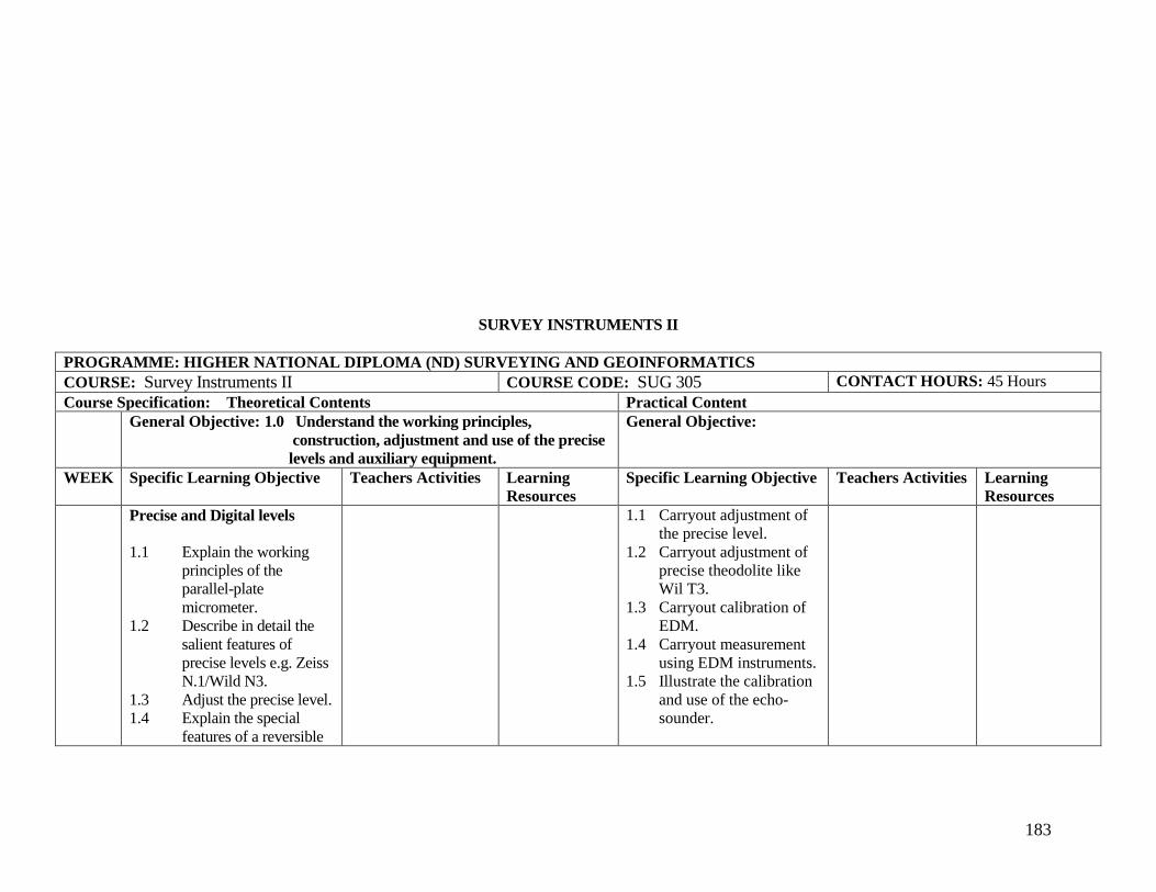
183
SURVEY INSTRUMENTS II
PROGRAMME: HIGHER NATIONAL DIPLOMA (ND) SURVEYING AND GEOINFORMATICS
COURSE: Survey Instruments II COURSE CODE: SUG 305 CONTACT HOURS: 45 Hours
Course Specification: Theoretical Contents Practical Content
General Objective: 1.0 Understand the working principles,
construction, adjustment and use of the precise
levels and auxiliary equipment.
General Objective:
WEEK Specific Learning Objective Teachers Activities Learning
Resources
Specific Learning Objective Teachers Activities Learning
Resources
Precise and Digital levels
1.1 Explain the working
principles of the
parallel-plate
micrometer.
1.2 Describe in detail the
salient features of
precise levels e.g. Zeiss
N.1/Wild N3.
1.3 Adjust the precise level.
1.4 Explain the special
features of a reversible
1.1 Carryout adjustment of
the precise level.
1.2 Carryout adjustment of
precise theodolite like
Wil T3.
1.3 Carryout calibration of
EDM.
1.4 Carryout measurement
using EDM instruments.
1.5 Illustrate the calibration
and use of the echo-
sounder.

184
level.
1.5 Explain the working
principles of the
automatic level and
digital level.
1.6 Evaluate the advantages
of an digital level as
compared with ordinary
levels.
1.7 Describe the auxilliary
equipment used in
precise levelling.
General Objective: 2.0 Know how to distinguish between ordinary
theodolites and geodetic theodolites.
General Objective:
WEEK Specific Learning Objective Teachers Activities Learning
Resources
Specific Learning Objective Teachers Activities Learning
Resources
Geodetic Theodolites
2.1 Explain the graduation
of the horizontal and
vertical circles of the
geodetic theodolite e.g.
Wild T3.
2.2 Explain how the
micrometer readings of
the circles are taken and
angles deduced in the
Wild T3 theodolite.
2.3 Carry out the
adjustment of the Wild

185
T3 theodolite.
2.4 Outline the
distinguishing features
of the T3 theodolite as
compared with T2
theodolite.
General Objective: 3.0 Understand the principles, adjustments and
observational procedure of the astronomical
theodolite.
General Objective:
WEEK Specific Learning Objective Teachers Activities Learning
Resources
Specific Learning Objective Teachers Activities Learning
Resources
Astronomical Theodolite
3.1 Explain the principles
of the broken telescope
design.
3.2 Explain the working
principles of the
astronomical theodolite
e.g. Wild T4 Kern
DKM3.
3.3 Describe in detail,
specific features of the
instrument e.g. the
reticule system of fixed
and movable plates,
eye-piece micrometer,
striding level, Horrebow
level.

186
3.4 Set up an astronomical
theodolite.
3.5 Describe the
adjustments required in
the instrument.
3.6 Carry out observations
with the instrument.
General Objective: 4.0 Understand the principles and classification of
EDM instruments.
General Objective:
WEEK Specific Learning Objective Teachers Activities Learning
Resources
Specific Learning Objective Teachers Activities Learning
Resources
Electromagnetic Distance
Measurer
4.1 Give an account of the
historical background of
EDM instruments.
4.2 Explain the
classification of EDM
instrument into MDM,
EODM.
4.3 Explain the basic
physical principles of
EDM carrier
signals/signal/modulatio
n (AM/FM)
polarisation/demodulati
on.
4.4 Explain the working of
signal radiators and

187
receivers.
4.5 Explain the processes of
signal reflection and
amplification.
4.7 Explain the principle of
phase comparison.
4.7 Explain the measuring
principles of various
types of instruments.
4.8 Calibrate EDM.
4.9 Carry out measurements
using EDM
instruments.
4.10 Evaluate the advantages
of Ga As as the light
source in short
distances.
General Objective: 5.0 Understand the special features of the
Mekometer.
General Objective:
WEEK Specific Learning Objective Teachers Activities Learning
Resources
Specific Learning Objective Teachers Activities Learning
Resources
Mekometer
5.1 Identify the principal
distinguishing features
of the mekometer.
5.2 Describe the
modulation system
(polarisation).
5.3 Describe the phase
measure procedure.
5.4 Explain the optical

188
principle.
5.5 Describe the
measurement
procedure.
5.6 Enumerate the
advantages of the
mekometer.
General Objective: 6.0 Understand the working principles of the
prismatic astrolabe.
General Objective:
WEEK Specific Learning Objective Teachers Activities Learning
Resources
Specific Learning Objective Teachers Activities Learning
Resources
Prismatic Astrolabe
6.1 Explain the principle of
the prismatic astrolabe
(450).
6.2 Describe the instrument,
identifying its different
parts.
6.3 Explain the function of
the attachments
deflecting prisms,
duplicating prism.
General Objective: 7.0 Understand the working principles,
adjustments and use of a sextant.
General Objective:
WEEK Specific Learning Objective Teachers Activities Learning
Resources
Specific Learning Objective Teachers Activities Learning
Resources
Sextant

189
7.1 Explain the basic
optical principle of the
sextant.
7.2 Describe the
construction and parts
of a sextant.
7.3 Explain the use of true
and artificial horizons.
General Objective: 8.0 Understand the working principles, and
uses of the Echo-sounder.
General Objective:
WEEK Specific Learning Objective Teachers Activities Learning
Resources
Specific Learning Objective Teachers Activities Learning
Resources
Echo-Sounder
8.1 Explain the
fundamental principles
of the echo-sounder.
8.2 Distinguish between
sonic and supersonic
(ultrasonic) systems.
8.3 Illustrate the calibration
and use of the
instrument.
General Objective: 9.0 Understand the working principles,
construction and operation of the Gyro-
theodolite.
General Objective:
WEEK Specific Learning Objective Teachers Activities Learning
Resources
Specific Learning Objective Teachers Activities Learning
Resources
Gyro-Theodolite

190
9.1 Give an account of the
historical background of
the application of
gyroscopes to
surveying.
9 .2 Explain gyroscopic
inertia and procession.
9.3 Describe the working
principles of a
gyroscope.
9.4 Explain the working
principle of the gyro-
theodolite.
9.5 Explain the operation of
a gyro-theodolite i.e.
method of setting up,
running up, reasing and
controlling the
amplitude.
9.6 Describe the measuring
operation (index with
moving gyromesh and
auxiliary scale), transit
method.
9.7 Explain the attainable
accuracy of different
models.
9.8 Observe procedures of
different models.
General Objective: 10.0 Understand the principles involved and
equipment used in position-fixing by satellite.
General Objective:

191
WEEK Specific Learning Objective Teachers Activities Learning
Resources
Specific Learning Objective Teachers Activities Learning
Resources
Position Fixing by Satellite
10.1 Give an account of
the
historical background of
position-fixing by
satellite.
10.2 Explain the Doppler
shift of frequency and
its use in position-fixing
by means of satellite
systems.
10.3 Describe the global
positioning system.
10.4 Describe typical
position-fixing
equipment e.g.
Magnavox MX 2502,
the wild WM101, for
recording and
computing satellite data
and display of 3 -
dimensional fix results.
10.5 Explain the position-
fixing technique, with
special reference to:
i] satellite signals:

192
stable
frequencies for
Doppler
measurements,
timing signal,
predicted
orbital
parameters.
ii] the Doppler
measurement-
minimum
observations
required for a
fix.
General Objective: 11.0 Understand the use of lasers in
surveying.
General Objective:
WEEK Specific Learning Objective Teachers Activities Learning
Resources
Specific Learning Objective Teachers Activities Learning
Resources
Lasers
11.1 Explain the historical
background of the
development of the
laser.
11.2 Describe the special
qualities of the laser
beam i.e. intensity of
power, small
divergence, coherence
and monochromatic.
11.3 State the principles of
precision alignment by

193
laser and its advantages
over the traditional
method.
11.4 Describe current
examples of laser
theodolite and levels.
11.5 Explain the basic
methods of distance
measurement by laser.
11.6 Enumerate the safety
regulation for laser
instruments.
General Objective: 12.0 Understand the general characteristics,
construction and operation of laser EDM
equipment e.g. Geodimeter 8.
General Objective:
WEEK Specific Learning Objective Teachers Activities Learning
Resources
Specific Learning Objective Teachers Activities Learning
Resources
Laser EDM Equipment
12.1 Describe the general
features of laser EDM
instruments with
particular reference to
the range, accuracy,
time required for
observations, power
consumption, etc.
12.2 Explain the use of laser
beam in the geodimeter
8 and the function of the
beam expander,
cylindrical lens and the

194
optical filter in this
connection.
12.3 Describe the
construction of the
geodimeter in detail:-
i] built-in power
unit;
ii] optical unit -
laser,
modulation
system,
transmission
optics, receiver
unit, photo-
electrical and
phase-
comparison
unit;
iii] electronic unit-
sub-units, high
voltage
transmitter,
reference
oscillator,
mixer,
amplifier/detect
or; and
iv] control unit.
General Objective: 13.0 Understand the working principles of
electronic theodolites and total stations.
General Objective:
WEEK Specific Learning Objective Teachers Activities Learning
Resources
Specific Learning Objective Teachers Activities Learning
Resources

195
Electronic Theodolites and
Total Station
13.1 Describe the working
principles of the
electronic theodolite.
13.2 Give a detailed
description of a current
model of electronic
theodolite.
13.3 Explain the significance
of the term total station.
13.4 Describe the working
principles and
capability of current
models of total stations.
13.5 Explain feature coding
data logging and data
transfer.
13.6 Use electronic
theodolite to survey a
given parcel of land.
General Objective: 14.0 Understand the basic working principles of
inertial surveying equipment.
General Objective:
WEEK Specific Learning Objective Teachers Activities Learning
Resources
Specific Learning Objective Teachers Activities Learning
Resources
Principles of Inertial
Surveying
14.1 Explain the basic
principles upon which

196
inertial surveying
depends.
14.2 Outline the working
principles and
performance of a
typical model inertial
surveying equipment.
COMPUTER COURSES
(SUG 315 AND 316)

197
FUNDAMENTALS OF COMPUTER
PROGRAMME: HIGHER NATIONAL DIPLOMA (ND) SURVEYING AND GEOINFORMATICS
COURSE: Fundamentals of Computer COURSE CODE: SUG 315 CONTACT HOURS: 30 Hours
Course Specification: Theoretical Contents Practical Content
General Objective: 1.0 Know the definitions of computer, bit and byte.
General Objective:
WEEK Specific Learning Objective Teachers Activities Learning
Resources
Specific Learning Objective Teachers Activities Learning
Resources
1.1 Define computer.
1.2 Define bit and bytes.
General Objective: 2.0 Know the history of Computer. General Objective:
WEEK Specific Learning Objective Teachers Activities Learning
Resources
Specific Learning Objective Teachers Activities Learning
Resources
2.1 Describe 1st generation
computers.
2.2 Describe 2nd generation
computer.
2.3 Describe 3rd generation
computer.
198
General Objective: 3.0 Know types of computers.
General Objective:
WEEK Specific Learning Objective Teachers Activities Learning
Resources
Specific Learning Objective Teachers Activities Learning
Resources
3.1 Describe micro/Desktop
3.2 Describe mainframe
computer
3.3 Programmable
calculatory
General Objective: 4.0 Know the structure of computer.
General Objective:
WEEK Specific Learning Objective Teachers Activities Learning
Resources
Specific Learning Objective Teachers Activities Learning
Resources
4.1 Describe ALG
4.2 Describe CPU
4.3 Describe Memories
4.4 Explain MS-DOS
Commands and winds
General Objective: 5.0 Know the application software.
General Objective:
WEEK Specific Learning Objective Teachers Activities Learning
Resources
Specific Learning Objective Teachers Activities Learning
Resources
5.1 Explain word
processing
5.2 Describe spread sheet
5.3 List statistical lications
General Objective: 6.0 Know Networking. General Objective:
WEEK Specific Learning Objective Teachers Activities Learning
Resources
Specific Learning Objective Teachers Activities Learning
Resources

199
6.1 Explain LAN
6.2 Explain WAN
COMPUTER APPLICATIONS
PROGRAMME: HIGHER NATIONAL DIPLOMA (ND) SURVEYING AND GEOINFORMATICS
COURSE: Computer Applications COURSE CODE: SUG 316 CONTACT HOURS: 45 Hours
Course Specification: Theoretical Contents Practical Content
General Objective: 1.0 Know BASIC, Fortran, and other
Programming Languages.
General Objective:
WEEK Specific Learning Objective Teachers Activities Learning
Resources
Specific Learning Objective Teachers Activities Learning
Resources
1.1 Review Trigonometric
function
1.2 Review Arithmetic
functions
1.3 Review Relational
expressions
1.4 Review Logical
operators
1.5 Review constants and
variables.
1.6 Explain random file
access
General Objective: 2.0 Know dBASE General Objective:

200
WEEK Specific Learning Objective Teachers Activities Learning
Resources
Specific Learning Objective Teachers Activities Learning
Resources
2.1 Explain control center
2.2 Explain Indexing
2.3 Explain Sorting
2.4 Structured query
language
2.5 Dot prompt
2.6 State commands.
2.7 State Set Commands
2.8 State function
2.9 State system variables
General Objective: 3.0 Know programme writing for survey
computation.
General Objective:
WEEK Specific Learning Objective Teachers Activities Learning
Resources
Specific Learning Objective Teachers Activities Learning
Resources
3.1 Write programme for
bearing computation
3.2 Write Programme for
Area computation
3.3 Write programme for
Traverse Computation
3.4 Write programme for
geodetic
3.5 Write programme for
transfer nation
3.6 Write programme
deviation and standard
3.7 Write programme for
tachometry
3.8 Write programme for

201
matrix multiplication
inversion
3.9 Write programme for
solving linear equations.
ELEMENTS OF ENVIRONMENTAL STUDIES
PROGRAMME: HIGHER NATIONAL DIPLOMA (ND) SURVEYING AND GEOINFORMATICS
COURSE: Elements of Environmental Studies COURSE CODE: GIT 412 CONTACT HOURS: 30 Hours
Course Specification: Theoretical Contents Practical Content
General Objective: 1.0 Understand the characteristics of population
dynamics and impact on the environment.
General Objective:
WEEK Specific Learning Objective Teachers Activities Learning
Resources
Specific Learning Objective Teachers Activities Learning
Resources
Specific Objectives
1.1 Define population
1.2 Explain the relationship
between biotic
potential, environmental
resistance, population
growth and population
density.
1.3 Explain the processes of
evolution, natural
selection and
differential

202
reproduction.
1.4 Discuss factors
affecting population
size.
1.5 Discuss growth rate,
rate of change, birth
rate, death rate of
population.
1.6 Discuss survivorship
courses, fertility rate
and its importance.
1.7 Discuss age pyramids
and their significance.
1.8 Discuss health hazards
of population pressures.
1.9 Explain the impact of
low population density
growth rate on the
environment.
General Objective: 2.0 Understand the fundamental ecological
concepts and climatic changes.
General Objective:
WEEK Specific Learning Objective Teachers Activities Learning
Resources
Specific Learning Objective Teachers Activities Learning
Resources
Ecological Concepts
2.1 Define ecology.
2.2 Explain the following
terms: human ecology,
bio diversity, cycle,
community, energy,
ecological niche,
ecosystem, biosphere,

203
biotic and abiotic
environmental.
2.3 Define system, open
systems and cybernetic
system.
2.4 Identify the relationship
between systems sub-
systems and super-
systems.
2.5 Explain in what respect
are all biological
systems are both open
and cybernetic systems.
2.6 Define weather, climate
and its elements.
2.7 Discuss the science and
development of
climatology.
2.8 Explain climate change,
climate system and
satellite casting.
2.9 Discuss climate change
on the environment.
2.10 Discuss the impacts of
climatic changes on
agriculture, industry,
human health and other
aspects of human
endeavours (e.g. water
bodies, vegetation, soil,
land forms etc.).

204
General Objective: 3.0 Understand the basic principles of resources
management .
General Objective:
WEEK Specific Learning Objective Teachers Activities Learning
Resources
Specific Learning Objective Teachers Activities Learning
Resources
Principles of Resources
Management
3.1 Define a resource.
3.2 Explain wild-life
resources management.
3.3 Explain the
management of energy
resources.
3.4 Discuss water resources
management.
3.5 Discuss the
management of mineral
resources.
3.6 Define environmental
impact assessment.
3.7 Discuss the use of data
in environmental impact
assessment.
3.8 Discuss the contents of
environmental impact
assessment.
3.9 Explain the methods of
assessing the
environment.
3.10 Discuss hydrological
resources management.
General Objective: 4.0 Understand the basic principles of Geographical General Objective:

205
Information System and its application in
Environmental Monitoring and Protection.
WEEK Specific Learning Objective Teachers Activities Learning
Resources
Specific Learning Objective Teachers Activities Learning
Resources
Geographical Information
System in Monitoring and
Protection
4.1 Define Geographical
Information System
(GIS).
4.2 Define environmental
monitoring
4.3 Discuss the basic
principles of
Geographical
Information System.
4.4 Discuss the application
of information
technology in
environmental
monitoring
4.5 Discuss the basic
elements of
environmental
monitoring.
4.6 Explain the use of GIS
in environmental
monitoring and
protection.

206
BASIC PRINCIPLES OF GEOINFORMATICS
PROGRAMME: HIGHER NATIONAL DIPLOMA (ND) SURVEYING AND GEOINFORMATICS
COURSE: Basic Principles of Geoinformatics COURSE CODE: GIT 304 CONTACT HOURS: 30 Hours
Course Specification: Theoretical Contents Practical Content
General Objective: 1.0 Know the historical development of GIS. General Objective:
WEEK Specific Learning Objective Teachers Activities Learning
Resources
Specific Learning Objective Teachers Activities Learning
Resources
1.1 Describe the evolution
of GIS
start from computer
anoted mapp -DMS -
GIS
1.2 Explain the additional
functions added from
one phase to the other
e.g. DMS + DBMS –
GIS
General Objective: 2.0 Know the components of GIS. General Objective:

207
WEEK Specific Learning Objective Teachers Activities Learning
Resources
Specific Learning Objective Teachers Activities Learning
Resources
2.1 List the components of
a GIS
2.2 Describe the
relationship using the
components
General Objective: 3.0 Know the applications. General Objective:
WEEK Specific Learning Objective Teachers Activities Learning
Resources
Specific Learning Objective Teachers Activities Learning
Resources
3.1 List the main
application of GISs.
3.2 Describe the benefits of
GIS in each application.
General Objective: 4.0 Understand the nature of spartial object.
General Objective:
WEEK Specific Learning Objective Teachers Activities Learning
Resources
Specific Learning Objective Teachers Activities Learning
Resources
4.1 Explain the component
of spartial object.
4.2 Explain the acquisition
of each component.
4.3 Describe the storage of
each component in the
database.
General Objective: 5.0 Know the components of a Database. General Objective:
208
WEEK Specific Learning Objective Teachers Activities Learning
Resources
Specific Learning Objective Teachers Activities Learning
Resources
5.1 List the components of
a database.
5.2 Describe the use of each
component.
5.3 Describe the
relationship among the
components.
General Objective: 6.0 Understand the arrangement of date in the
database.
General Objective:
WEEK Specific Learning Objective Teachers Activities Learning
Resources
Specific Learning Objective Teachers Activities Learning
Resources
6.1 Describe data layer.
6.2 Explain justification for
storing data in layers.
6.3 Explain concept of data
integration.
6.4 Compare data layer
approach with data
integration approach.
General Objective: 7.0 Know the subsytems of a GIS. General Objective:
WEEK Specific Learning Objective Teachers Activities Learning
Resources
Specific Learning Objective Teachers Activities Learning
Resources
7.1 List the subsystems of a
GIS.
7.2 Describe the function of
each subsystem.

209
General Objective: 8.0 Understand Land information system.
General Objective:
WEEK Specific Learning Objective Teachers Activities Learning
Resources
Specific Learning Objective Teachers Activities Learning
Resources
8.1 Identify components of
a Land information
system.
8.2 Differentiate between
LIS and GIS
8.3 Describe application of
LIS.
DIGITAL MAPPING AND CARTOGRAPHY
PROGRAMME: HIGHER NATIONAL DIPLOMA (ND) SURVEYING AND GEOINFORMATICS
COURSE: Digital Mapping and Cartography COURSE CODE: GIT 405 CONTACT HOURS: 60 Hours
Course Specification: Theoretical Contents Practical Content
General Objective: 1.0 Know the digital mapping system. General Objective:
WEEK Specific Learning Objective Teachers Activities Learning
Resources
Specific Learning Objective Teachers Activities Learning
Resources
1.1 Define digital mapping
system.
1.2 Explain the components
of digital mapping
system.
1.3 List digital mapping
input & output devices.
1.1 Carryout exercises with
a digital mapping
software e.g.
KORK,Desktop
Mapping System.
1.2 Create a topographic
database with any GIS
software.
General Objective: 2.0 Understand digital mapping software. General Objective:
WEEK Specific Learning Objective Teachers Activities Learning Specific Learning Objective Teachers Activities Learning

210
Resources Resources
2.1 List digital mapping
software.
2.2 Explain the capabilities
of digital mapping
software.
2.3 Carry out exercise with
digital software.
General Objective: 3.0 Understand the development of digital mapping
data base.
General Objective:
WEEK Specific Learning Objective Teachers Activities Learning
Resources
Specific Learning Objective Teachers Activities Learning
Resources
3.1 Create digital mapping
data base.
3.2 Develop digital
topography
Database.
3.3 Carryout exercise on
digital mapping system.
General Objective: 4.0 Know the digital cartographic system.
General Objective:
WEEK Specific Learning Objective Teachers Activities Learning
Resources
Specific Learning Objective Teachers Activities Learning
Resources
4.1 Define digital
cartographical system.
4.2 Explain the component
of digital cartography
system
4.3 List digital cartographic

211
input and output devices
General Objective: 5.0 Know digital cartographic software. General Objective:
WEEK Specific Learning Objective Teachers Activities Learning
Resources
Specific Learning Objective Teachers Activities Learning
Resources
5.1 List digital cartographic
software
5.2 Explain the capability
of digital cartographic
software
5.3 Carryout exercise with
digital cartographic
software
General Objective: 6.0 Understand the production of maps.
General Objective:
WEEK Specific Learning Objective Teachers Activities Learning
Resources
Specific Learning Objective Teachers Activities Learning
Resources
6.1 Describe the procedure
for the production of
maps & charts
6.2 Produce maps and
charts at various scales
& forms.
6.3 Explain the production
of auto photo maps and
mosaks.
6.4 Explain the production
of image map.
General Objective: 7.0 Know the production of digital terrain model. General Objective:

212
WEEK Specific Learning Objective Teachers Activities Learning
Resources
Specific Learning Objective Teachers Activities Learning
Resources
7.1 Describe the component
of DTM
7.2 Carryout exercises on
various DTM.