highway 17 wildlife crossing plan
TRANSCRIPT

Highway 17 Wildlife Crossing Plan
Assessment of Solutions to Improve Traversability of State Highway 17 Dec ember 2012
2
Preface
This plan was developed on behalf of the Midpeninsula Regional Open Space District to improve wildlife crossing across state highway 17, between Los Gatos and Lexington Hills. Several mountain lions, bobcats and deer have died along highway 17 due to collisions with vehicles. There are currently very few opportunities for wildlife to safely cross highway 17 along its entire length. This condition, combined with a concrete median barrier and high traffic levels means that highway 17 is a quantifiable barrier, isolating wildlife on the peninsula from the Central Coast and other eco-regions. This extremely significant ecological indication will cause local species endangerment, disruption of prey-predator relationships, and genetic/population fragmentation. Caltrans is conducting projects along highway 17 and thus can make improvements for wildlife crossing as part of these projects. This plan is intended to inform those project improvements.
The Authors Tanya Diamond is the founder and co-owner of Connectivity for Wildlife, a research organization specializing in studying and re-connecting wildlife and landscape. Ms. Diamond received her MSc in Wildlife Biology from San Jose State University. Zara McDonald is the founder of Felidae Conservation Fund, a scientific research, education and conservation organization dedicated to the protection of in situ wild felid populations throughout the world. Fraser Shilling is a road ecologist at the University of California, Davis. He and his center, the Road Ecology Center, specialize in studying landscape connectivity and wildlife movement. Dr. Shilling received his PhD from the University of Southern California.
3
Table of Contents
Preface .................................................................................................................................... 2 1. Highways & Medians ........................................................................................................... 4 2. Wildlife Movement and Mortality Data ............................................................................... 5 3. Fencing ................................................................................................................................ 8 4. Crossing Structures ............................................................................................................ 12 5. Priority Assessment: .......................................................................................................... 17 6. Funding .............................................................................................................................. 19 7. Monitoring Effectiveness .................................................................................................. 19 Appendices ............................................................................................................................ 20

4
1. Highways & Medians
Median barriers are designed to separate opposing traffic. These barriers may be vegetated separators, guard-rails, concrete walls, or other structures. An unintended consequence of median barriers is that they inhibit wildlife movement across the surface of the roadway, but in the middle of the road, rather than the edge. This means that animals may become trapped in the median, or not try to cross at all because they can’t see across the road.
At first, it might seem like a good thing if median barriers deter animals from entering
the roadway. This is true from the individual point of view because they are less likely to become involved in a collision with a vehicle. However, if there are not other crossing alternatives above or below the road, animal populations may become separated from each other, or from essential reproductive, hibernation, foraging, or other habitat. In other words, median barriers can cause population reduction and loss when they prevent or severely inhibit animal movement across the road or highway right-of-way.
Existing Condition
Within the study area, Highway 17 is a four lane highway with heavy traffic flow and
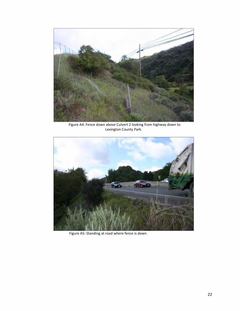
volume (Table 1), as it is a commuter highway between the Bay Area and Santa Cruz. There is a concrete median that runs through the entire length of the linkage, except for a break at the Cats Restaurant entrance (Figures 1, 2, and 3). The median is approximately 4 feet high, and then increases in height to five feet tall near the top of the incline before the road levels off at Lexington reservoir.
Table 1. Traffic volumes along highway 17 in study area Location (intersection) Peak vehicles/hour Average Annual Daily Travel (#
vehicles)
Highway 85 6,900 88,000
Santa Cruz Ave 5,000 64,000
Bear Creek Rd 4,400 56,000
Santa Clara Co. line 5,600 56,000
Granite Creek Rd 5,700 56,000
Figure 1 Highway 17 median where puma was hit, east view.

5
2. Wildlife Movement and Mortality Data
There are many approaches for hypothesizing about connectivity (e.g., connectivity
modeling in GIS), measuring connectivity among wildlife populations (e.g., genetic monitoring), observing live and dead wildlife occurrences, and measuring wildlife movement in the field (e.g., with radio-collars). Each of these methods provides some information about individuals and populations of wildlife species. None by itself provides sufficient information to plan and implement management practices to protect wildlife movement. For example, modeling in GIS provides an approximation or hypothesis about where wildlife might be moving, but only field measurements can confirm or test this hypothesis. Field observations can consist of roadkill or live animal observations, tracks & scat, or photographs from wildlife camera traps.
Existing Condition
There have been many animal road kills along Highway 17 over the past several years
(Figure 2 & Table 2). Road kill data that has been collected by the Bay Area Puma Project, show that at each road kill site, there is no existing fence to keep animals from entering onto the highway or to detour them to a crossing structure, such as a culvert or bridge.
Highway 17 Roadkill Sites and Crossing Structure locations on Puma Habitat Suitability map
Legend
1-2: strongly preferred
3-4: fair habitat
5-6: usable
7-8: not breeding habitat,perhaps occasionally used
9-10: strongly avoided
Hwy 17 Crossing Strcutures
" Lexington Bridge
! Lexington Culvert
Male Puma
Puma
Male Deer
Bobcat
Bobcat
Puma
Bobcat
µ0 2.51.25
Miles
Figure 2. Hwy 17 Roadkill Sites & crossing structure locations on a Puma Habitat Suitability Map
6
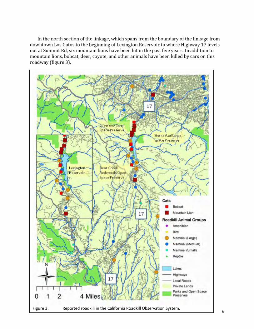
Figure 3. Reported roadkill in the California Roadkill Observation System.
In the north section of the linkage, which spans from the boundary of the linkage from
downtown Los Gatos to the beginning of Lexington Reservoir to where Highway 17 levels out at Summit Rd, six mountain lions have been hit in the past five years. In addition to mountain lions, bobcat, deer, coyote, and other animals have been killed by cars on this roadway (figure 3).

7
ID Species Date Sex Travel Direction Location
1 Puma 2/9/2011 at 9:30 pm
adult male southbound
Hwy 17, hit by ravine, with game trail leading down to road
2 Puma southbound
3 Puma 8/29/2010 southbound
4 Puma adult female
18 F was hit on Hwy 17 by Jarvis road, she was breeding and may have been pregnant
5 Puma adult male southbound
16M was hit on Hwy 17 near the Glenwood cut off, on the east side heading west
6 Puma 10/1/2011 southbound Puma was hit at the intersection of Highway 17 & 85
7 Puma 9-2011 Hwy 17 by the Cats Restaurant, southbound
8 Puma 10/15/2011 southbound Hwy 17 by Summit Road
1 Bobcat 2/10/2011 southbound near town of Los Gatos
2 Bobcat 5/17/2010 southbound on Bear Creek off ramp direction of travel: east
3 Bobcat 7/19/2010 southbound on Hwy 17 near Alma Fire Station direction of travel: east
4 Bobcat 10/2/2010 southbound on Old Santa Cruz HWY near Alma Fire Station direction of travel: east
5 Bobcat 12/1/2010 northbound on Hwy 17 near Alma Fire Station direction of travel EAST
6 Bobcat 8/15/2011 northbound Hwy 17 by Lexington County Park, where fence is down
7 Bobcat 12/13/2011 southbound Hwy 17 by Vasona Park, juvenile
1 Deer 7/2/2011 adult male southbound
Hwy 17, hit 20 meters down from ravine where puma was hit on 2/9/2011
2 Deer 8/8/2011 at 8:30 pm
adult female northbound
Hwy 17, by median across from Cats restaurant
3 Deer 11/28/2011 fawn northbound
By Lexington County Park, where the fence is down along the highway and deer often come down and graze by the side of the highway.
4 Deer 11/24/2011 adult male southbound
Hwy 17 by Bear Creek Redwoods Open Space Preserve
5 Coyote 12/3/2011 northbound Hit by Lexington County Park road exit
Table 2: Animal vehicle collisions-roadkill sites
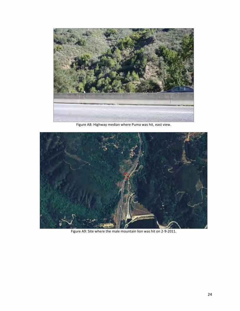
At the site where a mountain lion was hit on 2-9-2011 on Hwy 17 southbound, two ravines converge and there is no existing fencing (Figure 2, Figures A6-A9). Extensive game trails that lead to the ravine and toward the highway suggest this topographic feature leads animals to the highway (Figure A10). At the Trout Creek Culvert 2, puma, deer, bobcat, and deer have all been hit at this location, indicating that it is a high risk area for vehicle and animal collisions, as animals are moving down the ravine into the highway.
8
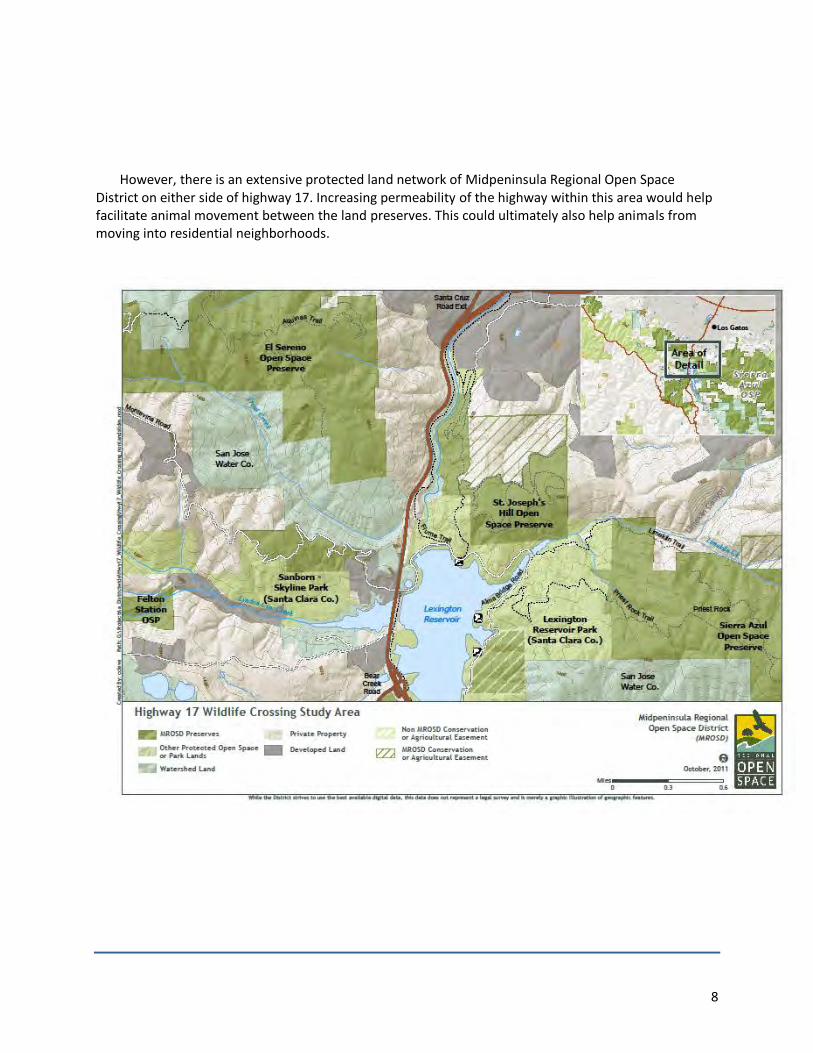
However, there is an extensive protected land network of Midpeninsula Regional Open Space
District on either side of highway 17. Increasing permeability of the highway within this area would help facilitate animal movement between the land preserves. This could ultimately also help animals from moving into residential neighborhoods.

9
3. Fencing
Advantages of wildlife fencing
Fencing along roadways is an effective way to protect people and wildlife, when it is combined with wildlife crossing opportunities and regular maintenance (Figure 4). Keeping wildlife out of the right-of-way, but providing them with a crossing alternative, is a good way to reduce harm to wildlife and people. Fencing, combined with crossing opportunities, can help do this. Fencing has two discrete functions, each at different scales: 1) keeping wildlife from accessing a stretch of road or highway, except at pre-determined crossing points and 2) keeping wildlife from passing through all segments of the fence-line. Fence-lines are the established boundary between wildlife habitat and the immediate road-side and roadway. They function only when they are extensive and intact. Location
Wildlife fencing is effective when it is associated with crossing structures. This
describes “directional fencing” in that wildlife is guided toward crossing opportunities. Fencing can be established where wildlife crossing is known to occur because of direct observations AND indirect evidence (e.g., traffic accidents caused by collisions with animals, animal carcasses from collisions). Since most areas with some kind of natural or agricultural vegetation will support wildlife, which need to move around, fencing could go next to most roads. A prioritization scheme for the best places to start fencing could look like this:
There is an obvious opportunity for wildlife (or several) to which the fencing can link. There is direct evidence (e.g., radio-collared animal movement, wildlife pictures) of
animal movement along the stretch of road/highway. There is indirect evidence of unsuccessful animal movement (e.g., traffic accidents,
animal carcasses). Combined with: Moderate to high traffic volumes (>1,000 cars/day) Poor line-of sight due to road curvature, vegetation/topography, or climatic conditions
10
Planning and Project Nexus
Fence-lines are best identified and described early in the process of corridor or project planning so that everyone is on the same page and is supportive. They should be built to coincide fairly exactly with new activities associated with wildlife crossing (e.g., new culverts). To function well in most environments, they should be inspected and maintained at least annually.
Limitations of wildlife fencing
As indicated above, wildlife fencing
is only effective when the ends of the fence-line join landscape elements or structures that keep wildlife out (figure 4b). Other limitations on effectiveness are related to sturdiness, regularity of inspection and maintenance, height of the fence, fabric mesh-size, number and adequacy of associated crossings, and location relative to wildlife movement.
Monitoring fencing effectiveness
There are two components of
monitoring – fence integrity and wildlife crossing response. Criteria for effectiveness include: structural integrity (year-to-year maintenance requirements), fence line integrity (wildlife are inhibited from crossing the roadway except through structures), fence line length adequacy (wildlife aren’t just going around the ends, figure 4b), wildlife behavioral response (wildlife are successfully directed to crossing structures, not just blocked and repelled, figure 4a), and increase in animal and public safety for roadway.
Costs
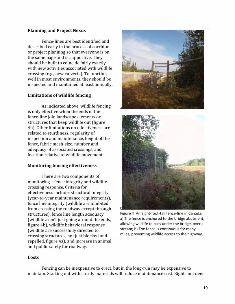
Fencing can be inexpensive to erect, but in the long-run may be expensive to
maintain. Starting out with sturdy materials will reduce maintenance cost. Eight-foot deer
a
b Figure 4 An eight-foot-tall fence-line in Canada. a) The fence is anchored to the bridge abutment, allowing wildlife to pass under the bridge, over a stream; b) The fence is continuous for many miles, preventing wildlife access to the highway.
11
fencing costs about $100,000/mile, including escape ramps and gates. Electrified fence strands may be more cost-effective in some cases than standard fencing because of its proven inhibition of large mammals and lower profile. Regular inspection and maintenance is a critical part of fence function and should be considered as part of the cost.
Document decisions and develop agreements
Fences interact with other land-owning and regulatory entities, who should be
consulted during planning. Because fence lines are often planned for the edge of the legal right-of-way, adjacent landowners should be consulted about how the fence lines may impact them. Wildlife agencies should be consulted because of possible negative and positive impacts on movement of legally-protected and other animals.
Existing condition
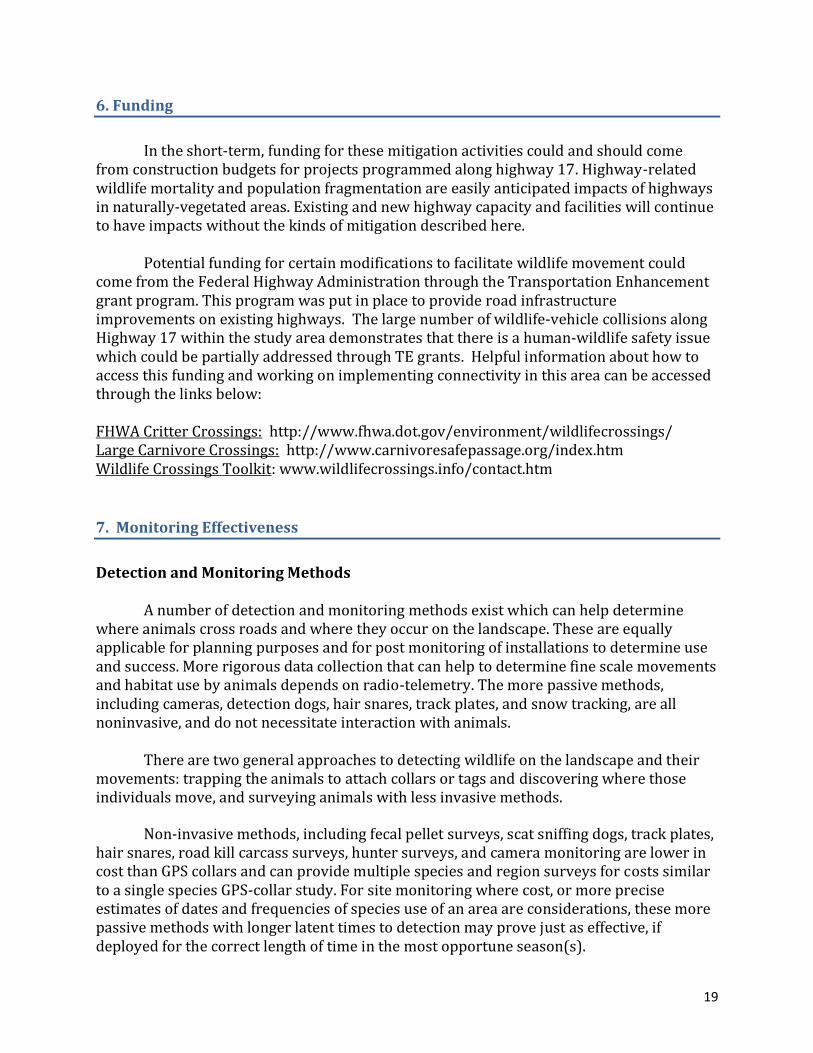
Fencing to deter animal access to the highway is very limited and existing fencing needs repair. For example, deer have been observed grazing along the side of the highway where the fence is down at Lexington County Park, by the main trail leading down to Los Gatos, just south of the spill way from the dam (Figure A4 and A5). For most of the highway, there is no existing fence to keep animals from entering onto the highway or to detour them to a crossing structure, such as a culvert or bridge. At the site where a mountain lion was hit on 2-9-2011 on Hwy 17 southbound, two ravines converge and there is no existing fencing (Figure 2, Figures A6-A9).
Fencing designs could be installed to lead animals to an existing culvert or bridge
(indicated on figure 2). There are three culverts running under Highway 17 within the study area and one bridge. One culvert is viable for facilitating a high amount of animal movement, while the other two are not. All three culverts require maintenance to facilitate animal movement through them and two of the culverts would need to be retrofitted with design improvements (Table 3). An existing bridge could be enhanced as wildlife crossing structure by adding two lanes and vegetation. There is also another location, Trout Creek culvert 2, in which there has been a high amount of mountain lion, bobcat, and deer road kill and movement across the highway, which would be suitable for building a land bridge for wildlife to cross Highway 17 in the north section of the study area.
Recommended Action
Four mountain lions, numerous bobcats, and deer, have been hit just north of
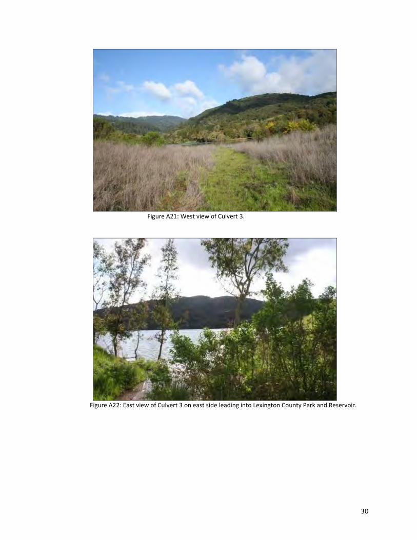
Culvert 3 at Lexington Reservoir. In the short-term, it would be beneficial to add in fencing to guide animals to this culvert (indicated on figure 2). The culvert is large enough, to facilitate large animal movement, animals can see from one end to the other, with sufficient lighting within it, and is not flooded during the dry season (Figure A20). In both directions there is open space available for animals to travel into the mountains and hills (Figures A21 and A22). From the east side of the culvert, animals can travel along the trail systems that
12
go around Lexington Reservoir to Lexington County Park and Mid-Peninsula Regional Open Space Preserve (Figure A23).
4. Crossing Structures
Frequency of animal crossings along roads and highways, as well as their size,
should be determined by the movement of target animals in an area. In general, smaller animals need more frequent and smaller crossing structures than larger animals, because of a combination of smaller home ranges and tolerance of smaller, more-confined spaces. Planning for a combination of crossing sizes at distances along a highway that suit animal home ranges is more likely to result in effective wildlife movement and connectivity.
Description
Sufficient size (combination of cross-sectional area and length, figure 5) and frequency (number of crossings per unit length of highway) of wildlife crossings can be calculated for groups of species found in a particular area. Although large crossings can accommodate small and large animal movement, small crossings are typically only used by small animals. In any given network of roads and highways, there are areas with sufficient culverts and bridges to provide animals of various kinds to safely cross and other areas needing retrofitting and enhancement. The main issue here is finding the right combination of higher frequency small crossings and lower frequency larger crossings to meet the needs of a wide range of species.
The Arizona Department of
Game and Fish developed guidance for bridge and culvert planning to meet the needs of fish and wildlife (AZDGF, 2006 and 2008). Both sets of guidance address the size of crossing structures to meet the needs of various species groups. The culvert guidance also includes a description of approximate frequencies that are needed by different size-groups of wildlife.
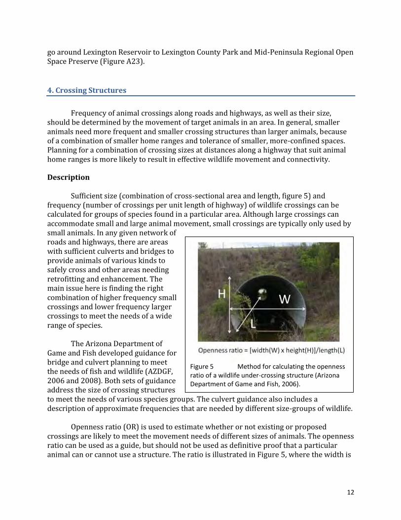
Openness ratio (OR) is used to estimate whether or not existing or proposed
crossings are likely to meet the movement needs of different sizes of animals. The openness ratio can be used as a guide, but should not be used as definitive proof that a particular animal can or cannot use a structure. The ratio is illustrated in Figure 5, where the width is
Figure 5 Method for calculating the openness ratio of a wildlife under-crossing structure (Arizona Department of Game and Fish, 2006).

13
multiplied times the height of the opening and the product is divided by the length of the structure. For almost all animals, the higher the OR, the better.
Limitations
Although grouping species, for example according their potential use of structures,
provides more efficient planning processes, not all species fit well within groups. Individual species may have special habitat requirements or behaviors which make them fit poorly into groups with other species. In addition, general rules about crossing sizes (e.g., the use of the openness ratio) may not suit all species equally. Compensating for these limitations can occur by considering the needs of individual species and ensuring that they are met in a system planned for groups of species.
Enhancing existing structures
Many existing structures may not be used by wildlife, but if they were enhanced through sometimes very inexpensive measures, they could become useful crossing structures. Enhancements include: wildlife sidewalks next to street under-crossings, culvert enlargement before or during scheduled replacement, culvert ledges as a retrofit, and benches under bridges across streams/rivers.
Enhancing or retrofitting existing culverts, bridges, fencing, and other
transportation infrastructure can be cost-effective actions that create more permeable passage for all wildlife in an area. These enhancements can be classified into six types:
1. remove obstacles,
2. facilitate movement and create pathways,
3. reduce intimidation,
4. enhance structures’ approaches,
5. addressing the fencing and barriers,
6. and add or adjust structural features.
These enhancements can be as simple as repairing fencing, to more involved actions
such as adding several dump trucks of soil on top of rip rap to create a wildlife-friendly path under a bridge.
14
Existing Condition
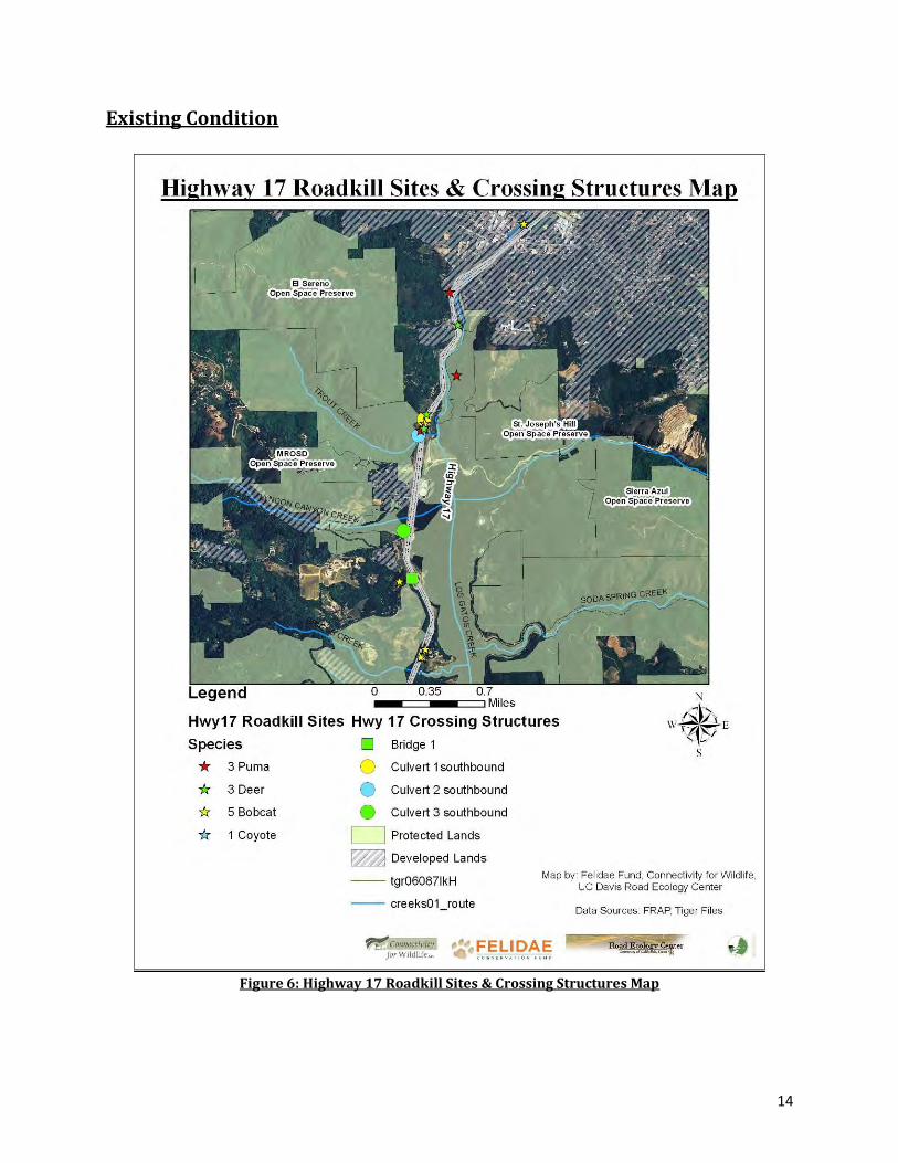
Figure 6: Highway 17 Roadkill Sites & Crossing Structures Map
15
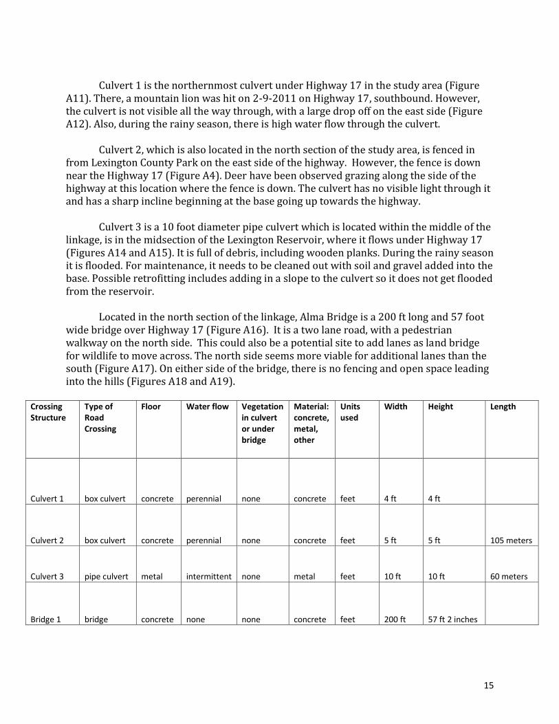
Culvert 1 is the northernmost culvert under Highway 17 in the study area (Figure
A11). There, a mountain lion was hit on 2-9-2011 on Highway 17, southbound. However, the culvert is not visible all the way through, with a large drop off on the east side (Figure A12). Also, during the rainy season, there is high water flow through the culvert.
Culvert 2, which is also located in the north section of the study area, is fenced in
from Lexington County Park on the east side of the highway. However, the fence is down near the Highway 17 (Figure A4). Deer have been observed grazing along the side of the highway at this location where the fence is down. The culvert has no visible light through it and has a sharp incline beginning at the base going up towards the highway.
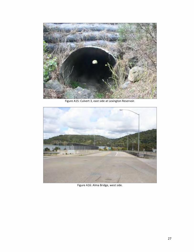
Culvert 3 is a 10 foot diameter pipe culvert which is located within the middle of the
linkage, is in the midsection of the Lexington Reservoir, where it flows under Highway 17 (Figures A14 and A15). It is full of debris, including wooden planks. During the rainy season it is flooded. For maintenance, it needs to be cleaned out with soil and gravel added into the base. Possible retrofitting includes adding in a slope to the culvert so it does not get flooded from the reservoir.
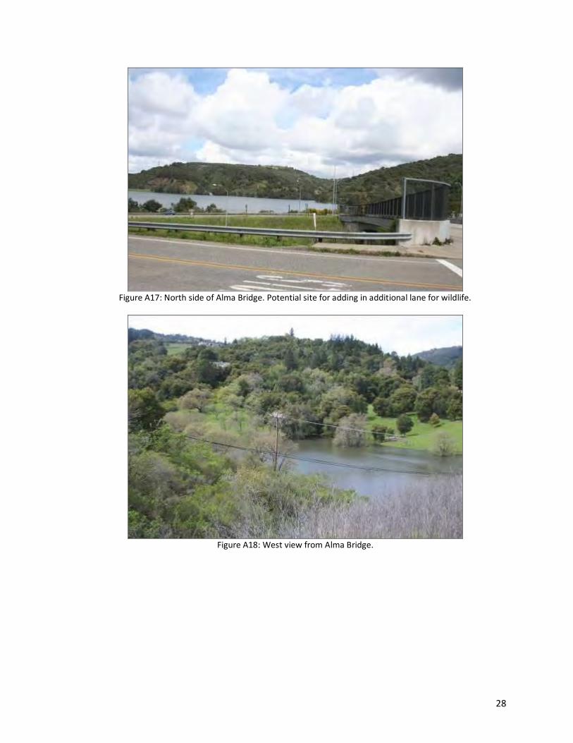
Located in the north section of the linkage, Alma Bridge is a 200 ft long and 57 foot
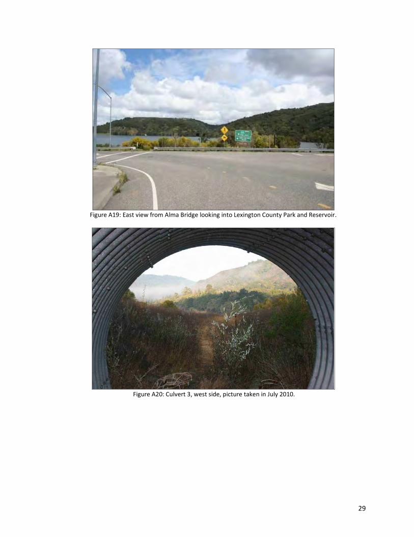
wide bridge over Highway 17 (Figure A16). It is a two lane road, with a pedestrian walkway on the north side. This could also be a potential site to add lanes as land bridge for wildlife to move across. The north side seems more viable for additional lanes than the south (Figure A17). On either side of the bridge, there is no fencing and open space leading into the hills (Figures A18 and A19).
Crossing Structure
Type of Road Crossing
Floor Water flow Vegetation in culvert or under bridge
Material: concrete, metal, other
Units used
Width Height Length
Culvert 1 box culvert concrete perennial none concrete feet 4 ft 4 ft
Culvert 2 box culvert concrete perennial none concrete feet 5 ft 5 ft 105 meters
Culvert 3 pipe culvert metal intermittent none metal feet 10 ft 10 ft 60 meters
Bridge 1 bridge concrete none none concrete feet 200 ft 57 ft 2 inches
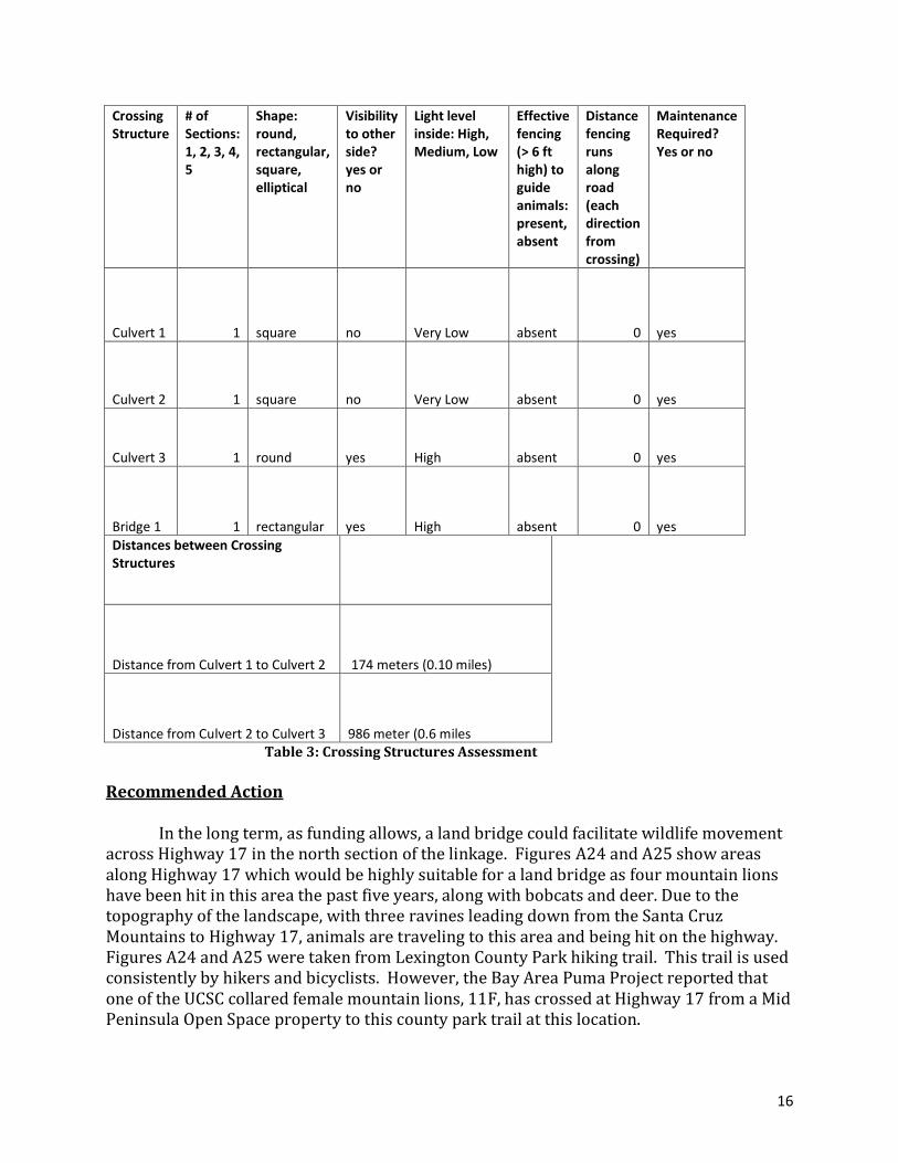
16
Crossing Structure
# of Sections: 1, 2, 3, 4, 5
Shape: round, rectangular, square, elliptical
Visibility to other side? yes or no
Light level inside: High, Medium, Low
Effective fencing (> 6 ft high) to guide animals: present, absent
Distance fencing runs along road (each direction from crossing)
Maintenance Required? Yes or no
Culvert 1 1 square no Very Low absent 0 yes
Culvert 2 1 square no Very Low absent 0 yes
Culvert 3 1 round yes High absent 0 yes
Bridge 1 1 rectangular yes High absent 0 yes
Distances between Crossing Structures
Distance from Culvert 1 to Culvert 2 174 meters (0.10 miles)
Distance from Culvert 2 to Culvert 3 986 meter (0.6 miles Table 3: Crossing Structures Assessment Recommended Action
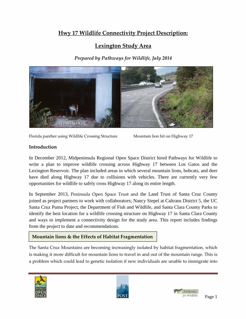
In the long term, as funding allows, a land bridge could facilitate wildlife movement
across Highway 17 in the north section of the linkage. Figures A24 and A25 show areas along Highway 17 which would be highly suitable for a land bridge as four mountain lions have been hit in this area the past five years, along with bobcats and deer. Due to the topography of the landscape, with three ravines leading down from the Santa Cruz Mountains to Highway 17, animals are traveling to this area and being hit on the highway. Figures A24 and A25 were taken from Lexington County Park hiking trail. This trail is used consistently by hikers and bicyclists. However, the Bay Area Puma Project reported that one of the UCSC collared female mountain lions, 11F, has crossed at Highway 17 from a Mid Peninsula Open Space property to this county park trail at this location.
17
Within the south section of the study area, there are no culverts, bridges, or underpasses available for animals to use. The south section does not seem as permeable for wildlife to move across Highway 17 as the midsection of the linkage (Figure A26).
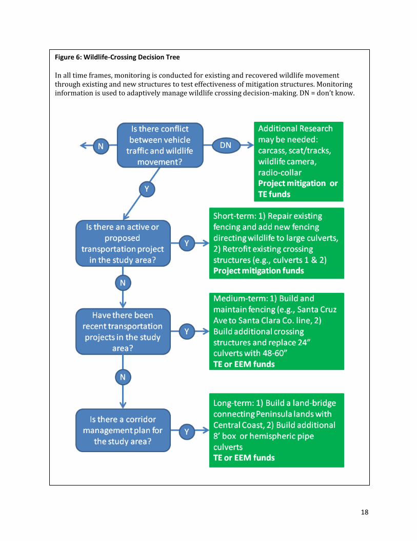
5. Priority Assessment:
There are a variety of actions that could be taken in the short-term, medium term, and long-term to reduce risks of wildlife-vehicle collision along highway 17. (figure 6). These can be thought of in terms of a decision-tree, relating the recommended actions to project development, design, and programming, and the Transportation Enhancement program.
Short term: 1) fencing – repair existing fencing and add new fencing directing
wildlife to large culverts, like culvert 3. 2) crossing structures – retrofit culverts 1 and 2 to permit wildlife passage. Currently neither culvert seems to be capable of passing wildlife.
Medium term: 1) build and maintain fencing between Santa Cruz Ave and the Santa
Clara County line directing wildlife to existing and new crossings; 2) crossing structures – build additional culverts, or replace existing 24” culverts with larger >48” – 60” culverts.
Long-term: 1) build a land-bridge to connect Peninsula lands with the Central Coast.
Build additional 8’ box culverts, or similar hemispheric pipe structures, to accommodate wildlife movement.
18
Figure 6: Wildlife-Crossing Decision Tree
In all time frames, monitoring is conducted for existing and recovered wildlife movement through existing and new structures to test effectiveness of mitigation structures. Monitoring information is used to adaptively manage wildlife crossing decision-making. DN = don’t know.
19
6. Funding
In the short-term, funding for these mitigation activities could and should come from construction budgets for projects programmed along highway 17. Highway-related wildlife mortality and population fragmentation are easily anticipated impacts of highways in naturally-vegetated areas. Existing and new highway capacity and facilities will continue to have impacts without the kinds of mitigation described here.
Potential funding for certain modifications to facilitate wildlife movement could
come from the Federal Highway Administration through the Transportation Enhancement grant program. This program was put in place to provide road infrastructure improvements on existing highways. The large number of wildlife-vehicle collisions along Highway 17 within the study area demonstrates that there is a human-wildlife safety issue which could be partially addressed through TE grants. Helpful information about how to access this funding and working on implementing connectivity in this area can be accessed through the links below:
FHWA Critter Crossings: http://www.fhwa.dot.gov/environment/wildlifecrossings/ Large Carnivore Crossings: http://www.carnivoresafepassage.org/index.htm Wildlife Crossings Toolkit: www.wildlifecrossings.info/contact.htm
7. Monitoring Effectiveness
Detection and Monitoring Methods
A number of detection and monitoring methods exist which can help determine where animals cross roads and where they occur on the landscape. These are equally applicable for planning purposes and for post monitoring of installations to determine use and success. More rigorous data collection that can help to determine fine scale movements and habitat use by animals depends on radio-telemetry. The more passive methods, including cameras, detection dogs, hair snares, track plates, and snow tracking, are all noninvasive, and do not necessitate interaction with animals.
There are two general approaches to detecting wildlife on the landscape and their
movements: trapping the animals to attach collars or tags and discovering where those individuals move, and surveying animals with less invasive methods.
Non-invasive methods, including fecal pellet surveys, scat sniffing dogs, track plates, hair snares, road kill carcass surveys, hunter surveys, and camera monitoring are lower in cost than GPS collars and can provide multiple species and region surveys for costs similar to a single species GPS-collar study. For site monitoring where cost, or more precise estimates of dates and frequencies of species use of an area are considerations, these more passive methods with longer latent times to detection may prove just as effective, if deployed for the correct length of time in the most opportune season(s).

20
Appendix
Figure # Site within
Linkage Description
1 North section Concrete median
2 Midsection Concrete median
3 South section Concrete median
4 Midsection Fence down above culvert 2 looking from highway down to
Lexington County Park
5 Midsection At road where fence is down.
6 North section Site where Puma was hit at southbound Hwy 17 on 2-9-2011,
northbound view.
7 North section Site where Puma was hit at southbound Hwy 17on 2-9-2011,
southbound view.
8 North section Highway median where Puma was hit, east view.
9 North section Site where the female mountain lion was hit on 2-9-2011.
10 North section Ravine behind where the Puma was hit, west view.
11 North section Culvert 1, west side, located at ravine, not visible all the way
through.
12 North section East side of Culvert 1, which has a high drop off from the entrance.
13 North section Culvert 2, east side, not visible through.
14 Midsection Culvert 3, west side, visible through.
15 Midsection Culvert 3, east side at Lexington Reservoir.
16 South section Alma Bridge, west side.
17 South section North side of Alma Bridge.
18 South section West view from Alma Bridge.
19 South section East view from Alma Bridge looking into Lexington County Park and
Reservoir.
20 Midsection Culvert 3, west side, picture taken in July 2010.
21 Midsection West view of Culvert 3.
22 Midsection East view of Culvert 3 on east side leading into Lexington County
Park and Reservoir.
23 Midsection Trail running north behind Culvert 3 on east side. Trail spans
around reservoir.
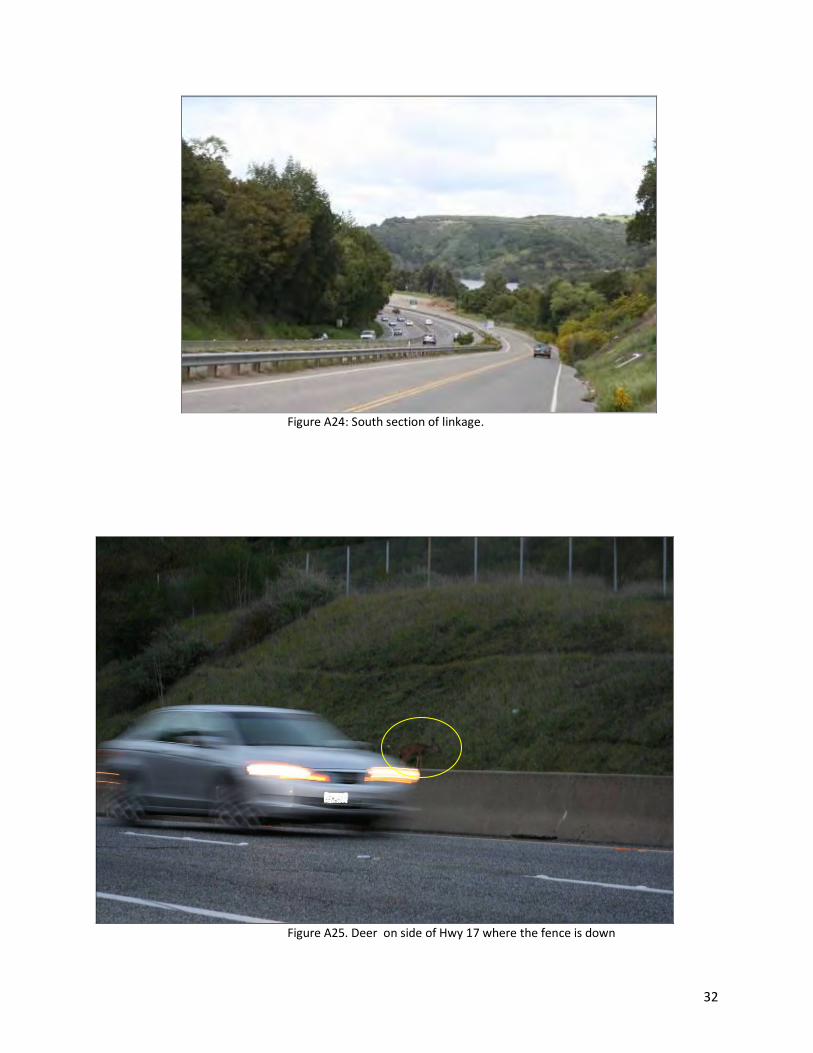
24 South section South section of linkage.
25 South section Deer on side of the highway where the fence is down.

21
Figure A1: Concrete median in Highway 17, north view.
Figure A2: Concrete median in Highway 17, south view.
22
Figure A4: Fence down above Culvert 2 looking from highway down to
Lexington County Park.
Figure A5: Standing at road where fence is down.

23
Figure A6: Site where Puma was hit at southbound Hwy 17 on 2-9-2011, northbound view.
Figure A7: Site where Puma was hit at southbound Hwy 17on 2-9-2011, southbound view.
24
Figure A8: Highway median where Puma was hit, east view.
Figure A9: Site where the male mountain lion was hit on 2-9-2011.
25
Figure A10: Ravine behind where the Puma was hit, west view.
Figure A11: Culvert 1, west side, located at ravine, not visible all the way through.

26
Figure A13: Culvert 2, east side, not visible through.
Figure A14: Culvert 3, west side, visible through.
27
Figure A15: Culvert 3, east side at Lexington Reservoir.
Figure A16: Alma Bridge, west side.
28
Figure A17: North side of Alma Bridge. Potential site for adding in additional lane for wildlife.
Figure A18: West view from Alma Bridge.
29
Figure A19: East view from Alma Bridge looking into Lexington County Park and Reservoir.
Figure A20: Culvert 3, west side, picture taken in July 2010.
30
Figure A21: West view of Culvert 3.
Figure A22: East view of Culvert 3 on east side leading into Lexington County Park and Reservoir.

31
Figure A23: Trail on the east side of Culver 3, that encircles the reservoir and provides access to the Mid
Peninsula Open Space Preserve.
.
32
Figure A24: South section of linkage.
Figure A25. Deer on side of Hwy 17 where the fence is down
Page 1
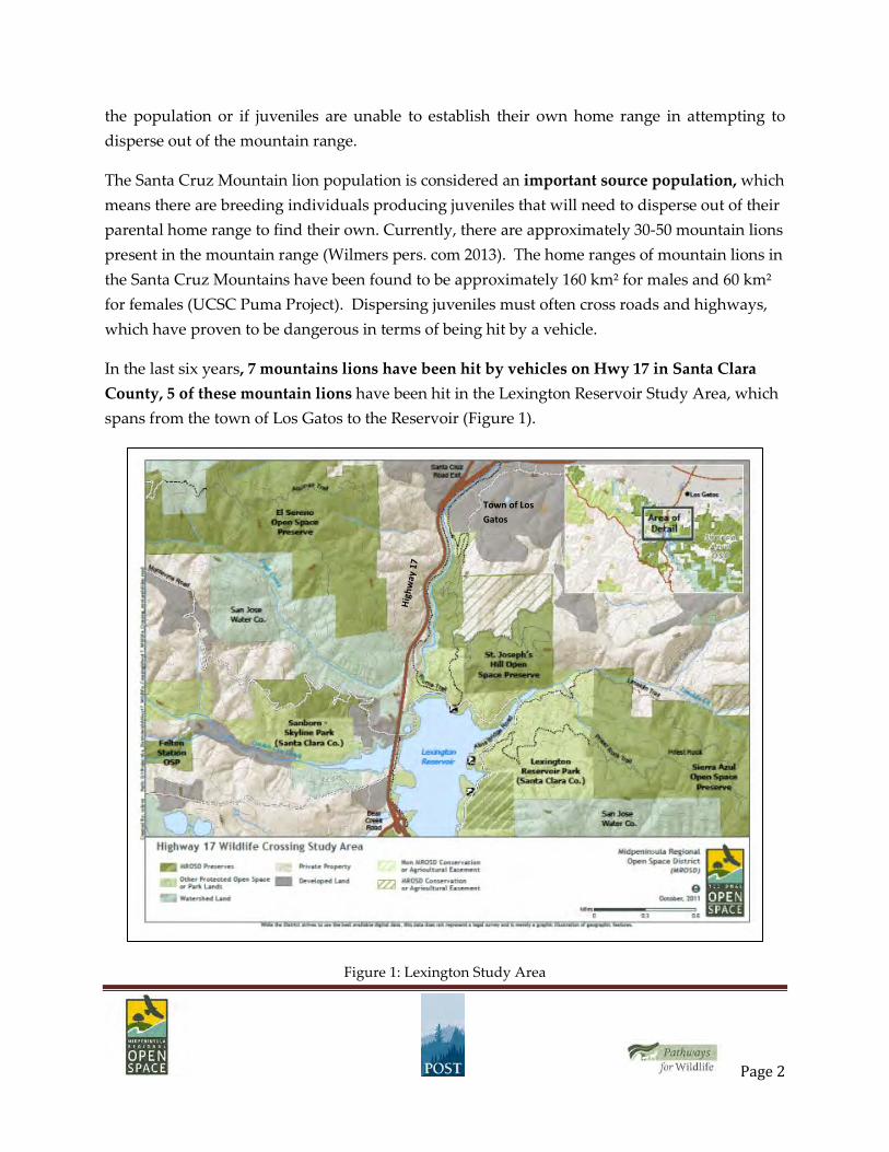
Hwy 17 Wildlife Connectivity Project Description:
Lexington Study Area
Prepared by Pathways for Wildlife, July 2014
Florida panther using Wildlife Crossing Structure Mountain lion hit on Highway 17
Introduction
In December 2012, Midpeninsula Regional Open Space District hired Pathways for Wildlife to write a plan to improve wildlife crossing across Highway 17 between Los Gatos and the Lexington Reservoir. The plan included areas in which several mountain lions, bobcats, and deer have died along Highway 17 due to collisions with vehicles. There are currently very few opportunities for wildlife to safely cross Highway 17 along its entire length.
In September 2013, Peninsula Open Space Trust and the Land Trust of Santa Cruz County joined as project partners to work with collaborators; Nancy Siepel at Caltrans District 5, the UC Santa Cruz Puma Project, the Department of Fish and Wildlife, and Santa Clara County Parks to identify the best location for a wildlife crossing structure on Highway 17 in Santa Clara County and ways to implement a connectivity design for the study area. This report includes findings from the project to date and recommendations.
The Santa Cruz Mountains are becoming increasingly isolated by habitat fragmentation, which is making it more difficult for mountain lions to travel in and out of the mountain range. This is a problem which could lead to genetic isolation if new individuals are unable to immigrate into
Mountain lions & the Effects of Habitat Fragmentation
Page 2
the population or if juveniles are unable to establish their own home range in attempting to disperse out of the mountain range.
The Santa Cruz Mountain lion population is considered an important source population, which means there are breeding individuals producing juveniles that will need to disperse out of their parental home range to find their own. Currently, there are approximately 30-50 mountain lions present in the mountain range (Wilmers pers. com 2013). The home ranges of mountain lions in the Santa Cruz Mountains have been found to be approximately 160 km² for males and 60 km² for females (UCSC Puma Project). Dispersing juveniles must often cross roads and highways, which have proven to be dangerous in terms of being hit by a vehicle.
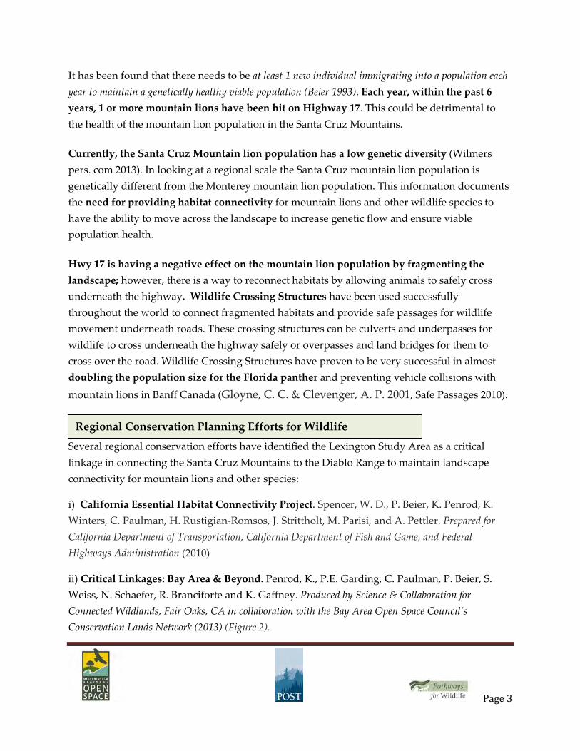
In the last six years, 7 mountains lions have been hit by vehicles on Hwy 17 in Santa Clara County, 5 of these mountain lions have been hit in the Lexington Reservoir Study Area, which spans from the town of Los Gatos to the Reservoir (Figure 1).
Figure 1: Lexington Study Area
Town of Los Gatos
Page 3
It has been found that there needs to be at least 1 new individual immigrating into a population each year to maintain a genetically healthy viable population (Beier 1993). Each year, within the past 6 years, 1 or more mountain lions have been hit on Highway 17. This could be detrimental to the health of the mountain lion population in the Santa Cruz Mountains.
Currently, the Santa Cruz Mountain lion population has a low genetic diversity (Wilmers pers. com 2013). In looking at a regional scale the Santa Cruz mountain lion population is genetically different from the Monterey mountain lion population. This information documents the need for providing habitat connectivity for mountain lions and other wildlife species to have the ability to move across the landscape to increase genetic flow and ensure viable population health.
Hwy 17 is having a negative effect on the mountain lion population by fragmenting the landscape; however, there is a way to reconnect habitats by allowing animals to safely cross underneath the highway. Wildlife Crossing Structures have been used successfully throughout the world to connect fragmented habitats and provide safe passages for wildlife movement underneath roads. These crossing structures can be culverts and underpasses for wildlife to cross underneath the highway safely or overpasses and land bridges for them to cross over the road. Wildlife Crossing Structures have proven to be very successful in almost doubling the population size for the Florida panther and preventing vehicle collisions with mountain lions in Banff Canada (Gloyne, C. C. & Clevenger, A. P. 2001, Safe Passages 2010).
Several regional conservation efforts have identified the Lexington Study Area as a critical linkage in connecting the Santa Cruz Mountains to the Diablo Range to maintain landscape connectivity for mountain lions and other species:
i) California Essential Habitat Connectivity Project. Spencer, W. D., P. Beier, K. Penrod, K. Winters, C. Paulman, H. Rustigian-Romsos, J. Strittholt, M. Parisi, and A. Pettler. Prepared for California Department of Transportation, California Department of Fish and Game, and Federal Highways Administration (2010)
ii) Critical Linkages: Bay Area & Beyond. Penrod, K., P.E. Garding, C. Paulman, P. Beier, S. Weiss, N. Schaefer, R. Branciforte and K. Gaffney. Produced by Science & Collaboration for Connected Wildlands, Fair Oaks, CA in collaboration with the Bay Area Open Space Council’s Conservation Lands Network (2013) (Figure 2).
Regional Conservation Planning Efforts for Wildlife

Page 4
Figure 2: Bay Area Critical Linkage Design for the Santa Cruz Mountains to the Diablo Range.
iii) Caltrans District 5 Wildlife Corridor and Habitat Connectivity Plan: Caltrans Region 5 biologist, Nancy Siepel, has been instrumental in advancing the project. In partnership with UC Davis, Ms. Siepel recently completed a first district-wide planning effort to evaluate and prioritize potential mitigation projects for Santa Cruz, San Luis Obispo, San Benito and Santa Clara counties. Throughout these four counties, Highway 17 was identified as one of the high-priority highways for addressing wildlife connectivity issues (Regional Wildlife Corridor and Habitat Connectivity Plan, Huber, P.R, Thorne, J. H, Bjorkman, J, and R.M. Boynton. Prepared for California Department of Transportation, District 5 (2014).
iiii. Midpeninsula Regional Open Space District Vision Plan: Top 25 Future Open Space Projects: Priority Action # 20. Wildlife Passage and Ridge Trail Improvements to provide safe wildlife corridors across Hwy 17 and add a new Bay Area Ridge Trail crossing. This Priority Action was among the highest rated actions for future implementation as rated by the public through the Vision Plan planning process, which involved over 2000 public participants, technical experts, partners, stakeholders, and different user groups. MidPen’s Board of
Page 5
Directors adopted this Priority Action as a priority for funding through a general obligation bond funding measure that was passed by over 2/3 of the region’s voters in June 2012.
The goals of this project meet the objectives of these regional conservation planning efforts in implementing the linkage designs through both improving the ability for wildlife to safely cross underneath Highway 17 and connecting existing open space owned by Midpeninsula Regional Open Space District and Santa Clara County Parks.
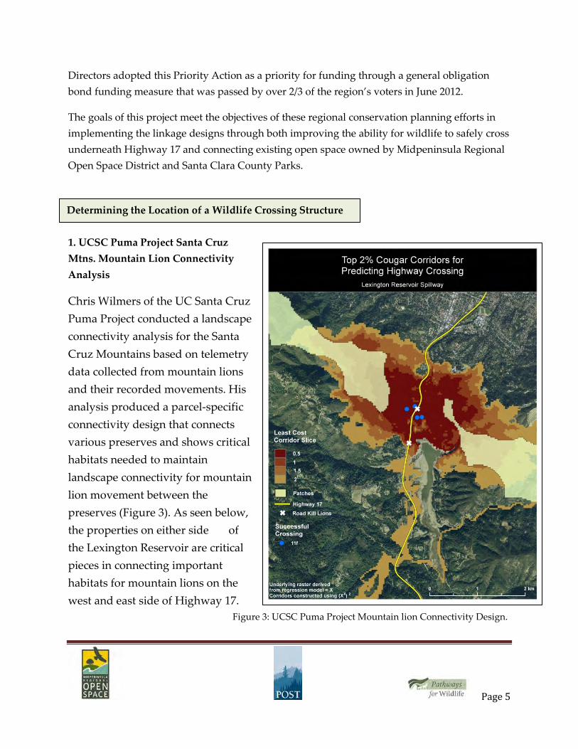
1. UCSC Puma Project Santa Cruz Mtns. Mountain Lion Connectivity Analysis
Chris Wilmers of the UC Santa Cruz Puma Project conducted a landscape connectivity analysis for the Santa Cruz Mountains based on telemetry data collected from mountain lions and their recorded movements. His analysis produced a parcel-specific connectivity design that connects various preserves and shows critical habitats needed to maintain landscape connectivity for mountain lion movement between the preserves (Figure 3). As seen below, the properties on either side of the Lexington Reservoir are critical pieces in connecting important habitats for mountain lions on the west and east side of Highway 17. Figure 3: UCSC Puma Project Mountain lion Connectivity Design.
Determining the Location of a Wildlife Crossing Structure
Page 6
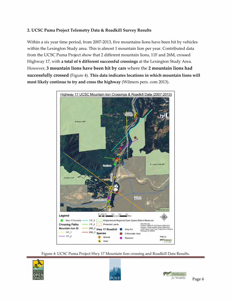
2. UCSC Puma Project Telemetry Data & Roadkill Survey Results
Within a six year time period, from 2007-2013, five mountains lions have been hit by vehicles within the Lexington Study area. This is almost 1 mountain lion per year. Contributed data from the UCSC Puma Project show that 2 different mountain lions, 11F and 26M, crossed Highway 17, with a total of 6 different successful crossings at the Lexington Study Area. However, 3 mountain lions have been hit by cars where the 2 mountain lions had successfully crossed (Figure 4). This data indicates locations in which mountain lions will most likely continue to try and cross the highway (Wilmers pers. com 2013).
Figure 4: UCSC Puma Project Hwy 17 Mountain lion crossing and Roadkill Data Results.
Page 7
3. Roadkill Data: Deer, bobcats, coyotes, and gray fox
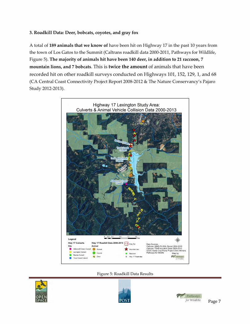
A total of 189 animals that we know of have been hit on Highway 17 in the past 10 years from the town of Los Gatos to the Summit (Caltrans roadkill data 2000-2011, Pathways for Wildlife, Figure 5). The majority of animals hit have been 140 deer, in addition to 21 raccoon, 7 mountain lions, and 7 bobcats. This is twice the amount of animals that have been recorded hit on other roadkill surveys conducted on Highways 101, 152, 129, 1, and 68 (CA Central Coast Connectivity Project Report 2008-2012 & The Nature Conservancy’s Pajaro Study 2012-2013).
Figure 5: Roadkill Data Results

Page 8
A substantial number of these animals were hit at the ravine in which Trout Creek runs underneath Highway 17. For example, 37 deer, 5 mountain lions, and 6 bobcats have been hit within the Lexington Study Area (Figure 6). Trout Creek is a significant tributary, which runs from the Santa Cruz Mountains under Highway 17 to the Los Gatos Creek in Santa Clara County Park. Midpeninsula Regional Open Space District has made significant conservation investments on both sides of Highway 17 in creating a linkage of connected habitats from the Santa Cruz Mountains to the Sierra Azul. There is an existing culvert at Trout Creek, although it is not being used by animals (See Camera Study section for more information).
Figure 6: Roadkill Data Results within the Lexington Study Area.

Page 9
This location is considered a road kill hot spot, where multiple species of animals are consistently hit on the highway. This could be due to animals attempting to cross the highway to access water at the Lexington Reservoir, juveniles dispersing out of their parental range, or animals traveling to find mates.
Medians, which have been installed to prevent head-on collisions between vehicles, pose a problem for wildlife that has been attempting to cross the highway. Medians are a barrier to wildlife movement across roads. Animals tend to become trapped at the median wall and have a high probability of becoming hit by a vehicle.
These medians increase the need for a wildlife crossing to make the highway permeable for wildlife movement by installing safe passages for them to travel underneath the road (Safe Passages, 2010). Highway 17 lacks the appropriate culverts and bridges for animals to cross underneath the highway. The inclusion of a wildlife crossing structure along Highway 17 would greatly increase the safety of drivers and wildlife, (Safe Passages 2010, Beier 1995).
4. Camera Study Data: Highway 17 Trout Creek & Ravine Culverts
There are two existing culverts at the ravine where Trout Creek is located. The culverts have been monitored to record if animals are using them to travel underneath the highway. Since November 2012, in the last 6 months, there has been no animals documented using these culverts. However, 118 animals have been recorded approaching the culverts on both sides of

Page 10
the highway but did not travel through them (Chart 2). This is most likely due to the lack of visibility through the culverts. Several studies have shown that there is a high preference of culvert use by animals if there is a clear line of visibility through it (Safe Passages, 2007).
Animal
Northbound Total
Southbound Total
Total by Species
Bobcat 1 0 1 Deer 22 1 23 Gray fox 17 1 18 Raccoon 62 1 63 Skunk 5 0 5 Opossum 1 0 1 Total 108 3 111
Chart 2: Trout Creek Culvert Data Results
The data collected from the cameras shows that animals are routinely approaching the culverts and using the habitat on either side of the culverts on a consistent basis, which indicates this location is a highly suitable site for installation of a wildlife crossing structure (Figures 7 & 8). For example, there has not been any deer recorded at the Lexington Culvert; however, there have been 23 deer recorded at the Trout Creek Culvert and 7 deer at the Ravine culvert. These deer approached the culverts but did not use them to travel underneath the highway.
Figure 7: Deer at Trout Creek Culvert 12/5/2013 Figure 8: Deer at Trout Creek Culvert 4/2/2014
Animal Ravine Culvert Southbound
Deer 7 Total 7
Page 11
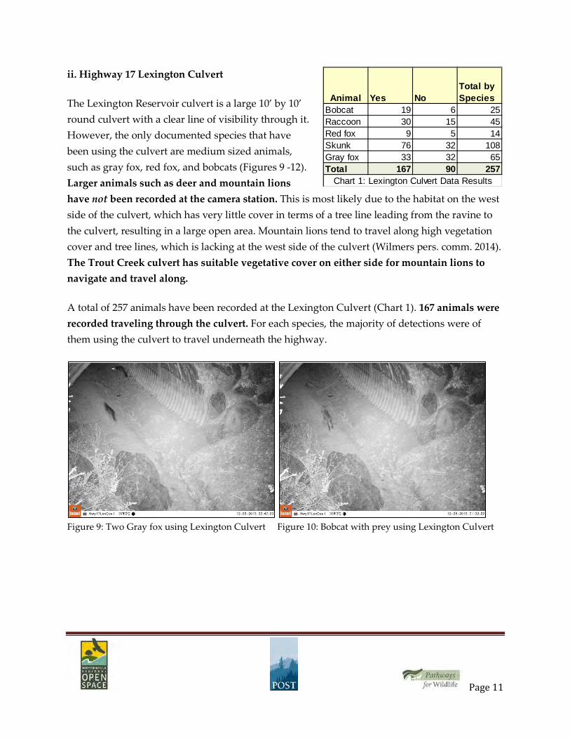
ii. Highway 17 Lexington Culvert
The Lexington Reservoir culvert is a large 10’ by 10’ round culvert with a clear line of visibility through it. However, the only documented species that have been using the culvert are medium sized animals, such as gray fox, red fox, and bobcats (Figures 9 -12). Larger animals such as deer and mountain lions have not been recorded at the camera station. This is most likely due to the habitat on the west side of the culvert, which has very little cover in terms of a tree line leading from the ravine to the culvert, resulting in a large open area. Mountain lions tend to travel along high vegetation cover and tree lines, which is lacking at the west side of the culvert (Wilmers pers. comm. 2014). The Trout Creek culvert has suitable vegetative cover on either side for mountain lions to navigate and travel along.
A total of 257 animals have been recorded at the Lexington Culvert (Chart 1). 167 animals were recorded traveling through the culvert. For each species, the majority of detections were of them using the culvert to travel underneath the highway.
Figure 9: Two Gray fox using Lexington Culvert Figure 10: Bobcat with prey using Lexington Culvert
Animal Yes NoTotal by Species
Bobcat 19 6 25Raccoon 30 15 45Red fox 9 5 14Skunk 76 32 108Gray fox 33 32 65Total 167 90 257 Chart 1: Lexington Culvert Data Results

Page 12
Figure 11: Bobcat at Lexington Culvert Figure 12: Red fox at Lexington Culvert
The scientific literature and various case studies have shown that a 10’h by 20’w box culvert was used in many locations throughout North America by large mammals, such as deer and mountain lions to cross underneath various highways (Safe Passages, 2010). In Florida, large 8’h by 25’w box culverts were used successfully as highway crossings structures for panthers and black bears. The cost of box culverts is modest compared to open-span bridges, bridge extensions, or wildlife overpasses (Safe Passage, 2007). Directional fencing would also be used on either side of the highway to prevent animals from crossing on top of the roadway and to funnel animals into the culvert.
The importance for providing habitat connectivity for wildlife are three fold: 1) Animals need to be able to access resources such as water and food 2) Juveniles need to have the ability to travel through the landscape to establish their own home range 3) To maintain genetically healthy populations, animals must be able to find viable mates.
Highway 17 currently lacks the appropriate culverts and bridges for animals to cross underneath the highway as animals are routinely hit on the highway. The data collected from the UCSC Puma Project and the roadkill data all indicate that the ravine in which Trout Creek runs underneath Highway 17 is the main location in which mountain lions and other wildlife species are attempting to cross Highway 17. Based on the data collected by: 1) UCSC Puma Project on mountain lion movement, 2) Roadkill Data and 3) Camera Stations at the culverts,
Summary

Page 13
the installation of a wildlife crossing structure, such as a 10’h by 20’w box culvert is needed to help animals safely cross underneath the highway. Several regional conservation plans have also identified the Lexington Study Area as a critical linkage for wildlife movement between the Santa Cruz Mountains and the Diablo Range. The data collected from this project has identified the ravine in which Trout Creek runs underneath Highway 17, as the best location in which to install a wildlife crossing structure.
The installation of a 10’h by 20’w box culvert with directional fencing to guide them to the crossing structure would greatly enhance the ability for wildlife to safely cross under Highway 17and provide a permanent solution for preventing animal-vehicle collisions at this location. This win-win solution would also help maintain healthy animal populations by increasing the ability for genetic flow to occur between populations.
Project Costs
The cost of the culvert includes $1.5 million for construction and $1.0 million for support costs, which would include environmental documents, technical studies, engineering designs, and permits (Nancy Siepel pers. comm.). Directional fencing, to guide animals to the culverts, would also need to be installed as part of the connectivity design. Eight-foot deer fencing costs about $100,000/mile, including escape ramps and gates. Regular inspection and maintenance is a critical part of fence function and should be considered as part of the cost.
Funding to support the research and data collection by Pathways for Wildlife to produce this document has been provided by Midpeninsula Regional Open Space District (MROSD) and Peninsula Open Space Trust (POST).
Project Partners & Collaborators
The Project Partners; Midpeninsula Regional Open Space District (MROSD), The Land Trust of Santa Cruz County (LTSCC), Peninsula Open Space Trust (POST) and Pathways for Wildlife are working with Project Collaborators; UC Santa Cruz Puma Project, Department of Fish & Wildlife, Santa Clara County Parks and our Caltrans project partner, Nancy Siepel, Mitigation and Wildlife Connectivity Specialist at the Environmental Stewardship Branch, Caltrans District 5, to develop win-win solutions for reconnecting fragmented habitats on either side of Highway 17.
Next Steps: Constructing a Wildlife Undercrossing
Page 14
Beier, P. (1993). Determining minimum habitat areas and habitat corridors for cougars. Conservation Biology, 7(1), 94-108.
Beier, P. (1995). Dispersal of juvenile cougars in fragmented habitat. The Journal of Wildlife Management, 228-237.
CA Central Coast Connectivity Project Report 2008-2012, prepared by Pathways for Wildlife.
CA Central Coast Connectivity Project Annual Report 2013-2014, prepared by Pathways for Wildlife.
Critical Linkages: Bay Area & Beyond. Penrod, K., P.E. Garding, C. Paulman, P. Beier, S. Weiss, N. Schaefer, R. Branciforte and K. Gaffney. Produced be Science & Collaboration for Connected Wildlands, Fair Oaks, CA in collaboration with the Bay Area Open Space Council’s Conservation Lands Network (2013).
Forman, R. T. (2010). Safe passages: highways, wildlife, and habitat connectivity. J. P. Beckmann, A. P. Clevenger, M. Huijser, & J. A. Hilty (Eds.). Island Press.
Foster, M. L., & Humphrey, S. R. (1995). Use of highway underpasses by Florida panthers and other wildlife. Wildlife Society Bulletin, 95-100.
Gloyne, C. C., & Clevenger, A. P. (2001). Cougar Puma concolor use of wildlife crossing structures on the Trans-Canada highway in Banff National Park, Alberta. Wildlife Biology, 7(2), 117-124.
Highway 17 Mountain lion Crossings & Culvert Overlay Analysis. August 2013. Prepared for the Land Trust of Santa Cruz County by Pathways for Wildlife in collaboration with the UC Santa Cruz Puma Project.
Literature Cited
Page 15
Hilty, J. A., Lidicker Jr, W. Z., & Merenlender, A. (2006). Corridor ecology: the science and practice of linking landscapes for biodiversity conservation. Island Press.
Safe Passages: A User’s Guide to Developing Effective Highway Crossings for Carnivores and Other Wildife. (2007). Prepared by Bill Ruediger and Monique DiGiorgio, Southern Rockies Ecosystem Project.
The Nature Conservancy’s Pajaro Study (2012-2013), prepared by Pathways for Wildlife.
U.S. Department of Transportation Federal Highway Administration 2013, Highway Safety Improvement Program Statistics, retrieved from http://safety.fhwa.dot.gov/
Wilmers, C. C., Wang, Y., Nickel, B., Houghtaling, P., Shakeri, Y., Allen, M. L., & Williams, T. (2013). Scale dependent behavioral responses to human development by a large predator, the puma.
Wilmers, C. 2014, Santa Cruz Puma Project website, retrieved from http://santacruzpumas.org/