hillsboro airport wildlife hazard management plan airport wildlife hazard management plan updated...
TRANSCRIPT
Hillsboro Airport
Wildlife Hazard Management Plan
Updated January 2015
Submitted by: Nick Atwell
FAA Qualified Airport Biologist Per AC 105/5200-36A
Contributing Aviation Wildlife Technicians: John Hilterbrand, Casey Kaffka, Alex Lauber, and Erick Shore

ii
This page intentionally left blank.
<< Signature on File >>
<< Signature on File >>
<< Signature on File >>
v
Airport Certification Manual Reference
The Port of Portland has completed a Wildlife Hazard Assessment and a Wildlife Hazard Management Plan (WHMP) for Hillsboro Airport (HIO) that conforms with 14 CFR Part 139.337. While HIO is not a Part 139 certified airport, the Port decided to address the wildlife hazard issues at HIO using the same Part 139 compliant model developed at PDX. The HIO WHMP will be reviewed on a periodic basis to determine the effectiveness of the program. Appropriate changes will be made as the need arises. This review will take place annually.

vi
This page intentionally left blank.
vii
TABLE OF CONTENTS
1 INTRODUCTION ..................................................................................................................................................... 1
1.1. Purpose and Application ............................................................................................................... 1
1.1.1. National Perspective.................................................................................................................... 1
1.1.2. Local Perspective .......................................................................................................................... 2
1.1.3. WHMP Objectives and Principles ........................................................................................... 3
1.2. Wildlife Hazard Assessment ........................................................................................................ 3
1.2.1. Wildlife Strikes ............................................................................................................................... 4
1.2.2. Wildlife Species of Concern ...................................................................................................... 5
1.3. WHMP Administration ................................................................................................................... 6
1.3.1. Review and Revision ................................................................................................................... 6
2 APPLICABLE LAWS, REGULATIONS AND POLICIES ............................................................................ 10
2.1. FAA Requirements ........................................................................................................................ 10
2.1.1. Airport Grant Assurances ....................................................................................................... 10
2.1.2. AC 150/5200-33B ..................................................................................................................... 11
2.2. Other Applicable Federal Regulations ........................................................................................ 12
2.2.1. National Environmental Policy Act .................................................................................... 12
2.2.2. Clean Water Act, Section 404 ................................................................................................ 12
2.2.3. Endangered Species Act (16 USC 1531-1543, Endangered Species Act of 1973, As Amended)............................................................................................................................................ 12
2.2.4. Migratory Bird Treaty Act ...................................................................................................... 13
2.2.5. Bald and Golden Eagle Protection Act ............................................................................... 13
2.2.6. Federal Insecticide, Fungicide, and Rodenticide Act ................................................... 14
2.2.7. Executive Order 11988, Floodplain Management ........................................................ 14
2.3. State Of Oregon Regulations............................................................................................................ 14
2.3.1. Oregon Removal Fill Law ........................................................................................................ 14
2.3.2. Oregon Endangered Species Act .......................................................................................... 15
2.3.3. Oregon Administrative Rules 635-43-0000 to 0045 [Scientific Taking Permit]15
2.3.4. Oregon Administrative Rules 635-043-051 to 0115 [Take or Harass Wildlife Permit] ....................................................................................................................................................... 16
2.3.5. Oregon Administrative Rules 837-12-305 to 370 [Agricultural Fireworks Permit] ....................................................................................................................................................... 16
viii
2.3.6. Oregon Revised Statute, ORS 836.623 .............................................................................. 16
2.3.7. State Planning Regulations .................................................................................................... 17
2.4. Local Regulations ................................................................................................................................. 17
2.4.1. Clean Water Services Design and Construction Standards ...................................... 17
2.4.2. City of Hillsboro, Significant Natural Resources Overlay .......................................... 18
2.4.3. City of Hillsboro, Habitat Friendly Development ......................................................... 20
2.4.4. City of Hillsboro, 7.08.010 Discharge of Weapons ....................................................... 20
2.5. Permits ..................................................................................................................................................... 20
2.6. Port of Portland Goals, Policies and Procedures ..................................................................... 22
2.6.1. Port Mission Statement: .......................................................................................................... 22
2.7. Discussion of Port Policies ............................................................................................................... 24
3 PROGRAM ORGANIZATION, ROLES AND RESPONSIBILITIES ........................................................ 26
3.1. Program Organization ...................................................................................................................... 26
3.2 Roles and Responsibilities of the Airports Operations Manager ...................................... 27
3.3. Roles and Responsibilities of other Port Staff.......................................................................... 27
3.3.1. General Aviation Manager ...................................................................................................... 27
3.3.2. Aviation Wildlife Manager ..................................................................................................... 28
3.3.3. General Aviation Operations Supervisor ......................................................................... 29
3.3.4. Aviation Wildlife Technicians (or outside contract resources) .............................. 30
3.4. Roles and Responsibilities of Other Port Departments ....................................................... 31
3.4.1. HIO Maintenance Staff ............................................................................................................. 31
4 IMPLEMENTATION STRATEGIES ................................................................................................................ 32
4.1. Risk Evaluation Process .................................................................................................................... 32
4.2. Zone Concept ......................................................................................................................................... 32
4.2.1. Primary Zone ............................................................................................................................... 33
4.2.2. Secondary Zone .......................................................................................................................... 33
4.3. Management Area Strategies .......................................................................................................... 38
4.4. General Operational Strategies ...................................................................................................... 42
4.5. Project Evaluation ............................................................................................................................... 43
4.5.1. Project Screening for Proposed Development ............................................................... 43
4.5.2. Monitoring and Evaluation .................................................................................................... 44
5 RISK MANAGEMENT TECHNIQUES AND PROTOCOLS ...................................................................... 46
5.1. Wildlife Control Procedures .......................................................................................................... 46
5.1.1. Personnel & Communications ............................................................................................. 47
5.1.2. Vehicles ......................................................................................................................................... 47
ix
5.1.3. Wildlife Surveys ........................................................................................................................ 47
5.1.4. Data Collection Procedure .................................................................................................... 47
5.1.5. Hazing and Harassment ......................................................................................................... 49
5.1.6. Raptor Trapping and Relocation ........................................................................................ 55
5.1.7. Avian Nest Intervention ......................................................................................................... 56
5.1.8. Lethal Action ............................................................................................................................... 56
5.2. Habitat Modification ......................................................................................................................... 62
5.2.1. Port-Owned Property.............................................................................................................. 62
5.2.2. Non-Port Owned Property .................................................................................................... 63
5.2.3. Water Management ................................................................................................................. 64
5.2.4. Vegetation Management ........................................................................................................ 67
5.2.5 Structure Management ............................................................................................................. 75
5.2.6. Wildlife Food Source Management ................................................................................... 78
5.3. Research and Development ........................................................................................................... 81
5.4. WHMP Information and Education ............................................................................................. 82
5.4.1. Internal Port Communication ............................................................................................... 82
5.4.2. External Audiences .......................................................................................................................... 82
6 AIRPORT STAFF TRAINING REQUIREMENTS ........................................................................................ 86
6.1. Awareness Training ............................................................................................................................ 89
7 LITERATURE CITED .......................................................................................................................................... 90

x
This page intentionally left blank.
xi
LIST OF APPENDICES
APPENDIX A Wildlife Risk Model
APPENDIX B FAA Advisory Circular 150/5200-33, Hazardous Wildlife Attractants On or Near Airports
APPENDIX C PDX Wildlife Control Permits.
APPENDIX D HIO Wildlife Attractants Table
APPENDIX E Management Areas Tracking Table
APPENDIX F List of Plants Approved for Landscaping at HIO
APPENDIX G HIO Plant Variance Form
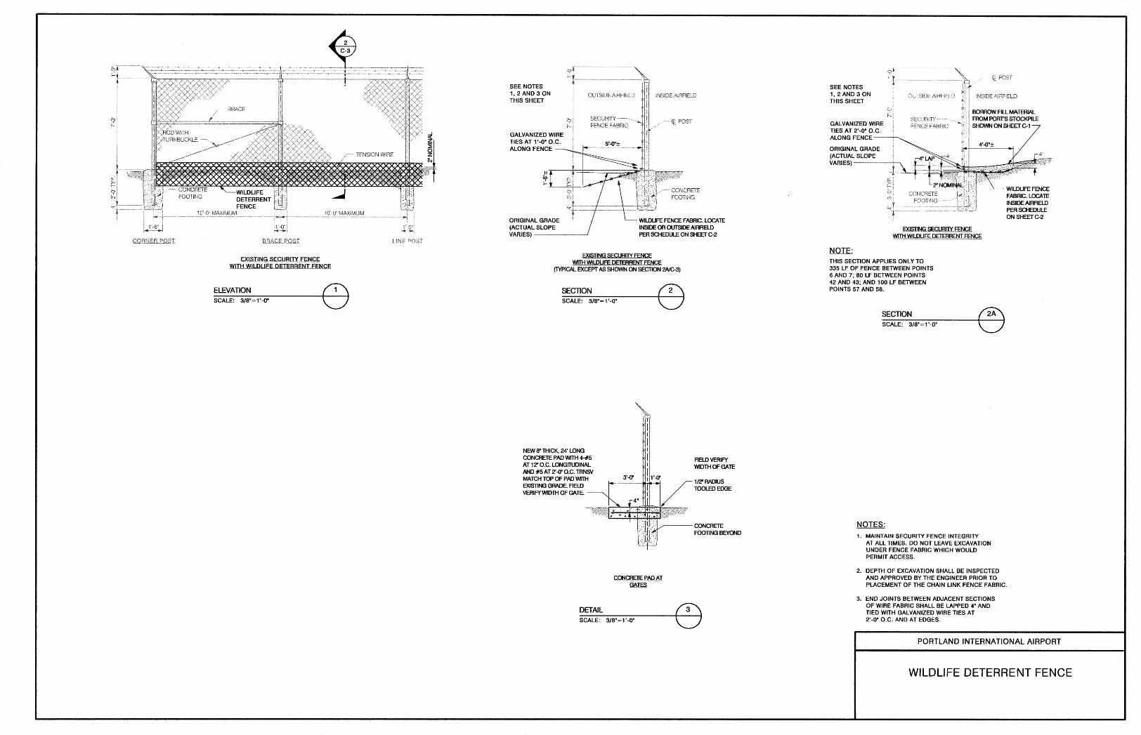
APPENDIX H PDX Wildlife Deterrent Fencing
xii
LIST OF FIGURES
Figure 1. Hillsboro Airport Vicinity Map ......................................................................................................... 7 Figure 2. Hillsboro Airport Facilities Map ...................................................................................................... 8 Figure 3. City of Hillsboro significant natural resource overlay and habitat benefit areas in the vicinity of HIO .................................................................................................................................................. 19 Figure 4. Representation of key decision-making factors considered by the Chief Operating Officer ......................................................................................................................................................................... 23 Figure 5. Port's General Aviation & Wildlife Management Program organization. ................... 26 Figure 6. Wildlife Habitats within the area of HIO. .................................................................................. 34 Figure 7. Primary Zone around HIO. .............................................................................................................. 35 Figure 8. Secondary Zone around HIO. ......................................................................................................... 36 Figure 9. Location of Wildlife Management Areas around HIO. ......................................................... 41 Figure 10. Lethal Action decision flowchart. .............................................................................................. 60 Figure 11. Overlapping crown structures that allow birds to move safely from tree to tree without exposure to predators or weather. ............................................................................................... 70 Figure 12. Conceptual landscaping design for the Secondary Zone. ................................................ 71 Figure 13. Example of a tree species that is attractive to birds due to horizontal branching structure. ................................................................................................................................................................... 71 Figure 14. Example of an ideal tree type for landscaping because of the minimal opportunities for perching/nesting due to vertical branching structure. ..................................... 71
xiii
LIST OF TABLES
Table 1. Current (2015) list of wildlife species of concern and monitor species at HIO............. 6 Table 2. Potential Federal, State, and Local permits required for wildlife hazard management practices at HIO. ......................................................................................................................... 21 Table 3. Aviation Grass Seed Specification. ................................................................................................. 72 Table 4. Agricultural activities associated with tall fescue grass seed farming at HIO............. 74 Table 5. Wildlife control measures & techniques evaluated and dismissed at PDX. ................. 81 Table 6. Wildlife Hazard Management program training requirements. ....................................... 86

xiv
This page intentionally left blank.
xv
ACRONYMS
AC – FAA Advisory Circular
ACHP – Advisory Council on Historic Preservation
ACM – Airport Certification Manual
AGL – Above Ground Level
AIRMAN – Airport Information Report Manager
ATC – Air Traffic Control
ATIS – Automatic Terminal Information Service
AOA – Air Operations Area
BATS – Business Analysis and Term Sheet Procedures
CATEX – Categorical Exclusion
CFR – Code of Federal Regulation
CWA – Clean Water Act
DEQ – Oregon Department of Environmental Quality
EA – Environmental Assessment
EMS – Environmental management system
EPA – U.S. Environmental Protection Agency
EIS – Environmental Impact Statement
FAA – Federal Aviation Administration
FAR – Federal Aviation Regulations
FWCA – Fish and Wildlife Coordination Act
FIFRA – Federal Insecticide, Fungicide, and Rodenticide Act
FOD – Foreign Object or Debris
GA – General Aviation
HIO – Hillsboro Airport
LCDC – Oregon Land Conservation and Development Commission
MBTA – Migratory Bird Treaty Act
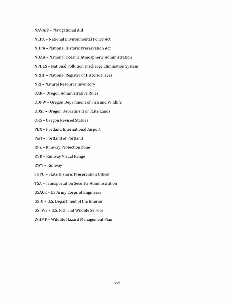
xvi
NAVAID – Navigational Aid
NEPA – National Environmental Policy Act
NHPA – National Historic Preservation Act
NOAA – National Oceanic Atmospheric Administration
NPDES – National Pollution Discharge Elimination System
NRHP – National Register of Historic Places
NRI – Natural Resource Inventory
OAR – Oregon Administrative Rules
ODFW – Oregon Department of Fish and Wildlife
ODSL – Oregon Department of State Lands
ORS – Oregon Revised Statues
PDX – Portland International Airport
Port – Portland of Portland
RPZ – Runway Protection Zone
RVR – Runway Visual Range
RWY – Runway
SHPO – State Historic Preservation Officer
TSA – Transportation Security Administration
USACE – US Army Corps of Engineers
USDI – U.S. Department of the Interior
USFWS – U.S. Fish and Wildlife Service
WHMP – Wildlife Hazard Management Plan
xvii
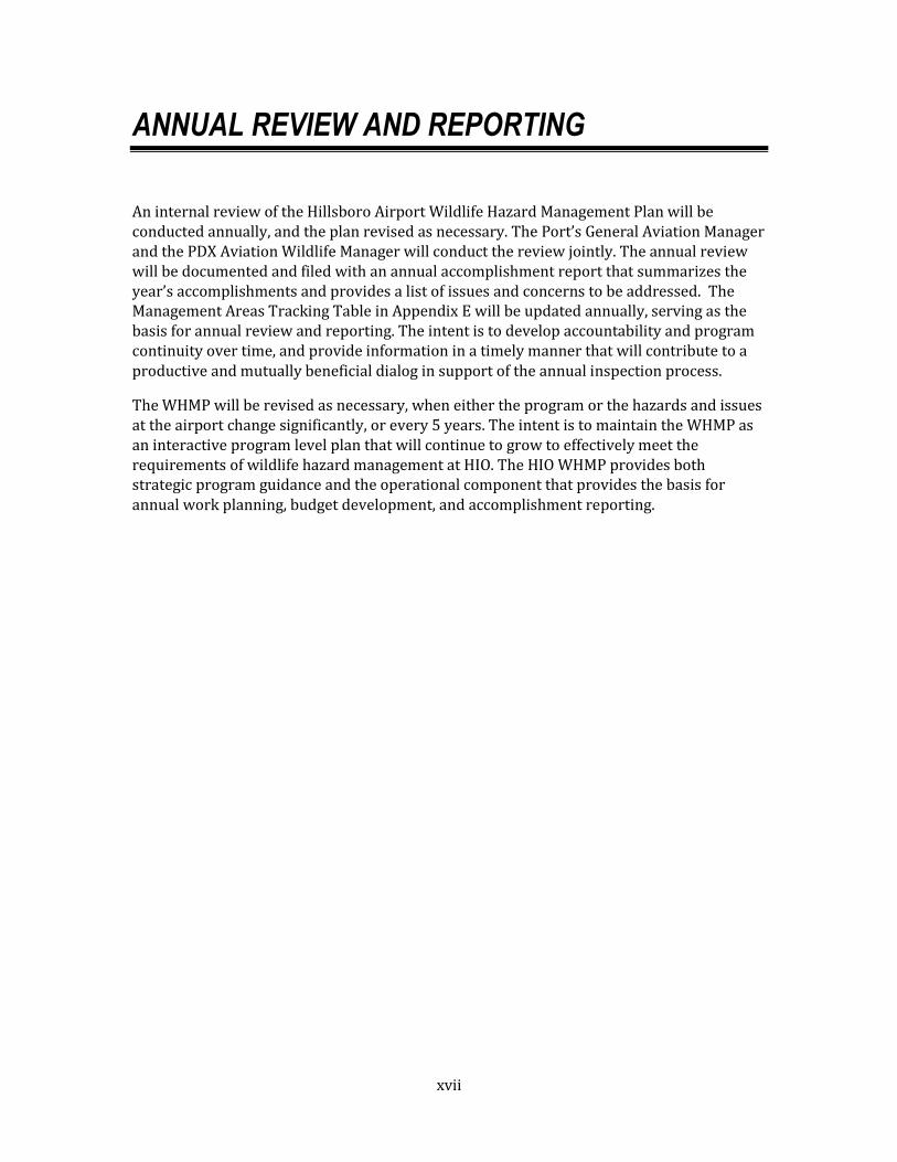
ANNUAL REVIEW AND REPORTING
An internal review of the Hillsboro Airport Wildlife Hazard Management Plan will be conducted annually, and the plan revised as necessary. The Port’s General Aviation Manager and the PDX Aviation Wildlife Manager will conduct the review jointly. The annual review will be documented and filed with an annual accomplishment report that summarizes the year’s accomplishments and provides a list of issues and concerns to be addressed. The Management Areas Tracking Table in Appendix E will be updated annually, serving as the basis for annual review and reporting. The intent is to develop accountability and program continuity over time, and provide information in a timely manner that will contribute to a productive and mutually beneficial dialog in support of the annual inspection process.
The WHMP will be revised as necessary, when either the program or the hazards and issues at the airport change significantly, or every 5 years. The intent is to maintain the WHMP as an interactive program level plan that will continue to grow to effectively meet the requirements of wildlife hazard management at HIO. The HIO WHMP provides both strategic program guidance and the operational component that provides the basis for annual work planning, budget development, and accomplishment reporting.
xviii
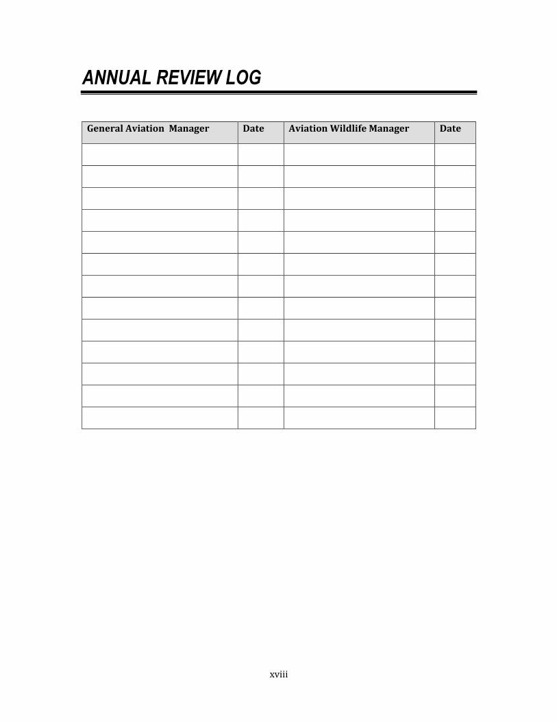
ANNUAL REVIEW LOG
General Aviation Manager Date Aviation Wildlife Manager Date
xix
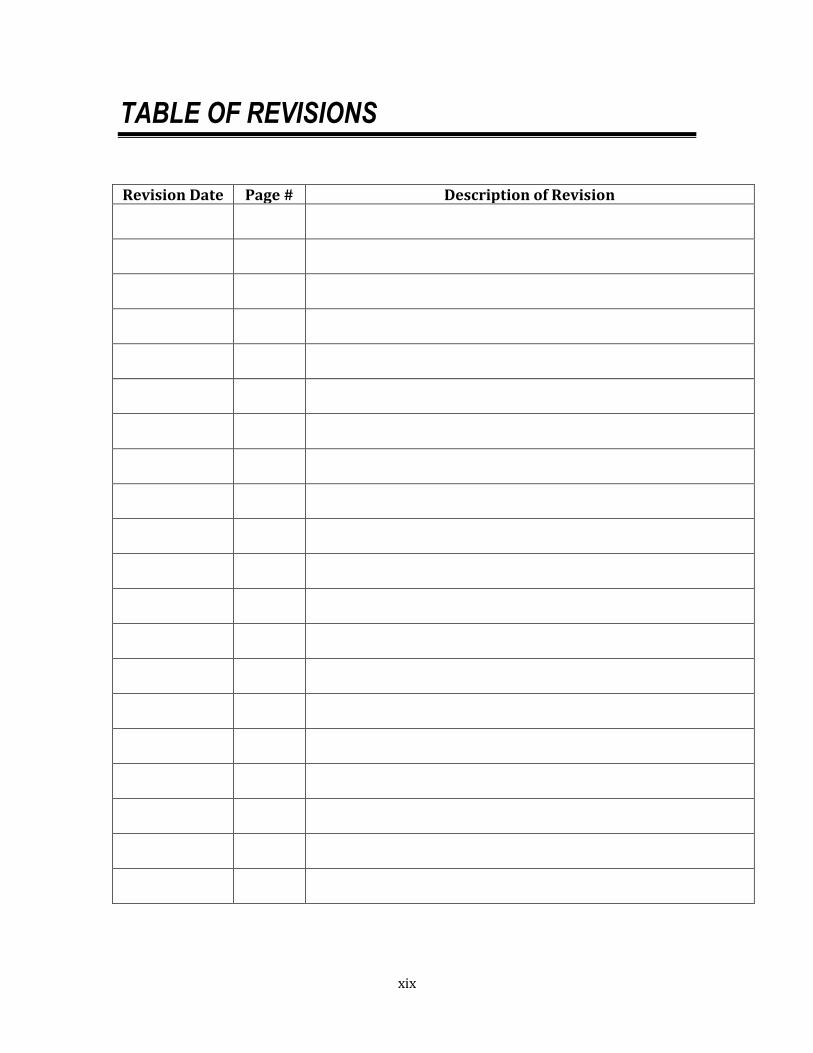
TABLE OF REVISIONS
Revision Date Page # Description of Revision

xx
This page intentionally left blank.
E1
EXECUTIVE SUMMARY
HILLSBORO AIRPORT WILDLIFE HAZARD MANAGEMENT PLAN
1.0 INTRODUCTION
The Federal Aviation Administration (FAA) recommends General Aviation airports to develop a Wildlife Hazard Assessment (WHA) and if necessary implement a Wildlife Hazard Management Plan (WHMP) at airports with aircraft that experience multiple wildlife strikes, damaging collisions with wildlife, engine ingestion of wildlife, or wildlife of a size or in numbers capable of causing such events. Aviation safety is paramount in the Port of Portland’s airport management objectives for HIO. Damaging wildlife strikes with private aircraft have been documented at HIO, and development surrounding the airport has accelerated as former open space is converted to alternative uses that could shift or intensify the presence of hazardous wildlife on the airfield. Consequently, in 2007 the Port elected to prepare a WHMP for HIO that meets industry standards, including the delineation of responsibilities, policies, procedures and regulations necessary to reduce identified wildlife hazards on or around HIO. This is a voluntarily action that is not currently required by the FAA. This document is the 2015 update of the HIO WHMP.
1.1 PURPOSE & APPLICATION
The overall objective of the WHMP is to develop an integrated and adaptive program to effectively manage risk at HIO by reducing the probability of occurrence of wildlife/aircraft collisions. While terrestrial wildlife are a concern at HIO, the security fencing that surrounds the airfield perimeter lessens the incursion of larger terrestrial wildlife (e.g., black-tailed deer) onto the airfield. Bird strikes, however, are statistically a much higher risk for aircraft using HIO, especially during the critical phases of departure and landing operations. Consequently, the risk evaluation process of the WHMP primarily focuses on avian wildlife. It is recognized that the risk of a bird strike at HIO can never be completely eliminated. However the underlying premise of the Wildlife Hazard Management program is that it is possible to manage the risk to an acceptable level, and it is the intent of the WHMP to provide the necessary direction to do so, in a scientifically sound manner, utilizing non-lethal means whenever possible.
The Port’s General Aviation (GA) Manager is responsible for the implementation of the wildlife hazard program at HIO. The Portland International Airport (PDX) Aviation Wildlife Manager is the Port’s technical area expert and supports the GA Manager in the development of this and future editions of the WHMP, as well as accomplishing the implementation of specific management strategies at HIO.
E2
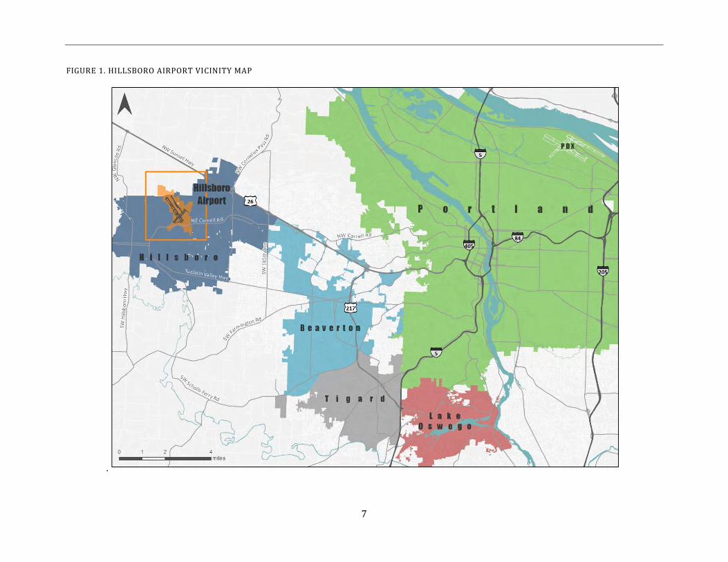
1.2 LOCAL PERSPECTIVE (AIRPORT DESCRIPTION)
Hillsboro Airport is owned and operated by the Port of Portland. It is located on the west side of the Portland Metropolitan region, mostly within the City of Hillsboro limits, in an area known as the Sunset Corridor. With more than 200,000 operations annually, HIO is Oregon’s second busiest airport, trailing only Portland International Airport. It is an executive airport that supports all facets of general aviation activity. With its two runways and four full-service fixed-base operators, the airport provides all the facilities necessary to support jet and propeller-driven aircraft and helicopters.
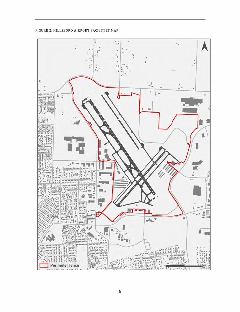
The HIO aviation property (inside and outside the airport perimeter fence) comprises approximately 846 acres that includes flat managed (mowed) grasslands, agricultural lands farmed for grass seed, asphalt runways, taxiways, roadways, and buildings associated with the airport terminal and other airport operations. An unnamed, intermittent tributary to McKay Creek flows just within the northwest boundary of the airfield, and a stormwater conveyance ditch that flows into Dawson Creek drains a small area along the southeastern perimeter of the airfield. An 8-foot high security fence surrounds the entire airfield. Land uses surrounding HIO include agriculture, light industrial, commercial, residential and undeveloped open space.
A large variety of wildlife live in the vicinity of HIO, and many more birds pass through the area during their seasonal migrations along the Pacific Flyway. Many of these species pose a potential hazard to the safe operation of aircraft whenever they enter the approach/departure path of HIO. The managed grasslands and agricultural lands on and around the airfield provide foraging opportunities for raptors and geese, and shelter to prey species such as voles and shrews. The tributary to McKay Creek provides nesting and loafing opportunities for waterfowl. As urban density increases in the surrounding area, the airport and adjacent open spaces become more attractive to resident and migratory wildlife that seek out remaining expanses of relatively undeveloped open space.
1.3 WHMP ADMINISTRATION
The 2007 WHMP serves as the foundation for the ongoing development of the Wildlife Hazard Management program at HIO. As such it not only incorporates strategic guidance and establishes baseline documentation for the program, but also demonstrates compliance with the operational recommendations of the FAA. This section of the plan provides a statutory overview of the FAA recommendations, and establishes a guide, or roadmap, that identifies where in the WHMP each specific need is fulfilled.
The WHMP is to be reviewed at least annually and revised as necessary, when either the program changes or management issues arise, or every 5 years, whichever comes first. This review/revision protocol will ensure that the WHMP stays current and responsive to changing conditions, and incorporates the principles of adaptive management. This 2015 version is the update of the original 2007 HIO WHMP.
E3
2.0 APPLICABLE LAWS, REGULATIONS AND POLICIES
Chapter 2 identifies the other major federal, state and local mandates that define the legal context of compliance within which the WHMP must operate. Along with the external mandates, the WHMP must demonstrate how it fits within and supports the stated missions of the Port and the Aviation Division, and how Port and Aviation policies guide it. While the priority of the Wildlife Hazard Management program at HIO is aviation safety, the Port will achieve this goal through responsible environmental stewardship. This reflects both the overarching mission of the Port and also the values of the regional community.
3.0 PROGRAM ORGANIZATION, ROLES AND RESPONSIBILITIES
Chapter 3 identifies and describes the roles and responsibilities of the various staff and departments at the Port that are involved in and responsible for implementation of the WHMP. The Port’s General Aviation Manager is ultimately responsible for the implementation of the wildlife hazard program at HIO. The Port’s Aviation Wildlife Manager is the technical area expert that supports the GA Manager in this effort. In order to fully implement a Wildlife Hazard Management program that incorporates a dedicated dawn-to-dusk hazing and harassment program (short-term operational strategies), a research and development component, long-term management strategies, and a proactive public information and education program, additional staffing and resources would need to be identified.
4.0 IMPLEMENTATION STRATEGIES
Chapter 4 summarizes the scientific information collected at HIO to support the development of management techniques incorporated into the WHMP. Specifically it:
Reviews the risk evaluation model developed by the Port to assess wildlife hazardsand prioritize actions based on the relative levels of risk they pose;
Provides a wildlife hazard assessment to identify wildlife species that pose asignificant hazard to aviation at HIO;
Describes features and habitats that act as attractants to potentially hazardouswildlife; and
Provides an overview of the zones and management areas designated at the airportfor the implementation of the WHMP.
The formal risk evaluation approach developed by the Port is based on the body of work of Dr. J. R. Allan, adapted to the site-specific issues and FAA requirements at HIO. This risk-based approach is the primary assessment methodology for wildlife hazard management in the future. All management scenarios presented in this document are to be validated by the risk evaluation process, as it is refined in each update. It is expected that this iterative process will evolve over time as new information and real world application provide direction. The risk evaluation model is included as Appendix A.
E4
Implementation of the WHMP is based upon management strategies developed to address the wildlife hazards unique to each of the 6 management areas identified at HIO. These strategies are organized according to four management components or “pillars” that support the Wildlife Hazard Management program: (1) short-term operational strategies, (2) research and development projects, (3) long-term management strategies, and (4) information and educational programs.
The first pillar, short-term operational strategies, deals with the need of the moment. This includes the reactive hazing and harassment program intended to clear the airspace of wildlife species of concern for an immediate aircraft operation. In addition, short-term habitat manipulations on a relatively small scale are included in this operational category. Examples include mowing schedules and small mammal baiting. The Port has set a management objective to achieve this first pillar, when possible, in a non-lethal manner, utilizing the full range of technologies available. However, implicit in this statement is the recognition that it may not always be possible to avoid lethal control. The WHMP identifies the decision-making process necessary for consideration of lethal action, which is based on the level of threat to public safety. A basic premise of the lethal action strategy is that it will target an individual animal and its problematic behavior, rather than targeting a population. The only current exceptions to this rule are for control of European starling and the prey base control strategies for small mammals.
The second pillar is ongoing applied research and development to expand the range of available wildlife control options, test new hypotheses and evaluate new technologies. It is important to the Port that the results of it’s applied research efforts be discussed and shared with the larger, professional community. Wildlife hazard management deals with the behavior of dynamic, living organisms that have a demonstrated capability to adapt to the human environment. This requires a level of program flexibility and a commitment to the principles of adaptive management for the program is to be effective over time. The information gained from research and development projects transfers into both the short-term operational strategies and the long-term management strategies. The results of research and development initiatives undertaken by the WHMP at PDX are used to inform and develop the applied management strategies at HIO and TTD.
The third program pillar is the development of long-term management strategies, including habitat modifications and permanent site conversion. These strategies are based on the premise that both the physical presence of wildlife species of concern on the airfield, and the length of time that they are present can be diminished by reducing the attractiveness of the habitat on and around the airport. However, in highly modified environments like airports, single-focused habitat alterations to discourage one species of concern often can create enhanced conditions for another species of concern. Therefore, effective long-term habitat modifications must be designed to consider changes to the whole ecological system. Long-term management strategies may range from physically excluding the species permanently from the area (where possible) to habitat modifications such as wetland removal.
The fourth pillar of the program is the information and education component, which recognizes that wildlife issues are of widespread interest to both internal and external groups and individuals. The success of the program is predicated on active cooperation with
E5
a large number of stakeholders, and an ongoing program to inform and elevate awareness of wildlife issues at HIO. Providing outreach opportunities also provides input that helps to tie HIO issues into its larger regional context.
5.0 RISK MANAGEMENT TECHNIQUES
The risk management techniques and protocols outlined in Chapter 5 define the full range of operational tactics and management strategies designed to ensure public safety by reducing the incidence of wildlife-aircraft collisions at HIO. Together these represent the toolbox of acceptable techniques available to the Airport staff, and run the full range of actions from day-to-day operational tactics to long-term habitat modification strategies. Because the WHMP serves as the foundation for program development, operational protocols that are responsive to legal, jurisdictional and safety constraints are included.
Wildlife control procedures are direct actions taken to discourage, disperse and remove wildlife species of concern from the airfield and vicinity. Their implementation includes the day-to-day operational efforts of the Airport staff to ensure that the approach and departure airspace is as free of potential wildlife hazards as is practicable. Wildlife control actions are generally reactive to the situation of the moment and are responsive to any perceived threats to aircraft safety that may be posed by wildlife species of concern. While the management objective is to accomplish this with non-lethal means whenever possible, protocols are established defining the decision-making process and implementation requirements for direct lethal control should the need arise.
Habitat modification and other long term management strategies attempt to address the reasons why certain species of wildlife are attracted to the airfield environment, bringing them into conflict with aircraft operations. These include the physical manipulation or complete removal of features or characteristics (both natural and constructed) that are attractive to wildlife species of concern and are spatially located such that they draw these species into or across the critical flight paths. The design and installation of structures intended to exclude wildlife species of concern from the airfield or from specific features on the airfield are included in this section.
Given that wildlife hazard management is not an exact science, and that species of wildlife respond differently to changing circumstances including sustained management actions, it is critical that an ongoing research and development program be integrated with the principles of adaptive management to provide the flexibility necessary to maintain an effective program over time. The results of ongoing testing and monitoring are applied directly to the development of operational tactics and management strategies.
Wildlife issues and management strategies at HIO are of interest to many people, both internal to the Port and in the public arena. The need for an ongoing public information and education component is recognized as essential to the success of the Wildlife Hazard Management program at HIO. In addition to public information and education, there is a need to continue to share and foster the exchange of technical information with other Port functional areas, as well as the larger regional and national aviation and wildlife communities.
E6
6.0 TRAINING REQUIREMENTS
Training is essential to provide Airport staff with the knowledge and skills needed to carry out the WHMP. Chapter 6.0 presents training requirements that Airport staff must meet before they can work independently on the airfield at HIO. The training program relies on other Port Departments and cooperating agencies for support (e.g., FAA Air Traffic Control Tower). As new training needs are identified it is expected that this chapter will expand to meet those needs.
7.0 LITERATURE CITED
Chapter 7.0 presents the literature citations referenced in the text of the WHMP.
APPENDICES
The Appendices contain pertinent supporting documentation to the WHMP
Hillsboro Airport 2015 Wildlife Hazard Management Plan
1
1 INTRODUCTION
1.1. Purpose and Application
The Federal Aviation Administration (FAA) recognizes the potential hazards that certain species of wildlife may pose, under certain circumstances, to aircraft operations at airports regulated by the FAA. The FAA recommends general airports to develop and implement a Wildlife Hazard Management Plan (WHMP) at airports with aircraft that experience multiple wildlife strikes, damaging collisions with wildlife, engine ingestion of wildlife, or wildlife of a size or in numbers capable of causing such events. Since the Port of Portland’s (Port) Hillsboro Airport (HIO) does not service scheduled air carrier aircraft, it is not obligated to develop and maintain a WHMP under current federal statute. Nonetheless, aviation safety is paramount in the Port’s airport management objectives for HIO. Damaging wildlife strikes with private aircraft have been documented at HIO, and development surrounding the airport has accelerated as former open space is converted to alternative uses that could shift or intensify wildlife presence on the airfield. Consequently, in 2007 the Port had elected to prepare a Wildlife Hazard Assessment (WHA) and WHMP for HIO that meets FAA standards, including the delineation of responsibilities, policies, procedures and regulations necessary to reduce identified wildlife hazards on or around HIO. The 2007 WHMP for HIO was submitted and approved by the FAA. This is the 2015 update of the signed 2007 WHMP.
1.1.1. National Perspective
Nationwide, wildlife can present a variety of problems that affect operations at airports. Between 1990 and 2011, 119,917 wildlife strikes involving civil aircraft were reported to the FAA. Wildlife strikes have also caused catastrophic accidents that involved the loss of human lives. Although the potential for this type of accident is low, the concern is,
nonetheless, very real. Globally wildlife strikes killed more than 231 people and destroyed over 220 aircraft since 1988 (Dolbeer et al. 2011). Wildlife strikes have other impacts at airports and on the traveling public. Thirteen percent of aircraft-bird strikes and fifty-nine percent of aircraft-mammal strikes reported from 1990 to 2010 resulted in damage to aircraft or some other related cost (USDA et al. 2010). The FAA reports that at a minimum, wildlife-aircraft strikes cost the USA civil aviation industry 448,138 hours of aircraft down time, and $394.4 million in monetary losses every year (USDA et al. 2010).
Hillsboro Airport 2015 Wildlife Hazard Management Plan
2
1.1.2. Local Perspective
Hillsboro Airport is located in the city of Hillsboro in Washington County, Oregon, approximately 2 ¼ miles from Hillsboro city center and 12 miles west of downtown Portland. The Port of Portland owns and operates HIO (Figure 1). With more than 200,000 operations annually, HIO is Oregon’s second busiest airport, trailing only Portland International Airport (PDX). The FAA’s National Plan of Integrated Airport Systems (NPIAS) lists HIO as a designated GA reliever airport for PDX. HIO is an executive airport that supports all facets of general aviation activity. With its two runways and four full-service fixed-base operators, the airport provides all the facilities necessary to support jet and propeller-driven aircraft and helicopters. There is a hotel at the airport and visitors may obtain a rental car in the terminal building. A TriMet light rail station located approximately 1/3 mile south of the airport provides travelers with access to Hillsboro as well as downtown Portland. Inside the airport perimeter fence, the 537-acre HIO airfield includes flat managed (mowed) grasslands, agricultural lands farmed for grass seed, asphalt runways, taxiways, roadways, and buildings associated with the airport terminal and other airport operations (Figure 2). An unnamed, intermittent tributary to McKay Creek flows just within the northwest boundary of HIO, and a stormwater conveyance ditch that flows into Dawson Creek drains a small area along the southeastern perimeter of the airfield. The perennial Dawson Creek and its associated riparian woodland lie to the east of the airfield. The managed grasslands and agricultural lands on the airfield provide foraging opportunities for raptors and geese, and shelter to prey species such as voles and shrews. The tributary to McKay Creek provides nesting and loafing opportunities for waterfowl. An 8-foot high security fence surrounds the entire airfield. Two runways lie within the airfield:
Runway 13/31 is 6,600 feet long and 150 feet wide; and
Runway 2/20 is 4,049 feet long and 100 feet wide
Runway 13/31 is oriented northwest by southeast, while Runway 2/20 is oriented northeast by southwest. Land uses surrounding HIO include agriculture, light industrial, commercial, residential and undeveloped open space, among others.
A large variety of wildlife live in the vicinity of HIO, and many more birds pass through the area during their seasonal migrations along the Pacific Flyway. As urban density increases in the surrounding area, the airport and adjacent open spaces become attractive to resident and migratory wildlife that seek out remaining expanses of relatively undeveloped open space. Port monitoring data indicate that about 61 different species of birds and 6 mammal species are observed in the vicinity of the airport. Many of these species pose a potential hazard to the safe operation of aircraft whenever they enter the approach/departure path.
Between January 1st 2002 and December 31st 2012, 77 documented bird strikes by aircraft were reported at HIO, including 3 engine ingestions, 6 damaging strikes total. No mammal strikes have been reported. These strikes did not result in any human injuries; however significant aircraft damage did occur in some cases. Additionally, wildlife on an airfield have been known to cause property damage and destruction to airport facilities (e.g., chewed electric cables powering runway lights). While these are not direct hazards to the safe operation of aircraft, they are recognized as part of the larger airport management program.
Hillsboro Airport 2015 Wildlife Hazard Management Plan
3
Furthermore, development surrounding the airport has accelerated over the past 10 years. Former open space (farmland and woodlands) is rapidly being converted to alternative land uses that may be incompatible with airport operations. These land use changes could contribute to an increase in wildlife use of the remaining relatively undeveloped areas, including the HIO airfield and vicinity. These cumulative events justify the development and implementation of a WHMP for HIO that reduces identified wildlife hazards on and around the airport.
1.1.3. WHMP Objectives and Principles
The ultimate objective of the WHMP is to provide a safer airfield environment for aircraft at, or in the vicinity of HIO by reducing aviation wildlife hazards. To accomplish this objective, the implementation of the Wildlife Hazard Management Plan is intended to reduce the probability of occurrence of a wildlife/aircraft collision.
Basic principles used by the Port in the implementation of the WHMP include:
Frequent inspections of airport facilities are necessary to identify potentialhazards and that sufficient wildlife control measures are in place;
Any response to a wildlife threat is handled using the widest range ofoptions available, and will be supported by the risk evaluation processdeveloped by the Port
Attempts to alleviate wildlife threats to public safety through recognizednon-lethal means when possible are the primary focus of the Port’s program;
Lethal means are recognized as an important additional option when thethreat to public safety is imminent and non-lethal means have failed toaddress the issue.
Regular reviews of proposed land use changes and proposed development insurrounding areas are vital in ensuring that adjacent land uses arecompatible with airport operations;
The Port’s General Aviation (GA) Manager is responsible for the implementation of this program. The PDX Aviation Wildlife Manager is the Port’s technical area expert and supports the GA Manager in the development of this WHMP and future editions based on the principles of adaptive management, as well as accomplishing the implementation of specific management strategies at HIO. This team integrates the professional and technical resources of the Aviation Wildlife Management program into the General Aviation management objective at HIO to address specific wildlife hazard issues.
The services and cooperation of city, state and/or federal agencies, as well as other Port departments, is essential to ensure the program’s effectiveness.
1.2. Wildlife Hazard Assessment
The Port has developed and is implementing a risk evaluation process as a means to improve the Port’s wildlife hazard management capabilities. The risk evaluation model is used to inform management decisions and focus management priorities. While terrestrial wildlife are a concern at HIO, the security fencing that surrounds the airfield perimeter
Hillsboro Airport 2015 Wildlife Hazard Management Plan
4
lessens the incursion of larger terrestrial wildlife (e.g., black-tailed deer) onto the airfield. Bird strikes, however, are statistically a much higher risk for aircraft using HIO, especially during the critical phases of departure and landing operations. Consequently, the risk evaluation process of the WHMP primarily focuses on avian wildlife. The guidelines and recommendations presented in this WHMP will be subject to an iterative re-analysis whenever the risk evaluation process is refined or modified.
A wildlife hazard assessment that meets the FAA’s recommended standards was completed and incorporated in the 2007 HIO WHMP. Information collected during the wildlife hazard assessment includes: an analysis of the events that prompted the assessment; the identification of observed wildlife species, their movements, numbers and locations; identification and location of wildlife attractants on and near the airport; a description of wildlife hazards to aircraft operations; and recommended actions for reducing wildlife hazards to aircraft operations. The findings of the wildlife hazard assessment are incorporated into this WHMP update.
1.2.1. Wildlife Strikes
Wildlife strike records at various airports have shown that birds and mammals can pose a threat to public aviation safety either by being present on the airfield during aircraft landings and departures or directly in the flight path of aircraft (Cleary and Dolbeer 2000). Strikes occur when: wildlife physically collide with aircraft, birds or other wildlife remains are found within 200 feet of centerline of a runway, unless another reason for the animal’s death is identified or the animal’s presence on the airport had a significant negative effect on a flight (e.g., aborted takeoff or landing, high-speed emergency stop, aircraft left pavement area to avoid collision with animal). Wildlife strikes are almost always fatal to the animal, can cause costly damages and delays, and potential loss of human life.
Nationally, approximately 56% of all bird-aircraft strikes occur below 100 feet above ground level (AGL), and 78% occur below 1,000 feet AGL (Cleary et al. 2003). At airports, this low altitude generally corresponds with aircraft that are in either the departure or landing phase of flight. The FAA requires the maintenance of a clear, safe airspace for aircraft landings and departures. The runway protection zone (RPZ), a profile of the approach and transition area located at the end of each runway, represents the area in which aircraft are most vulnerable to wildlife strike hazards. Risk to aircraft is greatest during takeoff when aircraft are likely to be at their maximum payload and thrust, and have limited maneuverability.
Over the last 10 years (2002 through 2012), 77 bird strikes (involving 99 birds) have been reported at HIO, but no mammal strikes have been documented. Most (96%) of these strike reports occurred after 2004 when the Port instituted a more rigorous program for documenting wildlife strikes on the airfield. Raptors (30%) and shorebirds (29%) were the most frequently struck groups of birds, followed by passerines (23%) and waterfowl (10%). Unidentified birds accounted for 8% of strikes, most of which were recorded before the Port instituted a more rigorous program for documenting wildlife strikes on the airfield. American kestrels (26%), barn swallows (10%) and mourning doves (10%) were the species most frequently struck during this period. Reported bird strikes have fluctuated over the last 10 years but there has been an overall increase in the numbers reported over
Hillsboro Airport 2015 Wildlife Hazard Management Plan
5
the last 5 years since the 2007 WHMP. This recent increase is a consequence of many factors, the most significant being an increase in strike reporting due to a higher level of training and awareness of both airport tenants and Port staff.
1.2.2. Wildlife Species of Concern
A number of factors interact to determine the frequency at which a particular species of wildlife may be struck by aircraft (Allan 2000). Included among these are:
Population abundance on and around the airfield (may vary diurnally andseasonally);
Habitat use patterns on and around the airfield (what are their local habitatpreferences for feeding, breeding and resting?);
Distribution of suitable habitat patches and movement patterns in relation tothe airfield;
Airport facilities and operations that may act as attractants (e.g., structures,landscaping, infield mowing) or deterrents (e.g., hazing, habitat modifications);
Behavioral patterns that may bring them into the approach/departure path ofaircraft (e.g., birds that soar, flocking, seasonal migrations);
Ability to detect and/or avoid aircraft (e.g., juveniles vs. adults, resident wildlifevs. transient wildlife); and
Frequency of air traffic and air traffic patterns at the airport.
Whether wildlife at risk of being struck by aircraft pose a hazard to aircraft depends upon the size and number of individuals involved. For example, it is well established that bird strikes involving larger birds or flocks of smaller birds are more likely to result in damage to aircraft than single small birds (Allan 2000). The current certification standards for turbine engine (60 inch and 100 inch size) testing are as follows: an engine must be able to withstand the ingestion of 16 small birds (3 oz. each); 8 medium birds (1.5 lbs each); or 1 large bird (4 lbs) (Eschenfelder 2000). Turbine engines are not required to be able to withstand the ingestion of a bird larger than 4 pounds. Eschenfelder (2000) concluded that these engine ingestion standards may be inadequate because they do not reflect the sizes and numbers of birds encountered in actual birdstrike incidents.
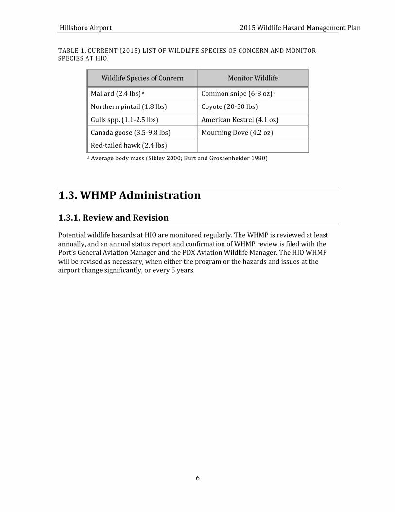
For the purposes of this revision of the WHMP, the Wildlife Species of Concern identified in Table 1 constitute those wildlife species deemed most hazardous to aircraft operations at HIO, while Monitor Wildlife represent those species determined to pose a lower risk to aircraft operations.
Hillsboro Airport 2015 Wildlife Hazard Management Plan
6
TABLE 1. CURRENT (2015) LIST OF WILDLIFE SPECIES OF CONCERN AND MONITOR SPECIES AT HIO.
Wildlife Species of Concern Monitor Wildlife
Mallard (2.4 lbs) a Common snipe (6-8 oz) a
Northern pintail (1.8 lbs) Coyote (20-50 lbs)
Gulls spp. (1.1-2.5 lbs) American Kestrel (4.1 oz)
Canada goose (3.5-9.8 lbs) Mourning Dove (4.2 oz)
Red-tailed hawk (2.4 lbs)
a Average body mass (Sibley 2000; Burt and Grossenheider 1980)
1.3. WHMP Administration
1.3.1. Review and Revision
Potential wildlife hazards at HIO are monitored regularly. The WHMP is reviewed at least annually, and an annual status report and confirmation of WHMP review is filed with the Port’s General Aviation Manager and the PDX Aviation Wildlife Manager. The HIO WHMP will be revised as necessary, when either the program or the hazards and issues at the airport change significantly, or every 5 years.
7
FIGURE 1. HILLSBORO AIRPORT VICINITY MAP
.
8
FIGURE 2. HILLSBORO AIRPORT FACILITIES MAP
10
2 APPLICABLE LAWS, REGULATIONS AND POLICIES
Federal, state and local governments administer a variety of laws and regulations that protect wildlife and their habitats. Wildlife control activities at airports are influenced by many of these regulations. The Port complies with these laws and regulations as a part of standard operational practices.
Most wildlife management agencies issue permits to allow the harassment and/or take of certain wildlife species when required by extenuating circumstances. These special permits are especially relevant and necessary for implementation of a successful airport Wildlife Hazard Management Program. Many of the regulatory requirements are interrelated, and the Port will continue to work collaboratively with the regulatory agencies in evaluating its WHMP implementation and ongoing compliance strategies.
This chapter provides a review of the following:
Key provisions of relevant federal, state and local regulations;
A general strategy for regulatory compliance;
Permits the Port should obtain and routinely renew to implement the WHMP; and
Internal Port policies that guide the development of wildlife hazard managementstrategies at HIO.
2.1. FAA Requirements
2.1.1. Airport Grant Assurances
FAA Airport Grant Assurances are contractual obligations incorporated into the provisions of FAA grants in support of airport improvement projects. These obligations are incurred upon acceptance of FAA funds by the “sponsor” [or Airport], and require the sponsor to “comply with all applicable Federal laws, regulations, executive orders, policies, guidelines and requirements” [reference Section C (1): General Federal Requirements]. Specific reference to the FAA Advisory Circulars is made in Section C (34) [Policies, Standards and Specifications], requiring the sponsor to “carry out the project in accordance with the …current FAA Advisory Circulars…”. These provisions, in effect, give the guidance providedin the Advisory Circulars the weight of law, and contractually obligate the Port to comply. Additional provisions of the Assurances deal specifically with hazard removal and mitigation [Section C (20)], and compatible land uses [section C (21)], directing the sponsor to “take appropriate action” to ensure a safe airspace and to restrict incompatible land uses adjacent to the airport, insofar as possible.
11
To a large extent, these requirements form the basis for the Wildlife Hazard Management Program at HIO, which is designed to be responsive to both the statement and the intent of the guidance.
2.1.2. AC 150/5200-33B
AC 150/5200-33B provides FAA guidance to airport operators on the recommended locations of certain land uses that have the potential to attract hazardous wildlife relative to the location of the airport. It also provides guidance on airport development projects, including construction, expansion, and renovations which affect aircraft movements near hazardous wildlife attractants.
AC 150/5200-33B defines wildlife attractants as “any human-made structure, land use practice, or human-made or natural geographic feature that can attract or sustain hazardous wildlife within the landing or departure airspace of the airport’s AOA. These attractants can include architectural features, landscaping, waste disposal sites, wastewater treatment facilities, agricultural or aquaculture activities, surface mining, and wetlands”.
For an airport serving turbine-powered aircraft such as HIO, AC 150/5200-33B recommends that “hazardous wildlife attractants” be separated from the airport’s air operations area (AOA) by a distance of 10,000 feet. This AC also recommends that the approach, departure and circling airspace be separated from hazardous wildlife attractants by 5 statute miles if the attractant could cause hazardous wildlife movement into or across the approach or departure airspace.
AC 150/5200-33B discusses land-use practices having the potential to attract hazardous wildlife and provides guidance on whether these land use practices are compatible or incompatible with safe airport operations if they are located within the specified separation distances from the airport. The guidance also provides recommendations on alternatives for incompatible land uses, and suggestions on managing or correcting these uses to discourage the attraction of hazardous wildlife to airport facilities.
In accordance with the Grant Assurances, the Port adheres to the guidance in AC 150/5200-33B to ensure that the proposed wildlife management practices, including habitat modification and mitigation activities, are consistent with the recommendations the AC provides. Refer to Appendix B for the complete text of AC 150/5200-33B.
12
2.2. Other Applicable Federal Regulations
2.2.1. National Environmental Policy Act
The National Environmental Policy Act (NEPA) requires that federal agencies study and disclose the environmental effects of their proposed actions and a reasonable range of alternatives in the appropriate level of assessment. There are three levels of assessment under NEPA, in ascending order: Categorical Exclusion (CATEX), Environmental Assessment (EA), and Environmental Impact Statement (EIS). Specifically, NEPA is triggered when an action requires a permit, entitlement, or funding from a federal agency, when an action is jointly undertaken with a federal agency, or when an action is proposed on federal land. Typically, federal agencies adopt guidance specific to actions that they undertake requiring NEPA compliance. The FAA Airport District Office will be contacted prior to implementing projects with a federal nexus to discuss potential NEPA requirements.
2.2.2. Clean Water Act, Section 404
Activities that result in a discharge of dredged or fill material into waters of the United States are regulated by the U.S. Environmental Protection Agency (EPA) and U.S. Army Corps of Engineers (USACE) under Section 404 of the Clean Water Act (CWA). Discharges of dredged or fill material into waters of the United States, including wetlands, generally require a permit from USACE.
Several waters of the United States, including on-site wetlands, have been identified on and around the HIO airfield. If activities designed to manage wildlife hazards would result in the discharge of dredged or fill material into a jurisdictional water of the U.S., the Port would apply for a permit from USACE before completing such activities. In Oregon, this is accomplished via a joint permit process with the USACE and the Oregon Department of State Lands (ODSL) (See Section 2.4.1). Mitigation for impacts to jurisdictional wetlands will be mitigated off-site outside of the 10,000 ft. separation criteria as established in FAA AC 150/5200-33B.
2.2.3. Endangered Species Act (16 USC 1531-1543, Endangered Species Act of 1973, As Amended)
Section 7 of the Endangered Species Act (ESA) requires all federal agencies, in consultation with the US Fish and Wildlife Service (USFWS) and the National Marine Fisheries Service (NMFS), to ensure that their actions do not jeopardize the continued existence of species listed as endangered or threatened, or result in the destruction or adverse modification of the critical habitat of these species. Section 7 provides that if a federal action "may affect" a listed species, the federal agency must consult with the USFWS or NMFS to determine whether the action is "likely to adversely affect the species," in which case the agency must formally consult on the action in order to obtain a Biological Opinion issued by the USFWS or NMFS that authorizes the take. Section 9 defines "Take" to include harassing, harming, pursuing, hunting, wounding, killing or capturing, or attempting such activity. The
13
requirements of Section 10 will apply to projects/activities without a federal nexus that could result in a “take” under the ESA.
Since the completion of the Port of Portland, Hillsboro Airport Parallel Runway 12L/30R Environmental Assessment, 2010, the US Fish and Wildlife Service (USFWS) has designated the Streaked horned lark, Eremophila alpestris strigata as threatened under the Endangered Species Act (ESA) (see 78 Federal Register 61451, October 3, 2013). The original Environmental Assessment noted that this species of bird was considered by USFWS in 2010 to be a candidate for listing as threatened. That Environmental Assessment noted, “According to a search of the Oregon Natural Heritage Information Center (ORNHIC) no rare, threatened, or endangered terrestrial species are documented at HIO. The nearest record of a state-listed species is about 3 miles to the southwest at Jackson Bottoms, where a bald eagle nest is documented ...” There is no documentation of any state/federally listed species or critical habitat presence at Hillsboro Airport. In support of the Hillsboro Airport Wildlife Management Hazard Plan, periodic wildlife surveys are conducted on the airfield and Streaked horned larks have not been documented on or around the Airport. If proposed wildlife management activities could possibly affect a listed species, the lead federal agency involved with the proposed action (e.g., FAA, USACE) will consult with USFWS and/or NOAA Fisheries as appropriate.
2.2.4. Migratory Bird Treaty Act
The Migratory Bird Treaty Act (MBTA) prohibits the take of any migratory bird, and any part, nest or eggs of any such bird. Take under the MBTA is defined as the action of or attempt to “pursue, hunt, shoot, capture, collect, or kill”. The MBTA is administered by the USFWS. Migratory birds also listed under the ESA are managed by the agency staff handling compliance with Sections 7 and 10 of the ESA; management of all other migratory birds is overseen by the Migratory Bird Division of the USFWS.
Numerous migratory birds use habitats on and around HIO. Since wildlife management activities could affect any of these birds, the Port has consulted with and obtained an Airport Depredation permit from the USFWS, which includes hazing and lethal actions. This annual permit is maintained on file at the PDX Wildlife office (See Section 2.6).
2.2.5. Bald and Golden Eagle Protection Act
The Bald and Golden Eagle Protection Act, as amended, provides for the protection of bald and golden eagles by prohibiting, except under certain specified conditions, the taking, possession and commerce of such birds. The act allows take, possession and transportation of bald and golden eagles for scientific, educational, and Native American religious purposes, or in circumstances when take may be necessary to ensure the protection of wildlife, agriculture, or other interests particular to a specific locality. The act also allows for take of golden eagle nests that interfere with resource development or recovery operations. A permit from the USFWS is required to take, possess, or transport any bald or golden eagle, or golden eagle nest. This annual permit is maintained on file at the PDX Wildlife office (See Section 2.6).
14
2.2.6. Federal Insecticide, Fungicide, and Rodenticide Act
The Federal Insecticide, Fungicide, and Rodenticide Act (FIFRA) give the EPA authority over distribution, sale, and use of pesticides. Manufacturers must provide a label for and register a pesticide with the EPA before they can manufacture pesticides for commercial use, and facilities that use pesticides on their premises must comply with the requirements outlined by the EPA on each pesticide container label. In addition, restricted use pesticides must be applied by or under the direct supervision of an applicator certified by the EPA.
When wildlife hazard management practices at HIO require application of pesticide, the Port will ensure that pesticides are applied in accordance with both the EPA, and manufacturer’s instructions.
2.2.7. Executive Order 11988, Floodplain Management
This executive order is a flood hazard policy for federal agencies. Executive Order 11988 requires that all federal agencies take actions to reduce the risk of flood loss, to restore and preserve the natural and beneficial values served by the floodplain, and to minimize the impact of floods on human safety, health and welfare. The Order defines, floodplains as “the lowland and relatively flat areas adjoining inland and coastal waters including flood prone areas of offshore islands, including at a minimum, that area subject to a one percent or greater chance of flooding in any given year”, i.e., the area that would be inundated by a 100-year flood.
Floodplains associated with the unnamed tributary to McKay Creek and Dawson Creek lie on and adjacent to HIO. If proposed wildlife management practices would involve a federal action that could impact floodplains (e. g., stream piping), the Port will take appropriate actions to minimize impacts to the floodplain.
2.3. State Of Oregon Regulations
2.3.1. Oregon Removal Fill Law
Similar to Section 404 of the Clean Water Act, Oregon’s Removal-Fill Law (ORS 196.795-900) regulates activities that would result in the removal or fill of material into waters of the state. Waters of the state include natural waterways, intermittent streams, constantly flowing streams, lakes and wetlands, including isolated wetlands not regulated by the USACE. The ODSL administers the Removal-Fill program.
If proposed wildlife management activities at HIO could result in a discharge or removal of material into or from a water of the state (e.g., wetlands, streams), the Port will consult with ODSL staff and apply for a Removal-Fill permit, as appropriate. In Oregon, this is accomplished via a joint permit process between USACE and ODSL. Mitigation for impacts to jurisdictional wetlands will be mitigated off-site outside of the 10,000 ft. separation criteria as established in FAA AC 150/5200-33B.
15
2.3.2. Oregon Endangered Species Act
Similar to the federal ESA, Oregon’s ESA offers protection to species listed as threatened or endangered under the Oregon ESA (ORS 496.002 through 496.192). However, the Oregon ESA is much more limited in scope and applies only to state agencies taking actions on state-owned or leased lands. Oregon’s ESA is administered by ODFW.
No state listed species are known to occur on or adjacent to HIO, but listed bird species may occur incidentally during normal movements between migratory ranges. If the Port receives state funding, the Port may be required to consult with ODFW. However, in practice, compliance with the Oregon ESA is typically achieved during consultations with the federal agencies pursuant to the federal ESA.
2.3.3. Oregon Administrative Rules 635-43-0000 to 0045 [Scientific Taking Permit]
Under Oregon Administrative Rules (OAR) 635-43-0000 to 0045, a Scientific Taking Permit is required to capture or handle the following wildlife in Oregon:
Endangered species (OAR 635-100-125: green sea turtle, leatherback sea turtle, short-tailed albatross, brown pelican, Aleutian Canada goose, American peregrine falcon, arctic peregrine falcon, California least tern, gray wolf, gray whale, sei whale, sperm whale, blue whale, humpback whale, black right whale, fin whale, and gray wolf);
Threatened species (OAR 635-100-125: loggerhead sea turtle, Pacific Ridley sea turtle, bald eagle, western snowy plover, northern spotted owl, marbled murrelet, kit fox, wolverine, and sea otter);
Game birds (ORS 496.007 - members of the following avian families: Anatidae (swans, geese, brant, river ducks, sea ducks), Columbidae (mourning doves and band-tailed pigeons), Tetranidae (grouse, ptarmigan prairie chickens), Phasianidae (pheasants, quail, partridge), Meleagrididae (wild turkey), Scolopacidae (snipe, woodcocks), Gruidae (cranes) and Rallidae (rails, gallinules, coots);
Fur-bearing mammals (ORS 496.004(8): beaver, bobcat, fisher, marten, mink, muskrat, otter, raccoon, red fox, and gray fox);
Game mammals (ORS 496.004(9): antelope, black bear, cougar, deer, elk, moose, mountain goat, mountain sheep, and silver gray squirrel; and
Other wildlife protected under OAR 635-44-130 (includes a number of rare native amphibians, reptiles, and mammals as well as all non-game birds except European starling, house (English) sparrow, and rock pigeon).
Since wildlife hazard management practices at HIO may require that some of the above species be collected, trapped and released, or salvaged for scientific purposes, the Port
16
holds a Scientific Taking Permit from ODFW. This permit is on file at the PDX Wildlife office (see Section 2.6).
2.3.4. Oregon Administrative Rules 635-043-051 to 0115 [Take or Harass Wildlife Permit]
Under OAR 635-0430951 to 0115, a property owner must obtain a Wildlife Harassing Permit from ODFW before harassing any wildlife on their property. Harassment is defined as any act that frightens or chases, but does not kill, wildlife. Harassment can be employed for scientific purposes pursuant to an ODFW program; to offer protection against a threat to human safety; to offer protection of land or property from damage; for wildlife management purposes pursuant to ODFW programs; or for rehabilitation of sick, injured, or orphaned wildlife. A Wildlife Harassing Permit is not required of those persons possessing a valid federal migratory bird permit authorizing harassment of migratory bird species.
The current federal migratory bird permit that the Port maintains on an annual basis meets the ODFW state requirements under OAR 635-043-051 to 0115 (see Section 2.6).
2.3.5. Oregon Administrative Rules 837-12-305 to 370 [Agricultural Fireworks Permit]
Under OAR 837-12-305 to 370, a landowner must obtain an Agricultural Fireworks Permit to scare away or repel birds or animals that injure crops or agricultural products. Permits are issued in-two year blocks by the Office of State Fire Marshal.
Under the provisions of this administrative rule, the airfield at HIO is considered equivalent to other agricultural areas in the state of Oregon. Because wildlife hazard management practices at HIO require the use of pyrotechnics, the Port holds an Agricultural Fireworks Permit from the State Fire Marshal (see Section 2.6).
2.3.6. Oregon Revised Statute, ORS 836.623
ORS 836.623 recognizes the importance of compatible land use planning at the local government level in the interest of public aviation safety. The statute specifically addresses potential bird attractants and bird strike hazards on and around airports, and recognizes federal regulation of public aviation safety. “The following requirements and conditions shall apply to safety risks associated with potential bird strike hazards resulting from new water impoundments proposed in close proximity to an airport. No new water impoundments of one-quarter acre or larger shall be allowed within an approach corridor and within 5,000 feet from the end of a runway; or on land owned by the airport or airport sponsor where the land is necessary for airport operations” (ORS 836.623).
17
2.3.7. State Planning Regulations
The purpose of the State of Oregon’s Airport Planning Division 13 is to implement ORS 836.600 through 836.630 and Statewide Planning Goal 12 (Transportation). The policy of the State of Oregon is to encourage and support the continued operation and vitality of Oregon's airports. These rules are intended to promote a convenient and economic system of airports in the state and for land use planning to reduce risks to aircraft operations and nearby land uses. This division also ensures the vitality and continued operation of Oregon's system of airports is linked to the vitality of the local economy where the airports are located. This division recognizes the interdependence between transportation systems and the communities on which they depend (OAR 660-013 Airport Planning).
The Oregon Department of Aviation has developed a guidebook to aid in compatible land use planning. It contains the means and requirements for local governments and those interested in Oregon aviation to comply with airport land use compatibility. The guidebook provides the tools to assist local governments, planners, airport administrators, and citizens wishing to update the aviation transportation element of their comprehensive plan (Airport Land Use Compatibility Guidebook, January 2003).
2.4. Local Regulations
2.4.1. Clean Water Services Design and Construction Standards
Clean Water Services (CWS) Design and Construction Standards outline the design requirements for sanitary sewer, storm sewer, and surface water management systems. These standards include specific provisions to prevent or reduce adverse impacts to the drainage system and water resources of the Tualatin River Basin.
Permits are required from Clean Water Services or one of its member cities (including Hillsboro) whenever:
Constructing, modifying or connecting to the public sanitary and surface watermanagement systems;
Grading, clearing, excavating, or potentially causing any temporary or permanentincrease in soil erosion;
Constructing or adding to a facility that will discharge non-domestic waste to thepublic sanitary system; or
Performing any development of property.Prior to obtaining permits for a development activity the applicant must secure a SPL from CWS. SPL’s are required to ensure streams, wetlands, and other water quality sensitive areas are protected. To obtain a SPL, CWS requires that each project area be evaluated to determine if there are water quality sensitive areas onsite and if they would be impacted by the project. CWS will issue a SPL once they determine that sensitive areas and vegetated corridors are adequately being protected or, if impacts cannot be avoided, mitigated. To ensure that wildlife attractants are not being created or enhanced near the airport, CWS has
18
allowed the Port to mitigate for sensitive area impacts and vegetated corridor impacts offsite.
If proposed wildlife management practices would involve modifying surface water management systems or grading and other actions that could result in erosion, the Port will acquire the appropriate permits from Clean Water Services.
2.4.2. City of Hillsboro, Significant Natural Resources Overlay
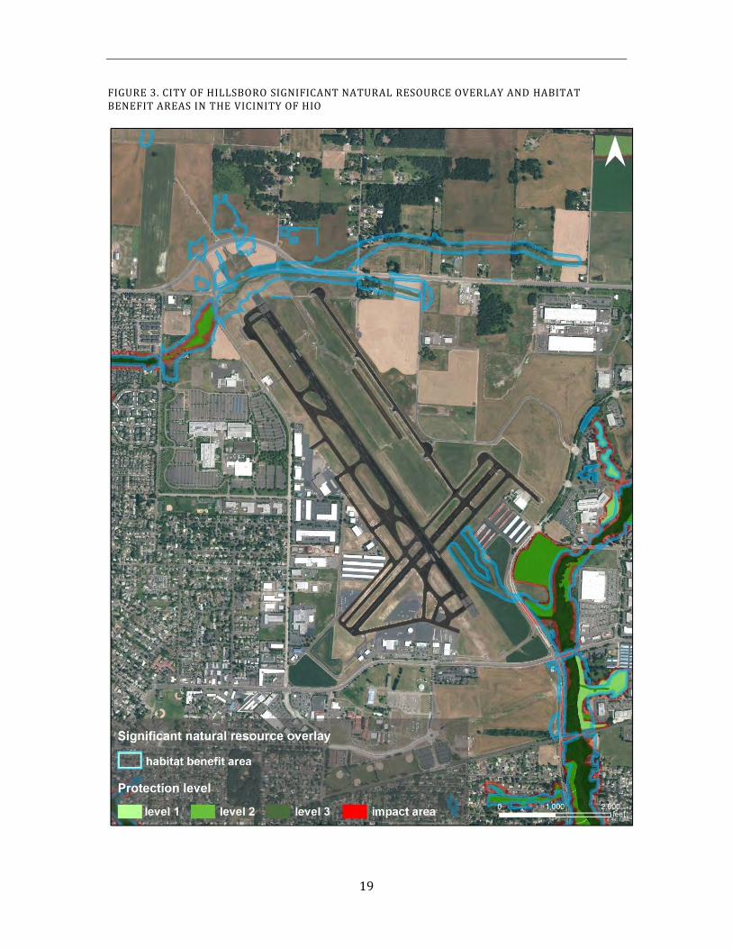
Section 131A of the City of Hillsboro Zoning Ordinance provides protection for Significant Natural Resources under Statewide Planning Goal 5 (Natural Resources) and the provisions of the Goal 5 administrative rule (OAR 660, Division 23). Significant Natural Resources are designated as Significant Wetlands, Riparian Corridors and Wildlife Habitat. These resources have been inventoried and mapped within areas under the City of Hillsboro’s jurisdiction according to the procedures, standards and definitions established under Goal 5. The mapping provides a general idea of where significant Goal 5 natural resources(wetlands, riparian corridors and wildlife habitat) may be located. The actual physical boundaries of these natural resources must be delineated prior to development or development activities occurring. A permit may be required to develop within significant natural resources or their protective buffers.
No significant natural resources lie within HIO, but are present adjacent to HIO along the unnamed tributary to McKay Creek and along Dawson Creek where Port-owned properties lie (Figure 3). Since HIO lies within the jurisdiction of the City of Hillsboro, the Port ensures that all activities on the site are consistent with the City’s comprehensive plan and zoning ordinances. Should local ordinances conflict with or constrain the Port’s ability to implement the requirements of FAA regulations or AC guidance, the Port will engage in a dialog with the City to achieve, through a variance or other mechanism, the appropriate solution, consistent with the federal interest in airport safety.
19
FIGURE 3. CITY OF HILLSBORO SIGNIFICANT NATURAL RESOURCE OVERLAY AND HABITAT BENEFIT AREAS IN THE VICINITY OF HIO
20
2.4.3. City of Hillsboro, Habitat Friendly Development
Section 131B of the City of Hillsboro Zoning Ordinance recommends the use of Habitat Friendly Development practices and low-impact development techniques. . The intent is to provide flexibility in the land development ordinances to encourage the protection of qualified Habitat Benefit Areas shown in Figure 3. A list of recommended habitat-friendly development practices is provided in section 131.B of the City’s zoning ordinance that may be considered where technically feasible and appropriate (http://www.ci.hillsboro.or.us/Planning/HTMLzoneVOL1/Vol_1_Section_131B.aspx). The recommended practices include a broad range of development techniques and activities that reduce the detrimental impact on fish and wildlife habitat associated with traditional development practices.
Qualified Habitat Benefit Areas are identified within and adjacent to HIO, generally associated with the unnamed tributary to McKay Creek, the stormwater conveyance ditch that drains to Dawson Creek and Dawson Creek (Figure 3). If proposed wildlife management practices would involve modifications to qualified Habitat Benefit Areas, the Port will consider habitat-friendly development practices, where technically feasible, that do not serve as attractants to wildlife that may be potentially hazardous to aircraft.
2.4.4. City of Hillsboro, 7.08.010 Discharge of Weapons
The City of Hillsboro code 7.08.010 generally prohibits the discharge of firearms in the City, except for those personnel specifically listed in the code. Currently the code states that firearms are allowed to be discharged “upon airport property for the purpose of taking and/or dispersing wildlife that are a hazard to air traffic, in accordance with any applicable law or regulation including U.S. Fish and Wildlife Service”.
2.5. Permits
The Port shall apply for, obtain and/or renew all necessary federal and state permits required to control wildlife on, and in the vicinity of, the airfield. Table 2 provides a summary of the potential federal, state, and local permits that the Port may be required to obtain prior to implementing wildlife hazard management practices at HIO. Copies of the current permits issued to the Port for wildlife control can be found in Appendix C.
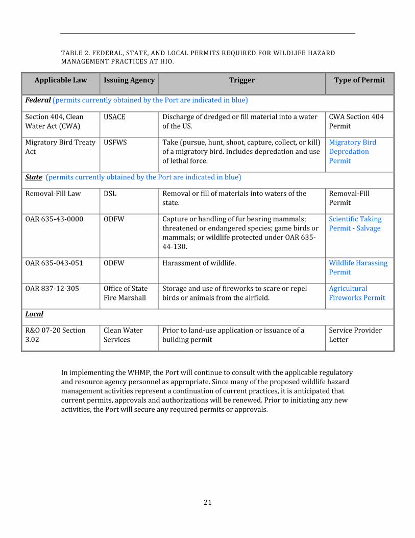
21
TABLE 2. FEDERAL, STATE, AND LOCAL PERMITS REQUIRED FOR WILDLIFE HAZARD MANAGEMENT PRACTICES AT HIO.
Applicable Law Issuing Agency Trigger Type of Permit
Federal (permits currently obtained by the Port are indicated in blue)
Section 404, Clean Water Act (CWA)
USACE Discharge of dredged or fill material into a water of the US.
CWA Section 404 Permit
Migratory Bird Treaty Act
USFWS Take (pursue, hunt, shoot, capture, collect, or kill) of a migratory bird. Includes depredation and use of lethal force.
Migratory Bird Depredation Permit
State (permits currently obtained by the Port are indicated in blue)
Removal-Fill Law DSL Removal or fill of materials into waters of the state.
Removal-Fill Permit
OAR 635-43-0000 ODFW Capture or handling of fur bearing mammals; threatened or endangered species; game birds or mammals; or wildlife protected under OAR 635-44-130.
Scientific Taking Permit - Salvage
OAR 635-043-051 ODFW Harassment of wildlife. Wildlife Harassing Permit
OAR 837-12-305 Office of State Fire Marshall
Storage and use of fireworks to scare or repel birds or animals from the airfield.
Agricultural Fireworks Permit
Local
R&O 07-20 Section 3.02
Clean Water Services
Prior to land-use application or issuance of a building permit
Service Provider Letter
In implementing the WHMP, the Port will continue to consult with the applicable regulatory and resource agency personnel as appropriate. Since many of the proposed wildlife hazard management activities represent a continuation of current practices, it is anticipated that current permits, approvals and authorizations will be renewed. Prior to initiating any new activities, the Port will secure any required permits or approvals.
22
2.6. Port of Portland Goals, Policies and Procedures
The 2015 HIO Wildlife Hazard Management Plan must demonstrate how it fits within and supports the stated missions of the Port of Portland, the Aviation Division, and the General Aviation program, The WHMP is an operational safety plan nested within the Aviation Safety and Security goal, which directly supports the Aviation and Port Mission Statements.
A summary of key mission statements, goals, and Port policies is provided below.
2.6.1. Port Mission Statement:
“The mission of the Port of Portland is to provide competitive cargo and passenger access to regional, national, and international markets while enhancing the region's quality of life.”
Aviation Mission Statement:
“To operate, maintain, and promote an airport system that satisfies the air transportation needs of our customers by providing competitive cargo and passenger access to regional, national and international markets.”
Aviation Safety and Security Goal:
“Ensure Aviation meets or exceeds all federal and state mandates to provide a safe and secure environment for airport users, employees, and tenants.”
Wildlife Hazard Management Program Goal:
“To control wildlife hazards to aircraft operations through non-lethal means when possible by focusing on intensive hazing and harassment, and long-term habitat modifications.” Decision making for routine, every day wildlife hazard management issues resides at the General Aviation Manager and the Aviation Wildlife Manager levels, however, the ultimate decision authority for Aviation is the Chief of Operations. Wildlife hazard issues and management recommendations are but one of many factors that influence the business decisions that the Chief of Operations must make to ensure accomplishment of the Aviation Mission (see Figure 4).
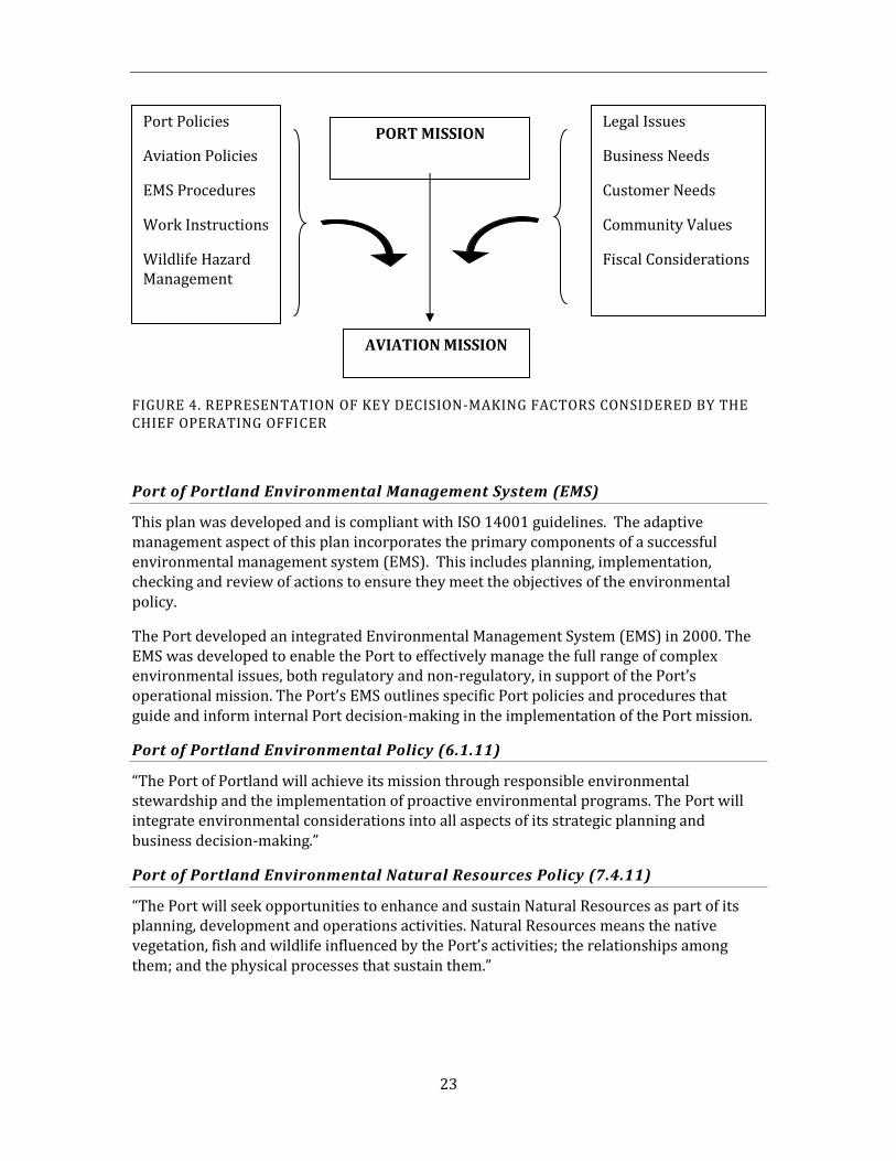
23
FIGURE 4. REPRESENTATION OF KEY DECISION-MAKING FACTORS CONSIDERED BY THE CHIEF OPERATING OFFICER
Port of Portland Environmental Management System (EMS)
This plan was developed and is compliant with ISO 14001 guidelines. The adaptive management aspect of this plan incorporates the primary components of a successful environmental management system (EMS). This includes planning, implementation, checking and review of actions to ensure they meet the objectives of the environmental policy.
The Port developed an integrated Environmental Management System (EMS) in 2000. The EMS was developed to enable the Port to effectively manage the full range of complex environmental issues, both regulatory and non-regulatory, in support of the Port’s operational mission. The Port’s EMS outlines specific Port policies and procedures that guide and inform internal Port decision-making in the implementation of the Port mission.
Port of Portland Environmental Policy (6.1.11)
“The Port of Portland will achieve its mission through responsible environmental stewardship and the implementation of proactive environmental programs. The Port will integrate environmental considerations into all aspects of its strategic planning and business decision-making.”
Port of Portland Environmental Natural Resources Policy (7.4.11)
“The Port will seek opportunities to enhance and sustain Natural Resources as part of its planning, development and operations activities. Natural Resources means the native vegetation, fish and wildlife influenced by the Port’s activities; the relationships among them; and the physical processes that sustain them.”
Legal Issues
Business Needs
Customer Needs
Community Values
Fiscal Considerations
Port Policies
Aviation Policies
EMS Procedures
Work Instructions
Wildlife Hazard Management
AVIATION MISSION
PORT MISSION
24
2.7. Discussion of Port Policies
The WHMP must operate within the parameters set by the mission statements, goals, and policies listed above. This requires that the Port address environmental stewardship concerns and aviation safety needs concurrently. The WHMP works within the framework of these objectives through careful planning, risk evaluation, and analysis of available wildlife control options. While the priority of this program is aviation safety, the Port’s commitment to environmental stewardship will continue to ensure that impacts to natural resources are avoided or minimized to the extent practicable.

25
This page intentionally left blank.
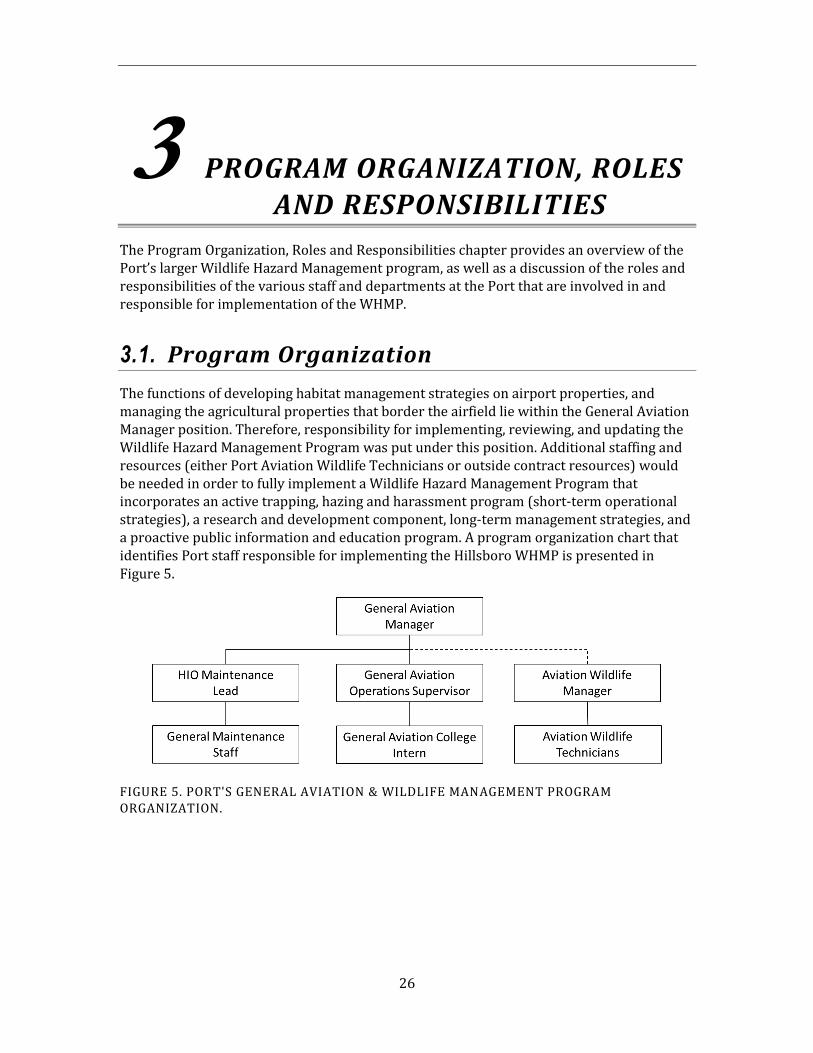
26
3 PROGRAM ORGANIZATION, ROLES AND RESPONSIBILITIES
The Program Organization, Roles and Responsibilities chapter provides an overview of the Port’s larger Wildlife Hazard Management program, as well as a discussion of the roles and responsibilities of the various staff and departments at the Port that are involved in and responsible for implementation of the WHMP.
3.1. Program Organization
The functions of developing habitat management strategies on airport properties, and managing the agricultural properties that border the airfield lie within the General Aviation Manager position. Therefore, responsibility for implementing, reviewing, and updating the Wildlife Hazard Management Program was put under this position. Additional staffing and resources (either Port Aviation Wildlife Technicians or outside contract resources) would be needed in order to fully implement a Wildlife Hazard Management Program that incorporates an active trapping, hazing and harassment program (short-term operational strategies), a research and development component, long-term management strategies, and a proactive public information and education program. A program organization chart that identifies Port staff responsible for implementing the Hillsboro WHMP is presented in Figure 5.
FIGURE 5. PORT'S GENERAL AVIATION & WILDLIFE MANAGEMENT PROGRAM ORGANIZATION.
27
3.2 Roles and Responsibilities of the Airports Operations Manager
The relevant responsibilities of the Manager of Airport Operations are as follows:
Provide the decision-making authority for major program decisions, controversial issues or conflict resolution in support of the Aviation Mission.
Coordinate major WHMP decisions with the Chief of Operations.
3.3. Roles and Responsibilities of other Port Staff
The following text provides an overview of the roles and responsibilities of Port staff involved in HIO wildlife related issues. Additional detail regarding roles and responsibilities will be documented within the Port’s Environmental Management System (EMS) fish and wildlife management procedure and associated work instructions.
3.3.1. General Aviation Manager
The relevant responsibilities of the General Aviation Manager are as follows:
Program Management:
Provide direction to the GA Operations Supervisor regarding the WHMP implementation policies and guidelines.
Ensure that aviation wildlife hazard concerns are incorporated into project planning early in the process.
Provide both strategic guidance and operational direction to the program.
Review and approve the annual budget for the Aviation Wildlife Management program.
Coordinate technical issues with wildlife management staff.
Participate with local, state, and federal agencies on land use decisions that could attract wildlife species of concern to properties around the airport.
If mitigation is required for an expansion or development project, coordinate with the Aviation Wildlife Manager for appropriate location of mitigation site.
Communication:
Actively engage the regulatory agencies, Port staff, and the public in dialog to foster the management objectives of the program.

28
Advise the GA Operation Supervisor about agency interaction, relationships withenvironmental groups, and internal/external exposure.
Work with the Aviation Wildlife Manager and GA Operation Supervisor to developpublic information and education campaigns on specific issues of public interest orcontroversy.
3.3.2. Aviation Wildlife Manager
Program Operations and Maintenance:
Supervise the Aviation Wildlife Program staff.
Provide technical Quality Assurance for WHMP projects.
Provide advice on planning and completing applied research activities.
Facilitate inter-departmental technical communications regarding project issuesand technical trends affecting the WHMP.
Serve as the technical area expert for all Port owned Aviation facilities (PortlandHillsboro, and Troutdale Airports) on wildlife hazard management issues andregulatory requirements.
Provide technical review of reports and other written documents.
Facilitate the respond to immediate wildlife concerns on the airfield if needed andavailable.
Plan and administer the Aviation Wildlife Management program budget.
Obtain the permits needed for wildlife control activities, and write the end of theyear reports to renew permits. Coordinate with agency staff regarding permitactivities.
Oversee raptor trapping and relocation program. Connect these activities with otherwildlife management activities ongoing at PDX and TTD.
Coordinate with the GA Operations staff (through the designated liaison) tocommunicate WHMP activities as they affect movement areas, NAVAIDS, or haveother airfield impacts.
Communicate airfield operational issues to HIO staff and tenants.
Analyze wildlife data, seasonally and annually, for identification of significant trendsor new hazards.
Review construction and maintenance projects to determine if there will be animpact to the HIO WHMP. Screen design features and landscaping plans for wildlifeattractants and recommend modifications.
29
Communication:
Provide briefings to the Natural Resource Manager on HIO WHMP events, projects, and programs.
Act as a technical referral to other Port departments on wildlife related issues at HIO.
Conduct media briefings as requested.
Participate in educational, outreach, or program awareness activities both within the Port, HIO, and in the larger community.
Agency Interaction:
When a strike occurs, gather the information needed and submit the strike report to the FAA.
Serve as the primary Wildlife Hazard Management program liaison with the FAA.
Update the WHMP as needed.
Act as the Port liaison with wildlife agencies for wildlife incidents that occur outside of the perimeter fence.
Facilitate the Wildlife Advisory Committee to get input from outside agencies and interest groups on the Wildlife Hazard Management program.
Scheduling and Training:
Train the Aviation Wildlife Management staff to respond to Wildlife issues as outlined in AC 150/5200-36.
3.3.3. General Aviation Operations Supervisor
Program Operations and Maintenance:
Conduct physical inspections and implement wildlife control measures on the airfield as needed. Record all data in AIRMAN.
Respond to immediate wildlife concerns on the airfield if needed to assist the Wildlife Technicians.
Work with the Aviation Wildlife Manager to identify hazards, trends, or new attractants that need to be addressed.
Provide input to wildlife control activities and projects.
Review construction and maintenance projects to determine if there will be an impact to the WHMP.
30
When a strike occurs, gather and submit the information to the Aviation WildlifeManagement program staff.
Gather information about wildlife activity and respond to wildlife situations on theairfield when Wildlife staff is not on duty, including throughout nighttime hours.
Data Management:
Maintain accurate data of wildlife activity, both on the airfield and in adjacent Port-owned properties. Providing quality assurance of the data in AIRMAN.
3.3.4. Aviation Wildlife Technicians (or outside contract resources)
Program Operations:
Conduct physical inspections and patrols of the airfield to conduct wildlife controlmeasures, and keep an accurate log of these activities in AIRMAN database.
Respond to calls from the tower in order to alleviate any wildlife hazards
During the spring, conduct inspections of the airfield and adjacent properties fornesting waterfowl.
Inspect the airfield during the winter season for areas of temporary standing water.Annually, provide a map to engineering of problem areas that need drainagecorrection.
Handle and transport wildlife removed from the airfield to the appropriaterehabilitation, relocation or disposal sites.
Trapping of diurnal raptors and maintenance of traps and trapping equipment.
Report significant wildlife activity to the Aviation Wildlife Manager and GAOperations Supervisor (when appropriate) if it impacts a movement area or is animmediate threat to aircraft operations.
Maintain wildlife control equipment.
Screen design features and landscaping plans for wildlife attractants andrecommend modifications that are consistent with this plan.
Coordinate needed wildlife control projects such as installation of anti-perchingmaterial, testing of new equipment, etc.
When a strike occurs, gather and submit the information to the FAA National StrikeDatabase.
Communicate new or increasing wildlife hazards to the Wildlife Manager. Alsoreport the effectiveness of current wildlife control activities.
31
Data Management:
Maintain accurate data of wildlife activity, both on the airfield and in adjacent Port-owned properties. Providing quality assurance of the data in AIRMAN.
3.4. Roles and Responsibilities of Other Port Departments
The Port recognizes that the cooperation of many departments within the Port, both in Aviation and in other divisions, is necessary for the successful implementation of the WHMP. Detailed roles and responsibilities matrices have been developed as part of the Port’s EMS. A summary of the HIO Maintenance department and their identified points of coordination with the WHMP are included in the following section. Because of the need for close day to day working relationship between the Aviation Wildlife, GA Operations, and HIO Maintenance departments, this is the only other Port department specifically outlined in this document.
3.4.1. HIO Maintenance Staff
Program Operations:
Report significant wildlife activity to the General Aviation Management if it impactsa movement area or is an immediate threat to aircraft operations.
Communicate new or increasing wildlife hazards to the General AviationManagement. Also report the effectiveness of current wildlife control activities.
Coordinate with Wildlife staff to minimize the attractiveness of airfield mowing.
Maintain airfield drainage to avoid pooling of water and minimize temporarystanding water.
Maintain current pesticide applicator’s certification in compliance with EPAstandards.
32
4 IMPLEMENTATION STRATEGIES
Management strategies and general operational strategies will be used to effectively implement the WHMP. The management strategies are based on four program components or “pillars” that tie together to address both the short and long term wildlife and habitat management needs at HIO. All management actions identified in this chapter are subject to reassessment and validation through the risk evaluation process and adaptive management.
4.1. Risk Evaluation Process
The Port has identified a need to document the systematic approach that is used to assess wildlife hazards at Port-owned airports and prioritize actions based on the relative levels of risk they create. To accomplish this task, the Port has developed a pro-active, adaptive process to identify wildlife hazards, assess risks and prioritize management actions that are responsive to the relevant species and their use of both natural and man-made features on and around the airport. The potential risk is determined by considering the potential for a particular species to cause physical damage to an aircraft and the probability of occurrence that the species would be involved in a collision at HIO. The Port can identify and examine potentially undesirable interrelated/interdependent effects of its actions prior to implementation of proposed management strategies.
This formal risk evaluation approach utilized by the Port builds on the body of work of Dr. J. R. Allan, adapting it to the site-specific issues at HIO. This process is designed to evolve over time as new information and real world application provide direction.
The potential severity of impact and probability of occurrence is rated as high, medium, or low for each of the relevant species at the airport and placed in a risk evaluation matrix. The Port will utilize the findings of the risk evaluation model to prioritize, and assess the effectiveness, of different aviation wildlife hazard management strategies. Included in this assessment will be an examination of potential impacts of proposed management actions, so that the Port can identify and examine potentially undesirable effects of its actions prior to implementation.
4.2. Zone Concept
FAA Advisory Circular 150/5200-33 provides guidance on the siting of certain land uses that have the potential to attract hazardous wildlife on or near public-use airports (Appendix B). At airports serving turbine-powered aircraft such as HIO, the FAA recommends a separation distance of 10,000 feet be maintained between the AOA and new land uses deemed incompatible with safe airport operations (e.g., municipal solid waste landfills, wastewater treatment facilities, wetland mitigation projects). Existing land uses within this zone (e.g., retail, storm water detention facilities, golf courses) may be
33
compatible with airport operations if there is no apparent attraction to hazardous wildlife, or if wildlife hazard management efforts effectively eliminate or contain the hazard. It should be noted that the identification of hazardous wildlife and hazards is an ongoing process at HIO. To aid in this process, the Port has surveyed and mapped all known habitats on Port owned aviation property (Figure 6).
For management prioritization the Port has divided the FAA’s 10,000-foot area around the AOA at HIO into 2 zones: the Primary Zone, and the Secondary Zone. This tiered approach to wildlife hazard management is based on the premise that the potential risk posed by a hazard increases with proximity to aircraft operations. A brief description of these 2 zones follows. Refer to Figures 7 & 8 for a map of these zones.
4.2.1. Primary Zone
The Primary Zone (Figure 7) is defined as the area within the airfield perimeter fence, a 300-foot buffer around the perimeter fence, and the runway protection zones (RPZs) located at the end of each runway. The RPZ, which is established by the FAA in AC 150/5300-13, represents the area in which aircraft are most vulnerable to wildlife strike hazards. The airfield perimeter fence establishes a secure perimeter to the immediate airfield for safety and security reasons, including the exclusion of most large terrestrial wildlife. Land management decisions within the Primary Zone are subject to the single dedicated land use of operating an airport and the associated public aviation safety concerns. The Port’s overarching WHMP objective for the Primary Zone is to eliminate or reduce to the extent practicable all attractants for wildlife species of concern that occur there, and to not allow any new attractants to be located within this zone. The WHMP risk evaluation analysis further defines the need for and the priority of management actions taken in this zone. Lands within the Primary Zone are monitored regularly for hazardous wildlife and wildlife control procedures are implemented as necessary to alleviate potential wildlife hazards.
4.2.2. Secondary Zone
The Secondary Zone (Figure 8) encompasses all remaining lands within the 10,000- foot separation criteria area established in FAA Advisory Circular 150-5200-33 that are not included in the Primary Zone. Land uses with the Secondary Zone must be compatible with safe aircraft operations and should not create new attractants for wildlife species of concern that result in unacceptable risks. Lands in the Secondary Zone are not monitored on a daily basis, and include private property not directly under the management control of the airport. Strategies on Port owned property in the Secondary Zone are by necessity less prescriptive. Early participation in Port land use and management planning is required to enable integration of aviation concerns. Strategies on non-Port owned properties within 10,000 feet of the airport are even more indirect, and require a proactive and ongoing dialog with both private landowners and local/regional planners.
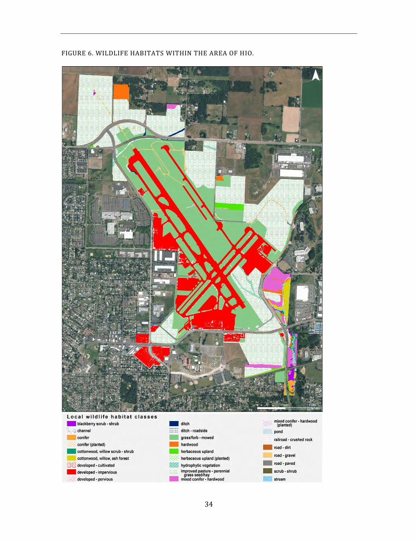
34
FIGURE 6. WILDLIFE HABITATS WITHIN THE AREA OF HIO.
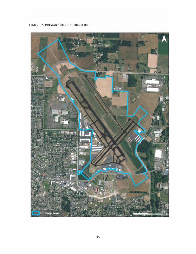
35
FIGURE 7. PRIMARY ZONE AROUND HIO.
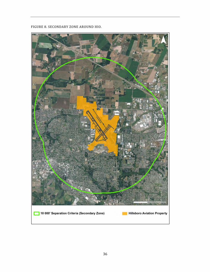
36
FIGURE 8. SECONDARY ZONE AROUND HIO.
37
This page intentionally left blank.
38
4.3. Management Area Strategies
In order to document and organize all of the management concerns, constraints, and actions, HIO was divided into logical areas based on land-use, wildlife management and habitat type. As a result, 6 large areas of land (management areas) were delineated (Figure 9). Management areas outside the airfield fence (areas B2, D, E) are managed under the Undeveloped Properties management program which implements the risk management strategies developed in the WHMP:
A – Airfield Area (excluding B1 and C below)
B1 – Agricultural Areas inside the Perimeter Fence
B2 – Agricultural Areas outside the Perimeter Fence
C – Wetland Area at the North End of Runway 12
D – Brookwood (Dawson Creek) Stream Corridor
E – Other Port-owned Properties outside the Perimeter Fence
This approach categorizes wildlife hazards and explains the operational strategies for each area in a comprehensive spatial context for all Port-administered properties in the Primary and Secondary Zones. It also facilitates the development of management scenarios. The effort utilizes the best information currently available, based on wildlife observations and strike data at HIO. These management areas are subject to ongoing assessment and revision.
The HIO Wildlife Attractants Table (Appendix D) also identifies the principal wildlife habitats present in each management area, expected utilization by wildlife species of concern, other management constraints and issues associate with the management areas, and management actions taken to date in these areas.
Within each management area, the risk management techniques and protocols discussed in Chapter 5 have been integrated into specific management strategies that address the wildlife hazards unique to each management area. These management strategies are organized according to four management components or “pillars” that support the Wildlife Hazard Management program: (1) short-term operational strategies, (2) research and development projects, (3) long-term management strategies, and (4) information and educational programs. These program components are interconnected by lateral paths representing information and technology transfer. A brief description of these 4 program components or pillars follows.
The first pillar, short-term operational strategies, addresses the need of the moment. This includes the reactive hazing program intended to clear the airspace of wildlife hazards that pose an immediate threat to safe aircraft operations. In addition, short-term habitat manipulations on a relatively small scale are included in this operational category, such as mowing schedules, tree topping and pruning, netting projects, perching deterrents, and rodenticide applications.
39
The Port set a wildlife management program goal to achieve this first pillar, when possible, in a non-lethal manner by utilizing the full range of technologies available. However, implicit in this statement is the recognition that it may not always be possible to avoid lethal control. The WHMP identifies the risk based decision-making process preceding the implementation of lethal action in section 5.1.8. A basic premise of the lethal action strategy is that it will target an individual animal and its problematic behavior, rather than a population. The only current exceptions to this rule are the European starling control program, and the prey base control strategies for small mammals. The European starling is an introduced pest that presents a significant hazard to aviation (due primarily to its flocking behavior and abundance), but also represents an ecological risk as they threaten native species diversity. Small mammals are found in abundance in the artificially created and maintained short grass environment of the airfield. They are a primary food source and attractant for red-tailed hawks and other predatory species. An effective prey base control strategy is essential in order to reduce the attractiveness of the airfield to red-tailed hawks and other predatory species.
The second pillar consists of ongoing applied research and development projects to expand the range of aviation wildlife hazard management strategies, test new hypotheses, and evaluate new technologies. Due to the adaptive nature of wildlife species of concern, an effective Wildlife Hazard Management Program requires a high level of flexibility and a commitment to the principles of adaptive management. The information gained from ongoing research and development projects provide a scientific base for decisions on how to best implement both short -term operational strategies and the long-term management strategies.
The third program pillar is the development of long-term management strategies, including habitat modifications and permanent site conversion. These strategies are based on the premise that both the physical presence of wildlife species of concern on the airfield and the length of time that they are present, can be diminished by reducing the attractiveness of the habitat on and around the airport. However, in highly modified environments like airports, single-focused habitat alterations to discourage one species of concern can often create enhanced conditions for another. Therefore, effective long-term habitat modifications must be designed to consider what effect the changes will have across the whole ecological system. Long-term management strategies may range from physically excluding the target species permanently from the area (where possible) to habitat modifications such as tree or wetland removal.
The fourth pillar of the program is the information and education component, which recognizes that wildlife issues are of widespread interest to both internal and external groups and individuals. The success of the program is predicated on active cooperation with a large number of stakeholders as well as an ongoing program to inform and elevate awareness of wildlife issues at HIO. Outreach opportunities also provide input that helps to incorporate HIO issues into the larger regional context.
40
Appendix E contains the Management Areas Tracking Table which provides a summary of management strategies proposed for HIO. The information in Appendix E is based on the ongoing and completed management actions outlined in Table 5 of the 2007 WHMP well as potential management actions that may be pursued in the future. The management strategies are organized by management area, and categorized into one or more of the four pillars described above. In addition, identified management strategies are also tied to their location within either the Primary or Secondary Zone at HIO. As described this chapter, the management of wildlife species of concern and wildlife attractants is driven, in part, by their location in these two areas, which together define the 10,000-foot separation criteria area at HIO. This tiered approach to wildlife hazard management is based on the assumption that the potential risk posed by a hazard increases with its proximity to aircraft operations. A more complete discussion of the Primary and Secondary Zones, and which management strategies apply to each, are described in Sections 4.2.1 and 4.2.2. As mentioned previously, all management strategies identified in Appendix E, as well as the need for the zone approach, are reassessed and validated on an ongoing basis.
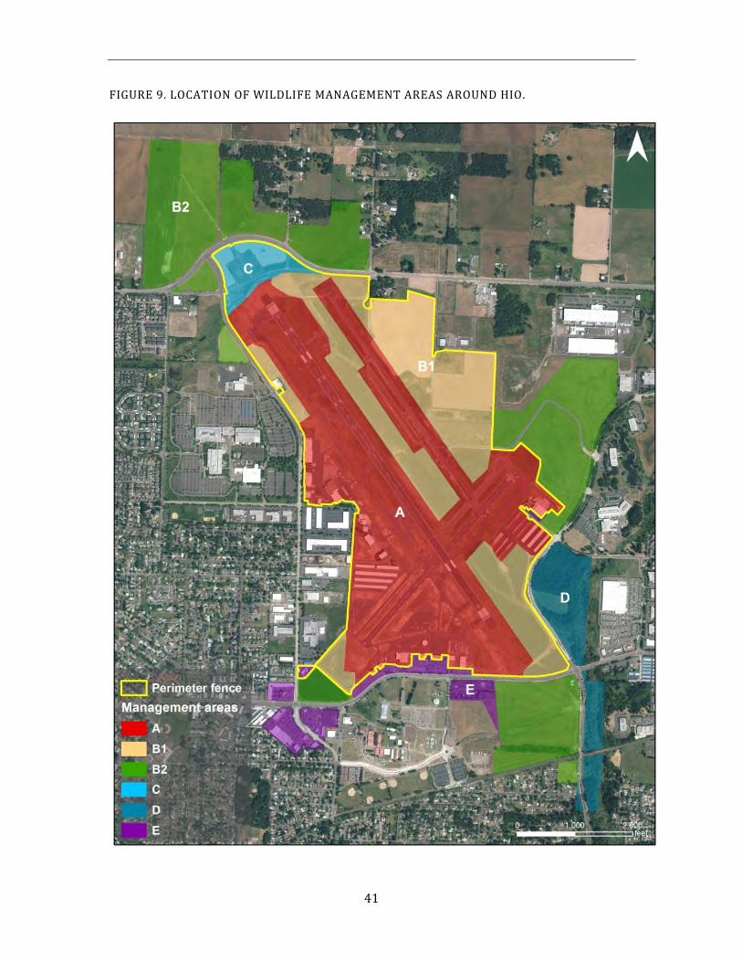
41
FIGURE 9. LOCATION OF WILDLIFE MANAGEMENT AREAS AROUND HIO.
42
4.4. General Operational Strategies
All of the components described in the previous sections interact on a daily basis to resolve both immediate and long-term wildlife hazard issues at HIO. When a wildlife hazard is identified, the first action is active hazing (except for species that cannot be effectively hazed, such as deer). The least aggressive tools are tried first, such as auditory and pyrotechnic harassment, to see if the wildlife hazard can be dispersed from the critical area. If the situation is not resolved by the use of these methods, airport staff will contact the Aviation Wildlife Manager for guidance on more aggressive options such as physical harassment devices (e.g., paintball markers).
GA airport staff and the Aviation Wildlife Manager will also consider whether an activity is occurring that may be attracting wildlife hazards to an area, such as mowing, watering, construction, or farming. Although these activities cannot always be stopped, they can often be modified or completed at a time of day when the species of wildlife in question is less active. Many times an awareness of the situation and responding with temporarily increased hazing efforts is enough to resolve the issue.
If these measures are ineffective, the next step is to consider the option of deterring or excluding wildlife from the area in question. This can be achieved through the installation of a variety of products such as netting, bird spikes or fencing. If none of the above options are effective or feasible, habitat modification will be considered to make the area less attractive to wildlife species of concern. GA Airport staff and the Aviation Wildlife Manager will determine what specific habitat is creating the attractant and then develop a range of possible actions to modify or eliminate that habitat. Caution must be exercised to ensure that the proposed habitat modification to deter one wildlife hazard does not inadvertently attract another. Consideration must also be taken for permits that may be required for some types of habitat modification, such as wetland modification or fill.
If habitat modification is not feasible, GA Airport staff and the Aviation Wildlife Manager will consider whether the wildlife species in question can be trapped for relocation or euthanasia. Coordination with the appropriate regulatory agencies is required in these cases. The “research and development” pillar and the “information and education” pillar (Section 4.3) also come into play at this stage. Airport staff and the Aviation Wildlife Manager will contact other airports to see how they may have resolved a similar situation. Often, the FAA has experience advising airports about wildlife situations and can provide contacts that have experience with the problem species. Researchers, such as the USDA National Wildlife Research Center or universities, will be contacted for ideas. Vendors of wildlife control equipment can be a good source for new equipment that might be used in specific situations. Even other industries that deal with wildlife control can provide ideas about methods or equipment that can mitigate a specific situation.
When a feasible idea is generated it will be implemented on a trial basis, be monitored, and evaluated to determine if it is an effective solution. As new methods or materials are found to be effective, they will be integrated into the daily operation of the Port’s Wildlife Hazard Management program.
43
If all non-lethal methods have been considered and are not effective or feasible, a lethal action may be considered. An evaluation will be conducted on how the lethal control would be implemented, who would do it, and what the determination would be to start and stop the lethal control. More detail on lethal control is presented in Section 5.1.8.
As the above discussion demonstrates, the integration of the four pillars works to achieve a successful resolution to any wildlife hazard problem. Information gained from applying each of the four aspects to a specific wildlife hazard situation is transferred to the other components. The principles of adaptive management are used to try various options until an acceptable one is found. The result is the generation of experience and data on the range of effectiveness of the options available in dealing with a specific wildlife situation, using the best science and technology available.
4.5. Project Evaluation
For consistency and to prevent potential conflicts of use and/or safety issues, the following decision making processes have been developed for activities within 10,000 feet of HIO. They outline the general decision making process for each of the following situations: requesting general technical assistance, coordinating activities and implementing actions on Port lands that may affect one or more Port operating areas, and implementing habitat modifications on Aviation lands. All of the processes were developed as part of the Port’s ongoing management program and were designed to ensure all parties are aware of potential conflicts in use.
4.5.1. Project Screening for Proposed Development
Activities and/or projects on Port lands within the 10,000-foot separation criteria of the HIO runways have the potential to adversely affect safe airport operations. Consequently, a decision making process was developed to assist in coordinating efforts for projects within the 10,000-foot area. For Port projects, the project managers should refer early conceptual project design to the Wildlife Manager to identify and avoid actions that may have the potential to adversely affect safe airport operations in accordance with FAA guidelines. This may include, but is not limited to:
Building location and design; Landscape design;
Stormwater Management;
Mitigation projects and general enhancement of natural areas;
Tenant or leasehold improvements.
In addition, the Port’s BATS procedure was developed to provide early conceptual screening for a wide range of potential impacts of proposed tenant projects. The wildlife program utilizes the BATS process to screen project proposals for potential wildlife hazard attractant features and recommendations are made as appropriate to the planning team. Once the Aviation Wildlife Manager is made aware of a project, the initial step is to determine whether the project may pose a hazard. If it is determined that the project would not pose a potential hazard, the project would move forward. If a potential hazard were
44
identified, the project would undergo the risk evaluation to determine if the risk due to the project is acceptable or if project modifications could be incorporated to lower the risk to an acceptable level.
Port owned Mitigation sites within 10,000 feet are managed by the Port’s Natural Resources program. Natural Resource staff works with the wildlife program to ensure that the management of the mitigation sites is compatible with the WHMP. For projects that are not on Port land within 10,000 feet, wildlife staff work cooperatively with local planning and zoning staff to screen projects for potential wildlife hazards, primarily stormwater management and landscaping.
4.5.2. Monitoring and Evaluation
The Port developed an integrated Environmental Management System (EMS) in 2000, compliant with ISO 14001 guidelines and based on the principles of adaptive management. The HIO Wildlife Hazard Management program is designed within this context, integrating scientific methodology with the built in adaptive management feedback loop of Plan; Do; Check; and Act. Adaptive Management has been defined as “a system of management practices based on clearly defined outcomes, monitoring to determine if management actions are meeting outcomes, and, if not, facilitating management changes that will best ensure that outcomes are met or to re-evaluate the outcomes.” (Department of the Interior Manual, May 27, 2004 Environmental Quality Programs).
The application of these principles at the operational and program levels provides the flexibility necessary to respond to changes in environmental conditions, adjust to unanticipated impacts, and modify management strategies to improve effectiveness. Given that the Port’s Wildlife program is dealing with living organisms which are adaptive by nature, and the complexity of ecological inter-relationships involved, this flexibility is essential to the success of the program. The program has been developed to constantly monitor success and re-assess strategies informally on an ongoing basis, and to formally assess overall program effectiveness on an annual basis.
Examples include wildlife surveys, recording hazing results, wildlife trapping and relocation; also, the monitoring of wildlife strikes, standing water, wetland development, avian nests, wildlife food sources, wildlife distribution, and habitat use in general, is ongoing.
45
This page intentionally left blank.
46
5 RISK MANAGEMENT TECHNIQUES AND PROTOCOLS
The risk management techniques and protocols chapter outlines the measures employed to ensure public safety at HIO by reducing the incidence of wildlife-aircraft collisions. These measures are grouped according to 4 general categories:
1. Wildlife control procedures to discourage, disperse and remove wildlife species ofconcern from the airfield vicinity;
2. Research and development projects to gather data and field test new equipment andtechniques, and to gain a better understanding of wildlife dynamics as they relate toHIO;
3. Habitat modification practices to reduce the attractiveness of lands on and aroundthe airport to wildlife species of concern; and
4. Information and education program that communicates to a variety groups thehazards wildlife create for safe aircraft operations.
Through adaptive management and the risk evaluation process, current wildlife control measures will periodically be reassessed by PDX Wildlife and HIO Airport staff for efficacy and correct prioritization. It is expected that these measures will change and be refined over time as more effective applications and new techniques are identified.
5.1. Wildlife Control Procedures
Wildlife control procedures are utilized to immediately discourage, disperse and remove wildlife species of concern from the HIO airfield vicinity. Their implementation encompasses the day-to-day, on-the-ground efforts routinely employed by Airport staff to ensure that the approach and departure airspace is as free of potential wildlife hazards for immediate aircraft operations as is practicable. Wildlife control operations are generally reactive to the situation of the moment, responding to any perceived threat to aircraft safety posed by wildlife species of concern.
Wildlife hazards that develop on or around the airfield are assessed by Airport staff to determine the most appropriate control option. A primary key to successful wildlife hazard management is persistence and innovation on the part of the individuals implementing the management strategies. Airport staff selects the appropriate control techniques according to biological, sociologic, economic and political factors. Most common control techniques retain their effectiveness if they are used infrequently, and in conjunction with other methods. The control method(s) chosen will depend largely on the situation at hand and the species involved.
47
A variety of control equipment and resources are currently used to disperse wildlife attempting to utilize HIO for food, shelter or resting. The type of equipment used in any given situation will vary depending on the nature of the wildlife threat and the associated risk. The ultimate goal of all wildlife control equipment is to achieve the most efficient means of wildlife dispersal.
5.1.1. Personnel & Communications
Airport staff is responsible for conducting physical inspections of airfield movement areas and other areas critical to wildlife hazard management as part of their airfield duties. During periods of high wildlife activity, more than one Airport staff person may be assigned to the airfield. Airport staff will contact the Aviation Wildlife Manager whenever additional support or direction is needed to address wildlife-aviation hazard issues at HIO.
5.1.2. Vehicles
In order to effectively reach all areas of the airfield, Airport staff vehicles are all wheel drive capable with the ability to communicate, via radios, with other airport assets including the Air Traffic Control Tower. In addition, each vehicle is equipped with a variety of hazing tools including but not necessarily limited to air horns, sirens, pyrotechnic devices, handheld lasers, and spotlights.
5.1.3. Wildlife Surveys
During daily runway checks, wildlife data are collected by Airport staff trained in wildlife data collection for entry into the Airport Information Report Manager (AIRMAN) database. AIRMAN is software designed by Winfield Solutions for use in airport wildlife management. AIRMAN provides a database where wildlife data is compiled and organized for easy management queries. Queries can be displayed spatially on an aerial photograph to show any and all attributes collected by Airport staff. Once the data is entered into AIRMAN, its logical organization allows trend analysis that can be performed instantly. Annual and monthly reports are generated for review, enabling well-informed management decisions.
5.1.4. Data Collection Procedure
Data collection procedures and sampling assumptions are periodically reviewed with all designated observers to ensure uniformity of observations and data collection. For each wildlife observation, the following information is recorded on AIRMAN data sheets while in the field:
Date/time of occurrence. The time of day is recorded when the wildlife species is initially observed.
Weather. Airport staff records the current weather conditions by tuning the 800 MHz radio frequency to Automatic Terminal Information Service (ATIS) at 127.65. Temperature, precipitation, cloud cover, wind speed and wind direction are recorded. If at any time
48
during each shift the weather changes significantly the datasheet is updated to the current weather conditions.
Grid location. The location where the species was first observed is recorded using a grid system that is overlaid onto an aerial photograph. When wildlife is observed moving through multiple grids, the first grid location is always recorded. A set of these aerial photographs remains in the observer’s truck for easy access while recording wildlife observations.
Species observed. Airport staff record the species observed using the assigned four letter codes. The codes are listed on the back of the datasheet for a reference while in the field. More specific information is collected on raptors to identify individuals that are then classified as resident or nonresidents. Plumage variation and band numbers are the primary characteristics used to determine individual birds of the same species. Any species that is not positively identified will be recorded as “unknown”. If a species is observed multiple times throughout the day in the same location and is exhibiting the same behavior, it is to be recorded as one observation. If a species is observed multiple times throughout the day in various locations, exhibiting different behavior, or if dispersal techniques are conducted, it is then recorded as an additional observation.
Number observed. The number of individuals is recorded for each species observed. When a particular species is exhibiting flocking behavior the total number of individuals in the flock is estimated. Airport staff are trained to estimate flocking numbers before entering data into the AIRMAN database.
Activity. The activity is intended to capture the behavior of the species when associated with the attractant. The initial activity of observed species is recorded. If there is a notable change in the species activity during the observation, additional information is recorded in the “notes” section of the datasheet.
Attractant. Assumptions are made by Airport staff regarding what the observed species is attracted to. These assumptions are based on the behavior of each individual species (e.g. feeding, breeding, resting/loafing, territorial, etc.). Airport staff undergo wildlife behavioral training for species commonly observed at HIO before collecting data for the AIRMAN database. If the observer is unable to determine the attractant, it is record as “unknown”. A list of attractants and their codes are on the back of the datasheet for a reference while in the field.
Dispersant. When hazing or dispersing wildlife from the airfield, the equipment or method used is recorded. If multiple dispersants are used, the two most aggressive dispersants are recorded. A list of dispersants and their codes is on the back of the datasheet for a reference while in the field.
Result. Airport staff will record the outcome of their hazing attempt. If no dispersal action is taken it is then recorded as observed.
Strike. If a species is involved in an aircraft strike, additional information will be collected and sent to the Aviation Wildlife Manager and Wildlife Technicians for the preparation and
49
submittal of a strike report to the FAA’s wildlife strike database. In the incidence of an aircraft strike, Airport staff document the following:
Species, number and size category of the species struck
Name of the airline (when applicable), type of aircraft, and registration number
Flight number (when applicable)
Phase of flight
Runway used
Part(s) of aircraft struck
Damage or no damage
Effect on flight
Any other pertinent information
5.1.5. Hazing and Harassment
Hazing and harassment are the primary methods used to disperse wildlife species of concern from the airfield to allow for safe aircraft operations. This is responsive to the immediate safety needs of each arriving and departing aircraft. Techniques that may be used to haze birds include pyrotechnic devices (e.g., shell launching pistols, 12-gauge shotguns), remote controlled propane cannons, and other auditory frightening devices (e.g., vehicle air horns and sirens), visual deterrents (e.g., green laser), and paintball markers. Before implementing any hazing techniques Airport staff will assess the location of wildlife relative to imminent aircraft operations and will determine the appropriate method and timing for hazing. Reactions to hazing are noted and wildlife is monitored to ensure that it does not relocate to another area of the AOA and continue to pose a hazard to aircraft. The results of each dispersal action taken are entered into the AIRMAN database for future retrieval and evaluation.
The techniques and protocols followed for hazing and harassment are expected to change over time as new information; including direction provided by the risk evaluation process and through adaptive management, is integrated into the WHMP. Current Port methodology appropriate for use at HIO is as follows.
Pyrotechnic Devices
HIO currently utilizes three types of pyrotechnic devices to control wildlife on the airfield, shell launching pistols, 12-gauge shotguns, and propane cannons.
- Shell Launching Pistols This lightweight and convenient device fires a 15 mm cartridge (a Bird Banger or Screamer Siren) approximately 40 to 70 yards while making a whistling noise or loud bang. The pistol gives the operator in the field the flexibility of localized wildlife control in a simple and timely manner. Before discharge, the user will evaluate the location of the wildlife to be hazed and determine if there is a potential for foreign object or debris (FOD) from the screamer shell casing to enter the movement areas. Bird Bangers do not generate FOD. Under no circumstances will FOD be allowed to land on the movement areas. These pistols and shells will be carried in all wildlife control vehicles.
50
- 12-Gauge Shotguns The shotguns discussed here are used exclusively to fire cracker shells. Cracker shells are 12-gauge shotgun shells that launch an explosive cartridge approximately 75 - 100 yards, before it explodes with a loud report. Cracker shells also do not generate FOD.
Remote Controlled Propane Cannons
Remote-controlled propane-powered sound cannons are a potential hazing option appropriate for areas that frequently attract large concentrations of wildlife, or in places that are difficult to access by vehicle. These cannons fire only when the units are electronically signaled to operate by a handheld or vehicle based radio. The ability to remotely fire individual cannons on command, as opposed to cannons that fire on a timer system, increases the sound cannon systems effectiveness by limiting wildlife habituation to a predictable noise.
Other Auditory Frightening Devices
Many times, wildlife can be dispersed from an area by using horns and sirens installed on wildlife vehicles. By positioning the vehicle between the movement area and the wildlife of concern, wildlife will often move away from the vehicle and therefore, away from the movement area. This is an effective way to disperse wildlife while in a moving vehicle, without having to use a pyrotechnic device. Using horns and sirens is also appropriate in situations where FOD from pyrotechnics is a concern or where pyrotechnic noise may be a hazard for personnel working in the area.
Visual Deterrents
- Green laser The laser is primarily used to disperse birds that do not react to other hazing methods or when there is a need to disperse outside of the range of pyrotechnics and cannons. Birds perceive the laser as a solid threatening object and tend to disperse when the laser beam is detected. The laser is a handheld unit which is activated from the Wildlife control vehicle. Wildlife staff follows approved FAA protocols when utilizing the laser inside the aircraft operating area. When Wildlife staff identify the need to use the laser they will take precautions similar to those taken when implementing pyrotechnic dispersals. The laser must be pointed at the ground and/or other non-reflective surfaces such as dry pavement to terminate the beam. The laser is most effective in low light conditions.
- Silt Fencing- Visual Barriers Silt fencing is used on undeveloped properties outside the PDX airfield fence, primarily as a goose deterrent. The fencing acts as a visual barrier that introduces the uncertainty of potential predators by obstructing the view. Being unable to see potential predators gives geese an unsettling feeling which has proven to be extremely effective in deterring geese in large open areas. This method will also be used at HIO as needed.
51
Paintball Markers
The paintball marker was purchased for the explicit purpose of hazing and marking wildlife on Port of Portland aviation property. Only Aviation Wildlife staff trained in its use will be allowed to use it, and it will only be used for the purpose of hazing and marking wildlife. A protocol for the use of paintball markers to deter wildlife on aviation property is as follows.
11.. Only temporary water soluble paint balls (both colored and clear) are used at HIO for the purpose of marking or hazing birds, and are therefore not subject to the permit requirements of the USDI Bird Banding Laboratory. Permanent paint balls are utilized for the marking of mammals for the purpose of documenting individual behavior.
22.. Before a paintball is discharged, the user will evaluate the location to determine if there is a potential for FOD from the paintball casing, or for paint marking a runway or taxiway sign or pavement area. No FOD from paintballs will be allowed to land on movement areas. No paintballs with colored paint will be shot toward movement area markings or signage; only clear paint balls will be used under these circumstances.
33.. The user of the paintball marker will consider the distance and species of bird before firing. An appropriate distance and psi will be used to minimize the potential of injuries to birds. The user will attempt to hit the bird in the keel or high on the shoulder. Every attempt will be made to avoid hitting birds in delicate areas. All birds tagged with the marker will be observed as they fly away to assure that they have not been harmed. Any bird that appears to be injured will be captured for treatment at the Audubon Society’s Wildlife Care Center.
44.. No paintballs will be fired toward or over public roadways or toward people on or off the airfield.
55.. The paintball marker will be used to discourage wildlife from using the airfield only after other dispersal techniques (vehicle, siren, horn, cannons, pyrotechnics) have proven ineffective. Appropriate situations include:
a. Marking a coyote that has been on the airfield to see if it returns. The coyote should be marked, if possible, during the process of herding it off the airfield.
b. Marking and hazing great blue herons and red-tailed hawks that have grown accustomed to pyrotechnics and will not leave the area.
c. Marking and hazing flocks of geese that use quiescent ponds or other adjacent airfield properties to determine if they are residents or migrants.
d. Paintballs are used as a negative reinforcement when birds have habitualized to pyrotechnics. Paintballs are used in conjunction with pyrotechnics to instill the fear of pyrotechnics.
52
Hazing Procedures- Birds
All bird species of concern observed on or near a runway, taxiway, or ramp will be hazed away from the aircraft operating area (AOA). Before conducting hazing activities, the Airport staff will consider:
1. The most effective method and tools for hazing the targeted wildlife species.
2. How to move the bird away from the AOA. If possible, the person will position thevehicle between the wildlife hazard and the runway or taxiway to push it from ahigh risk area to a low risk area.
3. Consideration will be taken to avoid shooting pyrotechnics toward aircraft, people,buildings, vehicles, etc. Cannons should only be fired when they are within visualrange of the operator to ensure that no one is in the immediate vicinity.
4. The airfield environmental conditions. In wet conditions, some areas are notaccessible with a vehicle. Alternately, using pyrotechnics in dry conditions cancreate a fire hazard.
5. The aircraft in the area and the direction of air traffic. Unless a bird/animal is on therunway and needs to be moved prior to a departure or landing, the dispersal willwait until there is a sufficient gap in aircraft movement. Airport staff will monitorthe tower radio and keep a visual on air traffic to avoid moving wildlife species ofconcern into the path of landing or departing aircraft.
6. The potential of the dispersal method to generate FOD. Non-FOD generatingtechniques are the preferred hazing method of use in the AOA.
Airport staff must determine the safest, most effective way to implement pyrotechnic control of wildlife species of concern. Reactions of birds to pyrotechnics vary by species, time of year, and numbers present. Generally, the best technique to disperse birds is to get positioned upwind between the bird(s) and the active runway(s) (birds normally take off into the wind, turn, and then fly off with the wind when being harassed). Airport staff should aim away from the runway if FOD is a concern and shoot the pyrotechnic about 45 degrees away from the target, on the opposite side of the desired escape route. Airport staff should get as close to the bird as possible in order to expedite their departure.
In some situations, birds may circle and move to another part of the airfield or attempt to return to the same location. In such cases, it is advantageous to have two personnel using control measures to prevent birds from relocating or returning. If only one person is available, use of propane cannons in conjunction with the cracker shells can effectively prevent birds from returning or relocating to another site on the airfield.
Any pyrotechnic FOD should be removed from a runway or taxiway as soon as possible.
53
Hazing procedures- Mammals
No standard protocol is followed to disperse or remove mammals from the AOA at HIO because of the varying response to hazing demonstrated by different species of mammals. Instead, species-specific procedures are followed that have proven effective over time. Domestic animals that are accidentally released on the airfield will not be classified as wildlife. Every attempt will be made to capture domestic animals and return them to their owners. Based on the risk evaluation process and adaptive management, Port protocols for addressing these issues may evolve to better reflect new information. The Port’s current operating procedures are as follows:
- Coyotes
When dispersing coyotes from the airfield, the acceptable procedure is to guide the coyote out of an opened perimeter gate or other perimeter access point (e.g., culvert under the perimeter fence) with vehicles. This may require enlisting assistance from other Airport staff. Our experience is that aggression towards a coyote makes them more difficult to control. Anticipating the direction they are likely to go, and providing them an avenue of escape proves to be an effective technique. Airport staff will coordinate with the Air Traffic Control tower if the coyote is on the runway, or if access to a movement area is needed to disperse the coyote away from aircraft activity. In the event that Airport staff are unable to disperse a coyote and it continues to be a hazard in the AOA, the Aviation Wildlife Manager will be contacted to discuss further management options.
- Deer Deer rarely find their way past the security fence and onto the airfield at HIO, and do not need to be dispersed if they are outside of the airfield security fence. If there is a need to remove deer from within the security fence, Airport staff may gently coax them to a place where they can exit the airfield or they will be lethally removed following the Port’s Oregon Department of Fish & Wildlife permit.
- Mole/Gopher Trapping Moles and gophers can damage airport facilities by damaging underground electric cables that power runway lights and by undercutting aircraft movement surfaces by burrowing under them. These consequences represent indirect hazards to the safe operation of aircraft at HIO. These species will be removed by direct control measures (e.g., trapping, poison applications) whenever they become problematic on the airfield.
54
Protocol for Airfield Access and Communications
The following protocol outlines the procedures to be followed by Airport staff when accessing the HIO airfield and maintaining communications during wildlife management operations. The procedures are intended to satisfy the requirements set forth by the FAA for access onto movement areas by Airport staff.
Communication procedures:
Any access to the movement areas for the purpose of wildlife management will be coordinated with the Air Traffic Control tower.
Accessing a movement area:
1. If access to a movement, safety, or critical area is necessary to facilitate wildlifemanagement activities, the Airport staff making the request shall contact the AirTraffic Control tower to coordinate access to a specific area.
2. Upon completion of the wildlife management operation, Airport staff will exit themovement, safety or critical area by the most direct and safe route. ATC should benotified when clear.
3. No uncoordinated access to runways or runway safety areas is allowed. If thereis a specific wildlife issue that involves a runway or runway safety area, Airport staffshall contact the Air Traffic Control tower to advise them of the situation andrequest access to the area if necessary. Operational options include:
a. Escorted access on to the runway or into the safety area.
b. Unescorted access into a safety area (on foot only if runway is open).
c. A runway closure for access.
4. Vehicles will not be allowed to park on any movement area or in the safety areaunless the area is closed.
Specific guidelines:
Airport staff may access movement, safety or critical areas in the course of wildlife management operations provided the following requirements are met:
1. Airport staff must have received specific training to implement this procedure.
2. Access to movement, safety or critical areas shall be coordinated with the Air TrafficControl tower.
3. Airport staff and all associated equipment must be able to clear any areaimmediately when instructed by the Air Traffic Control tower.
55
5.1.6. Raptor Trapping and Relocation
Raptor activity at HIO is assessed during daily runway inspections. Information on species, age, sex, location, identifying marks, and behavior is recorded. If raptors are judged to pose a continued hazard to aircraft, the trapping, banding and relocation of problem individuals is a management option allowed under permits issued by the ODFW and the U.S Department of the Interior. American kestrels and red-tailed hawks are the primary raptors observed at HIO, although northern harriers, turkey vultures and Cooper’s hawks are occasionally observed. The decision to trap and relocate a problem raptor would be made by the Aviation Wildlife Manager following the protocol established for HIO. Raptor translocation is considered an ongoing management practice because of the attractiveness of the area to hawks. Trapping primarily occurs during the spring and fall migratory periods when an influx of non-resident migratory and transient raptors pass through the area. A brief summary of the raptor translocation protocol follows.
Windshield surveys (surveys conducted from a vehicle) are conducted throughout the year to assess raptor activity. Additional visits are made during critical or high use periods. Information on species, age, sex, location, identifying marks, and behavior is recorded.
Opportunistic trapping is completed as needed during the windshield surveys. American kestrels may also be targeted for trapping. Cooper’s hawks and other raptors are usually caught incidentally.
Raptors are captured with bal-chatri and goshawk traps baited with domestic mice, gerbils, house sparrows, starlings or pigeons. Starlings and pigeons fitted with noosed jackets are also used.
Captured raptors are removed from the trap and placed in a carrier for transport to an off-site holding area. Birds are measured, weighed and fitted with a uniquely numbered silver federal band on their right leg. Most red-tail hawks also receive an orange plastic band with a black alpha-number or number-alpha code (PDX project band) on their left leg, and blue dye on the breast. The dye enables observers to spot birds that return even if the leg bands are not visible. Yellow plastic bands with a black number (USDA Airport band) may be used when PDX project bands are unavailable. Red-tailed hawks are usually held overnight in mid-sized airline-type dog kennels and offered food then transported and released within 72 hours. Other species (Cooper’s hawk and American kestrel) are usually released the day of capture.
Red-tailed hawk release sites are based upon presence of suitable habitat (open areas for hunting and adjacent forest with large trees for shelter and roosting); distance from PDX & HIO (average of 40 miles); and distance from other airports (more than 5 miles). Other factors influencing release site selection included presence/absence of territorial birds, proximity to busy roadways, human disturbance, prior success of the site, and number of red-tails recently released at the site. Cooper’s hawks and American kestrels are released in areas with suitable habitat at least 5 miles from any other airport.
56
Red-tailed hawks captured from January through May are primarily releasedat sites north of Columbia County, under the assumption that many of thebirds are moving northward. Beginning in June and continuing throughOctober, the primary release sites for red-tails are west of the Coast Range inTillamook County, and in Wasco County near Tygh Valley. Other areas areused during periods of high activity to better disperse the released birds.
5.1.7. Avian Nest Intervention
Avian nest intervention techniques that may be employed at HIO include red-tailed hawk nest manipulation and waterfowl egg/nest removal.
Red-tailed Hawk Nest Manipulation
Red-tailed hawk nest manipulation is intended to disrupt eggs from hatching so that offspring don’t fledge near the airfield and become imprinted to the area. The Port annually applies to the ODFW for authorization to conduct red-tailed hawk nest manipulation at Port-owned airports. These written requests allow the Port to manipulate specified nests located near the airfield. Each year, nests and methods of manipulation are specified in the ODFW permit. Nest manipulation methods may include removal, egg addling, replacement of fertile eggs with infertile eggs, or trapping and relocation of chicks.
A need for red-tailed hawk nest manipulation has not arisen at HIO. Should a resident red-tail hawk be identified as nesting on lands adjacent to the airfield, the nest location, chronology and nesting success may be monitored to determine if a potential aviation risk exists. Any decision to approve nest manipulation would be handled by the Aviation Wildlife Manager.
Waterfowl Nest Removal
Nests of waterfowl (primarily ducks and geese) located on and around the airfield are subjected to removal. The Port is permitted through the federal depredation permit issued by the USFWS to remove or destroy nests of species that pose a threat to safe aircraft operations. The results of nest removal are summarized and reported annually to the USFWS.
5.1.8. Lethal Action
GENERAL POLICY
The policy of the Port is to use lethal control only as a last resort after all other reasonable non-lethal options have been exhausted, and when there is an ongoing threat to public safety. If the need arises, the Port is committed to using lethal control in a reasoned, humane, controlled, limited, and efficient manner by trained staff. Lethal action on birds is allowed under a MBTA airport depredation permit issued by the USFWS, and will always be accomplished in accordance with permit guidelines. In any case where firearms are used to dispatch an animal on the airfield, the lethal action is not authorized until approved by the General Aviation Manager and the Aviation Wildlife Manager. Lethal action using firearms will be conducted solely by Aviation Wildlife staff. For
57
security reasons and in the interests of ensuring that staff are readily identifiable as Port employees, high visibility emergency vests clearly marked “PDX Wildlife” will be required for any staff implementing a lethal action against wildlife.
There are three situations that may warrant lethal action against wildlife at HIO. They are:
1. To humanely dispatch an animal that is obviously injured beyond hope of rehabilitation.
2. To address an immediate or ongoing threat to aircraft safety in an emergency situation.
3. As a population control measure to address an ongoing concern for aircraft safety.
Each of these situations has a different decision maker, method, and documentation required. Each will be outlined below.
To Dispatch an Injured Animal
Airport staff may encounter situations in which an injured, sick, or wounded animal is found at HIO. PDX wildlife staff can provide an initial assessment of the animal’s condition and decide on one of several options depending on the severity of the injuries:
1. House and monitor the animal on site.
2. Transport the animal to the Audubon Society of Portland’s Wildlife Care Center.
3. Humanely euthanize the animal.
Decision Maker: Aviation Wildlife Management staff. The decision to implement direct lethal action to end an animal’s suffering if the situation does not warrant transportation to a rehabilitation facility. This will not normally require the use of firearms.
Method: In this case, euthanasia will be done in the most quick and humane manner possible. In some situations, it may be appropriate for the Oregon Department of Fish and Wildlife or USDA Wildlife Services to be called in to assist.
Documentation: Any action taken will be entered into the AIRMAN database.
To Address an Ongoing Threat to Aircraft Safety
Hazing and harassment techniques are always the first strategy to attempt to move an animal away from the AOA. If non-lethal strategies have been tried and repeated, have proven ineffective, and the wildlife hazard poses an ongoing threat to airfield safety, it may become necessary to remove the animal using lethal means.
Decision Maker: General Aviation Manager & Aviation Wildlife Manager, The decision to immediately dispatch an individual animal that poses an ongoing threat to an aircraft or to personnel lies with the General Aviation Manager and the Aviation Wildlife Manager. An example of an ongoing threat to public safety would be an animal that has entered the security perimeter of the airfield, and is unresponsive to repeated attempts to haze it from the airfield. If the animal maneuvers itself into a position that poses an ongoing danger to
58
air traffic, then lethal force would be an appropriate action. In these types of cases, lethal force would be focused only on the problem individual rather than as a means of population control.
Method: The method of lethal removal will be determined by the species encountered. Wildlife staff may use Port firearms that they have received training on for use in lethal control. In most situations, a 12-gauge shotgun will be used in accordance with permit conditions. Only PDX Wildlife staff that have completed firearms training and are proficient in its use will be authorized to use lethal control with this equipment. In some situations, it may be appropriate for the Oregon Department of Fish and Wildlife or USDA Wildlife Services to be called in to assist. Personnel responding to this situation will always consider the safety of staff involved, and protection of airfield resources such as signs, buildings, and equipment.
Documentation: After the ongoing threat has been resolved, the Aviation Wildlife staff member will record the action in AIRMAN.
As a Population Control Measure
Special circumstances do exist where lethal action may be employed to reduce the population of a wildlife species on or around HIO. Population control measures usually involve prey species (e.g., small mammals, insects) that provide a food source for larger wildlife species which pose a hazard to aircraft. These measures can also involve non-native wildlife species which pose a hazard to aircraft because of their flocking behavior and/or large numbers (e.g., European starling, rock pigeons).
Decision Maker: General Aviation Manager & Aviation Wildlife Manager, The decision to begin a new lethal control program against a species of wildlife will be determined by the General Aviation Manager and the Aviation Wildlife Manager.
Method: In situations where lethal control is used as a population control measure, the method will be determined by the species involved. Every effort will be made to use a method that is humane, does not place undue stress on the animal, does not endanger non-target wildlife, and does not create any other environmental concerns.
Documentation: Documentation will be made by the Aviation Natural Resource Manager or designee. The written finding will document that the following threshold criteria have been met and no other reasonable means are available:
1. The presence or behavior of the target wildlife species has posed a significantongoing concern for aviation safety.
2. All methods of hazing or harassment have been tried and repeated with ineffectiveor limited results.
3. All reasonable means of habitat and/or behavior modification have been exhausted.
4. Trapping and relocation is not a viable alternative.
59
5. Potential adverse environmental effects or consequences have been identified andcan be reasonably managed.
6. Permits are in place for the species in question.
7. Notification requirements have been identified and implemented, including contactwith the appropriate regulatory agencies.
All findings shall be in writing and evaluated on at least an annual basis. An emphasis shall be placed on the identification and implementation of actions that can be taken to avoid the need to use lethal actions in the future. The decision process for authorizing lethal action is outlined in Figure 10.
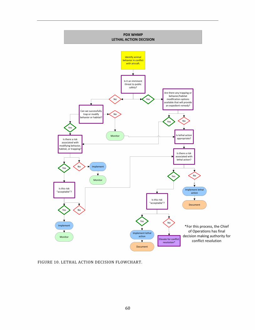
60
Identify animal behavior in conflict
with aircraft.
Is it an imminent threat to public
safety?
Can we successfully trap or modify
behavior or habitat?
No Yes
Yes
Is there a risk associated with
modifying behavior, habitat, or trapping?
Yes
Is this risk “acceptable”?
Yes
Implement
Monitor
No
Monitor
No Implement
Monitor
No
Are there any trapping or behavior/habitat
modification options available that will provide
an expedient remedy?
Yes No
PDX WHMPLETHAL ACTION DECISION
Is lethal action appropriate?
Is there a risk associated with lethal action?
Yes No
Implement lethal action
c
Is this risk “acceptable”?
Yes
Implement lethal action
No
Document
Document
*For this process, the Chiefof Operations has final
decision making authority forconflict resolution
Elevate for conflict resolution*
FIGURE 10. LETHAL ACTION DECISION FLOWCHART.
61
European Starling Trapping Protocol
Materials
Box traps with a funnel opening sized to that of a starling will be used to minimize the capture of non-target species. Traps will be baited with corn chips. Other equipment needed for the trapping effort includes a CO2 canister, garbage bags and an evacuation tube.
Trapping Conditions
1. While the traps are active, birds will be provided with food, water, and shelter from the weather. The Port will make every attempt to provide humane conditions for birds in traps.
2. Birds will not be left in the traps for more than three days, and will be removed more frequently during those seasons when large numbers are being trapped.
3. Dead birds will be removed from the traps daily or as needed.
Euthanasia Protocol
1. Before euthanasia of starlings is performed, all non-target birds will be removed from the traps and released.
2. When removing starlings from the traps, the triangular opening will be removed and the evacuation tube will be put in place. A garbage bag will be placed on the end of the evacuation tube and starlings will be hazed into the garbage bag through evacuation tube. Some starlings may be left in the traps to lure other birds in.
3. When all of the birds are in the garbage bag at the bottom of the evacuation tube, the extra air will be removed from the bag which will then be filled with CO2sufficient enough to ensure a quick death. Euthanized starlings will be transported to a local incineration facility within 12 hours, or will be frozen for transport at a later time.
Data Recording
After each trap is serviced, the number of starlings euthanized will be recorded in the AIRMAN database.
62
5.2. Habitat Modification
The long-range goal for HIO is to minimize the risk to aviation safety posed by wildlife species of concern on and around the airfield. With regard to wildlife habitat, this will be accomplished by: 1) modifying habitats and/or land uses on Port owned lands that are shown to be attractive to wildlife species of concern, and 2) discouraging land use practices on non-Port-owned lands adjacent to the airport that attract wildlife species of concern (in accordance with FAA AC #150/5200-33). Habitat modification is the most effective long-term remedial measure for reducing wildlife hazards on or near the airfield. Habitat modification includes the physical removal, exclusion, or manipulation of features or characteristics (both natural and constructed) that are attractive to wildlife species of concern. The objective is to make the airfield less attractive to wildlife species of concern at HIO, thereby reducing the probability of a wildlife strike. Habitat modifications will be carefully planned and closely monitored to ensure that they are effective in reducing wildlife hazards and do not create new wildlife problems.
Knowledge gained from the Port’s risk evaluation process and through adaptive management will be used to inform future decisions regarding habitat modification at HIO. Any recommended changes to habitat management at HIO will be incorporated into future updates of the WHMP.
5.2.1. Port-Owned Property
The Primary Zone is owned entirely by the Port of Portland. Since it encompasses the AOA and associated RPZs, it is a dedicated land use for aircraft movement. Because this zone is in the immediate vicinity of aircraft movement, the potential risk to aviation is higher if wildlife species of concern are present in the area. Therefore, all wildlife hazards identified within the primary zone will have priority over other projects that may fall in the secondary zone.
The Port owns much of the Secondary Zone that borders HIO. These areas may be managed by Port staff or by various leaseholders as authorized by the Port. If a wildlife attractant determined to pose an unacceptable risk is identified on Port-owned lands in the Secondary Zone, the General Aviation Manager and the Aviation Wildlife Manager will meet to discuss modifications to habitats and/or land uses, or to consider wildlife control efforts. The General Aviation Manager and the Aviation Wildlife Manager will also consult whenever modifications or new land uses are proposed for Port-owned lands adjacent to HIO to ensure that new attractants for wildlife species of concern are not created.
If a wildlife hazard identified in either the Primary or Secondary Zone involves lands under lease, the lessee will be included in discussions to resolve the wildlife hazard.
63
5.2.2. Non-Port Owned Property
To maximize the effectiveness of the WHMP, the Port must understand how wildlife habitat on non-Port owned properties in the Secondary Zone can influence the local distribution, movement and habitat use patterns of wildlife species of concern. The attractiveness of these non-Port owned properties to wildlife species of concern can influence whether and how often these species will use the airfield or cross the airfield to access other habitats. Wildlife management practices that are implemented on these properties also have the potential to move wildlife onto the airfield, or to increase the frequency of birds flying across aircraft flight paths.
Within this context, the Port will discourage land use practices that are known attractants of wildlife species of concern on non-Port lands in the Secondary Zone, consistent with FAA AC 150/5200-33B. The risk evaluation process will be used to assess whether the level of risk expected from actions in the Secondary Zone would be acceptable. The General Aviation Manager, Aviation Wildlife Manager and other Port staff will participate with local, state and federal agencies on land-use decisions that could possibly increase the attractiveness of the properties surrounding the airport to wildlife species of concern. Proposed land use projects that will likely increase populations of species of concern, or their activity within aircraft flight zones, will be discouraged. The FAA Regional Airport Division provides technical guidance to airport operators, and local/state governments, in addressing land use compatibility issues. Guidance on incompatible land uses near airports can be found in FAA AC 150/5200-33B (Appendix B).
The paragraphs below describe some of the Port’s strategies for managing potential wildlife hazards on non-Port owned properties in the Secondary Zone. More detail can also be found in Section 5.4, WHMP Information and Education. Knowledge gained from the Port’s risk evaluation process and through adaptive management will be used to inform future decisions regarding land uses in the Secondary Zone.
Private Lands: There are adjacent properties owned by private landowners that are used for residential, commercial, industrial and agricultural activities. Should significant wildlife issues be identified on these lands, the Port would approach the landowner and explain the association between the wildlife issue on their land and the WHMP. If needed, the Port would use the guidance in the Advisory Circular 150/5200-33 and ask for support from the FAA to encourage the landowner to modify any land use or practice found to pose an unacceptable risk to safe aircraft operations. The Port’s Community Affairs Department would assist in these outreach efforts.
Proposed New Land Uses: The Port uses the guidance in FAA AC 150/5200-33B, and its technical experience, to determine whether a proposed land use may result in a wildlife hazard that is incompatible with safe aircraft operations. If a new land use were proposed that is not recommended by the FAA, the Port would evaluate this land use using the accepted forums.
The Port of Portland, along with it’s advisory committee, the Hillsboro Airport Roundtable Exchange (HARE – see Section 5.4.2), will work with the City of Hillsboro and Washington County staff on proposed land use changes that may be in conflict with safe aircraft
64
operations, such as the location of wetland mitigation sites or wastewater treatment plants in the Secondary Zone. In addition, the Port’s Planning & Development, and Aviation Planning departments are often involved in land use decisions, and coordinate with the Aviation Wildlife Manager to ensure that no new wildlife attractants with unacceptable risk are planned for adjacent properties.
The movement of wildlife species of concern between adjacent lands and aircraft flight paths, and how wildlife use specific areas is a complex issue. There may be times that it is beneficial to have an area that draws wildlife species of concern away from the airfield. This must be balanced with the potential hazard of having an area near HIO that is attractive to wildlife species of concern. The decisions about habitat modifications or land uses must be made using the best science, expertise, and risk model data available to ensure that no new attractants that pose an unacceptable risk to aircraft operations are located near the perimeter of the HIO airfield.
5.2.3. Water Management
Because of the attractiveness of water features including natural wetlands, man-made wetlands, stormwater facilities, and other standing water to wildlife species of concern, the Port will examine the need for removing or modifying those water features located on Port property in the manner described below. Any actions taken would be designed to encourage wildlife species of concern to disperse to other habitats farther away from the airport where their presence would pose a lower risk to aircraft operations.
Wetlands and other Waters of the U.S.
The Port will apply for permits to modify or fill existing jurisdictional wetlands and other waters of the U.S. that lie within the Primary Zone and present an unacceptable risk to safe aircraft operations. The Port will investigate options for converting and maintaining these areas either in an upland condition or a non-hazardous wetland condition, if such an opportunity exists. In accordance with FAA AC 150/5200-33B, mitigation for the removal of these wetlands and other waters of the U.S. should occur on lands outside of the Secondary Zone. The Port will take appropriate actions to prevent new jurisdictional wetlands or other waters of the U.S. from developing in the Primary Zone (see following section).
Jurisdictional wetlands and other waters of the U.S. that lie on Port lands within the Secondary Zone will be monitored as potential attractants for wildlife species of concern. If use of these sites by wildlife species of concern is documented, and this use contributes to an increased presence of wildlife species of concern in the Primary Zone, a risk evaluation will be conducted to determine the level of risk and inform future decisions regarding appropriate actions to eliminate or minimize the hazard, when warranted. Actions may range from seeking a permit to fill the wetland or waters of the U.S. to modifying the wetland to make it less attractive to wildlife species of concern (e.g., vegetation modification, installation of netting). The Port will take appropriate actions to prevent new jurisdictional wetlands or other waters of the U.S. from developing on Port-owned lands within the Secondary Zone, unless the risk evaluation indicates the level of risk incurred would be acceptable.
65
Standing Water and Poor Drainage
Areas in the Primary Zone with standing water, when determined not to be jurisdictional wetlands or waters of the U.S., will be filled and/or graded to allow water to consistently drain into ditches and storm water detention facilities. Ditches should be appropriately sloped so that water does not pool and will drain from the airfield in an expedient manner. Several open drainage ditches remain that cross the airfield within the Primary Zone. Most, however, have been incorporated into an underground storm water drainage collection system.
Non-jurisdictional areas of standing water and poor drainage on Port-owned lands in the Secondary Zone will be monitored as potential attractants for wildlife hazards. If use of these sites by wildlife hazards is documented, and this use contributes to an increased presence of wildlife hazards in the Primary Zone, a risk evaluation will be conducted to determine the level of risk and inform future decisions regarding appropriate actions to eliminate or minimize the drainage problem (e.g., grading, improved drainage facilities), when warranted.
The following protocol has been developed to manage non-jurisdictional “wet areas” on Port-owned lands at HIO so they do not develop into jurisdictional wetlands at a future date.
1. Airport staff and the Aviation Wildlife Manager are responsible for inspecting HIO properties and identifying and tracking areas that have the potential of forming jurisdictional wetlands.
2. If Airport staff and the Aviation Wildlife Manager identify an area that has the potential to become a jurisdictional wetland, and through verification the area has not become a jurisdictional wetland, an action request to resolve the drainage problem will be submitted.
3. If HIO does not have the resources to eliminate the wet area (i.e., the drainage problem cannot be resolved through surface grading), the General Aviation Manager will evaluate the area of concern in consultation with the Aviation Wildlife Manager to determine if involvement by the Planning and Development Department is warranted.
4. The General Aviation Manager will take necessary actions through the engineering process or hiring a contractor to resolve the drainage problem. The General Aviation Manager will determine the funding source.
5. The Aviation Natural Resource program will communicate any potential projects to the Airfield Planning Group who will attempt to combine mitigation measures with already scheduled airfield projects.
66
Storm Water Detention Ponds
No existing storm water detention ponds are located in the Primary Zone, or on Port-owned land in the Secondary Zone. Should any new storm water detention ponds to be located in the Primary Zone, or on Port-owned land in the Secondary Zone, they will be designed in accordance with the Port of Portland’s Stormwater Pollution Prevention plan, ORS 836.623, and AC 150/5200-33B, Section 2-3.b.
Oregon Revised Statute, ORS 836.623: “The following requirements and conditions shall apply to safety risks associated with potential bird strike hazards resulting from new water impoundments proposed in close proximity to an airport. No new water impoundments of one-quarter acre or larger shall be allowed within an approach corridor and within 5,000 feet from the end of a runway; or on land owned by the airport or airport sponsor where the land is necessary for airport operations.”
Advisory Circular, AC 150/5200-33B, Section 2-3.b: “Storm water detention ponds should be designed, engineered, constructed, and maintained for a maximum 48–hour detention period after the design storm and remain completely dry between storms. To facilitate the control of hazardous wildlife, the FAA recommends the use of steep-sided, rip-rap lined, narrow, linearly shaped water detention basins. When it is not possible to place these ponds away from an airport’s AOA, airport operators should use physical barriers, such as bird balls, wire grids, pillows, or netting, to prevent access of hazardous wildlife to open water and minimize aircraft-wildlife interactions. When physical barriers are used, airport operators must evaluate their use and ensure they will not adversely affect water rescue. All vegetation in or around detention basins that provide food or cover for wildlife that are a risk to aviation should be eliminated. If soil conditions and other requirements allow, the FAA encourages the use of underground storm water infiltration systems, such as French drains or buried rock fields, because they are less attractive to wildlife.”
If, despite these guidelines, any new stormwater detention structure attracts wildlife species of concern, a risk evaluation will be performed to determine if additional modifications are necessary.
Other Constructed Water Features
Any other existing, man-made open water features that lie in the Primary Zone, or on Port-owned land in the Secondary Zone, will be monitored as potential attractants for wildlife species of concern. If use of these sites by wildlife species of concern is documented, and this use contributes to an increased presence of those species in the Primary Zone, a risk evaluation will be conducted to determine the level of risk and inform future decisions regarding appropriate actions to eliminate or minimize the hazard, when warranted.
Any new water features proposed for the Primary Zone, or on Port-owned land in the Secondary Zone, will be assessed for their potential to attract wildlife species of concern. Either appropriate design criteria will be incorporated to minimize the hazard, or the water feature will be eliminated unless it can be demonstrated that the water feature would not present an unacceptable risk to the safe operation of aircraft.
67
Runways, Taxiways, and Aprons
Airport staff will be responsible for identifying those areas of the runways, taxiways and aprons where pools of water consistently form after periods of rain. Areas where water regularly pools on pavement surfaces will be identified for corrective action.
5.2.4. Vegetation Management
Landscaping
Landscaping at HIO can affect tourism, business, and the overall feeling of the Hillsboro vicinity to visitors. With this in mind, landscaping needs to be aesthetically pleasing. However, it must also coincide with the airport’s greater responsibility for aviation safety. The goals of HIO landscape management are to reduce the attractiveness of airport landscaping to wildlife species of concern and to eliminate the vertical intrusion of vegetation into aircraft operating airspace while retaining an aesthetically pleasing landscape. The plant species found within the HIO Landscaping Standards apply only to management of vegetation in the built environment. Composition of plant species within the context of natural site conversions and stormwater infrastructure is not addressed within these standards.
Because landscaping at an airport has the potential to create wildlife attractant issues the FAA has issued Advisory Circulars that address a variety of landscaping concerns. An FAA Advisory Circular (AC) is guidance that should be adhered to by all airports that receive federal funding.
FAA AC 150/5200-33B provides guidance on certain land uses that have the potential to attract hazardous wildlife on or near public-use airports. Section 2-8 of this AC states:
“There may be circumstances where two (or more) different land uses that would not, by themselves, be considered hazardous wildlife attractants….are in such an alignment with the airport as to create a wildlife corridor directly through the airport and/or surrounding airspace….therefore, airport operators and the wildlife damage management biologist must consider the entire surrounding landscape and community….”
Additionally, the 2005 Wildlife Hazard Management at Airports Manual, written jointly by the FAA and USDA specifically states:
“Do not use trees and other landscaping plants for the street side of airports that produce fruits or seeds attractive to birds. Avoid plants that produce fruits and seeds desired by birds. Also avoid the creation of areas of dense cover for roosting, especially by European starlings and blackbirds. Thinning the canopy of trees, or selectively removing trees to increase their spacing, can help eliminate bird roosts that form in trees on airports.”
In support of this guidance the Port has developed a set of landscaping design standards for use within the Primary and Secondary Zones (Figures 7 & 8) that address plant species and planting standards for spacing of trees and shrubs within the built environment at HIO. A list of trees, shrubs, and groundcover for vegetation is comprised of species screened by Port’s Wildlife staff for general wildlife attractant features such as fruit, berries, height, density, branching structure, crown shape, planting density and arrangement, and location
68
relative to the Primary Zone and significant habitat features (see Appendix F, List of Approved HIO Plants). This landscaping list is a refinement of the list developed for the 2007 WHMP. The list is subject to revision whenever new candidate plants are submitted for variance granted they meet the screening criteria and are accepted by all members of the Port’s landscaping review team. The process for receiving a variance to the HIO Approved Plant List entails completing the HIO Plant List Variance Request Form (see Appendix G). Specific instructions for receiving a variance to the HIO Approved Plant List are included on the form. Variances to the HIO Approved Plant List will only be granted in instances where it can be proven that circumstances prohibit use of species found on the HIO Approved Plant List
The HIO landscaping standards within each zone are described below. For the purpose of these guidelines please reference the following definitions of trees and shrubs taken from the Utah State University Agricultural Extension Office. A plant will be defined as a tree based on having the characteristics of being a woody plant having one erect perennial stem (trunk) at least 3 inches in diameter at a height of 4 ½ feet above the ground, a definitely formed crown of foliage, and a mature height of at least 13 feet. A plant will be considered a shrub if it is a woody plant with several perennial stems that may be erect or may lay close to the ground, usually having a mature height less than 13 feet and stems no more than around 3 inches in diameter.
Primary Zone
All landscape management within the Primary Zone will be driven by the operational and safety needs of the Airport. HIO landscaping standards for the Primary Zone are proposed as follows:
Existing Landscaping
Existing trees, shrubs, and other landscaping will be assessed. Any landscaping thatis documented to pose a significant wildlife hazard to safe aircraft operations will beimmediately removed.
New Landscaping
1. Each new landscaping project within the Primary Zone will be reviewed by theAviation Wildlife Manager and other assigned Port staff before landscaping designsare finalized.
2. Landscaped areas within the Primary Zone, including tenant landscaping, will onlyinclude shrubs and groundcover. No new trees will be allowed. Species of vegetationmust be represented on the Port’s Primary Zone Plant Species list (see Appendix F),or be demonstrated to meet the wildlife attractant screening criteria prior toplanting. Design of the landscaping must also comply with the standards outlined inthis document.
3. Trees that penetrate 14 CFR Part 77 Transitional Surfaces, and are demonstrated ascontributing to hazardous wildlife conditions, will be removed rather than topped.Topping of trees creates an attractive platform for raptor nests, exacerbating birdstrike potential.
69
4. No shrubs will be allowed within ten (10) feet of the airfield perimeter fence. This requirement addresses security concerns as well as vertical structure and wildlife hazards.
5. Landscaping will be a combination of evergreen and deciduous species of shrubs, with no greater than 50 percent of evergreen species. No unbroken rows or clumps of evergreen shrubs will be allowed due to the shelter and insulation that is provided by contiguous crown cover.
Secondary Zone
Landscaping in the Secondary Zone should not create habitats attractive for wildlife species of concern. Therefore, the goal of landscaping in this zone is to provide a visually pleasing landscape that does not constitute an unacceptable wildlife risk to aircraft operations. All landscape management within the Secondary Zone will consider the operational and safety needs of the Airport. Landscaping Standards for Port-owned lands in the Secondary Zone around HIO are proposed as follows:
Existing Landscaping Existing trees, shrubs, and other landscaping will be assessed. If any landscaping is
documented to pose a significant wildlife hazard to safe aircraft operations, a proposal for vegetation modification will be presented to the appropriate Port department manager to address the issue.
New Landscaping 1. Because of the potential for landscaping to support wildlife species of concern that
could pose an unacceptable risk to aircraft operations, aviation wildlife concerns need to be incorporated into landscape project planning.
2. Species of vegetation must be represented on the HIO Secondary and/or Primary Zone Plant Species list, or be demonstrated to meet the wildlife attractant screening criteria and be accepted through the variance process prior to planting. Design and installation of landscaping should comply with the spacing and arrangement guidelines outlined below.
3. Tree species should be selected and planted so that, at maturity, overlapping crown structures, that are attractive to European starlings or other wildlife species of concern, will be minimized (Figure 11). In an effort to ensure that there are no areas within the landscaped environment with contiguous canopy cover the Port has developed tree spacing guidelines. These guidelines were developed by looking at the documented maximum spread at maturity of each species on the HIO Approved Plant List. In order to maintain a minimum of 15ft spacing between mature crowns the tree species on the HIO list were grouped into three categories. The first group includes columnar species with a maximum spread at maturity between 10 and 15ft. To maintain 15ft spacing between the crowns of these species the trees are required to be planted at a distance of 25ft on center. The next group includes species with a maximum spread at maturity between 20 and 30ft. To maintain 15ft spacing between the crowns of the species in this group, these trees are required to be planted at a distance of 40ft on center. The last group includes a few of the largest tree species on the HIO list. The maximum spread at maturity for these trees is between 40 and 75ft. To maintain 15ft spacing between the crowns of these species
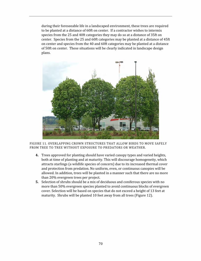
70
during their foreseeable life in a landscaped environment, these trees are required to be planted at a distance of 60ft on center. If a contractor wishes to intermix species from the 25 and 40ft categories they may do so at a distance of 35ft on center. Species from the 25 and 60ft categories may be planted at a distance of 45ft on center and species from the 40 and 60ft categories may be planted at a distance of 50ft on center. These situations will be clearly indicated in landscape design plans.
FIGURE 11. OVERLAPPING CROWN STRUCTURES THAT ALLOW BIRDS TO MOVE SAFELY FROM TREE TO TREE WITHOUT EXPOSURE TO PREDATORS OR WEATHER.
4. Trees approved for planting should have varied canopy types and varied heights,both at time of planting and at maturity. This will discourage homogeneity, whichattracts starlings (a wildlife species of concern) due to its increased thermal coverand protection from predation. No uniform, even, or continuous canopies will beallowed. In addition, trees will be planted in a manner such that there are no morethan 20% evergreen trees per project.
5. Selection of shrubs should be a mix of deciduous and coniferous species with nomore than 50% evergreen species planted to avoid continuous blocks of evergreencover. Selection will be based on species that do not exceed a height of 13 feet atmaturity. Shrubs will be planted 10 feet away from all trees (Figure 12).
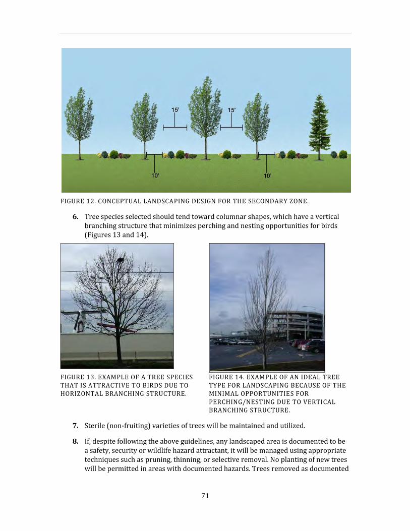
71
FIGURE 12. CONCEPTUAL LANDSCAPING DESIGN FOR THE SECONDARY ZONE.
6. Tree species selected should tend toward columnar shapes, which have a vertical branching structure that minimizes perching and nesting opportunities for birds (Figures 13 and 14).
FIGURE 13. EXAMPLE OF A TREE SPECIES THAT IS ATTRACTIVE TO BIRDS DUE TO HORIZONTAL BRANCHING STRUCTURE .
FIGURE 14. EXAMPLE OF AN IDEAL TREE TYPE FOR LANDSCAPING BECAUSE OF THE MINIMAL OPPORTUNITIES FOR PERCHING/NESTING DUE TO VERTICAL BRANCHING STRUCTURE.
7. Sterile (non-fruiting) varieties of trees will be maintained and utilized.
8. If, despite following the above guidelines, any landscaped area is documented to be a safety, security or wildlife hazard attractant, it will be managed using appropriate techniques such as pruning, thinning, or selective removal. No planting of new trees will be permitted in areas with documented hazards. Trees removed as documented
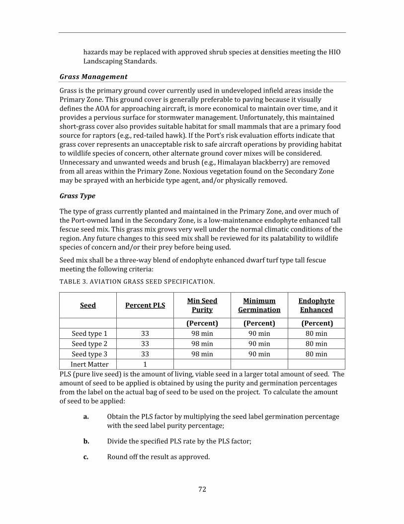
72
hazards may be replaced with approved shrub species at densities meeting the HIO Landscaping Standards.
Grass Management
Grass is the primary ground cover currently used in undeveloped infield areas inside the Primary Zone. This ground cover is generally preferable to paving because it visually defines the AOA for approaching aircraft, is more economical to maintain over time, and it provides a pervious surface for stormwater management. Unfortunately, this maintained short-grass cover also provides suitable habitat for small mammals that are a primary food source for raptors (e.g., red-tailed hawk). If the Port’s risk evaluation efforts indicate that grass cover represents an unacceptable risk to safe aircraft operations by providing habitat to wildlife species of concern, other alternate ground cover mixes will be considered. Unnecessary and unwanted weeds and brush (e.g., Himalayan blackberry) are removed from all areas within the Primary Zone. Noxious vegetation found on the Secondary Zone may be sprayed with an herbicide type agent, and/or physically removed.
Grass Type
The type of grass currently planted and maintained in the Primary Zone, and over much of the Port-owned land in the Secondary Zone, is a low-maintenance endophyte enhanced tall fescue seed mix. This grass mix grows very well under the normal climatic conditions of the region. Any future changes to this seed mix shall be reviewed for its palatability to wildlife species of concern and/or their prey before being used.
Seed mix shall be a three-way blend of endophyte enhanced dwarf turf type tall fescue meeting the following criteria:
TABLE 3. AVIATION GRASS SEED SPECIFICATION.
Seed Percent PLS Min Seed
Purity Minimum
Germination Endophyte Enhanced
(Percent) (Percent) (Percent)
Seed type 1 33 98 min 90 min 80 min
Seed type 2 33 98 min 90 min 80 min
Seed type 3 33 98 min 90 min 80 min
Inert Matter 1
PLS (pure live seed) is the amount of living, viable seed in a larger total amount of seed. The amount of seed to be applied is obtained by using the purity and germination percentages from the label on the actual bag of seed to be used on the project. To calculate the amount of seed to be applied:
a. Obtain the PLS factor by multiplying the seed label germination percentagewith the seed label purity percentage;
b. Divide the specified PLS rate by the PLS factor;
c. Round off the result as approved.
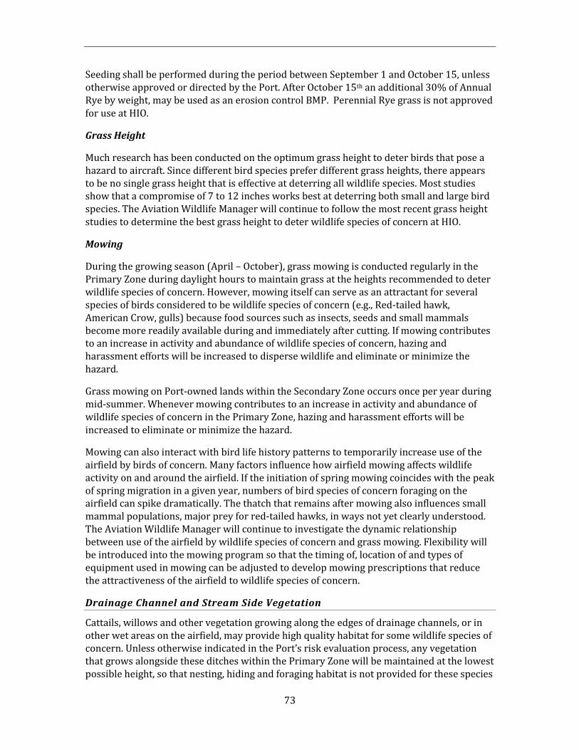
73
Seeding shall be performed during the period between September 1 and October 15, unless otherwise approved or directed by the Port. After October 15th an additional 30% of Annual Rye by weight, may be used as an erosion control BMP. Perennial Rye grass is not approved for use at HIO.
Grass Height
Much research has been conducted on the optimum grass height to deter birds that pose a hazard to aircraft. Since different bird species prefer different grass heights, there appears to be no single grass height that is effective at deterring all wildlife species. Most studies show that a compromise of 7 to 12 inches works best at deterring both small and large bird species. The Aviation Wildlife Manager will continue to follow the most recent grass height studies to determine the best grass height to deter wildlife species of concern at HIO.
Mowing
During the growing season (April – October), grass mowing is conducted regularly in the Primary Zone during daylight hours to maintain grass at the heights recommended to deter wildlife species of concern. However, mowing itself can serve as an attractant for several species of birds considered to be wildlife species of concern (e.g., Red-tailed hawk, American Crow, gulls) because food sources such as insects, seeds and small mammals become more readily available during and immediately after cutting. If mowing contributes to an increase in activity and abundance of wildlife species of concern, hazing and harassment efforts will be increased to disperse wildlife and eliminate or minimize the hazard.
Grass mowing on Port-owned lands within the Secondary Zone occurs once per year during mid-summer. Whenever mowing contributes to an increase in activity and abundance of wildlife species of concern in the Primary Zone, hazing and harassment efforts will be increased to eliminate or minimize the hazard.
Mowing can also interact with bird life history patterns to temporarily increase use of the airfield by birds of concern. Many factors influence how airfield mowing affects wildlife activity on and around the airfield. If the initiation of spring mowing coincides with the peak of spring migration in a given year, numbers of bird species of concern foraging on the airfield can spike dramatically. The thatch that remains after mowing also influences small mammal populations, major prey for red-tailed hawks, in ways not yet clearly understood. The Aviation Wildlife Manager will continue to investigate the dynamic relationship between use of the airfield by wildlife species of concern and grass mowing. Flexibility will be introduced into the mowing program so that the timing of, location of and types of equipment used in mowing can be adjusted to develop mowing prescriptions that reduce the attractiveness of the airfield to wildlife species of concern.
Drainage Channel and Stream Side Vegetation
Cattails, willows and other vegetation growing along the edges of drainage channels, or in other wet areas on the airfield, may provide high quality habitat for some wildlife species of concern. Unless otherwise indicated in the Port’s risk evaluation process, any vegetation that grows alongside these ditches within the Primary Zone will be maintained at the lowest possible height, so that nesting, hiding and foraging habitat is not provided for these species
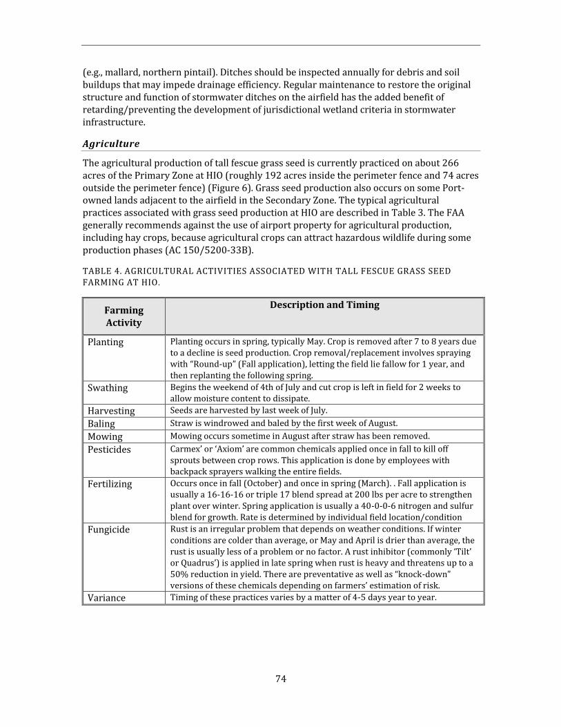
74
(e.g., mallard, northern pintail). Ditches should be inspected annually for debris and soil buildups that may impede drainage efficiency. Regular maintenance to restore the original structure and function of stormwater ditches on the airfield has the added benefit of retarding/preventing the development of jurisdictional wetland criteria in stormwater infrastructure.
Agriculture
The agricultural production of tall fescue grass seed is currently practiced on about 266 acres of the Primary Zone at HIO (roughly 192 acres inside the perimeter fence and 74 acres outside the perimeter fence) (Figure 6). Grass seed production also occurs on some Port-owned lands adjacent to the airfield in the Secondary Zone. The typical agricultural practices associated with grass seed production at HIO are described in Table 3. The FAA generally recommends against the use of airport property for agricultural production, including hay crops, because agricultural crops can attract hazardous wildlife during some production phases (AC 150/5200-33B).
TABLE 4. AGRICULTURAL ACTIVITIES ASSOCIATED WITH TALL FESCUE GRASS SEED FARMING AT HIO .
Farming Activity
Description and Timing
Planting Planting occurs in spring, typically May. Crop is removed after 7 to 8 years due to a decline is seed production. Crop removal/replacement involves spraying with “Round-up” (Fall application), letting the field lie fallow for 1 year, and then replanting the following spring.
Swathing Begins the weekend of 4th of July and cut crop is left in field for 2 weeks to allow moisture content to dissipate.
Harvesting Seeds are harvested by last week of July.
Baling Straw is windrowed and baled by the first week of August.
Mowing Mowing occurs sometime in August after straw has been removed.
Pesticides Carmex’ or ‘Axiom’ are common chemicals applied once in fall to kill off sprouts between crop rows. This application is done by employees with backpack sprayers walking the entire fields.
Fertilizing Occurs once in fall (October) and once in spring (March). . Fall application is usually a 16-16-16 or triple 17 blend spread at 200 lbs per acre to strengthen plant over winter. Spring application is usually a 40-0-0-6 nitrogen and sulfur blend for growth. Rate is determined by individual field location/condition
Fungicide Rust is an irregular problem that depends on weather conditions. If winter conditions are colder than average, or May and April is drier than average, the rust is usually less of a problem or no factor. A rust inhibitor (commonly ‘Tilt’ or Quadrus’) is applied in late spring when rust is heavy and threatens up to a 50% reduction in yield. There are preventative as well as “knock-down” versions of these chemicals depending on farmers’ estimation of risk.
Variance Timing of these practices varies by a matter of 4-5 days year to year.
75
Consequently, grass seed farming will continue to be allowed on Port-owned land in the Primary and Secondary Zones. Monitoring for wildlife presence within grass seed fields in the Primary Zone will continue as a part of the regular daily inspections conducted at HIO. Whenever an increase in the activity and abundance of wildlife species of concern is noted on grass fields in the Primary Zone, hazing and harassment efforts will be increased to disperse wildlife and eliminate or minimize the hazard.
Grass seed production on Port-owned lands will be reexamined if monitoring suggests a sustained increase of wildlife presence on agricultural fields, or indicates spikes in wildlife abundance linked to farming practices. The Port would meet with agricultural leaseholders to discuss modifications to any farming practices identified as contributing to an unacceptable risk to safe aircraft operations. If modifications are infeasible, agricultural leases would not be renewed and grass seed farming would be terminated on Port-owned lands.
5.2.5 Structure Management
Human-made structures can provide cover, nest sites and perches for wildlife species of concern and their prey. A wide variety of structures exist at HIO that may receive use by wildlife, including airfield buildings, aircraft hangars, terminals, light poles, fences and navigational aids, among numerous others. If wildlife exclusion is considered during the initial design phase for a structure, future costly control measures and design retrofits can often be avoided. To this end, structures should not provide potential nesting, perching or roosting sites for bird species of concern and should not allow access to mammals such as coyotes and rodents.
Management to reduce the attractiveness to wildlife of structures at HIO is a collaborative effort between Port Engineering, the Aviation Wildlife Manager, General Aviation Manager and HIO Maintenance. It includes a review of all proposed new construction during the initial project design phase, and the monitoring of existing structures for use by wildlife species of concern. Whenever a structure design issue is identified that may attract wildlife species of concern, the responsible Port department will be contacted to develop a corrective action. The goal is to resolve potential design conflicts before structures are constructed.
Existing Structures
All existing structures located in the Primary Zone will be periodically monitored as potential attractants to wildlife species of concern. If use of structures by wildlife species of concern is documented, and this use is determined to represent a potential hazard to aircraft, a risk evaluation will be conducted to inform future decisions regarding appropriate actions to eliminate or minimize the hazard. Actions may range from the installation of features that deter wildlife from using existing structures (e.g., netting, fencing, spikes) to design modifications that make structures less attractive to wildlife species of concern. Existing structures that lie on Port-owned land in the Secondary Zone will be monitored as potential attractants to wildlife species of concern. If use of these sites by wildlife species of
76
concern is documented, and this use contributes to an increased presence of wildlife species of concern in the Primary Zone, a risk evaluation will be conducted to inform future decisions regarding appropriate actions to eliminate or minimize the hazard.
New Structures
Any new structures proposed for the Primary Zone, or on Port-owned land in the Secondary Zone, will be assessed for their potential to attract wildlife species of concern during the initial design phase for the project. Architectural plans will be reviewed, and appropriate design modifications will be incorporated into the structure to eliminate or minimize the potential attractiveness to wildlife.
Airport Improvement Projects and Airfield Buildings
The Aviation Wildlife Manager will participate in the initial phase of all airport improvement projects to evaluate whether proposed structures could result in increased wildlife hazards. Such projects include (but are not limited to); architectural changes, terminal expansions, building improvements and construction, and landscape and other land use changes. Every effort will be made to minimize or eliminate designs and land use practices that may be attractive to wildlife species of concern, consistent with the Ports risk analysis. Some buildings on the airfield were unintentionally designed with features attractive to wildlife species of concern. As these buildings are identified, and the source of the architectural attractiveness is identified, steps shall be implemented to modify the building to decrease or eliminate the attractive features.
Sliwinski (1995) and Transport Canada Environment and Support Services (1994) identify common design features attractive to certain species of wildlife that should be avoided. These include:
1. Large gravel roofs that can attract gull nesting colonies.
2. Overhanging roof ledges, external roof support structures and architectural detailsthat provide nesting and roosting sites for birds. Sloping the ledges around abuilding to an angle greater than 45 degrees can limit the attractiveness for nestingand roosting.
3. Large buildings such as airport hangars that provide many places for wildlife to nestor roost. Often hangars have many holes and openings that birds may use to gainentrance. Blocking or covering all holes and vents is effective in restricting access bybirds. Blocking or covering all drains can also prevent rodents from becoming aproblem inside a building.
4. Excessive numbers of antennae, towers or overhead wires that provide perch sitesfor birds.
Abandoned Structures
Structures within the Primary Zone not pertinent to airport operations, and no longer in use, should be removed if they pose an unacceptable risk. This includes abandoned sheds, barns, machinery and poles. These unused structures may be attractive to small mammals
77
and birds, which in turn may attract wildlife species of concern (e.g., red-tailed hawks). Abandoned structures in the Secondary Zone will be surveyed to determine whether they are being used by wildlife species of concern, and whether this use poses an unacceptable risk. Airfield Structures
Airfield structures such as runway and taxiway signs, light poles, navigation aids and radar reflectors are often used as hunting and loafing perches for raptors and other birds. If it is determined that these structures are serving as attractants to wildlife species of concern, retrofitting these structures with bird exclusion devices will be evaluated. Physical Exclusion Devices
Many types of devices and materials are available to physically exclude certain wildlife species from particular areas. Examples currently in use at PDX, HIO and other Port-owned airports include animal deterrent fencing, bird netting and anti-perch devices. A brief description of these devices follows.
- Animal Deterrent Fencing HIO maintains a permanent, 8-foot high chain link fence perimeter fence around the airfield. The fence serves the dual purpose of providing a security barrier for the airport and of excluding large mammals (e.g., black-tailed deer) from the airfield. However, the perimeter fence contains numerous breach points that may allow coyotes and other medium-sized mammals to access the airfield (e.g., gaps under the fence, problem gates, culverts). If the existing perimeter fence is determined to be allowing access of hazardous wildlife to the airfield, an animal deterrent fence design similar to that at PDX should be considered for installation (see below). The Port has designed an animal deterrent fence to aid in preventing problem mammals from accessing the PDX airport. The permanent, 8-foot high chain link fence includes a 4-foot apron of chain link fence buried at a 45° angle at its base. This apron, which is tied into the vertical fence, is a very effective device for excluding a variety of medium-sized animals that attempt to access the airfield by digging under the perimeter fence (e.g., coyote). Design drawings and specifications for the animal deterrent fencing are presented in Appendix H. The PDX animal deterrent fencing design has been shared with many other airports that have problems with mammals accessing the airfield. The FAA has endorsed the design and is considering it for inclusion in an Advisory Circular.
To be effective, the animal deterrent fencing must be coupled with gates and culverts that also prevent access by large and medium-sized animals. Existing problem gates can usually be retrofitted to accomplish this goal. Retrofitting typically involves reducing gaps around a closed gate to less than 4 inches to limit the opportunity for wildlife to squeeze under or between the gates. This is usually accomplished by lowering the existing gate to reduce the space between the bottom of the gate and the surface of the ground, raising the ground surface by adding asphalt (e.g., speed bump) when lowering the gate is impractical, and/or attaching metal flashing to the bottom and edges of gates.
78
- Culvert Exclusion In order to prevent medium-sized animals such as coyotes and raccoons from accessing the airfield by way of culverts, metal grates should be placed at the terminal ends of each culvert that passes under the perimeter fence. The ideal gap size in the grates is 1.5 inches. This will allow water to flow through the culvert while excluding animals. If cost is a limiting factor, the priority should be to grate the culvert opening on the inside of the perimeter fence.
- Bird netting Small gauge netting is an ideal material for permanent exclusion of birds from buildings and overhangs that are attractive for nesting and roosting. Although this method of control can be expensive, the target bird species is permanently excluded from the area. This type of installation has proven to be very effective in preventing birds from nesting in the eaves of many buildings located around PDX. Small gauge netting may be appropriate at HIO if nesting and roosting by birds becomes problematic. There are currently no storm water detention or retention ponds on the HIO airfield that could serve as attractants to wildlife species of concern. Should such open water features be required in the future, they should be covered with small gauge netting structures to effectively exclude birds. Netting should be designed to go all the way to the ground to prevent some birds from walking under the net to access the water.
- Anti-perch Devices Airfield signs, posts, navigation aids and other structures provide attractive perch posts for birds in close proximity to runways and taxiways. Anti-perching devices mounted on these structures can be an effective way of deterring use of these perch posts by birds. If it is determined that these structures at HIO are serving as attractants to wildlife species of concern, retrofitting these structures with anti-perching devices will be evaluated.
5.2.6. Wildlife Food Source Management
Small mammals, earthworms, insects and other invertebrates are a highly attractive food source for many wildlife species of concern identified at HIO. In addition, trash, handouts and scattered refuse also provide a food source for some wildlife species of concern (e.g., gulls). Therefore, a program to manage the availability of these food sources is essential in reducing the relative attractiveness of HIO to wildlife species of concern.
Wildlife food source management at HIO is primarily an action targeted at the Primary Zone due to its proximity to the airfield. Whenever wildlife food sources in the Primary Zone are documented to attract wildlife species of concern, a risk evaluation will be conducted to inform future decisions regarding appropriate actions to eliminate or minimize the hazard. Options could range from increased hazing or trapping of wildlife species of concern until the availability of the food source naturally declines, to the physical removal of the attractive food source, or to the implementation of proactive control measures to reduce the abundance or attractiveness of the food source.
At times, wildlife food sources located in the Secondary Zone may contribute to the increased presence of wildlife species of concern in the Primary Zone. For example,
79
attractive food sources in the Secondary Zone may result in regular flyovers of the airfield by bird species of concern as they move between food sources and other important components of their home range (e.g., roosts, nest sites, other feeding areas). Whenever these circumstances are documented, the risk evaluation process will be employed to evaluate the level of risk posed to safe aircraft operations and guide management decisions. Such a process must, by necessity, include the influence of adjacent non-Port owned properties in the evaluation. If warranted, actions similar to those proposed for the Primary Zone could be taken to reduce or eliminate food source hazards on Port-owned lands in the Secondary Zone.
Insects
Insects are an important food source for many species of wildlife. Whenever insect abundance is unusually high because of climatic conditions, reproductive cycles or other events, wildlife species may congregate to exploit this food resource. For example, American kestrels have been observed to target the grasshopper hatch at PDX during late summer. If insects are determined to be an unacceptable attractant of wildlife species of concern at HIO, then an appropriate action should be taken to reduce population abundance. The State Agricultural Department or Extension Agent can help select appropriate control methods for insects, consistent with the Port’s risk analysis, should this action be deemed necessary. Earthworms
Earthworms are very attractive to bird species of concern at HIO when heavy rains bring large numbers of them to the surface. For example, gulls have been documented to feed opportunistically on earthworms at HIO during wet spring weather. If earthworms at HIO are determined to be an unacceptable attractant of wildlife species of concern, then an appropriate pesticide could be applied to reduce population abundance. Again, the State Agricultural Department or Extension Agent can help select an appropriate pesticide for control, consistent with the Port’s risk analysis. Small Mammals
Small mammals appear to be primary attractants of red-tailed hawks and other predatory wildlife species at HIO. The primary means for population control of small mammals is the removal or modification of the habitat that supports their populations and by the application of commercially available rodenticides on an annual basis. These control measures are focused within the HIO Primary Zone as a means of controlling the hunting behavior of predators that feed upon this source of food. The Port annually controls rodent populations within the fenced perimeter of HIO using the rodenticide zinc phosphide. The rodenticide is broadcast as grain bait laced with 2% zinc phosphide at a rate of 6 pounds per acre, usually in late summer. Zinc phosphide is highly toxic to birds and mammals, reacting with moisture and acid in the gastrointestinal tract of poisoned animals to produce deadly phosphine gas (Johnson and Fagerstone 1994). Death usually results from asphyxia. Both primary and secondary poisoning of non-target species may occur through either the consumption of treated baits or from consumption of poisoned animals (Johnson and Fagerstone 1994). Since zinc phosphide does not accumulate in a significant manner in the tissue of poisoned animals, secondary toxicity results from any remaining undigested bait in the gastrointestinal tract of individual prey.
80
Following the distribution of laced bait, Airport staff should intensify monitoring and wildlife hazing efforts for a time period sufficient for the chemical degradation of zinc phosphide (about 1 month). This effort would minimize the potential poisoning risk to nontarget species, such as raptors, from the rodent control.
Small mammals can be difficult to trap, and there are no easy or long-term solutions for population control. Usually, an integrated control strategy using multiple methods works best (trapping, poisoning, habitat modification, exclusion). If current rodent control methods prove ineffective at HIO, refer to the recommendations provided by USDA/APHIS Wildlife Services (Witmer 2003) for rodent population control at PDX for application to HIO.
Trash and Debris
Trash and debris around the terminal and nearby businesses are often responsible for attracting wildlife such as European starlings and gulls that scavenge on debris. Trash collection at HIO is conducted weekly so as not to allow the refuse containers to overflow and become an attractant. Whenever a specific area in the Primary Zone or Port-owned lands in the Secondary Zone is identified as overly attractive to wildlife species of concern, additional monitoring of the site by Airport staff will be conducted to determine the source of the attractiveness and the risk posed. If the attractant is linked to trash and debris, corrective measures to reduce the refuse will be instituted. These could include increasing the frequency of trash collection, adding additional or modified trash receptacles, and/or signage to educate the public on the importance of proper trash disposal in these areas.
Food Handouts
Members of the public and airport employees are discouraged from feeding wildlife at HIO. If a situation develops where animals are given handouts of food, the problem will be discussed with the person(s) involved so that it can be discontinued. If warranted, educational materials will be prepared and distributed to individuals or groups informing them of the prohibition of and the potential hazards associated with feeding wildlife at the airport. Where necessary, signs will be posted to educate the public on the association between feeding animals and creating wildlife hazards at the airport, and asking that individuals refrain from feeding any wildlife near the airport.
Pesticides
Only those pesticides registered through the EPA and the DEQ are considered for usage at HIO. These registered pesticides are available through private pesticide companies, the State Agriculture Office or USDA Animal Damage Control. Pesticides are used for a variety of reasons such as weed, insect, earthworm and rodent control. Pesticides kept on hand are limited by shelf life and are ordered on an as-needed basis. Insect and rodent control in and around airport buildings may be contracted to outside companies with licensed applicators. All legal requirements for pesticide storage, handling and application will be followed.
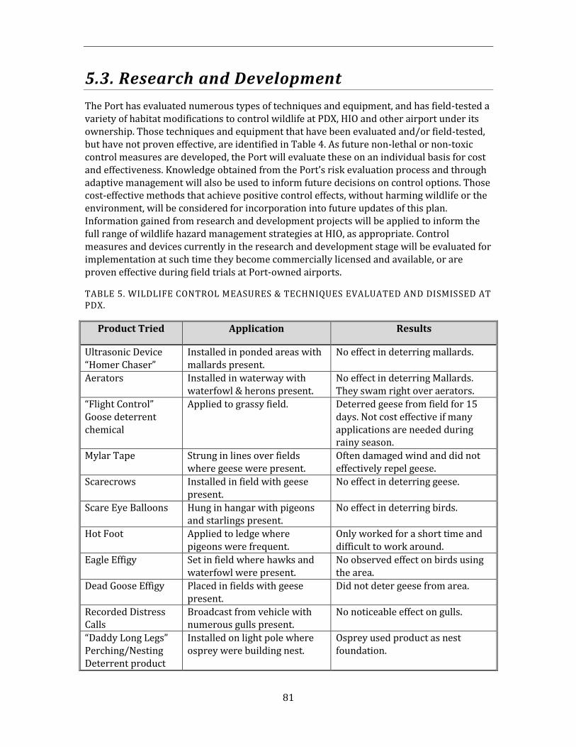
81
5.3. Research and Development
The Port has evaluated numerous types of techniques and equipment, and has field-tested a variety of habitat modifications to control wildlife at PDX, HIO and other airport under its ownership. Those techniques and equipment that have been evaluated and/or field-tested, but have not proven effective, are identified in Table 4. As future non-lethal or non-toxic control measures are developed, the Port will evaluate these on an individual basis for cost and effectiveness. Knowledge obtained from the Port’s risk evaluation process and through adaptive management will also be used to inform future decisions on control options. Those cost-effective methods that achieve positive control effects, without harming wildlife or the environment, will be considered for incorporation into future updates of this plan. Information gained from research and development projects will be applied to inform the full range of wildlife hazard management strategies at HIO, as appropriate. Control measures and devices currently in the research and development stage will be evaluated for implementation at such time they become commercially licensed and available, or are proven effective during field trials at Port-owned airports.
TABLE 5. WILDLIFE CONTROL MEASURES & TECHNIQUES EVALUATED AND DISMISSED AT PDX.
Product Tried Application Results
Ultrasonic Device “Homer Chaser”
Installed in ponded areas with mallards present.
No effect in deterring mallards.
Aerators Installed in waterway with waterfowl & herons present.
No effect in deterring Mallards. They swam right over aerators.
“Flight Control” Goose deterrent chemical
Applied to grassy field. Deterred geese from field for 15 days. Not cost effective if many applications are needed during rainy season.
Mylar Tape Strung in lines over fields where geese were present.
Often damaged wind and did not effectively repel geese.
Scarecrows Installed in field with geese present.
No effect in deterring geese.
Scare Eye Balloons Hung in hangar with pigeons and starlings present.
No effect in deterring birds.
Hot Foot Applied to ledge where pigeons were frequent.
Only worked for a short time and difficult to work around.
Eagle Effigy Set in field where hawks and waterfowl were present.
No observed effect on birds using the area.
Dead Goose Effigy Placed in fields with geese present.
Did not deter geese from area.
Recorded Distress Calls
Broadcast from vehicle with numerous gulls present.
No noticeable effect on gulls.
“Daddy Long Legs” Perching/Nesting Deterrent product
Installed on light pole where osprey were building nest.
Osprey used product as nest foundation.
82
5.4. WHMP Information and Education
5.4.1. Internal Port Communication
The success of the Wildlife Hazard Management program depends on the support of a variety of internal Port departments, teams, and individuals. Some of the departments with identified roles have been outlined in Section 3.0, including the interaction between the General Aviation Manager and the Aviation Wildlife Manager. Airport staff at HIO have frequent interaction with staff from Port departments on many levels.
In addition to this, there are many ways in which the issues of the Wildlife Hazard Management program are communicated to the larger Port audience. Briefings are provided to departmental staff meetings as needed. Presentations are made to Manager’s Forums, management teams, and the Environmental Quarterly Meetings. New employees are given an overview of the program by Port staff on their initial Port tour. Members of various departments are encouraged see the program first hand, as appropriate. Displays are set up in Port facilities to illustrate Wildlife Hazard Management program issues. Internal publications, such as “Currents,” “PDXaminer” and “Portsmouth” are communication tools that provide updates on specific projects or milestones of the program. Staff can also learn about the program when they bring their children to “Bring your Child to Work Day” or at interactive displays set up for special occasions.
The Wildlife Hazard Management program is greatly assisted by Port staff that learn about the program, remain current on the issues, and who can connect their specific job function to areas of interaction with the program.
5.4.2. External Audiences
Regulatory Agencies
There is a large group of regulatory agencies that interact with the Wildlife Hazard Management program to issue permits or to give advice or feedback. In addition, the Port makes every effort to interact with the regulatory agencies in other forums, to understand the larger context of the Wildlife Hazard Management program issues and to build positive relationships with agency members.
Members of the Wildlife Hazard Management program participate in forums with regulatory agencies. The “Living with Urban Wildlife” symposium series, hosted by the Audubon Society of Portland, is one forum that puts the Wildlife Hazard Management program into a larger regional context and facilitates informational sharing. Advisory committees at colleges and universities are other forums from which Port staff can interact with agency representatives and learn of ongoing research pertinent to wildlife hazard management.
In addition, Airport staff are encouraged to participate professionally in public educational programs, seminars, workshops, and field programs.
83
When new issues arise with the WHMP, members of regulatory agencies are invited to take a field tour with Airport staff so they can see the issue first hand and provide their perspective. This allows Port staff to receive advice, and agency representatives to understand current WHMP issues.
Adjacent Landowners
The Port recognizes that adjacent landowners can have an effect on the Wildlife Hazard Management program, either positive or negative. How the land is used and what attractants are present there, will affect the species of wildlife that are found on and around the airfield. In addition, any wildlife management practices employed on adjacent properties can push wildlife toward HIO.
The Port meets with adjacent landowners whenever concerns arise about wildlife management practices that may exacerbate the strike hazard at HIO. Private land owners may be contacted if they have an attractant of concern on their property. If land use practices are proposed for adjacent lands that are in conflict with safe aircraft operations, as outlined in FAA AC 150/5200-33B, the Port will meet with the property owner to recommend that the proposed land use change not occur. If necessary, the Port will ask the FAA to support these efforts. In order to achieve compatible land-use planning in the airport environment, a collaborative review of the local land-use is needed to be conducted by the Port, City of Hillsboro, Clean Water Services, and the FAA.
The Oregon Department of Aviation, Board of Aeronautics, is an active member of the PDX Wildlife Advisory Committee. The Wildlife Advisory Committee is a group started by the Port in 1996 to provide a forum to discuss Wildlife Hazard Management program issues pertinent to PDX with regulatory agencies, interest groups, and the public. This allows the Port to hear of proposed land use changes that may be in conflict with safe aircraft operations, such as the location of wetland mitigation sites or wastewater treatment plants. In addition, the Port’s Planning and Development and Aviation Planning departments are often involved in land use decisions, and will coordinate with the General Aviation Manager and the Aviation Wildlife Manager to ensure that no new wildlife attractants are planned for adjacent properties, whether they are Port-owned or privately owned.
General Public
There is a strong interest in wildlife issues in the Portland metropolitan area and in the Pacific Northwest. The Port promotes opportunities to provide the public with consistent messages and accurate information about the Wildlife Hazard Management program. This is done through the Port’s Public Affairs Department. Public Affairs looks for opportunities to disseminate information to the public, and also responds to requests from the media for information.
The Port’s public web site, www.portofportland.com, also has a web page to give an overview of the program and provide an update on current issues.
The Port participates in many public outreach opportunities, such as having a booth at an Earth Day fair, that provide the public with an overview of the Port’s Wildlife Hazard Management program. Port staff uses these opportunities to discuss the program with the public and provide consistent messages.
84
Transfer of Technology
Some of the technology used for airport wildlife management is very specific to the industry. The PDX Aviation Wildlife Manager has developed a strong network of contacts at other airports that share information about their programs, equipment, and techniques. The Port actively disseminates information and technology gained through implementation of the Wildlife Habitat Management program with the aviation/bird strike community and other interested parties through ongoing dialogue, professional conferences, newsletters and other appropriate avenues.
Many of these contacts have been established through meetings of the Bird Strike Committee USA / Canada, the International Bird Strike Committee, and the American Association of Airport Executives. Members of the Port staff will continue to attend these conferences to expand their network of airports, researchers, vendors, and experts in the field.
The Port has also taken advantage of opportunities to host conferences or technical training sessions that facilitate meaningful dialog with federal and state wildlife management agencies. Airport staff are also encouraged to participate in inter-agency training opportunities, like the Vertebrate Pest Control Seminar, or the “West Nile Virus Workshop.”
The Port subscribes to a variety of journals and newsletters to receive current information about wildlife control at airports.
Some of the technology that can be used for wildlife management comes from other industries, such as agriculture, wineries, mining, or other sectors that are concerned about problem wildlife control. The Port utilizes the Internet, professional publications, and local contacts to hear about new technology or techniques used by other industries to control problem wildlife in other industries.
HARE
Hillsboro Airport Roundtable Exchange (HARE) is the official forum for discussions about operational issues related to Oregon’s second busiest airport. Committee members represent the airport’s diverse stakeholders: nearby residents, neighboring businesses, airport tenants and users, and jurisdictions like the City of Hillsboro, Washington County, Metro, and State legislative districts. The Roundtable meets in downtown Hillsboro, and each meeting includes time for public comment on airport issues.

85
This page intentionally left blank.
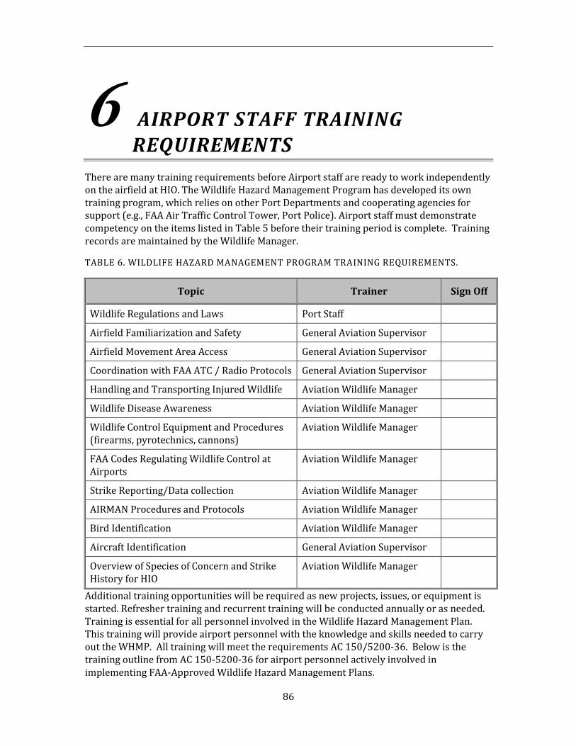
86
6 AIRPORT STAFF TRAINING REQUIREMENTS
There are many training requirements before Airport staff are ready to work independently on the airfield at HIO. The Wildlife Hazard Management Program has developed its own training program, which relies on other Port Departments and cooperating agencies for support (e.g., FAA Air Traffic Control Tower, Port Police). Airport staff must demonstrate competency on the items listed in Table 5 before their training period is complete. Training records are maintained by the Wildlife Manager.
TABLE 6. WILDLIFE HAZARD MANAGEMENT PROGRAM TRAINING REQUIREMENTS.
Topic Trainer Sign Off
Wildlife Regulations and Laws Port Staff
Airfield Familiarization and Safety General Aviation Supervisor
Airfield Movement Area Access General Aviation Supervisor
Coordination with FAA ATC / Radio Protocols General Aviation Supervisor
Handling and Transporting Injured Wildlife Aviation Wildlife Manager
Wildlife Disease Awareness Aviation Wildlife Manager
Wildlife Control Equipment and Procedures (firearms, pyrotechnics, cannons)
Aviation Wildlife Manager
FAA Codes Regulating Wildlife Control at Airports
Aviation Wildlife Manager
Strike Reporting/Data collection Aviation Wildlife Manager
AIRMAN Procedures and Protocols Aviation Wildlife Manager
Bird Identification Aviation Wildlife Manager
Aircraft Identification General Aviation Supervisor
Overview of Species of Concern and Strike History for HIO
Aviation Wildlife Manager
Additional training opportunities will be required as new projects, issues, or equipment is started. Refresher training and recurrent training will be conducted annually or as needed. Training is essential for all personnel involved in the Wildlife Hazard Management Plan. This training will provide airport personnel with the knowledge and skills needed to carry out the WHMP. All training will meet the requirements AC 150/5200-36. Below is the training outline from AC 150-5200-36 for airport personnel actively involved in implementing FAA-Approved Wildlife Hazard Management Plans.
87
I. Training Curriculum Outline
The goal of the training course must be to provide the knowledge, skills, and abilities needed by airport personnel to safely, accurately, and effectively implement relevant portions of an FAA-approved Wildlife Hazard Management Plan. To be acceptable to the FAA, initial and recurrent training must include the following agenda items:
a. General survey of wildlife hazards to aviation based on the most recent annual FAA National Wildlife Strike Database Serial Report
b. Review of wildlife strikes, control actions, and observations at the airport over at least the past 12 months
c. Review of the airport’s Wildlife Hazard Assessment is to include—
(1) Existing wildlife hazards and trends in wildlife abundance
(2) Status of any open or unresolved recommended action items for reducing identified wildlife hazards to air carrier operations within the past 12 months
d. Review of the airport’s Wildlife Hazard Management Plan, to include the following:
(1) Airport-specific wildlife attractants, including man-made and natural features and habitat management practices of the last 12 months.
(2) Review of the airport’s wildlife permits (local, State, and Federal)
(3) Review of other airport-specific items:
(a) Wildlife hazard management strategies, techniques, and tools:
(i) Flight schedule modification
(ii) Habitat modification, exclusion
(iii) Repelling methods
(iv) Wildlife population management
(b) Responsibilities of airport personnel for—
(i) Reporting wildlife strikes, control actions, and wildlife observations
(ii) Communicating with personnel who conduct wildlife control actions or who see wildlife hazards and air traffic control tower personnel and others who may require notification, such as airport operations or maintenance departments
(iii) Documenting and reporting wildlife hazards seen during patrols and inspections and follow-up control efforts
88
(iv) Documenting and reporting when no hazards are seen during patrols and inspections
e. Basic bird and mammal identification, stressing local hazardous and rareor endangered species of concern
f. For any airport personnel using pyrotechnic launchers or firearms,training on the following topics from a qualified individual:
(1) Safety, parts, and operation of pyrotechnic launchers
(2) Fundamentals of using pyrotechnics to safely and effectively disperse wildlife
(3) Personnel protective equipment
(4) Cleaning, storage, and transport of firearms and pyrotechnic launchers
(5) Applicable local, State, and Federal regulations on firearms, pyrotechnic launchers, and pyrotechnics
(6) Live fire training with pyrotechnic launchers including strategies for dispersing wildlife away from runways and aircraft movement corridors
(7) For any airport personnel using firearms, live fire training. This training is highly recommended from a qualified individual but not a requirement for this training program.
g. Any other training required by local, State, or Federal regulations
II. Training Recommendations
a. Exams or tests may be oral, written, practical demonstrations, or acombination of all three.
b. The Trainer should retain passing grades/evaluations records.
c. The Trainer should retain course attendance records for a period of threeyears.
d. Airport personnel responsible for the airport’s wildlife hazardmanagement program should retain records of those to whom instruction in airport wildlife hazard management has been given for the period of time during which the employees conduct aviation wildlife management.
89
6.1. Awareness Training
The Aviation Wildlife Manager will provide general awareness training of wildlife issues to airport and airfield personnel as appropriate. This training will include identifying wildlife hazards and proper reporting procedures.
90
7 LITERATURE CITED
Allan, J.R. 2000. A protocol for bird strike risk assessment at airports. International Bird Strike Proceedings 25: 29-46.
Burt, W.H. and R.P Grossenheider. 1980. A field guide to the mammals. The Peterson field guide series. Houghton Mifflin Co., Boston. 289pp.
Cleary, E.C., R.A. Dolbeer and S.E. Wright. 2003. Wildlife strikes to civil aircraft in the United States, 1990–2001. Serial Report Number 8. Federal Aviation Administration, Office of Airport Safety and Standards, Washington, D.C. 51pp.
Eschenfelder, P. 2000. Jet engine certification standards. Proceedings of the International Bird Strike Committee 25:535-540.
Humane Society of the United States. 2000. Canada goose egg addling protocol. Washington, D.C. 7pp.
Johnson, G.D. and K.A. Fagerstone. 1994. Primary and secondary hazards of zinc phosphide to nontarget wildlife – A review of the literature. USDA Animal and Plant Health Inspection Service, DWRC Research Report No. 11-55-005. 26pp.
Marcot, B. 1996. Selecting the appropriate statistical procedures and asking the right questions: A synthesis. Chapter 9 in V. Sit and B. Taylor, editors. Statistical methods for adaptive management studies. B.C. Ministry of Forests, Land Management Handbook 42. Victoria, B.C.
Sibley, D.A. 2000. National Audubon Society: The Sibley guide to birds. Alfred A. Knopf, Inc. New York. 545pp.
Sliwinski, R.P. 1995. Habitat management at airports to reduce wildlife hazards. Eleventh Annual Airport Conference. Federal Aviation Administration, Great Lakes Region.
Witmer, G. 2003. Assessment of the rodent situation at Portland International Airport: Trip report, February 5-6, 2003. USDA/APHIS Wildlife Services, Fort Collins, CO. 7pp.
Transport Canada Environment and Support Services. 1994. Wildlife Control Procedures Manual.

91
This page intentionally left blank.
92
APPENDIX A Wildlife Risk Model

93
This page intentionally left blank.
Wildlife Risk Evaluation Model
Prepared for
Port of Portland Portland International Airport
August 1, 2009
Page intentionally left blank.
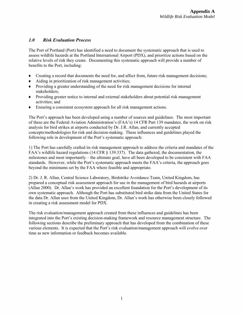
Appendix A Wildlife Risk Evaluation Model
1
1.0 Risk Evaluation Process
The Port of Portland (Port) has identified a need to document the systematic approach that is used to assess wildlife hazards at the Portland International Airport (PDX), and prioritize actions based on the relative levels of risk they create. Documenting this systematic approach will provide a number of benefits to the Port, including:
Creating a record that documents the need for, and affect from, future risk management decisions; Aiding in prioritization of risk management activities; Providing a greater understanding of the need for risk management decisions for internal
stakeholders; Providing greater notice to internal and external stakeholders about potential risk management
activities; and Ensuring a consistent ecosystem approach for all risk management actions.
The Port’s approach has been developed using a number of sources and guidelines. The most important of these are the Federal Aviation Administration’s (FAA’s) 14 CFR Part 139 mandates, the work on risk analysis for bird strikes at airports conducted by Dr. J.R. Allan, and currently accepted concepts/methodologies for risk and decision-making. These influences and guidelines played the following role in development of the Port’s systematic approach:
1) The Port has carefully crafted its risk management approach to address the criteria and mandates of theFAA’s wildlife hazard regulations (14 CFR § 139.337). The data gathered, the documentation, the milestones and most importantly – the ultimate goal, have all been developed to be consistent with FAA standards. However, while the Port’s systematic approach meets the FAA’s criteria, the approach goes beyond the minimums set by the FAA where feasible and appropriate.
2) Dr. J. R. Allan, Central Science Laboratory, Birdstrike Avoidance Team, United Kingdom, hasprepared a conceptual risk assessment approach for use in the management of bird hazards at airports (Allan 2000). Dr. Allan’s work has provided an excellent foundation for the Port’s development of its own systematic approach. Although the Port has substituted bird strike data from the United States for the data Dr. Allan uses from the United Kingdom, Dr. Allan’s work has otherwise been closely followed in creating a risk assessment model for PDX.
The risk evaluation/management approach created from these influences and guidelines has been integrated into the Port’s existing decision-making framework and resource management structure. The following sections describe the preliminary approach that has developed from the combination of these various elements. It is expected that the Port’s risk evaluation/management approach will evolve over time as new information or feedback becomes available.
Appendix A Wildlife Risk Evaluation Model
2
Definitions The Port’s risk evaluation/management methodology must reconcile a number of elements, including: Regulations and requirements of the FAA; The needs and expectations of the Port’s internal stakeholders; and The established science behind the reduction of hazards in current literature. All of these elements rely on their own definitions for key terminology. In order to produce a document to satisfy all concerned, agreed upon definitions have been developed and are listed in this section to avoid potential confusion. For purposes of the Port’s wildlife hazard risk evaluation/management strategy, the following terms have been defined to have the following agreed upon meanings: Wildlife Hazard - The FAA defines “Wildlife Hazard” as, “[t]he potential for a damaging aircraft collision with wildlife on or near an airport.” Hazard - Wildlife in a location, number, and/or with a behavior that gives it the potential for striking an aircraft. Risk Evaluation – A determination of the level of risk that exists for a particular wildlife species to produce a damaging aircraft collision based on the anticipated severity of impact and probability of occurrence. Probability - The likelihood that an adverse event, (i.e., a collision involving an aircraft and wildlife), will occur at PDX. Impact – The likely severity of the damage that will occur to an aircraft if a collision occurs with wildlife on or near an airport. Risk Evaluation Model (REM) – The methodology used by the Port to make an evaluation of risk as well as decisions with regard to managing that risk. 2.0 PDX Hazards The first step in the process of evaluating wildlife risk at PDX is to identify wildlife that could create a potential hazard. The Port maintains a comprehensive list of all wildlife known to frequent the PDX area or that has been observed at the airport during daily operations. A Wildlife Hazard Assessment has also been completed that identifies habitats that could attract wildlife to PDX. This assessment is validated with a database of the species struck at PDX has been kept since 1996. [The current list is contained within Appendix A of the Wildlife Hazard Management Plan (WHMP).] These three sets of data provide an increasingly detailed look at the species that may create hazards for aircraft at PDX. The data from the list of species struck at PDX is the basis for the risk evaluation process that is outlined in section 3.0. The overall objective of the PDX wildlife hazard management program is to develop an integrated and adaptive program to effectively manage risk at PDX by reducing the probability of occurrence of wildlife/aircraft collisions.
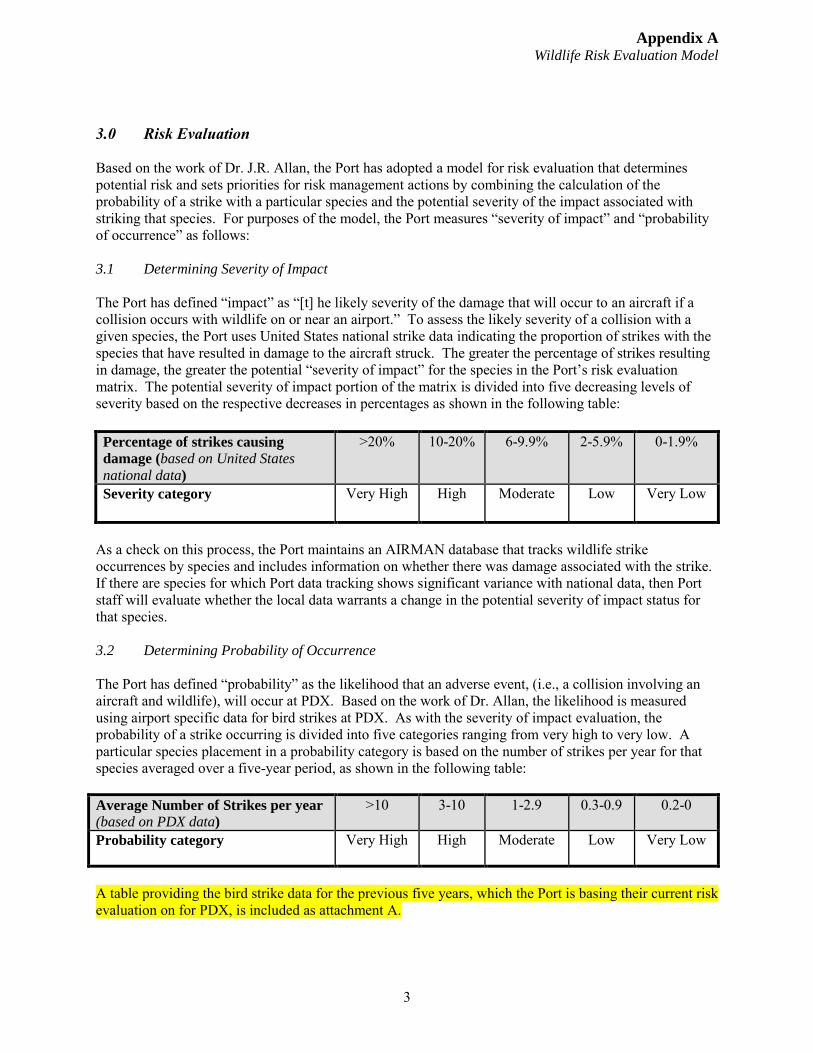
Appendix A Wildlife Risk Evaluation Model
3
3.0 Risk Evaluation
Based on the work of Dr. J.R. Allan, the Port has adopted a model for risk evaluation that determines potential risk and sets priorities for risk management actions by combining the calculation of the probability of a strike with a particular species and the potential severity of the impact associated with striking that species. For purposes of the model, the Port measures “severity of impact” and “probability of occurrence” as follows:
3.1 Determining Severity of Impact
The Port has defined “impact” as “[t] he likely severity of the damage that will occur to an aircraft if a collision occurs with wildlife on or near an airport.” To assess the likely severity of a collision with a given species, the Port uses United States national strike data indicating the proportion of strikes with the species that have resulted in damage to the aircraft struck. The greater the percentage of strikes resulting in damage, the greater the potential “severity of impact” for the species in the Port’s risk evaluation matrix. The potential severity of impact portion of the matrix is divided into five decreasing levels of severity based on the respective decreases in percentages as shown in the following table:
Percentage of strikes causing
damage (based on United States
national data)
>20% 10-20% 6-9.9% 2-5.9% 0-1.9%
Severity category Very High High Moderate Low Very Low
As a check on this process, the Port maintains an AIRMAN database that tracks wildlife strike occurrences by species and includes information on whether there was damage associated with the strike. If there are species for which Port data tracking shows significant variance with national data, then Port staff will evaluate whether the local data warrants a change in the potential severity of impact status for that species.
3.2 Determining Probability of Occurrence
The Port has defined “probability” as the likelihood that an adverse event, (i.e., a collision involving an aircraft and wildlife), will occur at PDX. Based on the work of Dr. Allan, the likelihood is measured using airport specific data for bird strikes at PDX. As with the severity of impact evaluation, the probability of a strike occurring is divided into five categories ranging from very high to very low. A particular species placement in a probability category is based on the number of strikes per year for that species averaged over a five-year period, as shown in the following table:
Average Number of Strikes per year
(based on PDX data)
>10 3-10 1-2.9 0.3-0.9 0.2-0
Probability category Very High High Moderate Low Very Low
A table providing the bird strike data for the previous five years, which the Port is basing their current risk evaluation on for PDX, is included as attachment A.
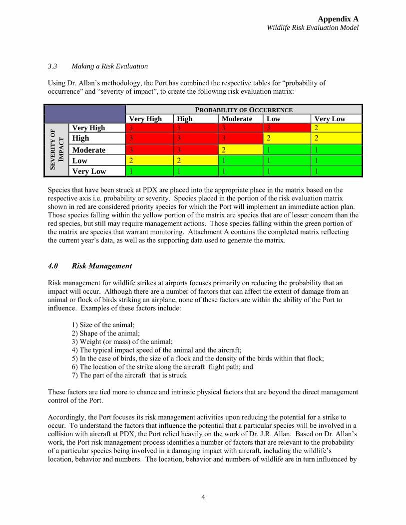
Appendix A Wildlife Risk Evaluation Model
4
3.3 Making a Risk Evaluation
Using Dr. Allan’s methodology, the Port has combined the respective tables for “probability of occurrence” and “severity of impact”, to create the following risk evaluation matrix:
PROBABILITY OF OCCURRENCE
Very High High Moderate Low Very Low
SE
VE
RIT
Y O
F
IMP
AC
T
Very High 3 3 3 3 2 High 3 3 3 2 2 Moderate 3 3 2 1 1 Low 2 2 1 1 1 Very Low 1 1 1 1 1
Species that have been struck at PDX are placed into the appropriate place in the matrix based on the respective axis i.e. probability or severity. Species placed in the portion of the risk evaluation matrix shown in red are considered priority species for which the Port will implement an immediate action plan. Those species falling within the yellow portion of the matrix are species that are of lesser concern than the red species, but still may require management actions. Those species falling within the green portion of the matrix are species that warrant monitoring. Attachment A contains the completed matrix reflecting the current year’s data, as well as the supporting data used to generate the matrix.
4.0 Risk Management
Risk management for wildlife strikes at airports focuses primarily on reducing the probability that an impact will occur. Although there are a number of factors that can affect the extent of damage from an animal or flock of birds striking an airplane, none of these factors are within the ability of the Port to influence. Examples of these factors include:
1) Size of the animal;2) Shape of the animal;3) Weight (or mass) of the animal;4) The typical impact speed of the animal and the aircraft;5) In the case of birds, the size of a flock and the density of the birds within that flock;6) The location of the strike along the aircraft flight path; and7) The part of the aircraft that is struck
These factors are tied more to chance and intrinsic physical factors that are beyond the direct management control of the Port.
Accordingly, the Port focuses its risk management activities upon reducing the potential for a strike to occur. To understand the factors that influence the potential that a particular species will be involved in a collision with aircraft at PDX, the Port relied heavily on the work of Dr. J.R. Allan. Based on Dr. Allan’s work, the Port risk management process identifies a number of factors that are relevant to the probability of a particular species being involved in a damaging impact with aircraft, including the wildlife’s location, behavior and numbers. The location, behavior and numbers of wildlife are in turn influenced by
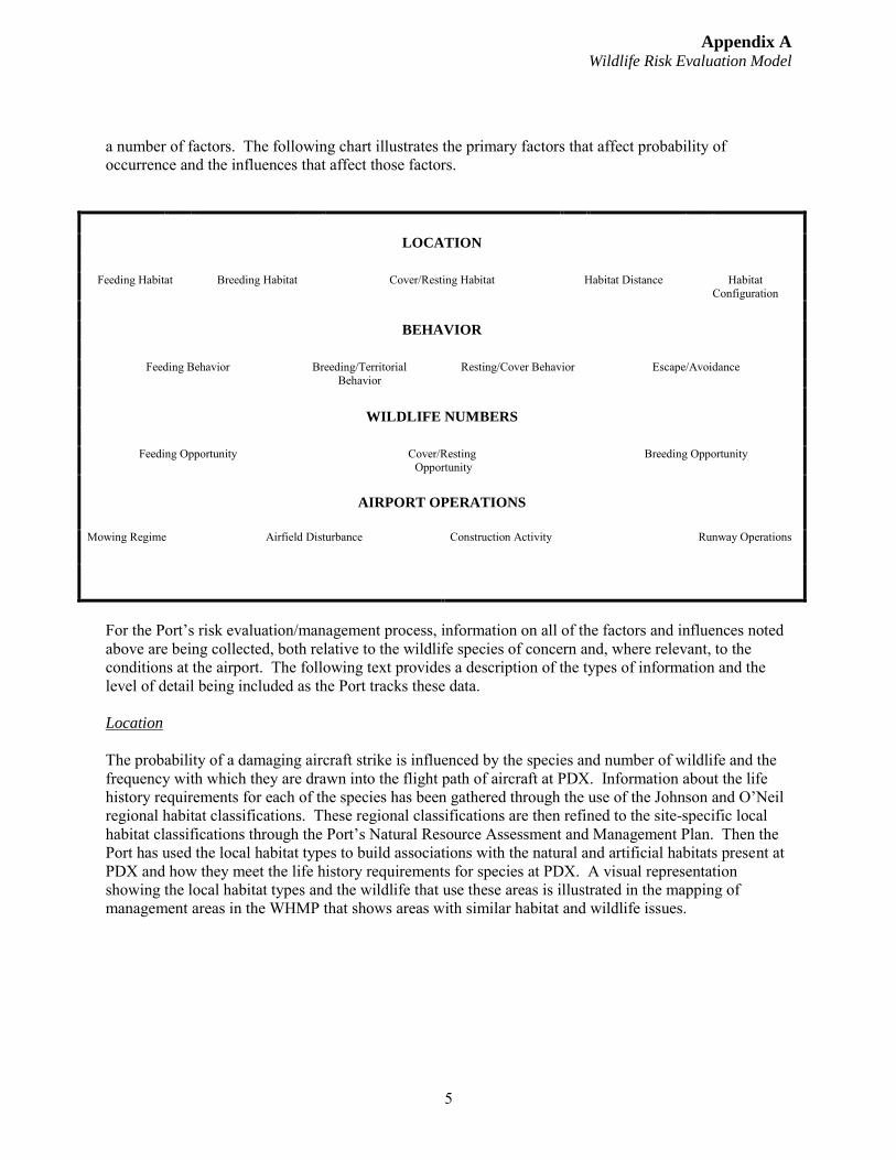
Appendix A Wildlife Risk Evaluation Model
5
a number of factors. The following chart illustrates the primary factors that affect probability of occurrence and the influences that affect those factors.
LOCATION
Feeding Habitat Breeding Habitat Cover/Resting Habitat Habitat Distance Habitat Configuration
BEHAVIOR
Feeding Behavior Breeding/Territorial Behavior
Resting/Cover Behavior Escape/Avoidance
WILDLIFE NUMBERS
Feeding Opportunity Cover/Resting Opportunity
Breeding Opportunity
AIRPORT OPERATIONS
Mowing Regime Airfield Disturbance Construction Activity Runway Operations
For the Port’s risk evaluation/management process, information on all of the factors and influences noted above are being collected, both relative to the wildlife species of concern and, where relevant, to the conditions at the airport. The following text provides a description of the types of information and the level of detail being included as the Port tracks these data.
Location
The probability of a damaging aircraft strike is influenced by the species and number of wildlife and the frequency with which they are drawn into the flight path of aircraft at PDX. Information about the life history requirements for each of the species has been gathered through the use of the Johnson and O’Neil regional habitat classifications. These regional classifications are then refined to the site-specific local habitat classifications through the Port’s Natural Resource Assessment and Management Plan. Then the Port has used the local habitat types to build associations with the natural and artificial habitats present at PDX and how they meet the life history requirements for species at PDX. A visual representation showing the local habitat types and the wildlife that use these areas is illustrated in the mapping of management areas in the WHMP that shows areas with similar habitat and wildlife issues.
Appendix A Wildlife Risk Evaluation Model
6
Behavior
How the various wildlife species behave is a very relevant factor in determining the probability of individual wildlife being at the wrong place at the wrong time. For instance, while feeding habitat may exist for several species at an airport, one species may hunt by stalking around the perimeter of the airfield, while others hunt by soaring over the airfield. In the very limited context of feeding behavior, the species that feed in flight or hunt while towering or and soaring have an increased potential for being at the wrong place at the wrong time.
This information is augmented by the Port wildlife staff’s knowledge of site-specific conditions for the species at the airport. This includes any regional variations, any seasonal variations in habitat or species presence, as well as unique behavioral patterns prompted by PDX’s geographic context. The site-specific variation is particularly relevant to the escape/avoidance tendencies within species. For instance, the behavior of juvenile birds is often different than that of adult birds, and resident birds may exhibit more “savvy” behavior around aircraft than birds encountering the airfield for the first time.
Wildlife Numbers
Land uses or management actions on or around the airport can influence the attractiveness of the area to species of concern for aviation. Accordingly, features of the environment that may lead to the increase or decrease in the number of individuals of that wildlife species may change the probability that a wildlife strike will occur. These features of habitat function and value are considered opportunities for wildlife and for this analysis are grouped into feeding, resting and protection, and breeding opportunities. Opportunities are species-specific characteristics.
Feeding opportunity provides an example of how the various opportunities can influence the probability that a strike will occur. Feeding opportunities for a particular species are those primary characteristics that (1) increase the abundance, quality and distribution of the food base, and (2) increase the availability of the food base. These may include optimal forage conditions or optimal habitat for a particular prey species. Increased forage or prey may not increase wildlife numbers unless the food source is readily accessible. Any features or activities that would increase the availability of forage or prey will increase feeding opportunity.
There are also seasonal variations in the number of species that occur at PDX, based on migration season, dispersion of juvenile birds, or other factors.
Airport Operations
In addition to the ecosystem conditions discussed above, the management and maintenance operations of the airport itself can influence the potential for a bird strike. For instance, short grass habitat is better suited to the feeding behaviors of some of the wildlife species of concern found at PDX. Accordingly, the mowing regime followed by the maintenance staff can affect the suitability of a given location as feeding habitat.
The mowing regime for the airport is a factor that the Port can control, within certain parameters. However, there are other factors that are relevant to determining the probability of an impact that are outside the control of the Port. For instance, because of the prevailing winds, aircraft at PDX tend to take off to the west during summer months and to the east during winter months. Because aircraft have greater
Appendix A Wildlife Risk Evaluation Model
7
vulnerability during take-off than during landing, the relevant location for the influence factors that affect bird strikes will tend to shift seasonally as take-off direction shifts.
Other airfield conditions will also change the species and number of birds that frequent the airfield. Construction activity will often draw birds to the area, especially if dirt moving, hydroseeding, or watering activities are involved. These activities may be unavoidable, but the hazard can be mitigated by awareness of the issue and increased hazing in response.
4.1 Process for Risk Management Decision Making
The Port is committed to developing a process for risk management in a comprehensive, well-documented and systematic manner. The primary challenge associated with reaching this goal is the overwhelming quantity and complexity of the data that is relevant to the decision making process.
For example, in the species behavior discussion above, it was noted that consideration of feeding behavior is important. The discussion noted that whether the presence of feeding habitat for a species is relevant depends in part on whether the species feeds in a manner that could create a conflict with aircraft. However, this is only the beginning of the consideration. Having feeding habitat that is used in a relatively safe manner (i.e., stalking) could still cause an increase in probability in other ways (e.g., feeding and nesting habitats are located in a configuration that results in species crossing runways frequently to access hunting grounds).
These complex interrelationships of the various ecosystem and operational factors make it impossible to consider the factors in isolation. To deal with this obstacle, the Port is creating two tools that are designed to help organize and aid in analysis of the relevant data.
4.1.1 Organizing Data
The first tool the Port has adopted is the Brain Enterprise Knowledge Platform software to help store, organize and understand the relationships within the relevant ecosystem and operational factors identified above. 1 The existing data concerning species habitat needs, behavioral patterns and opportunities for species abundance, as well as known conditions and operational information for PDX, have been input into the Brain program. The brain organizes the data and shows the potential relationships that exist and must be considered for each particular influence. The species-specific data that has been input into the Brain has been organized into the following general categories shown in Table 1:
1 Some relevant operational activities such as mowing are not currently being tracked within the Brain database because they are ongoing, irregularly timed processes. Because they are ongoing and irregular, keeping the database up to date would require excessive maintenance.
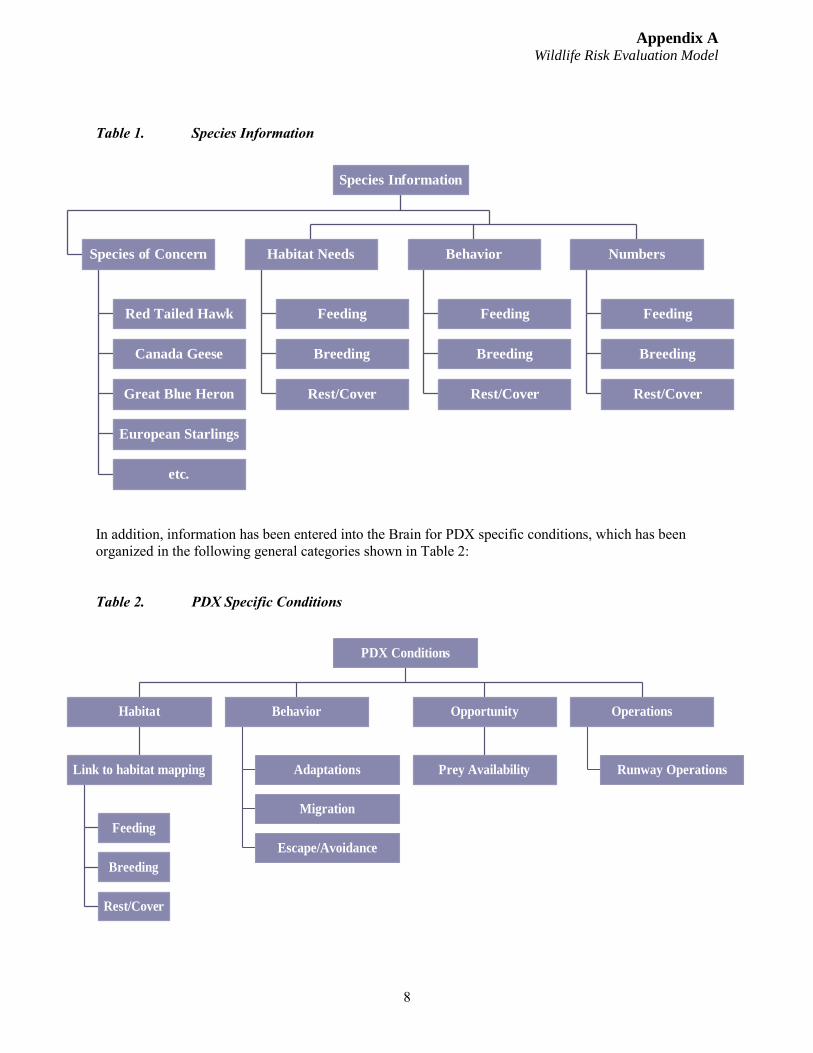
Appendix A Wildlife Risk Evaluation Model
8
Table 1. Species Information
In addition, information has been entered into the Brain for PDX specific conditions, which has been organized in the following general categories shown in Table 2:
Table 2. PDX Specific Conditions
Red Tailed Hawk
Canada Geese
Great Blue Heron
European Starlings
etc.
Species of Concern
Feeding
Breeding
Rest/Cover
Habitat Needs
Feeding
Breeding
Rest/Cover
Behavior
Feeding
Breeding
Rest/Cover
Numbers
Species Information
Feeding
Breeding
Rest/Cover
Link to habitat mapping
Habitat
Adaptations
Migration
Escape/Avoidance
Behavior
Prey Availability
Opportunity
Runway Operations
Operations
PDX Conditions
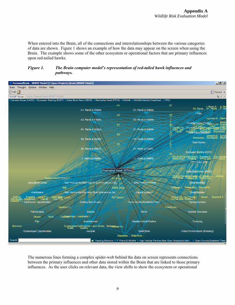
Appendix A Wildlife Risk Evaluation Model
9
When entered into the Brain, all of the connections and interrelationships between the various categories of data are shown. Figure 1 shows an example of how the data may appear on the screen when using the Brain. The example shows some of the other ecosystem or operational factors that are primary influences upon red-tailed hawks.
Figure 1. The Brain computer model’s representation of red-tailed hawk influences and pathways.
The numerous lines forming a complex spider-web behind the data on screen represents connections between the primary influences and other data stored within the Brain that are linked to those primary influences. As the user clicks on relevant data, the view shifts to show the ecosystem or operational
Appendix A Wildlife Risk Evaluation Model
10
factors that have primary linkages to that piece of data. This allows the user to identify the associations relevant to the management scenario.
4.1.2 Evaluating Data
Although the Brain is a great tool for storing and organizing data, the Brain holds too much information and too many relationships to understand without a guide. Accordingly, the Port is developing a pathway guide that helps users deal with the amount and complexity of the information within the Brain. The guide will consist of a list of questions with instructions to guide the user to the location in the Brain to answer the question. Each question is accompanied by follow up questions that guide the user through an evaluation of linked information that should also be considered.
By using the pathway guide or key, the data and relationships stored in the Brain can be queried with a specific focus towards the role of the respective habitat elements on increasing or decreasing probability of impacts. This allows evaluation of risk management options, as well as consideration of the consequences of those options. The pathway guide is the means of making the brain think. By walking the user step by step through the information contained in the Brain, the guide ensures that the analysis is consistent, comprehensive and well documented.
4.1.3 Risk Management Decision Making
In the end, best professional judgment is the ultimate basis for the decisions made using the Brain and the accompanying pathway guide. However, the Brain and the pathway guide give the best professional judgment structure, legitimacy, and credibility. These tools guide the species-specific management strategies. The pathway guide form will also serve as the documentation to support and justify the risk management determination that is made.
5.0 Conclusion
The REM and risk management process are anticipated to continuously evolve as the information available for the Brain is refined and improved. In addition, the pathway guides are easily adaptable to incorporate improvements in the understanding of ecosystem functions, risk theory, or wildlife hazards. Accordingly, the REM is expected to be in a continuous state of feedback and adaptation for at least several years. Nonetheless, based on preliminary use and evaluation of the Risk Evaluation Model, the Port believes that the model already provides the following elements to wildlife hazard management at PDX:
Improved documentation of the Port’s overall wildlife hazard management approach; Clear identification of the species that pose a hazard at PDX; Defined methodology for prioritizing management actions based on risk evaluation; Increased standardization and documentation of hazard management decision making; Improved ability to justifying hazard management decisions (both internally and externally); More certainty that risk management analysis will be comprehensive; and Increased support for risk management planning (e.g., identifying needs, prioritizing, targeting
issues, etc.).
Appendix A Wildlife Risk Evaluation Model
11
6.0 Literature Cited
Allan J.R. Birdstrike Assessment Model. Central Science Laboratory. Sand Hutton, York. 2003
Allan, J.R. A Protocol for Bird Strike Risk Assessment at Airports. International Bird Strike Proceedings 25: 29-46. 2000
Allan, J.R. The Use of Risk Assessment in Airport Bird Control. Birdstrike Avoidance Team – Central Science Laboratory. Sand Hutton, York. 2000
Johnson, David H. and Thomas A. O’Neil. Wildlife-Habitat Relationships in Oregon and Washington. Corvallis: Oregon State University Press. 2001.
Appendix A Wildlife Risk Evaluation Model
12
Page intentionally left blank.
Attachment 1
Example PDX Risk Evaluation Model & Supporting Data
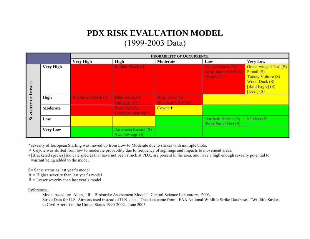
PDX RISK EVALUATION MODEL
(1999-2003 Data)PROBABILITY OF OCCURRENCE
Very High High Moderate Low Very Low
SE
VE
RIT
Y O
F I
MP
AC
T
Very High Mallard Duck (S) Canada Goose (S) Great-horned Owl (S) Osprey ()
Green-winged Teal (S) Pintail (S) Turkey Vulture (S) Wood Duck (S) [Bald Eagle] (S) [Deer] (S)
High Red-tailed Hawk (S) Blue Heron (S) Gull spp. (S)
Rock Dove (S) American Crow ()
Moderate Barn Owl (S) European Starling *
Coyote
Low Northern Harrier (S) Short-Eared Owl (S)
Killdeer (S)
Very Low American Kestrel (S) Swallow spp. (S)
*Severity of European Starling was moved up from Low to Moderate due to strikes with multiple birds. Coyote was shifted from low to moderate probability due to frequency of sightings and impacts to movement areas. [Bracketed species] indicate species that have not been struck at PDX, are present in the area, and have a high enough severity potential to
warrant being added to the model.
S= Same status as last year’s model = Higher severity than last year’s model = Lesser severity than last year’s model
References: Model based on: Allan, J.R. “Birdstrike Assessment Model.” Central Science Laboratory. 2003. Strike Data for U.S. Airports used instead of U.K. data. This data came from: FAA National Wildlife Strike Database. “Wildlife Strikes to Civil Aircraft in the United States 1990-2002. June 2003.
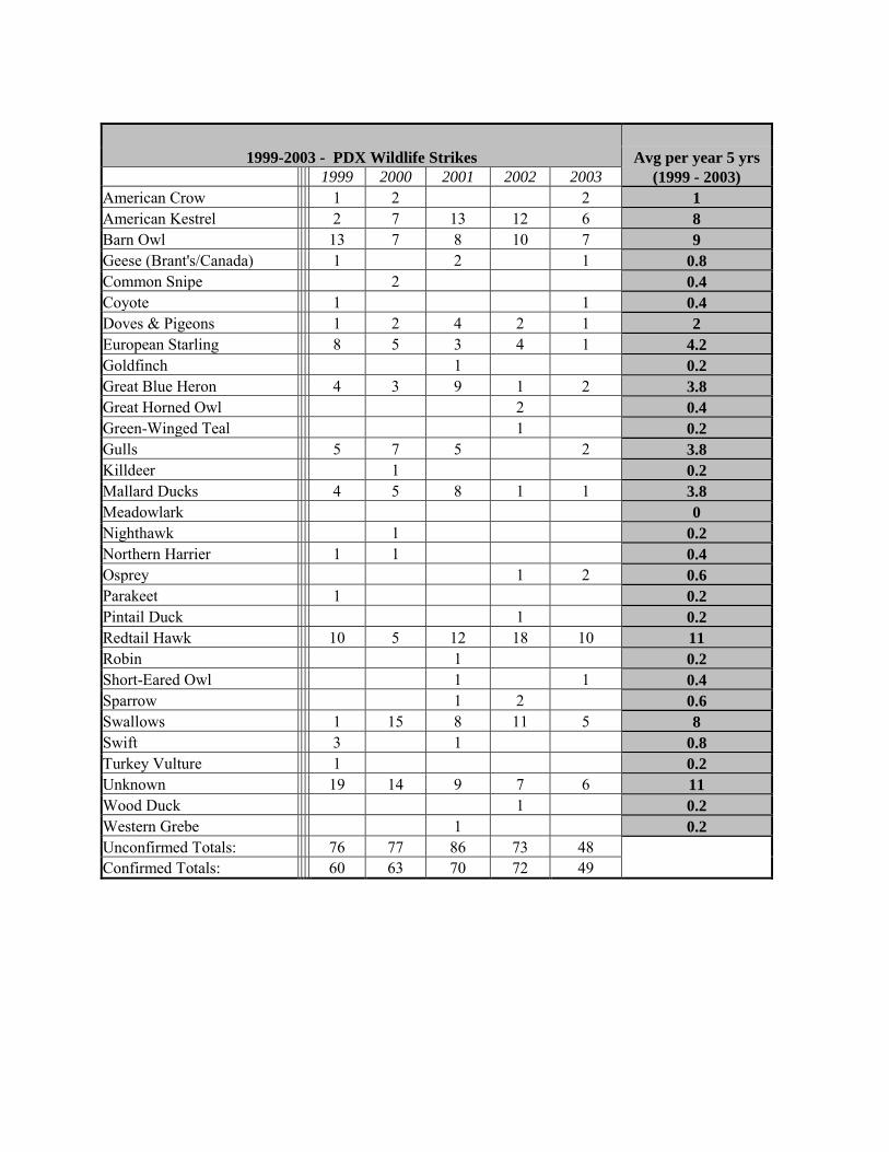
1999-2003 - PDX Wildlife Strikes Avg per year 5 yrs
1999 2000 2001 2002 2003 (1999 - 2003)
American Crow 1 2 2 1
American Kestrel 2 7 13 12 6 8
Barn Owl 13 7 8 10 7 9
Geese (Brant's/Canada) 1 2 1 0.8
Common Snipe 2 0.4
Coyote 1 1 0.4
Doves & Pigeons 1 2 4 2 1 2
European Starling 8 5 3 4 1 4.2
Goldfinch 1 0.2
Great Blue Heron 4 3 9 1 2 3.8
Great Horned Owl 2 0.4
Green-Winged Teal 1 0.2
Gulls 5 7 5 2 3.8
Killdeer 1 0.2
Mallard Ducks 4 5 8 1 1 3.8
Meadowlark 0
Nighthawk 1 0.2
Northern Harrier 1 1 0.4
Osprey 1 2 0.6
Parakeet 1 0.2
Pintail Duck 1 0.2
Redtail Hawk 10 5 12 18 10 11
Robin 1 0.2
Short-Eared Owl 1 1 0.4
Sparrow 1 2 0.6
Swallows 1 15 8 11 5 8
Swift 3 1 0.8
Turkey Vulture 1 0.2
Unknown 19 14 9 7 6 11
Wood Duck 1 0.2
Western Grebe 1 0.2
Unconfirmed Totals: 76 77 86 73 48 Confirmed Totals: 60 63 70 72 49
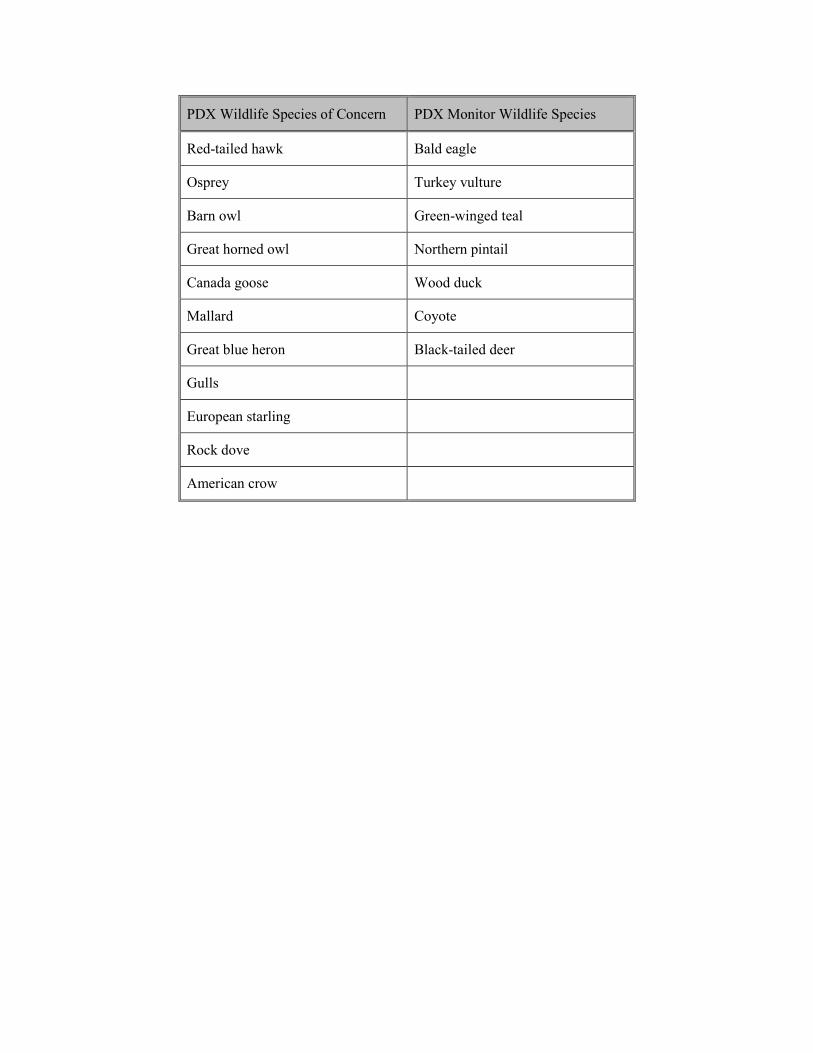
PDX Wildlife Species of Concern PDX Monitor Wildlife Species
Red-tailed hawk Bald eagle
Osprey Turkey vulture
Barn owl Green-winged teal
Great horned owl Northern pintail
Canada goose Wood duck
Mallard Coyote
Great blue heron Black-tailed deer
Gulls
European starling
Rock dove
American crow
94
APPENDIX B FAA Advisory Circular 150/5200-33B. Hazardous Wildlife Attractants On or Near Airports.

95
This page intentionally left blank.
U.S. Department of Transportation
Federal Aviation Administration
Advisory Circular
Subject: HAZARDOUS WILDLIFE ATTRACTANTS ON OR NEAR AIRPORTS
Date: 8/28/2007
Initiated by: AAS-300
AC No: 150/5200-33B
Change:
1. PURPOSE. This Advisory Circular (AC) provides guidance on certain land usesthat have the potential to attract hazardous wildlife on or near public-use airports. It also discusses airport development projects (including airport construction, expansion, and renovation) affecting aircraft movement near hazardous wildlife attractants. Appendix 1 provides definitions of terms used in this AC.
2. APPLICABILITY. The Federal Aviation Administration (FAA) recommends thatpublic-use airport operators implement the standards and practices contained in this AC. The holders of Airport Operating Certificates issued under Title 14, Code of Federal Regulations (CFR), Part 139, Certification of Airports, Subpart D (Part 139), may use the standards, practices, and recommendations contained in this AC to comply with the wildlife hazard management requirements of Part 139. Airports that have received Federal grant-in-aid assistance must use these standards. The FAA also recommends the guidance in this AC for land-use planners, operators of non-certificated airports, and developers of projects, facilities, and activities on or near airports.
3. CANCELLATION. This AC cancels AC 150/5200-33A, Hazardous WildlifeAttractants on or near Airports, dated July 27, 2004.
4. PRINCIPAL CHANGES. This AC contains the following major changes, whichare marked with vertical bars in the margin:
a. Technical changes to paragraph references.
b. Wording on storm water detention ponds.
c. Deleted paragraph 4-3.b, Additional Coordination.
5. BACKGROUND. Information about the risks posed to aircraft by certain wildlifespecies has increased a great deal in recent years. Improved reporting, studies, documentation, and statistics clearly show that aircraft collisions with birds and other wildlife are a serious economic and public safety problem. While many species of wildlife can pose a threat to aircraft safety, they are not equally hazardous. Table 1
<< Signature on File >>
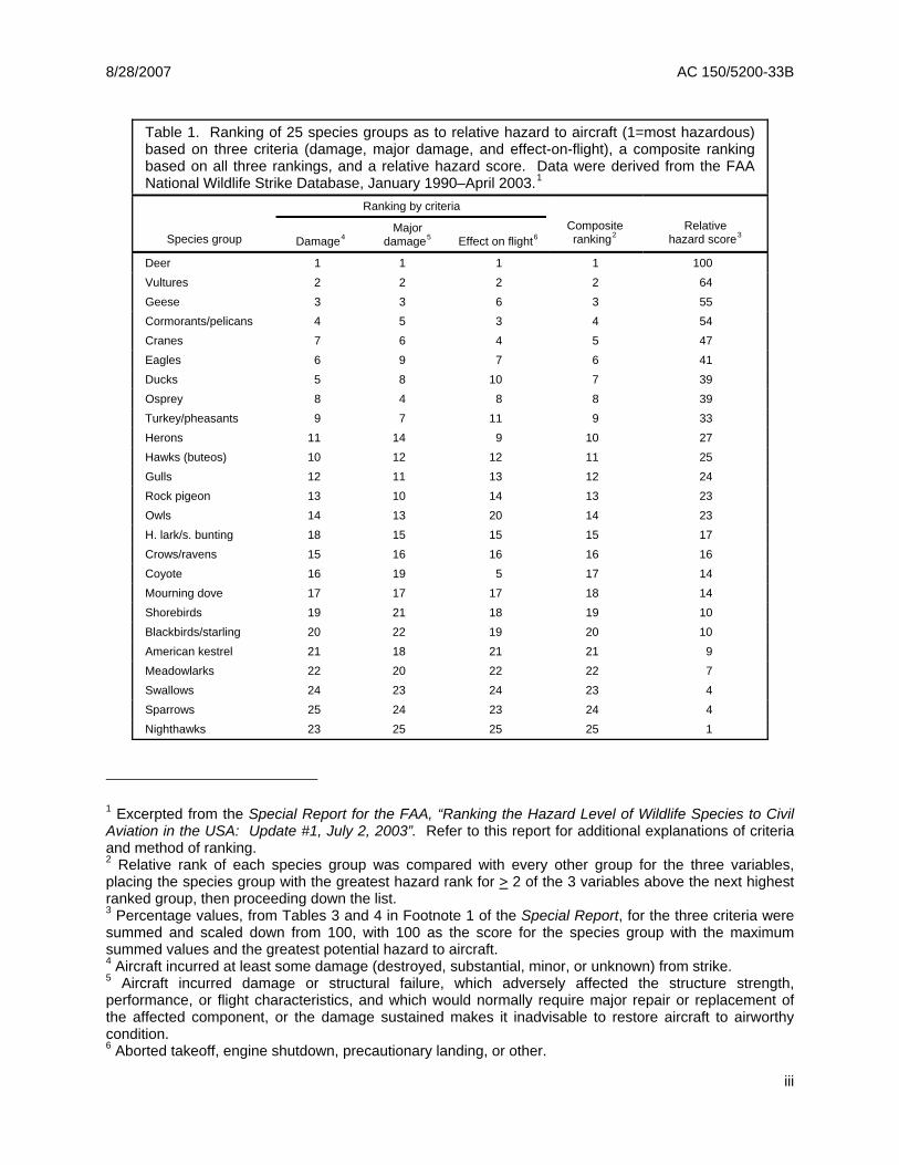
8/28/2007 AC 150/5200-33B
Table 1. Ranking of 25 species groups as to relative hazard to aircraft (1=most hazardous) based on three criteria (damage, major damage, and effect-on-flight), a composite ranking based on all three rankings, and a relative hazard score. Data were derived from the FAA National Wildlife Strike Database, January 1990–April 2003.1
Ranking by criteria
Species group Damage4Major
damage5 Effect on flight6Composite ranking2
Relative hazard score3
Deer 1 1 1 1 100Vultures 2 2 2 2 64Geese 3 3 6 3 55Cormorants/pelicans 4 5 3 4 54Cranes 7 6 4 5 47Eagles 6 9 7 6 41Ducks 5 8 10 7 39Osprey 8 4 8 8 39Turkey/pheasants 9 7 11 9 33Herons 11 14 9 10 27Hawks (buteos) 10 12 12 11 25 Gulls 12 11 13 12 24Rock pigeon 13 10 14 13 23 Owls 14 13 20 14 23H. lark/s. bunting 18 15 15 15 17 Crows/ravens 15 16 16 16 16Coyote 16 19 5 17 14Mourning dove 17 17 17 18 14 Shorebirds 19 21 18 19 10Blackbirds/starling 20 22 19 20 10American kestrel 21 18 21 21 9 Meadowlarks 22 20 22 22 7Swallows 24 23 24 23 4Sparrows 25 24 23 24 4Nighthawks 23 25 25 25 1
1 Excerpted from the Special Report for the FAA, “Ranking the Hazard Level of Wildlife Species to Civil Aviation in the USA: Update #1, July 2, 2003”. Refer to this report for additional explanations of criteria and method of ranking. 2 Relative rank of each species group was compared with every other group for the three variables, placing the species group with the greatest hazard rank for > 2 of the 3 variables above the next highest ranked group, then proceeding down the list. 3 Percentage values, from Tables 3 and 4 in Footnote 1 of the Special Report, for the three criteria were summed and scaled down from 100, with 100 as the score for the species group with the maximum summed values and the greatest potential hazard to aircraft. 4 Aircraft incurred at least some damage (destroyed, substantial, minor, or unknown) from strike. 5 Aircraft incurred damage or structural failure, which adversely affected the structure strength, performance, or flight characteristics, and which would normally require major repair or replacement of the affected component, or the damage sustained makes it inadvisable to restore aircraft to airworthy condition. 6 Aborted takeoff, engine shutdown, precautionary landing, or other.
iii

8/28/2007 AC 150/5200-33B
This page intentionally left blank.
iv
8/28/2007 AC 150/5200-33B
Table of Contents
SECTION 1. GENERAL SEPARATION CRITERIA FOR HAZARDOUS WILDLIFE ATTRACTANTS ON OR NEAR AIRPORTS. ........................................................................................................................... 1
1-1. INTRODUCTION................................................................................................................. 1
1-2. AIRPORTS SERVING PISTON-POWERED AIRCRAFT................................................... 1
1-3. AIRPORTS SERVING TURBINE-POWERED AIRCRAFT................................................. 1
1-4. PROTECTION OF APPROACH, DEPARTURE, AND CIRCLING AIRSPACE.................. 1
SECTION 2. LAND-USE PRACTICES ON OR NEAR AIRPORTS THAT POTENTIALLY ATTRACT HAZARDOUS WILDLIFE.............................................................................................................................. 3
2-1. GENERAL........................................................................................................................... 3
2-2. WASTE DISPOSAL OPERATIONS.................................................................................... 3
2-3. WATER MANAGEMENT FACILITIES................................................................................ 5
2-4. WETLANDS ........................................................................................................................ 8
2-5. DREDGE SPOIL CONTAINMENT AREAS ........................................................................ 9
2-6. AGRICULTURAL ACTIVITIES............................................................................................ 9
2-7. GOLF COURSES, LANDSCAPING AND OTHER LAND-USE CONSIDERATIONS ...... 10
2-8. SYNERGISTIC EFFECTS OF SURROUNDING LAND USES ........................................ 11
SECTION 3. PROCEDURES FOR WILDLIFE HAZARD MANAGEMENT BY OPERATORS OF PUBLIC-USE AIRPORTS ........................................................................................................................... 13
3.1. INTRODUCTION............................................................................................................... 13
3.2. COORDINATION WITH USDA WILDLIFE SERVICES OR OTHER QUALIFIED WILDLIFE DAMAGE MANAGEMENT BIOLOGISTS....................................................... 13
3-3. WILDLIFE HAZARD MANAGEMENT AT AIRPORTS: A MANUAL FOR AIRPORT PERSONNEL.................................................................................................................... 13
3-4. WILDLIFE HAZARD ASSESSMENTS, TITLE 14, CODE OF FEDERAL REGULATIONS, PART 139.............................................................................................. 13
3-5. WILDLIFE HAZARD MANAGEMENT PLAN (WHMP) ..................................................... 14
3-6. LOCAL COORDINATION ................................................................................................. 14
3-7. COORDINATION/NOTIFICATION OF AIRMEN OF WILDLIFE HAZARDS .................... 14
SECTION 4. FAA NOTIFICATION AND REVIEW OF PROPOSED LAND-USE PRACTICE CHANGES IN THE VICINITY OF PUBLIC-USE AIRPORTS..................................................................... 15
4-1. FAA REVIEW OF PROPOSED LAND-USE PRACTICE CHANGES IN THE VICINITY OF PUBLIC-USE AIRPORTS........................................................................................... 15
4-2. WASTE MANAGEMENT FACILITIES .............................................................................. 15
4-3. OTHER LAND-USE PRACTICE CHANGES .................................................................... 16
APPENDIX 1. DEFINITIONS OF TERMS USED IN THIS ADVISORY CIRCULAR .................................. 19
v
8/28/2007 AC 150/5200-33B
This page intentionally left blank.
vi
8/28/2007 AC 150/5200-33B
SECTION 1.
GENERAL SEPARATION CRITERIA FOR HAZARDOUS WILDLIFE ATTRACTANTS ON OR NEAR AIRPORTS.
1-1. INTRODUCTION. When considering proposed land uses, airport operators, local planners, and developers must take into account whether the proposed land uses, including new development projects, will increase wildlife hazards. Land-use practices that attract or sustain hazardous wildlife populations on or near airports can significantly increase the potential for wildlife strikes.
The FAA recommends the minimum separation criteria outlined below for land-use practices that attract hazardous wildlife to the vicinity of airports. Please note that FAA criteria include land uses that cause movement of hazardous wildlife onto, into, or across the airport’s approach or departure airspace or air operations area (AOA). (See the discussion of the synergistic effects of surrounding land uses in Section 2-8 of this AC.)
The basis for the separation criteria contained in this section can be found in existing FAA regulations. The separation distances are based on (1) flight patterns of piston-powered aircraft and turbine-powered aircraft, (2) the altitude at which most strikes happen (78 percent occur under 1,000 feet and 90 percent occur under 3,000 feet above ground level), and (3) National Transportation Safety Board (NTSB) recommendations.
1-2. AIRPORTS SERVING PISTON-POWERED AIRCRAFT. Airports that do not sell Jet-A fuel normally serve piston-powered aircraft. Notwithstanding more stringent requirements for specific land uses, the FAA recommends a separation distance of 5,000 feet at these airports for any of the hazardous wildlife attractants mentioned in Section 2 or for new airport development projects meant to accommodate aircraft movement. This distance is to be maintained between an airport’s AOA and the hazardous wildlife attractant. Figure 1 depicts this separation distance measured from the nearest aircraft operations areas.
1-3. AIRPORTS SERVING TURBINE-POWERED AIRCRAFT. Airports selling Jet-A fuel normally serve turbine-powered aircraft. Notwithstanding more stringent requirements for specific land uses, the FAA recommends a separation distance of 10,000 feet at these airports for any of the hazardous wildlife attractants mentioned in Section 2 or for new airport development projects meant to accommodate aircraft movement. This distance is to be maintained between an airport’s AOA and the hazardous wildlife attractant. Figure 1 depicts this separation distance from the nearest aircraft movement areas.
1-4. PROTECTION OF APPROACH, DEPARTURE, AND CIRCLING AIRSPACE. For all airports, the FAA recommends a distance of 5 statute miles between the farthest edge of the airport’s AOA and the hazardous wildlife attractant if the attractant could cause hazardous wildlife movement into or across the approach or departure airspace.
1
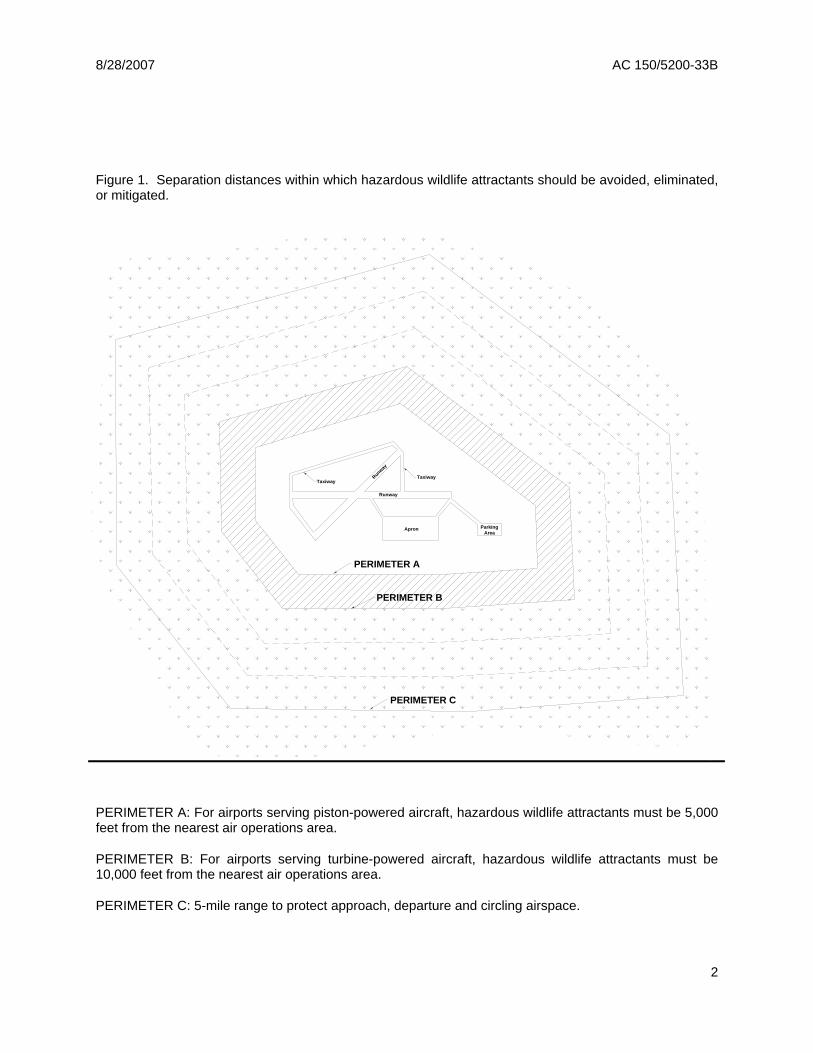
8/28/2007 AC 150/5200-33B
Figure 1. Separation distances within which hazardous wildlife attractants should be avoided, eliminated, or mitigated.
PERIMETER A
PERIMETER B
Runway
Parking ApronArea
y
Runwa
TaxiwayTaxiway
PERIMETER C
PERIMETER A: For airports serving piston-powered aircraft, hazardous wildlife attractants must be 5,000 feet from the nearest air operations area.
PERIMETER B: For airports serving turbine-powered aircraft, hazardous wildlife attractants must be 10,000 feet from the nearest air operations area.
PERIMETER C: 5-mile range to protect approach, departure and circling airspace.
2
8/28/2007 AC 150/5200-33B
SECTION 2.
LAND-USE PRACTICES ON OR NEAR AIRPORTS THAT POTENTIALLY ATTRACT HAZARDOUS WILDLIFE.
2-1. GENERAL. The wildlife species and the size of the populations attracted to the airport environment vary considerably, depending on several factors, including land-use practices on or near the airport. This section discusses land-use practices having the potential to attract hazardous wildlife and threaten aviation safety. In addition to the specific considerations outlined below, airport operators should refer to Wildlife Hazard Management at Airports, prepared by FAA and U.S. Department of Agriculture (USDA) staff. (This manual is available in English, Spanish, and French. It can be viewed and downloaded free of charge from the FAA’s wildlife hazard mitigation web site: http://wildlife-mitigation.tc.FAA.gov.). And, Prevention and Control of Wildlife Damage, compiled by the University of Nebraska Cooperative Extension Division. (This manual is available online in a periodically updated version at: ianrwww.unl.edu/wildlife/solutions/handbook/.)
2-2. WASTE DISPOSAL OPERATIONS. Municipal solid waste landfills (MSWLF) are known to attract large numbers of hazardous wildlife, particularly birds. Because of this, these operations, when located within the separations identified in the siting criteria in Sections 1-2 through 1-4, are considered incompatible with safe airport operations.
a. Siting for new municipal solid waste landfills subject to AIR 21. Section 503 ofthe Wendell H. Ford Aviation Investment and Reform Act for the 21st Century(Public Law 106-181) (AIR 21) prohibits the construction or establishment of a newMSWLF within 6 statute miles of certain public-use airports. Before theseprohibitions apply, both the airport and the landfill must meet the very specificconditions described below. These restrictions do not apply to airports or landfillslocated within the state of Alaska.
The airport must (1) have received a Federal grant(s) under 49 U.S.C. § 47101, et. seq.; (2) be under control of a public agency; (3) serve some scheduled air carrier operations conducted in aircraft with less than 60 seats; and (4) have total annual enplanements consisting of at least 51 percent of scheduled air carrier enplanements conducted in aircraft with less than 60 passenger seats.
The proposed MSWLF must (1) be within 6 miles of the airport, as measured from airport property line to MSWLF property line, and (2) have started construction or establishment on or after April 5, 2001. Public Law 106-181 only limits the construction or establishment of some new MSWLF. It does not limit the expansion, either vertical or horizontal, of existing landfills.
NOTE: Consult the most recent version of AC 150/5200-34, Construction or Establishment of Landfills Near Public Airports, for a more detailed discussion of these restrictions.
3
8/28/2007 AC 150/5200-33B
b. Siting for new MSWLF not subject to AIR 21. If an airport and MSWLF do notmeet the restrictions of Public Law 106-181, the FAA recommends against locatingMSWLF within the separation distances identified in Sections 1-2 through 1-4. Theseparation distances should be measured from the closest point of the airport’s AOAto the closest planned MSWLF cell.
c. Considerations for existing waste disposal facilities within the limits ofseparation criteria. The FAA recommends against airport development projectsthat would increase the number of aircraft operations or accommodate larger orfaster aircraft near MSWLF operations located within the separations identified inSections 1-2 through 1-4. In addition, in accordance with 40 CFR 258.10, owners oroperators of existing MSWLF units that are located within the separations listed inSections 1-2 through 1-4 must demonstrate that the unit is designed and operatedso it does not pose a bird hazard to aircraft. (See Section 4-2(b) of this AC for adiscussion of this demonstration requirement.)
d. Enclosed trash transfer stations. Enclosed waste-handling facilities that receivegarbage behind closed doors; process it via compaction, incineration, or similarmanner; and remove all residue by enclosed vehicles generally are compatible withsafe airport operations, provided they are not located on airport property or withinthe Runway Protection Zone (RPZ). These facilities should not handle or storeputrescible waste outside or in a partially enclosed structure accessible to hazardouswildlife. Trash transfer facilities that are open on one or more sides; that storeuncovered quantities of municipal solid waste outside, even if only for a short time;that use semi-trailers that leak or have trash clinging to the outside; or that do notcontrol odors by ventilation and filtration systems (odor masking is not acceptable)do not meet the FAA’s definition of fully enclosed trash transfer stations. The FAAconsiders these facilities incompatible with safe airport operations if they are locatedcloser than the separation distances specified in Sections 1-2 through 1-4.
e. Composting operations on or near airport property. Composting operations thataccept only yard waste (e.g., leaves, lawn clippings, or branches) generally do notattract hazardous wildlife. Sewage sludge, woodchips, and similar material are notmunicipal solid wastes and may be used as compost bulking agents. The compost,however, must never include food or other municipal solid waste. Compostingoperations should not be located on airport property. Off-airport propertycomposting operations should be located no closer than the greater of the followingdistances: 1,200 feet from any AOA or the distance called for by airport designrequirements (see AC 150/5300-13, Airport Design). This spacing should preventmaterial, personnel, or equipment from penetrating any Object Free Area (OFA),Obstacle Free Zone (OFZ), Threshold Siting Surface (TSS), or Clearway. Airportoperators should monitor composting operations located in proximity to the airport toensure that steam or thermal rise does not adversely affect air traffic. On-airportdisposal of compost by-products should not be conducted for the reasons stated in2-3f.
4
8/28/2007 AC 150/5200-33B
f. Underwater waste discharges. The FAA recommends against the underwaterdischarge of any food waste (e.g., fish processing offal) within the separationsidentified in Sections 1-2 through 1-4 because it could attract scavenging hazardouswildlife.
g. Recycling centers. Recycling centers that accept previously sorted non-food items,such as glass, newspaper, cardboard, or aluminum, are, in most cases, notattractive to hazardous wildlife and are acceptable.
h. Construction and demolition (C&D) debris facilities. C&D landfills do notgenerally attract hazardous wildlife and are acceptable if maintained in an orderlymanner, admit no putrescible waste, and are not co-located with other wastedisposal operations. However, C&D landfills have similar visual and operationalcharacteristics to putrescible waste disposal sites. When co-located with putresciblewaste disposal operations, C&D landfills are more likely to attract hazardous wildlifebecause of the similarities between these disposal facilities. Therefore, a C&Dlandfill co-located with another waste disposal operation should be located outside ofthe separations identified in Sections 1-2 through 1-4.
i. Fly ash disposal. The incinerated residue from resource recovery power/heat-generating facilities that are fired by municipal solid waste, coal, or wood is generallynot a wildlife attractant because it no longer contains putrescible matter. Landfillsaccepting only fly ash are generally not considered to be wildlife attractants and areacceptable as long as they are maintained in an orderly manner, admit noputrescible waste of any kind, and are not co-located with other disposal operationsthat attract hazardous wildlife.
Since varying degrees of waste consumption are associated with general incineration (not resource recovery power/heat-generating facilities), the FAA considers the ash from general incinerators a regular waste disposal by-product and, therefore, a hazardous wildlife attractant if disposed of within the separation criteria outlined in Sections 1-2 through 1-4.
2-3. WATER MANAGEMENT FACILITIES. Drinking water intake and treatment facilities, storm water and wastewater treatment facilities, associated retention and settling ponds, ponds built for recreational use, and ponds that result from mining activities often attract large numbers of potentially hazardous wildlife. To prevent wildlife hazards, land-use developers and airport operators may need to develop management plans, in compliance with local and state regulations, to support the operation of storm water management facilities on or near all public-use airports to ensure a safe airport environment.
a. Existing storm water management facilities. On-airport storm watermanagement facilities allow the quick removal of surface water, including dischargesrelated to aircraft deicing, from impervious surfaces, such as pavement andterminal/hangar building roofs. Existing on-airport detention ponds collect stormwater, protect water quality, and control runoff. Because they slowly release water
5
8/28/2007 AC 150/5200-33B
after storms, they create standing bodies of water that can attract hazardous wildlife. Where the airport has developed a Wildlife Hazard Management Plan (WHMP) in accordance with Part 139, the FAA requires immediate correction of any wildlife hazards arising from existing storm water facilities located on or near airports, using appropriate wildlife hazard mitigation techniques. Airport operators should develop measures to minimize hazardous wildlife attraction in consultation with a wildlife damage management biologist.
Where possible, airport operators should modify storm water detention ponds to allow a maximum 48-hour detention period for the design storm. The FAA recommends that airport operators avoid or remove retention ponds and detention ponds featuring dead storage to eliminate standing water. Detention basins should remain totally dry between rainfalls. Where constant flow of water is anticipated through the basin, or where any portion of the basin bottom may remain wet, the detention facility should include a concrete or paved pad and/or ditch/swale in the bottom to prevent vegetation that may provide nesting habitat.
When it is not possible to drain a large detention pond completely, airport operators may use physical barriers, such as bird balls, wires grids, pillows, or netting, to deter birds and other hazardous wildlife. When physical barriers are used, airport operators must evaluate their use and ensure they will not adversely affect water rescue. Before installing any physical barriers over detention ponds on Part 139 airports, airport operators must get approval from the appropriate FAA Regional Airports Division Office.
The FAA recommends that airport operators encourage off-airport storm water treatment facility operators to incorporate appropriate wildlife hazard mitigation techniques into storm water treatment facility operating practices when their facility is located within the separation criteria specified in Sections 1-2 through 1-4.
b. New storm water management facilities. The FAA strongly recommends that off-airport storm water management systems located within the separations identified inSections 1-2 through 1-4 be designed and operated so as not to create above-ground standing water. Stormwater detention ponds should be designed,engineered, constructed, and maintained for a maximum 48–hour detention periodafter the design storm and remain completely dry between storms. To facilitate thecontrol of hazardous wildlife, the FAA recommends the use of steep-sided, rip-raplined, narrow, linearly shaped water detention basins. When it is not possible toplace these ponds away from an airport’s AOA, airport operators should usephysical barriers, such as bird balls, wires grids, pillows, or netting, to preventaccess of hazardous wildlife to open water and minimize aircraft-wildlife interactions.When physical barriers are used, airport operators must evaluate their use andensure they will not adversely affect water rescue. Before installing any physicalbarriers over detention ponds on Part 139 airports, airport operators must getapproval from the appropriate FAA Regional Airports Division Office. All vegetationin or around detention basins that provide food or cover for hazardous wildlife shouldbe eliminated. If soil conditions and other requirements allow, the FAA encourages
6
8/28/2007 AC 150/5200-33B
the use of underground storm water infiltration systems, such as French drains or buried rock fields, because they are less attractive to wildlife.
c. Existing wastewater treatment facilities. The FAA strongly recommends thatairport operators immediately correct any wildlife hazards arising from existingwastewater treatment facilities located on or near the airport. Where required, aWHMP developed in accordance with Part 139 will outline appropriate wildlifehazard mitigation techniques. Accordingly, airport operators should encouragewastewater treatment facility operators to incorporate measures, developed inconsultation with a wildlife damage management biologist, to minimize hazardouswildlife attractants. Airport operators should also encourage those wastewatertreatment facility operators to incorporate these mitigation techniques into theirstandard operating practices. In addition, airport operators should consider theexistence of wastewater treatment facilities when evaluating proposed sites for newairport development projects and avoid such sites when practicable.
d. New wastewater treatment facilities. The FAA strongly recommends against theconstruction of new wastewater treatment facilities or associated settling pondswithin the separations identified in Sections 1-2 through 1-4. Appendix 1 defineswastewater treatment facility as “any devices and/or systems used to store, treat,recycle, or reclaim municipal sewage or liquid industrial wastes.” The definitionincludes any pretreatment involving the reduction of the amount of pollutants or theelimination of pollutants prior to introducing such pollutants into a publicly ownedtreatment works (wastewater treatment facility). During the site-location analysis forwastewater treatment facilities, developers should consider the potential to attracthazardous wildlife if an airport is in the vicinity of the proposed site, and airportoperators should voice their opposition to such facilities if they are in proximity to theairport.
e. Artificial marshes. In warmer climates, wastewater treatment facilities sometimesemploy artificial marshes and use submergent and emergent aquatic vegetation asnatural filters. These artificial marshes may be used by some species of flockingbirds, such as blackbirds and waterfowl, for breeding or roosting activities. The FAAstrongly recommends against establishing artificial marshes within the separationsidentified in Sections 1-2 through 1-4.
f. Wastewater discharge and sludge disposal. The FAA recommends against thedischarge of wastewater or sludge on airport property because it may improve soilmoisture and quality on unpaved areas and lead to improved turf growth that can bean attractive food source for many species of animals. Also, the turf requires morefrequent mowing, which in turn may mutilate or flush insects or small animals andproduce straw, both of which can attract hazardous wildlife. In addition, theimproved turf may attract grazing wildlife, such as deer and geese. Problems mayalso occur when discharges saturate unpaved airport areas. The resultant soft,muddy conditions can severely restrict or prevent emergency vehicles from reachingaccident sites in a timely manner.
7
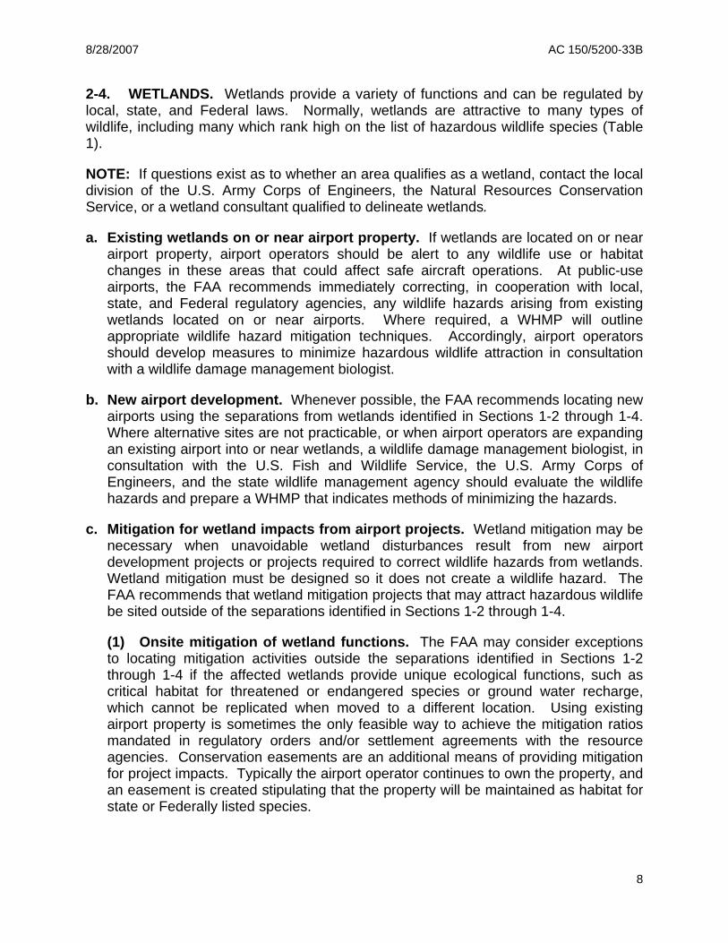
8/28/2007 AC 150/5200-33B
2-4. WETLANDS. Wetlands provide a variety of functions and can be regulated by local, state, and Federal laws. Normally, wetlands are attractive to many types of wildlife, including many which rank high on the list of hazardous wildlife species (Table 1).
NOTE: If questions exist as to whether an area qualifies as a wetland, contact the local division of the U.S. Army Corps of Engineers, the Natural Resources Conservation Service, or a wetland consultant qualified to delineate wetlands.
a. Existing wetlands on or near airport property. If wetlands are located on or nearairport property, airport operators should be alert to any wildlife use or habitatchanges in these areas that could affect safe aircraft operations. At public-useairports, the FAA recommends immediately correcting, in cooperation with local,state, and Federal regulatory agencies, any wildlife hazards arising from existingwetlands located on or near airports. Where required, a WHMP will outlineappropriate wildlife hazard mitigation techniques. Accordingly, airport operatorsshould develop measures to minimize hazardous wildlife attraction in consultationwith a wildlife damage management biologist.
b. New airport development. Whenever possible, the FAA recommends locating newairports using the separations from wetlands identified in Sections 1-2 through 1-4.Where alternative sites are not practicable, or when airport operators are expandingan existing airport into or near wetlands, a wildlife damage management biologist, inconsultation with the U.S. Fish and Wildlife Service, the U.S. Army Corps ofEngineers, and the state wildlife management agency should evaluate the wildlifehazards and prepare a WHMP that indicates methods of minimizing the hazards.
c. Mitigation for wetland impacts from airport projects. Wetland mitigation may benecessary when unavoidable wetland disturbances result from new airportdevelopment projects or projects required to correct wildlife hazards from wetlands.Wetland mitigation must be designed so it does not create a wildlife hazard. TheFAA recommends that wetland mitigation projects that may attract hazardous wildlifebe sited outside of the separations identified in Sections 1-2 through 1-4.
(1) Onsite mitigation of wetland functions. The FAA may consider exceptions to locating mitigation activities outside the separations identified in Sections 1-2 through 1-4 if the affected wetlands provide unique ecological functions, such as critical habitat for threatened or endangered species or ground water recharge, which cannot be replicated when moved to a different location. Using existing airport property is sometimes the only feasible way to achieve the mitigation ratios mandated in regulatory orders and/or settlement agreements with the resource agencies. Conservation easements are an additional means of providing mitigation for project impacts. Typically the airport operator continues to own the property, and an easement is created stipulating that the property will be maintained as habitat for state or Federally listed species.
8
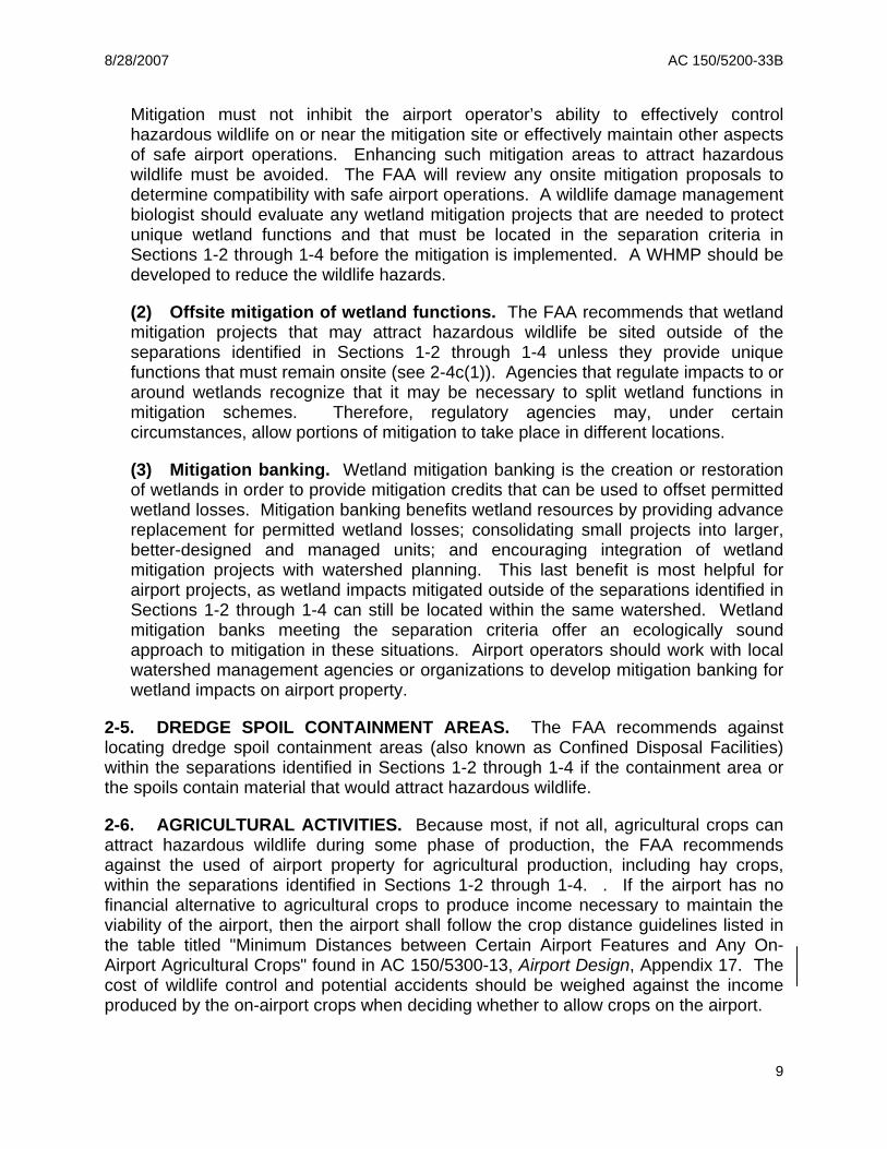
8/28/2007 AC 150/5200-33B
Mitigation must not inhibit the airport operator’s ability to effectively control hazardous wildlife on or near the mitigation site or effectively maintain other aspects of safe airport operations. Enhancing such mitigation areas to attract hazardous wildlife must be avoided. The FAA will review any onsite mitigation proposals to determine compatibility with safe airport operations. A wildlife damage management biologist should evaluate any wetland mitigation projects that are needed to protect unique wetland functions and that must be located in the separation criteria in Sections 1-2 through 1-4 before the mitigation is implemented. A WHMP should be developed to reduce the wildlife hazards.
(2) Offsite mitigation of wetland functions. The FAA recommends that wetland mitigation projects that may attract hazardous wildlife be sited outside of the separations identified in Sections 1-2 through 1-4 unless they provide unique functions that must remain onsite (see 2-4c(1)). Agencies that regulate impacts to or around wetlands recognize that it may be necessary to split wetland functions in mitigation schemes. Therefore, regulatory agencies may, under certain circumstances, allow portions of mitigation to take place in different locations.
(3) Mitigation banking. Wetland mitigation banking is the creation or restoration of wetlands in order to provide mitigation credits that can be used to offset permitted wetland losses. Mitigation banking benefits wetland resources by providing advance replacement for permitted wetland losses; consolidating small projects into larger, better-designed and managed units; and encouraging integration of wetland mitigation projects with watershed planning. This last benefit is most helpful for airport projects, as wetland impacts mitigated outside of the separations identified in Sections 1-2 through 1-4 can still be located within the same watershed. Wetland mitigation banks meeting the separation criteria offer an ecologically sound approach to mitigation in these situations. Airport operators should work with local watershed management agencies or organizations to develop mitigation banking for wetland impacts on airport property.
2-5. DREDGE SPOIL CONTAINMENT AREAS. The FAA recommends against locating dredge spoil containment areas (also known as Confined Disposal Facilities) within the separations identified in Sections 1-2 through 1-4 if the containment area or the spoils contain material that would attract hazardous wildlife.
2-6. AGRICULTURAL ACTIVITIES. Because most, if not all, agricultural crops can attract hazardous wildlife during some phase of production, the FAA recommends against the used of airport property for agricultural production, including hay crops, within the separations identified in Sections 1-2 through 1-4. . If the airport has no financial alternative to agricultural crops to produce income necessary to maintain the viability of the airport, then the airport shall follow the crop distance guidelines listed in the table titled "Minimum Distances between Certain Airport Features and Any On-Airport Agricultural Crops" found in AC 150/5300-13, Airport Design, Appendix 17. The cost of wildlife control and potential accidents should be weighed against the income produced by the on-airport crops when deciding whether to allow crops on the airport.
9
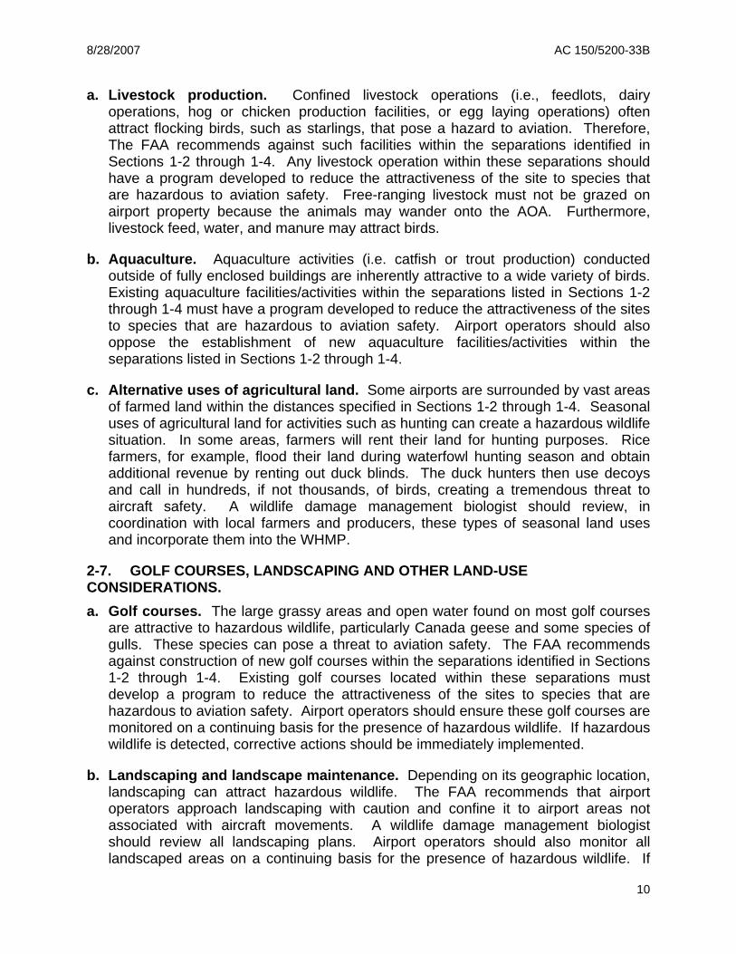
8/28/2007 AC 150/5200-33B
a. Livestock production. Confined livestock operations (i.e., feedlots, dairy operations, hog or chicken production facilities, or egg laying operations) often attract flocking birds, such as starlings, that pose a hazard to aviation. Therefore, The FAA recommends against such facilities within the separations identified in Sections 1-2 through 1-4. Any livestock operation within these separations should have a program developed to reduce the attractiveness of the site to species that are hazardous to aviation safety. Free-ranging livestock must not be grazed on airport property because the animals may wander onto the AOA. Furthermore, livestock feed, water, and manure may attract birds.
b. Aquaculture. Aquaculture activities (i.e. catfish or trout production) conducted outside of fully enclosed buildings are inherently attractive to a wide variety of birds. Existing aquaculture facilities/activities within the separations listed in Sections 1-2 through 1-4 must have a program developed to reduce the attractiveness of the sites to species that are hazardous to aviation safety. Airport operators should also oppose the establishment of new aquaculture facilities/activities within the separations listed in Sections 1-2 through 1-4.
c. Alternative uses of agricultural land. Some airports are surrounded by vast areas of farmed land within the distances specified in Sections 1-2 through 1-4. Seasonal uses of agricultural land for activities such as hunting can create a hazardous wildlife situation. In some areas, farmers will rent their land for hunting purposes. Rice farmers, for example, flood their land during waterfowl hunting season and obtain additional revenue by renting out duck blinds. The duck hunters then use decoys and call in hundreds, if not thousands, of birds, creating a tremendous threat to aircraft safety. A wildlife damage management biologist should review, in coordination with local farmers and producers, these types of seasonal land uses and incorporate them into the WHMP.
2-7. GOLF COURSES, LANDSCAPING AND OTHER LAND-USE CONSIDERATIONS. a. Golf courses. The large grassy areas and open water found on most golf courses
are attractive to hazardous wildlife, particularly Canada geese and some species of gulls. These species can pose a threat to aviation safety. The FAA recommends against construction of new golf courses within the separations identified in Sections 1-2 through 1-4. Existing golf courses located within these separations must develop a program to reduce the attractiveness of the sites to species that are hazardous to aviation safety. Airport operators should ensure these golf courses are monitored on a continuing basis for the presence of hazardous wildlife. If hazardous wildlife is detected, corrective actions should be immediately implemented.
b. Landscaping and landscape maintenance. Depending on its geographic location, landscaping can attract hazardous wildlife. The FAA recommends that airport operators approach landscaping with caution and confine it to airport areas not associated with aircraft movements. A wildlife damage management biologist should review all landscaping plans. Airport operators should also monitor all landscaped areas on a continuing basis for the presence of hazardous wildlife. If
10
8/28/2007 AC 150/5200-33B
hazardous wildlife is detected, corrective actions should be immediately implemented.
Turf grass areas can be highly attractive to a variety of hazardous wildlife species. Research conducted by the USDA Wildlife Services’ National Wildlife Research Center has shown that no one grass management regime will deter all species of hazardous wildlife in all situations. In cooperation with wildlife damage management biologist, airport operators should develop airport turf grass management plans on a prescription basis, depending on the airport’s geographic locations and the type of hazardous wildlife likely to frequent the airport
Airport operators should ensure that plant varieties attractive to hazardous wildlife are not used on the airport. Disturbed areas or areas in need of re-vegetating should not be planted with seed mixtures containing millet or any other large-seed producing grass. For airport property already planted with seed mixtures containing millet, rye grass, or other large-seed producing grasses, the FAA recommends disking, plowing, or another suitable agricultural practice to prevent plant maturation and seed head production. Plantings should follow the specific recommendations for grass management and seed and plant selection made by the State University Cooperative Extension Service, the local office of Wildlife Services, or a qualified wildlife damage management biologist. Airport operators should also consider developing and implementing a preferred/prohibited plant species list, reviewed by a wildlife damage management biologist, which has been designed for the geographic location to reduce the attractiveness to hazardous wildlife for landscaping airport property.
c. Airports surrounded by wildlife habitat. The FAA recommends that operators ofairports surrounded by woodlands, water, or wetlands refer to Section 2.4 of this AC.Operators of such airports should provide for a Wildlife Hazard Assessment (WHA)conducted by a wildlife damage management biologist. This WHA is the first step inpreparing a WHMP, where required.
d. Other hazardous wildlife attractants. Other specific land uses or activities (e.g.,sport or commercial fishing, shellfish harvesting, etc.), perhaps unique to certainregions of the country, have the potential to attract hazardous wildlife. Regardless ofthe source of the attraction, when hazardous wildlife is noted on a public-use airport,airport operators must take prompt remedial action(s) to protect aviation safety.
2-8. SYNERGISTIC EFFECTS OF SURROUNDING LAND USES. There may be circumstances where two (or more) different land uses that would not, by themselves, be considered hazardous wildlife attractants or that are located outside of the separations identified in Sections 1-2 through 1-4 that are in such an alignment with the airport as to create a wildlife corridor directly through the airport and/or surrounding airspace. An example of this situation may involve a lake located outside of the separation criteria on the east side of an airport and a large hayfield on the west side of an airport, land uses that together could create a flyway for Canada geese directly across the airspace of the airport. There are numerous examples of such situations;
11
8/28/2007 AC 150/5200-33B
therefore, airport operators and the wildlife damage management biologist must consider the entire surrounding landscape and community when developing the WHMP.
12
8/28/2007 AC 150/5200-33B
SECTION 3.
PROCEDURES FOR WILDLIFE HAZARD MANAGEMENT BY OPERATORS OF PUBLIC-USE AIRPORTS.
3.1. INTRODUCTION. In recognition of the increased risk of serious aircraft damage or the loss of human life that can result from a wildlife strike, the FAA may require the development of a Wildlife Hazard Management Plan (WHMP) when specific triggering events occur on or near the airport. Part 139.337 discusses the specific events that trigger a Wildlife Hazard Assessment (WHA) and the specific issues that a WHMP must address for FAA approval and inclusion in an Airport Certification Manual.
3.2. COORDINATION WITH USDA WILDLIFE SERVICES OR OTHER QUALIFIED WILDLIFE DAMAGE MANAGEMENT BIOLOGISTS. The FAA will use the Wildlife Hazard Assessment (WHA) conducted in accordance with Part 139 to determine if the airport needs a WHMP. Therefore, persons having the education, training, and expertise necessary to assess wildlife hazards must conduct the WHA. The airport operator may look to Wildlife Services or to qualified private consultants to conduct the WHA. When the services of a wildlife damage management biologist are required, the FAA recommends that land-use developers or airport operators contact a consultant specializing in wildlife damage management or the appropriate state director of Wildlife Services.
NOTE: Telephone numbers for the respective USDA Wildlife Services state offices can be obtained by contacting USDA Wildlife Services Operational Support Staff, 4700 River Road, Unit 87, Riverdale, MD, 20737-1234, Telephone (301) 734-7921, Fax (301) 734-5157 (http://www.aphis.usda.gov/ws/).
3-3. WILDLIFE HAZARD MANAGEMENT AT AIRPORTS: A MANUAL FOR AIRPORT PERSONNEL. This manual, prepared by FAA and USDA Wildlife Services staff, contains a compilation of information to assist airport personnel in the development, implementation, and evaluation of WHMPs at airports. The manual includes specific information on the nature of wildlife strikes, legal authority, regulations, wildlife management techniques, WHAs, WHMPs, and sources of help and information. The manual is available in three languages: English, Spanish, and French. It can be viewed and downloaded free of charge from the FAA’s wildlife hazard mitigation web site: http://wildlife-mitigation.tc.FAA.gov/. This manual only provides a starting point for addressing wildlife hazard issues at airports. Hazardous wildlife management is a complex discipline and conditions vary widely across the United States. Therefore, qualified wildlife damage management biologists must direct the development of a WHMP and the implementation of management actions by airport personnel.
There are many other resources complementary to this manual for use in developing and implementing WHMPs. Several are listed in the manual's bibliography.
3-4. WILDLIFE HAZARD ASSESSMENTS, TITLE 14, CODE OF FEDERAL REGULATIONS, PART 139. Part 139.337(b) requires airport operators to conduct a Wildlife Hazard Assessment (WHA) when certain events occur on or near the airport.
13
8/28/2007 AC 150/5200-33B
Part 139.337 (c) provides specific guidance as to what facts must be addressed in a WHA.
3-5. WILDLIFE HAZARD MANAGEMENT PLAN (WHMP). The FAA will consider the results of the WHA, along with the aeronautical activity at the airport and the views of the airport operator and airport users, in determining whether a formal WHMP is needed, in accordance with Part 139.337. If the FAA determines that a WHMP is needed, the airport operator must formulate and implement a WHMP, using the WHA as the basis for the plan.
The goal of an airport’s Wildlife Hazard Management Plan is to minimize the risk to aviation safety, airport structures or equipment, or human health posed by populations of hazardous wildlife on and around the airport.
The WHMP must identify hazardous wildlife attractants on or near the airport and the appropriate wildlife damage management techniques to minimize the wildlife hazard. It must also prioritize the management measures.
3-6. LOCAL COORDINATION. The establishment of a Wildlife Hazards Working Group (WHWG) will facilitate the communication, cooperation, and coordination of the airport and its surrounding community necessary to ensure the effectiveness of the WHMP. The cooperation of the airport community is also necessary when new projects are considered. Whether on or off the airport, the input from all involved parties must be considered when a potentially hazardous wildlife attractant is being proposed. Airport operators should also incorporate public education activities with the local coordination efforts because some activities in the vicinity of your airport, while harmless under normal leisure conditions, can attract wildlife and present a danger to aircraft. For example, if public trails are planned near wetlands or in parks adjoining airport property, the public should know that feeding birds and other wildlife in the area may pose a risk to aircraft.
Airport operators should work with local and regional planning and zoning boards so as to be aware of proposed land-use changes, or modification of existing land uses, that could create hazardous wildlife attractants within the separations identified in Sections 1-2 through 1-4. Pay particular attention to proposed land uses involving creation or expansion of waste water treatment facilities, development of wetland mitigation sites, or development or expansion of dredge spoil containment areas. At the very least, airport operators must ensure they are on the notification list of the local planning board or equivalent review entity for all communities located within 5 miles of the airport, so they will receive notification of any proposed project and have the opportunity to review it for attractiveness to hazardous wildlife.
3-7 COORDINATION/NOTIFICATION OF AIRMEN OF WILDLIFE HAZARDS. If an existing land-use practice creates a wildlife hazard and the land-use practice or wildlife hazard cannot be immediately eliminated, airport operators must issue a Notice to Airmen (NOTAM) and encourage the land–owner or manager to take steps to control the wildlife hazard and minimize further attraction.
14
8/28/2007 AC 150/5200-33B
SECTION 4.
FAA NOTIFICATION AND REVIEW OF PROPOSED LAND-USE PRACTICE CHANGES IN THE VICINITY OF PUBLIC-USE AIRPORTS
4-1. FAA REVIEW OF PROPOSED LAND-USE PRACTICE CHANGES IN THE VICINITY OF PUBLIC-USE AIRPORTS.
a. The FAA discourages the development of waste disposal and other facilities,discussed in Section 2, located within the 5,000/10,000-foot criteria specified inSections 1-2 through 1-4.
b. For projects that are located outside the 5,000/10,000-foot criteria but within 5statute miles of the airport’s AOA, the FAA may review development plans,proposed land-use changes, operational changes, or wetland mitigation plans todetermine if such changes present potential wildlife hazards to aircraft operations.The FAA considers sensitive airport areas as those that lie under or next toapproach or departure airspace. This brief examination should indicate if furtherinvestigation is warranted.
c. Where a wildlife damage management biologist has conducted a further study toevaluate a site's compatibility with airport operations, the FAA may use the studyresults to make a determination.
4-2. WASTE MANAGEMENT FACILITIES.
a. Notification of new/expanded project proposal. Section 503 of the Wendell H.Ford Aviation Investment and Reform Act for the 21st Century (Public Law 106-181)limits the construction or establishment of new MSWLF within 6 statute miles ofcertain public-use airports, when both the airport and the landfill meet very specificconditions. See Section 2-2 of this AC and AC 150/5200-34 for a more detaileddiscussion of these restrictions.
The Environmental Protection Agency (EPA) requires any MSWLF operatorproposing a new or expanded waste disposal operation within 5 statute miles of arunway end to notify the appropriate FAA Regional Airports Division Office and theairport operator of the proposal (40 CFR 258, Criteria for Municipal Solid WasteLandfills, Section 258.10, Airport Safety). The EPA also requires owners oroperators of new MSWLF units, or lateral expansions of existing MSWLF units, thatare located within 10,000 feet of any airport runway end used by turbojet aircraft, orwithin 5,000 feet of any airport runway end used only by piston-type aircraft, todemonstrate successfully that such units are not hazards to aircraft. (See 4-2.bbelow.)
When new or expanded MSWLF are being proposed near airports, MSWLFoperators must notify the airport operator and the FAA of the proposal as early aspossible pursuant to 40 CFR 258.
15
8/28/2007 AC 150/5200-33B
b. Waste handling facilities within separations identified in Sections 1-2 through1-4. To claim successfully that a waste-handling facility sited within the separationsidentified in Sections 1-2 through 1-4 does not attract hazardous wildlife and doesnot threaten aviation, the developer must establish convincingly that the facility willnot handle putrescible material other than that as outlined in 2-2.d. The FAAstrongly recommends against any facility other than that as outlined in 2-2.d(enclosed transfer stations). The FAA will use this information to determine if thefacility will be a hazard to aviation.
c. Putrescible-Waste Facilities. In their effort to satisfy the EPA requirement, someputrescible-waste facility proponents may offer to undertake experimental measuresto demonstrate that their proposed facility will not be a hazard to aircraft. To date, nosuch facility has been able to demonstrate an ability to reduce and sustainhazardous wildlife to levels that existed before the putrescible-waste landfill beganoperating. For this reason, demonstrations of experimental wildlife control measuresmay not be conducted within the separation identified in Sections 1-2 through 1-4.
4-3. OTHER LAND-USE PRACTICE CHANGES. As a matter of policy, the FAA encourages operators of public-use airports who become aware of proposed land use practice changes that may attract hazardous wildlife within 5 statute miles of their airports to promptly notify the FAA. The FAA also encourages proponents of such land use changes to notify the FAA as early in the planning process as possible. Advanced notice affords the FAA an opportunity (1) to evaluate the effect of a particular land-use change on aviation safety and (2) to support efforts by the airport sponsor to restrict the use of land next to or near the airport to uses that are compatible with the airport.
The airport operator, project proponent, or land-use operator may use FAA Form 7460-1, Notice of Proposed Construction or Alteration, or other suitable documents similar to FAA Form 7460-1 to notify the appropriate FAA Regional Airports Division Office. Project proponents can contact the appropriate FAA Regional Airports Division Office for assistance with the notification process.
It is helpful if the notification includes a 15-minute quadrangle map of the area identifying the location of the proposed activity. The land-use operator or project proponent should also forward specific details of the proposed land-use change or operational change or expansion. In the case of solid waste landfills, the information should include the type of waste to be handled, how the waste will be processed, and final disposal methods.
a. Airports that have received Federal grant-in-aid assistance. Airports that havereceived Federal grant-in-aid assistance are required by their grant assurances totake appropriate actions to restrict the use of land next to or near the airport to usesthat are compatible with normal airport operations. The FAA recommends thatairport operators to the extent practicable oppose off-airport land-use changes orpractices within the separations identified in Sections 1-2 through 1-4 that mayattract hazardous wildlife. Failure to do so may lead to noncompliance withapplicable grant assurances. The FAA will not approve the placement of airport
16
8/28/2007 AC 150/5200-33B
development projects pertaining to aircraft movement in the vicinity of hazardous wildlife attractants without appropriate mitigating measures. Increasing the intensity of wildlife control efforts is not a substitute for eliminating or reducing a proposed wildlife hazard. Airport operators should identify hazardous wildlife attractants and any associated wildlife hazards during any planning process for new airport development projects.
17

8/28/2007 AC 150/5200-33B
This page intentionally left blank.
18
8/28/2007 AC 150/5200-33B
APPENDIX 1. DEFINITIONS OF TERMS USED IN THIS ADVISORY CIRCULAR.
1. GENERAL. This appendix provides definitions of terms used throughout this AC.
1. Air operations area. Any area of an airport used or intended to be used forlanding, takeoff, or surface maneuvering of aircraft. An air operations areaincludes such paved areas or unpaved areas that are used or intended to beused for the unobstructed movement of aircraft in addition to its associatedrunway, taxiways, or apron.
2. Airport operator. The operator (private or public) or sponsor of a public-useairport.
3. Approach or departure airspace. The airspace, within 5 statute miles of anairport, through which aircraft move during landing or takeoff.
4. Bird balls. High-density plastic floating balls that can be used to cover pondsand prevent birds from using the sites.
5. Certificate holder. The holder of an Airport Operating Certificate issued underTitle 14, Code of Federal Regulations, Part 139.
6. Construct a new MSWLF. To begin to excavate, grade land, or raisestructures to prepare a municipal solid waste landfill as permitted by theappropriate regulatory or permitting agency.
7. Detention ponds. Storm water management ponds that hold storm water forshort periods of time, a few hours to a few days.
8. Establish a new MSWLF. When the first load of putrescible waste is receivedon-site for placement in a prepared municipal solid waste landfill.
9. Fly ash. The fine, sand-like residue resulting from the complete incineration ofan organic fuel source. Fly ash typically results from the combustion of coal orwaste used to operate a power generating plant.
10. General aviation aircraft. Any civil aviation aircraft not operating under 14CFR Part 119, Certification: Air Carriers and Commercial Operators.
11. Hazardous wildlife. Species of wildlife (birds, mammals, reptiles), includingferal animals and domesticated animals not under control, that are associatedwith aircraft strike problems, are capable of causing structural damage toairport facilities, or act as attractants to other wildlife that pose a strike hazard
12. Municipal Solid Waste Landfill (MSWLF). A publicly or privately owneddiscrete area of land or an excavation that receives household waste and thatis not a land application unit, surface impoundment, injection well, or waste pile,as those terms are defined under 40 CFR § 257.2. An MSWLF may receive
19
8/28/2007 AC 150/5200-33B
other types wastes, such as commercial solid waste, non-hazardous sludge, small-quantity generator waste, and industrial solid waste, as defined under 40 CFR § 258.2. An MSWLF can consist of either a stand alone unit or several cells that receive household waste.
13. New MSWLF. A municipal solid waste landfill that was established orconstructed after April 5, 2001.
14. Piston-powered aircraft. Fixed-wing aircraft powered by piston engines.
15. Piston-use airport. Any airport that does not sell Jet-A fuel for fixed-wingturbine-powered aircraft, and primarily serves fixed-wing, piston-poweredaircraft. Incidental use of the airport by turbine-powered, fixed-wing aircraftwould not affect this designation. However, such aircraft should not be basedat the airport.
16. Public agency. A State or political subdivision of a State, a tax-supportedorganization, or an Indian tribe or pueblo (49 U.S.C. § 47102(19)).
17. Public airport. An airport used or intended to be used for public purposes thatis under the control of a public agency; and of which the area used or intendedto be used for landing, taking off, or surface maneuvering of aircraft is publiclyowned (49 U.S.C. § 47102(20)).
18. Public-use airport. An airport used or intended to be used for public purposes,and of which the area used or intended to be used for landing, taking off, orsurface maneuvering of aircraft may be under the control of a public agency orprivately owned and used for public purposes (49 U.S.C. § 47102(21)).
19. Putrescible waste. Solid waste that contains organic matter capable of beingdecomposed by micro-organisms and of such a character and proportion as tobe capable of attracting or providing food for birds (40 CFR §257.3-8).
20. Putrescible-waste disposal operation. Landfills, garbage dumps, underwaterwaste discharges, or similar facilities where activities include processing,burying, storing, or otherwise disposing of putrescible material, trash, andrefuse.
21. Retention ponds. Storm water management ponds that hold water for severalmonths.
22. Runway protection zone (RPZ). An area off the runway end to enhance theprotection of people and property on the ground (see AC 150/5300-13). Thedimensions of this zone vary with the airport design, aircraft, type of operation,and visibility minimum.
23. Scheduled air carrier operation. Any common carriage passenger-carryingoperation for compensation or hire conducted by an air carrier or commercial
20
8/28/2007 AC 150/5200-33B
operator for which the air carrier, commercial operator, or their representative offers in advance the departure location, departure time, and arrival location. It does not include any operation that is conducted as a supplemental operation under 14 CFR Part 119 or as a public charter operation under 14 CFR Part 380 (14 CFR § 119.3).
24. Sewage sludge. Any solid, semi-solid, or liquid residue generated during thetreatment of domestic sewage in a treatment works. Sewage sludge includes,but is not limited to, domestic septage; scum or solids removed in primary,secondary, or advanced wastewater treatment process; and a material derivedfrom sewage sludge. Sewage does not include ash generated during the firingof sewage sludge in a sewage sludge incinerator or grit and screeningsgenerated during preliminary treatment of domestic sewage in a treatmentworks. (40 CFR 257.2)
25. Sludge. Any solid, semi-solid, or liquid waste generated form a municipal,commercial or industrial wastewater treatment plant, water supply treatmentplant, or air pollution control facility or any other such waste having similarcharacteristics and effect. (40 CFR 257.2)
26. Solid waste. Any garbage, refuse, sludge, from a waste treatment plant, watersupply treatment plant or air pollution control facility and other discardedmaterial, including, solid liquid, semisolid, or contained gaseous materialresulting from industrial, commercial, mining, and agricultural operations, andfrom community activities, but does not include solid or dissolved materials indomestic sewage, or solid or dissolved material in irrigation return flows orindustrial discharges which are point sources subject to permits under section402 of the Federal Water Pollution Control Act, as amended (86 Stat. 880), orsource, special nuclear, or by product material as defined by the Atomic EnergyAct of 1954, as amended, (68 Stat. 923). (40 CFR 257.2)
27. Turbine-powered aircraft. Aircraft powered by turbine engines includingturbojets and turboprops but excluding turbo-shaft rotary-wing aircraft.
28. Turbine-use airport. Any airport that sells Jet-A fuel for fixed-wing turbine-powered aircraft.
29. Wastewater treatment facility. Any devices and/or systems used to store,treat, recycle, or reclaim municipal sewage or liquid industrial wastes, includingPublicly Owned Treatment Works (POTW), as defined by Section 212 of theFederal Water Pollution Control Act (P.L. 92-500) as amended by the CleanWater Act of 1977 (P.L. 95-576) and the Water Quality Act of 1987 (P.L. 100-4).This definition includes any pretreatment involving the reduction of the amountof pollutants, the elimination of pollutants, or the alteration of the nature ofpollutant properties in wastewater prior to or in lieu of discharging or otherwiseintroducing such pollutants into a POTW. (See 40 CFR Section 403.3 (q), (r), &(s)).
21
8/28/2007 AC 150/5200-33B
30. Wildlife. Any wild animal, including without limitation any wild mammal, bird,reptile, fish, amphibian, mollusk, crustacean, arthropod, coelenterate, or otherinvertebrate, including any part, product, egg, or offspring thereof(50 CFR 10.12, Taking, Possession, Transportation, Sale, Purchase, Barter,Exportation, and Importation of Wildlife and Plants). As used in this AC, wildlifeincludes feral animals and domestic animals out of the control of their owners(14 CFR Part 139, Certification of Airports).
31. Wildlife attractants. Any human-made structure, land-use practice, or human-made or natural geographic feature that can attract or sustain hazardouswildlife within the landing or departure airspace or the airport’s AOA. Theseattractants can include architectural features, landscaping, waste disposal sites,wastewater treatment facilities, agricultural or aquaculture activities, surfacemining, or wetlands.
32. Wildlife hazard. A potential for a damaging aircraft collision with wildlife on ornear an airport.
33. Wildlife strike. A wildlife strike is deemed to have occurred when:
a. A pilot reports striking 1 or more birds or other wildlife;
b. Aircraft maintenance personnel identify aircraft damage as having beencaused by a wildlife strike;
c. Personnel on the ground report seeing an aircraft strike 1 or more birds orother wildlife;
d. Bird or other wildlife remains, whether in whole or in part, are found within200 feet of a runway centerline, unless another reason for the animal'sdeath is identified;
e. The animal's presence on the airport had a significant negative effect on aflight (i.e., aborted takeoff, aborted landing, high-speed emergency stop,aircraft left pavement area to avoid collision with animal) (TransportCanada, Airports Group, Wildlife Control Procedures Manual, TechnicalPublication 11500E, 1994).
2. RESERVED.
22
APPENDIX C HIO Wildlife Control Permits.

This page intentionally left blank.
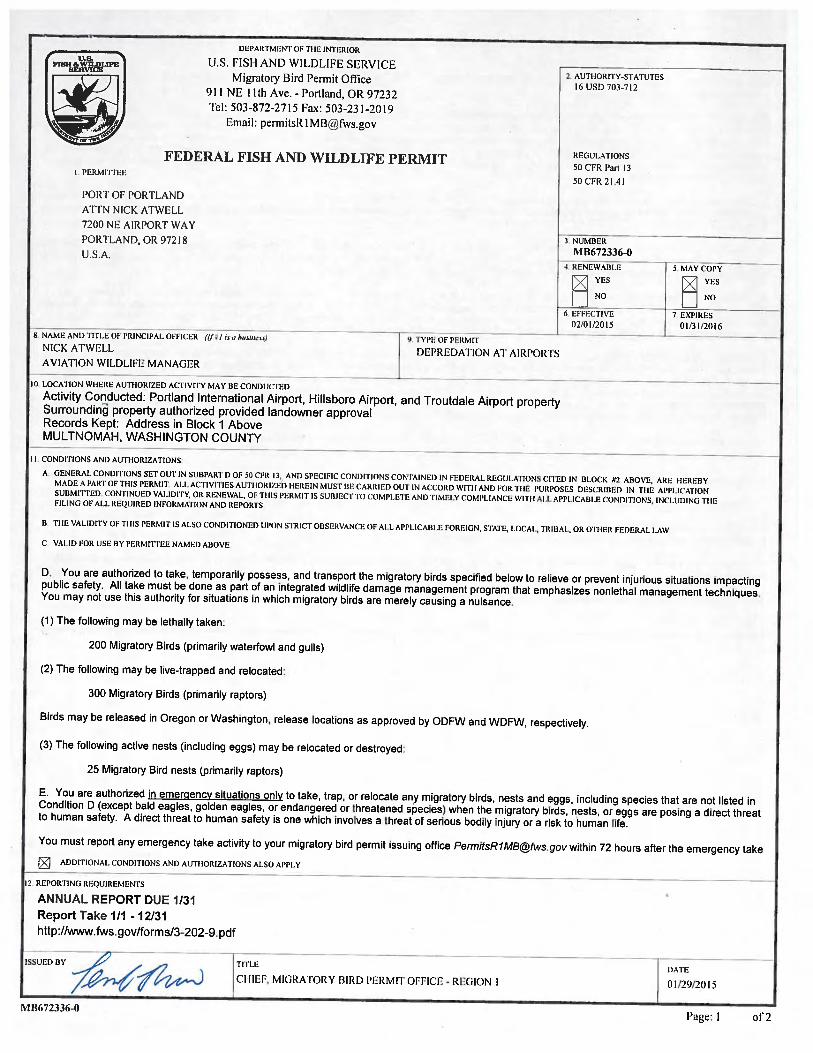
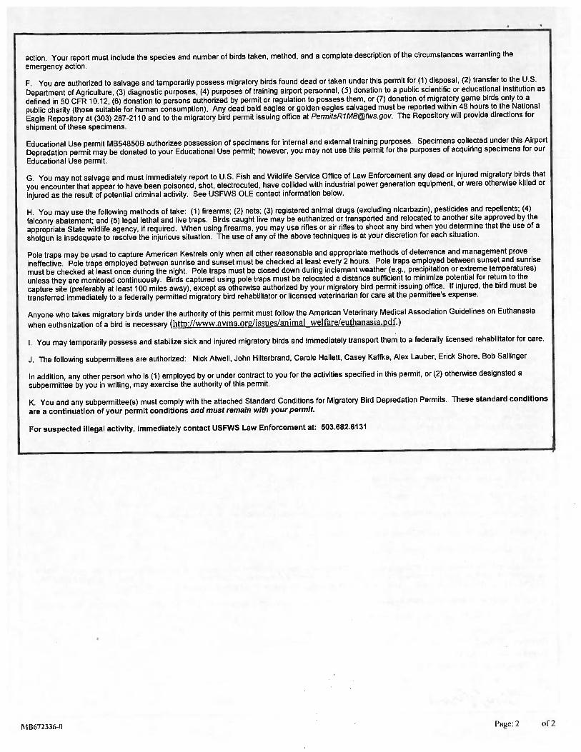
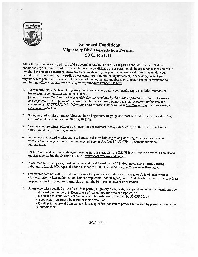
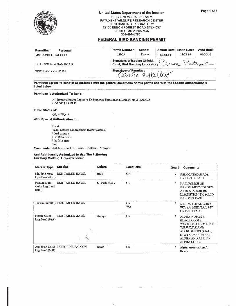
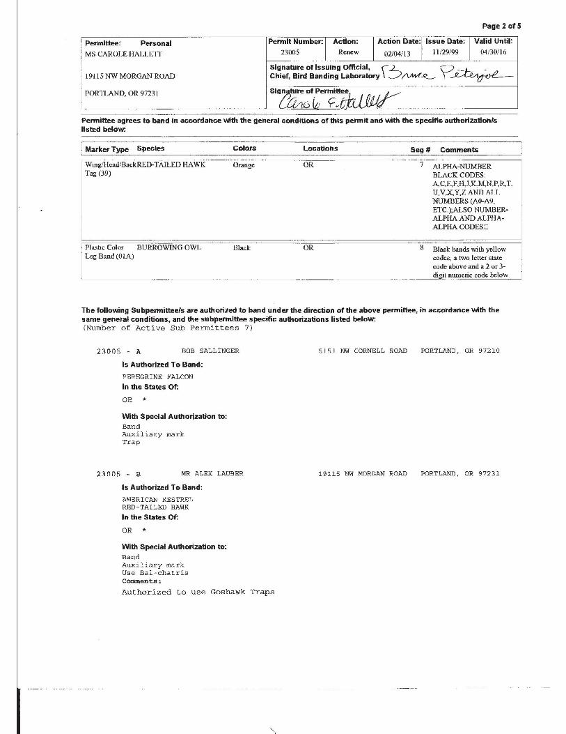
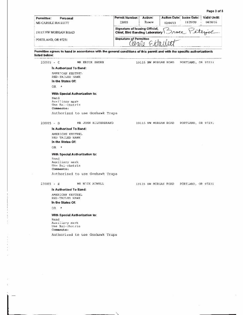
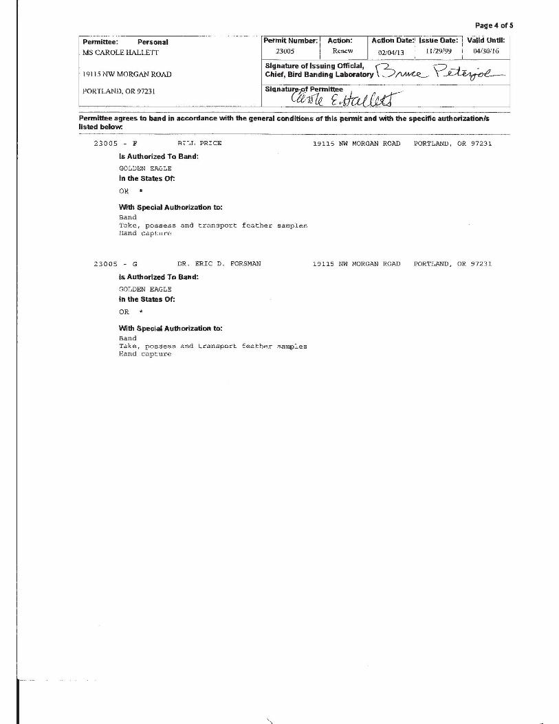
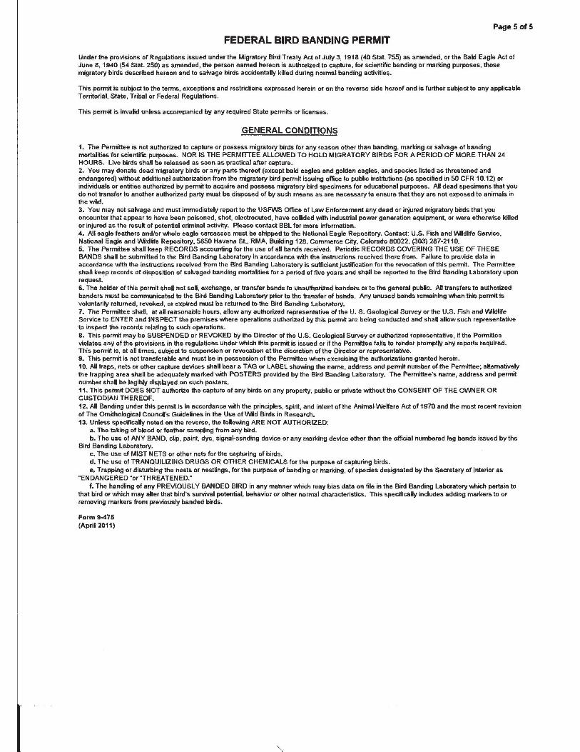

This page intentionally left blank.
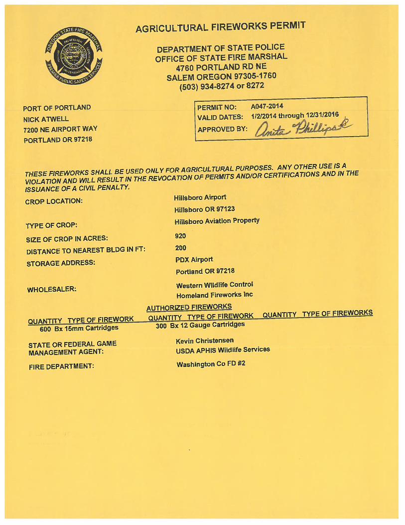

This page intentionally left blank.
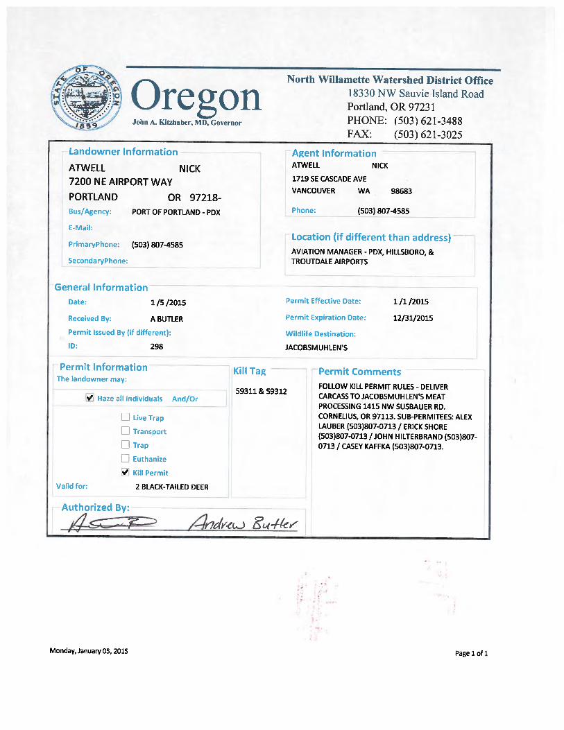
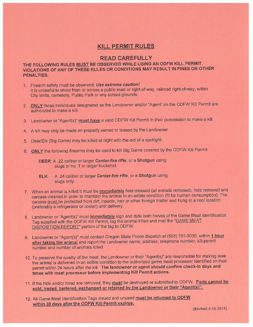
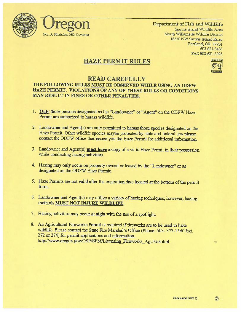


Federal Aviation Administration
Memorandum Date: January 15, 2015
To: All HIO Personnel
From: Scott A. Burk, Acting Air Traffic Manager Hillsboro Tower
Subject: Bird Hazing
As part of their ongoing mission to reduce bird strikes, the Port of Portland uses a number of tools to move birds away from the runways at HIO. These tools include sound cannons, other noise makers, and handheld lasers.
An aeronautical study conducted by the FAA on outdoor laser operations at PDX found no effect on the safe and efficient operation of aircraft. The FAA regulates the use of these lasers, and has found lasers to be an effective tool for hazing birds because of their sensitivity to colored light.
This bulletin is to let you know that the Port uses these lasers on a daily basis at HIO, and plans on continuing their use in the future. In discussion with the Port of Portland wildlife manager he advised the lasers are never higher than ground level. They are only used to move birds on the ground and never on airborne birds. Thus the lasers pose no hazard to pilots on the ground, in the air, nor the tower cab environment.

This page intentionally left blank.

<< Signature on File >>
APPENDIX D HIO Wildlife Attractants Table

This page intentionally left blank.
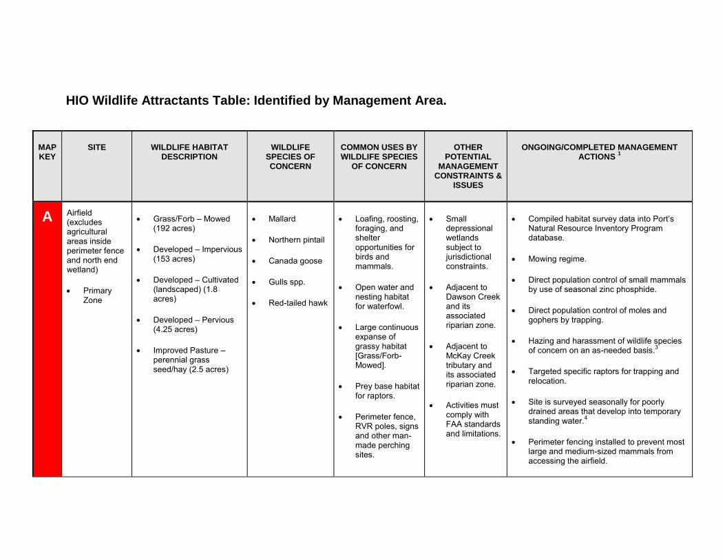
HIO Wildlife Attractants Table: Identified by Management Area.
MAP KEY
SITE WILDLIFE HABITAT DESCRIPTION
WILDLIFE SPECIES OF CONCERN
COMMON USES BY WILDLIFE SPECIES
OF CONCERN
OTHER POTENTIAL
MANAGEMENT CONSTRAINTS &
ISSUES
ONGOING/COMPLETED MANAGEMENT ACTIONS
1
A Airfield (excludes agricultural areas inside perimeter fence and north end wetland)
PrimaryZone
Grass/Forb – Mowed(192 acres)
Developed – Impervious(153 acres)
Developed – Cultivated(landscaped) (1.8acres)
Developed – Pervious(4.25 acres)
Improved Pasture –perennial grassseed/hay (2.5 acres)
Mallard
Northern pintail
Canada goose
Gulls spp.
Red-tailed hawk
Loafing, roosting,foraging, andshelteropportunities forbirds andmammals.
Open water andnesting habitatfor waterfowl.
Large continuousexpanse ofgrassy habitat[Grass/Forb-Mowed].
Prey base habitatfor raptors.
Perimeter fence,RVR poles, signsand other man-made perchingsites.
Smalldepressionalwetlandssubject tojurisdictionalconstraints.
Adjacent toDawson Creekand itsassociatedriparian zone.
Adjacent toMcKay Creektributary andits associatedriparian zone.
Activities mustcomply withFAA standardsand limitations.
Compiled habitat survey data into Port’sNatural Resource Inventory Programdatabase.
Mowing regime.
Direct population control of small mammalsby use of seasonal zinc phosphide.
Direct population control of moles andgophers by trapping.
Hazing and harassment of wildlife speciesof concern on an as-needed basis.3
Targeted specific raptors for trapping andrelocation.
Site is surveyed seasonally for poorlydrained areas that develop into temporarystanding water.4
Perimeter fencing installed to prevent mostlarge and medium-sized mammals fromaccessing the airfield.
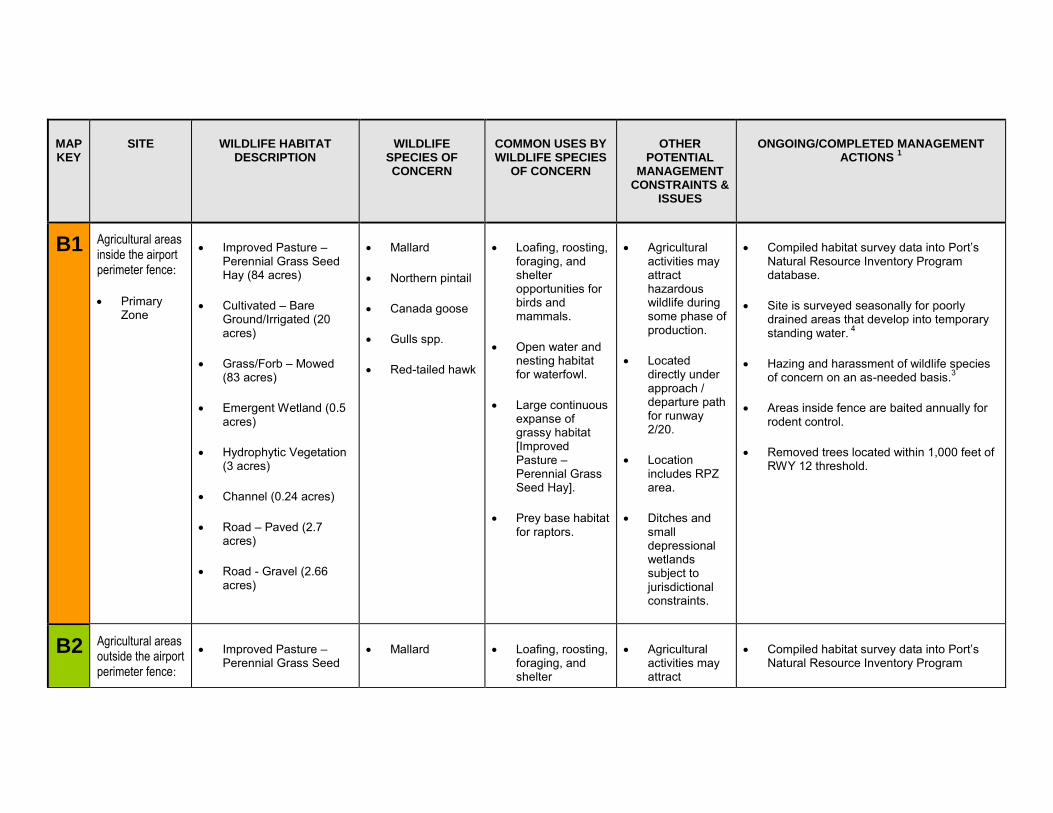
MAP KEY
SITE WILDLIFE HABITAT DESCRIPTION
WILDLIFE SPECIES OF CONCERN
COMMON USES BY WILDLIFE SPECIES
OF CONCERN
OTHER POTENTIAL
MANAGEMENT CONSTRAINTS &
ISSUES
ONGOING/COMPLETED MANAGEMENT ACTIONS
1
B1 Agricultural areas inside the airport perimeter fence:
PrimaryZone
Improved Pasture –Perennial Grass SeedHay (84 acres)
Cultivated – BareGround/Irrigated (20acres)
Grass/Forb – Mowed(83 acres)
Emergent Wetland (0.5acres)
Hydrophytic Vegetation(3 acres)
Channel (0.24 acres)
Road – Paved (2.7acres)
Road - Gravel (2.66acres)
Mallard
Northern pintail
Canada goose
Gulls spp.
Red-tailed hawk
Loafing, roosting,foraging, andshelteropportunities forbirds andmammals.
Open water andnesting habitatfor waterfowl.
Large continuousexpanse ofgrassy habitat[ImprovedPasture –Perennial GrassSeed Hay].
Prey base habitatfor raptors.
Agriculturalactivities mayattracthazardouswildlife duringsome phase ofproduction.
Locateddirectly underapproach /departure pathfor runway2/20.
Locationincludes RPZarea.
Ditches andsmalldepressionalwetlandssubject tojurisdictionalconstraints.
Compiled habitat survey data into Port’sNatural Resource Inventory Programdatabase.
Site is surveyed seasonally for poorlydrained areas that develop into temporarystanding water. 4
Hazing and harassment of wildlife speciesof concern on an as-needed basis.3
Areas inside fence are baited annually forrodent control.
Removed trees located within 1,000 feet ofRWY 12 threshold.
B2 Agricultural areas outside the airport perimeter fence:
Improved Pasture –Perennial Grass Seed
Mallard Loafing, roosting,foraging, andshelter
Agriculturalactivities mayattract
Compiled habitat survey data into Port’sNatural Resource Inventory Program
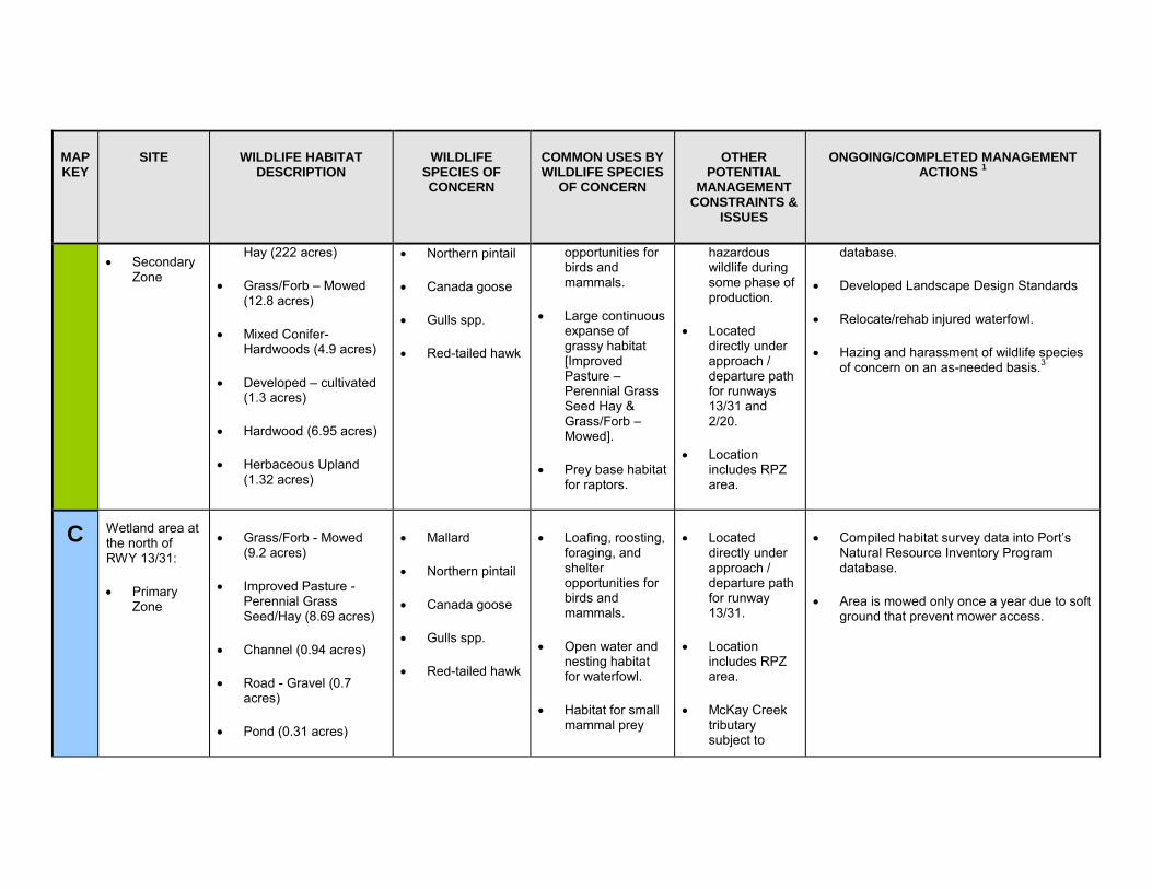
MAP KEY
SITE WILDLIFE HABITAT DESCRIPTION
WILDLIFE SPECIES OF CONCERN
COMMON USES BY WILDLIFE SPECIES
OF CONCERN
OTHER POTENTIAL
MANAGEMENT CONSTRAINTS &
ISSUES
ONGOING/COMPLETED MANAGEMENT ACTIONS
1
SecondaryZone
Hay (222 acres)
Grass/Forb – Mowed(12.8 acres)
Mixed Conifer-Hardwoods (4.9 acres)
Developed – cultivated(1.3 acres)
Hardwood (6.95 acres)
Herbaceous Upland(1.32 acres)
Northern pintail
Canada goose
Gulls spp.
Red-tailed hawk
opportunities for birds and mammals.
Large continuousexpanse ofgrassy habitat[ImprovedPasture –Perennial GrassSeed Hay &Grass/Forb –Mowed].
Prey base habitatfor raptors.
hazardous wildlife during some phase of production.
Locateddirectly underapproach /departure pathfor runways13/31 and2/20.
Locationincludes RPZarea.
database.
Developed Landscape Design Standards
Relocate/rehab injured waterfowl.
Hazing and harassment of wildlife speciesof concern on an as-needed basis.3
C Wetland area at the north of RWY 13/31:
PrimaryZone
Grass/Forb - Mowed(9.2 acres)
Improved Pasture -Perennial GrassSeed/Hay (8.69 acres)
Channel (0.94 acres)
Road - Gravel (0.7acres)
Pond (0.31 acres)
Mallard
Northern pintail
Canada goose
Gulls spp.
Red-tailed hawk
Loafing, roosting,foraging, andshelteropportunities forbirds andmammals.
Open water andnesting habitatfor waterfowl.
Habitat for smallmammal prey
Locateddirectly underapproach /departure pathfor runway13/31.
Locationincludes RPZarea.
McKay Creektributarysubject to
Compiled habitat survey data into Port’sNatural Resource Inventory Programdatabase.
Area is mowed only once a year due to softground that prevent mower access.
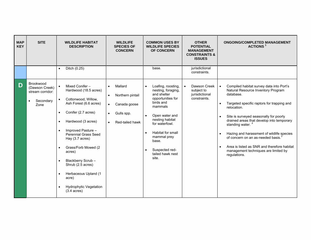
MAP KEY
SITE WILDLIFE HABITAT DESCRIPTION
WILDLIFE SPECIES OF CONCERN
COMMON USES BY WILDLIFE SPECIES
OF CONCERN
OTHER POTENTIAL
MANAGEMENT CONSTRAINTS &
ISSUES
ONGOING/COMPLETED MANAGEMENT ACTIONS
1
Ditch (0.25) base. jurisdictional constraints.
D Brookwood (Dawson Creek) stream corridor:
SecondaryZone
Mixed Conifer –Hardwood (18.5 acres)
Cottonwood, Willow,Ash Forest (6.6 acres)
Conifer (2.7 acres)
Hardwood (3 acres)
Improved Pasture –Perennial Grass SeedHay (3.7 acres)
Grass/Forb Mowed (2acres)
Blackberry Scrub –Shrub (2.5 acres)
Herbaceous Upland (1acre)
Hydrophytic Vegetation(3.4 acres)
Mallard
Northern pintail
Canada goose
Gulls spp.
Red-tailed hawk
Loafing, roosting,nesting, foraging,and shelteropportunities forbirds andmammals
Open water andnesting habitatfor waterfowl.
Habitat for smallmammal preybase.
Suspected red-tailed hawk nestsite.
Dawson Creeksubject tojurisdictionalconstraints.
Compiled habitat survey data into Port’sNatural Resource Inventory Programdatabase.
Targeted specific raptors for trapping andrelocation.
Site is surveyed seasonally for poorlydrained areas that develop into temporarystanding water. 4
Hazing and harassment of wildlife speciesof concern on an as-needed basis.3
Area is listed as SNR and therefore habitatmanagement techniques are limited byregulations.
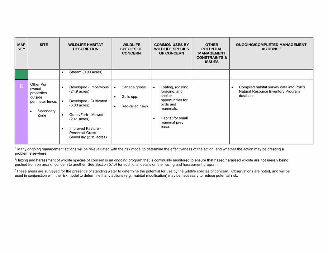
MAP KEY
SITE WILDLIFE HABITAT DESCRIPTION
WILDLIFE SPECIES OF CONCERN
COMMON USES BY WILDLIFE SPECIES
OF CONCERN
OTHER POTENTIAL
MANAGEMENT CONSTRAINTS &
ISSUES
ONGOING/COMPLETED MANAGEMENT ACTIONS
1
Stream (0.93 acres)
E Other Port owned properties outside perimeter fence:
SecondaryZone
Developed - Impervious(24.9 acres)
Developed - Cultivated(6.03 acres)
Grass/Forb - Mowed(2.41 acres)
Improved Pasture -Perennial GrassSeed/Hay (2.19 acres)
Canada goose
Gulls spp.
Red-tailed hawk
Loafing, roosting,foraging, andshelteropportunities forbirds andmammals.
Habitat for smallmammal preybase.
Compiled habitat survey data into Port’sNatural Resource Inventory Programdatabase.
1 Many ongoing management actions will be re-evaluated with the risk model to determine the effectiveness of the action, and whether the action may be creating a problem elsewhere. 3Hazing and harassment of wildlife species of concern is an ongoing program that is continually monitored to ensure that hazed/harassed wildlife are not merely being pushed from on area of concern to another. See Section 5.1.4 for additional details on the hazing and harassment program. 4These areas are surveyed for the presence of standing water to determine the potential for use by the wildlife species of concern. Observations are noted, and will be used in conjunction with the risk model to determine if any actions (e.g., habitat modification) may be necessary to reduce potential risk.

APPENDIX E Wildlife Hazard Management Areas Tracking Table
Color of management areas corresponds with Figure 9.

This page intentionally left blank.
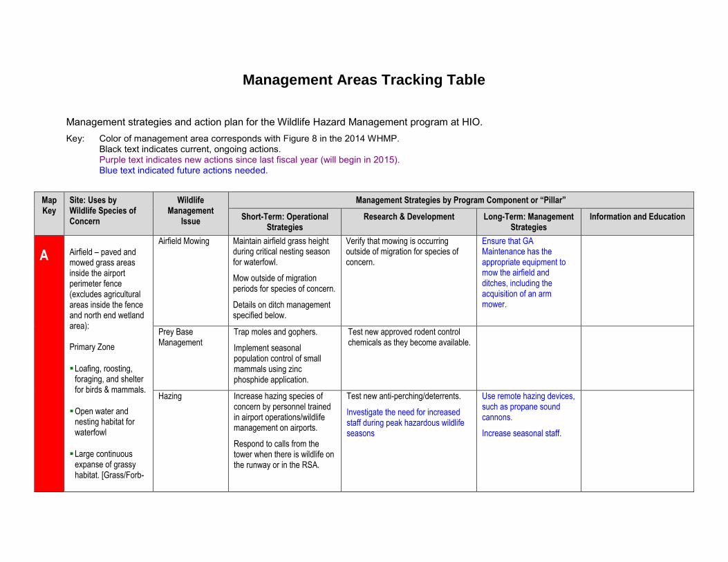
Management Areas Tracking Table
Management strategies and action plan for the Wildlife Hazard Management program at HIO. Key: Color of management area corresponds with Figure 8 in the 2014 WHMP.
Black text indicates current, ongoing actions. Purple text indicates new actions since last fiscal year (will begin in 2015). Blue text indicated future actions needed.
Map Key
Site: Uses by Wildlife Species of Concern
Wildlife Management
Issue
Management Strategies by Program Component or “Pillar”
Short-Term: Operational Strategies
Research & Development Long-Term: Management Strategies
Information and Education
A Airfield – paved and mowed grass areas inside the airport perimeter fence (excludes agricultural areas inside the fence and north end wetland area):
Primary Zone
Loafing, roosting,foraging, and shelterfor birds & mammals.
Open water andnesting habitat forwaterfowl
Large continuousexpanse of grassyhabitat. [Grass/Forb-
Airfield Mowing Maintain airfield grass height during critical nesting season for waterfowl.
Mow outside of migration periods for species of concern.
Details on ditch management specified below.
Verify that mowing is occurring outside of migration for species of concern.
Ensure that GA Maintenance has the appropriate equipment to mow the airfield and ditches, including the acquisition of an arm mower.
Prey Base Management
Trap moles and gophers.
Implement seasonal population control of small mammals using zinc phosphide application.
Test new approved rodent control chemicals as they become available.
Hazing Increase hazing species of concern by personnel trained in airport operations/wildlife management on airports.
Respond to calls from the tower when there is wildlife on the runway or in the RSA.
Test new anti-perching/deterrents.
Investigate the need for increased staff during peak hazardous wildlife seasons
Use remote hazing devices, such as propane sound cannons.
Increase seasonal staff.
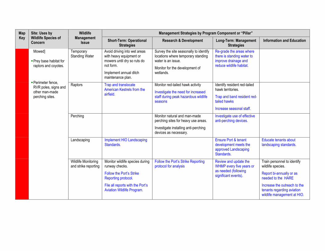
Map Key
Site: Uses by Wildlife Species of Concern
Wildlife Management
Issue
Management Strategies by Program Component or “Pillar”
Short-Term: Operational Strategies
Research & Development Long-Term: Management Strategies
Information and Education
Mowed]
Prey base habitat forraptors and coyotes.
Perimeter fence,RVR poles, signs andother man-madeperching sites.
Temporary Standing Water
Avoid driving into wet areas with heavy equipment or mowers until dry so ruts do not form.
Implement annual ditch maintenance plan.
Survey the site seasonally to identify locations where temporary standing water is an issue.
Monitor for the development of wetlands.
Re-grade the areas where there is standing water to improve drainage and reduce wildlife habitat.
Raptors Trap and translocate American Kestrels from the airfield.
Monitor red-tailed hawk activity
Investigate the need for increased staff during peak hazardous wildlife seasons
Identify resident red-tailed hawk territories.
Trap and band resident red-tailed hawks
Increase seasonal staff.
Perching Monitor natural and man-made perching sites for heavy use areas.
Investigate installing anti-perching devices as necessary.
Investigate use of effective anti-perching devices.
Landscaping Implement HIO Landscaping Standards.
Ensure Port & tenant development meets the approved Landscaping Standards.
Educate tenants about landscaping standards.
Wildlife Monitoring and strike reporting
Monitor wildlife species during runway checks.
Follow the Port’s Strike Reporting protocol.
File all reports with the Port’s Aviation Wildlife Program.
Follow the Port’s Strike Reporting protocol for analysis
Review and update the WHMP every five years or as needed (following significant events).
Train personnel to identify wildlife species.
Report bi-annually or as needed to the HARE
Increase the outreach to the tenants regarding aviation wildlife management at HIO.
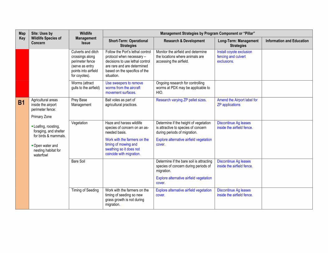
Map Key
Site: Uses by Wildlife Species of Concern
Wildlife Management
Issue
Management Strategies by Program Component or “Pillar”
Short-Term: Operational Strategies
Research & Development Long-Term: Management Strategies
Information and Education
Culverts and ditch crossings along perimeter fence (serve as entry points into airfield for coyotes).
Follow the Port’s lethal control protocol when necessary – decisions to use lethal control are rare and are determined based on the specifics of the situation.
Monitor the airfield and determine the locations where animals are accessing the airfield.
Install coyote exclusion fencing and culvert exclusions.
Worms (attract gulls to the airfield)
Use sweepers to remove worms from the aircraft movement surfaces.
Ongoing research for controlling worms at PDX may be applicable to HIO.
B1 Agricultural areas inside the airport perimeter fence:
Primary Zone
Loafing, roosting,foraging, and shelterfor birds & mammals.
Open water andnesting habitat forwaterfowl
Prey Base Management
Bait voles as part of agricultural practices.
Research varying ZP pellet sizes. Amend the Airport label for ZP applications
Vegetation Haze and harass wildlife species of concern on an as-needed basis.
Work with the farmers on the timing of mowing and swathing so it does not coincide with migration.
Determine if the height of vegetation is attractive to species of concern during periods of migration.
Explore alternative airfield vegetation cover.
Discontinue Ag leases inside the airfield fence.
Bare Soil Determine if the bare soil is attracting species of concern during periods of migration.
Explore alternative airfield vegetation cover.
Discontinue Ag leases inside the airfield fence.
Timing of Seeding Work with the farmers on the timing of seeding so new grass growth is not during migration.
Explore alternative airfield vegetation cover.
Discontinue Ag leases inside the airfield fence.
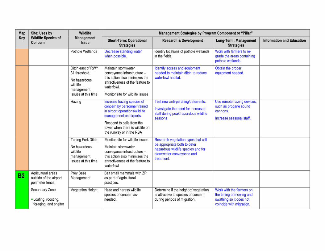
Map Key
Site: Uses by Wildlife Species of Concern
Wildlife Management
Issue
Management Strategies by Program Component or “Pillar”
Short-Term: Operational Strategies
Research & Development Long-Term: Management Strategies
Information and Education
Pothole Wetlands Decrease standing water when possible.
Identify locations of pothole wetlands in the fields.
Work with farmers to re-grade the areas containing pothole wetlands.
Ditch east of RWY 31 threshold.
No hazardous wildlife management issues at this time
Maintain stormwater conveyance infrastructure – this action also minimizes the attractiveness of the feature to waterfowl.
Monitor site for wildlife issues
Identify access and equipment needed to maintain ditch to reduce waterfowl habitat.
Obtain the proper equipment needed.
Hazing Increase hazing species of concern by personnel trained in airport operations/wildlife management on airports.
Respond to calls from the tower when there is wildlife on the runway or in the RSA
Test new anti-perching/deterrents.
Investigate the need for increased staff during peak hazardous wildlife seasons
Use remote hazing devices, such as propane sound cannons.
Increase seasonal staff.
Tuning Fork Ditch
No hazardous wildlife management issues at this time
Monitor site for wildlife issues
Maintain stormwater conveyance infrastructure – this action also minimizes the attractiveness of the feature to waterfowl
Research vegetation types that will be appropriate both to deter hazardous wildlife species and for stormwater conveyance and treatment.
B2 Agricultural areas outside of the airport perimeter fence:
Secondary Zone
Loafing, roosting,foraging, and shelter
Prey Base Management
Bait small mammals with ZP as part of agricultural practices.
Vegetation Height Haze and harass wildlife species of concern as-needed.
Determine if the height of vegetation is attractive to species of concern during periods of migration.
Work with the farmers on the timing of mowing and swathing so it does not coincide with migration.
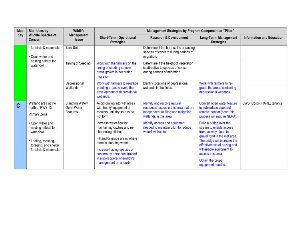
Map Key
Site: Uses by Wildlife Species of Concern
Wildlife Management
Issue
Management Strategies by Program Component or “Pillar”
Short-Term: Operational Strategies
Research & Development Long-Term: Management Strategies
Information and Education
for birds & mammals.
Open water andnesting habitat forwaterfowl
Bare Soil Determine if the bare soil is attracting species of concern during periods of migration.
Timing of Seeding Work with the farmers on the timing of seeding so new grass growth is not during migration.
Determine if the height of vegetation is attractive to species of concern during periods of migration.
Depressional Wetlands
Work with farmers to re-grade ponding areas to avoid the development of depressional wetlands.
Identify locations of depressional wetlands in the fields.
Work with farmers to re-grade the areas containing depressional wetlands.
C Wetland area at the north of RWY 13:
Primary Zone
Open water andnesting habitat forwaterfowl
Loafing, roosting,foraging, and shelterfor birds & mammals.
Standing Water/ Open Water Features
Avoid driving into wet areas with heavy equipment or mowers until dry so ruts do not form.
Increase water flow by maintaining ditches and re-channeling ditches.
Fill and/or grade areas where there is standing water.
Increase hazing species of concern by personnel trained in airport operations/wildlife management on airports.
Identify and resolve natural resources issues in this area that are independent to filing and mitigating wetlands in this area.
Identify access and equipment needed to maintain ditch to reduce waterfowl habitat.
Convert open water feature to subsurface pipe and remove habitat (note: this process will require NEPA).
Build a bridge over the stream to enable access from taxiway alpha to gravel road in the wet area. The bridge will increase the effectiveness of hazing and will enable equipment to access this area.
Obtain the proper equipment needed.
CWS, Corps, HARE, tenants
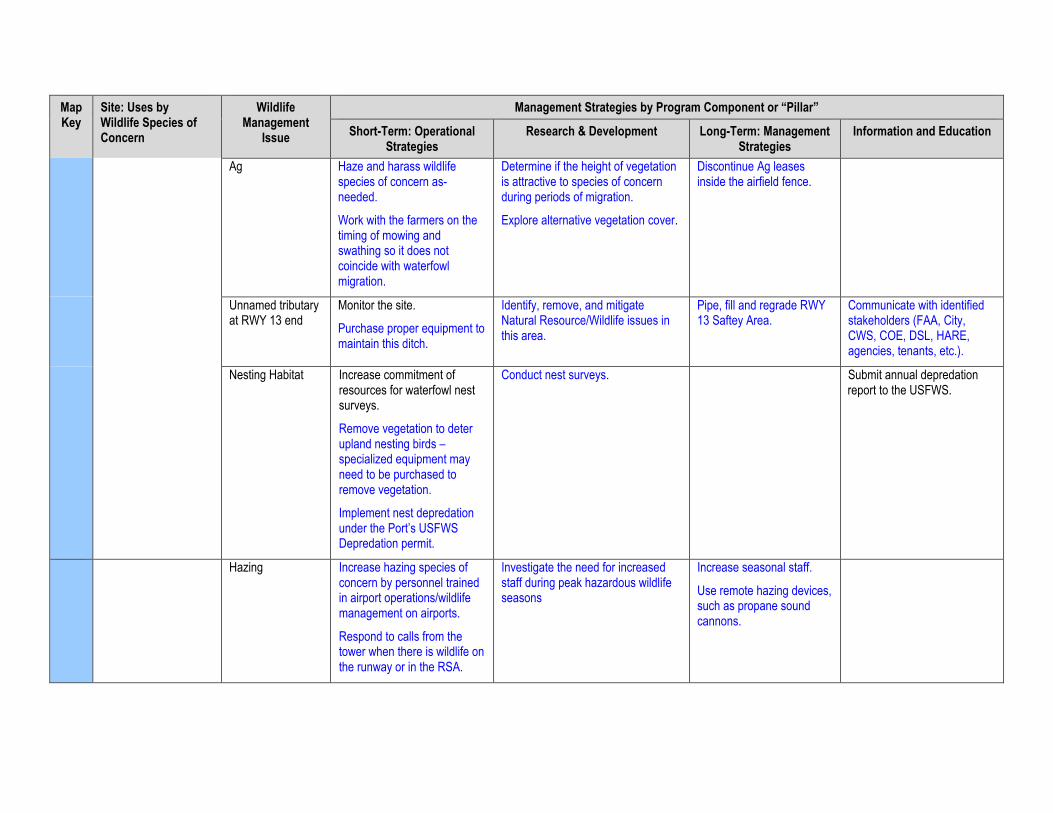
Map Key
Site: Uses by Wildlife Species of Concern
Wildlife Management
Issue
Management Strategies by Program Component or “Pillar”
Short-Term: Operational Strategies
Research & Development Long-Term: Management Strategies
Information and Education
Ag Haze and harass wildlife species of concern as-needed.
Work with the farmers on the timing of mowing and swathing so it does not coincide with waterfowl migration.
Determine if the height of vegetation is attractive to species of concern during periods of migration.
Explore alternative vegetation cover.
Discontinue Ag leases inside the airfield fence.
Unnamed tributary at RWY 13 end
Monitor the site.
Purchase proper equipment to maintain this ditch.
Identify, remove, and mitigate Natural Resource/Wildlife issues in this area.
Pipe, fill and regrade RWY 13 Saftey Area.
Communicate with identified stakeholders (FAA, City, CWS, COE, DSL, HARE, agencies, tenants, etc.).
Nesting Habitat Increase commitment of resources for waterfowl nest surveys.
Remove vegetation to deter upland nesting birds – specialized equipment may need to be purchased to remove vegetation.
Implement nest depredation under the Port’s USFWS Depredation permit.
Conduct nest surveys. Submit annual depredation report to the USFWS.
Hazing Increase hazing species of concern by personnel trained in airport operations/wildlife management on airports.
Respond to calls from the tower when there is wildlife on the runway or in the RSA.
Investigate the need for increased staff during peak hazardous wildlife seasons
Increase seasonal staff.
Use remote hazing devices, such as propane sound cannons.
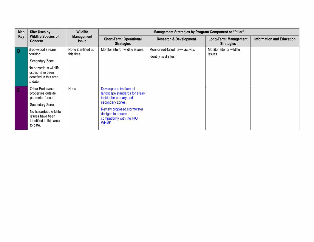
Map Key
Site: Uses by Wildlife Species of Concern
Wildlife Management
Issue
Management Strategies by Program Component or “Pillar”
Short-Term: Operational Strategies
Research & Development Long-Term: Management Strategies
Information and Education
D Brookwood stream corridor:
Secondary Zone
No hazardous wildlife issues have been identified in this area to date.
None identified at this time.
Monitor site for wildlife issues. Monitor red-tailed hawk activity.
Identify nest sites.
Monitor site for wildlife issues.
E Other Port owned properties outside perimeter fence:
Secondary Zone
No hazardous wildlife issues have been identified in this area to date.
None Develop and implement landscape standards for areas inside the primary and secondary zones.
Review proposed stormwater designs to ensure compatibility with the HIO WHMP

This page intentionally left blank.
APPENDIX F List of Plants Approved for Landscaping at HIO

This page intentionally left blank.
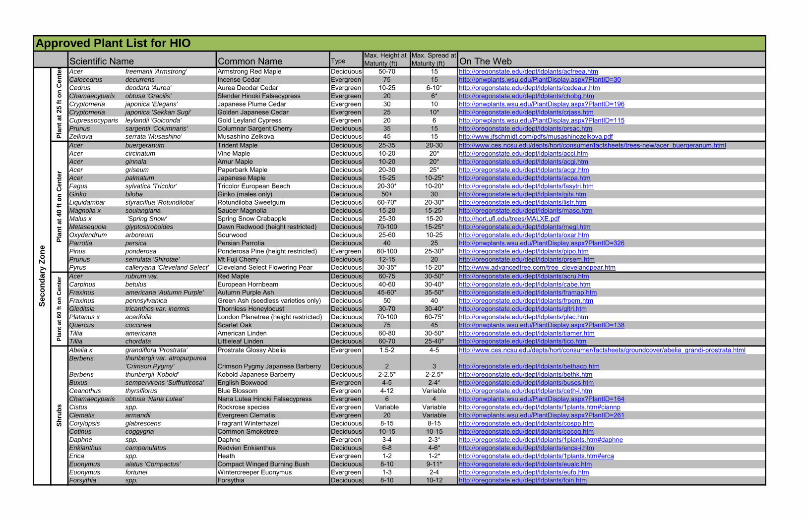
Common Name TypeMax. Height at Maturity (ft)
Max. Spread at Maturity (ft) On The Web
Acer freemanii 'Armstrong' Armstrong Red Maple Deciduous 50-70 15 http://oregonstate.edu/dept/ldplants/acfreea.htmCalocedrus decurrens Incense Cedar Evergreen 75 15 http://pnwplants.wsu.edu/PlantDisplay.aspx?PlantID=30Cedrus deodara 'Aurea' Aurea Deodar Cedar Evergreen 10-25 6-10* http://oregonstate.edu/dept/ldplants/cedeaur.htmChamaecyparis obtusa 'Gracilis' Slender Hinoki Falsecypress Evergreen 20 6* http://oregonstate.edu/dept/ldplants/chobg.htmCryptomeria japonica 'Elegans' Japanese Plume Cedar Evergreen 30 10 http://pnwplants.wsu.edu/PlantDisplay.aspx?PlantID=196Cryptomeria japonica 'Sekkan Sugi' Golden Japanese Cedar Evergreen 25 10* http://oregonstate.edu/dept/ldplants/crjass.htmCupressocyparis leylandii 'Golconda' Gold Leyland Cypress Evergreen 20 6 http://pnwplants.wsu.edu/PlantDisplay.aspx?PlantID=115Prunus sargentii 'Columnaris' Columnar Sargent Cherry Deciduous 35 15 http://oregonstate.edu/dept/ldplants/prsac.htmZelkova serrata 'Musashino' Musashino Zelkova Deciduous 45 15 http://www.jfschmidt.com/pdfs/musashinozelkova.pdfAcer buergeranum Trident Maple Deciduous 25-35 20-30 http://www.ces.ncsu.edu/depts/hort/consumer/factsheets/trees-new/acer_buergeranum.htmlAcer circinatum Vine Maple Deciduous 10-20 20* http://oregonstate.edu/dept/ldplants/acci.htmAcer ginnala Amur Maple Deciduous 10-20 20* http://oregonstate.edu/dept/ldplants/acgi.htmAcer griseum Paperbark Maple Deciduous 20-30 25* http://oregonstate.edu/dept/ldplants/acgr.htmAcer palmatum Japanese Maple Deciduous 15-25 10-25* http://oregonstate.edu/dept/ldplants/acpa.htmFagus sylvatica 'Tricolor' Tricolor European Beech Deciduous 20-30* 10-20* http://oregonstate.edu/dept/ldplants/fasytri.htmGinko biloba Ginko (males only) Deciduous 50+ 30 http://oregonstate.edu/dept/ldplants/gibi.htmLiquidambar styraciflua 'Rotundiloba' Rotundiloba Sweetgum Deciduous 60-70* 20-30* http://oregonstate.edu/dept/ldplants/listr.htmMagnolia x soulangiana Saucer Magnolia Deciduous 15-20 15-25* http://oregonstate.edu/dept/ldplants/maso.htmMalus x 'Spring Snow' Spring Snow Crabapple Deciduous 25-30 15-20 http://hort.ufl.edu/trees/MALXE.pdfMetasequoia glyptostroboides Dawn Redwood (height restricted) Deciduous 70-100 15-25* http://oregonstate.edu/dept/ldplants/megl.htmOxydendrum arboreum Sourwood Deciduous 25-60 10-25 http://oregonstate.edu/dept/ldplants/oxar.htmParrotia persica Persian Parrotia Deciduous 40 25 http://pnwplants.wsu.edu/PlantDisplay.aspx?PlantID=326Pinus ponderosa Ponderosa Pine (height restricted) Evergreen 60-100 25-30* http://oregonstate.edu/dept/ldplants/pipo.htmPrunus serrulata 'Shirotae' Mt Fuji Cherry Deciduous 12-15 20 http://oregonstate.edu/dept/ldplants/prsem.htmPyrus calleryana 'Cleveland Select' Cleveland Select Flowering Pear Deciduous 30-35* 15-20* http://www.advancedtree.com/tree_clevelandpear.htmAcer rubrum var. Red Maple Deciduous 60-75 30-50* http://oregonstate.edu/dept/ldplants/acru.htmCarpinus betulus European Hornbeam Deciduous 40-60 30-40* http://oregonstate.edu/dept/ldplants/cabe.htmFraxinus americana 'Autumn Purple' Autumn Purple Ash Deciduous 45-60* 35-50* http://oregonstate.edu/dept/ldplants/framap.htmFraxinus pennsylvanica Green Ash (seedless varieties only) Deciduous 50 40 http://oregonstate.edu/dept/ldplants/frpem.htmGleditsia tricanthos var. inermis Thornless Honeylocust Deciduous 30-70 30-40* http://oregonstate.edu/dept/ldplants/gltri.htmPlatanus x acerifolia London Planetree (height restricted) Deciduous 70-100 60-75* http://oregonstate.edu/dept/ldplants/plac.htmQuercus coccinea Scarlet Oak Deciduous 75 45 http://pnwplants.wsu.edu/PlantDisplay.aspx?PlantID=138Tillia americana American Linden Deciduous 60-80 30-50* http://oregonstate.edu/dept/ldplants/tiamer.htmTillia chordata Littleleaf Linden Deciduous 60-70 25-40* http://oregonstate.edu/dept/ldplants/tico.htmAbelia x grandiflora 'Prostrata' Prostrate Glossy Abelia Evergreen 1.5-2 4-5 http://www.ces.ncsu.edu/depts/hort/consumer/factsheets/groundcover/abelia_grandi-prostrata.htmlBerberis thunbergii var. atropurpurea
'Crimson Pygmy' Crimson Pygmy Japanese Barberry Deciduous 2 3 http://oregonstate.edu/dept/ldplants/bethacp.htmBerberis thunbergii 'Kobold' Kobold Japanese Barberry Deciduous 2-2.5* 2-2.5* http://oregonstate.edu/dept/ldplants/bethk.htmBuxus sempervirens 'Suffruticosa' English Boxwood Evergreen 4-5 2-4* http://oregonstate.edu/dept/ldplants/buses.htmCeanothus thyrsiflorus Blue Blossom Evergreen 4-12 Variable http://oregonstate.edu/dept/ldplants/ceth-i.htmChamaecyparis obtusa 'Nana Lutea' Nana Lutea Hinoki Falsecypress Evergreen 6 4 http://pnwplants.wsu.edu/PlantDisplay.aspx?PlantID=164Cistus spp. Rockrose species Evergreen Variable Variable http://oregonstate.edu/dept/ldplants/1plants.htm#ciannpClematis armandii Evergreen Clematis Evergreen 20 Variable http://pnwplants.wsu.edu/PlantDisplay.aspx?PlantID=261Corylopsis glabrescens Fragrant Winterhazel Deciduous 8-15 8-15 http://oregonstate.edu/dept/ldplants/cospp.htmCotinus coggygria Common Smoketree Deciduous 10-15 10-15 http://oregonstate.edu/dept/ldplants/cocog.htmDaphne spp. Daphne Evergreen 3-4 2-3* http://oregonstate.edu/dept/ldplants/1plants.htm#daphneEnkianthus campanulatus Redvien Enkianthus Deciduous 6-8 4-6* http://oregonstate.edu/dept/ldplants/enca-i.htmErica spp. Heath Evergreen 1-2 1-2* http://oregonstate.edu/dept/ldplants/1plants.htm#ercaEuonymus alatus 'Compactus' Compact Winged Burning Bush Deciduous 8-10 9-11* http://oregonstate.edu/dept/ldplants/eualc.htmEuonymus fortunei Wintercreeper Euonymus Evergreen 1-3 2-4 http://oregonstate.edu/dept/ldplants/eufo.htmForsythia spp. Forsythia Deciduous 8-10 10-12 http://oregonstate.edu/dept/ldplants/foin.htm
Approved Plant List for HIO
Scientific NameP
lan
t a
t 6
0 f
t o
n C
en
ter
Pla
nt
at
25 f
t o
n C
en
ter
Pla
nt
at
40 f
t o
n C
en
ter
Se
co
nd
ary
Zo
ne
Sh
rub
s
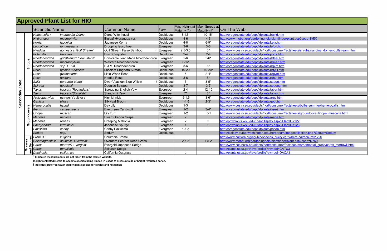
Common Name TypeMax. Height at Maturity (ft)
Max. Spread at Maturity (ft) On The Web
Approved Plant List for HIO
Scientific NameP
lan
t at
25 f
t o
n C
en
ter
Se
co
nd
ary
Zo
ne
Hamamelis x intermedia 'Diane' Diane Witchhazel Deciduous 8-12* 10-15* http://oregonstate.edu/dept/ldplants/haind.htmHydrangea macrophylla Bigleaf Hydrangea var. Deciduous 4-6 4-6 http://www.mobot.org/gardeninghelp/plantfinder/plant.asp?code=K550Kerria japonica Japanese Kerria Deciduous 4-8 6-9* http://oregonstate.edu/dept/ldplants/keja.htmLeucothoe fontanesiana Drooping leucothoe Evergreen 3-6 3-6 http://oregonstate.edu/dept/ldplants/lefo-i.htmNandina domestica 'Gulf Stream' Gulf Stream False Bamboo Ɨ Evergreen 2.5-3.5 3* http://www.ces.ncsu.edu/depts/hort/consumer/factsheets/shrubs/nandina_domes-gulfstream.htmlPotentilla fruitcosa Bush Cinquefoil Deciduous 2-4 2-4 http://oregonstate.edu/dept/ldplants/pofr-i.htmRhododendron griffithianum 'Jean Marie' Honorable Jean Marie Rhododendron Evergreen 5-6 5-6* http://oregonstate.edu/dept/ldplants/rhthei.htmRhododendron macrophyllum Western Rhododendron Evergreen 6-12 http://oregonstate.edu/dept/ldplants/rhmac.htmRhododendron spp. P.J.M. P.J.M. Rhododendron Evergreen 3-6 6* http://oregonstate.edu/dept/ldplants/rhpjm.htmRhus typhina 'Laciniata' Laceleaf Staghorn Sumac Deciduous 10-20 10-20* http://oregonstate.edu/dept/ldplants/rhtyl-i.htmRosa gymnocarpa Little Wood Rose Deciduous 6 2-4* http://oregonstate.edu/dept/ldplants/rogym.htmRosa nutkana Nootka Rose Deciduous 3-6 6* http://oregonstate.edu/dept/ldplants/ronut.htmSalix purpurea 'Nana' Dwarf Alaskan Blue Willow Ɨ Deciduous 5 3-5* http://oregonstate.edu/dept/ldplants/sapun.htmSpiraea douglasii Douglas Spiraea Deciduous 3-7 3-7 http://oregonstate.edu/dept/ldplants/spdoug.htmTaxus baccata 'Repandens' Spreading English Yew Evergreen 2-4 12-15 http://oregonstate.edu/dept/ldplants/tabar.htmTaxus baccata 'Standishii' Standishii Yew Evergreen 7* 3* http://oregonstate.edu/dept/ldplants/tabas.htmArctostaphylos uva-ursi ( cultivars) Kinnikinnick Evergreen .5-1.5 3-6* http://oregonstate.edu/dept/ldplants/aruv.htmGenista pilosa Silkyleaf Broom Deciduous 1-1.5 2-3* http://oregonstate.edu/dept/ldplants/gepi.htmHemerocallis hybrid Day Lily Deciduous 1-3 http://www.ces.ncsu.edu/depts/hort/consumer/factsheets/bulbs-summer/hemerocallis.htmlIberis sempervirens Evergreen Candytuft Evergreen 1-2 3-4* http://oregonstate.edu/dept/ldplants/ibse-i.htmLiriope muscari Lily Turf Evergreen 1-2 .5-1 http://www.ces.ncsu.edu/depts/hort/consumer/factsheets/groundcover/liriope_muscaria.htmlMahonia nervosa Dwarf Oregon Grape Evergreen 2 http://oregonstate.edu/dept/ldplants/mane.htmMahonia repens Creeping Mahonia Evergreen 2 3 http://pnwplants.wsu.edu/PlantDisplay.aspx?PlantID=122Pachysandra terminalis Japanese Spurge Evergreen 1 2 http://pnwplants.wsu.edu/PlantDisplay.aspx?PlantID=128Paxistima canbyi Canby Paxistima Evergreen 1-1.5 http://oregonstate.edu/dept/ldplants/pacan.htmSedum spp. Sedum Deciduous http://biology.burke.washington.edu/herbarium/imagecollection.php?Genus=SedumBromus vulgaris Columbia Brome http://www.calflora.org/cgi-bin/species_query.cgi?where-calrecnum=1220Calamagrostis x acutifolia 'Overdam' Overdam Feather Reed Grass 2.5-3 1.5-2 http://www.mobot.org/gardeninghelp/plantfinder/plant.asp?code=N750Carex morrowii 'Evergold' Evergold Japanese Sedge http://www.ces.ncsu.edu/depts/hort/consumer/factsheets/ornamental_grass/carex_morrowii.htmlCarex tumulicola Splitawn Sedge http://plants.usda.gov/java/profile?symbol=CATU3Danthonia californica California Oatgrass 2 http://plants.usda.gov/java/profile?symbol=DACA3* Indicates measurements are not taken from the related website.
(height restricted) refers to specific species being limited in usage to areas outside of height restricted zones.
Ɨ Indicates preferred water quality plant species for swales and mitigation
Sh
rub
s
Se
co
nd
ay
Zo
ne
Gra
sses
an
d S
ed
ges
Gro
un
dco
vers
APPENDIX G HIO Plant Variance Form

This page intentionally left blank.
Last updated November 2014
HIO Plant List Variance Request Form
Instructions for Submittal
In project specific situations a variance may be granted to supplement the List of Approved Plants found in the Hillsboro Airport (HIO) Wildlife Hazard Management Plan (WHMP) Landscaping Standards. Due to the excess amount of time and effort involved with receiving a variance, it is strongly recommended that contractors use only plants from the Approved Plants List for landscaping within the Primary and Secondary Zones at HIO. The species on these lists have been selected to meet criteria for maintenance, wildlife, and security issues. However, if a contractor wishes to use plant material that is not included in the list, they can obtain approval through the following process:
Instructions for Consultants:
1. Fill out the top portion of one “Plant List Variance Form – Signature Form” and completed“Plant Information Form” for each plant being requested.
2. Forward these forms to the Port Project Manager via email. The Port Project Manager willdisseminate the information to each member of the Port Landscaping Committee for theirreview.
3. When all of the members of the Port of Portland Landscaping Committee have reviewed theplant material, you will be notified within 10 business days that the plant will beaccepted/rejected for addition to the list for the specific project requested.
Instructions for Committee:
1. Please review the completed Plant Information Form for each plant being requested. Basedon your individual area of expertise, please accept or reject each plant. Comments are onlynecessary for rejections.
2. Forward your signed response to the Aviation Wildlife Manager within 10 business days ofreceipt of the forms.
3. Reponses from any member of the committee that are not received by the Aviation WildlifeManager within 10 business days will be assumed to be an acceptance of plant material.
Last updated November 2014
HIO Plant List Variance Form
Signature Form
Date:
Consultant Name:
Project Name:
Project Location (including zone designation):
Plant Name (botanical and common):
WILDLIFE MANAGER DATE APPROVE REJECT COMMENTS
1. Nick Atwell (Alt: John Hilterbrand)
HIO MAINTENANCE DATE APPROVE REJECT COMMENTS
2. TBD (Alt: ?)
CITY OF PORTLAND (REVIEW ONLY)
DATE APPROVE REJECT COMMENTS
3. City Representative (Alt: ?)
N/A N/A
Last updated November 2014
HIO Plant List Variance Form
Contact Information
NAME GROUP/ ORGANIZATION
ADDRESS PHONE FAX
Nick Atwell Aviation Wildlife Manager Port of Portland Aviation Wildlife Dept 7200 NE Airport Way Portland, OR 97218
503-460-4179 503-548-5888
John Hilterbrand (Nick’s Alternate)
Aviation Wildlife Technician
Port of Portland Aviation Nat Res Dept 7200 NE Airport Way Portland, OR 97218
503-460-4680
Airport Landscaping Lead Port of Portland Aviation Maint Dept 7111 NE Alderwood Portland, OR 97218
503-460-4097 503-460-4110
Last updated November 2014
PPllaanntt LLiisstt VVaarriiaannccee FFoorrmm
PPaaggee 44 –– PPllaanntt IInnffoorrmmaattiioonn FFoorrmm
Botanical Name: Common Name:
Native Origin of Plant:
Circle One: Deciduous Tree Evergreen Tree Annual Ground Cover Deciduous Shrub Evergreen Shrub Perennial Ground Cover
Height and Spread at Maturity:
Describe Branching Pattern (i.e. horizontal, vertical):
Describe Crown Shape (i.e. columnar, round):
Wildlife Attractant Characteristics: Flowering? If yes, what time of year and for how long?
Fruit, Berries, or Nuts? If yes, what time of year and for how long?
What type of wildlife and insects does the research indicate that this
plant may attract?
If this plant is found on a City of Portland Plant list or Plant Materials and Suggested Plant lists please indicate the appropriate list:
Native Nuisance Prohibited Suggested
Please provide photographs of the plant for each phase (with and without leaves, flowers, fruit, etc.)
Cite the sources you used to obtain this information (Note: Must be an agricultural extension or University web site. No gardening or horticultural websites, please.):
Describe circumstances prohibiting use of PDX Approved Plant List species:
APPENDIX H Wildlife Deterrent Fence

This page intentionally left blank.