historic environment background paper - reading...historic environment background paper reading...
TRANSCRIPT
1
Historic Environment Background Paper
Reading Borough Council Submission Local Plan
March 2018
2
Contents
1.0 INTRODUCTION …3 2.0 POLICY, GUIDANCE AND ADVICE …4
2.1 What is conservation and enhancement? What is its relationship to planning? …4
2.2 National legislation, policy and guidance …4 2.3 Local policies and strategies …6
3.0 RESULTS OF PREVIOUS CONSULTATIONS …11 4.0 CURRENT CHARACTERISTICS AND FUTURE TRENDS …12 5.0 POLICY ISSUES AND ANALYSIS …18
5.1 Recommended policies …19 5.2 Potential alternative policy approaches …22
6.0 RECOMMENDED APPROACH …25 7.0 REFERENCES …26
Appendix 1: Listed Buildings (Grade I and II*) …27 Appendix 2: Map of Historic Settlement Patterns …28 Appendix 3: Draft Heritage Strategy …29 Appendix 4: Historic Views Analysis …57
3
1.0 INTRODUCTION 1.1.1 This paper provides background evidence and justification for Reading Borough
Council’s commitment towards the protection and enhancement of the historic environment. The paper sets out relevant findings for research relating to the conservation of the various elements of the historic environment, and its relationship with planning and development. It is intended that the paper inform the development of the Local Plan document and demonstrate how evidence has been applied to the formulation of policies dealing with the conservation and enhancement of the historic environment.
1.1.2 This paper includes the following: -
• An outline of national, strategic and local legislation, policy and guidance relating to the conservation and enhancement of the historic environment;
• A summary of the relevant results of previous consultations; • An overview of the current situation and trends; and • A discussion on the results of research and the policy approach that should be
taken, including recommendations on the policy content for the Local Plan (including alternative approaches).

4
2.0 POLICY, GUIDANCE AND ADVICE 2.1 What is conservation and enhancement? What is its relationship to planning? 2.1.1 The National Planning Policy Framework (NPPF) defines conservation as ‘the
process of maintaining and managing change to a heritage asset in a way that sustains and, where appropriate, enhances its significance1.’ The statutory power to compile lists of buildings of architectural and historic interest was made by a duty under the Town and Country Planning Act in 1947.
2.1.2 In the context of the Council’s planning processes, the historic environment
includes buildings, areas, and features of historic interest. This includes archaeological sites and landscapes both rural and urban.
2.1.3 Planning is an important instrument for protecting and enhancing the environment,
and preserving built and natural heritage. Reconciling the need for development with the interests of conservation remains a challenge for planners. Commitments to sustainable development are also particularly relevant to the preservation of the historic environment, given that it is irreplaceable.
2.2 National legislation, policy and guidance 2.2.1 This document attempts to summarise the relevant legislation and guidance that
relates to the historic environment and its conservation, in the context of planning. Key elements of Conservation Areas and Listed Buildings are also examined. More detailed or technical information can be obtained from the sources included in the reference list at the end of this document.
2.2.2 National planning guidance for the identification and protection of historic
buildings, conservation areas, archaeological remains and other elements is contained primarily within paragraphs 126-141 of the NPPF. However, information related to the management of the historic environment is found in other guidance, as well. Guidance is outlined below.
National Planning Policy Guidance 2.2.3 Paragraphs 126-141 state:
• ‘Local planning authorities (LPAs) should set out in their Local Plan a positive strategy for the conservation and enjoyment of this historic environment, including heritage assets most at risk through neglect, decay or other threats.’
• Applicants should be required to ‘describe the significance of any heritage assets affected, including any contribution made by their setting […] using the appropriate expertise.’
• In determining planning applications, local planning authorities should enhance the significance of assets by putting them into viable uses consistent with their
1 NPPF Glossary https://www.gov.uk/guidance/national-planning-policy-framework/annex-2-glossary
5
conservation, consider the positive contribution that conservation can make to sustainable communities (including economic vitality) and require new development to make a positive contribution to local character.
• The more important the asset, the greater weight should be given to an asset’s conservation. Any harm or loss should require clear and convincing justification, while harm or loss to the most significant assets should be wholly exceptional.
• If substantial harm or loss would occur, LPAs should refuse consent, unless it can be demonstrated that the harm or loss is necessary to achieve substantial public benefits that outweigh the harm or loss.
• LPAs should seek opportunities for new development in Conservation Areas to enhance or better reveal the significance of nearby heritage assets.
• LPAs should make information about the significance of the historic environment publicly accessible. Developers should be required to record and advance understanding of any heritage assets lost and to make this information publicly accessible, as well.
2.2.4 The NPPF also emphasises the important role that conservation can play in building
sustainable communities. Planning policy should encourage a sense of place and improved quality of life through addressing the connections between people and the historic environment.
2.2.5 With regard to evidence, LPAs should have up-to-date evidence about the historic
environment and use it to assess the significance of assets. They should also be able to predict the likelihood that currently unidentified heritage assets will be discovered. Where appropriate, assessment of historic landscape character should also be prepared.
Planning (Listed Buildings and Conservation Areas) Act 1990 2.2.6 This Act provides specific protection for buildings and areas of special architectural
and historic interest. The Act requires that the Secretary of State compile lists of buildings of special architectural or historic interest, or approve such lists compiled by Historic England or by other bodies. The Act states that, in considering whether to include a building in a list compiled or approved, the Secretary of State may take into account not only the building itself, but also any respect in which its exterior contributes to the architectural or historic interest of any groups of buildings of which it forms part.
2.2.7 Section 69 of the Act imposes a duty on local planning authorities to designate as
conservation areas any ‘areas of special architectural or historic interest, the character or appearance of which it is desirable to preserve or enhance.’ Sections 67 and 73 protect the character and appearance of conservation areas, as well as listed buildings and their settings.
6
2.2.8 The Planning (Listed Buildings and Conservation Areas) Act 1990 is accompanied by supporting Regulations2.
Ancient Monument and Archaeological Areas Act 19793 2.2.9 This Act protects and designations Scheduled Ancient Monuments. Planning Practice Guidance: Conserving and Enhancing the Historic Environment4 2.2.10 Planning Practice Guidance on the historic environment outlines the overall
policies for achieving conservation and enhancement of assets and their settings. The PPG states that ‘protecting and enhancing the historic environment is an important component of the National Planning Policy Framework’s drive to achieve sustainable development.’ The guidance also notes the need to ensure that the most valued townscapes and landscapes (e.g. those with national and international designations) are given the highest level of protection. Development plan policies must take account of a range of environmental issues, which includes the need to improve the built and natural environment in and around urban areas, and the preservation and enhancement of built and archaeological heritage. The PPG outlines the following guidance that is relevant to the formulation of plans and policies by Local Planning Authorities:
• Local planning authorities should consider the relationship and impact of other policies on the delivery of the strategy for conservation.
• Conservation Area appraisals can be used to help local planning authorities plan policies for the Local Plan.
• Specific policies in the Local Plan should set out a positive strategy for the conservation and enjoyment of the historic environment. This is not a passive exercise, rather LPAs should identify specific opportunities within their area for conservation and enhancement of heritage assets. This could include the delivery of development within settings that make a contribution to or better reveal the significance of the heritage asset.
• LPAs are encouraged to include information about non-designated heritage assets in Local Plans, as well as identification of areas with potential for discovery of non-designated heritage assets with archaeological interest.
2 Planning (Listed Buildings and Conservation Areas) Regulations 1990 http://www.legislation.gov.uk/uksi/1990/1519/made 3 Ancient Monuments and Archaeological Areas Act 1979 http://www.legislation.gov.uk/ukpga/1979/46/pdfs/ukpga_19790046_en.pdf 4 Planning Practice Guidance: Conserving and Enhancing the Historic Environment https://www.gov.uk/guidance/conserving-and-enhancing-the-historic-environment
7
2.3 Local Policies and Strategies Reading Borough Council Draft Heritage Statement5 2.3.1 The Draft Heritage Statement provides context for Reading’s Heritage and how the
community as a whole can work to conserve and enhance heritage assets in the Borough. The Draft Heritage Statement is included in Appendix 3 of this document.
2.3.2 The statement proposes a vision for Reading’s heritage: Reading’s unique heritage will be a heart of the town’s identity and will be highly
visible, valued and accessible by those who live, work or visit the town. It will enrich Reading’s communities and enable them to interact with, and celebrate, the town’s history and historic assets.
2.3.3 The Draft Heritage Statement lists the following objectives:
• To protect and enhance Reading’s heritage assets for future generations; • To reveal and promote Reading’s unique heritage for the enjoyment of residents
and visitors, understanding its contribution to the town’s identity and economic development;
• To increase public awareness, understanding and enjoyment of Reading’s heritage; • To maximise investment to preserve and enhance Reading’s heritage; • To improve internal co-ordination and partnership working with the statutory,
voluntary and private sectors to protect and enhance Reading’s heritage; and • To promote Reading’s heritage as part of the town’s strategy for sustainable
economic development. Reading’s Culture and Heritage Strategy 2015-20306 2.3.4 This strategy was prepared by Reading’s Cultural Partnership. The Cultural
Partnership is a strategic network of stakeholders across sectors to support the delivery of the strategy.
2.3.5 This document establishes a ‘Reading cultural vision’ that states: By 2030, Reading will be recognised as a centre of creativity with a reputation for
cultural and heritage excellence at a regional, national and international level with increased engagement across the town.
2.3.6 Priorities include:
• Identifying long-term sources of funding and investment for Reading’s culture and heritage
• Empowering communities to further engage in and advocate for heritage 5 RBC Draft Heritage Statement http://www.reading.gov.uk/media/1193/Draft-Heritage-Statement/pdf/Draft-Heritage-Statement.pdf 6 Reading’s Culture and Heritage Strategy http://www.reading.gov.uk/media/4807/Culture--Heritage-Strategy-2015-2030/pdf/CultureandHeritageStrategy2015f.pdf
8
• Challenging and changing negative images and perceptions of Reading • Conserving and enhancing Reading’s unique heritage assets • Raising awareness of the heritage opportunities and activities in Reading
Reading Borough Council’s Local Development Framework7 2.3.7 The Local Development Framework (LDF) aims to proactively protect and enhance
the historic environment, recognising the pressures of continued infill development.
2.3.8 The LDF’s Core Strategy amended in 2015 states that the historic environment in
Reading will be protected and that, where appropriate, features of historical significance will be enhanced, including features of archaeological significance.
2.3.9 The key policy for heritage is CS33: Protection and Enhancement of the Historic
Environment - Historic features and areas of historic importance and other elements of the
historic environment, including their settings, will be protected and, where appropriate, enhanced. This will include:
• Listed Buildings; • Conservation Areas; • Other features with local and national designation, such as sites and
features of archaeological importance, and historic parks and gardens.
Planning permission will only be granted where development has no adverse impact on historic assets and their settings. All proposals will be expected to protect and, where appropriate, enhance the character and appearance of the area in which they are located.
Conservation Areas 2.3.10 Conservation Areas are designated by local planning authorities under the
provisions of Section 69 of the Planning (Listed Buildings and Conservation Areas) act 1990. A Conservation Area is defined as ‘an area of special architectural or historic interest, the character or appearance of which it is desirable to preserve or enhance8’. The key consideration in identifying a Conservation Area is the quality and interest of an area, as opposed to individual buildings.
2.3.11 Section 69 of the aforementioned Act states that it is a LPA’s duty to review
previous designations, and to determine whether any parts (or any new parts) should be designated as Conservation Areas (and to action this accordingly).
7 RBC Local Development Framework http://www.reading.gov.uk/readingldf 8 Planning (Listed Buildings and Conservation Areas) Act 1990, Section 39
9
2.3.12 Section 71 of the Act requires local planning authorities to formulate and publish proposals for the preservation and enhancement of any parts of their Borough that are conservation areas. Section 72 specifies that, in making a decision on an application for development in a conservation area, special attention shall be paid to the desirability of preserving or enhancing the character or appearance of that area.
2.3.13 The Act requires that buildings in Conservation Area are not demolished without
the consent of the appropriate authority (‘conservation area consent’). Planning proposals that would result in development affecting the character or appearance of a conservation area are also unlikely to be supported, in accordance with existing conservation policies and other DPD considerations.
Listed Buildings 2.3.14 The Planning (Listed Buildings and Conservation Areas) Act 1990 states that the
Secretary of State shall compile lists of buildings of special architectural and historic interest, or approve such lists compiled by the Historic Buildings and Monuments Commission for England.
2.3.15 In deciding whether to include a building in this list, the Act states that the
Secretary of State may take into account not only the building itself but also:
a) Any respect in which its exterior contributes to the architectural or historic interest of any group of buildings of which it forms part; and
b) The desirability of preserving, on the ground of its architectural or historic interest, any feature of the building consisting of a man-made object or structure fixed to the building or forming part of the land and comprised within the curtilage of the building.
2.3.16 As with conservation areas, the demolition of a listed building or its alteration or
extension in any manner that would affect its character as a building of special architectural or historic interest in prohibited, unless the works are authorised (i.e. consent is obtained from the local planning authority).
Other Mechanisms for Protection of the Historic Environment 2.3.17 Central government is responsible for scheduling ancient monuments. Ancient
monuments are monuments, which, in the opinion of the Secretary of State are of public interest by reason of the historic, architectural, traditional, artistic or archaeological interest attaching to it.
2.3.18 The Government is also responsible for registering historic parks and gardens. The
national designation of historic parks and gardens does not offer statutory protection, other than to structures that may be listed or buildings within conservation areas. However, the effect of development proposals on the

10
character of these parks and gardens is a material consideration in determining planning applications.
2.3.19 In areas where there is a need to protect historic character, local authorities have
the power to make an Article 4 direction to remove permitted development rights and require planning applications. There are 17 Article 4 directions currently in place in Reading (15 of these relate to patterned brickwork and two restrict conversions from a house to an HMO) and the Council will continue to consider the implementation of Article 4 directions in areas where special character is threatened.

11
3.0 RESULTS OF PREVIOUS CONSULTATIONS 3.1.1 The following section summarises the results of previous consultations undertaken
in relation to the Local Plan Issues and Options Paper (January to March 2016), the Draft Local Plan (May to June 2017) and the Pre-submission Draft Local Plan (November 2017 to January 2018). The public involvement process on the Issues and Options and Draft Local Plan encouraged the public to examine and comment upon (amongst other things), the Council’s preferred spatial strategy and draft heritage policies. There were many comments relating to the historic environment and general support for protection and enhancement, as well as an emphasis on the need to ensure that new design is sympathetic to surrounding architecture and integrated with heritage assets.
3.1.2 Options to increase density in the town centre presented in documents raised
concerns over the protection of the historic environment, including potential loss of character. This was acknowledged by the Council as a potential issue, particularly given that much of the Central Area contains attractive features and elements of historic character that could be fundamentally changed or affected by development. Respondents also emphasised the need to acknowledge and protect elements of local significance.
3.1.3 Some respondents believed that new housing throughout the Borough would
inevitably bring about a change in the local character of residential areas and their wider context. Many residents pointed out that the development in existing residential areas should be balanced by the identification of development opportunity areas. The re-use of existing employment areas for residential development, for example, would support this approach. Some of these areas may be capable of accommodating high-density development, which would have the effect of balancing the relatively low-density suburban character of other areas, and enabling a more balanced supply of housing.
3.1.4 Respondents appear to value the historic integrity of the town centre, and
recognise the subsequent need to protect and enhance this environment, through the appropriate use of materials (which respect the setting/s of buildings), and high standards of design. Every action should be taken to protect the remaining historic character of Reading.
3.1.5 Respondents were pleased that greater emphasis has been placed on heritage in
the new Local Plan and many expressed support for the Abbey Quarter initiative.
12
4.0 CURRENT CHARACTERISTICS AND FUTURE TRENDS 4.0.1 Although the character and appearance of Reading has been constantly changing,
the town contains a number of historic elements and features that have survived and have often helped to shape the later developments around them. The past is most apparent in the town centre, where medieval remains and street pattern, Georgian townhouse and Victorian shops have been mixed with modern commercial and retail developments. Further information on the history of Reading Borough is contained within the Council’s Draft Heritage Statement. Historic settlement patterns are described spatially in Appendix 2.
4.0.2 Many parts of Reading have been influenced by large-scale post-war suburban and
industrial development, including Tilehurst, Caversham and Whitley. Some of the older rural landscapes have survived reasonably untouched, particularly the water meadows of the Kennet Valley floodplain at Coley and Southcote. Several large areas of Ancient Woodland also survive as prominent ridgeline features that are visible from many parts of the town. It is important that these diverse elements of the historic landscape are preserved, especially when considering the highly urbanised nature of Reading Borough.
Archaeology 4.0.3 Reading also has a varied nature of archaeological heritage. A major component of
the town’s cultural heritage is the buried archaeological evidence that lies beneath the town, the majority of which is associated with the historic town centre. Other parts of Reading exhibiting elements of archaeological importance include the former village centres of Caversham and Tilehurst, the water meadows at Southcote and areas adjacent to the Thames, which have high potential for prehistoric remains. A database of archaeological finds and sites is maintained, and can be used to identify whether particular development sites are of archaeological potential. All finds and records from investigations within Reading are deposited at the Museum of Reading, for long-term care and public access. However, as the last archaeological survey of the historic town centre was carried out in 1978, the true extent of buried archaeological remains in Reading is not known.
4.0.4 Berkshire Archaeology has defined areas of archaeological potential in the town
based on knowledge of previous settlements and archaeological discoveries. The Council utilises the advice of Berkshire Archaeology when determining planning applications for proposals with the potential to affect sites of archaeological significance. The consultants have ready access to the archaeological database and associated information and have provided site-specific comments that fed into site allocations in the Local Plan.

13
Conservation Areas 4.0.5 Reading Borough contains 15 Conservation Areas and all are accompanied by a
Conservation Area Appraisal9. These include:
• Alexandra Road Conservation Area • Christchurch Conservation Area • Downshire Square Conservation Area • Eldon Square Conservation Area • Horncastle Conservation Area • Kendrick Conservation Area • Market Place/London Street Conservation Area • Redlands Conservation Area • Routh Lane Conservation Area • Russell Street/Castle Hill Conservation Area • South Park Conservation Area • St Mary’s Butts/Castle Street Conservation Area • St Peters Conservation Area • Surley Row Conservation Area • The Mount Conservation Area
Community groups, such as the Conservation Area Advisory Committee are in the process of updating Conservation Area Appraisals and these will be published as and when they are completed.
4.0.6 A number of the above Conservation Areas are located within Reading’s town
centre, reflecting the historic significance of this former medieval area. Within the town centre Conservation Areas however; the scale of development is substantially reduced from the average four-storey development that exists throughout much of the central area of Reading.
4.0.7 As well as the above Conservation Areas, fifteen streets (or part thereof) are
subject to Article 4 Directions to protect patterned brickwork that is reflective of the areas historic character. The streets typically comprise terraced housing with characteristic Victorian patterned brickwork. Article 4 Directions remove permitted development rights and seek to prevent alterations to the external features, style and materials of affected buildings. There are two other Article 4 Directions in place around the town that seek to remove permitted development rights for changes of use to HMOs. These two directions are in place to help maintain mixed and sustainable communities and are not directly related to the historic environment.
9 Conservation Area Appraisals http://www.reading.gov.uk/conservationareas
14
Listed Buildings 4.0.8 Reading contains over 850 listings on the Statutory List of Buildings of Special
Architectural or Historic Interest10. Whilst the majority of buildings are listed as Grade II (i.e. very important to the historic diversity of Reading’s character and appearance), the listing also includes Grade I and II* listed buildings of outstanding national importance. Grade I and II* listed buildings are recorded in Appendix 1.
4.0.9 There is no information available on the condition of Reading’s listed buildings, as
no borough-wide buildings-at-risk or condition surveys have ever been undertaken. A large number of Reading’s Victorian and later buildings remain unlisted and therefore have no statutory protection. Unfortunately, this means that the loss of (or significant alterations to) such buildings is often unable to be prevented other than through the use of an Article 4 Direction.
Scheduled Ancient Monuments 4.0.10 Reading Borough contains two Scheduled Ancient Monuments (SAM) including the
Reading Abbey and the High Bridge at Duke Street. As the SAM’s are subject to review by Historic England, there is some potential for the designation of additional sites. These Scheduled Ancient Monuments are of national importance, and are protected by the Ancient Monuments and Archaeological Areas Act 1979.
4.0.11 Reading Abbey (SAM 19019) includes the surviving Abbey buildings and ruins, and a
large area of underground remains. A restoration programme from the Council-owned component of the ruins was commenced in 1985 and again in 2016.
4.0.12 The High Bridge (SAM 31) dates from 1788, and is a stone bridge over the River
Kennet, on the site of earlier medieval bridges. The bridge is still used by town centre traffic (excluding heavy goods vehicles).
Local Archaeological Monuments 4.0.13 The following three earthwork monuments have been recognised as containing
local importance and thus contributing to Reading’s local heritage.
• Coombe Bank, Little John’s Farm (prehistoric earthwork) • Oxford Road linear bank (possible prehistoric or Anglo-Saxon boundary) • Southcote Manor moated site (medieval manor)
4.0.14 These monuments are not protected by national legislation.
10 National Heritage List for England https://historicengland.org.uk/listing/the-list/
15
Historic Parks and Gardens 4.0.15 Reading contains five sites that are listed on Historic England’s Register of Parks
and Gardens of Special Historic Interest (Grade II). These include:
• Caversham Court (small 20th c. garden on the site of a 17th c. garden); • Caversham Park (18th c. landscaped park and a 19th c. formal terraced garden,
formerly over 160 ha, but now only 30 ha); • The Forbury Gardens (mid-19th c. town centre public garden, occupying an area
that has been open space since the foundation of Reading Abbey in 1121); • Prospect Park (19th c. park, developed in the 20th c. as a 48 hectare public park);
and • Reading Cemetery, Cemetery Junction.
4.0.16 Collectively, the above parks and gardens are representative of change in English
garden design since the 17th c. They are good examples of 17th c. riverside design (Caversham Court); 18th and 19th c. designed landscapes (Caversham and Prospect Parks); and 19th c. public space (Forbury Gardens). All are owned by the Council, with the exception of Caversham Park.
4.0.17 A number of local parks and gardens have also been identified as containing
historic interest, including Whiteknights (University of Reading), St Mary’s and St Laurence’s Churchyards and the Abbey Ruins/Chestnut Walk.
Buildings at Risk 4.0.18 Historic England is responsible for maintaining a Register of Buildings at Risk11.
Buildings identified on the Register include those ‘at risk’ through neglect and decay, or vulnerable to becoming so. The following assets are included on the Register.
• Sacred Heart, Watlington Street • Chazey Farm barn, The Warren • St David’s Hall, Portland Place, 24-30, London Road • Remains of Reading Abbey
4.0.19 The following actions are being taken in order to secure the future of each ‘at risk’
asset:
• Sacred Heart, St John’s Road – The church has recently secured a Heritage Lottery Fund Grants for Places of Worship and a repair scheme is in progress.
• Chazey Farm barn, The Warren – The Council is working closely with Historic England to explore options for improvement works to the Chazey Farm barn. This could include the serving of an urgent works notice.
11 Heritage at Risk Register https://historicengland.org.uk/advice/heritage-at-risk/search-register/
16
• St David’s Hall, Portland Place, 24-30, London Road – Permission was granted in 2015 to convert the building into residential apartments. Work has commenced and is on-going.
• Remains of Reading Abbey – The Abbey is undergoing significant repairs and works to help interpret the site for visitors. It will re-open to the public in June 2018.
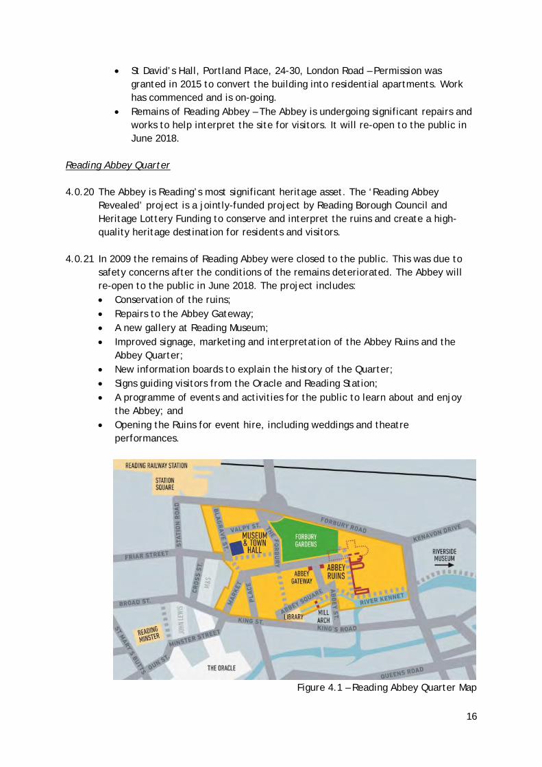
Reading Abbey Quarter 4.0.20 The Abbey is Reading’s most significant heritage asset. The ‘Reading Abbey
Revealed’ project is a jointly-funded project by Reading Borough Council and Heritage Lottery Funding to conserve and interpret the ruins and create a high-quality heritage destination for residents and visitors.
4.0.21 In 2009 the remains of Reading Abbey were closed to the public. This was due to
safety concerns after the conditions of the remains deteriorated. The Abbey will re-open to the public in June 2018. The project includes: • Conservation of the ruins; • Repairs to the Abbey Gateway; • A new gallery at Reading Museum; • Improved signage, marketing and interpretation of the Abbey Ruins and the
Abbey Quarter; • New information boards to explain the history of the Quarter; • Signs guiding visitors from the Oracle and Reading Station; • A programme of events and activities for the public to learn about and enjoy
the Abbey; and • Opening the Ruins for event hire, including weddings and theatre
performances.
Figure 4.1 – Reading Abbey Quarter Map
17
4.0.22 The Local Plan contains a new policy (CR15: The Reading Abbey Quarter) to
encourage and manage development associated with the Abbey Quarter in order to create a major area for heritage and cultural life within the Borough while conserving and enhancing the asset and its setting.
Locally Important Heritage Assets 4.0.23 The process for locally listed buildings in Reading provides the opportunity for
communities to nominate buildings and structures. This ensures that the contribution of buildings of local historic and architectural value to Reading’s distinctiveness and character is recognised and taken into account when changes affecting the historic environment are proposed. A list of locally important buildings and structures is available on the Council’s website12.
12 http://www.reading.gov.uk/media/5834/List-of-locally-important-buildings/pdf/List-Of-Important-Buildings-And-Structures_27.02.2018.pdf
18
5.0 POLICY ISSUES AND ANALYSIS 5.0.1 This section draws together the evidence that has been presented in this
background paper in the form of policy and guidance, consultation findings and local characteristics. Protection of the Borough’s historic environment is a priority that is reflected in the Local Plan and is a matter that the Council remains committed to.
5.0.2 Planning policies must be framed in the context of the relevant national, strategic
and local policies and be tailored to local conditions. National policies on planning matters contained within the National Planning Policy Framework and Planning Practice Guidance provide relevant direction for the formulation of policies. It is likely however, that many of the Government’s recommendations will be more applicable to detailed planning documents, such as supplementary planning documents. Local policies and strategies set the underlying objectives and targets for management of the local historic environment.
5.0.3 Local Plan policies will be required to take on the key objective of valuing,
protecting and where appropriate, enhancing the historic environment. There are various components to be considered within this underlying goal, in order to take account of the features of the historic environment, their relative contributions, and the different processes and techniques required to manage them.
5.0.4 Essentially, the Local Plan should seek to resist development that would adversely
affect any recognised feature of the historic environment or their setting(s) while implementing a positive strategy for retention, improvement and promotion of existing heritage assets. Development proposals should also be expected to contribute to the enhancement of the character and appearance of historic assets, and/or the area in which they are located.
5.0.5 Policies must reflect the various functions and contributions of the historic
environment. This includes recognising the contributions to sustainable development, in terms of the potential to support regeneration, tourism (including appreciation by both the local community and visitors) and social inclusion, as well as conservation. Conservation of the historic environment contributes to local character and distinctiveness, which can lead to a fostering of sense of place and identity. An enhanced quality of life can be attained through education, understanding and appreciation of the historic environment, however, to a large extent, this is reliant on the provision and facilitation of appropriate access to valued sites. Finally, the economic-related benefits of valued features and landscapes should not be overlooked.
5.0.6 Given the prominence of the historic environment within the Reading Central Area,
there is a need to ensure that the Local Plan reflects its value, and that development proposals are mindful of the need to deal with these areas sensitively. This includes recognition of the value of traditional terraced housing in the core of Reading’s Centre, and its subsequent contributions to the varying
19
character of the Town Centre, particularly in the context of the changes occurring around them.
5.0.7 Policy EN5: Protection of Significant Views with a Heritage Interest is supported by
Appendix 4. This appendix by the Conservation Area Advisory Committee provides a detailed analysis for each view listed in the policy and explains its historic merit.
5.1 Recommended Policies 5.1.1 In light of the above, it is recommended that the Local Plan Submission Document
contain the following policies: EN1: PROTECTION AND ENHANCEMENT OF THE HISTORIC ENVIRONMENT
Historic features, areas of historic importance and other elements of the historic environment, including their settings will be protected and where possible enhanced. This will include:
• Listed Buildings; • Conservation Areas; • Scheduled Monuments; • Historic parks and gardens; and • Other features with local or national significance, such as sites and
features of archaeological importance, and assets on the Local List.
All proposals will be expected to protect and where possible enhance the significance of heritage assets and their settings, the historic character and local distinctiveness of the area in which they are located. Proposals should seek to avoid harm in the first instance.
Any harm to or loss of a heritage asset should require clear and convincing justification, usually in the form of public benefits.
Applications which affect, or have the potential to affect, the significant features of heritage assets should be justified by a Heritage Statement.
The Council will monitor buildings and other heritage assets at risk through neglect, decay or other threats, proactively seeking solutions for assets at risk including consideration of appropriate development schemes that will ensure the repair and maintenance of the asset, and, as a last resort, using its statutory powers.
Where there is evidence of deliberate neglect or of damage to a heritage asset, the deteriorated state of the heritage asset should not be taken into account in any decision. EN2: AREAS OF ARCHAEOLOGICAL SIGNIFICANCE
20
Applicants should identify and evaluate sites of archaeological significance by consulting the Historic Environment Record. This will require an assessment of the archaeological impacts of development proposals to be submitted before the planning application is determined. Planning permission will not be granted in cases where the assessment of the archaeological impacts is inadequate. Where remains cannot be preserved ‘in situ,’ remains should be properly excavated, investigated and recorded. This will require adequate provision for the identification, investigation, recording and publication of the archaeological resource. Where appropriate, Section 106 agreements will be negotiated to protect, enhance and interpret archaeological remains. Development proposals which will have an adverse effect on scheduled monuments and other nationally important archaeological remains and their settings will not be allowed unless there is clear and convincing justification in the form of overriding public benefits. EN3: ENHANCEMENT OF CONSERVATION AREAS The special interest, character and architecture of Conservation Areas will be conserved and enhanced. Development proposals within Conservation Areas must make a positive contribution to local character and distinctiveness. Positive consideration will be given to proposals which take opportunities to enhance the character of conservation areas. These may include:
• Reducing visual clutter caused by negative factors, such as poles and overhead wires, satellite dishes or unnecessary street furniture;
• Restoring original building features; • Removing inappropriate additions or alterations to buildings; • Protecting and encouraging the maintenance of green spaces and
important trees, particularly where they are intrinsic to the history and character of the area;
• Improving signage and street furniture; • Restoring or re-establishing appropriate paving, railings or walls; • Sympathetic landscaping and planting; • Improving or restoring green spaces, including front gardens, that are
appropriate to the historic interest of a Conservation Area; • Signage that reveals and promotes the Conservation Area and its
boundaries; • Interpretation panels to inform the public of the area’s historical
significance.
Where a Conservation Area Appraisal and Management Plan has been adopted for a particular Conservation Area, this will be a material consideration in determining applications for development.
21
EN4: LOCALLY IMPORTANT HERITAGE ASSETS Development proposals that affect locally important heritage assets will
demonstrate that development conserves architectural, archaeological or historical significance which may include the appearance, character and setting of the asset.
Planning permission may be granted in cases where a proposal could result in harm to or loss of a locally important heritage asset only where it can be demonstrated that the benefits of the development significantly outweigh the asset’s significance. Where it is accepted by the Local Planning Authority that retention is not important, recording of the heritage asset should be undertaken and submitted alongside development proposals. Replacement buildings should draw upon heritage elements of the previous design, incorporating historical qualities that made the previous building significant. This may include appearance, scale and architectural quality.
EN5: PROTECTION OF SIGNIFICANT VIEWS WITH A HERITAGE INTEREST New development should not harm and where possible should make a positive
contribution to views of acknowledged historical significance. The following views merit special protection: 1. View from McIlroy Park towards Chazey Barn Farm, the Thames Meadow
and the Chilterns escarpment 2. View northwards down Southampton St from Whitley St towards St Giles
Church, St Mary’s Church and Greyfriars Church 3. View upstream from Caversham Bridge 4. View northwards down Russell St towards the Church of the Holy Trinity 5. View over Alexandra Road Conservation Area toward the Chilterns
escarpment 6. View southwards down St Annes Rd towards Downshire Square 7. View of St Annes Church Tower from the west 8. View towards Caversham Park House from the A329(M), railway and
surrounding streets 9. View southwards along tree-lined Coley Avenue
EN6: NEW DEVELOPMENT IN A HISTORIC CONTEXT In areas characterised by heritage assets, the historic environment will inform and shape new development. New development will make a contribution to the historic character of the area by respecting and enhancing its architectural and visual qualities and considering how heritage considerations can influence the design of new development. When determining planning applications for new development, the following factors will be taken into consideration:
a. The positive contribution of the development to the existing historic townscape (scale, height, mass, proportion, plot size, street form, materials, significant vistas and views, and open space);

22
b. Sensitivity to historic context; c. Reflection of borough-wide major heritage themes that contribute to
local distinctiveness (e.g. patterned brickwork or former worker terraced housing);
d. Whether development promotes and/or improves access to previously undiscovered or neglected historic significance.
5.2 Potential Alternative Policy Approaches 5.2.1 In addition to the above recommended approaches, the following alternative
approaches for each policy have been considered. A discussion as to why they have been rejected has also been included. Alternatives are aligned with options considered in the Sustainability Appraisal.
EN1: Protection and Enhancement of the Historic Environment 5.2.2 Option EN1(a): No policy
The NPPF and Planning Practice Guidance are reasonably detailed in their approach to identifying contributions of the historic environment, and communicating and rationalising the Government’s requirements for its protection. The guidance places a responsibility on Local Planning Authorities to formulate plans and policies that seek to protect aspects of the historic environment and clarify the basis upon which planning decisions will be made. These conservation policies need to be coordinated and integrated with other planning policies that apply to development (such as policies dealing with design and character) and given a local focus. This take cannot be undertaken at the national level. Furthermore, policies need to be based on a recognition of features of local historic interest and importance, and supported by actions considered necessary to protect these specific features. This demonstrates the need for a planning framework for the historic environment at the local level. Thus, this alternative would leave the town’s historic assets vulnerable and fail to fulfil the requirements of the NPPF.
5.2.3 Option EN1 (b): Continue with current policy (Core Strategy CS33) Continuing to apply the existing policy should result in the continued protection
and enhancement of Reading’s historic environment. As the Core Strategy was tailored to local conditions regarding specific historic assets, this provides a strong framework to protect recognised features from the adverse impacts of development. Despite strong protection, this option may not go far enough to proactively enhance the historic environment. This option would bring positive effects, but these effects would be less-pronounced than the preferred option.
EN2: Areas of Archaeological Significance 5.2.4 Option EN2 (a): No policy This option would lead to significant negative effects to areas of archaeological
importance. It would prevent the understanding of the significance of the historic
23
environment for residents and future generations. Furthermore, this option would fail to fulfil the requirements of the NPPF which states:
‘Where a site on which development is proposed includes or has the potential to include heritage assets with archaeological interest, local planning authorities should require developers to submit an appropriate desk-based assessment and, where necessary, a field evaluation.’ (Paragraph 128)
5.2.5 Option EN2 (b): Business as usual, no separate policy, but mentioned in EN1 This option is similar to the preferred option, but does not describe the
requirements placed on developers. Thus, the preferred option brings more significant positive impacts with regard to the historic environment. Placing value on archaeological investigations can help to foster a sense of place.
EN3: Enhancement of Conservation Areas 5.2.6 Option EN3 (a): No policy This option would likely result in degradation and loss of character in the Borough’s
Conservation Areas, bringing negative effects with regard to townscape character and the historic environment. It may allow for unconstrained development, but the costs of negative effects far outweigh any benefits to housing provision.
5.2.7 Option EN3 (b): Business as usual, no separate policy, but mentioned in EN1 This alternative would rely on EN1 and would grant cursory protection to
Conservation Areas as a type heritage asset, but fails to highlight specific issues in Conservation Areas. A separate policy draws attention to an important issue, as some of the Borough’s Conservation Areas are experiencing the cumulative negative effects of HMO development and loss of historic character.
EN4: Locally Important Heritage Assets 5.2.8 Option EN4 (a): No policy Historic England states: ‘Whilst local listing provides no additional planning controls, the fact that a
building or site on a local list means that its conservation as a heritage asset is an objective of the NPPF and a material consideration when determining the outcome of a planning application.13’
Thus, although a local list is not required by the NPPF, it can be used as a tool to extend protection to assets deemed locally significant. The absence of a policy regarding a local list could leave assets that are not formally listed vulnerable to decay and degradation.
5.2.9 Option EN4 (b): Business as usual, no separate policy, but mentioned in EN1
13 https://historicengland.org.uk/advice/hpg/has/locallylistedhas/

24
This option would grant cursory protection to locally listed assets simply as a type of heritage asset. Thus, some level of protection would be granted, but positive benefit would likely be more significant under the preferred option. The preferred option provides detail regarding when permission should be granted, that documentation should be undertaken by the developer and insists that development take historical design cues.
EN5: Protection of Significant Views with a Heritage Interest 5.2.10 Option EN5 (a): No policy, business as usual This option would provide no special protection for views of acknowledged
historical significance. Some views would be considered during the determination of planning applications, either as part of a site’s setting or with regard to existing landscape or tall buildings evidence. This approach would leave many views vulnerable and would result in negative impacts on the historic environment.
5.2.11 Option EN5 (b): New policy protecting views generally This option would extend protection to a much larger number and range of views
within the Borough. While this could result in positive effects for the historic environment, it may go too far to protect too many views and unnecessarily deter development. This would bring negative effects with regard to housing provision.
EN6: New Development in a Historic Context 5.2.12 Option EN5 (a): No policy, business as usual This option would fail to fulfil the following in the NPPF: ‘Local planning
authorities should look for opportunities for new development within Conservation Areas to enhance or better reveal their significance.’ Omission of the preferred option would rely on cross-cutting design policies that pay less attention to historic elements as cues for new development. Requiring new development to reflect existing historic character will help to create a sense of place and forms an integral part of the Local Plan’s efforts to develop a positive strategy for the historic environment.
25
6.0 RECOMMENDED APPROACH 6.0.1 Based on their valuable contribution to numerous aspects of Reading’s
environment, community and economy, there is a general presumption that all features of the historic environment will be preserved and enhanced. This is also consistent with Government guidance, and the relevant strategic policies.
6.0.2 Planners and other decision-makers have a responsibility to assist the preservation
of the historic environment, in the public interest. There is also considerable scope to value-add to the quality and integrity of the historic environment, through improvements; responsive design; the provision of appropriate access to historic assets; and effective ongoing management. The recommended planning policies are based on sound conservation principles and best practice.
6.0.3 The paper makes the following additional recommendations:
• Continuation of updates to the Conservation Area appraisals, to ensure up-to-date systematic analysis and recording of Conservation Areas; identifying valued components that contribute to character, and facilitating development of policies for their protection and enhancement.
• Ensure that the Local Plan embraces the principles of good design, which includes the recognition of the importance of the historic environment and its contributions, such as its association with economic and regenerative benefits.
• There may also be a need for condition surveys to be undertaken on a regular basis, to identify potential risks to historic features; help to maintain appropriate records; and provide greater understanding of Reading’s historic fabric. This represents a more proactive approach to managing the historic environment.
26
7.0 REFERENCES
• Department for Communities and Local Government (2012), National Planning Policy Framework
• Department for Communities and Local Government (2012), Planning Practice Guidance
• Reading Borough Council (2008, amended 2015), Core Strategy • Reading Borough Council (2009), Reading Central Area Action Plan • Reading Borough Council (2010), Conservation Area Appraisals • Reading Borough Council (2012), Proposals Map • Reading Borough Council (2012, altered 2015), Sites and Detailed Policies
Document • Reading Borough Council (2014), Draft Heritage Statement

27
APPENDIX 1 Grade I Listed Buildings Abbey Gate, Forbury Gardens Chazey Farm Barn, The Warren Church of St Mary, St Mary’s Butts Greyfriars Church, Friar Street Reading Abbey Ruins, Forbury Gardens St Laurence’s Church and Churchyard, Forbury Road Grade II* Listed Buildings 15 Castle Street 154-160 Castle Street 17 Castle Street 173-183 Kings Road 19 Castle Street 73 & 75 London Street 78-84 Southampton Street Albion Place, London Road Archway connecting Forbury Gardens to Abbey Ruins Chazey Farmhouse, The Warren Christ Church, Christchurch Road Church of Saint Mary, Castle Street Church of St Peter, Church Road Holybrook Culvert to the rear of Castle Street 1-31 Holybrook House, Castle Street Old Grove House, Surley Row Royal Berkshire Hospital, London Road St David’s Hall, London Road The Royal Berkshire Regiment Cenotaph, Brocks Barracks, Oxford Road The Simeon Monument, Market Place Town Hall and Clock Tower, Blagrave Street Watlington House, Watlington Street

28
APPENDIX 2 – MAP OF HISTORIC SETTLEMENT PATTERNS

29
APPENDIX 3: DRAFT HERITAGE STRATEGY
DRAFT PROTECTED Page of 27 E5
Reading Borough Council
Draft Heritage
Statement
Director of Environment and Neighbourhood Services
February 2014
Review date 2017

PREFACE
This Heritage Statement has been drafted to provide context and initial input in the development of the heritage section in the forthcoming Cultural and Heritage Strategy that the Council has committed to prepare and publish for consultation during 2014.
At the same time this statement will provide some context for an application that is being made in February 2014 for funding from the Heritage Lottery Fund (HLF) for works within the Abbey Quarter of Reading.
The preparation of this statement provides an opportunity for some initial consultation on how the community views Reading’s Heritage and how the community as whole can work to conserve and enhance the heritage assets in the Borough.
This is a very initial draft on which comments can be made. It is work in progress and some graphics and other information needs to be added to the document going forward.
Comments on this document can be made by email to […]
It would be helpful if comments on this document could be made by 11th
April 2014
DRAFT PROTECTED Page of 27 E6
Draft Heritage Statement Reading Borough Council
INTRODUCTION
‘History is so important, particularly in this hectic modern world – and all residents should be aware of this gem in our midst.’
Visitor to the Reading Abbey Quarter
The poet and writer Sir John Betjemen and artist John Piper recognised that it is sometimes all too easy to see Reading as a ‘modern place’. In fact Reading is an ancient town with over 1000 years of history, and contains a wealth of archaeology, historic buildings and museum collections.
‘The capital of the county is a much maligned town…too many people see it only
from the railway and dismiss it as a modern place’ (John Betjeman and John Piper, 1949)
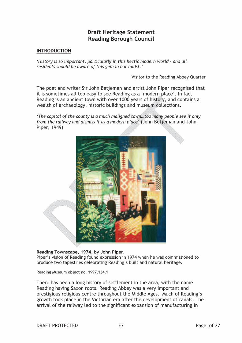
Reading Townscape, 1974, by John Piper. Piper’s vision of Reading found expression in 1974 when he was commissioned to produce two tapestries celebrating Reading’s built and natural heritage.
Reading Museum object no. 1997.134.1
There has been a long history of settlement in the area, with the name Reading having Saxon roots. Reading Abbey was a very important and prestigious religious centre throughout the Middle Ages. Much of Reading’s growth took place in the Victorian era after the development of canals. The arrival of the railway led to the significant expansion of manufacturing in
DRAFT PROTECTED Page of 27 E7

the town. This history is reflected in over 800 listed buildings, fifteen conservation areas and two scheduled ancient monuments, as well as six museums and a host of designated heritage assets. Those that seek out Reading’s heritage are richly rewarded.
This long heritage is important in forming the identity of the town and its people. It has a direct influence on the quality of life of its residents and is a key asset to the local and regional economy. Reading’s heritage is an important and unique asset, albeit sometimes our best kept secret.
This statement sets out Reading Borough Council’s framework for revealing its ‘secret’ assets. It is structured as follows:
an outline of the town’s long history and distinctive heritage;
the scope, purpose and objectives of the statement;
the policy context;
the Council’s heritage responsibilities;
heritage issues and opportunities;
action plan.
READING’S HERITAGE
An overview of Reading Heritage
Reading’s distinctive character is strongly linked to the history of the town. Although there is evidence for prehistoric and Roman settlement, Reading is a Saxon place-name meaning the ‘people of Reada’. Reada or ‘the Red’ was probably the leader of a group of early Saxon settlers in the late 5th or 6th
century AD. A cremation urn cemetery of this period, overlooking the symbolic meeting point of the Rivers Thames and Kennet, was found in 1891 at Kennetmouth. Reading was first recorded in 871 AD when the Danish Viking army built a rampart between the Kennet and Thames. The king of Wessex and his brother, later to become King Alfred the Great, unsuccessfully attacked the Danish encampment. The name ‘Vastern’ Road to the north of the railway station is an Old English word for a ‘stronghold’.
The historic core retains reminders of its Saxon and medieval origins through its early street pattern, ancient parish churches and the nationally important remains of Reading Abbey. The historic Abbey Quarter is particularly evocative with layers of history including the burial place of King Henry I, the civil war defences of Forbury Hill, the Abbey Gate where Jane Austen attended school, the Victorian Maiwand Lion, and Reading Gaol where Oscar Wilde was imprisoned. There are also buildings by the leading architects of the nineteenth century including Sir John Soane, Augustus Pugin, Sir George Gilbert Scott and Alfred Waterhouse.
By the eighteenth century Reading was expanding outside its medieval boundaries and was chiefly being rebuilt in the local brick. Significant
DRAFT PROTECTED Page of 27 E8
groups of late Georgian architecture can be seen in areas such as Russell Street and Castle Hill. Improved transport links via the Kennet and Avon Canal saw the use of Bath stone in areas such as Eldon Square and Queen’s Road, and for new public facilities like the Royal Berkshire Hospital and Reading Cemetery.
The arrival of the Great Western Railway in 1840 saw the expansion of Reading’s emerging industries, especially Simonds’ brewery, Huntley & Palmers biscuits and Sutton’s Seeds. The Victorian and Edwardian expansion and prosperity of the town is demonstrated by Reading’s distinctive use of locally made coloured brick, terracotta and tile. This has resulted in some of Reading’s most recognisable landmarks, including the Town Hall, and new suburbs such as The Mount and the Downshire Square Conservation Areas.
Beyond the town centre former rural parishes like Caversham and Tilehurst became part of the Borough in 1911. The rural origin of these areas is reflected in their heritage. For example St Peter’s conservation area is the old village centre of Caversham around the medieval parish church and the restored Thames-side Caversham Court Gardens. The parks and gardens of the many country houses that once surrounded Reading also survive within the modern urban townscape including Caversham Park, Prospect Park and Whiteknights (now the University of Reading campus).
After the Second World War the opening of the Inner Distribution Road transformed the town centre, with changes to the physical appearance of Reading, including alterations to the historic street pattern and the loss of historic buildings. Parts of Reading’s historic core were demolished but much of historical merit remains. Recent developments such as Forbury Square have been more sympathetic to this heritage, removing intrusive post-war structures, providing public open space and public realm, and improving their settings.1
Reading’s Heritage Assets
Reading Borough contains a diverse range of heritage assets2:
800 nationally Listed buildings (including 27 grade I and grade II*);
15 Conservation Areas;
Two Scheduled Ancient Monuments (Reading Abbey and High Bridge)
Five Historic Parks and Gardens;
Locally listed buildings and structures;
Fifteen Article 4 Directions protecting locally distinctive buildings by removing permitted development rights;
The Berkshire Historic Environment Record (HER)3 contains comprehensive records of over 1200 archaeological sites and finds in
1 http://www.reading.gov.uk/leisureandvisitors/historyandrecords/2 www.reading.gov.uk/businesses/Planning/HistoricEnvironment/
3 www.heritagegateway.org.uk/gateway/chr/default.aspx
DRAFT PROTECTED Page of 27 E9
Reading; Areas of archaeological potential are identified on the proposals map of LDF.
Reading has six museums and three archive collections:
Berkshire Medical Heritage Centre (independent);
Cole Museum of Zoology (University);
Museum of English Rural Life (University);
Reading Museum (RBC);
Riverside Museum at Blake’s Lock (RBC);
Ure Museum of Classical Archaeology (University);
Berkshire Record Office collection (RBC);
Reading Library Local Studies Collection (RBC);
University of Reading Special Collections (University).
[show on maps (from GIS map]
DRAFT PROTECTED Page of 27 E10

SCOPE, PURPOSE AND AIMS OF THE STATEMENT
Scope of the Statement
The Council intends that the preparation of this statement will provide a framework to ensure that we celebrate, protect, reveal and promote Reading’s unique heritage, so that it attracts and continues to delight residents and visitors alike. The aim is that this document will be developed into a plan which will inform and be part of the wider Cultural and Heritage Strategy for Reading.
Definition of heritage
For the purposes of this strategic statement, heritage is those parts of the historic environment that have national or local designated significance because of their historic, archaeological or artistic interest (including listed buildings, scheduled monuments, conservation areas, historic parks and gardens, archaeological sites identified on the HER and various historic assets of local importance), and accredited museum collections within the Borough.
Purpose
The purpose of this statement is to:
help to reveal, maintain and enhance Reading’s historic identity;
demonstrate links with the long term vision for Reading, central government agendas and strategies of national and regional agencies;
detail how heritage can contribute to the quality of life for residents and the community;
provide a framework for maximising investment in Reading’s heritage;
set a direction and define priorities within and between heritage initiatives and reconcile competing demands;
inform the management of the Council’s assets, service plans and the work of individual officers, departments and other agencies;
encourage innovation and improved partnership working;
act as a lever and rationale for gaining funding from external agencies and partners.
Vision
The statement proposes a new vision for Reading’s heritage:
DRAFT PROTECTED Page of 27 E11
Reading’s unique heritage will be a heart of the town’s identity and will be highly visible, valued and accessible by those who live, work or visit the town. It will enrich Reading’s communities and enable them to interact with, and celebrate, the town’s history and historic assets.
Objectives
1. To protect and enhance Reading’s heritage assets for future generations;
2. To reveal and promote Reading’s unique heritage for the enjoyment of residents and visitors, understanding its contribution to the town’s identity and economic development;
3. To increase public awareness, understanding and enjoyment of Reading’s heritage;
4. To maximise investment to preserve and enhance Reading’s heritage;
5. To improve internal co-ordination and partnership working with the statutory, voluntary and private sectors to protect and enhance Reading’s heritage;
6. To promote Reading’s heritage as part of the town’s strategy for sustainable economic development.
The value of heritage
Reading’s heritage is of local, national and, in cases such as Reading Abbey, European and wider international significance.
Reading has an obligation to protect its heritage for the benefit and the quality of life of its residents and visitors. Reading’s heritage assets are not just of relevance to the past, but also to the future, if Reading is to fulfil its role as a centre of culture at the heart of the Thames Valley.
Value of heritage to local people
In 2010, Reading Museum carried out consultation on what its visitors and stakeholder groups thought of the current Reading Gallery and what was important about Reading’s heritage. Feedback from 369 people identified the Abbey as Reading’s most important heritage, followed by the industries of beer, bulbs and biscuits. Guided tours have continued since the closure of the Abbey Ruins in 2009, highlighting the Abbey Quarter’s importance and giving people the opportunity to give feedback. 100% of the 309 participants who completed feedback agreed that the Abbey Quarter was highly significant and felt that it is important for young people to understand and take pride in the history of their town. They would like more to be done to promote Reading as a historical town, increasing tourism and therefore benefiting the town economically as well as culturally.
A further questionnaire consultation on the Abbey Quarter was undertaken during January 2014. There were over 1100 completed questionnaires.These are still to be fully analysed but they do indicate that heritage is
DRAFT PROTECTED Page of 27 E12
considered to be very important in Reading and that there is very strong support for the works proposed in the Abbey Quarter.
Economic impact of investing in heritage
In 2010 English Heritage commissioned research into the economic justification for investing in heritage. Key findings were:
Every £1 invested in the historic environment directly contributes on average an additional £1.60 to the local economy;
The historic environment attracts visitors and encourages them to spend more. Approximately one in five visitors spend more in an area after investment that they did before;
The historic environment is as an important factor in businesses’ decisions on location, as road access;
Historic areas also attract a greater mix of businesses, such as bars and restaurants, encouraging people to stay in an area longer and to visit at different times of the day;
Investment in the historic environment improves public perceptions, increases civic pride and provides a greater sense of identity. Almost every person surveyed in areas where investment had occurred agreed that the investment has raised local pride in the area (92%), improved perception of the local area (93%) and helped to create a distinct sense of place.
In 2013 Arts Council England (ACE) disseminated figures on the economic impact of culture and the growth of audiences:
For every £1 invested in arts and culture up to £6 is generated for the local economy;
UK visitor figures to museums and galleries are at their highest level since record began;
51% of UK adults visited a museum or gallery in 2011/12.
DRAFT PROTECTED Page of 27 E13

NATIONAL AND LOCAL POLICY CONTEXT
Reading Borough Council corporate vision and policy
The Reading 2020 Vision foresaw the regeneration and growth of the town as the capital of the Thames Valley.
The preparation of Reading’s Sustainable Community Strategy started a process of forming “A Vision for Reading in 2030 and beyond”.4 In terms of Reading as a place it is recognised that,
“Reading is attractive, thriving and culturally vibrant, with a strong sense of historic identity.”
The Council’s current Corporate Plan commits to producing a new Cultural and Heritage Strategy and to reviewing the vision for Heritage across the Borough. It also highlights the preparation of the Abbey Quarter Project Plan as a priority.
National Heritage Protection Plan 2011-2015, English Heritage
The NHPP5 sets out how English Heritage, together with partners in the heritage sector, will prioritise and deliver heritage protection.
The NHPP aims to identify those parts of England’s heritage that matter to people most and are at greatest risk – and then to concentrate efforts on saving them.
The Plan seeks to ensure that England’s historic environment; • is not needlessly at risk of damage, erosion or loss; • is experienced, understood and enjoyed by local communities; • contributes to sustainable and distinctive places to live and work; • helps deliver positive and sustainable economic growth.
It encourages organisations to develop their own Action Plan in response to the NHPP.
In recent years, English Heritage has increasingly restricted its involvement in individual cases to the more important buildings and historic assets of significant national importance. There is a corresponding expectation that local authorities take more responsibility for the historic assets in their areas and invest in the management and protection of their historic environment.
National Planning Policy Guidance 9.1.7 & 9.1.8 (SDPD)
4 http://www.reading2020.org.uk/reading-2020/reading-2020/vision-reading/5 www.english-heritage.org.uk/nhpp.
DRAFT PROTECTED Page of 27 E14

Government planning policy in the National Planning Policy Framework6 sees protecting and enhancing the historic environment as an important component of the drive to achieve sustainable development. The conservation of heritage assets forms one of the ‘core planning principles’ that underpin the planning system.
Reading Borough Council’s Local Development Framework (LDF), of which the last component document (the Sites and Detailed Policies Document) was adopted at the end of 2012, is very much in accordance with the importance given to the historic environment in the NPPF. This is demonstrated in that RBC has, through its LDF policies, extended its protection of the historic environment by putting in place a framework and criteria for the local listing of buildings in accordance with the policies in the NPPF and advice from English Heritage.
Arts Council England Strategic Framework 2010-2020
Arts Council England’s (ACE) mission is ‘Great art and culture for everyone’. ACE have a 10 year strategic framework from 2010-2020, it was revised in October 2013. At its heart are five goals:
Excellence is thriving and celebrated in the arts, museums and libraries
Everyone has the opportunity to experience and to be inspired by the arts, museums and libraries
The arts, museums and libraries are resilient and environmentally sustainable
The leadership and workforce in the arts, museums and libraries are diverse and appropriately skilled
Every child and young person has the opportunity to experience the richness of the arts, museums and libraries
There are complex interrelationships between these ACE goals. They support each other, and success in one goal contributes to success in others. Goals one, two and five are built on the foundation of goals three and four.
RBC Local Development Framework - Historic Environment policies
The role of the LDF7 is to proactively protect and enhance the historic environment, recognising the pressures of continued infill development. This entails recognition of the value of historic features that are desirable for retention, ensuring that the most valued townscapes and landscapes (e.g. those with national and international designations) are given the highest level of protection, and that other locally valued areas of landscape are provided with adequate protection.
6 NPPF, DCLG, 2012.7 www.reading.gov.uk/readingldf
DRAFT PROTECTED Page of 27 E15
The LDF’s Core Strategy Document adopted in 2008 recognises that physical survivals from our past are a central part of our cultural heritage and sense of both local and national identity. This heritage contributes to formal education, and our understanding and appreciation of both the past and the present. The presence of these remains enhances local distinctiveness and the character and appearance of Reading, and contributes to leisure and tourism.
The Core Strategy ‘vision for the historic environment in Reading is to protect and, where appropriate, enhance features of the historic environment, including features of archaeological significance’.
The key policy for heritage is CS33: Protection and Enhancement of the Historic Environment.
Historic features and areas of historic importance and other elements of the historic environment, including their settings, will be protected and where appropriate enhanced. This will include: -
• Listed Buildings; • Conservation Areas; • Other features with local or national designation, such as sites and
features of archaeological importance, and historic parks and gardens.
Planning permission will only be granted where development has no adverse impact on historic assets and their settings. All proposals will be expected to protect and where appropriate enhance the character and appearance of the area in which they are located.
Reading Museum policies
The collection of Reading Museum is an important part of the town’s publically owned heritage and a regionally significant cultural resource, which through its use and interpretation makes a major contribution to the Council’s vision and priorities. The collection tells the story of Reading’s people and places through the Museum’s galleries, exhibitions; online resources; school workshops and outreach programme.
As part of its Accredited status the Museum has several policies8 that guide the care and development of and access to its collection. These include:
Acquisition and Disposal Policy 2010-2015;
Collection Management Policy 2012;
Access Policy 2012.
8 http://www.readingmuseum.org.uk/aboutus/
DRAFT PROTECTED Page of 27 E16
HERITAGE ISSUES AND OPPORTUNITIES
Reading’s history and its historic assets are hugely important to the identity of the town and its communities. The conservation and enhancement of these assets is the responsibility of everyone in the community. Nearly all the assets are owned by private organisations and individuals. The Council owns relatively few historic assets. The conservation and enhancement of Reading’s historic assets needs to be based on innovative and creative approaches, involving high levels of partnership. The following section discusses current issues and opportunities and starts to sets out priorities along with some proposals for future action.
Heritage Protection and Management
Heritage Policies and Strategy
The Council operates a very successful and important museum and has significant library and archive resources related to the history of the town. It has planning policies, property management responsibilities, and various responsibilities in relation to listed buildings, conservation areas and scheduled monuments.
As the local planning authority RBC has a statutory responsibility to protect Reading’s heritage assets. The Council fulfils this through its Local Development Framework (LDF), planning consents and through various proactive activities. These include the important work of the Museum’s Berkshire Archaeology service in relation to the archaeology of Reading, the designating of Conservation areas, keeping Conservation Area Statements and Management Plans up to date, and creating a list of locally important buildings and structures.
Until now there has been no overarching framework for the protection and promotion of Reading’s heritage. As with most councils, responsibility for managing and promoting the borough’s heritage is divided amongst council departments. Various departments have been involved in developing and implementing heritage projects. While these have been individually successful, this has sometimes been at the expense of strategically prioritising investment where it is most needed.
This statement aims to align RBC policy with national policy and practice, to outline a more up-to-date direction for the approach to heritage assets in Reading. It seeks to set out priorities within and between heritage initiatives and to reconcile competing demands.
Action Point – the Council should integrate this Heritage Statement into the new Cultural and Heritage Strategy for Reading; and ensure regular reviews of this strategy.
DRAFT PROTECTED Page of 27 E17

Conservation Area Appraisals
The designation of a conservation area is not an end in itself. Local authorities develop policies which clearly identify what features of the area should be preserved or enhanced, and set out how this can be done. Character appraisals also identify areas where enhancement through development may be desirable.
Appraisals were undertaken for all Reading’s conservation areas between 2005 and 2010. The Conservation Area appraisals can be found on the Council’s website.9
Action Point – The Council should periodically review these appraisals to assess enhancement opportunities and to make recommendations for matters including boundary changes and Article 4 Directions.
The Local List of Heritage Assets
The new process for locally listed buildings in Reading provides the opportunity for communities to nominate buildings and structures that they believe fit the published criteria. This ensures that the contribution of buildings of local historic and architectural value to Reading’sdistinctiveness and character is recognised and taken into account when changes affecting the historic environment are proposed.
Action Point – The Council should continue to identify buildings or structures worthy of being locally listed through the published process.
At Risk Heritage
English Heritage (EH) regards the creation of a local Heritage At Risk Register as the first step in tackling neglected structures and buildings in order to assess and monitor the scale of the problem and prioritise resources and action. Over recent years RBC has not maintained a local Heritage at Risk for Grade II or locally listed buildings and structures.
In 2012 The English Heritage At Risk programme10 identified three ‘At Risk’ sites in Reading Borough:
Reading Abbey, Scheduled Monument and Grade I listed building, owned by Reading Borough Council (Reading Abbey Ruins and Gate)
Chazey Farm barn, Grade I listed building in private ownership
St David’s Hall, Grade II* listed building, owned by University of Reading
9http://www.reading.gov.uk/businesses/Planning/HistoricEnvironment/conservation-areas/
10 http://www.english-heritage.org.uk/caring/heritage-at-risk/
DRAFT PROTECTED Page of 27 E18
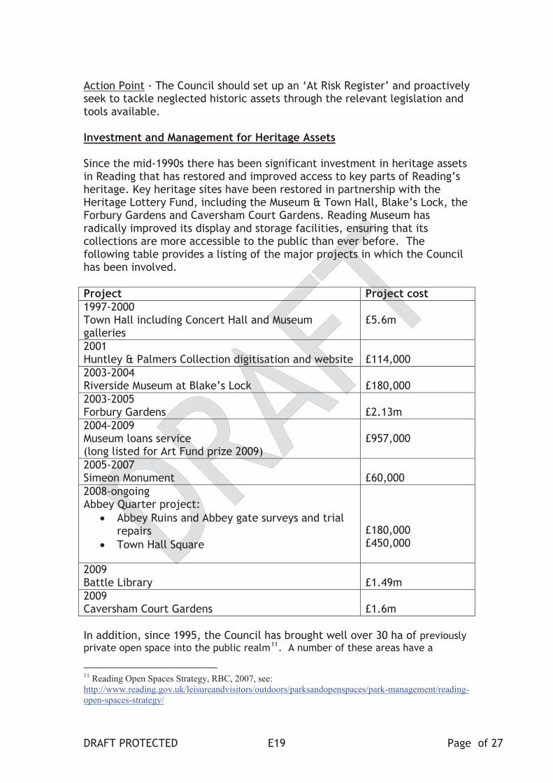
Action Point - The Council should set up an ‘At Risk Register’ and proactively seek to tackle neglected historic assets through the relevant legislation and tools available.
Investment and Management for Heritage Assets
Since the mid-1990s there has been significant investment in heritage assets in Reading that has restored and improved access to key parts of Reading’s heritage. Key heritage sites have been restored in partnership with the Heritage Lottery Fund, including the Museum & Town Hall, Blake’s Lock, the Forbury Gardens and Caversham Court Gardens. Reading Museum has radically improved its display and storage facilities, ensuring that its collections are more accessible to the public than ever before. The following table provides a listing of the major projects in which the Council has been involved.
Project Project cost 1997-2000Town Hall including Concert Hall and Museum galleries
£5.6m
2001Huntley & Palmers Collection digitisation and website £114,000
2003-2004Riverside Museum at Blake’s Lock £180,000
2003-2005Forbury Gardens £2.13m
2004-2009Museum loans service (long listed for Art Fund prize 2009)
£957,000
2005-2007Simeon Monument £60,000
2008-ongoingAbbey Quarter project:
Abbey Ruins and Abbey gate surveys and trial repairs
Town Hall Square
£180,000£450,000
2009Battle Library £1.49m
2009Caversham Court Gardens £1.6m
In addition, since 1995, the Council has brought well over 30 ha of previously
private open space into the public realm11. A number of these areas have a
11 Reading Open Spaces Strategy, RBC, 2007, see:
http://www.reading.gov.uk/leisureandvisitors/outdoors/parksandopenspaces/park-management/reading-
open-spaces-strategy/
DRAFT PROTECTED Page of 27 E19
heritage interest (e.g. Addington Road, Kings Road Gardens, View Island) and the council has an on-going programme for upgrading its parks and open spaces.
There are still some challenges to ensure that all RBC heritage assets are effectively maintained. Planned maintenance at operational sites reduces the risk of unforeseen and expensive capital expenditure in the future, while greatly reducing the risk of neglect and decay to our heritage and health & safety issues for people. Projects that have received Lottery funding have ongoing commitments to ensure that they have the appropriate levels of planned preventative maintenance (PPM) through their Conservation Management Plans.
The maintenance of some sites has been problematic due to the nature of their construction or current lack of a viable use. For example the flint and lime rubble of the Abbey Ruins was never meant to be exposed directly to the weather, and its condition has been further exacerbated by the recent severe winters. In addition buildings or sites that are vacant or closed to the public are at greater risk of decay and vandalism.
Action Point – The Council should carry out a desktop site assessment to establish the current condition of RBC owned heritage assets. Where necessary site surveys could be commissioned and Conservation Management Plans created for each heritage site. This would then be used to co-ordinate and inform planned preventative maintenance and investment priorities across RBC heritage assets.
[case study – abbey gate and ruins condition survey – EH grants]
Prioritisation of capital investment and funding bids
RBC is the owner of a number of important heritage assets in Reading, including two Scheduled Monuments (Reading Abbey and High Bridge), two Grade I listed buildings (Abbey Ruins and Abbey Gate), three Grade II* listed buildings (Archway in Forbury Gardens, Simeon Monument in the Market Place and the Town Hall - Council Chamber and office with Clock Tower), and over 40 Grade II listed structures.
The environment for funding heritage projects is particularly difficult due to the reduction in local and national government budgets, and the increased competition for grant funding. Heritage outcomes can also be funded within wider regeneration and infrastructure projects as demonstrated in the application of the Local Sustainable Transport Fund.
Prioritising capital investment for RBC-owned heritage assets, including the co-ordination of bids to funding bodies like the HLF, should be informed by the work recommended above to identify the current condition, risk level and grading of each asset.
DRAFT PROTECTED Page of 27 E20
Action Point – To maximise opportunities for external funding for heritage it is essential that RBC prioritises projects and ensures these are aligned with the requirements of key grant funders, especially the HLF..
Action Point – The Council should give the highest priority to Scheduled Monuments and Grade I listed structures. The Abbey Quarter project will be central to delivering a step-change regeneration of Reading’s historic heart.
Public-Private Partnerships
The Council has recently entered into negotiations with a private firm to restore the structure and re-open to the public the King’s Meadow Pool. This arrangement may be suitable for other assets with commercial value, and potential opportunities will be highlighted as part of the heritage site assessment described above.
Action Point – The Council should continue to secure the long term future of heritage assets, which are not a priority for grant funding, through commercial partnerships.
Reading Prison Site
The closure of the Prison announced by the Ministry of Justice in September 2013 presents an important opportunity to enhance a major part of the Abbey Quarter. Writer Oscar Wilde wrote The Ballad of Reading Goal after his incarceration at the prison in 1895-97. The surviving Victorian buildings are Grade II listed and the entire site covers the remains of the eastern precinct of Reading Abbey and is a Scheduled Monument. The prison site is identified as sub-area (RC3b) of the ‘East Side Major Opportunity Area’ in the Reading Central Area Action Plan (RCAAP). The RCAAP sets out the planning framework for the central area of Reading up to 2026. The Council is drawing up Outline Development Principles to guide the future development of the site, taking account of its important location within the Abbey Quarter.
Action Point – The Council’s Outline Development Principles should be used to guide the future development of the prison site, taking account of its important location within the Abbey Quarter.
Improving the Setting of Heritage Assets
RBC is responsible for much public land that provides the setting for many heritage features. Unfortunately in the 20th century, traffic management schemes that prioritised motor vehicles took precedence over ‘place-making’ for people. This legacy has often diminished the collective impact of important buildings even in conservation areas such as Castle Street and St Mary’s Butts.
DRAFT PROTECTED Page of 27 E21

Recent public and private schemes, like Forbury Square, Market Place and Town Hall Square, have begun to reverse this damage. These schemes provide a template for future projects to heal the scars in Reading’s historic fabric. This type of investment increases footfall therefore making a contribution to the vitality of the town centre.
Action Point – The Council should ensure that environmental improvement schemes enhance and protect the setting of heritage assets and areas.
[CASE STUDIES TOWN HALL SQUARE]
Economic Development
Heritage is widely recognised as an asset in supporting economic development. Surveys show that people prefer to live, work and visit places with distinctive heritage and this is a part of business decisions on where to locate. Investment in heritage and culture generates more spending in the local economy. For example previous investment in publically owned heritage assets within the Abbey Quarter, like the Forbury Gardens and Simeon Monument, has created an attractive environment for high-quality commercial investment within the Abbey Quarter including Forbury Square and Forbury Hotel. RBC works with Reading UK CIC to promote the town’s economic development.
Action Point: the Council should ensure that Reading’s Economic Development Strategy promotes awareness of Reading’s heritage and highlights the economic value of heritage and culture.
Historic Collections and Archaeological archives
Reading Borough Council owns and manages the important collections of Reading Museum12, containing historic objects of local, regional and national significance. The Museum provides award-winning access to the collections through its galleries, temporary exhibitions, websites, loan boxes, object handling, events and activities. The Museum services are used by over 700,000 people a year, including over 150,000 in person visits.
The Berkshire HER13 is maintained by Berkshire Archaeology14, an archaeological advice service for Bracknell Forest, Reading, Slough, Windsor and Maidenhead and Wokingham. Berkshire Archaeology was established in 2004 as part of Reading Museum.
The County Archive collection at the Berkshire Record Office15 is legally owned by West Berkshire Council, but operational control lies with RBC on
12 www.readingmuseum.org.uk13 Link to the HER 14 www.berkshirearchaeology.org.uk
15 www.berkshirerecordoffice.org.uk
DRAFT PROTECTED Page of 27 E22

behalf of all six Berkshire Unitary Authorities. It contains the archives of the Royal County of Berkshire, with items dating back almost 900 years.
Archaeological archives are the objects and associated data produced during archaeological investigations. Where remains cannot be preserved ‘in situ’ it is planning policy to investigate and record these remains. Archaeological excavation is, by its nature, a generally destructive process, so the archive is the unique record of this investigation, and needs to be preserved and accessible in perpetuity. Archives from within Reading Borough are usually added to Reading Museum’s collection. However the increase in archaeological activity through the planning process has led to a greater quantity of archives being deposited at the Museum. The Museum’s Collection Management Plan recognises that current storage is likely to reach capacity in the next 10 years.
Action Point – The Council should upgrade the storage at Reading Museum to increase the storage capacity for archaeological archives from within the Borough.
Heritage Promotion
Perception of Reading’s heritage
There is sometimes an impression that Reading is a twentieth century town or that it doesn’t have much heritage – neither of which are true! Many local organisations are working to dispel this impression; for example the works of the Friends of Reading Abbey, the Friends of Reading Museum, the Friends of Caversham Court, the History of Reading Society, etc. The annual Heritage Open Days, co-ordinated by Reading UK CIC, and the excellent local history publications of Two Rivers Press and other publishers provide excellent opportunities to understand and appreciate Reading’s history.
Action Point: the town’s public, private and voluntary sectors should continue to work together to raise the profile of Reading as a town with a rich heritage. This includes marketing its heritage attractions and assets.
Signage
Compared to some other large towns and cities Reading lacks a comprehensive network of easy to understand road and pedestrian signage highlighting heritage sites, attractions and areas, especially in the town centre. Local good examples include Oxford, Swindon, Southampton and the City of London, where pedestrian signage has been improved through way-finding strategies. An improved system would complement the existing Reading Explorer system of the 21 units that carries historical stories, and shows some of the town’s heritage assets.
Action Point – The Council should plan and co-ordinate a strategy for developing and maintaining an improved network of road and pedestrian signage, building on existing signage, highlighting heritage sites, attractions
DRAFT PROTECTED Page of 27 E23

and areas, especially in the town centre. There is an opportunity to develop a heritage map based on the existing Explorer map system in the town centre.
Community Access, Engagement and Learning
Community Heritage Projects
Reading Borough Council and its partners regularly work together on projects that increase community access and engagement with Reading’s heritage. For example, since 2010, Reading Museum has engaged with well over 100 diverse community groups across Reading, usually through partnership projects with external funding.
Examples of recent community projects and events include:
Heritage Open Days (ongoing) – Reading UK CIC and partners;
Caversham 100 years On (2010-11), Heritage Lottery Fund;
Get Grandad to DJ (2010-11), Readipop with My Generation funding;
Reading Steady Go! exhibition (2010-11), business sponsorship;
Young Roots Heritage Crime project (2010-11), Heritage Lottery Fund;
Our Sporting Life (2011–12), MLA and business sponsorship;
Pinning Reading’s History (2011-12), Historypin and Heritage Lottery Fund;
Reading Within Living Memory (2010-12), Earley Charity;
Off the Beaten Track (2012 – 13), Readipop and Heritage Lottery Fund;
John Tweed Archive (2012-13), University of Reading, Open Hand, Heritage Lottery Fund;
Revealing Reading’s Hidden History (2012-13), Happy Museum;
World Stories South East (2012-13), Arts Council England;
Reading Connections including Reading At War (2012-14) with MERL, Arts Council England;
Berkshire in the First World War (2013-14), Heritage Lottery Fund;
Enemies of the State (2013-14), Berkshire Record Office with University of Reading.
The Council is currently working closely with various groups to commemorate Trooper Potts (a Reading resident who won a Victoria Cross in the First World War16) and is planning a variety of events to commemorate the anniversary of the First World War17.
Boxed Case studies –
16See: http://pottsvctrust.org/ and: http://www.readingmuseum.org.uk/news/2010/dec/trooper-potts-
vc-display/ 17 See: http://www.readingmuseum.org.uk/news/2014/jan/grant-will-help-mark-great-war-centenary/
DRAFT PROTECTED Page of 27 E24
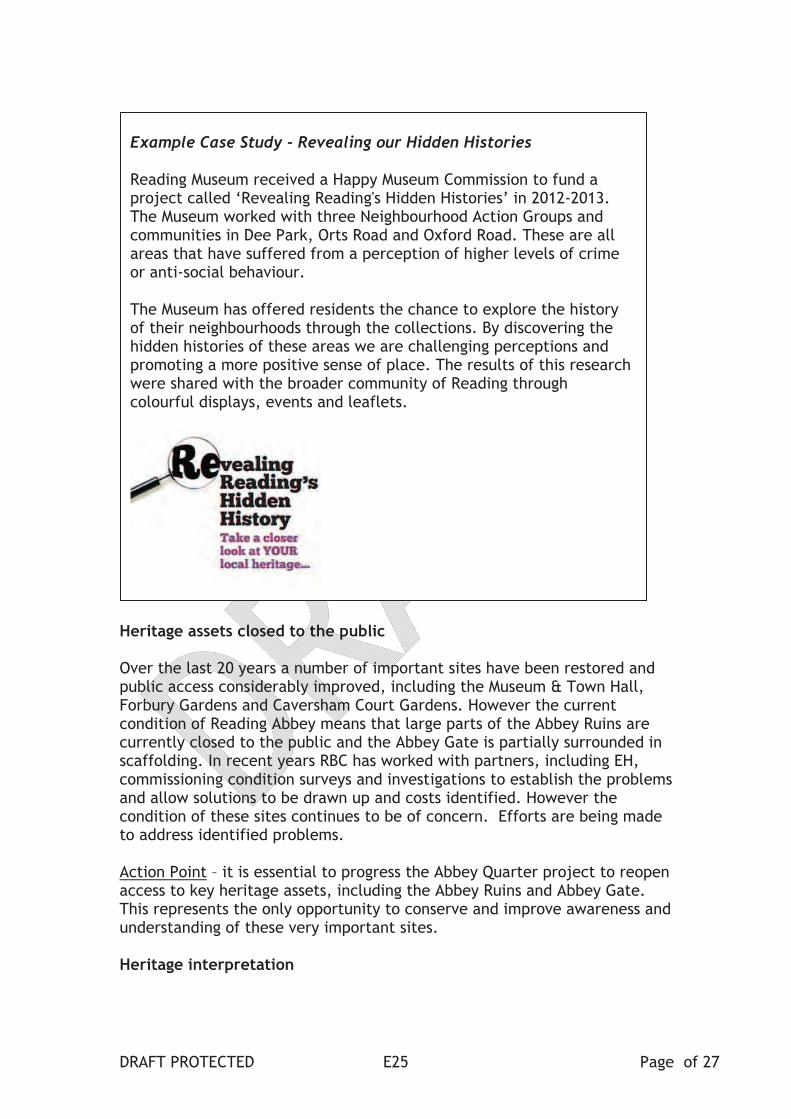
Example Case Study - Revealing our Hidden Histories
Reading Museum received a Happy Museum Commission to fund a project called ‘Revealing Reading's Hidden Histories’ in 2012-2013. The Museum worked with three Neighbourhood Action Groups and communities in Dee Park, Orts Road and Oxford Road. These are all areas that have suffered from a perception of higher levels of crime or anti-social behaviour.
The Museum has offered residents the chance to explore the history of their neighbourhoods through the collections. By discovering the hidden histories of these areas we are challenging perceptions and promoting a more positive sense of place. The results of this research were shared with the broader community of Reading through colourful displays, events and leaflets.
Heritage assets closed to the public
Over the last 20 years a number of important sites have been restored and public access considerably improved, including the Museum & Town Hall, Forbury Gardens and Caversham Court Gardens. However the current condition of Reading Abbey means that large parts of the Abbey Ruins are currently closed to the public and the Abbey Gate is partially surrounded in scaffolding. In recent years RBC has worked with partners, including EH, commissioning condition surveys and investigations to establish the problems and allow solutions to be drawn up and costs identified. However the condition of these sites continues to be of concern. Efforts are being made to address identified problems.
Action Point – it is essential to progress the Abbey Quarter project to reopen access to key heritage assets, including the Abbey Ruins and Abbey Gate. This represents the only opportunity to conserve and improve awareness and understanding of these very important sites.
Heritage interpretation
DRAFT PROTECTED Page of 27 E25
There has been localised investment in the interpretation of individual locations, but some of the town’s most important heritage areas need more focused explanation. This is particularly an issue within the Abbey Quarter, Reading’s most important heritage area. Planning and implementing new interpretation is also an excellent way of involving communities. Good examples of this include the restoration of Caversham Court Gardens involving the Friends of Caversham Court Gardens and Reading Museum’s project to reveal hidden heritage with communities in Dee Park, Orts Road and Oxford Road. Better interpretation ensures awareness and understanding of heritage, while improving perceptions of its importance.
Reading Museum has first-class gallery spaces exploring art, archaeology, history and the environment, particularly the upper floors that were reopened in 1999-2000. However some of the older ground floor display exploring local history is reaching the end of their planned life. Some of the displays relating to Reading’s twentieth century history were refurbished in 2012 with funding from the Earley Charity. This investment provides a template for future improvements to the ground floor gallery, and matches the quality of the upper floor galleries.
Action Point – there is a need to create a strategic plan for a network of outdoor interpretation panels, alongside improved signage. The town centre would be the priority for implementation, particularly the Abbey Quarter.
Action Point – the continued development of the ground floor galleries at Reading Museum provides an opportunity to improve interpretation and make more of Reading’s collections accessible to the public.
Community Consultation and Engagement
This preparation and development of the Cultural and Heritage Strategy is an ideal opportunity to find out what the residents and stakeholders value most about Reading’s heritage and how it should be looked after.
The Abbey Quarter proposals include an activity programme with opportunities for volunteering and learning. This complements the public programme already provided by Reading Museum and other RBC services.
Action Point – The Council should consult the public during the preparation of the Cultural and Heritage Strategy. The consultation results will inform the action plan for heritage.
Action Point – The Council’s museum service should continue to engage local communities with its important collections and Reading’s heritage.
DRAFT PROTECTED Page of 27 E26

DRAFT PROTECTED Page of 27 E27
Glossary of Abbreviations ACE Arts Council England BRO Berkshire Record Office EH English Heritage HER Berkshire Historic Environment Record LDF Local Development Framework NT National Trust PPM planned preventative maintenance RBC Reading Borough Council RCAAP Reading Central Area Action Plan RM Reading Museum
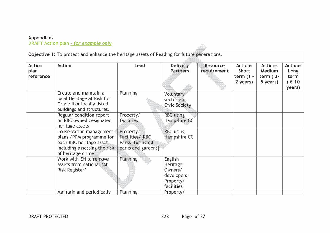
AppendicesDRAFT Action plan – for example only
Objective 1: To protect and enhance the heritage assets of Reading for future generations.
Actionplanreference
Action Lead Delivery Partners
Resource requirement
ActionsShort
term (1 -2 years)
ActionsMediumterm ( 3-5 years)
ActionsLongterm( 6-10 years)
Create and maintain a local Heritage at Risk for Grade II or locally listed buildings and structures.
Planning Voluntary sector e.g. Civic Society
Regular condition report on RBC owned designated heritage assets
Property/facilities
RBC using Hampshire CC
Conservation management plans /PPM programme for each RBC heritage asset; including assessing the risk of heritage crime
Property/Facilities/[RBCParks [for listed parks and gardens]
RBC using Hampshire CC
Work with EH to remove assets from national ‘At Risk Register’
Planning EnglishHeritageOwners/developers Property/facilities
Maintain and periodically Planning Property/
DRAFT PROTECTED Page of 27 E28

review Conservation Area appraisals and prioritise Action Points
FacilitiesTransport & Highways
Increase Reading Museum’s storage capacity for Archaeological archives
Museum PlanningProperty/Facilities
BerkshireArchaeologyOtherBerkshire UAs
Objective 2: To increase public awareness, understanding and enjoyment of our heritage.
Objective 3: To maximise investment to preserve and enhance Reading’s heritage.
Objective 4: To improve internal co-ordination and partnership working with the statutory, voluntary and private sectors to protect and enhance our heritage.
Objective 5: To promote Reading’s heritage as part of the town’s strategy for sustainable economic development.
DRAFT PROTECTED Page of 27 E29

Appendix 2- DRAFT SWOT- amend after public consultation Strengths Weaknesses
Varied heritage assets including many of national importance e.g. Reading Abbey (27
grade I and II* buildings)
Track record of successful restoration projects (Museum & Town Hall, Forbury Garden,
Simeon Monument, Caversham Court Gardens etc)
Good quality museums – large and small
Historic Environment Record
Local pride in Reading heritage
Highly educated population interested in heritage and culture
Respected university – historical expertise
Good communication links to London and rest of UK (e.g. new station)
Leisure destination good retail (The Oracle) and night time offer; range of visitor
accommodation; Reading Arts programme; compact town centre
High profile for business with a vibrant local economy
High profile cultural and sporting events e.g. Reading Festival, Reading Football Club
Extensive open spaces and waterways including historic areas
Low profile as a tourist/visitor destination
Outside perception of little heritage (e.g.. hidden treasures)
Failure to realise the potential of Reading’s heritage as a marketing and tourism asset
No single ‘must see attraction’
At Risk Heritage (e.g. Abbey, Kings Meadow Pool, The Keep)
Abbey Ruins (Scheduled Monument/Grade I) closed to the public
Local heritage assets with no official designation
Concerns about design, upkeep & maintenance of the public realm in central areas i.e.
inconsistent / poor quality
Pedestrian sign posting and historic interpretation is patchy or non existent
Poor quality of some 20thcentury architecture
Confusing traffic /one way system
Lack of internal RBC coordination on heritage assets and management
Lack of revenue funding for basic maintenance and staffing
Lack of consultation and evaluation on heritage
Opportunities Threats
New Heritage Strategy for Reading, linked to Local Development Framework balancing
requirements for sustainable growth with the need to conserve the area’s heritage
assets
RBC cross cutting projects and departmental coordination (e.g. planning,
Transport, culture) Links to RBC strategic objectives
HLF funding
Economic Regeneration (e.g. Station Hill and Square) and re use of historic buildings
improved overall perception of Reading
Partnership working The Cultural Partnership, Reading UK CIC (BID), Reading Abbey
Quarter Board etc
Good relationship with government bodies ( i.e. English Heritage, Arts Council England
etc)
Community involvement and public consultation (i.e. friends groups, volunteering)
increased well being of local residents
Public events and exhibitions Heritage Open days, Museum programme, Abbey Quarter
tours
National economic downturn
Irreversible loss of historic fabric/assets e.g. Abbey
Lack of match funding for grant applications
Pressures on local government funding
Unsuccessful grant applications
Lack of public engagement
Poor media coverage
Failure to find economically sustainable uses for heritage assets
Further damage and neglect to heritage assets e.g. conservation areas, Listed buildings
etc
A continued spiral of poor perception could be detrimental to attracting future
investment in Reading’s heritage and economy
Heritage crime – vandalism and theft e.g. lead roofs, metal plaques
DRAFT PROTECTED Page of 27 E30

DRAFT PROTECTED Page of 27 E31

57
APPENDIX 4: HISTORIC VIEWS ANALYSIS
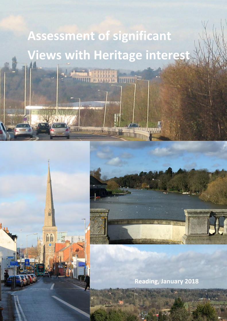
Assessment of significant
Views with Heritage interest
Reading, January 2018
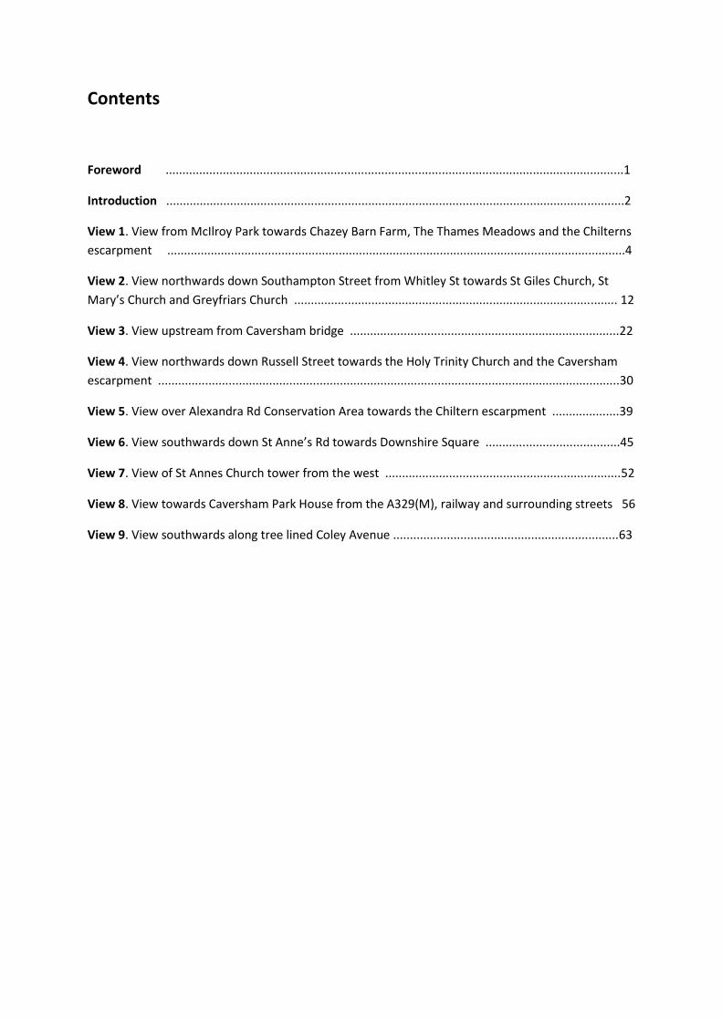
Contents
Foreword ........................................................................................................................................1
Introduction ........................................................................................................................................2
View 1. View from McIlroy Park towards Chazey Barn Farm, The Thames Meadows and the Chilterns
escarpment ........................................................................................................................................4
View 2. View northwards down Southampton Street from Whitley St towards St Giles Church, St
Mary’s Church and Greyfriars Church ................................................................................................ 12
View 3. View upstream from Caversham bridge ................................................................................22
View 4. View northwards down Russell Street towards the Holy Trinity Church and the Caversham
escarpment .........................................................................................................................................30
View 5. View over Alexandra Rd Conservation Area towards the Chiltern escarpment ....................39
View 6. View southwards down St Anne’s Rd towards Downshire Square ........................................45
View 7. View of St Annes Church tower from the west ......................................................................52
View 8. View towards Caversham Park House from the A329(M), railway and surrounding streets 56
View 9. View southwards along tree lined Coley Avenue ...................................................................63
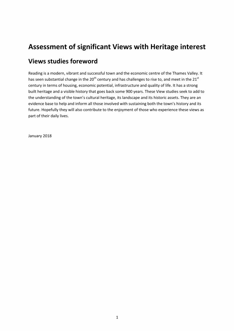
1
Assessment of significant Views with Heritage interest
Views studies foreword
Reading is a modern, vibrant and successful town and the economic centre of the Thames Valley. It
has seen substantial change in the 20th century and has challenges to rise to, and meet in the 21st
century in terms of housing, economic potential, infrastructure and quality of life. It has a strong
built heritage and a visible history that goes back some 900 years. These View studies seek to add to
the understanding of the town’s cultural heritage, its landscape and its historic assets. They are an
evidence base to help and inform all those involved with sustaining both the town’s history and its
future. Hopefully they will also contribute to the enjoyment of those who experience these views as
part of their daily lives.
January 2018

2
Assessment of significant Views with Heritage interest
Reading January 2018
Introduction
The topography of Reading set within its River valleys and with higher ground to the north and south
of these River plains, together with the substantial historic and heritage assets of the town, result in
a number of longer cross town views which have both visual and historic interest.
Reading Conservation Area Advisory Committee was formed in 2016 and comprises people with an
interest in the built environment and its heritage. Members are drawn from local amenity societies,
residents associations, independent historical, architectural and planning experts and local residents
and businesses.
The work of the CAAC in respect of community led Conservation Area re-appraisals began to identify
certain views which were important to the town but not directly within Conservation Areas and
which were not otherwise sufficiently valued or protected. This led to discussions between Reading
Borough Council and the CAAC about carrying out a possible Views study to raise awareness of the
merits of these views to inform future decision making. These discussions coincided with the start of
the preparation of the new Reading Local Plan by the RBC Planning Policy team.
A number of potential views were put forward by the CAAC and considered by RBC. The Planning
Policy team came to the view that a new policy ‘EN5 PROTECTION OF SIGNIFICANT VIEWS WITH
HERITAGE INTEREST’ was justified. The CAAC agreed to provide a study of each of the views that
were selected to provide a basis of evidence and analysis.
The studies makes use of the methodology and format of the ‘ Oxford View Cones Study ‘ developed
by Historic England, the Oxford Preservation Trust, Oxford City Council and others to provide a
sound methodology to identify the special quality of views. This was applied to Views in Oxford in
2015.
The study method brings together History, Social context, and Visual analysis including current
Detractors and Sensitivity to future change in order to provide a basis for the better appreciation
and consideration of the value of the views.

3
The nine Reading Views here analysed are by no means an exhaustive list of views important to
Reading. Many other views are cited in other parts and other policies of the Local Plan. It should also
be recognized that Planning policies alone are not sufficient to protect the views.
Overall Plan of Views (Reading Local Plan)
Acknowledgements
Thanks are due to those who have contributed to these Views studies and the formulation of the
new Policy.
Many CAAC members have contributed local historical research, editorial and other
assistance. Particular acknowledgement is due to Kim Pearce and Evelyn Williams.
Reading Borough Council Planning Policy team.
Reading Central Library, Reading Museum, the Berkshire Record Office and the Tate Gallery
for permission to use images cited in the text.
Photo credits are to Kim Pearce and Evelyn Williams unless otherwise indicated in the text.
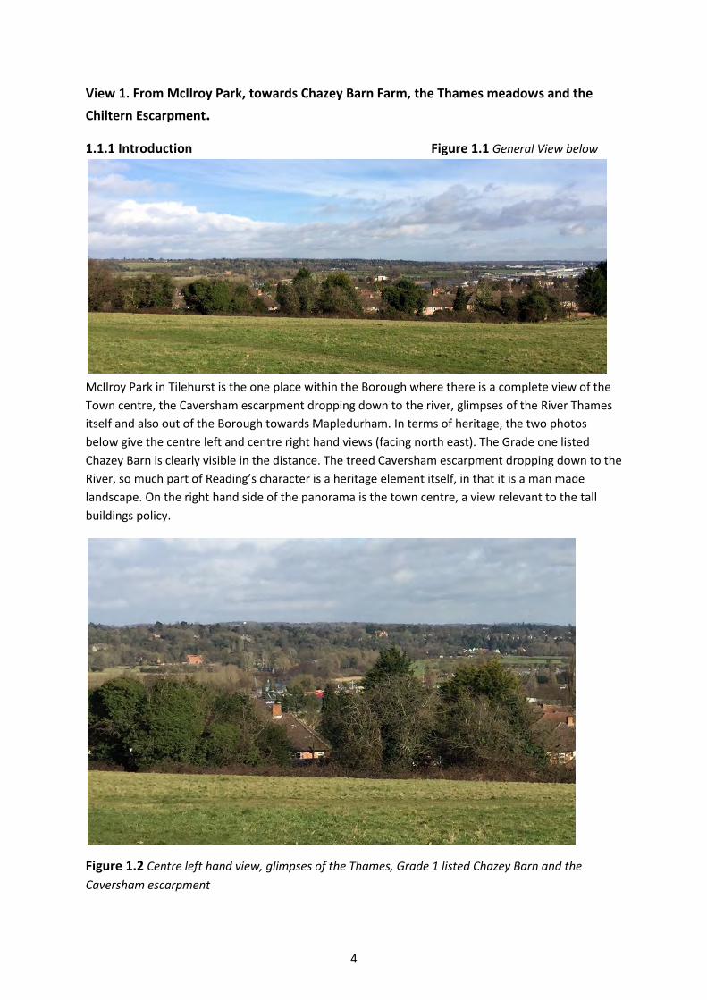
4
View 1. From McIlroy Park, towards Chazey Barn Farm, the Thames meadows and the
Chiltern Escarpment.
1.1.1 Introduction Figure 1.1 General View below
McIlroy Park in Tilehurst is the one place within the Borough where there is a complete view of the
Town centre, the Caversham escarpment dropping down to the river, glimpses of the River Thames
itself and also out of the Borough towards Mapledurham. In terms of heritage, the two photos
below give the centre left and centre right hand views (facing north east). The Grade one listed
Chazey Barn is clearly visible in the distance. The treed Caversham escarpment dropping down to the
River, so much part of Reading’s character is a heritage element itself, in that it is a man made
landscape. On the right hand side of the panorama is the town centre, a view relevant to the tall
buildings policy.
Figure 1.2 Centre left hand view, glimpses of the Thames, Grade 1 listed Chazey Barn and the
Caversham escarpment
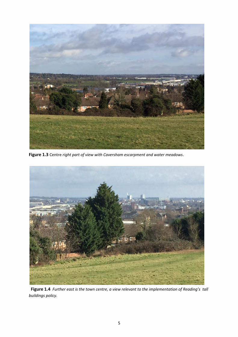
5
Figure 1.3 Centre right part of view with Caversham escarpment and water meadows.
Figure 1.4 Further east is the town centre, a view relevant to the implementation of Reading’s tall
buildings policy.

6
1.1.2 Present Viewers
This is a freely accessible view that many residents of Tilehurst and the surrounding area enjoy and
use on a daily basis. This includes those seeking general recreation and access to semi natural open
space as well as dog walkers. New visitors to the park, on coming out of the woods that enclose the
entrance, find that they have an exceptional view of the Thames Valley and Reading.
The importance of this view of the Thames is recognised by the River Thames Society and the
Thames Rivers Trust who included it in their book, ‘Exploring the Thames Wilderness’. The site was
designated a Local Nature Reserve in 1992 and is one of three which with Lousehill Copse and Arthur
Newbery Park form a wildlife corridor along this ridge above the Thames. Tilehurst Globe produced a
leaflet about the park with a suggested circular walk (Tilehurst Globe www.tlehurst-globe.org.uk/ text
frames/leaflet%20mcilroyss%201.pdf). They describe the park as ‘a mix of ancient woodland and open
meadow land in the heart of Tilehurst’. Friends of McIlroy Park meet monthly (except in August and
December) to carry out tasks in the park.
The view is also experienced from much of the mid 20th Century housing below the Park
contributing to the quality of life for the residents of this area and adding to its attractiveness.
Modest terraces and semi detached houses of limited architectural character nevertheless have
some of the finest views in Reading.
1.1.3 Viewers in the Past
William E C McIlroy donated the land for the park. He was the owner of Reading’s Oxford Street
department store and was Mayor of Reading for five terms from 1938-1943, during the Second
World War. He was made Freeman of the Borough in 1944. He stood unsuccessfully as MP for
Reading In the 1945 general election but was defeated by the Labour candidate Ian Mikardo. The
department store closed in 1955 and the first mention of the park is in the 1956 guide to Reading.
There are two stories about why William McIlroy bought this land and then donated it to Reading
Borough Council for a park and both relate to views. The first story is that he donated the land for
the park to the Borough to protect the view from his house (On old Reading Council website and here
www.geograph.org.uk/photo/612000). He lived at Carrick-a-Rede, 12 Clevedon Road in Tilehurst, at the
bottom of the hill near Tilehurst Station. The second story is that from the café on the top floor of
McIlroy’s Department Store, there was a view of this hill and that the land was purchased to protect
this view (Handscomb. Sue.Tilehurstp85).
It seems likely that he must also have been aware of the View from the hill but further historical
research would be necessary to establish this.

7
Figure 1.5 McIlroy’s Department Store today, Corner of
Oxford Street and Cheapside (photo Evelyn Williams)
1.1.4 The Viewing Place
The viewing place provides ‘kinetic’ views – that is a series of changing panoramic views seen as a
person moves through this linear park. The views change as a result of the direction a person is
facing and the framing effect of trees. With regard to the value of the foreground, the park
preserves a rough grassland character as a foreground with framing provided by hedgerow and small
trees to the north eastern boundary. The grassland reflects the previously pastoral agricultural use
of the land and the history of the hillside. The park is managed to provide wildlife habitat with birds
and insects contributing to its wild life quality.
1.1.5 General Description of the View
McIlroy Park provides a series of wide views towards Mapledurham, the Caversham escarpment, the
Thames water meadows and the Town centre. Mapledurham is outside the Borough boundary and
the views to the Town centre are covered by the tall buildings policy. This description therefore
confines itself to the two ‘central’ views (centre left and centre right facing north east) of the
Caversham escarpment and the Thames water meadows although all four views contribute to and
make up the viewing experience.
1.1.6 Topography and layout of the view
Elevation/Height: McIlroy Park and the Caversham escarpment are at similar elevations or contour
levels and are both circa 40 metres above the level of the Thames and water meadows adjoining it,
which lie in the valley below.
Foreground: The foreground is of rough grassland, hedgerow and trees as described above in 1.1.4.
Middle ground: Due to the topography and the sharp falling away of the land there is a limited
middle ground of trees and hedgerow.
Distant: There are distant fine views of the escarpment, the Thames and the water meadows and
the buildings and structures within these views.
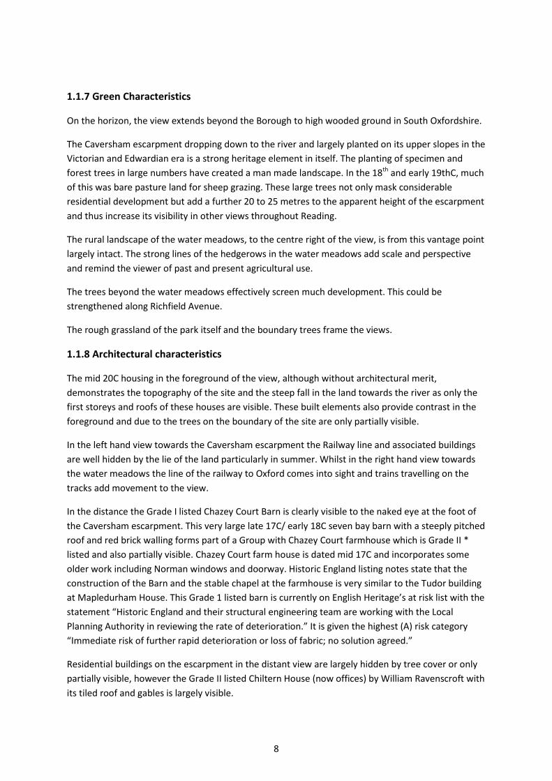
8
1.1.7 Green Characteristics
On the horizon, the view extends beyond the Borough to high wooded ground in South Oxfordshire.
The Caversham escarpment dropping down to the river and largely planted on its upper slopes in the
Victorian and Edwardian era is a strong heritage element in itself. The planting of specimen and
forest trees in large numbers have created a man made landscape. In the 18th and early 19thC, much
of this was bare pasture land for sheep grazing. These large trees not only mask considerable
residential development but add a further 20 to 25 metres to the apparent height of the escarpment
and thus increase its visibility in other views throughout Reading.
The rural landscape of the water meadows, to the centre right of the view, is from this vantage point
largely intact. The strong lines of the hedgerows in the water meadows add scale and perspective
and remind the viewer of past and present agricultural use.
The trees beyond the water meadows effectively screen much development. This could be
strengthened along Richfield Avenue.
The rough grassland of the park itself and the boundary trees frame the views.
1.1.8 Architectural characteristics
The mid 20C housing in the foreground of the view, although without architectural merit,
demonstrates the topography of the site and the steep fall in the land towards the river as only the
first storeys and roofs of these houses are visible. These built elements also provide contrast in the
foreground and due to the trees on the boundary of the site are only partially visible.
In the left hand view towards the Caversham escarpment the Railway line and associated buildings
are well hidden by the lie of the land particularly in summer. Whilst in the right hand view towards
the water meadows the line of the railway to Oxford comes into sight and trains travelling on the
tracks add movement to the view.
In the distance the Grade I listed Chazey Court Barn is clearly visible to the naked eye at the foot of
the Caversham escarpment. This very large late 17C/ early 18C seven bay barn with a steeply pitched
roof and red brick walling forms part of a Group with Chazey Court farmhouse which is Grade II *
listed and also partially visible. Chazey Court farm house is dated mid 17C and incorporates some
older work including Norman windows and doorway. Historic England listing notes state that the
construction of the Barn and the stable chapel at the farmhouse is very similar to the Tudor building
at Mapledurham House. This Grade 1 listed barn is currently on English Heritage’s at risk list with the
statement “Historic England and their structural engineering team are working with the Local
Planning Authority in reviewing the rate of deterioration.” It is given the highest (A) risk category
“Immediate risk of further rapid deterioration or loss of fabric; no solution agreed.”
Residential buildings on the escarpment in the distant view are largely hidden by tree cover or only
partially visible, however the Grade II listed Chiltern House (now offices) by William Ravenscroft with
its tiled roof and gables is largely visible.
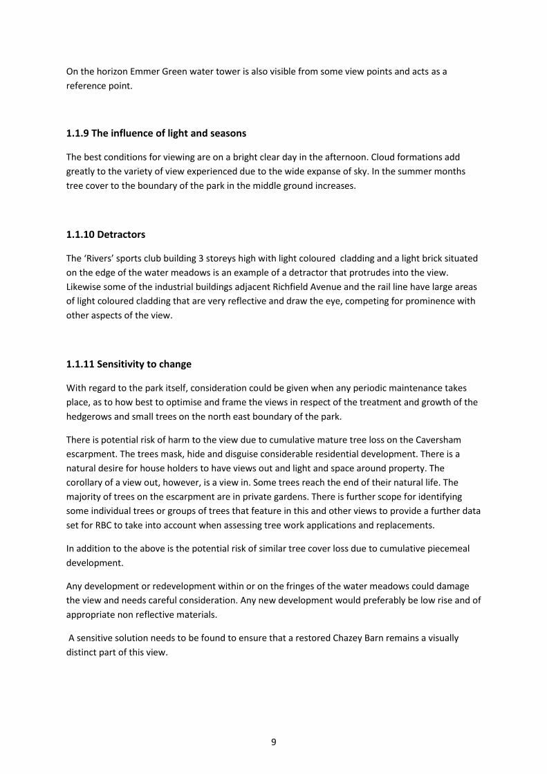
9
On the horizon Emmer Green water tower is also visible from some view points and acts as a
reference point.
1.1.9 The influence of light and seasons
The best conditions for viewing are on a bright clear day in the afternoon. Cloud formations add
greatly to the variety of view experienced due to the wide expanse of sky. In the summer months
tree cover to the boundary of the park in the middle ground increases.
1.1.10 Detractors
The ‘Rivers’ sports club building 3 storeys high with light coloured cladding and a light brick situated
on the edge of the water meadows is an example of a detractor that protrudes into the view.
Likewise some of the industrial buildings adjacent Richfield Avenue and the rail line have large areas
of light coloured cladding that are very reflective and draw the eye, competing for prominence with
other aspects of the view.
1.1.11 Sensitivity to change
With regard to the park itself, consideration could be given when any periodic maintenance takes
place, as to how best to optimise and frame the views in respect of the treatment and growth of the
hedgerows and small trees on the north east boundary of the park.
There is potential risk of harm to the view due to cumulative mature tree loss on the Caversham
escarpment. The trees mask, hide and disguise considerable residential development. There is a
natural desire for house holders to have views out and light and space around property. The
corollary of a view out, however, is a view in. Some trees reach the end of their natural life. The
majority of trees on the escarpment are in private gardens. There is further scope for identifying
some individual trees or groups of trees that feature in this and other views to provide a further data
set for RBC to take into account when assessing tree work applications and replacements.
In addition to the above is the potential risk of similar tree cover loss due to cumulative piecemeal
development.
Any development or redevelopment within or on the fringes of the water meadows could damage
the view and needs careful consideration. Any new development would preferably be low rise and of
appropriate non reflective materials.
A sensitive solution needs to be found to ensure that a restored Chazey Barn remains a visually
distinct part of this view.
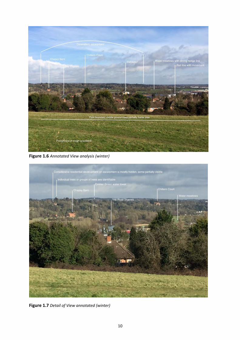
10
Figure 1.6 Annotated View analysis (winter)
Figure 1.7 Detail of View annotated (winter)

11
Figure 1.8 Detail
of View, Grade I
listed Chazey
barn, with the
Thames below
and to the right
Figure 1.9 Plan showing Viewing place and View (Map data: Copyright Google, Digital Globe)
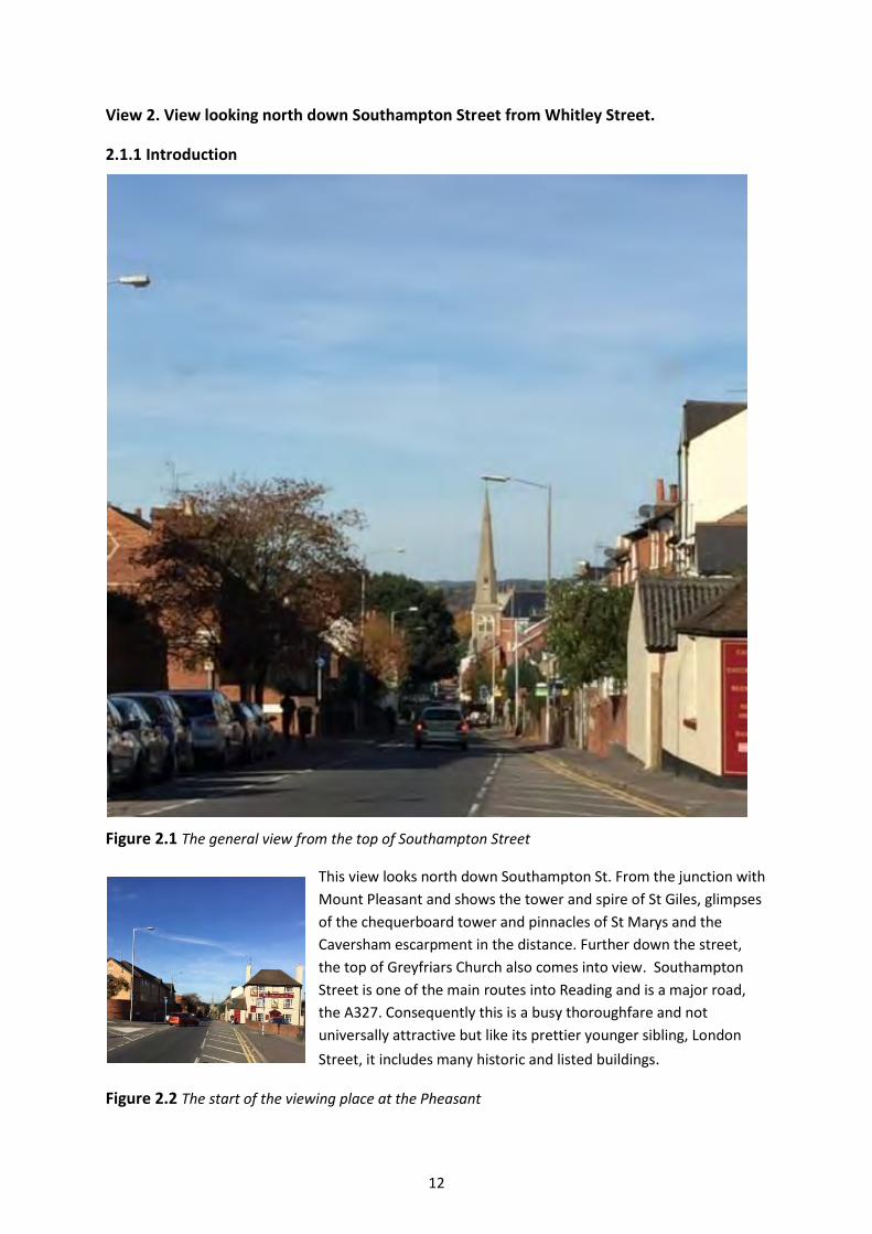
12
View 2. View looking north down Southampton Street from Whitley Street.
2.1.1 Introduction
Figure 2.1 The general view from the top of Southampton Street
This view looks north down Southampton St. From the junction with
Mount Pleasant and shows the tower and spire of St Giles, glimpses
of the chequerboard tower and pinnacles of St Marys and the
Caversham escarpment in the distance. Further down the street,
the top of Greyfriars Church also comes into view. Southampton
Street is one of the main routes into Reading and is a major road,
the A327. Consequently this is a busy thoroughfare and not
universally attractive but like its prettier younger sibling, London
Street, it includes many historic and listed buildings.
Figure 2.2 The start of the viewing place at the Pheasant
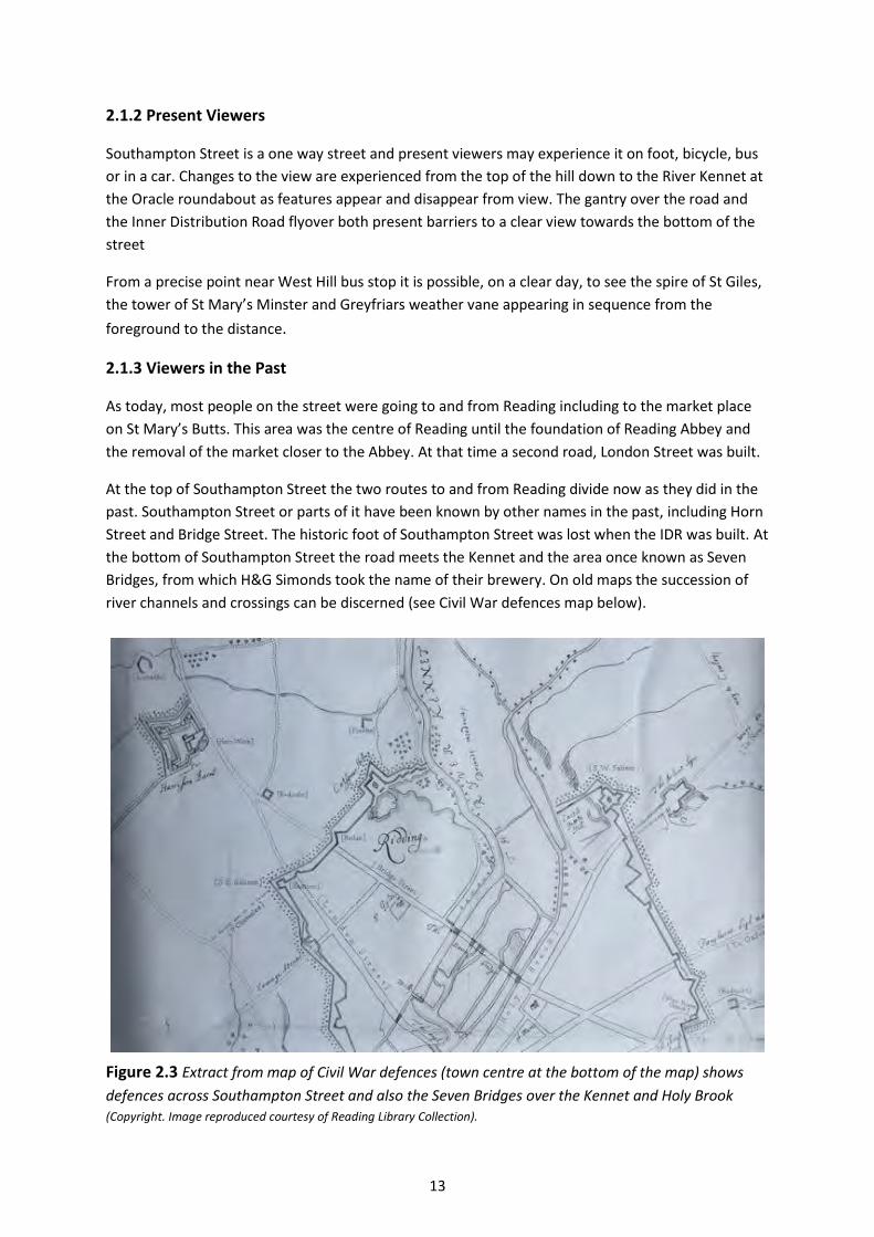
13
2.1.2 Present Viewers
Southampton Street is a one way street and present viewers may experience it on foot, bicycle, bus
or in a car. Changes to the view are experienced from the top of the hill down to the River Kennet at
the Oracle roundabout as features appear and disappear from view. The gantry over the road and
the Inner Distribution Road flyover both present barriers to a clear view towards the bottom of the
street
From a precise point near West Hill bus stop it is possible, on a clear day, to see the spire of St Giles,
the tower of St Mary’s Minster and Greyfriars weather vane appearing in sequence from the
foreground to the distance.
2.1.3 Viewers in the Past
As today, most people on the street were going to and from Reading including to the market place
on St Mary’s Butts. This area was the centre of Reading until the foundation of Reading Abbey and
the removal of the market closer to the Abbey. At that time a second road, London Street was built.
At the top of Southampton Street the two routes to and from Reading divide now as they did in the
past. Southampton Street or parts of it have been known by other names in the past, including Horn
Street and Bridge Street. The historic foot of Southampton Street was lost when the IDR was built. At
the bottom of Southampton Street the road meets the Kennet and the area once known as Seven
Bridges, from which H&G Simonds took the name of their brewery. On old maps the succession of
river channels and crossings can be discerned (see Civil War defences map below).
Figure 2.3 Extract from map of Civil War defences (town centre at the bottom of the map) shows
defences across Southampton Street and also the Seven Bridges over the Kennet and Holy Brook (Copyright. Image reproduced courtesy of Reading Library Collection).
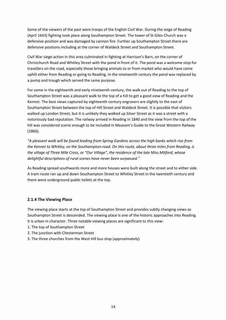
14
Some of the viewers of the past were troops of the English Civil War. During the siege of Reading
(April 1643) fighting took place along Southampton Street. The tower of St Giles Church was a
defensive position and was damaged by cannon fire. Further up Southampton Street there are
defensive positions including at the corner of Waldeck Street and Southampton Street.
Civil War siege action in this area culminated in fighting at Harrison’s Barn, on the corner of
Christchurch Road and Whitley Street with the pond in front of it. The pond was a welcome stop for
travellers on the road, especially those bringing animals to or from market who would have come
uphill either from Reading or going to Reading. In the nineteenth century the pond was replaced by
a pump and trough which served the same purpose.
For some in the eighteenth and early nineteenth century, the walk out of Reading to the top of
Southampton Street was a pleasant walk to the top of a hill to get a good view of Reading and the
Kennet. The best views captured by eighteenth century engravers are slightly to the east of
Southampton Street between the top of Hill Street and Waldeck Street. It is possible that visitors
walked up London Street, but it is unlikely they walked up Silver Street as it was a street with a
notoriously bad reputation. The railway arrived in Reading in 1840 and the view from the top of the
hill was considered scenic enough to be included in Measom’s Guide to the Great Western Railway
(1860).
“A pleasant walk will be found leading from Spring Gardens across the high banks which rise from
the Kennet to Whitley, on the Southampton-road. On this route, about three miles from Reading, is
the village of Three Mile Cross, or “Our Village”, the residence of the late Miss Mitford, whose
delightful descriptions of rural scenes have never been surpassed.”
As Reading spread southwards more and more houses were built along the street and to either side.
A tram route ran up and down Southampton Street to Whitley Street in the twentieth century and
there were underground public toilets at the top.
2.1.4 The Viewing Place
The viewing place starts at the top of Southampton Street and provides subtly changing views as
Southampton Street is descended. The viewing place is one of the historic approaches into Reading.
It is urban in character. Three notable viewing places are significant to this view:
1. The top of Southampton Street
2. The junction with Chesterman Street
3. The three churches from the West Hill bus stop (approximately)
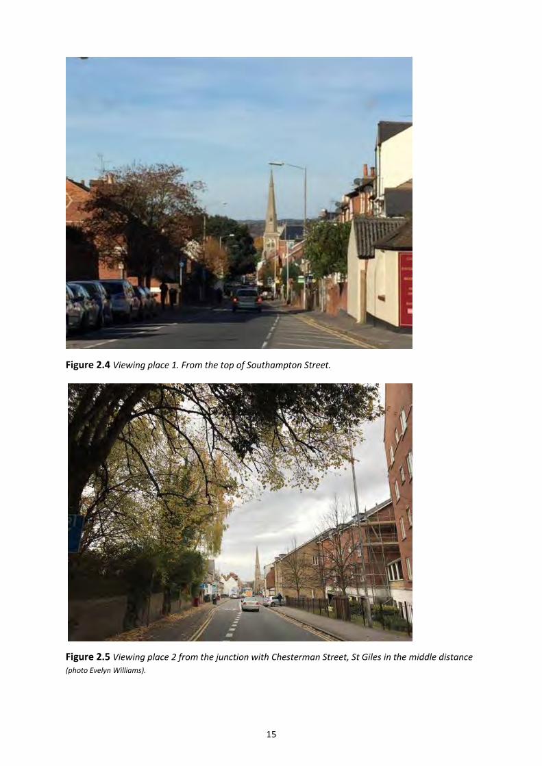
15
Figure 2.4 Viewing place 1. From the top of Southampton Street.
Figure 2.5 Viewing place 2 from the junction with Chesterman Street, St Giles in the middle distance
(photo Evelyn Williams).
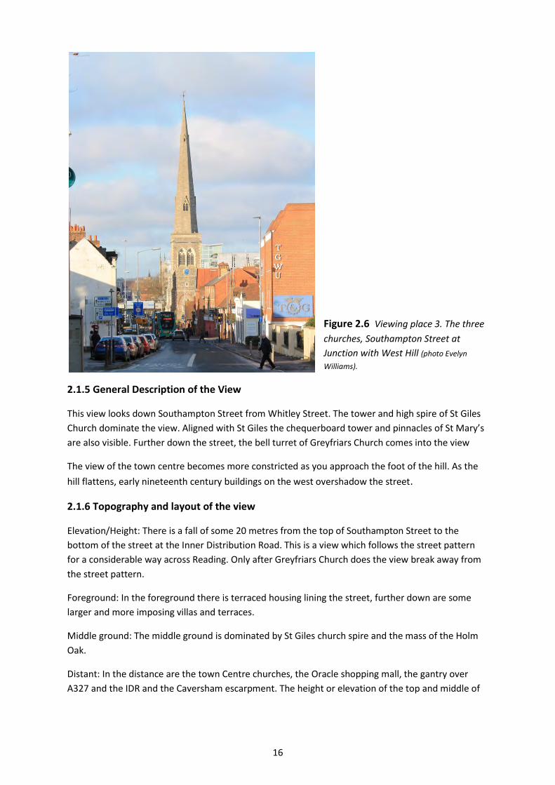
16
Figure 2.6 Viewing place 3. The three
churches, Southampton Street at
Junction with West Hill (photo Evelyn
Williams).
2.1.5 General Description of the View
This view looks down Southampton Street from Whitley Street. The tower and high spire of St Giles
Church dominate the view. Aligned with St Giles the chequerboard tower and pinnacles of St Mary’s
are also visible. Further down the street, the bell turret of Greyfriars Church comes into the view
The view of the town centre becomes more constricted as you approach the foot of the hill. As the
hill flattens, early nineteenth century buildings on the west overshadow the street.
2.1.6 Topography and layout of the view
Elevation/Height: There is a fall of some 20 metres from the top of Southampton Street to the
bottom of the street at the Inner Distribution Road. This is a view which follows the street pattern
for a considerable way across Reading. Only after Greyfriars Church does the view break away from
the street pattern.
Foreground: In the foreground there is terraced housing lining the street, further down are some
larger and more imposing villas and terraces.
Middle ground: The middle ground is dominated by St Giles church spire and the mass of the Holm
Oak.
Distant: In the distance are the town Centre churches, the Oracle shopping mall, the gantry over
A327 and the IDR and the Caversham escarpment. The height or elevation of the top and middle of
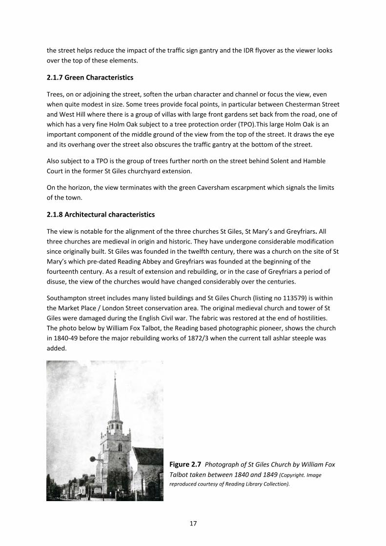
17
the street helps reduce the impact of the traffic sign gantry and the IDR flyover as the viewer looks
over the top of these elements.
2.1.7 Green Characteristics
Trees, on or adjoining the street, soften the urban character and channel or focus the view, even
when quite modest in size. Some trees provide focal points, in particular between Chesterman Street
and West Hill where there is a group of villas with large front gardens set back from the road, one of
which has a very fine Holm Oak subject to a tree protection order (TPO).This large Holm Oak is an
important component of the middle ground of the view from the top of the street. It draws the eye
and its overhang over the street also obscures the traffic gantry at the bottom of the street.
Also subject to a TPO is the group of trees further north on the street behind Solent and Hamble
Court in the former St Giles churchyard extension.
On the horizon, the view terminates with the green Caversham escarpment which signals the limits
of the town.
2.1.8 Architectural characteristics
The view is notable for the alignment of the three churches St Giles, St Mary’s and Greyfriars. All
three churches are medieval in origin and historic. They have undergone considerable modification
since originally built. St Giles was founded in the twelfth century, there was a church on the site of St
Mary’s which pre-dated Reading Abbey and Greyfriars was founded at the beginning of the
fourteenth century. As a result of extension and rebuilding, or in the case of Greyfriars a period of
disuse, the view of the churches would have changed considerably over the centuries.
Southampton street includes many listed buildings and St Giles Church (listing no 113579) is within
the Market Place / London Street conservation area. The original medieval church and tower of St
Giles were damaged during the English Civil war. The fabric was restored at the end of hostilities.
The photo below by William Fox Talbot, the Reading based photographic pioneer, shows the church
in 1840-49 before the major rebuilding works of 1872/3 when the current tall ashlar steeple was
added.
Figure 2.7 Photograph of St Giles Church by William Fox
Talbot taken between 1840 and 1849 (Copyright. Image
reproduced courtesy of Reading Library Collection).
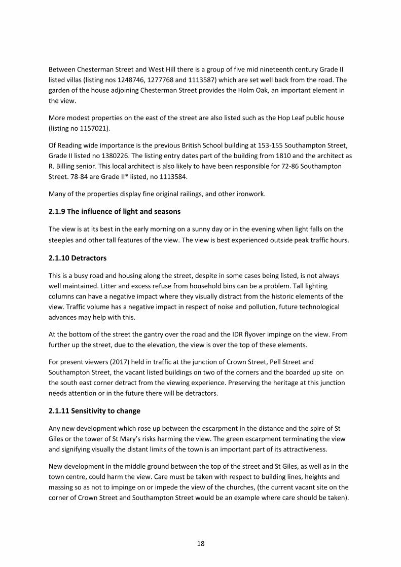
18
Between Chesterman Street and West Hill there is a group of five mid nineteenth century Grade II
listed villas (listing nos 1248746, 1277768 and 1113587) which are set well back from the road. The
garden of the house adjoining Chesterman Street provides the Holm Oak, an important element in
the view.
More modest properties on the east of the street are also listed such as the Hop Leaf public house
(listing no 1157021).
Of Reading wide importance is the previous British School building at 153-155 Southampton Street,
Grade II listed no 1380226. The listing entry dates part of the building from 1810 and the architect as
R. Billing senior. This local architect is also likely to have been responsible for 72-86 Southampton
Street. 78-84 are Grade II* listed, no 1113584.
Many of the properties display fine original railings, and other ironwork.
2.1.9 The influence of light and seasons
The view is at its best in the early morning on a sunny day or in the evening when light falls on the
steeples and other tall features of the view. The view is best experienced outside peak traffic hours.
2.1.10 Detractors
This is a busy road and housing along the street, despite in some cases being listed, is not always
well maintained. Litter and excess refuse from household bins can be a problem. Tall lighting
columns can have a negative impact where they visually distract from the historic elements of the
view. Traffic volume has a negative impact in respect of noise and pollution, future technological
advances may help with this.
At the bottom of the street the gantry over the road and the IDR flyover impinge on the view. From
further up the street, due to the elevation, the view is over the top of these elements.
For present viewers (2017) held in traffic at the junction of Crown Street, Pell Street and
Southampton Street, the vacant listed buildings on two of the corners and the boarded up site on
the south east corner detract from the viewing experience. Preserving the heritage at this junction
needs attention or in the future there will be detractors.
2.1.11 Sensitivity to change
Any new development which rose up between the escarpment in the distance and the spire of St
Giles or the tower of St Mary’s risks harming the view. The green escarpment terminating the view
and signifying visually the distant limits of the town is an important part of its attractiveness.
New development in the middle ground between the top of the street and St Giles, as well as in the
town centre, could harm the view. Care must be taken with respect to building lines, heights and
massing so as not to impinge on or impede the view of the churches, (the current vacant site on the
corner of Crown Street and Southampton Street would be an example where care should be taken).

19
Continuing inadequate maintenance of Listed Buildings or insensitive re use would be a negative
factor, whilst the converse of better and appropriate maintenance has the potential to improve the
viewing experience.
Figure 2.8 Annotated View analysis
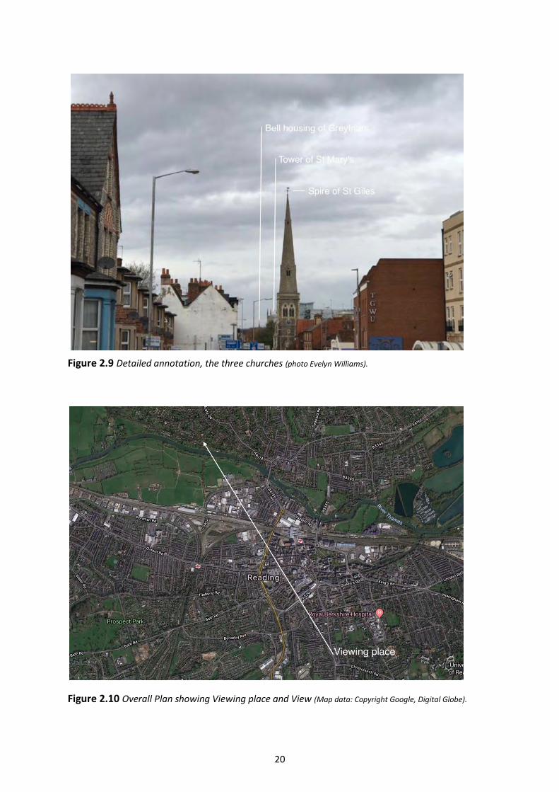
20
Figure 2.9 Detailed annotation, the three churches (photo Evelyn Williams).
Figure 2.10 Overall Plan showing Viewing place and View (Map data: Copyright Google, Digital Globe).
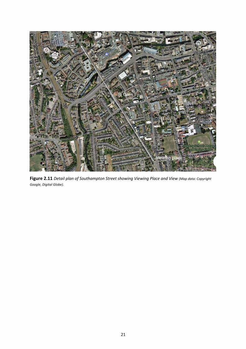
21
Figure 2.11 Detail plan of Southampton Street showing Viewing Place and View (Map data: Copyright
Google, Digital Globe).

22
View 3. View upstream from Caversham Bridge
3.1.1 Introduction
The view upstream from Caversham Bridge captures part of the Caversham escarpment. This
escarpment has wide significance for the character of Reading. It is visible from the train,
approaching Reading, the train station itself and in many other views from the south side of town. Its
comprehensive tree cover, a man made heritage of the 19th Century hides and disguises
considerable density of development. The tower of St Peter’s Church is visible within this view
particularly in winter.
Figure 3.1 From the Viewing Place on the central buttress of the Bridge looking upstream (winter)
3.1.2 Present Viewers
The Viewers today are commuters travelling to and from work, shoppers heading for the town
centre, joggers and families visiting the Promenade. Anyone taking a bus to or from Reading
experiences this view. Other present day viewers are walkers tackling the long distance Thames path
and those using the river for leisure and sporting pursuits such as rowers and boaters on the river.
This is a view which many people experience as part of their daily life rather than seeking out or
visiting especially.

23
3.1.3 Viewers in the Past
There has been a bridge on this site for approximately 900 years. In the middle ages pilgrims crossed
the Bridge between the shrines in Caversham and Reading Abbey and paid tolls. There was a ferry
alongside the bridge for those who could not afford the tolls. In 1642 during the English Civil War,
Charles I lead his troops over the Bridge to set up a garrison in Reading.
Views from the Bridge and of the Bridge were popular with artists at the beginning of the 19th
Century. There is a view from the Bridge by Edmund Havell Senior made in the early part of the
century. William Turner visited the area and painted the Bridge itself from upstream in 1806-7, this
oil painting is in the Tate Gallery.
Figure 3.2 ‘Caversham from the Bridge’ looking upstream by Edmund Havell Senior 1825
(Copyright Reading Museum (Reading Borough Council) All rights reserved)
Figure 3.3 ‘Caversham Bridge with Cattle in the Water’, c.1806-7, Joseph Mallard William Turner (1775-1851), Accepted by
the nation as part of the Turner Bequest 1856. Photo © Tate, London 2018
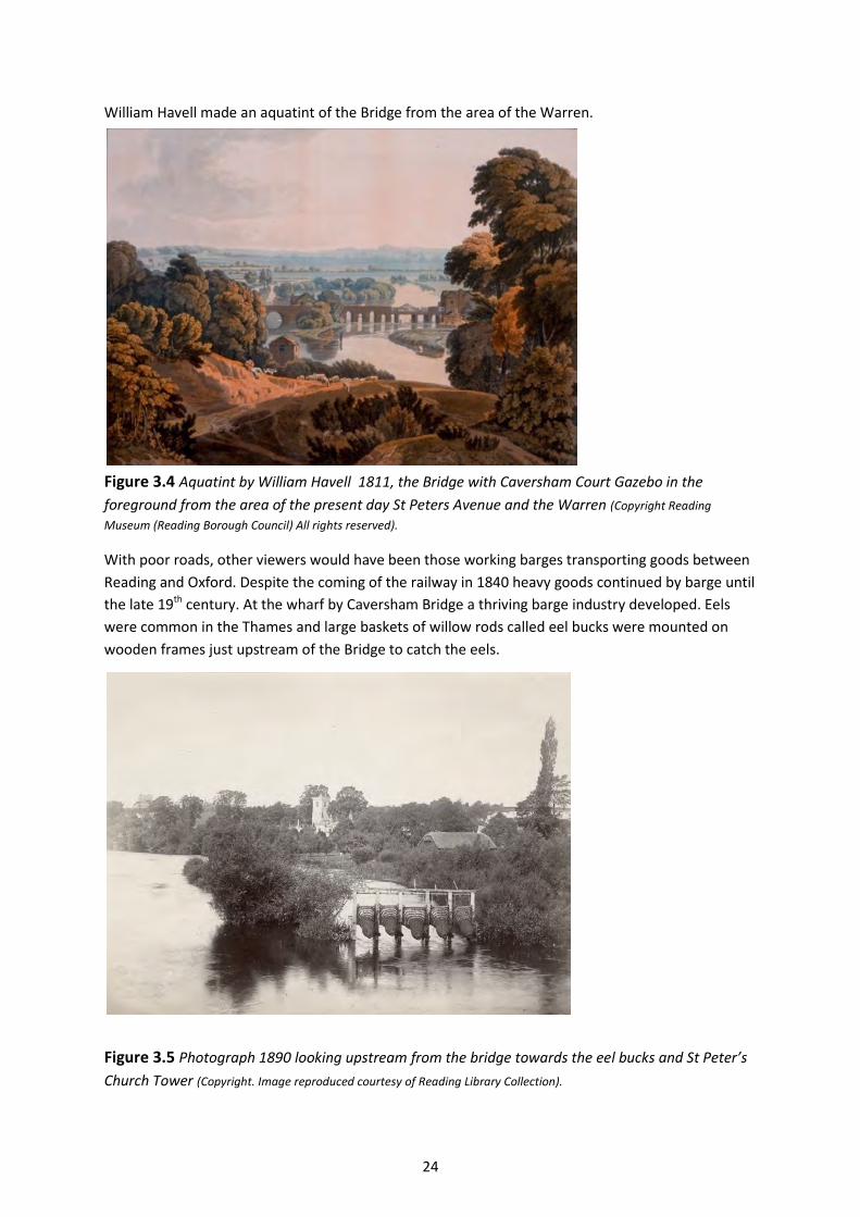
24
William Havell made an aquatint of the Bridge from the area of the Warren.
Figure 3.4 Aquatint by William Havell 1811, the Bridge with Caversham Court Gazebo in the
foreground from the area of the present day St Peters Avenue and the Warren (Copyright Reading
Museum (Reading Borough Council) All rights reserved).
With poor roads, other viewers would have been those working barges transporting goods between
Reading and Oxford. Despite the coming of the railway in 1840 heavy goods continued by barge until
the late 19th century. At the wharf by Caversham Bridge a thriving barge industry developed. Eels
were common in the Thames and large baskets of willow rods called eel bucks were mounted on
wooden frames just upstream of the Bridge to catch the eels.
Figure 3.5 Photograph 1890 looking upstream from the bridge towards the eel bucks and St Peter’s
Church Tower (Copyright. Image reproduced courtesy of Reading Library Collection).
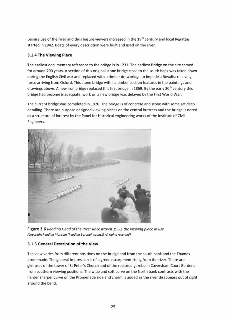
25
Leisure use of the river and thus leisure viewers increased in the 19th century and local Regattas
started in 1842. Boats of every description were built and used on the river.
3.1.4 The Viewing Place
The earliest documentary reference to the bridge is in 1231. The earliest Bridge on the site served
for around 700 years. A section of this original stone bridge close to the south bank was taken down
during the English Civil war and replaced with a timber drawbridge to impede a Royalist relieving
force arriving from Oxford. This stone bridge with its timber section features in the paintings and
drawings above. A new iron bridge replaced this first bridge in 1869. By the early 20th century this
bridge had become inadequate, work on a new bridge was delayed by the First World War.
The current bridge was completed in 1926. The bridge is of concrete and stone with some art deco
detailing. There are purpose designed viewing places on the central buttress and the bridge is noted
as a structure of interest by the Panel for Historical engineering works of the Institute of Civil
Engineers.
Figure 3.6 Reading Head of the River Race March 1950, the viewing place in use
(Copyright Reading Museum (Reading Borough council) All rights reserved).
3.1.5 General Description of the View
The view varies from different positions on the bridge and from the south bank and the Thames
promenade. The general impression is of a green escarpment rising from the river. There are
glimpses of the tower of St Peter’s Church and of the restored gazebo in Caversham Court Gardens
from southern viewing positions. The wide and soft curve on the North bank contrasts with the
harder sharper curve on the Promenade side and charm is added as the river disappears out of sight
around the bend.
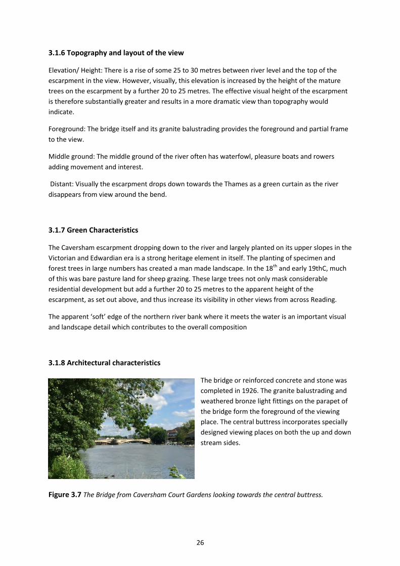
26
3.1.6 Topography and layout of the view
Elevation/ Height: There is a rise of some 25 to 30 metres between river level and the top of the
escarpment in the view. However, visually, this elevation is increased by the height of the mature
trees on the escarpment by a further 20 to 25 metres. The effective visual height of the escarpment
is therefore substantially greater and results in a more dramatic view than topography would
indicate.
Foreground: The bridge itself and its granite balustrading provides the foreground and partial frame
to the view.
Middle ground: The middle ground of the river often has waterfowl, pleasure boats and rowers
adding movement and interest.
Distant: Visually the escarpment drops down towards the Thames as a green curtain as the river
disappears from view around the bend.
3.1.7 Green Characteristics
The Caversham escarpment dropping down to the river and largely planted on its upper slopes in the
Victorian and Edwardian era is a strong heritage element in itself. The planting of specimen and
forest trees in large numbers has created a man made landscape. In the 18th and early 19thC, much
of this was bare pasture land for sheep grazing. These large trees not only mask considerable
residential development but add a further 20 to 25 metres to the apparent height of the
escarpment, as set out above, and thus increase its visibility in other views from across Reading.
The apparent ‘soft’ edge of the northern river bank where it meets the water is an important visual
and landscape detail which contributes to the overall composition
3.1.8 Architectural characteristics
The bridge or reinforced concrete and stone was
completed in 1926. The granite balustrading and
weathered bronze light fittings on the parapet of
the bridge form the foreground of the viewing
place. The central buttress incorporates specially
designed viewing places on both the up and down
stream sides.
Figure 3.7 The Bridge from Caversham Court Gardens looking towards the central buttress.
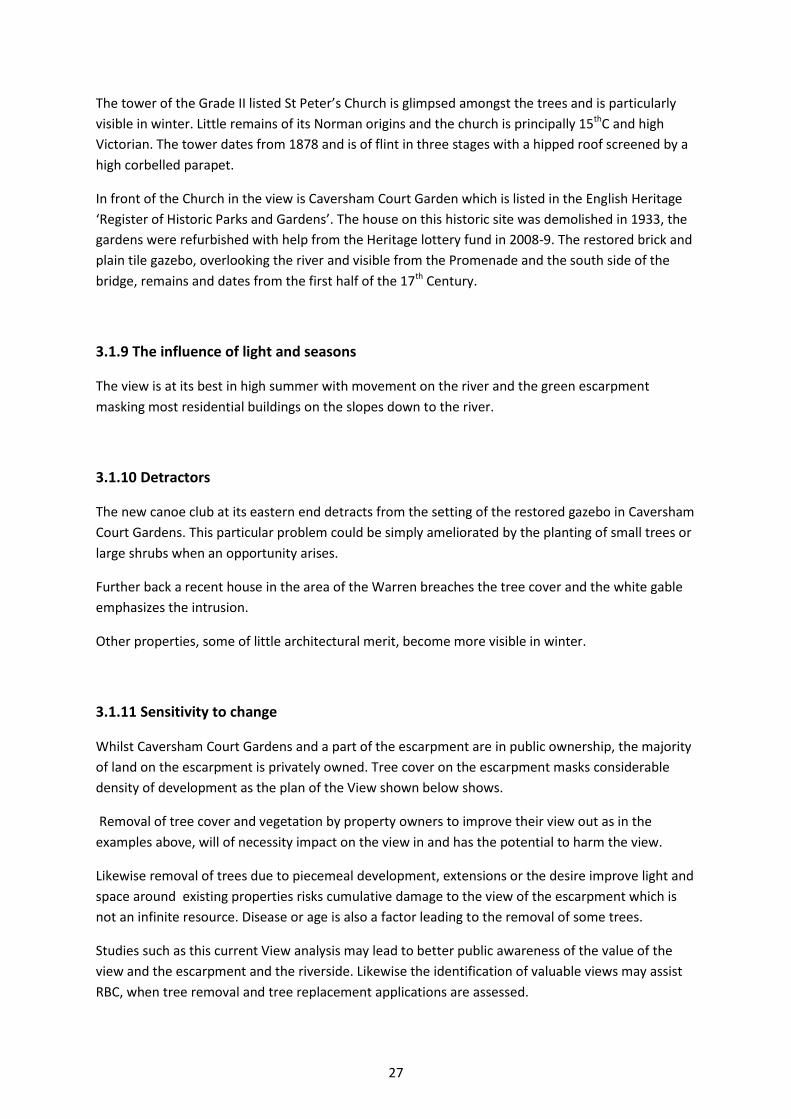
27
The tower of the Grade II listed St Peter’s Church is glimpsed amongst the trees and is particularly
visible in winter. Little remains of its Norman origins and the church is principally 15thC and high
Victorian. The tower dates from 1878 and is of flint in three stages with a hipped roof screened by a
high corbelled parapet.
In front of the Church in the view is Caversham Court Garden which is listed in the English Heritage
‘Register of Historic Parks and Gardens’. The house on this historic site was demolished in 1933, the
gardens were refurbished with help from the Heritage lottery fund in 2008-9. The restored brick and
plain tile gazebo, overlooking the river and visible from the Promenade and the south side of the
bridge, remains and dates from the first half of the 17th Century.
3.1.9 The influence of light and seasons
The view is at its best in high summer with movement on the river and the green escarpment
masking most residential buildings on the slopes down to the river.
3.1.10 Detractors
The new canoe club at its eastern end detracts from the setting of the restored gazebo in Caversham
Court Gardens. This particular problem could be simply ameliorated by the planting of small trees or
large shrubs when an opportunity arises.
Further back a recent house in the area of the Warren breaches the tree cover and the white gable
emphasizes the intrusion.
Other properties, some of little architectural merit, become more visible in winter.
3.1.11 Sensitivity to change
Whilst Caversham Court Gardens and a part of the escarpment are in public ownership, the majority
of land on the escarpment is privately owned. Tree cover on the escarpment masks considerable
density of development as the plan of the View shown below shows.
Removal of tree cover and vegetation by property owners to improve their view out as in the
examples above, will of necessity impact on the view in and has the potential to harm the view.
Likewise removal of trees due to piecemeal development, extensions or the desire improve light and
space around existing properties risks cumulative damage to the view of the escarpment which is
not an infinite resource. Disease or age is also a factor leading to the removal of some trees.
Studies such as this current View analysis may lead to better public awareness of the value of the
view and the escarpment and the riverside. Likewise the identification of valuable views may assist
RBC, when tree removal and tree replacement applications are assessed.

28
At river level part of the charm of the view is the contrast between the sharp hard curve of the
southern bank with the wide soft green curve of the north bank. It is important that the soft north
bank is maintained. Close to the bridge, one length of bank has been sheet steel piled at the river
edge to an unnecessary height adding a hard and discordant element. Further sheet steel piling of
other parts of the northern river bank to an excessive height should be discouraged and sympathetic
edge treatments should be sought where work is required to stabilise the river bank.
Figure 3.8 Annotated View analysis ( winter view )
Figure 3.9 Canoe club and restored gazebo Figure 3.10 Glimpse of Church from south bank
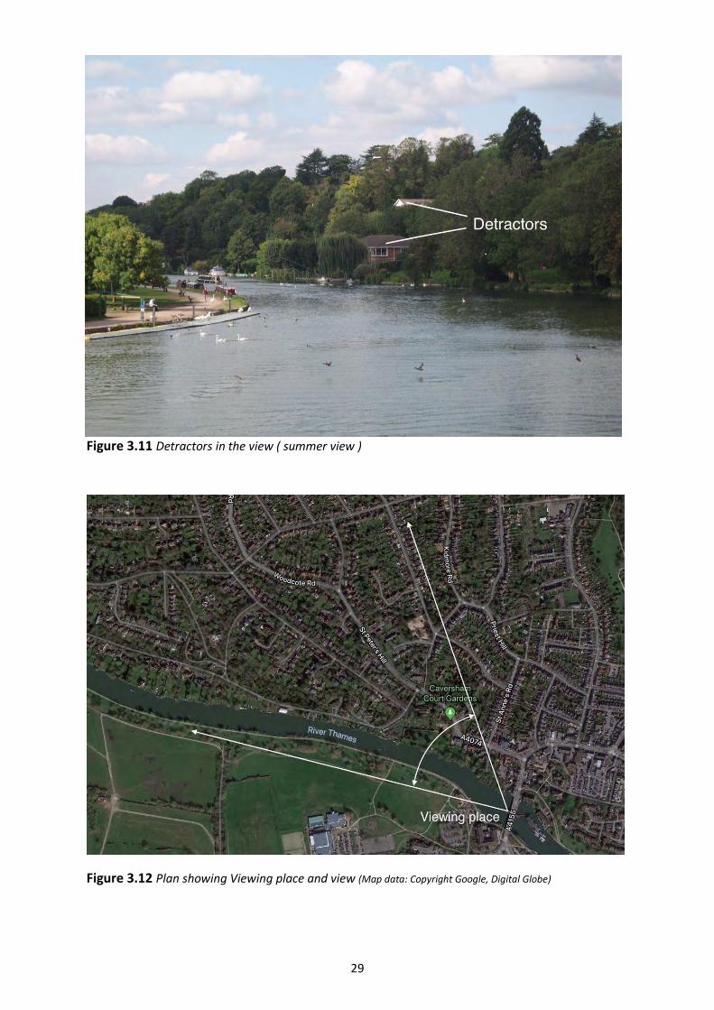
29
Figure 3.11 Detractors in the view ( summer view )
Figure 3.12 Plan showing Viewing place and view (Map data: Copyright Google, Digital Globe)
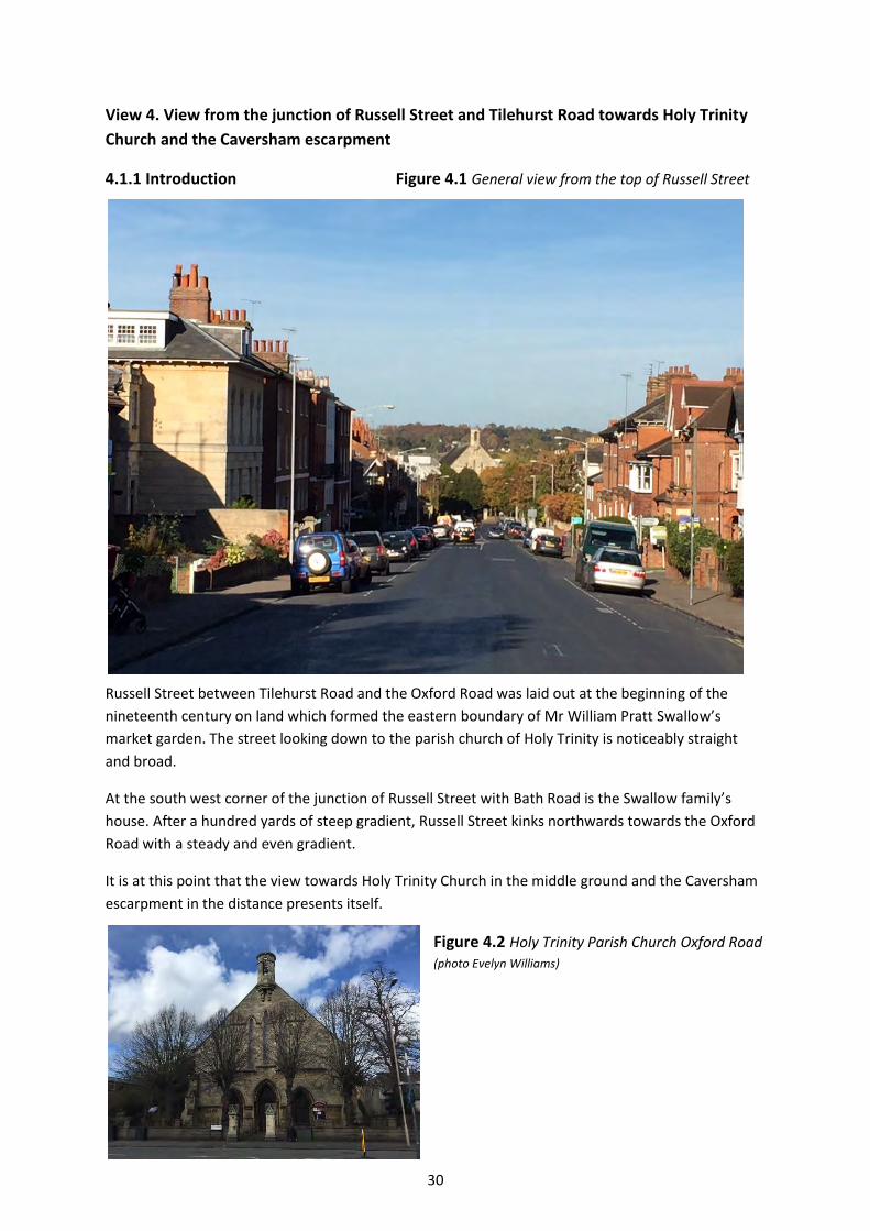
30
View 4. View from the junction of Russell Street and Tilehurst Road towards Holy Trinity
Church and the Caversham escarpment
4.1.1 Introduction Figure 4.1 General view from the top of Russell Street
Russell Street between Tilehurst Road and the Oxford Road was laid out at the beginning of the
nineteenth century on land which formed the eastern boundary of Mr William Pratt Swallow’s
market garden. The street looking down to the parish church of Holy Trinity is noticeably straight
and broad.
At the south west corner of the junction of Russell Street with Bath Road is the Swallow family’s
house. After a hundred yards of steep gradient, Russell Street kinks northwards towards the Oxford
Road with a steady and even gradient.
It is at this point that the view towards Holy Trinity Church in the middle ground and the Caversham
escarpment in the distance presents itself.
Figure 4.2 Holy Trinity Parish Church Oxford Road
(photo Evelyn Williams)

31
4.1.2 Present Viewers
Russell Street is a two-way street on more than one bus route. Changes to the view are experienced
from the top of the hill down to the Oxford Road as the gradient levels.
The viewer has Holy Trinity Church as an end point in the middle distance between a corridor of
Georgian homes to the west and mostly Victorian homes to the east.
Figure 4.3 Google map of the
street today (Map data: Copyright
Google, Digital globe).
4.1.3 Viewers in the Past
Some of the viewers of the past may have been troops of the English Civil War manning ‘The
Forlornd Hope’ astride the Bath Road. At the beginning of the nineteenth century this was market
gardens with few buildings interrupting a 360o view, except for those on Castle Street and St Mary’s
Butts.
Figure 4.4 Extract from Man’s
Map of 1798, Route of Russell
Street marked in green.
(Copyright. Image reproduced courtesy
of Reading Library collection)
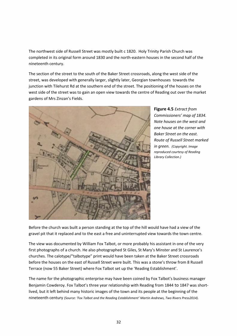
32
The northwest side of Russell Street was mostly built c 1820. Holy Trinity Parish Church was
completed in its original form around 1830 and the north-eastern houses in the second half of the
nineteenth century.
The section of the street to the south of the Baker Street crossroads, along the west side of the
street, was developed with generally larger, slightly later, Georgian townhouses towards the
junction with Tilehurst Rd at the southern end of the street. The positioning of the houses on the
west side of the street was to gain an open view towards the centre of Reading out over the market
gardens of Mrs Zinzan’s Fields.
Figure 4.5 Extract from
Commissioners’ map of 1834.
Note houses on the west and
one house at the corner with
Baker Street on the east.
Route of Russell Street marked
in green. (Copyright. Image
reproduced courtesy of Reading
Library Collection.)
Before the church was built a person standing at the top of the hill would have had a view of the
gravel pit that it replaced and to the east a free and uninterrupted view towards the town centre.
The view was documented by William Fox Talbot, or more probably his assistant in one of the very
first photographs of a church. He also photographed St Giles, St Mary’s Minster and St Laurence’s
churches. The calotype/“talbotype” print would have been taken at the Baker Street crossroads
before the houses on the east of Russell Street were built. This was a stone’s throw from 8 Russell
Terrace (now 55 Baker Street) where Fox Talbot set up the ‘Reading Establishment’.
The name for the photographic enterprise may have been coined by Fox Talbot’s business manager
Benjamin Cowderoy. Fox Talbot’s three year relationship with Reading from 1844 to 1847 was short-
lived, but it left behind many historic images of the town and its people at the beginning of the
nineteenth century (Source: ‘Fox Talbot and the Reading Establishment’ Martin Andrews, Two Rivers Press2014).
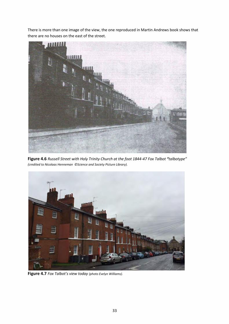
33
There is more than one image of the view, the one reproduced in Martin Andrews book shows that
there are no houses on the east of the street.
Figure 4.6 Russell Street with Holy Trinity Church at the foot 1844-47 Fox Talbot “talbotype”
(credited to Nicolaas Henneman ©Science and Society Picture Library).
Figure 4.7 Fox Talbot’s view today (photo Evelyn Williams).
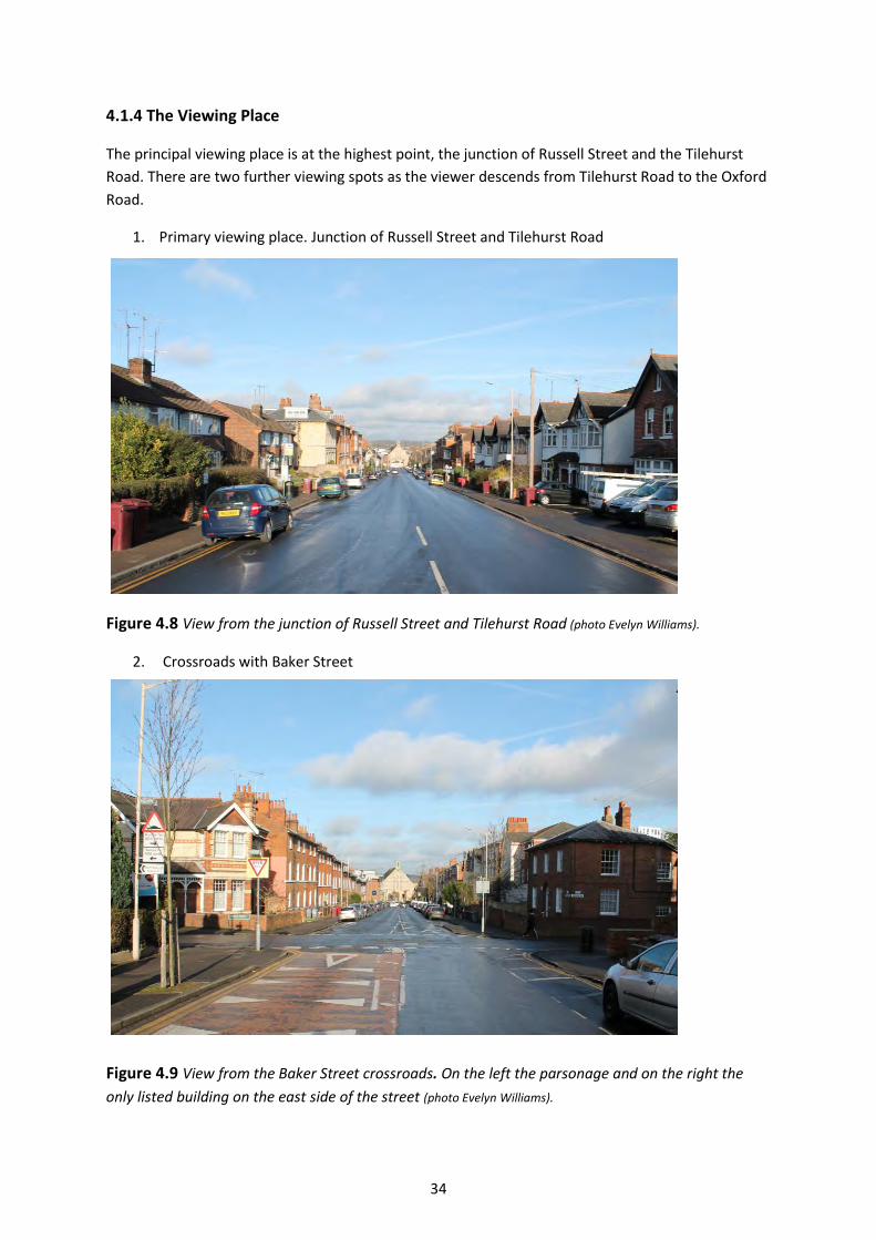
34
4.1.4 The Viewing Place
The principal viewing place is at the highest point, the junction of Russell Street and the Tilehurst
Road. There are two further viewing spots as the viewer descends from Tilehurst Road to the Oxford
Road.
1. Primary viewing place. Junction of Russell Street and Tilehurst Road
Figure 4.8 View from the junction of Russell Street and Tilehurst Road (photo Evelyn Williams).
2. Crossroads with Baker Street
Figure 4.9 View from the Baker Street crossroads. On the left the parsonage and on the right the
only listed building on the east side of the street (photo Evelyn Williams).
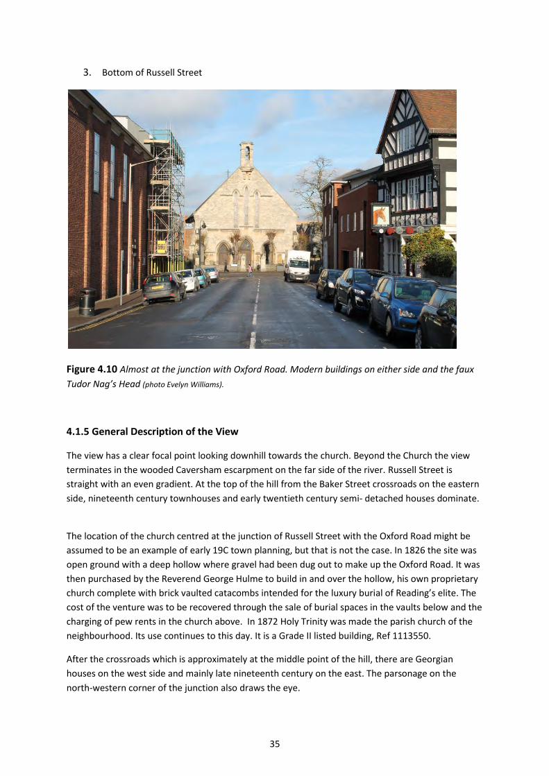
35
3. Bottom of Russell Street
Figure 4.10 Almost at the junction with Oxford Road. Modern buildings on either side and the faux
Tudor Nag’s Head (photo Evelyn Williams).
4.1.5 General Description of the View
The view has a clear focal point looking downhill towards the church. Beyond the Church the view
terminates in the wooded Caversham escarpment on the far side of the river. Russell Street is
straight with an even gradient. At the top of the hill from the Baker Street crossroads on the eastern
side, nineteenth century townhouses and early twentieth century semi- detached houses dominate.
The location of the church centred at the junction of Russell Street with the Oxford Road might be
assumed to be an example of early 19C town planning, but that is not the case. In 1826 the site was
open ground with a deep hollow where gravel had been dug out to make up the Oxford Road. It was
then purchased by the Reverend George Hulme to build in and over the hollow, his own proprietary
church complete with brick vaulted catacombs intended for the luxury burial of Reading’s elite. The
cost of the venture was to be recovered through the sale of burial spaces in the vaults below and the
charging of pew rents in the church above. In 1872 Holy Trinity was made the parish church of the
neighbourhood. Its use continues to this day. It is a Grade II listed building, Ref 1113550.
After the crossroads which is approximately at the middle point of the hill, there are Georgian
houses on the west side and mainly late nineteenth century on the east. The parsonage on the
north-western corner of the junction also draws the eye.
36
Almost at the junction the Life Spring Church, originally built in the late 1920s as the Pavilion
Cinema, later the Gaumont Cinema and Riley’s snooker hall on the west and a modern infill
development of flats narrow the view. The thriving faux-Tudor Nag’s Head pub adds interest to the
scene.
4.1.6 Topography and layout of the view
Elevation/ Height: Russell Street falls in excess of 10 metres from its top to the level of Holy Trinity
church.
Foreground: In the foreground are large Georgian houses to the west and large Victorian houses to
the east. Further down the hill at the junction with Baker Street, the parsonage, originally the
parsonage for Holy Trinity Parish Church, attracts the eye because of its polychrome and Victorian
detailing and prominent corner position.
Middle ground: Holy Trinity Parish Church on axis with the street and the trees in front of the church
form an intermediate stop to the view.
Distant: The Caversham escarpment terminates the view and completes the framing of the church.
4.1.7 Green Characteristics
There is little green in the view apart from the trees in front of the Holy Trinity Parish Church which
are protected by a TPO and provide welcome softening. The distant view of the wooded Caversham
escarpment is an important green element which terminates the view.
4.1.8 Architectural characteristics
All but one of Russell Street’s listed buildings are on the west side: Grade II listed 48 and 50
(1113570) Bath stone, 44 and 46 brick and stucco (1156906), 40 and 42 brick (1321883), 38 and 38A
brick and stucco (1113569), 36 brick (1302644) 24-34 red brick terrace (1113568), 6-22 brick
(1321882). On the east side there is 41 red brick detached house (1113567).
Holy Trinity church is also Grade II listed (1113550) not because of the exterior appearance or
significance, but according to its listing entry because of the ‘excellent chancel screen by Augustus
Welby Northmore Pugin from St Chad's Roman Catholic Cathedral, Birmingham.’
None of the Victorian properties are listed.
4.1.9 The influence of light and seasons
Due to the lack of trees along the route, the view is not one that dramatically changes throughout
the year along Russell Street itself. However, the trees in front of the Holy Trinity church leaf out
during the spring and summer frequently hiding much of the church’s façade with the austere
appearance of the church in the winter months in sharp contrast once the leaves fall from the trees
in the autumn.
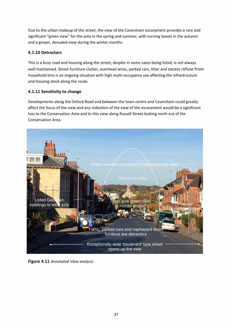
37
Due to the urban makeup of the street, the view of the Caversham escarpment provides a rare and
significant “green view” for the area in the spring and summer, with turning leaves in the autumn
and a greyer, denuded view during the winter months.
4.1.10 Detractors
This is a busy road and housing along the street, despite in some cases being listed, is not always
well maintained. Street furniture clutter, overhead wires, parked cars, litter and excess refuse from
household bins is an ongoing situation with high multi-occupancy use affecting the infrastructure
and housing stock along the route.
4.1.11 Sensitivity to change
Developments along the Oxford Road and between the town centre and Caversham could greatly
affect the focus of the view and any reduction of the view of the escarpment would be a significant
loss to the Conservation Area and to this view along Russell Street looking north out of the
Conservation Area.
Figure 4.11 Annotated View analysis
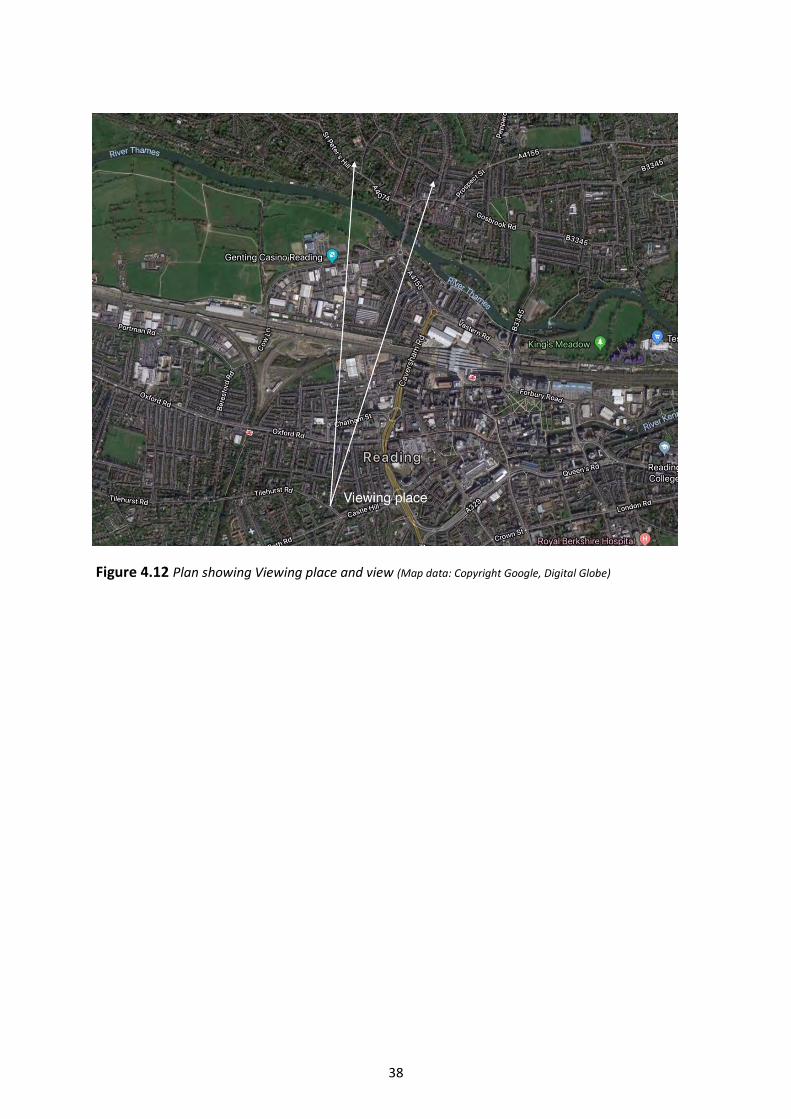
38
Figure 4.12 Plan showing Viewing place and view (Map data: Copyright Google, Digital Globe)
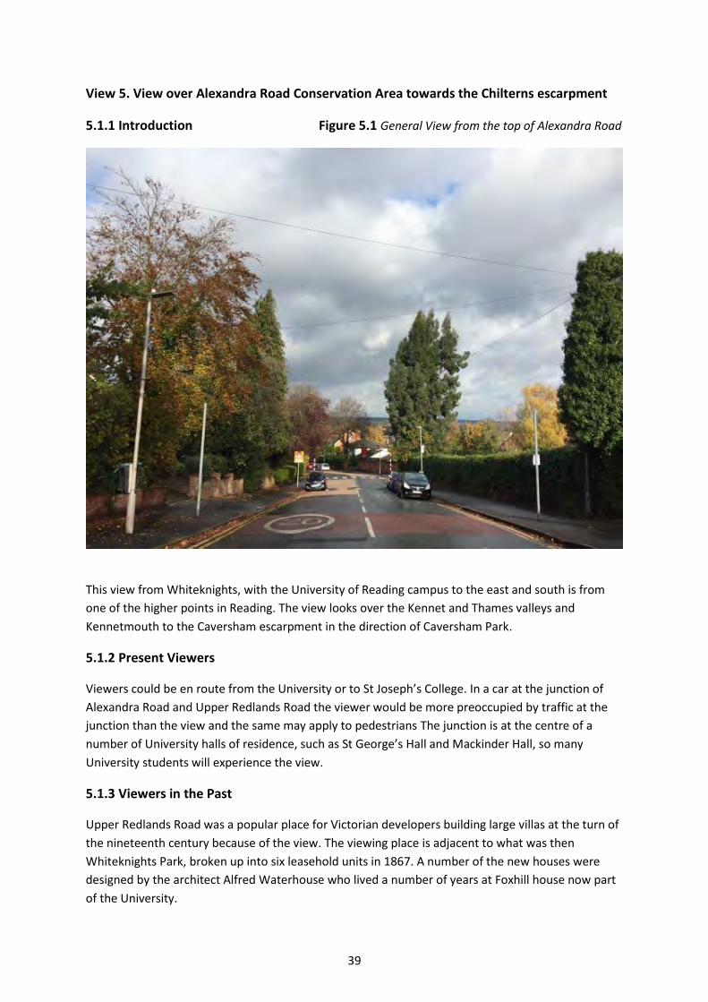
39
View 5. View over Alexandra Road Conservation Area towards the Chilterns escarpment
5.1.1 Introduction Figure 5.1 General View from the top of Alexandra Road
This view from Whiteknights, with the University of Reading campus to the east and south is from
one of the higher points in Reading. The view looks over the Kennet and Thames valleys and
Kennetmouth to the Caversham escarpment in the direction of Caversham Park.
5.1.2 Present Viewers
Viewers could be en route from the University or to St Joseph’s College. In a car at the junction of
Alexandra Road and Upper Redlands Road the viewer would be more preoccupied by traffic at the
junction than the view and the same may apply to pedestrians The junction is at the centre of a
number of University halls of residence, such as St George’s Hall and Mackinder Hall, so many
University students will experience the view.
5.1.3 Viewers in the Past
Upper Redlands Road was a popular place for Victorian developers building large villas at the turn of
the nineteenth century because of the view. The viewing place is adjacent to what was then
Whiteknights Park, broken up into six leasehold units in 1867. A number of the new houses were
designed by the architect Alfred Waterhouse who lived a number of years at Foxhill house now part
of the University.
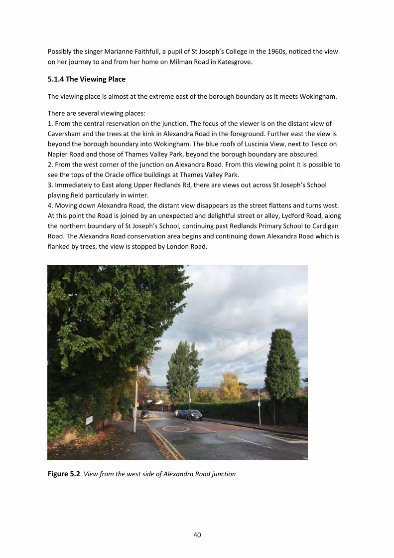
40
Possibly the singer Marianne Faithfull, a pupil of St Joseph’s College in the 1960s, noticed the view
on her journey to and from her home on Milman Road in Katesgrove.
5.1.4 The Viewing Place
The viewing place is almost at the extreme east of the borough boundary as it meets Wokingham.
There are several viewing places:
1. From the central reservation on the junction. The focus of the viewer is on the distant view of
Caversham and the trees at the kink in Alexandra Road in the foreground. Further east the view is
beyond the borough boundary into Wokingham. The blue roofs of Luscinia View, next to Tesco on
Napier Road and those of Thames Valley Park, beyond the borough boundary are obscured.
2. From the west corner of the junction on Alexandra Road. From this viewing point it is possible to
see the tops of the Oracle office buildings at Thames Valley Park.
3. Immediately to East along Upper Redlands Rd, there are views out across St Joseph’s School
playing field particularly in winter.
4. Moving down Alexandra Road, the distant view disappears as the street flattens and turns west.
At this point the Road is joined by an unexpected and delightful street or alley, Lydford Road, along
the northern boundary of St Joseph’s School, continuing past Redlands Primary School to Cardigan
Road. The Alexandra Road conservation area begins and continuing down Alexandra Road which is
flanked by trees, the view is stopped by London Road.
Figure 5.2 View from the west side of Alexandra Road junction
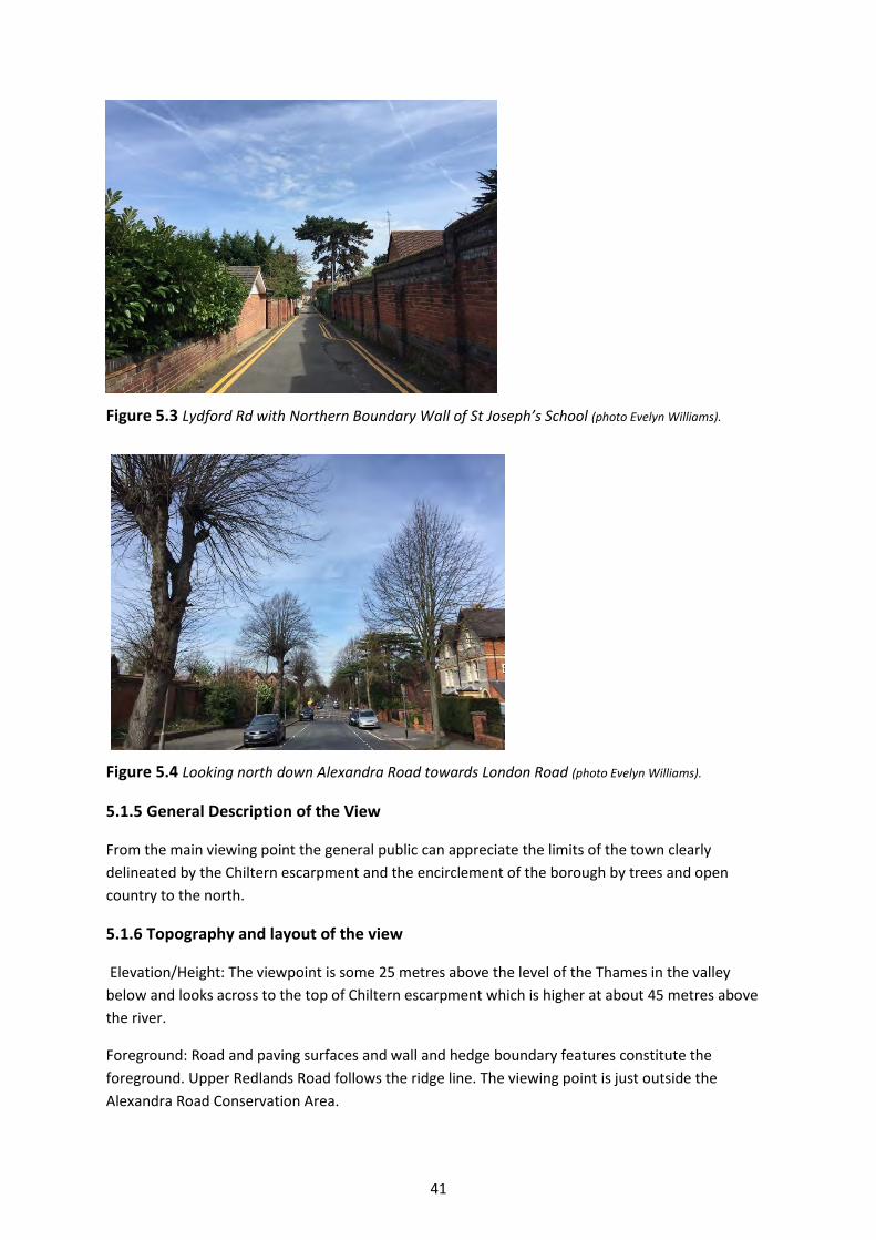
41
Figure 5.3 Lydford Rd with Northern Boundary Wall of St Joseph’s School (photo Evelyn Williams).
Figure 5.4 Looking north down Alexandra Road towards London Road (photo Evelyn Williams).
5.1.5 General Description of the View
From the main viewing point the general public can appreciate the limits of the town clearly
delineated by the Chiltern escarpment and the encirclement of the borough by trees and open
country to the north.
5.1.6 Topography and layout of the view
Elevation/Height: The viewpoint is some 25 metres above the level of the Thames in the valley
below and looks across to the top of Chiltern escarpment which is higher at about 45 metres above
the river.
Foreground: Road and paving surfaces and wall and hedge boundary features constitute the
foreground. Upper Redlands Road follows the ridge line. The viewing point is just outside the
Alexandra Road Conservation Area.

42
Middle ground: This is the Alexandra Road Conservation Area and east over Redlands. There are
Specimen trees which add interest.
Distant: There are fine views across to the Caversham/Chiltern escarpment.
5.1.7 Green Characteristics
The middle view is dominated by large numbers of trees lining the street and specimen trees in
gardens. A strong hedge lines is an important element of the foreground. High wooded ground on
the Chiltern escarpment ends the view.
5.1.8 Architectural characteristics
Apart from the roofs of houses in Alexandra Road and walls around properties, the view from the
top of the hill is not greatly influenced by architectural features. The grid of modest terraces built in
the 1870s for Huntley and Palmer workers is below the viewpoint and not visible. The Grade II
church of St Lukes although approximately on axis with the view is obscured by trees even in winter
although it is partially visible immediately along Redlands Rd across the adjoining St Josephs playing
fields. Caversham Park House is also visible from here. From the main viewing point Wycliffe Baptist
Church on the Kings Rd can be glimpsed.
5.1.9 The influence of light and seasons
The view is more obscured during the summer when trees are in full leaf. In autumn, when some of
these photographs were taken, the view was enhanced by yellow, orange and red colours of the
foliage.
5.1.10 Detractors
In the foreground a plethora of street furniture, an overgrown telegraph pole, speed limit signs,
traffic calming measures and particularly bright red banners and boards announcing St Joseph’s
College, founded in 1910, detract from the view and catch the eye. There is scope for the
rationalisation and reduction of visual impact of these elements during routine maintenance and
replacement.
Figure 5.5 Looking
north down Alexandra
Road at the junction
with Upper Redlands
Road (photo Evelyn Williams)
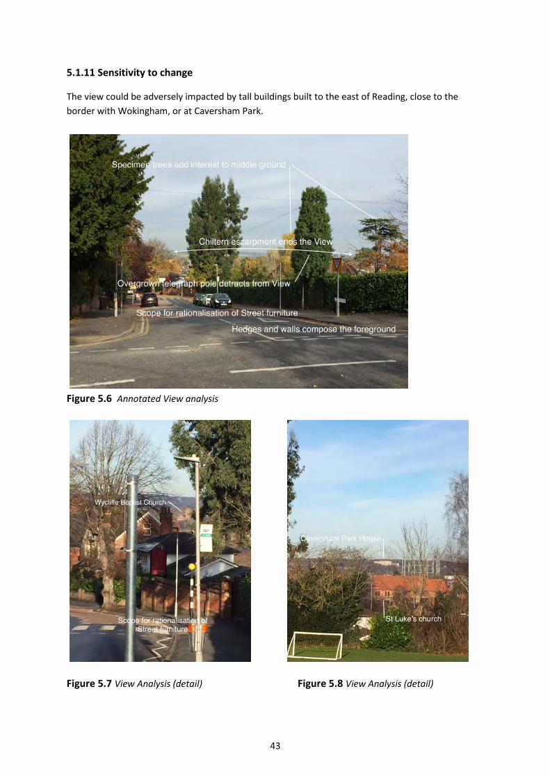
43
5.1.11 Sensitivity to change
The view could be adversely impacted by tall buildings built to the east of Reading, close to the
border with Wokingham, or at Caversham Park.
Figure 5.6 Annotated View analysis
Figure 5.7 View Analysis (detail) Figure 5.8 View Analysis (detail)

44
Figure 5.9 Plan showing Viewing Place and View (Map data: Copyright Google, Digital globe)
Figure 5.10 Detail plan showing Viewing Place (Map data: Copyright Google, Digital Globe)

45
View 6. View southwards down St Annes Rd towards Downshire Square.
6.1.1 Introduction Figure 6.1 General View below
This view taken adjacent to the listed St Annes Well at the top of St Annes Rd, at the junction with
Priest Hill, looks south over the eastern end of St Peter’s Conservation Area and across to the
Downshire Square Conservation Area on the far horizon. All Saints Church in Downshire Square with
its bell turret is visible on the horizon.
Figure 6.2 Detail of
the view, the horizon
with the roof of All
Saints Church and
specimen trees
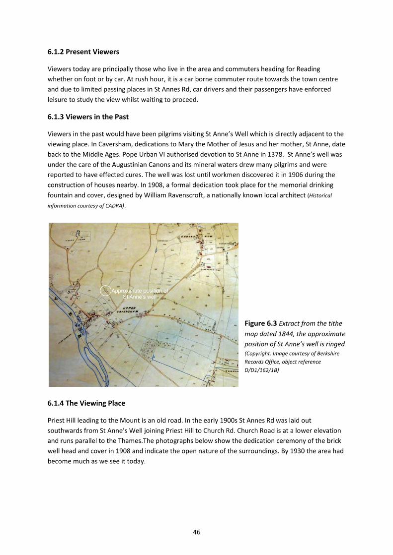
46
6.1.2 Present Viewers
Viewers today are principally those who live in the area and commuters heading for Reading
whether on foot or by car. At rush hour, it is a car borne commuter route towards the town centre
and due to limited passing places in St Annes Rd, car drivers and their passengers have enforced
leisure to study the view whilst waiting to proceed.
6.1.3 Viewers in the Past
Viewers in the past would have been pilgrims visiting St Anne’s Well which is directly adjacent to the
viewing place. In Caversham, dedications to Mary the Mother of Jesus and her mother, St Anne, date
back to the Middle Ages. Pope Urban VI authorised devotion to St Anne in 1378. St Anne’s well was
under the care of the Augustinian Canons and its mineral waters drew many pilgrims and were
reported to have effected cures. The well was lost until workmen discovered it in 1906 during the
construction of houses nearby. In 1908, a formal dedication took place for the memorial drinking
fountain and cover, designed by William Ravenscroft, a nationally known local architect (Historical
information courtesy of CADRA).
Figure 6.3 Extract from the tithe
map dated 1844, the approximate
position of St Anne’s well is ringed (Copyright. Image courtesy of Berkshire
Records Office, object reference
D/D1/162/1B)
6.1.4 The Viewing Place
Priest Hill leading to the Mount is an old road. In the early 1900s St Annes Rd was laid out
southwards from St Anne’s Well joining Priest Hill to Church Rd. Church Road is at a lower elevation
and runs parallel to the Thames.The photographs below show the dedication ceremony of the brick
well head and cover in 1908 and indicate the open nature of the surroundings. By 1930 the area had
become much as we see it today.
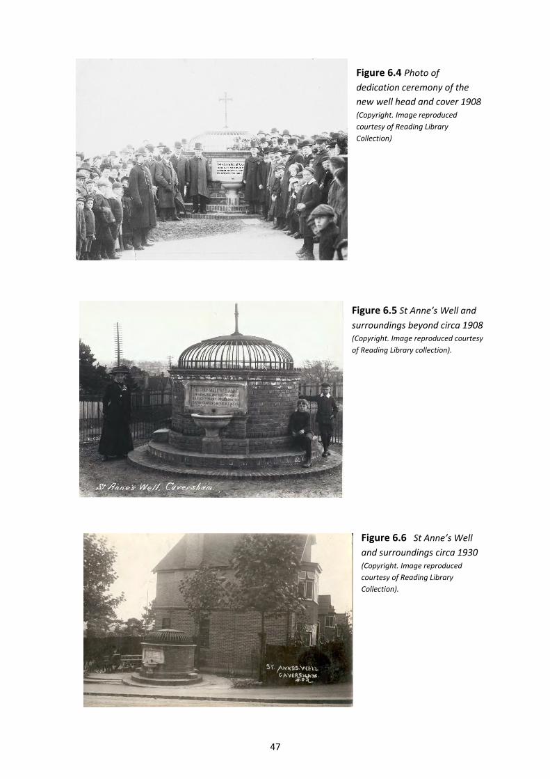
47
Figure 6.4 Photo of
dedication ceremony of the
new well head and cover 1908 (Copyright. Image reproduced
courtesy of Reading Library
Collection)
Figure 6.5 St Anne’s Well and
surroundings beyond circa 1908 (Copyright. Image reproduced courtesy
of Reading Library collection).
Figure 6.6 St Anne’s Well
and surroundings circa 1930 (Copyright. Image reproduced
courtesy of Reading Library
Collection).

48
Figure 6.6 Detail of the well today
Figure 6.7 Looking towards the viewing Place at the
junction with St Anne’s Road
6.1.5 General Description of the View
From the top of the St Annes Rd adjacent to the Well, the view is southwards down the road, over
listed buildings in the Conservation area and their gardens along Buckside. On the far side of the
Thames the view passes over the current industrial areas around Richfield Avenue and Milford Rd,
which due to their low elevation are not visible. The higher level railway tracks beyond exiting
Reading station to the west are visible in the view and trains crossing add movement and interest.
The view ends on the far horizon of higher ground of the Downshire Square Conservation Area and
the Tilehurst Road, picking up features in this area which are clearly visible.
6.1.6 Topography and layout of the view
Elevation/Height: St Anne’s Well is some 20 metres above the level of the River Thames in the valley
below, whilst the ground level at the horizon where the view terminates in the distance is around 40
metres above river level. The apparent level is increased by the height of features on the horizon
such as All Saints Church and the specimen trees planted in the 19C.
Foreground: The foreground is of St Annes Rd, parked cars and the turn of the 20th century houses
largely of brick.
Middle ground: The middle ground features the eastern end of St Peter’s Conservation Area and
also picks up trees in the back gardens of Buckside in the Conservation Area, the roof of the
boathouse and the trees adjacent to and beyond it in Richfield Avenue.
Distant: The view ends on the horizon, where features on the horizon line are clearly visible to the
naked eye.

49
6.1.7 Green Characteristics
Small flowering trees and shrubs in front gardens soften some of the foreground down St Annes
Road. Mature larger trees in the gardens to Buckside and on the far side of the river merge together
to form a strong green element which contributes greatly to the middle ground. As previously
mentioned, tall specimen trees planted in the 19C to the gardens of houses and villas around
Downshire Square, the Bath and Tilehurst Roads feature strongly in silhouette on the horizon.
6.1.8 Architectural characteristics
The starting point for the view is the Grade II Listed memorial well head and decorative iron work
cover designed by William Ravenscroft, photos above. Locally Ravenscroft also designed Grade II
Chiltern Court in Caversham, the Grade II Henry building at Katesgrove School, Goring Roman
Catholic Church, the Masonic building Henley on Thames and many individual houses and villas in
the Reading area, working in a mixture of an Arts and Crafts, and Gothic style.
The houses down St Annes Rd were built at the beginning of the 20th C, largely of red brick with
some render and originally slate roofs. The 17 C grade II cottage down Buckside continues the view
All Saints Church on the horizon in Downshire Square, Grade II listed was designed by JP St Aubyn,
built circa 1865 -74 of coursed rubble with ashlar dressings and a tiled roof with a bell turret. Aubyn
worked in the Gothic revival style of his day. The roof and turret are visible in the view. Foundations
were laid for a tower and spire to rival that of Christ Church in Reading. If this had been completed it
would have made an outstanding landmark due to the elevation of the site but the money ran out
and the work was discontinued (Historical information: Downshire Square Conservation Area Appraisal).
6.1.9 The influence of light and seasons
The best conditions for viewing are on a bright clear day in the morning in the Spring or early
Summer.
6.1.10 Detractors
Traffic and parked cars interfere with enjoyment of this view as do large lorries passing in Church Rd
at the bottom of St Annes Rd, although the parked cars do act as a traffic calming measure reducing
the road effectively to a single lane. Telegraph poles also detract from the view.
6.1.11 Sensitivity to change
The area in this view most sensitive to change relates to the middle and far middle ground of the
view. Care would need to be taken with regard to the height and bulk of any development or
redevelopment in the employment areas bounded by Cardiff Road and Richfield Avenue which might
intrude upon the view. This also applies to the area between the Oxford road and the Railway line
within the view. The horizon line could also be sensitive to adverse change, through the height or
bulk of future development.
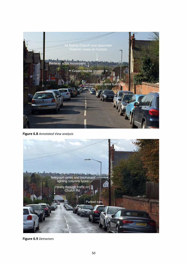
50
Figure 6.8 Annotated View analysis
Figure 6.9 Detractors
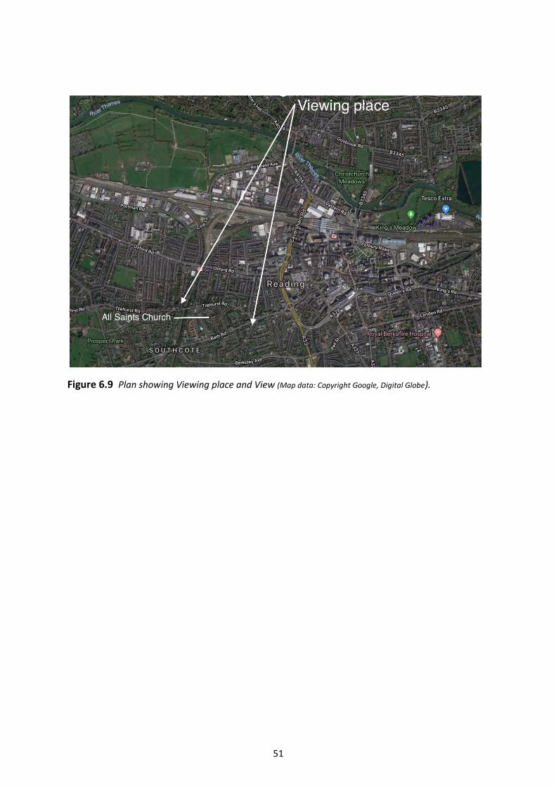
51
Figure 6.9 Plan showing Viewing place and View (Map data: Copyright Google, Digital Globe).
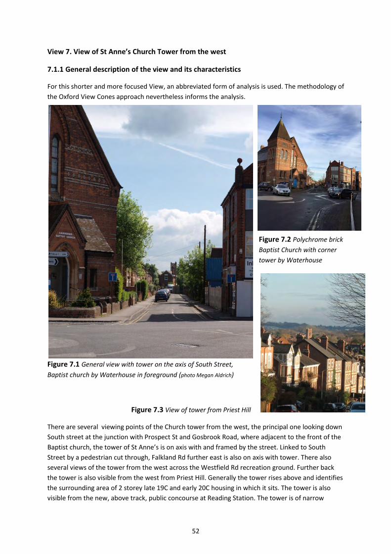
52
View 7. View of St Anne’s Church Tower from the west
7.1.1 General description of the view and its characteristics
For this shorter and more focused View, an abbreviated form of analysis is used. The methodology of
the Oxford View Cones approach nevertheless informs the analysis.
Figure 7.2 Polychrome brick
Baptist Church with corner
tower by Waterhouse
Figure 7.1 General view with tower on the axis of South Street,
Baptist church by Waterhouse in foreground (photo Megan Aldrich)
Figure 7.3 View of tower from Priest Hill
There are several viewing points of the Church tower from the west, the principal one looking down
South street at the junction with Prospect St and Gosbrook Road, where adjacent to the front of the
Baptist church, the tower of St Anne’s is on axis with and framed by the street. Linked to South
Street by a pedestrian cut through, Falkland Rd further east is also on axis with tower. There also
several views of the tower from the west across the Westfield Rd recreation ground. Further back
the tower is also visible from the west from Priest Hill. Generally the tower rises above and identifies
the surrounding area of 2 storey late 19C and early 20C housing in which it sits. The tower is also
visible from the new, above track, public concourse at Reading Station. The tower is of narrow

53
dimensions compared to its height and this gives two impressions a) that the tower is taller than it is
and b) that it is appears farther away than it is.
Figure 7.4 Looking across the Westfield Road recreation ground
Present viewers are local residents and those who use Caversham centre to shop or work. The tower
is set on and rises above the level ground of the Thames plain which surround it and it is from these
level areas that it is principally visible although there are also views from higher ground such as
Priest Hill. Green characteristics include the setting of the Westfield Rd Recreation ground and in
turn, the tower adds identity and contributes to the character of the recreation ground. From South
Street and elsewhere green contributions are made by trees and shrubs to the front gardens of
domestic houses. The view is best experienced on a bright sunlit day when the warm colours of the
brick and stone materials of the tower are reflected and at their best.
7.1.2 History of the view
Gosbrook Road and Prospect Street are roads linking original village settlements and predate the
laying out of South St and the residential roads around St Anne’s Church, these latter roads were all
laid out at the end of the 19C.
The church of Our Lady and St Anne is the full title of the Church. In Caversham, dedications to Mary
the Mother of Jesus and her mother, St Anne, date back to the Middle Ages. Pope Urban VI
authorised devotion to St Anne in 1378.The earliest reference to the Shrine of Our Lady of
Caversham is 1106, when Duke Robert of Normandy, eldest son of William the Conqueror,
presented a relic from the crusades. This shrine became a site of medieval pilgrimage and is thought
to have been near what is now Dean’s Farm. There are records of the shrine being visited and richly
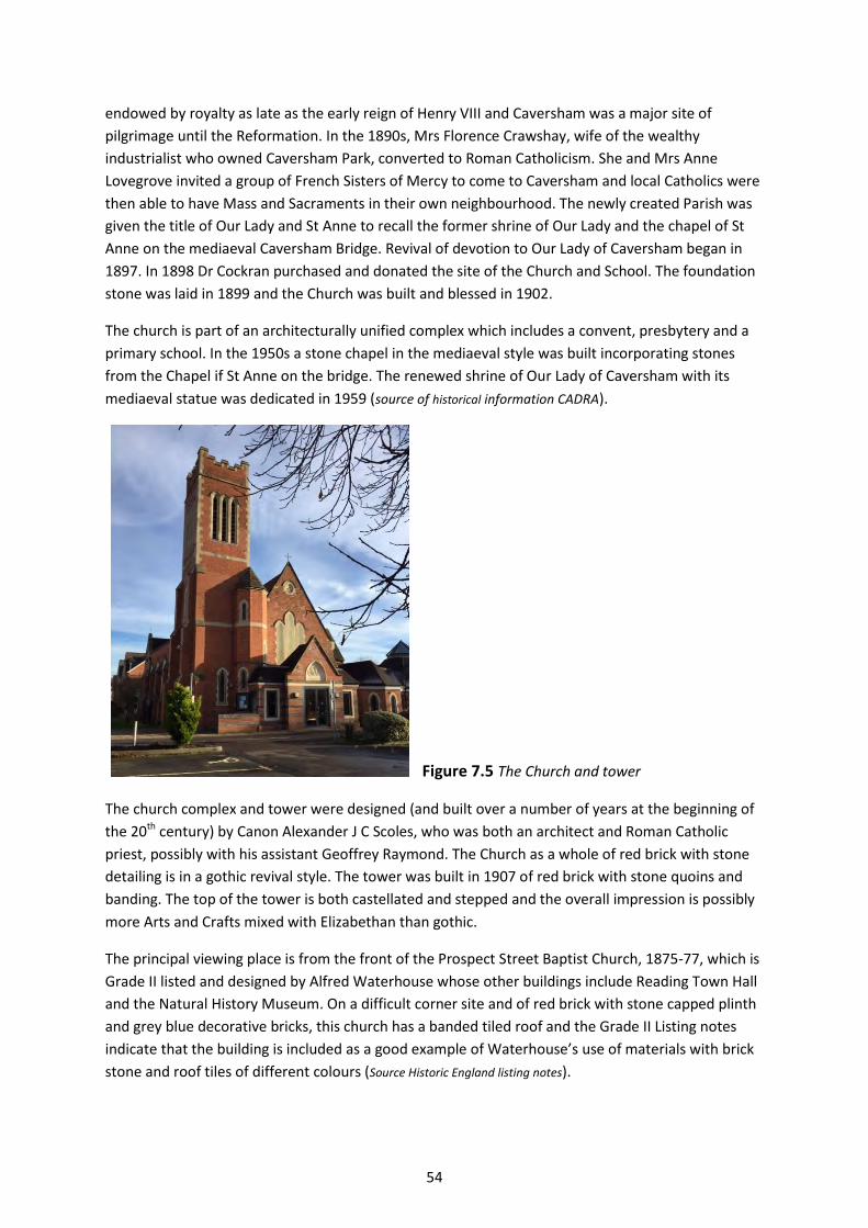
54
endowed by royalty as late as the early reign of Henry VIII and Caversham was a major site of
pilgrimage until the Reformation. In the 1890s, Mrs Florence Crawshay, wife of the wealthy
industrialist who owned Caversham Park, converted to Roman Catholicism. She and Mrs Anne
Lovegrove invited a group of French Sisters of Mercy to come to Caversham and local Catholics were
then able to have Mass and Sacraments in their own neighbourhood. The newly created Parish was
given the title of Our Lady and St Anne to recall the former shrine of Our Lady and the chapel of St
Anne on the mediaeval Caversham Bridge. Revival of devotion to Our Lady of Caversham began in
1897. In 1898 Dr Cockran purchased and donated the site of the Church and School. The foundation
stone was laid in 1899 and the Church was built and blessed in 1902.
The church is part of an architecturally unified complex which includes a convent, presbytery and a
primary school. In the 1950s a stone chapel in the mediaeval style was built incorporating stones
from the Chapel if St Anne on the bridge. The renewed shrine of Our Lady of Caversham with its
mediaeval statue was dedicated in 1959 (source of historical information CADRA).
Figure 7.5 The Church and tower
The church complex and tower were designed (and built over a number of years at the beginning of
the 20th century) by Canon Alexander J C Scoles, who was both an architect and Roman Catholic
priest, possibly with his assistant Geoffrey Raymond. The Church as a whole of red brick with stone
detailing is in a gothic revival style. The tower was built in 1907 of red brick with stone quoins and
banding. The top of the tower is both castellated and stepped and the overall impression is possibly
more Arts and Crafts mixed with Elizabethan than gothic.
The principal viewing place is from the front of the Prospect Street Baptist Church, 1875-77, which is
Grade II listed and designed by Alfred Waterhouse whose other buildings include Reading Town Hall
and the Natural History Museum. On a difficult corner site and of red brick with stone capped plinth
and grey blue decorative bricks, this church has a banded tiled roof and the Grade II Listing notes
indicate that the building is included as a good example of Waterhouse’s use of materials with brick
stone and roof tiles of different colours (Source Historic England listing notes).
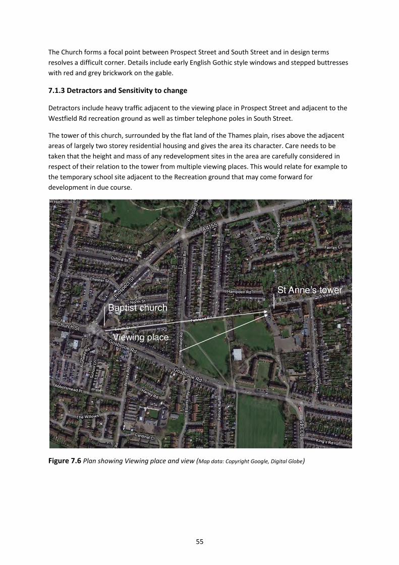
55
The Church forms a focal point between Prospect Street and South Street and in design terms
resolves a difficult corner. Details include early English Gothic style windows and stepped buttresses
with red and grey brickwork on the gable.
7.1.3 Detractors and Sensitivity to change
Detractors include heavy traffic adjacent to the viewing place in Prospect Street and adjacent to the
Westfield Rd recreation ground as well as timber telephone poles in South Street.
The tower of this church, surrounded by the flat land of the Thames plain, rises above the adjacent
areas of largely two storey residential housing and gives the area its character. Care needs to be
taken that the height and mass of any redevelopment sites in the area are carefully considered in
respect of their relation to the tower from multiple viewing places. This would relate for example to
the temporary school site adjacent to the Recreation ground that may come forward for
development in due course.
Figure 7.6 Plan showing Viewing place and view (Map data: Copyright Google, Digital Globe)
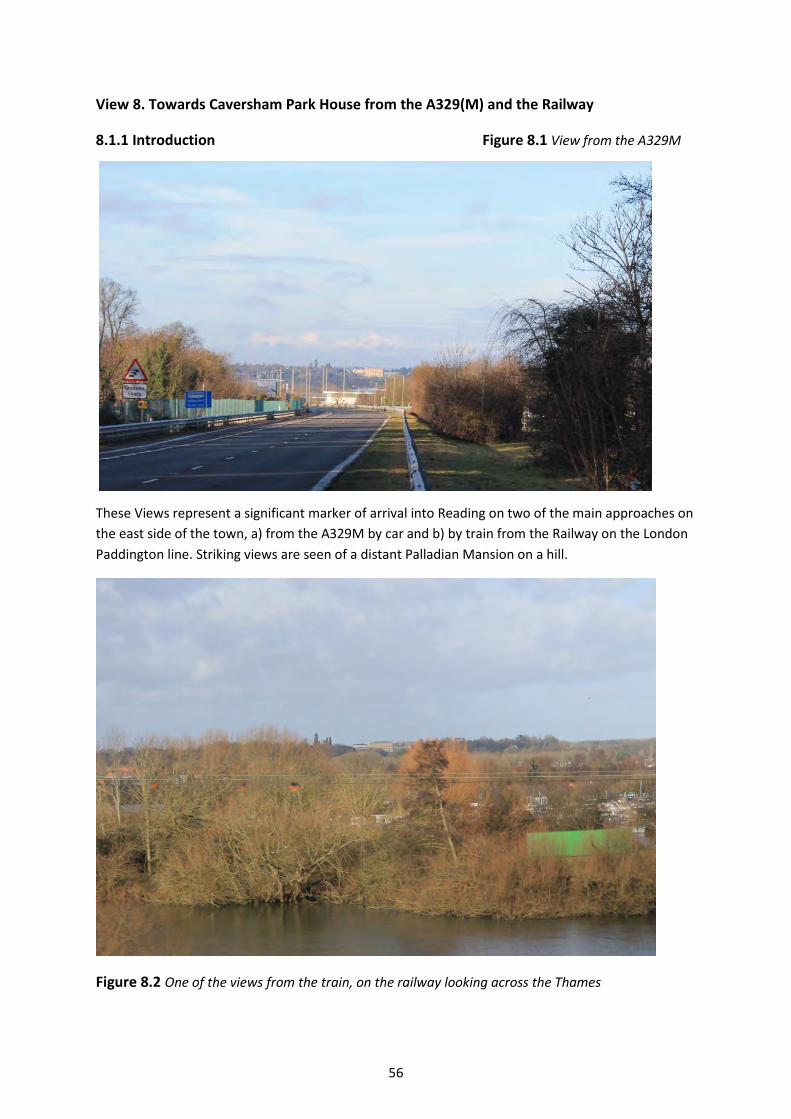
56
View 8. Towards Caversham Park House from the A329(M) and the Railway
8.1.1 Introduction Figure 8.1 View from the A329M
These Views represent a significant marker of arrival into Reading on two of the main approaches on
the east side of the town, a) from the A329M by car and b) by train from the Railway on the London
Paddington line. Striking views are seen of a distant Palladian Mansion on a hill.
Figure 8.2 One of the views from the train, on the railway looking across the Thames
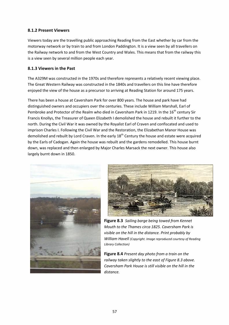
57
8.1.2 Present Viewers
Viewers today are the travelling public approaching Reading from the East whether by car from the
motorway network or by train to and from London Paddington. It is a view seen by all travellers on
the Railway network to and from the West Country and Wales. This means that from the railway this
is a view seen by several million people each year.
8.1.3 Viewers in the Past
The A329M was constructed in the 1970s and therefore represents a relatively recent viewing place.
The Great Western Railway was constructed in the 1840s and travellers on this line have therefore
enjoyed the view of the house as a precursor to arriving at Reading Station for around 175 years.
There has been a house at Caversham Park for over 800 years. The house and park have had
distinguished owners and occupiers over the centuries. These include William Marshall, Earl of
Pembroke and Protector of the Realm who died in Caversham Park in 1219. In the 16th century Sir
Francis Knollys, the Treasurer of Queen Elizabeth I demolished the house and rebuilt it further to the
north. During the Civil War it was owned by the Royalist Earl of Craven and confiscated and used to
imprison Charles I. Following the Civil War and the Restoration, the Elizabethan Manor House was
demolished and rebuilt by Lord Craven. In the early 18th Century the house and estate were acquired
by the Earls of Cadogan. Again the house was rebuilt and the gardens remodelled. This house burnt
down, was replaced and then enlarged by Major Charles Marsack the next owner. This house also
largely burnt down in 1850.
Figure 8.3 Sailing barge being towed from Kennet
Mouth to the Thames circa 1825. Caversham Park is
visible on the hill in the distance. Print probably by
William Havell (Copyright. Image reproduced courtesy of Reading
Library Collection)
Figure 8.4 Present day photo from a train on the
railway taken slightly to the east of Figure 8.3 above.
Caversham Park House is still visible on the hill in the
distance.
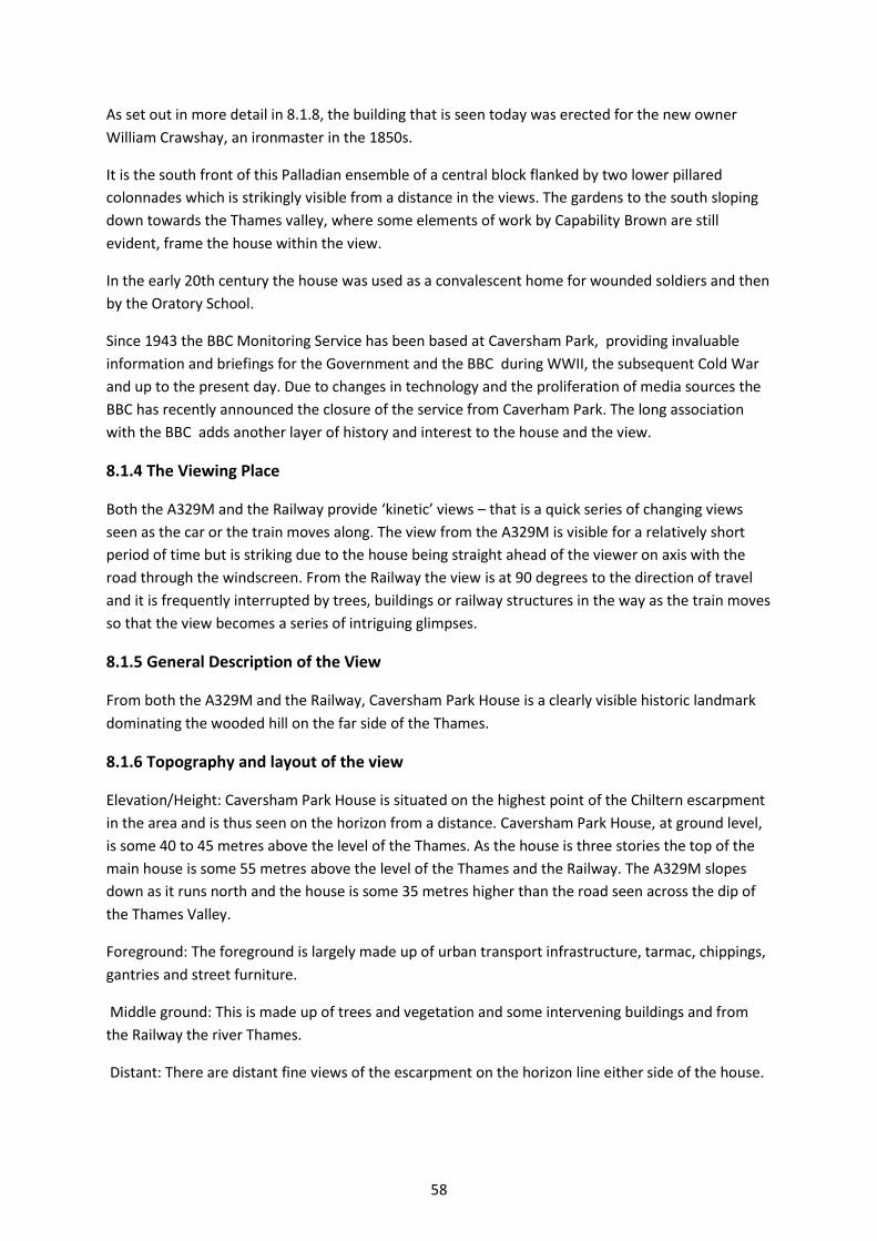
58
As set out in more detail in 8.1.8, the building that is seen today was erected for the new owner
William Crawshay, an ironmaster in the 1850s.
It is the south front of this Palladian ensemble of a central block flanked by two lower pillared
colonnades which is strikingly visible from a distance in the views. The gardens to the south sloping
down towards the Thames valley, where some elements of work by Capability Brown are still
evident, frame the house within the view.
In the early 20th century the house was used as a convalescent home for wounded soldiers and then
by the Oratory School.
Since 1943 the BBC Monitoring Service has been based at Caversham Park, providing invaluable
information and briefings for the Government and the BBC during WWII, the subsequent Cold War
and up to the present day. Due to changes in technology and the proliferation of media sources the
BBC has recently announced the closure of the service from Caverham Park. The long association
with the BBC adds another layer of history and interest to the house and the view.
8.1.4 The Viewing Place
Both the A329M and the Railway provide ‘kinetic’ views – that is a quick series of changing views
seen as the car or the train moves along. The view from the A329M is visible for a relatively short
period of time but is striking due to the house being straight ahead of the viewer on axis with the
road through the windscreen. From the Railway the view is at 90 degrees to the direction of travel
and it is frequently interrupted by trees, buildings or railway structures in the way as the train moves
so that the view becomes a series of intriguing glimpses.
8.1.5 General Description of the View
From both the A329M and the Railway, Caversham Park House is a clearly visible historic landmark
dominating the wooded hill on the far side of the Thames.
8.1.6 Topography and layout of the view
Elevation/Height: Caversham Park House is situated on the highest point of the Chiltern escarpment
in the area and is thus seen on the horizon from a distance. Caversham Park House, at ground level,
is some 40 to 45 metres above the level of the Thames. As the house is three stories the top of the
main house is some 55 metres above the level of the Thames and the Railway. The A329M slopes
down as it runs north and the house is some 35 metres higher than the road seen across the dip of
the Thames Valley.
Foreground: The foreground is largely made up of urban transport infrastructure, tarmac, chippings,
gantries and street furniture.
Middle ground: This is made up of trees and vegetation and some intervening buildings and from
the Railway the river Thames.
Distant: There are distant fine views of the escarpment on the horizon line either side of the house.
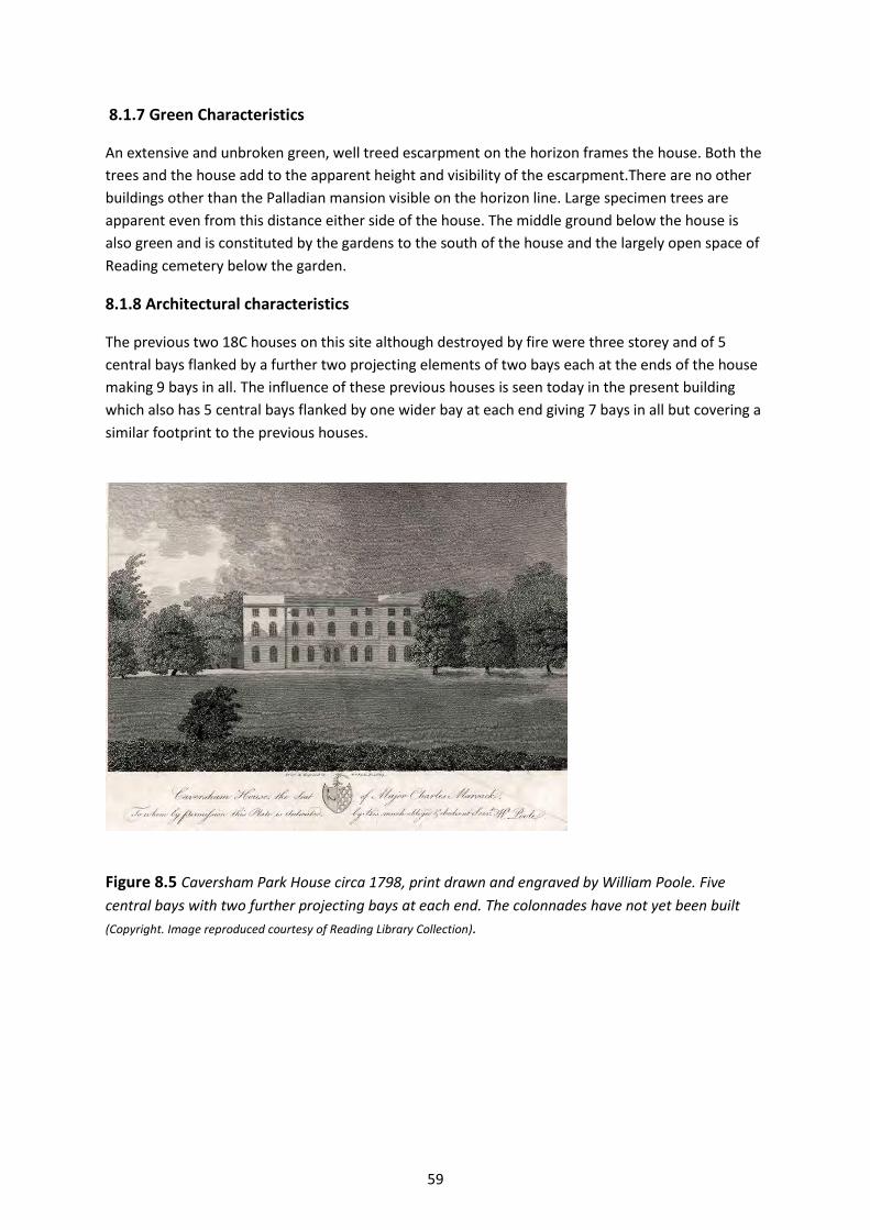
59
8.1.7 Green Characteristics
An extensive and unbroken green, well treed escarpment on the horizon frames the house. Both the
trees and the house add to the apparent height and visibility of the escarpment.There are no other
buildings other than the Palladian mansion visible on the horizon line. Large specimen trees are
apparent even from this distance either side of the house. The middle ground below the house is
also green and is constituted by the gardens to the south of the house and the largely open space of
Reading cemetery below the garden.
8.1.8 Architectural characteristics
The previous two 18C houses on this site although destroyed by fire were three storey and of 5
central bays flanked by a further two projecting elements of two bays each at the ends of the house
making 9 bays in all. The influence of these previous houses is seen today in the present building
which also has 5 central bays flanked by one wider bay at each end giving 7 bays in all but covering a
similar footprint to the previous houses.
Figure 8.5 Caversham Park House circa 1798, print drawn and engraved by William Poole. Five
central bays with two further projecting bays at each end. The colonnades have not yet been built
(Copyright. Image reproduced courtesy of Reading Library Collection).

60
Figure 8.6 Caversham Park house as it is today.
The building as seen today was erected for the new owner William Crawshay an ironmaster in the
early 1850s, by architect Horace Jones who later also designed Tower Bridge in London The house is
built on an iron frame, an early example of this technique. Jones inserted his seven bay block, (five
central and two wider end bays) of three storeys between the two surviving colonnades of 1840 by
John Thistlewood Crew.
It is the south front of this large Palladian ensemble of a central block flanked by two lower pillared
colonnades which is strikingly visible from a distance in the views. The gardens to the south slope
down towards the Thames valley, where some elements of work by Capability Brown are still
evident, and frame the house within the view.
8.1.9 The influence of light and seasons
The best conditions for viewing are on a bright clear day when the sun is on the south elevation of
the house bringing out the golden colour of the stonework and casting shadows which emphasize
the modelling of the stone colonnades and mouldings on the main house. Cloud formations add
greatly to the variety of view experienced due to the wide expanse of sky.
61
8.1.10 Detractors
Elements which are part and parcel of the infrastructure of this view, such as tall streetlights on the
A329(M) and gantries, fences, junction boxes etc on the Railway affect the view in some positions. It
is difficult to see how these can be practically ameliorated in the short term and they can also be
considered as part of the viewing experience. Possibly in the longer term when planned
maintenance and replacement take place, if there are alternative options, then consideration could
be given to any options which reduce the impact on the view or at best do not worsen it. Light
coloured roofing on buildings visible from the A329(M) detracts from the view from certain
positions.
8.1.11 Sensitivity to change
Any new development on lower ground in front of this south side of the house and the green
escarpment on either side would need careful consideration to avoid projecting into and harming
the view. In particular the garden and park to the south of the house are vital to the framing of the
view. Likewise built development which might become visible on the skyline/horizon should be
avoided. Careful consideration should be given to roof and cladding colours in respect of light
industrial or office development on the Business parks at the end of the A329(M). In respect of views
from the railway careful consideration should also be given to the height of any development
proposals if these were to come forward in the vicinity of the Marina on the far side of the Thames.
Figure 8.7 Annotated View analysis

62
Figure 8.8 Detail of view from the A329(M)
Figure 8.9 Plan showing Viewing place and View (Map data: Copyright Google, Digital Globe
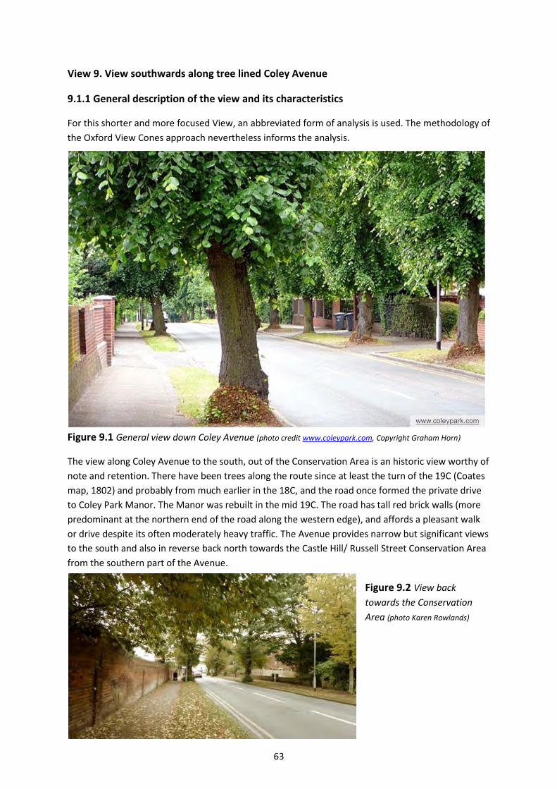
63
View 9. View southwards along tree lined Coley Avenue
9.1.1 General description of the view and its characteristics
For this shorter and more focused View, an abbreviated form of analysis is used. The methodology of
the Oxford View Cones approach nevertheless informs the analysis.
Figure 9.1 General view down Coley Avenue (photo credit www.coleypark.com, Copyright Graham Horn)
The view along Coley Avenue to the south, out of the Conservation Area is an historic view worthy of
note and retention. There have been trees along the route since at least the turn of the 19C (Coates
map, 1802) and probably from much earlier in the 18C, and the road once formed the private drive
to Coley Park Manor. The Manor was rebuilt in the mid 19C. The road has tall red brick walls (more
predominant at the northern end of the road along the western edge), and affords a pleasant walk
or drive despite its often moderately heavy traffic. The Avenue provides narrow but significant views
to the south and also in reverse back north towards the Castle Hill/ Russell Street Conservation Area
from the southern part of the Avenue.
Figure 9.2 View back
towards the Conservation
Area (photo Karen Rowlands)
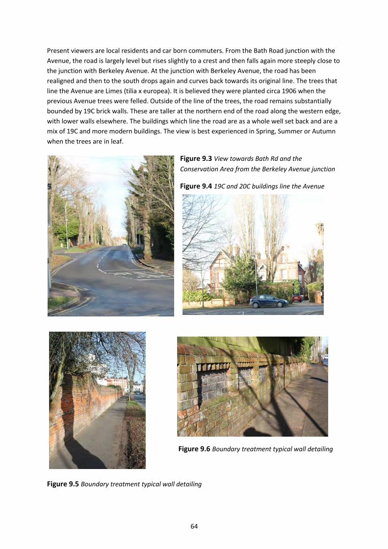
64
Present viewers are local residents and car born commuters. From the Bath Road junction with the
Avenue, the road is largely level but rises slightly to a crest and then falls again more steeply close to
the junction with Berkeley Avenue. At the junction with Berkeley Avenue, the road has been
realigned and then to the south drops again and curves back towards its original line. The trees that
line the Avenue are Limes (tilia x europea). It is believed they were planted circa 1906 when the
previous Avenue trees were felled. Outside of the line of the trees, the road remains substantially
bounded by 19C brick walls. These are taller at the northern end of the road along the western edge,
with lower walls elsewhere. The buildings which line the road are as a whole well set back and are a
mix of 19C and more modern buildings. The view is best experienced in Spring, Summer or Autumn
when the trees are in leaf.
Figure 9.3 View towards Bath Rd and the
Conservation Area from the Berkeley Avenue junction
Figure 9.4 19C and 20C buildings line the Avenue
Figure 9.6 Boundary treatment typical wall detailing
Figure 9.5 Boundary treatment typical wall detailing
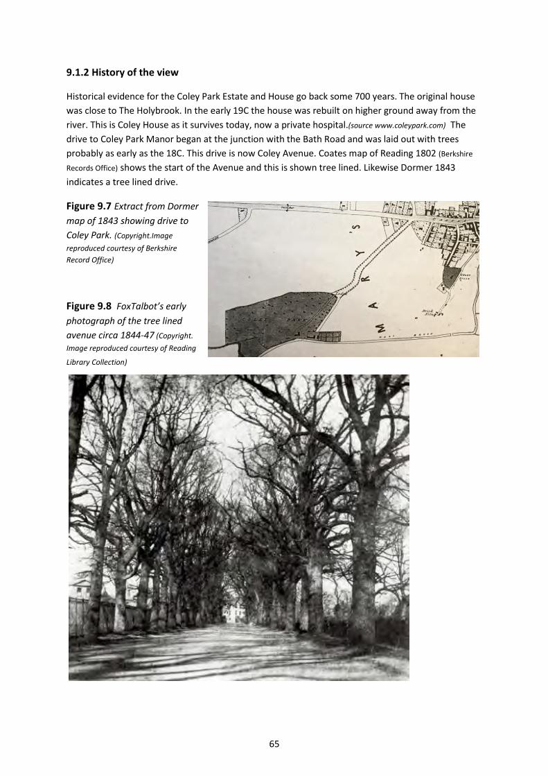
65
9.1.2 History of the view
Historical evidence for the Coley Park Estate and House go back some 700 years. The original house
was close to The Holybrook. In the early 19C the house was rebuilt on higher ground away from the
river. This is Coley House as it survives today, now a private hospital.(source www.coleypark.com) The
drive to Coley Park Manor began at the junction with the Bath Road and was laid out with trees
probably as early as the 18C. This drive is now Coley Avenue. Coates map of Reading 1802 (Berkshire
Records Office) shows the start of the Avenue and this is shown tree lined. Likewise Dormer 1843
indicates a tree lined drive.
Figure 9.7 Extract from Dormer
map of 1843 showing drive to
Coley Park. (Copyright.Image
reproduced courtesy of Berkshire
Record Office)
Figure 9.8 FoxTalbot’s early
photograph of the tree lined
avenue circa 1844-47 (Copyright.
Image reproduced courtesy of Reading
Library Collection)

66
The early photograph by Fox Talbot, during his association with Reading between 1844 and 1847, is
taken looking north up Coley Avenue towards the Bath Road and the current Conservation Area.
Large stone and render gateposts were erected circa 1870 on each side of the entrance to the
Avenue. These were topped with winged dragons (Wyverns). These large gate posts were
demolished at some point in the 20th century to widen the Bath Road Intersection. During the latter
half of the 19C land was sold off either side of the Avenue for large private houses. The original trees
to the Avenue were felled around 1905. The postcard illustrations below indicate the original trees
in a photo taken in 1903 and the subsequent photo taken 1907 from a similar position shows the
replanted trees (source www.coleypark.com). Also visible in the photos the separate smaller gate and
piers to Yeomanry House, the lodge of which survives today.
Figure 9.9 Stone
gate piers to the
Avenue taken
from Bath Rd in
1903 prior to tree
felling (Copyright.
Image reproduced
courtesy of Reading
Library Collection)
Figure 9.10 Stone
gate piers to the
Avenue taken from
Bath Rd in 1907
after replanting (Copyright. Image
reproduced courtesy of
Reading Library
Collection)
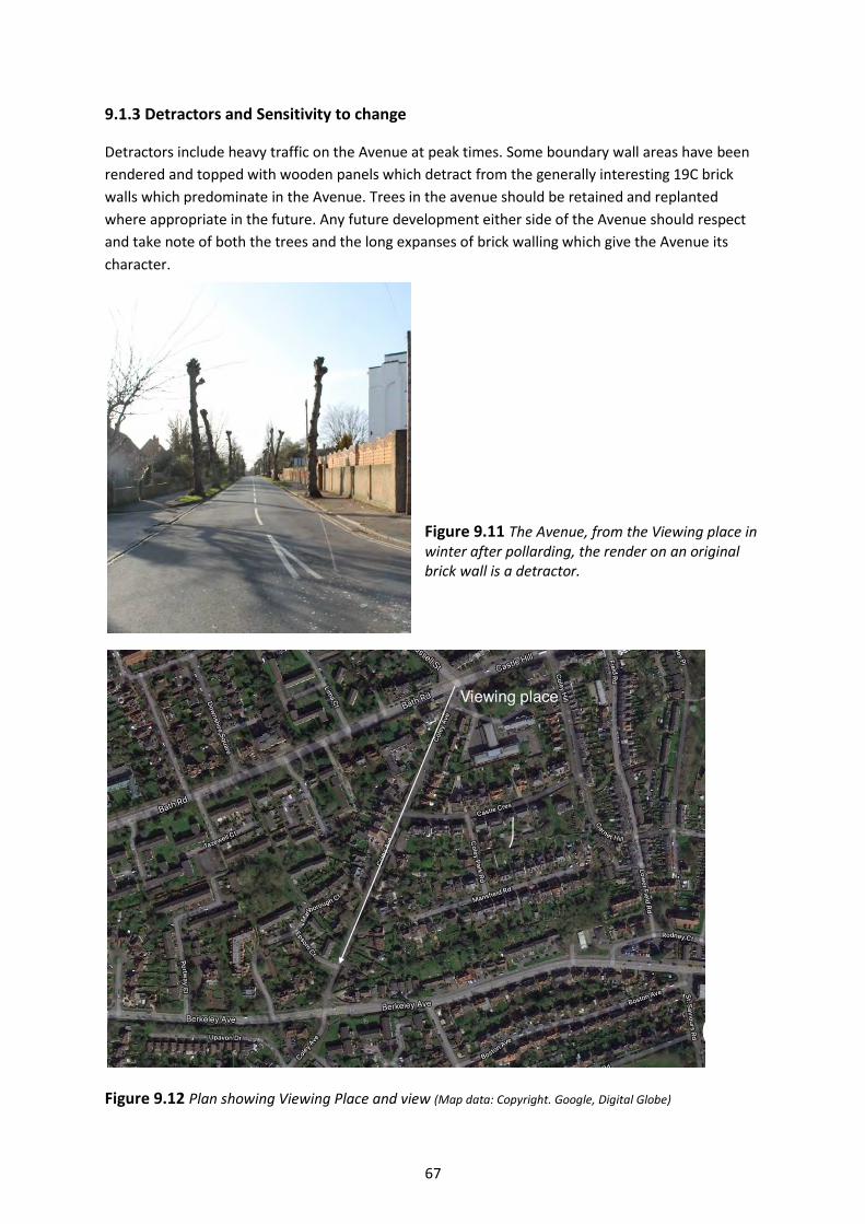
67
9.1.3 Detractors and Sensitivity to change
Detractors include heavy traffic on the Avenue at peak times. Some boundary wall areas have been
rendered and topped with wooden panels which detract from the generally interesting 19C brick
walls which predominate in the Avenue. Trees in the avenue should be retained and replanted
where appropriate in the future. Any future development either side of the Avenue should respect
and take note of both the trees and the long expanses of brick walling which give the Avenue its
character.
Figure 9.11 The Avenue, from the Viewing place in winter after pollarding, the render on an original brick wall is a detractor.
Figure 9.12 Plan showing Viewing Place and view (Map data: Copyright. Google, Digital Globe)