historic name other names/site number draft
TRANSCRIPT

NPS Form 10-900 OMB No. 1024-0018 (Oct. 1990)
United States Department of the Interior
National Park Service
National Register of Historic Places Registration Form This form is for use in nominating or requesting determinations of eligibility for individual properties or districts. See instructions in How to Complete the National Register of Historic Places Registration Form (National Register Bulletin 16A). Complete each item by marking "x" in the appropriate box or by entering the information requested. If an item does not apply to the property being documented, enter "N/A" for "not applicable." For functions, architectural classification, materials and areas of significance, enter only categories and subcategories listed in the instructions. Place additional entries and narrative items on continuation sheets (NPS Form 10-900a). Use a typewriter, word processor, or computer, to complete all items.
1. Name of Property
historic name Lane–Voorhees House
other names/site number Lane–Brokaw House
2. Location
street & number 551 Milltown Road not for publication
city or town Bridgewater Township vicinity
state New Jersey code 034 county Somerset code 035 zip code 08807
3. State/Federal Agency Certification
As the designated authority under the National Historic Preservation Act, as amended, I certify that this nomination
request for determination of eligibility meets the documentation standards for registering properties in the National Register
of Historic Places and meets the procedural and professional requirements set forth in 36 CFR Part 60. In my opinion, the property
meets does not meet the National Register criteria. I recommend that this property be considered significant
nationally statewide locally. See continuation sheet for additional comments.
Signature of certifying official/Title Date
State or Federal agency and bureau
In my opinion, the property meets does not meet the National Register criteria. See continuation sheet for
additional comments.
Signature of certifying official/Title Date
State or Federal agency and bureau
4. National Park Service Certification
I hereby certify that this property is: Signature of the Keeper Date of Action
entered in the National Register.
See continuation sheet.
determined eligible for the
National Register.
See continuation sheet.
determined not eligible for the
National Register.
removed from the National
Register.
other, (explain:)
DRAFT

Lane–Voorhees House Somerset County, NJ Name of Property County and State
5. Classification
Ownership of Property Category of Property Number of Resources within Property (Check as many boxes as apply) (Check only one box) (Do not include previously listed resources in the count.)
private X building(s) Contributing Noncontributing
X public-local district 1 buildings
public-State site sites
public-Federal structure structures
object objects
1 Total
Name of related multiple property listing (Enter "N/A" if property is not part of a multiple property listing.)
Number of contributing resources previously listed in the National Register
_______N/A 0
6. Function or Use Historic Functions (Enter categories from instructions)
Current Functions (Enter categories from instructions)
DOMESTIC/ single dwelling VACANT/ not in use
7. Description Architectural Classification (Enter categories from instructions)
Materials (Enter categories from instructions)
FEDERAL foundation STONE
GREEK REVIVAL walls BRICK
VINYL
roof ASPHALT
other
Narrative Description (Describe the historic and current condition of the property on one or more continuation sheets.)
DRAFT

Lane–Voorhees House
Somserset County, NJ
Name of Property County and State
8 Statement of Significance
Applicable National Register Criteria Areas of Significance (Mark "x" in one or more boxes for the criteria qualifying the property for National Register listing.)
(Enter categories from instructions)
ARCHITECTURE
A Property is associated with events that have made
a significant contribution to the broad patterns of
our history.
B Property is associated with the lives of persons
significant in our past.
X C Property embodies the distinctive characteristics
of a type, period or method of construction or Period of Significance
represents the work of a master, or possesses c. 1750-1847
high artistic values, or represents a significant and
distinguishable entity whose components lack
individual distinction.
D Property has yielded, or is likely to yield, Significant Dates
information important in prehistory or history. 1837
Criteria considerations (mark "x" in all the boxes that apply.)
Property is: Significant Person (Complete if Criterion B is marked above)
A owned by a religious institution or used for
religious purposes.
B removed from its original location. Cultural Affiliation
N/A
C a birthplace or grave.
D a cemetery.
E a reconstructed building, object or structure. Architect/Builder
F a commemorative property.
G less than 50 years of age or achieved significance
within the past 50 years.
Narrative Statement of Significance (Explain the significance of the property on one or more continuation sheets.)
9. Major Bibliographical References
Bibliography (cite the books, articles, and other sources used in preparing this form on one or more continuation sheets.)
Previous documentation on file (NPS): Primary location of additional data preliminary determination of individual listing (36 State Historic Preservation Office
CFR 67) has been requested Other State agency
previously listed in the National Register Federal agency
previously determined eligible by the National Local government
Register University
designated a National Historic Landmark Other
recorded by Historic American Buildings Survey Name of repository:
#
recorded by Historic American Engineering
Record #
DRAFT

Lane–Voorhees House
Somerset County, NJ Name of Property County and State
10. Geographical Data
Acreage of property Approximately .69 acres
UTM References (Place additional UTM references on a continuation sheet.) 40.590297, -74.677346
1 3 Zone Easting Northing Zone Easting Northing
2 4
See continuation sheet
Verbal Boundary Description (Describe the boundaries of the property on a continuation sheet.)
Boundary Justification (Explain why the boundaries were selected on a continuation sheet.)
11. Form Prepared By
name/title Dennis Bertland
organization Dennis Bertland Associates date July 2018
street & number P.O. Box 315 telephone 609-397-3380
city or town Stockton state NJ zip code 08559
Additional Documentation Submit the following items with the completed form:
Continuation Sheets
Maps
A USGS map (7.5 or 15 minute series) indicating the property's location.
A Sketch map for historic districts and properties having large acreage or numerous resources.
Photographs
Representative black and white photographs of the property.
Additional items (Check with the SHPO or FPO for any additional items)
Property Owner
(Complete this item at the request of the SHPO or FPO.)
name
street & number telephone
city or town state zip code
Paperwork Reduction Act Statement: This information is being collected for applications to the National Register of Historic Places to nominate properties for listing or determine eligibility for listing, to list properties and to amend existing listings. Response to this request is required to obtain a benefit in accordance with the National Historic Preservation Act, as amended (16 U.S.C.470 et seq.)
Estimated Burden Statement: Public reporting burden for this form is estimated to average 18.1 hours per response including time for reviewing instructions, gathering and maintaining data and completing and reviewing the form. Direct comments regarding this burden estimate or any aspect of this from to the Chief, Administrative Services Division, National Park Service, P.O. Box 37127, Washington, DC 20013-7127; and the Office of Management and Budget, Paperwork Reductions Projects (1024-0018), Washington, DC 20503.
DRAFT

NPS Form 10-900-a OMB Approval No. 1024-0018 (8-86)
United States Department of the Interior National Park Service
National Register of Historic Places Continuation Sheet Lane-Voorhees House Somerset County, NJ Section number 7 Page 1
Summary Description
The only surviving element of a farmstead established in the mid-18th century, the Lane-Voorhees House is located in the fertile Piedmont lowlands along the North Branch of the Raritan River, sited on the edge of the first terrace above the river’s flood plain and immediately south of a small nameless tributary. Set well back from the road, the south-facing dwelling consists of a brick main block, which evidently dates to the third quar-ter of the 18th century and was extensively rebuilt within its masonry shell shortly after a devastating fire in 1837, and a small frame west wing comprised of a 19th-century shed appendage, which appears to be contempo-rary with the c. 1837 renovations, and a mid 20th-century addition (Photos 1 – 9). The house, currently unoccu-pied, was most recently renovated during the first decade of this century. The five-bay, one-and-one-half-story, gable-roofed main block has a double-pile, center-hall plan, along with a partial cellar, interior gable-end chim-neys and a lofty attic, and exhibits simple exterior and interior detailing reflective of Georgian and late Feder-al/Greek Revival stylistic influences. The house is surrounded by preserved open space, comprised of fields and meadows with woods along the river. To the east across Milltown Road is a suburban landscape of single fami-ly dwellings and town houses built in recent decades.
The Lane-Voorhees House constitutes the property’s one contributing resource. Although some early
fabric has been lost or covered with modern finishes and modern development intrudes on its east, the Lane-Voorhees House retains its essential integrity of location, design, setting, materials, workmanship, feeling and association to a degree sufficient to convey its significance.
Main block exterior:
The main block of the Lane-Voorhees House is of traditional load-bearing masonry construction. Its coursed rubble stone foundation and brick walls date to the dwelling’s original construction (Photos 6 – 9). Hand-made brick, presumably of local manufacture, was used to build the walls, except for the west-end wall, which is constructed of coursed rubble stone up to the attic floor level with a frame gable above. The stone end wall conceivably might relate to different construction phase, as has been suggested based on the evidence of differences in the composition of the mortar used in the stone and brick construction, and perhaps survives from earlier building replaced by the current west wing.1 However, the nearby Guisbert Lane House (erected c. 1737 by, and named for, the father of the man who built the subject property) also combines brick and stone construc-tion, as do a number of other early houses in the Raritan Valley.2 The west gable of the Lane-Voorhees House 1 Keystone Preservation Group, Lane Brokaw House: Bridgewater, NJ Analysis Of Historic Building Materials, page 38, as included in Mills + Schnoering Architects, Historic Structure Report For The Lane-Brokaw House Bridgewater Township, NJ (Draft). 2 The Guisbert Lane House, now forming part of the headquarters of the Somerset County Parks Commission, is built of stone with brick gables [field observations by the preparer; see also Rosalie Fellows Bailey, Pre-Revolutionary Dutch Houses and Families in Northern New Jersey and Southern New York, pp. 441, 442 & 478]. Other early houses examples include the c. 1740s Dr. Edward Anthill House (Piscataway Township, Middlesex County, demolished) which had Flemish-bond brickwork on the front and side eleva-tions and a stone foundation and rear wall [HABS NJ-362]; the c. 1750-1780 Ryerson-Quick House (Readington Township, Hunter-don County) which is of stone construction with a brick principal facade [Bailey, pp. 531, 532 & 570; Raritan/Readington South Branch Historic District National Register nomination, page 7-20]; and c. 1750-1780 Daniel R. Reading House (Raritan Township,
DRAFT

NPS Form 10-900-a OMB Approval No. 1024-0018 (8-86)
United States Department of the Interior National Park Service
National Register of Historic Places Continuation Sheet Lane-Voorhees House Somerset County, NJ Section number 7 Page 2
is covered with aluminum siding installed over clapboard siding; the roof is clad in asphalt shingle applied over wood-shingle roofing. The brick stacks of the main block’s gable-end chimneys were rebuilt during the c. 2005 renovations; photographs taken shortly before that work began indicate that the extant stacks replaced brick stacks with small corbeled drip caps (Historic Photo 4).3 A photograph apparently dating to the early 20th-century (Figure 5b) documents a small square brick chimney stack topped by a terra cotta “pot” stack (a stack type common to the Victorian era) protruding from the roof ridge slightly west of its center point; the chimney presumably was installed in the late 19th-century to vent a heating stove, perhaps located in the center hall.4 When this chimney was removed is unknown.
The brickwork of the Lane-Voorhees House is laid in the Flemish bond, a traditional pattern used locally
during the 18th and early 19th centuries, comprised of alternating headers and stretchers, staggered to create a checkered pattern (Photos 6 through 9).5 Segmentally arched lintels composed of alternating brick stretchers and paired headers span the windows and entries, and a brick water table demarcates the first floor level. The molded bricks used for the water table have a sloping upper face with rounded outer edge (Photos 10 and 11). As was common practice, the masonry was originally pointed with a sand/lime mortar, and much early pointing remains. Several iron tie-rod anchors are visible at the west end of the south wall at the level of the attic floor joists and presumably anchor those framing members; why they are present only in this section of the wall is unknown (Photo 10). That they are cast iron, in contrast to the four wrought iron tie-rods anchors at the Guis-bert Lane House, suggest that they date to the c. 1837 renovations.6
The main block features a five-bay fenestration pattern on its south front, the principal façade, that is
regular but not strictly symmetrical, comprised of paired windows (the eastern pair being more widely spaced than the western pair) flanking the off-center entry (Photos 6 and 7). Blocked cellar windows (in-filled with stone) are aligned with the west-outer and east-inner window bays (Photo 11). A cellar entrance with modern metal hatch is located below the west inner-bay window; it has a concrete lintel, which presumably replaced, or conceals, a segmental lintel like those of the other openings. The three-bay north or rear elevation has an off-center entry (aligned with the south entry) and flanking windows; the small window with non-distinctive lintel near the west corner presumably is a 20th-century alteration, relating to the installation of a bathroom (Photos 8 and 9). The east wall has one first-story window and paired gable windows; the west gable also has paired win-dows (Photo 8).
The main block’s vinyl-clad multi-pane window sashes and plain trim also date to the c. 2005 renova-
tions. In describing the house in her seminal 1936 book on New Jersey’s early Dutch architecture, historian
Hunterdon County) which is also combines stone construction with a Flemish-bond, burnt-header pattern gable-end wall, the elevation facing the road Raritan/Readington South Branch Historic District National Register nomination, page 7-13]. 3 Lane-Brokaw House Certificate of Eligibility Application File, New Jersey Historic Preservation Office, c. 2003. 4 William A. Schleicher and Susan J. Winter, Images of America – Crossroads of the American Revolution, page 103. The exact date of the photograph is unknown, but it presumably was taken sometime during the early 20th century and apparently predates the photo-graph appearing in Rosalie Fellows Bailey’s 1935 book on early Dutch houses in New Jersey [Bailey, page 479]. 5 Harley J. McKee, Introduction to Early American Masonry, page 50; HABS NJ-294. 6 The four wrought-iron tie-rod anchors on the Guisbert Lane House are shaped to give the date “1737” [Bailey, page 442].
DRAFT

NPS Form 10-900-a OMB Approval No. 1024-0018 (8-86)
United States Department of the Interior National Park Service
National Register of Historic Places Continuation Sheet Lane-Voorhees House Somerset County, NJ Section number 7 Page 3
Rosalie Fellows Bailey noted: “The old twelve-pane window sashes and old door remain on the south front,” and although not visible in the photograph of the house included in her book (Historic Image 1), the existence of 12/12 sashes in the two west front windows is documented by another 1930s photograph (Historic Image 2).7 Presuming that the 12/12 sash windows dated to the 1837 renovations, and not earlier, they likely had small molded muntins with a Grecian ovolo profile like those of the rear door’s glass inset. The two 1930s photo-graphs (Historic Images 1 and 2) indicate that the other windows on the front and east sides had 2/2 sashes, no doubt installed sometime during the late 19th or early 20th centuries; the north and west gable windows probably also had 2/2 sash replacements of earlier small-paned sashes. Photographs taken before the c. 2005 renova-tions indicate that both the 12/12 and 2/2 sash windows survived until that time, and that the windows had slightly recessed plain frames with slightly projecting sills (Figures 6, 7a, 7b and 7c). Like many other 18th-century New Jersey houses, the main block’s original 18th-century windows may well have had multi-pane sashes with large muntins featuring a Roman-ovolo profile, along with molded architrave trim.
The current elaborate treatment of the front entry, also a product of the c. 2005 renovations, in-
corporates Corinthian flanking pilasters, a denticulated cornice and a glass door (Photo 6). While Bailey noted that the “old door remain on the south front,” contemporary photographs (Historic Images 1 and 2) reveal nothing about the character of the front door but do establish that the entry had narrow plain trim like that of the windows.8 Photographs taken just before the c. 2005 renovations (Historic Images 4, 5, and 6 depict the entry with what appears to be an eight-panel door that is too short for the opening and a par-tially blocked-in space above the door, suggesting that the entry may have had a transom. The photo-graph in Bailey’s book (Historic Image 1) reveals that the front entry had a stick-bracketed hood, and this may be the simple gable hood supported by stick brackets that, along with a brick stoop, is depicted in a c. 1960 picture of the house (Historic Image 3). The entry originally may have been fitted with a panel door, possibly a Dutch door, as well as a transom and architrave surround, and it is likely that evidence of the original or post-fire character of the entry, as well as of the windows, may remain beneath the mod-ern finishes.
In contrast to the front entry, the north or rear entry retains its post-fire treatment. Visible only on the in-
terior due to the plywood security panel installed on the exterior, the door is comprised of two vertical lower panels above which is a sixteen-pane sash inset, which evidently is a subsequent modification based on its in-stallation and paint analysis.9 The interior faces of the recessed panels are edged with a Grecian ovolo molding, as are the muntins of the glass inset, and a Grecian ovolo molding was used to cover the joint between the edge of the inset and the door stiles and rails (Photo 21). The moldings resemble those illustrated in popular design
7 Bailey, pp. 446 & 478; Schleicher and Winter, page 103. The exact date of the latter photograph is unknown, but it presumably was taken sometime during the early 20th century, and sometime before the one in Bailey’s book. 8 Ibid. 9 Keystone Preservation Group, Lane Brokaw House: Bridgewater, NJ Analysis Of Historic Building Materials, pp. 28 & 29, as in-cluded in Mills + Schnoering Architects, Historic Structure Report For The Lane-Brokaw House Bridgewater Township, NJ (Draft). The earliest paint layer on the molding associated with the glass inset is the third paint layer on the door trim, evidence that the inset is a latter element.
DRAFT

NPS Form 10-900-a OMB Approval No. 1024-0018 (8-86)
United States Department of the Interior National Park Service
National Register of Historic Places Continuation Sheet Lane-Voorhees House Somerset County, NJ Section number 7 Page 4
books of the period like Asher Benjamin’s The Architect, or Practical House Carpenter, first published in 1830.10 The door is hung on cast-iron butt hinges and features two metal throw bolts as well as remnants of one or more lift latches.
The main block’s roof eaves treatment is another exterior feature dating to the dwelling’s post-fire re-
construction. The front and rear eaves have only a slight overhang and are trimmed with a simple stepped fascia featuring a quirk-beaded molding on its lower edge (Photos 6 through 9). The east gable’s raking eaves also are nearly flush, with plain fascia. Main block interior:
The interior of the main block retains much of its post-fire character, albeit concealed behind the furred-out sheet rook walls and ceilings and plywood floors installed in the c. 2005 renovations, and surviving features are consistent with the region’s early 19th -century domestic architecture. The double-pile floor plan consists of a central entry hall (Room 100, Photo 12) flanked on the east by a parlor (Room 105, Photo 19) and on the west by a kitchen (Room 101, Photos 13 and 14) with a range of three smaller rooms to the rear: a rear entry or ser-vice room (Room 103, Photo 16) flanked by bed chambers (Rooms 102 and 104, Photos 15 and 17). This plan is typical of the largest Dutch-American farmhouses erected in the Raritan Valley during 18th and early 19th-centuries. A longitudinal wall divides the basement into unequal halves. An open, earth-floored cellar (Room 001, Photo 23) occupies the larger south section; the northern section is unexcavated except for a small earth-floored storeroom in the northeast corner. The attic, accessed by an enclosed staircase on the north wall of Room 101 (Photo 14), is open except for a small storeroom or bedchamber (Room 201, Photo 26) in the south-west corner, presumably located there for warmth from the kitchen below.
All of the roof and floor framing, judging by what is exposed to view, dates to the post-1837 reconstruc-tion. Saw-cut lumber was utilized in that work, along with traditional mortise-and-tenon joinery. At least some of framing members are hemlock, a wood species not readily available locally before the opening of Delaware and Raritan Canal in the 1830s, which facilitated the importation of lumber from other regions.11 The main block’s first and attic floors are framed with large girders and smaller joists (Photo 23). Girders are aligned with the partitions flanking the center hall (Rooms 100 and 103) and separating the Rooms 101/102 and 104/105, the latter resting on the cellar wall below. The perpendicular joists are connected to the girders with mortise-and-tenon joints; steel support beams were installed sometime in the mid 20th century or more recently (Photo 23). The roof framing consists of paired common rafters supported mid-span by purlins, which are car-ried on queen posts (Photos 24 and 25). Diagonal braces strengthen the junction of purlins and posts, and collar beams connect the paired rafters. While most of the framing members are connected by mortise-and-tenon
10 Asher Benjamin’s The Architect, or Practical House Carpenter, pp.72 -73, Plates XXXIX, XLIII, XLIV & XLV. 11 “New Lumber Yard… Vail & Acken,” The Somerset Whig, December 6, 1836. In announcing the opening of their new lumberyard on the canal basin in south Bound Brook, the subscribers noted that “they had on hand a large and general assortment of Albany & Delaware Lumber, including Boards, Plank, Joist, Shingles (Cedar & Pine,) Ceiling lath, etc.”
DRAFT

NPS Form 10-900-a OMB Approval No. 1024-0018 (8-86)
United States Department of the Interior National Park Service
National Register of Historic Places Continuation Sheet Lane-Voorhees House Somerset County, NJ Section number 7 Page 5
joints, the rafters appear to be spike-nailed to the wall plates and are connected with a nailed miter joint at the roof peak, in lieu of the traditional pegged lap joint used earlier for that connection.
While the two bases of the east gable-end chimney appear to contemporary with the 18th-century founda-
tion, the chimneys above, in whole or part, were reworked in the post-fire renovations. The larger base located in Room 001 consists of stone piers supporting a barrel vault outlined with brick headers; its size suggests that it was designed for a larger fireplace than the extant one in Room 106 above. The smaller base, which served a corner fireplace in Room 105, consists of a stone plinth set at an angle several feet from the floor in the south-east corner of Room 002 supporting an outwardly canted timber and plank cribbing, presumably filled with gravel and/or sand, which in turn supported the removed corner fireplace hearth. Apparently rebuilt after the 1837 fire, the east chimney consists of two separate brick flues above the bases, the larger one serving a fire-place in Room 106 and the smaller other designed to vent heating stove in Room 105, that are joined into a sin-gle stack below the roof peak (Photo 24). The west chimney consists of a single brick flue serving the large coking fireplace in Room 102; the fireplace base consists of stone piers spanned by timber lintels (Photo 23). While the west chimney base and fireplace may be 18th century work, the chimney above, which resembles the east chimney, presumably dates to the post-fire renovations.
Early fabric surviving in the main block includes random width, tongue-and-groove flooring, brick-in-
filled stud partitions on the first story, plaster walls and ceilings, molded woodwork (baseboards, chair rails and door and window trim), the enclosed attic stairs, the large cooking fireplace in the kitchen (Room 101) and the Rumford-type fireplace in the parlor (Room 105), along with its mantel and the four-door cupboard on its left. Except for the parlor cupboard doors, no early interior doors remain; however, shallow mortises in the door frames indicate that they were hung on butt hinges. The doors may have been removed in the recent renovations. Cut nails were employed to install the flooring, as well as the plaster lath, where exposed to view in ceilings and partition walls during the recent renovations; machine-made cut nails were not available until the early 1800s and saw-cut lath not much before 1830.12 The simple Grecian ovolo moldings used for most of the main block wood trim are typical of the early Greek Revival style and resemble those pictured in pattern books of the era (Photos 18 and 21).13 However, paint analysis has uncovered evidence of what may be paint finishes predating the 1837 fire, including baseboards in Room 102 and wall plaster in Rooms 100 and 101, and it is possible that some fabric survived the fire or was reused in the reconstruction.14
The parlor (Room 105) retains a brick fireplace of the “Rumford” type, a design first introduced in the
late 1700s, whose angled jambs and sloping rear wall better reflected heat into the room than larger earlier fire-
12 Lee H. Nelson, “Nail Chronology as a Guide to Dating Old Buildings: American Association of State and Local history Technical Leaflet 48,” History News, Vol. 24. No. 11 (November 1868); Harry B. Weiss and Grace M. Weiss, The Early Sawmills of New Jer-sey, page 33. 13 Asher Benjamin, The Architect, or Practical House Carpenter, pp.72 -73, Plates XXXIX, XLIII, XLIV & XLV. 14 Keystone Preservation Group, Lane Brokaw House: Bridgewater, NJAnalysis Of Historic Building Materials, pp. 2 & 3. The investigation uncovered a brown paint layer as the first coat on baseboards in Room 102 under a bluish-grey paint that was the first coat in most of the other first-story rooms. Paint analysis of wall plaster in Room 100 found a layer of soot between the plaster and first paint finish and in Room 101 found a layer of soot between layers of tinted whitewash, evidence suggest of repainting after a fire.
DRAFT

NPS Form 10-900-a OMB Approval No. 1024-0018 (8-86)
United States Department of the Interior National Park Service
National Register of Historic Places Continuation Sheet Lane-Voorhees House Somerset County, NJ Section number 7 Page 6
places (Photos 19 and 20). Combining a boldly molded frieze with more delicate paneled pilasters and cornice shelf, the parlor mantel reflects both Federal and Greek Revival style influences and bears a striking resem-blance to mantels in Peter G. Nevius House, Franklin Township, Somerset County, erected in 1846.15 The built-in cupboard to the left of the parlor fireplace has four doors, whose shallow recessed panels are edged with a delicate Grecian ovolo molding, and it is likely that the missing room doors had similar panels (Photo 19). Fin-ishes analysis has established that Room 105, as refurbished after the fire, had woodwork painted a pale yellow color, wall-papered walls, and brown-varnished (probably grained) cupboard doors.16 In Rooms 100 and 103, the woodwork featured a bluish gray paint as the earliest finish and the walls were wallpapered above the chair rail and coated with a lime wash tinted blue gray below.17 Room 104, whose woodwork was painted a similar bluish gray after the fire, was heated by a stove vented by a small chimney flue in its southeast corner, although it evidently had a corner fireplace originally, as indicated by an angled fireplace support below floor level at that location. The woodwork in Rooms 101 and 102 also had a bluish gray as the earliest paint layer, except for the baseboards, which had a brown paint layer as the earliest finish beneath the bluish-gray layer.18 The large cook-ing fireplace in the kitchen (Room 101, Photo 13) features the blocked arched opening of a bake oven at the north end of its rear wall; the bake oven, now removed, extended into the west shed appendage. The brickwork of the fireplace bears some evidence of reworking, and it is possible that it pre-dates the 1837 fire in whole or part. The attic staircase located along the north wall of the kitchen was enclosed with vertical tongue-and-groove boards, but much of the enclosure was cut away in the recent renovations (Photo 14). Partitions of verti-cal boards also enclose the attic chamber or storeroom (Room 201); this room features lath and plaster on its two exterior masonry walls as well as on the ceiling (Photo 26). Tongue-and-groove flooring survives exposed to view in this room and throughout the attic.
West wing exterior and interior:
The frame, 1-story wing on the main block’s west end consists of two sections: a 19th-century, shed-roofed appendage abutting the main block, probably contemporary with the c. 1837 renovations, and a gable-roofed addition of mid 20th-century date (Photo 7). As enlarged, the wing evidently served as a separate apart-ment comprised of four small rooms and a bath, and its finishes date to the mid-20th century or more recently and conceal, for the most part, evidence of any earlier construction. Exterior finishes include asphalt shingle roofing, aluminum siding, multi-pane windows with plains trim and the glass-and-panel doors of the two south entries, one of which serves the shed appendage and the other the addition. The roof profile of the shed append-age can be glimpsed in the early 20th-century photographs, which also document the presence of the append-age’s south entry (Historic Images 1 and 2). The shed-roofed section most likely is the “shed” mentioned just before the “kitchen” in the 1847 estate inventory of Court Voorhees, such service additions being a common appendage of Dutch-American farmhouses, one purpose of which would have been to protect the bake oven
15 Ford Farewell Mills and Gatsch, Architects, LLC, Historic Structures Report for the Peter G. Nevius House, photo #30. 16 Keystone Preservation Group, Lane Brokaw House: Bridgewater, NJ Analysis Of Historic Building Materials, pp. 3 and 11 as in-cluded in Mills + Schnoering Architects, Historic Structure Report For The Lane-Brokaw House Bridgewater Township, NJ (Draft). 17 Ibid, pp. 2 - 4. 18 Ibid.
DRAFT

NPS Form 10-900-a OMB Approval No. 1024-0018 (8-86)
United States Department of the Interior National Park Service
National Register of Historic Places Continuation Sheet Lane-Voorhees House Somerset County, NJ Section number 7 Page 7
protruding outside from the back wall of the kitchen fireplace.19 The trim on both sides of the doorway connect-ing the shed and the kitchen appears to be one build, evidence suggesting that shed is contemporary with the main bock rebuilding. The gable-roofed addition probably dates to the early/mid 20th century, judging by what appears to be its concrete-block foundation; the foundation of the shed appendage has been replaced with con-crete block.
With the exception of the above-mentioned trim on the doorway between the main block and the shed
appendage, no early finishes are exposed to view in that portion of the frame wing. The shed appendage has been divided into three rooms, vestibule, kitchen and bathroom (Rooms 106, 107 and 110, Photo 22); the addi-tion contains and living room and bedroom (Rooms 108 and 109). The mid/late 20th-century finishes found throughout include sheet-rock-clad walls and ceilings, synthetic flooring and carpeting, and simple woodwork. Site features and setting:
The Lane-Voorhees House is located about 600 feet east of the North Branch of the Raritan on the edge of the first terrace or upland above the river’s flood plain and 275 feet west of Milltown Road. An unkempt, overgrown yard with scattered trees surrounds the south-facing house, and the area south and east of the house features a layer of fill, presumably deposited during the c. 2005 renovation work. Recently paved, informal gravel parking areas are located southeast of the house along a gravel driveway providing access from the road. In agricultural use until some years ago, the surrounding property, which is preserved open space, consists of open fields and meadows, the remnant of the acreage historically associated with the house, and is crossed southeast of the house by a utility right-of-way with electrical power-line stanchions, to one of which are ap-pended a cell phone antenna and equipment shed. The banks of the river are heavily wooded, and scattered trees are found along the creek. While a similar mixed landscape of fields and woods survives across North Branch, the neighborhood to the east across Milltown Road has been almost completely developed with a mix of single-family dwellings and town houses (Photos 1 through 7).
Outside of the nominated boundary, but once associated with the house, there is a three-rail wooden
board fence along the road frontage with brick driveway-entrance gateposts that was evidently erected during the c. 2005 renovations (Photos 1 and 2). Also outside the nominated boundary there is the site of a complex of outbuildings that apparently extended along both sides of the driveway between the house and the road and was demolished during the recent renovation work, leaving only a fragment of a poured 20th-century concrete slab protruding above grade (Photo 5). As described in a 1981 historic sites survey, the outbuilding complex en-compassed an “English barn” with appendage and a garage, and recent aerial photographs suggest that the com-plex included other features to the south of the driveway.20 19 NJ Wills 5052R. 20 Upper Raritan Watershed Historic Sites Survey (NJ Historic Sites Inventory # 1806-17).
DRAFT

NPS Form 10-900-a OMB Approval No. 1024-0018 (8-86)
United States Department of the Interior National Park Service
National Register of Historic Places Continuation Sheet Lane-Voorhees House Somerset County, NJ Section number 7 Page 8
Historic Integrity:
The Lane-Voorhees House meets National Register requirements for integrity of location, design, set-ting, materials, workmanship, feeling and association sufficient to convey its significance under Criterion C for the period c. 1750-1847. The dwelling occupies the site on which it was built, thus retaining its integrity of loca-tion. Despite the loss of some early fabric (window sashes and doors) and the installation of modern finishes concealing early interior fabric, the building’s form, plan, structure, and detailing remain sufficiently intact to convey its essential integrity of design, as reconstructed after the c. 1837 fire within the 18th-century masonry shell. The Lane-Voorhees House also retains its integrity of setting, despite some intrusive development in its environs. The property immediately surrounding the dwelling and the adjoining lands along and across the North Branch comprise a landscape of open cropland and scattered woods, that excluding the modern residential development to the east and the power lines to the southeast, projects a rural agricultural character little changed from the dwelling’s period of significance. The Lane-Voorhees House retains its integrity of materials. The ma-terials used to build and rebuild the house also remain largely intact, except for the above-mentioned losses. Because of the integrity of materials and design, the workmanship used to construct the house is apparent, and the building clearly retains its integrity of workmanship. The property’s extant early fabric and features convey a clear sense of its historic character during its period of significance; as a result Lane-Voorhees House retains its integrity of feeling and association. Although some early fabric has been lost or covered by modern finishes and modern development intrudes on its east, the Lane-Voorhees House retains its essential integrity of location, design, setting, materials, workmanship, feeling and association to a degree sufficient to convey its significance.
DRA
FT

NPS Form 10-900-a OMB Approval No. 1024-0018 (8-86)
United States Department of the Interior National Park Service
National Register of Historic Places Continuation Sheet Lane-Voorhees House Somerset County, NJ Section number 8 Page 1
Summary Statement Of Significance Surrounded by a mix of preserved open space and modern residential development, the Lane-Voorhees
House is a remarkable survivor of Bridgewater Township’s early rural heritage. Although locally noted for its association with the Lane family, prominent 18th-century settlers of the neighborhood, and with the undocu-mented local tradition of General George Washington’s visit there to the widow of Lieutenant John Brokaw in 1779, the property’s significance is primarily architectural. Named for the two families during whose ownership its two principal phases of construction occurred, the house possesses significance under Criterion C in the area of architecture as (1) a notable example of 18th century domestic brick architecture in the Raritan Valley and (2) a good example of the distinctive dwellings erected by Dutch-Americans in that area during the 18th and early 19th centuries and as rebuilt c. 1837-47 an important expression of the persistence of Dutch-American material culture in the 19th century. The dwelling’s period of significance extends from c. 1750, the earliest estimated date for it original construction based on architectural and historical evidence, to 1847, by which year the re-building of house after the 1837 fire, which left it a brick shell, can be documented to have occurred.1 Although the house suffered from neglect and inappropriate alteration in recent years, a remarkable amount of early fabric has survived. Despite the loss of its outbuildings and the encroachment of modern development, the dwelling’s immediate surroundings still evoke its historic rural landscape. As a result, the Lane-Voorhees House conveys a high degree of historical integrity through location, design, setting, materials, workmanship, feeling and associa-tion. In addition, archaeological resources relating to the region’s 18th and 19th- century material culture may exist in the immediate environs of the house. Early Brick Domestic Architecture in the Raritan Valley
Although the historical record provides scant information about the Lane-Voorhees House itself, what has been gleaned from historical sources, coupled with physical evidence of its construction, suggest that the dwelling dates to the third quarter of the 18th-century, when the property was owned by William Lane, a third generation Dutch-American, and was rebuilt within the original brick walls shortly after a devastating fire in 1837, its then-owners also being of Dutch-American descent. The 18th-century shell is distinguished by its Flemish bond brickwork, molded water table and segmentally arched window lintels, all features characteristic of central New Jersey’s mid-18th-century domestic brick architecture, which based on the evidence of the few surviving examples, like the Reverend John Frelinghuysen Parsonage in nearby Somerville, built in 1751, and the Gov. John Reading House just east of Flemington, erected in 1760, appears to have been confined to re-gion’s elite builders and never common. 2 Despite the post-fire rebuilding, the Lane-Voorhees House remains one of the best-preserved examples of 18th-century brick domestic architecture in Somerset County.3
1 Reconstruction of the house occurred sometime after the fire and certainly before the 1847 interstate death of Cort Voorhees, whose inventory lists the rooms in his residence [“Farm for sale…Albert C. Voorhees … North Branch, May 9, 1837,” The Somerset Whig, May 16, 1837; NJ Wills 5052R]. 2 Historical American Building Survey, NJ-292 (Frelinghuysen Parsonage) and NJ-773 (Gov. Reading House). 3 Other early Raritan Valley examples include the General John Frelinghuysen House in Raritan Borough [HABS NJ-332] and the Der-rick Van Veghten House in Bridgewater Township [Bailey, pp. 446 and 480]. Along with the Frelinghuysen Parsonage, these houses have been enlarged and their brickwork altered.
DRAFT

NPS Form 10-900-a OMB Approval No. 1024-0018 (8-86)
United States Department of the Interior National Park Service
National Register of Historic Places Continuation Sheet Lane-Voorhees House Somerset County, NJ Section number 8 Page 2
Dutch-American Architecture in the Raritan Valley
A substantial brick house of Dutch-American design, the Lane-Voorhees House stands testament to the prosperity that could be achieved by industrious and prudent farmers cultivating the fertile agricultural lands of the Raritan Valley once the period of pioneer settlement had passed and to the regional persistence of Dutch-American material culture well into the 19th century. Throughout the Raritan Valley and other areas they settled, Dutch-Americans erected distinctive houses and farm buildings during the 18th and early 19th centuries, com-prising a regional architecture that despite losses to demolition and neglect remains the most notable and visible expression of their material culture. Dutch-American architecture combined building traditions from the Neth-erlands and northern Europe with those adopted from English vernacular practice and classically based styles.
Traditional Dutch buildings featured a distinctive timber-framing system, which utilized a series of H-shaped trusses (called anchorbents or H-bents), in contrast to the English box frame. Settlers throughout rural New Netherlands employed anchorbent framing to build one-and-one-half-story, gable-roofed houses, although masonry construction also was popular in areas where good building stone, or less commonly brick, was availa-ble, and even masonry houses typically incorporated large, rather closely spaced, clear-spanning joists, much like those of anchorbents. These rural dwellings typically had one-to-four rooms on the first story, full or partial cellars and large open attics. One or two gable-end chimneys, less often an interior chimney, served fireplaces without jambs (the side walls flanking the hearth) in accordance with Dutch tradition. The massive ceiling joists were left exposed and doors were divided into upper and lower sections that could be opened separately, the type still known today as a Dutch door.
Dutch-American houses retained traditional Dutch construction methods, although modifications reflect-ing English practices increasingly occurred, such as the introduction of summer beams breaking the span of the H-bents. Widely disseminated by architectural pattern books, the Georgian and Federal styles also exerted a strong influence on Dutch-American builders. Derived from classically based formal architectural designs, cen-ter-hall and side-hall floor plans and symmetrical facades of regularly placed windows and doors became wide-spread beginning in the middle of the 18th century. While traditional Dutch fireplaces were abandoned in favor of those with jambs in conformance with English practice, Dutch doors were retained. Smooth plaster interior finishes and wooden trim incorporating classical moldings and other motifs became popular, although exposed ceiling beams were often retained in kitchens and service areas. Although not as commonly in the Raritan Val-ley as elsewhere, many Dutch-Americans adopted the gambrel roof, rare in the Netherlands, to create what is now popularly called the Dutch Colonial house. Whether with gambrel or gable roof, Dutch-American houses frequently had wide overhanging roof eaves or a porch across the front. Small service wings or shed appendag-es usually were placed on one or both end walls.4
The double-pile plan and the one-and-one-half-story form of the Lane-Voorhees House, as well as the partitioned center hallway, enclosed staircase, lofty open attic and shed appendage, are features typical of the
4 John R. Stevens, Dutch Vernacular Architecture in North America, 1640-1830, pp. 21-31, 55-61, 68 & 95; Clifford W. Zink, “Dutch Framed Houses in New York and New Jersey,” Winterthur Portfolio, Vol. 22, No. 4, Winter, 1987, pp. 289-291.
DRAFT

NPS Form 10-900-a OMB Approval No. 1024-0018 (8-86)
United States Department of the Interior National Park Service
National Register of Historic Places Continuation Sheet Lane-Voorhees House Somerset County, NJ Section number 8 Page 3
region’s substantial Dutch-American farmhouses. That the builders after the fire chose to retain them may speak to local conservatism and the persistence of Dutch-American material culture. The inclusion of a large entry hall suggests that the dwelling’s owners placed a high value on what the 1989 Somerset County Historic Sites Survey has described as polite “concepts of architecture and social interaction,” including the differentia-tion of public and private space within dwellings.5 In the off-center placement of the front entry, the partitioning of the center hall and provision of an enclosed, utilitarian staircase, however, the house also reveals a certain rural conservatism at variance with high-style Georgian prototypes. While the house as originally built may have had massive hewn roof rafters and exposed ceiling beams, like those of the nearby stone dwelling built c. 1737 by Guisbert Lane, William Lane’s father; the post-fire reconstruction utilized the saw-cut lumber of small-er dimensions available locally at that time and incorporated summer beam-like members into the floor framing. Smooth plaster ceiling and wall finishes also were used throughout in the post-fire rebuilding, along with interi-or woodwork, most notably the parlor fireplace mantel (Room 105), of a transitional Federal/Greek Revival style design found locally during the second quarter of the 19th century.6 Historical Overview
Title to the site of the Lane-Voorhees House can be traced back to the 1680s when land in the Raritan
Valley encompassing what is now Somerset County was acquired by the East Jersey Proprietors through several purchases from its Native American owners. The Lane-Voorhees site formed part of a tract of 1,650 acres lo-cated on the east side of the North Branch of the Raritan River within the Fourth Indian Purchase that was sur-veyed for Lord Neil Campbell, one of the East Jersey Proprietors, on January 9, 1685.7 The tract subsequently was acquired from Campbell’s heirs by Charles Dunster, Esq., of Perth Amboy, New Jersey, who by a codicil to his will executed a few months before his death in 1727 bequeathed it to his kinsman Daniel Donalson, who as-sumed the name of Dunster.8 On April 6, 1730 Daniel Donalson Dunster, gentleman, of Middlesex County, conveyed a 654-acre lot subdivided from the north portion of his inherited tract to Guisbert Lane, blacksmith, of Somerset County, East Jersey for £650.9 5 Somerset County Historic Sites Survey, pp. 73-77. 6 Similar woodwork incorporating delicate Grecian ovolo moldings is present at the Peter G. Nevius House, Franklin Township, Som-erset County, erected in 1846 [Ford Farewell Mills and Gatsch, Architects, LLC, Historic Structures Report for the Peter G. Nevius House, photo #30]. 7 James P. Snell (ed.), History of Hunterdon and Somerset Counties, New Jersey, Vol. II, pp. 560 & 562, and map opposite page 562. The tract was identified as lot 48 on Schedule 3 of the Elizabethtown Bill in Chancery (and the accompanying map) and annotated with the name, date and acreage; the Elizabethtown Bill in Chancery was first published by James Parker, New York, in 1744. 8 New Jersey Wills, Liber B, page 37, as referenced in William Nelson (ed.), Archives of the State of New Jersey, 1st Series, XXIII, Calendar of New Jersey Wills, I, 1670-1730, page 146. . Daniel Donaldson was the grandson of the only sister of Charles Dunster (d.1727), one of the East Jersey proprietors, from whom he inherited land along the North Branch of the Raritan. Daniel Donaldson was a minor when Charles Dunster died in 1727. Donaldson adopted his kinsman’s last name and was subsequently known as Daniel Donaldson Dunster [Dennis Bertland Associates, Dunster-Squibb House Historic Structures Report, page 3-9]. 9 East Jersey Deeds, Book H2, pp. 368 and 369, both dated April 6, 1730 but not recorded November 21,1755. The second deed, (recorded on page 368), was intended to correct a defect in first deed (recorded on page 369), the consideration was which was two shillings. Both deeds described the 654-acre tract as fronting on the east side of the North Branch and as “severed from a larger tract of [1,650] acres to the sd. Daniel Donald Dunster granted and bequeathed by a codicil annexed to the last will and testament of Charles Dunster, Esq. dated [February 16, 1726/27] and is part of the lands to which the said Charles Dunster stood entitled to by several main
DRAFT

NPS Form 10-900-a OMB Approval No. 1024-0018 (8-86)
United States Department of the Interior National Park Service
National Register of Historic Places Continuation Sheet Lane-Voorhees House Somerset County, NJ Section number 8 Page 4
Although pioneer European settlement of the Raritan Valley, undertaken by agriculturists of predomi-
nately Dutch and English origins, was well underway by the end of the 17th century, how early the Campbell-Dunster tract was settled is unknown. Gusibert Lane, a third generation Dutch-American, is the first occupant of record, and it may be that he was already living there in 1730, as the first of his purchase deeds described the property as “land in his actual possession” and the second noted that “he may be in actual possession of the hereby granted land.”10 According to family genealogists, Guisbert Lane is thought to have been the grandson of Mathys Jansen Laenen van Pelt, who emigrated from the vicinity of Liege in northern Belgium in 1663 with his brother Thys and settled at New Utrecht, Long Island; the brothers are thought to have been Walloons. Guis-bert’s supposed father Adrian Lane migrated from New Utrecht, where he was born about 1672, to Monmouth County, New Jersey, and then to the Raritan Valley in the early 1700s, settling a few miles west of the North Branch in what is now Readington Township, Hunterdon County.11 While Guisbert Lane’s birthdate is un-known, he purportedly had been married for some years with several young children when he acquired the 654-acre tract along the North Branch in 1730.12
Guisbert Lane had a prosperous and successful life, as evidenced by his large dwelling and estate. He is
thought to have built the stone dwelling still standing on his farm about one mile south of the Lane-Voorhees House in 1737, the numerals of which date were employed for the exposed wrought-iron ends of the tie rods vis-ible on its front façade.13 In the 1740s, he expanded his plantation by the acquisition of two parcels from ad-joining landowner John Tunison, and he is probably the “Gusebert Lane,” who in 1742 was appointed as one of the judges of the Somerset County Court of Common Pleas, a position reflecting a level of stature and respect in the community.14 The inventory made upon his death in 1763 provides further evidence of his wealth, totaling
conveyances entered into the Public Records of the sd. Province of New Jersey in Lib. D No. 2 fol. 102:103.” The first deed added that Charles Dunster had acquired the property from Archibald Campbell, Esq., son and heir of Lord Neil Campbell, late of London, and James Blackwell of Edinburgh, son and heir of Robert Blackwell, “late of said city merchant deceased.” 10 Ibid. 11 A. Van Doren Honeyman, “The Lane Families of Somerset County and Vicinity,” Somerset County Historical Quarterly, Vol. II, 1913, pp. 110, 111, 117; Vol. III, pp. 211-214, 216 & 217 According to this source, on October 9, 1711 Adrian Lane purchased for from John and Catherine Van Horne of New York for £150 450 acre of land near Holland’s Brook, Readington, then Amwell twsp” in Hunterdon County a few miles west of the North Branch. See also Rosalie Fellows Bailey, Pre-Revolutionary Dutch Houses and Families in Northern New Jersey and Southern New York, page 441. The 1881 Hunterdon County history stated that he was on of “the first actual settlers of the township” claiming that he “settled about 1700” [Snell, History of Hunterdon and Somerset Counties, New Jersey, Vol. I, page 486]. 12 Honeyman, Vol. III, pp. 211-214, 216 & 217 Guisbert Lane presumably was married to Johanna Loveritz, no latter than February 9, 1724, the baptismal date of their daughter Margaret at the Dutch Reformed church in Marlboro, Monmouth County, NJ. Son Aurie was born about 1726, and son William was born May 27, 1727; daughters Hannah and Elizabeth were mentioned in his 1762 will, but not Margaret. The will gives his wife’s name as Hannah, so unless Johanna had been shortened to Hannah, Gusibert must have remar-ried. See also Bailey, pp. 441, 442 & 444. 13 Ibid., page 442. Only the first, second and fourth numerals of the date are now visible; the third was removed in the construction of the dwelling’s present front porch. As a blacksmith, Guisbert may have been responsible for the fabrication of the decorative tie rods; a neighboring blacksmith, John Tunison also could have been the fabricator (see the following footnote). 14 Lane acquired a two-acre lot from John Tunison, a blacksmith, in 1742, the deed for which referenced the adjoining land “whereon he [Lane] now dwells,” and a 55-acre parcel in 1748; both parcels formed part of land that Tunison had acquired from Daniel Donal-son Dunster in 1741. [East Jersey Deeds, Book H2, pp. 353 & 357, both recorded 8/11/1755].
DRAFT

NPS Form 10-900-a OMB Approval No. 1024-0018 (8-86)
United States Department of the Interior National Park Service
National Register of Historic Places Continuation Sheet Lane-Voorhees House Somerset County, NJ Section number 8 Page 5
£759.18.9, a substantial sum for his time and place, and documenting that he owned several slaves and consid-erable livestock.15
In his 1762 will, Guisbert Lane divided his estate among his two sons Arie and William and two daugh-
ters Hannah and Elizabeth, making provision as well for his wife Hannah. He directed that the “plantation whereon I now live” was to be divided equally between his sons “by an easterly line from the river,” Aurie (ca. 1726 – 1780) to receive “the southerly half part of my said plantation”(the location of Guisbert’s stone house), and William “the northerly part” of the same; which according to a 1791 mortgage contained 300 acres.16 Aurie also was to inherit his father’s “two Negro men, to whit, Harry and Jack.” Daughters Hannah and Elizabeth were to receive £250 each; the widow was allowed “the use of one half of the house wherein I now live,” along with other support.17
William Lane (1727-1797) may already have been living on “the northerly part” of his father’s farm with
his young family when he inherited the property in April 1763, a common practice among the large Dutch land-owners in the Raritan Valley who allowed their adult sons to reside on and farm portions of their property but often retained title until their deaths. In 1750, William married his first wife Jannetje Rappelyea by whom he had at least two sons and five daughters in the 1750s and 1760s.18 He mostly likely built the Lane-Voorhees House as his residence, some time between his marriage in 1750 and the death of his first wife in 1777, a time period consonant with its extant earliest fabric.19 The house almost certainly is the dwelling on the site identi-fied as that of “Wm Lane” on a c. 1779 map of the neighborhood (Historic Map 1).20 Like his father’s dwelling, William’s substantial brick house proclaims his substance as a successful farmer on the fertile lowlands along the Raritan River. As did his father, William also held local office, serving as Bridgewater Township’s repre-sentative to the Somerset County Board of Chosen Freeholders in 1777-1780, during the difficult years of the Revolutionary War.21
15 NJ Wills, 294R. The inventory, taken April 21, 1763 mentioned a barn and listed 311 bushels of wheat, green wheat in the field, a “silver pint tumbler,” a “parcel of books,” surveying tools and four female slaves, three women named Gin, Pol and Jude, valued at £70 each, and a “small Wench named Nance, valued at £55. His livestock included 7 horses, 11 head of cattle, 20 sheep, 21 lambs, 4 hogs and 7 pigs. 16 Ibid.; Somerset County Mortgages, Book C, page 119. 17 Ibid. The will was probated on April 12, 1763, and Guisbert presumably died shortly before that date. 18 Honeyman, vol. III, 1914, pp. 216, 219 & 220. The known children of William and Jannetje Lane, as listed by Honeyman, and named in his will and that of his son Tunis [NJ Wills 1047R & 2490R]: Hannah (1752 – 1835) m. Hendrick Field in 1774; Jane, (1755 – 1832) m. Jacob Ten Eyck; Gilbert or Guisbert (1757 – 1825) m. Rebecca Bertran; Sarah (1760 – 1841) m. Hendrick P. Vroon about 1783; Tunis (1763 – 1834); Elizabeth (1767 – 1854); and Maria (1771 – 1850) m. George McGowen. William Lane and his first wife, along with at least four of their children, Tunis, Gilbert, Rebecca and Elizabeth were buried in the Lane Family graveyard of Wil-liam portion of the homestead [“Somerset’s Old Burying Grounds” clipping from unnamed newspaper, dated May 311, 1940]. 19 Honeyman, vol. III, 1914, page 216. Her gravestone inscription in the Lane family graveyard gives her age at death on February 7, 1777 as 46 years and 3 months [“Somerset’s Old Burying Grounds,” clipping from unnamed newspaper, May 31, 1940]. 20 Robert Erskine, “Garisons Somerset Boundbrook from South Branch to Reddington Brokaws,” No. 71, A, c. 1779, New York His-torical Society Maps, M30. The maps produced by surveyor Robert Erskine for the American Army are considered fairly accurate. Downriver from William’s residence the name “Aurie Lane” appears in the vicinity of the stone house that he inherited from his father Guisbert but without a symbol for a dwelling, presumably an oversight. 21 Honeyman, vol. III, 1914, page 216.
DRAFT
NPS Form 10-900-a OMB Approval No. 1024-0018 (8-86)
United States Department of the Interior National Park Service
National Register of Historic Places Continuation Sheet Lane-Voorhees House Somerset County, NJ Section number 8 Page 6
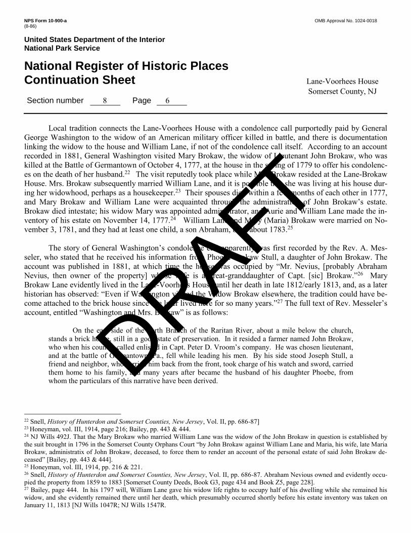
Local tradition connects the Lane-Voorhees House with a condolence call purportedly paid by General
George Washington to the widow of an American military officer killed in battle, and there is documentation linking the widow to the house and William Lane, if not of the condolence call itself. According to an account recorded in 1881, General Washington visited Mary Brokaw, the widow of Lieutenant John Brokaw, who was killed at the Battle of Germantown of October 4, 1777, at the house in the spring of 1779 to offer his condolenc-es on the death of her husband.22 The visit reputedly took place while Mrs. Brokaw resided at the Lane-Brokaw House. Mrs. Brokaw subsequently married William Lane, and it is possible that she was living at his house dur-ing her widowhood, perhaps as a housekeeper.23 Their spouses died within a few months of each other in 1777, and Mary Brokaw and William Lane were acquainted through the administration of John Brokaw’s estate. Brokaw died intestate; his widow Mary was appointed administrator, and Aurie and William Lane made the in-ventory of his estate on November 14, 1777.24 William Lane and Mary (Maria) Brokaw were married on No-vember 3, 1781, and they had at least one child, a son Abraham, born about 1783.25
The story of General Washington’s condolence call apparently was first recorded by the Rev. A. Mes-
seler, who stated that he received his information from Phoebe Brokaw Stull, a daughter of John Brokaw. The account was published in 1881, at which time the house was occupied by “Mr. Nevius, [probably Abraham Nevius, then owner of the property] whose wife is a great-granddaughter of Capt. [sic] Brokaw.”26 Mary Brokaw Lane evidently lived in the Lane-Voorhees House until her death in late 1812/early 1813, and, as a later historian has observed: “Even if Washington visited the Widow Brokaw elsewhere, the tradition could have be-come attached to the brick house since she later lived here for so many years.”27 The full text of Rev. Messeler’s account, entitled “Washington and Mrs. Brokaw” is as follows:
On the east side of the north Branch of the Raritan River, about a mile below the church,
stands a brick house, still in a good state of preservation. In it resided a farmer named John Brokaw, who when his country called enlisted in Capt. Peter D. Vroom’s company. He was chosen lieutenant, and at the battle of Germantown, Pa., fell while leading his men. By his side stood Joseph Stull, a friend and neighbor, who carried him back from the front, took charge of his watch and sword, carried them home to his family, and many years after became the husband of his daughter Phoebe, from whom the particulars of this narrative have been derived.
22 Snell, History of Hunterdon and Somerset Counties, New Jersey, Vol. II, pp. 686-87] 23 Honeyman, vol. III, 1914, page 216; Bailey, pp. 443 & 444. 24 NJ Wills 492J. That the Mary Brokaw who married William Lane was the widow of the John Brokaw in question is established by the suit brought in 1796 in the Somerset County Orphans Court “by John Brokaw against William Lane and Maria, his wife, late Maria Brokaw, administratix of John Brokaw, deceased, to force them to render an account of the personal estate of said John Brokaw de-ceased” [Bailey, pp. 443 & 444]. 25 Honeyman, vol. III, 1914, pp. 216 & 221. 26 Snell, History of Hunterdon and Somerset Counties, New Jersey, Vol. II, pp. 686-87. Abraham Nevious owned and evidently occu-pied the property from 1859 to 1883 [Somerset County Deeds, Book G3, page 434 and Book Z5, page 228]. 27 Bailey, page 444. In his 1797 will, William Lane gave his widow life rights to occupy half of his dwelling while she remained his widow, and she evidently remained there until her death, which presumably occurred shortly before his estate inventory was taken on January 11, 1813 [NJ Wills 1047R; NJ Wills 1547R.
DRAFT

NPS Form 10-900-a OMB Approval No. 1024-0018 (8-86)
United States Department of the Interior National Park Service
National Register of Historic Places Continuation Sheet Lane-Voorhees House Somerset County, NJ Section number 8 Page 7
In the spring of 1779, while Washington was yet residing in the Wallace house, in Somerville,
he was made acquainted with the circumstances above related (probably from conversation with Dr. Hardenburgh, who was the pastor of Mrs. Brokaw), and his sympathies were so excited in her behalf that he rode up to this house one day –a distance of five miles– to call on her. When he entered the house he was deeply affected, and with many kind and comforting words expressed his sorrow for her bereavement. We have always regarded this incident in our Revolutionary history as one of the most affecting and beautiful manifestations of the great and tender heart of the Father of his country.
The house is now occupied by Mr. Nevius whose wife is a great-granddaughter of Capt.
Brokaw. As a monument of Washington’s tender heart. It ought to stand until it crumbs into dust.28
The story was repeated by the noted architectural historian Rosalie Fellows Bailey in her account of the dwell-ing, which she named the Lane-Brokaw House in her 1936 history of Dutch house in New Jersey.29
Bailey also described William Lane as a “farmer of means,” and tax records for Bridgewater Township furnish some corroboration for that assertion, providing information about his farm during the late 18th century. Township assessment lists survive for twelve years between 1779 and 1797, and Williams Lane’s name appears on all of them. In 1779 he was assessed 496 acres, valued at £22 per acre, evidence that he had increased his landholdings since receiving his inheritance. In 1781, his assessed holdings dropped to 256 acres, but rose to 306 acres assessed at £24 per acre in 1784, and remained constant in terms of size and valuation in the nine sub-sequent years for which records survive (1785, 1788, 1789, 1791 through 1795 and 1797).30 The reduction of his assessed acreage can be explained by his relinquishing a portion of his farm to his eldest son Guisbert, or Gilbert (1757-1825), who beginning in 1784 was assessed for 150 acres.31 His other adult son Tunis (1763-1834) was listed as a “single man” in 1785 and on subsequent tax roles; he presumably lived with his parents.32 William’s livestock for the twelve assessments averaged about eleven horses and 20.5 head of cattle; hogs were assessed in 1779 and 1781, and in both years he had eight. That William was assessed for one slave in all but two years (1779 and 1795, when he was assessed for none) undoubtedly represents an undercounting since his 1797 estate inventory lists six slaves. In 1794 and 1795 he was assessed for a sawmill, evidently a short-lived enterprise, which his 1797 will indicates was located somewhere on his farm.33
For unknown reasons, however, William Lane apparently needed to raise capital in the 1790s, and on
three occasions obtained mortgages on his property. In 1791 he received £465.12.0 by mortgaging a 300-acre
28 Snell, History of Hunterdon and Somerset Counties, New Jersey, Vol. II, pp. 686-87. 29 Bailey, page 442. 30 Bailey, page 446; New Jersey Tax Ratables, Bridgewater Township, 1779, 1781, 1785, 1788, 1789, 1791 – 1795 & 1797. In 1779, William’s brother Aurie, who had inherited the south part of their father’s property, was assessed for 374 acres, valued at £22 per acre, 9 horses, 15 cattle, 10 hogs, 3 slaves & a riding chair, while William was assessed for 496 acres, valued at £22 per acre, 12 horses, 20 cattle, & 8 hogs. 31 Ibid. On the 1791 tax list he is identified as “Guisbert Lane, son of W[illiam],” on the 1792 role as “Guisbert W. Lane,” on the 1793 role as “Gilbert W. Lane” and on the 1794 role as “Gilbert Lane, son of W[illiam].” 32 Ibid. Tunis is identified “son of W[illiam]” on the 1791 tax role. 33 Ibid.; NJ Wills 1047R. No documentary evidence of the sawmill has been discovered postdating the will, and the mill’s exact loca-tion is unknown.
DRAFT

NPS Form 10-900-a OMB Approval No. 1024-0018 (8-86)
United States Department of the Interior National Park Service
National Register of Historic Places Continuation Sheet Lane-Voorhees House Somerset County, NJ Section number 8 Page 8
tract identified as “all that tract of land and plantation,” which had inherited from his father, and four years later he secured another mortgage on his plantation realizing £135.8.0.34 In 1796, he raised an additional £200 by mortgaging a 381-acre tract, which evidently encompassed the 300-acre plantation and some adjoining land but excluded “the land now in the possession of Gilbert W. Lane.”35 While all three mortgages were to be paid with interest within one or two years of issuance, they were not canceled until 1808, almost ten years after his death, suggesting that William was unable to meet the payment terms.
William Lane died October 14, 1797, five months after executing his will, and his estate records, despite
any financial difficulties that he may have had, provide further evidence as to his success as a farmer, as he iden-tified himself in his will, along with the disposition of his property after his death.36 He was able to bequeath land to his three sons, Gilbert, Tunis and Abraham and leave substantial sums of money to four of his five daughters, as well as make ample provisions for his wife Maria, the former Mary Brokaw. Maria was to receive “all the Goods and Chattles she brought” to the marriage, “likewise … my Negro wench Dine as long as she re-mains my widow, … one half of all my lands,” except for the sawmill, and “[o]ne half of my Dwelling House I now live in (that is) the east end of said House with the use of the kitchen seller [cellar] Chamber Milk House Garden & Barn… in Lieu of her Dower.” Eldest son Gilbert was to receive all the money that had been leant to him as well as the “land he now lives on,” which had already been conveyed to him by deed by his father. Son Tunis was to receive “one half of all my lands with the House & buildings where I now live, exclusive of his stepmother’s rights of occupancy during her widowhood, “to be taken from the north side of my Plantation and … valued at [£6] per acre.” Upon the remarriage or death of Maria Lane, William’s youngest son Abraham was to receive the land bequeathed to her for her widowhood, “to be valued at [£5] per acre.” William bequeathed the sawmill and one acre of land to Tunis and Abraham, who also received his personal property. William named as his executors his three sons and nephew Gilbert A. Lane, directing them to sell his real estate and per-sonal property as necessary to pay debts, legacies and expenses.37 While he was able to make ample provision for his heirs, sons Tunis and Abraham bore the burden of his debts.
Williams Lane’s estate inventory, dated October 28, 1797, further documents his status as a substantial
farmer, one who practiced the diversified farming typical of the period and region, and provides as well indica-tors of Dutch material culture and middle class status. The inventory identifies several outbuildings and crops: “hay in the Barn Barrack and stack,” “wheat in the barn and barrack,” “rye in the Barn Barrack and stack,” “corn in the field,” “a heap of buckwheat in the chamber” and “a heap of potatoes in cellar” and flaxseed. Livestock, comprising the most valuable portion of his personal property, included sixteen horses, thirty head of cattle, twelve sheep, fourteen pigs, five hogs and one sow. He owned six slaves, one man (Jack) valued at £100, three boys (Dick, Pompy and Sam) valued respectively at £90, 90 & 55, and two women Pole, valued at £20 and 34 Somerset County Mortgages, Book C, page 119 and Book D, page 172. 35 Ibid., Book E, page 27. 36 Honeyman, vol. III, 1914, page 216; “Somerset’s Old Burying Grounds” clipping from unnamed newspaper, dated May 311, 1940; NJ Wills 1047R. 37 NJ Wills 1047R. Maria and Elizabeth Lane, both unmarried, were to receive £150 each, also the right to live in their father’s house while they were single, Hannah (wife of Henry Field) was to receive £50 and Sarah (wife of Henry Vroom) was to receive £75. Wil-liam Lane left nothing to his daughter Jane (who married Jacob Ten Eyck), giving as his reason that she “has got a plantation left her by Jane Van East Dec. which I always thought was intended to be divided among my children.”
DRAFT

NPS Form 10-900-a OMB Approval No. 1024-0018 (8-86)
United States Department of the Interior National Park Service
National Register of Historic Places Continuation Sheet Lane-Voorhees House Somerset County, NJ Section number 8 Page 9
Dine, valued at £75. Among his agricultural implements was a “Dutch fan,” an implement for winnowing grain. His household goods included two “Dutch cupboards” valued at £3 & £2, an eight day clock worth £15, a silver watch worth £6, and a “loom & tackle,” evidence of domestic cloth production. Athough including no cash, notes or bonds, the inventory of his “good chattles [sic] and credits” totaled the considerable sum of £1,151.16.0.38
Tunis Lane succeeded his father on the homestead, which he owned and farmed until his death in 1834,
presumably sharing the family residence with his stepmother and unmarried sisters in accordance with his fa-ther’s will. Most likely to raise funds needed to pay his share of his late father’s debts and legacies, he mort-gaged a 90-acre portion of “the farm and plantation late the property of William Lane, deceased” for £240 in 1799.39 Bridgewater Township tax records, which survive for seven years during the first decade of the 19th century, indicate that his agricultural operation was smaller than that of his father. In all seven years he was as-sessed for 182 acres, valued at £24 per acre, and his livestock assessments averaged 4.8 horses and 3.7 head of cattle, less than half of what his father’s holdings had been. In the four years between 1806 and 1809 he was as-sessed for one slave, documenting that the family still relied on slave labor.40 Upon his stepmother’s death in late 1812/early 1813, he gained full control of the farm; and two years later he was able to cancel his 1799 mort-gage.41
The 1830 Federal Census documents that Tunis Lane, who never married, continued to live in a multi-
generational household, some of whose male members were engaged in agriculture. According to the 1830 cen-sus his household had five members: three white males (one aged between 60 and 69, one between 40 and 49, and one between 15 and 19) and two white females (one aged between 70 and 79 and one between 10 and 14). The male between 60 and 69 years-of-age presumably is Tunis, born in 1763, who was 67 in 1830, and the fe-male aged between 70 and 79 probably was his unmarried sister Elizabeth, if the census taker recorded her age incorrectly, since she was born in 1767. The young male and female members of the household presumably were servants or family members. The two adults males were engaged in agriculture. The household had no Af-rican-American members; suggesting that the family slaves had been freed or had died.42
Tunis Lane died July 26, 1834 at the age of seventy-one, and his estate inventory documents that his
wealth, as measured by value of his personal estate, $1,633.43, was substantial but less than that of his father. However, like his father, Tunis engaged in the general farming typical of the region, as evidence by such entries as “lot of corn in crib, “rye in the Barrack” “wheat in the [barrack],” “hay in barn & barrack,” as well as a “crop of oats” and “corn & bulk of wheat growing.” Except for an “eight day clock” worth $25.00, perhaps the clock mentioned in his father’s inventory, his household goods were not listing separately but valued collectively at $206.10). “Notes and bills” worth $506.58 comprised portion of his personal estate; his livestock was next in 38 Ibid. 39 Somerset County Mortgages, Book E page 347. Although the mortgage had a two-year term, it was not cancelled until 1815. 40 New Jersey Tax Ratables, Bridgewater Township, 1802, 1803, 1805 and 1806 – 1809. 41 NJ Wills 1547R; Somerset County Mortgages, Book E page 347. The inventory f Maria Lane’s estate, dated January 11, 1813, to-taled $780.70. The bulk of her estate consisted of five notes valued at $614.67 and $72.56 in cash, the remainder comprising a few household goods. 42 United States Census, Somerset County, Bridgewater Township, Population Schedule, 1830.
DRAFT

NPS Form 10-900-a OMB Approval No. 1024-0018 (8-86)
United States Department of the Interior National Park Service
National Register of Historic Places Continuation Sheet Lane-Voorhees House Somerset County, NJ Section number 8 Page 10
value, including six horses worth $235.00, ten head of cattle and four calves worth $116.00, and six swine $26.50. His “Purse and Apparel” was worth $30.75. He owned no sheep, which suggests that his household was not involved in domestic cloth production. “Notes desperate and not included” totaled $651.27.43
In his 1814 will Tunis Lane directed that his entire estate was to be divided equally among six of his
seven siblings, excluding his half-brother Abraham, and to satisfy this directive a few month after his death his farm was sold at public auction. Albert C. Voorhees of Hillsborough Township, Somerset County, was the high bidder at $55 per acre, and in January 1835 the heirs conveyed the 182-acre farm to him for $1,010 “excepting and reserving the graveyard as it is now enclosed with posts and rails thereof.”44
Voorhees appears to have moved to his new property, but his occupancy was disrupted two years later,
when his house was badly damaged by fire on April 30, 1837, suffering a loss for which he had no insurance coverage.45 Within days of the disaster, which left the dwelling’s brick walls intact, Voorhees advertised the property for sale, informing the public that he was “desirous of removing to the West” and describing the farm as containing
150 acre of first rate LAND, about 30 acres of which is WOOD LAND, and the residue under a good state of cultivation, being well watered in every field, and a young & thrifty orchard. This farm was formerly owned by Tunis Lane, and the buildings are good, with the exception of the House, which was lately burnt, but the walls, which are of brick, were left standing. The terms will be made easy, as the principal part of the purchase money will not be wanted this Spring, but can be secured by mort-gage.46
The advertisement (Supplemental Image 1) included the note that the farm with would be offered at for public sale at auction on May 20, 1837 on the premises if not sold beforehand.
Either by auction or private sale, Albert C. Voorhees soon found a buyer for the farm. On September 9,
1837 he and his wife conveyed the property to Isaac Polhemus, Montgomery Township, Somerset County for $6,026.59, realizing a handsome profit despite the fire loss.47 The deed described the premises as two adjoining tracts of land in Bridgewater: an 80-acre parcel on the east side of the North Branch, including a small island, but excepting the graveyard, and a 66-acre parcel abutting the east side of the first tract.48 Five weeks later,
43 Honeyman, vol. III, 1914, page 221; “Somerset’s Old Burying Grounds” clipping from unnamed newspaper, dated May 311, 1940; NJ Wills 2490R. Tunis gave as his reason for excluding his half-brother Abraham that “he had the half of all my fathers Estate wile [sic] my other brother and sisters got little or nothing.” 44 NJ Wills 2490R; Somerset County Deeds, Book T. page 15. 45 “Fire,” The Somerset Whig, May 2, 1837; Commercial Advertiser, New York, NY, Friday, May 5, 1837; Centennial of Freedom, Newark, Tuesday May 9, 1837. The Whig informed its readers that “We regret to hear that the dwelling house of Albert C. Voorhees, at North Branch was destroyed by fire on Sunday [April 30].” The two other papers reported the lack of insurance. 46 “Farm for sale…Albert C. Voorhees … North Branch, May 9, 1837,” The Somerset Whig, May 16, 1837. 47 Somerset County Deeds, Book T. page 15. 48 Ibid.. The boundary description indicates that both parcels forms part of the land Tunis had inherited from his father, and the first parcel appears to have formed part of the tract that Tunis Lane had mortgaged in 1799 [Somerset County Mortgages, Book E page 347]. While Albert and Court Voorhees presumably were related, their exact relationship is unknown.
DRAFT

NPS Form 10-900-a OMB Approval No. 1024-0018 (8-86)
United States Department of the Interior National Park Service
National Register of Historic Places Continuation Sheet Lane-Voorhees House Somerset County, NJ Section number 8 Page 11
Polhemus and his wife sold the 80-acre tract, which encompassed the farmstead, to Court G. Voorhees, Hills-borough Township, Somerset County, for $5,000.00, making what also appears to have been a considerable profit.49
Court (Courtland) G. Voorhees evidently occupied the farm until his death in 1847, and he presumably
was responsible for the reconstruction of the house, unless the work had been undertaken by during the summer after the fire. Born March 2, 1806, he was the son of Gerardus Voorhees and his wife Mary Quick; however, the name of his wife and children is unknown.50 As listed in the 1840 Federal Census, the household of Courtland Vorhees consisted of seven members: two white males (one aged between 15 and 19 and one between 40 and 49) and five white females (two aged between 5 and 9, one between 10 and 14, one between 15 and 19 and one between 60 and 69). The male aged between 40 and 49 must have been Court Voorhees, and the female aged between 60 and 69 presumably a relative or servant; and the younger male and females, his children. That there was no female around his age suggests that he was a widower.51
The inventory made on March 23, 1847 upon Court Voorhees’ intestate death reveals that he continued
the diversified farming of his predecessors on the property. Totaling $1,136.85, the inventory makes mention of buildings (barn, hovel, wagon house and poultry coops), crops (hay, straw, corn, potatoes, oats and “green grain” or wheat) and livestock (cattle, poultry and one hog). He also kept bees, owned blacksmith tool and had the use of a “colored boy’s time,” worth $100.52 The inventory also provides important information about the rebuilt dwelling. The following inventory entries, given in the order in which they were listed and presumably made as the inventory taker moved through the house, help identify rooms in the dwelling, as well as some fur-nishings and room uses. The likely corresponding rooms, as numbered for this report, are included in parenthe-sis:
Contents of shed (Rooms 106, 107 & 108) Contents of kitchen (Room 101) [contents] of back room (Room 102) Contents of garret (Room 200) Bed & table in store room (Room 201 or Room 103) Contents of store room (Room 201 or Room 103) Small bed (Room 103 or Room 104) Contents of Small room (Room 103 or Room 104) Bureau, bible & stand (Room 104 or Room 105) Contents of parlor (Room 105) Desk (Room 105)
49 Somerset County Deeds, Book Y, page 393. 50 Florence A. Christoph, (complier & editor), The Van Voorhees Family in America, pp. 381-382. 51 United States Census, Somerset County, Bridgewater Township, Population Schedules, 1840. 52 NJ Wills 5052R.
DRAFT

NPS Form 10-900-a OMB Approval No. 1024-0018 (8-86)
United States Department of the Interior National Park Service
National Register of Historic Places Continuation Sheet Lane-Voorhees House Somerset County, NJ Section number 8 Page 12
Finding its assets insufficient to cover its liabilities, the estate’s court-appointed administrator received
authorization from the county orphans court to sell the farm at auction in order to raise the necessary money. James P. Brokaw of Hillsborough Township, Somerset County, was the high bidder at $63.17 per acre at the December 1847 auction, and in following April the estate administrator conveyed the 79.77-acre farm to him, including the island and excluding the graveyard, for $5,038.00.53
James P. Brokaw owned, and presumably occupied the former Lane-Voorhees farm for only a few years.
The 1850 map of Somerset County depicts a house on the Lane-Voorhees site and identifies “J. P. Brokaw” as its owner (Historic Map 2).54 He does appear in the 1850 United States Census for Bridgewater Township, iden-tified as a married farmer, age twenty-five, but not in the agricultural census of that year, and by 1854 when he sold the property he had moved to New York City.55 Brokaw and his wife Amelia sold the farm to John D. Ker-show for $5,200, slightly more than he had paid for it, but the conveyance was subject to a mortgage given by Brokaw to the Vorhees estate administrator, the sum of $1,219.13 “being a balance due said mortgage.”56 When Kershow and his wife Catherine, Bridgewater Township, sold the farm to brothers Dennis and Abraham V. Nevius, Branchburg Township, Somerset County, five years later the conveyance was subject to two mortgages (the unpaid Brokaw mortgage and a new mortgage made by Kershow) totaling $2,555,20, which sum was de-ducted from the $6,400 purchase price and paid to the mortgage holders.57
The Nevius brothers appear in the 1860 Federal Census as members of the household of Bridgewater
Township resident, Simon Nevius, and the family purportedly occupied the former Lane-Voorhees farm.58 The household had seven members: Simon, age 63, farmer; Bridget Nevius, age 63, his wife, no occupation given; and three young men, presumably their unmarried sons: Dennis S. Nevius, age 29, no occupation given; Abram [Abraham] V. Nevius, age 26, no occupation given; and Garret L. Nevius, age 24, carpenter. The household’s seventh member, Ellen Sickles, age 16, presumably was a servant. Simon reported possession of real estate worth $6,500, almost the exact figure that Dennis and Abraham Nevius had paid for the farm purchased the year before, and it is possible that although the brothers held title to property that the father as head-of-household was given credit for ownership in the census.59 However, none of the farms included in the agricultural schedule of the 1860 census for Bridgewater Township can be associated with these members of Nevius family.
In March 1866, Dennis Nevius sold his undivided half share of the farm to Abraham V. Nevius, and cen-
sus data and other sources indicate that the latter owned and occupied the property until the 1880s.60 Abram V. Nevius, a farmer, age 36, was listed as the head of a Bridgewater Township household in the 1870 Federal cen-sus. In addition to his wife, Anna M. Nevius, age 25, and their two presumed children: Simon, age 4, and Ann, 53 Somerset County Deeds, Book H2, page 193. 54 J. W. Otley, L. Vanderveer, and J. Keily, Map of Somerset County, New Jersey, 1850. 55 United States Census, Somerset County, Bridgewater Township, Population Schedules, 1850; Somerset County Deeds, Book S2, page 278. 56 Ibid. 57 Somerset County Deeds, Book G3, page 434. 58 Bailey, page 445. 59 United States Census, Somerset County, Bridgewater Township, Population Schedules, 1860. 60 Somerset County Deeds, Book T3, page 477 and Book Z5, page 228.
DRAFT

NPS Form 10-900-a OMB Approval No. 1024-0018 (8-86)
United States Department of the Interior National Park Service
National Register of Historic Places Continuation Sheet Lane-Voorhees House Somerset County, NJ Section number 8 Page 13
age 1 month, the household included two laborers, Aaron Lowe, age 18, and Henry Brown, age 14, and a do-mestic servant, Mary Gerbert, age 11. The two youngest employees were reported as having attended school in the past years. Abram reported owning real estate worth $8,800 and personal property worth $1,000.61 The 1873 Somerset County atlas identified “A. V. Nevius” as the owner of a house just south of North Branch, its depict-ed at a location somewhat north of the site of the Lane-Voorhees House evidently a cartographical error (Histor-ic Map 3).62
While there is no listing for Abram or Abraham Nevius in the 1870 census agricultural schedule for
Bridgewater Township, Abraham V. Nevius does appear in that of 1880. The 1880 agricultural schedule enu-merates Abraham V. Nevius as the proprietor of a general farming operation. His 90-acre farm consisted of eighty acres of “tilled [land] including fallow and grass in rotation (whether pasture or meadow)” and ten acres of “permanent meadows, permanent pastures, orchards, [and] vineyards,” but no acreage of “woodland and for-est.” The farm was valued at 5,600. The value given for farm equipment was $200 and that for livestock is $440. The amount spent on farm labor in 1879 was $300, and labor was employed fifty-two weeks of that year. Livestock “on hand” included six dairy cows, three of whom had “dropped” calves, one other head of cattle, five horses, four swine and seventy poultry. The dairy cows in 1879 produced 900 gallons of “milk sold or sent to butter and cheese factories;” 300 pounds of butter were made on the farm. In 1879 the farm had sixteen acres of mown grasslands producing twenty tons of hay; ten acres were “not mown,” presumably used for pasture. Other farm production in 1879 included 900 bushels of corn from twenty acres, 600 bushels of oats from ten acres, 125 bushels of wheat from nineteen acres and twenty bushels of rye from one acre. An apple orchard of one acre had twelve bearing trees and produced ten bushels of apples. The total estimated value of the farm’s prod-ucts in 1879 was $1,000.63 Abraham V. Nevius undoubtedly was the “Mr. Nevius” who was reported as the farm’s occupant in 1881.64
Nevius ownership of the farm ended on March 23, 1883 when Abraham V. Nevius and wife Anna M., of
Bridgewater Township, conveyed the 79.77-acre property (still including the island and excluding the grave-yard) to Fanny M. Beekman and John M. Garretson, executors of Peter N. Beekman, for the sum of $8,100.00, along with “the straw and manure [and] the winter grain now growing.” The conveyance was subject to the payment of two mortgages totaling $4,200, which sum was deducted from the purchase price and paid to the mortgage holders, along with interest due.65 The purchasers of the Nevius farm were acting in accordance with Peter Beekman’s will, which directed them as executors to invest the inheritance of Beekman’s son Abraham until they felt he was mature enough to manage the investment. On the same day, Abraham Beekman gave for-mal consent to the acquisition and agreed to the “purchase [of] certain stock horse cattle farming utensils ma-chinery and other articles necessary for use on a farm.”66 Abraham Beekman may have occupied the farm at that 61 United States Census, Somerset County, Bridgewater Township, 1870. 62 F. W. Beers, County Atlas of Somerset, New Jersey, 1873. 63 US Census, Agricultural Schedule, Bridgewater Township, 1880. 64 Snell, History of Hunterdon and Somerset Counties, New Jersey, Vol. II, pp. 686-87. 65 Somerset County Deeds, Book Z5, page 228. The first mortgage for $3,000.00 was given by Abraham Nevius & wife to Derrick Lane (mortgage book L, page 471); the second mortgage for $1,200.00 was given Abraham Nevius & wife to Gabriel Field (mortgage book B2, page 484). The interest was calculated to April 1, 1883. 66 Somerset County Deeds, Book Z5, page 226.
DRAFT

NPS Form 10-900-a OMB Approval No. 1024-0018 (8-86)
United States Department of the Interior National Park Service
National Register of Historic Places Continuation Sheet Lane-Voorhees House Somerset County, NJ Section number 8 Page 14
time or shortly thereafter, since when he received title to the property from his father’s executors two years later he was already a resident of Bridgewater Township.67 Abraham Beekman owned the farm for only two years, and in March 1887, he and his wife sold it to Richard Field, Bedminster Township, Somerset County, for $5,000.00, with the usual exclusion of the graveyard. The conveyance was subject to a mortgage for $3,000, and no manure or straw was to be removed.68
Richard Field may not have occupied the property, since when he sold it seven years later in March
1894, he was still a Bedminster resident. The purchaser was George W. Field of Bedminster, a young man who probably was his son, who paid $7,000 for the farm and a 19.50-acre parcel, possibly a wood lot, subject to two mortgages amounting to $4,000.69 George W. Field, a farmer, age 29, is listed in the 1900 United States Census along with his wife Alice H. Field, age 26. The Bridgewater Township residents had been married three years, and they occupied a rented house, evidence that they no longer occupied the farm.70
George W. Field and his wife in 1902 sold the 79.77-acre farm and the 19.5-acre lot to Gilbert Chauncey
Brokaw of Bridgewater Township, whose wife Alice was related to the Fields. Brokaw paid $6,000 for the two tracts, which he owned until 1917, operating the farm and occupying the brick house.71 As listed in the 1910 federal census, the Brokaw household consisted of Gilbert, a farmer age 50, and his wife Sarah H. Field, age 47 (who had been married for twenty-five years), along with three other adults: Catherine Fuhrken, age 23, “com-panion” (probably servant); Daniel Housel, age 23, hired man; and Edward Weller, hired boy, age 13. Accord-ing to the census, Brokaw conducted a “general farm,” which he owned free of mortgage.72
In 1917 Bridgewater resident Henry W. Mingle purchased the two tracts from the Brokaws for $1, and
the property was subdivided and sold several times before 1929, when it was reunited in one ownership.73 In 1922 Mingle conveyed the two tracts to Margaret W. Deyman of Jersey City in 1922, and in following year, Margaret and her husband Bernhard, conveyed a 20.95-acre parcel subdivided from the farm back to Mingle.74 This parcel was located on the east side of Milltown Road, since in the Deymans, still residents of Jersey City, issued a corrective deed to cover the graveyard exclusion which had been omitted from the 1923 deed.75 In 1928 the Deymans sold the balance of the two tracks to Harry and Lena Sally, who in the following year pur-chased the 20.95-acre lot and thus reassembled the farm as it had existed since 1837.76
67 Ibid., Book C6, page 419. 68 Ibid., Book M6, page 524. 69 Ibid., Book V7, page 331. Richard Field acquired the smaller parcel from Edward Powes in 1888 [Deed Book Q6, page 142]. 70 United States Census, Bridgewater Township, 1900. 71 Somerset County Deeds, Book R9, page 173 and Book Y15, page 150; Bailey, page 446. 72 United States Census, Bridgewater Township, 1910. 73 Somerset County Deeds, Book Y15, page 150. 74 Somerset County Deeds, Book I19, page 321& Book V18, page 310. 75 Ibid., Book B20, page 413. 76 Ibid., Book D21, page 211 & Book N21, page 330.
DRAFT

NPS Form 10-900-a OMB Approval No. 1024-0018 (8-86)
United States Department of the Interior National Park Service
National Register of Historic Places Continuation Sheet Lane-Voorhees House Somerset County, NJ Section number 8 Page 15
Harry and Lena Sally, Jewish immigrants from Bessarabia (now part of Moldova and Ukraine), operated
a dairy farm and occupied the Lane–Voorhees House until the late 1960s.77 In 1930, their household consisted six members: Harry, a farmer age 40; his wife Lena Sally, age 36; their three children, Vivian I, age 12, Anita R., age 10, and Sara, age 8; and John Zimator, a farm laborer age 32. According to the census Sally owned his home. He could speak English, and his native language was Hebrew. All three daughters attended school. The household had a radio.78 One photograph dating to the 1960s records the well-kept appearance of the house dur-ing their ownership (Historic Image 3).
During the ownership of Harry and Lena Sally, several lots of varied size were subdivided from the property and sold, and four easements across it were granted for public utilities.79 Then in 1969, the balance of the property was sold by the Sallys to several investors, whose successors and executors sold a 28.77-acre lot stretching between the river and Milltown Road and encompassing the Lane-Voorhees House to Gloria F. Fierro of East Hanover, New Jersey, in 1996.80 Gloria Fierro and her husband John owned the property, in their own names, or through a holding company until 2005, when they transferred title to James Fierro, presumably their son, after having three years earlier conveyed the development rights to the tract, excluding one building lot as-sociated with the house, to the Township of Bridgewater.81 In 2006, James Fierro executed a deed amendment with the Township by which he agreed, among other items, to preserved the “historic character of the Dutch co-lonial farm house.”82 The house appears to have been unoccupied and neglected until this time when James Fi-erro began extensive renovations which remained uncompleted when he sold the property to the Township of Bridgewater in 2012.83
.
77 Betsey Amsel, “History of Dutch Settlement of NJ (Featuring the Lane-Brokaw house),” Amsellbird.com (accessed December 2015). 78 United States Census, Bridgewater Township, 1930. 79 Somerset County Deeds, Book 1199, page 152. 80 Ibid.; Somerset County Deeds, Book 1220, page 794 & Book 2050, page 776. 81 Somerset County Deeds, Book 2125, page 182, Book 2125, page 185, Book 5170, page 2499, Book 5551, page 463 & Book 5814, page 2951. 82 Somerset County Deeds, Book 5890, page 3376. 83 Somerset County Deeds, Book 6598, page 447.
DRAFT

NPS Form 10-900-a OMB Approval No. 1024-0018
(8-86)
United States Department of the Interior
National Park Service
National Register of Historic Places
Continuation Sheet Lane-Voorhees House Somerset County, NJ Section number 9 Page 1
BIBLIOGRAPHY Books, Pamphlets, Reports and Surveys
Bailey, Rosalie Fellows. Pre-Revolutionary Dutch Houses and Families in Northern New Jersey and Southern
New York. New York: Dover Publications, Inc., 1968 (reprint of 1936 William Morrow & Company limited edition).
Barber, John W. and Henry Howe. Historical Collections of the State of New Jersey. Newark, New Jersey: Benjamin Olds, 1844.
Benjamin, Asher. The Architect, or Practical House Carpenter. New York: Dover Publications, Inc., 1988
(reprint of 1830 edition). Benson, Adolph B. (ed.). The American of 1750: Peter Kalm’s Travels in North American. New York: Dover
Publications, Inc., 1937.
Brecknell, Ursula C. Hillsborough An Architectural History. Neshanic, New Jersey: The Township of Hillsborough Historic Preservation Commission, 1996.
Brecknell, Ursula (ed.). Somerset County Historical Quarterly Commemorative Issue. Somerville, New Jersey:
Somerset County Historical Society, 1982. Cohen, David Steven. The Dutch-American Farm. New York: New York University Press, 1992. Christoph, Florence A. (complier & editor). The Van Voorhees Family in America, Baltimore, Maryland: The
Van Vorhees Association, 2002. Dennis Bertland Associates. Andrew Ten Eyck House Historic Structures Report, Branchburg Township
Historical Society, 2002. _______________________. Dunster‐Squibb House Historic Structures Report. Bernardsville Historic
Preservation Committee, 2013. Edward s, Richard. Industries of New Jersey, Part 1. New Yotk: Historical Publishing company, 1882
DRAFT
NPS Form 10-900-a OMB Approval No. 1024-0018
(8-86)
United States Department of the Interior
National Park Service
National Register of Historic Places
Continuation Sheet Lane-Voorhees House Somerset County, NJ Section number 9 Page 2
Ewans, N. R. Early Brickmaking in the Colonies: A Common Fallacy Corrected. Camden, New Jersey:
Camden County Historical Society, 1938. Ford Farewell Mills and Gatsch, Architects, LLC. Historic Structures Report for the Cornelius Stoothoff House,
Franklin Township, Somerset County, New Jersey. Princeton, NJ, June 2004. ____________. Historic Structures Report for the Peter G. Nevius House, Franklin Township, Somerset
County, New Jersey. Princeton, NJ, June 2004. ____________. Neshanic Valley Golf course Preservation Plan. Princeton, New Jersey, December 2007. Historical American Building Survey. Washington, DC: National Park Service, various dates. Hunter, Richard W. and Richard L. Porter. Hopewell: A Historical Geography. Titusville, New Jersey:
Hopewell Township Historic Sites Committee, 1990. Keystone Preservation Group. Lane Brokaw House: Bridgewater, NJ Analysis Of Historic Building Materials.
August 6, 2015 (as included in Mills + Schnoering Architects. Historic Structure Report For The Lane-Brokaw House Bridgewater Township, NJ. (Draft). December 22, 2015).
McKee, Harley J. Introduction to Early American Masonry. Washington, DC: National Trust For Historic
Preservation, 1973. Meeske, Harrison. The Hudson Valley Dutch and Their Houses. Fleischmanns, New York: Purple Mountain
Press, 1998. Mills + Schnoering Architects. Historic Structure Report For The Lane-Brokaw House Bridgewater Township,
NJ. (Draft). December 22, 2015. Murphy, Henry C. (trans), Journal of a Voyage to New York: And a Tour in Several of the American colonies in
1679-80 By Jasper Danckaerts, Peter Sluyter of Wieward in Friesland. New York: C. Scribner's Sons, 1913.
Schleicher, William A., Susan J. Winter, and Robert Bouwman. Images of America – Branchburg and the
River Towns of Burnt Mills, North Branch, North Branch Depot, South Branch and Neshanic Station. Dover, New Hampshire: Arcadia Press, 1995.
DRAFT

NPS Form 10-900-a OMB Approval No. 1024-0018
(8-86)
United States Department of the Interior
National Park Service
National Register of Historic Places
Continuation Sheet Lane-Voorhees House Somerset County, NJ Section number 9 Page 3
Schleicher, William A. and Susan J. Winter. Images of America – Crossroads of the American Revolution.
Charleston, South Carolina: Arcadia Publishing, 1999. Snell, J. P. (ed.). History of Hunterdon and Somerset Counties, New Jersey. Philadelphia: Everts & Peck, 1881. Somerset County Historic Sites Survey. Somerville, NJ: Somerset County Cultural and Heritage Commission,
1989. Stevens, John R. Dutch Vernacular Architecture in North America, 1640-1830. West Hurley, New York: The
Society for the Preservation of Hudson Valley Vernacular Architecture, 2005. Thayer, Theodore. As We Were, The Story of Old Elizabethtown. Elizabeth, New Jersey: Grassman Publishing
Co., 1964. Trinity Episcopal Church (Woodbridge, New Jersey) National Register nomination, 2002. Upper Raritan Watershed Historic Sites Survey. Gladstone, New Jersey: Upper Raritan Watershed Association,
1981. Upton, Dell and John Vlach (Eds.). Common Places: Readings in American Vernacular Architecture. Athens,
Georgia: 1986University of Georgia Press, . Veit, Richard, PhD. “Following the Yellow Brick Road: Dutch Bricks in New Jersey, Fact and Folklore.”
Bulletin of the Archaeological Society of NJ. #55, 2000. ______________. Phase IA/B Archaeological Investigation, Lane - Brokaw House, 551 Milltown Road,
Bridgewater Township, Somerset County, New Jersey, Block 168, Lots 18 and 18Q. February 2016. (as included in as included in Mills + Schnoering Architects, Historic Structure Report For The Lane-Brokaw House Bridgewater Township, NJ (Draft). December 22, 2015).
Wacker, Peter O. Land and People: A Cultural Geography of Preindustrial New Jersey: Origins and
Settlement Patterns. New Brunswick, NJ: Rutgers University Press, 1975.
DRAFT

NPS Form 10-900-a OMB Approval No. 1024-0018
(8-86)
United States Department of the Interior
National Park Service
National Register of Historic Places
Continuation Sheet Lane-Voorhees House Somerset County, NJ Section number 9 Page 4
Weiss, Harry B. and Grace M. Weiss. Early Brickmaking in New Jersey. Trenton, New Jersey: New Jersey
Agricultural Society, 1966. ___________. The Early Sawmills of New Jersey. Trenton, New Jersey: New Jersey Agricultural Society, 1968. Yamins, Rebecca. Raritan Landing Traders: Local trade in pre-Revolutionary New Jersey. (New York
University, Doctoral Dissertation, 1988). Ann Arbor, Michigan: University Microfilms, 1988. ______________. Rediscovering Raritan Landing An Adventure in New Jersey Archaeology. The New Jersey
Department of Transportation and The Federal Highway Administration, 2011.
Maps and Atlases: Beers, F. W. County Atlas of Somerset, New Jersey. New York: F. W. Beers & Co., 1873. Beers, S. N. and D. J. Lake. Map of the Vicinity of Philadelphia and Trenton. Philadelphia: C. K. Stone and A.
Pomeroy, 1860. Otley, J. W. and J. Keily. Map of Somerset County, New Jersey. Camden, New Jersey: Lloyd Vanderveer, 1850. Robert Erskine, “Garisons Somerset Boundbrook from South Branch to Reddington Brokaws,” No. 71, A, c.
1779, New York Historical Society Maps, M30. Periodicals: Bulletin of the Archaeological Society of NJ, Trenton, New Jersey. Commercial Advertiser, New York, New York Centennial of Freedom, Newark, New Jersey History News, Nashville, Tennessee. Somerset County Historical Quarterly, Somerville, New Jersey. The Messenger-Gazette, Somerville, New Jersey. The Somerset Union, Somerville, New Jersey. The Somerset Whig, Somerville, New Jersey. Winterthur Portfolio, Wilmington, Delaware.
DRAFT

NPS Form 10-900-a OMB Approval No. 1024-0018
(8-86)
United States Department of the Interior
National Park Service
National Register of Historic Places
Continuation Sheet Lane-Voorhees House Somerset County, NJ Section number 9 Page 5
Public Records: New Jersey Archives, Trenton New Jersey.
East Jersey Deeds NJ Wills Bridgewater Township Ratables, various years 1779 to 1809
Somerset County Court House, Somerville, New Jersey.
Somerset County Deeds Somerset County Mortgages Somerset County Wills Somerset County Road Returns
United States Census
Population Schedules, Bridgewater Township, various years 1830 to 1930 Agriculture Schedules, Bridgewater Township, various years 1850 to 1880
DRA
FT

NPS Form 10-900-a OMB Approval No. 1024-0018 (8-86)
United States Department of the Interior National Park Service
National Register of Historic Places Continuation Sheet Lane–Voorhees House Somerset County, NJ Section number 10 Page 1
NARRATIVE BOUNDARY DESCRIPTION
The nominated property encompasses the small lot (proposed block 168, lot 18.02) which consti-tutes the small portion of existing lot 18, as indicated on the map accompanying this nomination, that the Township of Bridgewater intends to retain upon selling the remainder of lot 18 to the County of Somer-set. The boundary begins at the southeast corner of the proposed lot 18 on the west side of Milltown Road, and proceeds west, north and east along the south west and north side of proposed lot 18 to the northeast corner of the proposed lot on the west side of Milltown Road. From that point it proceeds south along the east side of the proposed lot and the west side Milltown Road to the place of beginning.
BOUNDARY JUSTIFICATION
The boundary of the nominated property encompasses the proposed lot that will remain in Township ownership and constitutes the remainder of the property historically associated with the Lane-Voorhees House.
DRAFT

NPS Form 10-900-a OMB Approval No. 1024-0018 (8-86)
United States Department of the Interior National Park Service
National Register of Historic Places Continuation Sheet Lane–Voorhees House Somerset County, NJ Section number Photo Page 1
PHOTOGRAPHIC IDENTIFICATION
The following information is the same for all photographs submitted with the nomination: Name: Lane-Voorhees House Location: Bridgewater Township, Somerset County, NJ Photographer: Dennis Bertland & Christa Gaffigan Date: Summer 2015 and winter 2016 Electronic file Repository: Dennis Bertland Associates, Stockton, NJ
Photo # View
1. Looking from road towards house, northwest view
2. Looking north along road, northwest view
3. Looking towards power line and river, southwest view
4. Looking towards river from house, southwest view
5. Looking towards road from house, southwest view
6. House, northwest view
7. House, northeast view
8. House, southwest view
9. House, northwest view towards creek and river
10. House, south façade, window and tie rod anchor detail, north view
11. House, south façade, blocked cellar window & water table detail, north view
12. Room 100, looking north
13. Room 101, looking northwest
14. Room 101, looking northeast towards attic stairs
15. Room 102, looking southeast in to Room 100
16. Room 103, rear entry detail, looking north
17. Room 104, looking northeast
DRAFT
NPS Form 10-900-a OMB Approval No. 1024-0018 (8-86)
United States Department of the Interior National Park Service
National Register of Historic Places Continuation Sheet Lane–Voorhees House Somerset County, NJ Section number Photo Page 2
18. Room 101, door detail, looking northeast
19. Room 105, looking northeast
20. Room 105, fireplace detail, looking east
21. Room 105, window detail, looking southeast
22. Room 107, looking south into Room 106
23. Room 001, looking northwest
24. Room 200, looking east towards east chimneystacks
25. Room 200, roof frame detail, looking southeast
26. Room 201, looking southeast
DRAFT
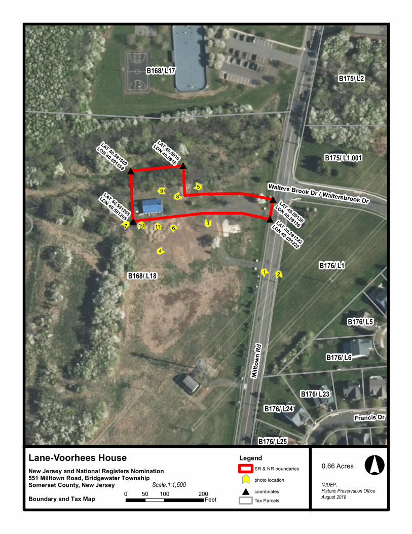
#
# #
##
ÛÛÛÛ
ÛÛ
ÛÛ
ÛÛ
ÛÛÛÛ
ÛÛ
Û Û
ÛÛ ÛÛ
LAT 40.5916
LON 40.5916
LAT 40.59136
LON 40.59136
LAT 40.591559
LON 40.591559
LAT 40.591222
LON 40.591222
LAT 40.591205
LON 40.591205
98
7 6
5
4
3
1 2
1110
Millto
wn R
d
Francis Dr
Walters Brook Dr / Waltersbrook Dr
B168/ L18
B168/ L17
B176/ L1
B175/ L2
B175/ L1.001
B176/ L6
B176/ L24
B176/ L5
B176/ L23
B176/ L25
°Legend
SR & NR boundariesÛÛ
photo location
# coordinatesTax Parcels
NJDEP, Historic Preservation OfficeAugust 2018
New Jersey and National Registers Nomination551 Milltown Road, Bridgewater TownshipSomerset County, New JerseyBoundary and Tax Map 0 100 20050
Feet
1:1,500Scale:
Lane-Voorhees House 0.66 Acres

DRAFT

DRAFT

DRAFT

______________________________________________________________________________Lane - Voorhees House National Register Nomination Somerset County, NJ Historic Maps
Historic Maps
Historic Map 1. Detail from Robert Erskine, “Garisons Somerset Boundbrook from South Branch to Reddington Brokaws,” No. 71, A, c. 1779. The Lane-Voorhees House is identified as the property of “W Lane.”
DRAFT

______________________________________________________________________________Lane - Voorhees House National Register Nomination Somerset County, NJ Historic Maps
Historic Map 2. Detail from: J. W. Otley, L. Vanderveer, & J. Keily, Map of Somerset County, New Jersey, 1850. The Lane-Voorhees House is identified as belonging to “J. P. Brokaw.”
DRAFT

______________________________________________________________________________Lane - Voorhees House National Register Nomination Somerset County, NJ Historic Maps
Historic Map 3. Detail from F. W. Beers, Atlas of Somerset County, New Jersey, 1873. The atlas map of Bridgewater Township identifies “A. V. Nevius” as the owner of a house just south of North Branch, its given location somewhat north of the correct site of the Lane-Voorhees House evidently is a cartographical error.
DRAFT

______________________________________________________________________________Lane - Voorhees House National Register Nomination Somerset County, NJ Historic Images
Historic Images
Historic Images 1. Lane- Voorhees House, Northwest view, c. 1930s. Rosalie Fellows Bailey, Pre-Revolutionary Dutch Houses and Families in Northern New Jersey and Southern New York, plate 132, page 441.
DRAFT

______________________________________________________________________________Lane - Voorhees House National Register Nomination Somerset County, NJ Historic Images
Historic Image 2. Lane-Voorhees House, Northwest view, c. 1930s. Collection of Branchburg Township Historical Society, as pictured in William A. Schleicher, and Susan J. Winter. Images of America – Crossroads of the American Revolution, page 103. DRA
FT

______________________________________________________________________________Lane - Voorhees House National Register Nomination Somerset County, NJ Historic Images
Historic Image 3. Lane- Voorhees House, Northwest view, c. 1960s. Melodi Amsel-Arieli, “History of Dutch Settlement in New Jersey,” History Magazine, June/July 2013, page 36.
DRAFT

______________________________________________________________________________Lane - Voorhees House National Register Nomination Somerset County, NJ Historic Images
Historic Image 4. Lane- Voorhees House, Northwest view, c. 2000. Township of Bridgewater.
DRAFT

______________________________________________________________________________Lane - Voorhees House National Register Nomination Somerset County, NJ Historic Images
Historic Image 5. Lane-Voorhees House, South facade, north view, c. 2002. Lane-Brokaw House Certificate of Eligibility Application File. New Jersey Historic Preservation Office.
DRAFT

______________________________________________________________________________Lane - Voorhees House National Register Nomination Somerset County, NJ Historic Images
Historic Image 6. Lane-Voorhees House, South facade detail, North view, c. 2002. Lane-Brokaw House Certificate of Eligibility Application File. New Jersey Historic Preservation Office.
DRAFT

______________________________________________________________________________Lane - Voorhees House National Register Nomination Somerset County, NJ Supplementary Historic Images
Supplementary Historic Images
Supplementary Historic Image 1. “Farm for sale…Albert C. Voorhees … North Branch, May 9, 1837,” The Somerset Whig, May 16, 1837.
DRAFT

NJ_SomersetCounty_LaneVoorhees_0001.tiff
NJ_SomersetCounty_LaneVoorhees_0002.tiff
Lane-Voorhees House - Somerset County, NJ
DRAFT

NJ_SomersetCounty_LaneVoorhees_0003.tiff
NJ_SomersetCounty_LaneVoorhees_0004.tiff
Lane-Voorhees House - Somerset County, NJ
DRAFT

NJ_SomersetCounty_LaneVoorhees_0005.tiff
NJ_SomersetCounty_LaneVoorhees_0006.tiff
Lane-Voorhees House - Somerset County, NJ
DRAFT

NJ_SomersetCounty_LaneVoorhees_0007.tiff
NJ_SomersetCounty_LaneVoorhees_0008.tiff
Lane-Voorhees House - Somerset County, NJ
DRAFT

NJ_SomersetCounty_LaneVoorhees_0009.tiff
NJ_SomersetCounty_LaneVoorhees_0010.tiff
Lane-Voorhees House - Somerset County, NJ
DRAFT

NJ_SomersetCounty_LaneVoorhees_0011.tiff
NJ_SomersetCounty_LaneVoorhees_0012.tiff
Lane-Voorhees House - Somerset County, NJ
DRAFT

NJ_SomersetCounty_LaneVoorhees_0013.tiff
NJ_SomersetCounty_LaneVoorhees_0014.tiff
Lane-Voorhees House - Somerset County, NJ
DRAFT

NJ_SomersetCounty_LaneVoorhees_0015.tiff
NJ_SomersetCounty_LaneVoorhees_0016.tiff
Lane-Voorhees House - Somerset County, NJ
DRAFT

NJ_SomersetCounty_LaneVoorhees_0017.tiff
NJ_SomersetCounty_LaneVoorhees_0018.tiff
Lane-Voorhees House - Somerset County, NJ
DRAFT

NJ_SomersetCounty_LaneVoorhees_0019.tiff
NJ_SomersetCounty_LaneVoorhees_0020.tiff
Lane-Voorhees House - Somerset County, NJ
DRAFT

NJ_SomersetCounty_LaneVoorhees_0021.tiff
NJ_SomersetCounty_LaneVoorhees_0022.tiff
Lane-Voorhees House - Somerset County, NJ
DRAFT

NJ_SomersetCounty_LaneVoorhees_0023.tiff
NJ_SomersetCounty_LaneVoorhees_0024.tiff
Lane-Voorhees House - Somerset County, NJ
DRAFT

NJ_SomersetCounty_LaneVoorhees_0025.tiff
NJ_SomersetCounty_LaneVoorhees_0026.tiff
Lane-Voorhees House - Somerset County, NJ
DRAFT