historic resource survey form - dot7.state.pa.us · historic resource survey form ... 2000 “stuck...
TRANSCRIPT

Key # 100219, 112378
ER# 02-8047-091 Historic Resource Survey Form PENNSYLVANIA HISTORICAL AND MUSEUM COMMISSION Bureau for Historic Preservation
Name, Location and Ownership (Items 1-6; see Instructions, page 4)
HISTORIC NAME Pennsylvania Railroad Morrisville Line; Trenton Cut-Off
CURRENT/COMMON NAME Norfolk Southern
STREET ADDRESS ZIP
LOCATION Thorndale, Chester County to Morrisville, Bucks County
MUNICIPALITY Caln Township, East Caln Township, West Bradford Township, East Bradford Township, West Whiteland Township, East
Whiteland Township, Tredyffrin Township, Upper Merion Township, Plymouth Township, Whitemarsh Township, Upper Dublin Township,
Upper Moreland Township, Lower Moreland Township, Lower Southampton Township, Upper Southampton Township, Northampton
Township, Middletown Township, Falls Township, Morrisville COUNTY Chester, Montgomery, Bucks
TAX PARCEL #/YEAR Multiple USGS QUAD Multiple
OWNERSHIP Private
Public/Local Public/County Public/State Public/Federal
OWNER NAME/ADDRESS Norfolk Southern
CATEGORY OF PROPERTY Building Site Structure Object District
TOTAL NUMBER OF RESOURCES 1
Function (Items 7-8; see Instructions, pages 4-6)
Historic Function Subcategory Particular Type
Transportation Rail-related Railroad
Current Function Subcategory Particular Type
Transportation Rail-related Railroad
Vacant/Not in use
Architectural/Property Information (Items 9-14; see Instructions, pages 6-7) ARCHITECTURAL CLASSIFICATION
No style
EXTERIOR MATERIALS and STRUCTURAL SYSTEM
Foundation Walls
Roof
Other Steel, wood, stone, concrete, brick
Structural System
WIDTH (feet) or (# bays) DEPTH (feet) or (# rooms) STORIES/HEIGHT

03/08 PA Historic Resource Survey Form 2
Key # 100219, 112378
ER# 02-8047-091
Property Features (Items 15-17; see Instructions, pages 7-8)
Setting Railroad corridor passing through wooded, industrial, and suburban landscapes Ancillary Features
Siding Berm Culverts
Signals Switches Grade crossings
Bridges Tunnel
Acreage Unknown (round to nearest tenth)
Historical Information (Items 18-21; see Instructions, page 8) Year Construction Began 1889 Circa Year Completed 1892 Circa
Date of Major Additions, Alterations 1902-06 Circa 1914-17 Circa Circa
Basis for Dating Documentary Physical
Explain Burgess and Kennedy 1949; Spivey 2001; Schotter 1927; bridge inscriptions and plaques
Cultural/Ethnic Affiliation(s) None
Associated Individual(s) None
Associated Event(s) None
Architect(s) N/A
Builder(s) N/A
Submission Information (Items 22-23; see Instructions, page 8)
Previous Survey/Determinations The Pennsylvania Railroad Morrisville Line was previously determined eligible under Criteria A
and C (PHMC September 24, 1992; September 14, 1993; and November 6, 2009). Threats None Neglect Public Development Private Development Other
Explain: This resource is located within the APE for the Lafayette Street Transportation Improvements Project, S.R. 9102,
Section MG1. This submission is related to a non-profit grant application business tax incentive
NHPA/PA History Code Project Review other
Preparer Information (Items 24-30; see Instructions, page 9)
Name & Title Elizabeth Amisson and Catherine Dluzak, Architectural Historians
Date Prepared June 30, 2010 Project Name Lafayette Street Transportation Improvements Project, S.R. 9102,
Section MG1
Organization/Company A.D. Marble & Company
Mailing Address 375 E. Elm Street, Ste. 200, Conshohocken, PA 19428
Phone 484-533-2500 Email [email protected]

03/08 PA Historic Resource Survey Form 3
Key # 100219, 112378
ER# 02-8047-091
National Register Evaluation (Item 31; see Instructions, page 9) (To be completed by Survey Director, Agency Consultant, or for Project Reviews ONLY.)
Not Eligible (due to lack of significance and/or lack of integrity)
Eligible Area(s) of Significance A, C
Criteria Considerations Period of Significance 1889-1957 Contributes to Potential or Eligible District District Name
Bibliography (Item 32; cite major references consulted. Attach additional page if needed. See Instructions, page 9.) Baer, Christopher T. n.d. “A General Chronology of the Pennsylvania Railroad Company Predecessors and Successors and Its
Historical Context.” Accessed online at http://www.prrths.com/Hagley/PRR_hagley_intro.htm [May 11, 2009]. Beck, Bill 2000 “Stuck in the Conrail/CSX/NS Bottleneck.” Published in Iron Age New Steel, February 2000 edition.
Accessed online at: http://web.archive.org/web/20051222124532/http://www.newsteel.com/2000/NS0002f3.htm [May 9, 2009].
Burgess, George H. and Miles C. Kennedy 1949 Centennial History of the Pennsylvania Railroad Company. The Pennsylvania Railroad Company,
Philadelphia, Pennsylvania. Czerwinski, Wanda S. 1995 Pennsylvania Historic Resource Survey Form for Trenton Cutoff Bridge (over S.R. 309). On file at
Pennsylvania Historical and Museum Commission, Harrisburg, Pennsylvania. Please see continuation sheet.
Additional Information The following must be submitted with form. Check the appropriate box as each piece is completed and attach to form with paperclip.
Narrative Sheets—Description/Integrity and History/Significance (See Instructions, pages 13-14)
Current Photos (See Instructions, page 10)
Photo List (See Instructions, page 11)
Site Map (sketch site map on 8.5x11 page; include North arrow, approximate scale; label all
resources, street names, and geographic features; show exterior photo locations; See Instructions, page 11)
Floor Plan (sketch main building plans on 8.5x11 page; include North arrow, scale bar or length/width
dimensions; label rooms; show interior photo locations; See Instructions, page 11)
USGS Map (submit original, photocopy, or download from TopoZone.com; See Instructions, page 12)
Send Completed Form and Additional Information to: National Register Program Bureau for Historic Preservation/PHMC Keystone Bldg., 2nd Floor 400 North St. Harrisburg, PA 17120-0093

03/08 PA Historic Resource Survey Form 4
Key # 100219, 112378
ER# 02-8047-091
Bibliography Continuation Sheet A.D. Marble & Company 2009 Historic Resource Survey Form for Pennsylvania Railroad Morrisville Line. Prepared for Pennsylvania
Department of Transportation Engineering District 6-0, May 2009. A.D. Marble & Company, Conshohocken, Pennsylvania.
Drury, George 2000 The Historical Guide to North American Railroads. Second Edition. Kalmbach Publishing Company,
Waukesha, Wisconsin. Lingez, Thompson S. 1998 Pennsylvania Historic Resource Survey Form for Morrisville Yard. On file at Pennsylvania Historical and
Museum Commission, Harrisburg, Pennsylvania. McCormick, Taylor & Associates, Inc. (MTA) 2003 S.R. 9102, Section MG1 Historic Resources Survey/Determination of Eligibility Report (Revised). September
2003. Prepared for Federal Highway Administration, Montgomery County Planning Commission, Pennsylvania Department of Transportation Engineering District 6, and the Pennsylvania Turnpike Commission.
Messer, David W. 2000 Triumph III: Philadelphia Terminal 1838-2000. Barnard, Roberts and Co., Baltimore, Maryland. National Park Service (NPS) 1997a National Register Bulletin, Defining Boundaries for National Register Properties. United States Department of
the Interior, Washington, D.C. 1997b National Register Bulletin, How to Apply the National Register Criteria for Evaluation. United States
Department of the Interior, Washington, D.C. Pennsylvania Historical & Museum Commission (PHMC) 1992 Letter to Joseph A. Smak, Conrail, regarding Proposed Abandonment of the Morrisville Line between Frazer
(milepost 45.3) and Thorndale (milepost 55.7), Chester County, PA (ER #92-3732-029-A). September 24, 1992.
1993 Letter to David J. Sands, P.E., Conrail, regarding Pennsylvania Double-Stack Clearance Improvement
Project, Statewide (ER #93-4041-042-A). September 14, 1993. 2003 Letter to R. Scott Christie, P.E., Director, Bureau of Design, Pennsylvania Department of Transportation
regarding S.R. 0063, Sections A06 and A07, Philadelphia, Montgomery, and Bucks Counties, PA (ER #93-0956-101-EE). February 24, 2003.
2009 Letter to Brian G. Thompson, P.E., Director, Bureau of Design, Pennsylvania Department of Transportation
regarding S.R. 9102, Section MG1, Lafayette Street Improvement Project, Borough of Norristown, Montgomery County, PA (ER #02-8047-091-Z). November 6, 2009.
Saunders, Richard 1978 The Railroad Mergers and the Coming of Conrail. Greenwood Press, Westport, Connecticut.
03/08 PA Historic Resource Survey Form 5
Key # 100219, 112378
ER# 02-8047-091
Bibliography Continuation Sheet (cont.) Schafer, Mike and Brian Solomon 1997 Pennsylvania Railroad. MBI Publishing, Osceola, Wisconsin. Schotter, H.W. 1927 The Growth and Development of the Pennsylvania Railroad Company. Allen, Lane & Scott, Philadelphia,
Pennsylvania. Snyder, Diane 1981 Pennsylvania Historic Resource Survey Form for Whitford Bridge. On file at Pennsylvania Historical and
Museum Commission, Harrisburg, Pennsylvania. Spivey, Justin 2001 Pennsylvania Railroad, Trenton Cut-Off, Bridge No. 25 at Earnest. HAER No. PA-538. Accessed online at
http://lcweb2.loc.gov/pnp/habshaer/pa/pa3700/pa3748/data/pa3748.pdf [June 4, 2010]. Taber III, Thomas T. 1987 Railroads of Pennsylvania, Encyclopedia and Atlas. T.T. Taber, Muncy, Pennsylvania. United States Railway Administration (USRA) 1975 Preliminary System Plan for Restructuring Railroads in the Northeast and Midwest Region Pursuant to the
Regional Rail Reorganization Act of 1973. United States Railway Administration, Washington, D.C.

03/08 PA Historic Resource Survey Form 6
Key # 100219, 112378
ER# 02-8047-091 Photo List (Item 33) See pages 10-11 of the Instructions for more information regarding photos and the photo list. In addition to this photo list, create a photo key for the site plan and floor plans by placing the photo number in the location the photographer was standing on the appropriate plan. Place a small arrow next to the photo number indicating the direction the camera was pointed. Label individual photos on the reverse side or provide a caption underneath digital photos. Photographer name Elizabeth Amisson
Date June 7-11, 2010
Location Negatives/Electronic Images Stored A.D. Marble & Company, Conshohocken, PA
Photo # Photo Subject/Description Camera
Facing 1 View along abandoned alignment from Southwind Lane in East Caln Township, Chester County. Note
the covered tracks and overgrown vegetation. W
2 South elevation of stone arch bridge over Bondsville Road (ID #1) in Caln Township, Chester County. N 3 South elevation of brick arch culvert over a small stream or drainage ditch (ID #3), west of
Gallagherville Road in Caln Township, Chester County. N
4 South elevation of stone arch bridge over South Lloyd Avenue (ID #4) in Caln Township, Chester County.
N
5 South elevation of stone arch bridge over Glenside Avenue (ID #6) in West Bradford Township, Chester County.
NW
6 South elevation of steel deck truss span over Bradford Avenue, Downingtown Pike, a small stream, and Old Trolley Road (ID #7) in West Bradford Township, Chester County. The structure is also comprised of deck plate girder spans on trestle bents (not visible in this photograph).
N
7 South elevation of stone arch bridge over Valley Creek Road (ID #8) in East Caln Township, Chester County.
N
8 North elevation of stone arch bridge over West Boot Road (ID #9) in East Bradford Township, Chester County.
SE
9 North elevation of stone arch bridge over Burgoyne Road (ID #10) in West Whiteland Township, Chester County. Looking south.
S
10 North elevation of stone arch bridge over Burgoyne Road (ID #11) in West Whiteland Township, Chester County.
SE
11 South elevation of steel Pratt through truss bridge over former Pennsylvania Railroad Harrisburg to Philadelphia Main Line (ID #13) in West Whiteland Township, Chester County.
N
12 South elevation of reinforced concrete deck girder bridge over South Pottstown Pike (S.R. 0100) (ID #15) in West Whiteland Township, Chester County.
N
13 North elevation of stone arch bridge over Walkertown Road (ID #16) in West Whiteland Township, Chester County.
S
14 South elevation of stone arch bridge over Ship Road (ID #17) in West Whiteland Township, Chester County.
N
15 North elevation of steel deck plate girder bridge over Phoenixville Pike (ID #21) in West Whiteland Township, Chester County.
S
16 South elevation of stone arch bridge over Ravine Road (ID #23) in East Whiteland Township, Chester County.
N
17 View along active alignment from Howelville Road in Tredyffrin Township, Chester County. Note the single track and catenary structures.
NE
18 View along active alignment from East Ridge Pike in Plymouth Township, Montgomery County. Note the two tracks and catenary structures.
E
19 View along active alignment from Belvoir Road in Plymouth Township, Montgomery County. Note the two tracks and catenary structures.
W
20 View along active alignment from Gallagher Road in Plymouth Township, Montgomery County. Note the two tracks.
SE
21 View along active alignment from Stenton Avenue in Whitemarsh Township, Montgomery County. Note the single track and modified catenary structures.
W

03/08 PA Historic Resource Survey Form 7
Key # 100219, 112378
ER# 02-8047-091
Photo # Photo Subject/Description Camera Facing
22 View along active alignment from west of Old York Road (S.R. 0263) in Upper Moreland Township, Montgomery County. Note the single track.
W
23 View along active alignment from Davisville Road in Upper Moreland Township, Montgomery County. Note the single track.
W
24 View along active alignment from at-grade crossing at County Line Road in Lower Moreland Township, Montgomery County. Note the single track.
S
25 View along active alignment from at-grade crossing at Bustleton Pike in Lower Southampton Township, Bucks County. Note the single track.
W
26 View along active alignment from Bristol Road in Northampton Township, Bucks County. Note the single track.
SW
27 South elevation of reinforced concreted deck beam bridge over South Malin Road (ID #27) in East Whiteland Township, Chester County.
N
28 West elevation of reinforced concreted deck beam bridge over West Lancaster Avenue (S.R. 0030) (ID #30) in East Whiteland Township, Chester County.
E
29 South elevation of stone arch bridge over Cedar Hollow Road (ID #31) in Tredyffrin Township, Chester County.
N
30 South elevation of reinforced concreted deck beam bridge over North Valley Road (ID #34) in Tredyffrin Township, Chester County.
N
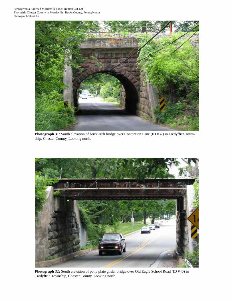
31 South elevation of brick arch bridge over Contention Lane (ID #37) in Tredyffrin Township, Chester County.
N
32 South elevation of pony plate girder bridge over Old Eagle School Road (ID #40) in Tredyffrin Township, Chester County.
N
33 North elevation of reinforced concreted deck beam bridge over Crooked Lane (ID #43) in Upper Merion Township, Montgomery County.
SW
34 South elevation of reinforced concreted deck beam bridge over Flint Hill Road (ID #44) in Upper Merion Township, Montgomery County.
NW
35 North elevation of brick arch bridge over Colbert Street (ID #45) in Upper Merion Township, Montgomery County.
S
36 South elevation of riveted Warren deck truss bridge over River Road (S.R. 0023), the Schuylkill River, and the former Philadelphia and Reading Railroad (ID #46) in Upper Merion Township, Montgomery County.
N
37 North elevation of steel deck plate girder bridge over the Schuylkill River Trail and the former Philadelphia and Reading Railroad (ID #47) in Plymouth Township, Montgomery County.
SE
38 North elevation of reinforced concrete deck beam bridge over Conshohocken Road (ID #48) in Plymouth Township, Montgomery County.
SE
39 North elevation of steel deck plate girder bridge over Butler Pike (ID #49) in Plymouth Township, Montgomery County.
SW
40 North elevation of pony plate girder bridge over Flourtown Road (ID #50) in Whitemarsh Township, Montgomery County.
SE
41 North elevation of stone arch bridge over the Wissahickon Creek and trail (ID #51) in Whitemarsh Township, Montgomery County.
S
42 North elevation of pony plate girder bridge over the intersection of South Bethlehem Pike (S.R. 0073), Skippack Pike, and Camp Hill Road (ID #52) in Whitemarsh Township, Montgomery County.
SE
43 South elevation of steel deck beam bridge/trestle over the former Philadelphia and Reading Railroad (ID #53) in Whitemarsh Township, Montgomery County.
NW
44 Detail of steel deck beam bridge/trestle over the former Philadelphia and Reading Railroad (ID #53) in Whitemarsh Township, Montgomery County.
NW
45 South elevation of brick arch bridge over Camp Hill Road (ID #54) in Upper Dublin Township, Montgomery County.
NE

03/08 PA Historic Resource Survey Form 8
Key # 100219, 112378
ER# 02-8047-091
Photo # Photo Subject/Description Camera Facing
46 Detail of brick arch bridge over Camp Hill Road (ID #54) in Upper Dublin Township, Montgomery County.
NE
47 Northwest elevation of steel deck beam bridge over Susquehanna Road (ID #57) in Upper Dublin Township, Montgomery County.
SE
48 North elevation of pony plate girder bridge over Easton Road (S.R. 0611) (ID #58) in Upper Moreland Township, Montgomery County.
S
49 South elevation of pony plate girder bridge over Old York Road (S.R. 0263) (ID #59) in Upper Moreland Township, Montgomery County.
NE
50 North elevation of steel deck plate girder bridge over the former Philadelphia and Reading Railroad (ID #60) in Upper Moreland Township, Montgomery County.
SE
51 North elevation of steel deck plate girder bridge over the former Philadelphia and Reading Railroad (ID #60) in Upper Moreland Township, Montgomery County.
SE
52 North elevation of brick arch bridge over Byberry Road (ID #62) in Upper Moreland Township, Montgomery County.
SE
53 Detail of brick arch bridge over Byberry Road (ID #62) in Upper Moreland Township, Montgomery County.
SE
54 North elevation of brick arch bridge over Pioneer Road (ID #63) in Upper Moreland Township, Montgomery County.
S
55 North elevation of brick arch bridge over Heaton Road (ID #66) in Upper Moreland Township, Montgomery County.
SW
56 South elevation of pony plate girder bridge over East Street Road (S.R. 0132) (ID #67) in Lower Southampton Township, Bucks County.
NW
57 South elevation of brick arch bridge over West Bristol Road (ID #68) in Lower Southampton Township, Bucks County.
NW
58 South elevation of brick arch bridge over Buck Road (ID #69) in Northampton Township, Bucks County.
N
59 North elevation of reinforced concrete deck beam bridge over Bridgetown Pike (ID #71) in Lower Southampton Township, Bucks County.
S
60 North elevation of five-span stone arch bridge over Neshaminy Creek and a park access road (ID #72) in Lower Southampton Township, Bucks County.
SW
61 North elevation of seven-span brick arch bridge over Neshaminy Creek and a park access road (ID #73) in Lower Southampton Township, Bucks County.
NW
62 South elevation of stone arch bridge over Newtown-Langhorne Road/S.R. 0413 (south alignment) (ID #76) in Middletown Township, Bucks County.
N
63 North elevation of brick arch bridge over Newtown-Langhorne Road/S.R. 0413 (north alignment) (ID #77) in Middletown Township, Bucks County.
N
64 South elevation of steel deck plate girder bridge over Langhorne-Yardley Road (south alignment) (ID #78) in Middletown Township, Bucks County.
NE
65 North elevation of reinforced concrete deck beam bridge over Langhorne-Yardley Road (north alignment) (ID #79) in Middletown Township, Bucks County.
SW
66 South elevation of brick and stone arch bridge over Woodbourne Road (ID #80) in Middletown Township, Bucks County.
N
67 Detail of brick and stone arch bridge over Woodbourne Road (ID #80) in Middletown Township, Bucks County.
N
68 South elevation of pony plate girder bridge over the former Philadelphia and Reading Railroad (ID #81) in Middletown Township, Bucks County.
NE
69 South elevation of reinforced concrete deck beam bridge over Woolston Drive (south track) (ID #83) in Falls Township, Bucks County.
N
70 North elevation of reinforced concrete deck beam bridge over Woolston Drive (north track) (ID #84) in Falls Township, Bucks County.
N

03/08 PA Historic Resource Survey Form 9
Key # 100219, 112378
ER# 02-8047-091
Photo # Photo Subject/Description Camera Facing
71 South elevation of concrete arch bridge over an unnamed road at the west end of the Morrisville Yard (ID #85) in Falls Township, Bucks County.
N
72 South elevation of reinforced concrete deck beam bridge over the former Philadelphia and Reading Railroad (ID #NC6) in Upper Merion Township, Montgomery County.
N

03/08 PA Historic Resource Survey Form 10
Key # 100219, 112378
ER# 02-8047-091
USGS Map Index Sheet

03/08 PA Historic Resource Survey Form 11
Key # 100219, 112378
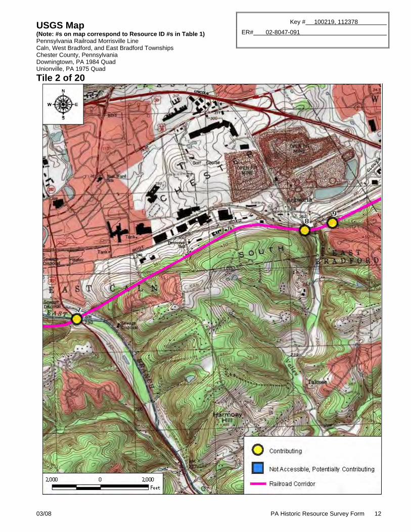
ER# 02-8047-091 USGS Map (Note: #s on map correspond to Resource ID #s in Table 1) Pennsylvania Railroad Morrisville Line Caln and West Bradford Townships Chester County, Pennsylvania Wagontown, PA 1984 Quad Downingtown, PA 1984 Quad Coatesville, PA 1975 Quad Unionville, PA 1975 Quad
Tile 1 of 20
03/08 PA Historic Resource Survey Form 12
Key # 100219, 112378
ER# 02-8047-091 USGS Map (Note: #s on map correspond to Resource ID #s in Table 1)
Pennsylvania Railroad Morrisville Line Caln, West Bradford, and East Bradford Townships Chester County, Pennsylvania Downingtown, PA 1984 Quad Unionville, PA 1975 Quad
Tile 2 of 20

03/08 PA Historic Resource Survey Form 13
Key # 100219, 112378
ER# 02-8047-091 USGS Map (Note: #s on map correspond to Resource ID #s in Table 1)
Pennsylvania Railroad Morrisville Line West Whiteland Township Chester County, Pennsylvania Downingtown, PA 1984 Quad Malvern, PA 1984 Quad Unionville, PA 1975 Quad West Chester, PA 1975 Quad
Tile 3 of 20

03/08 PA Historic Resource Survey Form 14
Key # 100219, 112378
ER# 02-8047-091 USGS Map (Note: #s on map correspond to Resource ID #s in Table 1)
Pennsylvania Railroad Morrisville Line West Whiteland and East Whiteland Townships Chester County, Pennsylvania Malvern, PA 1984 Quad
Tile 4 of 20

03/08 PA Historic Resource Survey Form 15
Key # 100219, 112378
ER# 02-8047-091 USGS Map (Note: #s on map correspond to Resource ID #s in Table 1)
Pennsylvania Railroad Morrisville Line East Whiteland Township Chester County, Pennsylvania Malvern, PA 1984 Quad
Tile 5 of 20

03/08 PA Historic Resource Survey Form 16
Key # 100219, 112378
ER# 02-8047-091 USGS Map (Note: #s on map correspond to Resource ID #s in Table 1) Pennsylvania Railroad Morrisville Line Tredyffrin Township Chester County, Pennsylvania Malvern, PA 1984 Quad Valley Forge, PA 1981 Quad
Tile 6 of 20

03/08 PA Historic Resource Survey Form 17
Key # 100219, 112378
ER# 02-8047-091 USGS Map (Note: #s on map correspond to Resource ID #s in Table 1) Pennsylvania Railroad Morrisville Line Tredyffrin Township Chester County, Pennsylvania Valley Forge, PA 1981 Quad
Tile 7 of 20

03/08 PA Historic Resource Survey Form 18
Key # 100219, 112378
ER# 02-8047-091
USGS Map (Note: #s on map correspond to Resource ID #s in Table 1) Pennsylvania Railroad Morrisville Line Upper Merion Township Montgomery County, Pennsylvania Valley Forge, PA 1981 Quad Norristown, PA 1984 Quad
Tile 8 of 20

03/08 PA Historic Resource Survey Form 19
Key # 100219, 112378
ER# 02-8047-091 USGS Map (Note: #s on map correspond to Resource ID #s in Table 1) Pennsylvania Railroad Morrisville Line Upper Merion and Plymouth Townships Montgomery County, Pennsylvania Norristown, PA 1984 Quad
Tile 9 of 20

03/08 PA Historic Resource Survey Form 20
Key # 100219, 112378
ER# 02-8047-091 USGS Map (Note: #s on map correspond to Resource ID #s in Table 1) Pennsylvania Railroad Morrisville Line Plymouth and Whitemarsh Townships Montgomery County, Pennsylvania Lansdale, PA 1984 Quad Norristown, PA 1984 Quad
Tile 10 of 20

03/08 PA Historic Resource Survey Form 21
Key # 100219, 112378
ER# 02-8047-091 USGS Map (Note: #s on map correspond to Resource ID #s in Table 1) Pennsylvania Railroad Morrisville Line Whitemarsh Township Montgomery County, Pennsylvania Ambler, PA 1984 Quad Lansdale, PA 1984 Quad Norristown, PA 1984 Quad Germantown, PA 1984 Quad
Tile 11 of 20

03/08 PA Historic Resource Survey Form 22
Key # 100219, 112378
ER# 02-8047-091 USGS Map (Note: #s on map correspond to Resource ID #s in Table 1) Pennsylvania Railroad Morrisville Line Upper Dublin Township Montgomery County, Pennsylvania Ambler, PA 1984 Quad Germantown, PA 1984 Quad
Tile 12 of 20

03/08 PA Historic Resource Survey Form 23
Key # 100219, 112378
ER# 02-8047-091 USGS Map (Note: #s on map correspond to Resource ID #s in Table 1) Pennsylvania Railroad Morrisville Line Upper Moreland Township Montgomery County, Pennsylvania Ambler, PA 1984 Quad Hatboro, PA 1984 Quad
Tile 13 of 20

03/08 PA Historic Resource Survey Form 24
Key # 100219, 112378
ER# 02-8047-091 USGS Map (Note: #s on map correspond to Resource ID #s in Table 1) Pennsylvania Railroad Morrisville Line Upper Moreland and Lower Moreland Townships Montgomery County, Pennsylvania Hatboro, PA 1984 Quad
Tile 14 of 20

03/08 PA Historic Resource Survey Form 25
Key # 100219, 112378
ER# 02-8047-091 USGS Map (Note: #s on map correspond to Resource ID #s in Table 1) Pennsylvania Railroad Morrisville Line Lower Southampton Township Bucks County, Pennsylvania Hatboro, PA 1984 Quad Langhorne, PA 1974 Quad
Tile 15 of 20

03/08 PA Historic Resource Survey Form 26
Key # 100219, 112378
ER# 02-8047-091 USGS Map (Note: #s on map correspond to Resource ID #s in Table 1) Pennsylvania Railroad Morrisville Line Lower Southampton, Northampton, and Middletown Townships Bucks County, Pennsylvania Langhorne, PA 1974 Quad
Tile 16 of 20

03/08 PA Historic Resource Survey Form 27
Key # 100219, 112378
ER# 02-8047-091 USGS Map (Note: #s on map correspond to Resource ID #s in Table 1) Pennsylvania Railroad Morrisville Line Middletown Township Bucks County, Pennsylvania Langhorne, PA 1974 Quad
Tile 17 of 20

03/08 PA Historic Resource Survey Form 28
Key # 100219, 112378
ER# 02-8047-091 USGS Map (Note: #s on map correspond to Resource ID #s in Table 1) Pennsylvania Railroad Morrisville Line Middletown Township Bucks County, Pennsylvania Langhorne, PA 1974 Quad Trenton West, PA-NJ 1982 Quad
Tile 18 of 20

03/08 PA Historic Resource Survey Form 29
Key # 100219, 112378
ER# 02-8047-091 USGS Map (Note: #s on map correspond to Resource ID #s in Table 1) Pennsylvania Railroad Morrisville Line Falls Township Bucks County, Pennsylvania Trenton West, PA-NJ 1982 Quad
Tile 19 of 20

03/08 PA Historic Resource Survey Form 30
Key # 100219, 112378
ER# 02-8047-091 USGS Map (Note: #s on map correspond to Resource ID #s in Table 1) Pennsylvania Railroad Morrisville Line Falls Township Bucks County, Pennsylvania Trenton West, PA-NJ 1982 Quad Trenton East, PA-NJ 1982 Quad
Tile 20 of 20

03/08 PA Historic Resource Survey Form 31
Key # 100219, 112378
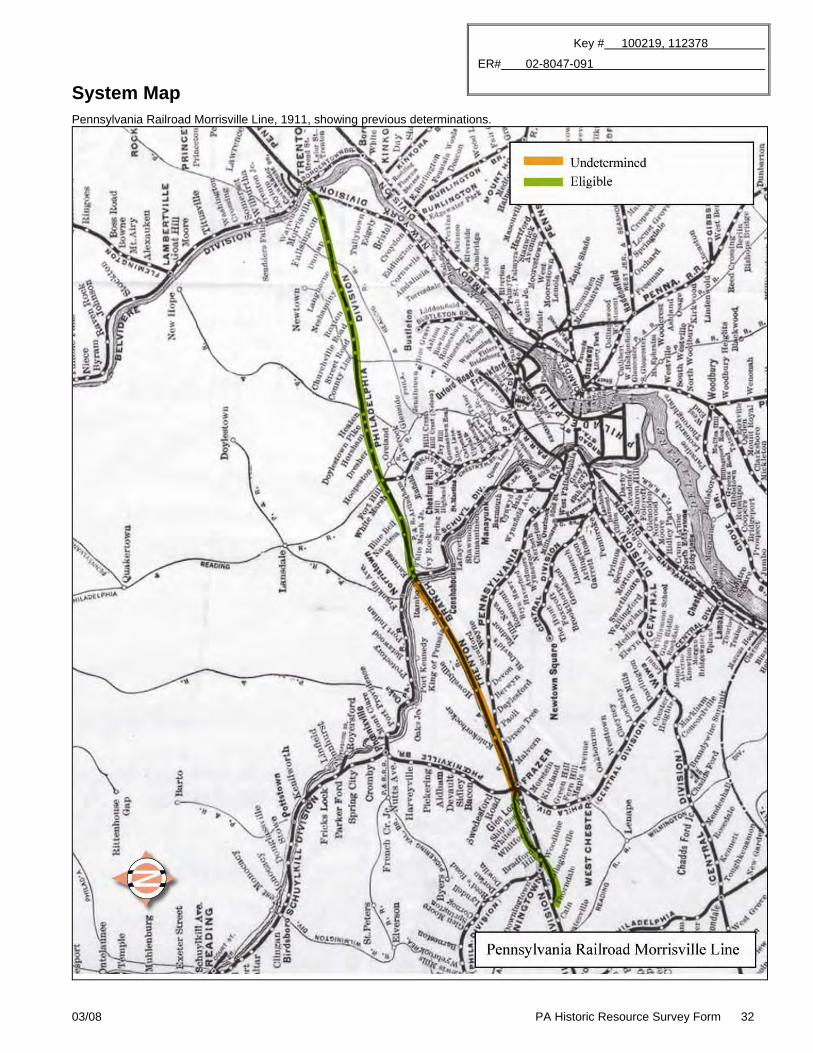
ER# 02-8047-091 System Map
Pennsylvania Railroad Morrisville Line, 1911
03/08 PA Historic Resource Survey Form 32
Key # 100219, 112378
ER# 02-8047-091 System Map
Pennsylvania Railroad Morrisville Line, 1911, showing previous determinations.

03/08 PA Historic Resource Survey Form 33
Key # 100219, 112378
ER# 02-8047-091 Physical Description and Integrity (Item 38) Provide a current description of the overall setting, landscape, and resources of the property. See page 13 of the Instructions for detailed directions. Continue on additional sheets as needed. Suggested outline for organizing this section:
Introduction [summarize the property, stating type(s) of resource(s) and function(s)] Setting [describe geographic location, streetscapes, natural/man-made landscape features, signage, etc.] Exterior materials, style, and features [describe the exterior of main buildings/resources] Interior materials, style, and features [describe the interior of main buildings/resources] Outbuildings/Landscape [describe briefly additional outbuildings/landscape features found on property, substitute Building Complex Form if preferred; See Instructions, page 18] Boundaries [explain how/why boundaries chosen, such as historic legal parcel, visual natural features such as tree lines,
alley separating modern construction, etc.] Integrity [summarize changes to the property and assess how the changes impact its ability to convey significance
Introduction This documentation for the Pennsylvania Railroad Morrisville Line/Trenton Cut-Off was prepared as part of the mitigation for the Lafayette Street Transportation Improvements project, S.R. 9102, Section MG1. The purpose of this Historic Resource Survey Form (HRSF) is to document the approximately 60-mile long corridor, which extends from Thorndale in Chester County to Morrisville in Bucks County, Pennsylvania, and to identify contributing features of the line. The Pennsylvania Railroad Morrisville Line was determined eligible for listing in the National Register of Historic Places (National Register) on the following dates:
September 24, 1992. Key #100219. The portion of the line from Thorndale to Frazer, Chester County, was evaluated as part of the Consolidated Rail Corporation’s (Conrail’s) proposed abandonment of the line between Mileposts 45.3 and 55.7 (ER #92-3732-029). This portion of the line was determined eligible under Criterion A for its local transportation significance (PHMC 1992). No Pennsylvania HRSF was prepared as part of the study; however, Conrail prepared an inventory of 23 bridges and culverts located within this portion of the line.
September 14, 1993. Key #112378. The portion of the line from Norristown, Montgomery County; to
Morrisville, Bucks County, was evaluated as part of Conrail’s Pennsylvania Statewide Double-Stack Clearance Improvement Project (ER #93-4041-042). This portion of the line was determined eligible under Criteria A and C for its statewide significance in transportation, economy, and industrial and community development (PHMC 1993). No HRSF was prepared as part of the study. National Register boundaries for this portion of the railroad were defined as follows in 2003, as part of the S.R. 0063, Section A06 and A07 project (ER #93-0956-101):
The National Register Boundary for the Pennsylvania Railroad – Morrisville Line includes the track, grading, and toe of slope. The boundary extends to the legal right-of-way to the east and west sides of the railroad. The southern terminus for the Morrisville Line is the connection with the Harrisburg Line in Norristown and the northern terminus is the connection with the Trenton Line in Morrisville. (PHMC 2003)
November 6, 2009. Key #100219 and #112378. The portion of the line in the Borough of Norristown and Plymouth Township, Montgomery County, was documented on an HRSF in May 2009 in association with the Lafayette Street Transportation Improvements project, S.R. 9102, Section MG1 (ER #02-8047-091). PHMC concurred that the Pennsylvania Railroad Morrisville Line remains eligible for listing in the National Register and that the period of significance extends from 1889 through 1957 (PHMC 2009). The current (July 2010) documentation was prepared to mitigate the adverse effect of the proposed project on the Pennsylvania Railroad Morrisville Line.
A portion of the Pennsylvania Railroad Morrisville Line was also briefly documented in September 2003 in the S.R. 9102, Section MG1 Historic Structures Survey/Determination of Eligibility Report (Revised) (ER #02-8047-091) (McCormick, Taylor & Associates [MTA]). The report recommended that the railroad bridges over the Schuylkill River (Table 1, ID #46) and over Conshohocken Road (Table 1, ID #48) are contributing features to the Pennsylvania Railroad Morrisville Line. The following determinations of eligibility have been made for individual features associated with the Pennsylvania Railroad Morrisville Line:

03/08 PA Historic Resource Survey Form 34
Key # 100219, 112378
ER# 02-8047-091 January 1, 1984. Key #064507. The Whitford Bridge over
the Pennsylvania Railroad and Whitford Road in West Whiteland Township, Chester County was determined not individually eligible for listing in the National Register (Table 1, ID #13).
July 17, 1995. Key #103971. The Trenton Cut-Off Bridge over S.R. 0309 in Whitemarsh Township,
Montgomery County, was determined not individually eligible for listing in the National Register. The bridge has since been replaced (Table 2, ID #NC10).
March 19, 1998. Key #109639. The Morrisville Yard in Falls Township, Bucks County, was determined eligible
for listing in the National Register under Criteria A and C for its transportation and engineering significance in association with the Pennsylvania Railroad Morrisville Line (Table 1, ID #86).
Historic American Engineering Record (HAER) recordation was prepared for the following individual feature associated with the railroad:
Bridge No. 25 at Earnest, spanning the Schuylkill River south of the Pennsylvania Turnpike (I-276) in Swedesburg, Upper Merion Township, Montgomery County (Table, 1 ID #46).
As constructed in 1889 to 1892, the Pennsylvania Railroad Morrisville Line (Morrisville Line) extended northeastward from the Pennsylvania Railroad’s Harrisburg to Philadelphia Main Line at Glen Loch (west of Frazer) in Chester County through Montgomery and Bucks counties to the Pennsylvania Railroad’s Philadelphia to New York Main Line at Morrisville, Bucks County. This 45-mile bypass line, known as the Trenton Cut-Off, roughly parallels the Pennsylvania Turnpike (I-276) today. It allowed the Pennsylvania Railroad freight traffic to bypass the City of Philadelphia, separating the freight and passenger lines and preventing added congestion and delays. The low grade of the line, usually around 0.5 percent slope, made the line easier and faster to travel than the higher grade lines. The construction of the Philadelphia and Thorndale Branch ca. 1902 to 1906 extended the Morrisville Line approximately 15 additional miles to the west (resulting in a total distance of approximately 60 miles), from Glen Loch to Thorndale in Chester County. The westernmost portion of the line, between Milepost 45.3 in Thorndale and Milepost 55.7 in Frazer, was abandoned by Conrail in the early 1990s and remains inactive in 2010. The rails, ties, and ballast have been removed from this approximately 10-mile segment, and portions of the abandoned alignment are overgrown with vegetation. Norfolk Southern operates the remainder of the line as an active freight line. Description The survey associated with this documentation was conducted entirely from public rights-of-way (ROWs); therefore, views to the railroad alignment were sometimes limited, and access to certain features (e.g., one tunnel, small culverts, and the Morrisville Yard) was prohibited. Where access was restricted, railroad features were identified through a review of current aerial imagery. The extant Morrisville Line tracks consist of steel rails and wood ties and generally rest on a shallow ballast berm. Remnants of the catenary support structures added when the line was electrified ca. 1937 to 1938 are still evident in some locations, although the track is no longer electrified. Steel poles that carry unrelated communication wires are located at regular intervals along the sides of the track. Table 1 lists all contributing and potentially contributing features of the Morrisville Line. Table 2 lists non-contributing railroad-related features associated with the line. An approximately 10-mile portion of the Morrisville Line from its western terminus in Thorndale to Frazer, Chester County, was abandoned in the early 1990s. This portion of the alignment represents the circa-1902 to 1906 Philadelphia and Thorndale Branch, which was the westward low-grade extension of the Morrisville Line. The single tracks appear to have been covered with dirt and stone or removed from the abandoned alignment, though many catenary support structures remain in place. The abandoned alignment is generally evident from aerial imagery; however, portions are overgrown with vegetation (Photograph 1). Fifteen stone arch bridges, constructed from 1903 to 1905, and one tunnel associated with the Morrisville Line remain extant along the abandoned alignment (Photographs 2 to 16). The tunnel was not accessible from public ROW. Three steel bridges from this period are also present, as well as a 1955 reinforced concrete bridge (Photographs 6, 11, 12, and 15). In addition, a number of 1903 to 1905 brick arch culverts are reportedly present in this section (according to a 1992 Conrail inventory), although only one was accessible during the field survey (Photograph 3). The alignment east of Frazer represents the original 45-mile Trenton Cut-Off, which was constructed in 1889 to 1892. A single track is visible on a shallow ballast berm from a point near the junction of the former Philadelphia and Thorndale Branch and the Trenton Cut-Off in Frazer and travels eastward to a point just west of I-276 in Upper Merion Township, Montgomery County. Catenary support structures are present in most of this segment (Photograph 17).

03/08 PA Historic Resource Survey Form 35
Key # 100219, 112378
ER# 02-8047-091 Aerial imagery indicates a second parallel track was once present throughout most of this section but has been covered or removed. Two tracks are present on the alignment from a point just west of I-276 east to a point just west of Flourtown Road in Whitemarsh Township, Montgomery County (Photographs 18 to 20). The line again reduces to one track east of Flourtown Road (Photographs 21 to 26). The line splits into two parallel alignments for a distance of approximately 4.5 miles, starting approximately 0.5 mile east of Bristol Road in Northampton Township, Bucks County; and extending to Woodbourne Road in Middletown Township, Bucks County. The maximum distance between the northern and southern alignments of the split is approximately 0.1 mile. Aerial imagery indicates a portion of the tracks in the northern alignment may be covered or removed. Photographs 27 to 71 depict extant, contributing features to the Morrisville Line/Trenton Cut-Off between Frazer and Morrisville that were accessible from public ROWs. Approximately ten circa-1890 brick arch bridges and approximately five circa-1890 to 1903 stone arch bridges remain extant along this portion of the alignment. Notable brick and stone arch bridges include the ten-span stone arch bridge over Wissahickon Creek (Photograph 41; Table 1, ID #51), the five-span stone arch bridge over Neshaminy Creek (Photograph 60; Table 1, ID #73), and the seven-span brick arch bridge over Neshaminy Creek (Photograph 61; Table 1, ID #72). The others are single-span structures over roadways. Approximately 21 single-span steel and reinforced concrete bridges dating to ca. 1914 to 1917 are also present, along with one single-span concrete arch bridge dating to 1917, one two-span reinforced concrete bridge dating to ca. 1920, one pony plate girder bridge dating to ca. 1950, and one reinforced concrete deck beam bridge dating to 1951. A notable example of a steel Pratt through truss bridge (the only structure of its kind along the Morrisville Line) is present at the crossing over the former Pennsylvania Railroad Harrisburg to Philadelphia Main Line in Whitford, Chester County (Photograph 11; Table 1, ID #13). One substantially altered railroad bridge with a reinforced concrete superstructure that appears to post-date the period of significance is considered non-contributing due to the extent of the alterations (Photograph 72; Table 2, ID #NC6). Aerial imagery indicates a number of culverts may be present at small stream and ditch crossings in this section; however, they were not accessible during the field survey. Two at-grade roadway crossings are present: one at County Line Road in Lower Moreland Township, Montgomery County; and one at Bustleton Pike in Lower Southampton Township, Bucks County (Photographs 24 and 25; Table 2, ID #NC11 and NC12). These crossings are not considered significant features of the line. No extant freight depots were observed during the field survey or aerial imagery review. The only railroad yard present along the line is the Morrisville Yard (Table 1, ID #86). The double tracks split into several sets of parallel tracks at the western approach to the yard, starting just east of Queen Anne Court in Falls Township, Bucks County. The main yard is located between U.S. 0013 and the Delaware Canal. Previous documentation prepared for the Morrisville Yard in 1998 indicates most of the trackage was removed in the late 1980s, leaving an open area of compacted gravel, ballast, and cinders overgrown with vegetation. Three buildings/structures remained at the yard in 1998: a 1960s yard office of concrete construction, a steel frame and brick engine house dating to the 1940s or 1950s, and a pre-World War II coaling/sand tower (Lingez 1998). Integrity The Pennsylvania Railroad Morrisville Line continues to retain integrity of location, design, materials, workmanship, setting, feeling, and association. Although an approximately 10.4-mile segment of the line has been abandoned, approximately 50 miles of the line remain active as a freight line under Norfolk Southern’s operation. The Pennsylvania Railroad Morrisville Line retains sufficient integrity of design, materials, and workmanship through the retention of the original rail alignment, berm, most of the tracks, one tunnel, a number of bridges and culverts, and one railroad yard dating from the period of significance. The line also retains several sidings and small-scale elements such as catenary support structures, switches, and signals. The Pennsylvania Railroad Morrisville Line retains integrity of feeling and association through its continued use as a freight line by Norfolk Southern. The setting of the Morrisville Line has not been substantially altered in a manner that impacts the line’s significance or integrity. Boundary Description and Justification The National Register boundary for the Pennsylvania Railroad Morrisville Line follows the legal ROW and includes the track, grading, and toe-of-slope extending to the legal ROW. The western terminus is the connection with the former Pennsylvania Railroad Harrisburg to Philadelphia Main Line in Thorndale, Chester County; and the eastern terminus is the connection with the former Philadelphia to New York Main Line in Morrisville, Bucks County. Contributing features of the Pennsylvania Railroad Morrisville Line generally include all major built elements of the line that were constructed within the line’s period of significance, which extends from 1889 to 1957. Major built elements of the Morrisville Line are defined as those that were crucial to the continued operation of the line and were directly related to its function as a low-grade, high-speed freight line, such as bridges, tunnels, culverts, and yards. Tracks, sidings, and small-scale elements such as switches, signals, and catenary structures are not considered contributing features, nor are highway bridges that were not built by the railroad. This boundary was prepared within the guidelines set forth by the National Register Bulletin, “Defining Boundaries for National Register Properties” (National Park Service [NPS] 1997a).

03/08 PA Historic Resource Survey Form 36
Key # 100219, 112378
ER# 02-8047-091
History and Significance (Item 39) Provide an overview of the history of the property and its various resources. Do not substitute deeds, chapters from local history books, or newspaper articles. See page 14 of the Instructions for detailed directions. Continue on additional sheets as needed. Suggested outline for organizing this section:
History [Summarize the evolution of the property from origin to present] Significance [Explain why the property is important] Context and Comparisons [Describe briefly similar properties in the area, and explain how this property compares]
HISTORICAL NARRATIVE The Pennsylvania Railroad The Pennsylvania Railroad was opened from Philadelphia to Pittsburgh in 1855 (Burgess and Kennedy 1949:81). In that year, the Pennsylvania Railroad had completed a line from Pittsburgh across the Alleghenies to Harrisburg, where its line connected with the Harrisburg, Portsmouth, Mount Joy & Lancaster Railroad, a railroad that extended 36 miles beyond Harrisburg to Lancaster. From this point, the line connected with the state-owned Philadelphia & Columbia Railroad, which completed the final 81 miles of the approximately 245-mile route between Pittsburgh and Philadelphia (Burgess and Kennedy 1949:81). The Pennsylvania Railroad acquired the state-owned line in 1857, followed by the Harrisburg, Portsmouth, Mount Joy and Lancaster Railroad in 1860, bringing the complete line under a single ownership (Burgess and Kennedy 1949:90). The completion of the Pennsylvania Railroad across the state from Pittsburgh to Philadelphia allowed Pennsylvania to compete for commerce coming in from the west that was previously funneled to New York and Baltimore via the Erie Canal, the National Road, and the Baltimore & Ohio Railroad. With acquisitions and leases, the Pennsylvania Railroad expanded eastward to New York, westward to Chicago and Illinois, and southward to Washington, D.C. In 1929, the Pennsylvania Railroad operated 10,512 miles of track. In the 1920s and 1930s, the Pennsylvania Railroad undertook a massive improvement project with the electrification of its main lines from Philadelphia to Harrisburg, New York, and Wilmington. By the mid-twentieth century, passenger and freight traffic traveled more by motor vehicle via highways, and the Pennsylvania Railroad found itself with far more lines, locomotives, and cars than traffic necessitated (Drury 2000:329-335). In February 1968, the Pennsylvania Railroad and the New York Central merged to form the Pennsylvania and New York Central Transportation Company, which filed for bankruptcy just two years later in June 1970 (Saunders 1978:261, 294). In 1975, the United States Congress created Conrail to assume control of the lines deemed worthy of continued service (United States Railroad Administration [USRA] 1975). In 1997, Norfolk Southern and CSX Transportation, Inc., bought out Conrail and divided the lines between the two entities (Beck 2000). The Pennsylvania Railroad Morrisville Line The Pennsylvania Railroad Morrisville Line is comprised of two primary segments: the Trenton Cut-Off constructed in 1889 to 1892 between Morrisville, Bucks County (on the west side of the Delaware River) and Glen Loch, Chester County (west of Frazer); and the low-grade Philadelphia and Thorndale Branch constructed ca. 1902 to 1906 between Glen Loch and Thorndale, Chester County. In 1889, the Trenton Cut-Off Railroad Company, a subsidiary of the Pennsylvania Railroad, began construction on the Trenton Cut-Off. This line, alternately called the Trenton Branch of the Philadelphia Division, was designed to expedite the flow of freight traffic between New York and points west of Harrisburg by bypassing Philadelphia and its congested rail traffic. Upon completion in 1892, the Trenton Cut-Off connected to the Pennsylvania Railroad’s Harrisburg to Philadelphia Main Line at Glen Loch bypassed Philadelphia on a route located north of the Harrisburg to Philadelphia Main Line and met with the Pennsylvania Railroad’s Philadelphia to New York Main Line at Morrisville. The new route was approximately 7 miles shorter and was constructed at a lower grade than the Harrisburg to Philadelphia Main Line, allowing for faster freight movement (Burgess & Kennedy 1949:428). The line also alleviated some congestion from the Philadelphia area by removing freight trains from the Main Line (Snyder 1981). The first section of the Trenton Cut-Off (from Morrisville, Bucks County to the Schuylkill River [where it connected with the Reading Railroad at Swedeville and the Pennsylvania Railroad’s Schuylkill Valley Division at Earnest]) opened to freight traffic in June 1891 (Spivey 2001:2; Lingez 1998; Czerwinski 1995). This segment expedited freight traffic between Trenton, New Jersey; and Norristown, Pennsylvania (Lingez 1998). The construction cost of just a 15.7-mile portion of the Trenton Cut-Off between the Bucks County line and the Schuylkill River was over 1.3 million dollars; however, the railroad expected to make up the cost with reductions in time and distance (Snyder 1981; Messer 2000:14; Schotter 1927:224). The western half of the cut-off, crossing the Schuylkill River to Glen Loch, Chester County (where it rejoined the Harrisburg to Philadelphia Main Line), opened in January 1892 (Spivey 2001:2). The Trenton Cut-Off was originally constructed as a single track line with sidings for trains to pass one another; however, it was double-tracked in 1893 (Snyder 1981). The Trenton Cut-Off Railroad Company was incorporated into the Pennsylvania Railroad in 1902 (Burgess and Kennedy 1949:509).

03/08 PA Historic Resource Survey Form 37
Key # 100219, 112378
ER# 02-8047-091 The Pennsylvania Railroad Morrisville Line significantly reduced congestion throughout the Philadelphia area. Following construction of the Pennsylvania Railroad Morrisville Line, the Pennsylvania Railroad initiated projects to bypass other major cities, including Newark in 1901 and Pittsburgh in 1902 (Baer n.d.). The Morrisville Line was extended westward from Glen Loch to Thorndale, Chester County (as the low-grade Philadelphia and Thorndale Branch), ca. 1902 to 1906 (Spivey 2001:2; Taber 1987:381). In Thorndale, the line again connected with the Pennsylvania Railroad’s Harrisburg to Philadelphia Main Line (Czerwinski 1995). The Trenton Cut-Off was one of the first of many terminal and track improvements around the turn of the century that enabled the Pennsylvania Railroad to become a twentieth-century transportation machine under the administration of President Alexander J. Cassatt (1899 to 1906) (Schafer and Solomon 1997:82). Cassatt initiated a construction plan in 1902 that included the construction of two additional sections of low-grade freight tracks: the aforementioned Morrisville Line extension (Philadelphia and Thorndale Branch) in Chester County and the Atglen and Susquehanna Branch on a separate alignment in Lancaster County. Around the same time, the Pennsylvania Railroad reduced grades on the original (1889 to 1892) portion of the Morrisville Line for compatibility with the new low-grade branch lines (Spivey 2001:2; Schotter 1927:294, 299; Burgess and Kennedy 1949:492). This resulted in the reconstruction of the bridge over the Schuylkill River (Bridge No. 25 at Earnest) in 1904 (Spivey 2001:2). Together, the Morrisville Line and Atglen and Susquehanna Branch created a low-grade, double track relief line approximately 139 miles in length between Marysville on the west side of the Susquehanna River and Morrisville on the west side of the Delaware River (Schotter 1927:293; Burgess and Kennedy 1949:492). A number of stone and brick arch bridges and culverts were constructed along the Morrisville Line during the original periods of construction (1889 to 1892 and ca. 1902 to 1906), many of which remain extant (Table 1). In addition, one stone arch tunnel was constructed in 1903 at the western end of the Philadelphia and Thorndale Branch to carry the line over the Harrisburg to Philadelphia Main Line. A number of additional steel and reinforced concrete bridges were constructed ca. 1914 to 1917. These features, along with other railroad bridges constructed along the Morrisville Line prior to 1958, were directly associated with the line’s primary function as a low-grade, high-speed freight route because they permitted the line to pass through territory with few grade crossings. The Pennsylvania Railroad made substantial improvements to the Morrisville Line ca. 1914 to 1915. The superstructure of the Schuylkill River bridge (Bridge No. 25 at Earnest) was replaced in 1914 to 15 by a seven-span Warren deck truss structure fabricated by the Phoenix Bridge Company (Spivey 2001:2). Based on date inscriptions, plaques, and visual inspection, the railroad constructed approximately 20 deck beam and plate girder bridges along the Morrisville Line between Glen Loch and Morrisville ca. 1914 to 1917. The Pennsylvania Railroad electrified the Morrisville Line ca. 1937 to 1938 as part of a larger electrification project. The electrification of the Morrisville Line and the Harrisburg to Philadelphia Main Line improved service throughout the region by increasing the speed of both passenger and freight trains (Burgess & Kennedy 1949:649-54). The construction of the Pennsylvania Turnpike in the 1940s and 1950s, combined with the 1956 founding of the Interstate Highway System, resulted in a significant decrease in usage of the Pennsylvania Railroad Morrisville Line as trucks were used more frequently for freight transport. Norfolk Southern acquired the line ca. 1997. In 2010, the westernmost portion of the line (between Thorndale and Frazer, Chester County) is no longer in use, and rails, ties, and ballast have been removed or covered and are overgrown with vegetation in some places. The remainder of the former Pennsylvania Railroad Morrisville Line is operated by Norfolk Southern as a freight line in 2010. SIGNIFICANCE AND EVALUATION The Pennsylvania Railroad Morrisville Line was previously determined eligible for listing in the National Register on September 24, 1992; September 14, 1993; and November 6, 2009. No HRSF was prepared in association with the early 1990s determinations. The portion of the line in the Borough of Norristown and Plymouth Township, Montgomery County, was documented on an HRSF in May 2009 in association with the Lafayette Street Transportation Improvements project, S.R. 9102, Section MG1 (ER #02-8047-091) (A.D. Marble & Company 2009). PHMC concurred that the Pennsylvania Railroad Morrisville Line remains eligible for listing in the National Register under Criteria A and C. The period of significance extends from 1889 (when construction began on the bypass line) to 1957 (when the Pennsylvania Railroad was facing a steep decline in business and merger discussions began with New York Central). The current (July 2010) documentation was prepared to mitigate the adverse effect of the proposed Lafayette Street Transportation Improvements project, S.R. 9102, Section MG1, on the Pennsylvania Railroad Morrisville Line. The Pennsylvania Railroad Morrisville Line is eligible for listing in the National Register under Criterion A for transportation. The approximately 45-mile Trenton Cut-Off of the Morrisville Line was constructed in 1889 to 1892 specifically to alleviate freight traffic in Philadelphia along the Pennsylvania Railroad’s Harrisburg to Philadelphia Main

03/08 PA Historic Resource Survey Form 38
Key # 100219, 112378
ER# 02-8047-091 Line. The Morrisville Line was one of the earliest examples of the Pennsylvania Railroad’s use of low-grade lines and cut-off lines for freight traffic to bypass congested areas and to separate the passenger and freight lines for increased efficiency. The westward extension of the line with the approximately 15-mile low-grade Philadelphia and Thorndale Branch ca. 1902 to 1906 further expedited freight service. The construction of the Pennsylvania Railroad Morrisville Line directly resulted in improved service and success for the railroad in the early twentieth century. The Pennsylvania Railroad Morrisville Line is eligible under Criterion C for engineering as an early low-grade line in the Pennsylvania Railroad network. The 1889 to 1892 Trenton Cut-Off of the Morrisville Line was constructed not only to provide a bypass around Philadelphia but also to provide a line with lower grades than the Harrisburg to Philadelphia Main Line. The grade of the Trenton Cut-Off was reduced in the early twentieth century for compatibility with the Philadelphia and Thorndale Branch, further increasing its efficiency as a high-speed freight line. Other notable low-grade lines, such as the Atglen and Susquehanna Railroad, extended the Pennsylvania Railroad’s freight-only network in the early twentieth century. The majority of the line (approximately 50 of 60 miles) is still in active use today and retains integrity of location, design, setting, materials, workmanship, feeling, and association. The approximately 10-mile portion from Thorndale to Frazer was abandoned in the early 1990s and remains inactive in 2010; however, a number of bridges and culverts remain in place in this section, contributing to the overall integrity of the line. This section of the line also continues to retain its historic alignment, and aerial imagery indicates the tracks may remain in place beneath dirt and gravel fill. General features that characterized the Pennsylvania Railroad Morrisville Line and other high-speed freight lines included low grades, limited rail interchange traffic, and few grade crossings. Extant contributing features of the Morrisville Line are identified in the attached Table 1. Contributing features generally include all major built elements of the line that were constructed within the line’s period of significance (1889 to 1957). Major built elements of the Morrisville Line are defined as those that were crucial to the continued operation of the line and were directly related to its function as a low-grade, high-speed freight line, such as bridges, tunnels, culverts, and yards. Bridges and culverts permitted the line to pass through territory with few grade crossings, and the one known tunnel minimized rail interchange traffic. Tracks and small-scale elements such as switches, signals, and catenary structures are not considered contributing features, nor are highway bridges that were not built by the railroad. Industrial sidings are also non-contributing because they do not contribute to the line’s significance as a high-speed bypass route. The following previously identified historic districts are located adjacent to the Pennsylvania Railroad Morrisville Line. The impacts that the Morrisville Line may have had on the development of these communities were not studied as part of this investigation.
Key#000562. The Plymouth Meeting Historic District was listed in the National Register on February 18, 1971. Key #050963. The Cold Point Historic District was listed in the National Register on September 9, 1983.
Key #086385. The Langhorne Historic District was listed in the National Register on November 20, 1987.
Key #105216. The Whitford Station Historic District was determined eligible for listing in the National Register
on May 14, 1996.
Key #111921. The Tredyffrin Historical District has not been evaluated for National Register eligibility.
Key #117498. The Bridgeport Historic District was determined not eligible for listing in the National Register on August 6, 2001.
Key #118136. The Historical District of the Borough of Langhorne has not been evaluated for National
Register eligibility.
Key #123334. The County Line Residential District was determined ineligible for listing in the National Register on April 23, 2002.
Key #144157. The Johnsontown Historic District has not been evaluated for National Register eligibility.

Pennsylvania Railroad Morrisville Line; Trenton Cut-OffThorndale Chester County to Morrisville, Bucks County, PennsylvaniaPhotograph Sheet 1
Photograph 1: View along abandoned alignment from Southwind Lane in East Caln Township, Chester County. Note the covered tracks and overgrown vegetation. Looking west.
Photograph 2: South elevation of stone arch bridge over Bondsville Road (ID #1) in Caln Township, Ches-ter County. Looking north.

Pennsylvania Railroad Morrisville Line; Trenton Cut-OffThorndale Chester County to Morrisville, Bucks County, PennsylvaniaPhotograph Sheet 2
Photograph 3: South elevation of brick arch culvert over a small stream or drainage ditch (ID #3), west of Gallagherville Road in Caln Township, Chester County. Looking north.
Photograph 4: South elevation of stone arch bridge over South Lloyd Avenue (ID #4) in Caln Township, Chester County. Looking north.

Pennsylvania Railroad Morrisville Line; Trenton Cut-OffThorndale Chester County to Morrisville, Bucks County, PennsylvaniaPhotograph Sheet 3
Photograph 5: South elevation of stone arch bridge over Glenside Avenue (ID #6) in West Bradford Town-ship, Chester County. Looking northwest.
Photograph 6: South elevation of steel deck truss span over Bradford Avenue, Downingtown Pike, a small stream, and Old Trolley Road (ID #7) in West Bradford Township, Chester County. The structure is also comprised of deck plate girder spans on trestle bents (not visible in this photograph). Looking north.

Pennsylvania Railroad Morrisville Line; Trenton Cut-OffThorndale Chester County to Morrisville, Bucks County, PennsylvaniaPhotograph Sheet 4
Photograph 7: South elevation of stone arch bridge over Valley Creek Road (ID #8) in East Caln Town-ship, Chester County. Looking north.
Photograph 8: North elevation of stone arch bridge over West Boot Road (ID #9) in East Bradford Town-ship, Chester County. Looking southeast.

Pennsylvania Railroad Morrisville Line; Trenton Cut-OffThorndale Chester County to Morrisville, Bucks County, PennsylvaniaPhotograph Sheet 5
Photograph 9: North elevation of stone arch bridge over Burgoyne Road (ID #10) in West Whiteland Township, Chester County. Looking south.
Photograph 10: North elevation of stone arch bridge over Burgoyne Road (ID #11) in West Whiteland Township, Chester County. Looking southeast.

Pennsylvania Railroad Morrisville Line; Trenton Cut-OffThorndale Chester County to Morrisville, Bucks County, PennsylvaniaPhotograph Sheet 6
Photograph 11: South elevation of steel Pratt through truss bridge over former Pennsylvania Railroad Har-risburg to Philadelphia Main Line (ID #13) in West Whiteland Township, Chester County. Looking north.
Photograph 12: South elevation of reinforced concrete deck girder bridge over South Pottstown Pike (S.R. 0100) (ID #15) in West Whiteland Township, Chester County. Looking north.

Pennsylvania Railroad Morrisville Line; Trenton Cut-OffThorndale Chester County to Morrisville, Bucks County, PennsylvaniaPhotograph Sheet 7
Photograph 13: North elevation of stone arch bridge over Walkertown Road (ID #16) in West Whiteland Township, Chester County. Looking south.
Photograph 14: South elevation of stone arch bridge over Ship Road (ID #17) in West Whiteland Town-ship, Chester County. Looking north.

Pennsylvania Railroad Morrisville Line; Trenton Cut-OffThorndale Chester County to Morrisville, Bucks County, PennsylvaniaPhotograph Sheet 8
Photograph 15: North elevation of steel deck plate girder bridge over Phoenixville Pike (ID #21) in West Whiteland Township, Chester County. Looking south.
Photograph 16: South elevation of stone arch bridge over Ravine Road (ID #23) in East Whiteland Town-ship, Chester County. Looking north.

Pennsylvania Railroad Morrisville Line; Trenton Cut-OffThorndale Chester County to Morrisville, Bucks County, PennsylvaniaPhotograph Sheet 9
Photograph 17: View along active alignment from Howelville Road in Tredyffrin Township, Chester County. Note the single track and catenary structures. Looking northeast.
Photograph 18: View along active alignment from East Ridge Pike in Plymouth Township, Montgomery County. Note the two tracks and catenary structures. Looking east.

Pennsylvania Railroad Morrisville Line; Trenton Cut-OffThorndale Chester County to Morrisville, Bucks County, PennsylvaniaPhotograph Sheet 10
Photograph 19: View along active alignment from Belvoir Road in Plymouth Township, Montgomery County. Note the two tracks and catenary structures. Looking west.
Photograph 20: View along active alignment from Gallagher Road in Plymouth Township, Montgomery County. Note the two tracks. Looking southeast.

Pennsylvania Railroad Morrisville Line; Trenton Cut-OffThorndale Chester County to Morrisville, Bucks County, PennsylvaniaPhotograph Sheet 11
Photograph 21: View along active alignment from Stenton Avenue in Whitemarsh Township, Montgomery County. Note the single track and modified catenary structures. Looking west.
Photograph 22: View along active alignment from west of Old York Road (S.R. 0263) in Upper Moreland Township, Montgomery County. Note the single track. Looking west.

Pennsylvania Railroad Morrisville Line; Trenton Cut-OffThorndale Chester County to Morrisville, Bucks County, PennsylvaniaPhotograph Sheet 12
Photograph 23: View along active alignment from Davisville Road in Upper Moreland Township, Mont-gomery County. Note the single track. Looking west.
Photograph 24: View along active alignment from at-grade crossing at County Line Road in Lower More-land Township, Montgomery County. Note the single track. Looking south.

Pennsylvania Railroad Morrisville Line; Trenton Cut-OffThorndale Chester County to Morrisville, Bucks County, PennsylvaniaPhotograph Sheet 13
Photograph 25: View along active alignment from at-grade crossing at Bustleton Pike in Lower South-ampton Township, Bucks County. Note the single track. Looking west.
Photograph 26: View along active alignment from Bristol Road in Northampton Township, Bucks County. Note the single track. Looking southwest.

Pennsylvania Railroad Morrisville Line; Trenton Cut-OffThorndale Chester County to Morrisville, Bucks County, PennsylvaniaPhotograph Sheet 14
Photograph 27: South elevation of reinforced concreted deck beam bridge over South Malin Road (ID #27) in East Whiteland Township, Chester County. Looking north.
Photograph 28: West elevation of reinforced concreted deck beam bridge over West Lancaster Avenue (S.R. 0030) (ID #30) in East Whiteland Township, Chester County. Looking east.

Pennsylvania Railroad Morrisville Line; Trenton Cut-OffThorndale Chester County to Morrisville, Bucks County, PennsylvaniaPhotograph Sheet 15
Photograph 29: South elevation of stone arch bridge over Cedar Hollow Road (ID #31) in Tredyffrin Township, Chester County. Looking north.
Photograph 30: South elevation of reinforced concreted deck beam bridge over North Valley Road (ID #34) in Tredyffrin Township, Chester County. Looking north.
Pennsylvania Railroad Morrisville Line; Trenton Cut-OffThorndale Chester County to Morrisville, Bucks County, PennsylvaniaPhotograph Sheet 16
Photograph 31: South elevation of brick arch bridge over Contention Lane (ID #37) in Tredyffrin Town-ship, Chester County. Looking north.
Photograph 32: South elevation of pony plate girder bridge over Old Eagle School Road (ID #40) in Tredyffrin Township, Chester County. Looking north.

Pennsylvania Railroad Morrisville Line; Trenton Cut-OffThorndale Chester County to Morrisville, Bucks County, PennsylvaniaPhotograph Sheet 17
Photograph 33: North elevation of reinforced concreted deck beam bridge over Crooked Lane (ID #43) in Upper Merion Township, Montgomery County. Looking southwest.
Photograph 34: South elevation of reinforced concreted deck beam bridge over Flint Hill Road (ID #44) in Upper Merion Township, Montgomery County. Looking northwest.

Pennsylvania Railroad Morrisville Line; Trenton Cut-OffThorndale Chester County to Morrisville, Bucks County, PennsylvaniaPhotograph Sheet 18
Photograph 35: North elevation of brick arch bridge over Colbert Street (ID #45) in Upper Merion Town-ship, Montgomery County. Looking south.
Photograph 36: South elevation of riveted Warren deck truss bridge over River Road (S.R. 0023), the Schuylkill River, and the former Philadelphia and Reading Railroad (ID #46) in Upper Merion Township, Montgomery County. Looking north.

Pennsylvania Railroad Morrisville Line; Trenton Cut-OffThorndale Chester County to Morrisville, Bucks County, PennsylvaniaPhotograph Sheet 19
Photograph 37: North elevation of steel deck plate girder bridge over the Schuylkill River Trail and the former Philadelphia and Reading Railroad (ID #47) in Plymouth Township, Montgomery County. Looking southeast.
Photograph 38: North elevation of reinforced concrete deck beam bridge over Conshohocken Road (ID #48) in Plymouth Township, Montgomery County. Looking southeast.

Pennsylvania Railroad Morrisville Line; Trenton Cut-OffThorndale Chester County to Morrisville, Bucks County, PennsylvaniaPhotograph Sheet 20
Photograph 39: North elevation of steel deck plate girder bridge over Butler Pike (ID #49) in Plymouth Township, Montgomery County. Looking southwest.
Photograph 40: North elevation of pony plate girder bridge over Flourtown Road (ID #50) in Whitemarsh Township, Montgomery County. Looking southeast.

Pennsylvania Railroad Morrisville Line; Trenton Cut-OffThorndale Chester County to Morrisville, Bucks County, PennsylvaniaPhotograph Sheet 21
Photograph 41: North elevation of stone arch bridge over the Wissahickon Creek and trail (ID #51) in Whitemarsh Township, Montgomery County. Looking south.
Photograph 42: North elevation of pony plate girder bridge over the intersection of South Bethlehem Pike (S.R. 0073), Skippack Pike, and Camp Hill Road (ID #52) in Whitemarsh Township, Montgomery County. Looking southeast.

Pennsylvania Railroad Morrisville Line; Trenton Cut-OffThorndale Chester County to Morrisville, Bucks County, PennsylvaniaPhotograph Sheet 22
Photograph 43: South elevation of steel deck beam bridge/trestle over the former Philadelphia and Read-ing Railroad (ID #53) in Whitemarsh Township, Montgomery County. Looking northwest.
Photograph 44: Detail of steel deck beam bridge/trestle over the former Philadelphia and Reading Rail-road (ID #53) in Whitemarsh Township, Montgomery County. Looking northwest.

Pennsylvania Railroad Morrisville Line; Trenton Cut-OffThorndale Chester County to Morrisville, Bucks County, PennsylvaniaPhotograph Sheet 23
Photograph 45: South elevation of brick arch bridge over Camp Hill Road (ID #54) in Upper Dublin Township, Montgomery County. Looking northeast.
Photograph 46: Detail of brick arch bridge over Camp Hill Road (ID #54) in Upper Dublin Township, Montgomery County. Looking northeast.

Pennsylvania Railroad Morrisville Line; Trenton Cut-OffThorndale Chester County to Morrisville, Bucks County, PennsylvaniaPhotograph Sheet 24
Photograph 47: Northwest elevation of steel deck beam bridge over Susquehanna Road (ID #57) in Upper Dublin Township, Montgomery County. Looking southeast.
Photograph 48: North elevation of pony plate girder bridge over Easton Road (S.R. 0611) (ID #58) in Up-per Moreland Township, Montgomery County. Looking south.

Pennsylvania Railroad Morrisville Line; Trenton Cut-OffThorndale Chester County to Morrisville, Bucks County, PennsylvaniaPhotograph Sheet 25
Photograph 49: South elevation of pony plate girder bridge over Old York Road (S.R. 0263) (ID #59) in Upper Moreland Township, Montgomery County. Looking northeast.
Photograph 50: North elevation of steel deck plate girder bridge over the former Philadelphia and Reading Railroad (ID #60) in Upper Moreland Township, Montgomery County. Looking southeast.

Pennsylvania Railroad Morrisville Line; Trenton Cut-OffThorndale Chester County to Morrisville, Bucks County, PennsylvaniaPhotograph Sheet 26
Photograph 51: North elevation of steel deck plate girder bridge over the former Philadelphia and Reading Railroad (ID #60) in Upper Moreland Township, Montgomery County. Looking southeast.
Photograph 52: North elevation of brick arch bridge over Byberry Road (ID #62) in Upper Moreland Township, Montgomery County. Looking southeast.

Pennsylvania Railroad Morrisville Line; Trenton Cut-OffThorndale Chester County to Morrisville, Bucks County, PennsylvaniaPhotograph Sheet 27
Photograph 53: Detail of brick arch bridge over Byberry Road (ID #62) in Upper Moreland Township, Montgomery County. Looking southeast.
Photograph 54: North elevation of brick arch bridge over Pioneer Road (ID #63) in Upper Moreland Township, Montgomery County. Looking south.

Pennsylvania Railroad Morrisville Line; Trenton Cut-OffThorndale Chester County to Morrisville, Bucks County, PennsylvaniaPhotograph Sheet 28
Photograph 55: North elevation of brick arch bridge over Heaton Road (ID #66) in Upper Moreland Township, Montgomery County. Looking southwest.
Photograph 56: South elevation of pony plate girder bridge over East Street Road (S.R. 0132) (ID #67) in Lower Southampton Township, Bucks County. Looking northwest.

Pennsylvania Railroad Morrisville Line; Trenton Cut-OffThorndale Chester County to Morrisville, Bucks County, PennsylvaniaPhotograph Sheet 29
Photograph 57: South elevation of brick arch bridge over West Bristol Road (ID #68) in Lower Southamp-ton Township, Bucks County. Looking northwest.
Photograph 58: South elevation of brick arch bridge over Buck Road (ID #69) in Northampton Township, Bucks County. Looking north.
Pennsylvania Railroad Morrisville Line; Trenton Cut-OffThorndale Chester County to Morrisville, Bucks County, PennsylvaniaPhotograph Sheet 30
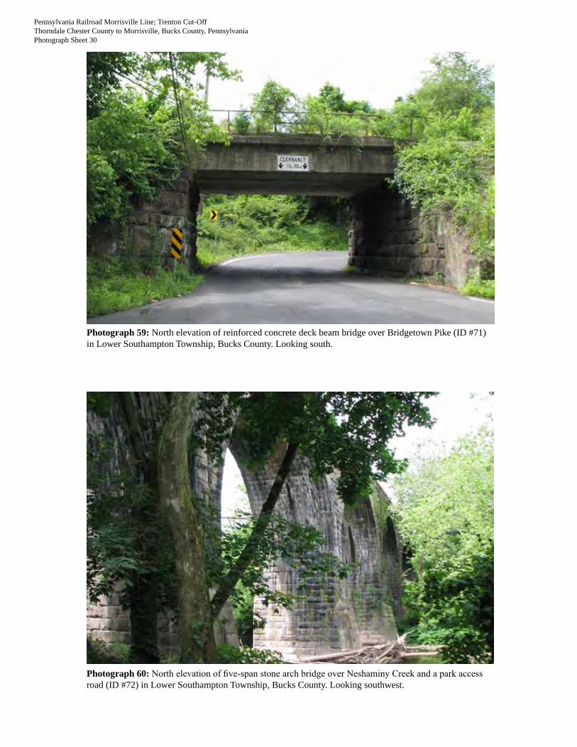
Photograph 59: North elevation of reinforced concrete deck beam bridge over Bridgetown Pike (ID #71) in Lower Southampton Township, Bucks County. Looking south.
Photograph 60: North elevation of five-span stone arch bridge over Neshaminy Creek and a park access road (ID #72) in Lower Southampton Township, Bucks County. Looking southwest.

Pennsylvania Railroad Morrisville Line; Trenton Cut-OffThorndale Chester County to Morrisville, Bucks County, PennsylvaniaPhotograph Sheet 31
Photograph 61: North elevation of seven-span brick arch bridge over Neshaminy Creek and a park access road (ID #73) in Lower Southampton Township, Bucks County. Looking northwest.
Photograph 62: South elevation of stone arch bridge over Newtown-Langhorne Road/S.R. 0413 (south alignment) (ID #76) in Middletown Township, Bucks County. Looking north.

Pennsylvania Railroad Morrisville Line; Trenton Cut-OffThorndale Chester County to Morrisville, Bucks County, PennsylvaniaPhotograph Sheet 32
Photograph 63: North elevation of brick arch bridge over Newtown-Langhorne Road/S.R. 0413 (north alignment) (ID #77) in Middletown Township, Bucks County. Looking north.
Photograph 64: South elevation of steel deck plate girder bridge over Langhorne-Yardley Road (south alignment) (ID #78) in Middletown Township, Bucks County. Looking northeast.

Pennsylvania Railroad Morrisville Line; Trenton Cut-OffThorndale Chester County to Morrisville, Bucks County, PennsylvaniaPhotograph Sheet 33
Photograph 65: North elevation of reinforced concrete deck beam bridge over Langhorne-Yardley Road (north alignment) (ID #79) in Middletown Township, Bucks County. Looking southwest.
Photograph 66: South elevation of brick and stone arch bridge over Woodbourne Road (ID #80) in Middletown Township, Bucks County. Looking north.

Pennsylvania Railroad Morrisville Line; Trenton Cut-OffThorndale Chester County to Morrisville, Bucks County, PennsylvaniaPhotograph Sheet 34
Photograph 67: Detail of brick and stone arch bridge over Woodbourne Road (ID #80) in Middletown Township, Bucks County. Looking north.
Photograph 68: South elevation of pony plate girder bridge over the former Philadelphia and Reading Railroad (ID #81) in Middletown Township, Bucks County. Looking northeast.

Pennsylvania Railroad Morrisville Line; Trenton Cut-OffThorndale Chester County to Morrisville, Bucks County, PennsylvaniaPhotograph Sheet 35
Photograph 69: South elevation of reinforced concrete deck beam bridge over Woolston Drive (south track) (ID #83) in Falls Township, Bucks County. Looking north.
Photograph 70: North elevation of reinforced concrete deck beam bridge over Woolston Drive (north track) (ID #84) in Falls Township, Bucks County. Looking north.
Pennsylvania Railroad Morrisville Line; Trenton Cut-OffThorndale Chester County to Morrisville, Bucks County, PennsylvaniaPhotograph Sheet 36
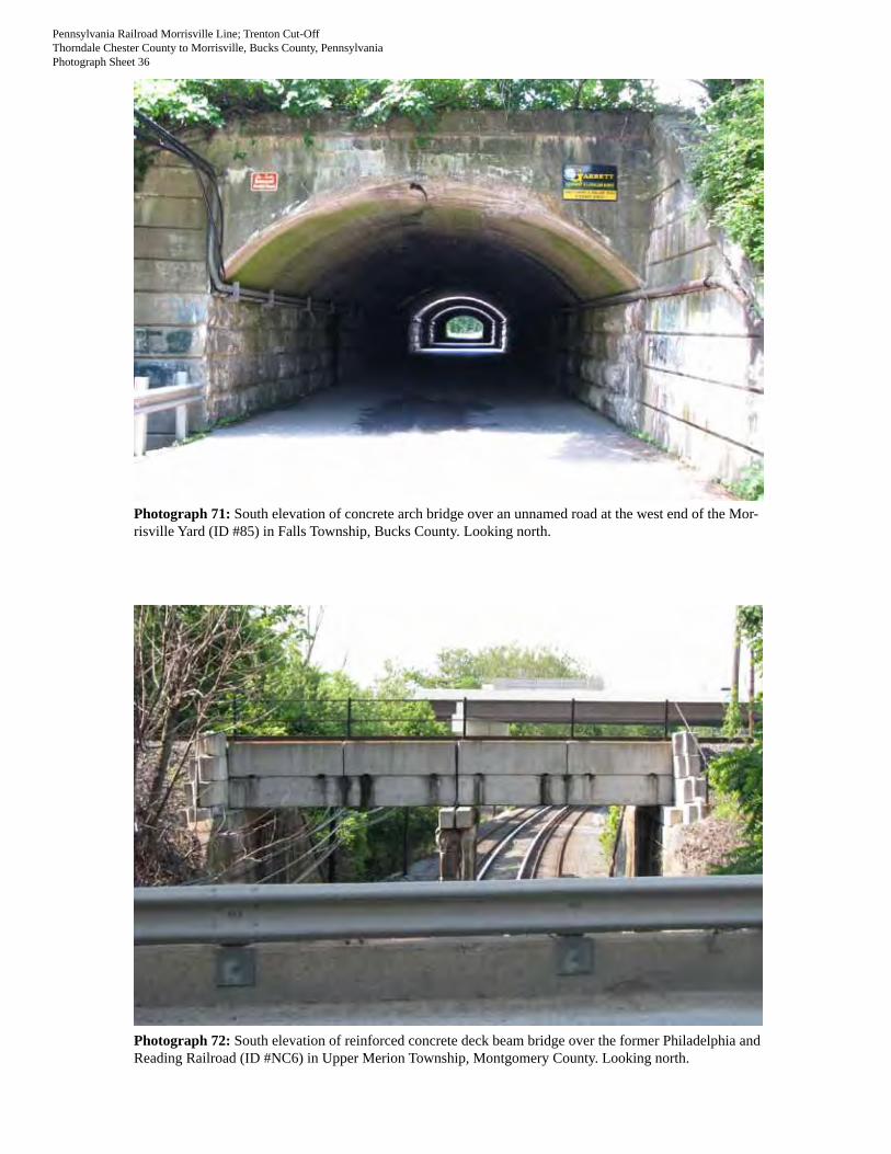
Photograph 71: South elevation of concrete arch bridge over an unnamed road at the west end of the Mor-risville Yard (ID #85) in Falls Township, Bucks County. Looking north.
Photograph 72: South elevation of reinforced concrete deck beam bridge over the former Philadelphia and Reading Railroad (ID #NC6) in Upper Merion Township, Montgomery County. Looking north.

Table 1. Contributing and Potentially Contributing Resources to Pennsylvania Railroad Morrisville Line (Key #100219, 112378; ER #02-8047-091).
Resource ID #
Contributing Status Resource Type
Bridge No./Resource Name Location Municipality County
Feature Design Materials
Construction Date (source) Notes
Previous Documentation Photograph No.
1 Contributing Railroad bridge UG 33.92 Tracks over Bondsville Rd CALN CHESTERStone arch, single-span
Stone arch, abutments, and wingwalls; steel pipe railing
1904 (date inscription, Conrail inventory)
Shares abutments with two metal girders also carrying tracks
Conrail inventory (ER #92-3732-029) 2
2 Contributing Railroad tunnel UG 33.50
Tracks over former PA RR Harrisburg to Philadelphia Main Line, west of Fox Farm Ln CALN CHESTER
Stone arch, single-span Stone arch and portals
1903 (date inscription, Conrail inventory)
Conrail inventory (ER #92-3732-029) N/A
3 Contributing Railroad culvert UG 33.32
Tracks over small stream or drainage ditch, west of Gallagherville Rd CALN CHESTER
Brick arch, single-span
Brick arch; stone facing, abutments, and wingwalls
1904 (Conrail inventory)
Conrail inventory (ER #92-3732-029) 3
4 Contributing Railroad bridge UG 32.67 Tracks over South Lloyd Ave CALN CHESTERStone arch, single-span
Stone arch, abutments, and wingwalls; concrete superstructure
1904 substructure (arch date inscription), 1924 deck (date inscription)
Conrail inventory (ER #92-3732-029) 4
5
Not accessible, potentially contributing Railroad bridge UG 32.64
Tracks over small stream or drainage ditch, near South Lloyd Ave CALN CHESTER Brick arch Unknown
1905 (Conrail inventory)
Conrail inventory (ER #92-3732-029) N/A
6 Contributing Railroad bridge UG 32.01 Tracks over Glenside Ave WEST BRADFORD CHESTERStone arch, single-span
Stone arch, abutments, and wingwalls
1904 (date inscription, Conrail inventory)
Conrail inventory (ER #92-3732-029) 5
7 Contributing Railroad bridge UG 31.31
Tracks over Bradford Ave, Downingtown Pike, small stream, and Old Trolley Rd WEST BRADFORD CHESTER
Steel deck truss, deck plate girder/trestle
Steel superstructure; steel trestle bents; stone piers under deck truss section
1905 (Conrail inventory)
Conrail inventory (ER #92-3732-029) 6
8 Contributing Railroad bridge UG 29.37 Tracks over Valley Creek Rd EAST CALN CHESTERStone arch, single span
Stone arch, abutments, and wingwalls
1903 (datestone, Conrail inventory)
Datestone: "1903, W.H. Brown Chief Engineer, W.A. Pratt Asst. to the Chief Engineer, J.R. Potter Asst. Engineer, Sparks & Evans Contractors"
Conrail inventory (ER #92-3732-029) 7
9 Contributing Railroad bridge UG 29.15 Tracks over West Boot Rd EAST BRADFORD CHESTERStone arch, single span
Stone arch, abutments, and wingwalls
1903 (date inscription; Conrail inventory says 1905)
Conrail inventory (ER #92-3732-029) 8
10 Contributing Railroad bridge UG 28.53 Tracks over Burgoyne Rd WEST WHITELAND CHESTERStone arch, single span
Stone arch, abutments, and wingwalls
1905 (Conrail inventory)
Conrail inventory (ER #92-3732-029) 9
11 Contributing Railroad bridge UG 28.26 Tracks over Burgoyne Rd WEST WHITELAND CHESTERStone arch, single span
Stone arch and abutments; stone and concrete wingwalls; concrete deck; steel railings
1905 (Conrail inventory)
Conrail inventory (ER #92-3732-029) 10
12
Not accessible, potentially contributing Railroad culvert UG 28.23
Tracks over small stream or drainage ditch, near Burgoyne Rd and Spackman Ln WEST WHITELAND CHESTER Brick arch Unknown
1905 (Conrail inventory)
Conrail inventory (ER #92-3732-029) N/A

Table 1. Contributing and Potentially Contributing Resources to Pennsylvania Railroad Morrisville Line (Key #100219, 112378; ER #02-8047-091).
Resource ID #
Contributing Status Resource Type
Bridge No./Resource Name Location Municipality County
Feature Design Materials
Construction Date (source) Notes
Previous Documentation Photograph No.
13 Contributing Railroad bridge UG 27.76/Whitford Bridge
Tracks over former PA RR Harrisburg to Philadelphia Main Line, at intersection of Spackman Ln and South Whitford Rd WEST WHITELAND CHESTER
Steel Pratt through truss
Steel superstructure, stone abutments and wingwalls
1904 (1981 HRSF, plaque)
Plaque: "1904, W.H. Brown Chief Engineer, W.A. Pratt Assistant to the Chief Engineer, J.R. Potter Assistant Engineer, Smith Construction Co. Contractor"
Conrail inventory (ER #92-3732-029); Whitford Bridge, Key No. 064507 - determined not eligible 1/1/84. 1981 HRSF states it is significant as one of two remaining PA RR "jump-over bridges" used to provide unobstructed mainline clearance with a minimum of switches and turnoffs. 11
14
Not accessible, potentially contributing Railroad culvert UG 26.95
Tracks over small stream or drainage ditch, west of S. Pottstown Pike (S.R. 0100) WEST WHITELAND CHESTER Brick arch Unknown
1905 (Conrail inventory)
Conrail inventory (ER #92-3732-029) N/A
15 Contributing Railroad bridge UG 26.84Tracks over S. Pottstown Pike (S.R. 0100) WEST WHITELAND CHESTER
Reinforced concrete deck girder
Reinforced concrete superstructure, piers, and abutments
1955 (Conrail inventory)
Conrail inventory (ER #92-3732-029) 12
16 Contributing Railroad bridge UG 26.83 Tracks over Walkertown Rd (at SEPTA Exton station) WEST WHITELAND CHESTER
Stone arch, single span
Stone arch, abutments, and wingwalls
1905 (Conrail inventory)
Conrail inventory (ER #92-3732-029) 13
17 Contributing Railroad bridge UG 26.06 Tracks over Ship Rd WEST WHITELAND CHESTERStone arch, single span
Stone arch, abutments, and wingwalls
1905 (Conrail inventory)
Conrail inventory (ER #92-3732-029) 14
18
Not accessible, potentially contributing Railroad culvert UG 25.90
Tracks over small stream or drainage ditch, west of U.S. 0202 WEST WHITELAND CHESTER Brick arch Unknown
1905 (Conrail inventory)
Conrail inventory (ER #92-3732-029) N/A
19
Not accessible, potentially contributing Railroad culvert UG 25.41
Tracks over small stream or drainage ditch, east of Ship Rd WEST WHITELAND CHESTER Brick arch Unknown
1904 (Conrail inventory)
Conrail inventory (ER #92-3732-029) N/A
20
Not accessible, potentially contributing Railroad culvert UG 24.76
Tracks over small stream or drainage ditch, west of Phoenixville Pike WEST WHITELAND CHESTER Brick arch Unknown
1904 (Conrail inventory)
Conrail inventory (ER #92-3732-029) N/A
21 Contributing Railroad bridge UG 24.74 Tracks over Phoenixville Pike WEST WHITELAND CHESTERSteel deck plate girder
Steel superstructure; stone abutments and wingwalls
1903 (Conrail inventory)
Conrail inventory (ER #92-3732-029) 15
22
Not accessible, potentially contributing Railroad culvert UG 24.38
Tracks over small stream or drainage ditch, west of Ravine Rd EAST WHITELAND CHESTER Brick arch Unknown
1903 (Conrail inventory)
Conrail inventory (ER #92-3732-029) N/A
23 Contributing Railroad bridge UG 24.34 Tracks over Ravine Rd EAST WHITELAND CHESTERStone arch, single span
Stone arch, abutments, and wingwalls; steel railing
1905 (Conrail inventory)
Conrail inventory (ER #92-3732-029) 16
24
Not accessible, potentially contributing Railroad culvert Unknown
Tracks over small stream or drainage ditch, east of Ravine Rd EAST WHITELAND CHESTER Unknown Unknown Unknown N/A
25
Not accessible, potentially contributing Railroad culvert Unknown
Tracks over small stream or drainage ditch, between Ravine Rd and Sproul Rd EAST WHITELAND CHESTER Unknown Unknown Unknown N/A
26
Not accessible, potentially contributing Railroad culvert Unknown
Tracks over small stream or drainage ditch, between Sproul Rd and Malin Rd EAST WHITELAND CHESTER Unknown Unknown Unknown N/A

Table 1. Contributing and Potentially Contributing Resources to Pennsylvania Railroad Morrisville Line (Key #100219, 112378; ER #02-8047-091).
Resource ID #
Contributing Status Resource Type
Bridge No./Resource Name Location Municipality County
Feature Design Materials
Construction Date (source) Notes
Previous Documentation Photograph No.
27 Contributing Railroad bridge Unknown Tracks over S. Malin Rd EAST WHITELAND CHESTER
Reinforced concrete deck beam
Reinforced concrete superstructure; stone abutments; stone and concrete wingwalls; steel railing
circa -1890 substructure; 1915 superstructure (deck date inscription) 27
28
Not accessible, potentially contributing Railroad culvert Unknown
Tracks over small stream or drainage ditch, east of S. Main Rd EAST WHITELAND CHESTER Unknown Unknown Unknown N/A
29
Not accessible, potentially contributing Railroad culvert Unknown
Tracks over small stream or drainage ditch, east of S. Main Rd EAST WHITELAND CHESTER Unknown Unknown Unknown N/A
30 Contributing Railroad bridge UnknownTracks over West Lancaster Ave (U.S. 0030) EAST WHITELAND CHESTER
Reinforced concrete deck beam, two-span
Reinforced concrete superstructure; concrete piers, abutments, wingwalls, and parapets ca. 1920 28
31 Contributing Railroad bridge Unknown Tracks over Cedar Hollow Rd TREDYFFRIN CHESTERStone arch, single span
Stone arch and abutments; stone and concrete wingwalls; concrete deck; steel railings ca. 1890 29
32
Not accessible, potentially contributing Railroad culvert Unknown
Tracks over small stream or drainage ditch, east of Cedar Hollow Rd TREDYFFRIN CHESTER Unknown Unknown Unknown N/A
33
Not accessible, potentially contributing Railroad culvert Unknown
Tracks over small stream or drainage ditch, west of North Valley Rd TREDYFFRIN CHESTER Unknown Unknown Unknown N/A
34 Contributing Railroad bridge Unknown Tracks over North Valley Rd TREDYFFRIN CHESTER
Reinforced concrete deck beam, single span
Reinforced concrete superstructure; stone and concrete abutments and wingwalls; steel railings
circa -1890 substructure; 1915 superstructure (deck date inscription) 30
35
Not accessible, potentially contributing Railroad culvert Unknown
Tracks over small stream, west of Bearhill Rd TREDYFFRIN CHESTER Unknown Unknown Unknown N/A
36
Not accessible, potentially contributing Railroad culvert Unknown
Tracks over small stream or drainage ditch, between Bearhill Rd and Howellville Rd TREDYFFRIN CHESTER Unknown Unknown Unknown N/A
37 Contributing Railroad bridge Unknown Tracks over Contention Lane TREDYFFRIN CHESTERBrick arch, single span
Brick arch; stone facing and abutments; stone and concrete wingwalls; concrete deck; steel railings ca. 1890 31
38
Not accessible, potentially contributing Railroad culvert Unknown
Tracks over small stream or drainage ditch, east of North Valley Forge Rd TREDYFFRIN CHESTER Unknown Unknown Unknown N/A
39
Not accessible, potentially contributing Railroad culvert Unknown
Tracks over small stream or drainage ditch, east of West Valley Rd TREDYFFRIN CHESTER Unknown Unknown Unknown N/A
40 Contributing Railroad bridge UnknownTracks over Old Eagle School Rd TREDYFFRIN CHESTER
Pony plate girder
Steel superstructure; stone and concrete abutments; concrete wingwalls 1915 (plaque)
Plaque: "The Pennsylvania Steel Co., Steelton, PA, 1915" 32

Table 1. Contributing and Potentially Contributing Resources to Pennsylvania Railroad Morrisville Line (Key #100219, 112378; ER #02-8047-091).
Resource ID #
Contributing Status Resource Type
Bridge No./Resource Name Location Municipality County
Feature Design Materials
Construction Date (source) Notes
Previous Documentation Photograph No.
41
Not accessible, potentially contributing Railroad culvert Unknown
Tracks over small stream or drainage ditch, west of County Line Rd TREDYFFRIN CHESTER Unknown Unknown Unknown N/A
42
Not accessible, potentially contributing Railroad culvert Unknown
Tracks over small stream, east of Long Rd UPPER MERION MONTGOMERY Unknown Unknown Unknown N/A
43 Contributing Railroad bridge Unknown Tracks over Crooked Lane UPPER MERION MONTGOMERY
Reinforced concrete beck beam
Reinforced concrete superstructure; stone abutments; stone and concrete wingwalls; steel railing
circa -1890 substructure; circa -1915 superstructure with later concrete alterations 33
44 Contributing Railroad bridge Unknown Tracks over Flint Hill Rd UPPER MERION MONTGOMERY
Reinforced concrete beck beam
Reinforced concrete superstructure; stone abutments and wingwalls; steel railing
circa -1890 substructure; circa -1915 superstructure 34
45 Contributing Railroad bridge Unknown Tracks over Colbert St UPPER MERION MONTGOMERYBrick arch, single span
Brick arch; stone facing, abutments, and wingwalls ca. 1890 35
46 Contributing Railroad bridge Unknown
Tracks over River Rd (S.R. 0023), Schuylkill River, former Philadelphia & Reading RR, and PA RR Schuylkill Valley Division UPPER MERION MONTGOMERY
Riveted Warren deck truss, seven-span
Steel superstructure; stone and concrete piers; stone abutments and wingwalls; concrete deck; steel railings
1890-91 substructure, 1914-15 superstructure (HAER No. PA-538)
ER #02-8047-091 (MTA 2003) - recommended contributing feature to the Morrisville Line. HAER No. PA-538 (Pennsylvania Railroad, Trenton Cut-Off, Bridge No. 25 at Earnest). 2001 HAER documentation states bridge designer was H.R. Leonard (Engineer of Bridges, Pennsylvania Railroad) and fabricator was Phoenix Bridge Co. 36
47 Contributing Railroad bridge Unknown
Tracks over Schuylkill River Trail and former Philadelphia & Reading RR PLYMOUTH MONTGOMERY
Steel deck plate girder
Steel and concrete superstructure; stone and concrete abutments and wingwalls; steel railings
circa -1890 substructure; circa -1915 superstructure 37
48 Contributing Railroad bridge Unknown Tracks over Conshohocken Rd PLYMOUTH MONTGOMERY
Reinforced concrete deck beam
Reinforced concrete superstructure; stone abutments and wingwalls; steel railings
circa -1890 substructure; circa -1915 superstructure
ER #02-8047-091 (MTA 2003) - recommended contributing feature to the Morrisville Line. 38
49 Contributing Railroad bridge Unknown Tracks over Butler Pike PLYMOUTH MONTGOMERYSteel deck plate girder
Steel and concrete superstructure; stone and concrete abutments and wingwalls; steel railings
circa -1890 substructure; circa -1915 superstructure 39

Table 1. Contributing and Potentially Contributing Resources to Pennsylvania Railroad Morrisville Line (Key #100219, 112378; ER #02-8047-091).
Resource ID #
Contributing Status Resource Type
Bridge No./Resource Name Location Municipality County
Feature Design Materials
Construction Date (source) Notes
Previous Documentation Photograph No.
50 Contributing Railroad bridge Unknown Tracks over Flourtown Rd WHITEMARSH MONTGOMERYPony plate girder
Steel superstructure; stone abutments and wingwalls
circa -1890 substructure; 1914 superstructure (plaque)
Plaque: "American Bridge Company, USA, 1914" 40
51 Contributing Railroad bridge UnknownTracks over the Wissahickon Creek and trail WHITEMARSH MONTGOMERY
Stone arch, ten-span
Stone arches; concrete deck and vertical reinforcements; steel tie rods; steel railings ca. 1890 41
52 Contributing Railroad bridge Unknown
Tracks over South Bethlehem Pike (S.R. 0073), Skippack Pike, and Camp Hill Rd intersection WHITEMARSH MONTGOMERY
Pony plate girder
Steel superstructure; stone and concrete abutments and wingwalls
circa -1890 substructure; circa -1915 superstructure 42
53 Contributing Railroad bridge UnknownTracks over former Philadelphia & Reading RR WHITEMARSH MONTGOMERY
Steel deck beam
Steel superstructure; stone and concrete abutments and wingwalls; steel trestle bent ca. 1915 43-44
54 Contributing Railroad bridge Unknown Tracks over Camp Hill Rd UPPER DUBLIN MONTGOMERYBrick arch, single span
Brick arch; concrete deck; stone facing, abutments, and wingwalls; steel railings ca. 1890 45-46
55
Not accessible, potentially contributing Railroad culvert Unknown
Tracks over small stream, east of Camp Hill Rd UPPER DUBLIN MONTGOMERY Unknown Unknown Unknown N/A
56
Not accessible, potentially contributing Railroad culvert Unknown
Tracks over small stream or drainage ditch, west of Susquehanna Rd (S.R. 2017) UPPER DUBLIN MONTGOMERY Unknown Unknown Unknown N/A
57 Contributing Railroad bridge Unknown Tracks over Susquehanna Rd UPPER DUBLIN MONTGOMERYSteel deck beam
Steel superstructure; stone and concrete abutments and wingwalls
circa -1890 substructure; circa -1915 superstructure 47
58 Contributing Railroad bridge UnknownTracks over Easton Rd (S.R. 0611) UPPER MORELAND MONTGOMERY
Pony plate girder
Steel superstructure; concrete abutments and wingwalls ca. 1915 48
59 Contributing Railroad bridge UnknownTracks over Old York Rd (S.R. 0263) UPPER MORELAND MONTGOMERY
Pony plate girder
Steel superstructure; concrete abutments and wingwalls ca. 1915 49
60 Contributing Railroad bridge UnknownTracks over former Philadelphia & Reading RR UPPER MORELAND MONTGOMERY
Steel deck plate girder
Steel and concrete superstructure; stone and concrete abutments and wingwalls; steel railings ca. 1915 50-51
61
Not accessible, potentially contributing Railroad bridge Unknown Tracks over Pennypack Creek UPPER MORELAND MONTGOMERY Unknown Unknown Unknown N/A
62 Contributing Railroad bridge Unknown Tracks over Byberry Rd UPPER MORELAND MONTGOMERYBrick arch, single span
Brick arch; concrete deck; stone facing, abutments, and wingwalls
1890 (date inscription) 52-53
63 Contributing Railroad bridge Unknown Tracks over Pioneer Rd UPPER MORELAND MONTGOMERYBrick arch, single span
Brick arch; concrete deck; stone facing, abutments, and wingwalls; steel railings ca. 1890 54

Table 1. Contributing and Potentially Contributing Resources to Pennsylvania Railroad Morrisville Line (Key #100219, 112378; ER #02-8047-091).
Resource ID #
Contributing Status Resource Type
Bridge No./Resource Name Location Municipality County
Feature Design Materials
Construction Date (source) Notes
Previous Documentation Photograph No.
64
Not accessible, potentially contributing Railroad culvert Unknown
Tracks over small stream, between Pioneer Rd and Heaton Rd UPPER MORELAND MONTGOMERY Unknown Unknown Unknown N/A
65
Not accessible, potentially contributing Railroad culvert Unknown
Tracks over small stream or drainage ditch between Pioneer Rd and Heaton Rd UPPER MORELAND MONTGOMERY Unknown Unknown Unknown N/A
66 Contributing Railroad bridge Unknown Tracks over Heaton Rd LOWER MORELAND MONTGOMERYBrick arch, single span
Brick arch; concrete deck; stone facing, abutments, and wingwalls; steel railings ca. 1890 55
67 Contributing Railroad bridge UnknownTracks over East Street Rd (S.R. 0132) LOWER SOUTHAMPTON BUCKS
Pony plate girder
Steel superstructure; concrete abutments and wingwalls ca. 1950 56
68 Contributing Railroad bridge Unknown Tracks over West Bristol Rd LOWER SOUTHAMPTON BUCKSBrick arch, single span
Brick arch; concrete deck; stone facing, abutments, and wingwalls; steel railings ca. 1890 57
69 Contributing Railroad bridge Unknown Tracks over Buck Rd NORTHAMPTON BUCKSBrick arch, single span
Brick arch; concrete deck; stone facing, abutments, and wingwalls; steel railings ca. 1890 58
70
Not accessible, potentially contributing Railroad culvert Unknown
Tracks over small stream or drainage ditch, east of Bristol Rd NORTHAMPTON BUCKS Unknown Unknown Unknown N/A
71 Contributing Railroad bridge Unknown Tracks over Bridgetown Pike LOWER SOUTHAMPTON BUCKS
Reinforced concrete deck beam
Reinforced concrete superstructure; stone abutments; stone and concrete wingwalls; steel railing
circa -1890 substructure; circa -1915 superstructure 59
72 Contributing Railroad bridge UnknownTracks over Neshaminy Creek and park access rd LOWER SOUTHAMPTON BUCKS
Stone arch, five-span
Stone arches, piers, and abutments 1903 (plaque)
Plaque: "1903, Wm. H. Brown Chief Engineer, Wm. A Pratt Ass't. to Chief Engineer, J.F. Cullen Ass't. Engineer, the Drake & Stratton Co. Contractors" 60
73 Contributing Railroad bridge UnknownTracks over Neshaminy Creek and park access rd LOWER SOUTHAMPTON BUCKS
Brick arch, seven-span
Brick arches; stone facing, piers, and abutments; steel railing ca. 1890 61
74
Not accessible, potentially contributing Railroad culvert Unknown
Tracks over a ditch, between Neshaminy Creek and NewtownLanghorne Rd MIDDLETOWN BUCKS Unknown Unknown Unknown N/A
75
Not accessible, potentially contributing Railroad culvert Unknown
Tracks over multiple ditches, between Neshaminy Creek and Newtown-Langhorne Rd MIDDLETOWN BUCKS Unknown Unknown Unknown N/A
76 Contributing Railroad bridge Unknown
Tracks over Newtown-Langhorne Rd (S.R. 0413) (south alignment) MIDDLETOWN BUCKS
Stone arch, single span
Stone arch, abutments, and wingwalls; concrete deck; steel railings ca. 1890 62
77 Contributing Railroad bridge Unknown
Tracks over Newtown-Langhorne Road (SR 413) (north alignment) MIDDLETOWN BUCKS
Brick arch, single span
Brick arch; stone facing, abutments, and wingwalls ca. 1890 63
78 Contributing Railroad bridge UnknownTracks over Langhorne-Yardley Rd (south alignment) MIDDLETOWN BUCKS
Steel deck plate girder
Steel superstructure; stone abutments and wingwalls; steel railing ca. 1915 64

Table 1. Contributing and Potentially Contributing Resources to Pennsylvania Railroad Morrisville Line (Key #100219, 112378; ER #02-8047-091).
Resource ID #
Contributing Status Resource Type
Bridge No./Resource Name Location Municipality County
Feature Design Materials
Construction Date (source) Notes
Previous Documentation Photograph No.
79 Contributing Railroad bridge UnknownTracks over Langhorne-Yardley Rd (north alignment) MIDDLETOWN BUCKS
Reinforced concrete deck beam
Reinforced concrete superstructure; stone abutments and wingwalls; steel railing ca. 1915 65
80 Contributing Railroad bridge Unknown Tracks over Woodbourne Rd MIDDLETOWN BUCKS
Brick and stone arch, single span
Brick and stone arch; stone abutments; stone and concrete wingwalls; concrete deck; steel railings
circa -1890 brick arch, enlarged circa -1905 with stone arch section 66-67
81 Contributing Railroad bridge UnknownTracks over former Philadelphia & Reading RR MIDDLETOWN BUCKS
Pony plate girder
Steel superstructure; stone and concrete abutments and wingwalls ca. 1915 68
82
Not accessible, potentially contributing Railroad culvert Unknown
Tracks over small stream or drainage ditch, west of Queen Anne Court FALLS BUCKS Unknown Unknown Unknown N/A
83 Contributing Railroad bridge Unknown Tracks over Woolston Drive FALLS BUCKS
Reinforced concrete deck beam
Reinforced concrete superstructure; concrete abutments and wingwalls
1951 (date inscription) 69
84 Contributing Railroad bridge Unknown Tracks over Woolston Drive FALLS BUCKS
Reinforced concrete deck beam
Reinforced concrete superstructure; concrete abutments and wingwalls
1917 (date inscription) 70
85 Contributing Railroad bridge UnknownTracks over unnamed rd at west end of Morrisville Yard FALLS BUCKS
Concrete arch
Concrete arch and wingwalls; stone abutments
1917 (date inscription) 71
86 Contributing Railroad yard Morrisville YardBetween U.S. 0013 and Delaware Canal FALLS BUCKS
Railroad yard Unknown 1891 (1998 HRSF)
Morrisville Yard, Key No. 109639 - determined eligible under Criteria A & C 3/19/98. 1998 HRSF states most of trackage was removed in late 1980s and three buildings were present: circa -1960s yard office; circa -1940s-50s engine house; pre-WWII coaling/sand tower. N/A

Table 2. Non-contributing Rail-related Resources along Pennsylvania Railroad Morrisville Line (Key #100219, 112378; ER #02-8047-091).
Resource ID #
Contributing Status Resource Type
Bridge No./Resource Name Location Municipality County Feature Design Materials
Construction Date (source) Notes
Previous Documentation Photograph No.
NC1
Non-contributing (not a significant feature) Railroad siding N/A
North side of tracks, west of Cedar Hollow Rd TREDYFFRIN CHESTER Siding tracks Unknown Unknown N/A
NC2
Non-contributing (not a significant feature) Railroad siding N/A
North side of tracks, east of South Warner Rd UPPER MERION MONTGOMERY Siding tracks Unknown Unknown N/A
NC3
Non-contributing (post-dates period of significance) Railroad bridge Unknown Tracks over I-76 UPPER MERION MONTGOMERY
Warren through truss
Steel superstructure; concrete abutments and wingwalls ca. 2002 N/A
NC4
Non-contributing (post-dates period of significance) Railroad bridge Unknown
Tracks over South Gulph Rd UPPER MERION MONTGOMERY Pony plate girder
Steel superstructure; concrete abutments and wingwalls ca. 2002 N/A
NC5
Non-contributing (post-dates period of significance) Railroad bridge Unknown
Tracks over South Henderson Rd UPPER MERION MONTGOMERY Pony plate girder
Steel superstructure; concrete abutments and wingwalls ca. 1990 N/A
NC6
Non-contributing (substantial alterations post-dating period of significance) Railroad bridge Unknown
Tracks over former Philadelphia & Reading RR UPPER MERION MONTGOMERY
Reinforced concrete deck beam
Reinforced concrete superstructure; concrete pier, abutments, and wingwalls
ca. 1980 (superstructure), ca. 1915 (substructure) 72
NC7
Non-contributing (post-dates period of significance) Railroad bridge Unknown
Tracks over Germantown Pike PLYMOUTH MONTGOMERY Pony plate girder
Steel superstructure; concrete abutments and wingwalls ca. 1990 N/A
NC8
Non-contributing (not a significant feature)
Railroad switching station N/A West of Flourtown Rd WHITEMARSH MONTGOMERY
Railroad switching station
Metal signal, switching equipment, and equipment shed Unknown N/A
NC9
Non-contributing (not a significant feature) Railroad siding N/A
North side of tracks, west of S.R. 0309 WHITEMARSH MONTGOMERY Siding tracks Unknown Unknown N/A
NC10
Non-contributing (post-dates period of significance) Railroad bridge Unknown Tracks over S.R. 0309 WHITEMARSH MONTGOMERY Pony plate girder
Steel superstructure; concrete abutments and wingwalls ca. 2005
Trenton Cut-Off Bridge, Key No. 103971 - determined not eligible 7/17/95 (structure has since been replaced) N/A
NC11
Non-contributing (not a significant feature) At-grade crossing N/A
At-grade crossing with County Line Rd LOWER MORELAND MONTGOMERY At-grade crossing
Steel rails; asphalt roadway; metal signals, and equipment sheds Unknown N/A
NC12
Non-contributing (not a significant feature) At-grade crossing N/A
At-grade crossing with Bustleton Pike LOWER SOUTHAMPTON BUCKS At-grade crossing
Steel rails; asphalt roadway; metal signals and equipment sheds Unknown N/A
NC13
Non-contributing (not a significant feature) Railroad siding N/A
North side of tracks, east of Oxford Valley Rd and south of Cabot Blvd FALLS BUCKS Siding tracks
Steel rails; wood ties; stone ballast Unknown N/A