history of the kansa indians - emporia state university
TRANSCRIPT
I their "Sunday best:' (Courtesy ot The
History of the Kansa Indians
The first recorded mention of the Kansa nation is found in the account of the explorations of Juan de Onate, who met this tribe on the plains in 1601. probably in what is now the eastern half of the state. He was searching, just as Coronado had in 1541. for the land of the Quiviras. With eighty soldiers, a large number of armed Indians, several guides, two friars, and full supplies for either war or peace, Onate had come some 600 miles from New Mexico.
The Escansaques, as Onate called them, were a wild and powerful tribe who were out on their annual raid on the Quiviras, their hereditary enemies. The Spanish battled with the .Escansaques to teach them not to attack the gentle Quiviras, and then proceeded to the Quiviran settlement (probably in the vicinity of present Junction City).
The next important meeting of white men with the Kansa occurred in 1724 when M. Etienne Venyard de Bourgmont. French military commandant on the Missouri. visited the "Grand village des Cansez." It was located at the mouth of Independence creek (Doniphan county), and seemeq to be the capital of the Kansa nation. There was a two-week celebration spent in councils, powwows, trading of horses and merchandise, and giving of gifts (including a constant supply of wild grapes which the Indians furnished to the French for making wine). Bourgmont and his forces brought about a compact of friendship between the Kansa and the French which lasted for many years.
In 1804, Lewis and Clark visited the abandoned Grand village site on their westward exploration. The following account ap· peared in their journal under the date of July 4:
We came to and camped on the lower edge of the plain, where the 2d old Kanzas village formerly stood, above the mouth of a creek, 30 yards wide; this creek we call Creek Independence. As we approached this place the prairie had a most bequtiful appearance. Hills and val
7

--------------------------- --- -------------
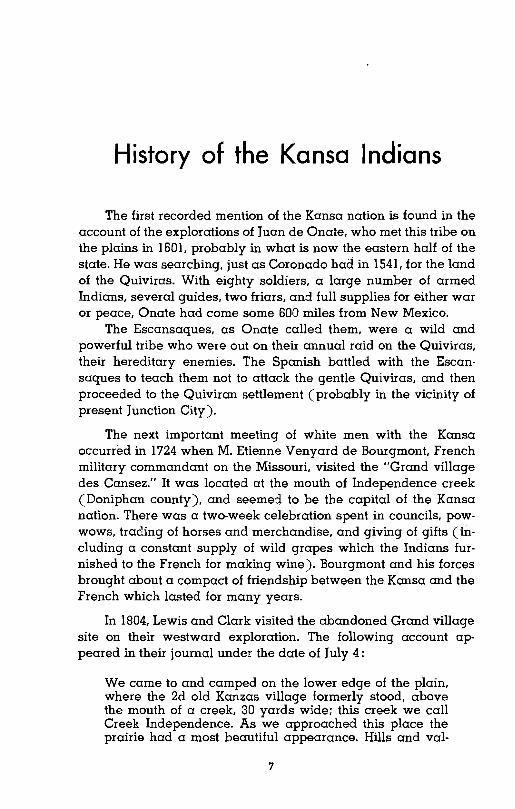
\(AN SA VIll" lTE (11'10'S ~-leH)
FOOL CHIEFS VILlA6-E
!'lARD CHlfF'S I/llLAc;.E~~~~~2~~~~§;:9trl....""AMERICAN CHIEF'S VILLAG.E
(1&)0-/84")
leys interspersed with copses of timber gave a pleasing diversity to the scenery. the right fork of the Creek Independence meandering through the middle of the plain. A point of high land near the river gives an elevated situation. At this place the Kanzas Indians formerly lived. This town appears to have covered a large space. The nation must have been numerous at the time they lived here. The cause of their moving to the Kanzas river I have never heard nor can I learn. War with their neighbors must have reduced this nation and compelled them to retire to a situation in the plains better calculated for their defense. and one where they may make use of their horses with good effect in pursuing their enemies. We closed the day by a discharge of our bow piece. [and] an extra gill of whisky.
July 5th. 1804. Set out very early; proceeded on near the bank where the old village stood for two miles. The origin of this old village is uncertain. M. de Bourgmont. a French officer•... commanded a fort near the town of the Missouris [Fort Orleans] in about the year 1724. and in July of the same year he visited this village. At that time the nation was numerous and well disposed towards the French . . . as M. de Bourgmont was accompanied by 300 warriors. 500 young people and 300 dogs of burthen out of this village. The cause of these Indians moving over to the Kanzis river I have never learned.
The remains of another old Kansa town were located about twenty miles down the Missouri from the Grand village. a little below Isle au Vache (Cow Island) in Atchison county. This is
COUNCil G-ROVE--- --l... COUNCIL (;lloVE P.ESERVAl1ol\l-- I/LA~~
(1M" -1873)
Map showtnq northeast quarter of the state with villaqe locations.
8
I
I
'I I
.! I
\ I
-I

of timber gave a pleasing ight fork of the Creek Indeh the middle of the plain. Ie river gives an elevated lzas Indians formerly lived. overed a large space. The rous at the time they lived g to the Kanzas river I have War with their neighbors
I and compelled them to re; better calculated for their y may make use of their IIsuing their enemies. We ! of our bow piece. [and] an
illy; proceeded on near the od for two miles. The origin , M. de Bourgmont. a French ort near the town of the bout the year 1724. and in ed this village. At that time well disposed towards the
Dont was accompanied by 1e and 300 dogs of burthen ,e of these Indians moving ~ never learned.
:ansa town were located about :rom the Grand village. a little d) in Atchison county. This is
~~~--l state with village locations.
sometimes referred to as the "first" village. although there seems to be little evidence that historically it preceded the Grand village.
Of occupied Kansa villages. Lewis and Clark wrote: This river [Kansas] receives its name from a nation which dwells at this time on its banks. and has two villages. one about twenty leagues [sixty miles], and the other forty leagues up. Those Indians are not very numerous at this time. reduced by war with their neighbors. They formerly lived on the south banks of the Missouri. twenty-four leagues above this river in an open and beautiful plain and were very numerous at the time the French first settled the Illinois. I am told they are a fierce and warlike people. [but] being badly supplied with firearms. became easily conquered by the lowas and Sacs. who are better furnished with those materials of war. This nation is now out on the plains hunting the buffalo. They consist of about 300 men.
Although Zebulon Pike had made a treaty with the Kansa and Osage in his camp near Pawnee Republic village in 1806. the first formal recorded treaty between the tribe and the United States occurred in 1815. It was a treaty of friendship and peace. and of forgiveness on the part of the government for the Indians' leaning towards the British in the War of 1812. At the time of the treaty. the Kaw capital village was located at the mouth of the Blue Earth river. about two miles east of the present city of Manhattan. There were between 120 and 180 lodges there. each ten to fifty feet in diameter.
Major Stephen H. Long planned to visit this village during his expedition in 1819. His company came up the Missouri in a steamboat; they were to ascend the Kansas river to the Kaw settlement. but found the river unnavigable. As a result. he settled at Cow Island. and sent a messenger to summon the Kaw tribe to council at the island. His map of 1819 shows the site of the "Old Konzas village" (Grand village) at the mouth of Independence creek. as well as the occupied village at the Blue Earth river.
The Kansa tribe made two very important treaties with the Unite:! States in 1825. On June 3 they bartered away a vast tract of their lands for practically nothing: $4000 in merchandise and
horses; an annual tribal annuity of $3500 for twenty years; some
cattle. hogs. and chickens; a few half-breed land allotments; and
a very limited reservation along the Kansas river.
9
I

By this treaty, the Kansa tribal lands were reduced from nearly half the area of the state of Kansas to a reserve thirty miles wide and extending westward indefinitely from an eastern border near Topeka.
The second treaty of 1825 gave citizens of the United States and the Mexico Republic freedom to survey the Santa Fe Trail and to travel along it unmolested. In return, the tribe received $500 in cash and $300 in merchandise.
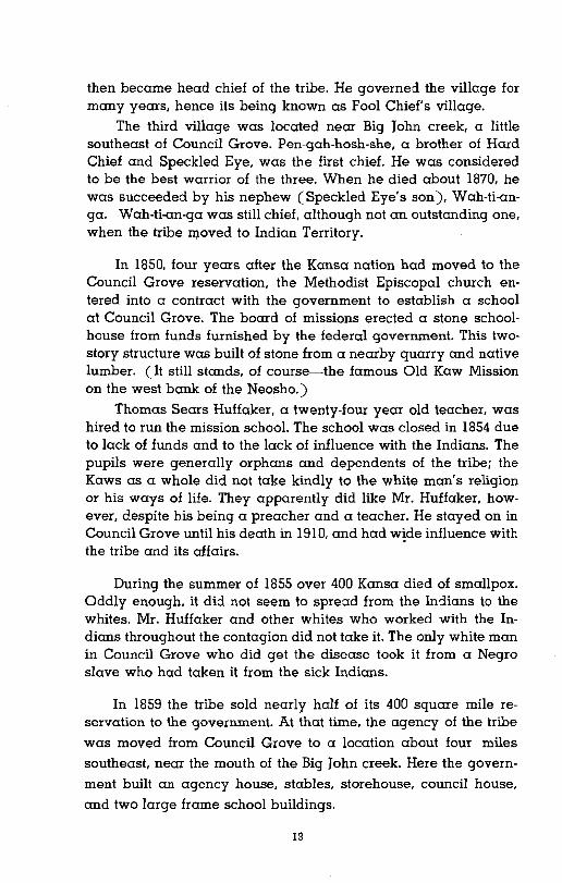
Otoes and MissQurias
1. Sacs & Foxes of Missouri (1837) 2. Iowas (1837) 3. Sacs & Foxes of Mississippi (1843) 4. Chippewa Reserve (1830) 5. Ottawa Reserve (1832) 6. Peorias & Kaskaskias (1833) 7. Weas & Piankeshaws (1833) 8. Miami Reserve (1839 & 1841) 9. Pottawatomie Reserve (Treaty of 1837)
10. Cherokee Neutral Lands (1835) II. Quapaw Strip (1834) 12. Cherokee Strip (Treaty of 1835)
Kickapoo Reserve (Treaty 011833) ,
"""""""'r--'-~~----?-------,oo,_.,o ~,~ (Treaty 01 183D~
Osage Reservef (Treaty 01 1838) /0
( 1
Indian reservations in territory included in Kansas, 1846. (Based on map opposite p. 88, Kansas Historical Collections, Vol. 8.) This shows the Kansa Reserve
treated lor in 1825: thirty miles wide, and extending westward indefinitely.
In 1827 quite a settlement sprang up on the most eastern of the half-breed allotments (slightly south of the present Williamstown, Jefferson county). There were the agency officers (Col. Dan Morgan Boone, son of the famed pioneer, was appointed farmer to the tribe at this location) and their families, some half-breed families, and a few Indians. Frederick Chouteau located his trading post just across the river.
10

)al lands were reduced from ~ansas to a reserve thirty miles linitely from an eastern border
e citizens of the United States )survey the Santa Fe Trail and eturn, the tribe received $500
Delaware Reserve (Treaty of 1831)
Shawnee Reserve (Treaty of 1825)
~ Reserve y of 1838) /0
in Kansas, 1846. (Based on map op
fol. 8.) This shows the Kansa Reserve
clending westward indefinitely.
mg up on the most eastern of south of the present Williams• the agency officers (Col. Dan !ioneer, was appointed farmer ~eir families, some half-breed ick Chouteau located his trad! L.
One of the famous Kansa chiefs lived near the agencyWom-p::r-wa-ra (He Who Scares All Men). He was also known as "Plume Blanche" (White Plume). The government had built a large stone house for this venerable chief. but he refused to stay in it. Instead, he put up his wigwam in the front yard and lived in it. White Plume once gave as an excuse for not using the house, "Too much fleas."
By 1830, the Kaw population had moved west a few miles and had settled in two villages near the mouth of Mission creek and one slightly north of the present town of Menoken. The smaller of the Mission creek villages consisted of about twenty lodges on the west side of the creek, about two miles from the Kansas river. AmericaI\ Chief was the leader of the small band of about a hundred followers who lived there in the permanent dirt lodges.
The village of Hard Chief consisted of ne::rrly a hundred lodges and 500 or 600 people. It was located on a hill overlooking the Kansas river, a mile and a half west of the mouth of Mission creek, and less than two miles from American Chief's location. To Hard Chief's village came the first missionaries for the Kaw Indians, Rev. William Johnson and his wife. For seven years they worked with the tribe, erecting mission buildings, learning the language, trying to te::rch the white man's religion and the white man's schooling. A few years after Johnson's death in 1842, Rev. John T. Peery was sent to the mission to establish a manual train· ing school. The project failed after a year's triaL and the mission was discontinued in 1846.
The largest of the three villages between 1830 and 1846 was the one located on the north side of the Kansas river near the Menoken of today. 700 or 800 people lived there under the leadership of Kah-he-gah-wa-ti-an-gah, better known as Fool Chief.
Old Fool Chief. peaceable when sober, ruled the village
authori~ptively until his death around 1846. The Methodists who
had the' Kaw Mission near Mission creek took him to a general
conference once at Baltimore, where he appeared one hot, sultry
morning on the streets, stark naked, just as he was accustomed to
do at home. One can im::rgine the complete mortification of the
missionaries! Later, he was killed by one of his own braves, whose
life he was trying to take during a fit of drunkeness.
Father Pierre-Jean de Smet, who visited Fool Chief's village
11

in May of 1841. gave the following description of its appearance:
At the first sight of their wigwams we were struck at the resemblance they bore to the large stacks of wheat which cover our fields in harvest-time. There were of these in all no more than about twenty. grouped together without order. but each covering a space of about 120 feet in circumference. and sufficient to shelter from 30 to 40 persons. The entire village appeared to us to consist of from 700 to 800 souls . . . . These cabins. however humble they may appear. are solidly built and convenient. From the top of the wall. which is about six feet in height, rise inclined poles. which terminate round an opening above. serving at once for chimney and window. The door of the edifice consists of an undressed hide on the most sheltered side; the hearth occupies the center. and is in the midst of four upright posts destined to support the rotunda; the beds are ranged round the walL and the space between the beds and the hearth is occupied by members of the family. some standing. others sitting or lying on skins or yellow-colored mats.
Early in 1846. the Kaws ceded two million acres of the east end of their tract to the federal government for the use of the Pottawatomies. Because the timber on the remainder of their land was not sufficient to support the tribe. the government laid out a tract of land twenty miles square at Council Grove.
Between 1846 and 1873. Kansa Indian life centered in three villages on the Council Grove reservation: Cahola creek village, Fool Chief's village near the present town of Dunlap. and Big John creek village.
The largest of the three villages. located on Cahola creek, was ruled from 1847 until his death sometime in the 1860's by Hard Chief, who had brought his people from the Mission creek location. His successor was Al-Ie-ga-wa-ho. a stately six-and-ahalf-foot tall chief, who was respected by both the Indians and the whites.
The second village was located in the valley near the Neosho river. It was first ruled by Speckled Eye. a brother of Hard Chief. He was highly regarded as a sober and alert leader and as a great speech maker. Speckled Eye died from eating too much "store trash" on the day he received his annuity money. (He had been living on short rations. and the change to too much rich food was too sudden for his system.) His nephew. Fool Chief the Younger.
12
description of its appearance:
:xms we were struck at the uge stacks of wheat which '. There were of these in all grouped together without pace of about 120 feet in to shelter from 30 to 40
Ipeared to us to consist of These cabins, however
solidly built and conveniwhich is about six feet in rhich terminate round an e for chimney and window. Is of an undressed hide on learth occupies the center, 'ight posts destined to supranged round the wall, and md the hearth is occupied me standing, others sitting lored mats.
i two million acres of the east Jovernment for the use of the on the remainder of their land
tribe, the government laid out e at Council Grove. a Indian life centered in three lrvation: Cahola creek village, it town of Dunlap, and Big John
ges, located on Cahola creek, rth sometime in the 1860's by people from the Mission creek ·ga-wa-ho, a stately six-and-a!Cted by both the Indians and
i in the valley near the Neosho i Eye, a brother of Hard Chief. and alert leader and as a great I from eating too much "store ~nnuity money. (He had been ~ge to too much rich food was IPhew, Fool Chief the Younger,
then became head chief of the tribe. He governed the village for many years, hence its being known as Fool Chief's village.
The third village was located near Big John creek, a little southeast of Council Grove. Pen-gah-hosh-she, a brother of Hard Chief and Speckled Eye, was the first chief. He was considered to be the best warrior of the three. When he died about 1870, he was succeeded by his nephew (Speckled Eye's son), Wah-ti-angao Wah-ti-an-ga was still chief. although not an outstanding one, when the tribe moved to Indian Territory.
In 1850, four years after the Kansa nation had moved to the Council Grove reservation, the Methodist Episcopal church entered into a contract with the government to establish a school at Council Grove. The board of missions erected a stone schoolhouse from funds furnished by the federal government. This twostory structure was built of stone from a nearby quarry and native lumber. (It still stands, of course-the famous Old Kaw Mission on the west bank of the Neosho.)
Thomas Sears Huffaker, a twenty-four year old teacher, was hired to run the mission school. The school was closed in 1854 due to lack of funds and to the lack of influence with the Indians. The pupils were generally orphans and dependents of the tribe; the Kaws as a whole did not take kindly to the white man's religion or his ways of life. They apparently did like Mr. Huffaker, however, despite his being a preacher and a teacher. He stayed on in Council Grove until his death in 1910. and had w!de influence with the tribe and its affairs.
During the summer of 1855 over 400 Kansa died of smallpox. Oddly enough, it did not seem to spread from the Indians to the whites. Mr. Huffaker and other whites who worked with the In
1\ dians throughout the contagion did not take it. The only white man in Council Grove who did get the disease took it from a Negro slave who had taken it from the sick Indians.
In 1859 the tribe sold nearly half of its 400 square mile reservation to the government. At that time, the agency of the tribe
was moved from Council Grove to a location about four miles
southeast, near the mouth of the Big John creek. Here the govern
ment built an agency house, stables, storehouse, council house,
and two large frame school buildings.
13

One of the school buildings was used for classes. The other was used as a dwelling place for the people connected with the school and also as the training center for cooking and other domestic arts for the young Indians.
The government also built some 150 small stone cottages along the valley for the individual use of Indian families. The Kaws did not approve of the cabins. and continued living in their tents, which they thought were more healthful. In bad weather. though, they used the cabins as stables for their ponies.
According to Frank Haucke in his article "The Kaw or Kansa Indians." the most serious trouble between the Kaws and the whites took place in the same year that the "diminished reserve" was treated for-1859.
It seems that a lot of horse thieving had been taking place. and the settlers blamed the Kaws. Two white men who had been suspected for some of the stealing were caught, and one side of their heads was shaved as a sign of punishment and disgrace. The Indians. who had watched this performance with great interest, were threatened with the same treatment when and if they were caught.
On June 2. a hundred Kaws came riding into Council Grove. painted and feather-decked for war. They stopped their ponies in front of the Hays tavern and told the settlers that white men are all cowards. and that if they wanted the stolen horses. to come and get them.
Seth M. Hays. who had been the first white settler and traderf in the Council Grove location. fired into the group of Indians; the Indians returned the fire. ~
r I
1 One white man was hit by a shot and another by an Iarrow. The Indians then withdrew across the river. Before
the town had time to organize themselves, the Kaws had " returned from the Elm creek woods. The settlers started south and several times the Kaws raced the settlers from west to south. south to west, until they were exhausted. Then the Kaws retreated to the timber along Elm creek. After organizing and selecting a leader. the settlers worked their way into the woods. where a battle was waged. The settlers drove the Kaws back. The Kaws then took their position on the bluff. where their warriors lined the bluff for a mile. The settlers were in the open prairie.
I with the Kaws on the bluff in front of them and the timber a long way back of them. They dared not fall back with
I 14j
1

70S used for classes. The other the people connected with the mter for cooking and other do
orne 150 small stone cottages II use of Indian families. The IS, and continued living in their lore healthful. In bad weather, tables for their ponies.
1 his article "The Kaw or Kansa Ie between the Kaws and the Ir that the "diminished reserve"
b.ieving had been taking place, . Two white men who had been :J were caught, and one side of n of punishment and disgrace. his performance with great inlme treatment when and if they
:ame riding into Council Grove, ar. They stopped their ponies in le settlers that white men are all the stolen horses, to come and
the first white settler and trader ~d into the group of Indians; the
a shot and another by an hew across the river. Before ~ themselves, the Kaws had woods. The settlers started ~aws raced the settlers from until they were exhausted. he timber along Elm creek. ~ing a leader, the settlers woods, where a battle wasIKaws back. The Kaws then ~, where their warriors lined rs were in the open prairie, ront of them and the timber~ ey dared not fall back with
no reinforcements in sight. The Indians threw sun reflections in their eyes from mirrors and flourished their spears and blankets. The Kaws then began a series of attacks. They charged three times but the settlers held their ground. The settlers kept looking for help, as messengers had been disp::xtched for assistance at the start of the battle. In the afternoon they saw a few heads coming toward them in the grass in the rear and their shouts of joy led the Kaws to believe that a large number had come to help.
The Kaw leaders counseled together and several of them approached with a white flag. The settlers demanded the two who had shot the white men. The Indians again counseled and returned saying that they would surrender the man who had shot Parkes but that they did not know which of their number had shot the other man. The settlers were sure that a young chief greatly loved by the tribe was the guilty one. The Kaws then tried to buy the liberty of the two, offering half of the money they would receive from the government. The settlers insisted that the Indians be turned over to them. At that point the young chief spoke up and said that since his people had offered to give him up he would kill anyone who came near him. The young braves and the chief overpowered him and tie:l and bound him. He and the other warrior were then turned over to the settlers and taken to Council Grove on horseback, where they were both hanged.
With the sun the next morning two squaws entered the trading post and trudged sorrowfully up the trail to the suspended bodies of their dead. They were the mother of tl).e brave and the young wife of the chief. Their cries could be heard up and down the valley. Each carried a large knife with which she hacked her head and breast until blood flowed from the wounds. They poured ashes over themselves and rubbed the blood near the bodies of their dead. Some of the settlers cut the bodies down so they could be returned to the Indian burial grounds. One of the men at the post was assigned to drive the ox cart in which the bodies were placed. Several others went along as guards. The tribe assembled at Elm creek to meet them. Without warning a low moan arose from the tribe, which frightened the oxen, and they overturned the cart, dumping the bodies on the ground.
The school at the Big John creek location was opened on May 1, 1863, under the control of the Quakers. Mahlon Stubbs was sent by the Friends church of Indiana to manage the school. When
15

he and his wife arrived, the buildings were not furnished, so he had to make furniture for them, including the desks for the school rooms. The school was attended the first year by thirty-six boys and three girls, most of whom came "in a nude state."
When the children were brought in, they had to be thoroughly ,
j
, scrubbed and barbered. Most of them knew no English at all. Mrs. Stubbs took full charge of the work at the boarding school. cooking. washing. and sewing for the pupils. The classroom teaching was done by Martha Townsent. Mr. Stubbs spent his time in farming and raising livestock. and later accepted the position of farmer ( teacher of farming) of the Friends Kansas Manual
1 Labor School at the agency.
~
I 1 I
!
I1
j
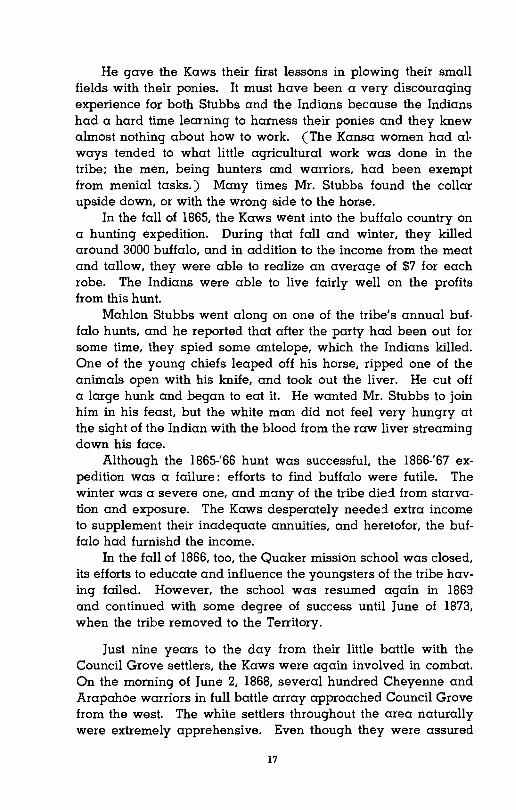
Left: An 1871 photoqraph 01 a younq Kaw. Riqht: May Johnson. a lull·blood Kaw. 1903. (Courtesy 01 The Kansas State Historical Society)
16
lings were not furnished, so he eluding the desks for the school the first year by thirty-six boys ne "in a nude state."
,ht in, they had to be thoroughly [ them knew no English at all. le work at the boarding school. or the pupils. The classroom )wnsent. Mr. Stubbs spent his lCk, and later accepted the posi) of the Friends Kansas Manual
IXaw. Riqht: May Johnson. a full-blood II Historical Society)
He gave the Kaws their first lessons in plowing their small fields with their ponies. It must have been a very discouraging experience for both Stubbs and the Indians because the Indians had a hard time learning to harness their ponies and they knew
jf almost nothing about how to work. (The Kansa women had al· ways tended to what little agricultural work was done in the, tribe; the men, being hunters and warriors, had been exempt from menial tasks.) Many times Mr. Stubbs found the collar upside down, or with the wrong side to the horse.
In the fall of 1865, the Kaws went into the buffalo country on a hunting expedition. During that fall and winter, they killed around 3000 buffalo, and in addition to the income from the meat and tallow, they were able to realize an average of $7 for each robe. The Indians were able to live fairly well on the profits from this hunt.
Mahlon Stubbs went along on one of the tribe's annual buffalo hunts, and he reported that after the party had been out for some time, they spied some antelope, which the Indians killed. One of the young chiefs leaped off his horse, ripped one of the animals open with his knife, and took out the liver. He cut off a large hunk and began to eat it. He wanted Mr. Stubbs to join him in his feast. but the white man did not feel very hungry at the sight of the Indian with the blood from the raw liver streaming down his face.
Although the 1865-'66 hunt was successful. the 1866-'67 expedition was a failure: efforts to find buffalo were futile. The winter was a severe one, and many of the tribe die:! from starvation and exposure. The Kaws desperately neede:! extra income to supplement their inadequate annuities, and heretofor, the buf
• i falo had furnishd the income.
In the fall of 1866, too, the Quaker mission school was closed, its efforts to educate and influence the youngsters of the tribe having failed. However, the school was resumed again in 1869 and continued with some degree of success until June of 1873, when the tribe removed to the Territory.
Just nine years to the day from their little battle with the Council Grove settlers, the Kaws were again involved in combat. On the morning of June 2, 1868, several hundred Cheyenne and Arapahoe warriors in full battle array approached Council Grove from the west. The white settlers throughout the area naturally were extremely apprehensive. Even though they were assured
17

that the war party desired only to fight the Kaws. the settlers hastened to ranches and town~ where they could band together for general protection.
Addison W. Stubbs. official interpreter for the Kaws from 1871 to 1873. and the son of Mahlon Stubbs, wrote the story of the famous Cheyenne raid in verse form:
CHEYENNE RAID OF 1868
Gather around me. my little friends, And hear my story until the end. 'Tis a story that's true of the long ago; My grandmother told it, I know it is so.
Way back in the Sixties. just after the war, When scenes were enacted we all abhor; A messenger came to Our little town. And this is the message he brought down:
The Cheyennes are coming! Run! Flee for your lives! They are armed with guns and bowie knives. Ye men of the Grove arm quick for a fight, I saw the Indians. I know I am right.
Their bces were painted a crimson red, A war bonnet streamed form each warrior's head. They will slaughter your children and steal your wife! Flee, my countrymen. flee for your lives!
But the Cheyennes were enemies of the Kaws. Whom they charged with breaking the Indian laws. It was them they sought. not the whites. To seek revenge for their former fights.
Through the town they rode nor touched a hair Of the frightened people dwelling there. But a war cry arose as they passed on down And crossed the waters of Little John.
The peaceful Kaws all out of breath. Came rallying forth to fight to death The wild Cheyennes who dared invade The land where their fathers' bones were laid.
When the Cheyennes saw the Kaws show fight. They soon betook themselves in flight. While Council Grovites from the hills Enjoyed the scene of the battle thrill.
The calamities. if none I have missed, Were an Indian wounded in the wrist. And this. dear children, is all I know Of Council Grove and the Indian woe.
18
Iy to fight the Kaws, the settlers f where they could band together
interpreter for the Kaws from 1871 Stubbs, wrote the story of the fa
Irm:
RAID OF 1868
~ friends, e end. ~ long ago; :now it is so.
it after the war, we all abhor; tHe town, brought down:
Run! Flee for your lives! md bowie knives. uick for a fight, lm right.
crim!?on red, n each warrior's head. tildren and steal your wife! lr your lives!
mies of the Kaws, eaking the Indian laws. t the whites, ,rmer fights.
. nor touched a hair elling there. passed on down tHe John.
f breath, to death
Ired invade s' bones were laid.
.e Kaws show fight, I in flight. , the hills ttle thrill.
ve missed, the wrist.
11 I know :lian woe.
The battle took place near the agency. The Kansa warriors secretej themselves along the Big John and refused to fight out in the open in usual Plains Indian fashion. This tactic was adopted on the advice of several experienced white men and a number of the Kaws who had been in the service in the Union Army and had learned the advantage of fighting from protected positions. No doubt if the battle had been fought out in the open in the customary way, much blood would have flowed on both sides; as it was, little harm was done in the fight.
In 1872 the Secretary of the Interior came to the agency to negotiate with the tribe for their land. The government wanted the tribe to remove to a new reservation in Indian Territory. Chief Al-le-ga-wa-ho at the end of the Secretary's persuasive speech pulled himself up to his full height (6' 6") and made reply. After reviewing the past history of the tribe. he told the council:
Be-che-go, great father, you treat my people like a flock of turkeys. You come into our dwelling places and scare us out. We fly over and alight on another stream, but no sooner do we get well settled than again you come along and drive us farther and farther. Ere long we shall find ourselves across the great Bah-do-Tunga (mountains) landing in the "Ne-sah-tunga" (ocean).
Al-le-ga-wa-ho was followed by others, some of whom favored removal. some of whom opposed it. The Secretary of the Interior again spoke, but this time there was no friendly urging, no effort at persuading the tribe to accept by their own volition. This time he commanded that they sell their lands and select a new reservation in the Indian Territory.
In the middle of the summer of 1872, a delegation of the head men of the tribe. along with two commissioners and A. W. Stubbs as interpreter, set out to look over the proposed reservation. They were well pleased with the new land: the soil was good, and there was an abundance of wild turkeys, deer, and small game. Negotiations for the purchase of 100,000 acres for the reserve were made with the Osages. who had previously been removed there.
The 42nd Congress appropriated $25,000 for the removal of the tribe and for one year's subsistence. Indian Agent Mahlon Stubbs hired about forty men with teams to haul the poorer families; the others were instructed to pack their ponies and make the trip just as they used to traveL On June 3, 1873, some five
19
I
hundred Kaws left Council Grove for their new home in the area of the present Kay county, Oklahoma, and arrive::! there seventeen days later.
The Kaw agency was established at Washunga (about a mile north of the present town of Kaw City). Food, clothing, cooking utensils, and farming equipment were issued to the once proud, independent Kaws. The full-bloods lived in tepees and dugouts, but the half-breeds lived in government-built log houses. The Kaws held their lands in common, each occupying as much land as he desired.
In the fall of 1873, the tribe started out on its last big buffalo hunt. Men, women, and children set out on ponies and in wagons for the hunt. Although most of them used muzzle-loading rifles by that time, some still hunted with bows and arrows. They made around $5000 on the skins obtained on the trip.
By 1890, the federal government was pressing for the liquidation of Indian reservations in the western half of Indian territory. Because the Kaws and Osages, along with a few other tribes, had acquired their lands by purchase, they were abie to resist the offers and threats made to them. However, in 1900, the Kaws succumbe::! and agreed to take allotments of 160 acres per capita and relinquish the reservation.
By 1903 the land allotments had been taken care of: 247 Kansa Indians received the 160 acre homestead allotments plus an equal share of the surplus land from the original 100,000 acre purchase. Each Indian on the tribal roll thus received about 400 acres of land.
As for the land that the Kaws had owned in Kansas, not until 1951 was it re::rlly paid for. When the tribe moved from the Council Grove reservation, settlers began to move onto that land at once. Very few made payments for it, claiming that the price was too high. (It had been valued at $1 per acre on the stony uplands, $10 on the best bottom lands.)
In 1905 for $155,976.88, the Kaws signed a release of all claims and demands against the United States. In 1951, however, the Indian claims commission ruled that the federal government owed the Kaw Indians $2.493,688.75 because the amount the tribe had received for their lands in 1905 had been so grossly inadequate.
20

l
re for their new home in the area ahoma, and arrived there seven
ililished at Washunga (about a of Kaw City). Food, clothing,
Iuipment were issued to the once full-bloods lived in tepees and
d in government-built log houses. lmmon, each occupying as much
started out on its last big buffalo set out on ponies and in wagons em used muzzle-loading rifles by ~ bows and arrows. They made led on the trip.
lent was pressing for the liquida! western half of Indian territory. :long with a few other tribes, had se, they were able to resist the 0.. However, in 1900. the Kaws llotments of 160 acres per capita
: had been taken care of: 247 acre homestead allotments plus ld from the original 100,000 acre bal roll thus received about 400
I had owned in Kansas, not until lhe tribe moved from the Council to move onto that land at once.
claiming that the price was too ~r acre on the stony uplands, $10
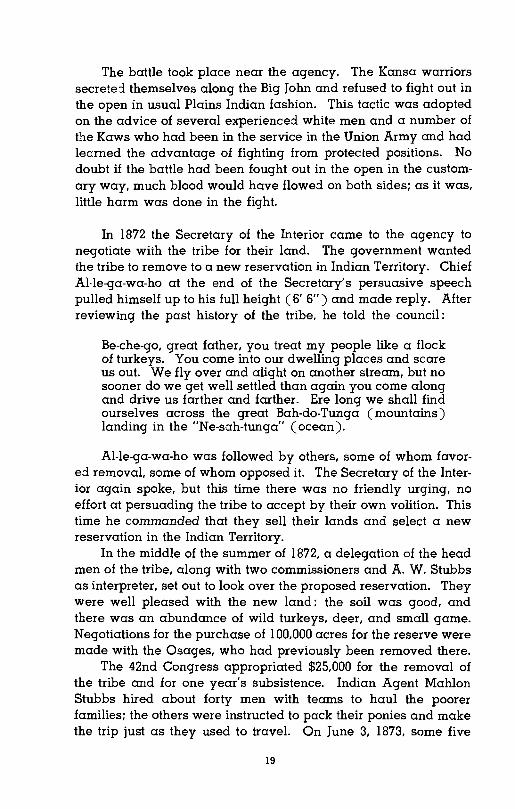
rts signed a release of all claims , States. In 1951, however. the t that the federal governmentrS because the amount the tribe b05 had been so grossly inade- Chief Washunga. the last of the blood chiefs r' the Kaws. He succeeded Chief
AI-Ie-ga-wa-ho soon after the Kaws were removed to Oklahoma. and ruled until
his death in 1908. (Courtesy of The Kansas State Historical Society)
21