history of weather observations fort sisseton, south ... · education at the old courthouse museum...
TRANSCRIPT
HISTORY OF WEATHER OBSERVATIONS Fort Sisseton, South Dakota
1866 - 1889
September 2006
Prepared by: Gary K. Grice
Information Manufacturing Corporation Rocket Center, West Virginia
This report was prepared for the Midwestern Regional Climate Center under the auspices of the Climate Database Modernization Program, NOAA’s National
Climatic Data Center, Asheville, North Carolina
i
TABLE OF CONTENTS
Acknowledgments ii LIST OF ILLUSTRATIONS iii INTRODUCTION
Historical Overview 1 Goal of the Study 3
LOCATION OF OBSERVATIONS 4
INSTRUMENTATION 7
Documented Destructive Storms at Fort Sisseton 18 Use of Weather Observations at Fort Sisseton 19
OTHER OBSERVATIONS 20 BIBLIOGRAPHY 22 APPENDIX Methodology 24
ii
Acknowledgments The staff at the Fort Sisseton State Park made available archives from the post,
in particular old letters. This information was important in resolving several questions regarding the hospital. A guided tour also was provided of the post, explaining the locations and functions of the various buildings. Their hospitality is greatly appreciated.
Staff at the South Dakota State Historical Society located relevant material and
made photographic copies of archives on Fort Sisseton. Their expertise and effort were essential in identifying specific areas of this research. Kevin Gansz, Curator of Education at the Old Courthouse Museum in Sioux Falls, SD provided the photograph of the Fort Sisseton hospital and weather instruments used by the Army surgeons, along with other photographs of the post. His generosity is greatly appreciated.
Dr. Dennis Today, South Dakota Extension/State Climatologist, was helpful in
identifying sources of relevant photographs and information, especially in the Sioux Falls area. His insight was valuable.
A special thanks to Norma Johnson, author of the book entitled Chilson’s
History of Fort Sisseton, for taking the time to share her expertise on the fort in general, and on the hospital in particular. Her insight assisted in pinning down the location of the hospital during the duration of the fort, as well as location of the weather instruments. Considering the paucity of information regarding weather instrument locations at/near Army hospitals during the 19th Century, Norma’s knowledge was especially beneficial.
iii
LIST OF ILLUSTRATIONS
Figures 1. Fort Sisseton and Surrounding Area 1 2. Map of Area Around Fort Sisseton (1879) 2 3. Topographical Map of Area Around Fort Sisseton 5 4. Topographical Map of Fort Sisseton 5 5. Diagram of Fort Sisseton (1860s) 6 6. Drawing of Fort Sisseton (1860s) 7 7. Fort Sisseton Hospital, Instrument Shelter, and Wind Vane (1880s) 8 8. Remains of Fort Sisseton Hospital (1930s) 10 9. Aerial View of Fort Sisseton 11 10. Remains of Fort Sisseton Hospital 11 11. View of Hospital and Fort Sisseton Parade Grounds 12 12. Terrain North of Hospital 12 13. Terrain South of Hospital 13 14. Terrain West of Hospital 13 15. First Observations at Fort Sisseton (September 1866) 14 16. Enlarged Photograph of Instrument Shelter at the Hospital (1880s) 15 17. Enlarged Photograph of Wind Vane at the Hospital (1880s) 16 18. Locations of Significant Weather Observations near Fort Sisseton 21
1
HISTORY OF WEATHER OBSERVATIONS Fort Sisseton, South Dakota
1866 – 1889
Gary Grice
INTRODUCTION
Historical Overview
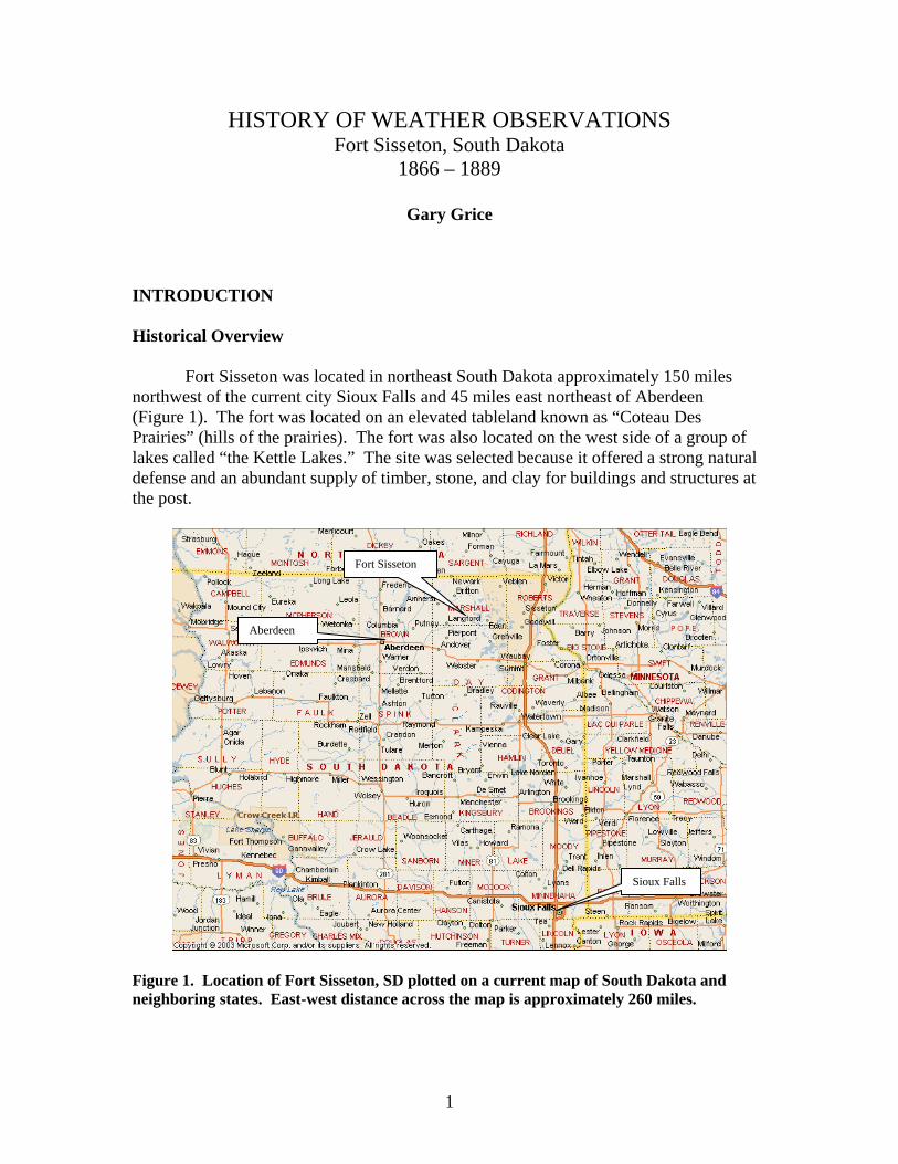
Fort Sisseton was located in northeast South Dakota approximately 150 miles
northwest of the current city Sioux Falls and 45 miles east northeast of Aberdeen (Figure 1). The fort was located on an elevated tableland known as “Coteau Des Prairies” (hills of the prairies). The fort was also located on the west side of a group of lakes called “the Kettle Lakes.” The site was selected because it offered a strong natural defense and an abundant supply of timber, stone, and clay for buildings and structures at the post.
Figure 1. Location of Fort Sisseton, SD plotted on a current map of South Dakota and neighboring states. East-west distance across the map is approximately 260 miles.
Fort Sisseton
Aberdeen
Sioux Falls
2
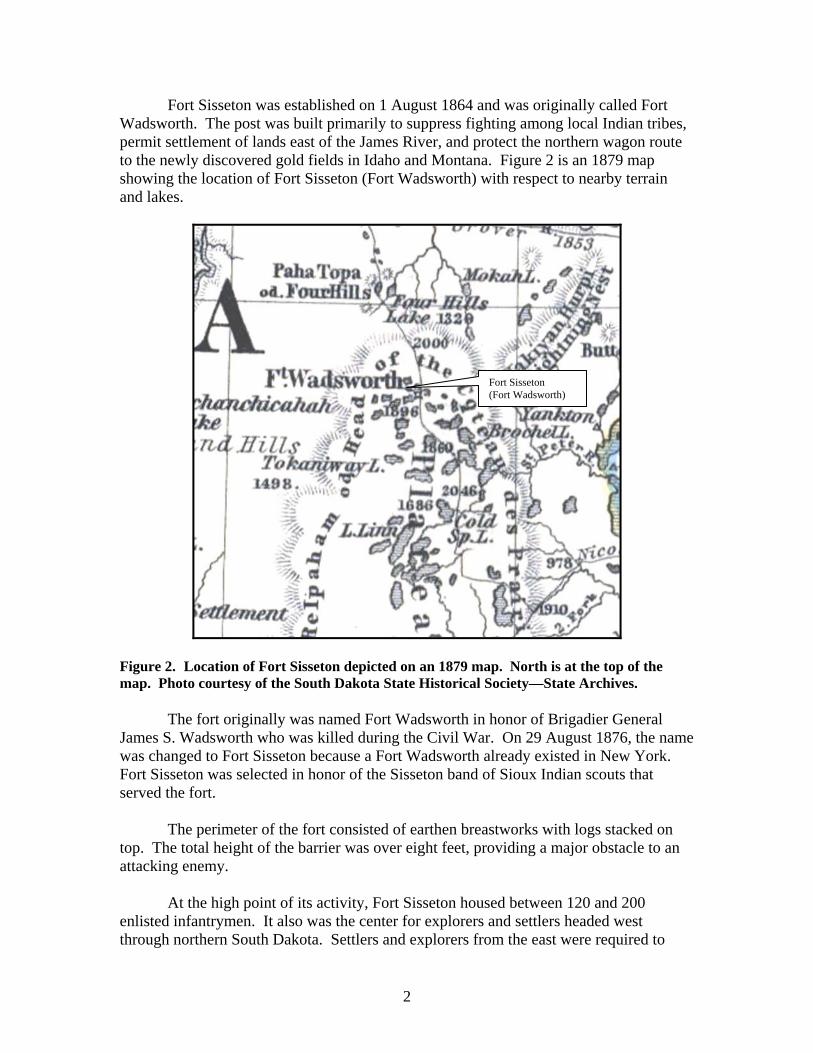
Fort Sisseton was established on 1 August 1864 and was originally called Fort Wadsworth. The post was built primarily to suppress fighting among local Indian tribes, permit settlement of lands east of the James River, and protect the northern wagon route to the newly discovered gold fields in Idaho and Montana. Figure 2 is an 1879 map showing the location of Fort Sisseton (Fort Wadsworth) with respect to nearby terrain and lakes.
Figure 2. Location of Fort Sisseton depicted on an 1879 map. North is at the top of the map. Photo courtesy of the South Dakota State Historical Society—State Archives.
The fort originally was named Fort Wadsworth in honor of Brigadier General James S. Wadsworth who was killed during the Civil War. On 29 August 1876, the name was changed to Fort Sisseton because a Fort Wadsworth already existed in New York. Fort Sisseton was selected in honor of the Sisseton band of Sioux Indian scouts that served the fort.
The perimeter of the fort consisted of earthen breastworks with logs stacked on
top. The total height of the barrier was over eight feet, providing a major obstacle to an attacking enemy.
At the high point of its activity, Fort Sisseton housed between 120 and 200
enlisted infantrymen. It also was the center for explorers and settlers headed west through northern South Dakota. Settlers and explorers from the east were required to
Fort Sisseton (Fort Wadsworth)
3
stop at Fort Sisseton for military inspection prior to heading west. They usually used the stop as an opportunity to rest and reorganize, camping approximately one mile east of the fort.
During the mid and late 1880s, post commanders recommended that the fort be
closed because the area was becoming settled. In February 1889, the Adjutant General to the Army recommended that Fort Sisseton be discontinued and on 22 April 1889, Fort Sisseton was transferred to the Interior Department. During much of the month of May 1889, supplies, equipment, and relevant facilities were shipped to other posts, including equipment and supplies of the U.S. Signal Service which operated a telegraph office for the area for a number of years. The fort closed 9 June 1889.
The first weather observation at Fort Sisseton in the NCDC database was on
1 September 1866 and the last observation 30 April 1889. Goal of the Study
The goal of this study was to document the location and exposure of weather instruments at Fort Sisseton, SD. The scope of this study primarily covered the 19th Century. Extrinsic observations related to the Army surgeons’ weather observing program also were considered.
4
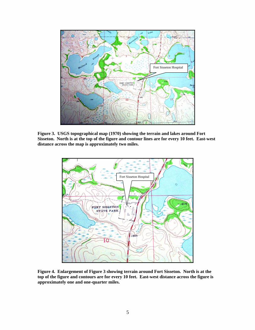
LOCATION OF OBSERVATIONS Fort Sisseton was located on a slightly elevated plateau in an area almost
surrounded by seasonal lakes (Figures 3 and 4). According to the staff at the Fort Sisseton State Park, the lakes in the immediate vicinity of the fort can become completely dry during prolonged drought. In some instances, local farmers will cultivate and plant crops in the lake bottoms during dry spells. Similar changes in lake levels occurred during the existence of Fort Sisseton. The Commanding Officer included the following in a report on 23 November 1878:
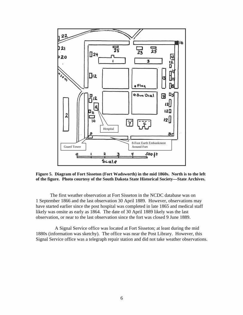
“I am informed that when the Post was located, it was surrounded by a chain of lakes and the road to the Post was through water, over a bar, connecting two of the lakes. Now that road is high and dry far above high water mark. These lakes are many of them now dry, and grass grows luxuriantly, where once, for years and years were lakes.’ ‘Since the establishment of this Post, these lakes have been steadily drying up. Many have gone entirely dry and others have dried down so that the washing from the burned prairies makes their water so strongly alkaline with earthly ingredients as to render them in the vicinity of the Post, in the opinion of the Post Surgeon, unhealthy to use for drinking and cooking purposes, which opinion is concurred in by officers serving here. These lakes have fallen perpendicularly 12 feet or more in the last 12 years.” Weather observations at Fort Sisseton were taken at the hospital. The hospital
was located at the northwest corner of the post square or parade ground (Figure 5). Latitude/longitude initially was listed as 45°43’30”N 97°30’W, changing slightly through the years of the observations. In June 1872, the latitude was changed to 46°30’N with no change in longitude. These coordinates were quoted in a number of letters and reports from the Commanding Officer and appeared to be the “official” latitude/longitude established by post officials. No mention was made as to how these values were determined. GPS coordinates for the hospital is 45°39’30”N 97°31’51W. Elevation for the hospital is 1,830 feet above sea level. Elevation on the observation forms varied from 1,500 feet to 2,000 feet.
5
Figure 3. USGS topographical map (1970) showing the terrain and lakes around Fort Sisseton. North is at the top of the figure and contour lines are for every 10 feet. East-west distance across the map is approximately two miles.
Figure 4. Enlargement of Figure 3 showing terrain around Fort Sisseton. North is at the top of the figure and contours are for every 10 feet. East-west distance across the figure is approximately one and one-quarter miles.
Fort Sisseton Hospital
Fort Sisseton Hospital
6
Figure 5. Diagram of Fort Sisseton (Fort Wadsworth) in the mid 1860s. North is to the left of the figure. Photo courtesy of the South Dakota State Historical Society—State Archives.
The first weather observation at Fort Sisseton in the NCDC database was on 1 September 1866 and the last observation 30 April 1889. However, observations may have started earlier since the post hospital was completed in late 1865 and medical staff likely was onsite as early as 1864. The date of 30 April 1889 likely was the last observation, or near to the last observation since the fort was closed 9 June 1889.
A Signal Service office was located at Fort Sisseton; at least during the mid
1880s (information was sketchy). The office was near the Post Library. However, this Signal Service office was a telegraph repair station and did not take weather observations.
Hospital
8-Foot Earth Embankment Around Fort Guard Tower
7
INSTRUMENTATION
Fort Sisseton was named Fort Wadsworth from 1864 (year of construction) through 29 August 1876. After 29 August 1876, the fort was called Fort Sisseton.
Weather observations at Fort Sisseton were somewhat consistent for the 22 year
period from 1 September 1866 through 30 April 1889. The main exceptions are indicated below:
1867 – December missing 1868 – Entire year missing 1876 – November missing 1877 – May through July and September through December missing 1878 – February, August, September, and November missing 1879 – June and August missing 1880 – April missing 1881 – February missing
The reasons for the missing observations were not apparent, i.e., whether observations were not taken or the data had been lost over the years.
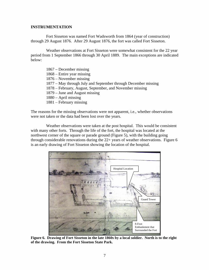
Weather observations were taken at the post hospital. This would be consistent with many other forts. Through the life of the fort, the hospital was located at the northwest corner of the square or parade ground (Figure 5), with the building going through considerable renovations during the 22+ years of weather observations. Figure 6 is an early drawing of Fort Sisseton showing the location of the hospital.
Figure 6. Drawing of Fort Sisseton in the late 1860s by a local soldier. North is to the right of the drawing. From the Fort Sisseton State Park.
Hospital Location
8-Foot Embankment that Surrounded the Fort
Guard Tower
8
Based on the drawing, the eight-foot high earth embankment was located behind
(north of) the hospital. The remains of this embankment are readily apparent today. The main gate was on the east side of the fort, although a secondary opening in the embankment was located just east of the hospital.
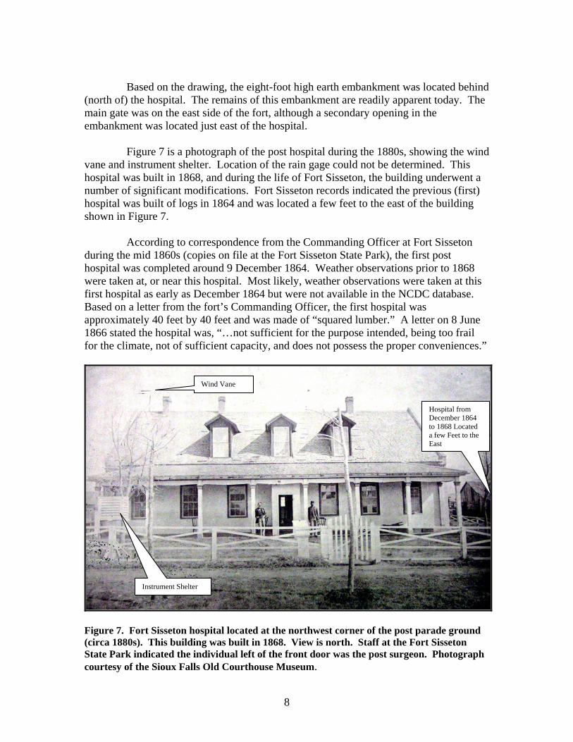
Figure 7 is a photograph of the post hospital during the 1880s, showing the wind
vane and instrument shelter. Location of the rain gage could not be determined. This hospital was built in 1868, and during the life of Fort Sisseton, the building underwent a number of significant modifications. Fort Sisseton records indicated the previous (first) hospital was built of logs in 1864 and was located a few feet to the east of the building shown in Figure 7.
According to correspondence from the Commanding Officer at Fort Sisseton
during the mid 1860s (copies on file at the Fort Sisseton State Park), the first post hospital was completed around 9 December 1864. Weather observations prior to 1868 were taken at, or near this hospital. Most likely, weather observations were taken at this first hospital as early as December 1864 but were not available in the NCDC database. Based on a letter from the fort’s Commanding Officer, the first hospital was approximately 40 feet by 40 feet and was made of “squared lumber.” A letter on 8 June 1866 stated the hospital was, “…not sufficient for the purpose intended, being too frail for the climate, not of sufficient capacity, and does not possess the proper conveniences.”
Figure 7. Fort Sisseton hospital located at the northwest corner of the post parade ground (circa 1880s). This building was built in 1868. View is north. Staff at the Fort Sisseton State Park indicated the individual left of the front door was the post surgeon. Photograph courtesy of the Sioux Falls Old Courthouse Museum.
Instrument Shelter
Wind Vane
Hospital from December 1864 to 1868 Located a few Feet to the East
9
The hospital building built in 1868 (Figure 7) was made of bricks, was one and
one-half stories tall, 60 feet long, and 32 feet wide with a 6 foot wide north-south hall extending through the center. The hospital was supplied with water from a galvanized sheet-iron cistern with a capacity of about 100 barrels.
According to documents from the Army Surgeon General’s Office, the hospital
was not well constructed. A War Department inspector in 1870 (Circular 4) stated:
“The hospital was very much slighted in its building, especially about the doors and windows, through the openings of which a greater quantity of snow was blown into the building, above the ceilings, into the wards, dispensary, office, kitchen, and all the other rooms. The hospital was most wretchedly plastered; in the dispensary the plastering has entirely fallen from the ceiling, through which the wind has free access. The roof, ill-constructed, freely admits wind and snow. Considerable portions of plastering have also fallen from the ceilings of the wards and other rooms of the building, with the same unpleasant results.”
Continued repairs were required during the 1870s.
During the 1880s, considerable renovation was made to the hospital building.
In 1881, a second floor was added and later in the decade, the building was extended to the north and east. Also, new floors were installed and partitions built in the wards. More importantly, new storm houses were installed both in the front and in the rear. A fence was added around the hospital and a gravel road built west of the building.
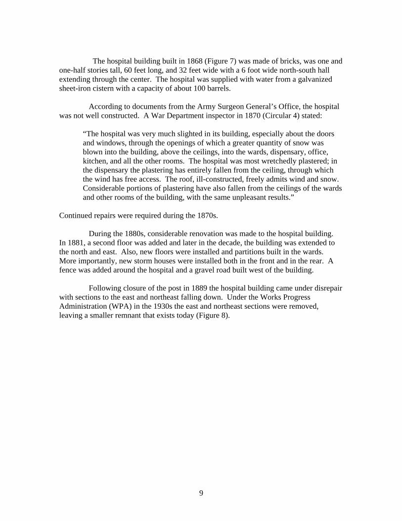
Following closure of the post in 1889 the hospital building came under disrepair
with sections to the east and northeast falling down. Under the Works Progress Administration (WPA) in the 1930s the east and northeast sections were removed, leaving a smaller remnant that exists today (Figure 8).
10
Figure 8. Fort Sisseton hospital following remodeling by WPA workers. View is northwest. Photograph courtesy of the Sioux Falls Old Courthouse Museum.
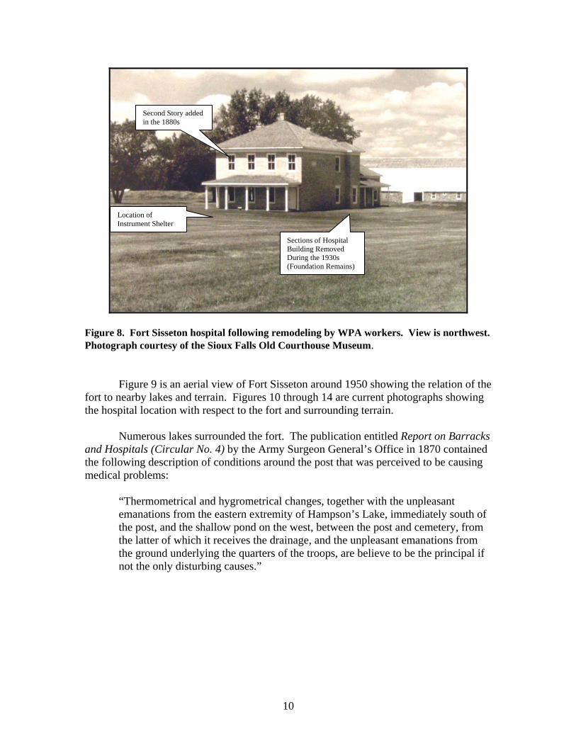
Figure 9 is an aerial view of Fort Sisseton around 1950 showing the relation of the fort to nearby lakes and terrain. Figures 10 through 14 are current photographs showing the hospital location with respect to the fort and surrounding terrain.
Numerous lakes surrounded the fort. The publication entitled Report on Barracks
and Hospitals (Circular No. 4) by the Army Surgeon General’s Office in 1870 contained the following description of conditions around the post that was perceived to be causing medical problems:
“Thermometrical and hygrometrical changes, together with the unpleasant emanations from the eastern extremity of Hampson’s Lake, immediately south of the post, and the shallow pond on the west, between the post and cemetery, from the latter of which it receives the drainage, and the unpleasant emanations from the ground underlying the quarters of the troops, are believe to be the principal if not the only disturbing causes.”
Second Story added in the 1880s
Sections of Hospital Building Removed During the 1930s (Foundation Remains)
Location of Instrument Shelter
11
Figure 9. Aerial view of Fort Sisseton (around 1950). View is north. Photo courtesy of the South Dakota State Historical Society—State Archives.
Figure 10. Remains of Fort Sisseton hospital looking north. Photograph taken by the author.
Post Hospital
Location of Instrument Shelter
Remains of Earth Embankment
12
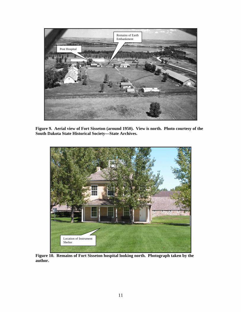
Figure 11. Hospital viewed from the southeast part of the parade grounds. Photograph taken by the author.
Figure 12. Terrain north of the hospital. Photograph taken by the author.
Hospital
Remains of Earth Embankment
13
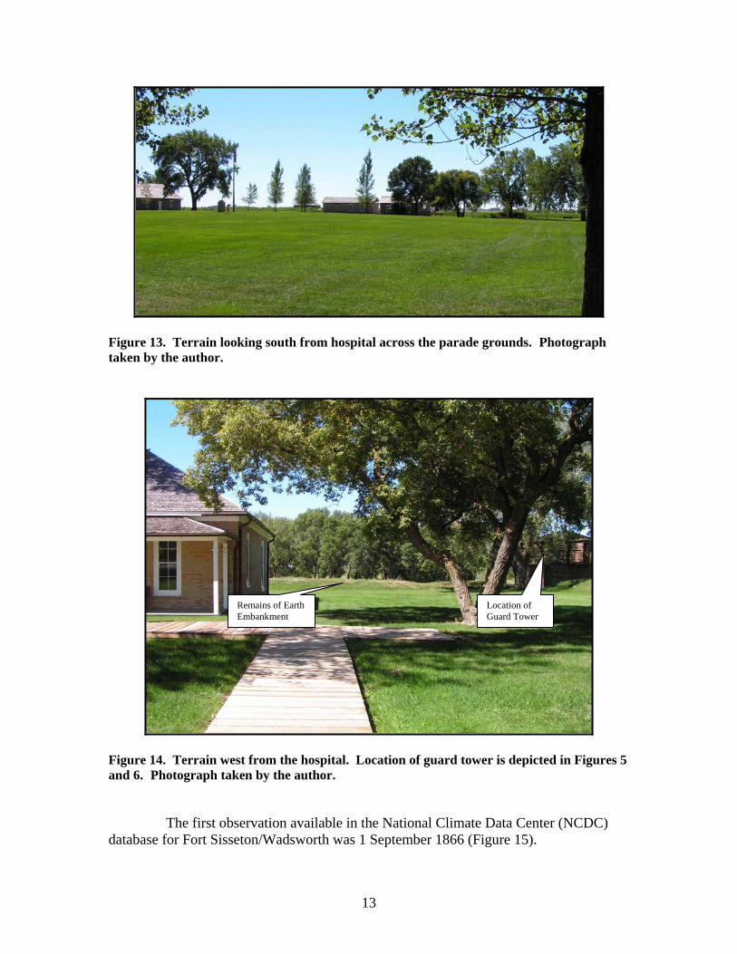
Figure 13. Terrain looking south from hospital across the parade grounds. Photograph taken by the author.
Figure 14. Terrain west from the hospital. Location of guard tower is depicted in Figures 5 and 6. Photograph taken by the author.
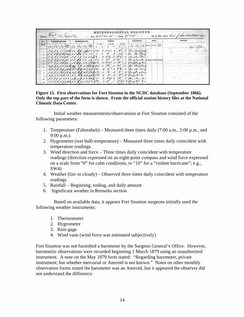
The first observation available in the National Climate Data Center (NCDC)
database for Fort Sisseton/Wadsworth was 1 September 1866 (Figure 15).
Remains of Earth Embankment
Location of Guard Tower
14
Figure 15. First observations for Fort Sisseton in the NCDC database (September 1866). Only the top part of the form is shown. From the official station history files at the National Climatic Data Center.
Initial weather measurements/observations at Fort Sisseton consisted of the
following parameters:
1. Temperature (Fahrenheit) – Measured three times daily (7:00 a.m., 2:00 p.m., and 9:00 p.m.).
2. Hygrometer (wet bulb temperature) – Measured three times daily coincident with temperature readings.
3. Wind direction and force – Three times daily coincident with temperature readings (direction expressed on an eight-point compass and wind force expressed on a scale from “0” for calm conditions, to “10” for a “violent hurricane”; e.g., SW4)
4. Weather (fair or cloudy) – Observed three times daily coincident with temperature readings
5. Rainfall – Beginning, ending, and daily amount 6. Significant weather in Remarks section
Based on available data, it appears Fort Sisseton surgeons initially used the
following weather instruments: 1. Thermometer 2. Hygrometer 3. Rain gage 4. Wind vane (wind force was estimated subjectively)
Fort Sisseton was not furnished a barometer by the Surgeon General’s Office. However, barometric observations were recorded beginning 1 March 1879 using an unauthorized instrument. A note on the May 1879 form stated: “Regarding barometer, private instrument; but whether mercurial or Aneroid is not known.” Notes on other monthly observation forms stated the barometer was an Aneroid, but it appeared the observer did not understand the difference.
15
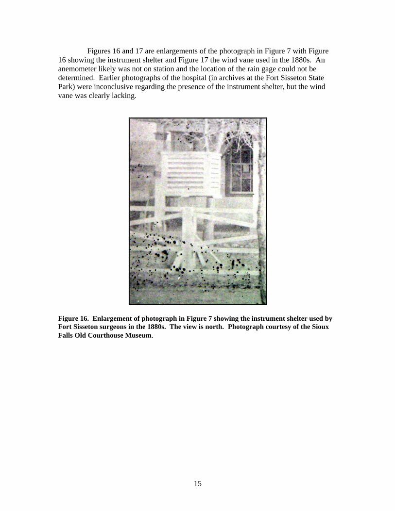
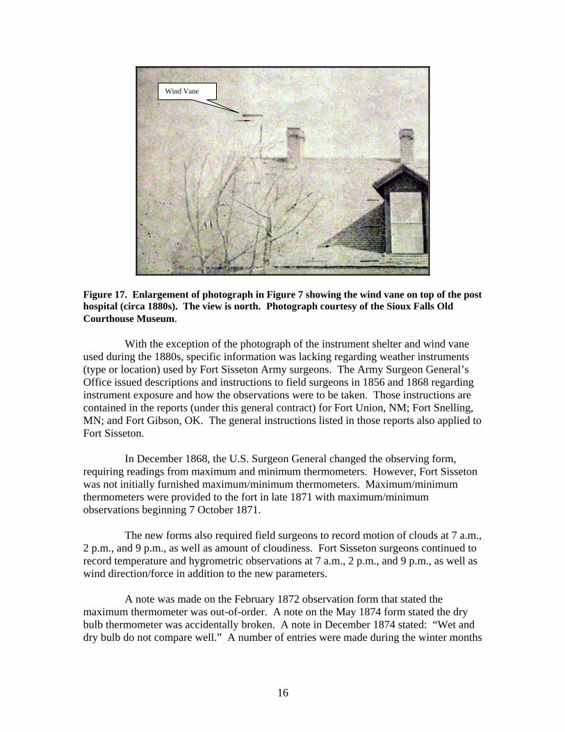
Figures 16 and 17 are enlargements of the photograph in Figure 7 with Figure 16 showing the instrument shelter and Figure 17 the wind vane used in the 1880s. An anemometer likely was not on station and the location of the rain gage could not be determined. Earlier photographs of the hospital (in archives at the Fort Sisseton State Park) were inconclusive regarding the presence of the instrument shelter, but the wind vane was clearly lacking.
Figure 16. Enlargement of photograph in Figure 7 showing the instrument shelter used by Fort Sisseton surgeons in the 1880s. The view is north. Photograph courtesy of the Sioux Falls Old Courthouse Museum.
16
Figure 17. Enlargement of photograph in Figure 7 showing the wind vane on top of the post hospital (circa 1880s). The view is north. Photograph courtesy of the Sioux Falls Old Courthouse Museum.
With the exception of the photograph of the instrument shelter and wind vane
used during the 1880s, specific information was lacking regarding weather instruments (type or location) used by Fort Sisseton Army surgeons. The Army Surgeon General’s Office issued descriptions and instructions to field surgeons in 1856 and 1868 regarding instrument exposure and how the observations were to be taken. Those instructions are contained in the reports (under this general contract) for Fort Union, NM; Fort Snelling, MN; and Fort Gibson, OK. The general instructions listed in those reports also applied to Fort Sisseton.
In December 1868, the U.S. Surgeon General changed the observing form,
requiring readings from maximum and minimum thermometers. However, Fort Sisseton was not initially furnished maximum/minimum thermometers. Maximum/minimum thermometers were provided to the fort in late 1871 with maximum/minimum observations beginning 7 October 1871.
The new forms also required field surgeons to record motion of clouds at 7 a.m.,
2 p.m., and 9 p.m., as well as amount of cloudiness. Fort Sisseton surgeons continued to record temperature and hygrometric observations at 7 a.m., 2 p.m., and 9 p.m., as well as wind direction/force in addition to the new parameters.
A note was made on the February 1872 observation form that stated the
maximum thermometer was out-of-order. A note on the May 1874 form stated the dry bulb thermometer was accidentally broken. A note in December 1874 stated: “Wet and dry bulb do not compare well.” A number of entries were made during the winter months
Wind Vane
17
in various years that lack of temperature and/or hygrometric recordings were the result of “…mercury sunk in bulb.”
A note on the September 1876 form stated: “Name of Post changed by G.O. 94
Std Qrs. Of the Army series 1876 from Fort Wadsworth to Fort Sisseton.” A note on the December 1876 form stated the maximum thermometer was
broken with a similar note on the January 1877 form. A number of notes were included that stated no wet bulb temperature was made when colder than freezing. A note on the March 1879 stated no wet bulb temperature observations were taken because the instrument was broken. A similar note was included on the April 1879 form. A note on the May 1882 form stated the maximum thermometer was broken on 1 May 1882. Maximum temperature recordings were absent through December 1883.
The November 1883 observation form contained the following statement:
“The minimum thermometer has been carefully tested and found to be three and one-quarter degrees too low at the temperature of melting ice, but the variation as compared with reliable thermometers is not constant, amounting corrections to five degrees. This variation was found to be due to alcohol having distilled over in the vacuum chamber of the tube. The aneroid barometer has been compared with the cistern barometer of the Chief Engineer Department of Dakota and found to be 0.64 inch too low.” A note on the December 1883 form stated: “Barometer was adjusted correctly this day (December 22nd) and indicates right now.”
On 21 February 1884, the hospital steward slipped and accidentally broke the maximum thermometer. Maximum temperature observations were not recorded until 26 August 1885.
Beginning 1 September 1888, only one daily observation was taken at Fort
Sisseton. This observation consisted of daily maximum/minimum temperatures, beginning/ending of precipitation, total daily precipitation, depth of snow, and general direction of the wind. This change was the result of instructions from the Army Surgeon General’s Office. The last observation listed in the NCDC database for Fort Sisseton was on 30 April 1889.
18
Documented Destructive Storms at Fort Sisseton
The following descriptions of destructive storms at Fort Sisseton were obtained
from reports written by the post’s Commanding Officer or hospital surgeon:
Storm of 18 July 1870
“The storm commenced at 7 p.m. with a violent wind from the northeast, proceeded by a blinding cloud of dust, gravel and rain, rendering it impossible to see a hundred feet ahead, carrying with it everything moveable. Striking the corner of the company quarters, the roof, rafters, garret, flooring, and chimneys were ripped off like paper, and hurled in some instances hundreds of yards, shingles and heavy masses of roofing having been picked up across the lake. Two walls and brick partitions were cracked in several places.’
‘The hurricane lasted from twenty to thirty minutes. Had it lasted longer it is
believed other buildings would have been laid in ruins. The men, with one exception, escaped injury, miraculously it would seem, as the air was filled with debris. A fire was at one time imminent from the overturning of the stoves, but the fires were promptly extinguished.”
Storm of 29 July 1873
On 29 July 1873, a destructive thunderstorm hit Fort Wadsworth (Sisseton). The following description from an Army Surgeon General publication described the damage:
“On the 29th of July 1873, a terrific storm of wind, hail, and rain broke over the
fort, which seemed to have originated but a few minutes before in a comparatively small, dark cloud. In a few minutes the commanding officer’s quarters, one of the company barracks, the guardhouse, the adjutant’s office, the Government stables, and the old buildings outside the fort, formerly used as quarters for scouts, were either wholly or partially unroofed. Every window exposed to the storm was broken, and the buildings were deluged with water, which caused the plastering to fall. The hospital had one hundred and eighteen panes of glass broken, and the produce of the gardens was destroyed.”
19
Use of Weather Observations at Fort Sisseton
The following paragraph was included in a report by the fort’s Commanding Officer (23 November 1873), indicating one use of the weather observations taken by the surgeons:
“I append the official report of the Post Surgeon, Dr. McChesney, showing the average rainfall, at this Post for the past five years—this with the size of the roofs will enable calculations to be made of the number and size of the cisterns to be supplied, to contain the water the roofs will supply, one cubic foot containing 7.4805 gallons. I would recommend that cisterns be provided of the same material and construction, as those already furnished by contract made of boiler iron and riveted.”
20
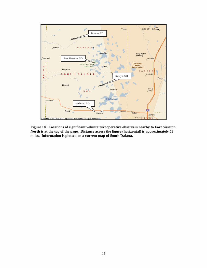
OTHER OBSERVATIONS Figure 18 shows the locations of significant observations in the vicinity of Fort
Sisseton during the 19th and early 20th centuries. Weather Bureau voluntary/cooperative weather observations were taken in the vicinity of Webster, SD (22 miles south of Fort Sisseton) from 1 January 1896 through 31 May 1897 and 28 April 1932 through 1955. These stations had a standard instrument shelter, maximum/minimum thermometers, and a standard rain gage, except in 1932 the shelter was changed to a cotton region type. Latitude/longitude for these sites was listed as approximately 45°20’N 97°35’W, although the coordinates varied slightly during the years. The elevation was listed as approximately 1,850 feet above sea level.
Voluntary/cooperative weather observations were taken in the vicinity of
Roslyn, SD (11 miles southeast of Fort Sisseton) from 1 September 1898 to 31 July 1903 and 8 April 1906 to 7 May 1952. Latitude/longitude for these sites was listed as approximately 45°28’N 97°32’W, although the coordinates varied slightly during the years. The elevation was listed as around 1840 feet. These stations had a standard instrument shelter, maximum/minimum thermometers, and a standard rain gage, except the instrument shelter was changed to a cotton region type in 1906. Also, a recording rain gage was added in1951.
Voluntary/cooperative weather observations were taken in the vicinity of
Britton, SD (15 miles northwest of Fort Sisseton) from September 1891 to November 1891, February 1896 through June 1898, and August 1903 through 1955. Latitude/longitude for these sites was listed as approximately 45°50’N 97°45’W, although the coordinates varied slightly during the years. The listed elevation varied from approximately 1,250 feet to 1,350 feet. These stations had a standard instrument shelter, maximum/minimum thermometers, and a standard rain gage, except the instrument shelter was changed to a cotton region type in 1913.
21
Figure 18. Locations of significant voluntary/cooperative observers nearby to Fort Sisseton. North is at the top of the page. Distance across the figure (horizontal) is approximately 53 miles. Information is plotted on a current map of South Dakota.
Fort Sisseton, SD
Webster, SD
Roslyn, SD
Britton, SD
22
BIBLIOGRAPHY Army Surgeon General, 1850. Regulations for the Medical Department of the Army. War
Department, C. Alexander Printer, Washington. Army Surgeon General, 1856. Regulations for the Medical Department of the Army.
U.S. Army Surgeon General’s Office. War Department, Government Printing Office, Washington.
Army Surgeon General, 1868. Barometers. War Department, Government Printing
Office, Washington D.C. Army Surgeon General, 1868. General Meteorological Instructions. War Department,
Government Printing Office, Washington D.C. Army Surgeon General, 1870. Report on Barracks and Hospitals with Descriptions of
Military Posts (Circular No. 4). War Department, Surgeon General’s Office, Washington.
Army Surgeon General, 1875. Hygiene of the United States Army, with Descriptions of
Military Posts. War Department, Government Printing Office, Washington. Finley, John P., 1893. Certain Climatic Features of the Two Dakotas. Government
Printing Office, Washington. Hume, Edgar Erskine, Lieutenant Colonel (U. S. Army), August 1940. The Foundation
of American Meteorology by the United States Army Medical Department. Military Surgeon v87, pp 89-118.
Johnson, Norma, 1996. Chilson’s History of Fort Sisseton. ESCO Publishing, Pierre,
SD. Kapler, Todd, 1993. Fort Sisseton: Report on the 1992 Archaeological Excavations at a
19th Century Frontier Military Post in Marshall County, South Dakota. University of South Dakota, Vermillion, SD.
Midwestern Regional Climate Center (Gary Grice), 2005. History of Weather
Observations at Fort Gibson, Oklahoma 1824-1890. National Climatic Data Center, Asheville, NC.
Midwestern Regional Climate Center (Gary Grice and Peter Boulay), 2005. History of
Weather Observations at Fort Snelling, Minnesota 1819-1892. National Climatic Data Center. Asheville, NC.
23
Midwestern Regional Climate Center (Gary Grice), 2005. History of Weather Observations at Fort Union, New Mexico 1851-1891. National Climatic Data Center, Ashville, NC.
Schuler, Harold H., 1996. Fort Sisseton. Center for Western Studies, Sioux Falls, SD. Schumucker, Paul, 1974. Fort Sisseton, Dakota Territory, 1888. Historical Review and
Plan for Preservation and Restoration. Nohr and Associates, Consulting Engineers, Mitchell, SD.
Sheridan, P.H. (Lt. General), 1876: Outline of Posts (Military Division of the Missouri).
War Department, Washington D.C. South Dakota Department of Game, Fish and Parks, 1979. Our Living Heritage. Courier
Printing, Pierre, SD. Weather Bureau, 1956. Substation History (South Dakota). Department of Commerce,
Government Printing Office, Washington D.C.
24
Appendix
Methodology
Specific information regarding weather instrument location and exposure at Fort Sisseton during observations by Army surgeons was sparse. The NCDC database was the primary source of weather observations for this report.
General information regarding weather instruments used by the Army surgeons, and procedures used to take the observations, came from publications by the Army Surgeon General’s Office (1850, 1851, 1856, and 1868). This general information was included with the assumption that the military surgeons followed those instructions closely.
Annual reports by the U.S. Army Surgeon General were reviewed for the years
1825 through 1875 with only bits and pieces of revealed information. Several publications by the Army Surgeon General were obtained from the extensive government library microfiche collection at Oklahoma State University.
The staff at the Fort Sisseton State Park shared their archives for this research.
Their archives contained a number of old photographs of the fort, as well as copies of numerous letters and reports by the Commanding Office. These documents provided insight into the location, building, and maintenance of the hospital.
The Old Courthouse Museum at Sioux Falls made available photographs of Fort
Sisseton that were used in an exhibit. Most importantly, this museum shared the photograph showing the hospital, instrument shelter and wind vane.
The South Dakota State Historical Society (Pierre) contains numerous archives
on Fort Sisseton. A number of relevant photographs, maps, and documents were found at the library. Documents on Fort Sisseton (published and unpublished) were obtained from the I.D. Weeks Library at the University of South Dakota (Vermillion).
Other research sources checked in person, by telephone, or via the Internet
included Central Plains Region Branch of the National Archives and Records Administration (Kansas City), Rocky Mountain Region Branch of the National Archives and Records Administration (Denver), Sioux City Public Museum, Sioux City Public Library, Sioux Falls Municipal Library, South Dakota State Library, Pierre Municipal Library, Rapid City Public Library, South Dakota School of Mines and Technology Library, Northern State University Williams Library, South Dakota State University Hilton M. Briggs Library, U.S. Army Military History Institute (Carlisle, PA), and the Nebraska State Historical Society.