holocene geology of the central south louisiana coastal zone
DESCRIPTION
PDF file of van Heerden, I. L., G. P. Kemp and H. H. Roberts, 1996, The Holocene Geology of the Central South Louisiana Coastal Zone. Unpublished report prepared for the UnitedStates Geological Survey by the Louisiana Geological Survey.TRANSCRIPT

,
THE HOLOCENE GEOLOGY OF THE CENTRAL
SOUTH LOUISIANA COASTAL ZONE
by
Ivor Ll. van Heerden, G. Paul Kemp' and Harry H. Roberts'
LOUISIANA GEOLOGICAL SURVEY
Baton Rouge
=
II

THE HOLOCENE GEOLOGY OF THE CENTRAL
SOUTH LOUISIANA COASTAL ZONE
by
Ivor Ll. van Heerden, G. Paul Kemp' and Harry H. Roberts'
Louisiana Geological Survey Louisiana State University Baton Rouge, La 70803
Contract Report for the U.S. Geological Survey March 1996
'Natural Systems Management and Engineering Program
'Coastal Studies Institute Center for Coastal, Energy, and Environmental Resources

CONTENTS PAGE
Summary ............................................... . . ............ 3
Introduction ............................................................... 4
Methodology ............................................................... 4
Earlier Studies of Delta Plain Development and Stratigraphy ........................... 5 a. The Delta Cycle ..................................................... 5 b. Early Depositional Models ............................................ 6
Western Terrebonne Basin ..................................................... 7 a. The Maringouin Delta Complex ......................................... 7 b. Lafourche Delta Complex .............................................. 9
1. The deltas .................................................... 9 2. The Caminada-Moreau ridge plain ................................ 11
c. Modern-day processes ............................................... 12
Point Au Fer Island ......................................................... 13 a. The Maringouin Delta Complex. . . . . . . . . . . . . . . . . . . . . . . . . . . . . . . . . . . . . . . . 14 b. Lafourche Delta Complex ............................................ 15 c. Modern-day processes . . . . . . . . . . . . . . . . . . . . . . . . . . . . . . . . . . . . . . . . . . . . . . . 17
Atchafalaya Wax Lake Delta Complex-The New Mississippi River Delta Lobes ............ 18 a. The Maringouin Delta Complex. . . . . . . . . . . . . . . . . . . . . . . . . . . . . . . . . . . . . . . . 19 b. Modern-day processes ............................................... 19
1. Delta development -channel elongation and bifurcation ................. 19 2. Delta development-channel abandonment and lobe fusion ............... 20 3. Sedimentary architecture ....................................... 20
a. Depositional environments and sedimentary characteristics ........ 20 b. Stratigraphic relationships ................................. 23 c. Impacts on adjacent wetlands .............................. 24
Discussion ................................................................ 25 a. Western Terrebonne Region ........................................... 25 b. Point au Fer Island .................................................. 26 c. Atchafalaya Bay . . . . . . . . . . . . . . . . . . . . . . . . . . . . . . . .......... 26
Conclusion ............................................................... 27
Acknowledgments .......................................................... 28
References ............................................................... 28
Appendix ................................................................. 33
Figures .................................................................. 34
2

THE HOLOCENE GEOLOGY OF CENTRAL SOUTH LOUISIANA COASTAL ZONE
by
Ivor Ll. van Heerden, G. Paul Kemp, and Harry H. Roberts
SUMMARY
The Holocene stratigraphic sequence, for south-central coastal Louisiana, was determined from vibracore and borehole data. The sequence is up to 35m thick consisting off our major delta cycles deposited during the last 6,000 - 7,000 years. These are the Maringouin, the Teche, the Lafourche, and the Atchafalaya.
The stratigraphy ofthe western Terrebonne region generally reveals Maringouin deposits, at least 5000 years old, occurring deeper than 11 m below sealevel and resting on an eroded surface that dips to the east. Ship Shoal represents a drowned, transgressive barrier island complex which originated from eroded Maringouin delta material. The shoal is approximately 5 meters thick and the shoal base and crest shallow to the west. The shallowing reflects differential subsidence of sediments, beneath the shoal, within a drowned alluvial valley cut into the Pleistoocene. Locally, a shell hash layer is present at or near the top of the Maringouin sequence. This shell hash appears to be either a storm (Hurricane) reworked surface or a ravinement surface separating the Maringouin and overlying Lafourche deposits. Teche delta complex sediments were not to be found in the study area.
There is a very complex sequence, up to 9 m thick of Lafourche delta deposits in the western Terrebonne region. Generally, an upward coarsening sequence is overlain by an upward fining sequence which terminates in the modern marsh surface or bay deposits. This complex of four distinct Lafourche delta cycles accumulated during the last 2,500 to 2,800 years until Bayou Lafourche was sealed from the Mississippi River in 1904. The Caminada-Moreau headland was formed as a consequence of Gulf swells reworking landwards the coarest fractions of Bayou Lafourche distributaries' sediment load that had been displaced to the south east by strong currents generated during cold front passages. The sands thus moved updrift to the east while the fines moved downdrift to the west.
Interpretation of shallow vibracores suggests that Point au Fer Island aggraded as mudflats analogous to the mudflats presently forming along the Chenier Plain. The sediment source for these mudflats appears to be the Lafourche deltas distributaries to the east.
The recent capture by the Atchafalaya River of a portion of the Mississippi River discharge has initiated a new delta building cycle in Atchafalaya Bay. Two deltas are prograding into the bay and will shortly extend out onto the adjacent shelf. There are stratigraphic differences between the
3

two deltas although they have the same sediment source and their mouths are only 18 km apart. The differences reflect that the Wax Lake is a man-made diversion and the Atchafalaya, while it is a natural delta, is bisected by a navigation channel that is regularly dredged.
This study dramatically illustrates the direct consequences of large-scale Mississippi river diversions (distributaries) in the formation of delta lobes, and the indirect consequences some distance from the distributary mouth, namely mudflat accumulation. The influence of ocean swells, subsidence, and winter cold front passages in shaping delta lobes is apparant. All of these factors should be taken into consideration in planning artificial diversions off the Mississippi River for coastal restoration and maintenance projects.
Additionally, it illustrates one of the paradoxes of the Louisiana coastal environment. Point au Fer Island was built as a down drift recipient of Lafourche deposition but is now eroding despite the adjacent development of the Atchafalaya deltas.
INTRODUCTION
The Louisiana coastal zone evolved during the Holocene as a consequence of delta building associated with the Mississippi River. Numerous studies (Fisk 1944, Kolb and van Lopik 1958, Frazier 1967, amongst others) have recognized that the basic cycle consists of delta lobe progradation; channel switching and lobe abandonment; and subsequent development of a new lobe. These authors have attempted to map the various lobes and establish their chronology. The present study's aims are to decipher the Holocene stratigraphic evolution of the south central Louisiana coastal zone utilizing this historic data as well as that obtained from boreholes and vibracores. The study area consists of three distinct physiographic zones, the western Terrebonne basin, Point au Fer Island, and Atchafalaya Bay (Figure I). In each area the objectives were:
1. Undertake a literature review as to the historic concepts of Holocene stratigraphic development of the area.
2. Re-interpret the stratigraphy by assembling the various historic data sets, unpublished borehole data, and an extensive vibracore data set collected in the study area since 1977.
3. Develop the details of the Holocene stratigraphic history of the coastal zone, with particular reference to process-response relationship when this approach is applicable.
METHODOLOGY
The historic scientific literature for the study area was drawn together in a first attempt to link these stratigraphic data sets and determine the regional stratigraphy. Subsequently, consulting and pipeline companies were contacted in an attempt to secure unpublished borehole data.
4

Extensive use was made of vibracores. The Louisiana vibracoring program was initiated in the late 1970's by the Coastal Studies Institute and was subsequently extended by the Louisiana Geological Survey. These data were augmented with vibracores collected from Point au Fer Island and the adjacent shelf Selected vibracores were analyzed by X-ray radiography and over a hundred radiographs were produced. The vibracore data sets have allowed refinement of the earlier delta plain stratigraphic models reported in the literature and better interpretation of the Holocene stratigraphy of the south central Louisiana coastline.
EARLIER STUDIES OF DELTA PLAIN STRATIGRAPHY AND DEVELOPMENT
a. The Delta Cycle
Since the end of the Holocene transgression, the Mississippi River delta plain has been built by a process of sequential episodes of delta building followed by abandonment and barrier shoreline generation (Fisk 1952; Kolb and Van Lopik 1958; Scruton 1960; Coleman and Gagliano 1964; Frazier 1967; Roberts 1997). Through this process the Mississippi River built a delta plain encompassing some 26,000 km2 (van Heerden 1994a).
The depositional history of each Holocene Mississippi delta complex is initiated with the progradational (regressive) phase in which a new Mississippi River begins to deposits its sediment load in the Gulf of Mexico. Long-term delta lobe progradation leads to overextension of the distributary network, a decrease in hydraulic efficiency, followed by stream capture upriver. The bulk of the river discharge switches to this shorter course with a steeper gradient and hence more efficient route to the sea. A new locus of delta development is then initiated.
Upstream diversion initiates the transgressive phase of the delta cycle. Discharges through the abandoned distributary channel do not transport sufficient quantities of sediment to balance progradation of the delta against the effects of subsidence, and marine processes erode and rework the seaward periphery of the abandoned delta. After abandonment, and where organic matter production results in significant accumulation, marshes maintain their elevation at or above sea-level for a period of time longer than the period of active delta growth. The combined effects of reduced discharge of fresh water and sediment plus subsidence facilitates the transgressive phase. A salinity gradient is established from fresh water at the landward end, toward the salt water of the Gulf of Mexico. Vegetation patterns follow with fresh marsh inland, grading to salt marsh near the Gulf (van Heerden 1997). As marine forces begin to dominate, the shoreline is reworked into sandy headlands and barrier shorelines, and tidal channels form (Boyd and Penland 1984). The marsh is increasingly eroded or flooded and the land opens to form shallow interior lakes and bays connected to the sea by tidal channels (Kwon 1969). The sandy headlands and barrier shorelines are thus eventually separated from the mainland to form discrete barrier island chains. Under marine processes the barrier islands slowly migrate landward, at a lower rate than the outer shoreline of the marshes. Ultimately, the outer coastal marshes are eroded into islands, with the barrier islands separated from the marshes
5

by large, open estuaries (e.g., Barataria Bay). The estuarine system continues to open and is eventually replaced by a sound (e.g., Breton Sound) (van Heerden 1997).
After subsidence and development of new accumulation space, sites of abandoned deltas may at a later date be occupied by a new delta. When this new episode of deposition occurs, Mississippi River sedimentation has completed a full cycle of regression, abandonment, transgression, and reoccupation.
Relative sea level changes can have a very strong control on both the transgressive and regressive cycles oflVlississippi River sedimentation. Relative sea level (RSL) in the Gulf of Mexico is inferred to have risen from depths of 120 m, 18,000 years ago before present (BP), to around -9 m, by 8,000 years BP (Curray 1960). This rise in sea level reflects a transgression rate of 172 cm/century. A subsequent rate ofRSL rise around 20 cm/century is then believed to have occurred until eustatic sea level reached it present level around 3,600 BP (Coleman and Smith 1964). Since this time RSL along the lYlississippi Delta coastline has continued to rise, mainly in response to submergence of the land surface. Subsidence is primarily caused by the compaction and dewatering of deltaic deposits and varies as a function of sediment thickness and age (Morgan and Larimore 1957). Until recently, sea level rise rates were thought to vary from 7.5 cm/century for old shallow-water delta complexes (Coleman and Smith 1964), 60 cm/century for intermediate age deltas, to 600 cm/century for the presently active Balize Delta (Kolb and van Lopik 1958). Ramsey and Penland(1989) utilizing extensive tidal records have shown an acceleration in RSL during this century. The present study area is apparently experiencing RSL rates of 104cm/century to 117cm/century.
b. Early depositional models
Fisk (1944) produced the first depositional model of the Mississippi River delta plain. This model depicts a single delta plain approximately 4,000 years old consisting of five delta complexes (Figure 2). From the oldest to the youngest these are the Maringouin, Teche, Lafourche, St. Bernard, and Modern Mississippi. Within these delta complexes, Fisk (1944) identified 20 different stages. Kolb and Van Lopik (1958) presented a simplified depositional model for the Mississippi River delta plain, 5,400 years old, consisting of seven delta complexes: the Sale-Cypremont, Cocodrie, Teche, St. Bemard, Lafourche, Plaquemine, and Balize in order of decreasing age (Figure 3). The most recent depositional model of the Mississippi River was developed by Frazier (1967, 1974), which depicts a plain 7,250 years old, consisting of a sixteen separate delta lobes organized into five delta complexes (Figure 4). From oldest to youngest they are the Maringouin, Teche, St. Bernard, Lafourche, and Plaquemine-Modern Mississippi delta complexes.
There is a remarkable similarity between the major delta cycles within each of the above delta plain depositional models (Figure 5). Each model suggests that during transgression from the last glacial maximum, relative sea level rise rates were sufficient to overwhelm Mississippi River sedimentation, transgress the lower alluvial valley, and prevent development of a shelf-phase delta plain. Thus, the shoreline moved over 100 km landward under the effects of RSL during the
6

transgression. It was not until approximately 8,000 years BP that Holocene transgression rates dropped below a threshold rate that allowed the Mississippi River delta building process to operate.
WESTERN TERREBONNE BASIN
Both Fisk (1944) and Frazier (1967) have termed the oldest delta complex in the western Terrebonne Basin, the Maringouin. Although this delta complex occupies more or less the same area as Kolb and van Lopik (1958) Sale-Cypremort delta complex, we shall utilize the term Maringouin when referring to these oldest deltaic deposits in western Terrebonne Basin. All of the above authors consider the next youngest delta complex to be the Teche delta complex followed by the Lafourche delta complex.
a. The Maringouin Delta Complex
Frazier (1967) presented data from numerous borings across coastal Louisiana (Figure 6). Section A (Figure 7) from Frazier (1967) extends from Bayou Little Coteau southward for 85 km to just beyond Ship Shoal (Figure 6). The oldest deposits occur at depths greater than 11 m for the last 48 km of the section and are believed to belong to the Maringouin delta complex (Frazier 1967). Seaward of Ship Shoal these deposits occur deeper than 15 m below sea level. It is important to note the Frazier interpretation for seaward of the coastline is based on very limited borehole control. A seismic profile (Figure 8), approximately 30 km west of Frazier's (1967) Section A (Figure 9), presented by Suter et. al. (1991) indicates that immediately landward of Ship Shoal a large distributary charmel system is to be found. This channel and associated deltaic deposits overlie a very crenelated (erosive) surface as a distinct unconformity. The average depth of this unconformity is 20 m. below mean sea level (msl) in the vicinity of the channels and -15 m msl in adjacent non-channel areas. Suter et. al. (1991) present additional seismic data from Ship Shoal (Figure 10). This profile, which is located approximately 5 km southeast of that depicted in Figure 8 reveals the high amplitude reflector, or unconfonnity, to be somewhat shallower, suggesting a regional deepening of this surface to the west.
The sequence beneath the unconfonnity has a crenelated and undulatory surface. The nature of this surface suggests it must have been exposed to subaerial erosional processes, rather than marine processes. The latter would result in a more uniform surface. The possibility exists that this surface was eroded during the early Holocene when the shoreline was much further to the south. Radiocarbon dates from the top of the sequence resting on the unconformity range from 5930-6682 yr B.P.(Penland et.al. 1991). These dates suggest this sequence is Maringouin in age. Thus, the sediments beneath the unconformity must be older shelf fluvial/deltaic deposits. Overlying the unconfomlity, Frazier's (1967) stratigraphic section reveals a thin transgressive sequence, followed by up to 5 m of prodelta material which in tum is overlain by a maximum of3.2 m of delta front silty sand and silty clay (Fi~,'ure 7). Thus there is a discrepancy between our interpretation of the Holocene stratigraphic sequence seaward of the coast and that ofFrazier(1967). Frazier feels the sediments below the unconformity to be the Marinqouin delta complex, however, our interpretation suggests that the delta complex is older and that the Maringouin deposits overly the unconformity.
7

Frazier( 1967) does not comment on the progradational material overlying the transgressive sequence, but apparently believes that these are Lafourche delta complex sediments. The question thus becomes; do these delta front sediments represent the seaward extreme of the Teche delta complex or are they part of the younger Lafourche delta complex? As revealed in Figure 14 the Maringouin complex is overlain by one complete delta package up to 7 m thick. Fresh and brackish marsh at the top of this complex (Figure 13) was dated at 187 and 357 years BP (Penland et. aI., 1987). This means that the upper delta complex must be Lafourche in age (Figure 5). Thus the data presented by McBride et.al. (1990), Penland et. al. (1987) and Suter et. al. (1991) support Frazier's earlier conclusion that the Teche delta did not extend into western Terrebonne.
After abandonment of the Maringouin complex the seaward edges, as is typical of Mississippi delta complexes, were eroded and reworked up into the Ship Shoal barrier island complex (Figure 11). Continued transgression and submergence of the delta complex resulted in a uniform reworked surface, over which Ship Shoal initially migrated. However, the shoal characteristics vary from east to west. Penland et. al. (1987) and McBride et. al. (1990) collected a series of vibracores in Terrebonne Parish (Figure 12). In order to present a true north-south section from the Terrebonne marshes to the shoal, Figure 13 was constructed from data presented by McBride et. al. (1990), Penland et. al. (1987), and Suter et al.(1991). This presentation allows for a more accurate representation of Section B-B' (Figure 12) which heads due south from a point 5 km south of Houma (Core TB-6) to Ship Shoal. These vibracore data suggest the eastern half of the shoal is presently migrating over a lagoon sedimentary sequence at a depth of 13 m below present sea level, which separates it from underlying delta front/prodelta deposits. The transgressive shoal package is approximately 5 meter thick. Based on Suter et. al. (1991) data (Figure 14), the delta front/prodelta sediments beneath the eastern half of the shoal are believed to represents regressive Maringouin sediments. As the prodelta facies is being transgressed, and, it can be assumed that most of the rest of the delta package (delta front and distributary) has been eroded, the coarse fractions thereof must comprise the shoal. Core ID-83-18 was taken immediately seaward of the present day Isles Dernieres (Figure 12). Beneath the sand sheet are Maringouin delta front and distributary deposits that stratigraphically overlie the Maringouin prodelta sediments of core Ship Shoal 15. Transgressive bay(lagoon) deposits are topped by a sand sheet which forms the base of the next progradational (regressive) sequence. Tracing the top of these transgressive sediments landward reveals a salt marsh age of 6682 years BP (core FC-2), a sand sheet age of 5930 years BP (core TB-4), and cypress swamp deposits near the top of core TB-6 of 3340 and 4690 years BP (Figure 13). All of these ages fit those given by Frazier (1967) for the Maringouin delta complex (Figure 5). Thus by inference, the eastern half of Ship Shoal represents the remnants of a barrier island complex which originated as eroded outer Maringouin delta deposits. The situation for the western half of the shoal is somewhat different.
The shoal base in the west is 8.8 meter below present sea level and the shoal package some 4 meters thick. The shoal is migrating across lagoon and distributary channel material and the shoal base is some 4 meters shallower in the west than the east. The crest of the shoal is thus also shallower than in the east (compare Figures 13 and 15). Recently, Roberts et al. (1994) discussed the positive relationship between the thickness of Holocene sediments and subsidence rates (Figure 16). The
8

eastern half of Ship Shoal appears to be positioned above the deepest part of an entrenched alluvial valley where subsidence rates were deternlined to be 40.7cmlcentury (Figure 16). The western half of the shoal, situated closer to the edge of the entrenched alluvial valley, has subsidence rates of about 33.4cmlcentury. Assuming an age of approximately 6000 B.P. for the Maringouin delta complex means that during this 6000 year period the western half of the Ship Shoal package would have subsided some 4.38 m less than in the east (40. 7cmll OOyr - 33.4cmll00yr X 6000yr). Thus the difference in subsidence rates across this 50 km long feature explains why the shoal base is 8.8m below M. S.L. in the west and 13 m below M. S.L. in the east. Besides this difference the shoal has a relatively uniform thickness. The difference in subsidence rates also explains why the crest of the shoal is shallower in the west.
c. Lafourche Delta Complex
1. The deltas.
Frazier's (I 967) data (Figures 4 and 7) suggests five Lafourche delta lobes are present south of Houma. The oldest ofthese, the Bayou Terrebonne lobe was active for approximately 1,500 years beginning around 3,500 years BP and built a lobe out to the southeast (Figure 4). Thereafter the main channel switched to a more easterly course and apparently extended seawards as far as the present location of Grand Isle. Frazier (1967) termed the results of this depositional event the Bayou Blue lobe. Approximately 1,800 years BP the main channel switched towards the present Atchafalaya Bay and prograded the Bayou Black lobe. Approximately 900 years BP, Frazier's (1967) data suggest that Bayou Terrebonne was reoccupied and along with an elongating Bayou Lafourche, were responsible for the development of the largest Lafourche delta lobe, which is presently exposed at the surface.
McBride et. al. (1990) present a section generated from vibracores that extends south from Houma to Isles Dernieres (see Figure 13). Their section parallels Frazier's (1967) section for approximately 26 km south of Houma, whereafter Frazier's section trends in a southeasterly directions towards Wine Island. The upper 4 m of the McBride et al. (1990) core FPB-I0 (Figure 17) shows an upward fining cycle varying from distributary into marsh. This cycle overlies an upward coarsening prodelta/delta front cycle approximately 3.5 m thick that rests on a sand sheet approximately 7.5 m down core. Core FPB-I0 is located approximately at the same latitude as Frazier's (1967) second-most seaward boring (Figure 7), but 24 km to the west. Directly relating Frazier's (1967) section with FPB-I0 allows the following comparisons. McBride et. al. (1990) suggest that the upward coarsening and upward fining cycle are one package. Thus, Frazier's delta complex 12 (Bayou Black) is equivalent to the upward fining cycle, and his delta front is equivalent to the delta front in FPB-l O. Likewise, prodelta sediments in FPB-l 0 are in stratigraphic agreement with the prodelta facies as depicted by Frazier (1967). Additionally, both authors agree that the prodelta deposits overlie a fine-grained sequence with shells. McBride et al. (1990) suggest that this basal sequence is lagoonal while Frazier (1967) describes this sequence as a bay fill. The question then is, what is the significance, ifany, of the thin sand sheet (shell hash)(Figure 13 and 17) as encountered in core FPB-l O? Does the shell hash represent a ravinement surface marking a marine transgression
9

as suggested by Penland et. al.(1987) or is this whole sequence in fact a storm (hurricane) deposit. Van Heerden (1983), in studies in Atchafalaya Bay, traced buried shell hash layers laterally for many kilometers. He could correlate the shell hash layers and similar erosional sequences with hurricanes that directly impacted Atchafalaya Bay. His hypothesis was that during the passage of a hurricane the high wind-wave energy greatly agitated the bottom so that the finer particles were winnowed out and a lag of coarser sediment and shell remained. Thus, there is a probability that the shell hash encountcred in core FPB-I0 (Figure 17) is in fact a hurricane storm deposit rather than a major marine transgression. Core TB-4 (Figure 13) is very similar to core FPB-I0. Certainly, the material overlying the shell hash is a single parasequence (McBride et. al. 1990). Thus, it would appear that Frazier failed to recognize that the upward coarsening sequence, overlying the shell hash, is a part of the Bayou Lafourche delta complex. If this shell hash is in fact a stoml deposit rather than a ravinement surface then it means there was not a major transgression, or Teche shoreline. As the shell hash is in bay/lagoon deposits and overlain by delta front sediment we believe that this is in fact a graded surface created during a major tropical storm passage. It is very similar to storm deposits documented by van Heerden (1983) in Atchafalaya Bay. In Atchafalaya Bay we also see these deposits in sediments transitioning from bay/lagoon to delta front.
McBride et. al. (1990) collected a vibracore, FC-2, approximately halfWay between the position of core FPB-lO and Houma (Figure 13). Frazier's (1967) sixteenth core from the seaward end of his section (Figure 7) was acquired at approximately the same latitude as FC-2. Frazier's line is close to Bayou Grand Caillou, while core FC-2 is in the same interdistributary basin but closer to Bayou du Large. Core FC-2 (Figure 18) is very similar to core FPB-lO in that a sand sheet (shell hash) is overlain by a upward coarsening sequence followed by an upward fining cycle. The major difference between the two cores is that core FC-2, which penetrated 6.8 m (Figure 18), encountered a salt marsh deposit rather than bay sediments beneath the sand sheet. Frazier's (1967) data would suggest core FC-2 should have terminated in a silty-clay to silty-sand delta-front deposit. Once again McBride et al. (1990) suggest that the shell hash is evidence of a regional rapid marine transgression. Alternatively, the shell hash could represent a hurricane storm deposit. This sediment could have been deposited upon the surface of a salt marsh that had subsided below sea level. Such a marsh would have formed at or close to sea-level on top of delta material deposited when Bayou du Large had previously been active.
Penland et. al. (1987), through detailed radiometric dating and correlation with archaeological data (McIntire 1958; Weinstein and Gagliano 1982), revised Frazier's (1967) Lafourche delta complex chronology. Penland et. al. (1987) recognized 4 distinct deltas: Bayou du Large, Bayou Terrebonne, Bayou Grand Caillou, and Bayou Lafourche. Firstly, the Bayou du Large complex built out to the west from 2,490 to 1,620 years BP. This development includes Frazier's (1967) Bayou Black (#12) delta. Thereafter, the main river discharge was to the east. Frazier's complex 14, Bayou Lafourche and Terrebonne, has been divided into 3 separate deltas by these authors. The Bayou Terrebonne delta complex prograded to the east from 1,270 to 830 years BP. This complex includes Frazier's (1967) Bayou Blue (#10) and overlies his Bayou Terrebonne complex (#6). Penland et. al. (1991) state the Bayou Grand Caillou Complex then developed from 910 to 420 years BP. This delta complex occupied the middle ground between the Bayou du Large and Bayou Terrebonne complexes.
10

Lastly, the Bayou Lafourche complex developed from about 710 years BP to about 1,900 AD. The Bayou Lafourche complex is equivalent to Frazier's (1967) Bayou Lafourche (#15) delta. It is important to note that Frazier's (1967) chronology presented in Figure 20 is based on dating peat samples which developed during the aggradational phase, and does not reflect the time that individual delta lobes prograded prior to aggradation. Penland et. a!. (1987) presented dates for active delta growth. This explains why Penland et. a!. (1987) dates of active delta initiation are in each case older than the individual delta lobe chronology presented by Frazier (1967). The discrepancy between these authors as to the exact extent of each of their delta lobes suggests that the actual delineation of delta lobes would require a far more extensive data set than presently exists.
2. The Caminada-Moreau ridge plain.
The Caminada-Moreau system represents an anomalous region of coastal morphology within the lVlississippi River deltaic plain (Gerdes 1978). The ridge plain is located in southernmost Lafourche and Jefferson parishes and is associated with the Lafourche delta complex (Figure 20). The plain occupies approximately 60 square km immediately inland of the present Gulf of Mexico shoreline. Whilst most of the sand ridges comprising the system are located between Bayou Moreau and Caminada Pass, a few ridges exist peripheral to tlus group. The main part of the ridge plain consists of about sixty sub-parallel, generally concave-seaward arcuate ridges (Gerdes 1978). The length of the individual ridges comprising the system ranges from several hundred to several thousand meters. The northeast-southwest trending ridges are oriented at an angle to the present coastline. Some ridges are truncated in places by the modern beach.
The continuity of ridges and large areal extent of the plain distinguishes the Caminada system from the ridge plains found on nligrating deltaic barrier islands (Kwon 1969, Gerdes 1978). The lugh subaerial expression and concave-seaward nature of the Caminada-Moreau ridges are morphologically similar to ridges found within the Chenier plain of south-west Louisiana. This morphologic sinlilarity led early researchers (Dtvos 1969) to speculate a similar origin for both the Caminada and Chenier Plain features. Gerdes (1978), as a consequence of an extensive vibracoring program, concluded that the central ridge fan of the Caminada-Moreau system fonned as a beach ridge plain up drift ofa prograding distributary (Bayou Moreau) of the Lafourche delta complex. He believes the system was initiated 600 yr B.P. and ceased prograding no later than 250 years ago. Gerdes (1978) concluded that the interdistributary area between Bayous Lafourche and Moreau formed contemporaneously with the fan complex but the small interdistributary ridges were stratigraphically distinct. These interdistributary ridges were apparently derived from reworking of finer-grained fluvial sediments and encased, chenier like, in dominantly muddy sediments.
The presence of Caminada-Moreau complex demonstrates the significance of wave processes during development oftlus portion of the Lafourche delta complex. Figures 21 a, band c from Gerdes (1978) shows his interpretation of the development of the Caminada-Moreau ridge system from about 1200 yrs. B.P. to approximately 200 yrs. B.P. Harper (1977) states that at the time of the fonnation of the beach-ridge system, the dominant wave induced drift would have been to the west, opposite to that of the present. The change in drift direction being related to the subsequent
11

development of the Mississippi river bird-foot delta, which created a wave shadow to the east. Gerdes (1978) feels that the Caminada-Moreau ridge system reflects reworking of the outer edges of a prograding delta system due to high wave energy associated with a relatively steep continental shelf, and, movement of the coarse fraction was to the east in an up drift direction. However, the exact mechanism of up drift coarse sediment movement was not discussed by Gerdes (1978). If the morphology of this system reflected only wave reworking processes then one would have expected some evidence, albeit minor, of beach ridges down drift, that is, west of the bayou mouths. Instead low ridge deposits are encountered with very little coarse grained material.
Adams et. al. (1982) investigated patterns of sediment movement along the central Louisiana coast immediately seaward of the modem Atchafalaya delta complex. Along this portion of the coast the flow field is represented by a tidally dominated regime superimposed upon a slow wind-driven westward drift, perhaps some what analogous to the Caminada-Moreau coast some 600 years ago. During the winter, Adams et. al. (1982) showed that mean westerly flow is interrupted by brief periods of intense easterly flow resulting from the passage of continental cyclonic storms (cold fronts). Predominance of eastward displacements during periods when bottom stress is high enough to cause resuspension of sand-sized sediments suggest that sand-sized sediments, together with small quantities of silts and clays, are moved selectively eastward and offshore, while the finer sediments are moved down current with the mean flow. The implications for the Atchafalaya delta once it extends beyond the confines of Atchafalaya Bay, is that much of the coarser material will remain in the immediate vicinity of the delta front, and perhaps move to the southeast and thus tend to skew the coarser size components of the advancing delta in that direction (Adams et. al. 1982). This scenario could have held true for Bayou Moreau, which is believed to be the principal source of the Caminada-Moreau beach ridges. Winter storm events could have displaced coarse distributary bar materials to the southeast. Wave energy was apparently higher off the Caminada-Moreau coast, than the Atchafalaya coast with its shallow, wide shelf As a consequence, the coarse sediments moved south east by winter northerlies, would have been subsequently moved landward, especially in the summer to form the "updrift" beach ridges. If this was the case then what happened to the fine grained portion ofthe distributaries' sediment load. Part of this suspended sediment load appears to have been trapped between bayous Moreau and Lafourche. Either during periods of hurricane passage or low discharge years, the small interdistributary ridges between the bayous could have been created through reworking of shoreline deposits. Differentiation of the sediment load offshore explains why there are updrift sand ridges, and down drift chenier-like formations. However, the area between Bayou Moreau and Lafourche is too small to account for all the fine sediments that would have exited these distributaries. The fate of the rest of the fine suspended load will be considered when dealing with the Point au Fer section of the coast.
d. Modern day processes
Through the analysis of2 tide gauge records from the National Ocean Survey (NOS) and the U.S. Army Corps of Engineers (CaE) in the Terrebonne coastal zone, the rate ofRSL rise since 1945 was determined to range from 98 to 109 cm/century (Ramsay and Penland 1989).
12

The National Academy of Sciences and the U. S. Environmental Protection Agency forecast accelerated relative sea level rise rates due to the green house effect (Barth and Titus 1984). This trend in accelerating relative seal level rise rates in the modem transgression is believed to be reflected in increasing land loss occurring in the Terrebonne Coastal Zone (CWPPRA 1994). However, while eustatic forcing is important, one must also consider changes that have occurred in the processes of wetlands maintenance, since the early 1900's.
Man has greatly manipulated the lower Mississippi River system to aid settlement and infrastructure development. These activities have dramatically reduced sediment input to Louisiana coastal wetlands. Mississippi River flood control has been an issue since New Orleans was established in l7l7 (Davis 1993). Although never very substantial, various levee systems were constructed along the lower Mississippi River after 1717. The wlississippi River flood of 1927 was considered the "greatest peace time disaster in our history" (Simpich 1927, p.245). The severity of the 1927 flood resulted in the passage of the 1928 Flood Control Act. The U.S. Army Corps of Engineers constructed an artificial levee system that has confined the river ever since. Bayou Lafourche was a major distributary of the Mississippi River carrying about 12% of the Mississippi discharge until it was closed in 1904 as a flood protection measure (van Heerden 1994). Closure of Bayou Lafourche and levee construction after 1928 cut off the annual delivery of sediments to Louisiana's coastal wetlands. As a consequence many wetland areas cannot maintain base level and are slowly losing elevation. Ultimately, the marsh plants become so waterlogged and the soils so organic that the plants die. Additionally, stressed waterlogged marshes cannot tolerate rapid salinity changes, which is aiding the loss of marsh plants and hence landloss.
The Caminada-Moreau shoreline is the most rapidly transgressing portion of the Louisiana coast (Morgan and Larimore 1957). Shoreline retreat rates have historically averaged up to 20 m per year (Harper 1977), with values over 40 m per year measured recently (Penland and Ritchie 1979). Sediment movement is dominated by north westerly long shore transport, and occurs primarily during high energy events (storms) rather than seasonally. Of the material transported down drift, 41 percent is captured on the Grand Isle barrier. The sediment crosses Caminada Pass through lateral migration of inter channel shoals (Harper 1977). The remaining 59 percent of the material is either lost offshore or incorporated into the tidal delta complex.
POINT AU FER ISLAND
Point au Fer Island covers 15,200 ha. and is situated between Atchafalaya Bay and Western Terrebonne (Figure 1). Its southern shoreline is the Gulf of Mexico and Four League Bay separates it from western Terrebonne. The island incorporates the following habitats: intermediate marsh, brackish marsh, saline marsh, natural shallow ponds and bays, natural bayous, and man-made canals with associated levees (van Heerden 1994b).
The coring program included vibracores on the island, seaward of the island, deep borings from the eastern portion of the island, and seismic data from the shallow shelf off the island (Figure 22).
13

a. The Maringouin delta complex.
Frazier (1967) presents subsurface data from a line of cores that parallels the east bank of the lower Atchafalaya River, cuts south-west across Atchafalaya Bay and then crosses Point au Fer Island heading in a south-westerly direction (Figure 23). The Maringouin deposits generally occur 13 m below sea level with a surface peat which dates at 6,150 years B.P. Frazier (1967) feels that Trinity Shoal, which is located approximately 32 km seaward of Point au Fer Island in about 9 m of water, represents the reworked outer limits of the Maringouin delta.
McClelland Engineering Company (MCE) obtained 3 long borings along a N-S transect from western Point au Fer Island (Figure 2). Boring 3 (Figure 23) was taken on the Gulf shoreline and penetrated to 49 m below sea level (Appendix A). The lower 12.5 m of the section have a relatively low water content and higher cohesion strength than the overlying material. Additionally, it is more tan in color than the grey clays above and is thus considered to be Pleistocene with an unconformity at 36.5 m below sea level. This depth ties in with data recently reported by Roberts (1997), who showed that the Pleistocene valley wall some 20 km north of Point au Fer occurred at a depth ranging from 30 to 40 meters (Figure 14). The assumed Holocene package appears to consist almost entirely of grey clays with some inclusions, with the upper 18 m of the section being softer than that below. Based on the data presented by Frazier (1967) this boring should have encountered the top of the Maringouin delta complex approximately II m to 12.5 m below sea level. At 11.6 m below sea level the boring does indicate a marked reduction in water content, increase in cohesion and the presence of silt seams to a depth of 15.3 m below sea level. Following Frazier (1967), we place the top of the Maringouin delta complex at a depth of 11. 6 m in boring 3.
The upper 3 m of boring 3 is characterized by very high water content and the presence of organic matter (Appendix A). This sequence corresponds with Frazier's (1967) data, which he considered to be Lafourche delta complex material. The clays between the base of Lafourche and the top of the Maringouin delta complexes thus appear to be a shel£lupper prodelta transgressive sequence, some 6.7 m in thickness. The age of this rather thick sequence is not known, but apparently accumulated from about 6000 yr B.P to 1000 yr B.P.
The MCE boring 2 (Figure 22), which penetrated 16 m below the mudline, is stratigraphically similar to boring 3; low water content Maringouin delta complex below 10m and Lafourche delta material above 3 m (Appendix A). Boring 1, taken by MCE was located some 5.3 km inland. The boring penetrated 56 m below the mudline (Appendix A). The oxidized Pleistocene surface appears to be at a depth of38.4 m below sea level and stratigraphically generally mirrors boring 3. The top of the Maringouin sequence appears to be at 14.7 m below sea level, while the Lafourche delta sequence seems to be thicker with its base 7.2 m below sea level. The major difference between borings 1 and 3 appears to be a coarse grained sequence 26.6 m down section. Given the present data set, it is impossible to speculate on the origin or age of this material.
14

b. Lafourche delta complex.
In collaboration with C. K. and Associates (CKA) 14 cores were collected seaward of Point au Fer Island, while we collected 7 cores from the island (Figure 22). Eight of the CKA cores were located a few km seawards of MCE boring 3, along 2 lines parallel to the coast. These cores generally penetrated to a depth of 6.25 m below sea level. The upper lengths of each core contained recent outer prodelta material interpreted as originating from the Atchafalaya River. Thereafter the cores encountered cohesive grey clays with occasional silt/sand/shell lenses. This latter material represents Holocene to Recent transgressive shelf deposits. Previously, MCE boring 3 had revealed Lafourche delta material down to 5 m below sealevel. There was no evidence of any Lafourche delta complex material in the CKA cores suggesting that the seaward limit of the Lafourche material would have been somewhere between CKA core locations and the present shoreline. The same conclusions can be drawn from the CKA lines of cores collected further to the west, a few km from the Gulf shoreline of Point au Fer Island.
The east line of vibracores collected by ourselves paralleled MCE line of borings although not extending as far landward (Figure 22). This line of cores penetrated 5-6m below sea level, and X-ray radiographs were made of each core. Figure 24 is a depositional environment interpretation of the cores along section X-X'(Figure 22). Four depositional events are depicted on tlus figure. The oldest sequence (A) occurs beneath an unconfomuty 4.5 m below sea level. Figure 25 is a X-ray radiograph of this material which consists of mostly parallellanlinated blue-grey to grey clays and silty clays with occasional shell and organic fragments. Disruption through bioturbation has destroyed some of the primary sedimentary structures. Weakly graded beds are sometimes present and probably represent reworking during violent storms. These grey clays are interpreted as old shelf clays deposited in an area being influenced by a nearby delta distributary. This sequence must be the top of the transgressive shelf muds that separate the Maringouin and Lafourche deltas complexes as depicted in the stratigraphic section of Frazier (1967) that crosses Atchafalaya Bay and Point au Fer Island (Figure 23).
The next depositional sequence (B) consists of a relatively thin (OJ m) upper prodelta deposit at a depth of approximately 4.5 m bounded by unconformities. As depicted in the lower half of a Xradiograph (Figure 26), these deposits consist of vertically stacked cycles up to 6cm thick of parallellanunated silty clays and clays separated by thin (2 to 3 l1ll1l) silt lenses. A distinguishing characteristic of this upper prodelta facies is its high lateral continuity and low lithologic variation. As revealed in Figure 26 there is an abrupt change from the upper prodelta deposits to the overlying clays of sequence C. The latter sequence is mostly clays some 2.6 m thick (Figure 24). As one proceeds landwards sequence C increases in thickness and complexity. The base is a 1.0 to 1.2 m of bioturbated grey silty clays that occasionally contain weak parallellan1inations. Diagenetic material is present and the whole sequence is interpreted as shelf and/or bay deposits. The sheltlbay sediment is overlain by 1.0-1.2 m of grey silty clays with organic bands and mottling (Figure 27 and 28). This material is very similar to that reported from the mud flats of the Chenier plain (Kemp 1986) and is interpreted as mudflats. Figure 27 shows the abrupt change in lithology and primary sedimentary stuctures between the lower mudflat deposits and the underlying shelf sediments. Typically the mudflats
15
display 2 to 10 cm thick beds composed of laminated silts overlain by massive muds (Figure 28). Scour and fill are sometimes discernable at the base of couplets and some semblance of mud cracks are present near the top of couplets. Overlying the mudflat material is a sequence interpreted as marsh/levee deposits (Figure 24). These marsh/levee deposits consists of horizontally laminated silts and clays with organic horizons and numerous root burrows (Figure 29a). Laminations are not always very distinct but distinct couplets are discemable. Each couplet appears to have an erosional base and to be topped by organics (leaflitter).
Although it is clear that fine-grained sediment from the Atchafalaya River is the source of material for renewed progradation of the Chenier Plain, the actual processes of sediment transport to a shore face and preservation of that sediment as a permanent part of the coast are still poorly understood. Kemp (1986) is responsible for the definitive work to date. He postulated that progressive near shore attenuation of incident waves decreased shear stress on mud bottoms and promoted deposition. Thus, significant diabathic transport of fluid mud would occur on the near shore shelf. This is the reverse of the response by sandy surf-dominated coasts. In addition, Kemp et al. (1987) also found lowfrequency flows were associated with shore-amplified water level oscillations which have characteristics of a standing wave with an antinode at the shoreline. The onshore decreasing shearstress gradient developed under attenuating waves causes mud deposition close to shore. Water level fluctuations, in combination with wave states, wind speed and direction, and atmospheric conditions associated with the passage of winter cold fronts (Roberts et al. 1987) force cross-shore fluid mud transport that stabilizes the mud flats.
The upper half meter ofthe stratigraphic sequence (Figure 24) consists of modern marsh deposits. The material is rich in silty clays and the organic content is much higher than the marsh/levee material beneath (Figure 29b) but some evidence of weakly defined horizontal laminations and couplets are present. The upper silty-rich marsh deposit represents the present marsh which is aggrading as RSL is balanced by sediment influx from the Atchafalaya River system. The shelf through mudflat through marsh/levee deposits are considered to be one continuous depositional sequence. Thus, to the 5.5 m depth penetrated by the vibracores, four distinct depositional sequences (A-D) were identified.
A second line ofvibracores (WPF 1-4, Figure 22) were collected from the western edge of Point au Fer Island. The stratigraphic section interpreted from these cores also reveals four depositional sequences, in similarity to the eastern line of core discussed previously (Figure 30).
Depositional sequence A consisting of bay shelf silts and clays lies beneath an unconformity which dips seaward from a depth of 5 m to 6 m near the coast (Figure 30). This surface is deeper than the same unconformity in the east suggesting that at this time the bay deepened to the west. This relationship would be expected considering that the source of sediments was to the east of Point au Fer Island. Depositional sequence B, in similarity to the eastern half of the island (compare Figures 24 and 30), consists of upper prodelta deposits separated from the overlying cycle by an unconformity, which dips to the south.
16

The base of depositional sequence B, consisting of a 0.5 m of bay muds thickens and shallows as one moves inland (Figure 30). A 1.0 to 1.2 m thick bay mud overlies the prodelta in the southern half of the island, but the prodelta sequence is directly overlain by marsh/pond deposits in the north. These marsh/pond deposits are laterally extensive and in turn are overlain by marsh deposits. The marsh and marsh/pond sequence appear an extension of the depositional sequence C mudflat deposits found in the eastern core section from Point au Fer Island (Figure 24). Depositional sequence D appears to be a repeat of the upper C sequences, namely marsh/pond deposits overlain by marsh deposits.
Based on the discussion of the CKA core material the bulk of Point au Fer Island appears to be related to the Lafourche Delta Complex. Material deeper than 4.5 m and down to the Maringouin surface ± 12 m depth appears to have slowly accumulated on the open shelf, depositional sequence A (Figure 24). Depositional sequences Band C appear to be Lafourche Delta Complex material as defined by Penland et al. (1987) to have been active from 710 years B.P. to about 1900 A.D. Depositional sequence D (Figure 24) represents the modern marsh, the source of the sediments being the Atchafalaya River.
c. Modern day processes.
The whole Point au Fer area is influenced by the prograding Atchafalaya delta complex, which delivers about 30 percent of the Mississippi River's discharge to this portion of the coast. Point au Fer Island has, until recently, experienced a net surface loss. Since the 1930's the island has lost about 15 percent of its surface area. Reduction in marsh surface area was due to natural subsidence and natural shoreline erosion; direct loss due to oil/gas canal construction; losses due to impoundment and natural hydrologic pattern disruption by artificial levees associated with oil/gas canals; and increased salt loading due to pipeline canals breaching the Gulf shoreline (CWPPRA 1993b). The introduction of Atchafalaya sediment and water is causing a dramatic reduction in wetland loss rates. Data from the Natural Wetlands Research Center (as presented by Van Heerden 1992) reveal a dramatic decrease in wetland loss and substantial gain during the period 1978-1984 as compared to the 22 years prior to 1956. This reversal reflects the increasing input of Atchafalaya River sediment into Atchafalaya Bay.
Satellite imagery reveals that sediment -rich waters, especially during floods when Atchafalaya waters are elevated, readily move into the Point Au Fer marshes, down Four League Bay, and exit at Oyster Bayou into the Gulf (van Heerden 1994b). During long periods of southerly quadrant winds, water level set up in Atchafalaya Bay aids in the movement of water into marshes surrounding the bay, including Point Au Fer. Review of river flood water level data, collected from the center of the Atchafalaya delta, reveals that the 0.2m to 0.5m NGVD marshes of Point Au Fer are potentially inundated for many days during the flood period (van Heerden 1992).
The mainland wetlands of the Atchafalaya Basin, as defined by CWPPRA (1993a), extend west from the Lower Atchafalaya River across Wax Lake outlet to Bayou Sale and cover some 120,000 acres. These wetlands experienced an annual loss of 200 acres for the period 1958 to 1974. However, during 1983-1990 the wetland loss was 74 acres per year. These data from CWPPRA
17

(1 993a) include loss due to man's activities and do not include any wetland gain data. Nevertheless, the significant factor is the dramatic reduction in the loss rate reflecting that for many wetland areas, the introduction of Atchafalaya sediment and water is having a positive result.
Marshes throughout the island are showing a freshening trend in terms of plant composition. Therefore, it could be concluded that Point au Fer Island is "on the mend" (CWPPRA 1993b).
ATCHAFALAYA - WAX LAKE DELTA COMPLEX THE NEW MISSISSIPPI RIVER DELTA LOBE
The high sea level stand parasequences, the Atchafalaya and Wax Lake deltas (Figure 31), are in the process of rapid growth along the central Louisiana coast (van Heerden 1983). The two deltas developing in Atchafalaya Bay are a product of capture of Mississippi River flow by the Atchafalaya River several hundred years ago. Rapid sedimentation has been occurring in the bay since the Atchafalaya River basin (an area characterized by swamps and lakes) was filled to near capacity with lacustrine deltas and overbank deposits in the late 1940s and early 1950s. These two distinct bay head deltas consists of rapidly expanding wedges of dominantly silt-to-sand sized sediment that will soon fill Atchafalaya Bay and emerge as one complex on the open continental shelf. In the sedimentary framework of the Holocene Mississippi River delta complex, the Atchafalaya-Wax Lake deltas are important because they represent the embryonic products of a major delta switching event, the process responsible for off-set and overlapping delta lobes characteristic of the Mississippi River's depositional style during Holocene times. Presently, the Atchafalaya and Wax Lake deltas have a combined area of 57 km2 above the low tide datum (van Heerden 1994b).
In 1963, as a consequence of a fear the Atchafalaya river would capture the total Mississippi discharge, the U.S. Army Corps of Engineers established a control structure at the confluence of the Atchafalaya and Mississippi rivers. Since then flow down the Atchafalaya has been regulated to -30% of the Mississippi discharge combined with input from the Red River. The average discharge of the Atchafalaya River at Simmesport is 226,760 cubic feet per second (cfs). High flows generally occur between January and June, and the average annual peak flow is 428,000 cfs. Approximately 70% of the flow at Simmesport now passes through the Lower Atchafalaya River to eastern Atchafalaya Bay, and the remainder passes through the l3-mi (20.9 km) shortcut to the western part of the bay created by Wax Lake Outlet (van Heerden 1983).
The average annual sediment load of the Atchafalaya River at Simmesport, for the period 1952-1989 was 88,223,000 tons (Roberts and van Heerden 1992). Sediment reaching Atchafalaya Bay changed from a dominance of silt and clay to silt and fine sand between the mid-1950s and mid 1970s (Roberts et. at. 1980). With increased efficiency of the main channel, the lower parts of the basin are being filled by an assemblage of channel, lacustrine delta fill, and overbank deposits ranging in size from clay to fine sand (van Heerden 1994b).
The material carried as bedload in the lower part of the Atchafalaya Basin is in the silt to fine sand size range and is capable of reentrainment as suspended load. Confinement of the river in the lower
18

basin to a single channel in the 1960s for navigation efficiency has resulted in scouring of previously deposited channel, levee, and lake fiU sediments, as evidenced by channel deepening (Roberts et. at 1980).
a. The Maringouin Delta Complex
Frazier( 1967) presents subsurface data from a line of cores that paraUels the east bank of the lower Atchafalaya River, cuts north-west across Atchafalaya Bay and then crosses Point au Fer Island heading in a south-westerly direction (Figure 23). Based on this data it would appear that the Maringouin deposits generaUy occur at depth of 13 m or more below sea level. An approximately 7m thick transgressive shelf/outer delta sequence covers the Maringouin. The modem Atchafalaya delta complex overlies this transgressive sequence.
b. Modern-day Processes
Systematic monitoring of delta growth in the eastern Atchafalaya delta and the Wax Lake delta by mapping subaerial lobes revealed two entirely different growth responses: one involving channel elongation and bifurcation and the other related to channel abandonment, leading to lobe fusion and upstream accretion of lobes.
1. Delta development-Channel Elongation and Bifurcation
Since inception of subaerial growth in the eastern Atchafalaya delta, a three-level hierarchy of channels has developed. Broad primary channels, wider than 900 m and approximately 3 m deep at the upstream ends bifurcated to form secondary channels with widths less than 300 m and depths of 2 m. Narrow tertiary channels, 150 m wide or less and about 1 m deep, evolved in subsequent bifurcations (van Heerden 1983).
The Wax Lake delta, when compared to the eastern Atchafalaya, displays a similar hierarchy of channel sizes. However, channel elongation and bifurcation patterns vary across the delta. In the western third ofthe delta, tertiary sized channels have formed at bifurcations of secondary channels. As in the Atchafalaya case, the bifurcation with the orientation most similar to the parent channel assumes dominance (Figure 32). With time, this channel enlarges in size at the expense of its sister distributary, and its orientation aligns that of the parent channel. Through a succession of such bifurcations, the secondary channels in the western Wax Lake delta have prograded since 1973, and continue to date. Progradation of the mid section of the delta is also through secondary channel elongation. However, here the channels extend through linear subaqueous levee growth, rather than through bifurcations (Figure 32). The progradation pattern in the eastern third onVax Lake delta is similar to the eastern Atchafalaya delta.
19
2. Delta Development-Channel Abandonment and Lobe Fusion
Aerial photography and LANDSAT interpretation (van Heerden 1983) revealed no significant seaward extension or channel bifurcation after 1977 in the eastern Atchafalaya delta. Delta area, expressed as subaerial land, increased, during this period through two processes; lobe fusion by channel abandonment and accretion of the upstream ends of some subaerial units (van Heerden and Roberts 1988).
Upstream growth of delta lobes has been one of the growth processes in the Wax Lake delta since 1978. Additionally, channel infilling and lobe fi.tsion has occurred throughout the delta, but not at the scale that characterized the eastern Atchafalaya delta after 1976.
Channel abandonment and lobe fusion in the eastern Atchafalaya delta become the dominant process once channel bifurcation and progradation ceased. However, in the Wax Lake delta progradation and lobe fusion occur concurrently. The marked difference between growth patterns of the two deltas suggests that the sediment load is bypassing the eastern Atchafalaya delta because of the more efficient navigation channel, whereas the Wax Lake is in a more natural state with sediments being distributed by all channels.
3. Sedimentary Architecture
a) Depositional Environments and Sediment Characteristics
The following discussion is based on 50 short cores and 44 vibracores obtained from the Atchafalaya delta (Figure 33) and 16 vibracores from the Wax Lake delta (Figure 34).
1. Subaqueous Depositional Environment
Old Bay Bottom
These deposits include Frazier's (1967) transgressive sequence overlying the Maringouin delta deposits. They are typically highly bioturbated blue-gray clays and silty clays, with numerous oyster shell fragments (Figure 35a). Disruption through bioturbation has destroyed most of the primary sedimentary structures; although, weakly graded beds are sometimes present and probably represent reworking during violent storms.
Micro-fossil examination reveals that old-bay-bottom deposits are dominated by the brackish water ostracod, Perissocvtheridea bracll'o?,fonna. The transition from old bay sediment to lower prodelta deposits is rather abrupt and is accompanied by less evidence of biogenic activity in the prodelta sediment.
20

Prodelta
The bayhead delta complex, initiated by prodelta sediments, overlies the old bay deposits. Because sedimentary structure associations differ, prodelta deposits can be divided into two distinct subenvironments. Lower prodelta sediment consists of highly bioturbated brown-grey clays and silty clays and contain one or two layers of shell lag that are generally about 1 Ocm thick. Brackish water Rangia and Mulinia shells and casts of the freshwater ostracods, Candona laclea and Cyuridousis vidlKI, (Engel and Swain 1967) are conunon. The foraminifera, Ammonia beccarii and Eluhidium su., showed marked reductions in numbers from old bay to lower prodelta sediments.
The upper prodelta sequence consists of vertically stacked cycles 10cm thick of red-brown, parallel-laminated silty clays and clays separated by thin (2 to 3 mOl) silt lenses (Figure 35b) that may contain clam shell fragments. Small, polychaete worm burrows originate in the silts and penetrate into the underlying material. A distinguishing characteristic of the upper prodelta facies is its high lateral continuity and low lithologic variation. Upper prodelta median grain size is smaller and the sorting is better than the underlying lower prodelta and old-bay-bottom sediment . (van Heerden 1983). Unlike prodelta deposits of the modern Mississippi delta these deposits are thin and laminated, as compared to the thick and massive Mississippi examples.
Distal Bar
Overlying the prodelta facies is a coarsening-upward sequence that varies from silty clays to coarse silt (median grain size, 20 microns). These deposits constitute the distal bar, which is characterized by textually variable parallel laminations and lenticular laminations. Individual lamination may be 2 Col thick (Figure 36). Closer to the individual river mouths, distal-bar deposits become coarser with small scale cross-laminations, scour and fill and other similar sedimentary structures. Distinct, vertical textural contrasts are present throughout the distal-bar facies; although, lateral continuity is lower than in the prodelta environment. Deformation structures are common in distal-bar sediments. Like the prodelta deposits this facies is thin, less than I m to 1.5 m.
Distributary Mouth Bar
Close to distributary mouths, distal-bar sediments grade upward into a shallower and coarser distributary-mouth-bar facies. Although the distributary-mouth-bar deposits also coarsen upward, they consist of upward fining cycles of cross and parallel-laminated fine sands, silts, and clayey silts which alternate with parallel-laminated silty clays (Figure 37). The distributary-bar cycles vary in thickness from 3 to 9 Col. Some upper horizons of distributary-mouth-bar deposits contain up to 10 Col thick layers of parallel-laminated silts and clays with numerous erosional surfaces (lenticular bedding, Reineck and Wunderlick 1968).
Deformation structures are common in these deposits. Highly structured and sand-rich subaqueous levee deposits are difficult to distinguish from the coarsest distributary-mouth-bar facies in thin deltas like the Atchafalaya and Wax Lake.
21

Channel Fill
Clayey, silty, and sandy channel fill have been recognized. Clayey channel fill is generally found in small abandoned channels that are usually flanked by vegetated levees (Figure 38) (van Heerden 1983). Parallel laminations are the most common primary structures.
The large, primary and secondary distributary channels in the eastern Atchafalaya delta are undergoing reductions in cross-sectional area by aggradation of chalmel flanks and general shallowing of the chatmels. The silty fill material deposited in these channels consists of parallel-laminated silts and clays (Fih'Ure 33). Erosional surfaces and worn1 burrows are common. Occasionally, thin lenses of cross-laminated silts that represent starved ripples are present.
Sandy channel fill consists of parallel- and cross-laminated, gray, silty sand which acts as a capping layer in channels of the eastern Atchafalaya delta area and is part of the lobe-fusion process (Figure 38).
2. Subaerial Depositional Environments
Natural Levee
Because subaqueous and subaerial natural levee deposits are similar and gradational, they have been considered one environment. N aturallevee deposits are composed of silts and fine sands, with minor amounts of clay, atld display various sedimentary structures that reflect differing intensities of flood-related sedimentation (Figure 39). Trough and climbing-ripple cross laminations are the dominant structures because of high sedimentation rates associated with high flood conditions. When minimal sedimentation occurs during low floods, simple cross laminations are the most common structures found.
Back-Bar Algal Flats
Algal flats form the central part oflobes between subaerial levees. Generally, algal flat sediment is highly organic and consists of parallel-laminated silts and clays interbedded with thin reduced organic layers (Figure 40). Algal flat sand lobes and sand sheets are situated within the algal sequence. Sand lobes consist of thin, cross-laminated, sandy material that occurs near overbank channel mouths. Sand sheets, as the name suggests, are laterally continuous although thin deposits. Generally, they are made up of clean, cross-laminated, fine sands.
Back-bar algal flats are sites of algal production, specifically during summer and fall. Slow deposition accompanied by low turbidity and shallow waters can result in the accumulation of laterally extensive, thick algal layers. Once buried, they compress readily and are discernible in cores as dark organic rich layers no more than 3 cm thick (Figure 40). Algal layers tend to bind the surface sediment and offer protection against storm erosion mechanisms, especially in the fall and early
22

winter. Eventually, back-bar algal flats attain enough elevation for colonization by marsh plants. Algal flats overlie distributary-mouth-bar deposits and may attain thickness in excess of I m.
hJ Stratigraphic Relationships
Figure 33 shows the locations of stratigraphic cross sections of the natural eastern lobes of the Atchafalaya delta. Core control for constructing the interpreted stratigraphic relationships is shown in Figures 41 and 42. Input data from vibracores were used to determine the styles of vertical stacking of facies and sediment characteristics for the Atchafalaya delta.
The old-bay-bottom sediment, which underlies the prodelta deposits, is shell rich, burrowed, and interpreted as having been primarily derived from shoreline erosion of the bay perimeter. Morgan et al. (1953) estimated that coastal retreat in this area was around 2 to 3 m/year, prior to significant delta growth in the bay in the early 1950s.
The lower prodelta clay unit was initiated as a consequence of high discharge that occurred when major logjams were cleared in 1839 (van Heerden 1983). However, initial stages of delta growth are recorded in the upper prodelta sediment (Figures 41 and 42), which began continuous bay floor aggradation in 1952. Upper prodelta deposits appeared as a seaward-thinning wedge of sediment, fronting the lower Atchafalaya River mouth. Establishment of an embryonic channel network in the bay provided the conduits for the distribution of coarser sediment. This transition as a consequence of channel development forced deposition ofa slit-rich, distal bar-facies, overlying the fine-grained prodelta deposits.
As subaqueous delta growth continued, distal-bar material was overlaid by distributary-mouth-bar sediment (Figure 41). Stratigraphic relationships show this change occurred in the early 1970s. The overall coarsening-upward sequence of distributary mouth bars consists of repeated upward-fining cycles of parallel-and cross-laminated silts and fine sands that pass upward into parallel-laminated clay (van Heerden 1983). Cycles range between 3 to 10 em in thickness. These structures are quite distinct from the textually more variable and parallel-laminated, distal-bar sediments. In contrast to older facies, distributary mouth bars are initially restricted to sites of channel bifurcation.
Upper prodelta, distal-bar, and distributary-mouth-bar facies aggraded the delta over 20 years (1952-1972) to prepare for progradation of coarser grained facies, which eventually led to subaerial exposure of the delta lobes.
Transport of substantial silt and sand-sized sediment during the unusually high flood of 1973 was responsible for the emergence of coarse delta lobes, initiating the subaerial phase of delta development (Roberts et. al. 1980). Much of the sand-rich sediment deposited during this flood was retained in the construction of thick subaqueous and subaerial natural levees, which were apparent on post-flood air photographs as well as in cores.
23

Sand and silt deposition was so rapid during the high flood years 1973-1976 that levees directly overlie distal-bar deposits in the seaward parts of the eastern Atchafalaya delta. The coarse facies in these levees typically are cross laminated in contrast to parallel micro-cross-Iaminated and crosslaminated cyclic bedding characteristic of distributary mouth bars (van Heerden 1983). Absence of clearly distinguishable distributary-mouth-bar deposits indicates rapid channel advancement and accompanying overbank sedimentation under the impetus of major floods.
There are other differences when comparing the Wax Lake delta package with that of the Atchafalaya reflecting that the Wax Lake outlet is a man-made feature excavated in 1942. Thus prior to 1942 deposition in this portion of the bay was slow accumulating of new bay fill/outer prodelta with the lower Atchafalaya River as the source. At an average depth oD.5 m below sea level there is a marked change in the lithology. The new bay fill material is directly overlain by distal bar sequences. There is very little evidence of any prodelta sequences. These lithologic differences reflect the opening of the Wax Lake outlet in 1942 and direct deposition of relatively coarse grained material in the bay as the embryonic Wax Lake Delta. Thereafter there has been rapid sedimentation in the Wax Lake delta reflecting that the Wax Lake Outlet offers a shorter course to the Gulf The original Wax Lake Outlet concept was designed to carry 30% of the lower Atchafalaya's discharge, however by 1985 this had increased to 42%. In 1987 the COE installed a weir in the upper portions of the Wax Lake Outlet to reverse this trend and keep Wax Lake Outlet discharges to 30% of the lower Atchafalaya discharges. However, the weir enhanced flooding problems in Morgan City and was subsequently removed in 1994 (Kemp et. aL 1995).
At this point in time the Wax Lake delta has the same subaerial extent as the Atchafalaya delta. Rapid growth of the Wax Lake delta reflects that it is prograding naturally against the Atchafalaya delta, which is bisected by a large deep navigation channeL Disposal of annual maintenance dredge material from this channel has resulted in enormous upland spoil piles further restricting subaerial delta growth (van Heerden 1994b). However, the beneficial use of dredge material, now being practiced by the Corps of Engineers as a consequence of a mandate from the state, should result in a dramatic increase in the subaerial extent of the Atchafalaya delta.
c.) Impacts on adjacent wetlands.
Although the Atchafalaya and Wax Lake deltas represent the only real area of natural wetland growth in Louisiana (Roberts and van Heerden 1992a), Atchafalaya sediment is being deposited in adjacent wetlands. Atchafalaya sediment is being transported latitudinally along the GulfIntracoastal Waterway (GIWW). In West Cote Blanche and Vermilion Bays, where short connections link the GIWW to the bays, sediment accumulation and bay shallowing are ongoing processes. In the area known as the Jaws, at the head of\Vest Cote Blanche Bay, distinct natural levee systems line the navigation channel that extends into the bay. The landward portions of these levees have aggraded to such an extent that emergent wetland vegetation dominates, and these subaerial levees have become attached to the land (van Heerden 1994b). Obviously, shoreline erosion of the original marsh in this part of the bay has terminated.
24

Marshlands around the perimeter of Atchafalaya Bay, which were deteriorating prior to the 1950's, are now actively accreting because of the availability of abundant suspended sediments (van Heerden 1992). Sediment-laden water is transported to the marshlands during high water level events associated with floods and water level setup caused by frontal passages during the winter months (van Heerden 1983). Fronts are accompanied by strong winds, which cause wave resuspension of sediment in coastal bays. Water-level setup against the bay shoreline, before the front passes, forces turbid water into surrounding marshes. The fact that the cold-front season overlaps when the Atchafalaya river is flooding, with associated high suspended sediment loads, maximizes the availability of fluvial sediment input to the wetlands surrounding Atchafalaya Bay (Mossa and Roberts 1990). This backwater effect has enhanced substrate accretion and revitalized plant productivity in this area since the late 1960's and early 1970's (van Heerden I 994b, Roberts 1997).
DISCUSSION
Figure 43 is a schematic representation of the stratigraphy of the central south Louisiana coastal zone.
a. Western Terrebonne Region
The stratigraphy of the western Terrebonne region generally reveals Maringouin deposits, at least 5000 years old, occurring deeper than II m below sea level. The Maringouin rests on an unconformity that gently dips to the east. Ship Shoal represents a drowned, transgressive barrier island complex which originated from eroded Maringouin delta material. The shoal is approximately 5 meter thick and the shoal base and crest shallow to the west. The shallowing reflects differential subsidence of Holocene sediments beneath the shoal that occupy a drowned alluvial valley cut into the Pleistocene. Locally, a shell hash layer is present at or near the top of the Maringouin sequence. This shell hash appears to be a local storm (Hurricane) reworked surface or local ravinement surface separating the Maringouin and overlying Lafourche deposits. Teche delta complex sediments were not to be found in the study area.
There is a very complex sequence, up to 9 m thick of Lafourche delta deposits in the western Terrebonne region. Generally, an upward coarsening sequence is overlain by an upward fining sequence which terminates in the modern marsh surface. This complex of four distinct Lafourche delta cycles accumulated during the last 2,500 to 2,800 years until Bayou Lafourche was sealed off from the Mississippi River in 1904. The Caminada-Moreau headland was formed as a consequence of Gulf swells reworking landwards the coarsest fractions of the distributaries sediment load into beach ridges. Differentiation of the distributaries sediment load is believed to have been forced by the energy pulses associated with cold front passages. The coarse fraction being displaced to the south east by strong currents generated during front passage. The sands thus moved up drift while the fines moved down drift to the west.
25

b. Point au Fer Island
The top of the Maringouin delta sequence occurs on average 13 m below the surface of Point au Fer Island. Overlying the Maringouin is a sequence, up to 8 m thick, of transgressive shelflbay fill deposits. This sequence appears to have accumulated from the abandonment of the Maringouin delta until about midway into the Lafourche delta cycle at an accumulation rate of about 0.26 cm/year.
Generally, at a depth of about 6 m these fine grained transgressive shelfibay fill deposits are overlain by Lafourche delta cycle material. The Lafourche deposits are themselves very fine grained and did not seem to extend much beyond the present limits of Point au Fer Island. The Lafourche deposits appear to consist of three separate mudflat sequences, each possibly being associated with a distinct Lafourche delta cycle. These mud flat deposits are analogous to the present Chenier Plain mudflats which are forming as a consequence of deposition of fine-grained sediments, originating from the Atchafalaya River, being carried to the Chenier coast by the coastal mud stream (Kemp 1986).
The similarity in lithology, and sedimentary structures suggests the Point au Fer mudflats accumulated in a similar setting to the Chenier Plain, with the fine grained sediments originating from Lafourche delta distributaries some distance to the east. Thus, the development of the Point au Fer region of the coast dramatically emphasizes, as does the Chenier coast, the indirect land building potential of the Mississippi delta distributaries. Indirect, in that they are not true delta deposits, but rather represent fine grained material carried some distance from the distributary mouths by coastal currents and deposited as mud flats. The mudflats then become colonized by plants forming an organic rich marsh capping the sequence. As Point au Fer is composed mostly of fine-grained sediments the reworking of its Gulf shoreline is not producing a barrier shoreline. Rather, the beach consists predominantly of shell fragments with minor amounts of terrigenous sand-sized components.
c. Atchafalaya Bay
The Maringouin delta surface generally occurs 14 m below sea level and is overlain by up to 9 m of fine-grained shelflbay fill deposits. The recent capture by the Atchafalaya River of a portion of the Mississippi River discharge has initiated a new delta building cycle in Atchafalaya Bay. Two deltas are prograding into the bay and will shortly extend out onto the adjacent shelf.
Van Heerden (1983) presented data to suggest that the initial deposition of Atchafalaya River material, in the Atchafalaya Bay, occurred in 1839. Over the next 60 years a prodelta package some 2.5 m thick accumulated and from 1952 onwards the coarser grained delta package started to accumulate. More distant from the delta, new bay fill deposits started to accumulate and rapidly in filled the bay.
The Wax Lake delta package started to accumulate after the excavation of the Wax Lake Outlet in 1942. There are stratigraphic differences between the two deltas (Figure 44) although they have the same sediment source and their mouths are only 18 km apart. The differences reflect that the Wax
26

Lake is a man-made diversion and the Atchafalaya, while it is a natural delta, is bisected by a navigation channel that is dredged regularly.
Marshlands around the perimeter of Atchafalaya bay, which were deteriorating prior to the 1950's, are now actively accreting because of the availability of abundant suspended sediments (van Heerden 1992). Sediment-laden water is transported to the marshlands during high water level events associated with floods and water level setup caused by frontal passages during the winter months (van Heerden 1983)
CONCLUSIONS
An e>..iensive review of the literature and interpretation of deep boring and vibracore data in the central portion of the Louisiana coast has resulted in the following conclusions;
1. The Holocene sediment colunm in the south central coastal Louisiana is up to 35 m thick and is dominated by a 20 m thick Maringouin delta sequence.
2. The Maringouin sequence is overlain by up to 10 m of transgressive shelflbay fill material. In the east this transgressive package is relatively thin and sandwiched between Maringouin and Lafourche sediments, but in the west transgressive muds appear to have accumulated continuously from the abandonment of the Maringouin delta until the initiation of the Atchafalaya delta deposits.
3. Ship Shoal represents a drowned, transgressive barrier island complex which originated from eroded Maringouin delta material. The shoal is approximately 5 meter thick and the shoal base and crest shallow to the west. The shallowing reflects differential subsidence, beneath the shoal, of Holocene sediments within a drowned alluvial valley cut into the Pleistocene.
4. The Lafourche delta complex is represented by up to a 6 m thick delta/mud flat sequence but does not extend beyond Point au Fer Island. At least four separate delta depositional sequences are present in the Lafourche delta sequence.
5. The Caminada-Moreau headland was formed as a consequence of Gulf swells reworking landwards the coarsest fractions of the Bayou Lafourche distributaries' sediment load that had been displaced to the south east by strong currents generated during cold front passages. The sands thus moved up drift while the fines moved down drift to the west.
6. Modern sedimentation in the eastern section of the study area is primarily in bays, the source of the sediment is primarily from shoreline erosion. However, winter storms, tidal interchange and impacts of tropical storms all force sediments out of bays onto the adjacent shelf.
7. The recent capture by the Atchafalaya River of a portion of the Mississippi River discharge has initiated a new delta building cycle in Atchafalaya Bay. Two deltas are prograding into the bay and will shortly extend out onto the adjacent shelf. There are stratigraphic differences between the two
27

deltas although they have the same sediment source and their mouths are only 18 km apart. The differences reflect that the Wax Lake is a man-made diversion and the Atchafalaya is bisected by a navigation channel that is regularly dredged.
8. Point au Fer's marshes are aggrading due to sedimentation trom the Atchafalaya River.
9. Marshlands around the perimeter of Atchafalaya bay, which were deteriorating prior to the 1950's, are now actively accreting because of the availability of abundant suspended sediments
10. This study dramatically illustrates the direct consequences oflarge-scale lVlississippi River diversions ( distributaries) in the formation of delta lobes and the indirect consequences some distance from the disributary mouth, namely mudflat accumulation. Additionally, the influence of ocean swells, subsidence and winter cold front passages in shaping delta lobes is also apparant. These factors should be taken into consideration in planning artitlcial diversions off the Mississippi River for coastal restoration and maintenance projects.
ACKNOWLEDGMENTS
Special acknowledgment goes to the U.S. Geological Survey support for a multi-year program entitled "Critical Physical Processes of Wetland Loss," Contract No. 14-08-0001-23411. This program produced the most up-to-date information on the processes of subsidence that are largely responsible for driving the changes a delta undergoes after abandonment by the fluvial system that built it. The U.S. Anny Corps of Engineers, New Orleans District, is acknowledged for support of work in the Atchafalaya-Wax Lake system.
REFERENCES
Adams, C.E., Jr., J.T. Wells, and J.M. Coleman, 1982, Sediment transport on the central Louisiana shelf implications for the developing Atchafalaya River delta. Contrib. Mar. Sci., 25: 138-148.
Barth, M.C. and J.e. Titus. 1984. Greenhouse effect and sea level rise:A challenge for this generation. New York: Van Nostrand Reinhold Company.
Boyd R., and S. Penland. 1984. Shore face translation and the Holocene stratigraphic record in Nova Scotia, Southeastern Australia, and the Mimonfre River deltaic Main in Greenwood, B., and R.A. Davis Jr., eds. Hydrodynamics and Sedimentation in Wave-Dominated Coastal Environments: Marine Geology, v. 63, p. 391-412.
Coastal Wetlands Planning, Protection and Restoration Act, 1993a, Louisiana coastal wetlands Restoration plan, Prepared by the Louisian Coastal wetlands Conservation and restoration Task Force, New Orleans, La., 12 vols.
28

Coleman, J.M. and S.M. Gagliano. 1964. Cyclic sedimentation in the Mississippi river deltaic plain. Transactions, Gulf Coast Association of Geological Societies 14:67-80. Elliott, D.O. 1932. The improvement of the lower Mississippi River for flood control and navigation. War Dept., Corps of Engrs., Experiment Station, Vicksburg, Miss., 3 vols.
Coleman, lM. and W.G. Smith, 1964, Late recent rise of sea level. Geol Soc. Of Amer. Bull., 75: 833-840.
Cuny, lR., 1960, Sediments and history of Holocene transgression, continental shelf, northwest Gulf of Mexico. : 221-266 in F.P. Shepard, Phleger, F.B., and Van Andel, T.R., eds. Recent sediments, Northwestern Gulf of Mexico. Anler. Assoc. Petr. Geo!.., Tulsa, Ok, 394p.
Davis, D.W. 1993. Crevasses on the Lower Course of the ]'vIississippi River. Coastal Zone '93, voU, p. 360 - 378, July 19-23, 1993, New Orleans, Louisiana.
Engel, P.L., and F.M. Swain, 1967, Environmental relationships of recent ostracoda in Mesquite, Aransas, and Copano bays, Texas gulf coast., GCAGS Trans. XVII: 408-427.
Fisk, R.N. 1944. Geological investigation of the alluvial valley of the lower Mississippi River: Vicksburg, Mississippi, U.S. Army Corps of Engineers, Mississippi River Commission.
Fisk, R.N., 1952, Geological investigations of the Atchafalaya basin and the problem of Mississippi River diversion. U.S. Army Corps Engr., Miss, River Comm., Vicksburg, Miss., 1:1-145.
Frazier, D.E., 1967, Recent deltaic deltaic deposits of the Mississippi River--theri development and chronology. Trans. Gulf Coast Assoc. Geol. Soc. 17:287-315.
Frazier, D.E., 1974, Depositional Episodes: Their Relationship to the Quaternasry Stratigraphic Framework in the Northwestern Portion of the gulf Basin. Texas Bur. Econ. Geol Geol. Circular 74-1, Austin, ,texas, 28p.
Gerdes, RG., 1978, Stratigraphy and history of development of the Caminada-Moreau beach ridge plain, southeastern Louisiana. MS Thesis, Dept. Geo!.., LSU, Baton Rouge, 185p.
Harper, J., 1977, Sediment dispersal trends ofthe Caminada-Moreau beach ridge system. Trans. Gulf Coast Assn. Geol. Socs., 27, 283-289.
Kemp, G.P., 1986. Mud Deposition at the Shoreface: Wave and Sediment Dynamics on the Chenier Plain of Louisiana. Ph.D. Dissertation, Louisiana State University: 1-146.
Kemp, G.P., Mashriqui, H.S., Suhayda, IN., and Malbrough, 0 and van Heerden I.LI., 1995, Assessment of the Impact of the Wax Lake Weir on the Water Levels and Sedimentation with the Lower Atchafalaya River,. Open File report to Morgan City, Nat. Sys. Man. And Eng. Prog., LSU.
29

Kolb, C. R, and J. R Van Lopik, 1958, Geology of the Mississippi river deltaic plain, southeastern Louisiana, v.I. United States Army Engineer Waterways Experiment Station, Vicksburg, Mississippi.
Kwon, H.J., 1969, Barrier islands of the nothern Gulf of Mexico coast: sediment source and development. Louisiana State Univ. Press, CSI Series November 15, 51 p.
McBride, RA., Penland S., and IT. Mestayer, IT., 1990, Facies architecture of the Bayou grand Caillou area: An abandoned shallow water delta of the Missippi River Delta Plain. GCAGS Trans., 40: 575-583.
McIntire, W.G., 1958, Prehistoric Indian settlements of the changing Mississippi River delta, Baton Rouge, Louisiana state university Press. Coastal Studies Series No.1, 65p.
Morgan, J.P., and P.B. Larimore, 1957, Changes in the Louisiana Shoreline. Trans. Gulf Coast Assoc. Geol. Soc. 7:303-310.
Morgan, J.P., Van Lopik, J.R. and L.G. Nichols, 1953, Occurrence and development of mudflats along the western Louisian coast, Coastal studies Inst., La State Univ., Tech Rep. @, 34p. etal 1953
Mossa, J. and H.H. Roberts, 1990, Synergism of river and winter storm-related sediment transport processes in Louisiana's coastal wetlands. Trans. Gulf Coast Assn. Geol. Socs., 40: 635-642.
Otvos, E.G. Jr., 1969, A subrecent beach ridge complex in southeastern Louisiana, Bull. Geol. Soc. Arner., 80: 2353-2358.
Penland, S. and W. Ritchie, 1979, Short-term morphological changes along the Caminada-Moreau coast, Louisiana. Trans Gulf Coast Assn. Geol. Socs., 29: 342-346.
Penland, S., J.R. Suter, and R Boyd. 1987. The erosion and protection of Louisiana's barrier islands. Unpublished final report prepared for the Louisiana Department of Natural Resources, Baton Rouge. 84 pp.
Penland, S., Suter, lR., McBride, RA., Williams, S.J., Kindinger, J.L. and R Boyd, 1989, Holocene sand shoals offshore of the Mississippi River delta plain. GCAGS Trans., 39: 417-480.
Penland, S., McBride, R.A., Williams, S.l, Boyd, R, and J.R. Suter, 1991, Effects of sea level rise on the Mississippi River delta plain, Coastal sediments Confer. Proc.: 1248-1264.
Ramsey, K.E. and S. Penland. 1989. Sea-level rise and subsidence in Louisiana and the Gulf of Mexico. Transactions, Gulf Coast Association of Geological Societies 39:491-500.
30

Reineck, HE., and F. Wunderlick, 1968, Classification and origin of flasher and lenticular bedding. Sedimentology, V. II: 99-104.
Roberts, HH, 1977, Dynamic changes of the Holocene l\!1ississippi River delta plain: The delta cycle. Jour. Of Coast. Res., 13(3): 605-627.
Roberts, H.H, R.D. Adams, and R.H.W. Cunningham, 1980, Evolution of the sand-dominant subaerial phase, Atchafalaya delta, Louisiana. Am. Assoc. Petroleum Geologists Bull., 64:264-279.
Roberts, H.H, and 1. Ll. van Heerden, 1982, Reversal of coastal erosion by rapid sedimentation: The Atchafalaya delta (south-central Louisiana). In: D.F. Boesch (Editor), Proceedings of the conference on coastal erosion and wetland modification in Louisiana: cause, consequences and options. U.S. Fish and Wild Serv., B.S.P., Washington D.C.: 214-231.
Roberts, H.H., and I.LI. van Heerden, 1992, The Atchafalaya delta: an analog for thin deltas and subdeltas in the subsurface. BRI Bulletin, Louisiana State University, 2:31-42.
Roberts, H.H, Bailey, A., and Kuecher, G.J., 1994, Subsidence in the Mississippi River Delta: Important influences of valley filling by cyclic deposition, primary consolidation phenomena, and early diagenisis. Trans. Gulf Coast Assn. Geol. Socs., 44: 619-629.
Scruton, P.C.,1960, Delta building and the delta sequence, In Shepard, F., et. aI., (eds) Recent sediments, Northwest Gulf of Mexico, Tulsa, Ok., Amer. Assoc. Petr. Geol.,: 82-102.
Suter, J.R., HL. Berryhill, Jr., and S. Penland. 1987. Late Quaternary sea level fluctuations and depositional sequences, southwest Louisiana continental shelf In O. Pilkey, P. Howard, and D. Nummedal, eds., Stratigraphic record of sea level changes. Special Publication. Tulsa, Okla.: Society of Economic Paleontologists and Mineralogists, p. 199-219.
Suter, JR., Penland S., and K.E. Ramsay, 1991, Near shore sand resources of the Mississippi river delta plain: Marsh Island to Sandy Point. Coastal Geology Technical report No.8, Louisiana geological Survey, Baton Rouge, La.,130p.
Simpich, F., 1927. The great Mississippi flood of 1927: The National Geographic Magazine, v. 52, nO.3.
U.S. Army Corps of Engineers, 1974, Preliminary draft environmental impact statement, Atchafalaya basin flood way. New Orleans, La.: 1-324.
U.S. Amly Corps of Engineers, 1975, Stages and discharges of the Mississippi River and tributaries in the New Orleans district: Annual Vol. 1973-1975, New Orleans, La.
31

van Heerden I.LI., 1980, Sedimentary responses during flood and non-flood conditions, new Atchafalaya delta, Louisiana. Master's thesis, Dept. Of Marine Sciences, La. State Univ., Baton Rouge, La.: 1-76.
van Heerden I.LI., 1983, Deltaic sedimentation in eastern Atchafalaya Bay, Louisiana: Ph.D. thesis, Louisiana State University, Baton Rouge, La.: 1-161.
van Heerden I.LI., 1992, Point au Fer Fact Sheet. Aspects of the management of Point au Fer Island. Un pub Rep. For Nat. Mar. Fish. Serv., Woodward-Clyde Consultants, Baton Rouge, La., lOp.
van Heerden, 1. Ll. 1994a. A Long-Term, Comprehensive Management Plan for Coastal Louisiana to Ensure Sustainable Biological Productivity, Economic Growth, and the Continued Existence of its Unique Culture and Heritage. NSMP/CCEER Louisiana State University, Baton Rouge, LA.
van Heerden I.LI., 1994b. Natural and dredged material sedimentation in Atchafalaya Delta, Louisiana. NSl'vlEP-CCEER, LSU, Contract Report to EPA, 50p.
van Heerden I. Ll., 1977, Implementing a Barrier Island and Barrier Shoreline Restoration ProgramThe State of Louisiana's Perspective, Journal of Coastal Research, 13(3): 679-685.
van Heerden I.LI., and H.H Roberts, 1980b, The Atchafalaya delta: Louisiana's new prograding coast. Trans. Gulf Coast Assoc. Geol. Soc. 30:497-506.
van Heerden I.LI., and H.H Roberts, 1988, Facies development of Atchafalaya delta, Louisiana: a modern bayhead delta. AAPG, 72:439-453.
van Heerden, I.LI., H.H. Roberts, S. Penland and R.H.W. Cunningham, 1991, Subaerial delta development, Eastern Atchafalaya Bay, La. GCSSEPM Foundation, 12th Ann. Res. Conf: 271-277.
Weinstein, R.A. and S.M. Gagliano, 1982, The shifting deltaic coast of the Lafourche country and its prehistoric settlementIn The Lafourche Country: the people and the land, P.D. Uzee, ed.,Center for Louisiana studies, Universith ofSothwestern Louisiana: 122-148.
32

APPENDIX
A Logs of McClelland Engineers deep borings from eastern Point au Fer Island.
33

LOG OF BORING NO, 1 MOSQUITO BAYOU AREA
TRANSCONTINENTAL GAS PIPE LINE CORP,
TyPE: 3" shelby-tube & 2" split-spoon LOCATION: Platform "D"
t J o m :; >"'
DESCRIPTION OF MATERIAL
Mudllne at EI -5'
f---t~, Very soft gray clay =::~ -with organic matter to 10'
:J~.' ~"Y "0,",10, 3' '" 5'
'~~. -with traces of shell below 18'
-with sand seams & pockets, 28' to 48'
COHESION. TON/SQ FT ~I-- -0--->- 4. 0.2 0.4 0.6 0. a 1.0 1,2. I." ~~ ~~--~---L---L--~--~~~-4 av , ~w -~
Z
PLASTIC WATER LIQUID LIMIT CONTENT,"/o LIMIT
::J +------- -- ----0 ------ -----J. 10 20 '0 40 00 ,0 TO
, 206 '32'4 Q--
* 134 160 35 +- -- G- -;\;'-130
36
106 42~n=+ __ ~~L--+ __ +-~~~G~
59 0 1 , ,
r---->~. 20~ ~~ 40~
-wi th si I t seams & sil t porti ngs below 69 1 38' ~~,~+-~-+--~~-+~
!-----l'>.~ 50~
t----l.~ i=:O~ I~~ ,!O~
-soft by 39'
-fi rm be low 58'
"
"I. ___ ",11:," ' , !-----:--:----;~--:---;-__:__' -
Gray scndy silt w/flocculated clay ,{ seoms
',~
~"
1'_9~:', , , ---~: ... . " .;. -with traces of shell & orgonic I"'.
matter, 88' to 90' I '" 1-
,100 f---
, _~ , firm gray c I a y wit h ,i I t sea ms & !: = +----1--.::: ~'1__l-_+--_+_1 'o'::"+ __ +---.-J
1 partings t
1-
M<=CLELLAHO (ljl)(HEC"'~
, -with trace of shell, 98' to 100 1 J 1.- ___ ~ ______________ ~
(-Continued on Plate 20-)
PLATE 2

I I
LOG OF BORING NO. I (Coni 'd.) MOSQUITO BAYOU AREA
TRANSCONTINENTAL GAS PIPE liNE CORP.
t: >- COHESION. TON/Sa FT >--
~ ~t --0---
~ ..J 0: a W w 0.2 0.' 0.' O •• 1.0 1.2 1.' I '"
..J DESCRIPTION OF MATERIAL "- n:o "-l-- '" :E U> au
PLASilC WATE:R uaulD n. )-,
w ~ '" ,·w Lt MIT CO NT ENT, ./ .. LIMIT '" " -J 0 0 Z + ------- -- ----{J - - --------+ ..J "
~ Firm gray clay w/,ilt ,earn' &
porti ngs
~ -flocev 10 ted 10 108'
110 -w/silt layers, 105' to 107'
~ -light groy & ,lightly ,il ty below 108'
~ Sti ff I ight gray & ton cloy 120 -slick~n,;ded, 118' to 120'
~ -layer of ,and with shell, ~ 126.5' to 128.5' '130
~ -fi rm I ight gray & tan si I fy 1- clay layer with ,hell, 128' I------I------~. to 130'
140
~ -flocculated below 148' 150 ~. -firm gray w/shell & organic
matter, 148' to ISO' -with sand layer, 154' to 156'
~ -w/organic matler (wood), 160 158' to 160' ~
~ !---- -with silt partings below 158' I------I------
170 ~ 180 ---I-i-~
190 ~ I------~ ·1-
,200 .. ~ 1-
COMPLETION DEPTH: 175' OATE: October 19, 1967
MCCLELLAND tNOlliCCrI.'
al 10 20 ,0 40 00 dO 70
99 <0
\ 95
88 1,,-- -( - - - ±=
16 ~j
1'\ I
79 ( Ir.
~
76 n " ,-
76 . '" ol}.' . ..
.... -
PlArE 20

LOG OF BORING NO, 2 MOSQUITO BAYOU AREA
TRANSCONTINENTAL GAS PIPE LINE CORP,
3" shelby-tube Bulkhead, south,ide
TYPE: LOCATION; Houma Oil Co, Canal
~ T.1 ~>-COHESION, TON/Sa FT ,- ----cr-
"-0.' ~ I~I )-- 0.' Q.4 0.' 1.0 1.2 ,.,
:i DESCRIPTION OF MATERIAL a:~ Co " . ou n. t:; . 1--;; PLASTIC WATER LIQUID W "'
,( Lf MIT CONTENT. Yo LlM1T
"' -~
0 z +----- ---- -- --0----- -- -----+ -6' J
Mudline at EI 10 20 '0 '0 50 .0 70
--~. Very soft gray clay 542 tt43 f-.--wi th much organic matter to 2 f o~
1~09 120 1-~. 40 '0\ + -- -- - - .. ~ ·\0
~ -with scattered shell fragments & I 2.0
~ organic matter, 18' to 30' 52 u
C> -soft with silt partings below 20' <')
~--~ -with silty fine sand layer, 29,5 ' to 59 q V ::10 30' V
~ -wi th si I t seams below 30' 0 ~
- 53 P + -- f- -" [q- -- -+
~ 40
\ I-- -flocculated below 43' <')
~ 64 h\ 50
l' --I--~
60 I--I--~ ~ ·70 I-I-- .. ~.'.' .'~.'
I--~
80 I--I--~ ~
90 I-I--I--
, I----'100 \ '"'C --~ ~ ~
COMPLETION DEPTH; 50' DATE: October 19, 1967
fA e CLELLAN 0 ('/(;lN~t",g
"
PLATE 3

~-
LOG OF BORING NO, 3 MOSQUITO BAYOU AREA
TRANSCONTINENTAL GAS PIPE LINE CORP,
TYPE: 3" shelby-tube LOCATION: Mouth of Flolotion Conal
I-COHESION, TON/Sa FT
>-'" ~~ -0-----
~ _1 0 w
>-~ 0,' 0,4 0,6 0,0 1.0 1,2 1.4 I rn --' DESCRIPTION OF ~iATERIAL "J >- ~ ou "- " " "- PLASTIC WATER LlOU:O w >- « ~~ 1.I MIT CONTENT,~/ .. LIMIT v,
'" "J 0 +-- ------ -----0 -- ----- -----+ Mudl ine at EI -5' :>
10 ,0 ,0 40 50 60 70
f-----~. Very so it gray clay r> 1113 IO~ 115 1---
~ -with organic matter 10 5' .. ~
73 102 -few shell seams with sand, 7' 52 c(> + 1--- -- --- o~ +--,10 10 9' --
~-I--------with scattered shell, 17' to 19' 58 0 -sofl by 18' 20 ~ f---
~ 59 cC ---30 -with silt seams, 32' to 44' V
~ G 'l: I
f\ ~ 40
1-.'\ 65 -<b +- -- -- I--I------~ 50
0 ~--firm below 58'
60
~ 66 0 (
~ , \
70 -·with silt partings bleow 72' ~. 0
.; .. . ,-.. "
I------~ eo ~. -flocculated, 82' to 102'
65 0 ..
--
V " ..
',~
~ 90 -wi th si J I layers & scattered she lis .! ~. below 92' 0
-with organic matter, 92' to 94'
~ 100 -----------_._----- -1-
(-Continued on Plate 40-) I-----I----- .~
1-----
MCCLELLAND (>JOIt/tEn!;
PLATE 4

C-K ASSOCIATES, INC.
SOIL BORING LOG: SO-l CL1ENT: Dept. of Nat. Resources LOCATION: Terrebonne Parish PROJECT NO.: 24-800
DRILLER: P & 0 PROJECT NAME: Point au Fer Restoration X COORD.: NI A
DATE DRILLED: 07104/94 DRILLING METHOD: Vibra-Core Y COORD.: NI A
TOTAL DEPTH: 15.5 WATER LEVEL (j): NI A WATER LEVEL (S): N/A
LOGGED BY: Dave Beck SURFACE ELEVATION: N/A TOC ELEVATION: N/A
Depth Core OVA DescriptIon uses lith. Well Remarks (ft bgs) Sample (ppm) Design
0
- Soft gray CLAY w!organic CH/CL
~ , material
2 ,
~ ---becoming medium
4 . ~
6-,--- ~f- ~ .
..
~ 8 ; . ---organic material
---fine sand ~ -10 ' . ---fjne sand w/shell fragments
~ . , 12-I-- ,-
. ---fine sand
Wi1 14
~ -
16-~ ---shell fragments
Boring terminate at 15.5' bgs
~OTE: CORE SAMPLE -18- Continuous Sample Obtained by -
Vibra-Core
-20-
NOTES:
~ Hand Shelby
~ Split
ITJ1 No
:sz Initial Water Level Grab rn Tube Spoon Recovery
Approved: __ ~ Static water Level ~Tnlnr,

C-K ASSOCIATES, INC.
SOIL BORING LOG: SO-2
CLIENT; Dept. of Nat. Resources LOCATION: Terrebonne Parish PROJECT NO.: 24-800
OR;LLER: P & 0 PROJECT NAME: Point au Fer Restoration X COORD.: NI A
DA TE DRILLED: 07/04/94 DRILLING METHOD: Vlbra-Core Y COORD.: NI A
TOT AL DEPTH: 14.0 WATER LEVEL (I): NI A WATER LEVEL (5): N/A
LOGGED BY: Aaron Adolph SURFACE ELEVATION: N/A TOC ELEVA nON: N/A
Dept!') Core OVA Description uses lith. Hell Rernarks (It b;;~) Sample (ppm) Design
0 " Soft gray Sandy CLAY CL //
CH/CL // -\ Soft gray CLAY CH/CL
~ 2 Medium gray CLAY
- ~ 4
~ 6
~ " " ,
~ " , IJ
,
~ 12 ~ I'
0 Boring terminate at 14' bgs
le- NOTE: CORE SAMPLE -
I Continuous Sample Obtained by Vlbra-Core
13
20-
NOTES:
It] Hand Shelby
~ Split
ID No
SZ Initial Water Level Grab []] Tube Spoon Recovery
Approved: ~ Static Water Level c::; Tn! nr;

C-K ASSOCIATES, INC.
SOIL BORING LOG: SO-5
CLIENT: Dept. of Nat. Resources lOCA liON: Terrebonne Parish PROJECT NO.: 24-800
DRILLER: P & 0 PROJECT NAME: Point au Fer Restoration X COORD.: NI A
DATE DRILLED: 07/04/94 DRILLING METHOD: Vibra-Core Y COORD.: NI A
TOT AL DEPTH: 13.0 WATER LEVEL (I): NI A WATER LEVEL (Si: N/A
LOGGED BY: Dave Beck SURF ACE ELEVA nON: NI A TOC ELEVATION: N/A
Depth Core OVA DescrIption uses LIth. Well Remarks (It bgsi Sample (ppm) DesIgn
a ( Soft gray CLAY w/organic CH/CL
~ material, shell fragments /h 2 . Medium gray CLAY w/organic CH/CL
~ >
material
4 ~ . 0 6 - - .-_.---
Discontinuous sand lenses CH/CL
~ 8
,
~ >
10 ~ Medium gray CLAY CH/CL
~ 12-- I-- ~
Boring terminate at 13' bgs 14-
NOTE: CORE SAMPLE -
16-Continuous Sample Obtained by Vibra-Core
18
20-
NOTES:
[t] Hand rn Shelby
~ Split [] No
:sz Initial Water Level Grab Tube Spoon Recovery
Approved: ~ Static Water Level STr>!nr:;

C-K ASSOCIATES, INC.
SOIL BORING LOG: SO-6 CLIENT: Dept. of Nat. Resources LOCA nON: Terrebonne Parish PROJECT NO.: 24 -800
DRILLER: P & 0 PROJECT NAME: Point au Fer Restoration X COORD.: NI A
DATE DRILLED: 07104/94 DRILLING METHOD: Vibra-Core Y COORD.: NI A
TOTAL DEPTH: 14.0 WATER LEVEL III: NI A rlATER LEVEL (S): N/A
LOGGED BY; Dave Beck SURF ACE ELEVATION: NI A TOC ELEVATION: N/A
Depth Core OVA Descrlp tlon uses lith. WeI! Remarks (It bgg) Sample (ppm) Design
O-r- -" Fine Silty SAND Sfi
CH/CL
~ Soft gray CLAY
2-1-- -
~ 4
~ -
---becoming medium
6 I-- - ~ 8 ~ -
" Fine Silty SAND SM I II 10 CH/CL
~ Medium gray CLAY
12 ~ ---organic material ~ 14 I-- - ~---shell fragments
16-
~~ring terminate at 14' bgs
OTE: CORE SAMPLE -Continuous Sample Obtained by
-Vibra-Core
18-
20-
NOTES:
~ Hand shelby
~ Split
lDJ No
:s:z Initial Water Level Grab []] Tube Spoon Recovery
Approved: __ ~ Static Water Level c;TOI. nr;

C-K ASSOCIATES, INC.
SOIL BORING LOG: SO-y
CLIENT: Dept. of Nat. Resources LOCA nON: Terrebonne Parish PROJECT NO.: 24-800
OR ILLER: P & 0 PROJECT NAME: Point au Fer Restoration X COORD.: NI A
DATE DRILLED: 07/04/94 DRILLING ~IETHOD: Vitra-Core Y COORD.: NI A
TOT AL DEPTH: 10.0 WATER LEVEL (I): N/A WATER LEVEL (S): N/A
LOGGED BY: Aaron Adolph SURFACE ELEVATION: N/A TOC ELEVATION: N/A
OePth) I Core OVA DescrIption uses Lith. Well Remarks (ft bgs) Sample (ppm) Design
0 . Soft gray CLAY w/organic CH/CL
~ .' matter ~ 2 r- ,-
Medium gray CLAY CH/CL
~ 4 ~ •
,
~ 6
8 ~ " ~ 10 i--- L-..
Boring terminate at 10' bgs
12- NOTE: CORE SAMPLE -Continuous Sample Obtained by Vlbra-Core
14
16
18
--20
NOTES:
[t] Hand Shelby
~ Split []
No :sz Initial Water Level Grab rn Tube Spoon Recoyery
Approved: SlZ Static Water level ~Tnl nr,
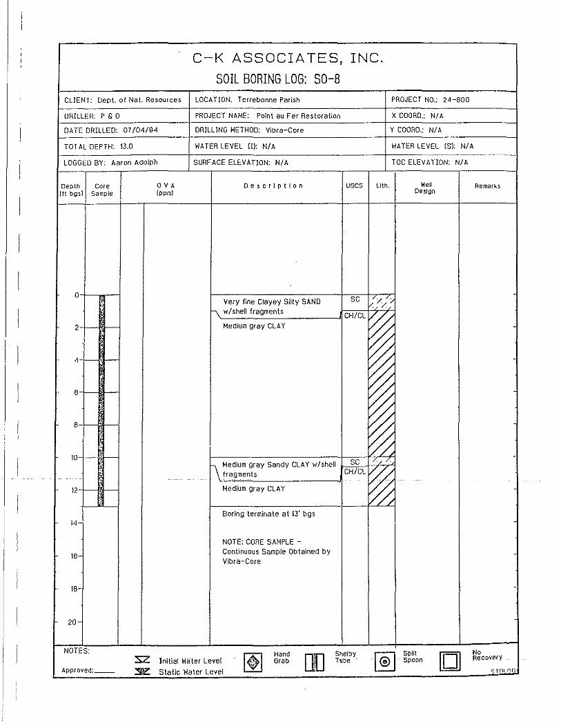
C-K ASSOCIA TES, INC.
SOIL BORING LOG: SO-8
CLIENT: Dept. of Nat. Resources LOCA nON: Terrebonne Parish PROJECT NO.: 24-800
ORILLER: P & a PROJECT NA~IE: Point au Fer Restoration X COORO.: NI A
DATE DRILLED: 07/04/94 DRILLING METHOD: Vibra-Core Y COORD.: NI A
TOT AL DEPTH: 13.0 WATER LEVEL iIl: N/ A WATER LEVEL (S): N/A _oooo __
LOGGED BY: Aaron Adolph SURF ACE ELEVA nON: N/ A TOC ELEVATION: N/A
Depth Core OVA Description uses LIth. Well Remarks (ft bgsJ Sample (ppm) Design
a Very fine Clayey Silly SAND SC 1// //
"\. w/shelJ fragments C:/ //
CH/CL
~ 2-I- - Medium gray CLAY
4 ~ ~ 6
~ 8- - -
~ 0
10 f-- - 1\ Medium gray Sandy CLAY w/shell SC /./ /.
fragments CH/CL
~ 12-f-- - Medium gray CLAY ~ - -Boring terminate at 13' bgs
14-
NOTE: CORE SAMPLE -
16-Continuous Sample Obtained by Vibra-Core
18-
20-
NOTES:
~ Hand Shelby
~ Spilt [0
No :2: Initial Water Lever Grab []] Tube Spoon Recovery
Approved: ~ Static Water Level <:;Tnl nri

C-K ASSOCIA TES, INC.
SOIL BORING LOG~SO-g CLIENT: Dept. of Nat. Resources LOCA nON: Terrebonne Parish PROJECT NO.: 24-800
DRILLER: P & a PROJECT NAME: Point au Fer Restoration X COORD.: NI A
DATE DRILLED: 07/04/94 DRILLING METHOD: ViDra-Core Y COORD.: NI A
TOT AL DEPTH: 13.5 WATER LEVEL II): N/A WATER LEVEL (51: N/A
LOGGED BY: Dave Beck SURF ACE ELEVA TlON: NI A TOC ELEVA TlON: N/A
... .. ---Depth Core OVA Description USGS LIth. 'Well Remarks (It bgs) Sample (ppmJ Design
0 Soft gray CLAY w/shell CH/CL
~ " fragments
~ 2 CH/CL
~ Medium gray CLAY , ,
~ 4 . -, -6 ~ )l
~ 8
10 ~ 12 ~ ,
~ 14 Boring terminate at 13.5' bgs -
NOTE: CORE SAMPLE -
16-Continuous Sample Obtained by Vibra-Core
18-
20-
1-- NOTES:
[t] Hand Shelby
~ Split [OJ No :sz Initia! Water Level Grab fIJ Tube Spoon Recovery
Approved: __ ~ Static Water Level C:TOlnr;

C-K ASSOCIATES, INC.
SOIL BORING LOG: SO-10 CLIEtlT: Dept. of Nat. Resources LOCATION: Terrebonne Parish PROJECT NO.: 24-800
DRILLER: P & 0 PROJECT NAME: Point au Fer Restoration X COORD.: N/ A
DATE DRILLED: 07/04/94 DRILLING METHOD: Vibra-Core Y COORD.: N/ A
TOT AL DEPTH: 10.0 WATER LEVEL (I): N/ A WATER LEVEL (S): N/A
LOGGED BY: Aaron Adolph SURFACE ELEVATION: N/A TOC ELEVATION: N/A
Depth Core OVA Description uses LIth. Hell Remarks (It bgsi Sample (ppm) Design
0 Soft gray CLAY wish ell CH/CL
~ fragments
2 Medium gray CLAY CH/CL
~ 4 I-- ,- ~ -
6 - ~ 8 ~ - ~ ,
10 ,
Boring terminate at 10' bgs
12- NOTE: CORE SAMPLE -Continuous Sample Obtained by Vibra-Core
14-
16-
18
20
NOTES:
[t] Hand Shelby
~ SpItt [OJ No
:sz Initial Water Level Grab []J Tube Spoon Recovery
Approved: __ ~ Static Water Level ~Tnlnr;

C-K ASSOCIATES, INC.
SOIL BORING LOG: SO-li CLIENT: Dept. of Nat. Resources LOCATION: Terrebonne Parish PROJECT NO.: 24-800
DRILLER: P & a PROJECT NAME: Point au Fer Restoration X COORD.: NI A
DATE DRILLED: 07104/94 DRILLING METHOD: ViDra-Core Y COORD.: NI A
TOT AL DEPTH: 14.5 WATER LEVEL !II: NlA WATER LEVEL (S): N/A
LOGGED BY: Aaron Adolph SURFACE ELEVATION: N/A TOe ELEVA nON: N/A
Depth Core OVA Oescrlptlon uses LIth. Well Remarks (ft bgs) Sample (ppm) Design
a , Soft CLAY w/sheli fragments CH/CL
~ 2 Soft gray CLAY CH/CL
~ ,
~ . 4
, 0 6 I---- ,- Medium gray CLAY CH/CL
~ -------8
, ~ ,
~ 10
'p ~ 12
14 ;' ~ Boring terminate at 14.5' bgs
16 NOTE: CORE SAMPLE -Continuous Sample Obtained by Vlbra-Core
18
. -
20
NOTES:
[t] Hand [[] Shelby
~ Split []
No :sz Initial Water Level Grab Tube Spoon Recovery
Approved: ""Ii'" Static Water Level C;TQLnr,

C-K ASSOCIA TES, INC.
SOIL BORING LOG: SO-12 CLIENT: Dept. of Nat. Resources LOCATION: Terrebonne Parish PROJECT NO.: 24-800
DRILLER: P & 0 PROJECT NAME: Point au Fer Restoration X COORD.: N/ A
DATE DRILLED: 07/04/94 DRILLING METHOD: Vibra-Core Y COORD.: N/ A
TOTAL DEPTH: 12.0 WATER LEVEL (J): N/ A WATER LEVEL is): N/A
LOGGED BY: Dave Beck SURF ACE ELEV ATION: N/ A TOC ELEVATION: N/A
Depth Core OVA Description uses LIth. Well Remarks (tt bgs) Sample Ippm) Design
0 , Soft gray CLAY CH/CL
~ 2 Medium gray CLAY CH/CL
~ 4 (I- ~ 6 ~
, ~ 8 ; ,
~ 10
~ "
12 Boring terminate at 12' bgs
14 NOTE: CORE SAMPLE -Continuous Sample Obtained by Vibra-Core
16
18
20- -
NOTES:
~ Hand Shelby
~ Split [0]
No :sz Initial rlater Level Grab rn Tube Spoon Recovery
Approved: :'!\'C: Static Water Level <:;Tnlnr>

C-K ASSOCIATES, INC.
SOIL BORING LOG: SO-13
CLIENT: Dept. of Nat. Resources LOCA nON: Terrebonne Parish PROJECT NO.; 24-800
DRILLER; P & 0 PROJECT NAME; Point au Fer Restoration X COORD.; N/A
DATE DRILLED; 07104/94 DRILLING METHOD: Vibra-Core Y COORD.: NI A
TOT AL DEPTH: 14.0 WATER LEVEL (I): N/A WATER LEVEL (S): N/A
LOGGED BY; Dave Beck SURF ACE ELEVATION: NI A TOC ELEVATION: N/A
Depth Core OVA Description uses lith. "Hell Remarks lit bgsl Sample (ppm) Design
a Soft gray CLAY w/shell CH/CL
~ fragments ,
2 Soft-medium gray CLAY CH/CL
~ · ~ ,
4 CH/CL
~ .. Medium gray CLAY ,
6 ~ ., .,
8 ~ · ~ 10 -;,
~ ~ , 12 · , % 14
, Boring terminate at 14' bgs
16 NOTE: CORE SAMPLE -
Continuous Sample Obtained by Vibra-Core
18
--20
NOTES:
~ Hand Shelby
~ Spilt []
No :s:z Initial Water Level Grab [[] Tube Spoon Recovery
Approved: __ ~ Static Water Level <::Tnl nr:;

C-K ASSOCIA TESt INC.
SOIL BORING LOG; SO-14
CLIENT: Dept. of Nat. Resources LOCA nON; Terrebonne Parish PROJECT NO.: 24-800
DRILLER: P & 0 PROJECT NAME: Point au Fer Restoration X COORD.: NI A
DATE DRILLED: 07/04/94 DRILLING METHOO: Vibra-Core Y COORD.: NI A
TOTAL DEPTH: 10.0 WATER LEVEL (]I: NI A WATER LEVEL is): NIA
LOGGED BY: Dave Beck SURFACE ELEVATION: N/A TOC ELEVATION: NIA
Depth Core OVA Description uses lith. 'liell Remarks (ft bgsl Sample Ippm! Design
;
0 t-- -Soft gray CLAY CH/CL
~ . ~ 2 I- -CH/CL
~ Medium gray CLAY
4 ~ 6 ~ 8 ~ ,
{ ~ ,
10 Boring terminate at 10' bgs
12 NOTE: CORE SA~IPLE -Continuous Sample Obtained by Vibra-Core
14 .
16
18-
20-
NOTES:
[tl Hand
[]J Shelby
~ Spilt [] No
:sz Initial Water level Grab Tube spoon Recovery
Approved: ::sl'Z Static Water level <;Tnlnr;

"rj ciCi' C '"1 ro
r 0
" "' -0' ::I 0 ...., '" -c ~ "' @
"' 5' '" 0 c -=-" w ro ..,. g '"1
e-" 0
"' '" e. r 0 c 0;' 0;' ::I
"' L.;:::: ::::::::
GOLF
6
OLD RIVER oufFCbW CHANNEL MISSISSIPPI
~ --~----
I{f? Baton Rouge
- " -~.' WESTERN OF 4f £ A.TCHAFALAYA.'::: TE. RREBONNE :'::::, . ..r/ BAY ~:: .: .. c:> ,,' ...
, . '0 . "::'.. ::" 60km. Poiritau Fer';"::::::>
10'Q--30mi

Figure 2.
Figure 3.
o mi 20 .. I ""'! o km 30
MISSISSIPPI DELTA COMPLEXES
= Modern Mississippi _ Lafourche = La Loutre = Teche
(St. Bernard) ''''',,'' .... Maringouin Fisk 1944
Fisk's (1944) depositional model of a single Holocene Mississippi River delta plain 4,250 years old.
r.:,.-(D--.-- Salc'- Cyprcmort <:
rorm1?:1CocodrJc ;'~: iD; n Plaquemines
1I0001ITeche 11II<1III1n,u" ~ St. Bernard c::J Pleistocene Uplands
o 10 20 30Milu
Kilometers
Kolb and Van Lopik's (1958) depositional model of a single Holocene Mississippi River delta plain 5,400 years old.
35

eN 0-
i W __ 'L2!
KAUUlM,1,U
C {J.(. J:'
OF
.v.t;~,/co A(4R +
1NCOUIP1 DEL.TA COMPl.EX
Figure 4. Delta lobes formed by the Mississippi River in the past 6,000 years (from Frazier, 1967). #15 Bayou Lafourche; #14 Bayous Lafourche and Terrebonne; #12 Bayou Black; #10 Bayou Blue; and #6 Bayou Terrebonne.
9
9--•

Figure 5.
O •.•••••• r.,. S .• ·.K .••. , .••. t.9.4.;4\ .~QI@\fAND~PIK,19~8<FRAZJE~,19~7 ..
.... . .............. . .
MISSISSIPPI MISSISSIPPI MISSISSIPPI
ST. BERNARD -------------~---r---------------
LAFOURCHE, LAFOURCHE LAFOURCHE ----------------- ---------------
2000~------------
ST. BERNARD TECHE ST. BERNARD
1------------TECHE ' 1----------------
------------------MARINGOUIN COCODRIE
TECHE
4000----------------------------------------,.....-----
SALE CYPREMORT
MARINGOUIN SALE CYPREMORT
6000r---------r-------------+-----------~-
---------------
8000~--------~------------~----------~
Comparison of Fisk, (1944), Kolb and Van Lopik, (1958) and Frazier (1967) delta models.
37

.-\
r'.~,,:.., -... ...
+ ""-. ...... .. \ +
38
+
+
o u
" ,. . o . o o
+
+

w -0
c
N
V:;·,'·q Illliilil ~
II
UPPER SECTION
BOUNDARY BETWEEN DELTA LOBES&BETWEEN AGGRADATIONAL -===DELTA~COMPLEX BOUNDARY UNITS GENETICALLY RELATED TO DELTA- LOBES ------
BASE OF TRANSGRESSIVE e DELTA-LOBE DESIGNATION ~ ERODED PLEISTOCENE SURFACE DEPOSITS '"
PROGRADATIONAL FACIES
DISTRIBUTARY MOUTH-BAR SILTY SAND
DELTA FRONT SILTY $ANO&SJLTYCLAY
PRODELTA SILHCLAY
I r r I I I r II r t I I
IB!I!II PEAT
AGGRADATIONAL FACIES
~ CLAYEY PEAT,PEATY ~ '\.. CLAY ,ORGANIC MUCK
1<",~>t.;;,:lINORGANIC CLAY CJ t:::::s:::4 NATURAL~LEVEE --------- SILTY CLAY
I JI I r II I
BAYOU PETITE CAfLLOU
LOWER :SECTION
t:;; [2J LAKE ,," DEPOSIT r o
" 0: B I~< CREVASSE w= DEPOSIT IZ~
Dll IZz I~-I"
I! I 1 \I
I"i·:.:::',,:,.l
1:::::::::1
PROGRADATIONAL FACIES I2EJ TRANSGRESSIVE
FACIES
AGGRADATIONAL FACIES
TERREBONNE BAY
TRANSGRESSIVE FACIES
BARRIER, TIDAL-DELTA OR STRANDLINE SAND
BAY SILT, ClAY,& SHELL
OYSTER REEF
I-BORINGS
WINE ISLAND
I I
02600
.:~
GULF OF MnfCO
LOCATION OF BORINGS
RADIOCARBON AGE YEARS BEFORE PRESENT
WEATHERED & ERODED PLEISTOCENE SURFACE
Figure 7, Section A, modified from Frazier (1967), from Bayou Little Coteau to Ship Shoal.
C'
s

" • • ..Ii • "'8 .-,,'" •• • > ... e ... .. • • • '"
Figure 8.
A. SEISMIC PROFILE
West
Vertical Exaggeration: llx
B. INTERPRETATION
0 .~====~~~-------------------------.o 1 Water Column Seafloor
25 -
De~alc Sediment~ ~11~:i'I~~~C
50
Reflectors
30
A 3.5-kHz seismic profile and an interpretive drawing of a meandering distributary channel. From Suter et al. (1991).
40

'10 4 Cd;" uBay
~=- dJ ~'" '/;:~~ ''''''''~ I........................ ...... ............... ... ....... .. .......... ..
.. - 4 m·............................................ .. ... -......... ... ..... .. .. ~.. I __ ...... .. .. 10m .. __ ..........
,-- Figure 8 J--"" - Figure 1 0, __ ' , Gul' Of Mexico
,- ......... ("-'::":'::J ... / h.~~l? ........ , ' , " " •• ~: ::O'Figure ni .---... ;--=,~= .. ;:-, \ ' --.' .. '4m ----_ .. ~ .. .-.N-~"~". .. ....
"'-' , •• - •• - #12"'" .,.-I.... .._":>...( ..... "6 ......... , ...... -10m-- ......... Figure 11
m , Frazier (1967) Section A
... __ .... .. I .... ,..' '" ,
, , , , , Figure 13
Seismic Sections
o Vibra Cores
f ",' ~L' '_' '_' _S_ut_e..lt ~_e_t _a'_(_1 9_9---,2;)~
Figure 9. Location of the seaward sections of core and boring data presented by Frazier (1967), Penland et a!. (1987), and Suter eta!' (1991).
41

A SEISMIC PROFILE
!; f .
Vertical Exaggeratlon-20x
- B. INTERPRETATION
:: -_!e 0 l~"";"~"::~"':~''':~'t.O'~'''''''''''~''''~--''~''~~~~P~u~l~se~W;I~d~th;~;~;;~;~i~~~~~~r 0 :: " '. ":;11 .. : ... : :.. L f6·'·'"::" e ~o ~ 25 .. Hlg~e~emc~~:~de Tec:2ement ... Seaward Dipping V'''tO':' ...... f- 15 :;;
:> Surface Clinoforms a a ~ .. f-< ~ Teche-Marlngouln 0
.. Inner Shelf Shoal Distributary 30
'" l 50~D~------------------------------------------------~D'
Figure 10. ORE Geopulse seismic profile and interpretive drawing of the Ship Shoal sand body. From Suter et al. (1991)
42

SHIP SHOAL # 15 MEAN
GRAIN- SORTING VIBRACORE LOG ENVIRONMENT SIZE Il 11 % TEXTURE
Om---,...".,===:::-o 2 4 6 8 0 1 2 3 01-_--"50'---_.:,j100
Shoal Crest
2m ....... :
Shoal Front
Shoal Base
6m Lagoon
8m~"""'" Prodelta
SHIP SHOAL #12 MEAN
GRAIN- SORTING VIBRACORE LOG ENVIRONMENT SIZE 11 fJ % TEXTURE
Water Depth: -6.1m Om ---,-==6="..,
6m
8m
10m
aI> 1"'1 Shells
1\ Broken Shells
..J} Ophiomorpha
-V- Bioturbation
2 4 6 8 0 1 2 3 0 50 100 1----'----nI
Shoal Crest (
Shoal Front
Shoal Base Lagoon
Delta Front
Prodelta
C>. Lenticular Beds
~ Scour Surface
\\.\ Trough Cross-beds
nr Ripple Cross-beds
?
.
\
~ Deformation
.::::=:::: Wavy
0 Clay Clast
- Laminae
Figure 11. Representative vibracores from the Ship Shoal sand body. From Suter et al. (1991)
43

, ,~, , , , , ,
Figure 12.
-------, , -- ---
LOUISIANA
, , , ,
... -",/ -'
- , '-, B' ,~
liiirl AlluvIum
MM$d Natural Levee
~'.c~ Fresh ~arsh
E===='l Salt ~arsh
'·(\,-'1 Barrier Shoreline
~-
o
I o 10
Miles 10
:
20 Kilometers
Vibracore sites and cross-section location for the Bayou Grand Caillou area. McBride et aI., 1990 and Penland et aI., 1987)
(From
44
/ /
/
/ /
20 I
I 30

~ " ;; w ~ 0 0 ~ U .:: 0 z 0
1 0 ;; .. • ~
0 0 .:l ~ ~
ffi '" '" '" ~ • w .... " . « 0" 0 U o :c <2., <f) ~
'" ;;
l: <f)
Figure 13. A representative north-south vibra core cross section of western Terrebonne. (Modified frrom sources as mentioned in the text).
45

--- ' .- ..'
'tl West C
'tJ cQ
4m
8m
12m
16m
-<Il ..... C -.0 ~<Il ..... In cQ<Il ,
Ql cQ , , -<Il
Cr') Isles Cr') Cr') ~cQ
co cQ. co co .... Q. 8 Dernieres ~ , Q cQ 0 _u -
_ Ebb-Tidal Delta
~ Tidal Deposits 1':"1 Tidal Channel Fill o Deltaic Deposits
C1\ , -.0 -.0 co
, , -.0 T;mbalier
(f) co Island , (f) r-
Kilometers j I o 5
~ Tidal Inlet Scour -- Ravinement
East
..... ..... , -.0 co , r-
I<,~",'I Maringouin Delta Complex
Figure 14. Strike cross section through the cat Island Pass tidal sand bodies (from Suter et aL 1991).
46

MSL Om
2m
]' .Eft " .. • C
6m
8m
1 SS-83-11
Gulf of Mexico
Ship Shoal
Sf!oal Crest
Shoal Bue
Lagoon
Figure 15. A vibracore from west Ship Shoal. For location see figure 9.
47

• LOESS
DMARSH
EJ ~~~tPlJ)E (2)
MDEWEYVILLE TERRACE
E'3BACKSWAMP 0 PRAIRIE TERRACE
EJ MEANDER BElT D ¥tP~RT:COEMERY r;;:a UNOIFFERENTIATED ~TERRACE
" lJ
o f L F 9 2,0 40 6pMi.
o 20 40 6'~ S'OKm
WEST EAST A TM 3 TM 40 TM 14.:.D ___ .:..P-1-9D A' D.-~z---~~-----------------
10 l--~~-.
20
30
40
50
60
/ PLE1STCENE I 9.4cn'lGGyr I
ALLUVIAL VALLEY WALL
Ql PEAT
o SAND
13 CLAY
@l SAND/GRAVEL
---
HOLOCENE TOPSTRA TUM DEPOSt TS
(CYCliC DEPOSrTlONAL UNITS)
--- ------------ ----PLEISTOCENE SUBSTRATUM
DEPOSITS
---
70~~~~~~~~~~~~~--c.~-~--~-~~-~~-~~~~~~ SCALE(KM)
Figure 16. (Top) Map of the Mississippi river deltaic plain and southern alluvial valley showing the approximate position of the entrenched alluvial valley beneath delta plain deposits and the location of borings and cross section. (Bottom) A west-to-east transect of borings showing the influence of Holocene sediment thickness on subsidence rates as determined from Carbon-14 dates (modified from Roberts et al. 1994).
48

I FPB-IO I % Sand I I o 100
Om -..,...,"' I~ Salt Marsh
-& r~
Fresh Marsh
~: ... 2m- ... %
SEDIMENTARY STRUCTURES
I· .. ··· I Parallel
I c-> I Lenticular
I~I Wavy
I I Current Ripple
B Ripple Drift
I~';;;id Graded
I" v I Marine Shells
~ Small Burrows
I ~ft I Large Burrows
I ~~I Rooting
[;;;3 Peat
B Sharp Contact
Figure 17. Vibracore FPB-lO from Bayou Grand Caillou area (From McBride et ai., 1990). See
Figure 12 for location.
49

Om
2m
4m
6m
Figure 18.
-
-
-
-
-
-
IFC-21 % Sand
I I o 100
l'l'"'
~ -,(;-/;~ tI-t: ~-{:
tt"i-....... ~""." ;.:.:.: -=-:.:;....~ ..... .. ". . .... ;-)
....... ·······1 _ ................ :. ~ ....... T .::::::. ~ -....... - -...... -.::::>.
Salt Marsh
Fresh Marsh
Levee
Distributary
Delta Front
..... ----Prodelta
<Sand Sheet
I~ J\l~ t=:
Salt Marsh
SEDIMENT ARY STRUCTURES
1·····"=1 Parallel
1 =- / Lenticular
1 r-tf/ Wavy
1 ..... -'/ Current Ripple
@ Ripple Drift
[il Small Burrows
m Rooting
I"'"""" / Pea t
I;;;;.:·~/ Graded
B Sharp Contact
Vibracore FC-2 from the Bayou Grand Caillou delta. See Figure 12 for location.
(Modified from McBride et al. 1990).
50
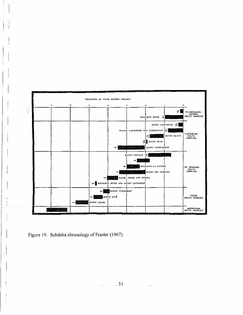
THOUSANDS OF YEARS aeFORE PRESEHr
u u -
.""j"", "'" W
SAl·OUS LAFOURCHE . .1. o I BAYOU BLUE I
BAYOU n,.RREBi ........ E
B~YOU SAUVAGE =:
-I· . +-"~~, -...j BAYOU DES FAl/IUES
...... BAYOU TERRE AUX BOEUI'S
I I w IMISS/SstP,i RiVER AND BA1YOU LAFOURCHE
8AYOU TECHB
Figure 19. Subdelta chronology of Frazier (1967).
51
0
~ _ PLAOUfW,IHES_ I40DERH
CEL.TA COW.PLI!X
ST. BERHARD CEL.TA
COMPLEx
TECHE CI!L.TA COMPLEX
.lURIHGOUIH DELTA COMPLEX

P/,~ti~ti'I.
P.pq •• , Ah-Ilal
, Tlmballer
a.y
GULF OF MEXICO
CAMINAOAMOREAU RIDGES
Bayou Moreau
------- SANO RIDGE
o 5 10 KILOMETERS
Figure 20. Location of the Cam.inada-Moreau ridge plain.
52

~ Present shoreline
_____ Transgressive beach ,£j) G)
.@ Shell reef o Active distributary \
\ mouth bar ,\ \ '-~ I I
--.... I;~ --- ~..-==--..... _ J I
..... ,- '" I I ~_ I \,.- ,_------- .... ..,
c. 1000-1200 B.P.
o , 5 io---.:::=.~-~---_..J
K~. ' GULF OF MEXICO
I \ . I " \ ,_ I
-----.... I~~
I
.... ~- "'\ I .d!¥t , J ___ ' ___ :::.::a-~':::::~ ____ ' ......... ----.--- ...
\
" -, --
C. 600-650 B.P.
-- ---...... _I, I '(,,1 \ .......... ------~-_\-----
A
c
Figure 21a. Paleography of the Caminada-Moreau ridge plain, 1200 BP - 600 BP (fonn Gerdes 1978).
53

Unnamed Distributary Bayau Ferblanc ~
Bayou Moreau
600-650 B.P. ~ - - ~~ ...... --' .-.' ~. -::::,
:::: ._c
450 B.P.
Gulf of Mexico
--
-- - ... .. ~ ., ~ -...
---
--o 2
Km
Ridge Axis o Active Distributary Mouth Bar
/ ./
Figure 2lb. Paleography of the Caminada-Moreau ridge plain, 650 BP - 450 BP (form Gerdes 1978).
54

~'.
"'.
"'- ~' .. ~. ".:' -
"
c. 450 RP.
~' ,'. , '" u..-
c.300RP.
c,200 B.P.
Transgressive beach Gulf of Mexico I
Active distributary mouth bar Present shoreline Ridge oxis
o 5 10 '~-+'---"' Km.
A
B
c
Figure 21c. Paleography of the Caminada-Moreau ridge plain, 450 BP - 200 BP (form Gerdes 1978).
55

CK. " 10
CK' 13 12 ck
14
LEGEND
EPF/WPF = VIBRACORES ON LAND
CK1-CK14 = C.K. ASSO.S SHELF
VIBRACORES B1- B3 = McCLELLAND
DEEP BORINGS L...,..---------I1 91'1S·
CK1.
CK2' CK8 CK4"CK6
o 2000m
Figure 22. Location of cores and drill holes referred to in this report on Port au Fer Island.
56

V1 ....,
ATCHAFALAYA BAY
, , , , ,
GULF OF MEXICO
, , , , , I' , ,- BORINGS
TRINITY SHOAL
Figure 23. Frazier (1967) stratigraphic section that crosses Atchafalaya Bay, See figure 7 for an explanation of the legend.
-10'-
-20'-

x
7
Figure 24.
X'
0;..._...;;,50;,;;0 meters
A ~ Depositional Cycle H ~ Hurricane Andrew Deposits
S ~ Shell Beach
Stratigraphic section X-X' from the eastern section of Point au Fer Island (For location see Figure 22).
58

Figure 25. X-Ray radiograph of depositional sequence A - old shelf clays.
59

Figure 26. X-Ray radiograph of upper prodelta deposits from the Point au Fer vibracores.
60

Figure 27. X-ray radiograph of mudflat deposits from Point au Fer vibracores.
61

Figure 28. X-Ray radiographs of mudflat deposits from the Point au Fer vibracores.
62

Figure 29a. X-Ray radiograph of marsh/levee deposits from the Point au Fer vibracores. 29b. Radiograph of marsh deposits.
63

WPF4 Y
a ~_
6
7
Bay
WPF3 WPF2 WPFl
a 1000 meters
A = Depositional Cycle H = Hurricane Andrew Deposits
S = Shell Beach
Figure 30. Stratigraphic section Y-Y' form the west of Point au Fer Island.
64
Gulf

Figure 31. High altitude aerial photograph of the Atchafalaya and Wax Lake delta lobes.
65

, -.. ", • 1 ,
#: 1 I ,~ fi ~11. .Illl~ I ~ ~I. ,
J o 1000 2000
" , , I
1973 B 1977
c 1986 D 1990
Figure 32. Progressive subaerial growth of the Wax Lake delta lobe from 1973 to 1990.
66

Figure 33.
LJ 5<JbooriaJ do!!", Merch 19a1
/ /
500 1000 15C<I "'.
Secl.
Transects of deep vibracores in the eastern Atchafalaya delta. These lines of cores are used in sedimentary facies relationship determinations shown in Figures 41 and 42.
67

Figure 34. Map of\.Vax Lake Delta indicating the locations of vi bra cores described in this report.
68

Figure 35a. X-ray radiography of the old bay bottom (shell-rich area) facies. This image is a photograph of the X-ray radiograph negative.
69
Figure 35b. X-ray radiograph of typical prodelta sediment illustrating parallel-laminated and very-low-angle, cross-laminated silty clays. This image is a photograph of the X-ray radiograph. Light tones are areas most dense to X-ray radiation.

Figure 36.
• .<~%" . ..,~-~-:-•..
rJiji,4it:~ ! .....
X-ray radiograph (exposure 3271 of distal-bar sediment, which are composed of alternating clays, silty clays, and thin silts. This image is a photograph of the X-ray radiograph negative.
(
Figure 37.
70
D
.~!.
X-ray radiograph (exposure 2928) of cross-and parallellaminated distributary mouth bar, fine sands, silts, and silty clays. This image is a photograph of the X-ray radiograph negative.

Figure 38. X-ray radiograph of (a) (exposure 2544) clay-rich channel fill, (b) (exposure 2923) silty channel fill, (c) (exposure 2543) sand channel fill. These images are photographs of the X-ray radiograph negative.
71

Figure 39. X-ray radiograph (exposure EWlOT) of highly structured silts and five sands associated with subaqueous natural levee deposits. This image is a photograph of the X-ray radiograph negative.
72
Figure 40. X-ray radiograph (Exposure 2850) of interbedded, parallel-laminated silts, clays, and thin, highly organic units from back-bar algal flat environment. This image is a photograph of the X-ray radiograph negative.

E
:5 ~
• "
0
-1
-2
-3
Cores locations and numbers
A 17
EAST
JlIne 82
Dec. 75
1962
1 Channel till
Levee
D Upper prodelta
o Lower prodelta
Distributary mouth; bar eli] ord bay bottom
Cray-rich distal bar ~ Shell dredger
Distal bar
ROONEY·S ISLAND
19 20 A' WEST
Figure 41. Interpreted stratigraphic cross section (profile A-A' of Figure 33) from the eastern lobe of the Atchafalaya delta. Core control is shown on the cross section.
73

:§:
" c. 0
Q
B EAST
.,
·2
C.1962
C. J9.52 ·3
.• l1li
·5
o levee
m Back bar algal /lal
o Oi$lribulary moulh bor
Core locoliofl and numbe,
lower prodelta
~ Old bay boltom
~ layen shell hash
WEST ViSE GRIP
Juno 82 Dec. 78
0"c.73
B'
·6 L~[J~~D~;'~la~l~ba~'~ __ ~ ____ ~C~.~18~3~9~ .. ~.~D~al:.~H:o.~ __ ~~~~~~~~~~~~~~~~~~~~~ ________ J
Figure 42. Interpreted stratigraphic cross section (profile B-B' of Figure 33) from the eastem lobe of the Atchafalaya delta. Core control is shown on the cross section.
74

o
5
15
W WaY. Lake
Delta
Figure 43.
E Atchafalaya River Point Au Fer Island West Terrebonne
Schematic representation of the Holocene stratigraphy of central south Louisiana coastal zone.
75