hot spot mapping - lu
TRANSCRIPT
Department of Human Geography Examiner: Ola Hall SGEM07 Supervisor: Nicklas Guldåker Spring 2017
Hot Spot mapping
A spatial and methodological approach to analyzing outdoor crimes in Malmö.
Jimmy Holm
Abstract
This thesis aim to visualize and explore the methodological approach to finding the spatial patterning of crime through a geographical information system as a means for future guidance within spatial crime analysis. The analysis was applied to outdoor crimes for the city of Malmö in the year 2007. As a means for conducting this analysis a case-study is performed. Both as a review of current police-methodology within crime-preventive work and on two individual geographic locations. After gathering and sorting of data a total of 9876 crime incidents was analysed. Two spatial analyses are performed, the Optimized Hot Spot-analysis tool and the Kernel Density Estimation-analysis tool. The Average Nearest Neighbor-model was applied to the data for further statistical accuracy. The thesis concludes that both tools have their usages. The optimized hot spot analysis was concluded to be of most use when the study area was large whereas the kernel density estimation analysis performed better for finding small variations on smaller study areas. However, they are the most efficient as complementary tools rather than when used as a single-method approach.
Keywords: Crime, Cluster, Hot spot, GIS, Methodology
1
Table of contents 1. Introduction ........................................................................................................................ 3
1.2 Aim of thesis ..................................................................................................................... 4
1.3 Research question ............................................................................................................ 5
1.4 Disposition ........................................................................................................................ 5
1.5 A contextual background .................................................................................................. 6
2. Theory ................................................................................................................................. 8
2.1 Grounded theory .............................................................................................................. 8
2.1.1 Criticism on grounded theory .................................................................................. 10
2.2 Why place matters – a geographers’ perspective on crime ........................................... 12
2.3 Crime and place – what makes crime spatially dependant? .......................................... 13
2.4 Routine activity theory ................................................................................................... 14
2.5 Why the local matters – micro-place analysis in criminology ........................................ 15
2.5.1 Criticism on micro-place analysis ............................................................................. 16
2.6 Chapter conclusion ......................................................................................................... 19
3. Methodology ..................................................................................................................... 19
3.1 Methodological approach .............................................................................................. 19
3.1.1 Explorative research methodology .......................................................................... 22
3.2 Data ................................................................................................................................. 23
3.3 Data, integrity and ethical dilemmas ............................................................................. 24
3.4 Place of study .................................................................................................................. 25
3.5 Visualization and presentation of data .......................................................................... 26
3.6 Spatial analysis methods ................................................................................................ 27
3.6.1 Optimized hot spot analysis ..................................................................................... 27
3.6.2 Kernel Density Estimation Analysis .......................................................................... 28
3.6.3 The Average Nearest Neighbor tool. ....................................................................... 30
2
3.7 Chapter conclusion .................................................................................................... 30
4. Analysis/Findings/Evaluation ............................................................................................... 31
4.1 A global perspective on crime – clusters and hot spots through Optimized Hot Spot
analysis ................................................................................................................................. 31
4.2 Kernel density analysis – from global to local. ............................................................... 34
4.3 The Average Nearest Neighbor-tool – supporting data. ................................................ 36
4.4 Repeat-victimization and static high crime hot spots. ................................................... 38
4.5 Recurring crime-scenes – a case-study. ......................................................................... 41
4.5.1 Location 1 - The Stortorget square .......................................................................... 41
4.5.2 Location 2 - The Gustav Adolfs square .................................................................... 44
4.6 Environmental and structural enablers: similarities and differences in hot spots. ....... 45
5. Discussion .......................................................................................................................... 46
6. Conclusion ......................................................................................................................... 47
3
1.Introduction
Criminology have changed over time, as most sciences have. Criminology have for a long
time primarily focused on offenders and behavioural explanations for crime and large-
scale trends. Researchers are now turning their attention to environmental criminology
as a means for understanding the spatio-temporal, physical and social processes which
underlie the explanations for crime. What it is that enables crime to occur (Cohen,
Felson, 1979:588, Piquero, Weisburd, 2010:5)? Patters and trends in crime-tendencies
can reveal information about both nature of crime and those offending. For instance,
processes such as repeat-victimization, crime hot-spots or crime-highways as well as
locations of offenders. There is a large toolset available to the crime-analyst and as such
there is a need to explore their application. Furthermore, there is a need to explore in
what way they are of use to law enforcement and analysts as an active and preventive
crime-fighting tool.
Weisburd and Mazerolle (2000:336) address this topic in an important
question. How are analysts and researchers meant to deal with crime hot spots over
large geographic areas? Weisburd and Mazerolle took issue with the way large
aggregates of crime-data was traditionally visualized over large spatial units with the
consequence of analyses being far too generalized and imprecise. However, instead of
questioning the purpose of large-scale analyses this thesis questions the working
procedures, predictions and possibilities available through a geographical information
system within criminology. Weisburd and Mazerolle’s topic on large spatial units and
visualisation is therefore partly answered in this master’s thesis. How does one proceed
from a large study area to the local? Can the analytical methodology applied in this
master’s thesis behave as guidelines on further studies?
Swedish law enforcement is one authority working within this traditional
methodology mentioned. More so, they have for some time now lacked the ambition or
ability to incorporate and apply more recent research on the topic of crime-prevention.
The methodological approach has not been in line with current scientific findings and
the organisations ability to introduce new knowledge and methods have been

4
inadequate (see Riksrevisionen, 2010). As such it is of interest to apply this thesis and its
methodological approach within the context of the Swedish city Malmö, as this thesis
does. Doing so can increases our knowledge on crime-distribution in Malmö as well as
provide input into the discourse on Swedish crime-preventive work.
Studying crime and its spatial distribution can be a challenging task. Not only
are datasets often large and therefore require in-depth analysis. More so, sticking to
traditional, deep-rooted methodologies without adapting to new development could
suggest that knowledge remains limited whereas offenders adapt at a higher rate. These
dated methodologies such as working with points or thematic maps could show general
signs of how crimes are distributed or tell the analysts on the broader trends but lack in
detail and suffers from the inability to, for instance, discern any patterns when points
are too many in one location. Subsequently this thesis approach both data and spatial
methodology from an explorative perspective. Through the use a geographical
information system (GIS) and the optimized hot spot analysis-tool and kernel density
estimation analysis-tool this thesis will make sense of a large set of crime data in Malmö
for the year 2007.
1.2 Aim of thesis
This master’s thesis attempts to make sense and direction from a large set of crime data
for the city of Malmö for the year 2007. This is done from an explorative perspective, to
some degree guided by Grounded Theory. The objective of the thesis is to attempt at
formulating theory or future guidance for analysing crime-data and its geographical
nature through the use of a geographical information system and spatial methods,
optimized hot spot analysis and kernel density estimation analysis. Through visualization
and geo-statistics, the reliability of the methods is determined along with a conclusion
on their performances.
5
1.3 Research question
The following questions will help reach the aim of this master’s thesis.
• How is crime data in Malmö for the year 2007 distributed from a spatial
perspective and how does the annual development of crime behave?
o Can hot spots be detected through the application of an Optimized Hot
Spot analysis and a Kernel Density Estimation analysis?
▪ How are hot spots distributed over space?
o How should these methods be applied when studying distribution-
patterns?
▪ Are they similar in outcome?
▪ Are they complementary?
▪ Are they contradicting to each other?
• Are there signs of repeat-victimization?
o If so, what distinguishes the location(s)?
The outcome of these questions will help in making decisions for future studies of crime
and its spatial distribution and further highlight the purposes and advantages to a GIS-
aided approach within criminology.
1.4 Disposition
The thesis’ second chapter presents the theoretical topics and arguments underlying
much of the analyses performed. It covers the subjects of routine activity theory, micro-
place hot spots in criminology as well as the notion of space and place within the concept
of criminology. The chapter closes with a discussion on crime and place in relation to
what creates hot spots. Chapter three expands on the methodology applied in the
thesis, data usage and the methodology behind the optimized hot spot analysis and
kernel density analysis. In chapter four the analysis is presented. This includes the two
6
GIS models performed along with a shorter case-study on the locations identified.
Finally, chapter five and six concludes the paper as well as discusses possible paths
forward considering the findings presented.
1.5 A contextual background
The cause for this thesis partly comes from a report published by Riksrevisionsen (2010)
(the authority appointed for auditing state-owned functions) where critique is raised at
the Swedish law enforcement and its difficulty at adapting to contemporary and up-to-
date research within the field of crime-prevention. The stance in this thesis is that with
proper knowledge working within a geographical information systems-environment
there are many advantages to be gained.
One point in Riksrevisionen’s report, among several other, stated that “One
drawback from inadequate planning process is that the efforts are usually kept on a
general level and aimed at traditional working procedures such as patrolling on foot,
visibility, […] and traffic controls” (Riksrevisionen, 2010:10, my translation). Based on this
one may claim that a lack of planning and a generalizing stance on analysis-work is
common-practice and that the implications are limited advancement in working
methods. Yet, it seems to be commonly known that these methods are not effective
enough for crime-preventive work. Further on they continue that the Swedish police
does not rely enough on knowledge-based intelligence in their analyses and work
procedures (ibid:11). This could suggest that further emphasize is needed on the
usability and applicability of a GIS-based approach to hot spots and crime mapping.
Whereas I would never discredit the need for what they call traditional
working procedures one needs to acknowledge the issue of resource-allocation. Having
the ability to direct resources towards more affected segments of the city would be the
goal to aim for. Continuing the critique towards police and crime-preventive work in
Sweden Riksrevisionen argue that the authorities does not to a large enough degree
cooperate within its own organisation (ibid:11). This is highly troublesome if much
preventive work further on could be achieved through cooperation with outside-actors
7
such as housing agencies and city planners. However, if it is lacking in inter-
organisational cooperation would it be able successfully cooperate with external actors?
Riksrevisionen’s report is dated to 2010 and as such is not entirely new.
However, judging by the reports on the recently performed re-organisation undergone
in 2015 one may see indications of a worsening situation (Dagens Nyheter, 20160830).
Solved crimes are at an all-time low comparing 2010 to 2015, suggesting that the report
published was never implemented into the organisation, not recognized among those
on the field or alternatively lost during the re-organisation.
Riksrevisionen analysed the police preventive work in a number of ways and
thus stated several conclusions. However, discussed here are those of relevance to this
paper. Firstly, they find that a large majority of higher officers feel that prioritizing
arrests and focus on offenders is the most effective way to prevent criminal activity. In
fact, half of all commanding officers agree with such statement to a large degree
whereas the other half agree without emphasizing it as the most effective
(Riksrevisionen, 2010:55). While not a radical opinion judging by Riksrevisionen’s report
it is found to go against what some modern research claims. Weisburd, et.al., (2016:27-
28) argues that for a more effective crime-preventive working procedure one needs to
focus on place and thus prioritize removing or reducing offenders desire or possibility to
commit these acts. Be it through physical design or in other manners.
Secondly, Riksrevisionen argue that too much of the authority’s work is non-
grounded in knowledge and science, but rather on traditions and “what has always
worked” (Riksrevisionen, 2010:81). This goes in hand with the first critique on where
priority needs to be regarding offenders, crimes or places. Strangely enough the police
do work around intelligence-info regarding intensified surveillance of offenders (ibid:
57) but not for other work routines. Here one would argue that such work procedures
for certain places or locations could prove to be just as effective in regard to crime-
preventive results. More so it would fulfil the Government’s and Rikspolisstyrelsen’s
requirement for the police to base their work on scientific knowledge.
Thirdly, Riksrevisionen concluded in their report that Brå (the Crime-preventive council)
had suggested to Rikspolisstyrelsen that hot spots or targeted patrolling was an effective
and scientifically proven method. Discussions were held between Brå and
Rikspolisstyrelsen on how these methods should be implemented (ibid:98) however no
8
agreement seem to have been made. Subsequently one must conclude that not only do
they conduct much of their work on non-scientifically grounded methods, but they are
lacking in ability to introduce and absorb what knowledge is passed on to the
organisation as was mentioned previously.
Finally, and possibly most importantly, they found that the crime-preventive
work within the organisation was severely under-prioritized. This was the reality despite
having knowledge within its own organisation that situational crime-preventive work,
or reducing the recurrence of crime, is indeed the most effective. Why it has proven to
be the most effective was found to relate to the fact that the tasks are closely related to
actual police-tasks unlike more socially related crime-prevention (ibid:57). While not
disagreeing, it does need to be said that working with social processes give results which
are difficult to quantify and thus measure. However, I would argue that having a more
detailed knowledge on crimes spatiality could ease implementing situational work-
methods and increase results despite not setting aside enough workhours on such tasks.
2.Theory
2.1 Grounded theory
Grounded theory and its different variations, initially developed by Strauss and Glazer
(1967), is fundamentally about allowing theories to evolve as new data or knowledge is
produced. Grounded theory is about moving from empirically grounded research to
develop theories based on these findings (Esaiasson, et., al., 2012:127). In this sense it
is very much inductive and theories emerge from an examination of available data. Upon
formulating these theories, the aim is to achieve what is termed theoretical saturation,
in essence exhausting the data through a set of thorough analyses so that no more
theories, categories, themes or possible relationships can be identified (Steinberg and
Steinberg, 2015:81).
9
This approach has not been without critique, see below, and thus this master’s thesis
will extend its theoretical approach by incorporating further theories as a means of
supporting the arguments brought forward in here. This is partly done as the thesis
acknowledges theories within criminology and their approaches discussed as holding
explanatory value. Further, the thesis does not rely on the ability of grounded theories
to through a spatial analysis explain the processes or explanatory variables behind
crimes. And while the purpose of this master’s thesis is not to explain presence of the
crime, it is studying their spatial distribution. By acknowledging the changing spatial-
temporal dynamics of crimes as important the thesis will relate its findings to
contemporary crime-theory. These theories will be discussed further down however.
Practicing grounded theory when doing research is also mainly about coding
and sorting data. Thus, the method of building theories relies on categorizing and coding
the data and subsequently develop an idea based on how the results are connected or
related (Cloke, et., al., 2004:313; Esaiasson, et., al., 2012:127). The process of coding,
and sorting within grounded theory very much resembles the act of categorizing,
sorting, and making sense of the large datasets used when analysing the crime-data in a
geographical information system.
The stance from Cloke., et., al., (ibid) is more on grounded theory as a
qualitative approach, however as Knigge and Cope (2004) argue it is very much suitable
when working with a geographical information system. They argue that a geographical
information system has a “basic compatibility” with grounded theory. The theory and
its emphasis on small-scale and large-scale processes in symbiosis as well as its focus on
specific instances and broader trends goes well in hand with the functions of a
geographical information system which “enables or demands attention to both the
particular and the general” (Knigge and Cope, 2004:2025). Furthermore, they follow
their argument for the compatibility of grounded theory and geographical information
system with the similarities between coding qualitative data and dealing with data-rich
databases and observing patterns, trends or processes (ibid:2025). Indeed, much of the
work done in this thesis revolves around categorizing and dividing data within months,
years and spatial distribution, much like coding qualitative data into categories or
patterns.
10
Continuing the discussion of grounded theory and qualitative or quantitative data
Knigge and Cope state that the theory rather than being implicitly related to qualitative
data it is to be considered as “an approach to data gathering, analysis, and theorizing
that encourages a deep level of flexibility on the part of the researcher, part of which
involves openness to using multiple methods.” (ibid:2025). During the process of this
thesis its methodological approach has changed multiple times. Furthermore, the
approach to research area and what questions to ask changed. In its early stages certain
methods suggested questions had to be asked regarding crime distribution and its
underlying causes. However once posed the following findings suggested that neither
analysis nor related method could be considered reliable and thus forced a new
methodological approach.
Finally, the working procedures of using a geographical information system
and the question of transparency work well with the requirement within grounded
theory to be open with the research procedures (ibid:2026). The methods performed in
this thesis require the researcher to rely on several algorithms. When lacking full insight
into programming language or the underlying process when using computing software,
it would be necessary to be transparent and open about what methods used and its
possible shortcomings and advantages in order for readers to judge the credibility,
reliability or legitimacy of the results.
2.1.1 Criticism on grounded theory
Some of the critique towards grounded theory stems from Glaser and Strauss (1967)
claim that researchers should conduct their studies without any “preconceived ideas”
(Allan, 2003:8). As Allan states there must be some form of initial agenda or interest
prior to conducting any research. What is being questioned is therefor if one is without
preconceived idea or bias in such a case? Further on it is a reference to the idea that
researchers applying a grounded theory methodology will always approach their
research with previous baggage. All humans are shaped and constructed from past
11
experiences and knowledge. As such one can never claim to be entirely without
“preconceived ideas”, opinions or past experience.
A second critique from Allan was Glaser and Strauss notion on saturation.
That is, the researcher may reach conclusion only when all possible data has been
analysed and no more remain to be achieved. Allan found it hard to determine when
this stage was reached. More so he found that in his own research the theory could have
emerged prior to the stage of saturation. Primarily due to the openness of grounded
theory. Allan found that the initial concepts and categories emerged early on in his own
analysis and, as he argues, this is the start of the theory (ibid:9).
Thomas and James (2006) goes further with their critique of grounded
theory to where they question labelling it a “theory”. As they claim theory could in broad
terms be anything from evolving explanation to developed arguments or personal
reflection (Thomas, James:2006:6). As Thomas and James interpret Glaser and Strauss
intention when naming it grounded theory it is to be read as “everyday reasoning”. In
short, generalization from extensive data collection following testing of this
generalization for possible verification or falsification (ibid:7). In their opinion it is not to
be confused with for instance the meaning of theory within the natural sciences. They
even go so far as to call the claim for grounded theory to be “theory” as a mental
construction (ibid:17). Perhaps a more accurate interpretation of grounded theory
would be a scientific approach to reach valid theory?
Hammersley (1992, in Thomas and James:2006) noted that the
methodological approach is far too concerned with discovering the world in an effort of
producing theoretical descriptions. Itself non-compatible, in Hammersley’s words, as
this is closely related to ethnography which places emphasis on description. As he argues
description cannot be theory due to “Descriptions are about particulars … whereas
theories are about universals” (ibid:17).
Thomas and James also conclude that they take issue with the idea that
formulating theories is the end-point of any serious inquiry as well as what is meant by
and expected from theory (ibid:17). It is partly from this critique this master’s thesis does
not solely aim at producing a final theory. Grounded theory in here is rather applied as
a suitable approach to issues and questions which can cause both discussion and
disagreement. In particular when one involves a social element to crime.
12
2.2 Why place matters – a geographers’ perspective on
crime
Modern day criminology and crime mapping tend to refer to what is called spatial
heterogeneity. That is, variations observed in relationships within space (Vilalta,
2013:290). This matters to this master’s thesis and it is what establishes the links
between criminology and geography. In claiming that space matters and that it is not
constant nor free from influence from others, we introduce the concept of place. One
way or another crime always occurs within space and place. Be it a street-corner or in
connection to bank-fraud using computers. While the street-corner may take on a more
absolute notion of space and thus also a physical location as a place to be observed the
same could be said about computer-enabled crimes. While the crime itself might be
electronic in its nature an offender is required. As such the crime is always anchored to
places or locations (Eck, Weisburd, 1995:6).
Further on, Brantingham et.al., (in Weisburd, et.al., 2016:8) suggest that for
creating the bigger picture one needs to begin with small spatial units and build upon
this to observe patterns. This argument would apply for not only criminology but
geography in general. And indeed, without the local there would be no pattern to
observe. More so, we may argue that even dispersed hot spots resembles patterning
over space. Clusters and dispersed distribution are inherently patterned.
As Agnew and Massey argues place also extends beyond the physical,
further emphasizing the importance of observing for spatial differences. Places can be
emotional and have meaning (Agnew, 1987:26). And just as the spatial heterogeneity is
about variations in relationships of space, relationships within its population change and
rely on their spatial contextuality. Places depend on networks of social relations, as
Massey (1994:120-121) phrased it, and which vary with place. Based on this Vilalta
argues that place is physical but also in a sense a “state of mind”. Social relations shape
who we are and subsequently implies that places which are similar in some aspect, such
as demographically or socio-economically, may have residents thinking, acting and
behaving very differently (Vilalta, 2013:292).
13
The argument then goes that the social bonds unique to one place changes the
perception of life and how individuals think and live their lives. This mental image
individuals hold on to is what differentiates residents from those living in proximity. And
despite sharing similarities such as socio-economic situation residents in places in space
can be very different. Without exploring too far into the notion of place and space we
need to be aware of how space changes meaning depending on what we are observing,
if it is absolute space, relative or even relational space. It changes how we look at place
but also the meaning and construction of place. For these reasons, it becomes vital to
our knowledge on crime and its distribution that street-to-street variability is present
and that large generalizations impact this knowledge as well as risks stigmatising
neighbourhoods as will be discussed further down.
2.3 Crime and place – what makes crime spatially
dependant?
“Offenders who encounter high-risk sites, they are more likely to commit crime. […] Occasionally, they
will encounter highly suitable locations where they are likely to commit crimes. Having learned of a
suitable crime place, and having been successful at exploiting it, they are more likely to return, or inform
other offenders who then attack the place” (Weisburd, et.al., 2016:43)
Weisburd, et.al., (2016) discusses the nature of opportunity criminology with the above
explanation as they discuss what creates opportunity. They essentially present two
functioning models of how and why crime concentrates in specific places based on
opportunity. This could then suggest that if the Malmö crimes are clustered follows the
logic of such models.
Firstly, there is a model which one could say emphasize an environmentally
deterministic reasoning, called the flag model or heterogeneity model. The flag model
suggests how and why certain environmental traits may enable or deter from
committing criminal acts. Weisburd, et.al., (ibid:43) argues that the flag model is a
mental compromise offender make in considering a possible crime-sites’ risk and gain
14
and that this risk is determined, as one explanation, by a place’s immediate
surroundings.
The second model goes by the name boost model or state-dependant model
and is rather a model assessing the rational choices made by offenders and their
willingness to commit a crime (ibid:43). This process is similar to the flag model as similar
environmental surroundings could result in crime increases in those locations as well. If
an offender come to the rational conclusion that the surrounding enables offending with
low enough risk the same conclusion could be met for adjacent locations. In this case
both the flag model and the boost model relate to distribution patterns as they directly
relate to how crime is spatially dependant.
As such, what may be suggested is that the large clustering of crimes in certain
locations could be explained as re-offending by a few individuals identifying suitable
locations for crime. As a bi-product this also attract new offenders based on previous
crimes and their success-rate. This could go hand in hand with social unrest or social
movements where such knowledge could travel quickly within groups prone to similar
behaviour. If these two models are at play in the clustering and locations identified in
this master’s thesis it could explain both local clustering to streets and possible non-
clustering of hot spots. In the instance of dispersed hot spots an element of established
“successful” crime-scenes are identified, while adventuring beyond these would then
appear connected to an elevated risk of detection or getting arrested.
2.4 Routine activity theory
Routine activity theory is a sub-theory which falls within the larger branch of crime
opportunity theories. The basis of the routine activity theory relies on three elements in
regard to crime-occurrence. First, there needs to be a target or victim. Secondly, for a
crime to occur there needs to be a motivated offender and thirdly, there needs to be a
lack of capable guardians (Cohen, Felson, 1979:593). Capable guardians could refer to
for instances the police, security guards, land-owners, prohibiting structures or even
citizens (Andresen, Graham, 2015:20). What the routine activity does is study the
15
patterns associated to this and how crime is related and dependent upon non-criminal
activities. Once this is established we may look at the daily routines as rhythmic,
following patterns in space and time. Subsequently, for a crime to occur there needs to
be a convergence between these three elements in both space and time.
The underlying connection between micro-place analysis (discussed further
down in the thesis) and the routine activity theory one could argue is how this rhythmic
and patterned flow in space creates these differences on street- or block-level. Even
more so as Ceccato (2012:12) mentions, analysis on a temporal basis further emphasize
the possibility of high street-variation. If variations are fluctuating over time and street
one would make the assumption that global patterns and trends are inadequate in
explaining or finding correlation for processes if small and local variations are masked.
2.5 Why the local matters – micro-place analysis in
criminology
Much of the research in criminology and sociology have traditionally concerned itself
with social analysis when asking questions on the cause for crimes. Mapping socio-
economic trends, differences or patterns of different shapes of segregation. However,
as Weisburd, Groff and Yang (2010:7) discuss, our understanding of society and the
always evolving technical ability of analytical software have changed. With that our
knowledge on crime and place have changed. What in the past was neighbourhood-
studies, or even cities, can now be scaled down to a level where observations on the
level of specific addresses, blocks or streets changes the possibility for us to map,
analyse and draw conclusions. More so, the use of tools such as GIS-software have
provided us with large databases allowing one to run statistical models and visualize the
findings in ways which were previously much more time-consuming.
Weisburd, et.al., states that past research consistently has revealed that any
micro-place analysis highlight how crime, on a micro-level, tends to agglomerate at
specific places (Weisburd, Groff, Yang, 2010:8). As Sherman et.al., argued, “[V]ariation
in crime within communities is probably greater than variations across communities.”
16
(Sherman, et.al., 1989:29), suggesting that by scaling down our analysis, and allowing
for a more “free” interpretation and inclusion of variables it may provide greater
explanatory value than what was previously considered reliable.
The question of scale however, is a question of different nature. In one regard,
it is a question of methodology. For analysing processes or events spatially concentrated
down-scaling may become necessity. More than this however, we may look at it from
an ontological standpoint. The suggestion according to Weisburd, Groff and Yang
(2010:11) is to introduce micro-place analysis to expand the field of criminology to add
to a field what was previously not known. The question then becomes a matter of
reductionism where these place-bound studies may expand on our knowledge of the
larger parts. In this case increasing our knowledge on neighbourhoods or city blocks.
What has not been answered as of now is what constitutes a “micro-place”.
Weisburd does not explicitly give us the answer to this question other than referring to
it as a setting no larger than a small group of street blocks (Weisburd, et.al., 2016:17).
Ceccato however (2012:14) refers to micro-spaces which I argue resembles my
definition of a micro-place. Ceccato defines it as facades, differences in height and
density of buildings, direction of windows facing streets, backyards, parking lots or
garages, fences, use of land and physical barriers between such, security cameras and
so on. All of these physical features could greatly change the way offenders consider
their success-rate committing a crime. They also indicate that the urban landscape gives
rise to uneven distribution of crimes. Given this it becomes important to look at what is
being studied and what data is available when determining scale of analysis. If the urban
landscape is very uneven in regard to physical features an analyst should not assume
that crime-distribution break this pattern.
2.5.1 Criticism on micro-place analysis
The idea of micro place analysis and the claim that emphasis need to be on place of
crime and less on offender has not gone without critique. Most recently arguments have
been made that fighting crime with tools such as place-based preventive methods
17
merely create a process of crime-displacement. By preventing crime in one place it is
moved to or enabled in another.
Weisburd, et.al., addresses some of the critiques raised both historical and
contemporary in their 2006 study. In the study, they firstly argue that if displacement is
present in place-based preventive work one should not discredit such processes as
entirely negative. Rather they propose the idea that displacing unwanted criminal
elements from certain victims or societal elements more sensitive to harmful behaviour
could be considered as beneficial to a community (Weisburd, et.al., 2006:553).
However, they also conclude that there was yet to be found any empirical study which
supported these claims of crime displacement (ibid:551). Rather the critique appeared
to be based on a theoretical level, still lacking in empirical substance. Indeed, if the
frequency of crime is determined by environmental criminology theories as those
proposed in this master’s thesis crime does not simply change location without sufficient
“resources”. Teichman (2005:1838-1839) argues for instance that the reasoning behind
the locality of crime most logically would be analysed through a cost-benefit model. In
other words, offenders evaluate any potential gain or cost of committing acts of crime
in their rationale of when and where crime is most suitable to be committed. If one
crime-location is brought down through crime-preventive efforts new spots will appear
in their surroundings which are not yet targeted with the same crime-preventive effort.
While not discrediting the previous line of thought it would in many ways be
limited in regard to what type of crimes could be analysed. How does such a theory hold
up when the gain is non-material? In the case of intentional fires, we could suspect that
frustration, anger or ill-will (Bohman, et., al., 2013:15) is the reasons behind and thus
any possible gain may only be psychological. One may also include further variables. As
Guldåker, et., al., (2013:38-39) discuss two large explanatory variables are presence of
young people and education level. This is further problematized in their paper as those
two variables often relate to the socio-economic environment they live in. After having
constructed an index for living conditions there was a negative correlation between
intentional fires and lower scores on said index. This could further support the argument
that cost/benefit would be a low explanatory variable to outbursts of crimes. It is
possible that analysing distribution of drug-trafficking to some degree holds true to the
18
displacement-theory however findings by Weisburd, et.al., (2006:554) would argue that
is still not the case.
Furthermore, Teichman himself concludes that any statistical significance
between place-based preventive work and displacement is of small values. Teichman
follow up on this statement arguing that this low measure of relationship is based upon
a too high a cost for re-locating one’s criminal business (Teichman, 2006:1842). Once
more we may question the reasons for applying economic theory for explaining criminal
intention and motivation. If the cost is considered too high would this not imply that the
supposed gain from a dislocation of crime is not high enough? And thus, no
displacement takes place? Weisburd, et.al., went on to show how crimes which
supposedly were vulnerable to displacement (robberies, prostitution, drug-dealing)
rather relied on situational premises. The crime in question was chosen based on what
for the time and place-context appeared to be most beneficial to the offender
(Weisburd, et.al., 2006:554). Thus, changing location would not assume that the same
offending would re-appear in new locations but rather that the offender would be
forced to change crime-path.
Critique have also been aimed at cases where proximal street-segments or
blocks show similarity, or equal crime-patterns. Claiming that the need for micro-place
analysis could appear redundant and more likely suggest that neighbourhood-analysis
is more appropriate (Weisburd, et.al., 2010:12). In response to this however, one could
claim that the appropriate scale of analysis is quite unknown prior to performing any
analysis. Subsequently, one could hardly fault a methodology prior to evaluating the
results. If similarity between streets or blocks show up in the analysis it would be
considered a conclusive result at which point one could scale back and look at larger
study areas. As an avid supporter of micro-place analysis Weisburd himself questions
the applicability of such analysis, referring to the question of a reductionist standpoint.
Could this new knowledge aid and inform us on the larger scale of things, or are we but
left with the local?
Further on, the criticism is on the risk of such micro-analysis and if analysts
run the risk of masking larger spatial trends (ibid:11). This would suggest that what little
knowledge we create forces us to ignore global trends. This problem could be dealt with
through the use of a modern GIS software. While maintaining a micro-place perspective,
19
distancing oneself for a broader perspective is not as time-consuming as it might have
been in the past, allowing us to run models on a larger scale.
2.6 Chapter conclusion
The above discussed criminological theories are all emphasizing external processes and
events which effect offending and victimization. As such this master’s thesis argues that
these theories are what causes street-to-street variations within neighbourhoods and
blocks and why grand theories on entire subareas are not suitable when mapping trends
and patterns. It is also what has shaped the aim of this thesis to analyse crimes
distribution and clustering from both a global and local perspective.
3.Methodology
3.1 Methodological approach
The approach to conducting research when partly relying on grounded theory have been
thoroughly reviewed and studied, and despite not being forced into a pre-determined
working procedure certain guideline have been acknowledged (see Bernard and Ryan,
in Denzin and Lincoln, 2000:783). As there are what resembles standardized procedures
to performing grounded theory as a methodological approach this will outlined here.
The analysis is conducted in a manner refined and developed by Steinberg and
Steinberg (2015:82). Their methodological approach to incorporating GIS into grounded
theory revolves around seven steps;
1. Determine a topic of interest.
2. Determine a geographic location of interest.
3. Collect the data.
20
4. Geocode the data.
5. Ground truth the data.
6. Analyse the data and look for spatial and social patterns.
7. Generate theory (spatial and social).
Steinberg and Steinberg suggest that by initially determining a topic of interest will
encourage maintaining interest and enjoyment throughout the research-process. More
so, being cautious and careful about what topic to study involves making sure the topic
or subject is feasible and in fact doable within one’s time-frame (ibid:82). In the case of
this master’s thesis the case of determining a topic was largely dictated by resources
and to some degree time available. Having to rely on map-data and statistics as a
second-hand source it was necessary to ensure that what was to be analysed could be
achieved using what was available or possible to produce out of this pre-existing data.
Finding a geographical study area came in two steps. Initially, interest was
provided through lived experience and knowledge of the city. Being knowledgeable on
rising crime-trends and increased media coverage on the topic meant a peak in interest,
also related to the first step. Secondly, the geographic location came by through the
steps taken in the analysis. The first model performed on the thesis data provided a
smaller geographical location. This was subsequently further reduced in size through a
second model identifying small spatial areas which became the final focal points for the
thesis.
Collecting the data, as Steinberg and Steinberg (ibid:84) suggest, is important
as social and physical environments interact with and affect the other. Incorporating
geographical location and information could help identify patterns, ideas or possible
relationships in the analysis previously not found. This step, in this master’s thesis, one
could argue is performed in a reversed manner. By initially collecting geographical
information, possible locations and their spatial patterning it would be appropriate to in
the following step include social data to provide arguments or explanations for the
spatial patterning or distribution detected.
Ground truthing the data is a procedure much similar to fact-checking the
data analysed. As argued by the authors it is necessary to ensure that what data is used
is representative of reality and that no major errors are found in the data. This step could
21
be difficult to identify for this thesis however a few processes and methods are
performed as a step towards ground truthing the data. First and foremost, the data was
manipulated so that no crime data for indoor-crimes was included. This was primarily
done for integrity-reasons as discussed in the data-chapter below. However, it was also
to make sure that spatial environments and incident-data could be related to each
other. This would not be possible for indoor-crimes as geographical location does not
necessarily impact those crimes. Steinberg and Steinberg argue that when working with
old data it would be wise to re-visit the locations analysed (ibid:86). This is not possible
for the incident-data in this thesis as they are not static in time. That being said it was
possible to make visits to the final locations identified in the analysis.
The fifth step is to analyse the data and look for possible spatial and social
patterns. This is arguably the essence of this thesis. By applying a set of methods to the
dataset the aim is to see how patterns form and how one may further analyse these
patterns. This is also related to determining the geographical location. Once those steps
are performed one may look at social or cultural connections between the geographical
locations detected. It would also be possible to extend this part of the thesis to identify
physical features of each location. Detecting recurring features or peculiarities it would
be possible to discuss this as patterns. While some of these working procedures are
performed in this master’s thesis it is perhaps the hardest to distinguish.
The final step is to generate possible theories on the results from the analysis.
Steinberg and Steinberg emphasize in this section that it is suggested to indicate what
element or elements played a part in generating this theory. Was the theory derived
from physical, environmental or social context, or possible all three (ibid:87)? As this
thesis does not include social data in the analysis any theory would most likely be the
result of physical or environmental factors. However, having knowledge on the locations
one could include social context if the locations are distinguished as socio-culturally
deviant.
22
3.1.1 Explorative research methodology
Given the perspective of a “bottom-up”-approach determined by the use of grounded
theory the thesis is inherently inductive. Based on the large amount of incident-reports
analysed proposing a larger, pre-determined hypothesis or theory would make little
sense as knowledge on the data and its distribution is largely unknown beforehand.
Approaching such large sets of data with a decided method could prevent researchers
from observing or finding patterns disguised by said (hypothetical) method. Rather than
digging into such databases with a pre-determined method and approach but rather
being flexible and testing several methodological approaches one may discover what is
not at first apparent.
When discussing the distribution of crime, it is necessary to not only analyse
its spatial distribution but also how it changes in time. And through an explorative
approach the numbers and analyses present a truth. Not necessarily the only truth, but
it does give an idea of what reveal itself behind the data observed. It opens for
questioning and discussion of past truths, theories and assumptions.
The general methodological approach is generally considered an exploratory
data analysis (EDA). Essentially it employs statistical techniques to reveal hidden
characteristics and facilitate seeing what the data ‘tell’ in order to develop new
questions or hypotheses (Knigge and Cope, 2004:2027). This approach is further
developed into what goes by the name exploratory spatial data analysis (ESDA) which
adds a spatial and temporal dimension to this. More specifically the ability to scale up
and down, both visually and in terms of place of analysis, it extends the possibility of
analysing both general and specific processes. Much of this relates to the idea that
generalizing methods and too large of a geographical area of analysis might make
researchers miss patterns or trends due to coarser resolution and data aggregation
(ibid:2026-2027).
23
3.2 Data
The data used for this master’s thesis is provided through several sources. Data for
intentional fires was provided by Räddningstjänsten Syd. The remaining crime-data was
provided by Polismyndigheten Syd. In this thesis the crimes covered are bike theft, car
burglaries, vandalism, assault and robbery (of individuals). In common is that they are
crimes often conducted in public space. These categories were selected as a means for
eliminating a too large share of crimes occurring indoors and thus having to eliminate a
large section of original data. They further represent crimes not considered “extreme”,
as would the case be with, for instance, gang shootings with fatal outcomes. The
geographical data such as layers for maps, roads and so forth was provided from two
sources. Those are Lund University and Lantmäteriet. In the case of Lantmäteriet this
data is licensed through Lund University and attained through the GET (Geodata
Extraction Tool) service (https://maps.slu.se).
The crime data was provided as Excel-documents making up a larger
database. Metadata for this included coordinates, date and time for when incidents
occurred and when the incident was initially processed within the authorities. Along
with this was different internal codes which held no use to the thesis. Or the codes were
not possible to make sense of due to lacking information. For those reasons all data
which held no relevance to the thesis was removed. The database holding information
on fires was of similar extent. After extracting the information useable for the thesis
there was a process of categorizing fires on their type (intentional/unintentional) and if
they were created indoors or outdoors. As part of the thesis purpose is to map crimes
spatial distribution in space the decision was made to remove any fires which took place
indoors. This same decision applied to the crime-data from Polismyndigheten.
Once the two sources of data were organized they were merged to build one
larger database. This is done in order to simplify and make analyses easier. As is often
the case when merging layers and databases in ArcMap the process was not as straight-
forward as hoped for. Small variations with field-positions and spelling caused errors. In
a small number of cases incidents returned as null-data entries placing them in a non-
suitable geographical location. These were removed as they would force the models to
24
extend their search field out into the sea, returning a false output. In total this was 311
incidents. What remained was 9876 incidents which was then imported and converted
into useable data points. Each with a set of unique coordinates.
3.3 Data, integrity and ethical dilemmas
When working with GIS it is important to open up on the usage of spatial data, the
ethical dilemma and representation. GIS, while it has its merit and reputation, have not
gone without its critics. A large part of this critique has concerned itself with data, data-
usage and representation.
Schuurman (2000) wrote a thorough review of the critique towards GIS and
its development throughout the process. As Schuurman outlines this critique has come
in three waves. The first wave was concerned with the epistemology of GIScience and
its place within geography. Rightly so, the technology was new, and many human
geographers questioned its positivism (Schuurman, 2000:673). The second wave of
critique, very much formulated by John Pickles and Brian Harley through the publication
of Ground Truth, was a social critique on GIS and the conflict between maps and power.
When the critique towards GIS further developed into a third wave of critique it touched
upon related topics such as under-representation of marginalized people, surveillance,
the conflict between subject and object as well as the social consequences of the
methods related (ibid:677).
Such critique was new in that the arguments rather than objecting to the
general idea of GIS rather attacked the implications of using such system. These
arguments remain a large topic in modern practice and need to remain the foundation
for all GIS practitioners. And while the critique remains important to the use of a GIS,
perhaps the aim should rather be at the data used and the way one interprets and use
this data and not so much the methodology.
One of the more pressing issues and critiques on the use of this data is
personal privacy and integrity. When working with spatial information geographically
anchored chances are that individuals are singled out. It is partly for that reason this
25
master’s thesis analysed outdoor crimes only. As the number of crime incidents were so
many and geographically widespread the decision was that there was never the risk of
identifying any individuals. It is however an issue which needs consideration as
Blakemore and Longhorn discuss (2004:8). Perhaps even more so if one is to argue for
the need for micro-place analyses. Often the decision is to censor data once you reach
a too low threshold where one start being able to identify individuals.
3.4 Place of study
Initially the data suggested that emphasis was to be made on the city district of
Rosengård following a number of analyses on crime data and a previous study by Ek, et.,
al., (2014). However further analysis revealed that extending beyond a shorter
timeframe the frequency of crimes (and primarily, exclusively intentional fires) did not
differentiate much from other parts of the city.
By analysing a broader category of crime data (discussed in the data-chapter)
on a global scale for the city of Malmö one larger area identified itself as a temporally
stable area of high clustering. The southern parts of Centrum, Most of Södra
Innerstaden, most eastern part of Västra Innerstaden and finally most northern part of
Rosengård. These parts of the city are thus analysed in more detail for the kernel density
analysis. The different city districts will not be differentiated in the analysis or discussion
as crimes, crime-trends or patterns does not rely on administrative boarders.
One not yet mentioned purpose of not pre-determining a place of study is
accidental labelling or territorial stigmatization. In the case of analysing crime-
distribution and frequency one need to be aware of the implications of such studies.
Each time research on crime is conducted on an area labels and meanings are
reproduced. For already socially segregated and stigmatized city districts, blocks or
streets this is of even more caution. How reliable are the results, can they be altered,
modified or can there be bias found? Who conducted the analysis, from what
background? All these questions are of importance and by allowing the methods to
26
decide on the study-area one can argue that objectivity was maintained in the most
transparent way possible.
3.5 Visualization and presentation of data
Presenting the results from the analyses performed in the thesis rely heavily on the
visual interpretation. While each of the methods performed allow for a statistical
interpretation one need to visualize the results for spatial representation. This is further
one of the largest benefits of using a GIS. While visualization does not necessarily refer
to maps but rather the possibility to enable insight into data through visual
representation (Knigge and Cope, 2004:2026) maps will be the primary method used in
this thesis.
While this approach to presenting results has benefits such as providing the
reader with spatial visualization of statistics in space readers of maps need to be aware
of the objectivity of the creator. Spatial visualization in a GIS is modifiable and thus open
for misrepresentation, errors and hidden agendas. Most importantly one need to make
a distinction between printed maps and virtual maps. One of the main distinctions
between the two is the possibility of accessing the particularities of the objects in a map
and take part of its metadata. There is a transparency in being able to arrange, sort and
expand on map-layers in a virtual environment which one does not get when observing
printed maps. It does however also open up for misuse which one need to be aware of.
One way of dealing with these issues is accompanying the visualizations with
tables and related data. Such is the case in this thesis where tables will be made available
as appendixes if further inquiry into the data is requested.
27
3.6 Spatial analysis methods
3.6.1 Optimized hot spot analysis
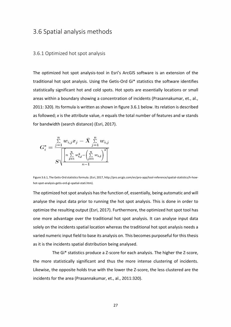
The optimized hot spot analysis-tool in Esri’s ArcGIS software is an extension of the
traditional hot spot analysis. Using the Getis-Ord Gi* statistics the software identifies
statistically significant hot and cold spots. Hot spots are essentially locations or small
areas within a boundary showing a concentration of incidents (Prasannakumar, et., al.,
2011: 320). Its formula is written as shown in figure 3.6.1 below. Its relation is described
as followed; x is the attribute value, n equals the total number of features and w stands
for bandwidth (search distance) (Esri, 2017).
Figure 3.6.1, The Getis-Ord statistics formula. (Esri, 2017, http://pro.arcgis.com/en/pro-app/tool-reference/spatial-statistics/h-how-
hot-spot-analysis-getis-ord-gi-spatial-stati.htm).
The optimized hot spot analysis has the function of, essentially, being automatic and will
analyse the input data prior to running the hot spot analysis. This is done in order to
optimize the resulting output (Esri, 2017). Furthermore, the optimized hot spot tool has
one more advantage over the traditional hot spot analysis. It can analyse input data
solely on the incidents spatial location whereas the traditional hot spot analysis needs a
varied numeric input field to base its analysis on. This becomes purposeful for this thesis
as it is the incidents spatial distribution being analysed.
The Gi* statistics produce a Z-score for each analysis. The higher the Z-score,
the more statistically significant and thus the more intense clustering of incidents.
Likewise, the opposite holds true with the lower the Z-score, the less clustered are the
incidents for the area (Prasannakumar, et., al., 2011:320).
28
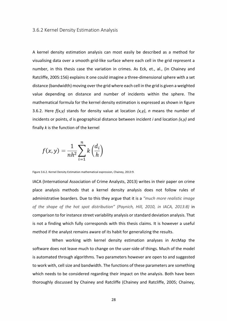
3.6.2 Kernel Density Estimation Analysis
A kernel density estimation analysis can most easily be described as a method for
visualising data over a smooth grid-like surface where each cell in the grid represent a
number, in this thesis case the variation in crimes. As Eck, et., al., (in Chainey and
Ratcliffe, 2005:156) explains it one could imagine a three-dimensional sphere with a set
distance (bandwidth) moving over the grid where each cell in the grid is given a weighted
value depending on distance and number of incidents within the sphere. The
mathematical formula for the kernel density estimation is expressed as shown in figure
3.6.2. Here f(x,y) stands for density value at location (x,y), n means the number of
incidents or points, d is geographical distance between incident i and location (x,y) and
finally k is the function of the kernel
Figure 3.6.2. Kernel Density Estimation mathematical expression, Chainey, 2013:9.
IACA (International Association of Crime Analysts, 2013) writes in their paper on crime
place analysis methods that a kernel density analysis does not follow rules of
administrative boarders. Due to this they argue that it is a “much more realistic image
of the shape of the hot spot distribution” (Paynich, Hill, 2010, in IACA, 2013:8) in
comparison to for instance street variability analysis or standard deviation analysis. That
is not a finding which fully corresponds with this thesis claims. It is however a useful
method if the analyst remains aware of its habit for generalizing the results.
When working with kernel density estimation analyses in ArcMap the
software does not leave much to change on the user-side of things. Much of the model
is automated through algorithms. Two parameters however are open to and suggested
to work with, cell size and bandwidth. The functions of these parameters are something
which needs to be considered regarding their impact on the analysis. Both have been
thoroughly discussed by Chainey and Ratcliffe (Chainey and Ratcliffe, 2005; Chainey,
29
2013) as little previous research or evaluation on their impact on crime mapping had
been done on this topic previously.
Chainey did his evaluation on these parameters using his own set of past
crime-data. For an extensive review on the parameters confer Chainey (2013). The
important notes for this thesis are found in Chainey’s conclusions. He found that cell size
makes little difference on the analysis precision and that the impact is more of an
aesthetic decision (Chainey, 2013:16). The decision on cell size then is rather dictated by
how important visuals are and computing power. For the above reasons the thesis will
use a sell size of 1 for creating the kernel density outputs. It will produce a smoother
raster dataset which could improve or help with visual interpretation for maps in smaller
scale as well as increasing the ability to distinguish small variations.
More important is the decision on bandwidth and its impact on the analysis.
Bandwidth in the kernel density analysis directly translates to the search radius when
finding hot spots. Depending on the size of the study area and the number of incidents
analysed a too large bandwidth could translate into finding hot spots which are too large
to be of importance. On a global scale it would make sense to study hot spots covering
blocks or neighbourhoods as is the case in Chainey’s 2013 paper which applied a kernel
density estimation analysis on the entire city of Newcastle. Such an analysis leaves a
larger freedom when it comes to adjusting the bandwidth used. Likewise, a too small
bandwidth would reveal hot spots consisting of very few incidents and thus making the
findings hard to legitimize.
For this thesis the bandwidth formula from Chainey (ibid:10) was used.
Measuring the shorter side of the study areas minimum bounding rectangle and dividing
that distance with 150 and then multiply the following value with 5. To find a constant
minimum bounding rectangle for the analysis the decision fell on finding an average
sized rectangle where the significant cluster was within 95% confidence or higher.
Measuring all the outputs from the hot spot analysis the average (mean) shortest side
of these outputs were 3382 meters. and calculating the bandwidth based on the mean
distance (81188/24 = 3382). As such the bandwidth used for the kernel density analysis
end up at 112 meters (3382/150*5). It would be possible to experiment with different
bandwidths however the formula suggested here is common practice within criminology
and in some software’s used the default method for calculating bandwidth (ibid:10).
30
3.6.3 The Average Nearest Neighbor tool.
The average nearest neighbor-tool was used to determine the statistical significance of
the clustering of incidents which the kernel density analysis detected. The tool analyses
the point spread and produces five outputs for interpretation: observed mean distance,
expected mean distance, nearest neighbor index, z-score and finally p-value.
The values of importance to this analysis is the z-score and p-value. The p-value
analyses the probability for the distribution of the data-set to be caused by some
(unknown) random process. The z-score represents the standard deviation for the data-
set. Together, when within the “desired” range, they provide a confidence-level to the
analysis as well as the statistical significance. It is then for the researcher to determine
how conservative one wishes to be with the confidence-level, usually determining
between a 90, 95 or 99% confidence-level. Finally, the Z-score also give an indication to
clustering-tendencies providing a measurable tool for analysis-methods which does not
provide the same statistical detail, such as the kernel density analysis.
3.7 Chapter conclusion
This chapter has outlined the methodological approach to the data and aim of this
master’s thesis when moving on to the analysis-chapter. It also highlights the tasks and
purposes of each individual analysis method used, the manipulation and usage of data
and its considerations as well as framing the general methodological approach
31
4. Analysis/Findings/Evaluation
The explorative approach provided by applying the methodology of grounded theory to
the dataset used determined the workflow and the process of how this data was
analysed. Prior to formulating any possible theories there is therefore a need for general
analysis on the incident-data’s spatial distribution. Once an indication on how this
distribution is organized in space the analysis can continue and, if considered necessary,
a theory could be applied to the results.
4.1 A global perspective on crime – clusters and hot spots
through Optimized Hot Spot analysis
The results for the Optimized Hot Spot analysis will be presented bi-monthly as
discussed in the methodology-chapter. These results will be discussed and analysed as
a means for further extending the analysis. Table 4.1 outlines how crimes in 2007 are
distributed on a bi-monthly period.
Table 4.1: Proportion of crimes / period analysed for the year 2007.
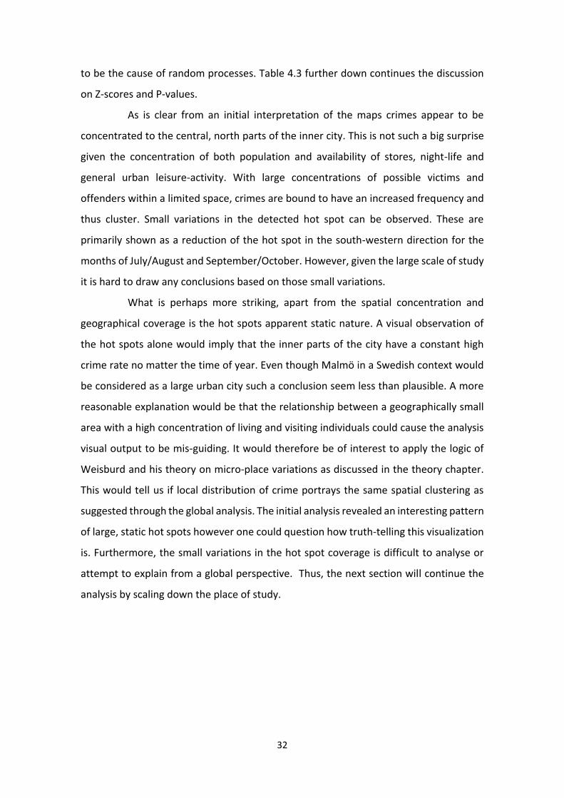
The initial analysis can be observed in figure 4.1 which displays the six outputs from the
optimized hot spot analysis for 2007. Each of the six maps represent two months of the
year. The output produces a raster-grid representing significant cold spots (dark blue)
too significant hot spots (dark red) as well as grids with zero significance (white). Areas
not covered by said raster-grid show no indication of clustering or dispersion. In
common for all the cells indicating where significant hot spots are present are large Z-
scores representing standard deviations along with very small P-values representing
statistical significance. Statistical significance is the probability of the observed pattern
Period Jan Feb
Mar Apr
May Jun
Jul Aug
Sep Oct
Nov Dec
Incidents reported: 1707 1389 2026 1743 1632 1379
% of total: 17,284% 14,064% 20,514% 17,648% 16,524% 13,963%
32
to be the cause of random processes. Table 4.3 further down continues the discussion
on Z-scores and P-values.
As is clear from an initial interpretation of the maps crimes appear to be
concentrated to the central, north parts of the inner city. This is not such a big surprise
given the concentration of both population and availability of stores, night-life and
general urban leisure-activity. With large concentrations of possible victims and
offenders within a limited space, crimes are bound to have an increased frequency and
thus cluster. Small variations in the detected hot spot can be observed. These are
primarily shown as a reduction of the hot spot in the south-western direction for the
months of July/August and September/October. However, given the large scale of study
it is hard to draw any conclusions based on those small variations.
What is perhaps more striking, apart from the spatial concentration and
geographical coverage is the hot spots apparent static nature. A visual observation of
the hot spots alone would imply that the inner parts of the city have a constant high
crime rate no matter the time of year. Even though Malmö in a Swedish context would
be considered as a large urban city such a conclusion seem less than plausible. A more
reasonable explanation would be that the relationship between a geographically small
area with a high concentration of living and visiting individuals could cause the analysis
visual output to be mis-guiding. It would therefore be of interest to apply the logic of
Weisburd and his theory on micro-place variations as discussed in the theory chapter.
This would tell us if local distribution of crime portrays the same spatial clustering as
suggested through the global analysis. The initial analysis revealed an interesting pattern
of large, static hot spots however one could question how truth-telling this visualization
is. Furthermore, the small variations in the hot spot coverage is difficult to analyse or
attempt to explain from a global perspective. Thus, the next section will continue the
analysis by scaling down the place of study.
33
Figure 4.1. Optimized Hot Spot analysis on crimes in Malmö city 2007. Signs of steady spatial and temporal placement.

34
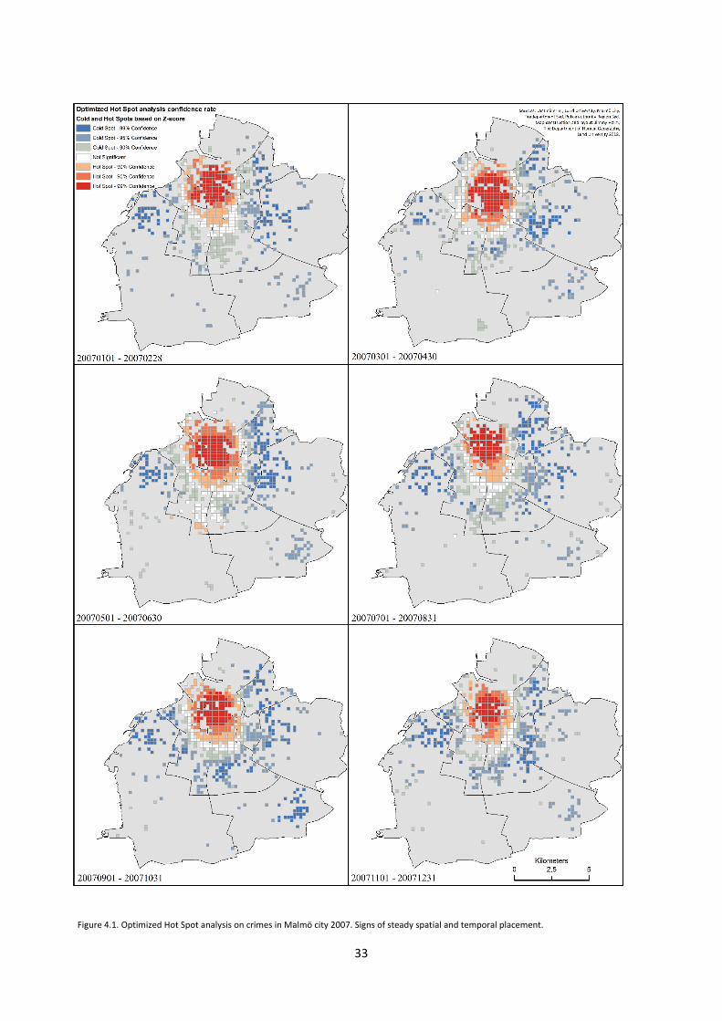
4.2 Kernel density analysis – from global to local.
The optimized hot spot analysis concluded that observed hot spots were relatively static
both spatially and temporally. The tool also suggested that most of the central parts of
Malmö city was the victim of repeat victimization. This observation should be analysed
further however as such a theory does not agree with the every-day experiences of
those living in the city, nor with the lack of alarming reports for the crime-situation of
Malmö city (this discusses “smaller” crimes, as such recent outbursts of shootings does
not apply here). It is more appropriate to suspect that the large scale of previous analysis
area mask small differences in spatial distribution.
What is also in need of further analysis is the small variations detected within
the hot spot analysis. Applying a kernel density analysis may reveal whether this notion
from the optimized hot spot analysis holds true and possibly reveal patterns with the
change of time. These possible patterns could be related to seasonal changes or events.
The area of analysis will be the geographical area highlighted as a static hot spot through
the optimized hot spot analysis. Any places or locations which does distinguish
themselves will be discussed in detail further below.
The initial analysis discusses the spatial distribution of crime hot spots. These
are visualized through a raster-layer produced through a kernel density estimation-
analysis as shown in figure 4.2 below. The darker green indicate that density is higher
than for places without clustering. Note however that green to yellow does not correlate
to high crime-rates. It is possibly more suitable to consider small patches of green as
signs of no clustering as it is hard to determine how many incidents are counted for in
those locations. As crimes cluster and concentrate to smaller places the analysis
indicates this by shifting towards orange and red. The further too red the higher
concentration of crimes. This is where one may discuss these hot spots as high-crime
areas.
Studying the bi-monthly periods analysed one can observe that the months
of January and February show a centrally weighted pattern where patches of low-
density hot spots concentrate from Södra Innerstaden through Centrum where it is
dissolved. Its most intense concentration is located around Centrum while the remaining
hot spots are deep-green suggesting that clustering is present yet rather low in intensity.
35
Figure 4.2. Visualization of kernel density analysis output. From dark green to red indicating increased clustering and density of incidents.
36
March and April suggest a similar pattern, however lacking the same amount of high-
intensity hot spot as the previous period would suggest. Hot spots also cover a larger
geographical area between the areas of Centrum and Södra Innerstaden.
May and June indicate the strongest, and largest, high-density clusters while
also indicating that density hot spots cover less space of the study area. They mainly
cover locations west and east of Centrum and just north of Södra Innerstaden. July and
August further follow the observations from the May and June-period. July and August
do show a heightened intensity near Centrum while showing the opposite development
near Södra Innerstaden with a reduced intensity. Although the May, June period and
July, August period show similarities to presence of high intensity clustering they
differentiate themselves in regard to spatial placement. July and August further show a
larger, general distribution of clustering.
By September and October all high-intensity hot spots have dissolved and
what remains is a very dispersed pattern of low-intensity hot spots. This pattern could
be of interest for further studies, possibly relating to the topic of crime displacement.
Finally, the months of November and December further continues this reduction in
intensity, however not as dispersed as the pattern observed for previous period.
4.3 The Average Nearest Neighbor-tool – supporting data.
As the kernel density estimation analysis does not provide the same statistical
information as the optimized hot spot analysis there is a need for supporting statistics if
one wish to draw conclusions on the significance of the hot spots detected. In order to
determine whether the visuals attained could be caused by random chance the thesis
will run the Average Nearest Neighbor-tool on each set of incidents. These results are
presented in table 4.3 below.
Table 4.3, Average Nearest Neighbor-output. Results indicating statistically significant clustering of incidents.
Period Jan/Feb Mar/Apr May/Jun Jul/Aug Sep/Oct Nov/Dec
Z-score -32,02603 -25,09675 -33,88441 -48,00314 -30,90542 -26,30323
P-score 0,00 0,00 0,00 0,00 0,00 0,00
37
As with the case of the optimized hot spot analysis the average nearest neighbor-test
tells the statistical reliability and significance of the spatial distribution on incidents and
the possibility of this being purely through random chance. This is given through a
variation in both Z-score and P-value. A high Z-score and low P-value indicates that the
distribution is dispersed. A high negative Z-score and low P-value is indicative of a
clustered distribution. Furthermore, the Z-score determines the chance of these results
being the result of random chance. In ArcMap when reaching beyond a Z-score of +-2.58
the result is on the extreme ends of the normal distribution-curve, or, on a 99%
confidence level. This would imply that the possibility of the result being the cause of
random chance is less than 1%.
The output of this test also indicates clustering tendencies. If one is to observe
the Average Nearest Neighbor-output as an indication of clustering, we may through
table 4.3 note that clustering of incidents appears to increase for the months May and
June (with a Z-score of -33,884) as well as July and August (with a Z-score of -48,003).
Further possible abnormalities would be the months of January and February (with a Z-
score of -32,026) indicating that crime intensify its clustering behaviour in comparison
to its adjacent months of March and April (a Z-score of -25,096) and November,
December (a Z-score of -26,303). However, to draw conclusions on January and February
one would need to go further back to 2006. The higher clustering for this period could
be an isolated event or a lower tail of previous intensification from the previous year.
The output of the Average nearest neighbor-tool concurs with the kernel
density analysis. For the months of January and February a slight increase in cluster
density is identified further emphasized by the peaking Z-score. It does however
contradict the kernel density analysis as high intensity hot spots are more limited and
smaller in size. This is followed by a drop off for the months of March and April possible
to observe through visualization in figure 4.2 and the Z-score in table 4.3. Crimes in May
and June once again intensifies, this time more so than for the first two months of the
year. In comparison to the months of July and August the May/June-period shows a
lower Z-score while having larger density hot spots. This is most likely explained with the
higher total rate of crime incidents for the months of May/June as outlined in table 4.1
and due to July and August having a higher count of small clusters.
38
From September and onward the Z-score gradually decreases suggesting that clustering
decreases. This pattern is possible to observe from the kernel density analysis visualized
in figure 4.2. September/October, as discussed previously, lack high-intensity hot spots
while having a large spread of low-intensity hot spots. November/December follows the
pattern of a gradually decreasing clustering and also a reduction in total number of
crimes as shown in table 4.1.
Having processed the data through the kernel density analysis and the
average nearest neighbour-tool the output tells us two things. Firstly, as discussed in the
previous section, crime clustering and dispersion varies over the year. During the
summer months crime cluster to specific locations. One suspicion for this distribution
relates to holidays and school-breaks. Two of them appear to recur in the same locations
as discussed in the following section. For the other months (January through April and
September through December) crime-rates or clustering appear to be seemingly static
with few or no high crime hot spots as well as large dispersion over the study area.
Secondly, the average nearest neighbour-tool agrees with the kernel density
analysis as far as clustering-trends go. For that reason, one may conclude that the kernel
density-visualization is reliable. Together with the distribution of crime-count over the
year and its clustering, the summer months could be considered an anomaly. Crime
count increases and clustering intensifies while the total geographical spread of crime
clusters is reduced. The two recurring hot spots would then be particularly interesting.
As such the next section will highlight those hot spots.
4.4 Repeat-victimization and static high crime hot spots.
As discussed in the theory-chapter repetitive crime-patterns are considered of high
interest (Farrell, et., al., 1995:384) and it is argued that this is more important than
analysing sporadic crime spots. It may hide processes or structures which enables or
allows for criminal activity. As such emphasis in this section will be on if, when and
where high-intensity hot spots repeat themselves.
39
Identifying intensity-levels is possible through the contour-list tool. It functions by
determining a cell-value to base its contour on. This cell-value will relate to intensity in
crime-clustering as well as crime-count (as they are related). As a means for
standardizing the identification of hot spots the analysis is determined upon the most
intense period. In this case it is the months of May and June. The results can be seen in
figure 4.4. Based on those visuals one may draw three conclusions.
First, it highlights locations where hot spots of high crime-rates appear
through the visible contour-list (visualized as black circles around hot spots). In total
there were 11 locations which stood out as high-intensity hot spots through the kernel
density analysis. Secondly, it becomes visible that high-crime hot spots are non-existent
for the periods March through April and September through December. For the period
of January and February one small high-crime hot spot can be observed just south of the
Centrum label. For the period of May through August hot spots of high crime are more
prevalent, larger and showing a more intense clustering. Thirdly, one can observe that
two high-crime hot spots show tendencies for repeat victimization during the most
intense months of the year.
While all hot spots are of interest from a crime-preventive and crime-fighting
perspective the recurrence of hot spots call for increased attention as some process(es)
allow for this to occur. Many criminology theories highlight this as a main-concern within
crime-preventive work (e.g routine activity theory and rational choice theory). These
repeated high-crime hot spots will be discussed in more detail in the following section.
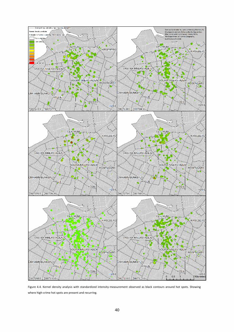
40
Figure 4.4. Kernel density analysis with standardized intensity-measurement observed as black contours around hot spots. Showing
where high-crime hot spots are present and recurring.
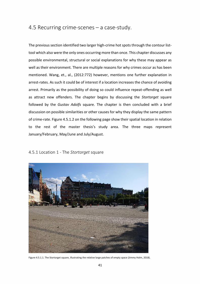
41
4.5 Recurring crime-scenes – a case-study.
The previous section identified two larger high-crime hot spots through the contour list-
tool which also were the only ones occurring more than once. This chapter discusses any
possible environmental, structural or social explanations for why these may appear as
well as their environment. There are multiple reasons for why crimes occur as has been
mentioned. Wang, et., al., (2012:772) however, mentions one further explanation in
arrest-rates. As such it could be of interest if a location increases the chance of avoiding
arrest. Primarily as the possibility of doing so could influence repeat-offending as well
as attract new offenders. The chapter begins by discussing the Stortorget square
followed by the Gustav Adolfs square. The chapter is then concluded with a brief
discussion on possible similarities or other causes for why they display the same pattern
of crime-rate. Figure 4.5.1.2 on the following page show their spatial location in relation
to the rest of the master thesis’s study area. The three maps represent
January/February, May/June and July/August.
4.5.1 Location 1 - The Stortorget square
Figure 4.5.1.1. The Stortorget square, illustrating the relative large patches of empty space (Jimmy Holm, 2018).
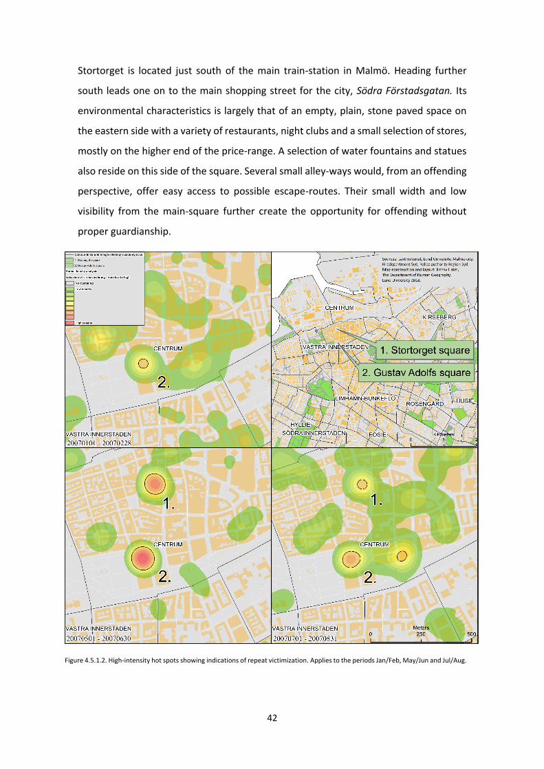
42
Stortorget is located just south of the main train-station in Malmö. Heading further
south leads one on to the main shopping street for the city, Södra Förstadsgatan. Its
environmental characteristics is largely that of an empty, plain, stone paved space on
the eastern side with a variety of restaurants, night clubs and a small selection of stores,
mostly on the higher end of the price-range. A selection of water fountains and statues
also reside on this side of the square. Several small alley-ways would, from an offending
perspective, offer easy access to possible escape-routes. Their small width and low
visibility from the main-square further create the opportunity for offending without
proper guardianship.
Figure 4.5.1.2. High-intensity hot spots showing indications of repeat victimization. Applies to the periods Jan/Feb, May/Jun and Jul/Aug.
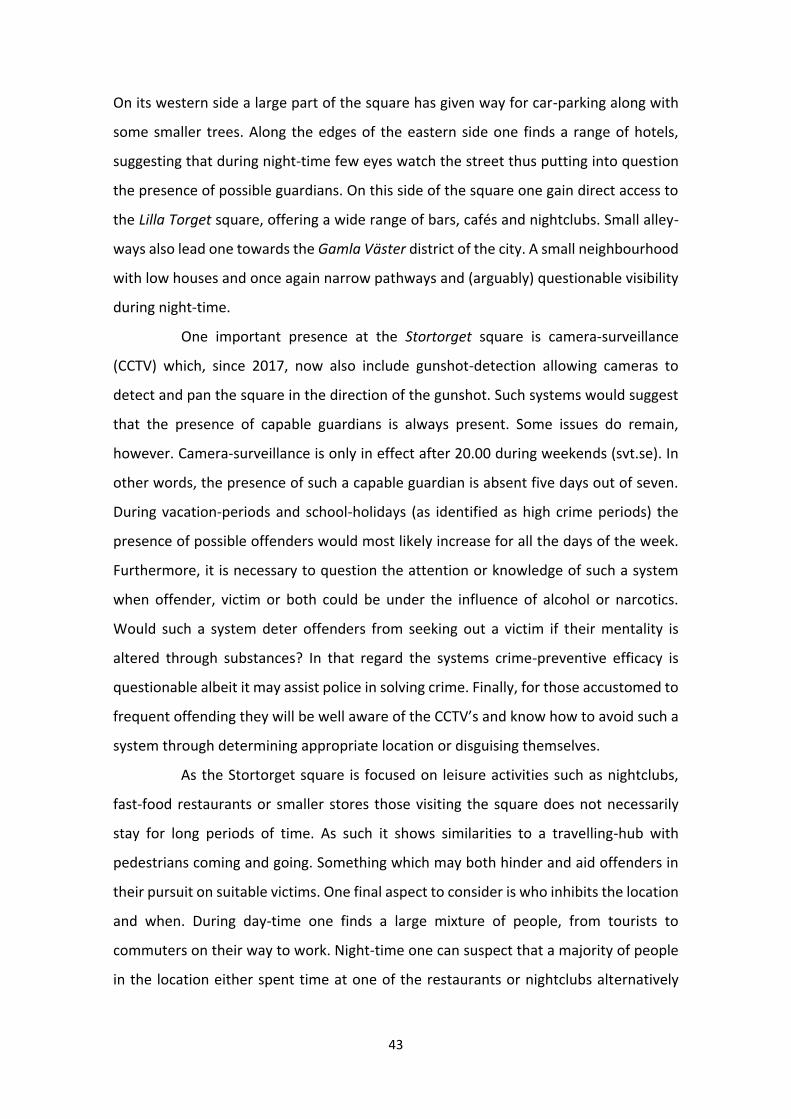
43
On its western side a large part of the square has given way for car-parking along with
some smaller trees. Along the edges of the eastern side one finds a range of hotels,
suggesting that during night-time few eyes watch the street thus putting into question
the presence of possible guardians. On this side of the square one gain direct access to
the Lilla Torget square, offering a wide range of bars, cafés and nightclubs. Small alley-
ways also lead one towards the Gamla Väster district of the city. A small neighbourhood
with low houses and once again narrow pathways and (arguably) questionable visibility
during night-time.
One important presence at the Stortorget square is camera-surveillance
(CCTV) which, since 2017, now also include gunshot-detection allowing cameras to
detect and pan the square in the direction of the gunshot. Such systems would suggest
that the presence of capable guardians is always present. Some issues do remain,
however. Camera-surveillance is only in effect after 20.00 during weekends (svt.se). In
other words, the presence of such a capable guardian is absent five days out of seven.
During vacation-periods and school-holidays (as identified as high crime periods) the
presence of possible offenders would most likely increase for all the days of the week.
Furthermore, it is necessary to question the attention or knowledge of such a system
when offender, victim or both could be under the influence of alcohol or narcotics.
Would such a system deter offenders from seeking out a victim if their mentality is
altered through substances? In that regard the systems crime-preventive efficacy is
questionable albeit it may assist police in solving crime. Finally, for those accustomed to
frequent offending they will be well aware of the CCTV’s and know how to avoid such a
system through determining appropriate location or disguising themselves.
As the Stortorget square is focused on leisure activities such as nightclubs,
fast-food restaurants or smaller stores those visiting the square does not necessarily
stay for long periods of time. As such it shows similarities to a travelling-hub with
pedestrians coming and going. Something which may both hinder and aid offenders in
their pursuit on suitable victims. One final aspect to consider is who inhibits the location
and when. During day-time one finds a large mixture of people, from tourists to
commuters on their way to work. Night-time one can suspect that a majority of people
in the location either spent time at one of the restaurants or nightclubs alternatively
44
heading through to catch a train or on its way home. If such assumption holds true one
can argue that there is a socio-cultural shift depending on the hour of the day.
4.5.2 Location 2 - The Gustav Adolfs square
Gustav Adolfs square is located just further south from the Stortorget square. The
square is connected, mainly, by the large shopping-street Södra Förstadsgatan
mentioned in the previous section. A range of smaller streets would also be considered
as links between the two squares however those would involve some minor criss-
crossing around and between smaller buildings.
Figure 4.5.2.1. The Gustav Adolfs square with signs of temporary and permanent physical structures (Jimmy Holm, 2018).

45
In environmental or structural terms this square is quite congested. Large trees, hedges,
water fountains, buildings with public bathrooms, several bus stops and roads passing
through would suggest that the presence of pedestrians would be vibrant and present.
However, it also suggest that visibility is quite low. The larger presence of both stores
and restaurants suggest that possible victims are abundant. This could, given the
obstructed vision throughout the square, imply that the possibility for offender, victim
and a lack of capable guardians to meet in time and space is likely. Being subjected to a
crime at such a location appear most likely during later hours as low visibility together
with reduced population increase the impact of obstructed visibility. However, one
could suspect that the possibility for offenders to find a suitable target is not restricted
to night-time. Rather it is a matter of finding the time when guardians are lacking. Such
as after prime rush-hour as a large part of populations are at work or schools.
4.6 Environmental and structural enablers: similarities and
differences in hot spots.
There are several similarities between the two locations discussed which are at play
when discussing crime-processes. First, they are both large hubs for retail and leisure
within the city. Having a large range of both stores, cafés, pubs, available seating means
there is always going to be a steady stream in/out as well as residing victims and
offenders. Secondly, after concluding that the CCTV present at Stortorget is of limited
assistance, the presence of guardians is not enough. It is possible to remain both unseen
and aware of any hinderance to commit crimes. And if need be, it is possible to follow
any targeted victim if one decides to venture into the outer surroundings of the area for
further discretion.
The differences between the two locations can be observed from a
structural standpoint. While they are both large hubs of people venturing to, from and
through, hey do differ by how the squares are used by people with Gustav Adolfs having
a bigger tendency for crowds of people remaining longer. Stortorget is seemingly quite
46
flat, open and easy to move around with only few large buildings and statues disturbing
visibility. Gustav Adolfs however is more build, have more statues, high hedges, trees
and water fountains. With this in mind visibility is much worse giving more discretion to
offenders. It also further reduces the impact of possible capable guardians as they are
unable to monitor the entire location at one time.
5.Discussion
This master’s thesis primarily grew out of an interest for physical variations within space
and its relation and impact on crime-trends and clustering. However, after initial analysis
and research it became evident that such studies reached beyond the extent of both
time and availability of data. That being said, it provided a framework for analysing how
and where crime cluster as well as how it changes on a temporal scale. It is clear from
this thesis that the outdoor-crimes analysed in this thesis have their highest peaks at
and around large gathering-points, which is not all too surprising. If one was to move
forward with this thesis it would be of great interest to change scope and identify those
locations which show a relatively high intensity while geographically limited. If those
were isolated one could move forward with the initial idea for this master’s thesis and
measure possible correlation to physical factors or structural presence/absence.
With limited number of locations and fewer physical and structural factors to
measure it would increase the chance for gaining reliable results from a thesis. This
master’s thesis preliminary focus was on the whole of Malmö and outdoor crimes for
2007. Something which was likely too hard to measure successfully. One issue to
overcome remain however. If one work under the assumption that the production and
spatiality of crime works under the routine activity theory or rational choice theory one
must acknowledge that crime is inherently based on opportunistic behaviour. In there
the conflict lies. Weisburd, et., al., (2016:56) argue that the relationship between crime
and opportunity is that of a non-linear relationship. If Weisburds claims hold true, can
47
one measure such correlation? It is possible that the limitation lies within the software
used.
6.Conclusion
There are several conclusions which can be drawn from this master’s thesis. The purpose
of the thesis and the questions framing the analysis was largely answered. However,
some questions still remain, including both application of methods and the final results.
The question on whether the optimized hot spot analysis and kernel density estimation
analysis could detect possible hot spots of crime, the short answer is yes. Both methods
showed signs of spatial clustering and annual changes depending on the time of year
studied. Their individual performance however, is discussed further down as the
question of compatibility and end-result was quite different.
One of the main-questions were on the spatial distribution of crime for the
year 2007 and if patterns changed over the year. The analysis showed that clustering-
tendencies of crime changed over the year. In the analysis a differentiation was made
on these clusters depending on their intensity. What in the analysis was called high
intensity hot spots were few (11 hot spots). It was further possible to observe that
clustering tendencies, and thus hot spots, was at its highest peak for the months of May
through August. Few clusters appeared for the remaining months. Interestingly only two
of those locations showed signs of repeat-victimization. This answers the question on
whether there were signs of repeat-victimization. Regarding the question on possible
distinguishing features of those repeat-victimization locations, both two locations were
found to be large hubs where individuals gathered at and/or passed through while
moving through the city.
As for the case study of the two repeat-victimization locations identified in
the analysis the thesis concluded that crime had its largest repeated clustering within
the proximity of Stortorget and Gustav Adolfs square. One possible explanation for this
is, as mentioned, their aggregation of people. A wide array of stores, hotels, restaurants

48
and other leisure activities draw people, including offenders. More so they both provide
structural designs which in different ways could encourage or enable offenders to use
these locations as place of crime. One location with visual obstacles providing cover and
the other as a desolate place where possible victims are easy to target and several
escape-routes. Both factors, along with their tendency to draw larger crowds of people
relate to processes which impact crime occurrence.
One possible explanation as to why Stortorget show similar crime tendencies
as Gustav Adolfs could be explained by further extending the temporal analysis.
Proceeding with these findings for further studies could be to divide the crime into hours
of the day. If most crimes at Stortorget were to occur during late evening and nights, the
reason could possibly be that offenders feel secure in desolated places. For instance,
relating to (the lack of) capable guardians as suggested by the routine activity theory. It
would then question the idea that a deserted square increases visibility and as such the
feeling of security and the possibility for guardians to intervene or deter diminishes.
Instead it would suggest that offenders use the open space as a means for finding a good
opportunity for offending.
The following section(s) will discuss the remaining questions. It was asked how
the methodology used for this thesis should be applied. It was further asked if these
methods showed similar outcomes, if they were in fact complementary or possibly
contradicting. Both the optimized hot spot analysis tool and the kernel density
estimation analysis are developed to find hot spots for events or incidents. The
optimized hot spot analysis also indicates the significance for our results. There are
obvious advantages to this such as determining the reliability of our model. The same
cannot be said about the kernel density analysis. That being said, the optimized hot spot
analysis performed less well in regard to identifying variations within the hot spots while
the model did manage to highlight the larger area where crime had a tendency to
cluster.
The optimized hot spot analysis provided the thesis with a framework of
where the study area for further analysis were to be conducted. Through this method
the GIS software concluded that a large section of central Malmö was considered a
crime-hot spot. As the scale of analysis was for the entire city of Malmö the method
provided low detail in its findings making variations within space hard to identify. Finally,
49
the method provided statistics to further provide reliability to its results as was
mentioned. There were also questions raised as to how accurate the model-output was.
One suspicion with the optimized hot spot analysis was that the small geographical size
of inner-city Malmö together with large aggregations of individuals living and visiting
caused an imbalance in the analysis. Further investigation turned to running a kernel
density analysis-tool on that geographical area.
The kernel density analysis showed its use primarily in finding variations
within the smaller study area identified in the optimized hot spot analysis. The liability
when using a model which does not provide the statistical metadata, as the optimized
hot spot analysis does, is that one cannot judge its credibility nor reliability. For this
master’s thesis the workaround to this was to use the average nearest neighbor-tool.
Running that tool on the same data-set as used for the kernel density analysis one could
observe both fluctuation in time on clustering as well as the significance. The results
from both these models suggested that the visual output from our kernel density
analysis was consistent with how the average nearest neighbor-tool measured
clustering tendencies. It also suggested that the likelihood of this clustering to be the
cause of random chance was very low. Most prominent and intense clusters were
identified for the months of May to August. This could indicate that crime-clusters and
hot spots correlate with both school-breaks, holidays and gathering of tourists.
Questions were however raised for the months of January and February. While the
visual output of the kernel density analysis suggested clustering was low the average
nearest neighbor tool showed clustering tendencies to be near-equal to those of May
and June.
As a conclusion on the performances of used methods in this master’s thesis
it appears reasonable to argue that they have separate uses depending on the data and
scale of analysis. Most noticeable perhaps is the optimized hot spot analysis tendency
to over-generalize the coverage of hot spots and the kernel density analysis to not
provide necessary data to evaluate the results. For research which does not rely on one
geographical area they are suitable as a means for measuring each other’s performance
throughout the analysis. The optimized hot spot analysis performed well in regard to
finding the study area where crimes were indeed more frequent than for other places.
It also indicated that the findings were to be accurate in terms of reliability. Re-framing

50
the study-area and running it through the kernel density analysis provided the thesis
with detailed visuals on where crime cluster and its dispersion where it does not cluster.
Concluding the analysis with the average nearest neighbor-tool on our kernel density
data one could substantiate the visuals with statistical arguments. One tendency to be
aware of when working with the kernel density estimation-analysis is awareness of low-
intensity clusters. Depending on the data used, frequency of incidents and study area
clusters can be visualized without being proper clusters. There are occasions when 2-3
incidents were visualized as low-intensity hot spots.
As a conclusion to this master’s thesis one may argue that both methods used
here have their uses. But more so they complement each other, where one provides us
with statistical predictions and arguments for one’s case. The other provide us with the
possibility of detecting variations within smaller spaces. These two methods, the
optimized hot spot analysis and kernel density analysis, are particularly complementary
when taking on an exploratory approach where one appears more suitable for global
analysis while the other has an advantage when working on a smaller study area. From
a practical standpoint the use of both methods would provide crime-preventive work
with assistance both from a resource-allocation perspective as well as insight on where
patrolling or monitoring of places are of most effect. As such they prove a suitable future
approach to crime-analysis.
List of References
Agnew, John, 1987, Space and Place, The SAGE Handbook of Geographical Knowledge, Agnew, John, Livingstone, N. David (eds.), Sage Publications, Thousand Oaks. Agnew, John, (1987), Place and politics: The geographical mediation of state and society, Boston MA, Allen and Unwin. Allan, George, (2003) A critique of using grounded theory as a research method, Portsmouth University, UK. Andresen, A. Martin, Farrell, Graham, (2015) The Criminal Act – The Role and Influence of Routine Activity Theory, Palgrave Macmillan, London. Blakemore, Michael, Longhorn, Roger, (2004) Ethics and GIS: The Practitioner’s Dilemma – a position paper on GIS ethics, AGI 2004 Workshop on “GIS Ethics”, London. Bohman, Helena, Gerell, Manne, Lundsten, Jonas, Tykesson, Mona, (2013) Stadens Bränder Del 2 – Fördjupning, Malmö, Publikationer i Urbana Studier. Ceccato, Vania, (2012) The Urban Fabric of Crime and Fear, Springer, London. Chainey, Spencer, Ratcliffe, Jerry, (2005) GIS and Crime Mapping, John Wiley & Sons, Ltd, West Sussex. Chainey, Spencer, (2013) Examining the influence of cell size and bandwidth size on kernel density estimation crime hot spot maps for predicting spatial patterns of crime, Bulletin of the Geographical Society of Liege, Vol:60, pp:7-19. Cloke, Paul, Cook, Ian, Crang, Philip, Goodwin, Mark, Painter, Joe, Philo, Chris, (2004) Practicing human geography, Sage Publications, Thousand Oaks. Cohen, E. Lawrence, Felson, Marcus, (1979) Social Change and Crime Rate Trends: A Routine Activity Approach, American Socilogical Reviev, 44:4, pp:588-608. Cozens, P., 2008, Crime Prevention Through Environmental Design, Environmental Criminology and Crime Analysis, Wortley, R., Mazerolle, L. (eds.), pp: 153-177, Devon, UK. Dagens Nyheter, Rekordfå brott klaras upp efter polisens omorganisation, published 2016-08-30. [http://www.dn.se/nyheter/sverige/rekordfa-brott-klaras-upp-efter-polisens-omorganisation/, accessed 2017-05-29]. Denzin, Norman, Lincoln, Yvonna, 2000, Handbook of Qualitative Research, Sage publications, Thousand Oaks.
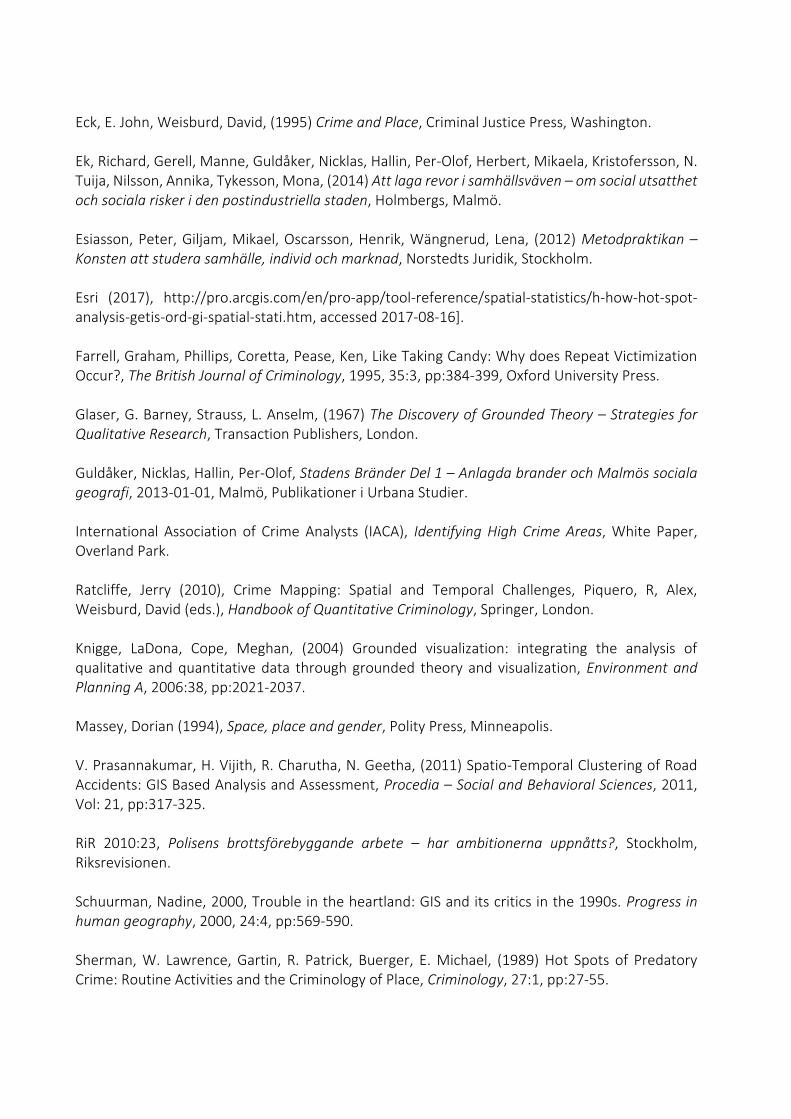
Eck, E. John, Weisburd, David, (1995) Crime and Place, Criminal Justice Press, Washington. Ek, Richard, Gerell, Manne, Guldåker, Nicklas, Hallin, Per-Olof, Herbert, Mikaela, Kristofersson, N. Tuija, Nilsson, Annika, Tykesson, Mona, (2014) Att laga revor i samhällsväven – om social utsatthet och sociala risker i den postindustriella staden, Holmbergs, Malmö. Esiasson, Peter, Giljam, Mikael, Oscarsson, Henrik, Wängnerud, Lena, (2012) Metodpraktikan – Konsten att studera samhälle, individ och marknad, Norstedts Juridik, Stockholm. Esri (2017), http://pro.arcgis.com/en/pro-app/tool-reference/spatial-statistics/h-how-hot-spot-analysis-getis-ord-gi-spatial-stati.htm, accessed 2017-08-16]. Farrell, Graham, Phillips, Coretta, Pease, Ken, Like Taking Candy: Why does Repeat Victimization Occur?, The British Journal of Criminology, 1995, 35:3, pp:384-399, Oxford University Press. Glaser, G. Barney, Strauss, L. Anselm, (1967) The Discovery of Grounded Theory – Strategies for Qualitative Research, Transaction Publishers, London. Guldåker, Nicklas, Hallin, Per-Olof, Stadens Bränder Del 1 – Anlagda brander och Malmös sociala geografi, 2013-01-01, Malmö, Publikationer i Urbana Studier. International Association of Crime Analysts (IACA), Identifying High Crime Areas, White Paper, Overland Park. Ratcliffe, Jerry (2010), Crime Mapping: Spatial and Temporal Challenges, Piquero, R, Alex, Weisburd, David (eds.), Handbook of Quantitative Criminology, Springer, London. Knigge, LaDona, Cope, Meghan, (2004) Grounded visualization: integrating the analysis of qualitative and quantitative data through grounded theory and visualization, Environment and Planning A, 2006:38, pp:2021-2037. Massey, Dorian (1994), Space, place and gender, Polity Press, Minneapolis. V. Prasannakumar, H. Vijith, R. Charutha, N. Geetha, (2011) Spatio-Temporal Clustering of Road Accidents: GIS Based Analysis and Assessment, Procedia – Social and Behavioral Sciences, 2011, Vol: 21, pp:317-325. RiR 2010:23, Polisens brottsförebyggande arbete – har ambitionerna uppnåtts?, Stockholm, Riksrevisionen. Schuurman, Nadine, 2000, Trouble in the heartland: GIS and its critics in the 1990s. Progress in human geography, 2000, 24:4, pp:569-590. Sherman, W. Lawrence, Gartin, R. Patrick, Buerger, E. Michael, (1989) Hot Spots of Predatory Crime: Routine Activities and the Criminology of Place, Criminology, 27:1, pp:27-55.
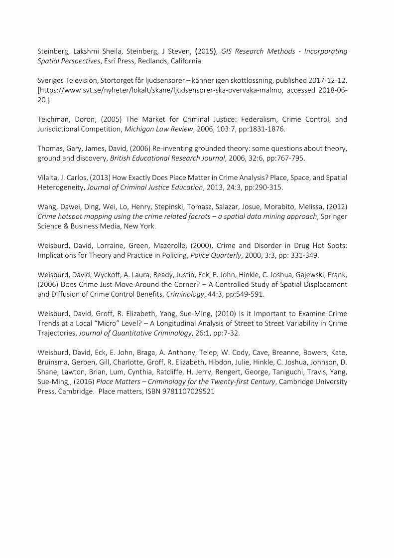
Steinberg, Lakshmi Sheila, Steinberg, J Steven, (2015), GIS Research Methods - Incorporating Spatial Perspectives, Esri Press, Redlands, California. Sveriges Television, Stortorget får ljudsensorer – känner igen skottlossning, published 2017-12-12. [https://www.svt.se/nyheter/lokalt/skane/ljudsensorer-ska-overvaka-malmo, accessed 2018-06-20.]. Teichman, Doron, (2005) The Market for Criminal Justice: Federalism, Crime Control, and Jurisdictional Competition, Michigan Law Review, 2006, 103:7, pp:1831-1876. Thomas, Gary, James, David, (2006) Re-inventing grounded theory: some questions about theory, ground and discovery, British Educational Research Journal, 2006, 32:6, pp:767-795. Vilalta, J. Carlos, (2013) How Exactly Does Place Matter in Crime Analysis? Place, Space, and Spatial Heterogeneity, Journal of Criminal Justice Education, 2013, 24:3, pp:290-315. Wang, Dawei, Ding, Wei, Lo, Henry, Stepinski, Tomasz, Salazar, Josue, Morabito, Melissa, (2012) Crime hotspot mapping using the crime related facrots – a spatial data mining approach, Springer Science & Business Media, New York. Weisburd, David, Lorraine, Green, Mazerolle, (2000), Crime and Disorder in Drug Hot Spots: Implications for Theory and Practice in Policing, Police Quarterly, 2000, 3:3, pp: 331-349. Weisburd, David, Wyckoff, A. Laura, Ready, Justin, Eck, E. John, Hinkle, C. Joshua, Gajewski, Frank, (2006) Does Crime Just Move Around the Corner? – A Controlled Study of Spatial Displacement and Diffusion of Crime Control Benefits, Criminology, 44:3, pp:549-591. Weisburd, David, Groff, R. Elizabeth, Yang, Sue-Ming, (2010) Is it Important to Examine Crime Trends at a Local “Micro” Level? – A Longitudinal Analysis of Street to Street Variability in Crime Trajectories, Journal of Quantitative Criminology, 26:1, pp:7-32. Weisburd, David, Eck, E. John, Braga, A. Anthony, Telep, W. Cody, Cave, Breanne, Bowers, Kate, Bruinsma, Gerben, Gill, Charlotte, Groff, R. Elizabeth, Hibdon, Julie, Hinkle, C. Joshua, Johnson, D. Shane, Lawton, Brian, Lum, Cynthia, Ratcliffe, H. Jerry, Rengert, George, Taniguchi, Travis, Yang, Sue-Ming,, (2016) Place Matters – Criminology for the Twenty-first Century, Cambridge University Press, Cambridge. Place matters, ISBN 9781107029521