how to develop a pedestrian and bicycle safety action plan to develop a pedestrian and bicycle...
TRANSCRIPT

How to Develop a Pedestrian and Bicycle Safety Action Plan
AUGUST 2017
FHWA-SA-17-050

i
Notice
This document is disseminated under the sponsorship of the U.S. Department of Transportation in the interest of information exchange. The U.S. Government assumes no liability for the use of the information contained in this document. This report does not constitute a standard, specification, or regulation.
The U.S. Government does not endorse products or manufacturers. Trademarks or manufacturers’ names appear in this report only because they are considered essential to the objective of this document.

ii
1. Report No.
FHWA-SA-17-050
2. Government Accession No. 3. Recipient’s Catalog No.
4. Title and Subtitle
How to Develop a Pedestrian and Bicycle Safety Action Plan
5. Report Date
August 2017
6. Performing Organization Code
7. Author(s)
UNC: Dan Gelinne, Libby Thomas, Katy Lang, Charles V. Zegeer; VHB: Elissa Goughnour
8. Performing Organization Report No.
9. Performing Organization Name and Address
Vanasse Hangen Brustlin, Inc. 8300 Boone Boulevard, Suite 700 Vienna, VA 22182‐2626
University of North Carolina Highway Safety Research Center Chapel Hill, NC 27599
10. Work Unit No. (TRAIS)
11. Contract or Grant No.
DTFH61-16-D-00005
12. Sponsoring Agency Name and Address
Federal Highway Administration 1200 New Jersey Avenue, SE Washington, DC 20590
13. Type of Report and Period Covered
14. Sponsoring Agency Code
15. Supplementary Notes
FHWA Contracting Officer’s Technical Representative: Tamara Redmon Further technical input and content development provided by the National Highway Traffic Safety Administration’s (NHTSA) Safety Countermeasures Division within the Office of Safety Programs.This guide is a revision of How to Develop a Pedestrian Safety Action Plan (https://safety.fhwa.dot.gov/ped_bike/ped_focus/docs/fhwasa0512.pdf) originally developed in 2006 and revised in 2009 for the Federal Highway Administration and National Highway Traffic Safety Administration. The current version builds on the existing content, which was created by the following authors and organizations: UNC Highway Safety Research Center (Charles V. Zegeer, Laura Sandt and Margaret Scully). Other Contributors: Michael Ronkin, Mike Cynecki, and Peter Lagerwey
16. Abstract
The purpose of this guide is to assist agencies in developing and implementing a safety action plan to improve conditions for bicycling and walking. The plan lays out a vision for improving safety, examining existing conditions, and using a data-driven approach to match safety programs and improvements with demonstrated safety concerns. This guide will help agencies enhance their existing safety programs and activities, including identifying safety concerns and selecting optimal solutions. It will also serve as a reference for improving pedestrian and bicycle safety through a multidisciplinary and collaborative approach to safety, including street designs and countermeasures, policies, and behavioral programs.
17. Key Words
Bicycle, pedestrian, safety, plan, resource, guide
18. Distribution Statement
No restrictions.
19. Security Classif. (of this report)
Unclassified
20. Security Classif. (of this page)
Unclassified
21. No. of Pages
66
22. Price
Form DOT F 1700.7 (8‐72) Reproduction of form and completed page is authorized

iii
Images
Nearly all of the images in this guide were sourced from the Pedestrian and Bicycle Information Center’s (PBIC) Image Library (www.pedbikeimages.org). A special thanks to Dan Burden, who provided most of the images used in this guide from the PBIC Image Library.

Table of Contents
iv
Chapter 1. Introduction and Background ....................................................................................................1Pedestrian and Bicyclist Safety Problem Background ........................................................................................ 1
Components of a Safety Action Plan ........................................................................................................................... 2
How to Use This Guide .......................................................................................................................................................... 5
Closing Thoughts ...................................................................................................................................................................... 6
Chapter 2. Establishing a Vision for Pedestrian and Bicyclist Safety ...................................................7Street Design Policies Affecting Nonmotorized Road Users ......................................................................... 7
Design and Policy Elements that Influence Pedestrian and Bicyclist Safety ....................................... 8
Strategies to Improve Safety ........................................................................................................................................... 12
Reviewing Existing Policies and Design Guidelines ......................................................................................... 14
Closing Thoughts ................................................................................................................................................................... 14
Chapter 3. Understanding Safety Problems ............................................................................................. 15Strategies for Identifying High-Crash or High-Risk Locations .................................................................... 15
Information Needed to Identify and Understand Safety Problems ....................................................... 16
Common Types of Safety Data ...................................................................................................................................... 16
Types of Areas to Identify ................................................................................................................................................. 20
Closing Thoughts ................................................................................................................................................................... 23
Chapter 4. Involving Stakeholders ............................................................................................................... 25Stakeholders to Involve ..................................................................................................................................................... 26
Principles and Strategies for Involving Stakeholders ...................................................................................... 29
Closing Thoughts ................................................................................................................................................................... 30
Chapter 5. Selecting Safety Improvements .............................................................................................. 31Diagnosing Safety Problems........................................................................................................................................... 31
Types of Solutions ................................................................................................................................................................. 33
Closing Thoughts ................................................................................................................................................................... 42
Chapter 6. Program Implementation and Evaluation ........................................................................... 43Funding Strategies ................................................................................................................................................................ 43
Funding Criteria and Prioritization .............................................................................................................................. 45
Major Funding Sources ...................................................................................................................................................... 45
Evaluating Safety Programs and Projects ............................................................................................................... 47
Closing Thoughts ................................................................................................................................................................... 49
Chapter 7. Summary and Conclusion ......................................................................................................... 51
Appendix A. List of Pedestrian and Bicycle Safety Guides and Resources .................................... 53
Appendix B. Examples of Pedestrian and Bicycle Safety Plans .......................................................... 55
Appendix C. Checklist of Safety Action Plan Elements ......................................................................... 57

v
How to Develop a Pedestrian and Bicycle Safety Action Plan
List of FiguresFigure 1. Pedestrian and bicyclist fatalities in the US by year, 2006 to 2015. .......................................1
Figure 2. Seattle Vision Zero data for bicycle and pedestrian safety analysis. ................................... 18
Figure 3. Santa Ana crash type identification example. .......................................................................... 19
Figure 4. Chicago Department of Transportation modal hierarchy. .................................................... 33
Figure 5. The ActiveTrans Priority Tool. ......................................................................................................... 46
List of TablesTable 1. Pedestrian and bicycle crash data and potential risks. ............................................................ 21
Table 2. Walk First crash profiles and recommended solutions. .......................................................... 37


1
1
Chapter 1. Introduction and Background
The purpose of this guide is to present an overview
and framework to develop and implement a
safety action plan to improve conditions for
bicycling and walking.
A safety action plan provides a framework for focusing your community’s attention on improving conditions for bicycling and walking. The plan lays out a vision for improving safety, examining existing conditions, and using a data-driven approach to match safety programs and improvements with demonstrated problems.
This guide is intended to help State and local officials decide where to begin to address pedestrian and bicycle safety issues. It will help agencies enhance their existing safety programs and activities, including identifying safety problems and selecting optimal solutions. The guide will also serve as a reference for improving pedestrian and bicycle safety through a multidisciplinary and collabora-tive approach to safety, including street designs and countermeasures, policies, and behavioral programs. Engineers, planners, traffic safety and enforcement professionals, public health and injury prevention profes-sionals, and decision-makers who have the responsibility of improving pedestrian and bicycle safety at the State or local level can use this guide.
Pedestrian and Bicyclist Safety Problem BackgroundA total of 5,376 pedestrians1 and 818 bicyclists2 were killed in crashes involving motor vehicles in the United States in 2015, according to data compiled by the National Highway Traffic Safety Administration (NHTSA). These fatalities repre-sented 17.7 percent of all traffic related deaths
Multiple road users share our transportation system, each with their own safety needs and concerns. Credit: Dan Gelinne, PBIC Image Library.
in the United States that year. Many more nonmotorized road users are injured each year, in addition to many unreported crashes or near misses involving pedestrians and bicyclists.3 While reducing crashes continues to gain priority among some State and local agencies, as well as the United States Department of Transportation (USDOT), more eff orts are needed to develop and implement eff ec-tive strategies to reduce injuries and deaths.
0
1000
2000
3000
4000
5000
6000
7000
2006 2007 2008 2009 2010 2011 2012 2013 2014 2015
5,567 5,400 5,1324,737 4,925 5,139
5,552 5,528 5,6396,194
Total US Pedestrian and Bicyclist Fatalities by Year, 2006 to 2015
1 2Figure 1. Total pedestrian and bicyclist fatalities in the US by year, 2006 to 2015.
Source: NHTSA Traffi c Safety Facts.
1 National Center for Statistics and Analysis. (2017, February). Pedestrians: 2015 data. (Traffi c Safety Facts. Report No. DOT HS 812 375). Wash-ington, DC: National Highway Traffi c Safety Administration.
2 National Center for Statistics and Analysis. (2017, March). Bicyclists and other cyclists: 2015 data. (Traffi c Safety Facts. Report No. DOT HS 812 382). Washington, DC: National Highway Traffi c Safety Administration
3 Stutts, J. C., & Hunter, W. W. (1999). Motor vehicle and roadway factors in pedestrian and bicyclist injuries: An examination based on emer-gency department data. Accident Analysis and Prevention, 31, 505-514.

2
How to Develop a Pedestrian and Bicycle Safety Action Plan
The safety literature reveals a variety of risk factors that influence the risk of pedestrian and bicycle crashes and severity. For example, crash risk increases on wide roads (four lanes or more) with high motor vehicle speeds and volumes. Intersections are more difficult to cross when pedestrians encounter wide crossing distances, large turning radii, multiple turn lanes, or traffic controls that are confusing or complex. Roadways with high vehicle speeds and volumes create potential for conflicts for bicyclists, who may resort to riding on sidewalks that do not provide adequate separation from pedestrians. Diminished visibility and conspicuity, due to obstructions, lack of lighting, and other factors, can increase the crash risk for both pedestrians and bicyclists. Older pedestrians and bicyclists are much more susceptible to serious or fatal injuries because of their frailty and limitations with respect to vision and reaction times. Younger children are unable to adequately judge gaps in traffic to negotiate a crossing and may be more likely to dart unexpectedly into traffic.
Many crashes are the result of road user behaviors, but casting the blame upon victims themselves ignores the fact that the environment directly influences motorist, pedestrian, bicyclist, and other road user behaviors. For example, wide streets encourage higher motorist speeds. High-volume multilane roads with long distances between traffic signals and a lack of improved crossings at regular and shorter intervals can contribute to pedestrians crossing streets at unexpected locations. Land use deci-sions can also indirectly affect pedestrian and bicyclist
safety. For example, many people would like to be able to walk or bike to local businesses and restaurants. However, in areas that have been developed to prioritize motor vehicle access, a gradual change in adjacent land uses can result in more pedestrian and bicycle trips where accom-modations do not exist, placing these road users in high- risk situations. That crash risk is even greater when high- volume, high-speed, multilane roads divide those areas.
In a society that values choice and freedom, people should be able to bike or walk safely, whether for fun and recreation, errands, getting to work or school, shopping, or other reasons. Unfortunately, many of our nation’s streets and highways were primarily built to facilitate the convenience of motor vehicles. Yet, walking is the funda-mental mode of human mobility; everyone is a pedestrian at some point in every journey that they take. Bicycling offers numerous economic, quality of life, and health benefits. Many agencies are trying to adjust their tradi-tionally auto-oriented approach to roadway design to
accommodate the rise in both walking and biking. Understanding the desire for individuals to walk or bike and the risks and factors involved in crashes, agencies can begin to prioritize and address the safety needs of nonmotorized road users.
Components of a Safety Action PlanAttempts to address and prioritize road safety require a collaborative and multidisciplinary approach. Relying on standalone strategies, such as roadway design or awareness campaigns, will not accomplish the goal of reducing fatali-ties and injuries. The development of effective approaches involves all part-ners, from leaders and decision makers
to individuals with disabilities and school districts. The development of a safe transportation system requires collaboration between all types of transportation profes-sionals and community stakeholders. A variety of strate-gies are available to improve safety, from roadway design and engineering to policies and behavioral campaigns, and each should be included in a successful safety action plan. With this in mind, this guide lays out a framework for developing a comprehensive safety action plan to address pedestrian and bicyclist safety.
Older adults and those with limited vision may be unable to adequately negotiate gaps in traffic for crossing opportunities. Credit: Dan Burden, PBIC Image Library.

Chapter 1. Introduction and Background
3
Many communities struggle with the focus of their safety plans: Where pedestrians and bicyclists are concerned, should the plan consider them together or separately? Can pedestrian and bicyclist safety be adequately addressed in a plan that addresses the safety of all road users? The answers to these questions depend on many factors. Community size, available resources, and the scope of the safety problem will all help determine what sort of plan is needed. Pedestrians and bicyclists each have unique safety needs and require careful consideration of appropriate safety interventions. Changes made to improve pedestrian safety can sometimes, but will not always, improve safety for bicyclists. Providing more direct and convenient connections between origins and destinations can directly benefit both modes. However, simply building sidewalks along a corridor is often not suffi-cient for addressing bicyclist safety issues on that corridor. Similarly, some safety improvements can provide direct benefits to pedestrians, bicyclists, motorists, and other road users. Deploying speed management programs will positively impact safety for all road users.
Your safety action plan should help reinforce and build upon other existing plans that address the walking and bicycling environment. Coordination with other plans will ensure that the approach laid out in your safety action plan will not contradict other plans’ recommendations. Furthermore, by coordinating your plan with other guiding documents, you may be able to more effectively collaborate with other partners and build on shared goals. The following list includes some examples of existing plans that should be coordinated with the pedestrian and bicycle safety action plan:
■ State Strategic Highway Safety Plans.■ Community-wide Transportation or Mobility Plan.■ Americans with Disabilities Act (ADA) Transition Plan.■ Trails or Greenways Plan.■ Parks and Recreation Plans.■ Capital Improvement Plans.■ Area-Specific or Neighborhood Plans.
Regardless of your agency’s approach, there are several critical elements of any safety action plan. Each of these is covered in greater detail in the subsequent chap-ters of this guide.
■ Defined Safety Goals and Performance Measures.■ Safety Data Analysis.■ Stakeholder Engagement.■ Countermeasure and Program Recommendations.■ Implementation and Evaluation.
Separate or Combined Safety Action Plans?
Communities may struggle with the decision to create individual safety action plans for each road user type or to combine multiple user types into one safety action plan. This is ultimately the decision of the local community, but a few of these factors may influence your approach. First, consider your available resources. Do you have the staff and budget resources to create multiple plans, or would it be more efficient to combine these into one document? Consider a combined plan if you would like to pool your resources into one effort. Second, think about how you can most effectively tie your safety plan into existing docu-ments and plans. Would it help you coordinate activities by including all road users in one safety plan? Communities who have combined transpor-tation decisions into a complete streets frame-work may find benefits in addressing road users in one single plan.
There are also good reasons to consider devel-oping separate plans. Your community may already have a mode-specific safety plan. If so, it might be beneficial to concentrate another plan entirely on another mode that wasn’t already captured in previous documents. Your State agency may have specific target areas for individual road users identified in its Strategic Highway Safety Plan (SHSP). If that is the case, you might consider a separate action plan for each road user to align with the State’s goals and funding opportunities. Finally, your community’s size may help you determine the most appropriate scope for your plan. Larger cities with more miles of roadway may find it difficult to combine every road user into one plan.
This decision should be made carefully, early in the planning process. Ultimately your community’s context will drive the type of plan you choose to develop.

4
How to Develop a Pedestrian and Bicycle Safety Action Plan
Defined Safety Goals and Performance MeasuresA community should clearly communicate its vision and goals for road safety in its safety action plan. Many local and State agencies’ plans lay out an objec-tive to “improve safety” without attaching specific benchmarks or performance metrics. A good plan will include explicit target for reducing fatalities, injuries, and/or crashes, as well as a timeline for achieving these results. The Federal Highway Administration’s Guidebook for Developing Pedestrian and Bicycle Performance Measures (https://www.fhwa.dot.gov/environment/bicycle_pedestrian/publications/performance_measures_guidebook/page02.cfm) identifies 21 different performance measures that can be used to measure an agency’s progress toward improving safety as well as other goal categories such as health and connectivity.
Many communities across the country are moving toward a more comprehensive approach to road safety through Vision Zero programs. Vision Zero reaf-firms an agency’s commitment to safety by calling for the elimination of road fatalities, and in some cases serious injuries, by prioritizing safety above other transportation goals. Through early and frequent collaboration between transportation agencies, law enforcement departments, public health agencies, and a host of community organizations and stake-holders, these programs seek to respond to safety problems by laying out a framework for improving safety for all road users. Vision Zero action plans provide a specific focus on each mode, but capture road safety in a single unifying program. Vision Zero programs and those with other goals should think about how they set their interim benchmarks and performance measures. Chapter 2 of this guide provides a look at the background of the pedestrian and bicycle safety problems and encourages agencies to think about their community’s vision for pedestrian and bicyclist safety.
Safety Data AnalysisSafety plans should be data-driven and based on demonstrated safety problems and risks. Communi-ties cannot adequately respond to a safety problem without first defining its scope and magnitude. Strategies are available for examining and identifying high-crash locations, but a good safety plan will also
Performance Measures and Safety GoalsAt the national level, agencies can look to guidance from FHWA for establishing and tracking safety performance measures as part of the Highway Safety Improvement Program (HSIP) (https://safety.fhwa.dot.gov/hsip/spm/). The following five performance measures are used to track and measure safety performance as five-year rolling averages:
■ Number of Fatalities.
■ Rate of Fatalities per 100 million VehicleMiles Traveled (VMT) .
■ Number of Serious Injuries.
■ Rate of Serious Injuries per 100 million VMT.
■ Number of Non-motorized Fatalities andNon-motorized Serious Injuries.
Another useful resource for safety performance measure-ment is the FHWA Guidebook for Developing Pedestrian and Bicycle Performance Measures (https://www.fhwa.dot.gov/environment/bicycle_pedestrian/publications/performance_measures_guidebook/page02.cfm), which identifies the following performance measures that relate to achieving safety goals:
■ Access toCommunity Destinations.
■ Adherence toAccessibility Laws.
■ Adherence to Traffic Laws.
■ Average Travel Time.
■ Average Trip Length.
■ Connectivity Index.
■ Crashes.
■ Crossing Opportunities.
■ Delay.
■ Density of Destinations.
■ Facility Maintenance.
■ Level of Service.
■ Miles of Pedestrian/Bicycle Facilities.
■ Network Completeness.
■ Pedestrian Space.
■ Population Served byWalk/Bike/Transit.
■ Route Directness.
■ Street Trees.
■ User Perceptions.
■ Vehicle Miles Traveled(VMT) Impacts.
■ Volume.
For more information about these measures and others, please refer to Table 5 from the Guidebook for Developing Pedestrian and Bicycle Performance Measures (https://www.fhwa.dot.gov/environment/bicycle_pedestrian/publications/performance_measures_guidebook/page02.cfm).

Chapter 1. Introduction and Background
5
examine areas of high-risk for crashes and injuries. By iden-tifying areas of high-risk, an agency can deploy resources proactively in an effort to prevent injuries and fatalities from occurring. Chapter 3 provides an overview of the safety analysis process and some strategies for identifying high-crash and high-risk locations.
Stakeholder EngagementWhile analysis of safety data provides a quantitative and objective way to examine a safety problem, the users of the transportation system should be included in the development of a safety plan. Relying solely on regular public meetings and resident complaints is not a suffi-cient strategy to incorporate a community’s input into a safety plan. Agencies are challenged to develop public outreach strategies that seek input from all members of the community, especially those who may not regularly participate or attend public meetings. In addition to the general public, there are dozens of stakeholders to include in this process – from local business owners and nonprofits to school districts and public health agencies. Chapter 4 provides ideas about engaging the public in your plan and project development process.
Countermeasure and Program RecommendationsOne of the most critical elements of any safety plan is to match identified safety problems and community concerns with specific countermeasures and programs that address those problems. Plans that identify problems are not complete if they only include a laundry list of every available countermeasure or program. Policies, campaigns, enforcement strategies, and design solutions should be tailored to the identified safety problems based on an analysis of available data and further diagnosis. The range of solutions are presented in Chapter 5.
Implementation and EvaluationSafety action plans should be implemented through careful coordination among all partners. With limited funding to support safety programs, opportunities for collaboration and coordination should be identifiedand laid out in the safety action plan. Specific sources of funding can be identified and attached to various recom-mendations. Finally, including a process for program evalu-ation is essential. Regular evaluation of safety projects is the only way to track progress toward meeting the plan’s goals, yet this step is often omitted from an agency’s
activities. Evaluating projects can also help build the case for future investment by demonstrating a program’s success. Evaluation should be built into the plan and steps should be taken to collect data and perform routine evalu-ation as projects are implemented. Strategies for funding, implementing, and evaluating your safety programs are included in Chapter 6.
In addition to the main contents of this guide, you can find supporting resources and links in the Appendices. Appendix A provides a complete list of tools and resources mentioned in this guide. Appendix B features some examples of safety action plans developed by State, regional, and local agencies. Finally, Appendix C includes a framework you can use to evaluate your existing plans and identify opportunities to enhance your programs.
How to Use This Guide Creating a pedestrian and/or bicycle safety action plan requires advance planning and collaboration among multiple partners. The subsequent chapters of this guide are organized into the major components of any safety action plan. The following step-by-step approach can be used to guide your process and help you navigate the contents of this guide.
Step 1 - Establish Goals and Objectives
■ Determine the scope of the safety action plan.■ Establish goals and targets for improving safety.
Step 2 - Analyze Safety Data
■ Perform analysis of high-c rash and high-r isk locations.■ Identify spot locations, corridors, areas, and system-wide problems.
Step 3 - Gather Stakeholder Input
■ Identify community stakeholders to involve. ■ Establish venues and channels for gathering stakeholder input.
Step 4 - Identify Safety Improvements
■ Diagnose sites to understand safety problems.■ Develop recommendations for policy changes, design and
countermeasure improvements, and behavioral programs.
Step 5 - Implement and Evaluate Programs
■ Identify funding sources and strategies to support projects.■ Determine criteria for prioritizing projects.■ Collect data to evaluate programs and inform future actions.

2
6
How to Develop a Pedestrian and Bicycle Safety Action Plan
There are numerous resources available to help agen-cies navigate the various steps needed for developing, implementing, and evaluating safety action plans. FHWA produced Non-Motorized User Safety: A Manual for Local Rural Road Owners (https://safety.fhwa.dot.gov/local_rural/training/fhwasa010413/) to provide guidance for making safety improvements on local and rural roads. The report provides a useful framework for thinking about identifying safety prob-lems and making recommendations for safety improve-ments. Another guide from FHWA, Improving Safety on Rural Local and Tribal Roads (https://safety.fhwa.dot.gov/local_rural/training/fhwasa14072/isrltrst.pdf), lays out an entire toolkit of safety resources and recommends step-by-step approaches an agency can take to develop safety action plans. Though the guide is specific to rural and tribal roads, the steps can be applied in a wide range of settings.
Closing Thoughts This guide will help your agency navigate the process of developing a plan of action for improving the walking and bicycling transportation network. From developing your goals to developing a strategic approach for deploying policy improvements, design changes, and behavioral campaigns, the subsequent chapters will help you understand what is needed to develop a comprehensive strategy for addressing safety problems.

2
7
Establishing a Vision for Pedestrian and Bicyclist SafetyChapter 2.
A safety plan should acknowledge the unique needs
of pedestrians and bicyclists among road users
and lay out a vision for improving their safety. This
chapter will help your community understand how
to approach pedestrian and bicycle safety problems
and understand the ways in which transportation
decisions affect nonmotorized road users.
This chapter explains how some common roadway design practices and policies can have negative impacts on bicyclist and pedestrian travel and safety. It also discusses other major factors that affect safety such as street connectivity, site design, land use, and access management. Next, it suggests changes that can lead to improvements in the pedestrian and bicyclist environ-ment. Finally, it discusses the need to institutionalize these changes by reviewing, amending, and adopting policies and design guidelines to better accommodate pedestrian and bicyclist travel.
design process from the beginning to ensure the quality of future developments.
Good safety planning should include an understanding of the users of the transportation system. With an understanding of the unique needs and characteristics of pedestrians and bicyclists, those involved in safety planning can more effectively understand how new and existing facilities should operate, as well as how these users will act when faced with certain conditions. Applying a practical understanding of nonmotorized road user characteristics will provide insights when considering appropriate solutions and will particularly help ensure that streets are safe and inviting to these users.
Important characteristics include understanding why and where people walk or bike, what types of design features create a safer environment for walking or biking, and what types of behavioral decisions people are likely to make. In addition, nonmotorized road users also consist of specific populations, including children (who may be impulsive or unpredictable), individuals with disabilities (who may require audible signals and other design enhancements), and older adults (who may require additional time for roadway crossings). Some locations may have addi-tional kinds of nonmotorized uses, such as skateboard or equestrian use.
Street Design Policies Affecting Nonmotorized Road UsersMotor vehicle-focused design policies have resulted in many unintended consequences for nonmotorized users of the transportation system. In particular, two examples of these policies are the effort to achieve a desired level of service for motor vehicles and designing streets to accommodate large vehicles.
Achieving a Desired Level of ServiceLevel of Service (LOS) is a descriptive framework for describing hourly flow conditions of motor vehicle traffic,
Roads that prioritize motor vehicle traffic can introduce safety risks and chal-lenges for pedestrians and bicyclists. Credit: Dan Burden, PBIC Image Library.
It is important to be proactive as well as responsive to safety problems. This chapter reflects the need to develop safety action plans both as a response to current design issues and as an effort to integrate pedestrians into the

8
How to Develop a Pedestrian and Bicycle Safety Action Plan
expressed in letter grades A through F. The LOS framework ranges from LOS A (free-flowing unimpeded motor vehicle traffic) to LOS F (gridlock). LOS D and beyond is typical of congested urban areas where streets regularly reach capacity and motor vehicle traffic is moving relatively slowly. It is not uncommon for intersections to operate at LOS F during the peak hour periods of traffic.
The measurements and calculations needed to predict or determine LOS are quantitative. However, the desired LOS is often a political or policy decision, based on how much congestion decision-makers assume the public will tolerate. Those communities that have sought to
local streets is known as an SU (Single Unit delivery truck), such as those used by delivery and shipping services.
The most critical application of this concept is at inter-sections, where the radius is made large enough so the design vehicle can make a right turn without encroaching into other lanes. This can have a negative effect on pedestrian safety and comfort, because a large radius allows passenger vehicles to make right turns at higher speeds and increases the pedestrian’s crossing distance. Vehicles turning at higher speeds can result in a more severe crash involving a bicyclist or a pedestrian and the turning motor vehicle.
Design and Policy Elements that Influence Pedestrian and Bicyclist Safety There are many factors that affect safety, mobility, and access for pedestrians and bicyclists within the trans-portation network. Certain design practices and policies conceived to improve motor vehicle mobility are now recognized as barriers to a roadway environment that facilitates walking and biking. The major planning, design, and policy elements that impact pedestrian and bicy-clist safety include:
■ Street design.■ Network connectivity.■ Site design.■ Land use.■ Access management.
This guide includes a discussion about improving pedes-trian and bicyclist safety through street redesign and engineering. The interrelated subjects of street connec-tivity, site design, land use, and access management, while major components of a well-built environment, will be discussed briefly within the context of providing safer environments for pedestrians and bicyclists.
Street DesignThe traditional street system is based on a simple hier-archy: most trips originate on local streets; travelers are then connected via collector streets to arterials, which are intended to carry large amounts of motor vehicle traffic long distances at higher speeds. This approach assumes that most trips occur by motor vehicle, so most of the facil-
Designing intersections to accommodate turns by large vehicles may result in corners that facilitate faster turning vehicle speeds, as well as longer cross-ing distances. Credit: Libby Thomas, PBIC Image Library.
have motor vehicle traffic flow smoothly often have characteristically wide roads and intersections, with minimal accommodations for nonmotorized road users. Consequently, they may experience higher crash rates for all roadway users, as bicyclist and pedestrian accom-modations are sacrificed in order to achieve higher levels of vehicle mobility.
Accommodating Special VehiclesRoadway design is usually predicated on the concept of the “design vehicle.” The design vehicle is the largest vehicle that can be expected to use the road often enough to justify designing the roadway to accommodate that vehicle. Large design vehicles are commonly trucks and buses, including trash collection trucks, moving vans, school buses, and fire trucks. A typical design vehicle for

Chapter 2. Establishing a Vision for Pedestrian and Bicyclist Safety
9
ities are designed primarily for motor vehicle travel. By designing the traditional street system with a focus on motor vehicles, many current roadways do not serve pedestrians and bicyclists due to:
1. Lack of appropriate facilities: Manycollector and arterial streets are built withinadequate or limited pedestrian or bicyclefacilities. Without sidewalks, pedestrians maychoose not to walk or may be forced to walkon the shoulder or the side of the roadway,and without separated facilities, bicyclistsmay not be comfortable sharing the roadwith motor vehicles.
2. Multiple lanes with long crossingdistances and high volumes and speeds:Since arterial roads are designed to facili-tate smooth and efficient motor vehicle flow, they often have multiple lanes in each direction to accommodate high motor vehicle traffic volumes and multiple turn lanes. The number of lanes a pedestrian must cross has a direct effect on the complexity of the crossing task and the pedestrian crash risk. The pedestrian must find an adequate gap in motor vehicle traffic, a task that increases exponentially with the number of lanes. As speeds and volumes increase, it can be more difficult for pedestrians and bicyclists to negotiate gaps in traffic for crossing at uncontrolled locations.
3. Complex intersections: Typically, wide arterial streetshave intersections that are even wider due to the addi-tion of multiple turn lanes. They also often have large
turning radii to allow larger vehicles, such as trucks and buses, to make turns easily and quickly. This requires pedestrians to cross longer distances and watch for more cars in more lanes, an often challenging and dangerous task. Skewed intersection designs and high vehicle right- and left-turn volumes at an intersection can also add complexity to the crossing task. Left turn arrows can also be confusing to pedestrians.
4. Long delays at intersections: Wide intersections andthose with multiple turn lanes create a long wait fordrivers, pedestrians, and bicyclists. With numerous phasesneeded to handle vehicle movements, pedestrians may berequired to wait for 120 seconds or longer for an oppor-tunity to cross with the signal. Many intersections are notequipped with technology to allow bicyclists to trigger thesignal, which may encourage cyclists to find their own waythrough intersections.
5. No “friction” to reduce speeds: Much of the trafficengineering philosophy of the last few decades has beenaimed at removing fixed objects alongside roads thatcould present a risk to drivers whose vehicles left theroadway. Indeed, removing fixed objects like trees, polesand other structures from the roadside has shownreductions in fatalities and injuries resulting from roadwaydeparture crashes. However, maintaining street trees andother forms of visual friction can narrow the roadway envi-ronment and promote more low-speed environments.
Multilane roads developed to prioritize automobiles often lack appropriate bicycle facilities. As speeds and volumes increase, a simple shared lane does not provide bicyclists with a comfortable, safe option. Credit: Nicole Schneider, PBIC Image Library.
As vehicle speeds and volumes increase, so does the complexity of a pedestrian’s crossing. Crosswalks alone may not be sufficient to facilitate vehicle yielding. Credit: Dan Burden, PBIC Image Library.

10
How to Develop a Pedestrian and Bicycle Safety Action Plan
Network ConnectivityWithin the context of the conven-tional street hierarchy, local streets typically do not connect well to each other, arterial streets, or destinations such as transit stops or stores. Traffic is systematically corralled onto higher-capacity, higher-speed collectors and arterials. This discontinuous pattern of local streets limits travel choices for pedestrians and bicyclists to higher-risk arterial streets that reduce both comfort and safety. A lack of street connectivity often leads to intersec-tions that are fewer in number and larger in size, creating networks that are more difficult for nonmotorized users to navigate. Developments with curvilinear or cul-de-sac designs and limited connectivity can:
■ Limit the ability to travel in themost direct path.
■ Increase the distancesto destinations.
■ Increase exposure time to othervehicles on the road.
■ Discourage walking or bicyclingbecause of the added traveldistance to destinations.
Fewer people walking and bicycling reduces the motorist’s expectation of seeing these users along and crossing streets. These street designs have some negative impacts on motorists as well, increasing driving distance and time, and affecting the response time for emergency vehicles.
Site DesignMany existing developments do not provide direct, clear, and convenient access for bicyclists or pedestrians. Those wishing to access a site may have to determine their own path and navigate through driveways, parking lots, landscaping, and other
Understanding Speed and Determining Appropriate Speed Limits
Whether your agency is working on designs for a new facility or reviewing safety problems along an existing corridor, vehicle speeds will likely be an area of focus. One impor-tant concept to understand is design speeds. According to the Sixth Edition of A Policy on Geometric Design of Highways and Streets from the American Association of State Highway and Transportation Officials (AASHTO)(also known as the Green Book), the design speed of a roadway is the speed that is used to determine the various geometric design features for the road. The design speed is different from the target speed, which is the desired operating speed on the roadway. Although design speeds for rural roads are typically higher than for downtown urban streets, it is impor-tant to select design speeds that account for the needs of pedestrians, bicyclists, and other road users. Lower design speeds are consistent with features such as narrow street widths, on-street parking, tight turning radii, buffered sidewalks with street trees, short block lengths, short building setbacks, and street-lights. These features are more likely to result in lower operating speeds.
It is also important to select a design speed for the type and purpose of the road. For example, on a low-volume, urban local street, it may
be appropriate to provide narrow roadway widths and allow trees close to the road. A suburban arterial street might typically have wider lanes, trees and utilities set back further from the road, and no on-street parking. Although a design speed may be higher on suburban arterial streets (compared to urban local or collector streets), it is still important to provide pedestrian accommodations on such roads (e.g., sidewalks, appropriate street crossings, adequate lighting), since pedestrians in those situations should also be able to walk and cross streets safely.
The process of selecting speed limits that are appropriate for a given road and its current and potential users can be complex. To support agen-cies in selecting appropriate speed limits, FHWA produced USLIMITS2: A Tool to Aid Practitioners in Determining Appropriate Speed Limit Recommenda-tions (https://safety.fhwa.dot.gov/uslimits/). The tool is a product of NCHRP 03-67 and provides an interactivesystem that encourages agenciesto consider a range of data sourcesand inputs before making decisionsabout speed limits.

Chapter 2. Establishing a Vision for Pedestrian and Bicyclist Safety
11
buildings to reach their destinations. This often leads to confusion and conflicts with motorists, resulting in more crashes. This problem is especially evident at modern school sites where the primary consideration for access is motor vehicles. These sites tend not to provide a clear path for accessing the entrance from the street on foot or bike, setting up opportunities for conflicts and discouraging alternative travel modes.
Land UseThe practice and evolution of land use planning and zoning in the United States is long, complex, and beyond the scope of this document. However, an acknowledge-ment of its influence on certain issues pertaining to pedes-trian and bicycle safety is helpful to understanding present challenges. Land use practices that took shape after World War II have typically favored the segregation of land uses (e.g., commercial and employment areas, schools, and residences), overall lower density developments, and the concentration of commercial activities along auto-domi-nated arterial corridors. As a result, origins and destinations are separated by distances that cannot be easily covered by foot or bike. More driving leads to higher volumes of traffic, leading to less comfortable environments for walking and bicycling.
The typical land use pattern of concentrating commercial activities along auto-dominated corridors often creates roads that are hard for pedestrians to cross. Bicyclists must travel along and turn across multiple lanes of traffic to access these destinations. The safety consequences are evident when one analyzes crash data and sees that many crashes occur along higher speed suburban corridors with few or no pedestrian facili-ties and long distances between destinations.
Access ManagementAccess management refers to a suite of design options that restricts turning movements and consolidates access points to decrease conflicts between road users. Access management limits the number of driveways and intersections on arterials and highways to improve the efficiency and flow of motor vehicle traffic. In some cases this has improved safety for pedestrians, bicyclists, and motorists alike, but in other instances it has had the unintended consequence of facilitating the design of larger intersections spaced far apart. These
intersections can be difficult for pedestrians and bicyclists to cross because the intersections tend to be larger and have large numbers of turning vehicles. Pedestrians and bicyclists trying to cross at an intersection may have to travel long distances, increasing their exposure to traffic. People may choose to cross away from intersections rather than traveling long distances to access a marked crosswalk or traffic signal. However, innovative intersection designs, including roundabouts and median U-turns, may enhance walking and biking with fewer of these unintended conse-quences. These designs may feature more opportunities for medians and enhanced crossings, for example, and can be designed to facilitate lower vehicle speeds at turns.
For communities that do not limit the number of drive-ways and intersections, the issue of intersection size and spacing may not be a problem, but an excessive number of driveways can create another problem. Every driveway results in many new potential conflict points for all roadway users. Commercial driveways can pose even more risks as motor vehicle traffic may be more frequent, and driveways may be designed more like street intersections with larger intersection radii resulting in higher vehicle turning speeds. Many driveways along a street can also create a challenging walking environment, especially for individuals with disabilities. On high-speed, high-volume roadways, bicyclists may choose to ride on the sidewalk. Drivers exiting the driveways may not expect or look for higher speed bicycles on sidewalks, particularly if they are riding opposite of the vehicular traffic.
Frequent driveways can be difficult to traverse by individuals with disabilities, and some may choose instead to travel in travel lanes. Credit: Dan Burden, PBIC Image Library.

12
How to Develop a Pedestrian and Bicycle Safety Action Plan
Strategies to Improve Safety There are several measures that can be taken to improve conditions for pedestrians and bicyclists within these transportation conventions previously discussed. Improved safety can be achieved in a variety of ways, including street design, network connectivity, site design, land use and access management improvements.
Street Design ImprovementsTo make streets safer for nonmotorized users, your agency can focus on:
■ Managing vehicle speeds.
■ Reducing crossing distances for pedestrians.
■ Providing adequate separation between motor vehicletraffic, bicyclists, and pedestrians.
■ Improving visibility and conspicuity of pedestriansand bicyclists.
■ Developing connected networks of walking andbicycling facilities.
Achieving one or more of these improvements not only reduces the risk of crashes involving pedestrians and bicy-clists, but also usually improves safety for motor vehicle drivers and passengers. In some cases, improving bicyclist and pedestrian safety and convenience involves trade-offs with aspects of motor vehicle operation. Although a community will be supportive of improved safety, it is important to educate and inform people about how and why certain choices are made.
To achieve these objectives, your agency may need to rethink or reprioritize some policies. One of these includes revisiting the role that motor vehicle LOS plays in driving project outcomes and decisions. If your agency wants to achieve serious safety measures, the particular LOS may be lower for motor vehicles than if you do not take those measures. Improvements in capacity can be achieved in other ways: by expanding the capacity of other transpor-tation options, re-thinking land use strategies, or deter-mining where important destinations—such as schools—are located. Using alternative metrics to measure the success of the transportation system, such as travel time reliability, can help an agency meet goals that are more supportive of pedestrian and bicyclist safety.
The conflict between vehicle accommodation and the safety of nonmotorized road users is usually considered a design decision, but it is also a values (policy) decision. An intersection can be designed with a smaller radius than is typically used for a selected design vehicle, thereby increasing pedestrian safety by reducing crossing distance and exposure. For example, a turning truck or bus may encroach in to an adjacent lane to complete the turn, but the turn is still physically possible. Narrower lane widths can usually accommodate large vehicles like trucks and buses while leaving space for bicycle facilities. Communi-ties that place a high priority on bicyclist and pedestrian safety and convenience do more to balance the needs of large vehicles with the nonmotorized users in their street design practices and policies. This does not mean trucks, school buses, and fire trucks cannot physically use the streets—they just usually need to travel at a lower speed and take greater care in making turns. Transportation professionals are expected to carefully weigh these factors when making street design decisions.
Network Connectivity ImprovementsIncreasing street connectivity creates a safer, more pedes-trian- and bicyclist-friendly transportation system by reducing travel distances, offering more route choices, and dispersing traffic across the network. Street connectivity with the transit network is very important. If people are to use transit, then their role as pedestrians or bicyclists on both ends of their trip is important and should be accom-modated on well-connected streets.
Connected networks are vital to nonmotorized road users, and your agency can do many things to improve the connectivity of existing networks and plan for the connectivity of future developments. Your agency can improve existing local street connectivity and circulation by adding sidewalks and shared use paths to connect dead-end streets and cul-de-sacs to other parts of the street network. Neighborhoods can increase the number of access points to and from neighborhoods and other destinations, so not all trips are funneled through one or two large intersections or access points. More neigh-borhood travel options means less motor vehicle traffic on any given street.

Chapter 2. Establishing a Vision for Pedestrian and Bicyclist Safety
13
Site Design ImprovementsBoth small-scale and large-scale developments should be directly accessible through a conveniently located sidewalk or shared use path. Many communities are achieving better pedestrian safety records by requiring businesses and developments to locate close to the street (with parking provided in the back) in more pedestrian-oriented site developments that balance auto access with the needs of other road users. This does not mean that auto access is denied; it is just managed more appropriately. These site design goals are achieved by enacting local zoning ordinances, which should be enforced. These principles contribute greatly to the safety, comfort, and aesthetics of the walking experience.
Land Use ImprovementsLand use planning has often been considered a disci-pline separate from transportation planning, street design, and traffic engineering, and the coordination of land use planning processes receives insufficient emphasis. However, the relationship between land use and transportation is evident, and the responsibility to coordinate between the two is imperative. Your agency can set policies to encourage mixed-use devel-opment and require new developments to provide connections with the existing network.
Access Management ImprovementsOne of the most important access management techniques includes reducing conflicts at driveways to improve the walking and biking environment. Some driveways can be closed— increasing the safety of both pedestrians and motorists—without impeding access to local businesses. Certain innovative intersection designs, including roundabouts and median U-turns, can facilitate better overall street connections along a corridor, while providing safer and more convenient options for people walking and biking. Other access management goals can work in favor of pedestrians and bicyclists within the context of other important planning and policy issues. Appropriately designed medians can control turning movements and help pedestrians and bicyclists manage their crossings.
Resources for Developing Safe, Comfortable and Connected Networks
Many agencies are shifting from building stand-alone bicycle lanes and sidewalks toward a more comprehensive approach for providing connected transportation walking and bicycling networks. By acknowledging gaps in the existing network, your agency can begin developing systems that allow people to access a variety of destinations safely, conveniently, and comfortably. FHWA developed the following resources to help agencies begin the process of prioritizing network improvements.
Achieving Multimodal Networks: Apply Design Flexibility and Reducing Conflicts(https://www.fhwa.dot.gov/environment/bicycle_pedestrian/publications/multimodal_networks/fhwahep16055.pdf)
Bike Network Mapping Idea Book(https://www.fhwa.dot.gov/environment/bicycle_pedestrian/publications/bikemap_book/)
Case Studies in Delivering Safe, Comfortable and Connected Pedestrian and Bicycle Networks(https://www.fhwa.dot.gov/environment/bicycle_pedestrian/publications/network_report/)

3
14
How to Develop a Pedestrian and Bicycle Safety Action Plan
Reviewing Existing Policies and Design Guidelines Agencies should review their design guidelines and poli-cies to ensure that quality facilities are provided with both developer-built and new agency-built roadway projects. To support a multimodal approach, agencies can adopt policies that require a complete streets approach to trans-portation projects. Complete streets are developed to be inclusive of all road users, rather than prioritizing automo-bile safety and convenience. Subsequent sections of this guide provide a more complete list of common and effec-tive practices that may serve as a template for reviewing the current agency policies and guidelines. It provides policies and design recommendations organized into the following sections:
■ Improvements along the road (on sidewalks, atdriveways, etc.).
■ Improvements for crossing the road (at midblocklocations and signalized or unsignalized intersections).
■ Transit improvements.
■ Speed management strategies.
■ Land use and site design.
There are numerous other guidelines that can be used to identify design and traffic management practices to incor-porate into appropriate agency manuals. Periodic review of agency policies and design guidelines for pedestrian and bicyclist facilities should be a priority. Most improve-ments to transportation infrastructure will be gradual and implemented over many years as a part of future develop-ment and roadway reconstruction projects.
Closing Thoughts Safety plans should acknowledge the unique needs of pedestrians and bicyclists among road users. Each mode has its own needs, yet decades of planning and design decisions that prioritized motor vehicle travel have had unintended consequences on the safety of pedestrians and bicyclists. Safety plans should acknowledge the deficiencies of the transportation system and lay out a strategy for developing a transportation network that prioritizes walking and bicycling.

3
15
Understanding Safety ProblemsChapter 3.
Safety plans should be data-driven and based on
a complete understanding of the safety problem.
There are many methods available for quantifying
and understanding pedestrian and bicyclist safety,
and your approach may depend on the types of
data you have available. This chapter lays out
some strategies for examining safety data and
makes recommendations for understanding and
quantifying safety risk.
Strategies for Identifying High- Crash or High-Risk LocationsAs a percentage of their crash involvement, pedestrians and bicyclists are much more likely to be killed or seri-ously injured in crashes involving motor vehicles than vehicle occupants or drivers. Pedestrian and bicycle crashes, as a percentage of total crashes, tend to be relatively rare, especially at particular intersections or segments. This makes it a challenge to understand the conditions that contribute to crashes and to identify the locations most in need of improvements to help achieve the largest safety benefits. In addition, the types of data – beyond crash data – that may be needed for robust pedestrian and bicycle safety analysis are often unavail-able. In particular, many agencies may not have robust inventories of their infrastructure and may lack pedestrian and bicycle counts (or exposure) data. The next section will describe crash and other types of data that are useful for pedestrian and bicycle safety analysis and screening.
There are two basic approaches to identifying and treating locations to help reduce future crashes and injuries:
1) High-Crash, or reactive, approach.
2) Systemic, or risk-based, which is considered a proactive approach.
The reactive, high-crash approach relies on the assump-tion that if crashes have occurred at a location, they will continue to occur there. However, history and statistical trends have demonstrated that crashes in fact tend to shift around and what was once a high-crash location may tend to experience fewer crashes in the future. This makes it a challenge to prioritize on a cost-benefit basis since crash frequencies alone tend to provide poor prediction. There have also been challenges in using this approach for pedestrian and bicycle safety analysis and prioritization since there tend to be few locations that can be categorized as high-crash. Pedestrian and bicyclist crashes especially tend to be widely dispersed, affecting the ability to perform either a high-crash or a risk-based assessment, at least based on local data.
Several guidebooks are underway at the time of publica-tion, to help agencies tackle or adapt to these barriers to enable both a more robust high expected-crash location prioritization process, and a systemic risk prior-itization process.
■ The Highway Safety Manual (HSM) ( http://www. highwaysafetymanual.org) provides guidance on crashprediction modeling that ideally would be used topredict crash hotspots. The HSM method accountsfor traffic volume trends and the tendency of crashes tomove around somewhat randomly over time. Toimplement these methods for pedestrian or bicyclecrash prediction, agencies need both traffic volume andpedestrian or bicycle volume data, which tend to be lessreadily available than motorized volume data. Agenciesmay find the HSM challenging to use in the BPSAPprocess due to the limited amount of pedestrian andbicycle safety performance functions.
■ The Guidebook on Identification of High Pedestrian Crash Locations (forthcoming from FHWA) will help agencies withalternative metrics and methods using spatial analysistools, crash, roadway and other typically available datato serve as surrogates for pedestrian and bicycle activity,to identify and prioritize high pedestrian or bicycle crashhotspots.
■ For agencies that have pedestrian or bicycle volumes,the HSM method using empirical Bayes estimation

16
How to Develop a Pedestrian and Bicycle Safety Action Plan
is preferred, and is deemed to be most effective at predicting future crash locations (considering where prior crashes have occurred, traffic, and other predictive factors).
■ While there may be some high pedestrian or bicyclecrash locations (previous or expected based onpredictions) in dense urban areas where many peoplewalk or bike, treating only these areas may still leavemany locations vulnerable to future crashes and fails toaddress the on-going safety challenges faced bypedestrians and bicyclists trying to travel in variousenvironments. These locations are often widely-dispersedin less dense environments but with high volumes andspeed of automobile traffic and, frequently, fewerpedestrian facilities. The risk per number of pedestrians orbicyclists tends to be higher. Increasingly, jurisdictions areseeking methods of identifying and screening locationssuch as these or other types of locations that may be athigh-risk of future injury and fatal crashes over a period oftime. The National Cooperative Highway ResearchProgram (NCHRP) Project 17-73 aims to create a Systemic Pedestrian Safety Analysis Guidebook to describe a process andgive case examples of how agencies may implement arobust risk-based approach to pedestrian safety. While nocomparable guide is underway for bicyclists, severaljurisdictions have applied a similar process for bicycles,including the City of Seattle.1 The ActiveTrans Priority Tool(http://www. pedbikeinfo.org/planning/tools_apt.cfm), which wascreated based on NCHRP 07-17, can assist agencies inidentifying and prioritizing areas or locations forimprovements. FHWA is developing a scalable riskassessment methodology to standardize approaches forestimating pedestrian and bicyclist safety risks based onexposure. The methodology will be available in July of2018.
High-crash and risk-based methods are both important and complementary to each other, as each alone has limitations. Agencies may need to allocate funding invest-ment according to anticipated benefits from imple-menting measures through the two types or hybrid type of safety processes.
Information Needed to Identify and Understand Safety ProblemsCrash, roadway, traffic, and other data are essential to identify pedestrian and bicycle safety deficiencies and
1 Thomas, L., Lan, B., Sanders, L., Frackleton, A., Gardner, S., and Hintze, M. (2017). In Pursuit of Safety: Systemic Bicycle Crash Analysis in Seattle, WA. TRB 96th Annual Meeting Compendium of Papers. 17-06840. Transportation Research Board. Washington, DC.
to select and prioritize the appropriate improvements to make conditions safer for pedestrians and other roadway users. More data and higher quality data will typically give an agency more tools to identify and address safety prob-lems. However, an agency may need to prioritize its data needs depending on the type(s) of crash histories in the jurisdiction and the types of safety approaches to yield the greatest payoffs in terms of system wide improvements in safety and mobility. For example, agencies pursuing a systemic approach will want to focus on the data types that can help identify risks associated with fatalities and serious injuries. Agencies should also consider how data improvements will help meet the needs for safety data in the future. In some instances, improvements in databases or more accurate data will enhance the ability to identify pedestrian deficiencies.
Developing relationships with other departments can enhance data quality and may reveal other data sources you can incorporate into your analysis. Credit: VHB.
In thinking about the types of data to collect and analyze, it helps if practitioners have a basic understanding of the risks associated with pedestrian or bicycle collisions, which may be very different from collisions that only involve motor vehicles. As your agency identifies data types, it can form partnerships between agencies to make sure all data are incorporated into your safety analysis. Different partners typically collect different types of data, but these are much more useful when used in combination than on their own. Data analysis presents opportunities for multi-disciplinary collaboration across agencies.
Common Types of Safety Data Crashes are an important source of assessing risk, since these incidents represent the ultimate exposure and

Chapter 3. Understanding Safety Problems
17
multiple failures of the system of interacting contributing causes to prevent a crash. Crashes can be used to help identify priority locations, road types and configuration, environmental conditions, and ages and conditions of those involved in the crash. If all of these data types are collected through crash reporting, and are relatively complete and accurate, they can provide useful context for understanding safety problems. In addition, some jurisdictions generate or collect the locations of crashes in a geographic information system (GIS) or spatial coordinate system, although others use different methods of assigning locations.
Crash data should be linkable with roadway inventory data and traffic volume data through a common locating or loca-tion key framework. With a GIS-based location-referencing system for these data types, it is also possible to generate linkages with other data types described below. The self-evaluation conducted as part of your Americans with Disabilities Act (ADA) Transition Plan likely generated an inventory of needs with respect to curb ramps and sidewalk repairs, among others. Linking crash data to these features can help inform you of areas in need of improvement.
If there are too few crashes to gain a full understanding of the issues and safety needs, it may be because several or many of the types of risks below are so high that people choose not to walk and bike when they have a choice, and there may be the presence of extreme barriers to walking and cycling. While few crashes is a good thing, it is not good if the lack of crashes represents an environment that is hostile to walking and bicycling.
Data types from different sources can aid in understanding these risks locally, and are especially useful for a systemic risk-based approach to safety. These data usually available do not directly measure the events or behaviors that led to the crashes, but provide a way of understanding the likely chain of events and contributing factors that could be addressed through countermeasures and policies. Consider these risks within the following categories:
■ Volume and Type of Road Users – The more motorvehicles, pedestrians, and bicyclists, the greater the exposure or opportunities for conflict and crashes (although the relationships are not linear). It is also important to consider road users and characteristics beyond just their role in the system. Demographic factors such as age and ability can help you understand safety problems and solutions.
■ Time or Distance Exposed to Traffic – Wider roads and longer distances between destinations mean that pedestrians and bicyclists spend more time exposed to traffic at crossings or traveling along the road with greater potential for conflicts that may lead to crashes.
■ Conflicting Movements and Designs – Streets and roads and their operations that put multiple users on conflicting paths at junctions or crossings or sharing space along a roadway may lead to more crashes.The transportation system inherently serves to move multiple road users along and across the same space, but risks are introduced as streets are shared and different road users mix in the same space. Lower speed roads are shared more safely (at least at less risk of severe injuries) than higher speed ones. However, the speedof motorized traffic in comparison with walking speed means that virtually any built-up area where pedestrians should be able to walk might benefit from sidewalks or shared use paths.
■ Speed – Operating speeds are strongly associated with the number of fatal and injury crashes on a facility, while impact speed is associated with the degree of injuries received in a specific crash. Speed affects the abilityof drivers (or bicyclists) to avoid a crash. Speed is also associated with drivers’ tendencies to stop or yield at uncontrolled locations: as operating speed increases, yielding rates tend to decrease.
■ Conspicuity – Pedestrians and cyclists typically travel along the edge of roadways or on separate facilities when not crossing a road, and as a result, drivers are less likely to notice them before any maneuvers that may leadto a conflict. Pedestrians and bicyclists are also much smaller in profile and may be less conspicuous in the daytime and at night.
■ Visibility – Being visible to each other involves more than just conspicuity. Buildings, parking or bus lanes, multiple traffic lanes, curves and other geometric design and sight distance factors, along with how roadways and intersections and other crossings are or are not lit at night are just some of the factors that affect the ability of drivers and pedestrians or bicyclists to observe and give wayto each other.
■ Behaviors – Driver, pedestrian, or bicyclist behaviors such as exceeding limits or driving too fast for conditions; failure to yield; failure to obey traffic controls; impairments; and distractions can all compound the above risks and increase the chances of a collision in the final causal web of events and conditions. Specific behaviors such as running to catch a bus might also play a role in crashes in neighborhoods where transit use is common.

18
How to Develop a Pedestrian and Bicycle Safety Action Plan
As they point out on their Vision Zero website (http://www. seattle.gov/visionzero), the Seattle Department of Transporta-tion is “kind of into data.” The City’s commitment to a data-driven road safety approach led to their develop-ment of a systemic, risk-based analysis of safety problems throughout the City. Examining crashes involving pedes-trians and bicyclists between 2007 and 2014, the City and its consultants were able to isolate risk factors associated with crashes involving these vulnerable road users.
The first part of Seattle’s analysis reviewed more traditional factors associated with pedestrian and bicyclist crashes. Around 75 percent of bicyclist and 80 percent of pedes-trian crashes occurred on arterials. Pedestrians were more likely to be struck at signalized intersections, while just under half of the bicyclists involved in crashes were struck at a non-intersection location.
A more proactive approach allowed the City to look beyond crash data and incorporate other variables like roadway characteristics, land use, pedestrian and bicyclist volume data, and other sources to get a handle on risk factors that seem to contribute to or be associated with crashes involving bicyclists and pedestrians. By identi-fying these other factors, identified in Figure 2 below, the City was able to determine that areas with commercial development, transit stops, and downhill approaches to intersections may be at risk of crashes. The City is well-positioned to address these risk factors proactively, rather than waiting for crashes to occur.
To learn more about the methods and findings, please visit the City of Seattle Bicycle and Pedestrian Safety Analysis (http://www.seattle.gov/Documents/Departments/beSuperSafe/BicyclePedestrianSafetyAnalysis.pdf).
Figure 2. Seattle Vision Zero data for bicycle and pedestrian safety analysis. The City of Seattle used a variety of data types to perform its safety analysis. Credit: Seattle Department of Transportation.
Risk-Based Safety Analysis in Seattle

Chapter 3. Understanding Safety Problems
19
To develop its safety action plan, Safe Mobility Santa Ana, California program staff sought to understand the factors that contributed to pedestrian and bicyclist crashes in the City. As a starting point, they began to analyze collisions based on factors like roadway type, injury severity, and presence of infrastructure like traffic signals. An example of their crash analysis is provided in Figure 3. As documented in their findings, the City found that arterial streets (which accounted for only 20 percent of the roadway network) experienced 60 percent of pedestrian and 68 percent of bicycle crashes. They also found that more than a third of crashes involving pedestrians and bicyclists occurred at signalized intersections, despite the fact that only 9 percent of the City’s intersections were signalized.
The next step was to conduct a more complete assessment of the factors and circumstances that contributed to the crashes occurring at these locations. By using data that provided this level of detail, the City was able to determine the top collision types for pedestrians and bicyclists, which brought them one step closer to understanding the locations at the highest risk of pedestrian and bicyclist crashes.
To learn more about their methods and read the complete findings, please visit the Safe Mobility Santa Ana plan (http://www.santa-ana.org/smsa/documents/SafeMobilitySantaAnaFINAL.pdf).
Figure 3. Santa Ana crash type identification example. Credit: City of Santa Ana.
Safe Mobility Santa Ana Collision Analysis

20
How to Develop a Pedestrian and Bicycle Safety Action Plan
If plan goals include encouraging more walking and bicycling, then pedestrian and bicyclist surveys and other forms of public input are also desirable. Public stake-holders, including community members, advocates, and individuals with disabilities, may have important knowl-edge of safety problems that are not identifiable through crash data, but it is important for both safety and equity that public input be conducted in such a way as to gather information from all community types. In addition, to encourage more travel by these modes, it is very impor-tant to address public perceptions of safety since percep-tions of safety can serve as a barrier to walking and biking.
Different types of data or information-gathering processes may be needed to assess these different types of risks for pedestrians and bicyclists. Except for crash data, the types of data usually available do not measure the events, behaviors, and causal factors that directly led up to the crash, but are deemed risk factors for collisions. Some data types may also be associated with multiple types of risk (and consequently are more important to measure). For example, transit activity likely helps capture risk exposure based on volumes of pedestrians and cyclists who use transit, but several crash and activity predic- tion studies suggest that transit activity may also reflect other risks possibly associated with behaviors, complexity of maneuvers around transit stops, and visibility among the different modes.
To simplify the understanding of data types and uses, Table 1 presents key types and how they can be used in either a systemic risk-based or traditional hotspot analysis approach. Forthcoming guides, including the previously mentioned FHWA scalable risk assessment methodology and the results of NCHRP 17-73, will provide more infor-mation on identifying safety problem locations through either a more traditional hotspot approach or systemic risk-based approach.
Types of Areas to Identify Quantifying pedestrian and bicyclist safety risk, and using these risks to identify locations where safety improve-ments are needed, is an important process that requires careful consideration of the available data. Identifying and addressing only those locations that have a demonstrated history of crashes will miss an important opportunity to focus attention on high-risk locations where crashes can
be prevented. For this reason, safety plans should use their data to identify the following locations.
Intersections and SegmentsYou will likely identify several high-crash locations like intersection or shorter segments in your analysis. For spot locations, solutions are most likely to involve operational or construction changes, but they could incor-porate behavioral programs. Operational or construction countermeasures include anything from a change in cross-walk striping or lane configuration to construction projects such as curb extensions, realignment of an intersection approach, or adding a vertical or curb separation for bicycle lanes. Education and enforcement solutions could include spot enforcement of drivers-yield-to-pedestrian laws or education materials aimed at well-defined user group. However, these behavioral programs can achieve widespread deployment with high-visibility campaigns and media attention.
CorridorsAssess the entire corridor for problems that occur along multiple segments or at subsequent intersec-tion locations. For analysis purposes, study areas can be subdivided into roadway segments of 0.5 to 5 miles (0.8 to 8 kilometers) in length. Crashes at first may seem to occur in undefined, almost random locations. A more thorough analysis may reveal patterns such as crashes occurring primarily along bus routes, at transit stops, or at night. What seemed like an insurmountable problem can be tackled systematically and comprehensively by focusing one or two countermea-sures throughout the corridor. For example, in the case of a predominance of nighttime crashes, improving illumina-tion throughout the corridor may solve many problems. In the case of transit-related crashes, working with the local transit provider to assess all bus stops may lead to simple solutions such as relocating, adding, or eliminating some stops, and implementing countermeasures to assist pedestrians in crossing the street at a limited number of critical locations.

Chapter 3. Understanding Safety Problems
21
Data Types Risk Types Location Types
Crash Data
Location
Contributing factors and crash types
Environmental and temporal factors
Time or Distance Exposed to Traffic
Behaviors
Speed
Conspicuity
Intersections and Segments
Corridors
Areas
System-wide Problems
Behavior and Observational Data
Intersection conflicts
Motor vehicle speeds
Citations and convictions
Use of bicycle lights/reflectors
Behaviors
Speed
Conspicuity
Corridors
Areas
System-wide Problems
Volume and Count Data
Traffic volumes and projections
Pedestrian crossing counts or estimates
Bicycle counts and estimates
Volume and Type of Road Users
Time or Distance Exposed to Traffic
Intersections and Segments
Corridors
Roadway and Inventory Data
Roadway characteristics (number of lanes, width, median or turn lanes)
Pedestrian and bicycle facility and signal inventories (presence, type, condition)
Lighting
Parking location and type
Intersection characteristics (number and type of lanes, curb radius, signal timing)
Speed Limits
Time or Distance Exposed to Traffic
Conflicting Movements and Designs
Conspicuity
Visibility
Speed
Intersections and Segments
Corridors
Areas
Land Use Data
Land use type
Density and mix of uses
Building volume/density and setback
Volume and Type of Road Users
Time or Distance Exposed to Traffic
Corridors
Areas
Census and Population Data
National Household Travel Survey
American Community Survey
Vehicle ownership
Mode Share by Road User Type
Commute Mode Share
Areas
Transit Data
Routes
Stop or station locations and features
Ridership
Number of buses
National Transit Database
Volume and Type of Road Users
Conflicting Movements and Designs
Intersections and Segments
Corridors
Areas
Table 1. Pedestrian and bicycle crash data and potential risks.

22
How to Develop a Pedestrian and Bicycle Safety Action Plan
Observational studies and counts can provide your agency with valuable information not captured in crash reports and other traditional safety data sources. When conducting these studies, consider the following step-by-step approach:
Step 1: Decide on Types of Studies to PerformThe type of study you perform will be determined by what you want to know. Studies may include collecting data on pedestrian or bicycle volumes, traffic speeds, gaps in motor vehicle traffic, conflicts between different road users, or behaviors like yielding.
Step 2: Determine Study Location and ScopeWhen conducting an observational study it is important to identify the exact location of where the data is to be collected. Observational studies can be time-intensive, so it is important to pick the right location. Typically your study will be limited to a particular intersec-tion or a short segment, where one person or a video camera can collect the needed observations from a single vantage point.
Step 3: General Observation of the Study Site and Road UsersBefore starting the actual data collection, data collectors should familiarize themselves with the study location and note the types of signal control, the location of cross-walks, presence of bicycle facilities, and features such as sight distance restrictions.
Step 4: Develop a Data Collection PlanIt is important to create a plan for what type of data will be collected and during what time period. Volume/count and behavior data should focus on the time of day or day of week when a concern exists. This could include times with high or low pedestrian or bicyclist volumes, depending on when pedestrian crashes occurred. Studies at schools should be conducted during school arrival or departure times and the duration may be limited to the start.
Step 5: Collect the DataCollect data based on the type of study you are performing. A few examples include:
■ Count and volume data can be collected with a range of technologies. The PBIC page on count programs includes resources to assist with counts:http://www.pedbikeinfo.org/planning/tools_counts.cfm.
■ Behavior studies require a standard protocol for defining and measuring things like conflicts and violations. Make sure those coding these observations standardize their definitions of what they are observing for consistency.
■ Gap and speed studies can be performed using a range of technologies and platforms, and may be important for measuring for signal or crossing warrants.
Step 6: Prepare Data for AnalysisData analysis will depend largely on the type of data you are collecting, but often the data you collect can reveal cursory results to inform your decision making. It is important to maintain the data you collect, as well as your plans and protocols, so you can replicate the process during evaluation.
Conducting Observational Studies and Counts

Chapter 3. Understanding Safety Problems
23
Targeted AreasUse geographic and spatial analysis to iden-tify high-crash areas within your agency. It is important that statewide crash databases allow for geographically mapping crashes for analyses purposes.
For targeted area problems occurring throughout a neighborhood, take a similar approach to that outlined in corridor problems. Are there patterns, similarities, or a predominance of one crash type? Engineering improve-ments can include area-wide traffic calming to reduce motorist speed, the installation of sidewalks to separate traffic, or streetlights to enhance conspicuity. In some cases, changes in local, regional, or State policy may be necessary to allow or promote these improvements. Consider overlaying your crash data with crime data, as outlined in Data Driven Approaches to Crime and Traffic Safety (DDACTS) (https://www.nhtsa.gov/staticfiles/nti/ddacts/811185_DDACTS_ OpGuidelines.pdf), which can allow law enforcement agencies to more effectively deploy resources.
System Wide ProblemsFor a problem that is common throughout an entire jurisdiction, agencies should ensure that their policies, plans, and engineering design guidelines adequately embrace the appropriate coun-termeasures. Problems in spot locations, targeted areas, corridors, and jurisdictions can often reveal a funda- mental design flaw in the roadway; solutions then include changes in design guidelines. Chapter 5 provides guid-ance for selecting design solutions and countermeasures that should be incorporated into the agency’s design manuals, practices, and procedures so all future road proj-ects are designed with these safety features at the onset.
Closing Thoughts There are many strategies and methods available for conducting safety analyses. Your own analysis may depend on the data you have available. A data-driven safety plan
will look not only at crash history, but will include a proac-tive assessment of risk factors to identify opportunities for safety improvements where they are most needed. Data-driven safety analysis requires input from numerous partners, since each agency may have a different set of data to share.
Examples of Safety Data AnalysisNumerous examples of safety data analysis are available to serve as models for agencies interested in performing their own analyses. Several of the plans and documents listed below provide recommendations for using data to identify safety problems.
City of Seattle Bicycle and Pedestrian Safety Analysis: The analysis conducted for the Seattle Department of Transportation examined pedestrian and bicycle crashes between 2007 and 2014 to identify common crash types and safety factors associated with both high-crash and high-risk locations across the City. The findings provide a basis for interventions and programs supported by the City’s Vision Zero program. (http://www.seattle.gov/Documents/Departments/beSuperSafe/BicyclePedestrianSafetyAnalysis.pdf)
Los Angeles Vision Zero Safety Study: The safety study exam-ined all crashes occurring in Los Angeles between 2003 and 2013. They identified common crash factors and characteristics, and identified a priority network of corri-dors that will be addressed through the City’s Vision Zero program. (https://view.joomag.com/vision-zero-safety-study/0065798 001485405769?short)
Florida Pedestrian and Bicycle Strategic Safety Plan: The state-wide safety plan for Florida analyzed factors from pedestrian and bicycle crashes occurring between 2007 and 2011. The study revealed factors related to age, location, alcohol involvement, and temporal factors. The findings helped develop components of the State’s comprehensive plan to improve pedestrian and bicycle safety, focusing on the top ten priority counties. (http://www.fdot.gov/safety/6-Resources/FloridaPedestrianandBicycleStrategicSafetyPlan.pdf)

4

4
25
Involving StakeholdersChapter 4.
In addition to being data-driven, safety plans should
also be community-driven. The plan you develop is a
reflection of the community’s goals and vision, and
you should take steps to ensure that all members of
the community have opportunities to provide their
input. This often means looking beyond traditional
forms of public engagement and proactively
soliciting input from traditionally underrepresented
voices. With an effective public outreach strategy,
your community will feel invested in the plan’s
recommendations and outcomes.
Stakeholders include people who have a stake or an interest in a certain policy, program, or project and may be affected by its implementation. Stakeholder involvement is an essential element in creating publicly supported and trusted policies, programs, and projects that reduce pedestrian and bicycle crashes in an effort to decrease serious injuries and fatalities on public roadways while also meeting other community goals. Public participation is not an end in itself, but part of a collaborative process to achieve a transportation system that works for all road users. Public engagement can help create trust and credibility with stakeholders. The public should be included throughout the planning process, and the participation of all interested and affected parties should be prioritized, especially individuals with disabilities and traditionally underserved or underrepre-sented populations.
Public stakeholders should be viewed as useful partners in bringing helpful information and judgment to the table. They often are the on-the-ground scouts who can identify problems, needs, and opportunities. Since the professional staff cannot be everywhere at all times, the public can serve as additional eyes and ears and be effective resources.
By incorporating mapping exercises and other interactive elements into an input session, you can encourage community members to share their ideas for what could come out of the community’s safety plan. Credit: Dan Burden, PBIC Image Library.
The extent of the processes in which local agencies involve the public will vary according to their size and budget. Some communities are better equipped to implement these strategies while others may not have the resources and staff to implement all the strategies, so some modification and tailoring of these recommen-dations may be required. Keep in mind that input you gather from stakeholders can be used to inform different types of plans and programs. If possible, consider a combined approach to public engagement so you can use input from stakeholders to inform different plans and programs. For example, if you plan to complete a school transportation master plan, a comprehensive transporta-tion plan, and a pedestrian and bicycle safety action plan, your community should take advantage of the public and stakeholder input process so you aren’t asking the public to provide their input on three separate plans. Receiving input on stakeholder priorities and incorporating that feedback into each plan can be an effective method for gathering feedback efficiently.
State and local agencies operate and relate to the public differently, so some modifications of the recommenda-tions in this report will be needed to accommodate these differences.

26
How to Develop a Pedestrian and Bicycle Safety Action Plan
Stakeholders to InvolveStakeholders include several distinct groups:
1. Individual residents.2. Community and advocacy organizations.3. Public employees, officials, and
agencies (including first responders and public health agencies).
4. The private sector (including local business owners and developers).
5. The media.
All have a unique role to play and require a different strategy for involvement.
Individual ResidentsRequests from individual residents are an important way for agencies to learn about problems at specific locations. Typically, resi-dents will contact agencies with a request for a particular treatment such as a marked crosswalk or bike lane. While residents may or may not have asked for the correct solution, they are likely to have identified a problem. Sometimes, the problem residents perceive is different than an analysis of data reveals. Consequently, the first step is to figure out the problem that the resident is trying to solve. Sometimes it is obvious, other times it may require further commu-nication with the public, a field visit, and an engineering study.
Responding to these requests can be a time-consuming task. Agencies should develop procedures for quickly determining which requests deserve a higher level of atten-tion. Time and money are often best spent addressing the problems that are most likely to reduce the potential for crashes, whether those are high-crash or high-risk locations. Online tools are available to help agencies collect this sort of input from residents and create a more formal list of problem sites.
Using the collective memory of the agency with some available data, it is often possible to prioritize the requests and identify those
Identifying State and Federal Partners and StakeholdersCity and town representatives may have a good handle on the stakeholders and partners in their local communities, but may be less familiar with resources at the State-level. The list below will provide you with a quick reference for finding State-level resources and partners who can assist in developing plans and supporting programs.
State Departments of TransportationEvery State’s Department of Transportation assigns at least one person to serve as the Statewide Bicycle and Pedestrian Coor-dinator. This person can be a valuable resource to help identify State resources, funding streams, and data that can help support your local programs. The PBIC maintains a database of contact information for these Coordinators and other State-specific infor-mation at http://www.pedbikeinfo.org/data/state.cfm.
Highway Safety OfficesThough they go by different names in different States, the Highway Safety Office in your State can link you to valuable resources to help support education, enforcement, data analysis, and other behavioral campaigns and programs. The Governors Highway Safety Association maintains a list of each State’s safety office with links to their programs: http://www.ghsa.org/about/shsos.
FHWA Division OfficesFHWA works collaboratively with State and local agencies through its Division Offices. There is one Division Office in each State, and additional resources are available through the FHWA Resource Center and the Federal Lands Highway Division Offices. A complete list of Division Offices and contacts is available at https://www.fhwa.dot.gov/about/field.cfm.
NHTSA Regional OfficesLike FHWA, NHTSA provides support to State and local agencies through field offices distributed into ten regions around the country. These regional offices work with partners within State DOTs, State Highway Safety Offices, and other organizations to provide support for pedestrian and bicycle programs. You can find your NHTSA Regional Office contact by visiting https://www.nhtsa.gov/about-nhtsa.

Chapter 4. Involving Stakeholders
27
that require further analysis. Though resident requests and complaints should be considered as an important data source, agencies should not make improvements solely based on resident input. In some cases, neighbor-hoods most in need of safety improvements are not directly connected or aware of the appropriate channels for reporting problems. If government agencies have not been responsive to community or neighborhood needs in the past, those communities may not proactively reach out with their requests. Using a data-driven approach, or one that designates outreach specifically to reach these communities of concern, will ensure that safety improvements aren’t deployed only in neighborhoods that are most vocal.
Community OrganizationsCommunity organizations can refer to several broad coali-tions or interest groups (such as advisory boards, service groups, and faith-based organizations) and neighborhood groups where people are members by virtue of living or having a business in a certain neighborhood. Working with local neighborhood associations is another excellent way to get a better product while building support for agency policies, programs, projects, and funding. Geographically-based organizations or historically established neighbor-hoods may represent core stakeholders who should be included in transportation decisions and planning initia-tives. Also included in this category are various advocacy and non-profit organizations. All these groups can play a critical role in creating a better walking and bicy-cling environment.
Advisory BoardsState and local agencies should form an advisory board to facilitate ongoing public input. Meeting times, places, and frequencies will vary depending on whether it is a State or local advisory board. Statewide advisory boards tend to only meet several times a year—often at locations around the State to accommodate its members. Local advisory boards usually meet monthly, often at the same location. It is preferable to have separate pedestrian and bicycle boards so that pedestrian boards can focus solely on pedestrian issues. If this can’t be achieved, measures need to be made to ensure that both the pedestrian and bicycle modes get equal attention. Creating and running an effec-tive advisory board requires a thoughtful, purposeful, and informed strategy.
Engaging directly with community members and stakeholders will provide your agency with critical feedback and input to your safety action plan. Credit: VHB.
Advocacy and Nonprofit GroupsThese organizations may represent a spectrum of interests, from promoting walking or advocating for the rights of people with varying disabilities, to protecting the envi-ronment or encouraging bicycle facility development. Your community likely has a local group that organizes casual bicycle rides, and its members can provide valu-able input about existing conditions and needs. Often, these groups will have an interest in promoting safety in accordance with their overall objectives but may in other cases be opposed to certain changes. Agencies should be aware of these groups and work to include them in the public involvement process, forming partner-ships when applicable.
Public Employees, Officials, and AgenciesPublic employees, elected officials, and local agencies are also stakeholders, but their level of participation in the public involvement process may differ, depending on the level at which the safety action plan is meant to be implemented. A State, Metropolitan Planning Organization (MPO), county, or other similar government’s regional plan will most likely address these stakeholders in a different manner than local plans will. Public agencies are impor-tant stakeholders to the extent that the policies, projects, and programs developed in the plan affect their areas of responsibility. For example, a major arterial project is likely to have a significant impact on area drainage and therefore will require involvement and buy-in from the agency that manages surface water runoff. The same will be true for all major public and private utilities. Transit

28
How to Develop a Pedestrian and Bicycle Safety Action Plan
agencies are an important stakeholder group for projects related to pedestrian and bicycle facilities and safety near and at transit stops. Public health agencies may also take an interest in promoting pedestrian and bicyclist safety and be able to provide valuable resources and partner-ship opportunities. It is in the States’ and localities’ interest to build positive, working relationships with these indi-viduals and agencies.
Private SectorThe private sector includes individual business owners as well as property owners and developers. Members of the private sector have an interest in the built environment from several perspectives: as members of the commu-nity, from an investment standpoint, and as users of the environment (e.g., employees or customers). Some will be interested in investing more—they may offer to provide financial resources to make improvements or help with maintenance. Many businesses are important pedestrian generators that contribute to the life of a street and can affect a street’s walkability or bikeability. It is valuable to include these business owners when implementing a pedestrian or bicycle safety action plan.
There are regulatory tools that impact the private sector, such as zoning or building regulations. Private individuals will be interested in participating in discussions that propose to make changes that will impact them as well.
Involving the business community may require a different approach than traditional public participation methods. Members of the private sector may not come
to public meetings but respond better on a one-on-one basis or in forums dedicated to only their participa-tion where they will get a chance to meet and network with elected leaders.
The MediaMedia outlets have an interest in public welfare and information. Good working relationships with the media contribute to more effective pedestrian safety programs. By developing strong channels of communication with media contacts, news outlets are able to provide a more informed, accurate report on the issues and help reinforce important safety messages. Mechanisms for engaging media include, but are not limited to: press releases, news conferences, media events launching a pedestrian or bicycle safety effort like enforcement operations, and an invitation from law enforcement via a Ride Along program. By including the media as a stakeholder group, State and local agencies make them part of the solution and avoid potential negative or ill-informed media coverage. They will gain more accurate publicity to spread awareness of safety issues as well attention to what is being done at the State and local levels.
Engaging with business owners in the public input process will ensure that recommendations that are included in your plan have will not be a surprise down the road. Credit: Dan Burden, PBIC Image Library.
A Resident’s Guide for Creating Safer Communities for Walking and BikingYour community may have residents, organizations, advocates, and others who would like to engage with transportation decision makers. The FHWA’s A Resident’s Guide for Creating Safer Communities for Walking and Biking provides a framework for community engagement and helps non-professionals navigate transportation planning, design, and implementation processes. The guide features tips and strategies to help community members become more effective in communicating their interests and needs.
A Resident’s Guide for Creating Safer Communities for Walking and Biking (https://safety.fhwa.dot.gov/ped_bike/ped_cmnity/ped_walkguide/residents_guide2014_final.pdf)

Chapter 4. Involving Stakeholders
29
Principles and Strategies for Involving Stakeholders Your strategies for facilitating public input will depend largely on local context and the needs of your commu-nity. There are likely stakeholders in your community that require unique, tailored approaches, and it is important to seek out opportunities to engage with all members of the community. The principles below are relevant to all communities, and can be applied in a context specific way when reaching out to different stakeholders.
Provide Quality InformationPart of the strategy for working with stakeholders is to provide information that invites input. Informed residents, business owners, and other groups are more likely to iden-tify real problems and provide more constructive feedback on project proposals. Public-facing websites and dash-boards containing project details are essential, and email or social media outreach may also be effective methods of communication. However, web-based information may not reach every audience. For some audiences, providing information directly using mail or phone calls may be the best way to communicate important informa-tion about a project.
Include State, Regional, and Local AgenciesThis activity is important for both local agencies and for State projects on State roads. Most policy, program, and project initiatives will be an activity for local agencies since they involve local residential and arterial streets. This, however, will vary based on location. In some States, most arterial streets are State roads; in some big cities, very few arterials are State roads; in small towns, it is not uncommon for the two or three major roads running through the city to be State roads. In a few States, almost all roads, even local roads, are State roads. Make sure all concerned agencies are involved.
Consider Neighborhood PlansNeighborhood (or sector) plans can be an excellent way to establish community priorities and generate support for pedestrian- and bicycle-related safety improvements. Many cities have named neighborhood districts, each with its own neighborhood plan. For example, Evanston, IL, uses area plans to focus on zones like neighborhoods that benefit from unique approaches. Numerous corridor
and neighborhood plans identify priorities and projects to improve the pedestrian and bicycle environment (https://www.cityofevanston.org/government/departments/community-development/planning-zoning/area-planning). Transportation agencies should always look to these plans for guidance when developing policies, projects, and programs because these plans will only have value if they are used and referenced.
Establish Venues for Stakeholder ParticipationStakeholders should have multiple ways to participate. Outreach should include opportunities to attend public meetings, emails, telephone calls, and filling out commentforms. Opportunities exist to expand public input on social media platforms, which some of your target audience may use. These approaches will result in a broader, more diverse group of residents and businesses providing input that will increase project acceptance and success.
Instead of presenting plans and listening to feedback, consider providing unique ways for participants to get involved in the process. Credit: Dan Burden, PBIC Image Library.
Prioritize EquityNo matter the community you represent, there are likely disadvantaged or underserved populations who have a real stake in transportation decisions. In many cases, individuals with disabilities or populations with limited financial resources are more dependent on the transit, pedestrian and bicycle network than other members of the community. All too often, these individuals are left out of planning and project development processes because they may not attend public meetings or feel engaged

5
30
How to Develop a Pedestrian and Bicycle Safety Action Plan
with plans that are developed. In many cases, agencies make no effort to include them, further distancing these communities from the decision making process. Building an equitable approach into your public participation strategy is essential. The white paper, Pursuing Equity in Pedestrian and Bicycle Planning (http://www.pedbikeinfo.org/cms/downloads/PBIC_WhitePaper_Equity.pdf), provides an over-view of this issue and presents strategies for proactive engagement techniques.
Hold Public Meetings or EventsPublic meetings and events can be an excellent way to solicit public input on plans and projects. They require structure and control in order to make progress and remain focused. Public meetings may have different formats or elements, including open houses and meet-and-greets that are less formal. Sometimes more formal presentations of project details and impacts are needed, and there should always be plenty of time devoted to hearing resident concerns and opinions.
While public meetings have value, it is also important for residents to have other opportunities for providing feedback. Not everyone is willing or able to attend a public meeting. Sometimes hosting forums at different times (e.g., weekends) or providing childcare can help. Other ways of soliciting general input—such as char-rettes, walking meetings, bicycle rides, or surveys—should also be included. No matter your venue or method, be sure to consider how individuals with disabilities or those with technological limitations will be able to participate and attend.
Create a Project-Specific Task ForceA task force may be desirable and useful for large, complicated, or controversial projects. Typically, a task force will be more involved in the early stages of plan-ning and design. When forming a task force, many of the same principles used for forming advisory boards will apply. It should represent the community, and roles and responsibilities should be clear. The task force should include both local residents and members from the larger community to provide a balanced representation of the community as a whole.
Closing Thoughts Along with safety data analysis, the quality of your public input and participation processes could determine the success of your safety plan. By limiting opportunities for community members to engage and provide input to your plan, you may be limiting the success of its recommenda-tions. Community members should have ample opportu-nity to provide their input, and you should seek out voices from those organizations and individuals who will be espe-cially impacted by future transportation projects.

5
31
Selecting Safety ImprovementsChapter 5.
Once local and State agency staff identify safety
problems and document community input, the
agency should take steps to match demonstrated
needs with the appropriate solutions. This chapter
outlines steps that can be taken to further diagnose
and understand safety problems, as well as strategies
for matching these problems with a range of
interventions and countermeasures.
Diagnosing Safety Problems The outcomes of a safety data analysis will reveal a range of locations in need of improvements. These prob-lems may be high-crash or high-risk sites and corridors, areas, or jurisdiction wide problems spread across the network. Before jumping directly to selecting solutions, agencies should perform additional diagnosis to under-stand the problem.
Field Reviews and Road Safety AuditsRoad Safety Audits (RSA) are an effective way to diagnose safety issues in a corridor or at an intersection. RSAs involve an independent, multidisciplinary team of
professionals to review a particular location and identify environmental, behavioral, and other factors that might be influencing crashes and conflicts. While general RSAs can examine safety problems among all road users, it is important for teams to use checklists and prompts that specifically draw attention to pedestrian and bicycle safety issues. The RSA differs from the NHTSA Pedestrian Safety Program Technical Assessment (https://www.nhtsa.gov/pedestrian-safety/pedestrian-program-assessment), which reviews existing programs at a statewide level and provides detailed recommendations for improvement. The RSA itself will focus on a much smaller scale – at a specific intersection or along a corridor. A wide range of audit tools (http://www.pedbikeinfo.org/planning/tools_audits.cfm) are available focusing on different user groups and area types, but Bicycle Road Safety Audit Guidelines and Prompt Lists (https://safety.fhwa.dot.gov/ped_bike/tools_solve/fhwasa12018/) and Pedestrian Road Safety Audit Guidelines and Prompt Lists (http://www. pedbikeinfo.org/pdf/PlanDesign_Tools_Audits_PedRSA.pdf) developed by FHWA are recommended as a starting point.
Before countermeasures or other solutions are recommended, problem sites like individual intersections, segments and corridors should be further diagnosed to understand the problem. Credit: Dan Gelinne, PBIC Image Library.
Road Safety Audits bring together multidisciplinary teams to diagnose safety problems at a particular site. Credit: Dan Burden, PBIC Image Library.
Audit review team participants should include a variety of transportation professionals such as a traffic engineer, a pedestrian or bicycle planner, a law enforcement profes-sional, or a transit agency representative. This team is provided with crash history and other data for the crash

32
How to Develop a Pedestrian and Bicycle Safety Action Plan
location or study area such as traffic counts, proposed plans, and other input. In order to have the best chance of observing safety problems, the team should visit the site at different times of the day and under different condi-tions so they can get a complete picture of overall safety and potential crash problems. For instance, there may be a safety issue at night time due to lack of lighting that would not be present during the day. The multidisciplinary team members visit the location or corridor together with each member making their own observations of vehicle, traffic, and environmental conditions. The observations and suggested solutions are summarized in a report once the team has a chance to compare notes. The documented
findings can be turned into a presentation to your local decision makers, your pedestrian and bicycle advisory board, or community members in the neighborhoods surrounding the road or intersection.
Assessment of Crash TypesWhile an agency’s safety data analysis may have already defined and included crash types, many agencies do not routinely assign specific crash types to pedestrian and bicyclist crashes. For this reason, it is recommended that crashes occurring at high-crash or high-risk locations be further examined to determine the circumstances leading up to the crash.
Crash types are routinely recorded for crashes involving motor vehicles. Agencies typically understand rear-end crashes, angle crashes, and roadway departure crashes, for example. Using the crash types as shown in Pedsafe and Bikesafe will help an agency understand what factors may have contributed to a motor vehicle crash involving a pedestrian or bicyclist.
Road Safety Audit Guidelines and Prompt ListsA detailed road safety audit can help an agency better understand safety concerns along a corridor, at an intersection, or within a certain area. FHWA offers guidelines and prompt lists to help support these audits and focus attention on the needs of bicyclists and pedestrians. These resources provide guidance for selecting audit team members, defining the scope of the audit, and documenting findings.
Bicycle Road Safety Audit Guidelines and Prompt Lists (https://safety.fhwa.dot.gov/ped_bike/tools_solve/fhwasa12018/)
Pedestrian Road Safety Audit Guidelines and Prompt Lists (http://www.pedbikeinfo.org/pdf/PlanDesign_Tools_Audits_PedRSA.pdf)
FHWA Pedestrian and Bicycle Safety Resources
The U.S. DOT is invested in developing livable communities that support safe transporta-tion choices for all modes of travel. FHWA has worked with agencies to support and address the safety of their vulnerable road-users through resources such as guidance documents, crash statistics, research, and webinars. Links to this information and more are provided on the FHWA Bicycle and Pedestrian Safety webpage: (https://safety.fhwa.dot.gov/ped_bike/)

Chapter 5. Selecting Safety Improvements
33
Types of Solutions Before matching solutions to identified problems, agencies should understand the range of initiatives and project types available to improve safety. Though pedestrian and bicycle plans sometimes result only in recommendations for infrastructure improvements, it is important that your plan include a range of solutions. Collaborative and multidisciplinary approaches that take advantage of policy improvements, design changes, and behavioral campaigns will help leverage a wide range of resources in your response to pedestrian and bicyclist safety problems.
PoliciesYour agency can address problems across the jurisdiction or at a system level through policy changes. Rather than focusing on a specific intersection or corridor, a policy
will influence safety throughout the entire transportation system. Policy recommendations can provide excellent opportunities for addressing road safety and establishing a foundation for more targeted interventions and programs.
■ Vision Zero Policies: Vision Zero represents a dramatic shift from a traditional to a safe system approach to road safety. At the State level, these are often referred to as Toward Zero Deaths policies. At the core of a Vision Zero program is a policy statement that indicates a high-level and broadly supported commitmentto eliminating all road fatalities. A Vision Zero policy built on a firm commitment to a multidisciplinary and collaborative road safety initiative can lay the foundation for an agency’s programs. The Vision Zero Network(http://visionzeronetwork.org/) provides a range of tools to help communities understand and move toward Vision
Under ideal circumstances, transportation decisions can be made that improve conditions for all road users simultaneously. In some cases, however, decisions are made that place the needs of one road user above the needs of another. The Complete Streets Design Guidelines developed by the Chicago Department of Transportation (CDOT) acknowledges that sometimes tradeoffs must be made between different groups of road users. To help guide its decisions, CDOT developed a modal hierarchy that determines which road users are given priority in transportation decisions. The hierarchy
places pedestrian needs among all other road users, followed by transit users, bicyclists, and finally motorists. This hierarchy is combined with the guide’s established form and function categories for buildings and road-ways to determine the most appropriate cross-section for the resulting project.
Complete Streets Chicago Design Guidelines(https://www.cityofchicago.org/content/dam/city/depts/cdot/Complete%20Streets/CompleteStreetsGuidelines.pdf)
Establishing a Modal Hierarchy in Chicago
Figure 4. Chicago Department of Transportation modal hierarchy. Source: Complete Streets Chicago Design Guidelines

34
How to Develop a Pedestrian and Bicycle Safety Action Plan
Zero programs. The Road to Zero Coalition (http://www.nsc.org/learn/NSC-Initiatives/Pages/The-Road-to-Zero.aspx) represents the National Safety Council, the USDOT, and other partners to focus attention on this topic at a national level.
■ Complete Streets Policies: A national movementhas resulted in the widespread adoption of Complete Streets Policies requiring transportation decisions to be made with all road users in mind. These polices indicate a shift in an agency’s process from auto-oriented transportation systems to acknowledging and incorporating the needs of all road users into every road project. The National Complete Streets Coalition and Smart Growth America (https://smartgrowthamerica.org/program/national-complete-streets-coalition/) provide tools that can help agencies develop and implement effective policies.
■ Land Use, Parking, and Site Design Policies: A range of policy tools and zoning strategies can set the stage for future development that is supportive of pedestrian and bicyclist safety. Parking policies, for example, can dictate the placement of parking lots behind developments to improve access between destinations and the roadway. Ordinances that support and incentivize mixed-use development can help create opportunities for housing, work, and other destinations within shorter distances to encourage more opportunities for walking and bicycling. Connectivity policies that reduce block lengths can provide pedestrians and bicyclists with more direct connections and crossing opportunities between destinations.
■ Maintaining Connectivity through Work Zones: Construction sites and work zones often spill out of the project site and into the roadway, sidewalk, and bicycle facility. While motor vehicle traffic is often served with alternate routes and detours, routes for bicycling and walking are often not maintained. These connections are especially critical for individuals with disabilities. Policies for work zones can require that steps are taken to prioritize the safe movement of pedestrians, bicyclists, and individuals with disabilities around or through work sites without forcing them into the roadway where crash risk may increase.
■ Minimum Passing Distance Laws: State and local agencies can adopt laws requiring that motor vehicles passing bicyclists maintain a minimum passing distance, typically between three and five feet. These laws address
1 New York City Department of Transportation. (2010). NYC DOT Pilot Program Finds Economic Savings, Efficiencies For Truck Deliveries Made During Off-hours. July 1, 2010. Access June 2, 2017. http://www.nyc.gov/html/dot//html/pr2010/pr10_028.shtml.
safety problems stemming from motorists passing bicyclists too closely, which can contribute to overtaking crashes. Such laws provide a basis for law enforcement agencies to conduct enforcement operations that target this high-risk behavior.
■ Freight and Delivery Policies: Large truck trafficcan pose a safety risk to pedestrians and bicyclists,as these vehicles complete deliveries in dense urban environments where they may block bicycle lanes or sidewalks. Local policies can shift delivery times and locations to minimize risk to nonmotorized road users. The implementation of this policy in New York City saw a range of other benefits, from safety to economic.1
■ Speed Limits: While speed management requiresa more comprehensive strategy, one critical stepis setting an appropriate speed limit for any given road. Using tools like USLIMITS2, agencies can review existing limits to determine whether they are set appropriately. Often a change will require a revision of the State or local policy that sets the speed limit. By adjusting these policies to allow for lower speeds, law enforcement and transportation agencies can more appropriately deploy programs and countermeasures that reinforce safe speeds.
■ Use of Automated Enforcement Technologies: Studies have demonstrated that automated enforcement technologies such as red-light cameras and automated speed enforcement improve safety for
To meet the needs of all road users and ensure connections during construction, agencies can set polies that establish safe and continuous routes around work zones. Credit: Dan Gelinne, PBIC Image Library.

Chapter 5. Selecting Safety Improvements
35
all road users,2 but State and local policies can limit use of these technologies. Working with State legislators and local governments to adjust these policies and allow for the use of these technologies is one strategy that can help support safe transportation systems by enforcing appropriate speeds. Though Federal funds cannot be used to support these systems, agencies around the country have found ways to support their use.
Agencies are encouraged to review their policies as part of their safety action plan. What policies are available that may help set the stage for more effective programs and interventions? What existing policies may be holding an agency back from making changes that could improve safety? A discussion of current and proposed policies should be included in a safety action plans list of recommendations.
Roadway Design and Safety CountermeasuresAs described in the earlier sections of this guide, many safety problems can be traced back to decades of roadway design and engineering that prioritized the efficient movement of motor vehicles. While opportunities exist
2 Poole, B. (2012). An Overview of Automated Enforcement Systems and Their Potential for Improving Pedestrian and Bicyclist Safety. Pedestrian and Bicycle Information Center. http://www.pedbikeinfo.org/cms/downloads/WhitePaper_AutomatedSafetyEnforcement_PBIC.pdf
to change policies and develop programs to address road user behavior, agencies should prioritize roadway design changes and countermeasures that reflect their safety goals.
Countermeasures and designs can often be viewed as responses to demonstrated safety problems. High-crash intersections are improved with improved signal phasing, crossing refuges, and pavement markings to facilitate the safe movement of bicyclists. However, the safety action plan presents an opportunity for agencies to adopt specific designs into routine use at all locations. Agencies are encouraged to use this opportunity to update stan-dard design manuals and design guidelines so they reflect the latest proven safety countermeasures and design strategies. By developing and adopting a design manual that features these strategies, future transportation projects will result in streets and intersections that reflect the agency’s safety goals.
Safety designs and countermeasures that address pedes-trian and bicycle safety problems are presented in full detail in the Pedestrian Safety Countermeasure Selection System (PEDSAFE) and Bicycle Safety Countermeasure
Speed Limit Reduction to Improve Safety in Seattle
To respond to system wide road safety concerns and support the goals of its Vision Zero plan, the Seattle City Council and Mayor approved a reduc-tion in the citywide speed limit in the fall of 2016. The change resulted in a permanent reduction of 5 miles per hour on all arterials (from 35 to 30 miles per hour) and non-arterials (from 25 to 20 miles per hour). This change responded directly to a growing concern across the City, and created a policy environment that helped support other speed management strategies recommended in the City’s plans. For more information, visit http://www.seattle.gov/visionzero/speed-limits.
Policy ResourcesPolicy measures to improve safety are wide ranging, and communities are encouraged to complete a comprehensive review of existing policies to identify areas where changes are needed. The resources below provide some directions for developing and changing policies.
Noteworthy Local Policies that Support Safe and Complete Pedestrian and Bicycle Networks (FHWA) (https://safety.fhwa.dot.gov/ped_bike/tools_solve/docs/fhwasa17006-Final.pdf)
USLIMITS2: A Tool to Aid Practitioners in Determining Appropriate Speed Limit Recommendations (FHWA) (https://safety.fhwa.dot.gov/uslimits/)
Vision Zero Network (http://visionzeronetwork.org/)
National Complete Streets Coalition (https://smartgrowthamerica.org/program/national-complete-streets-coalition/)
Road to Zero Coalition (http://www.nsc.org/learn/NSC-Initiatives/Pages/The-Road-to-Zero.aspx)

36
How to Develop a Pedestrian and Bicycle Safety Action Plan
Selection System (BIKESAFE). These tools provide ’expert systems’ that guide an agency through the process of selecting a countermeasure or design that will address a demonstrated safety problem. Details of each available countermeasure, including supporting research, estimated cost, and considerations for implementation, are included for more than 100 countermeasures. This guide will not present the full details for each countermeasure, but will lay out a process that an agency can use to facilitate the appro-priate selection of countermeasures within the context of their safety plans. It is important for agencies to understand which treatments are compliant under the Manual of Uniform Traffic Control Devices (MUTCD), which their State Department of Transportation may further supplement.
The challenge to agencies during the development of the pedestrian and bicycle safety action plan is to correctly match solutions with observed safety problems. Your agency may have unique problems that deserve careful consideration before selecting and implementing safety improvements. Countermeasures and roadway design strat-egies are organized into the following location types within
■ Along the Road: Facilities that provide comfortableand safe travel along the roadway form the core of thepedestrian and bicycle network. For pedestrians theseinclude primarily sidewalks, which should be providedon both sides of the road. In more rural settings, it may
Pedestrian and Bicycle Countermeasure Selection ToolsCountermeasure selection is a complex process that involves matching the safety problem at a particular site with a specific solutions or package of treatments. To help agencies approach this process, FHWA produced two countermeasure selection systems: the Pedestrian Safety Guide and Countermeasure Selection System (PEDSAFE) (http://www.pedbikesafe.org/PEDSAFE/) and Bicycle Safety Guide and Countermeasure Selec-tion System (BIKESAFE) (http://www.pedbikesafe. org/BIKESAFE). These are robust, interactive tools that can help your agency navigate dozens of designs and countermeasures to identify those most appropriate for a given site. Users can navi-gate the full list of countermeasures, read about supporting research on each treatment, and use the ’expert system‘ to enter a site’s parameters and create a curated list of solutions.
Pedestrian Safety Guide and Countermeasure Selection System (PEDSAFE)(http://www.pedbikesafe.org/PEDSAFE/)
Bicycle Safety Guide and Countermeasure Selection System (BIKESAFE)(http://www.pedbikesafe.org/BIKESAFE)
Buffered bike lanes provide additional separation from motor vehicle traffic and can enhance comfort and safety for bicyclists as a result. Credit: Steven Faust, PBIC Image Library.
PEDSAFE and BIKESAFE, and you are encouraged to make use of the countermeasure selection tools and matrices within each of these resources to help you select appro-priate countermeasures.

Chapter 5. Selecting Safety Improvements
37
Matching Crash Profiles with Design Improvements in San Francisco
Crash Profile Relevant Tools and Solutions
Nighttime Visibility
Advance Stop or Yield Lines / Red Visibility Curbs
Flashing Beacons (Rectangular Rapid Flashing Beacons or Pedestrian Hybrid Beacons)
Roadway Safety Lighting
Left Turn at Signalized Intersection
Advance Stop or Yield Lines / Red Visibility Curbs
Leading Pedestrian Intervals
Pedestrian Refuge Islands
Protected Left Turns
Turn Prohibitions
Right Turn at Signalized Intersection
Advance Stop or Yield Lines / Red Visibility Curbs
Corner Bulbs and Chokers
Leading Pedestrian Intervals
Turn Prohibitions
Education and Enforcement Campaigns
Complex Intersections
Advance Stop or Yield Lines / Red Visibility Curbs
Corner Bulbs and Chokers
Pedestrian Countdown Signals
Pedestrian Refuge Islands
Protected Left Turns
Road Diets
Roadway Safety Lighting
Traffic Circles, Roundabouts & Chicanes
Turn Prohibitions
Education and Enforcement Campaigns
Midblock Collisions
Advance Stop or Yield Lines / Red Visibility Curbs
Automated Speed Enforcement
Flashing Beacons (Rectangular Rapid Flashing Beacons or Pedestrian Hybrid Beacons)
Pedestrian Refuge Islands
Radar Speed Display Sign / Portable Speed Trailer
Road Diets
Speed Humps
Speed Tables and Raised Crosswalks
The Walk First initiative in San Francisco included a data-driven effort to understand and respond to pedestrian safety problems in the City. Following a comprehen-sive data analysis identifying priority corridors and intersections across the City, the Planning Department used contributing crash factors to develop a series of
12 crash profiles representing the bulk of the crashes involving pedestrians. The City linked each crash profile to different high injury corridors and matched them to a set of design improvements responding directly to the observed problem. A sampling of five crash profiles and some identified solutions include:
Table 2. Walk First crash profiles and recommended solutions. Source: San Francisco Crash Profile tool: http://walkfirst.sfplanning.org/index.php/home/streets.
More detail can be found at the project website: http://walkfirst.sfplanning.org/index.php/home/streets/

38
How to Develop a Pedestrian and Bicycle Safety Action Plan
be sufficient to provide a wide paved shoulder in areas where there are gaps in the network and funding limitations. In these cases, your agency should ensure the facility is accessible for individuals with disabilities. Facilities for bicyclists along the road exist on a spectrum defined by a level of separation from motor vehicle traffic. Low volume and low speed streets can be appropriate for shared lane facilities, but as speeds and volumes increase, bicyclists require options that provide greater separation. Bicycle lanes, buffered bicycle lanes, or physically separated bicycle lanes provide increasing
levels of comfort and safety for all types of bicyclists. Strategies to narrow lanes, eliminate lanes, or provide medians can improve safety and comfort for all road users by managing traffic speeds and breaking up long crossings.
■ Crossing Locations: The unique needs of pedestrians and bicyclists are most apparent at intersection locations, where safety improvements for one road user cannot always solve problems for the other. Design principles at crossing locations should help reduce crossing distances and exposure to motor vehicles while also minimizing conflicts between modes that can often result from turning movements. Reducing curb radii, improving sight distance, and enhancing signs, signals, and markings can address these concerns and make complex intersections more manageable for all road users. Intersections at interchanges, and locations that may not be considered intersections, such as driveways
and alleys, also present challenges to nonmotorized road users and should be addressed with similar safety design principles in mind.
■ Traffic Calming: Traffic calming solutions help reduce traffic speeds and volumes to enhance the safety of pedestrians and bicyclists. Deploying countermeasures like mini traffic circles, speed humps or tables, and landscaping can improve safety and comfort for
pedestrians while also creating low stress routes for bicyclists. Traffic calming strategies are most often used to achieve lower volume, lower speed streets, but the same principles can be applied in other parts of the network to achieve speed management and other safety goals.
Pedestrian crossings at intersections can be enhanced by adding islands to help break the crossing into shorter distances while providing additional protection and improving visibility for all road users. Credit: Laura Sandt, PBIC Image Library.
Neighborhood traffic circles can be used in residential areas to reduce the need for signals or all-way stops while also controlling speeds. Credit: Carl Sundstrom, PBIC Image Library.
Shared use paths and separated facilities provide some of the most comfortable options for bicyclists and pedestrians. Credit: Dan Burden, PBIC Image Library.

Chapter 5. Selecting Safety Improvements
39
■ Shared Use Facilities: Shared use paths and trailsprovide pedestrians and bicyclists with the maximum amount of separation from motor vehicle traffic and can
serve to connect destinations where on-road facilities do not exist. Shared use paths and trails should be designed with both pedestrians and bicyclists in mind, providing sufficient width to manage high volumes of trafficthat may include commuters, recreational users, and others. Locations where trails cross roadways should be prioritized for safety improvements.
■ Lighting: Improved street lighting is not always includedin the toolbox of safety countermeasures, but it can be aneffective way of improving visibility and conspicuity.Pedestrian-scale lighting provides much-neededillumination that overhead corridor lighting often doesnot provide. Lighting can be systemically appliedthroughout the transportation system, and opportunitiesfor enhanced lighting can be identified by conductingnighttime road safety audits. Improving lighting alongroads, at intersections, and along trails can provide bothsafety and personal security benefits. Ensure that lightingdoes not create excessive light pollution.
These very general categories of designs and counter-measures provide a brief look at the different ways an agency can begin thinking about the different locations where safety projects can be completed. The list of coun-termeasure and design resources below can serve as a starting point for agencies who wish to explore all avail-able options and begin building their own toolbox of design improvements.
Programs to Address Road User BehaviorsDeveloping programs to educate law enforcement officers and the public, create awareness of safety problems, and enforce safety laws can provide essential support for policy and design changes. Law enforcement is a critical component of efforts to ensure safe and secure travel options. Law enforcement agencies have a role to play in setting policies, raising awareness about safety issues, influencing behaviors and social norms, and reinforcing and supporting educational and engineering programs and strategies, but often, they lack the knowledge of issues associated with pedestrian and bicycle safety. States and localities have access to resources or templates to create State or locality specific training for law enforcement officers by contacting their State Highway Safety Office or NHTSA Regional Office.
Addressing Crashes Involving Left-Turn Vehicles in New York City
To better understand pedestrian and bicycle safety at intersections across New York City, the New York City Department of Transportation (NYCDOT) performed a study to examine factors in crashes that involved left-turn vehicles. These locations accounted for some of the most severe crashes around the City, and the study revealed common factors associated with these crashes.
After quantifying the problem, the City identifiedseveral countermeasures to help address safety risks at several locations citywide. These treatments included leading pedestrian intervals (LPIs), left turn restrictions, and low-cost intersection islands to guide lower-speed turns. After implementing the projects, the City was able to document a 24.4 percent decrease in median turning speeds.
More information can be found at http://www.nyc.gov/html/dot/html/pedestrians/left-turn-traffic-calming.shtml.
Low-cost treatments to tighten corners, as shown above, allowed NYCDOT to treat many of the locations where left turning conflicts were identified. Credit: NYC Vision Zero Year Three Report. https://www1.nyc.gov/assets/visionzero/downloads/pdf/vision-zero-year-3-report.pdf
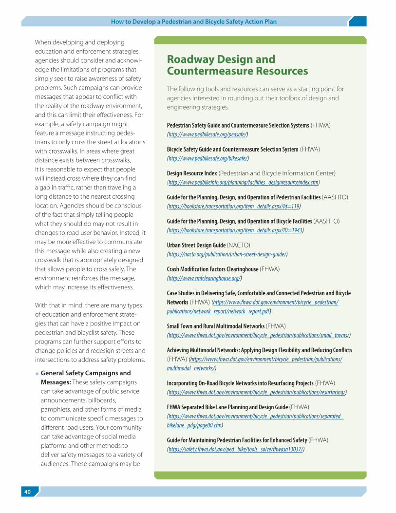
40
How to Develop a Pedestrian and Bicycle Safety Action Plan
When developing and deploying education and enforcement strategies, agencies should consider and acknowl-edge the limitations of programs that simply seek to raise awareness of safety problems. Such campaigns can provide messages that appear to conflict with the reality of the roadway environment, and this can limit their effectiveness. For example, a safety campaign might feature a message instructing pedes-trians to only cross the street at locations with crosswalks. In areas where great distance exists between crosswalks, it is reasonable to expect that people will instead cross where they can finda gap in traffic, rather than traveling a long distance to the nearest crossing location. Agencies should be conscious of the fact that simply telling people what they should do may not result in changes to road user behavior. Instead, it may be more effective to communicate this message while also creating a new crosswalk that is appropriately designed that allows people to cross safely. The environment reinforces the message, which may increase its effectiveness.
With that in mind, there are many types of education and enforcement strate-gies that can have a positive impact on pedestrian and bicyclist safety. These programs can further support efforts to change policies and redesign streets and intersections to address safety problems.
■ General Safety Campaigns and Messages: These safety campaigns can take advantage of public service announcements, billboards, pamphlets, and other forms of media to communicate specific messages to different road users. Your community can take advantage of social media platforms and other methods to deliver safety messages to a variety of audiences. These campaigns may be
Roadway Design and Countermeasure ResourcesThe following tools and resources can serve as a starting point for agencies interested in rounding out their toolbox of design and engineering strategies.
Pedestrian Safety Guide and Countermeasure Selection Systems (FHWA) (http://www.pedbikesafe.org/pedsafe/)
Bicycle Safety Guide and Countermeasure Selection System (FHWA) (http://www.pedbikesafe.org/bikesafe/)
Design Resource Index (Pedestrian and Bicycle Information Center)(http://www.pedbikeinfo.org/planning/facilities_designresourceindex.cfm)
Guide for the Planning, Design, and Operation of Pedestrian Facilities (AASHTO)(https://bookstore.transportation.org/item_details.aspx?id=119)
Guide for the Planning, Design, and Operation of Bicycle Facilities (AASHTO) (https://bookstore.transportation.org/item_details.aspx?ID=1943)
Urban Street Design Guide (NACTO)(https://nacto.org/publication/urban-street-design-guide/)
Crash Modification Factors Clearinghouse (FHWA) (http://www.cmfclearinghouse.org/)
Case Studies in Delivering Safe, Comfortable and Connected Pedestrian and Bicycle Networks (FHWA) (https://www.fhwa.dot.gov/environment/bicycle_pedestrian/publications/network_report/network_report.pdf)
Small Town and Rural Multimodal Networks (FHWA) (https://www.fhwa.dot.gov/environment/bicycle_pedestrian/publications/small_towns/)
Achieving Multimodal Networks: Applying Design Flexibility and Reducing Conflicts (FHWA) (https://www.fhwa.dot.gov/environment/bicycle_pedestrian/publications/multimodal_networks/)
Incorporating On-Road Bicycle Networks into Resurfacing Projects (FHWA) (https://www.fhwa.dot.gov/environment/bicycle_pedestrian/publications/resurfacing/)
FHWA Separated Bike Lane Planning and Design Guide (FHWA) (https://www.fhwa.dot.gov/environment/bicycle_pedestrian/publications/separated_bikelane_pdg/page00.cfm)
Guide for Maintaining Pedestrian Facilities for Enhanced Safety (FHWA) (https://safety.fhwa.dot.gov/ped_bike/tools_solve/fhwasa13037/)

Chapter 5. Selecting Safety Improvements
41
limited in effectiveness on their own, but can provide essential messages in advance of design improvements or targeted enforcement campaigns. Carefully select messages based on your safety analysis and target them to the users you want to reach.
■ Automated Enforcement: The purpose of using these systems is to monitor and cite drivers for unsafe behaviors and they are typically the responsibility of law enforcement agencies. Automated enforcement systems can be used to enforce red light running violations as well as speeding violations, issuing tickets or warnings to drivers using camera technology. These can be effective methods for curbing unsafe behaviors, but should be supported by policies that allow their use. As previously mentioned, Federal funds do not support automated enforcement systems, so agencies must determine the best way to support their use.
■ Speed Feedback Signs: Dynamic speed feedback signs provide display speeds to drivers in comparison to the established speed limit on a corridor. The message is intended to remind drivers of the speed limit, but these systems do not typically include any enforcement mechanism. When used in targeted locations like school zones, and moved around frequently to different locations, these systems can be effective in reducing driver speeds.
■ Enforcement Operations: When coupled with a high visibility media campaign to advertise their goals, targeted enforcement operations can be a very effective way of improving road user behaviors. Some of the most common examples of these operations include those to address seat belt use (“Click it or Ticket”) and address impaired driving (“Drive Sober or Get Pulled Over”). These campaigns can support pedestrian and bicycle safety by targeting specific motorist behaviors. For example, officers can perform operations at crosswalks to warn or cite drivers that fail to yield to pedestrians. Officers can equip bicycles with sensors that help detect and enforce violations of minimum passing distance laws. By working with courts to ensure these programs are set up appropriately, and working with media to ensure there is widespread knowledge ofthe law, targeted enforcement provides agencies with valuable safety tool.
■ Education and Skills Training for Children: Develop school-based programs to communicate rules of the road to young pedestrians and bicyclists. Many schools
offer these programs as part of their Safe Routes to School program, physical education and health classes, and incorporate educational messages with bicycling and walking skills training to help develop safe behaviors at a young age. Key safety messages for expectations of safe behaviors among pedestrians, bicyclists, and especially drivers (often the parents themselves) should be reinforced through various channels to care-givers and the community.
■ Adult Crossing Guards and Safety Teams: Typicallyused at school locations or in areas with high volumesof pedestrian activity, crossing guards can reinforce
Resources for Addressing Road User BehaviorsThe following resources can help agencies identify and select awareness campaigns, educational programs, and law enforcement strategies that can address safety problems stemming from unsafe road user behaviors.
Advancing Pedestrian and Bicyclist Safety: A Primer for Highway Safety Professionals (NHTSA) (https://www.nhtsa.gov/sites/nhtsa.dot.gov/files/812258-peds_bike_primer.pdf)
Pedestrian Safety Enforcement Operations: A How-To Guide (NHTSA) (https://www.nhtsa.gov/sites/nhtsa.dot.gov/files/812059-pedestriansafetyenforceoperahowtoguide.pdf)
Countermeasures That Work: A Highway Safety Countermeasure Guide for State Highway Safety Offices (NHTSA) (https://www.nhtsa.gov/sites/nhtsa.dot.gov/files/812202-countermeasuresthatwork8th.pdf)
Crossing guards are valuable resources for facilitating crossings and serving as safety ambassadors to the local community. Credit: Dan Burden, PBIC Image Library.

6
42
How to Develop a Pedestrian and Bicycle Safety Action Plan
safety messages and built environment changes. Some cities will form teams of safety “ambassadors” to attend community events and provide presentations to provide another level of targeted safety messaging. When performing field audits to diagnose safety problems, be sure to talk with your crossing guards about behaviors and problems they observe.
Closing Thoughts Pedestrian and bicyclist safety problems are complex in nature and require a collaborative response from a broad range of partners. Using standalone efforts to redesign the roadway, develop new policies, and roll out behavioral campaigns are not sufficient responses to the problem. Instead, agencies should work with all partners to develop coordinated safety programs that can more effectively leverage all of these interventions through a coherent and multidisciplinary approach.
Conducting Targeted Enforcement OperationsBased on the Click it or Ticket (CIOT) model, but strategi-cally focused on addressing the safety of pedestrians (and bicyclists at times), law enforcement officers can perform pedestrian crosswalk enforcement using officers as pedestrian decoys or “watch and respond” approach where uniformed officers watch public areas for motorist responses to crossing pedestrians. In both cases, officers radio ahead to marked or unmarked squad cars to pull over offenders. As with the CIOT model, these efforts often use media to raise public awareness, enforcement to educate offenders coupled with a warning period, and is followed by education and citations. Enforcement efforts to enhance pedestrian
and bicycle safety, like other types of enforcement oper-ations, follow the data to target locations where crashes and fatalities are happening. These campaigns can also be conducted in high-risk areas where large numbers of pedestrians and motorists interact. While efforts more frequently focus on drivers, pedestrians’ and bicyclists’ behavior can be incorporated into any campaign. Officers may use their discretion and cite pedestrians or bicyclists engaging in high-risk behaviors. Additionally, while not specifically directed to pedestrian and bicycle safety, enforcement operations directed at impaired or distracted driving behooves the safety of all road users. Officers can equip bicycles with sensors that help detect and enforce violations of minimum passing distance laws. Enforcement efforts must coincide with education and buy-in from the courts. This includes assurance of standardized protocol for set-up, establishing periods of education followed by enforcement, and developing methods to evaluate the program. Media collaboration should ensure there is widespread knowledge of the law and outreach that officers will be looking to behaviors that impact the safety of pedestrians and bicyclists.
For more information on pedestrian safety operations, see NHTSA’s Pedestrian Safety Enforcement Operations: A How-To Guide (https://www.nhtsa.gov/sites/nhtsa.dot.gov/files/812059-pedestria nsafetyenforceoperahowtoguide.pdf).
Targeted enforcement operations can reinforce yielding and other traffic laws. Credit: Dan Burden, PBIC Image Library.

6
43
Program Implementation and EvaluationChapter 6.
A safety action plan shouldn’t conclude with a simple
list of recommendations. A strategy to prioritize and
implement those recommendations is required for
a plan to become reality. Often this means making
tough decisions about how to allocate resources, and
ultimately this becomes one of the most challenging
parts of your pedestrian and bicycle safety program.
Once projects and programs are implemented,
agencies should take steps to evaluate the impact of
their efforts. This chapter will help you understand
what steps are needed to implement and evaluate
your safety action plan.
Funding is critical to implementation. It can be the enabler for making improvements that reduce crashes, or it can be the barrier that prevents needed improve-ments from being made. With most State and local governments facing severe budget constraints, allocating funds to address pedestrian and bicycle safety issues can be a challenge. Nevertheless, some States and urban areas are achieving very low crash numbers despite limited funding. The challenge is to figure out how these outcomes are being achieved and then apply them to States and communities with high numbers of pedestrian and bicyclist crashes.
Achieving better outcomes always begins with a commit-ment to safety for all road users. It should be the number one priority of State and local transportation agencies. A firm commitment allows transportation agencies to allo-cate funds to address all crash types, including pedestrian and bicycle crashes. Projects that only focus on reducing congestion or motor vehicle crashes may jeopardize the safety of pedestrians and bicyclists.
Funding StrategiesThe following funding strategies can be applied to finance pedestrian and bicycle safety improvements:
■ Routine accommodation in new projects.
■ Partnerships.
■ Dedicated funds and set asides.
■ Annual maintenance budget.
Routine Accommodation in New ProjectsRoutinely including pedestrian and bicycle facilities with other roadway improvement projects is a cost-effective strategy for improving safety. Incorporating pedestrian- and bicycle-friendly design strategies as part of normal public and private development and the adoption of good traffic management practices are known as “routine accommodation.” Most pedestrian and bicycle infrastructure is built in conjunction with other projects: pedestrian crossings are built in conjunction with the construction of intersections; space is reallocated for bicycle lanes when roads are resurfaced; and most sidewalks in residential neighborhoods are built as part of private, residential housing construction.
Routine accommodation allows for significant improve-ments over time, even if there is no special funding available for pedestrian safety improvements. Chapter 5 provides a list of standardized traffic managementand design practices that will reduce crashes over time. Routine accommodation for new projects does not diminish the importance of immediately addressing high-crash locations, corridors, and other targeted areas immediately.
PartnershipsBoth public works and many private development projects provide partnership opportunities for making safety improvements and providing routine accommodation. For example, opportunities to construct sidewalks can be provided with resurfacing projects;

44
How to Develop a Pedestrian and Bicycle Safety Action Plan
opportunities for placing utilities underground (and thus eliminating obstructions on sidewalks) can be found with other projects.
Some projects may generate neighborhood concern or opposition. Frequently, public and private projects include some pedestrian or bicycle facilities, supported by the neighborhood, to build good will. In other cases, there may be a common benefit. Private developers and other agencies are often willing to make needed safety improve-ments, as a safer, more accessible development is more attractive to potential tenants or customers.
Large projects present an opportunity for significant pedestrian and bicycle improvements. For example, a new development may generate enough traffic to warrant a signal near a school or other pedestrian destination. Utility work next to a roadway or in an abandoned rail-
road line can provide an opportunity for constructing a sidewalk or pathway.
Combined improvements involve grouping smaller proj-ects with an existing funded project. Funding improve-ments as part of larger projects creates economies of scale. For example, if there is a public works project to construct a concrete roadway, it may be cheaper to add construction of sidewalks on nearby streets instead of building them as a separate project. It may also be advantageous to provide funding for a spot improvement such as a midblock crossing where pedestrians are expected to cross. Not only are costs reduced when two types of work are combined into one project, but other advantages include reduced impact to traffic, residents, and businesses.
Dedicated Funds and Set AsidesSome States, MPOs, and local governments have set aside dedicated funds for pedestrian and/or bicycle improvements. Set asides are either a percentage of a larger fund; for example, a percentage of funds for pedestrian and/or bicycle projects. Typical examples include developer funds (developers deposit funds into a centralized fund or escrow account for future use), resource funds (taxes on extracted natural resources such as gravel or oil), and real estate excise funds.
While dedicated funds and set asides are possible funding sources, they should not be a substitute for routine accommodation. For example, funding for shoulder and sidewalk improvements should be routine practice and not paid for through set aside funds. In general, changing policy to include pedestrian and bicycle improve-ments in all programs and projects will produce more funding than set asides.
Annual Maintenance BudgetAgencies can use existing annual maintenance budgets to make important improvements to bicycling and walking infrastructure. For example, limited budgets for painting marked crosswalks can be focused around schools and high-crash locations. Crosswalks can be widened or changed to high-visibility markings when they are scheduled to be repainted. Crosswalk signs scheduled for replacement can be upgraded to the brighter fluorescent yellow-green signs adopted by the MUTCD as an option for pedestrian and bicycle warning signs. During regular
Incorporating Nonmotorized Networks into Resurfacing ProjectsYour community likely faces the same funding chal-lenges as States and cities across the country. With limited funds available for developing and imple-menting pedestrian and bicycle facilities, agencies should take advantage of ongoing maintenance budgets to implement low cost projects. The regular resurfacing of streets in your community may provide an opportunity to accomplish some of your goals. By planning ahead, you may be able to incorporate bike lane or road diet projects simply by updating pavement marking plans. The FHWA guide Incorporating On-Road Bicycle Networks into Resurfacing Projects (https://www.fhwa.dot.gov/environment/bicycle_pedestrian/publications/resurfacing/) lays out a framework for making this happen and includes case studies from agencies that have been successful in taking advantage of these opportunities for implementation.
Incorporating On-Road Bicycle Networks into Resurfacing Projects (https://www.fhwa.dot.gov/environment/bicycle_pedestrian/publications/resurfacing/)

Chapter 6. Program Implementation and Evaluation
45
road resurfacing, there are opportunities to adjust pavement markings to include recommendations laid out in the safety action plan. This can involve lane narrowing, road diets, and adding bicycle lanes. The FHWA Guide Incorporating On-Road Bicycle Networks into Resurfacing Projects (https://www.fhwa.dot.gov/environment/bicycle_pedestrian/publications/resurfacing/) provides more detail about taking advantage of regular maintenance activities.
FHWA’s Guide for Maintaining Pedestrian Facilities for Enhanced Safety (https://safety.fhwa.dot.gov/ped_bike/tools_solve/fhwasa13037/) offers additional guidance for funding maintenance activities that can help address safety problems. The guide points to several examples of strategies being used by communities that could serve as models:
■ A sidewalk mileage tax in Ann Arbor, Michigan,generates more than $500,000 per year to performneeded sidewalk repair and replacement.
■ Utility bills in Corvallis, Oregon, and Cheney,Washington, generate funds for sidewalk constructionand maintenance through water, sewer, electricaland gas services.
■ The City of Madison, Wisconsin, conducts regularsidewalk assessments and works with property ownersto complete needed repairs and upgrades.
More information about funding strategies for main-tenance activities can be found in Chapter 7 of the guide (https://safety.fhwa.dot.gov/ped_bike/tools_solve/fhwasa13037/chap7.cfm).
Funding Criteria and Prioritization State and local governments typically use multiple funding sources for transportation projects, from Federal grants to gas taxes to general tax revenues. These sources often have funding criteria that determine what projects are eligible. Funding criteria are reviewed and updated periodically; they can be rewritten to increase funding for pedestrian and bicycle safety projects. There are two ways to levy these sources for safety improvements for pedestrians and bicyclists: 1) Giving higher scores to projects that include pedestrian or bicycle safety elements; and 2) Adjusting criteria to prioritize projects that will reduce pedestrian and bicycle crashes. By updating these criteria to prioritize nonmotorized road users, your agency may be able to give pedestrian and bicycle projects a boost. Finding a way to incorporate other community and agency goals into your prioritization system may be difficult, but tools like the ActiveTrans Priority Tool (http://www. pedbikeinfo.org/planning/tools_apt.cfm) can help combine both quantitative and qualitative inputs to help drive decision making. Many roadway improvements, such as road diets or roundabouts, can improve safety for all users. Funding criteria that acknowledges projects with multiple benefits may help accomplish all of your safety goals instead of singling out certain road user groups.
Major Funding Sources Federal funding used by State and local agencies for pedestrian and bicyclist improvements has increased dramatically in recent decades. State and local agen-cies only invested a few million dollars of Federal funds on bicycle and pedestrian projects. While the energy crisis of the early 1970s had spawned new interest and
Ongoing Maintenance for Pedestrian Facilities
When budgeting for safety projects in your pedes-trian and bicycle safety action plan, remember to account for the ongoing expenses involved in maintaining these facilities. Pedestrian facilities, in particular, experience wear and tear over time that your agency should capture in its budget. The FHWA Guide for Maintaining Pedestrian Facilities for Enhanced Safety (https://safety.fhwa.dot.gov/ped_bike/tools_solve/fhwasa13037/) will help your agency think through all of the maintenance considerations you may encounter. The guide lays out consider-ations for street tree plantings and avoiding root damage to sidewalks. It also provides strategies for accomplishing snow removal without disrupting the pedestrian network. The guide includes case studies of maintenance programs from around the country to illustrate effective maintenance activities and provide inspiration to other communities.
Guide for Maintaining Pedestrian Facilities for Enhanced Safety(https://safety.fhwa.dot.gov/ped_bike/tools_solve/fhwasa13037/)

46
How to Develop a Pedestrian and Bicycle Safety Action Plan
some modest government initiatives to make improve-ments, the government invested very little money at any level in pedestrian and bicycle facilities. Likewise, the outdoor recreation industry and business community in general provided very little funding for facilities, planning, programs, or organizational development. Throughout the late 1970s and 1980s, State and local parks agen-cies invested the largest amounts of funds for bicycling and walking to build multiuse trails; however, even these levels of investment were very small compared to what is happening today.
Federal FundsAs with most highway projects, pedestrian and bicycle safety projects can be supported by funds made available through the Federal-aid Highway Program. Each funding source has specific stipulations as to the type of projects it can support, so a detailed review of the available funds is recommended. The FHWA Bicycle and Pedestrian Program maintains a detailed breakdown of Pedestrian and Bicycle Funding Opportunities (https://www.fhwa.dot.gov/environment/bicycle_pedestrian/funding/funding_opportunities.cfm) matching each to the types of projects it can support. Your agency should
ActiveTrans Priority ToolProject prioritization can be a complex process, and there is no shortage of information available about different ways to weight and prioritize potential improvements. Unfortunately, many prioritization schemes are rigid and may not easily incorporate other qualitative input and community values that are captured within a safety action plan. The ActiveTrans Priority Tool (APT) provides agencies with an option for accomplishing data-driven prioritization that also acknowledges and captures agency desires and community values. Divided into two phases (scoping and prioritization), the APT allows agencies to develop project priorities that accomplish complete streets goals that are particularly responsive to the needs of pedestrians and bicyclists. An online version of the tool hosted by the PBIC includes further guidance, a link to the NCHRP source material, and interactive spreadsheets.
ActiveTrans Priority Tool(http://www.pedbikeinfo.org/planning/tools_apt.cfm)
Figure 5. The ActiveTrans Priority Tool. The ActiveTrans Priority Tool lays out a two-phase approach to project scoping and prioritization. Credit: ActiveTrans Priority Tool.

Chapter 6. Program Implementation and Evaluation
47
proactively review these available sources and work with your State department of transportation to identify those that can support your project.
Outside of the Federal transportation programs there are a wide range of other Federal funds that can be used for walking facilities. Community Development Block Grants through the Department of Housing and Urban Development (HUD) are a likely source of funds for community-based projects such as commercial district streetscape improvements, sidewalk improvements, Safe Routes to School, or other neighborhood-based walking facilities that improve local transportation or help revi-talize neighborhoods.
State and Local FundsStates typically raise revenue for highway and transportation infrastructure through a State motor vehicle fuel taxes and vehicle registration fees. Similar to the Federal legislation, laws in many States make most pedestrian and bicycle programs eligible for funding. In some States, use of funds may be limited to improvements on State-owned and operated facilities. Other sources of funding that Federal agencies distribute to States can help support education and enforcement activities that address pedestrian and bicycle safety, such as Section 405 funds distributed by NHTSA (https://www.nhtsa.gov/highway-safety-grants-program).
Some examples of revenue streams used by local commu-nities to improve conditions for pedestrians include: special bond issues, dedications of a portion of local sales taxes or a voter-approved sales tax increase, and the use of the annual capital improvement budgets of public works and/or parks agencies. Your agency can work with State and regional partners to learn how your plan’s recommendations can tap into funding sources avail-able in your state.
Health AgenciesPublic health partners are often overlooked as potential sources of funding for pedestrian and bicycle projects. By collaborating with these partners on safety projects, agencies may be able to identify funding sources that can support projects that achieve shared goals between transportation and health organizations, such as addressing concerns about equity and promoting active
transportation. State and local health departments may provide more information about what opportunities may be available. Work with these health agencies and partners to identify funding sources available for supporting transportation projects.
Private FundingIt may be possible to collaborate with private organizations to support safety projects or take advantage of new development to have elements of your safety plan implemented.
Private foundations have provided funding for pedestrian and bicycle projects and programs. A few national and large regional foundations have supported the national organizations involved in pedestrian and bicycle policy advocacy. However, it is usually the regional and local foundations that get involved in funding pedestrian and bicycle projects. These same foundations may also fund Statewide and local advocacy efforts.
In some cases, developers are required to provide funding for roadway improvement projects that will build side-walks, bicycle facilities, and paths. In other cases, devel-opers are required to build off-site improvements, largely in response to master plans or stipulations on their development. While in the latter case, they may not be providing funding to the agency to build the project, the result may be the same.
Evaluating Safety Programs and Projects A successful pedestrian and bicycle safety action plan must contain a mechanism to evaluate results. This ensures that stakeholders of the action plan understand whether or not the implemented strategies were effec-tive in reducing crashes and improving safety, and helps ensure future funding opportunities if the plan demon-strates successful outcomes. In order to perform a thor-ough evaluation, the specific objectives of your action plan need to be defined prior to implementation. By ensuring your objectives are SMART (specific, measurable, achievable, reasonable, and time-focused), they are condu-cive to being evaluated. Given limited resources, identify, prioritize, and pursue the most effective countermeasures. Where such action plans have not been successful in

48
How to Develop a Pedestrian and Bicycle Safety Action Plan
some communities, it is not because of a lack of funds, but because the wrong countermeasures and strategies were chosen, including making meaningful changes to agency design and management policies. This is often the result of poor or no evaluation feedback to inform the action plan. Evaluation means that action plans are not static docu-ments—they should change over time as various safety countermeasures and strategies are tried and evaluated. Consider trial deployments of roadway designs with low-cost treatments, or testing your campaign messages with a focus group of end users. The input you receive from this process should feed into your decision making so you invest resources where they will be most effective.
A key prerequisite to any evaluation process is to quan-tify the before conditions and track changes in the after condition. The data collection efforts discussed previously earlier in this guide provide some ideas for measures that can be routinely tracked and collected for each project. Documenting these outcomes can be an excellent way to monitor the success of countermeasures and inter-ventions. It is also important to note that, in some cases, pedestrian and bicycle crashes may increase when walking and biking activity also increases. In these instances, the respective crash rates may have decreased, and a well-documented evaluation of results is needed to provide the most accurate measure of success.
Your agency may struggle with fully integrating project evaluation into your ongoing activities. One reason for skipping evaluation is simple: there may not be funding available to perform robust evaluation of safety projects. Even without funding, agencies can effectively track their progress by agreeing to collect basic informa-tion each time a project is completed. The following list includes some simple metrics that can help you measure your impact:
■ Installation Date: It may seem simple, but mostagencies don’t keep accurate records about the datewhen they installed treatments. Knowing this date canallow you to look back and perform a simple before andafter evaluation down the road.
■ Vehicle Speeds: Law enforcement partners can collectspeed data along a corridor before construction beginsand again once the changes are made. Vehicle speedsprovide an excellent surrogate measure of safety, andknowing that your project resulted in lower speeds
can help you communicate success back to your decision makers.
■ Before and After Pictures: Images are more qualitative than other measures listed here, but sometimes the most effective way to communicate a story is through imagery. Unfortunately many agencies skip this step and aren’t able to go back in time to take a picture of their previous condition. Remembering to capture images of the site before the project, and then take the same picture after construction is complete, to give you powerful visuals to document your successes.
■ Counts and Volumes: Traffic volume data are regularly collected and should be available from your local transportation department. Pedestrian and bicyclist counts, on the other hand, may not be readily available. Steps can be taken to make sure these important data points are collected before and after your project is implemented. The Pedestrian and Bicycle Information Center (PBIC) has resources for conducting pedestrian and bicyclist counts at http://www.pedbikeinfo.org/planning/tools_counts.cfm.
■ Crash Data: Crashes may not be the most reliable way to measure the impact of a project at just one location, but it is important to monitor your crash data and understand if your project is having an impact on crashes.
There are many more metrics available that your agency can use to measure project impact, but the list above provides a starting point. For more information about how to measure and monitor your various performance measures, visit the FHWA Guide for Developing Pedestrian and Bicycle Performance Measures (https://www.fhwa.dot.gov/environment/bicycle_pedestrian/publications/performance_measures_guidebook/).
Combining a record of successful projects is very helpful in showing progress over time. Understanding where your projects didn’t have their desired impact can help inform your future activities. Good safety plans will include a comprehensive documentation of successful projects or institutional changes. It is also important to note that in some cases, the number of pedestrian crashes may not go down due to the fact that pedestrian activity and access has increased. In these instances, the rate of pedestrian and bicyclist crashes may have decreased, and a well-documented evaluation of results is needed to provide the most accurate measure of success.

Chapter 6. Program Implementation and Evaluation
49
Closing Thoughts Program implementation and evaluation represent the outcomes of your safety plan. To make sure these steps are taken, your agency needs to be sure to include them in the plan’s recommendations. Without setting specificassignments and next steps for project implementation, your plan’s recommendations may never become reality. Being able to track your success and report your impact back to decision makers may be an effective way to justify more future investment in walking and bicycling.

7

7
51
Summary and ConclusionChapter 7.
Your pedestrian and/or bicycle safety action plan will lay out a vision for how your community will respond to safety problems. As outlined in this guide, the develop-ment of your safety action plan requires input from a broad range of partners and stakeholders in order to be effective. The following takeaways from the previous chapters can help guide the development and imple-mentation of your plan.
■ A safety plan should acknowledge the unique needs of pedestrians and bicyclists among road users and lay out clear, measurable goals for improving their safety.
■ Plans should be data-driven and based on a complete understanding of the safety problem. Use a range of data sources and types to look at high-crash and high- risk locations.
■ The plan you develop is a reflection of the community’s goals and vision, and steps should be taken to ensure that all members of the community have opportunities to provide their input.
■ Properly diagnosing a safety problem using audits and crash types will help you match the appropriate policy, design, and behavioral interventions to respond to the problem.
■ Your plan should include specific recommendations for funding and supporting its recommendations. Always evaluate the impacts of your safety projects and use the findings to demonstrate your success and modify your strategy as needed.
The success of your plan will be determined by all of these factors. Your approach will be unique and tailored to the specific needs of your community, and the resulting plan will demonstrate your commitment to improving the safety of the most vulnerable road users.
Pedestrian and bicycle safety action plans incorporate and protect all users of the transportation system. Credit: Laura Sandt, PBIC Image Library.

A

A
5353
List of Pedestrian and Bicycle Safety Guides and ResourcesAppendix A:
The following reports, tools, and guides can serve as useful references as you develop and implement your pedestrian and bicycle safety action plans.
Planning and Performance Measurement ResourcesGuidebook for Developing Pedestrian and Bicycle Performance Measures (FHWA) (https://www.fhwa.dot.gov/environment/bicycle_pedestrian/publications/performance_measures_guidebook/page02.cfm)
Achieving Multimodal Networks: Apply Design Flexibility and Reducing Conflicts (FHWA) (https://www.fhwa.dot.gov/environment/bicycle_pedestrian/publications/multimodal_networks/fhwahep16055.pdf)
Bike Network Mapping Idea Book (FHWA) (https://www.fhwa.dot.gov/environment/bicycle_pedestrian/publications/bikemap_book/)
Case Studies in Delivering Safe, Comfortable and Connected Pedestrian and Bicycle Networks (FHWA) (https://www.fhwa.dot.gov/environment/bicycle_pedestrian/publications/network_report/)
A Resident’s Guide for Creating Safer Communities for Walking and Biking (FHWA) (https://safety.fhwa.dot.gov/ped_bike/ped_cmnity/ped_walkguide/residents_guide2014_final.pdf)
Pedestrian Safety Program Technical Assessment (NHTSA) (https://www.nhtsa.gov/pedestrian-safety/pedestrian-program-assessment)
Small Town and Rural Multimodal Networks (FHWA) (https://www.fhwa.dot.gov/environment/bicycle_pedestrian/publications/small_towns/)
ActiveTrans Priority Tool (PBIC) (http://www.pedbikeinfo.org/planning/tools_apt.cfm)
Resources for Conducting Pedestrian and Bicyclist Counts (PBIC) (http://www.pedbikeinfo.org/planning/tools_counts.cfm)
Metropolitan Pedestrian and Bicycle Planning Handbook (https://www.fhwa.dot.gov/planning/processes/pedestrian_bicycle/publications/mpo_handbook/index.cfm)
Statewide Pedestrian and Bicycle Planning Handbook (https://www.fhwa.dot.gov/planning/processes/pedestrian_bicycle/publications/pedestrian_bicycle_handbook/fhwahep14051.pdf?redirect)
Resources for Diagnosing Safety ProblemsBicycle Road Safety Audit Guidelines and Prompt Lists (FHWA) (https://safety.fhwa.dot.gov/ped_bike/tools_solve/fhwasa12018/) and
Pedestrian Road Safety Audit Guidelines and Prompt Lists (FHWA) (http://www.pedbikeinfo.org/pdf/PlanDesign_Tools_Audits_PedRSA.pdf)
Road Safety Audit Tools (PBIC) (http://www.pedbikeinfo.org/planning/tools_audits.cfm)
Countermeasure and Design ResourcesThe Road Diet Informational Guide (https://safety.fhwa.dot.gov/road_diets/guidance/info_guide/)
Guide for the Planning, Design, and Operation of Pedestrian Facilities (AASHTO) (https://bookstore.transportation.org/item_details.aspx?id=119)
Guide for the Planning, Design, and Operation of Bicycle Facilities (AASHTO) (https://bookstore.transportation.org/item_details.aspx?ID=1943)
Urban Street Design Guide (NACTO) (https://nacto.org/publication/urban-street-design-guide/)
Pedestrian Safety Guide for Transit Agencies (FHWA) (https://safety.fhwa.dot.gov/ped_bike/ped_transit/ped_transguide/)
Crash Modification Factors Clearinghouse (FHWA) (http://www.cmfclearinghouse.org/)
Guide for Maintaining Pedestrian Facilities for Enhanced Safety (FHWA) (https://safety.fhwa.dot.gov/ped_bike/tools_solve/fhwasa13037/)

BPedestrian Safety Guide and Countermeasure Selection Systems (FHWA) (http://www.pedbikesafe.org/pedsafe/)
Bicycle Safety Guide and Countermeasure Selection System (FHWA) (http://www.pedbikesafe.org/bikesafe/)
Design Resource Index (Pedestrian and Bicycle Information Center) (http://www.pedbikeinfo.org/planning/facilities_designresourceindex.cfm)
USLIMITS2: A Tool to Aid Practitioners in Determining Appropriate Speed Limit Recommendations (FHWA) (https://safety.fhwa.dot.gov/uslimits/)
Incorporating On-Road Bicycle Networks into Resurfacing Projects (FHWA) (https://www.fhwa.dot.gov/environment/bicycle_pedestrian/publications/resurfacing/)
FHWA Separated Bike Lane Planning and Design Guide (FHWA) (https://www.fhwa.dot.gov/environment/bicycle_pedestrian/publications/separated_bikelane_pdg/page00.cfm)
Behavioral ResourcesData Driven Approaches to Crime and Traffic Safety (DDACTS) (https://www.nhtsa.gov/staticfiles/nti/ddacts/811185_DDACTS_OpGuidelines.pdf)
Pedestrian Safety Enforcement Operations: A How-To Guide (NHTSA) (https://www.nhtsa.gov/sites/nhtsa.dot.gov/files/812059-pedestriansafetyenforceoperahowtoguide.pdf)
Advancing Pedestrian and Bicyclist Safety: A Primer for Highway Safety Professionals (NHTSA) (https://www.nhtsa.gov/sites/nhtsa.dot.gov/files/812258-peds_bike_primer.pdf)
Countermeasures That Work: A Highway Safety Countermeasure Guide for State Highway Safety Offices (NHTSA) (https://www.nhtsa.gov/sites/nhtsa.dot.gov/files/812202-countermeasuresthatwork8th.pdf)
National Pedestrian Safety Campaign (FHWA) (https://safety.fhwa.dot.gov/local_rural/pedcampaign/)
Pedestrian Safer Journey (FHWA) (http://www.pedbikeinfo.org/pedsaferjourney/)
Bicycle Safer Journey (FHWA) (http://www.pedbikeinfo.org/bicyclesaferjourney/)
Policy ResourcesNoteworthy Local Policies that Support Safe and Complete Pedestrian and Bicycle Networks (FHWA) (https://safety.fhwa.dot.gov/ped_bike/tools_solve/docs/fhwasa17006-Final.pdf)
Vision Zero Network (Vision Zero Network) (http://visionzeronetwork.org/)
Road to Zero Coalition (National Safety Council) (http://www.nsc.org/learn/NSC-Initiatives/Pages/The-Road-to-Zero.aspx)
National Complete Streets Coalition and Smart Growth America (Smart Growth America) (https://smartgrowthamerica.org/program/national-complete-streets-coalition/)
Helpful ContactsStatewide Bicycle and Pedestrian Coordinators Contact Information (PBIC) (http://www.pedbikeinfo.org/data/state.cfm)
State Highway Safety Offices (GHSA) (http://www.ghsa.org/about/shsos)
FHWA Division Offices (FHWA) (https://www.fhwa.dot.gov/about/field.cfm)
NHTSA Regional Offices (NHTSA) (https://www.nhtsa.gov/about-nhtsa)
54
How to Develop a Pedestrian and Bicycle Safety Action Plan

B
55
Examples of Pedestrian and Bicycle Safety PlansAppendix B:
Agencies across the United States have developed plans to respond to pedestrian and bicycle safety. The list below is not exhaustive, but provides a range of plans that may provide inspiration to those interested in developing a safety action plan of their own.
Statewide PlansCalifornia State Bicycle and Pedestrian Plan (http://www.goactiveca.org/)
Florida Pedestrian and Bicycle Strategic Safety Plan (http://www.fdot.gov/safety/6-Resources/FloridaPedestrianandBicycleStrategicSafetyPlan.pdf)
New York State Pedestrian Safety Action Plan (https://www. ny.gov/pedestrian-safety-action-plan/pedestrian-safety-action-plan)
Oregon Bicycle and Pedestrian Safety Implementation Plan (https://www.oregon.gov/ODOT/HWY/TRAFFIC-ROADWAY/Pages/Bicycle_Pedestrian_Safety.aspx)
Arizona Bicycle Safety Action Plan (http://azbikeped.org/downloads/archive/2012-09-Bicycle_Safety_Action_Plan.pdf) and Pedestrian Safety Action Plan (http://azbikeped.org/downloads/archive/2009-06-Pedestrian_Safety_Action_Plan.pdf)
Local PlansNew York City Pedestrian Safety Action Plans (http://www.nyc. gov/html/dot/html/pedestrians/ped-safety-action-plan.shtml)
Safe Mobility Santa Ana (http://www.santa-ana.org/smsa/)
Los Angeles Vision Zero Action Plan (http://visionzero.lacity.org/wp-content/uploads/2017/04/VisionZeroActionPlan-2017.pdf)
Chicago Streets for Cycling Plan 2020 (https://www.cityofchicago.org/content/dam/city/depts/cdot/bike/general/ChicagoStreetsforCycling2020.pdf)
County and Regional PlansHillsborough County Pedestrian Safety Action Plan (http://www.tampabaytrafficsafety.com/Engineering/Shared%20Documents/BWTB/Pedestrian%20Safety%20Action%20Plan%20-%20Hillsborough.pdf)
San Antonio-Bexar County Pedestrian Safety Action Plan (http://www.alamoareampo.org/Bike-Ped/docs/PedestrianSafetyActionPlan.pdf)

C

C
57
Checklist of Safety Action Plan ElementsAppendix C:
The following checklist provides agencies with a frame-work for quickly evaluating their safety action plan based on the components recommended in this guide. Use the checklist to evaluate existing plans or create a frame-work for a new plan.
Goals and Objectives1. Commitment to safety for all modes should be thenumber one goal and priority of state and local transpor-tation agencies. Once this commitment is made, it allowstransportation agencies to allocate funds to reducing allcrash types, including pedestrian and bicyclist crashes.
■ Do you have a clearly stated commitment to safety asyour number one priority? Yes / No
■ If not, what change(s) need to be instituted to ensurethat safety becomes the number one priority ofyour agency?
2. Clear objectives are needed for a pedestrian and bicycle safety action plan to be successful in reducing crashes. They allow for the development of practical and achievable strategies; they also provide a way to measure progress over time. To be effective, objectives must be specific and measurable.
■ Do you have a clearly stated objective for reducingpedestrian and bicyclist crashes? Yes / No
■ If not, what change(s) need to be instituted to ensurethat objectives are adopted?
Data Collection and Analysis 3. Crash data are essential to identify high-crash locations, corridors, and/or larger areas and to select appropriate improvements to make conditions safer for pedestrians and other roadway users.
■ Do you have direct access to updatedcrash data? Yes / No
■ If not, what change(s) need to be instituted to ensurethat crash data are available?
4. Pedestrian and bicyclist counts along with field obser-vations can be very useful in understanding road user behavior and in considering the need for facilities. Counts and behavior studies, when combined with crash data, can also provide insights into specific crash causes and potential countermeasures.
■ Do you routinely collect counts and otherobservational data? Yes / No
■ If not, what change(s) need to be instituted to ensurethat pedestrian and bicyclist counts and observationsare routinely completed?
5. Inventories of sidewalks, paths, bicycle lanes, cross-walks and other facilities can help identify system gaps and unsafe conditions. When combined with crash data, counts, and traffic characteristics, they can be very useful in prioritizing locations for countermeasures and other improvements.
■ Do you routinely inventory pedestrian and bicyclefacilities? Yes / No
■ If not, what change(s) need to be instituted to ensurethat inventories of facilities are routinely completed?
6. Inventories of traffic characteristics (such as ADT, road widths, and speeds) help identify likely crash locations. When combined with actual crash data and pedestrian or bicycle counts, they can be very useful in prioritizing loca-tions for countermeasures and other improvements.
■ Do you routinely inventory roadway ADT, widths andspeeds? Yes / No
■ If not, what change(s) need to be instituted to ensurethat ADT, width and speed information is routinelycollected and coded?
7. Inventories of traffic characteristics (such as ADT, road widths, and speeds) help identify likely crash locations. When combined with actual crash data and pedestrian or bicycle counts, they can be very useful in prioritizing loca-tions for countermeasures and other improvements.

58
How to Develop a Pedestrian and Bicycle Safety Action Plan
■ Do you routinely inventory roadway ADT, widths andspeeds? Yes / No
■ If not, what change(s) need to be instituted to ensurethat ADT, width and speed information is routinelycollected and coded?
Stakeholder Engagement 8. Individual stakeholder involvement is an excellent wayto get a better product. Public stakeholders should beviewed as partners who are the on-the-ground scoutswho can identify problems, needs and opportunities. Tobe effective, stakeholders must be involved in a regular,ongoing, and systematic way.
■ Do you routinely provide for individual stakeholderinvolvement? Yes / No
■ If not, what change(s) need to be instituted to ensurethat stakeholders are routinely involved?
9. A pedestrian and bicycle advisory board is anotherexcellent way to get a better product. They also buildpublic support for policies, programs, and projects toreduce pedestrian and bicycle crashes. To be effective,stakeholders must be involved in the review of policies,programs and projects.
■ Do you have an advisory that regularly reviews policies,programs, and projects? Yes / No
■ If not, what change(s) need to be instituted to ensurethe creation of an effective PAB?
10. Not all members of the community feel engaged withgovernment agencies and feel empowered to becomeinvolved in the planning process. In particular, communi-ties that have been disadvantaged may be reluctant toengage with government agencies. Individuals with vision,mobility, or other impairments may not have the toolsneeded to engage in traditional ways.
■ Do you use strategies to foster community engagementamong traditionally underserved, disadvantaged, ordifferently-abled populations? Yes / No
■ If not, what change(s) need to be instituted to ensure amore equitable approach to public engagement?
11. Public agency staff in other agencies are also stake-holders. Building positive, working relationships is essen-tial for coordination on regional planning issues; it also
provides a way to coordinate on solving specific problems such as identifying high-crash locations where additional enforcement may be needed, and coordinating transit stops with crossing locations.
■ Do you routinely coordinate with other agencies oncrash, transit, etc., issues? Yes / No
■ If not, what change(s) need to be instituted to ensureyou coordinate with other agencies?
Selecting Safety Improvements 12. Conducting field reviews and safety audits can be used to identify how each crash occurred, and what may be done to prevent future similar crashes. The outcome is a list of improvements that can be implemented to address those crashes and enhance safety.
■ Do you routinely conduct field reviews and safety audits? Yes / No
■ If not, what change(s) need to be instituted to ensure that field reviews and safety audits are routinely completed?
13. Crash typing describes the pre-crash actions of theparties involved. When crashes are typed, a pattern canemerge that helps identify what the problem is and whatcountermeasures are generally related to each crash type.
■ Do you routinely “crash type” your pedestrian andbicyclist crash data? Yes / No
■ If not, what change(s) need to be instituted to ensurethat crash typing is routinely completed?
14. A comprehensive approach to improving safetyrequires a balance of policy changes, design improve-ments and countermeasures, and behavioral programs.
■ Do your safety programs include recommendations forpolicy changes, roadway design and countermeasuredeployment, and programs to address road userbehaviors? Yes / No
■ If not, how can you expand your programs to include amore comprehensive approach?

Appendix C. Checklist of Safety Action Plan Elements
59
Implementation and Evaluation 15. Routine accommodation for pedestrians and bicy-clists in all projects, programs, and maintenance activities is the most cost-effective funding strategy for reducing crashes and encouraging more walking and bicycling. The majority of infrastructure is built in conjunction with other projects. It allows for significant improvements over time, even if there is no special funding available for safety improvements.
■ Do you routinely include pedestrian and bicyclesafety improvements in all projects, programs, andmaintenance activities? Yes / No
■ If not, what change(s) need to be institutedto ensure that pedestrian and bicycle safetyimprovements are included?
16. Dedicated funds and set-asides for projects allow for immediate action in addressing high-crash locations, corri-dors, and other targeted areas. They can be federal, state or local funds and are often a percentage of another fund.
■ Do you routinely set aside funds that are dedicated topedestrian and bicyclist safety? Yes / No
■ If not, what change(s) need to be instituted to ensurethat funds are routinely set aside?
17. Evaluation of results ensures that implemented solu-tions are effective in reducing crashes and improvingthe safety and accessibility of pedestrian facilities; it alsohelps ensure future funding opportunities if the planis perceived as a success. Success should be measuredagainst the objectives set forth in the safety action plan.
■ Do you routinely evaluate results of your efforts toreduce pedestrian and bicycle crashes? Yes / No
■ If not, what change(s) need to be instituted to ensurethat regular evaluation occurs?

For More Information:visit https://safety.fhwa.dot.gov/ped_bike/ped_focus/
FHWA, Office of SafetyTamara [email protected](202) 366-4077
FHWA-SA-17-050