how to establish a first party offset site · first party offset guide 3 to deliver a first party...
TRANSCRIPT

July 2018
First party offset guide
How to establish a first party offset site

Cover image: Linum marginale, DELWP (Ian McCann)
© The State of Victoria Department of Environment, Land, Water and Planning 2018
This work is licensed under a Creative Commons Attribution 4.0 International licence. You are free to re-use the work under that licence, on the condition that you credit the State of Victoria as author. The licence does not apply to any images, photographs or branding, including the Victorian Coat of Arms, the Victorian Government logo and the Department of Environment, Land, Water and Planning (DELWP) logo. To view a copy of this licence, visit http://creativecommons.org/licenses/by/4.0/
ISBN 978-1-76047-879-7 (pdf/online/MS word)
Disclaimer
This publication may be of assistance to you but the State of Victoria and its employees do not guarantee that the publication is without flaw of any kind or is wholly appropriate for your particular purposes and therefore disclaims all liability for any error, loss or other consequence which may arise from you relying on any information in this publication.
Accessibility
If you would like to receive this publication in an alternative format, please telephone the
DELWP Customer Service Centre on 136186, email [email protected],
or via the National Relay Service on 133 677 www.relayservice.com.au. This document is
also available on the internet at www.environment.vic.gov.au/native-vegetation/

First party offset guide
1
Introduction ...................................................................................................................................................... 2
Quick Guide ...................................................................................................................................................... 3
Step 1. Is my native vegetation eligible to be an offset site? ................................................................ 4
1.1 Do you have a suitable area on your property? ............................................................... 4
1.2 Is the native vegetation eligible to be an offset? ............................................................. 4
Step 2. Can I secure and manage an offset site? .................................................................................... 6
2.1 Management obligations .................................................................................................... 6
2.2 Security agreement ............................................................................................................. 6
2.3 Offset site costs ................................................................................................................... 7
Step 3. How much gain is available? ........................................................................................................ 8
3.1 Appoint an accredited native vegetation assessor to complete the
assessment .......................................................................................................................... 9
3.2 Complete your own assessment using the NVIM native vegetation offset
tool ........................................................................................................................................ 9
Step 4. Does the proposed offset site meet offset requirements? ..................................................... 13
Step 5. Prepare the offset management plan and security agreement ............................................... 14
5.1 Prepare the offset management plan .............................................................................. 14
5.2 Prepare the security agreement ....................................................................................... 14
5.3 Submit the proposal to the statutory body ..................................................................... 14
Step 6. Establish the offset site .............................................................................................................. 15
6.1 Sign the agreement ........................................................................................................... 15
6.2 Register the agreement with the Land Titles Office ...................................................... 15
6.3 Register the offset site on the Native Vegetation Offset Register ............................... 15
6.4 Annual reporting ................................................................................................................ 15
Appendix 1 – How to classify native vegetation ........................................................................................ 16
Appendix 2 – Minimum condition, size and configuration requirements ................................................ 19
Glossary . ...................................................................................................................................................... 20
Contents

2 First party offset guide
In Victoria, a planning permit is usually required to
remove, destroy or lop native vegetation.
Landholders must apply for a planning permit from
their local council. If a permit is granted a native
vegetation offset must be secured before the native
vegetation is removed.
The Guidelines for the removal, destruction or
lopping of native vegetation (the Guidelines) are
incorporated into all Victorian planning schemes.
The Guidelines set out what must be included in an
application to remove native vegetation, how an
application is assessed, and what can be an offset.
What is an offset?
An offset compensates for the loss in biodiversity
value when native vegetation is removed. An offset
is delivered by protecting and managing native
vegetation at an offset site. This protection and
management improves the security and condition of
the native vegetation, resulting in ‘gain’. This gain is
used to meet the offset requirements when native
vegetation is removed.
Types of offsets
There are two types of offsets:
• A species offset is required when the removal of
native vegetation has a significant impact on
habitat for a rare or threatened species.
• A general offset is required when the removal of
native vegetation does not have a significant
impact on habitat for a rare or threatened species.
Offset sites are described as either first or third
party. Table 1 gives a quick comparison of first party
and third party offset sites.
This guide explains how a landowner can
establish an offset site on their own property to
meet their own offset requirements – this is
called a first party offset.
If you want to establish a third party offset site and
trade credits through the Native Vegetation Credit
Register (NVCR) visit the DELWP website for more
information.
Table 1. A quick comparison of first party and third party offset sites
First party offset sites Third party offset sites
Description First party offset sites are on land owned by
the holder of a permit to remove native
vegetation. They are used to meet landowners’
own offset requirements.
Third party offset sites are on land owned by
another party. Permit holders can buy native
vegetation credits from other landowners to meet
their offset requirements.
Eligibility All offset sites must meet the eligibility requirements described in section 9.1 of the Guidelines and
summarised in Step 1 of this guide.
Security All offset sites must be protected in perpetuity (forever) with an on-title security agreement. The
security requirements are described in section 9.2 of the Guidelines and Step 2 of this guide.
First party offset sites can be secured with:
• an agreement with the Secretary to DELWP
under section 69 of the Conservation, Forests
and Lands Act 1987
• an agreement with a responsible authority
under section 173 of the Planning and
Environment Act 1987
• an agreement with Trust for Nature to register
an offset covenant under the Victorian
Conservation Trust Act 1972.
Third party offset sites can be secured with:
• an agreement with the Secretary to DELWP
under section 69 of the Conservation, Forests
and Lands Act 1987
• an agreement with Trust for Nature to register
an offset covenant under the Victorian
Conservation Trust Act 1972.
Management All offset sites must be managed to ensure gain is achieved. The management requirements are
described in section 9.3 of the Guidelines and Step 2 and 5 of this guide.
Trading and
registration
First party offset sites should be recorded on the
Native Vegetation Offset Register.
Any first party offset site that will be allocated
over time to a number of approvals must be
registered on the NVCR.
Third party offset sites must be recorded on the
Native Vegetation Credit Register.
Third parties can sell credits that their offset site
generates to permit holders needing to meet
offset requirements.
Introduction

First party offset guide
3
To deliver a first party offset you must agree to protect and manage native vegetation on your property in
perpetuity (forever). Figure 1 explains the process to establish a first party offset site. The remainder of this
document provides the details required to respond to each step.
Figure 1. Summary of process to establish a first party offset site
Step 1
Is my native
vegetation
eligible to be an
offset site?
Check whether the native vegetation you wish to protect is eligible to be an offset site:
• Do you have an area on your property that contains a patch of native vegetation, scattered tree(s)
or that can be revegetated with native vegetation?
• Does the native vegetation meet minimum condition, size and configuration requirements?
• Are current and future land use(s) compatible with managing the native vegetation for
conservation?
• Can significant threats to the native vegetation be controlled?
• Is the vegetation under another agreement, incentive or grant to manage the native vegetation?
• Does the native vegetation have to be managed to reduce bushfire risk?
Step 2
Can I secure
and manage an
offset site?
You must agree to protect and manage native vegetation on your property forever. Decide if you are
able to deliver a first party offset:
• Can you enter into a security agreement to permanently protect the native vegetation?
• Are you able to undertake all of the management commitments and actions?
• Do you accept the costs to secure and manage the native vegetation as an offset site?
Step 3
How much gain
is available?
An assessment is completed to determine how much gain (measured in general and species habitat
units) is available at the proposed offset site. There are two options for this assessment:
A. Complete your own assessment using
the Native Vegetation Information
Management (NVIM) native vegetation
offset tool
Identify and map the vegetation you want to
protect as an offset site.
The NVIM native vegetation offset tool will use
this information and statewide maps determine
the amount of gain available and include this in
a Native vegetation offset report.
Only general habitat units of gain can be
generated using this method.
B. Appoint an accredited native vegetation
assessor to complete the assessment
Your local council can recommend an assessor that
services your area. The assessor will work with you
to identify and map vegetation that can be protected
and they will complete a gain scoring assessment
based on native vegetation condition, proposed
management actions and type of security.
The assessor will get a Native vegetation offset
report from DELWP that details the available gain.
General and species habitat units of gain can be
generated using this method.
Step 4
Does the offset
site meet offset
requirements?
Look at the offset requirements on the permit condition or the Native vegetation removal report.
Compare these to the information in the Native vegetation offset report. Confirm that:
• you have sufficient gain on your property to meet your offset requirements
• the native vegetation has the appropriate offset attributes to meet your offset requirements (i.e.
minimum strategic biodiversity value score, same CMA or municipal area, number of large trees
and/or species habitat).
Step 5
Prepare the
OMP and
security
agreement
An offset management plan (OMP) template
for first party general offset sites is available
on the DELWP website.
The statutory body will review this plan, check
the eligibility requirements and work with you
to prepare the security agreement.
The assessor will develop the offset management
plan and work with you and the statutory body to
confirm eligibility requirements and prepare the
security agreement.
Step 6
Establish the
offset site
The security agreement lists legal obligations for land management, and includes the OMP, first two
pages of the Native vegetation offset report and a survey plan. Ensure you understand the agreement
and your obligations.
The agreement is signed by the landowner and the statutory body responsible for the agreement, and
then registered with the Land Titles Office and on the DELWP Native Vegetation Offset Register.
Quick Guide

4 First party offset guide
To deliver a first party offset you must have
eligible native vegetation and agree to
protect and manage it forever. This step will
determine if the native vegetation you plan
to protect is eligible to be an offset site.
To establish a first party offset site, the
vegetation you protect and manage
must be located on your own land. The
offset site can only be used for your own
offset requirements.
1.1 Do you have a suitable area on your property?
The Guidelines state that an offset can be any or a
combination of:
• a patch of native vegetation
• a scattered tree
• an area of revegetation.
Appendix 1 has information to help recognise native
vegetation and classify whether native vegetation is
a patch or a scattered tree.
1.2 Is the native vegetation eligible to be an offset?
An area of native vegetation is eligible to be an
offset site when:
• it meets condition, size and configuration
standards
• surrounding land uses are compatible
• significant threats can be controlled
• it is not subject to certain other agreements, and
• it is not managed to reduce bushfire risk.
Does the native vegetation meet minimum
condition, size and configuration requirements?
Appendix 2 has information on the minimum size
condition and configuration standards for patches,
scattered trees and revegetation. The NVIM native
vegetation offset tool will check these in Step 3.
Are current and future land use(s) compatible
with managing the native vegetation for
conservation?
Incompatible uses may include:
• activities requiring the removal of logs or
trimming/clearing of understorey plants or trees
• horse-riding, cycling or motorised vehicle use off
established tracks
• infrastructure easements
• cropping
• earth works
• ongoing activities that are likely to degrade
vegetation condition or restrict improvement in
vegetation condition.
If any of these land uses occur, or are planned to
occur at the proposed offset site, then it is not
eligible.
Can significant threats to the condition of the
native vegetation be controlled?
Significant threats to the condition of native
vegetation impact on your ability to complete
management commitments. Consider:
• high levels of continued nutrient run off
• salinity issues where the issue will continue or
increase
• significant erosion that cannot be controlled
without impacting native vegetation
• significant invasion from pest animals such as
rabbits, deer, goats and pigs
• extensive die-back or plant diseases
If these threats are present and you cannot
effectively manage them, the site is not eligible to be
secured as an offset site.
Step 1. Is my native vegetation eligible to be an offset site?

First party offset guide
5
Is the native vegetation already a native
vegetation offset or carbon credit, or under a
grant or incentive program?
A site is not eligible to be an offset if it is:
• already being used to offset other removal of
native vegetation or species habitat required under
Victorian or federal legislation
• subject to a current agreement or initiative to
generate carbon credits
• subject to a current agreement under a biodiversity
or native vegetation related incentive or grant
program.
Does the native vegetation need to be managed
to reduce bushfire risk?
A site is not eligible to be an offset if it is:
• within 50 metres of a dwelling (or future dwelling)
that is not in a Bushfire Management Overlay
(BMO)
• within 150 metres of a dwelling (or future dwelling)
that is in a Bushfire Management Overlay (BMO)
• The distance can be reduced if a planning permit
or the Country Fire Authority, or relevant fire
authority as defined by the planning schemes, has
allowed this distance to be safely reduced.
Planned disturbance regimes
Planned disturbance regimes such as fuel reduction
burning, or flooding may impact on your ability to
complete management commitments. Consider
whether these apply to the land and whether they are
incompatible with conservation objectives.
If your answers to the below questions are in the
GREEN boxes, continue to Step 2.
Do you have an area on your property
that contains a patch of native vegetation
or scattered tree(s), or that can be
revegetated with native vegetation?
Y N
Does the native vegetation meet
minimum condition, size and
configuration requirements?
Y N
Are current and future land use(s)
compatible with managing the native
vegetation for conservation?
Y N
Can significant threats to the condition of
the native vegetation be controlled? Y N
Is the native vegetation already a native
vegetation offset or carbon credit, or
under a grant or incentive program?
Y N
Does the native vegetation need to be
managed to reduce bushfire risk? Y N
If any of your answers were in the RED boxes
If any of your answers were in the RED boxes then you
will not be able to meet your offset requirements with a
first party offset. You can purchase your offset from a
third party via the NVCR. For more information on the
NVCR visit the DELWP website.

6 First party offset guide
A statutory body must agree to sign a security agreement with you. The agreement is registered on the land title and protects the native vegetation forever.
Ensure you read and understand the management
and security obligations and commitments described
in this section and the costs associated with these
before proceeding.
2.1 Management obligations
Are you able to undertake all the land
management commitments and actions?
Offset sites must be managed in perpetuity, either
by yourself or a suitable contractor. You must
commit to 10 years of land management
commitments, plus ongoing management
commitments to maintain the vegetation at the
improved condition, following the initial 10 year
period. Land management commitments are
detailed in the security agreement, and include:
• retain all trees, including dead trees that are
standing
• exclude stock and other threats
• ensure that weed cover does not increase beyond
the current level
• monitor for new and emerging weeds and
eliminate to less than one per cent
• retain all logs, fallen timber and organic litter
• control rabbits
• for grassland vegetation types biomass
management may be a requirement
• for scattered trees you must recruit or plant at
least five native canopy tree species for each
scattered tree that is protected
• for revegetation you must undertake revegetation
in accordance with the minimum planting
standards specified in the Native vegetation gain
scoring manual, Version 2
• report annually on management actions.
2.2 Security agreement
Can you enter into a security agreement to
permanently protect the native vegetation?
Offset sites need to protect the native vegetation in
perpetuity (forever). To protect the native vegetation,
you must sign a security agreement with a relevant
statutory body.
The security agreement details your legal
obligations, includes the offset management plan,
the first two pages of the Native vegetation offset
report and a survey diagram, and will be recorded
on your land title.
There are three types of agreements available to
secure first party offsets:
• an agreement with a responsible authority (usually
local Council) under section 173 of the Planning
and Environment Act 1987.
• an agreement with the Secretary to DELWP under
section 69 of the Conservation Forest and Lands
Act 1987
• an agreement with Trust for Nature to register an
offset covenant under the Victorian Conservation
Trust Act 1972.
One of Council, DELWP or Trust for Nature must be
willing to sign a security agreement to protect the
native vegetation as an offset site. Contact them to
confirm they are willing to enter into a security
agreement with you and to obtain a copy of any
standard agreements used. If these organisations
are unwilling to enter into an agreement then you
cannot use the property as an offset.
DELWP has developed templates for:
• a section 173 agreement for first party offset sites
that Council may choose to use.
• a standard 10 year offset management plan for a site
mapped using the NVIM native vegetation offset tool.
Step 5 has more details.
Templates are available on the DELWP website:
https://www.environment.vic.gov.au/native-
vegetation/offsets.
Step 2. Can I secure and manage an offset site?
If you don’t want to protect your
vegetation forever or if the costs to
secure and manage a first party offset
site are too high, you can purchase your
offset from a third party via the Native
Vegetation Credit Register (NVCR).
Buying credits from existing offset sites
can be more convenient and cost
effective. You can download a list of the
prices of previous native vegetation
credit trades from the DELWP website,
or you can contact an offset broker.

First party offset guide
7
2.3 Offset site costs
Do you accept the costs to secure and manage
the native vegetation as an offset site?
Estimate the security and management costs before
you commit to establishing a first party offset site.
Security agreement costs
Consider the cost of the security agreement. This is
estimated below (as at June 2018) but will vary and
is subject to change – get a current cost estimate
from the statutory body when you contact them.
• costs to establish the agreement with:
– a responsible authority (usually local Council)
under section 173 of the Planning and
Environment Act 1987 – varies between
Councils, approximately $5,000
– the Secretary to DELWP under section 69 of the
Conservation Forest and Lands Act 1987 –
approximately $15,000
– Trust for Nature to register an offset covenant
under the Victorian Conservation Trust Act 1972
– approximately $20,000
• preparation of a site plan by a licensed surveyor to
Land Victoria’s specifications – approximately
$1,500, depending on size of offset site
• legal fees associated with drafting and reviewing
the security agreement, and recording your offset
site on the land title. Contact a legal organisation
to find out their rates
• Land Titles Office fee for the registration of the
security agreement on the land title –
approximately $100.
Potential lost income
Consider whether you will lose income from
foregoing a potential use or development of the land
by designating the land for conservation. Remember
that the site must remain an offset site forever, in
accordance with the security agreement.
Costs of any assessment
If you complete your own assessment using the
NVIM native vegetation offset tool, there is no cost.
If you appoint an accredited native vegetation
assessor to complete a gain scoring assessment
and an offset management plan, the cost is likely to
be at least $3,000. This cost will vary between
assessors and will depend on the size of the offset
site and the type of vegetation to be assessed.
There are some benefits to appointing an accredited
native vegetation assessor to complete a gain
scoring assessment, such as generating species
habitat units of gain, and gain for wetland
vegetation. This is described in Table 2.
You will need to contact an assessor to get a quote
for your site. Your local council can recommend an
assessor that services your area.
Management costs
You must commit to managing the offset site in
perpetuity (forever). Management costs will vary
between properties and may include:
• initial set up costs e.g. erecting fences, intense
weed or pest control, or planting native vegetation
• annual ongoing management costs e.g. repairing
damaged fences, regular weed and pest control
and replacing dead plants. These costs continue
forever – not just for the first 10 years of
management
• monitoring and reporting costs specified in the
management plan (landowners time or
consultant’s fees).
NOTE: Costs and fees in this section are
estimates based on known fees in June 2018.
Costs and fees are subject to change and
standard increases.
Can you secure and manage a first party offset
site? If you answer Yes to all of these questions,
continue to Step 3.
Can you enter into a security agreement to
permanently protect the native vegetation? Y N
Are you able to undertake all the land
management commitments and actions? Y N
Do you accept the costs to secure and
manage the native vegetation as an offset? Y N
If you answered No to any of these questions
If you answered No to any of these questions then you
will not be able to meet your offset requirements with a
first party offset. You can purchase your offset from a
third party via the NVCR. For more information on the
NVCR visit the DELWP website.

8 First party offset guide
The site must be assessed to determine how much gain (measured in general or species habitat units) is available at the proposed offset site.
There are two options to complete an assessment:
1. appoint an accredited native vegetation assessor
to complete the assessment, or
2. complete your own assessment using the Native
Vegetation Information Management native
vegetation offset tool (NVIM native vegetation
offset tool).
Table 2 provides an overview of the two options,
when they can be used, their advantages and
limitations.
If you have a general offset requirement
and you want to establish an offset site
on your own property, you can use the
NVIM native vegetation offset tool to
complete your own assessment.
If you have a species offset
requirement and you want to establish
an offset site on your own property, you
must appoint an accredited native
vegetation assessor to complete the
assessment.
Table 2. Options for the assessment of a first party offset site
1. Appoint an accredited native vegetation
assessor to complete the assessment
2. Complete your own assessment using
the NVIM native vegetation offset tool
Description An accredited native vegetation assessor
completes a gain scoring assessment of the
potential offset site in accordance with the
Guidelines and the Native vegetation gain scoring
manual, Version 2. The gain scoring assessment
includes:
• a site assessment
• an assessment of a site’s eligibility, threatening
processes and weed cover
• the calculation of a gain score.
The assessor provides this information to DELWP
and DELWP generates a Native vegetation offset
report used to establish an offset site.
This option is used if you want to generate general
and species habitat units of gain to use as an
offset for your own offset requirements. This
establishes a First party offset site.
The online NVIM native vegetation offset tool
enables landholders to complete their own
assessment. The tool allows you to:
• map the native vegetation you propose to
protect and manage
• find out how much gain is available if that
mapped native vegetation is protected and
managed (calculate gain)
• download a Native vegetation offset report
used to establish an offset site.
This option can be used if you want to
generate general habitat units of gain to use
as an offset for your own offset requirements.
This establishes a First party general offset
site.
Advantages A gain scoring assessment completed by an
accredited native vegetation assessor can be used
if you want to generate species habitat units of gain,
and gain for wetland vegetation. Native vegetation
condition is assessed on site, threats are identified
and a purpose-built management plan is developed.
If a gain scoring assessment is completed by a
NVCR-accredited site assessor, the property could
be established as a third party offset site to
generate native vegetation credits. You can use
credits for your own offset requirements and trade
any excess to others.
Using the NVIM native vegetation offset tool
and the standard offset management plan
template provides a simplified process that
allows a landowner to complete the
assessment themselves (at no cost).
Limitations A gain scoring assessment must be completed by
an accredited native vegetation assessor. An
accredited assessor will charge a fee for their
services.
This tool cannot be used to generate species
habitat units or protect wetland vegetation
types. This option can only be used to
establish a first party general offset site.
More info Step 3.1 has more information. Step 3.2 has more information.
Step 3. How much gain is available?
First party offset guide
9
3.1 Appoint an accredited native vegetation assessor to complete the assessment
You can appoint an accredited native vegetation
assessor to complete the assessment. Accredited
native vegetation assessors are listed on DELWP’s
Vegetation Quality Assessment Competency
Register. Your local council may be able to
recommend an assessor that services your local
area. The assessor will:
• ensure that the native vegetation meets all
eligibility requirements
• complete a gain scoring assessment of the native
vegetation to be protected
• provide you with a Native vegetation offset report
• tell you if the proposed offset meets your offset
requirements
• develop an offset management plan outlining the
commitments and actions required to manage the
native vegetation.
3.2 Complete your own assessment using the NVIM native vegetation offset tool
The online NVIM native vegetation offset tool can
only be used to establish a first party general offset
site.
The following can be protected at an offset site:
• A patch of native vegetation.
• A scattered tree.
• An area of woody revegetation.
Appendix 1 has information on how to recognise and
classify native vegetation. If you are unsure seek
advice from your local council, they may be able to
assist you or refer you to someone who can help. Take
photos of the bark, leaves, flowers, fruit or gum nuts
that will help identify if it is native.
You need to map areas on your property that you
want to protect as an offset site. The tool will use
this information and:
• check and report the condition, size and
configuration of the native vegetation
• determine the general habitat units of gain
• generate a Native vegetation offset report that you
can download.
The following sections describe how to do this.
3.2.1 Collect site information
Before you use the online NVIM native vegetation
offset tool to map the native vegetation you plan to
protect, you need to collect site information:
• the location and boundary of patches of native
vegetation
• the location and boundary of any proposed
revegetation
• the location and trunk circumference of native
canopy trees that are taller than 3 metres.
There are minimum size and quality requirements
for native vegetation protection (Appendix 2). The
NVIM native vegetation offset tool will determine this
for you using information you provide.
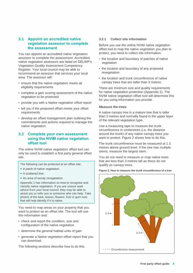
Measure the trees
A native canopy tree is a mature tree that is taller
than 3 metres and normally found in the upper layer
of the relevant vegetation type.
Use a measuring tape to measure the trunk
circumference in centimetres (i.e. the distance
around the trunk) of any native canopy trees you
want to protect. Figure 2 shows how to do this.
The trunk circumference must be measured at 1.3
metres above ground level. If the tree has multiple
stems, measure the largest stem.
You do not need to measure or map native trees
that are less than 3 metres tall as these do not
qualify as canopy trees.
Figure 2. How to measure the trunk circumference of a tree

10 First party offset guide
Take photographs
You must take photographs of all the native
vegetation proposed to be protected, including
photos taken from several different locations and
distances. These photos will be included in the offset
management plan prepared during Step 5.
It is desirable to include close-up photographs of the
plants and their leaves, flowers, bark and fruit (as
applicable) to assist in identification. If the area of
native vegetation to be protected is large, provide
photos that are indicative of the native vegetation.
3.2.2 Map the native vegetation in the NVIM
native vegetation offset tool
Access the NVIM native vegetation offset tool at
https://nvim.delwp.vic.gov.au/ to map the native
vegetation information you collected in Step 3.2.1.
Table 3 explains how to use the NVIM native
vegetation offset tool. Points 5, 6 and 7 explain how
to map native vegetation you plan to protect. The
native vegetation can include a patch, scattered tree
or revegetation or a combination of these.
Table 3. How to use the NVIM native vegetation offset tool
1. Open the NVIM native vegetation offset tool
Go to the NVIM system home page
https://nvim.delwp.vic.gov.au/
Click ‘Proceed to the native vegetation offset tool’.
2. Proposal to protect native vegetation
Read the information about protecting native vegetaton.
Make sure the NVIM native vegetation offset tool is the
right tool for you. If it is - click ‘Start’.
3. Locate your site
Type your address in the property search bar.
You can also use the zoom buttons or your mouse
scroller to find your site.
Property search bar
Proceed to the native
vegetation offset tool
Click Start
Zoom buttons

First party offset guide
11
4. View the condition score and strategic
biodiversity value score
Select the ‘Map layers & legend’ menu.
• Select ‘Aerial imagery’ to view the native vegetation.
• You will generate more gain if you protect areas of
native vegetation with greater biodiversity value.
These are the areas with:
– higher ‘native vegetation condition’ (select layer to
view, and expand the legend)
– higher strategic biodiversity value (select layer to
view, and expand the legend), and
– large scattered trees.
5. Draw the boundary of any patches
Select the ‘Identify native vegetation’ menu to start
mapping.
Select ‘Map patch’ to draw a boundary around any
patches of native vegetation you plan to protect.
• A patch is either an area with 25 per cent native
perennial understorey plant cover OR three canopy
trees with a continuous canopy (see Appendix 1).
Draw a line that follows the boundary of the patch.
• If the patch boundary includes a tree, the drip line of
the tree canopy is the boundary of the patch.
6. Map native canopy trees
Select ‘Map tree’ to map the location of all canopy trees
you want to protect.
• Mark the location of trees within patches of native
vegetation.
• Mark the location of trees outside patches of native
vegetation (scattered trees).
For each tree you map, the NVIM native vegetation
offset tool will prompt you to enter the trunk
circumference.
• Type in the trunk circumference (see section 3.2.1
and Figure 2) when prompted.
The NVIM native vegetation offset tool determine if a
tree is scattered or within a patch and if the tree is
large, or too small to be protected as an offset.
Enter trunk circumference
‘Map layers and legend’ menu
Scattered trees
Trees within
patches

12 First party offset guide
7. Draw the boundary of any areas of
revegetation
Select the ‘Identify native vegetation’ menu. Choose
‘Map revegetation’ to draw a boundary around any area
you plan to revegetate.
An area of revegetation must be woody and must meet
the minimum size and configuration requirements
(Appendix 2). The NVIM native vegetation offset tool
will tell you the area to perimeter ratio of any
revegetation area that you map. Generally, circular or
square areas of more than 0.64 hectares would meet
the requirements. Long and narrow revegetation sites
would not.
8. Estimate gains and proceed to results
As you map the vegetation you want to protect, a
summary will appear on the left of the screen.
Click ‘Estimate gains’ at any time to see how many
habitat units of gain would be generated by protecting
the vegetation you have mapped. You can use this to
check if potential gain meets your offset requirements
or if more vegetation has to be protected.
When you have finished mapping the vegetation you
want to protect, click ‘Proceed to results’.
9. Summary of offset site
The summary of mapped native vegetation includes the
habitat units of gain, number of large trees and the
strategic biodiversity value score.
If you want to adjust the native vegetation you mapped,
click ‘Back to Identify your proposal’.
You can use the ‘Edit’ button to adjust the areas you
have mapped.
When you are happy with the native vegetation you
have mapped and are ready to continue, click ‘Next’.
10. Next steps
Review the next steps for securing your first party
general offset site.
Click ‘Download report’ to save the Native vegetation
offset report to your computer.
Click ‘Export map’ to save the map to your computer as
a Shapefile.
Summary of mapped vegetation
Area to perimeter ratio for revegetation
Estimate gains
Proceed to results
Next
Download report
Export map
Back to Identify
your proposal

First party offset guide
13
Compare the offset requirements on your permit conditions or on the Native vegetation removal report with the information in the Native vegetation offset report.
If you appointed an accredited native vegetation
assessor to complete the assessment, the assessor
will provide you with a Native vegetation offset
report. If you completed your own assessment you
would have downloaded the Native vegetation offset
report using the NVIM native vegetation offset tool.
• Are there enough habitat units of gain at the offset
site to meet your offset requirements?
• Is the offset site located in the same Catchment
Management Authority area or municipal district as
the native vegetation removal site?
• Is the offset site’s strategic biodiversity value score
the same or higher than the minimum strategic
biodiversity value score requirement?
• Are there at least the same number of large trees
on the offset site as the number being removed
from the removal site?
Next steps
You should now have checked that:
• the native vegetation you have mapped is eligible
to be an offset site
• you can secure and manage a first party offset
site, the costs are acceptable and a statutory body
is prepared to sign the security agreement
• you can generate sufficient habitat units of gain to
meet your offset requirements, and
• the property has the appropriate offset attributes to
meet your offset requirements (i.e. minimum
strategic biodiversity value score, same CMA or
municipal area, large trees).
If you have decided to meet your offset requirement
with a first party offset, go to Step 5.
Step 4. Does the proposed offset site meet offset requirements?
Look at the offset requirements on the Native vegetation
removal report. Compare these to the information in the
Native vegetation offset report.

14 First party offset guide
The security agreement specifies management obligations and commitments for the offset site. The offset management plan becomes a schedule to the security agreement and provides detail on how the management obligations and commitments will be achieved.
Ensure you are aware of the costs to
manage and secure your offset site.
Obtain quotes and confirm current fees.
Estimates are provided in Step 2.3.
5.1 Prepare the offset management plan
The offset management plan sets out a 10 year plan
for managing and improving the site condition and
includes:
• 10 years of management obligations and
commitments to improve the offset site condition,
and
• ongoing management commitments to maintain
the vegetation at the improved condition, following
the initial 10 year period.
Sites assessed by an accredited native
vegetation assessor
If an accredited native vegetation assessor
completed a gain scoring assessment an offset
management plan would have been prepared by
them. The plan will be tailored to the specific needs
of the offset site to address the threatening
processes and weed cover determined during the
gain scoring assessment.
The offset management plan must be developed in
accordance with the Native vegetation gain scoring
manual, Version 2. A 10 year offset management
plan template is available on the DELWP website.
Sites assessed using the NVIM native vegetation
offset tool
A simplified version of the offset management plan
template has been developed for landowners using
the NVIM native vegetation offset tool. The template
is available on the DELWP website and can be used
by a land owner to complete their own offset
management plan.
5.2 Prepare the security agreement
You must prepare the security agreement in
consultation with the statutory body that agreed to
sign it in Step 2. The security agreement is a legal
document so you may need a lawyer to assist you.
Ensure you are willing and able to meet the legal
obligations for land management and land use
restrictions that will be recorded on your land title.
The following must be included in the agreement:
• Agreement – legal obligations and commitments of
the landowner and the responsible authority
• Schedules to the agreement:
– details of the agreement, signatories and
description of the land
– site plan to Land Victoria’s specifications
– the offset management plan
– pages 1 and 2 of the Native vegetation offset
report, produced in Step 3.
Site plan to Land Victoria’s specifications
The site plan is included as a schedule to the
security agreement. This is a black and white plan
showing the location of the offset site (i.e. the area
of vegetation to be protected).
The plan must be drawn to Land Victoria’s Surveyor
General’s specifications. For example the offset site
must be hatched and anchored to a crown point with
bearing and distances shown in true north.
A licensed surveyor should be engaged to ensure
the plan meets the standards outlined in the
Surveyor’s Manual. You can provide the surveyor
with the Shapefile of the offset site that you
downloaded from the NVIM native vegetation offset
tool.
5.3 Submit the proposal to the statutory body
The statutory body that will sign the security
agreement will review the proposal to ensure it has
been correctly completed. They will review the offset
management plan and Native vegetation offset
report to confirm that is in accordance with the
Guidelines. They will check that the native
vegetation is eligible to be an offset.
If the agreement is a section 173 with local Council,
they may require the agreement be peer reviewed
by Council’s preferred legal provider. Any legal
expenses are usually borne by the landowner.
Step 5. Prepare the offset management plan and security agreement

First party offset guide
15
Offset sites need to protect and manage native vegetation in perpetuity (forever). Once the security agreement has been signed by the landowner and the statutory body it will be registered on the land title and the offset management plan must be implemented.
6.1 Sign the agreement
Make sure you understand the agreement and what
you are committing to. Once you are satisfied with
the agreement, you must sign and date the
agreement and submit it with all the Schedules to
the statutory body for their signature. A copy with all
signatures will be returned to you for your records.
The 10 year offset management plan commences
from the date the statutory body signs the
agreement.
6.2 Register the agreement with the Land Titles Office
The statutory body will advise you on the process to
lodge the agreement for registration at the Land
Titles Office. The statutory body may engage their
preferred legal provider to complete this process.
Any legal expenses are usually borne by the
landowner.
Once the agreement is registered on the land title,
the landowner, statutory body and any other parties
to the agreement should be notified. Registration of
the agreement on the land title ensures that all
future owners are aware of, and bound by, the
requirements of the agreement.
6.3 Register the offset site on the Native Vegetation Offset Register
Once the site is registered with the Land Titles
Office, the landowner should notify DELWP of the
registration and send a copy of the approved
agreement via email to the Native Vegetation Offset
Register -
The site will then be registered on the Native
Vegetation Offset Register.
If you intend to use your first party offset site to meet
the offset requirements of multiple applications to
remove native vegetation, your offset site must be
registered on the Native Vegetation Offset Register.
This ensures that units are correctly allocated over
time. To register the site, send an email to the
Native Vegetation Offset Register and include the
following:
• Native vegetation offset report
• Shapefile of the offset site (this will be provided by
your site assessor or downloaded from NVIM)
• Approved security agreement signed by all parties
• A completed Offset allocation form (this can be
downloaded from the DELWP website).
If you are not sure whether your site is registered,
you can contact the Native Vegetation Offset
Register.
6.4 Annual reporting
All offset management plans include a commitment
to submit an annual report to the statutory body that
signed the security agreement (Council, DELWP or
Trust for Nature).
The annual report must outline the actions
undertaken for the previous year, and make a
comment about the site’s ‘end of year’ condition
compared to the ‘pre-management’ condition of the
site.
The annual report template is available on DELWP’s
website.
NOTE
If the Native vegetation offset report forms part of
an offset statement included in a permit application,
the local council will ensure that the proposed offset
site:
• has sufficient habitat units of gain to meet your offset
requirements.
• has the appropriate offset attributes to meet your
offset requirements (i.e. minimum strategic
biodiversity value score, same CMA or municipal
area, large trees).
The offset site should not be established until the
approval to remove the native vegetation has been
granted.
If evidence of the secured offset site is being
provided to local council to satisfy a permit
condition, the signed agreement with all Schedules
must be provided as evidence.
Step 6. Establish the offset site

16 First party offset guide
A. What is native vegetation?
Native vegetation is defined in the Victoria Planning
Provisions as ‘plants that are indigenous to Victoria,
including trees, shrubs, herbs and grasses’.
The Guidelines classify native vegetation in two
categories; patch and scattered tree.
B. What is a patch of native vegetation?
A patch of native vegetation is either:
• an area of vegetation where at least 25 per cent of
the total perennial understorey plant cover is
native (Figures 4, 5 and 6), or
• any area with three or more native canopy trees
where the drip line of each tree touches the drip
line of at least one other tree, forming a continuous
canopy (Figures 4 and 7), or
• any mapped wetland included in the current
wetlands layer, available in systems and tools
developed by DELWP.
When you are mapping a patch of native vegetation
that contains native canopy trees you will also need
to measure the trees to determine if any are
considered to be ‘large trees’.
C. What is a scattered tree?
A scattered tree is a native canopy tree that does
not form part of a patch (Figures 4, 6 and 7).
A scattered tree can be a ‘large scattered tree’ or a
‘small scattered tree’.
D. What is a native canopy tree?
A native canopy tree is a mature tree that is taller
than 3 metres and normally found in the upper layer
of the relevant vegetation type.
E. What is a large tree?
A large tree is a native canopy tree with a trunk
circumference greater than or equal to the large tree
benchmark for the local vegetation type1.
A large tree can be a large scattered tree or a large
tree within a patch of native vegetation.
1 A large tree is a native canopy tree with a Diameter at Breast Height
(DBH) greater than or equal to the large tree benchmark for the local
Ecological Vegetation Class (EVC), measured at 1.3 metres above
ground level.
You will need to measure the trunk circumference of
all native canopy trees so that the NVIM native
vegetation offset tool can determine if a tree is large
enough to generate gain or qualify as large. Section
3.2.1 explains how to do this.
F. Extent
The extent of native vegetation is the area of land
covered by a patch and/or a scattered tree:
• The extent of a patch is the size of the patch in
hectares.
• The extent of a scattered tree is mapped as a
circle with a 15 metre radius.
If you are not an accredited native
vegetation assessor, you can use the
flow diagram in Figure 8 to help you
work out if the native vegetation is a
patch or a scattered tree.
Appendix 1 – How to classify native vegetation

First party offset guide
17
Figure 5. Patch of native vegetation (treeless) where at least 25
per cent of the total perennial understorey plant cover is native
Figure 6. Patch of native vegetation (including trees within the
patch) where at least 25 per cent of the total perennial
understorey plant cover is native
Figure 7. Patches of native vegetation with three or more native
canopy trees where the drip line of each tree touches the drip line
of at least one other tree, forming a continuous canopy
Figure 8. Planted wind row. This is unlikely to meet eligibilty
requirements to be an offset.
Crop
Patch (understorey
>25% native)
Patch (at least 3 trees
with continuous
canopy)
Scattered trees
Scattered
tree
Patch (understorey
>25% native)
Pasture grass
(understorey
<25% native)
Figure 4. How to classify native vegetation
Planted wind row

18 First party offset guide
Figure 8. How to decide if native vegetation is a patch or scattered tree
Is it a native canopy tree that is taller than 3 metres?
Hint: Eucalyptus (Gum Trees) and Bulokes are typical native canopy trees. Wattles, Paperbarks and Tea-trees are usually understorey trees. Canopy trees less than 3 metres tall are considered understorey trees.
Yes
Is it in a group of three or more
native canopy trees with overlapping or
continuous canopy?
Yes - this is a patch No
Is the tree surrounded by
other native vegetation with
25% native cover, such as grasses,
shrubs or understorey trees?
Yes - this is a patch
No - this is a scattered tree
No
Is there any other native vegetation, such as grasses,
shrubs or understorey trees?
Yes
Is at least 25% of the plant cover native at that
location?
Yes - this is a patch
No - this is native vegetation that
does not qualify as either a patch or a
scattered tree
No - this is not native vegetation
Legend

First party offset guide
19
The NVIM native vegetation offset tool is described
in Step 3.2.2. This Appendix provides you with
further information about the size and quality
requirements of a first party general offset site.
A. Patch of native vegetation
A patch of native vegetation should have a minimum
condition score of 0.4 out of 1, in the Native
vegetation condition map.
To see the condition score of the native vegetation
you want to protect:
• select the ‘Map layers & legend’ menu
• in the Layers tab, select ‘Native vegetation
condition
• in the Legend tab you can view the condition score
for each colour you see in the map.
B. Scattered tree
A scattered tree must have a DBH greater than or
equal to 75 per cent of the large tree DBH
benchmark for the local area. The NVIM native
vegetation offset tool will tell you if a tree is:
• large (i.e. greater than or equal to the large tree
benchmark for the local area)
• between 75% and 100% of the large tree
benchmark for the local area
• If the tree is less than 75% of the large tree
benchmark, the tool will tell you the tree is too
small to generate gain.
Each scattered tree must have an area of land
secured around it (a circle with a diameter of at least
30 metres) to provide space for recruitment. The
NVIM native vegetation offset tool will draw a circle
with a 30 metre diameter around each scattered tree
you identify for protection.
At least five recruits need to regenerate, or be
planted in the area around each protected scattered
tree.
C. Revegetation
Revegetation must be for a woody vegetation type.
The NVIM native vegetation offset tool will tell you if
the revegetation you propose is not in a woody
vegetation type.
To see the vegetation type of the area you want to
revegetate:
• select the ‘Map layers & legend’ menu
• in the Layers tab, select ‘Pre-1750 Ecological
Vegetation Class’
• click on EVC query, then click on the area you
want to revegetate.
Revegetation must be in accordance with the
minimum planting standards specified in the Native
vegetation gain scoring manual, Version 2. The first
party general offset site management plan template
on the DELWP website will assist you.
An area of revegetation must meet the minimum
size and configuration requirements:
• When revegetation is not next to a patch of native
vegetation the revegetation site must have an area
to perimeter ratio of at least 20.
• When revegetation is next to a patch of native
vegetation the combined revegetation area and
adjacent patch of native vegetation must have an
area to perimeter ratio of at least 20.
The area to perimeter ratio is calculated by dividing
the area (metres squared) by the perimeter (metres).
The NVIM native vegetation offset tool will tell you
the area to perimeter ratio of any proposed
revegetation area that you map. Generally, circular
or square areas of more than 0.64 hectares would
meet the requirements. Long and narrow
revegetation sites would not.
Appendix 2 – Minimum condition, size and configuration requirements
Condition scores
EVC query
Pre-1750 Ecological
Vegetation Class

20 First party offset guide
Accredited native vegetation assessor – A native
vegetation assessor listed on DELWP’s Vegetation
Quality Assessment Competency Register. An
accredited native vegetation assessor must have
current accreditation (less than two years old at the
time the site assessment is completed).
First party offset site – an offset site on the same
property as the proposed removal of native
vegetation, or on another property owned by the
party requiring the offset.
First party general offset site – an offset site on
the same property as the proposed removal of
native vegetation, or on another property owned by
the party requiring the offset that can be established
using the NVIM native vegetation offset tool and
standard templates developed by DELWP without
specialist assistance. This site can only generate
and provide general habitat units of gain.
Gain – The predicted improvement in biodiversity
value of native vegetation due to active
management and increased security provided at an
offset site.
General habitat unit – A measure of loss and gain
in overall biodiversity value of native vegetation.
General habitat units are used to measure offset
amount and gain generated at an offset site.
General offset – An offset requirement specified in
general habitat units to compensate for the
biodiversity loss from native vegetation removal
Native Vegetation Credit Register – A statewide
register of native vegetation credits that meet
minimum standards for security and management of
sites. The register is administered by DELWP and
records the creation, trade and allocation of credits
to meet offset requirements.
Native Vegetation Offset Register – A statewide
register containing information relating to existing
and potential offset sites including the number of
habitat units that an offset site generates and when
these offsets have been used to offset the removal
of native vegetation. The Native Vegetation Offset
Register is administered by DELWP, and includes
the Native Vegetation Credit Register
NVCR accredited site assessor – an accredited
native vegetation assessor that has signed an
agreement to be a service provider with the NVCR.
Native vegetation credit – habitat units protected at
a third party offset site are traded as native
vegetation credits
Statutory body – a body that can sign a security
agreement to protect native vegetation as an offset
site. This can be Trust for Nature, Local Council or
DELWP.
Species habitat unit – A species habitat unit is the
measure of loss and gain in biodiversity value of
native vegetation for a particular rare or threatened
species. Species habitat units are used to measure
offset amount and gain generated at an offset site.
Species offset – An offset requirement specified in
species habitat units to compensate for the impact
on a rare or threatened species habitat from native
vegetation removal.
Third party offset site – an offset site that is
established on another party’s property. Third party
offsets are traded as native vegetation credits.
Glossary .

First party offset guide
21

22 First party offset guide
delwp.vic.gov.au