how to use the photo rectification software
TRANSCRIPT

How to use the Photo Rectification Software You only need 2 measurements, width & height
Open Curamess photo rectifying software. Use the software to rectify the jpeg photo. After you have calibrated your image, Draw 1 large rectangle around the image you want to export into CAD. This can be one total image or a selection of smaller images, e.g. doors, windows, stone detail, etc. In Curamess go to Export, Image Rectification. In your CAD software just import the image as a Raster image. Use the scale by reference command to re-size the image in CAD. Now trace over the image to produce a very accurate elevation. It’s so simple.
Surveyors with total stations You can survey a skeleton of the building, and then use the software to add detail to your elevation. This skeleton elevation was produced on site with a PocketPC and our PocketCAD software.
Finished Drafted CAD Elevation
Imported Rectified Photo Trace over this to produce your finished elevation.
Rectified Photo
Only £ 360.00
braasch & jäschke computertechnik www.maxmess.de dornbergsweg 2 www.curamess.de D-38855 wernigerode [email protected]
maxmess is a flexible system for
the survey of buildings which has
been proven in many projects.
maxmess records geometries,
additional data and multimedia
information of buildings. Intelligent
drawing and measurement functions
ensure rapid working. Ground plans
are composed of a puzzle of base
surfaces. This puzzle can be easily
applied and delivers excellent
results.
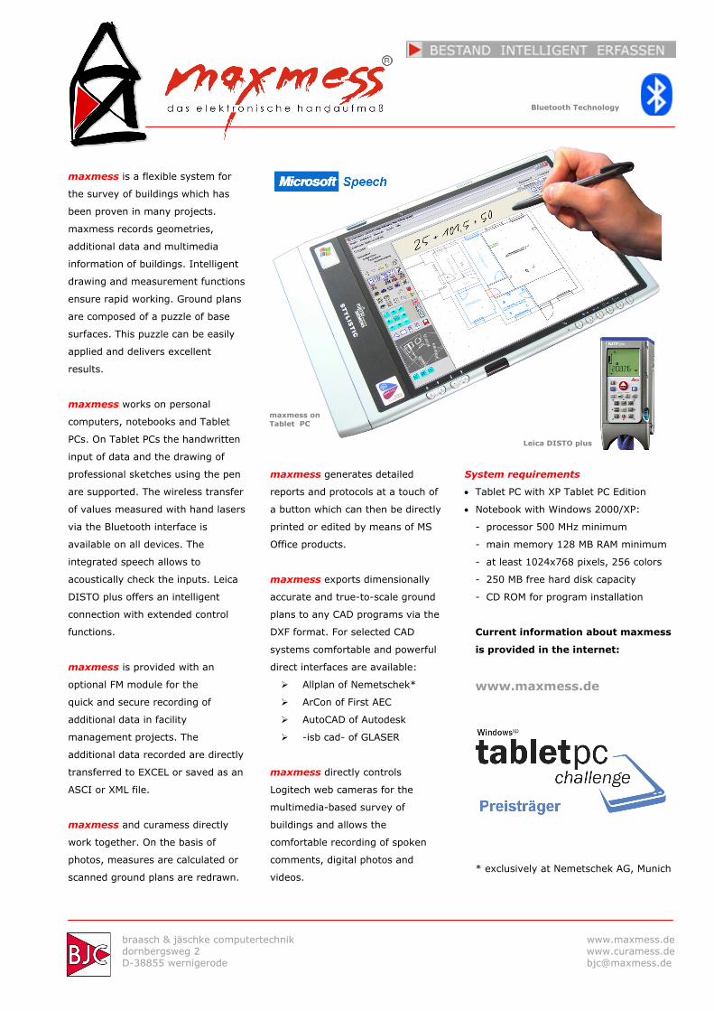
maxmess works on personal
computers, notebooks and Tablet
PCs. On Tablet PCs the handwritten
input of data and the drawing of
professional sketches using the pen
are supported. The wireless transfer
of values measured with hand lasers
via the Bluetooth interface is
available on all devices. The
integrated speech allows to
acoustically check the inputs. Leica
DISTO plus offers an intelligent
connection with extended control
functions.
maxmess is provided with an
optional FM module for the
quick and secure recording of
additional data in facility
management projects. The
additional data recorded are directly
transferred to EXCEL or saved as an
ASCI or XML file.
maxmess and curamess directly
work together. On the basis of
photos, measures are calculated or
scanned ground plans are redrawn.
maxmess generates detailed
reports and protocols at a touch of
a button which can then be directly
printed or edited by means of MS
Office products.
maxmess exports dimensionally
accurate and true-to-scale ground
plans to any CAD programs via the
DXF format. For selected CAD
systems comfortable and powerful
direct interfaces are available:
Allplan of Nemetschek*
ArCon of First AEC
AutoCAD of Autodesk
-isb cad- of GLASER
maxmess directly controls
Logitech web cameras for the
multimedia-based survey of
buildings and allows the
comfortable recording of spoken
comments, digital photos and
videos.
System requirements
• Tablet PC with XP Tablet PC Edition
• Notebook with Windows 2000/XP:
- processor 500 MHz minimum
- main memory 128 MB RAM minimum
- at least 1024x768 pixels, 256 colors
- 250 MB free hard disk capacity
- CD ROM for program installation
Current information about maxmess
is provided in the internet:
www.maxmess.de
* exclusively at Nemetschek AG, Munich
maxmess auf Tablet PC
Bluetooth Technology
Leica DISTO plus
Leica DISTO plus
maxmess on Tablet PC

braasch & jäschke computertechnik www.maxmess.de dornbergsweg 2 www.curamess.de D-38855 wernigerode [email protected]
curamess Photogrammetry for Everyone
curamess is a worldwide new
precision method for calculating the
measures of digital photos.
• Two known lengths are sufficient
to establish the dimensional
relations.
• Image defects due to the lens and
perspectives are corrected.
curamess allows everyone to use
the advantages of photogrammetric
methods.
• The technical equipment is to
meet low requirements.
• The familiarization with the
product is supported by videos.
curamess is suitable for planners,
experts and craftsmen.
• The results are exported to MS
Excel, MS Word and CAD
programs.
• In addition to the DXF interface
comfortable and powerful direct
interfaces are available for the
following CAD systems:
� Allplan of Nemetschek*
� ArCon of First AEC
� AutoCAD of Autodesk
� -isb cad- of GLASER
curamess offers 3D drawing
functions for ground plans and quick
calculations.
curamess distorts image sections
and saves them with selectable
resolutions in image files, if required.
curamess significantly reduces the
number of editing steps. With a
minimum expenditure curamess
achieves maximum results.
• curamess ensures exact working
and immediately displays the
dimensional accuracy
• curamess supports damage
mapping and the quantity
determination of plans
• curamess is ideally suited for
generating drawings of photos as
well as ground and key plans
based on scanned paper
documents.
System requirements
• Windows 2000, XP
• personal computer
- 1024x768 pixels, 16.7 million colors
- 256 MB RAM main memory
- 800 MHz Pentium processor
- 250 MB free hard disk capacity
- CD ROM for program installation
• any digital cameras and scanners
Current information about curamess
is provided in the internet:
www.curamess.de
* exclusively at Nemetschek AG, Munich
Patent granted