%20line,%20and%20trawler
DESCRIPTION
http://www.pacificenvironment.org/downloads/Hook,%20Line,%20and%20Trawler.pdfTRANSCRIPT

HOOK, LINE,& TRAWLER
Gear Impacts and International Cooperation in the Bering Seaby Jennifer Castner, Artur Maiss, Whit Sheard, Gennady Evsikov
Edited by Leah Zimmerman
P A C I F I C E N V I R O N M E N T
w w w . p a c i f i c e n v i r o n m e n t . o r g
To the average American or Russian, the Bering Sea is a little
known and exotic place—perhaps it is not even clear where to pin-
point this body of water on a world map. To those who depend
upon the Bering Sea for sustenance, financial security, and cultural
traditions, however, it holds a much more significant place. Even
those who cannot find it on a map unknowingly depend upon the
Bering Sea for its bounty of fish and other seafood products. The
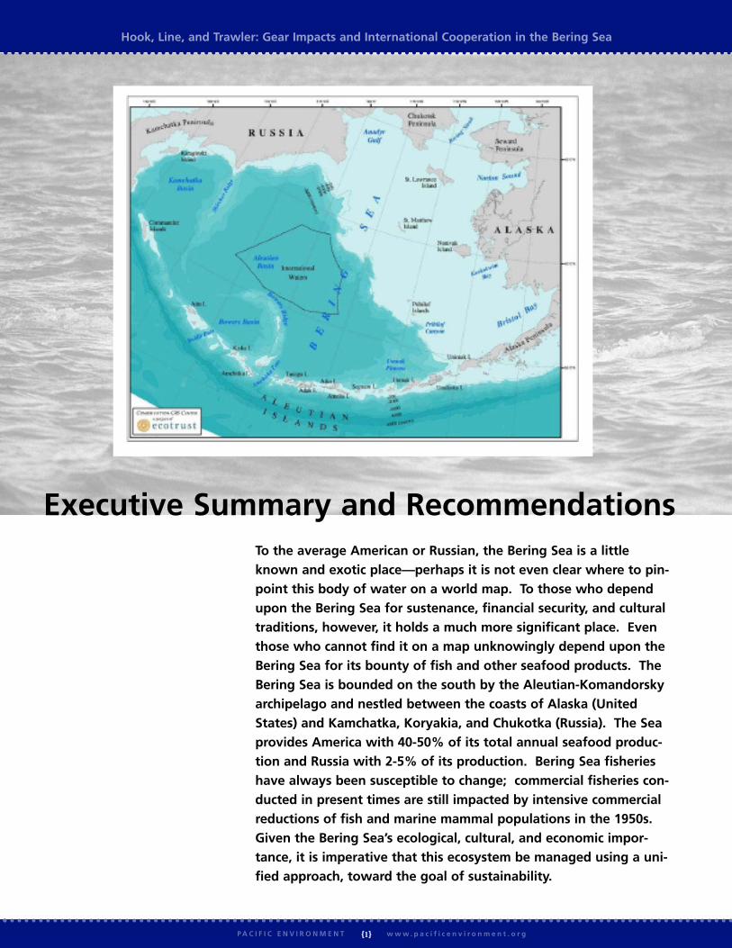
Bering Sea is bounded on the south by the Aleutian-Komandorsky
archipelago and nestled between the coasts of Alaska (United
States) and Kamchatka, Koryakia, and Chukotka (Russia). The Sea
provides America with 40-50% of its total annual seafood produc-
tion and Russia with 2-5% of its production. Bering Sea fisheries
have always been susceptible to change; commercial fisheries con-
ducted in present times are still impacted by intensive commercial
reductions of fish and marine mammal populations in the 1950s.
Given the Bering Sea’s ecological, cultural, and economic impor-
tance, it is imperative that this ecosystem be managed using a uni-
fied approach, toward the goal of sustainability.
Hook, Line, and Trawler: Gear Impacts and International Cooperation in the Bering Sea
{1}P A C I F I C E N V I R O N M E N T w w w . p a c i f i c e n v i r o n m e n t . o r g
Executive Summary and Recommendations

The Bering Sea can be divided into three geopolitical regions:the Eastern and Western Bering, located respectively within theUnited States’ and Russia’s Exclusive Economic Zones (EEZs);and the Central Bering Sea “Donut Hole,” consisting of inter-national high seas belonging to no single country. Thus, whilethe Bering Sea is recognized as a single large ecosystem com-prised of smaller ecosystems, its management is shared byRussia, the United States, and various international fisheriesbodies. While there have been positive management measurestaken to address ecosystem stress in all three regions, there is nosingle unified international management plan that takes intoaccount the entire ecosystem. Instead, the Bering Sea is man-aged under a complex and disjointed system that focuses largelyon commercial extraction. This system, although constantlyevolving, is neither sufficiently integrated nor coordinated toensure that the Bering Sea remains one of the world’s most pro-ductive ecosystems.
This report will present a brief overview of the Bering Seaecosystem and the impacts associated with industrial fisheries.More specifically, it will focus on several themes:
w Russian and U.S. management structures
w Commercial fleet structures
w Impacts from specific commercial fishing gear
While there is no simple solution to increasing the effectivenessof fisheries management in the Bering Sea, there are importantmeasures that can be taken immediately to increase the likeli-hood of preserving this ecologically unique ecosystem. Indeed,there are positive examples on both sides of the Bering fromwhich to draw. Specific recommendations that can be imple-mented immediately include:
w An effective international agreement and commission tocoordinate management
w Increased scientific research and coordination
w A transition to Ecosystem-Based Management across theentire Bering
w Further restrictions on harmful gear, such as bottom trawl-ing and large-scale driftnets, throughout the Bering
The Bering Sea EcosystemThe Bering Sea is a semi-enclosed northern extension of theNorth Pacific Ocean that covers nearly three million km2 andincludes unusual geographic features such as an enormous conti-nental shelf with a gentle gradient and seven of the largest sub-marine canyons in the world. The Bering Sea is fed by waterfrom the Gulf of Alaska in the south. In the north, this nutri-ent rich water exits the Bering Sea through the Bering Straitinto the Chukchi Sea. Water also exits the Bering Sea to the
southwest, along the Kamchatka Peninsula. The nutrient richwaters of the Bering support at least 450 species of fish, crus-taceans, and mollusks; 50 species of seabirds; and 25 species ofmarine mammals.1
The Bering Sea consists of the Bering Sea abyssal basin, thecontinental slope, the continental shelf, the islands, the mixingzone along the North Pacific Ocean, and the coastal areas ofthe U.S. and Russian shores. Along the shelf break is a pro-ductive area known as the “Green Belt.” This narrow band isthought to extend along both continental shelves (eastern andwestern) and into the Chukchi Sea. Interactions betweenupwellings formed by the steep shelf break and tidal transport,canyons, and eddies along the shelf edge create nutrient richwaters and a cascading bloom of life. The unique physical fea-tures of the Green Belt have resulted in biological hotspotsincluding the Zhemchung and Pribilof canyons. The areaaround the Pribilof Islands is considered to be especially bio-logically rich due to the proximity of these large underseacanyons and nutrient rich waters, which support large concen-trations of fish, seabirds and marine mammals.
Benthic – or seafloor – habitat in the Bering Sea consists of liv-ing and nonliving substrates. Nonliving substrates include boul-ders, cobbles, sand waves, and other seafloor components.Living substrates include macroalgae, bryozoans, stalked ascidi-ans, corals, sponges, and anemones. Living substrates such ascold-water corals are extremely slow-growing, and may take over100 years to reach maximum size. These substrates harbor richpopulations of groundfish, and have been documented in associ-ation with the life stage of almost all important commercialspecies.
Bering Sea Fisheries and FisheryManagementGroundfish make up the majority of the catch in the BeringSea. The major targets of U.S. fisheries are pollock, Pacific cod,flatfish (including yellowfin sole, rock sole, and arrowtoothflounder), sablefish, rockfish, Atka mackerel, halibut, and crab.There are 15 primary commercial targets in the Western Bering:pollock, cod, halibut, herring, perch, Atka mackerel, flounder,Far Eastern cod, goby, skates and sharks, squid, grenadier,salmon, shrimp, and crab. These fisheries are prosecuted withmany types of fishing gear; major gear types include pelagic andbottom trawls, driftnets, set nets, Dutch seines, longlines, trapsand pots, purse seines, and dredges.
Alaska is the United States’ leading fishing grounds, with land-ings totaling 2.3 million metric tons of fish in 2002. Theselandings include 1.5 million metric tons of pollock, the largestsingle fishery in the country, with an approximate ex-vesselvalue of $210 million. Alaska is also responsible for 92% of thewild salmon production in the U.S. – approximately 237,000metric tons in 2002.2 Of the 2.3 million metric tons of total
Hook, Line, and Trawler: Gear Impacts and International Cooperation in the Bering Sea
{2}P A C I F I C E N V I R O N M E N T w w w . p a c i f i c e n v i r o n m e n t . o r g

Hook, Line, and Trawler: Gear Impacts and International Cooperation in the Bering Sea
{3}P A C I F I C E N V I R O N M E N T w w w . p a c i f i c e n v i r o n m e n t . o r g
catch, nearly 2 million metric tons comes from the Bering Seaand Aleutian Islands fisheries management areas.3
While there are some similarities between regulations by theRussian and U.S. governments on fishing and fishing gear usagein the Bering Sea, the two countries ultimately take very differentapproaches to fisheries management. Although U.S. laws includeconservation mandates for fisheries and habitat, Russian lawsregarding fisheries are in some ways more stringent thanAmerican laws. For example, there is a near total ban on bottomtrawling in the Western Bering, while harmful bottom trawlingcontinues legally on the U.S. side of the sea. However, Russianlaw has its own problems. One issue is the lack of requirementsfor an independent and non-corrupt observer network on Russianfishing vessels. In addition, the uncertainty and lack of trans-parency that characterize Russia’s transition to a market economyalso plague the fishing industry. Even though Russia has specificfishing regulations, direct enforcement of these regulations onopen waters is often weak and inconsistent. This leads to over-fishing and illegal bottom trawling, among other problems.
Bottom trawling has extensively impacted fisheries habitat in theU.S. side of the Bering Sea. Research has shown negativeimpacts particularly to old-growth corals and other rocky areasthat are critical to fisheries habitat. Recent developments on theU.S. side indicate a willingness to begin addressing these issues.The North Pacific Fishery Management Council (NPFMC), afederal commercial fisheries advisory body, reached a unanimousdecision in early 2005 to recommend the closure of 375,000square miles – or 60 percent – of the Bering Sea’s Aleutian Islandmanagement sub-area. Efforts are still needed to implement thisdecision, which will help reduce coral bycatch and protect deepwater corals near the Aleutian Islands. The decision applies aneeded precautionary approach and provides a step toward theecosystem-based management needed in the North Pacific toreverse the declines of its marine mammals, seabirds, and otherplants and animals. Following this important first step, U.S.management agencies should review whether the closure areashould be expanded to other areas in the Bering Sea.
Regulatory and management regimes on both sides of theBering have several shared limitations. One of the most seriousissues relates to conflicts of interest between commercial fishingentities and government policy-making and regulation. Forexample, the NPFMC (as well as all other U.S. federal fisheriesmanagement councils) lacks a clause to prevent conflicts ofinterest, unlike most other federal U.S. regulatory bodies. As aresult, commercial fishing representatives are overly influentialin allocating quotas and opening areas to fishing. In Russia, it iscommon for successful entrepreneurs, businesses, and commer-cial fishermen to promote their own interests into political andregulatory positions in federal regional and local governments.In practice, Russian fishing quotas, total allowable catch levels,and enforcement efforts are highly influenced and manipulated
by commercial fishing companies.
International cooperation in management of the Bering Seaecosystem is complicated by what Russian fishing interests per-ceive as an ongoing border dispute with the United States. Thecurrent observed maritime boundary, known colloquially inRussian as the “Baker-Shevardnadze Line,” was agreed to in1990. However, the Supreme Soviet failed to ratify the borderbefore the collapse of the Soviet Union. The Russian Duma hasrefused to ratify the agreement, arguing that the boundarydeprives the Russian fishing industry of significant pollockstocks. The U.S. Coast Guard and Russian government official-ly observe the “Baker-Shevardnadze Line,” although Russianfishing vessels sometimes cross the line, resulting in vesselseizures and deepened distrust.
Impacts from Fishing GearDifferent fishing gear types have different impacts upon themarine environment. These impacts include both indirecteffects, such as reductions of biomass and ecosystem-widechanges in productivity, and direct effects including increasedmortality of benthic species, increased food for scavengingspecies, and habitat loss.
Experts generally agree that bottom trawling has the most exten-sive impacts on the marine environment. Direct effects includesmoothing of sediments, dragging rocks and boulders, resuspen-sion and mixing of sediments, removal of seagrass, damage tocorals, and damage or removal of epibenthic organisms.4
Studies in Alaska demonstrate that highly trawled areas in theBering Sea are significantly different than untrawled areas, withthe overall diversity of sedentary taxa reduced in highly trawledareas.5 A survey of various studies both inside and outsideBering Sea waters led the U.S. National Marine Fisheries Service(NMFS) to conclude that bottom trawls cause both short-termchanges in infauna, epifauna, megafauna, and substrates as wellas persistent changes in megafauna communities.6 The FisheriesService also noted that dredges, longlines, pots, and pelagictrawls also cause damage to habitat, but not at the same intensi-ty as bottom trawls. Although bottom trawling is highlyrestricted in Russia, it is fairly common practice to rig pelagictrawls for use as bottom trawls. Pelagic trawls used as bottomtrawls wreak even more destruction on seafloor habitat than tra-ditional bottom trawling.
Large-scale driftnetting also causes significant impacts to theBering Sea. Although banned for more than a decade in inter-national waters due to a U.N. Convention, large-scale driftnet-ting continues to be allowed in Russia’s EEZ under a bilateralagreement between Russia and Japan. Driftnet impacts includelarge catches of immature fish and the resultant impact to targetspecies’ population structures; the unintended bycatch and mor-tality of whales, dolphins, pinnipeds, sea birds, turtles, and

sharks; and “ghost fishing,” where nets lost at sea continue toentrap marine life.
Although all gear causes impacts to the environment, it is gener-ally agreed that large-scale driftnets in the Western Bering andbottom trawls in the Eastern Bering are causing disproportionateharm.
RecommendationsThe negative impacts associated with gear usage in the BeringSea are only one of many challenges to managing fisheries.Recommendations for specific protections from large-scale drift-nets and bottom trawls are simply a piece of the overall puzzle.While calling for an end to these destructive practices is simpleenough, complex issues linger over managing an internationalecosystem that provides a large yield of economic, cultural, andecological returns. Larger solutions must therefore be consid-ered.
Specific recommendations on how to achieve a sustainableBering Sea include:
w An international agreement and commission to coordinatemanagement of bioresources. Currently, there is a great dealof disparity and a lack of comprehensive multi-level coordi-nation between Russian and United States regulations onfishing gear and fisheries, rules regarding onboard observers,and enforcement. Only by taking a long-term view onresources management and international cooperation basedon an integrated and unified standard for all resource users,can we ensure sustainable Bering Sea fisheries protected inpart by habitat and species conservation.
w Increased scientific research and coordination. There is a needfor more specific data on fisheries and the impacts of gearuse, particularly in the Western Bering. Without furtherstudies, it is difficult, for example, to quantify the impactsof legal and illegal bottom trawling on habitat in the BeringSea. Coordination should be improved between Russianand American scientific communities working in theBering. This coordination could be accomplished throughthe establishment of a Scientific Advisory Board as a part ofan international agreement on Bering Sea management.
w Shifting to Ecosystem-Based Management. An ecosystem-based transboundary management regime must be negotiat-ed and put into place, carefully designed to address theneeds of ecosystems, rather than political and businessinterests.
w Further restrictions on harmful gear such as bottom trawlingand large-scale driftnets. Restrictions should include bothspatial restrictions and conversion to cleaner gear, with theassurance that commercial bottom trawling regulations andfisheries are managed with the parallel goals of minimizing
benthic habitat impacts and developing and implementingconsistent and ecologically-sustainable transboundaryRussian-American agreements. In the Western Bering,driftnets larger than 2.5 kilometers in length should betotally banned in order to bring Russia up to internationaland U.S. standards, while the Eastern Bering is in need offurther research and restrictions on bottom-trawling.
w Improved enforcement, monitoring of commercial fishing, andobserver programs. Inconsistency and a lack of coordinationare the primary issue here. In the United States, currentrules on observers require only partial coverage dependingon the size of the vessel. In Russia, mainly internationalfishing vessels are required to have observers on board.Enforcement, while both politically and financially bettersupported in the United States’ EEZ, requires additionaltechnical resources, funding, legislation, and political will inRussia. One of the biggest problems of enforcement inRussia involves illegal bottom trawling; illegally modifiedpelagic trawls must be stopped and restrictions on tradition-al bottom trawls should continue to be strictly enforced.Satellite and GPS monitoring are both excellent new tech-nologies that must be better and more broadly utilized inthis process. Other countries, such as Korea and Japanmust increase their efforts in helping Russia and the UnitedStates enforce existing international and regional agreementson fish landings and gear enforcement.
w Increased collaboration between all Bering Sea stakeholders,resulting in industry outreach to the larger community, espe-cially the indigenous community. The issue here is not astruggle between conservationists, scientists, and commer-cial fishing companies, rather an ongoing effort to sustain-ably manage the Bering Sea’s resources for the benefit of allcommunity members as well as the rich life in the sea itself.
w Creation of an adaptively managed network of marine protect-ed areas, including no-take marine reserves. Perhaps no rec-ommendation has more potential to protect the Bering Seathan the creation of marine protected areas.
The health and biodiversity of the Bering Sea ecosystem areessential to the livelihoods of people in both the U.S. andRussia. The fish of the Bering Sea provide sustenance to peoplethroughout each nation, and the communities that live alongthe shores of the Sea - in Alaska, Chukotka, Koryakia, andKamchatka - depend on its bounty. By implementing these rec-ommendations, we have a vital opportunity to reduce the nega-tive impacts of fishing gear in the Bering Sea and to adopt anecosystem-based approach that will allow for sustainable andproductive management of the Sea.
Hook, Line, and Trawler: Gear Impacts and International Cooperation in the Bering Sea
{4}P A C I F I C E N V I R O N M E N T w w w . p a c i f i c e n v i r o n m e n t . o r g

Hook, Line, and Trawler: Gear Impacts and International Cooperation in the Bering Sea
{5}P A C I F I C E N V I R O N M E N T w w w . p a c i f i c e n v i r o n m e n t . o r g
Table of ContentsNote to Reader . . . . . . . . . . . . . . . . . . . . . . . . . . . . . . . . . . . . . . . . . . . . . . . . . . . . . . . . . . . . . . . . . . . . . . . . . . . . . . . . . . . . . .6
The Bering Sea Ecosystem . . . . . . . . . . . . . . . . . . . . . . . . . . . . . . . . . . . . . . . . . . . . . . . . . . . . . . . . . . . . . . . . . . . . . . . . . . . .6
Water Transportation . . . . . . . . . . . . . . . . . . . . . . . . . . . . . . . . . . . . . . . . . . . . . . . . . . . . . . . . . . . . . . . . . . . . . . . . . . . . . .6
Physiography . . . . . . . . . . . . . . . . . . . . . . . . . . . . . . . . . . . . . . . . . . . . . . . . . . . . . . . . . . . . . . . . . . . . . . . . . . . . . . . . . . . .7
Seafloor Composition . . . . . . . . . . . . . . . . . . . . . . . . . . . . . . . . . . . . . . . . . . . . . . . . . . . . . . . . . . . . . . . . . . . . . . . . . . . . . .7
The Green Belt . . . . . . . . . . . . . . . . . . . . . . . . . . . . . . . . . . . . . . . . . . . . . . . . . . . . . . . . . . . . . . . . . . . . . . . . . . . . . . . . . .8
Benthic Habitat . . . . . . . . . . . . . . . . . . . . . . . . . . . . . . . . . . . . . . . . . . . . . . . . . . . . . . . . . . . . . . . . . . . . . . . . . . . . . . . . .8
Fisheries . . . . . . . . . . . . . . . . . . . . . . . . . . . . . . . . . . . . . . . . . . . . . . . . . . . . . . . . . . . . . . . . . . . . . . . . . . . . . . . . . . . . . . .9
International, Russian, and US Regulations on Fishing and Fishing Gear . . . . . . . . . . . . . . . . . . . . . . . . . . . . . . . . . .9
International Regulations . . . . . . . . . . . . . . . . . . . . . . . . . . . . . . . . . . . . . . . . . . . . . . . . . . . . . . . . . . . . . . . . . . . . . . . . . . .9
Eastern Bering . . . . . . . . . . . . . . . . . . . . . . . . . . . . . . . . . . . . . . . . . . . . . . . . . . . . . . . . . . . . . . . . . . . . . . . . . . . . . . . . . . .9
Western Bering . . . . . . . . . . . . . . . . . . . . . . . . . . . . . . . . . . . . . . . . . . . . . . . . . . . . . . . . . . . . . . . . . . . . . . . . . . . . . . . . .10
Gear Use in the Bering Sea . . . . . . . . . . . . . . . . . . . . . . . . . . . . . . . . . . . . . . . . . . . . . . . . . . . . . . . . . . . . . . . . . . . . . . . . . .11
Eastern Bering . . . . . . . . . . . . . . . . . . . . . . . . . . . . . . . . . . . . . . . . . . . . . . . . . . . . . . . . . . . . . . . . . . . . . . . . . . . . . . . . . .11
Western Bering . . . . . . . . . . . . . . . . . . . . . . . . . . . . . . . . . . . . . . . . . . . . . . . . . . . . . . . . . . . . . . . . . . . . . . . . . . . . . . . . .15
Gear Impacts in the Bering Sea . . . . . . . . . . . . . . . . . . . . . . . . . . . . . . . . . . . . . . . . . . . . . . . . . . . . . . . . . . . . . . . . . . . . . . .18
Impacts by Gear Type: trawls, Danish seines, purse seines, pots/traps, longlines, set nets, driftnets . . . . . . . . . . . . . . . . . . . . . .18
Eastern . . . . . . . . . . . . . . . . . . . . . . . . . . . . . . . . . . . . . . . . . . . . . . . . . . . . . . . . . . . . . . . . . . . . . . . . . . . . . . . . . . . . . . .20
Bottom Trawling and Habitat Impact . . . . . . . . . . . . . . . . . . . . . . . . . . . . . . . . . . . . . . . . . . . . . . . . . . . . . . . .20
Bycatch . . . . . . . . . . . . . . . . . . . . . . . . . . . . . . . . . . . . . . . . . . . . . . . . . . . . . . . . . . . . . . . . . . . . . . . . . . . . . . .21
Western . . . . . . . . . . . . . . . . . . . . . . . . . . . . . . . . . . . . . . . . . . . . . . . . . . . . . . . . . . . . . . . . . . . . . . . . . . . . . . . . . . . . . . .23
Bottom Trawling and Habitat Impact . . . . . . . . . . . . . . . . . . . . . . . . . . . . . . . . . . . . . . . . . . . . . . . . . . . . . . . .23
Bycatch . . . . . . . . . . . . . . . . . . . . . . . . . . . . . . . . . . . . . . . . . . . . . . . . . . . . . . . . . . . . . . . . . . . . . . . . . . . . . . .23
Conclusions and Recommendations . . . . . . . . . . . . . . . . . . . . . . . . . . . . . . . . . . . . . . . . . . . . . . . . . . . . . . . . . . . . . . . . . .24
An International Agreement and Commission to Coordinate Management of Bioresources . . . . . . . . . . . . . . . . . . . . . . . . . . .24
Continued Research and International Cooperation . . . . . . . . . . . . . . . . . . . . . . . . . . . . . . . . . . . . . . . . . . . . . . . . . . . . . . .24
Enforcement, Monitoring, and Observing . . . . . . . . . . . . . . . . . . . . . . . . . . . . . . . . . . . . . . . . . . . . . . . . . . . . . . . . . . . . . .24
Gear Restrictions and Conversion . . . . . . . . . . . . . . . . . . . . . . . . . . . . . . . . . . . . . . . . . . . . . . . . . . . . . . . . . . . . . . . . . . . .24
Ecosystem-based Management . . . . . . . . . . . . . . . . . . . . . . . . . . . . . . . . . . . . . . . . . . . . . . . . . . . . . . . . . . . . . . . . . . . . . . .25
Marine Protected Areas and Reserves . . . . . . . . . . . . . . . . . . . . . . . . . . . . . . . . . . . . . . . . . . . . . . . . . . . . . . . . . . . . . . . . . .25
Works Cited . . . . . . . . . . . . . . . . . . . . . . . . . . . . . . . . . . . . . . . . . . . . . . . . . . . . . . . . . . . . . . . . . . . . . . . . . . . . . . . . . . . . . . . .26
Appendices
A – US Regulations and Management of the Bering Sea . . . . . . . . . . . . . . . . . . . . . . . . . . . . . . . . . . . . . . . . . . . . . . . . .29
B – Russian Regulations and Management of the Bering Sea . . . . . . . . . . . . . . . . . . . . . . . . . . . . . . . . . . . . . . . . . . . . . .30
C – Fishing Gear Used in the Bering Sea . . . . . . . . . . . . . . . . . . . . . . . . . . . . . . . . . . . . . . . . . . . . . . . . . . . . . . . . . . . . .33
D – Salmon Losses in Driftnet Fishing . . . . . . . . . . . . . . . . . . . . . . . . . . . . . . . . . . . . . . . . . . . . . . . . . . . . . . . . . . . . . .37
E – Bird Bycatch in Salmon Driftnet Industry (Western Bering) . . . . . . . . . . . . . . . . . . . . . . . . . . . . . . . . . . . . . . . . . . .38
Endnotes . . . . . . . . . . . . . . . . . . . . . . . . . . . . . . . . . . . . . . . . . . . . . . . . . . . . . . . . . . . . . . . . . . . . . . . . . . . . . . . . . . . . . . . . . . .39
Contact . . . . . . . . . . . . . . . . . . . . . . . . . . . . . . . . . . . . . . . . . . . . . . . . . . . . . . . . . . . . . . . . . . . . . . . . . . . . . . . . . . . . . . . . . . . .41
cover photos: Greenpeace, Vladimir Burkanov
Hook, Line, and Trawler: Gear Impacts and International Cooperation in the Bering Sea
{6}P A C I F I C E N V I R O N M E N T w w w . p a c i f i c e n v i r o n m e n t . o r g
Note to the ReaderThis report was made possible by generous support from the AlaskaConservation Foundation.
The following data represent a compilation of materials gatheredon both sides of the Bering Sea. Narrative text was combinedfrom three separate reports, authored by Whit Sheard, GennadyEvsikov, and Artur Maiss. Additional primary source materialswere taken from a number of scientific institutions and otherdependable sources. A complete list of references is provided atthe end of the report. While the authors share a common goalof promoting sustainable management of the Bering Sea, differ-ent viewpoints on how these goals should be accomplished areinevitable. In this report, the authors attempt to reconcile dif-ferences and to produce a list of basic recommendations – logi-cal and tangible ways to improve fishing gear usage and reducenegative gear impacts in the Bering Sea.
Worth noting is the difference in data available for the Easternand Western regions of the Bering Sea. In general, scientificdata for the Eastern Bering is more readily available, especiallydata regarding seafloor composition and the effects of bottomtrawling on habitats. One of our recommendations is for con-tinued scientific research and coordination.
Whit Sheard is an Environmental Affairs Consultant and wasformerly the Fish Conservation Program Manager for the OceanConservancy. Whit’s undergraduate work was at MiamiUniversity of Ohio, where he graduated with a Bachelor of Artsin Political Science. He later attended the University of Oregonand earned both a Masters of Science and a Juris Doctorate,with an emphasis on natural resource management. Before relo-cating to Alaska, Whit litigated salmon and forestry issues in thePacific Northwest. His work now focuses primarily on taking ascience-based approach to ensuring healthy fish populations andprotecting habitat in the North Pacific. Whit is a member ofthe International Bering Sea Forum.
Artur Maiss is an assistant in the Far East office of the Initiativefor Social Action and Renewal in Eurasia (ISAR). For the pastfive years, he has been involved in preserving Kamchatka’smarine biological resources. He has organized multiple publicevents in the region, such as meetings with representatives ofboth regional and local administrations, members of NGOs,Kamchatka’s organizations of indigenous ethnic groups, andfishery businesses. Artur is also involved in collecting, analyzing,and disseminating information on the usage of biologicalresources of the Northern Pacific Region. He has been profes-sionally active in environmental development since 1999, first asa head of environmental camp for children (the NGO “Pilot”),and then as manager of marine programs for the KamchatkaLeague of Independent Experts. He obtained a bachelor’s degreeat Kamchatka State Academy of Fish Industry and a MechanicalEngineering degree in Fish Industry.
Gennady Evsikov was born in 1946 in the Russian Far East. In1969 he graduated from the Far Eastern Fisheries University andwent to work at the Pacific Scientific Research Fisheries Center
(TINRO), where he stayed for approximately 8 years.
From1977-1990, Evsikov worked in the design department ofthe Far Eastern Technical Fisheries Organization in pre-projectresearch. For the next decade he worked as an expedition leaderfor KraiRybakKolkhozSoyuz (“Regional Fishing CollectiveFarm”). He has also been an instructor at Far Eastern FisheriesUniversity. He completed “all but dissertation” studies atTINRO. Since 2004, he has served as an expert consultant onthe impacts of commercial fishing gears on resource ecology, theenvironment, and marine habitats in Far Eastern seas.Currently, he has focused his research on a variety of issues inecology and fishing gear certification, as well as managementtheory and the regulation of multiple commercial fisheries in theRussian Far East.
Jennifer Castner is the Russia Program Director for PacificEnvironment. At Pacific Environment, she plays an importantrole in the work of the International Bering Sea Forum, in theAltai region and Russian marine campaign activities. Jennifer hasextensive experience in Russian-American cross-cultural commu-nity work and program management in the Bay Area not-for-profit community, working with such organizations as JewishVocational Service, Heart to Heart International Children’sMedical Alliance, and the American Council of Teachers ofRussian. Jennifer is fluent in Russian, in addition to being con-versant in Serbo-Croatian (Bosnian) and German. Jennifer stud-ied Russian at the Moscow Energy Institute, received herBachelor of Arts in Russian Language and Linguistics from BrynMawr College, and completed advanced Croatian/Serbian coursework at the University of California at Berkeley.
Pacific Environment is a California-based nonprofit organizationdevoted to protecting the living environment of the Pacific Rim.

The Bering Sea EcosystemThe Bering Sea, situated between 52º and 66º North and 162ºEast and 157º West, is a semi-enclosed northern extension ofthe North Pacific Ocean. The Western part of the Bering, outto 200 miles from shore, is Russian territory, and the Easternpart belongs to the United States. The section between, whichmakes up 10% of the Sea, is known as the “Donut Hole” and is considered international waters. At its longest and widest, the Donut Hole is about 2000 km by 1500 km. Altogether, the Bering Sea covers nearly 3 million km2 and includes unusual geographic features such as an enormous continentalshelf with an extremely gentle gradient and seven of the largestsubmarine canyons in the world. The nutrient rich waters ofthe Bering Sea support at least 450 species of fish, crustaceans,and mollusks; 50 species of seabirds; and 25 species of marinemammals.7
Water TransportationThe Bering Sea is fed by water from the Gulf of Alaska thatpasses through the 1900 km arc-shaped Aleutian-Komandorskyarchipelago in the south. In the north, this nutrient rich waterexits the Bering Sea through the 80-km wide Bering Strait intothe Chukchi Sea. Water also exits the Bering Sea along theKamchatka Peninsula to the southwest.
The Sea is fed by warm water from the Kuroshio Current flow-ing between the Komandorsky and Aleutian Islands. The
Oiyasio current brings in cold arctic waters from the north.The meeting place of these two currents forms frontal zones,along whose borders is a nutrient-rich area of phyto- and zoo-plankton. Similar zones exist along the Aleutian Islandsbetween St. Lawrence Island and the Bering Strait, as well as inAnadyr Bay. Total plankton biomass in this nutrient-rich zoneis, on average, eight times greater than in the Barents Sea.
PhysiographyThe Bering Sea can be divided into six distinct zones: theBering Sea abyssal basin (2800-4000m), the continental slope(200-2800m), the continental shelf (0-200m), the islands, themixing zone along the North Pacific Ocean, and the coastalareas of the U.S. and Russian shores. Of the Eastern BeringSea’s 2.3 million km2, 43% is deep water abyssal basin, 13%continental slope, and 44% continental shelf.
The abyssal basin is generally considered flat, but is marked byseveral significant features, which include the Aleutian shelf,Shirshov Ridge, and Bowers Bank. The Aleutian Trench isanother prominent feature which affects water and nutrienttransport. The continental slope is steep and consists of diversehabitat for many species. The continental shelf comprises anarea of approximately one million km2. 80% of the shelf lies inthe Eastern Bering, where it ranges from 4-46 km wide alongthe Aleutian Islands to 500-800 km wide in the northernreaches. The remainder of the shelf is an 80-160 km stretchalong Russia’s Koryak coast and Kamchatka Peninsula.
Seafloor Composition
Hook, Line, and Trawler: Gear Impacts and International Cooperation in the Bering Sea
{7}P A C I F I C E N V I R O N M E N T w w w . p a c i f i c e n v i r o n m e n t . o r g
Figure 1. Surficial sediment textural characteristics for a portion of the continental shelf. 9

The Eastern Bering Sea benthic sediment composition includesa wide range of mud, sand, and gravel habitats. Sand and siltpredominate, with finer particle size generally occurring fartherfrom shore. The southeast and eastern inner shelf (0-50m) ismarked by sandy gravel and gravelly sand which becomes sandfarther offshore. The middle shelf (50-100m) and outer shelf(100-200m) are marked by muddy sand and sandy mud. TheEastern Bering Sea continental shelf can be delineated into foursediment habitat types: (1) sand substrates with some gravelaround the shallow eastern and southern perimeter and alongthe Pribilof Islands; (2) sand and mud mixtures along the cen-tral shelf and out to 100m; (3) silty mud with some sand westof a line between St. Matthew and St. Lawrence islands; and (4)a variety of substrates north and east of St. Lawrence Island (seeFigure 1).8
The Aleutian Islands region, approximately 2260 km long, con-tains a wide variety of substrates, including pebbles, cobbles,boulders, and rock. Relatively unexplored, there is no data todescribe the spatial variation amongst these habitats. TheNational Oceanic and Atmospheric Administration (NOAA)Fisheries is currently researching these habitats and the AlaskaFisheries Science Center has been developing remote cameradevices which may alleviate the cost prohibitive nature of map-ping this enormous area of complex subhabitats.
In the Western Bering, the seafloor is extremely varied to thenorth, east, and south/southwest of the Cape of Navarin. Theseregions, with depths from 20-80 meters, are rife with seafloorobstacles: cliffs, canyons boulders, terraces, etc. Fishing in thisarea can only take place with scrupulously detailed maps classi-fying risk to fishing gear.
Similar relief continues for some distance to the south andsouthwest of the Cape of Navarin. The character and conditionof the seafloor improves significantly at depths greater than 100-150 meters, as well as along the approach to the Korfo-Karaginsky and Karaginsky regions.
In the Korfo-Karaginsky and Karaginsky regions, the characterof the seafloor is more or less the same as along the Baker-Shevardnadze line.10 In the Olyutorsky Bay, however, approxi-mately 10-15 miles offshore, there is a rocky cliff, which is espe-cially hazardous to the multi-depth trawl herring fishery. Inwestern Olyutorsky Bay, where salmon set netting occurs, sub-strates are generally favorable.
The Green BeltAlong the continental shelf break is a productive area known asthe “Green Belt” of the Bering Sea. This narrow band isthought to extend around the entire continental shelf and intothe Chukchi Sea. Interactions between tidal transport, canyonsand eddies along the shelf edge and upwellings formed by thesteep shelf break create nutrient rich waters and a cascadingbloom of life. Immature pollock and other fish and non-fishspecies migrate along this zone into the Bay of Anadyr and the
western and southwestern Bering along a branch of the Oiyasiocurrent. The unique physical features of the Green Belt resultin biological hotspots including the Zhemchung and Pribilofcanyons. The area around the Pribilof Islands is considered tobe especially biologically rich due to the proximity of these largeundersea canyons and nutrient-rich waters; this region in turnsupports significant concentrations of fish, seabirds, and marinemammals.
Benthic HabitatBenthic habitat in the Bering Sea consists of living and nonliv-ing substrates. Nonliving substrates include boulders, cobbles,sand waves, and other seafloor components. Living substratesinclude macroalgae, bryozoans, stalked ascidians, corals,sponges, and anemones. It is generally agreed that benthic habi-tat is at greater risk from fishing gear impacts than non-benthichabitat in the water column.11 Of this benthic habitat, largebodied, attached, and emergent epifauna are particularly vulner-able to damage.12 Furthermore, several studies indicate thatfauna in stable gravel, mud, and biogenic sediments are at high-er risk of damage than less consolidated coarse sediments, suchas sand.13
While cold-water corals, sponges, bryozoans, ascidians, andother benthic habitat have been documented in both bycatchfrom commercial fishing gear and during fisheries’ survey trawls,their spatial extent and diversity are largely unknown. In July2002, NMFS sent a manned submersible to investigate coraland sponge habitat in the Central Aleutian Islands. Thisresearch continued in 2003 and 2004. Preliminary observationshave concluded that corals and sponges are widely distributedthroughout the region and that high density areas of taxonomi-cally diverse corals, sponges, and other benthic habitat exist.14
Corals, members of the phylum Cnidaria, in the Bering Sea andAleutian Islands have an unknown distribution. Most majorcommercially fished species, including gadids (such as cod andpollock), rockfish, flatfish, and Atka mackerel, have been docu-mented in association with corals.15 Corals are slow-growing,and many take over 100 years to reach their maximum size.16
Some corals, such as Paragorgia spp. (bubblegum coral) andPrimnoa spp. (red tree coral) are thought to be particularlyimportant for fish habitat due to both their long-lived natureand the extensive size of their colonies.17
Sponges, members of the phylum Porifera, are one of the oldestmulti-cellular organisms on the planet. Sponges accounted for67% of all living substrate observed in the Aleutian Islands and16% of all living substrate observed in the Bering Sea.18 Areaswith records of large sponge catches include the shelf north ofthe Alaska Peninsula, near St. George Island, and across theAleutian archipelago, with the largest Aleutian sponge catch onPetrel Bank.19
Bryozoans, members of the phylum Bryozoa, are also commonon hard substrates throughout the Bering Sea. Approximately
Hook, Line, and Trawler: Gear Impacts and International Cooperation in the Bering Sea
{8}P A C I F I C E N V I R O N M E N T w w w . p a c i f i c e n v i r o n m e n t . o r g

90-180 species of bryozoans are found in the Bering Sea, andmost are attached to rocks, bivalve shells, gastropod shells, andcrab shells.20 Bryozoans accounted for 7% of all Aleutian Islandand 6% of all Bering Sea living substrate observations, withlarge concentrations around Bristol Bay, on the Bering Sea shelf,and in the Western Aleutians near Kiska Island.21
Ascidians, members of the phylum Chordata, were the mostcommon living substrate found in the 1975-2000 Bering Seafishery survey trawls. Ascidians accounted for 17% of allAleutian Island and 43% of all Bering Sea living substraterecords.22
Anemones, Sea Pens, and Sea Whips are, like corals, members ofthe phylum Cnidaria. Anemones are broadly distributed andaccounted for 33% of living substrate recorded in the BeringSea and 8% of the living substrate observed in the AleutianIslands.23
All of the aforementioned benthic species, except for corals, arecommonly associated with populations of flatfish and gadids.
FisheriesAlaska is the United States’ leading fishing grounds, with a totalcatch of 2.2 million metric tons (t), a retained catch of 2.0 mil-lion t, and an ex-vessel value of $608 million in 2003. Of thetotal catch, approximately 2 million metric tons comes from theBering Sea and Aleutian Islands fisheries management areas.24
Landings from the Bering Sea accounted for 51% of the weightand 18% of the ex-vessel value of total U.S. domestic landingsin 2003. The value of the 2003 catch after primary processingwas approximately $1.5 billion.25 The U.S. government has setBering Sea catch levels for 2005 and 2006 at approximately twomillion metric tons. These levels exclude salmon, but the land-ings do include 1.5 million metric tons of pollock, the largestsingle fishery in the country, with an approximate ex-vesselvalue of $210 million. Alaska is also responsible for 92% of thewild salmon production in the U.S., which was approximately237,000 metric tons in 2002.26
Groundfish make up the majority of the catch in the Bering Seaand Aleutian Islands, with the major targets being pollock(Theragra chalcogramma); Pacific cod (Gadus macrocephalus);flatfish such as yellowfin sole (Pleuronectes asper), rock sole(Pleuronectes bilineatus), and arrowtooth flounder (Atheresthesstomias); sablefish (Anoplopoma fimbria); rockfish (Sebastes andSebastolobus spp.); and Atka mackerel (Pleurogrammus monopterygius).
In the western and northwestern Bering Sea, there are approxi-mately 195 species of fish and 150 species of shellfish and mol-lusks. Generally speaking, biodiversity in the Bering Sea is com-parable to that in the Sea of Japan, the Sea of Okhotsk, and theGulf of Alaska. From a commercial perspective, the most valu-able species include 12 flounder species, halibut, herring, crabs,shrimp, and black cod.
There are 15 primary commercial targets in the Western Bering:pollock, cod, halibut, herring, perch, Atka mackerel, flounder,Far Eastern cod, goby, skates and sharks, squid, grenadier,salmon, shrimp, and crab. In addition, targets categorized as“other” by the fisheries regulations may also be allocated quotas.This category generally refers to species rarely caught as bycatch.
International, Russian, and U.S. Regulationson Fishing and Fishing GearWhile there are some similarities between regulations by theRussian and U.S. governments on fishing and fishing gear usagein the Bering Sea, the two countries ultimately take very differ-ent approaches to fisheries regulations. Each side would do wellto learn from the strengths and weaknesses of the other.
Regulatory and management regimes on both sides of theBering have several shared limitations.
It will be helpful for our purposes to explore the specific rulesand regulations written into law on both sides of the Bering Seaas well as existing international management regimes and prac-tices. Inconsistency and lack of enforcement are the two biggestobstacles to productive fishing regulation in the Sea. Our intentis to call attention to problem areas and to make the case forboth increased international management efforts and developingmutually-consistent regulations across the Bering Sea that willbenefit both American and Russian fishing industries while pro-tecting fisheries and habitat from needless destruction.
International “Donut Hole” ManagementThe May 1988 Agreement on Mutual Fisheries Relationsbetween the U.S. and the USSR set a precedent for Russian-U.S. collaboration on Bering Sea management. The greatestconcern in the Central Bering has been pollock overfishing and in 1994, the U.S. ratified the Convention on theConservation and Management of Pollock Resources in theCentral Bering Sea.
Another result of the 1988 Agreement was the establishment ofa U.S.-Russian Intergovernmental Committee (ICC). The ICCis a bilateral fisheries agreement meant to use cooperative scien-tific research to address illegal or unregulated fishing activitieson the high seas of the North Pacific and the Bering Sea. Thereis no permanent Secretariat for the Committee and meetings areheld annually, alternating between the U.S. and Russia. Theissues discussed by the ICC in recent years include pollockresource sharing, boundary disputes, and enforcement practices.Unfortunately, little action has resulted from these conversationsand importantly, the ICC has never addressed fishing gear issuesin the Bering Sea.
Eastern BeringThe Magnuson-Stevens Act (MSA) established the primary legalframework for the management of the BSAI [Bering Sea andAleutian Islands] and GOA [Gulf of Alaska] groundfish fish-eries. Fishery Management Plans (FMPs) are intended to satisfy
Hook, Line, and Trawler: Gear Impacts and International Cooperation in the Bering Sea
{9}P A C I F I C E N V I R O N M E N T w w w . p a c i f i c e n v i r o n m e n t . o r g

the requirements of the MSA as well as other federal mandatesincluding NEPA,27 the Endangered Species Act (ESA), theMarine Mammal Protection Act (MMPA), and Executive Order(EO) 12898 on Environmental Justice. The MSA contains tenNational Standards that serve as overarching policy goals forfederal fisheries management. The NPFMC was established bythe MSA to serves as a policy advisor to the Secretary ofCommerce. Its many responsibilities include the preparation ofFMPs and plan amendments for each fishery that require fish-eries conservation and management.28
The National Oceanic and Atmospheric Administration(NOAA) and the NPFMC collaboratively manage fisheries sub-ject to the conservation and economic limitations of the MSAand the National Standards, while at the same time consideringthe mandates of other environmental restrictions and social con-siderations. In the case of the North Pacific, this includes avoid-ing adverse modification of critical habitat designated for endan-gered species, conservation plans designed for MMPA listedspecies, etc. State managed fisheries in the Bering Sea andAleutian Islands include crab, Pacific cod, sablefish, herring, andsalmon fisheries.
The 1996 passage of the Sustainable Fisheries Amendment tothe Magnuson-Stevens Act by the U.S. Congress marked a con-siderable change in the mandate under which the NPFMC andNMFS were to manage fisheries in the United States. One keyprovision was that managers were directed to designate“Essential Fish Habitat” (EFH) and to minimize the negativeimpacts to this habitat from fishing. NMFS and the NPFMC,however, after designating all habitats EFH, took no specificmanagement measures to protect them. After conservationorganizations litigated the adequacy of the environmentalreview, rationale, and documentation of this decision, NMFSand the NPFMC were forced to reinitiate the process. A pre-liminary decision was reached in 2005 to protect some coral andsponge areas in the Aleutian Islands from bottom trawling andother harmful gear types. There were no new protective meas-ures proposed for the rest of the Bering Sea.
Bering Sea/Aleutian Islands Fishery Management Plan(Appendix A)The fisheries of the Bering Sea are managed by NMFS.Although technically considered a joint Bering Sea/AleutianIslands Fishery Management Plan, much of the data and catchallocation is split out between the two sub-areas. This is largelydue to the differing ecology of the regions: the eastern BeringSea consists of an expansive shallow, sandy, and muddy conti-nental shelf giving away to the slope, whereas the AleutianIslands region consists of rocky bottoms and a narrow continen-tal shelf. The management plan is generally centered on limit-ed-entry fisheries with tightly controlled quotas.
Although the Magnuson-Stevens Fishery ConservationManagement Act was amended in 1996 to require NMFS todesignate and protect essential fish habitat, no protective meas-
ures in the Bering Sea/Aleutian Islands management area havebeen put in place under the Act. NMFS has instead taken apiecemeal approach and implemented several measures whoseprimary purpose have been to reduce bycatch or incidental take,but that have had a secondary benefit of protecting habitat.29
These measures include limiting gear size, apportioning quotasto the longline fleet to discourage bottom trawl efforts, banningpollock bottom trawling, and closing areas to various gear typesto protect specific species.
One serious flaw in management of the Eastern Bering concernsconflicts of interest between commercial fishing entities andgovernment policy-making and regulation. For example, theNorth Pacific Fishery Management Council (as well as all otherfederal fisheries management councils) does not have a strictconflict of interest clause, unlike all other federal U.S. regulatorybodies. As a result, commercial fishing representatives have toomuch unchecked influence in determining resource allocationand policy.
In spite of the abovementioned problems, it should be noted,that the Eastern Bering is one of the most highly regulated andwell-managed fisheries in the world. Lessons could be learnedfrom this region. Strict licensing procedures, data collection andreporting, quota systems, certification of product origin, supportfor regional fisheries management plans, and strengthening ofenforcement mechanisms are all options that, if used effectively,have been shown to dramatically reduce the incidence of illegalfishing. When quotas are reached, NMFS shuts down fishing,and boats are tightly regulated by the Coast Guard, byobservers, and at the docks. The U.S. Coast Guard watches theborder very closely.
In Alaska, the Coast Guard provides critical search and rescueservices, as well as surface and air law enforcement patrols tomonitor compliance of the U.S. domestic fleet. The foreign fish-ing activity on the Russian side of the U.S. Russia MaritimeBoundary has become of increasing concern. In recent years, theCoast Guard has resorted to near-daily C-130 flights and con-tinuous cutter presence along the boundary line during peakfishing seasons to ensure that the huge foreign fleets, includingRussian, Japanese, Polish, Chinese and Taiwan fishing vesselsoperating near the line do not violate the U.S. EEZ.30
Western BeringAlthough U.S. laws reflect conservation values regarding fish-eries and habitat, Russian fisheries laws are, in some ways, morerestrictive than American laws; for example, while there is a neartotal ban on bottom trawling in the Western Bering, only in2005 has bottom trawling seen any significant cutbacks (a375,000 square mile closure) on the U.S. side of the Sea.Unfortunately, the uncertainty and lack of transparency thatcharacterize Russia’s transition to a market economy also plaguethe fishing industry. Even though Russia has some tough lawson the books, there is little by way of direct enforcement ofthese regulations on open waters. This leads to overfishing and
Hook, Line, and Trawler: Gear Impacts and International Cooperation in the Bering Sea
{10}P A C I F I C E N V I R O N M E N T w w w . p a c i f i c e n v i r o n m e n t . o r g

illegal bottom trawling, amongst other problems.
Beginning at the end of 2003, Russian fisheries managementunderwent a series of significant changes, especially concerningquota allocation. The most important changes include the cre-ation of a payment mechanism for commercial targets of marinebioresources and the establishment of a specific mechanism forallocating and affixing quotas for a 5-year period, includingquotas for applicants wishing to fish in bodies of water managedby international fishing agreements.
In March 2004, President Vladimir Putin dissolved the RussianState Fisheries Committee and established the Federal FisheriesAgency (FFA). The FFA falls under the jurisdiction of theMinistry of Agriculture and will be responsible for the study ofmarine resources, development of fisheries management recom-mendations, construction and maintenance of government fish-ing vessels, captive breeding and acclimatization of marineresources, and the auction of fishing quotas. The FFA is alsocharged with the task of creating a state register of marineresources and a list of fisheries regions. The effectiveness of theFFA and the receptivity of the agency to conservation goalsremain to be seen—many changes in government structure arestill in process, and a significant number of key appointmentshave yet to be made.
For a complete description of recent changes in Russian fisheriesmanagement laws and in the FFA’s responsibilities, see Appendix B.
Specific marine management regulations for 2004 includedexplicit quotas for foreign states, scientific research, commercialfishing, indigenous peoples, and sport fishing. Bycatch by geartype and region was minimally regulated, but bottom trawlingcontinues to be extremely limited.
There are three Russian agencies responsible for monitoringfishing quotas: commercial councils, onboard inspectors, andshipboard statistical reporting (SSR) transmitted to statisticsagencies and the Federal Border Service. Vessels enter and leavefishing areas through control points monitored by patrol ships,and there are strict requirements demanding the presence ofsatellite monitoring systems for fishing vessels. Enforcementremains an extremely important issue.
Corruption continues to hinder to Russia’s economic develop-ment and can be seen throughout society, government, andindustry. Fisheries management is no exception. A relatedproblem is the frequency with which successful entrepreneurs,business people, and commercial fishermen hold political andregulatory positions in federal, regional, and local governments.Russian fishing quotas, total allowable catch levels, and enforce-ment efforts are highly influenced and manipulated by commer-cial fishing companies.
Russia and Large-Scale Driftnets: A Study of Politics andFisheries
In response to the United Nations Convention on the Law ofthe Sea (1982), which established an international managementregime for anadromous and other highly migratory fish stocks, acoalition of governments initiated a ban on driftnet fishing ininternational waters. Recognizing the harmful impacts of drift-net gear, Iran, Panama, New Zealand, South Africa, Qatar, andMalta have banned driftnetting altogether in their own EEZ’s;many other governments have implemented bans on large-scaledriftnets exceeding 2.5km in length.31
Unfortunately, not all nations have initiated such regulatorymeasures regarding large-scale driftnets. Japan, for example,agreed to ban driftnets in international waters in 1993, butallows driftnets up to 13 km in length in Japanese waters. In1998, Russia officially announced that it would not participatein any commercial driftnetting, but would not comment on itssale of fishing rights – including driftnetting rights – to Japan.Japan continues to conduct a driftnet fishery within the RussianEEZ. Russia is the only nation permitting a large-scale driftnetindustry by foreign vessels in its own waters.32
The problem of driftnet use in Russia is not limited to Japanesevessels. In the early 1990’s, Russia began using driftnets to con-duct scientific research. Using driftnets for research purposescan be helpful, but the commercial fishing rights sold to Japanmake such driftnet fishing unacceptable by established interna-tional standards.
Fisheries management is an inherently politicized and territorialprocess, and both Russia and U.S. management agencies aresometimes lacking in transparency, accountability, and avoid-ance of conflicts of interest. Regular fluctuations in the fisheriesthemselves, gaps in science, and frequent adjustments and evenupheaval in management policy and regulations, create a greatdeal of uncertainty, increased competition, and lengthy decision-making processes.
Gear Use in the Bering SeaOf all the fishing gear currently in use today, most are net gear:pelagic and bottom trawls, driftnets, set and other nets, Dutchseines, a few types of traps/pots, purse seines, longlines, liftnets,and others.
Over the course of centuries, fishing gear has undergone signifi-cant changes. Looking at specific gear more closely, however, itis clear that basic physical principles and designs are still intact.For the most part, gear have preserved coverings or surfaceswhich comprise either a homogenous net or progressivelychanging mesh with a variety of diameter filaments serving sev-eral simple functions: mechanical restraint or limitation of free-dom of motion of a target species within a given area, volume orlabyrinth, filtration or concentration of the target within thenet, entanglement in the mesh, retention on a hook or similaritem, all of which result ultimately in capture.
For diagrams of various fishing gear used in the Bering Sea, see
Hook, Line, and Trawler: Gear Impacts and International Cooperation in the Bering Sea
{11}P A C I F I C E N V I R O N M E N T w w w . p a c i f i c e n v i r o n m e n t . o r g

Appendix C.
Although there are general principles dictating fishing gear inthe Bering Sea, use varies greatly by region and fishery. Becauseof the variety of fishing methods and the diversity of fisheriesand habitats, it is helpful to describe vessels and gear use in spe-cific fisheries on both sides of the Bering Sea.
Eastern BeringThe Bering Sea groundfish fisheries accounted for the largestshare (54%) of the ex-vessel value of all commercial fisheries offAlaska in 2003. The value of Pacific salmon (Oncorhynchusspp.) catch amounted to $168 million – 15% of the total forAlaska. The decline in the ex-vessel value of the salmon catch inthe last several years is the result of low prices paid to salmonfishers due largely to competition from farmed salmon.
Walleye (Alaska) pollock (Theragra chalcogramma) has been thedominant species in the commercial groundfish catch off Alaska.The 2003 pollock catch of 1.54 million t accounted for 71% ofthe total groundfish catch of 2.2 million t (Figure 2). The pol-lock catch was up approximately 0.5% from 2002. The nextmajor species, Pacific cod (Gadus macrocephalus), accounted for261,600 t or 12.1% of the total 2003 groundfish catch. Pollock,Pacific cod, and flatfish comprised almost 93% of the total 2003catch. Other important species are sablefish (Anoplopoma fim-bria), rockfish (Sebastes and Sebastolobus spp.), and Atka mackerel(Pleurogrammus monopterygius).
Trawl, hook and line (including longline and jigs), and pot gearaccount for virtually all the catch in the Bering Sea/AleutianIslands and Gulf of Alaska groundfish fisheries. There are catch-er vessels and catcher/processor vessels for each of these threegear groups.
In the last five years, the trawl catch averaged about 90% of thetotal catch, while the catches with hook and line gear accountedfor 8.1%. Most species are harvested predominately by one typeof gear, which typically accounts for 90% or more of the catch.The one exception is Pacific cod; in 2003, 37% (98,000 t) wastaken by trawls, 46% (121,000 t) by hook and line gear, and16% (43,000 t) by pots. In each of the years since 1999, catch-er vessels took about 47% of the total catch and catcher/proces-sors took the other 53%. The increase from years prior to 1999is explained in part by the American Fisheries Act33, whichincreased the share of the Bering Sea/Aleutian Islands pollocktotal allowable catch (TAC) allocated to catcher vessels deliver-ing to shoreside processors.
The following fisheries have been closed since 1998 and wereprosecuted with gear similar to the Bristol Bay Red King CrabFishery, although with smaller vessels: Pribilof Islands Red andBlue King Crab Fishery, St. Matthew Blue King Crab Fishery,Aleutian Islands Red King Crab Fishery. The Aleutian IslandsTanner Crab Fishery has been closed in the western district since1991, in the eastern district since 1994 and was prosecuted withgear similar to the Bristol Bay Red King Crab Fishery. TheBering Sea Tanner Crab Fishery, which has been closed since
Hook, Line, and Trawler: Gear Impacts and International Cooperation in the Bering Sea
{12}P A C I F I C E N V I R O N M E N T w w w . p a c i f i c e n v i r o n m e n t . o r g
Figure 2. Groundfish catch in the commercial fisheries off Alaska by species, 1984-2003 34
Pollock Pacific cod Sablefish Flatfish Other

Hook, Line, and Trawler: Gear Impacts and International Cooperation in the Bering Sea
{13}P A C I F I C E N V I R O N M E N T w w w . p a c i f i c e n v i r o n m e n t . o r g
Table 1. Gear Use in Eastern Bering, by Fishery 35
* Rubber chafing gear was used to lessen seafloor impact by protecting the links connecting the rings, but this gear is no longer in use.
Fishery Gear type Fleet Size FrequencyDepth – Speed–Duration
Seafloor Contact
Trawls
Bering Sea (BS)Pollock Trawl Fishery
Pelagic otter trawlsfront meshes: 105-210 ftcodend meshes: 4 in.headrope to footrope: 60-180 ftsteel otter boards: 5-14 m2, 328-590 ft
apart
112 catcher ves-sels (70-90 ft)16 catcher-processors (220-350 ft)
Less than 40 hauls/km2;high concentration (<200hauls/25 km2) S of St.George Island and NE ofUnimak Island
210-1500 ft3.5-4.5 knots20 minutes - 10hours
Due to weight in thenet and thefootropes (extending590-1475 ft)
Aleutian Islands (AI)and Bogoslof PollockTrawl Fishery
Pelagic trawls, similar to BS PollockTrawl Fishery
30 catchers (140 ft)10 catcher-processors (220-350 ft)
43 hauls/25 km2; someconcentration N ofKanaga and UmnakIslands
200-1500 ft3.5-4.5 knots3 hours
Avoided because ofrougher seafloor andpossible net tearing
BS and AI Pacific CodTrawl Fishery
Bottom trawlshorizontal front opening: 49 ftheadrope footrope vertical distance:
6-30 ftcodend diamond-shaped mesh: 5.5-8 in.footrope extension: 100-200 ft, covered
with 8-18 in. bobbins or rubber discsotter boards: 4-10 m2, 328 ft apart
84 catcher ves-sels (60-180 ft)27 catcher-processors (107-295 ft)
BS: 102 hauls/25 km2
(concentrations to 477hauls/25 km2 N ofUnimak Island)AI: 21-58 hauls/25 km2
(concentrations from 58hauls/25 km2 N of AmliaIsland and S of AdakIsland)
120-540 ft3-4 knots2-4 hours
Doors, bobbins, andwire sweeps
BS Rock Sole TrawlFishery
Otter trawlsvertical opening: 6-18 ftintermediate and codend diamond
mesh: 5.5-8 in.bridles and sweeps: 98-656 ft (length)rubber disks rigging steel sweeps: 4-8 in.
diameterdoors: 5-11 m2, 328-656 ft apartdisks covering footrope: 12-18 in. diame-
ter, 18-48 in. intervals
20 catcher-processors (107-295 ft)
Less than 28 hauls/25km2; intensities greaterthan 93 hauls/25 km2 Nof Unimak and AmakIslands
3-4 knots1-4 hours
Doors, sweeps, andbobbins
BS Yellowfin SoleTrawl Fishery
Otter trawls, similar to BS Rock SoleTrawl Fishery
20-30 catcher-processors (107-371 ft)
Less than 33 hauls/25km2; concentrations from128 hauls/25 km2 E of thePribilof Islands and W ofCape Constantine
100-300 ft; <150 ft3-4 knots1-4 hours
Doors, sweeps, andbobbins
BS FlatheadSole/Other FlatfishTrawl Fishery
Otter trawls, similar to BS Rock SoleTrawl Fishery
20-30 catcher-processors (107-295 ft)
Less than 9 hauls/25 km2;concentrations from 128hauls/25 km2 E of thePribilof Islands, N ofUnimak Pass
3-4 knots1-4 hours
Doors, sweeps, andbobbins
BS and AI PacificOcean Perch andNorthern RockfishTrawl Fishery
Otter trawlsheadrope-footrope vertical distance:
24-36 ftdiamond-shaped mesh: 8 in. (wings
and front), 5.5 in. (intermediate and codend)
doors: 6.5-12 m2, 148-164 ft apart
20-30 catcher-processors (107-341 ft)
BS: fewer than 8 hauls/25km2 (concentrations from21 hauls/25 km2 nearZhemchug canyon)AI: fewer than 16hauls/25 km2 (concentra-tions from 122 hauls/25km2 S of Seguam Pass)
574-1640 ft3-4 knots1-4 hours
Doors, bobbins, andbridles
AI Atka MackerelTrawl Fishery
Otter trawls, similar to BS and AI Perchand Northern Rockfish Trawl Fishery
8-12 catcher-processors (107-295 ft)
Fewer than 60 hauls/25 km2; concentrationsgreater than 231hauls/25 km2 on PetrelBank
410-656 ft Doors, bridles, andbobbins
Dredges
BS Scallop Fishery “New Bedford” style dredgesWidth: max. 15 ft.frame: 1900 lb on two shoes (4x9 in.)
and 500 lb bag
9 vessels (60-124 ft)
200-460 ft Steel dredge shoeand steel rings (4 in.diameter)

Hook, Line, and Trawler: Gear Impacts and International Cooperation in the Bering Sea
{14}P A C I F I C E N V I R O N M E N T w w w . p a c i f i c e n v i r o n m e n t . o r g
Longlines
BS and AI Pacific CodLongline Fishery
Catcher vesselsgroundlines: 3/8 in. sinking linegangions: 16-18 in., #72 twine12/0 circle hooks50 lb two-prong standard anchorsaverage set: 12 skates of baited
groundlineCatcher-processorsgroundline: 9mmgangions: 10-14 in., 3.5 ft apartNo. 6 to 14 modified “J” or full circle
hooks and swivel gearAutobaiting equipment: 12,320 hooks
5-10 catchervessels (less than 75 ft)35 catcher-processors (90-200 ft)
Fewer than 19 sets/25km2; concentrations to58 sets/25 km2 N ofUnalaska and AkunIslands, W of Attu Island,N and S of Amlia Islands,and S of Amchitka andKiska Islands
150-250 ft (sum-mer), 300-500 ft(winter)2-24 hours(catchers)4-20 hours(catcher-proces-sors)
Anchors, groundline,gangions, and hooks
BS and AI Sablefish/Greenland HalibutLongline Fishery
Catcher vessels3/8 in. sinking line, 12 ft gangions #72
and #86 twine), 13/0 and 14/0 circlehooks, 50 lb two-pronged anchors
average set: 600-900 ft skates of batedgroundline
Catcher-processors, similar to Pacific Cod Fishery
Catcher vessels(less than 75 ft)34 catcher-processors (90-200 ft)
11 sets/25 km2; concen-trations from 58sets/25km2Halibut: 4-5 mile setsSablefish: 3-4 mile sets
Halibut: 2100-2400 ftSablefish: 1800-2400 ft5-24 hrs
Anchors, groundline,gangions, and hooks
BS and AI HalibutFisheries
Stationary longlines with baited hookssinking line: 3/8 in.gangions: 12 ft long, #72, 86 twine, 30-
40 ft intervals13/0 and 14/0 circle hooks50 lb two-prong standard anchorsAverage set: 10-20 skates, 600-900 ft
Small (less than60 ft) and medi-um (60-90 ft)vessels
82-902 ft6-24 hours
Jigs
BS Pacific Cod JigFishery
Jig (8 lb)mainline: 400-lb monofilament 10/0 J-hooks
Vessels <60 ftwith 2-4 jigmachines each
150-250 ft (sum-mer), 300-800 ft(winter)
Pots King and tanner crab pots (6X8X3 ft)Dungeness crab pots (rounded, 3.5-5 ft)
Set on lines in groups of up to 100
BS and AI Pacific CodPot Fishery
Square pots (6,000) on single linessteel bar frame: 1.25 in. diameter, cov-
ered with 3.5 in. tarred nylontwo tunnels with eyes <9 in.line: 5/8 in. sinking line (top), 3/4 in.
(bottom)bridle: 6-8 ft, 1 in. diameter poly line
45 catcher ves-sels (60-125 ft)5 catcher-processors (>125 ft)
Fewer than 24 hauls/25km2; concentrationsfrom 105 hauls/25 km2 Eof Unimak Island
165-985 ft 24 hours
Bristol Bay Red KingCrab Fishery
Square potssteel bar frame: 1.25 in. diameter, cov-
ered with 3.5 in. tarred nylonbiodegradable panels: >18 in.escape rings or 10 in. stretched meshtwo tunnel openings: 9x36 in.line: sinking (top), 3/4 in. floating
polypropylene (bottom)
213 catcher ves-sels and 5 catch-er-processors(60-180 ft)
120-480 ft Weight bars (lowrelief, sandy and siltyseafloor)
Norton Sound RedKing Crab Fishery
Square pots, similar to Bristol BayConical pots, 4-6 ft base diameter
Vessels lessthan 32 ft
<150 ft (Sandy and silty bot-toms)
AI Golden King CrabFishery
Pots500-1800 lb eachaverage longline: 20-80 pots, 480-600 ft
floating polypropylene line
17 vessels (<125ft)one 130-ftcatcher-proces-sor
710 pots/vessel 2-5 miles 600-2400 ft (Uneven seafloor incompacted sand-cob-ble sediments)
BS Snow Crab Fishery Pots, similar to Bristol Bay Red KingCrab Fishery
tunnel: max. height 4 in.required escape ring: 4 in. diameter
229 vessels 170,064 pot lifts in 2000 240-660 ft7 days
(Silt and mudseafloor in coldwater)

1996, was prosecuted with gear similar to the Aleutian IslandsTanner Crab Fishery.
Western BeringThe following species have total allowable catches and quotas:cod, halibut, pollock, Pacific mackerel, perch, Atka mackerel,flounder, Far Eastern cod; gobies, skates and sharks, squid,grenadiers, salmon, shrimp, and crab. Capelin, eelpout andother species falling into the “other” category have neither TACsnor quotas.
Of these 15 fisheries, nine species are prosecuted using trawls(multi-depth and bottom) and Danish seines: pollock, cod, FarEastern cod, flounder, Atka mackerel, herring, bottom feeders,shrimp, and squid. Three fisheries use longlines: cod, halibut,and grenadier. One fishery uses purse seines (herring), one usesset nets (salmon), and one uses traps/pots (crabs).
The structure and administration of fisheries in the WesternBering is not as developed as in the Eastern Bering, but at leastten commercial regions can be described with some detail.
(1) Pollock fishery stretching along the Baker-Shevardnadze line,approximately 150 miles long and 5 miles wide.
w 33 commercial vessels, ranging from 41-60 meters in lengthand roughly 40 fisher-processor vessels 80-130 meters longused exclusively for pelagic trawls.
(2) Pollock fishery to the east from 174º East between isobaths of100-300 meters.
w Earlier regional Russian fleets worked periodically in thisregion while approaching the zone along the Baker-Shevardnadze line. This fishery was never registered ormonitored.
(3) Cod fishery with pollock, flounder, goby and other speciesbycatch—to the north, east, southeast and south of the Cape ofNavarin, depth of 50-70 meters.
w 17-20 commercial vessels up to 40 meters in length,equipped with commercial Danish seines.
(4) Crab fishery (opilio, berdi, blue crab) using pot lines—westernBering Sea zone at depths from 40-120 meters in the region to thesouth and southeast of the Cape of Navarin.
w 12 vessels (40-60 meters in length) with pots specialized forthe crab fishery.
w These Russian-manufactured pots have a metal mesh exteri-or (wire diameter ranges from 8-9 mm to 12-16 mm) inthe shape of a truncated cone with a lower diameter of1250-1350 mm and an upper diameter of 650-770 mm.Two ends of the cone are connected to the frame with stan-chions. The entire pot is tightly wrapped in colored (green
or brown) netting of 50-80 mm mesh, which is attachedalong the perimeter of ends of the cone. The stanchionsand the cone end edges are thoroughly wrapped withkapron filament or other materials. Without this wrapping,use of crab pots is forbidden by Russian fishing regulations.A portion of the codline is organic, allowing it to decay andthe trap to open in the case of underwater loss of the trap.Fresh and frozen pollock, herring, cod, and others are usedas bait.
w These pots are strung into strings of approximately 200each, connected to the mainline about every 20 meters.Depending on the vessel type, vessels can be equipped with5-10 such pot lines and are capable of servicing 1000-2000pots.
(5) Crab fishery (opilio, berdi, blue, etc.) in the Karaginsky zoneusing the same gear, at depths from 35-120 meters.
w 17 vessels (40-60 meters in length) specialized or cus-tomized for the crab fishery. Pot lines are used for opilio,berdi and Kamchatka crab in the Petropavlovsk-Komandorsky zone at depths of 35-85 meters.
w 8 vessels, 45-60 meters in length.
(6) Shrimp fishery (northern, humpy, etc.)—using bottom shrimptrawls with soft footropes, “windows,” and size-selecting grills at theentrance to the codend at depths from 200-400 meters.
w 4-6 specialized vessels approximately 50 meters in length.2-3 vessels (105 meters) are used to catch shrimp on inter-mittent runs.
w These bottom trawls have conical nets with a maximummesh pitch at the mouth and square not exceeding 100-200mm. As a rule, shrimp trawls for northern, humpback, andother shrimp are made by a variety of companies (GreenNet, and others), and are equipped with special “windows”and calibrated selective gratings to prevent illegal bycatch offish and other prohibited species.
(7) Bottom-species (flounders, Atka mackerel, etc.) in theKaraginsky and Petropavlosko-Komandorsky zone using bottomtrawls and Danish seines.
w 17 vessels, 40-60 meters in length.
w Bottom-feeding fisheries (including shrimp) exclusively usebottom trawls and Danish seines. In Danish seines, themaximum mesh pitch in the wings ranges from 70-90 mm,with a minimum size of 30 mm.
(8) Cod and halibut fishery region near the Cape of Navarin, on the continental slope to the south/southwest of the Cape ofNavarin, and on the slope in the Karaginsky and Petropavlosko-Komandorsky zone.
Hook, Line, and Trawler: Gear Impacts and International Cooperation in the Bering Sea
{15}P A C I F I C E N V I R O N M E N T w w w . p a c i f i c e n v i r o n m e n t . o r g

w Approximately 23 vessels, 40-50 meters in length.
w Midsize trawling vessels, freezer trawlers, and specializedlongline vessels are the primary boats used in longline fish-eries. Depending on the habitat of the target species, bot-tom or near-bottom set lines are used.36 More rarely,Danish seines are also used in this fishery. Bottom lines arecharacterized by the short distance between hooks, whichvaries based on fish density and ranges from 0.5-0.8 meters.The length of gangions is 0.5-3.0 meters. Working depthsfor longlines can vary from a few dozen to 1200 meters.The working portion of the longline is comprised of severalcassette sections, interconnected by double weaver’s knots,
w In bottom longlining (cod, etc.), each cassette section con-sists of ten 174-meter subsections. Such longlines areapproximately 5.2 km in length. Each longline section has145 hooks, size 18 or 20. The total number of hooks perlongline is 4,350. The mainline is made of 7-mm lavsan or7.4-8.1 mm polyethylene. Frequently, mainlines are madeusing aqualine-type filament with an approximate diameterof 10 mm. Hooks are attached to the mainline with thehelp of 0.4 mm gangions at 1.2 meter intervals and thegangions are made from 3-4 mm wide woven fiber.Cassette sections are connected using double weaver’s knotsidlers while the final section is connected using buoy lineswith eye-splicing. The longline is weighted using two 25kg fluke anchors. The mainline and hook and line are ele-vated above the seafloor using floats or synthetic buoys.Anchors and buoys are connected to the hook and lineusing split rings and the marker buoys are connected to thehook and line with a carabiner.
(9) Pacific herring fishery using purse seines and occasionally pelagictrawls in the Karaginsky zone (Olyutorsky Bay).
w Approximately 50 vessels, 40-130 meters in length.
w Purse seines (nets) are used periodically in the OlyutorskyBay and the Cape of Navarin by mid-size vessels not capa-ble of traveling faster than 4-5 knots. The length of the netvaries from 750-1200 meters. The height of the net wallranges from 100-120 meters, depending on fishing depths.Net walls are made from synthetic sections, primarilykapron mesh, with mesh diameters of 16-18 mm. Eachsection is 50 meters long. The Bering Sea purse seine fish-ery is also dependent on meteorological conditions, thechanges in currents from the northeast or southwest (speedsof which can reach 3-5 knots), and the fairly large numberof vessels in the fishery itself. The total catch for this fish-ery frequently does not exceed 1-2% of the TAC.
(10) Coastal salmon fishery near Karaginsky and Petropavlovsk-Komandorsky zones using set nets.
w Approximately 150 nets.
w This fishery is prosecuted exclusively using set nets (some-times also known as coast nets), set out during salmonmigrations and collected at the end of the migration usingspecialized worker brigades in zones allocated to them. TheRussian Far East has three types of nets:
w Coastal nets, which each have a wing to direct fish and atrap covering the entire width of the water surface from topto bottom;
w Semi-floating trap nets, where the wing covers the entirewidth of the water, and the trap does not touch theseafloor; and
w Floating stake net, where both the wing and the trap donot touch the seafloor.
(11) Coastal salmon fishery using large-scale driftnets
w Up to 12 Russian vessels and 100 Japanese vessels.
w Currently, driftnets consist of separate kapron net panels,10 meters in length and longer, 6-10 meters in height, with55-65 millimeter holes. Floats are attached to the upperpart of the nets, with weights on the bottom. All the netpanels are attached to one another in multi-kilometerlengths, which are then left to float in the uppermost partof the water. Nets drift for 8-24 hours. Maximum catch(depending on the region, month, and weather) on onepanel is 2,400-3,350 salmon.
w Japan uses mid-size driftnet vessels (displacement 130-150tons), which, in recent years have numbered fewer than100. The boats are meant to land their catch at Japaneseports. Salmon-fishing vessels use standard driftnets (50x8meters), where one panel of driftnets equals 4 km in length.The total length of all driftnet panels set out by one vesselin one setting may not exceed 32 km in length, and the dis-tance between nets in any direction must be a minimum of4 km. Upon setting, each net is marked at either end usingmarker buoys or radio buoys. During fishing, the numberof nets set is determined by the commercial situation:small catches use eight nets (32 km), but large quantities offish and heavy seas reduce the number. Nets are generallyset out at dusk and retrieved at dawn. Nets with meshholes no smaller than 110 mm diagonally across are permit-ted. Commercial vessels generally use nets with a mesh sizeof 124-132 mm, while scientific vessel nets are 110 mms in size.37
Hook, Line, and Trawler: Gear Impacts and International Cooperation in the Bering Sea
{16}P A C I F I C E N V I R O N M E N T w w w . p a c i f i c e n v i r o n m e n t . o r g
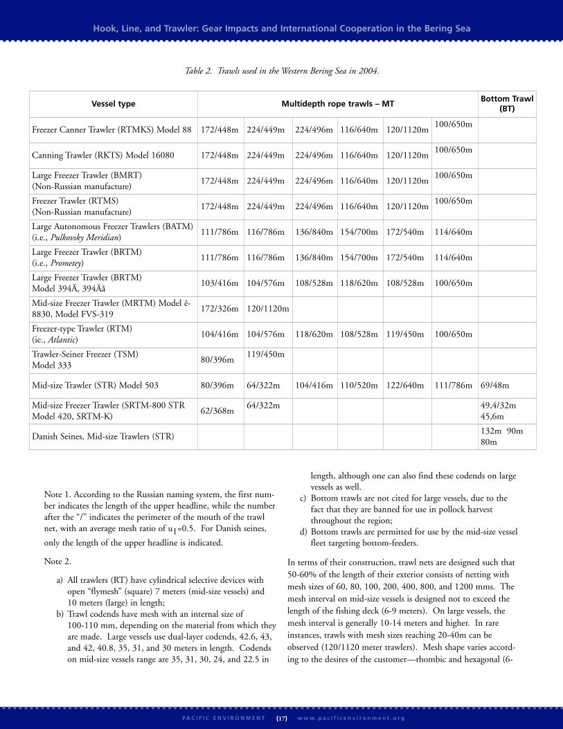
Note 1. According to the Russian naming system, the first num-ber indicates the length of the upper headline, while the numberafter the “/” indicates the perimeter of the mouth of the trawlnet, with an average mesh ratio of u1=0.5. For Danish seines,
only the length of the upper headline is indicated.
Note 2.
a) All trawlers (RT) have cylindrical selective devices with open “flymesh” (square) 7 meters (mid-size vessels) and 10 meters (large) in length;
b) Trawl codends have mesh with an internal size of 100-110 mm, depending on the material from which theyare made. Large vessels use dual-layer codends, 42.6, 43, and 42, 40.8, 35, 31, and 30 meters in length. Codends on mid-size vessels range are 35, 31, 30, 24, and 22.5 in
length, although one can also find these codends on large vessels as well.
c) Bottom trawls are not cited for large vessels, due to the fact that they are banned for use in pollock harvest throughout the region;
d) Bottom trawls are permitted for use by the mid-size vesselfleet targeting bottom-feeders.
In terms of their construction, trawl nets are designed such that50-60% of the length of their exterior consists of netting withmesh sizes of 60, 80, 100, 200, 400, 800, and 1200 mms. Themesh interval on mid-size vessels is designed not to exceed thelength of the fishing deck (6-9 meters). On large vessels, themesh interval is generally 10-14 meters and higher. In rareinstances, trawls with mesh sizes reaching 20-40m can beobserved (120/1120 meter trawlers). Mesh shape varies accord-ing to the desires of the customer—rhombic and hexagonal (6-
Hook, Line, and Trawler: Gear Impacts and International Cooperation in the Bering Sea
{17}P A C I F I C E N V I R O N M E N T w w w . p a c i f i c e n v i r o n m e n t . o r g
Vessel type Multidepth rope trawls – MTBottom Trawl
(BT)
Freezer Canner Trawler (RTMKS) Model 88 172/448m 224/449m 224/496m 116/640m 120/1120m100/650m
Canning Trawler (RKTS) Model 16080 172/448m 224/449m 224/496m 116/640m 120/1120m100/650m
Large Freezer Trawler (BMRT) (Non-Russian manufacture)
172/448m 224/449m 224/496m 116/640m 120/1120m100/650m
Freezer Trawler (RTMS) (Non-Russian manufacture)
172/448m 224/449m 224/496m 116/640m 120/1120m100/650m
Large Autonomous Freezer Trawlers (BATM)(i.e., Pulkovsky Meridian)
111/786m 116/786m 136/840m 154/700m 172/540m 114/640m
Large Freezer Trawler (BRTM) (i.e., Prometey)
111/786m 116/786m 136/840m 154/700m 172/540m 114/640m
Large Freezer Trawler (BRTM) Model 394Ä, 394Äå
103/416m 104/576m 108/528m 118/620m 108/528m 100/650m
Mid-size Freezer Trawler (MRTM) Model ê-8830, Model FVS-319
172/326m 120/1120m
Freezer-type Trawler (RTM) (ie., Atlantic)
104/416m 104/576m 118/620m 108/528m 119/450m 100/650m
Trawler-Seiner Freezer (TSM) Model 333
80/396m119/450m
Mid-size Trawler (STR) Model 503 80/396m 64/322m 104/416m 110/520m 122/640m 111/786m 69/48m
Mid-size Freezer Trawler (SRTM-800 STRModel 420, SRTM-K)
62/368m64/322m 49,4/32m
45,6m
Danish Seines, Mid-size Trawlers (STR)132m 90m80m
Table 2. Trawls used in the Western Bering Sea in 2004.

sided or honeycomb).
Foreign vessels and mixed-company vessels operate trawls manu-factured by Gloria, Radial Trawl, Wonder Trawl, Bering SeaPelagic Trawl, and Aleutian Wing Trawl, as well as custom-designed trawls.
Gear Impacts in the Bering SeaThe impacts of fishing in the Bering Sea vary by gear type andregion. Impacts include indirect effects such as reductions inbiomass and ecosystem-wide changes in productivity and directeffects such as inflicted mortality on benthic species, increasedfood for scavenging species, and habitat loss from gear impacts.38
We will spotlight habitat destruction and bycatch as the mainharms from fishing, focusing on bottom trawling and certainforms of pelagic fishing as culprits.
TrawlsNumerous studies have been published describing the varyingimpacts of gear types, with most concentrating on the impactsfrom bottom trawling. The focus on bottom trawling reflectsthe international consensus that bottom trawling has the largestimpact on seafloor habitat.40
The effects of bottom trawling can be extensive. Direct effectsinclude smoothing of sediments, dragging of rocks and boulders,
resuspension and mixing of sediments, removal of sea grass, dam-age to corals, and damage or removal of epibenthic organisms.41
Studies in Alaska demonstrate that highly trawled areas in theBering Sea are significantly different than untrawled areas, withthe overall diversity of sedentary taxa reduced in highly trawledareas.42 A survey of various studies both inside and outsideBering Sea waters led the National Marine Fisheries Service toconclude that bottom trawls cause both short term changes ininfauna, epifauna, megafauna and substrates and persistentchanges in megafauna communities.43 NMFS also noted thatdredges, longlines, pots, and pelagic trawls cause damage tohabitat, but not at the same intensity as bottom trawls.
Specific studies in Alaska have shown removal of and damage toliving habitat resulting from bottom trawling:
w Freese et al. (1999) found that a single bottom trawlremoved and damaged large epifaunal invertebrates and thattrawling damaged 70% of vase sponges, 55% of sea whips,greater than 20% of brittle stars, and 13% of fingersponges. A return to the site after a year showed increasedmortality of sponges and no signs of repair or regrowth.44
w Krieger (2000) studied an area where 2000 pounds of redtree coral (Primnoa) had been removed by a bottom trawland found that after 7 years, 27% of the corals in the trawl
Hook, Line, and Trawler: Gear Impacts and International Cooperation in the Bering Sea
{18}P A C I F I C E N V I R O N M E N T w w w . p a c i f i c e n v i r o n m e n t . o r g
Table 4. Marine Conservation Biology Institute: Experts’ Impact Rating, Survey Severity Rankings, and Policy Implications 39

path were removed, the remaining corals were missing up to99% of their branches, and the detached corals were miss-ing 50-90% of their polyps.45
Another possible problem cited for trawls is fish coming intocontact with gear, which results in injury and death for escapingfish. According to some Russian data, fish mortality due to con-tact with trawl mesh in the Western Bering is inconsequentialand does not exceed 10 percent of the total number of fish thatcome into contact with the mesh.46 Other research, however,contradicts these findings; for example, according to results ofresearch in the northern basin in 1989, scientists estimated thepercentage of posttraumatic fish deaths at 75-80% of the totalnumber of fish.
Danish SeinesThe most damaging use of Danish seines arises when fishing forcod and other bottom species living in “inconvenient places”(among rocks, on cliff faces, etc.), or when the risk of net loss isthe greatest. Loss of net fragments or entire nets presents athreat to both specific habitat and to the environment as awhole. These lost nets can also be a danger to other fishing ves-sels, putting them at risk of entangling their own nets, trawls,longlines, etc.
Purse SeinesIn some ways, purse seines are less of a threat to the environmentthan Danish seines in that they do not come into contact withthe seafloor. Purse seines do, however, threaten habitat whenlost, just as Danish seines. Unofficial testimony reports that 20-30 purse seines or their fragments are lost every year in theBering Sea. Needless to say, the data is incomplete, since no offi-cial studies have been conducted and the seafloor is not cleaned.
Pots/TrapsModern crab traps are equipped with preventative mechanisms(rapid decaying organic filaments) that open in the case of traploss, releasing the living creatures within. This gear can be con-sidered relatively low-impact in terms of its impact on theseafloor and surrounding resources.
LonglinesHook-based gear has many of the same issues as nets, the onlydifference being that the net mechanically impounds or restrainsfish, while a hook penetrates the fish or any other creature,inflicting greater damage, which continues until the creatureeither tears away (with resulting trauma), dies from shock, iseaten by predators, or is hauled aboard a vessel.
Longlines demonstrate a high level of size selectivity, but offerweak species selectivity, resulting in bycatch of species notincluded in the definition of the fishery. As with nets, longlinespresent a significant threat in terms of bycatch, as marine mam-mals and seabirds are often unable to resist an easy meal. The use of “streamers” and other diversion devices are used
to reduce impacts.
In addition, anchors, mainlines, hooks (with or without bait),anchor ropes, and gangions all come into contact with theseafloor, potentially resulting in habitat destruction.
Set NetsWing ends of these nets have contact with the seafloor, and ifthe net is not a floating stake net, then the trap net will alsocontact the seafloor, resulting in habitat impacts. These netsonly become dangers in the event that fishermen lose control ofthe net or the trap net becomes overfull during fishing. Theseconditions arise, for example, during stormy weather, and canlead to the destruction or loss of the net.
Large-scale driftnetsOne problem associated with large-scale driftnets is the significantloss of fish from trauma by sea birds and marine mammals, as wellas from tears in the nets when hauling the panel. Perhaps thebiggest problem resulting from driftnet fishing is bycatch.Driftnets do not discriminate by species and studies have foundlarge bycatch of immature fish and underweight fish, which hasalso led to resource and biomass loss. Due to the selective natureof the fish harvest (the largest, older fish age groups are harvestedby driftnet), the entire population structure becomes more juve-
nile.47
Commercially valuable chum and reds are the most subjectto pressure by the salmon driftnet industry. Whales, dolphins, seabirds, turtles, sharks, and other marine creatures not targeted bythe industry frequently perish in driftnet barriers.
The next section will examine region-specific problems of fish-ing gear use in the Bering Sea.
Eastern BeringBottom Trawling and Habitat ImpactsThe North Pacific Fishery Management Council must be com-mended for its recommendation to close 375,000 square milesof the Bering Sea eastern continental shelf to bottom trawling.At the time of writing, this decision has yet to be approved andimplemented by the National Marine Fisheries Service. Themost conservative decision would be to entirely ban the destruc-tive practice of bottom trawling throughout the Eastern Bering.
NMFS highlighted the disproportionate damage to habitat frombottom trawling in both the 2003 Alaska Groundfish FisheriesDraft Programmatic Supplemental Environmental ImpactStatement (DPSEIS) and the 2004 Draft Environmental ImpactStatement for Essential Fish Habitat Identification andConservation in Alaska (EFHEIS). The DPSEIS, which exam-ined the impacts to habitat, concluded, “Impacts to long-livedslow growing species (i.e., coral) could cause long term damageand possibly irreversible loss of living habitat, especially in theAleutian Islands.”48
Hook, Line, and Trawler: Gear Impacts and International Cooperation in the Bering Sea
{19}P A C I F I C E N V I R O N M E N T w w w . p a c i f i c e n v i r o n m e n t . o r g

The EFHEIS also noted extensive damage to habitat and esti-mated the percentage by which habitat features would bereduced from a hypothetical unfished abundance under currentfishing practices. The EFHEIS then related the damage to habi-tat both by habitat category and in terms of species present.Although it is hoped that the predicted habitat loss in theAleutian Islands will be mitigated by the proposed partial banon bottom trawling, it is unclear if this will occur as the man-agement bodies chose not to institute corresponding reductionsin fishing effort.
The EFHEIS also indicated that if current trends continue,there would be a greater than 75% reduction in habitat featuresin site-specific areas including a patch of sand habitat north ofUnimak Island and Unimak Pass and areas of sand/mud habitatbetween Bristol Bay and the Pribilof Islands. The EFHEIS alsostressed the ultra-slow recovery rates of corals, which are consid-ered vulnerable to long-term effects from fishing.
Pelagic Trawling and Marine MammalsModification of marine mammal habitat by large-scale commer-cial fisheries in the North Pacific is of great concern. Industrialfisheries, such as the Eastern Bering Sea pollock fishery, are more
or less designed to outcompete other top predators. As far backas in 1981 the U.S. government recognized this competition tobe “especially acute with respect to the more than 2 million pin-nipeds that inhabit the Bering Sea and Aleutians, particularlythe northern sea lion and the northern fur seal.”51 Indeed, theBering Sea pollock and other groundfish fisheries increased from12,500 tons in the early 1950s to over 2.2 million tons in theearly 1970s. This high level of biomass removal, which contin-ues to the present day, may be reducing the environment’s carry-ing capacity for marine mammals and seabirds.
Coincident with this rise in fisheries’ biomass removal has beenthe steep decline of the Steller sea lion, now listed as “endan-gered” under the Endangered Species Act, as well as theNorthern fur seal, which is now listed as “depleted” under theMarine Mammal Protection Act. As fisheries are currently pros-ecuted, there has been increasing removal of biomass from boththe critical habitat and foraging areas of these keystone preda-tors. Current fisheries management does not adequately assessthe ecosystem impacts of the global, local, and temporalremovals of prey species important for critical life stages of thesepredators. Indeed, there is no evidence that the foraging needsof lactating females and juveniles are being met.
Hook, Line, and Trawler: Gear Impacts and International Cooperation in the Bering Sea
{20}P A C I F I C E N V I R O N M E N T w w w . p a c i f i c e n v i r o n m e n t . o r g
Affected SpeciesReduction of Living Structure to
Result from Bottom Trawling
Habitat AffectedPercentage of Species
Habitat Affected
Red king crab 35% of living structure Bering Sea sand/mud 25-30%
Golden king crab 20-25% of hard coral Aleutian Islands shallow water 24%
Tanner crab 15-20% of living structure Bering Sea sand/mud 68-71%
Atka mackerel 30-40% of hard coral Aleutian Islands shallow water 44-50%
Greenland turbot 12-14% of living structure Bering Sea sand/mud 56-65%
Rock sole 13-15% of living structure Bering Sea sand/mud 37-41%
Shortraker and Rougheye rockfish 8-13% of hard coral Aleutian Islands deep shelf 22-36%
Habitat Affected Structure Predicted Reduction
Aleutian Islands shallow hard corals 11-20%
Aleutian Islands slope soft substrate living structure 4-19%
Bering Sea sand/mud habitat soft substrate living structure 3-19%
Aleutian Islands shallow hard substrate nonliving structure 5-11%
Aleutian Islands shallow hard substrate living structure 3-17%
Aleutian Islands deep hard corals 4-9%
Table 5. Damage to living and nonliving structures in key Bering Sea habitats promised by current patterns: 49
Table 6. Current fishing patterns will cause the following habitat destruction:50

BycatchAll gear types are associated with the bycatch of non-targetedspecies. The effects of this bycatch vary in intensity andspecifics. The effects of bycatch include destruction of seafloorhabitat, reductions in biomass to non-targeted fish species, thekilling and injuring of marine mammals and seabirds, andchanges in the marine food web. Of great concern in the BeringSea is the bottom trawl fishery bycatch of long-lived, slow-repro-ducing species such as rougheye rockfish, the longline fisherybycatch of seabirds, and the pelagic trawl bycatch of salmon.
In the Bering Sea, jig gear is the most selective, targeting onefish at a time, while bottom trawls are the most destructive,causing high levels of mortality to both the seafloor and non-tar-geted species. Several bottom trawl fisheries are also extremelywasteful, throwing over half of their catch overboard. There arealso lesser, but unobservable impacts from discarded pot, long-line, and trawl gear, which continue “ghost fishing” when theyare lost.
Despite these problems, there has been some progress in the lastdecade in reducing bycatch. Although the sheer volume of thepelagic pollock trawl fishery bycatch is still of great concern interms of ecosystem effects, the transition from bottom trawlingto pelagic trawling reduced the overall amount of bycatch in thelate 1990s. Similarly, concerns over the bycatch of endangeredshort-tailed albatrosses in the longline fisheries led to the intro-duction of streamers, which curtailed much of the mortality.Finally, pot gear is now required to have biodegradable mesh,
which reduces the bycatch from “ghost fishing.”
In the DPSEIS report, bycatch data is broken down by individ-ual fishery in the Bering Sea and Aleutian Islands regions; 94% of corals and bryozoans and 98% of sponge were taken inthe bottom trawl fisheries.52
Our recommendations for reducing bycatch are to increase datacollection through observers on all vessels, restrict indiscriminatefishing gear in biologically sensitive habitats, and provide incen-tives for transition to cleaner gear types.
WesternBottom Trawling and Habitat ImpactTrawls that come into contact with the seafloor are the worstoffenders when it comes to habitat destruction. Where permit-ted, Russian trawlers equip the bottom trawl footrope withmetal or synthetic balls possessing zero or slight negative flota-tion. Bottom trawls are designed to bounce along the bottomwithout the net portion coming into contact with the seafloor,skirting small irregularities and obstacles. This, however, is theideal and not the reality. As a rule, all bottom trawling results ina great deal of damage and disturbance to the benthos.
In 1989, the Soviet fisheries management agency unilaterallyimplemented a near-complete ban on bottom trawling. The banon bottom trawling is much more restrictive and covers a muchlarger geographical area than does bottom trawling in theEastern Bering. Russia also has a much smaller continental
Hook, Line, and Trawler: Gear Impacts and International Cooperation in the Bering Sea
{21}P A C I F I C E N V I R O N M E N T w w w . p a c i f i c e n v i r o n m e n t . o r g
1998 1999 2000 2001 2002 2003
Total Groundfish Catch (mt) 1,774,489 1,527,219 1,672,261 1,831,197 1,924,256 1,970,496
Total Groundfish Discards (mt) 149,606 148,946 150,576 118,647 135,952 137,976
Groundfish Discards (pounds) 329,822,000 328,368,000 331,961,000 261,568,000 299,720,000 304,182,000
Percent Groundfish Discarded 8.4% 9.8% 9.0% 6.5% 7.1% 7.0%
Prohibited Species (in addition to groundfish discards above)
Halibut Mortality (pounds) 14,087,000 14,414,000 13,558,000 13,673,000 13,688,000 13,051,000
Herring (pounds) 1,797,000 1,989,000 1,137,000 608,000 308,000 2,444,000
Chinook Salmon (numbers) 70,000 43,492 33,825 53,055 50,433 67,867
Other Salmon (numbers) 81,580 53,792 68,532 63,380 81,772 199,291
Red King Crab (numbers) 49,191 94,022 115,682 80,909 133,832 105,509
Other King Crab (numbers) 43,220 61,879 36,914 36,284 62,477 151,438
Bairdi Tanner Crab (numbers) 1,643,587 996,764 1,254,100 1,258,219 1,404,762 1,223,117
Other Tanner Crab (numbers) 4,633,578 1,604,354 3,314,970 2,043,627 1,501,745 787,832
Table 7.* Bycatch in Alaska by Species, 1997-200353
* Table 7 does not include catch and discards from CDQ groundfish fisheries. Halibut, herring, salmon and crab discards are in addition to groundfish discards.

shelf, and as a result, a much smaller surface area of seafloor islikely to be impacted by bottom trawling. In the Eastern Beringthe continental shelf is enormous, and there is a great deal ofseafloor biodiversity and geographical relief.
Despite the risk of arrest and fines, unsanctioned bottom trawl-ing for pollock, illegal since 1980 in the Russian EEZ, happensregularly. Traditionally, Russian fishermen seek to take advan-tage of long summer nights (white nights) when pollock concen-trate in aggregates on the seafloor, out of reach of pelagic trawls.Pelagic trawls can be forced into use for these purposes, byadjusting the size of the trawl opening from 60-80 meters to 18-20 meters. Such adjustments lead to frequent trawl damage oreven loss of gear. The common Russian practice of riggingpelagic trawls for bottom trawling purposes is in fact moredestructive than traditional bottom trawling.
BycatchIt is important to note that Russia’s Commercial FishingRegulations define “specialized” fisheries as, “those fisheries that,irregardless of the percentage of fish in relation to other speciescaught, have the highest total catch in that target area with aspecific fishing gear or fishing technique.”56 The implication ofthis distinction is that only 50% of a given catch is required tobe the target species and the rest of the catch must be thrown back.
Moreover, the Regulations stipulate neither a required propor-tion of targeted species versus non-target species, nor bureaucrat-ic and legal measures to make such a determination.
Driftnets, commonly used in the Russian Far East by Japaneseand Russian vessels are of particular concern in regards to both
Hook, Line, and Trawler: Gear Impacts and International Cooperation in the Bering Sea
{22}P A C I F I C E N V I R O N M E N T w w w . p a c i f i c e n v i r o n m e n t . o r g
Bering Sea Aleutian Islands
Coral Sponge Coral Sponge
Bottom Trawl 87,964 500,008 54,675 261,468
Longline 2,425 2,205 6,614 10,362
Pot 220 661 0 2,205
Total 90,609 502,874 61,289 274,035
Table 8. Average annual bycatch (pounds) of coral and sponge by region and gear type, 1997-2001 54
Figure 3. Annual estimates of seabirds taken in longline fisheries. 55

bycatch and loss of salmon from torn nets. The bycatch ratesfor marine mammals and sea birds are particularly high (seeAppendix D and Appendix E). Because of these egregiousharms, driftnetting is entirely banned in the Eastern Bering.
Conclusions and RecommendationsThe Bering Sea includes a diversity of habitat types and supportsextensive fisheries. Although managers on both the Eastern andWestern sides of the Sea have implemented a variety of restric-tions, there is little consistency in regulations across the Sea andinternational management of the Donut Hole is narrowlyfocused on just a few species. In light of the economic andenvironmental value of the Bering Sea, it is imperative that theRussian and U.S. governments and regulatory agencies worktogether to foster sustainable management practices throughoutthe Sea. The authors of this report offer the following recom-mendations to ensure the long-term viability of all Bering Seahabitats and fisheries:
An International Agreement and Commission to CoordinateManagement of Bioresources. The current lack of comprehensive multi-level coordinationbetween Russian and U.S. agencies on fisheries managementissues results in confusion and uneven management of one bodyof water that happens to straddle an international boundary.The authors of this report recommend the creation of a multi-stakeholder and transparent international agreement and com-mission to coordinate an ecosystem-based approach to biore-sources management – including fishing gear regulations – inthe Bering Sea.
Currently, there is a great deal of disparity and a lack of compre-
hensive multi-level coordination between Russian and UnitedStates regulations on fishing gear and fisheries, rules regardingonboard observers, and enforcement. Only by taking a long-term view on resources management and international coopera-tion based on an integrated and unified standard for all resourceusers, can we ensure sustainable Bering Sea fisheries protected inpart by habitat and species conservation.
Continued Research and International CooperationThere is also a great need for more data on fisheries and fishinggear use in the Bering Sea – particularly in the Western Bering.Without more data, it is difficult to make the best possible decisions regarding management of Bering Sea resources, and particularly regarding fishing gear use in the Sea.Coordination between Russian and U.S. scientific communitiesworking in the Bering could be accomplished through aScientific Advisory Board established by the international agree-ment and commission.
There needs to be increased collaboration between all Bering Seastakeholders on both sides of the Sea. Industry must reach outto the larger community. Scientists and conservationists mustcommunicate with both industry and local communities, work-ing toward the goal of resource management for the benefit ofall community members and of the rich life in the sea.
Enforcement, Monitoring, and ObservingWell-written regulations on fishing gear and fisheries manage-ment are ineffectual without means of effective enforcement.Inconsistency and lack of coordination are the main concerns ofthe authors in regards to enforcement of fishing and fisheriesregulations. We recommend full observer coverage, special mon-
Hook, Line, and Trawler: Gear Impacts and International Cooperation in the Bering Sea
{23}P A C I F I C E N V I R O N M E N T w w w . p a c i f i c e n v i r o n m e n t . o r g
Fishery Bycatch
Pollock cod, halibut, herring, perch, Atka mackerel, flounder, saffron cod, skates, sharks, bull heads, blackbelly eelpout, squid
Cod halibut, pollock, flounder, saffron cod, bull heads, skates, sharks, capelin
Herring cod, halibut
Flounder cod, halibut, pollock
Atka mackerel cod, pollock, perch, flounder, bull heads
Gear Type Bycatch
Bottom trawls cod, halibut, pollock, perch, Atka mackerel, flounder, saffron cod, bull heads, skates and sharks
Longlines halibut, pollock, perch, mackerels, skates and sharks
Purse seines pollock, medusas
Large-scale driftnets Whales, dolphins, sea birds, turtles, sharks, other marine mammals
Table 10. Bycatch by Gear Type
Table 9. Bycatch by Fishery

itoring systems aboard all fishing and cargo vessels, as well aspublic access to observer data. Currently, observer data in theU.S. is treated as commercially valuable and is thus deemed pri-vate information. Norms for enforcement should be establishedby the international agreement/commission.
Observer Programs are currently one of the top issues in U.S.fisheries management. Dating back to the 1970’s, U.S. observerprograms are funded by both government and industry and fieldover 500 observers in more than 20 fisheries.57 These programsmust be improved and expanded. Russian fisheries managerswould do well to model U.S. observer programs. The authorsrecognize that improved enforcement and monitoring in Russiawill require additional technical resources, funding, and politicalsupport.
Fisheries management agencies on both sides of the Bering Seaalso must immediately adopt strict conflict of interest clauses inorder to protect the Sea from agendas that do not promote sus-tainable management of fisheries.
Gear Restrictions and Conversion
Specific harmful fishing gear should be further restricted andconverted on both sides of the Bering Sea.
In the Eastern Bering, the NPFMC recently took an importantfirst step by recommending the closure of 375,000 square milesor 60 percent of the Bering Sea?s Aleutian Island managementsub-area. Efforts are still needed to implement this decision,which should help reduce coral bycatch and protect deep watercorals near the Aleutian Islands. The decision applies a neededprecautionary approach and provides a step toward the ecosys-tem-based management needed in the North Pacific to reversethe declines of its marine mammals, seabirds, and other plantsand animals. Following this important first step, U.S. manage-ment agencies should review whether the closure area should beexpanded to other areas in the Eastern Bering and whether effortreductions or a ban on bottom trawling should be implemented.
In the Western Bering, driftnetting should be banned and therestriction on bottom trawling strictly enforced. Managementagencies should develop and implement economic incentivesand mandates to ease the transition. Italy offers an example ofsuccessful gear conversion. In 1999, after enacting a ban onpossession and use of nets greater than 2.5 km in length, Italyspent more than $300 million to re-equip their driftnet fleet.The Italian government began an extended conservation plandesigned to include cooperation with EU inspectors and indi-cated an interest in signing similar bilateral agreements withother Mediterranean nations. The Italian Coast Guard pledgedto activate a marine observation system and to inspect driftnetvessels at dock.58
Ecosystem-based Management
Current Bering Sea management structures are largely basedupon a single-species model of fish population exploitation. Assuch, managers look at the impacts of fishing without consider-ing the effects to the food web at large. Recent reports from theUnited States Commission on Ocean Policy and the PewOceans Commission have highlighted this failure. Ecosystem-based management policies should:
w Look at all the links among living and nonliving resources;
w Focus on multiple activities occurring within specific areasthat are defined by ecosystem boundaries, rather than polit-ical boundaries;
w Deal with scientific uncertainty through the use of the pre-cautionary principle (when the potentially adverse effects ofa proposed activity are not fully understood, the activityshould not be allowed to proceed);
w Set catch levels based upon the needs of all parts of thefood web; and
w Undertake research to determine the ecosystem effects offishing and monitor the trends and dynamics in ecosystemfunctionality.
Marine Protected Areas and Reserves
There is a growing recognition that marine protected areas are apromising component of ecosystem-based management that canassist managers in protecting the health of marine ecosystems.59
Conservation organizations and scientists in both Russia and theU.S. have been advocating for more marine protected areas,including fully protected no-take marine reserves, especially inareas of long-lived fish and habitat species that are particularlysensitive to the impacts of fishing. There is currently only onemarine protected area in all of Russia.
Marine reserves serve many functions, including:
w protecting habitat;
w conserving plants and animals living in protected habitat;
w allowing depleted populations of fished species in reservesto recover;
w spillover of species in reserves to surrounding unprotectedareas;
w providing insurance against environmental and manage-ment uncertainty;
w providing ecosystem services; and
w protecting ecological baseline areas.60
Hook, Line, and Trawler: Gear Impacts and International Cooperation in the Bering Sea
{24}P A C I F I C E N V I R O N M E N T w w w . p a c i f i c e n v i r o n m e n t . o r g

Although some protections for Bering Sea wildlife and habitatare already in place, a need for implementation of zoning as animportant component of an ecosystem-based approach to man-aging public marine resources is indicated by declines in somemarine mammal, bird, and fish species; the discovery ofextremely sensitive and diverse old-growth coral and spongehabitat; research into the effects of fishing impacts on habitat;and the need for baseline ecological information. Recentresearch, legislation, litigation, and administrative processes haveresulted in several zoning proposals for protecting Eastern Beringwildlife, habitat, and resources. Proposals have been submitted
by fishing industry organizations, agency scientists, conservationorganizations, and other interested members of the public.
The authors recommend a commitment to marine protectedareas be included in an international agreement on Bering SeaManagement. In the meantime, proposals for the Eastern Beringthat are being considered should be accepted and implemented.
The health and biodiversity of the Bering Sea ecosystem areessential to the livelihoods of people in both the U.S. andRussia. The fish of the Bering Sea provide sustenance to peoplethroughout each nation, and the communities that live along
Hook, Line, and Trawler: Gear Impacts and International Cooperation in the Bering Sea
{25}P A C I F I C E N V I R O N M E N T w w w . p a c i f i c e n v i r o n m e n t . o r g

the shores of the Sea - in Alaska, Chukotka, Koryakia, and Kamchatka - depend on its bounty. By implementing these recommen-dations, we have a vital opportunity to reduce the negative impacts of fishing gear in the Bering Sea and to adopt an ecosystem-based approach that will allow for sustainable and productive management of the Sea.
Appendix AU.S. Regulations and Management of the Eastern Bering SeaBering Sea/Aleutian Islands Fishery Management Plan
w Catch limits that are strictly enforced through reporting requirements and in-season management by gear types and areas.
w Gear allocations by target species.
w Prohibited species bycatch limits for salmon, halibut, red king crab, tanner crab, snow crab and herring which, if reached, shutdown fisheries.
w Prohibitions on forage fish fisheries, area restrictions, and seasonal allocations of catch for prey species in order to protectseabirds and marine mammals.
w Seasonal and year-round fishing area restrictions.
w Gear restrictions and limitations on gear types allowable.
w An observer program, with observers required at vessel owner’s expense (<60 feet=exempt; 60-124 feet=30% coverage; >124feet=100% coverage).
w Effort limitation with a moratorium on entry, license limitation program, Individual Fishing Quota programs, and rationaliza-tion among participants.
w Community Development Quotas which allocate 10% of pollock quota, 20% of sablefish fixed gear allocation, and 7.5% ofmost other groundfish species quotas to communities in Western Alaska.
w Retention and utilization requirements banning the roe stripping of pollock and requiring full retention of Pacific cod and pol-lock.
Marine Protected Areasw The Pribilof Island Habitat Conservation Area, a 7000 nm? area closed to all trawling for the protection of blue king crab habi-
tat.
w The Red King Crab Savings Area, a 4000 nm? area closed to bottom trawling and dredging.
w Walrus Islands Closure Area, a 900 nm? area around Round Island, the Twins, and Cape Pierce closed to all fishing vessels fromApril 1 through September 30.
w Steller’s sea lion closures, a 58,000 nm? area partially, and in some small cases, fully, closed to vessels.
w Closures include 3 nm “no entry” zones for all vessels around rookeries, 10 nm and 20 nm “no trawl” zones around rookeries.
w Scallop dredge closure areas in crab habitat.
w There are also seasonal closure areas for Pacific cod, groundfish (including pollock), Atka mackerel fisheries, in some casesdesigned to reduce bycatch of crab, salmon, herring, and halibut.
Hook, Line, and Trawler: Gear Impacts and International Cooperation in the Bering Sea
{26}P A C I F I C E N V I R O N M E N T w w w . p a c i f i c e n v i r o n m e n t . o r g

Hook, Line, and Trawler: Gear Impacts and International Cooperation in the Bering Sea
{27}P A C I F I C E N V I R O N M E N T w w w . p a c i f i c e n v i r o n m e n t . o r g
Appendix BRussian Regulations and Management of the Western Bering SeaRecent changes in Russian fisheries management:
1) Payment mechanism for use of commercial targets of marine bioresources.
Law 148-F361
states that organizations and individuals are recognized as paying fees for the right to use marine bioresources. Payersinclude individual enterprises officially receiving permission to use resources in internal waters, territorial seas, on the Russian conti-nental shelf and in the EEZ of the Russian Federation, as well as the Seas of Azov, Caspian, and Barents as well as the region aroundthe Spitsbergen Archipelago. Fee levels are also set (Tables 1-2) and a list of those species subjecting to licensing requirements inaccordance with Russian Federation laws.
Moreover, the given Federal Law determines the mechanism for calculation and payment of fees for marine biological resources.The resource use fee is paid in the form of one-time and continuing payments. One-time fees are calculated as 10% of the total cal-culated fee. The initial payment is due upon receipt of the license to use resources, while the remaining amount (the differentbetween the initial payment and the total amount) is paid in equal monthly installments over the duration of the length of thelicense. For city- and village-based fishing organizations included in the list approved by the Russian Federation, the fee is calculatedat a rate of 15%.
2) Mechanism for allocating and affixing quotas for a 5-year period.According to Decree #704 (20 November 2003) “On fishing quotas for water bioresources,” a new mechanism was created fordetermining fishing quotas as a whole, commercial fishing quota levels on the continental shelf and EEZ of the Russian Federation(with the exception of the Baltic and Black Seas), as well as shares of the total shares set by the Russian Federation in the EEZs ofother countries and in regions under the management of international fishing agreements to which the Russian Federation is a signa-tory. According to this mechanism, upon application each enterprise that meets a series of requirements is allocated a share of thetotal commercial catch quotas for water bioresources based on that enterprise’s quota allocated over the previous 3 years in definedzones and regions.
Moreover, on the basis of meetings of the interagency commission on the determination of quotas, the Russian State Committee onFisheries enters into 5-year quota allocation agreements with applicants. These agreements must include conditions under which theagreement is abrogated.
In addition, a mechanism was created for quota allocation for resource users in the coastal zone. Coastal fisheries allocations are
determined on a competition basis for 5-year periods by executive agencies of subjects62
of the Russian Federation in accordance withgeneral decrees on the order and conditions of quota allocations in subjects of the RF whose territories are associated with the coast.The subjects determine allocations for each applicant for coastal fishing, including a requirement that the applicant’s product bedelivered to Russian territory. On an annual basis, the Russian State Fisheries Committee determines the estimated shares to allRussian subjects with territories on the coast. The indicated estimated share by subject is determined as a sum of the total shares ofshareholders registered on the territory of that subject.
A number of federal entities63 were assigned the task of developing and ratifying the priorities and conditions for auctioning quotasin the total volume for existing catch of water bioresources, reauthorized for commercial fishing purposes as well as the catch ofwater bioresources for regions newly under development. Finally, the process was created for determining quotas among applicantswishing to catch water bioresources in the EEZ of foreign countries and in water bodies managed by international fishing agree-ments to which Russia is a signatory (in places where it is not possible to use the quota allocation method). This final process takesinto account priority rights to quotas earlier exploited by enterprises in the indicated zones and regions (in cases where nothing isindicated by the given agreements).
3) Liquidation of the Russian State Fisheries Committee and Creation of the Federal Fisheries Agency.According to Article 12 of the President’s Decree #314 (09 March 2004) “On the system and structure of Federal Organs ofExecutive Power” the Russian State Fisheries Committee is being replaced by the Federal Fisheries Agency (FFA), which will assumethe functions of government service in the sphere of fisheries activity, management of government property in lower organizationsand agencies as well as law enforcement actions in the area of rational use, science, conservation and production of water biore-sources and those resources’ habitats.
The FFA is under the jurisdiction of the Russian Ministry of Agriculture. The primary functions of the FFA are:

a) In the area of fisheries management, provision of government services of significant social value, based on existing federal legislation
b) Organization of the following activities:
w Complex study of water bioresources with the goal of assessing the condition stocks and the determination of Total AllowableCatches for water bioresources;
w Conducting scientific and design studies in areas related to the encouragement of fisheries complex activities;
w Development of recommendations on the growth levels of fish and other organisms in water bodies;
w Construction of fishing vessels for federal government purposes and the encouragement of production activities in marine fishports under the jurisdiction of the Agency;
w Artificial production and acclimatization of water bioresources;
w Organization of auctions for the sale of quotas in the total volume of catch for water bioresources reauthorized for commercialfishing, as well as the catch of water bioresources for regions newly under development;
c) Creation of a state land register, a unified register of bioresource waters, and a list of fisheries regions for coastal fishing;
d) Implementation of state assessment and monitoring of the condition of water bioresources;
e) Introduction of proposals for total allowable catch levels and fishing quotas for water bioresources according to their use;
f ) Submissions proposals for TAC levels for water bioresources for evaluation by state environmental assessment (ekspertiza);
g) Realization of a mechanism for the rotation of shares in total volume of catch for water bioresources for commercial purposes ofRussian users.
Management Plan for 2004Classification of quotas for the catch of water bioresources:
w Quotas for foreign states;
w Quotas for scientific, study, and cultural-awareness-raising purposes;
w Quotas for production and acclimatization of water bioresources;
w Quotas for the catch of water bioresources on the continental shelf, in the Russian EEZ;
w Quotas in the EEZ of foreign states and regions where international agreements are in effect;
w Quotas for commercial coastal fishing;
w Quotas for the provision of individual needs of indigenous peoples and ethnic communities of the North, Siberia and the FarEast of the Russian Federation;
w Quotas for the organization of amateur and sport fishing;
Specific Fishing Regulation Includes:w Only those vessels belonging to the government and other types of property owners possessing an allocated share of the total
determined by the Federal Fishing Agency are authorized to fish.
w Requirements to receive authorization to fish: the presence of an active commercial fishing fleet, fishing operations for at least 5years, lack of fisheries code limitation or debts due to tax agencies.
w There are 3 agencies responsible for monitoring fishing quotas: commercial councils, onboard inspectors, and shipboard statisti-cal reporting (SSR) transmitted to statistics agencies and the Federal Border Service, according to monitoring regulations.
w Bycatch calculations for all species is calculated against total quotas for each species and shall not exceed 8% of the total catchon the vessel, and no more than 20% of immature pollock.
Hook, Line, and Trawler: Gear Impacts and International Cooperation in the Bering Sea
{28}P A C I F I C E N V I R O N M E N T w w w . p a c i f i c e n v i r o n m e n t . o r g

w Fisheries are closed based on the selection of fishing quotas for a variety of resources.
w Restrictions on fisheries; seasons are determined according to the Fishing Regulations of each regional fishery including specifi-cation of coordinates.
w Bottom trawling using thrust trawls for pollock have been forbidden since 1980.
w Bycatch by region and by gear are also limited. For the Bering Sea this can be illustrated in Table 1.
w Problematic vessels (and on all foreign vessels) must host a representative of the Federal Border Service and undergo multipleinspections. As a rule, these inspectors lack the training or relevant education necessary for this work. In contrast to inspectorsfor other countries (USA, etc.), Russian inspectors do not use whole and partial sampling to conduct resource monitoring.Their presence on board is paid for by the resource user, with amounts ranging from $100-$350. In some cases this pay isincreased, which serves as fertile soil for drunkenness, corruption and bribery in exchange for favors.
w The character of fishing protection operations is fairly primitive and results in limitations to fishing and financial checks. Inorder to respect these restrictions, ships must enter and leave fishing areas through control points, monitored by patrol ships.
w There are strict requirements demanding the presence of satellite monitoring systems for fishing vessels. Whenever the signal isabsent, observers and enforcement agencies stop commercial fishing until the reason for the lacking signal is traced. This hap-pens frequently in the upper latitudes of the Bering Sea 62-63Ó due to weak or unstable satellite signal and the limited numberof satellites in the area (7) and the very small angle of signal which, due to background and atmospheric interference, is notreceivable by antennae.
Hook, Line, and Trawler: Gear Impacts and International Cooperation in the Bering Sea
{29}P A C I F I C E N V I R O N M E N T w w w . p a c i f i c e n v i r o n m e n t . o r g

Appendix CFishing Gear Used in the Bering SeaUnless otherwise indicated, all drawings are used by permission from Tim Richards, graphic artist, TetraTech CW Inc.
Hook, Line, and Trawler: Gear Impacts and International Cooperation in the Bering Sea
{30}P A C I F I C E N V I R O N M E N T w w w . p a c i f i c e n v i r o n m e n t . o r g
Bottom Trawl
Pelagic Trawl

Hook, Line, and Trawler: Gear Impacts and International Cooperation in the Bering Sea
{31}P A C I F I C E N V I R O N M E N T w w w . p a c i f i c e n v i r o n m e n t . o r g
Vertical Longline

Hook, Line, and Trawler: Gear Impacts and International Cooperation in the Bering Sea
{32}P A C I F I C E N V I R O N M E N T w w w . p a c i f i c e n v i r o n m e n t . o r g
Scallop Dredge, New Bedford Style 64
Vertical Longline Salmon Troll Jig Machine

Hook, Line, and Trawler: Gear Impacts and International Cooperation in the Bering Sea
{33}P A C I F I C E N V I R O N M E N T w w w . p a c i f i c e n v i r o n m e n t . o r g
Crab Pot 65
Drift Gillnet
Purse Seine 66

Hook, Line, and Trawler: Gear Impacts and International Cooperation in the Bering Sea
{34}P A C I F I C E N V I R O N M E N T w w w . p a c i f i c e n v i r o n m e n t . o r g
Date (DD.MM.YY)Average catch/4-km panel, each
Lost through tearsin one panel, each
Injured by seacreatures, birds,
each
Actual Catch/panel, each
Salmon losses/panel, %
01.06.95 728 8 10 746 2.503.06.95 954 6 N/A 960 0.6
04.06.95 1178 12 18 1208 2.5
05.06.95 1012 10 N/A 1022 1.0
06.06.95 1288 N/A 12 1300 1.007.06.95 1170 7 N/A 1177 0.6
09.06.95 2180 N/A 50 2230 2.313.06.95 1567 11 N/A 1578 0.714.06.95 1333 12 50 1395 4.716.06.95 803 6 68 877 9.217.06.95 1285 15 5 1305 1.620.06.95 1046 8 23 1077 3.022.06.95 932 8 5 945 1.4
23.06.95 975 5 15 995 2.0
26.06.95 1477 N/A 200 1677 13.5
27.06.95 1950 N/A 150 2100 7.7
05.07.95 896 N/A 179 1075 20.007.07.95 1510 24 23 1561 3.110.07.95 2400 12 83 2495 4.0
13.07.95 3213 25 100 3338 4.0
14.07.95 2255 13 N/A 2268 0.6
16.07.95 998 18 N/A 1016 1.8
17.07.95 728 15 13 754 3.918.07.95 1036 9 11 1056 1.9
21.07.95 927 8 6 941 1.5
22.07.95 965 6 16 987 2.3
23.07.95 528 13 11 552 4.5
24.07.95 936 18 11 965 3.0
25.07.95 677 12 N/A 689 1.8
30.07.95 806 17 53 876 8.7
31.07.95 827 17 11 855 3.4
Appendix DSalmon Losses in Driftnet FishingMidsize Processor-Trawler Vessel in the region of the Petropavlovsk-Komandorsky zone (1995)
The table illustrates that salmon losses ranged from 0.6% to 20%. It is especially notable that whales, dolphins, sea birds, turtles,sharks, and other marine creatures not targeted by the industry perish in driftnet barriers.
SOURCE: Mikhno, 2004

Hook, Line, and Trawler: Gear Impacts and International Cooperation in the Bering Sea
{35}P A C I F I C E N V I R O N M E N T w w w . p a c i f i c e n v i r o n m e n t . o r g
Date (DD.MM.YY) Coordinates Species NumberDistance from Kamchatka
Salmon68
01.06.95 53º 15’ 64º 23Northern fulmars69
Glaucous-winged gulls
47
7620–100 m
02.06.95 53º 17’ 164º 16’
Northern fulmars
Kittiwakes
Laysan Albatross70
250
52
6
20–100 m
04.06.95 53º 25’ 164º 11’
Northern fulmars
Kittiwakes
Laysan Albatross
350
50
10
20–100 m
05.06.95 53º 25’ 164º 12’
Northern fulmars
Kittiwakes
Laysan Albatross
120
50
45
45–70 m
06.06.95 53º 33’ 163º 50’Northern fulmars
Laysan Albatross
50
4850–100 m
07.06.95 53º 31’ 163º 16’Northern fulmars
Glaucous-winged gulls
206
49
06.07.95 54º 45’ 161º 14’Northern fulmars
Skuas
500
210–150 m
13.07.95 53º 40’ 161º 23’
Northern fulmars
Kittiwakes
Tufted puffins71
Glaucous-winged gulls
Skuas
1000
300–400
25
10
2
16.07.95 53º 30’ 161º 23’
Northern fulmars
Horned puffins
Tufted puffins
Glaucous-winged gulls
Skuas
500
2
30
150
4
20–100 m
21.07.95 53º 10’ 161º 32’
Northern fulmars
Slaty-backed gull72
Glaucous-winged gulls
Skuas
Laysan albatross
1500
12
10
10
1
10–100 m
24.07.95 53º 19’ 160º 38’
Northern fulmars
Kittiwakes
Glaucous-winged gulls
Skuas
Shearwaters
800–1000
30
500–600
10
150
10–100 m
30.07.95 51º 26’ 160º 00’
Northern fulmars
Kittiwakes
Tufted puffins
Glaucous-winged gulls
Skuas
Laysan albatross
280–300
70
42
8
4
1
10–100 m
Appendix EBird Bycatch in Salmon Driftnet Industry (Russian Federation)67

Hook, Line, and Trawler: Gear Impacts and International Cooperation in the Bering Sea
{36}P A C I F I C E N V I R O N M E N T w w w . p a c i f i c e n v i r o n m e n t . o r g
Works CitedCimberg, R.L., T. Gerrodette, and K. Muzik, 1981. “Habitat requirements and expected distribution of Alaska coral.” OCSEAPFinal Report 54 (1987). The report was prepared for the Alaska Office of Marine Pollution Assessment, DOC, NOAA. Pp. 207-308.In National Marine Fisheries Service, 2004.
Enticknap, B. Trawling the North Pacific: Understanding the Effects of Bottom Trawl Fisheries on Alaska’s Living Seafloor. Alaska MarineConservation Council, April 2002.
Freese, L., P.J. Auster, J. Heifetz, and B.L. Wing. Effects of Trawling on seafloor habitat and associated invertebrate taxa in the Gulf ofAlaska. Marine Ecology Progress Series 182, 1999, p. 119-126.
Freese, L. “Trawl-induced damage to sponges observed from a research submersible.” Marine Fisheries Review 63:3 (2002), p. 7-13.
Heifetz, J. “Coral in Alaska: distribution, abundance, and species associations.” Hydrobiologia, Volume 471 (1-3), October 2002, p.19 - 28.
Heifetz, J. NMFS. Effects of Fishing Gear on Seafloor Habitat Progress Report for FY 2003. Alaska Fisheries Science Center,2003.
Hiatt, T., R. Felthoven, C. Seung, and J.Terry, 2003. NMFS. Stock Assessment and Fishery Evaluation Report for the GroundfishFisheries of the Gulf of Alaska and Bering Sea/Aleutian Island Area: Economic Status of the Groundfish Fisheries off Alaska, 2002.
Hiatt, T., R. Felthoven, C. Seung, and J. Terry, 2004. NMFS. Stock Assessment and Fishery Evaluation Report for the GroundfishFisheries of the Gulf of Alaska and Bering Sea/Aleutian Island Area: Economic Status of the Groundfish Fisheries off Alaska.
Jennings, S., Kaiser, M.J. & Reynolds, J.D., 2001. Marine Fisheries Ecology. Blackwell Science, Oxford, England.
Johnson, T. 2003. “The Bering Sea and Aleutian Islands: Region of Wonders.” Alaska Sea Grant College Program. Fairbanks, AK.
Krieger, K. NMFS. “Coral (Primnoa) Impacted by Fishing Gear in the Gulf of Alaska” (Unpublished manuscript). Alaska FisheriesScience Center, Aukes Bay Lab, 2001. In Enticknap 2002.
Kruse, G.H., J.P. Barnhart, G.E. Rosenkranz, F.C. Funk, and D. Pengilly. Alaska Department of Fish and Game. “Overview of state-managed marine fisheries in the Central and Western Gulf of Alaska, Aleutian Islands, and Southeastern Bering Sea, with Referenceto Steller’s Sea Lions.” Regional Information Report 5J00-10. NMFS 2004.
McConnaughey, R.A., and K.R. Smith, 2000. “Associations between flatfish abundance and surficial sediments in the eastern BeringSea.” Can. J. Fisher. Aquat. Sci. 57(12): 2,410-2,419.
McConnaughey, R., K.L. Mier, and C.B. Dew, 2000. “An examination of chronic trawling on soft-benthos of the eastern BeringSea.” ICES Journal of Marine Science. 57(5): 1377-1388.
Malecha, P., Stone, R., and Jon Heifetz. NMFS. Living Substrate in Alaska: Distribution, Abundance and Species Associations (Draftmanuscript). Alaska Fisheries Science Center, Auke Bay Lab, December 2002.
Morgan, L. and R. Chuenpagdee. Shifting Gears: Addressing the Collateral Impacts of Fishing Methods in U.S. Waters. Washington:Island Press, 2003.
NPFMC, 2003. North Pacific Fishery Management Council Bering Sea/Aleutian Islands and Gulf of Alaska SAFE. Appendix C,Ecosystem Considerations. Pgs 218-228.
United States. National Research Council (NRC). The Bering Sea Ecosystem. Washington: National Academy Press, 1996.
NRC. 2001. Marine Protected Areas: Tools for Sustaining Ocean Ecosystems. National Research Council. National Academy Press,Washington D.C.
NRC. 2002. Effects of Trawling and Dredging on Seafloor Habitat. National Research Council. National Academy Press,Washington D.C.
United States. National Marine Fisheries Service (NMFS). Alaska Groundfish Fisheries Draft Programmatic Supplemental ImpactStatement. 2003.

United States. NMFS. Draft Environmental Impact Statement for Essential Fish Habitat Identification and Conservation in Alaska.2004.
United States. NMFS. Draft Programmatic Supplemental Environmental Impact Statement, September 2003 (Revised Draft).
Alaska Marine Conservation Council. Discards in the North Pacific Groundfish Fisheries 2003. Juneau: Fisheries InformationServices, August 2004.
Ohtani, K., and T. Azumaya. 1995. Influence of interannual changes in ocean conditions on the abundance of walleye pollock(Theragra chalcogramma) in the eastern Bering Sea. Pp. 87-95 in North Pacific Workshop on Stock Assessment and Management ofInvertebrates, R.J. Beamish ed. Can. Spec. Publ. Fish. Aquat. Sci. 92. In NRC 1996.
Oceana. “Deep Sea Corals: Out of Sight, But No Longer Out of Mind.” Washington, D.C, 2003.
PISCO. “The Science of Marine Reserves. The Partnership for Interdisciplinary Studies of Coastal Oceans.” 2002.
Witherell D. and C. Coon. “Protecting gorgonian corals off Alaska from fishing impacts.” Proceedings of the First InternationalSymposium on Deep-Sea Corals, 2000.
Hook, Line, and Trawler: Gear Impacts and International Cooperation in the Bering Sea
{37}P A C I F I C E N V I R O N M E N T w w w . p a c i f i c e n v i r o n m e n t . o r g

Hook, Line, and Trawler: Gear Impacts and International Cooperation in the Bering Sea
{38}P A C I F I C E N V I R O N M E N T w w w . p a c i f i c e n v i r o n m e n t . o r g
Endnotes1 NRC, 1996.
2 Hiatt et al., 2003.
3 Hiatt et al., 2003.
4 NMFS, 2004.
5 McConnaughey et al., 2000.
6 NMFS, 2004.
7 NRC, 1996.
8 McConnaughey, R.A., and K.R. Smith, 2000.
9 Draft EFHEIS, January 2004.
10 According to Russian interests, under a document signed by Soviet Foreign Minister Eduard Shevardnadze and U.S. Secretary ofState James Baker in 1990, the border between Russian Chukotka and Alaska was not equidistant from Soviet and U.S. coasts,with 50,000 square kilometers of Russian territorial waters and continental shelf ending up under U.S. jurisdiction. The agree-ment was never ratified – either by the USSR Supreme Soviet or the Russian parliament – due to the perceived infringement onRussia’s national interests. This dispute is not yet resolved.
11 NMFS, 2003.
12 NMFS, 2004.
13 Alaska Marine Conservation Council (AMCC), 2002.
14 Heifetz, 2003.
15 Heifetz 2002
16 Cimberg, R.L., T. Gerrodette, and K. Muzik, 1981.
17 Witherell D. and C. Coon, 2000.
18 Malecha, P., Stone, R., and Jon Heifetz. NMFS, 2002.
19 Ibid.
20 NMFS, 2003.
21 Malecha et al., 2002.
22 Ibid.
23 Ibid.
24 Ibid.
25 Fisheries of the United States, 2003.
26 Hiatt, T., H. Felthoven, C. Seung, and J.Terry. NMFS, 2003.
27 National Environmental Protection Act of 1969. The purposes of the Act were “To declare a national policy which will encourageproductive and enjoyable harmony between man and his environment; to promote efforts which will prevent or eliminate damageto the environment and biosphere and stimulate the health and welfare of man; to enrich the understanding of the ecological sys-tems and natural resources important to the Nation; and to establish a Council on Environmental Quality.” <http://ceq.eh.doe.gov/nepa/regs/nepa/nepaeqia.htm>

Hook, Line, and Trawler: Gear Impacts and International Cooperation in the Bering Sea
{39}P A C I F I C E N V I R O N M E N T w w w . p a c i f i c e n v i r o n m e n t . o r g
28 NOAA, Final Programmatic EIS, June 2004.
29 NMFS, 2003.
30 U.S. Coast Guard. <http://www.uscg.mil/hq/g-cp/history/h_fisheries.html>
31 The UN General Assembly found that driftnet fishing not only undermines transboundary, highly migratory, and anadromous fishstocks, but also inflicts irreparable harm to marine ecosystems (Resolutions 44/225 in 1989, 45/297 in 1990, and 46/215 in1991). The General Assembly’s Resolution 44/225 (25 December 1989) concerns the limitation of pelagic fishing using large-scale driftnets extending great distances. Resolution 46/215 (20 December 1991) calls for the banning of driftnetting. Also in1991, the Wellington Convention (ratified by 12 nations) took effect, banning fishing in the South Pacific Ocean using driftnetsgreater than 2.5 km in length. The Convention on the Conservation of Anadromous Fish in the Northern Pacific Ocean(Moscow, 1992) was signed in an attempt to further develop the aforementioned UN Resolutions. According to the Convention,a complete ban on driftnetting was enacted beyond the 200-mile EEZs north of the 33rd parallel. The European Union bannedthe use of driftnets greater than 2.5 km in length in waters adjacent to EU member countries. Australia and Mauritius have madethe most progress, banning not just driftnetting in their waters, but also closing their ports to driftnet vessels and the vessels thatdirectly service them. Oman’s laws demand strict punishment of violators using driftnets, including confiscation of said gear,detainment of the ship, prison terms, and fines. Mexico has a program to gradually replace driftnets with longline gear, consid-ered a more selective gear type. Canada, U.S., Italy, Saudi Arabia, Barbados, Namibia, and Cyprus have limited the length ofdriftnets.
32 Mikhno, Igor. “Analysis of Driftnetting.” (Unpublished, presented at the 2004 International Bering Sea Forum Working Meetingin Petropavlovsk-Kamchatsky, Russia.)
33 Through the American Fisheries Act, passed in 1998, a small number of fishing vessels were specifically granted, by name, exclu-sive rights to fish in the Bering Sea/Aleutian Islands, primarily for pollock.
34 Hiatt et Al, 2004.
35 Kruse G.H., J.P. Barnhart, G.E. Rosenkranz, F.C. Funk, and D. Pengilly, 2000. In NMFS, 2004.
36 Mizyurkin M.A., A.V.Mizyurkina, V.A. Pimnev, L.I. Sorokin, 1997.
37 Mikhno, 2004.
38 NRC, 2002.
39 MCBI, 2003.
40 Morgan, L. and R. Chuenpagdee, 2003.
41 NMFS, 2004.
42 McConnaughey et al., 2000.
43 NMFS, 2004.
44 Freese, L, 2002.
45 Krieger, K. NMFS, 2001. In Enticknap, 2002.
46 Treshev et al, 1985; Schevchenko, 2001.
47 Mikhno, 2004.
48 NMFS, 2003. Revised Draft: < http://www.fakr.noaa.gov/sustainablefisheries/seis/default.htm>
49 EFHEIS, 2003.
50 EFHEIS, 2003.
51 Taken from NOAA’s final Environmental Impact Statement for the Bering Sea/Aleutian Islands Fishery Management Plan, 1981.

52 NMFS, 2003.
53 AMCC, August 2004.
54 NMFS, 2003.
55 NPFMC, 2003.
56 Point 6.1, Russian Federation National Fishing Administration “Commercial Fishing Regulations,” 2002 edition.
57 Hogarth, William T. “Observer Programs in the United States.” International Fisheries Observer Conference, IntroductorySession.
58 Mikhno, 2004.
59 NRC, 2001.
60 PISCO, 2002.
61 Federal Law dated 11 November 2003, #148-F3 “On the introduction of changes to part of the Second Tax Code of the RussianFederation and several other Laws of the Russian Federation”
62 The term “subject” here refers to Russia’s seven federal districts, headed by plenipotentiaries who were appointed by PresidentPutin.
63 Russian State Fisheries Committee, the Ministry of Economic Development and Trade, and the Ministry of Finance in agreementwith the Ministry of Antimonopoly Policy and Enterprise Support.
64 Coonamessett Farm, 2002.
65 Alaska Department of Fish and Game
66 Jennings et. Al, 2001. Permission pending.
67 Mikhno, 2004.
68 Mid-size freezer trawler
69 Fulmarus glacialis
70 Diomedea immutabilis
71 Fratercula _irrhata
72 Larus schistisagus
Hook, Line, and Trawler: Gear Impacts and International Cooperation in the Bering Sea
{40}P A C I F I C E N V I R O N M E N T w w w . p a c i f i c e n v i r o n m e n t . o r g

Hook, Line, and Trawler: Gear Impacts and International Cooperation in the Bering Sea
{41}P A C I F I C E N V I R O N M E N T w w w . p a c i f i c e n v i r o n m e n t . o r g
ContactPacific Environment
311 California Street, Suite 650
San Francisco, CA 94104-2608
USA
Phone: 415/399-8850
Fax: 415/399-8860
Email: [email protected]