humber low carbon pipelines
TRANSCRIPT
Route Corridor ReportSeptember 2021
Humber Low Carbon Pipelines

Humber Low Carbon Pipelines – Route Corridor Report
Document Control
Document Properties
Organisation Arcadis
Author Various
Approved by Andy Killip
Title Humber Low Carbon Pipelines
Route Corridor Report
Version History
Date Version Status Description/Changes
16/09/2021 01 Issued for Consultation
Humber Low Carbon Pipelines – Route Corridor Report
Key Abbreviations
NGV National Grid Ventures
DCO Development Consent Order
EIA Environmental Impact Assessment
RS Routeing Study
SSSI Site of Special Scientific Interest
SAC Special Area of Conservation
SPA Special Protection Area
AGI Above Ground Installation
PIG Pipeline Inspection Gauge

Humber Low Carbon Pipelines – Route Corridor Report
Table of Contents
EXECUTIVE SUMMARY ..................................................................................................... I
1 INTRODUCTION ..................................................................................................... 3
1.1 Overview and Purpose ............................................................................................. 3
1.2 Project Background .................................................................................................. 4
1.3 Project Need Case ................................................................................................... 7
1.4 Description of the Project ......................................................................................... 8
1.5 Structure of this Report .......................................................................................... 11
2 THE STUDY AREA ............................................................................................... 12
2.1 Introduction ............................................................................................................ 12
2.2 Key Features and Receptors ................................................................................. 12
3 APPROACH TO THE IDENTIFICATION OF ROUTE CORRIDORS .................... 14
3.1 Overview of Approach to Options Appraisal........................................................... 14
3.2 Baseline Data Gathering ........................................................................................ 17
3.3 Route Selection Process ........................................................................................ 17
3.4 Undertake Options Appraisal and Selection of Preferred Options ......................... 17
4 PACKAGE 1 OPTIONS APPRAISAL ................................................................... 27
4.1 Introduction ............................................................................................................ 27
4.2 Package 1 – Options Appraisal for Configurations A and B ................................... 28
4.3 Package 1 – Preliminary Considerations and Recommendation ........................... 67
4.4 Package 1 – Options Appraisal for Configuration A ............................................... 69
4.5 Package 1 – Preferred Main Corridor Route for Non-statutory Consultation.......... 87
5 PACKAGE 2 OPTIONS APPRAISAL ................................................................... 88
5.1 Introduction ............................................................................................................ 88
5.2 Package 2 - Options Appraisal ............................................................................... 90
5.3 Package 2 – Preferred Option for Non-Statutory Consultation............................. 139
6 CONCLUSION ..................................................................................................... 142
6.1 Conclusion ........................................................................................................... 142
7 REFERENCES .................................................................................................... 144

Humber Low Carbon Pipelines – Route Corridor Report
i
EXECUTIVE SUMMARY
The Humber Low Carbon Pipelines (HLCP) project (hereinafter referred to as the ‘Project’) is being developed by National Grid Ventures (NGV) and will comprise the construction of dual pipelines to transport carbon dioxide (to facilitate carbon capture, utilisation and storage (CCUS)) and hydrogen between potential Project emitters between Drax in North Yorkshire to a landfall point on the Holderness coast in East Riding of Yorkshire (for onward transportation (of carbon dioxide only) to the Endurance saline aquifer under the North Sea where connection would be made with the Endurance offshore carbon dioxide pipeline), together with associated above ground installations (AGI).
The purpose of this Route Corridor Report (RCR) is to present the outcome of the HLCP Routeing Study (RS) undertaken to further define the location of the proposed Project components within a defined study area.
This report makes a recommendation in respect of the emerging preferred route corridors for the dual pipelines, and identifies further work to identify AGI locations. The preferred route corridors will be subject to review and potential modification following stakeholder engagement, two rounds of Non-statutory Consultation, statutory consultation through the EIA and DCO processes, further design development and survey work.
A staged approach has been adopted to routeing which has included the identification of potential physical and environmental and community/social features and receptors that could be affected by, and hence may influence the routeing options for the Project. In addition, physical and technical engineering constraints have been considered, as well as relevant planning policy, and potential interactions with other existing and proposed developments. The aim of the approach is to balance consideration of these factors to help further develop route corridors, undertake options appraisal, and ultimately develop an end-to-end solution between Drax and the landfall on the Holderness Coast.
The wide geographical coverage of the Study Area, and the geographical spread and interlinking of route corridors and landfall options had a potential to result in a high number of different option combinations, which in turn would result in a complex and convoluted options appraisal. To simplify the appraisal process, the Project has therefore been sub-divided into two separate ‘packages’.
Package 1 comprises the main route corridors (pipelines providing connections between the potential Project emitters). It was considered that there are two principal ways to connect the potential Project emitters to the north and to the south of the Humber Estuary. Configuration A was identified as the shortest, most direct route, running mostly in a west to east direction, but requiring a longer bored tunnel crossing close to the mouth of the estuary south of Paull. Configuration B would be a longer route with the emitters south of the Humber being connected via a route initially running east to west, then crossing the River Ouse, before running in a west to east direction towards the landfall.
The Package was subject to two rounds of options appraisal, the first of which appraised options for each Configuration A and B. For Configuration A, two route corridor options (Options A1 and A2) and for Configuration B, a total of four route corridor options (Option B1, B2, B3, and B4) were identified for options appraisal. Following completion of the options appraisal the Project

Humber Low Carbon Pipelines – Route Corridor Report
ii
team held discussions to review the appraisal work, challenge judgements made as to the effects of particular options and associated mitigation and management measures, check understanding and assumptions, and compile an overall view of the relative performance of each option based on the available information. The project team discussions led to Configuration A being selected as the preliminary recommendation.
Following the identification of Configuration A as the preliminary recommendation, its constituent options were reviewed in further detail alongside the consideration of connections to potential emitters. This led to Configuration A being further developed to comprise three updated options with one of these options being routed further to the north of Scunthorpe, and the other to the south of Scunthorpe through more rural land avoiding potential pinch points relating to receptors. The third option was made up of the best performing sections of the previous Configuration A options (A1 and A2).
The revised options that make up Configuration A were then subject to a second round of appraisal to validate their efficacy and check that Configuration A was still preferable to Configuration B across the full suite of environmental, socio-economic, technical and cost considerations. This final round of appraisal forms the evidence base for the selection of the potential route corridors taken forward to Non-statutory Consultation.
Package 2 comprises the pipeline route corridor options from the three landfall options (Easington, Aldbrough, and Atwick) to the main route corridors (Package 1) and includes consideration of pumping facilities at the three landfall areas. There are six ‘complete combination’ Package 2 options that provide a connection to main route corridor Configuration A, and five complete combination Package 2 options that provide a connection to main route corridor Configuration B. Following completion of the options appraisal, the Project team discussed and recommended that Easington (A or C) or Aldbrough (A or B) were the preferred landfall options to be subject to consultation.
At this early stage in the development of the Project it is necessary to maintain a degree of optionality due to the uncertainty associated with site level constraints, ongoing survey and assessment work and the responses received through forthcoming public consultation. Following feedback from Non-statutory Consultation (scheduled to take place in September and October 2021) and further studies to consider environmental, socio-economic, technical and planning constraints, the proposed route corridor will be further refined and consulted on again in a second round of non-statutory consultation in 2022. An above ground installation (AGI) siting study will also be undertaken to identify and appraise locations for the required AGIs, including pipeline inspection gauge (PIG) Traps, block valves and a pumping facility.
Humber Low Carbon Pipelines – Route Corridor Report
3
1 INTRODUCTION
1.1.1 The Humber Low Carbon Pipelines (HLCP) project (hereinafter referred to as the ‘Project’) is being developed by National Grid Ventures (NGV) and comprises the construction of dual pipelines to transport carbon dioxide (to facilitate carbon capture, utilisation and storage (CCUS)) and hydrogen between Drax in North Yorkshire to a landfall point on the Holderness coast in East Riding of Yorkshire (for onward transportation of carbon dioxide only) to the Endurance saline aquifer under the North Sea where connection would be made with the Endurance offshore carbon dioxide pipeline), together with associated above ground installations (AGI).
1.1.2 This report (and the routeing of dual (carbon dioxide and hydrogen) pipelines) is predicated in advance of the outcome of an ongoing process by the Department for Business, Energy and Industrial Strategy (BEIS) to identify the sequencing of CCUS deployment; the study is necessarily 'assumptions' based with a focus on projects identified through Zero Carbon Humber and the Industry Strategy Challenge Fund. These potential connecting emitter projects are all within a 50km radius which helps focus development of a carbon dioxide transportation and storage network for the Humber region. Further emitter projects could be identified through the ongoing BEIS process. For the purposes of this study it is assumed that a hydrogen pipeline would run in parallel to an onshore carbon dioxide transportation network. BEIS published a hydrogen strategy in August 2021 which will guide future hydrogen production development.
1.1.3 The locations of the potential Project emitters included in this report are listed below (see also Figure 1-1):
• Drax
• Keadby
• Scunthorpe (British Steel)
• Killingholme
• Saltend

Humber Low Carbon Pipelines – Route Corridor Report
4
Figure 1-1 Project Study Area and Location of Potential Project Emitters
1.1.4 The Project will include associated infrastructure comprising pipeline inspection gauge (PIG) traps, a multi-junction (depending on the pipeline routeing and configuration selected), block valves, a pumping facility (for carbon dioxide only) and associated works. Although these Above Ground Installations (AGIs) will be a requirement of the final development, potential sites are not included in this Route Corridor Report (RCR); AGIs will be considered in detail in subsequent studies and consulted upon in future rounds of consultation in 2022.
1.1.5 The purpose of this report is to present the outcome of the HLCP Routeing Study (RS) undertaken to further define the location of the proposed Project components within the Study Area (see Figure 1-1).
1.1.6 This report makes a recommendation for preliminary preferred route corridors that will be consulted on during the first round of Non-statutory Consultation. The preferred route corridors will be subject to review and potential modification following stakeholder engagement, public consultation, further design development, survey work, and the BEIS’ CCUS deployment sequencing process as the Project progresses through the consenting process.
1.2.1 There have been two stages of appraisal undertaken prior to this RCR. Stage 1 looked at broad constraints north and south of the Humber, and Stage 2 considered a wide range of potential route corridors, landfalls and AGI sites.
Stage 1 – Initial Constraints Analysis
1.2.2 This report identified constraints within two Study Areas:
• Study Area 1: This was a route originally identified for the Yorkshire and

Humber Low Carbon Pipelines – Route Corridor Report
5
Humber Carbon Capture and Storage (YHCCS) Cross Country Pipeline, which was subject to a previous Development Consent Order (DCO) application under the Planning Act 2008 (submitted in June 2014). The Study Area was limited to the original draft Order Limits, totalling 1,138ha, and was studied principally to identify any changes to constraints that were considered as part of that application.
• Study Area 2: This Study Area covered an area to the south of the Humber Estuary and extended down the coast to just south of Theddlethorpe. The Study Area included the settlements of Scunthorpe, Barton-upon Humber, Grimsby, Cleethorpes, Louth, and Market Rasen. This Study Area did not relate to a previous application and was therefore substantially larger than Study Area 1.
1.2.3 Stage 1 was undertaken by NGV in collaboration with Hartley Anderson Limited (2020) which (using a range of physical, environmental, and socio-economic constraints) identified three main offshore route corridors with multiple offshore and nearshore corridor options, matched to seven potential landfall areas on the Holderness coast and south of the Humber Estuary.
1.2.4 The report was primarily intended to provide an updated baseline in readiness for Stage 2 of the appraisal.
Stage 2 – Pipeline Route Corridor Constraints Study
1.2.5 The purpose of the Stage 2 appraisal was to identify potential corridors and landfalls to connect a wide range of potential emitters. Stage 2 was also undertaken by NGV in collaboration with Hartley Anderson Limited (2020).
1.2.6 Seven potential landfall locations, onshore and offshore pipeline routeing options were identified in separate onshore and offshore constraints studies, allowing a coordinated approach to the consideration of coastal constraints from Theddlethorpe in the south, to Barmston in the north. Onshore 1km wide route corridor options were identified linking emitters in the Humber region to potential landfall points for onward transportation (of carbon dioxide only) to the Endurance saline aquifer under the North Sea. The scope of work also included an initial identification and appraisal of sites for a pump facility as well as other AGIs (e.g. for PIG traps installations, multi-junction sites). This work will be further reviewed in advance of the second round of non-statutory consultation in 2022.
1.2.7 Route corridors were identified that could connect emitter groups together, rather than each having a separate route corridor connecting back to the landfall location. Routes were identified by working from the coastal landfall locations back towards the closest emitter. A wide range of physical, environmental, and socio-economic constraints were considered during the routeing and siting work but there are some key constraints within the Study Area that bear initial consideration.
1.2.8 A key feature of the Study Area is the Humber Estuary, which is designated as a Special Area of Conservation (SAC), a Special Protection Area (SPA) and a Ramsar site. Depending upon the pipeline configuration adopted, it is feasible that there will be a need to cross the Humber Estuary and works are likely to be required close to the boundary of the designated site. Other sites of note for their nature conservation value include Thorne Moor SAC, Hatfield Moor SAC and Thorne and Hatfield Moors SPA. There is the potential for temporary effects

Humber Low Carbon Pipelines – Route Corridor Report
6
during the construction phase on The Lincolnshire Wolds Area of Outstanding Natural Beauty (AONB) and the proposed Yorkshire Wolds AONB.
1.2.9 When developing routeing options, care was taken to avoid any key constraints wherever feasible, and the routes devised directed towards less constrained areas, though this was balanced with an overarching need to keep pipeline route corridors as short as practicable. Where this has not been feasible, this has been identified as an unavoidable constraint.
1.2.10 This work resulted in the identification of a large network of potential route corridor connections (see Figure 1-2). Taking account of the number of emitters and potential landfalls; the number of individual options would be likely to run into the thousands. However, the assessment was undertaken to assist the initial stages of the subsequent RS stage by identifying a vast range of routeing and siting options which could be further defined and rationalised once the potential Project emitters are confirmed and an ‘end to end’ Project is defined.
Figure 1-2: Network of Potential Route Corridor Connections
Stage 3 – Routeing Study
1.2.11 This RS builds upon the previous stages of work by identifying a discrete set of corridor and landfall options, and then appraising those options to inform the selection of route corridor options to present at Non-statutory Consultation in September – October 2021.
1.2.12 At the commencement of the study, it was considered that there are two principal ways to connect the potential Project emitters to the north and to the south of the Humber Estuary. These are as follows and shown in Figure 1-3:
• Configuration A: This is the shortest, most direct route, running mostly in a west to east direction, requiring a longer bored tunnel crossing close to the mouth of the estuary south of Paull. Most of the route corridor would be to the south of the Humber Estuary.

Humber Low Carbon Pipelines – Route Corridor Report
7
• Configuration B: This would be a longer route with the emitters to the south of the Humber being connected via a route initially running east to west, then crossing the River Ouse with an additional section of pipeline running in a west to east direction towards the landfall.
Figure 1-3: Configurations A and B
1.2.13 An appraisal was undertaken on the options that make up Configurations A and B. The results of this appraisal (see Section 4.2) informed the preliminary recommendation (see Section 4.3) to select Configuration A as the preferred general arrangement to connect the potential emitters to Saltend and the landfall options on the Holderness Coast.
1.2.14 Following the recommendation to proceed with Configuration A, its constituent options were reviewed in further detail. Additional route options were identified through more rural areas, avoiding larger settlements, and facilitating a more viable connection to British Steel as an emitter.
1.3.1 The Humber area has a high concentration of energy intensive industries near to each other in a ‘cluster’ and it is one of the most important industrial economies in the country. It is also the UK’s most carbon intensive region. Transitioning away from high carbon emissions to a more sustainable economy would allow the Humber area to make a significant contribution to meeting the Government’s climate targets. It is therefore an ideal place to deploy CCUS and hydrogen technology.
1.3.2 The Paris Agreement was adopted at the 21st Conference of the Parties in December 2015. A central aim of the Paris Agreement is to strengthen the global response to climate change by limiting the global temperature increase this century to below 2 degrees Celsius above pre-industrial levels, and to

Humber Low Carbon Pipelines – Route Corridor Report
8
pursue efforts to limit the temperature increase even further to 1.5 degrees Celsius. To achieve this aim, the Paris Agreement additionally sets a target for net zero global carbon emissions in the second half of this century.
1.3.3 The UK Government adopted the world’s first legally binding greenhouse gas emissions legislation in the form of the Climate Change Act 2008 which set out the pathway to achieving an 80% reduction in greenhouse gas emissions by 2050 through five-year carbon budgets. In June 2019, the Government amended the Climate Change Act 2008 to revise the current 2050 greenhouse gas emissions target to net-zero by 2050.
1.3.4 The UK Government laid out a Ten Point Plan for a Green Industrial Revolution1 in November 2020 which states an ambition to capture 10 million tonnes of carbon dioxide a year by 2030. To achieve this aim, they intend to:
• Invest £1 billion to support CCUS in four industrial clusters;
• Establish CCUS in two industrial clusters by the mid-2020s; and
• Aim for four of these sites by 2030.
1.3.5 Commitments to CCUS technology were further reaffirmed in the Energy White Paper: ‘Powering our net zero future’, which was issued in December 20202. The Government’s vision is “to establish the UK as a world leader in terms of the deployment of clean hydrogen and CCUS in the UK.” The key commitments within the Energy White paper are:
• Supporting the deployment of CCUS in four industrial clusters, including one project to be operational by 2030; and
• Putting in place the commercial frameworks required to help stimulate the market.
1.3.6 NGV has been investigating onshore carbon dioxide ‘shared user’ transportation pipeline configurations that could be adopted in the Humber area. The aim of the pipeline configurations is to serve multiple industrial and power sector emitters and hydrogen production plants, with the potential to be expanded in the future to provide a wider network arrangement linking up several parts of the UK. This provides the potential for the Humber cluster to be better utilised and to deliver ‘economies of scale’, reducing chain development risk for future carbon dioxide capture opportunities in the region, and possibly attracting new industry to the Humber region through the growth opportunities and advantages created by the proposed carbon dioxide and hydrogen pipeline network.
1.3.7 As described in this report at Section 1.1 (paragraph 1.1.2), this report (and the routeing of the pipelines) is predicated in advance of the outcome of an ongoing process by BEIS to identify the sequencing of CCUS deployment. In due course, the routeing assumptions and conclusions in this report will be back-checked upon the outcome of the BEIS' sequencing process.
1.4.1 As outlined in Section 1 of this report, the key Project components are likely to include the following:
1 HM Government, 2020, ‘The Ten Point Plan for a Green Industrial Revolution Building back better, supporting green jobs, and accelerating our path to net zero’ 2 BEIS, 2020, ‘ENERGY WHITE PAPER Powering our Net Zero Future’

Humber Low Carbon Pipelines – Route Corridor Report
9
• An onshore pipeline transportation arrangement to transport carbon dioxide from industrial and power sector emitters, including hydrogen production plants as potential ‘anchor’ emitters in the Humber area.
• An onshore pipeline transportation arrangement of hydrogen from production plants to end users (aligned with the carbon dioxide pipeline).
• A suitable pumping facility next to or in close vicinity to the Holderness coast, to increase the pressure of the carbon dioxide. This increase in pressure is necessary to allow for efficient onward transportation of the carbon dioxide offshore, in the dense (liquid) phase.
• Additional AGI including: potential multi-junctions; PIG traps to ensure pipelines can be cleaned and inspected; and block valves (nominally every 16-18km along the route) to allow sections of the pipeline to be isolated for maintenance.
• A ‘landing’ point on the Holderness coast for the offshore pipeline transportation system (referred to as a ‘landfall’) where the transportation pipeline infrastructure transitions from the onshore to the marine environment.
1.4.2 The Project comprises the onshore pipeline infrastructure works only between Drax to a landfall point on the Holderness coast (up to the Mean Low Water (MLW) mark). From the MLW mark, the Project would connect to an offshore pipeline to transport dense (liquid) phase carbon dioxide to the proposed storage facility in the Southern North Sea, known as ‘Endurance’. The offshore works will be taken forward under a separate consenting regime by consortium partners and they do not form part of the Project and are excluded from this report. Potential cumulative effects with this Project and all other committed developments will be considered in due course through the EIA process.
1.4.3 Further details of the onshore Project components are provided in Table 1-1. The details on the footprint and scale of AGIs are estimates for the purpose of this report and will be revised following further design work.
1.4.4 As the development of the scheme progresses, NGV will collaborate with the proponents of other projects associated with the cluster, including the offshore pipeline and potential emitters. This will ensure that project designs are aligned and the EIA process is based on consistent, robust data and shared assumptions.
Table 1-1: Overview of Onshore Project Components
Component Summary
Carbon dioxide and hydrogen transportation pipeline route corridors
Landfall route corridors
Route corridor options (approximately 1km in width wherever feasible) to link the potential Project emitters in the Humber region to three potential landfall points for onward transportation (of carbon dioxide only) to the Endurance saline aquifer under the North Sea. The route corridors will also connect potential hydrogen production plants with consumers in the region.
The two pipes are assumed to be installed in separate trenches at a depth of approximately 1.2m utilising an installation ‘corridor’ / working width up to approximately 100m wide (this could be wider at crossings and narrower through sensitive areas) which would consist of the two pipe trenches, a temporary haul road,

Humber Low Carbon Pipelines – Route Corridor Report
10
Component Summary
space for temporary spoil storage, construction fencing and drainage (where required).
It is assumed to be feasible for the installation corridor to narrow or split it into two smaller corridors (each containing one pipe) for short distances to navigate any pinch points/constraints. When the constraint has been 'cleared', the installation corridor reverts to an approximate 100m working width.
Pipes would be predominantly installed using an open cut installation method except in the following pre-identified locations where physical constraints would necessitate the use of trenchless techniques:
• Motorways.
• Railways.
• A Roads.
• Main river crossings (River Ouse, River Don, River Trent).
• Humber Estuary crossing likely to be between Killingholme and Saltend is assumed to be undertaken via a bored tunnel.
Pumping facility siting options (for carbon dioxide only)
Pumping facility sites would be located close to the landfall options, no greater than 5km from the coast.
The pumping facility site would likely contain a variety of buildings and equipment including pump buildings, administrative building, variable speed drive buildings, workshop, switch house, substation enclosure, vent stack, nitrogen/air building and above and below ground pipework and PIG traps.
Multi-junction (in the event that one of the ‘B’ options of the main route corridors is selected as the Preferred Option for Package 1)
A potential multi-junction site in the vicinity of Reedness.
The multi-junction site would likely contain an instrument building, PIG trap arrangements, and isolation valves. The multi junction internal pipework and associated valves would likely be buried; most of the site would be open.
PIG traps Each PIG trap site would likely contain an instrument building and PIG trap arrangement.
Block valves Block valves would be required along the pipeline route corridor/alignment at approximate intervals of 16-18km and would enable the operator to isolate a section of the pipeline for maintenance work or in the unlikely event of a leak. Their above ground footprint and scale is relatively small and there is a lot of flexibility as to their location.

Humber Low Carbon Pipelines – Route Corridor Report
11
1.5.1 This report is structured as set out in Table 1-2.
Table 1-2: Report Structure
Section Name Purpose
1 Introduction An introduction to the purpose and scope of the report with contextual background which explains how the options considered in this report have been identified.
2 The Study Area Provides an overview of the Study Area including the key features and baseline conditions.
3 Approach to the identification of route corridors
Describes the approach taken to developing the route corridors.
4 Package 1 Options Appraisal
Provides a summary of the options appraisal process for the main pipeline route corridor options linking together all the potential Project emitters and presents the preliminary preferred Package 1 option.
5 Package 2 Options Appraisal
Provides a summary of the options appraisal process for the pipeline route corridor options from the three landfall areas (including a pumping station) to the main route corridors. This chapter also presents the preliminary preferred Package 2 option.
6 Conclusion, Further Analysis, and Next Steps
Outlines the conclusion, key limitations that will be subject to further analysis, and the next steps in the development of the Project.
Humber Low Carbon Pipelines – Route Corridor Report
12
2 THE STUDY AREA
2.1.1 Figure 1-1 shows the location of the Study Area; this is the same as that identified for Stage 1 and Stage 2 of the Project.
2.2.1 Although a wide range of environmental features and receptors have been considered as part of the routeing and siting work, there are some key constraints within the Study Area that bear initial consideration.
2.2.2 The topography in the Study Area is predominantly flat and low-lying, comprised of large-scale arable fields with clusters of urban settlements, including the larger settlements of Hull and Scunthorpe. National Character Areas in the Study Area include the Humber Estuary, Lincolnshire Coast and Marshes, Lincolnshire Wolds, Central Lincolnshire Vale, Vale of York, Northern Lincolnshire Edge with Coversands, Humberhead Levels, Yorkshire Wolds, and Holderness; the gradient of the terrain notably increases where the centre of the Study Area crosses the Yorkshire Wolds and Lincolnshire Wolds in an approximate north northwest to south southeast direction.
2.2.3 A key feature of the Study Area is the Humber Estuary, which is designated as a SSSI, SAC, a SPA and a Ramsar site. These designations are made to protect sites of importance for nature conservation, and therefore reflect the high value of the estuary.
2.2.4 The habitats that are the primary reasons for the designation as a SAC include Atlantic salt meadows, sandbank, mudflats and sandflats and coastal lagoons. Significant fish species include river lamprey Lampetra fluviatilis and sea lamprey Petromyzon marinus. Other key habitats include embryonic, shifting, and fixed sand dunes.
2.2.5 The SPA is designated due to the presence of a range of wintering and passage bird species. The estuary supports important numbers of waterbirds (especially geese, ducks, and waders) during the migration periods and in winter. In summer, it supports important breeding populations of bittern Botaurus stellaris (10.5% of the GB population), marsh harrier Circus aeruginosus (6.3% of the GB population), avocet Recurvirostra avosetta (8.6% of the GB population) and little tern Sterna albifrons (2.1% of the GB population).
2.2.6 As described in Section 3.4 (Package 1) of this report, there will be a need to cross the River Ouse or the River Trent and Humber Estuary using a trenchless technique, either via horizontal directional drilling (HDD) or, where the crossing is too wide to use HDD, via a bored tunnel. Works will be required close to the boundary of the designated sites, and possibly within habitat that supports bird species that are interest features of the SPA/Ramsar. Therefore, it is anticipated that a Habitat Regulations Assessment (HRA) will be required.
2.2.7 A HRA refers to the several distinct stages of assessment which must be undertaken in accordance with the Conservation of Habitats and Species Regulations 2017 (as amended) and the Conservation of Offshore Marine Habitats and Species Regulations 2017 (as amended) to determine if a plan or project may affect the protected features of a habitats site before deciding whether to undertake, permit or authorise it. European Sites and European
Humber Low Carbon Pipelines – Route Corridor Report
13
Offshore Marine Sites identified under these regulations are referred to as ‘habitats sites’ in the National Planning Policy Framework.
2.2.8 All plans and projects (including planning applications) which are not directly connected with, or necessary for, the conservation management of a habitat site, require consideration of whether the plan or project is likely to have significant effects on that site. This consideration – typically referred to as ‘HRA screening’ – should consider the potential effects both of the plan or project itself and in combination with other plans or projects. Where the potential for likely significant effects cannot be excluded, a competent authority must make an appropriate assessment of the implications of the plan or project for that site, in view of the site’s conservation objectives. The competent authority may agree to the plan or project only after having ruled out adverse effects on the integrity of the site. Where an adverse effect on the site’s integrity cannot be ruled out, and where there are no alternative solutions, the plan or project can only proceed if there are imperative reasons of over-riding public interest and if the necessary compensatory measures can be secured.
2.2.9 Other sites of note for their nature conservation value include Thorne Moor SAC, Hatfield Moor SAC and Thorne & Hatfield Moors SPA. These moorlands cover a large area within the south western part of the terrestrial Study Area. There are several Sites of Special Scientific Interest (SSSI) in the Study Area, many with relationships to the European Sites. The Holderness coast is also a designated Marine Conservation Zone (MCZ) (Holderness Inshore MCZ) which includes the immediate offshore around the three landfall points.
2.2.10 Notwithstanding potential emitter projects (such as the Keadby 3 DCO application and the Drax Bioenergy with Carbon Capture and Storage DCO application), there are several granted and pending planning and DCO applications within the Study Area with the potential to interact with the Project. Examples of some of the planning and DCO applications are as follows, with full reference made in Sections 4 – 6 of this report:
• Humber Enterprise Park on the northern side of the Humber Estuary near Saltend.
• Yorkshire Energy Park on the northern side of the Humber Estuary near Saltend.
• Able Marine Energy Park on the southern side of the Humber Estuary near Killingholme.
• Thorne Marsh Wet Grassland Mitigation Area in association with the Yorkshire Energy Park development, on the northern side of the Humber Estuary near Thorngumbald.
• North Lincolnshire Green Energy Park (DCO application) near Flixborough Industrial Estate.

Humber Low Carbon Pipelines – Route Corridor Report
14
3 APPROACH TO THE IDENTIFICATION OF ROUTE CORRIDORS
Overview
3.1.1 A staged approach has been adopted to corridor routeing. This has included identification of potential physical and environmental and community/social features and receptors that could be affected and may influence the routeing and siting options for the Project. In addition, physical and technical engineering constraints have been considered, as well as relevant planning policy, and interactions with other existing and proposed developments.
3.1.2 The aim of the approach is to balance consideration of these factors to help further develop route corridors and ultimately develop a preliminary preferred end-to-end solution from Drax to the Holderness Coast.
3.1.3 Figure 3-1 presents an overview of the likely approach to consenting that the Project will follow, including the current development status of the Project (Options Identification and Selection) and what future stages will be required.
Figure 3-1: Overview of General Approach to Consenting
Options Appraisal
3.1.4 Each of the route corridor options identified have been appraised in accordance with a methodology developed to provide a thorough framework for the appraisal of options and to inform robust decision-making. The aim (notwithstanding the BEIS’ CCUS deployment sequencing process) is to ensure that decisions regarding the technology options and the location of infrastructure projects are based upon a thorough understanding of the implications of each option, using a wide range of criteria.
Options Identification and Selection
• Identify and appraise project options, engage stakeholders and seek consultees feedback to shape development of the Project.
Defined Proposal and Statutory Consultation
•Develop Project design in response to feedback, identify preliminary environmental information, and undertake statutory consultation.
Assessment and Land Rights
•Refine Project design in response to feedback, assess the Project’s impacts, seek voluntary land rights, and prepare application documents.
Application, Examination and Decision
•Submit application, respond to Examining Authority’s questions and support examination hearings.
Construction
•Discharge Requirements, deliver Project, implement reinstatement, mitigation, and post-construction monitoring.

Humber Low Carbon Pipelines – Route Corridor Report
15
3.1.5 The Project is of a type and scale that will be classed as nationally significant infrastructure under the Planning Act 2008 and would therefore need to be subject to a DCO application. As such, the appropriate policy tests for the Project are those set out in the suite of energy National Policy Statements (NPS); Overarching National Policy Statement for Energy (EN-1) is of particular relevance (noting that BEIS opened a consultation on a revised energy NPS in September 2021) and is discussed further below. The appraisal will be updated to reflect the updated NPS is due course.
3.1.6 Table 3-1 presents the topics and criteria which have been considered for this RS. The environment and socio-economic topics are aligned with applicable requirements of Section 5 of EN-1. At this early development stage of the Project, air quality and emissions (EN-1 Section 5.2); dust, odour, light, smoke, and insect infestation (EN-1 Section 5.6); noise and vibration (EN-1 Section 5.11) are considered in the context of the socio-economic topic (settlement and population).
3.1.7 Waste management (EN-1 Section 5.14) will be considered in more detail as the development of the Project progresses as it is not generally considered to be a topic that would assist in distinguishing between the options at this stage of the Project; however, waste has been considered in the context of any route corridor options that would likely require a bored tunnel crossing of the Humber Estuary (compared to those options that would not require such a crossing) due to the potential for large amounts of waste arisings. Such waste is considered to result in direct implications for traffic and access and any associated socio-economic impacts resulting from the storage and transportation of the waste; this is considered in the traffic and access and socio-economic options appraisal accordingly.
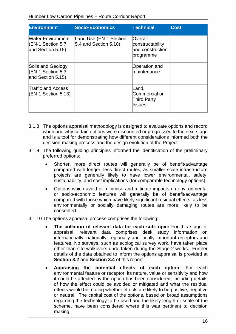
Table 3-1 Options Appraisal: Topics and Associated Sub-Topics (reference to EN-1 is included in brackets where applicable)
Environment Socio-Economics Technical Cost
Biodiversity (EN-1 Section 5.3)
Settlement and Population (EN-1 Section 5.12)
Crossings (including trenchless)
Capital Cost
Landscape and Views (EN-1 Section 5.9)
Tourism and Recreation (EN-1 Section 5.12)
Topography, ground condition, access and reduced construction working areas
Historic Environment (EN-1 Section 5.8)
Planning (development plan allocations, planning policy and relevant planning applications) (EN-1 Section 5.10)
Testing
Humber Low Carbon Pipelines – Route Corridor Report
16
Environment Socio-Economics Technical Cost
Water Environment (EN-1 Section 5.7 and Section 5.15)
Land Use (EN-1 Section 5.4 and Section 5.10)
Overall constructability and construction programme
Soils and Geology (EN-1 Section 5.3 and Section 5.15)
Operation and maintenance
Traffic and Access (EN-1 Section 5.13)
Land, Commercial or Third Party Issues
3.1.8 The options appraisal methodology is designed to evaluate options and record when and why certain options were discounted or progressed to the next stage and is a tool for demonstrating how different considerations informed both the decision-making process and the design evolution of the Project.
3.1.9 The following guiding principles informed the identification of the preliminary preferred options:
• Shorter, more direct routes will generally be of benefit/advantage compared with longer, less direct routes, as smaller scale infrastructure projects are generally likely to have lower environmental, safety, sustainability, and cost implications (for comparable technology options).
• Options which avoid or minimise and mitigate impacts on environmental or socio-economic features will generally be of benefit/advantage compared with those which have likely significant residual effects, as less environmentally or socially damaging routes are more likely to be consented.
3.1.10 The options appraisal process comprises the following:
• The collation of relevant data for each sub-topic: For this stage of appraisal, relevant data comprises desk study information on internationally, nationally, regionally and locally important receptors and features. No surveys, such as ecological survey work, have taken place other than site walkovers undertaken during the Stage 2 works. Further details of the data obtained to inform the options appraisal is provided at Section 3.2 and Section 3.4 of this report.
• Appraising the potential effects of each option: For each environmental feature or receptor, its nature, value or sensitivity and how it could be affected by the option has been considered, including details of how the effect could be avoided or mitigated and what the residual effects would be, noting whether effects are likely to be positive, negative or neutral. The capital cost of the options, based on broad assumptions regarding the technology to be used and the likely length or scale of the scheme, have been considered where this was pertinent to decision making.

Humber Low Carbon Pipelines – Route Corridor Report
17
3.1.11 Following completion of the options appraisal, the Project team has discussed and reviewed the appraisal work, challenged judgements made as to the effects of particular options, checked understanding and assumptions, and compiled an overall view of the relative performance of each option based on the available information. During these discussions, each option is considered, and the extent of any likely environmental or socio-economic impacts or technical issues associated with the option is reviewed for each of the identified sub-topics, so that a shared understanding regarding the preliminary preferred option(s) is reached.
3.2.1 Relevant environmental, socio-economic and technical data within the Study Area is required to inform the RS. Most of this spatial data is available online; some elements have had to be manually digitised, where there has been no online availability.
3.2.2 Data layers have been collated into an ArcGIS Online Geographic Information System (‘WebGIS’) database to allow them to be individually mapped, overlain and used to help in the identification of potential route corridor and siting options.
3.2.3 Since the completion of the Stage 2 process, the WebGIS data has been reviewed and refreshed (February 2021) to ensure it remains up to date and relevant to the RS stage. In addition, the following new data layers have also been identified and added to the WebGIS database:
• Relevant major planning applications (including those pending decision and those at the Environmental Impact Assessment (EIA) screening or scoping stage).
• Socio-economic point data for camping, caravanning, mobile homes, holiday parks, bed & breakfast (B&B), backpacker accommodation, hostels, homeless refuges, hotels, motels, country houses and inns, self-catering units, allotments and playgrounds.
3.2.4 The key WebGIS data layers are provided at Table 3-2.
3.3.1 As outlined at Section 3.1 of this report, a staged approach has been adopted to identify potential physical and environmental features and receptors and to identify potential routeing options for the Project. This involved the initial identification of route corridors identified at Stage 2 of the Project, which were then reviewed and, where relevant, subject to further refinement through the review and analysis of the available data.
Overview
3.4.1 The wide geographical coverage of the Study Area, and the geographical spread and interlinking of route corridors and landfall options has a potential to result in many different option combinations, which in turn would result in a complex and convoluted options appraisal and preliminary preferred option selection process. To simplify the appraisal process, the Project has therefore been sub-divided into two separate ‘packages’ as follows:
• Package 1: Main route corridors (pipelines providing connections
Humber Low Carbon Pipelines – Route Corridor Report
18
between the potential Project emitters).
• Package 2: Pipeline route corridor options from the three landfall options to a connection with the main route corridors (set out in Package 1).
Routeing Principles
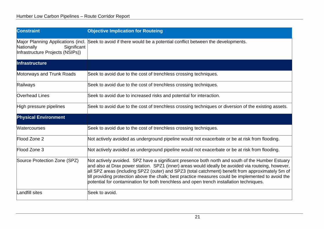
3.4.2 The route corridor options identified at Stage 2 of the Project that were considered suitable for further consideration for the RS stage (see bespoke approaches for Package 1 and Package 2 in the sub-headings below) were subject to further refinement, taking into consideration the updated RS Project description as set out in Section 1 of this report and the location and nature of the environmental and physical features and receptors present in the Study Area. Wherever feasible these features and receptors are avoided; Table 3-2 sets out further details of routeing principles for the key environmental and physical features and receptors.

Humber Low Carbon Pipelines – Route Corridor Report
19
Table 3-2: WebGIS Key Environmental and Physical Features and Receptors
Constraint Objective Implication for Routeing
Biological Environment
Special Area of Conservation (SAC)
Seek to avoid due to the potential for effects on site integrity because of construction activity. Proposals interacting with a SAC, or its associated interest features (e.g. mobile species) may trigger the need for an Appropriate Assessment.
Special Protection Area (SPA) Seek to avoid due to the potential for effects on site integrity because of construction activity. Proposals interacting with a SPA or its associated interest features (e.g. mobile species) may trigger the need for an Appropriate Assessment.
Ramsar site Seek to avoid. Ramsar sites are treated in the same way as SAC and SPA.
Site of Special Scientific Interest (SSSI)
Seek to avoid as SSSI assent required to undertake certain works within a SSSI.
Ancient Woodland Seek to avoid as any loss of Ancient Woodland cannot be effectively mitigated.
National Nature Reserve (NNR) NNR are also protected as SSSI and are therefore treated in a similar way, i.e. seek to avoid.
Local Nature Reserve (LNR) Seek to avoid.
Local Wildlife Sites (LWS) Seek to avoid (to avoid local impacts and potential conflict with local planning policy).
Royal Society for the Protection of Birds (RSPB) Reserve
Seek to avoid.
RSPB Important Bird Area (IBA) Seek to avoid.

Humber Low Carbon Pipelines – Route Corridor Report
20
Constraint Objective Implication for Routeing
Landscape and Visual
Area of Outstanding Natural Beauty (AONB)
Seek to avoid.
National Trails Avoid crossing where suitable alternatives exist.
Country/Forest Parks Avoid where there are viable alternatives, such as land under agricultural use.
Historic Environment
Listed Buildings Seek to avoid.
Scheduled Monuments Seek to avoid.
Registered Park and Garden Seek to avoid.
Conservation Area Seek to avoid.
Land Use and Planning
Agricultural Land Classification (ALC)
Best and Most Versatile (BMV) Agricultural Land not typically avoided as a) effects are temporary and b) BMV Agricultural Land is likely to recover more quickly than poorer quality land.
Golf Courses Golf courses are avoided where viable alternatives are potentially feasible, for example agricultural land.
Land Allocations Seek to avoid.
Humber Low Carbon Pipelines – Route Corridor Report
21
Constraint Objective Implication for Routeing
Major Planning Applications (incl. Nationally Significant Infrastructure Projects (NSIPs))
Seek to avoid if there would be a potential conflict between the developments.
Infrastructure
Motorways and Trunk Roads Seek to avoid due to the cost of trenchless crossing techniques.
Railways Seek to avoid due to the cost of trenchless crossing techniques.
Overhead Lines Seek to avoid due to increased risks and potential for interaction.
High pressure pipelines Seek to avoid due to the cost of trenchless crossing techniques or diversion of the existing assets.
Physical Environment
Watercourses Seek to avoid due to the cost of trenchless crossing techniques.
Flood Zone 2 Not actively avoided as underground pipeline would not exacerbate or be at risk from flooding.
Flood Zone 3 Not actively avoided as underground pipeline would not exacerbate or be at risk from flooding.
Source Protection Zone (SPZ) Not actively avoided. SPZ have a significant presence both north and south of the Humber Estuary and also at Drax power station. SPZ1 (inner) areas would ideally be avoided via routeing, however, all SPZ areas (including SPZ2 (outer) and SPZ3 (total catchment) benefit from approximately 5m of till providing protection above the chalk; best practice measures could be implemented to avoid the potential for contamination for both trenchless and open trench installation techniques.
Landfill sites Seek to avoid.

Humber Low Carbon Pipelines – Route Corridor Report
22
Constraint Objective Implication for Routeing
Historical landfill sites Seek to avoid – would require risk assessment for contamination and stability issues.
Regionally Important Geological/Geomorphological Site (RIGS)
Seek to avoid.
Geological Conservation Review (GCR) sites
Seek to avoid.
Unexploded Ordnance (UXO) Seek to avoid.
Settlement and Population
Urban Settlements Seek to avoid, however at pinch points routeing on urban streets may possibly be considered.
Tourism and Recreation
National Cycle Network Avoid if there are alternatives readily available. However, no long-term effects due to the pipeline being buried.
Humber Low Carbon Pipelines – Route Corridor Report
23
3.4.3 The approach set out in Table 3-2 is balanced with an additional principle of selecting the shortest, most direct route wherever feasible, with, all other aspects being equal, would generally ensure that environmental effects are minimised as far as practicable.
3.4.4 Due to the large footprint of the route corridors options, it was not always feasible to avoid the environmental and physical features and receptors present in the Study Area. The route corridors are approximately 1km wide and in some places are up to 1.5km wide to provide additional routeing flexibility where fewer features and constraints are present., However, the extent to which the much narrower c.100m pipeline construction corridor would be able to avoid such features and/or be able to reduce adverse effects through temporary narrowing or splitting for short distances (see Table 1-1 for further details) or through the implementation of mitigation measures (such as use of trenchless installation techniques) is considered in more detail in the options appraisal process.
3.4.5 Pipelines are typically installed in an open cut trench (see also Table 1-1 of this report), however consideration has been given to the use of trenchless techniques, such as HDD, to enable the pipelines to be installed beneath certain physical constraints (motorways, railway lines, A roads, main rivers and the Humber Estuary).
3.4.6 The appraisal process included input from a range of technical disciplines including biodiversity, historic environment, landscape and visual, water environment, soils and geology, traffic and access, socio-economic, planning, and land use. Construction issues were considered by the engineering team (as summarised at Section 4, Section 5, and Section 6 of this report). Input was also provided by a lands and legal teams.
3.4.7 The options appraisal was undertaken through detailed discussions in the Project team to the benefits and disbenefits of each option from the perspective of each technical discipline. This resulted in collective agreement as to which routeing options, on balance, proved to be most preferable.
3.4.8 A summary of the specific approach taken to identify route corridors for each of the two packages is set out below.
Package 1 (Main Route Corridors)
3.4.9 At Stage 2 of the Project, the various route corridor options identified fell into defined ‘zones’ (see Figure 3-2) depending on where the emitters were located.

Humber Low Carbon Pipelines – Route Corridor Report
24
Figure 3-2: Routeing Zones
3.4.10 The zones within which the potential Project emitters (see Figure 3-3) are
located are as follows:
• Northern Zone: Saltend
• East Central Zone: Keadby, British Steel and Killingholme
• West Central Zone: Drax
3.4.11 One of the key challenges has been the need to connect emitters both north and south of the Humber Estuary, which means that crossings of the Humber Estuary SSS/SPA/SAC/Ramsar site would be required either across the River Ouse or the Humber Estuary proper (both are within the designated sites. These designations are made to protect sites of international importance for nature conservation, and therefore reflect the high biodiversity value of the estuary.
3.4.12 It was determined that there are two principal ways to connect the potential Project emitters north and south of the Humber Estuary. These are as follows:
• Configuration A: This is the shortest, most direct route, running mostly in a west to east direction, but requiring a longer crossing close to the mouth of the estuary. Most of the route corridor would be south of the Humber Estuary; the crossing of the estuary would be via a bored tunnel immediately north of Killingholme power station and south of the Saltend Chemicals Park at the eastern extent of the Study Area.
• Configuration B: This would be a longer route with the emitters south of the Humber being connected via a route initially running east to west, then crossing the River Ouse, before running in a west to east direction towards the landfall. The River Ouse would be crossed close to Reedness, most likely via HDD. This configuration is significantly longer than Configuration A as it replaces a 3km tunnel under the Humber Estuary with an HDD

Humber Low Carbon Pipelines – Route Corridor Report
25
crossing of the River Ouse and approximately 49km – 53km of additional cross-country pipeline.
3.4.13 A review was undertaken to further develop route corridors identified at Stage 2 that align with Configurations A and B and ensure that environmental and physical features and receptors were avoided as far as feasible.
3.4.14 For Configuration A, two route corridor options were taken forward for the first round of options appraisal. For Configuration B, four route corridor options were identified for the first round of options appraisal (see Section 4.2 for overview of the options). Taking into account the recommendations of the options appraisal it was determined that the two options that make up Configuration A were the preferred main route corridors (see Section 4.3).
3.4.15 Following the recommendation to proceed with Configuration A, its constituent options were reviewed in further detail alongside the consideration of connections to potential additional emitters. As such, Configuration A was further developed to comprise three updated options. One of which was routed further to the north of Scunthorpe through more rural land avoiding potential pinch points relating to sensitive receptors. Another was routed to the south of Scunthorpe to avoid the River Trent where it forms part of the Humber Estuary SAC and RAMSAR site and facilitate a more viable connection to British Steel as an emitter (see Section 4.4 for overview of the options).
3.4.16 The revised options that make up Configuration A were then subject to a second round of appraisal (see Section 4.4) to validate their efficacy and check that Configuration A was still preferable to Configuration B across the full suite of environmental, socio-economic, technical and cost considerations. This final round of appraisal forms the evidence base for the selection of the Preferred Route Corridors taken forward to Non-statutory Consultation (see Section 4.5).
Package 2 (Landfall Route Corridors) - Landfall Zones/Route Corridors
3.4.17 At Stage 2 of the Project, seven potential landfall zones were identified from Theddlethorpe in the south up to Barmston in the north. Three of these landfall zones were south of the Humber Estuary and four were north of the Humber Estuary, on the Holderness coast.
3.4.18 A review was undertaken of the seven landfall zones to assess their practicality given the refined Project definition and the location of the potential emitters. The following landfall zones are no longer considered to be reasonable options due to the availability of viable, shorter alternatives:
• Landfall Zone 1: Theddlethorpe.
• Landfall Zone 2: Tetney Haven to Horseshoe Point.
• Landfall Zone 7: Ulrome Sands to Fraisthorpe Sands (Barmston).
3.4.19 Although Landfall Zone 7 provides an opportunity to avoid the Greater Wash SPA and the Holderness Inshore MCZ, it is considered that its greater length (approximately 11km longer than the Atwick options (which are currently the longest landfall route corridor options in Package 2)) together with this location already serving as the landfall location for the Dogger Bank Creyke Beck and Hornsea Four Offshore Wind Farm export cables means that, on balance, it should not be considered further for the purpose of this RS. In addition, Hartley Anderson Limited (2020) describes the ‘ease of consenting as ‘High’ for Landfall Zones 4, 5, 6 and 7, offering no substantial differentiation between them.

Humber Low Carbon Pipelines – Route Corridor Report
26
3.4.20 Hartley Anderson Limited (2020) confirmed that the three landfall zones south of the Humber Estuary (1 and 2 listed above and 3 – East of Immingham Dock) would require much longer offshore pipelines (ranging from approximately 120km to 145km) and would cross a much larger number of existing and proposed pipeline and cable routes (12 - 13 existing and two proposed). There is also a greater navigation density, greater potential for overlap with wind farm areas and slightly more interaction with nature conservation designations than for landfall zones north of the Humber Estuary. These factors are considered sufficient to also no longer consider the following additional option:
• Landfall Zone 3: East of Immingham Dock.
3.4.21 The above process results in three landfall zones being taken forward for detailed consideration in the RS as follows:
• Landfall Zone 4: Holmpton to Spurs (Easington).
• Landfall Zone 5: South Cliff to Tunstall (Aldbrough).
• Landfall Zone 6: Moor Hill to Double Gates (Atwick).
3.4.22 A review was undertaken to further refine the landfall route corridors (i.e. the route corridors connecting the landfall zones to the point at which they connect back to the main route corridors (set out in Package 1). Again, this was to ensure that environmental and physical features and receptors are avoided as far as reasonably practicable. The following landfall route corridors were identified for options appraisal:
• Easington: Initially one landfall corridor to Configuration A and one landfall corridor to Configuration B. A further review of the technical feasibility of the corridor was undertaken which determined that the corridor was potentially highly constrained by the National Transmission System (NTS) pipelines that follow the same route. As such, a further landfall corridor option to Configuration A was developed that was directed north around the NTS pipelines.
• Aldbrough: Two route corridors to main route corridor Configuration A and two route corridors to main route corridor Configuration B.
• Atwick: Two route corridors to main route corridor Configuration A and two route corridors to main route corridor Configuration B.

Humber Low Carbon Pipelines – Route Corridor Report
27
4 PACKAGE 1 OPTIONS APPRAISAL
4.1.1 As set out in Table 1-1 and Section 3.4 of this report, Package 1 comprises the main route corridors (pipelines providing connections between the potential Project emitters).
4.1.2 For Configuration A, two route corridor options (Options A1 and A2) were initially identified and subject to a first round of options appraisal (Section 4.2). For Configuration B, a total of four route corridor options (Option B1, B2, B3, and B4) were identified for the first round of options appraisal. Section 4.2 presents the Options Appraisal of the Configuration A and B Options. Section 4.3 sets out the preliminary recommendation based on this appraisal.
4.1.3 Following this recommendation further technical work was undertaken to review the preferred options in Configuration A and update the routes to avoid pinch points with close proximity to sensitive receptors. As such, three refined options (A3, A4 and A5) were identified and subject to another round of options appraisal (see Section 4.4). Section 4.5 sets out a summary of the appraisal of the preferred options to be taken forward to Non-statutory Consultation.
4.1.4 A summary of the options for Package 1 is provided in Table 4-1.
Table 4-1: Summary of Package 1 Options
Option Route Corridor Sections
First Round of Options Appraisal
A1 Route Corridor Sections A5, A4, A2, A1, and C
A2 Route Corridor Sections A5, A4, A3, A1, and C
B1 Route Corridor Sections B1, B2, B4, A5, A4, A2, and A1
B2 Route Corridor Sections B1, B2, B4, A5, A4, A3, and A1
B3 Route Corridor Sections B1, B3, B4, A5, A4, A2, and A1
B4 Route Corridor Sections B1, B3, B4, A5, A4, A3, and A1
Second Round of Options Appraisal
A3 Route Corridor Sections A5, A6, A1, and C
A4 Route Corridor Sections A5, A4, A7, A1 and C
A5 Route Corridor Sections A5, D3, D3a/D3b, A1 and C
4.1.5 The options appraisal process for Package 1 is summarised in Section 4.2 of this report and has been undertaken in accordance with the approach described in Section 3.1 and Section 3.4 of this report.

Humber Low Carbon Pipelines – Route Corridor Report
28
Option A1
4.2.1 As described in Section 3.4 of this report, Option A1 is one of the two initial options of Configuration A (the shortest route west to east and close to the emitters). Option A1 has an approximate length of 80km and runs mostly in a west to east direction, south of the Humber Estuary; the crossing of the estuary would be via a bored tunnel immediately north of Killingholme power station and south of the Saltend Chemicals Park at the eastern extent of the Study Area.
4.2.2 Option A1 is shown at Figure 4-1.
Figure 4-1: Option A1
4.2.3 Most of the route corridor passes through arable farmland. Key features and receptors within, or close to the route corridor are as follows:
• The route corridor runs south and parallel to the Humber Estuary SAC/SPA/Ramsar/SSSI/Royal Society for the Protection of Birds (RSPB) Important Bird Area (IBA) with two crossings of the estuary required; one at Flixborough Industrial Estate (the River Trent); and one via a bored tunnel at Killingholme. The route corridor is approximately 500m north of Thorne and Hatfield Moors SPA/RSPB IBA, Thorne Moor SAC, Thorne, Crowle and Goole Moors SSSI, and Humberhead Peatlands National Nature Reserve (NNR) south of Goole, and immediately north of Risby Warren SSSI at High Risby as route corridor Section A2 passes south of Appleby.
• Drax Augustinian Priory Scheduled Monument is within the route corridor immediately north of Drax power station. Scurff Hall Moated Site Scheduled Monument is immediately adjacent the route corridor (Section

Humber Low Carbon Pipelines – Route Corridor Report
29
A5) east of Drax. There are several scheduled monuments close to route corridor Section A2 at Flixborough, Dragonby and High Risby (including Flixborough Saxon Nunnery) and a further grouping close to the eastern extent of route corridor Section A2/C at Killingholme (including Thornton Abbey Augustinian Monastery and the three Grade I listed buildings within its grounds).
• On the northern/eastern side of the Humber Estuary, the route corridor (Section C) passes between the Paull Holme Moated Site and Tower and the World War II Decoys for Hull Docks Scheduled Monuments before passing immediately south of Hedon Medieval Town Scheduled Monument as the route corridor connects to Saltend Chemicals Park.
• The route corridor crosses several National Character Areas including the Humber Estuary, Lincolnshire Coast and Marshes, Lincolnshire Wolds, Central Lincolnshire Vale, Northern Lincolnshire Edge with Coversands, and Humberhead Levels.
• The route corridor intersects Source Protection Zone (SPZ) 3 (SPZ3) for approximately 4km at Drax power station and SPZ3, SPZ2 and SPZ1 (for approximately 8km, 5km, and 1km respectively) between Elsham and Killingholme. There is a cluster of historic landfill sites at the approach to Keadby power station, some or all of which are likely to be subject to remediation as part of the Keadby 3 (Low Carbon Gas Power Station) project. The route corridor is partially within the Drax landfill site at the northern boundary of Drax power station and the historic landfill site at Haven, south of Hedon; these can be avoided via careful routeing.
• There are extensive areas of Flood Zone 2 and Flood Zone 3 within the route corridor due to extensive areas of low-lying flood plains surrounding the various rivers that feed into the Humber Estuary. The route corridor crosses many of these rivers and man-made land drains including the River Aire, Dutch River, Swinefleet Warping Drain, River Trent, Winterton Beck, Weir Dike, East Halton Beck and the Humber Estuary/River Humber.
• Most of the route corridor consists of Grade 1 (excellent quality), Grade 2 (very good quality) and Grade 3 (good to moderate quality) Agricultural Land, with significantly smaller areas of land either lower grade (4 or 5) Agricultural Land, non-agricultural land or urban land.
• The route corridor interacts with several major planning and DCO applications and permissions including the National Grid Scotland to England Green Link (SEGL2) project, Drax Bioenergy with Carbon Capture and Storage project, Keadby 3 (Low Carbon Gas Power Station) project, North Lincolnshire Green Energy Park at Flixborough, Able Marine Energy Park at Killingholme, Yorkshire Energy Park at Saltend and Humber Enterprise Park at Saltend.
• The route corridor intersects Minerals Safeguarding Areas (MSA) at Section A5 (at Rawcliffe, south of Goole, and Eastoft) and Section C (between Paull and Saltend).
• Several transport routes are intersected by the route corridor including railway lines, A roads, and the M62 at Rawcliffe (Section A5).
4.2.4 Table 4-2 provides a summary of the relevant environmental, socio-economic, technical and cost considerations for Option A1.

Humber Low Carbon Pipelines – Route Corridor Report
30
Table 4-2: Option A1 Appraisal Summary
Discipline Summary of Option A1
Biodiversity Notable local, national and international designated sites (most of these being notable for their bird assemblages) include the Humber Estuary SSSI/SAC/Ramsar, Warren Risby SSSI, Thorne, Crowle and Goole Moors SSSI/Thorne and Hatfield Moors SPA/RSPB IBA, Blacktoft Sands RSPB (composite area), Slag Banks Local Wildlife Site (LWS), Normandy Park LWS, Conesby Quarry LWS, South Cloister Covert LWS and Halton Marsh Clay Pits LWS. Oak Hill Nature Reserve and Paull Holmes Yorkshire Wildlife Trust (YWT) Nature Reserve should be avoidable through either re-routeing or trenchless crossings.
Surveys on land suitable for birds associated with surrounding SPA/Ramsar/SSSI/RSPB IBA, may be required to confirm this and inform mitigation. Data collection and/or surveys on designated sites would inform mitigation relevant to qualifying features. Mitigation measures to reduce noise, and potentially light, disturbance pollution and pollution prevention should be applied where necessary. Risks to the Humber Estuary SSSI/SAC/Ramsar would be more significant where it crosses; mitigation including trenchless crossing and timing works to avoid key seasons for qualifying features likely to be required.
Several priority habitats are within this option; most could be avoided with careful routeing, with the remaining likely to be avoidable by implementing trenchless technique approach; these include the former railway crossing surrounded by Sharp Lane, deciduous woodland east of Station Road, Redhouse Lane, Pear Tree Avenue and by ensuring the trenchless crossings extends beyond these for the Humber crossing.
A great crested newt District Level Licence point occurs within Section A2 and adjacent to Section C; surveys would be required to confirm presence/likely absence of this species; results would inform any mitigation requirements. Surveys on any waterbodies potentially suitable for great crested newts within 500m of works would likely need surveying to determine mitigation requirements.
Landscape and Visual
There are no nationally important designated landscapes that constrain Option A1. Local level designated landscapes are relatively close to parts of this option. Parts of Option A1 may route through landscapes that have a locally high value but are not recognised through designation.
Opportunities to avoid constraints on landscape character, including valued or sensitive landscape features/elements, exists through more detailed assessment, routeing, and siting.
The underground nature of these options means that the potential for residual significant effects on visual receptors is reduced; nonetheless, routeing close to receptors that are typically of higher sensitivity such as residential

Humber Low Carbon Pipelines – Route Corridor Report
31
Discipline Summary of Option A1
dwellings/settlement and recreational receptors should be avoided where feasible.
Both Option A1 and Option A2 pass near a variety of settlements. Although Option A1 passes closer to the north of Scunthorpe, the landscape context to the settlement edge at this point appears moderately industrial and with other large-scale infrastructure (a wind farm) which could help to reduce effects. The landscape context of both Options A1 and A2 is broadly similar, and with avoidance of sensitive landscape features through siting and routeing and good-practice construction methods the potential effects are likely to be broadly comparable. Option A1 may have a disbenefit insofar as Section A2 appears less direct than Section A3 of Option A2, which is likely to result in a greater amount of landscape disturbance and, it is assumed, may potentially have a longer construction phase.
Historic Environment
There would likely be no physical impacts to designated assets, such as scheduled monuments and listed buildings, as it is assumed the site of Drax Priory and associated remains (SM1016857) would be avoided at the western extent of the route corridor. Physical impacts would be limited to non-designated assets and previously unrecorded assets, although these were not assessed as part of this appraisal.
Impacts on setting would be temporary due to the underground nature of the works.
Mitigation would be required and could include a phased programme of works including geophysical survey, archaeological evaluation trenching, and full archaeological excavation to mitigate physical impacts.
Water Environment
Flood zones and the crossing of multiple watercourses would be unavoidable (including six main river crossings). Approximately two thirds of this option is within Flood Zone 2 and 3. Works within the floodplain (Flood Zone 2 and 3) would likely require the application of the Exception Test and any future flood risk assessment would need to demonstrate how the Exception Test has been met. Pollution prevention measures and best available techniques should be adopted during construction. Some opportunities exist for mitigation including the use of best practice guidelines and trenchless techniques at main river crossing points and large floodplain crossings. Compensatory storage may be required to offset any loss in floodplain storage because of the temporary or permanent works.
Soils and Geology
Ground investigation would be required across much of the route. Precise routeing should take account of the presence of historic landfill and Regionally Important Geological/Geomorphological Sites (RIGS)/Geological Conservation Review (GCR) sites within the route corridor. Landfills in Section A5 (near Keadby) would be unavoidable. Routeing through SPZ 1 presently unavoidable, suitable hydrogeological risk assessment, construction management and
Humber Low Carbon Pipelines – Route Corridor Report
32
Discipline Summary of Option A1
suitable backfill material may be required. However, underlying glacial till would reduce risk to groundwater resources.
Settlement and Population
There are no educational facilities, medical facilities or emergency facilities in the route corridor. No urban settlements are crossed or overlapped, and population density is in the lowest band at 0-20 persons per hectare. There are approximately 20 residential properties within the route corridor. There is potential for direct impacts (e.g. noise disturbance and dust emissions) on all of these properties; however, routeing and siting of construction activities and the route alignment should avoid being close to these residential properties to minimise potential direct and indirect impacts.
Tourism and Recreation
The National Cycle Network (NCN) is crossed in two places. Temporary closure of the NCN is likely to be unavoidable at these locations and would necessitate diversions which could result in adverse direct impacts. Minimising the length of diversions and duration of closure would mitigate these direct impacts.
Other than the potential closure of the NCN, there would be no direct or indirect impacts regarding Tourism and Recreation.
Traffic and Access
Option A1 is well situated for access with the A1033, A15, A1077, A161, A645 running across the route corridor allowing for good accessibility for all vehicle types although an in-depth assessment of the local roads would need to be undertaken to determine accessibility. Mitigation may be required to minimise residual impacts on highway safety and exposure of sensitive receptors to construction traffic. This option also benefits from the M180 running east/west along the route corridor which is capable is supporting all types of vehicles however Highways England (HE) would have to be consulted in relation the impact on the strategic road network (SRN). The crossing of the Humber is also an important consideration with respect to the transportation of spoil on the local road network and more general disturbance/amenity issues associated with a relatively long-term operation in one locality. Option A1/A2 is preferable due to good accessibility as well limiting the highway impact on sensitive receptors and should cause the least disruption to existing routes to large urban areas. Whilst this has generally good access to the highway network, the access to the area to the south of Goole would need to be assessed in more detail due to the need to use more "country lane" type roads.
Land Use Temporary construction works (including access) are unlikely to significantly affect agricultural land use or the long-term viability of functionality of any affected operations due to the temporary nature of the works. Access land and rural businesses can be avoided through routeing.
During operation, the (predominately agricultural) land would be restored back to its former use; the loss of agricultural land (regardless of Grade) would be temporary (no permanent loss)

Humber Low Carbon Pipelines – Route Corridor Report
33
Discipline Summary of Option A1
and any standard agricultural land use operations above the pipelines would be able to continue during the operation phase. Operational effects are unlikely to be significant.
There is an existing solar farm in Section A2 (immediately south of Flixborough Industrial Estate) which the route corridor significantly interacts with. It is not considered that the Project would impact the operation of the solar farm or that the solar farm would provide a constraint to the Project provided a trenchless crossing is undertaken here (ideally as an extension of the trenchless crossing already required for the railway line 400m to the north east). The trenchless crossing would add technical complexity in this location which should be investigated further. Alternatively, due to the proximity of Section A3 to the north, it would also be feasible to switch to the northern section to avoid if required; as this is very close to where Section A2 and A3 converge, it is not considered that this would have any significant implications for the appraisal of the Package 1 options undertaken.
Planning Section A5 requires an understanding of the interaction with Twin Rivers wind farm. Section A2 has a major obstacle in the form of an employment allocation to the North West of Scunthorpe, plus the Lincolnshire Green Energy Park (currently at DCO pre application stage). This similarly applies to Sections A1 and C which are mainly within the South Humber Bank strategic employment allocation (and which has been the subject of major planning applications). Section C to the east of the Humber near Saltend is also subject to applications/permissions that could impede routeing and act as a pinch point for northerly onward connections. Routeing through MSA is seemingly unavoidable for all corridors and therefore requires an early (more detailed) policy assessment to understand the likelihood of policy accordance.
Technical (Engineering)
Constructability across the Humber crossing is good albeit the North bank is heavily drained. Terrain is flat, access reasonable from public roads and ground conditions acceptable. Crossings of HP pipelines on North Bank will probably involve auger bores. Humber crossing poses a challenge, but a similar tunnel has been installed in recent years by National Grid in the same area and therefore feasibility is confirmed.
The constructability of the route is generally good except for the 7km section west of the River Trent to A1077 where lock out sections are evident, and adoption of long HDD sections will be required to traverse the obstacles including river/road/railway.
Constructability may be impacted by factors associated with heavily drained farmland and river flood plains i.e. high-water table and possibility of sand and gravels in underlying geology making trench stabilisation subject to dewatering measures in this instance. There are lock out sections, but these are readily accessible from public roads and there seems to be ample room

Humber Low Carbon Pipelines – Route Corridor Report
34
Discipline Summary of Option A1
for the logistics associated with the crossings such as room for the pipe string for an HDD.
Cost Based on initial assumptions, a potential capital cost was considered. Options A1 and A2 were considered to be marginally less expensive than the Configuration B options.
Lands Potential issues over land purchase agreements. Agreement with The Crown Estate would require detailed negotiations, although as the River Ouse would be crossed under all configuration options this issue is not limited to Option A1. Preference for Configuration A than Configuration B as the longer route would introduce more land interests and crossings including but not limited to utility, rail, Public Rights of Way (PRoW) and trunk roads.
Option A2
4.2.5 As described in Section 3.4 of this report, Option A2 is one of the two options of Configuration A (the shortest route west to east and close to the emitters). Option A2 has an approximate length of 80km and runs mostly in a west to east direction, south of the Humber Estuary; the crossing of the estuary would be via a bored tunnel immediately north of Killingholme power station and south of the Saltend Chemicals Park at the eastern extent of the Study Area.
4.2.6 Option A2 is shown at Figure 4-2.
Figure 4-2: Option A2

Humber Low Carbon Pipelines – Route Corridor Report
35
4.2.7 Most of the route corridor passes through arable farmland. Key features and receptors within, or close to the route corridor are as follows:
• The route corridor runs south and parallel to the Humber Estuary SAC/SPA/Ramsar/SSSI/RSPB IBA with two crossings of the estuary required; one at Flixborough Industrial Estate (the River Trent); and one via a bored tunnel at Killingholme. The route corridor is approximately 500m north of Thorne and Hatfield Moors SPA/RSPB IBA, Thorne Moor SAC, Thorne, Crowle and Goole Moors SSSI, Humberhead Peatlands NNR south of Goole, and approximately 1.4km south of South Ferriby Chalk Pit SSSI as route corridor Section A3 passes between Horkstow and Saxby All Saints.
• Drax Augustinian Priory Scheduled Monument is within the route corridor immediately north of Drax power station. Scurff Hall Moated Site Scheduled Monument is immediately adjacent the route corridor (Section A5) east of Drax. There are two scheduled monuments close to and north of route corridor Section A3 at Horkstow (including the Jacobean Manor House and Gardens south of Horkstow and the Roman Villa immediately west of Horkstow Hall). A further grouping of scheduled monuments is close to the eastern extent of route corridor Section A3/C at Killingholme (including Thornton Abbey Augustinian Monastery and the three Grade I listed buildings within its grounds).
• On the northern/eastern side of the Humber Estuary, the route corridor (Section C) passes between the Paull Holme Moated Site and Tower and the World War II Decoys for Hull Docks Scheduled Monuments before passing immediately south of Hedon Medieval Town Scheduled Monument as the route corridor connects to Saltend Chemicals Park.
• The route corridor crosses several National Character Areas including the Humber Estuary, Lincolnshire Coast and Marshes, Lincolnshire Wolds, Central Lincolnshire Vale, Northern Lincolnshire Edge with Coversands, and Humberhead Levels.
• The route corridor intersects SPZ3 for approximately 4km at Drax power station and SPZ3, SPZ2 and SPZ1 (for approximately 5.5km, 9.5km, and 500m respectively) between Horkstow and Killingholme; SPZ1 is avoidable in this location via careful routeing. SPZ1 is also intersected for approximately 4km between Roxby and Winterton. There is a cluster of historic landfill sites at the approach to Keadby power station, some or all of which are likely to be subject to remediation as part of the Keadby 3 (low carbon gas power station) project. The route corridor is partially within the Drax landfill site at the northern boundary of Drax power station and the historic landfill site at Haven, south of Hedon; these can be avoided via careful routeing.
• There are extensive areas of Flood Zone 2 and Flood Zone 3 within the route corridor due to extensive areas of low-lying flood plains surrounding the various rivers that feed into the Humber Estuary. The route corridor crosses many of these rivers and man-made land drains including River Aire, Dutch River, Swinefleet Warping Drain, River Trent, Winterton Beck, Weir Dike, East Halton Beck and the Humber Estuary/River Humber.
• Most of the route corridor consists of Grade 1 (excellent quality), Grade 2 (very good quality) and Grade 3 (good to moderate quality) Agricultural

Humber Low Carbon Pipelines – Route Corridor Report
36
Land, with significantly smaller areas of land either lower grade (4 or 5) Agricultural Land, non-agricultural land or urban land.
• The route corridor interacts with several major planning and DCO applications and permissions including the SEGL2 project, Drax Bioenergy with Carbon Capture and Storage project, Keadby 3 (Low Carbon Gas Power Station) project, North Lincolnshire Green Energy Park at Flixborough, Able Marine Energy Park at Killingholme, Yorkshire Energy Park at Saltend and Humber Enterprise Park at Saltend.
• The route corridor intersects MSA at Section A5 (at Rawcliffe, south of Goole, and Eastoft) and Section C (between Paull and Saltend).
• Several transport routes are intersected by the route corridor including railway lines, A roads, and the M62 at Rawcliffe (Section A5).
4.2.8 Table 4-3 provides a summary of the relevant environmental, socio-economic, technical and cost considerations for Option A2.
Table 4-3 Option A2 Appraisal Summary
Discipline Summary of Option A2
Biodiversity Notable local, national and international designated sites (most of these being notable for their bird assemblages) include the Humber Estuary SSSI/SAC/Ramsar, Warren Risby SSSI, Thorne, Crowle and Goole Moors SSSI/Thorne and Hatfield Moors SPA/RSPB IBA, Blacktoft Sands RSPB (composite area), Slag Banks LWS, Normandy Park LWS, Conesby Quarry LWS, South Cloister Covert LWS and Halton Marsh Clay Pits LWS. Oak Hill Nature Reserve and Paull Holmes YWT Nature Reserve should be avoidable through either careful routeing or trenchless crossings.
Surveys on land suitable for birds associated with surrounding SPA/Ramsar/SSSI/RSPB IBA, may be required to confirm this and inform mitigation. Data collection and/or surveys on designated sites would inform mitigation relevant to qualifying features. Mitigation measures to reduce noise, and potentially light, disturbance pollution and pollution prevention should be applied where necessary. Risks to the Humber Estuary SSSI/SAC/Ramsar would be more significant where it crosses; mitigation including trenchless crossing and timing works to avoid key seasons for qualifying features likely to be required.
Several priority habitats are within this option; most could be avoided with careful routeing, with the remaining likely to be avoidable by implementing a trenchless technique approach; these include the former railway crossing surrounded by Sharp Lane, deciduous woodland east of Station Road, Redhouse Lane, Pear Tree Avenue and by ensuring the trenchless crossings extends beyond these for the Humber crossing.
A great crested newt District Level Licence point occurs adjacent to Section C; surveys would be required to confirm presence/likely absence of this species; results would inform any mitigation requirements. Surveys on any waterbodies potentially

Humber Low Carbon Pipelines – Route Corridor Report
37
Discipline Summary of Option A2
suitable for great crested newts within 500m of works would likely need surveying to determine mitigation requirements. In Section A3, there are several watercourses, waterbodies and drains Including those near Winterton Beck, Old River Ancholme and New River Ancholme; these may be of value for species such as water vole, therefore trenchless techniques (potentially following surveys to determine presence) may avoid adverse impacts on the habitats and, if present, species.
Landscape and Visual
There are no nationally important designated landscapes that constrain Option A2. Local level designated landscapes lie within approximately 400m of parts of this option. Parts of Option A2 may route through landscapes that have a locally high value but are not recognised through designation.
Opportunities to avoid constraints on landscape character, including valued or sensitive landscape features/elements, exists through more detailed assessment, routeing, and siting.
The underground nature of the options means that the potential for residual significant effects on visual receptors is reduced; nonetheless, routeing close to receptors that are typically of higher sensitivity such as residential dwellings/settlement and recreational receptors should be avoided where feasible.
Both Option A1 and Option A2 pass near a variety of settlements; Option A2 routes further from the large settlement of Scunthorpe but closer to Burton upon Stather. The landscape context of both Options A1 and A2 is broadly similar, and with avoidance of sensitive landscape features through siting and routeing and good-practice construction methods the potential effects are likely to be broadly comparable. Option A2 may have benefits over Option A1 insofar as Section A3 appears more direct than Section A2 of Option A1, which is likely to result in a lesser amount of landscape disturbance and, it is assumed, may potentially have a shorter construction phase.
Historic Environment
There would likely be no physical impacts to designated assets, such as scheduled monuments and listed buildings, as it is assumed the site of Drax Priory and associated remains (SM1016857) would be avoided at the western extent of the route corridor. Physical impacts would be limited to non-designated assets and previously unrecorded assets, although these were not assessed as part of this appraisal.
Impacts on setting would be temporary due to the underground nature of the works. There is also the potential for impacts on the setting of the Grade II listed buildings within Section A3, although it is assumed the pipeline would avoid the assets and therefore remove any physical impacts.
Mitigation would be required and could include a phased programme of works including geophysical survey, archaeological evaluation trenching, and full archaeological excavation to mitigate physical impacts.

Humber Low Carbon Pipelines – Route Corridor Report
38
Discipline Summary of Option A2
Water Environment
Flood zones and the crossing of multiple watercourses would be unavoidable (including six main river crossings). Approximately two thirds of the route corridor is within Flood Zone 2 and 3. Works within the floodplain (Flood Zone 2 and 3) would likely require the application of the Exception Test and any future flood risk assessment would need to demonstrate how the Exception Test has been met. Pollution prevention measures and best available techniques should be adopted during construction. Some opportunities exist for mitigation including the use of best practice guidelines and trenchless techniques at main river crossing points and large floodplain crossings. Compensatory storage may be required to offset any loss in floodplain storage because of the temporary or permanent works.
Soils and Geology
Ground investigation would be required across much of the route corridor. Precise routeing should take account of the presence of historic landfill and RIGS/GCR sites within the route corridor. Routeing through SPZ1 is presently unavoidable, suitable hydrogeological risk assessment, construction management and suitable backfill material may be required. However, underlying glacial till reduces risk to groundwater resources.
Settlement and Population
There are no educational facilities, medical facilities or emergency facilities in the route corridor. No urban settlements are crossed or overlapped, and population density is in the lowest band at 0-20 persons per hectare. There are approximately 30 residential properties within the route corridor. There is potential for direct impacts (e.g. noise disturbance and dust emissions) on all of these properties; however, routeing and siting of construction activities and the route alignment should avoid being close to these residential properties to minimise potential direct and indirect impacts.
Tourism and Recreation
The NCN is crossed in one place. Temporary closure of the NCN is likely to be unavoidable in this location and would necessitate diversions which could result in adverse direct impacts. Minimising the length of diversions and duration of closure would mitigate these direct impacts; however, routeing and siting of construction activities and the route alignment should avoid being close to the Acorn Wood Caravan Park and Glamping Park to minimise potential indirect impacts.
Traffic and Access
Option A2 is well situated for access with the A1033, A15, A1077, A161, A645 running across the route corridor allowing for good accessibility for all vehicle types although an in-depth assessment of the local roads would need to be undertaken to determine accessibility; mitigation may be required to minimise residual impacts on highway safety and exposure of sensitive receptors (at Roxby, Normanby, Burton upon Stather, Winterton) to construction traffic. This option also benefits from the M180 running east/west along the route corridor which is capable is supporting all types of vehicles however HE would have to be consulted in relation the impact on the SRN. The crossing of the

Humber Low Carbon Pipelines – Route Corridor Report
39
Discipline Summary of Option A2
Humber is also an important consideration with respect to the transportation of spoil on the local road network and more general disturbance/amenity issues associated with a relatively long-term operation in one locality. Option A1/A2 is preferable due to good accessibility as well limiting the highway impact on sensitive receptors and should cause the least disruption to existing routes to large urban areas. Whilst this has generally good access to the highway network, the access to the area to the south of Goole would need to be assessed in more detail due to the need to use more "country lane" type roads.
Land Use Temporary construction works (including access) are unlikely to significantly affect agricultural land use or the long-term viability of functionality of any affected operations due to the temporary nature of the works. The allotment and rural businesses can be avoided through routeing.
During operation, the (predominately agricultural) land would be restored back to its former use; the loss of agricultural land (regardless of Grade) would be temporary (no permanent loss) and any standard agricultural land use operations above the pipelines would be able to continue during the operation phase. Operational effects are unlikely to be significant.
Planning Section A5 requires an understanding of the interaction with Twin Rivers wind farm. Section A1 and Section C have a major obstacle in that they are mainly within the South Humber Bank strategic employment allocation (and which has been the subject of major planning applications). Section C to the east of the Humber is also subject to applications/permissions that could impede routeing. Routeing through MSA is seemingly unavoidable for all corridors and therefore requires an early policy assessment to understand the likelihood of policy accordance. Section A3 is preferred to Section A2 on the basis that Section A2 has a major obstacle in the form of an employment allocation to the North West of Scunthorpe, albeit both are impacted by the Lincolnshire Green Energy Park (currently at DCO pre application stage).
Technical (Engineering)
Constructability across the Humber crossing is good albeit that the North bank is heavily drained. Terrain is flat, access reasonable from public roads and ground conditions ok. Crossings of HP pipelines on North Bank will probably involve auger bores. Humber crossing poses a challenge, but a similar tunnel has been installed in recent years by National Grid in the same area and therefore feasibility is confirmed.
The constructability of the route is generally good except this route does involve a major crossing of the River Trent and Roxby Catchwater. There will be a special section around the New River Anchome area which forms a major water course corridor. There is some question about contaminated ground potential near the former open cast mining area and Roxby Catchwater.

Humber Low Carbon Pipelines – Route Corridor Report
40
Discipline Summary of Option A2
Constructability may be impacted by factors associated with heavily drained farmland and river flood plains i.e. high-water table and possibility of sand and gravels in underlying geology making trench stabilisation subject to dewatering measures in this instance. There are lock out sections, but these are readily accessible from public roads and there seems to be ample room for the logistics associated with the crossings such as room for the pipe string for an HDD.
Cost Based on initial assumptions, a potential capital cost was considered. Options A1 and A2 were considered to be marginally less expensive than the Configuration B options.
Lands Potential issues over land purchase agreements. Agreement with The Crown Estate would require detailed negotiations, although as the River Ouse would be crossed under all configuration options this issue is not limited to Option A2. Preference for Configuration A than over Configuration B as the longer route would introduce more land interests and crossings including (but not limited to) utility, rail, PRoW and trunk roads.
Option B1
4.2.9 As described in Section 3.4 of this report, Option B1 is one of the four options of Configuration B (a longer route between the emitters avoiding the requirement for a bored tunnel beneath the Humber Estuary). Option B1 has an approximate length of 129km with the emitters south of the Humber Estuary being connected via a route initially running east to west, then crossing the River Ouse at Reedness, before running in a west to east direction (south of Beverley) towards the landfall.
4.2.10 Option B1 is shown at Figure 4-3.
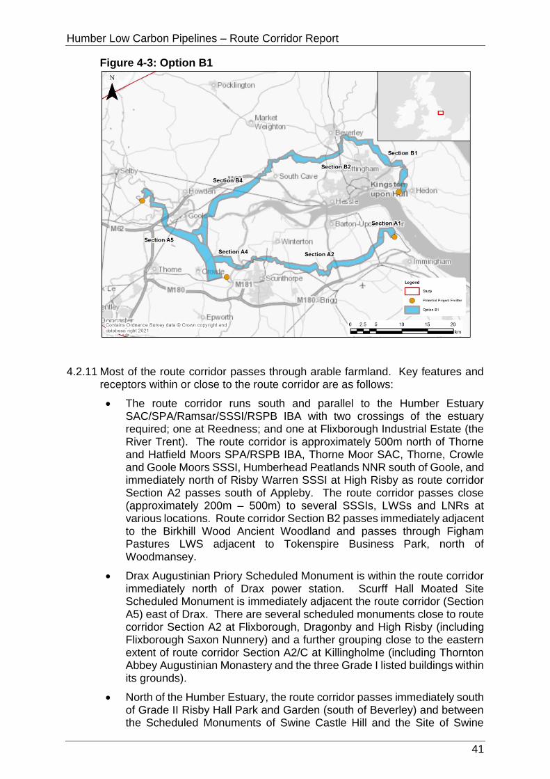
Humber Low Carbon Pipelines – Route Corridor Report
41
Figure 4-3: Option B1
4.2.11 Most of the route corridor passes through arable farmland. Key features and receptors within or close to the route corridor are as follows:
• The route corridor runs south and parallel to the Humber Estuary SAC/SPA/Ramsar/SSSI/RSPB IBA with two crossings of the estuary required; one at Reedness; and one at Flixborough Industrial Estate (the River Trent). The route corridor is approximately 500m north of Thorne and Hatfield Moors SPA/RSPB IBA, Thorne Moor SAC, Thorne, Crowle and Goole Moors SSSI, Humberhead Peatlands NNR south of Goole, and immediately north of Risby Warren SSSI at High Risby as route corridor Section A2 passes south of Appleby. The route corridor passes close (approximately 200m – 500m) to several SSSIs, LWSs and LNRs at various locations. Route corridor Section B2 passes immediately adjacent to the Birkhill Wood Ancient Woodland and passes through Figham Pastures LWS adjacent to Tokenspire Business Park, north of Woodmansey.
• Drax Augustinian Priory Scheduled Monument is within the route corridor immediately north of Drax power station. Scurff Hall Moated Site Scheduled Monument is immediately adjacent the route corridor (Section A5) east of Drax. There are several scheduled monuments close to route corridor Section A2 at Flixborough, Dragonby and High Risby (including Flixborough Saxon Nunnery) and a further grouping close to the eastern extent of route corridor Section A2/C at Killingholme (including Thornton Abbey Augustinian Monastery and the three Grade I listed buildings within its grounds).
• North of the Humber Estuary, the route corridor passes immediately south of Grade II Risby Hall Park and Garden (south of Beverley) and between the Scheduled Monuments of Swine Castle Hill and the Site of Swine

Humber Low Carbon Pipelines – Route Corridor Report
42
Cistercian Nunnery (the latter immediately adjacent the Grade I listed Church of St Mary), before heading south east towards its connection to Saltend Chemicals Park approximately 1km west of Hedon Medieval Town Scheduled Monument.
• The route corridor crosses several National Character Areas including the Humber Estuary, Lincolnshire Coast and Marshes, Lincolnshire Wolds, Central Lincolnshire Vale, Northern Lincolnshire Edge with Coversands, Humberhead Levels, Yorkshire Wolds, and Holderness. The route corridor (Section B2) intersects the Yorkshire Wolds Way National Trail at High Hunsley.
• The route corridor intersects SPZ3 for approximately 4km at Drax power station and SPZ3, SPZ2 and SPZ1 (for approximately 8km, 5km, and 1km respectively) between Elsham and Killingholme. The route corridor also intersects SPZ3, SPZ2, and SPZ1 (for approximately 5.5km, 7km, and 2km respectively) between High Hunsley and Wawne. There is a cluster of historic landfill sites at the approach to Keadby power station, some or all of which are likely to be subject to remediation as part of the Keadby 3 (Low Carbon Gas Power Station) project. The route corridor is partially within the Drax landfill site at the northern boundary of Drax power station; this can be avoided via careful routeing.
• There are extensive areas of Flood Zone 2 and Flood Zone 3 within the route corridor due to extensive areas of low-lying flood plains surrounding the various rivers that feed into the Humber Estuary. The route corridor crosses many of these rivers and man-made land drains including River Aire, Dutch River, Swinefleet Warping Drain, River Trent, Winterton Beck, Weir Dike, East Halton Beck, River Ouse, and the River Hull.
• Most of the route corridor consists of Grade 1 (excellent quality), Grade 2 (very good quality) and Grade 3 (good to moderate quality) Agricultural Land, with significantly smaller areas of land either lower grade (4 or 5) Agricultural Land, non-agricultural land or urban land. Section B2 of the route corridor passes through most of the registered common land at Beverley (Figham) immediately east of Tokenspire Business Park.
• The route corridor interacts with several major planning and DCO applications and permissions including the SEGL2 project, Drax Bioenergy with Carbon Capture and Storage project, Keadby 3 (low carbon gas power station) project, North Lincolnshire Green Energy Park at Flixborough, Able Marine Energy Park at Killingholme, and Yorkshire Energy Park at Saltend.
• The route corridor intersects MSA at Section A5 (at Rawcliffe, south of Goole, and Eastoft). Most of route corridor Section B2 (south of Beverley) and part of route corridor Section B4 (at Everthorpe and Oxmardyke) are within a MSA.
• Several transport routes are intersected by the route corridor including railway lines, A roads, and the M62 at Rawcliffe (Section A5).
4.2.12 Table 4-4 provides a summary of the relevant environmental, socio-economic, technical and cost considerations for Option B1.

Humber Low Carbon Pipelines – Route Corridor Report
43
Table 4-4: Option B1 Appraisal Summary
Discipline Summary of Option B1
Biodiversity Notable local, national and international designated sites (most of these being notable for their bird assemblages) include the Humber Estuary SSSI/SAC/Ramsar, Warren Risby SSSI, Thorne, Crowle and Goole Moors SSSI, Drewton Lane Pits SSSI, Wyedale SSSI, Thorne and Hatfield Moors SPA/RSPB IBA, Blacktoft Sands RSPB (composite area), Slag Banks LWS, Normandy Park LWS, Conesby Quarry LWS, South Cloister Covert LWS and Halton Marsh Clay Pits LWS. Oak Hill Nature Reserve, Paull Holmes YWT Nature Reserve, Noddle Hill and Beverley Parks Local Nature Reserves (LNR) should be avoidable through either careful routeing or trenchless crossings.
Surveys on land suitable for birds associated with surrounding SPA/Ramsar/SSSI/RSPB IBA, may be required to confirm this and inform mitigation. Data collection and/or surveys on designated sites would inform mitigation relevant to qualifying features. Mitigation measures to reduce noise, and potentially light, disturbance pollution and pollution prevention should be applied where necessary.
Several priority habitats are within this option; most could be avoided with careful routeing, with the remaining likely to be avoidable by implementing trenchless technique approach; these include the former railway crossing surrounded by Sharp Lane, deciduous woodland east of Station Road, Redhouse Lane, Pear Tree Avenue, A1033 crossing, priority coastal and floodplain grazing marsh immediately east of A1174, Drewton Beck crossing west of the A1034, the Market Weighton canal crossing south of the B1230 and the River Ouse crossing.
A great crested newt District Level Licence point occurs within Section A2 and passes close to Sections B1, B2 and B4; surveys would be required to confirm presence/likely absence of this species; results would inform any mitigation requirements. Surveys on any waterbodies potentially suitable for great crested newts within 500m of works would likely need surveying to determine mitigation requirements. Trenchless crossings may be appropriate, including but not limited to Market Weighton Canal, River Ouse and River Hull to avoid adverse impacts on the habitats and, if present, species.
Landscape and Visual
There are no nationally important designated landscapes that constrain Option B1. Parts of the route corridor are close to landscapes that are designated at a local level (Important Landscape Area) (ILA) which is considered less favourable than Options A1 and A2 that avoid these areas.
Opportunities to avoid constraints on landscape character, including valued or sensitive landscape features/elements, exists through more detailed assessment, routeing, and siting.
The underground nature of the options means that the potential for residual significant effects on visual receptors is reduced;

Humber Low Carbon Pipelines – Route Corridor Report
44
Discipline Summary of Option B1
nonetheless, routeing close to receptors that are typically of higher sensitivity such as residential dwellings/settlement and recreational receptors should be avoided where feasible.
Options B1, B2, B3 and B4 all pass close to several settlements. Option B1, Section B2, routes between Hull and Beverley close to the suburban edges and outlying villages around these settlements. In this regard, there may be greater potential for effects on a greater number of these receptors than Options B3 and B4 which route to the north of Beverley via Section B3.
The landscape context of both Options B1 - B4 is broadly similar, and with avoidance of sensitive landscape features through siting and routeing and good practice construction methods the potential effects are likely to be broadly comparable; although Option B1, Section B2, contains fewer potential trenchless crossing points which might help to reduce potential landscape and visual impacts compared to Options B3 and B4.
Option B1 appears to take a more direct route which may have benefits over Options B3 and B4 regarding limiting the amount of landscape disturbance and, it is assumed, may potentially have a shorter construction phase.
Historic Environment
There would likely be no physical impacts to designated assets, such as scheduled monuments, listed buildings, and Registered Parks and Gardens as there are only a very limited number of designated assets within the route limits, and these are listed buildings and the scheduled Drax Priory and associated remains (SM1016857) which it is assumed would be avoided. Physical impacts would currently be limited to non-designated assets and previously unrecorded assets, although these were not assessed as part of this appraisal.
Impacts on setting would be temporary due to the underground nature of the works.
Mitigation would be required and could include a phased programme of works including geophysical survey, archaeological evaluation trenching, and full archaeological excavation to mitigate physical impacts.
Water Environment
Flood zones and the crossing of multiple watercourses would be unavoidable (including 15 main river crossings). Approximately half of the route corridor is within Flood Zone 2 and 3. Works within the floodplain (Flood Zone 2 and 3) would likely require the application of the Exception Test and any future flood risk assessment would need to demonstrate how the Exception Test has been met. Pollution prevention measures and best available techniques should be adopted during construction. Some opportunities exist for mitigation including the use of best practice guidelines and trenchless techniques at main river crossing points and large floodplain crossings. Compensatory storage may be required to offset any loss in floodplain storage because of the temporary or permanent works.

Humber Low Carbon Pipelines – Route Corridor Report
45
Discipline Summary of Option B1
Soils and Geology
Ground investigation will be required across much of the route. Precise routeing should take account of the presence of historic landfill and RIGS/GCR sites within the route corridor. Routeing through SPZ1 is unavoidable, suitable hydrogeological risk assessment, construction management and suitable backfill material may be required. However, underlying glacial till reduces risk to groundwater resources.
Settlement and Population
There are no educational facilities, medical facilities or emergency facilities in the route corridor. No urban settlements are crossed or overlapped, and population density is in the lowest band at 0-20 persons per hectare. There are approximately 40 residential properties within the route corridor. There is potential for direct impacts (e.g. noise disturbance and dust emissions) on all of these properties; however, routeing and siting of construction activities and the route alignment should avoid being close to these residential properties to minimise potential direct and indirect impacts.
Tourism and Recreation
Two hotels (the Lazaat Hotel and Rudstone Walk) are in the route corridor and a holiday park (the Wood Carr Holiday Centre) is adjacent to the route corridor. Routeing and siting of construction activities and the route alignment should avoid being close to these resources to minimise potential direct and indirect impacts.
The NCN is crossed in two places. Temporary closure of the NCN is likely to be unavoidable at these locations and would necessitate diversions which could result in adverse direct impacts. Minimising the length of diversions and duration of closure would mitigate these direct impacts.
Traffic and Access
The route corridor has good, connecting roads links with the A1033, A165, A1174, A1079, A164, A1034, A161 as well as the M62/M180 (HE would need consulting) running through it. This allows for good accessibility for all vehicle types although an in-depth assessment would be required of the local roads particularly north of the River Humber near Gilerdyke where access maybe more difficult (access may also be difficult between Woodmansey and the A165 with only small local roads present) to determine accessibility; mitigation may be required to minimise residual impacts on highway safety and exposure of sensitive receptors to construction traffic. The route corridor passes by major residential areas including Hull and Beverley where the impacts may be larger and cause more disruption.
Land Use Temporary construction works (including access) are unlikely to significantly affect agricultural land use or the long-term viability of functionality of any affected agricultural land use operations due to the temporary nature of the works. Rural businesses and the access land south of Wootton can be avoided through routeing.
The temporary construction works would be of a sufficient duration to have adverse effects on the ability of the (common)

Humber Low Carbon Pipelines – Route Corridor Report
46
Discipline Summary of Option B1
land to remain accessible to the public under the provisions of the Countryside and Rights of Way Act 2000 and the Commons Act 2006.
During operation, the (predominately agricultural) land would be restored back to its former use; the loss of agricultural land (regardless of Grade) would be temporary (no permanent loss) and any standard agricultural land use operations above the pipelines would be able to continue during the operation phase.
Maintenance (easement required) would be infrequent and have no significant land use impacts, with the exception of the access land which has the potential to affect the ability for the land to remain accessible to the public under the provisions of the Countryside and Rights of Way Act 2000 and the Commons Act 2006.
There is an existing solar farm in Section A2 (immediately south of Flixborough Industrial Estate) which the route corridor significantly interacts with. It is not considered that the Project would impact the operation of the solar farm or that the solar farm would provide a constraint to the Project provided a trenchless crossing is undertaken here (ideally as an extension of the trenchless crossing already required for the railway line 400m to the north east). The trenchless crossing would add technical complexity in this location which should be investigated further. Alternatively, due to the proximity of Section A3 to the north, it would also be feasible to switch to the northern section to avoid if required; as this is very close to where Section A2 and A3 converge, it is not considered that this would have any significant implications for the appraisal of the Package 1 options undertaken.
Planning South of the Humber – Section A5 requires an understanding of the interaction with Twin Rivers wind farm. Section A2 has a major obstacle in the form of an employment allocation to the North West of Scunthorpe, plus the Lincolnshire Green Energy Park (currently at DCO pre application stage). This similarly applies to Section A1 which is mainly within the South Humber Bank strategic employment allocation (and which has been the subject of major planning applications). Routeing through MSA is seemingly unavoidable for all route corridors and therefore requires an early policy assessment to understand the likelihood of policy accordance.
North of the Humber – Section B1 to the east of the Humber near Saltend is subject to applications/permissions that could impede routeing and act as a pinch point for northerly onward connections. Section B2 and B3 routes follow a similar MSA corridor; this potential obstacle becomes more pronounced when they merge into Section B4 which has recent permission to extend mineral extraction that occupies the width of the corridor. The detail of the mineral application requires closer scrutiny. No major differentiators between Section B2 and Section B3.

Humber Low Carbon Pipelines – Route Corridor Report
47
Discipline Summary of Option B1
Technical (Engineering)
The constructability of the route is generally good except for the 7km section west of River Trent to A1077 where lock out sections are evident, and adoption of long HDD sections will be required to traverse the obstacles including river/road/railway. Constructability south of the River Humber may be impacted by factors associated with heavily drained farmland and river flood plains i.e. high-water table and possibility of sand and gravels in underlying geology making trench stabilisation subject to dewatering measures in this instance. There are lock out sections, but these are readily accessible from public roads and there seems to be ample room for the logistics associated with the crossings such as room for the pipe string for an HDD.
Section B2 contains more hilly terrain than other route corridors. These do not contain extreme slopes but will need to be carefully considered during construction from a safety and water run off control and management. Other than these considerations there are no other obvious problems other than the high level of drainage and some minor access issues.
All major crossings look viable and access is good except for one special crossing of note, the railway line in Section B2, but this is not in cutting and has plenty of working space either side.
Cost Based on initial assumptions, a potential capital cost was considered. Options B1, B2, B3 and B4 were considered to be marginally more expensive than the Configuration A options.
Lands Potential issues over land purchase agreements. Agreement with The Crown Estate would require detailed negotiations, although as the River Ouse would be crossed under all configuration options this issue is not limited to Option B1. South of Beverley is heavily constrained due to common land. This option is located close to Creyke Beck Substation and obtaining a land purchase agreement for this area of land is considered a potential risk.
Preference for Configuration A than Configuration B as the longer route would introduce more land interests and crossings including but not limited to utility, rail, PRoW and trunk roads.
Option B2
4.2.13 As described in Section 3.4 of this report, Option B2 is one of the four options of Configuration B (a longer route between the emitters avoiding the requirement for a bored tunnel beneath the Humber Estuary). Option B2 has an approximate length of 129km with the emitters south of the Humber Estuary being connected via a route initially running east to west, then crossing the River Ouse at Reedness, before running in a west to east direction (south of Beverley) towards the landfall.
4.2.14 Option B2 is shown at Figure 4-4.

Humber Low Carbon Pipelines – Route Corridor Report
48
Figure 4-4: Option B2
4.2.15 Most of the route corridor passes through arable farmland. Key features and receptors within or close to the route corridor are as follows:
4.2.16 The route corridor runs south and parallel to the Humber Estuary SAC/SPA/Ramsar/SSSI/RSPB IBA with two crossings of the estuary required; one at Reedness; and one at Flixborough Industrial Estate (the River Trent). The route corridor is approximately 500m north of Thorne and Hatfield Moors SPA/RSPB IBA, Thorne Moor SAC, Thorne, Crowle and Goole Moors SSSI, Humberhead Peatlands NNR south of Goole, and approximately 1.4km south of South Ferriby Chalk Pit SSSI as route corridor Section A3 passes between Horkstow and Saxby All Saints. The route corridor passes close (approximately 200m – 500m) to several SSSIs, LWSs and LNRs at various locations. Route corridor Section B2 passes immediately adjacent Birkhill Wood Ancient Woodland and passes through Figham Pastures LWS adjacent Tokenspire Business Park, north of Woodmansey.
4.2.17 Drax Augustinian Priory Scheduled Monument is within the route corridor immediately north of Drax power station. Scurff Hall Moated Site Scheduled Monument is immediately adjacent the route corridor (Section A5) east of Drax. There are two scheduled monuments close to and north of route corridor Section A3 at Horkstow (including the Jacobean Manor House and Gardens south of Horkstow and the Roman Villa immediately west of Horkstow Hall). A further grouping of scheduled monuments is close to the eastern extent of route corridor Section A3/C at Killingholme (including Thornton Abbey Augustinian Monastery and the three Grade I listed buildings within its grounds).
4.2.18 North of the Humber Estuary, the route corridor passes immediately south of Grade II Risby Hall Park and Garden (south of Beverley) and between the Scheduled Monuments of Swine Castle Hill and the Site of Swine Cistercian Nunnery (the latter immediately adjacent the Grade I listed Church of St Mary),
Humber Low Carbon Pipelines – Route Corridor Report
49
before heading south east towards its connection to Saltend Chemicals Park approximately 1km west of Hedon Medieval Town Scheduled Monument.
4.2.19 The route corridor crosses several National Character Areas including the Humber Estuary, Lincolnshire Coast and Marshes, Lincolnshire Wolds, Central Lincolnshire Vale, Northern Lincolnshire Edge with Coversands, Humberhead Levels, Yorkshire Wolds, and Holderness. The route corridor (Section B2) intersects the Yorkshire Wolds Way National Trail at High Hunsley.
4.2.20 The route corridor intersects SPZ3 for approximately 4km at Drax power station and SPZ3, SPZ2 and SPZ1 (for approximately 5.5km, 9.5km, and 500m respectively) between Horkstow and Killingholme; SPZ1 is avoidable in this location via careful routeing. SPZ1 is also intersected for approximately 4km between Roxby and Winterton, and SPZ3, SPZ2, and SPZ1 intersected (for approximately 5.5km, 7km, and 2km respectively) between High Hunsley and Wawne. There is a cluster of historic landfill sites at the approach to Keadby power station, some or all of which are likely to be subject to remediation as part of the Keadby 3 (low carbon gas power station) project. The route corridor is partially within the Drax landfill site at the northern boundary of Drax power station; this can be avoided via careful routeing.
4.2.21 There are extensive areas of Flood Zone 2 and Flood Zone 3 within the route corridor due to extensive areas of low-lying flood plains surrounding the various rivers that feed into the Humber Estuary. The route corridor crosses many of these rivers and man-made land drains including River Aire, Dutch River, Swinefleet Warping Drain, River Trent, Winterton Beck, Weir Dike, East Halton Beck, River Ouse, and the River Hull.
4.2.22 Most of the route corridor consists of Grade 1 (excellent quality), Grade 2 (very good quality) and Grade 3 (good to moderate quality) Agricultural Land, with significantly smaller areas of land either lower grade (4 or 5) Agricultural Land, non-agricultural land or urban land. Section B2 of the route corridor passes through most of the registered common land at Beverley (Figham) immediately east of Tokenspire Business Park.
4.2.23 The route corridor interacts with several major planning and DCO applications and permissions including the SEGL2 project, Drax Bioenergy with Carbon Capture and Storage project, Keadby 3 (low carbon gas power station) project, North Lincolnshire Green Energy Park at Flixborough, Able Marine Energy Park at Killingholme, and Yorkshire Energy Park at Saltend.
4.2.24 The route corridor intersects MSA at Section A5 (at Rawcliffe, south of Goole, and Eastoft). Most of route corridor Section B2 (south of Beverley) and part of route corridor Section B4 (at Everthorpe and Oxmardyke) are within a MSA.
4.2.25 Several transport routes are intersected by the route corridor including railway tracks, A roads, and the M62 at Rawcliffe (Section A5).
4.2.26 Table 4-5 provides a summary of the relevant environmental, socio-economic, technical and cost considerations for Option B2.
Table 4-5: Option B2 Appraisal Summary
Discipline Summary of Option B2
Biodiversity Notable local, national and international designated sites (most of these being notable for their bird assemblages) include the Humber Estuary SSSI/SAC/Ramsar, Warren Risby SSSI, Thorne, Crowle and Goole Moors SSSI/Thorne and Hatfield Moors
Humber Low Carbon Pipelines – Route Corridor Report
50
Discipline Summary of Option B2
SPA/RSPB IBA, Blacktoft Sands RSPB (composite area), Slag Banks LWS, Normandy Park LWS, Conesby Quarry LWS, South Cloister Covert LWS and Halton Marsh Clay Pits LWS. Oak Hill Nature Reserve and Paull Holmes YWT Nature Reserve should be avoidable through either careful routeing or trenchless crossings.
Surveys on land suitable for birds associated with surrounding SPA/Ramsar/SSSI/RSPB IBA, may be required to confirm this and inform mitigation. Data collection and/or surveys on designated sites would inform mitigation relevant to qualifying features. Mitigation measures to reduce noise, and potentially light, disturbance pollution and pollution prevention should be applied where necessary.
Several priority habitats are within this option; most could be avoided with careful routeing, with the remaining likely to be avoidable by implementing trenchless technique approach; these include the former railway crossing surrounded by Sharp Lane, deciduous woodland east of Station Road, Redhouse Lane, Pear Tree Avenue, A1033 crossing, priority coastal and floodplain grazing marsh immediately east of A1174, Drewton Beck crossing west of the A1034, the Market Weighton canal crossing south of the B1230 and the River Ouse crossing.
Sections B1, B2 and B4 pass close to great crested newt District Level Licence points if careful routeing to keep a suitable distance from suitable waterbodies for this species is not feasible, surveys to determine presence/likely absence would be required to inform mitigation measures. Surveys on any waterbodies potentially suitable for great crested newts within 500m of works would likely need surveying to determine mitigation requirements. Trenchless crossings may be appropriate, including but not limited to, Winterton Beck, Market Weighton Canal, River Ouse and River Hull to avoid adverse impacts on the habitats and, if present, species.
Landscape and Visual
There are no nationally important designated landscapes that constrain Option B2. Parts of the route corridor are close to landscapes that are designated at a local level (ILA) which is considered less favourable than Options A1 and A2 that avoid these areas.
Opportunities to avoid constraints on landscape character, including valued or sensitive landscape features/elements, exists through more detailed assessment, routeing, and siting.
The underground nature of the options means that the potential for residual significant effects on visual receptors is reduced; nonetheless, routeing close to receptors that are typically of higher sensitivity such as residential dwellings/settlement and recreational receptors should be avoided where feasible.
Options B1, B2, B3 and B4 all pass close to several settlements. Option B2, Section B2, routes between Hull and Beverley close

Humber Low Carbon Pipelines – Route Corridor Report
51
Discipline Summary of Option B2
to the suburban edges and outlying villages around these settlements. In this regard, there may be greater potential for effects on a greater number of these receptors than Options B3 and B4 which route to the north of Beverley via Section B3.
The landscape context of both Options B1 - B4 is broadly similar, and with avoidance of sensitive landscape features through siting and routeing and good practice construction methods the potential effects are likely to be broadly comparable; although Option B2, Section B2, contains fewer potential trenchless crossing points which might help to reduce potential landscape and visual impacts compared to Options B3 and B4.
Option B2 appears to take a more direct route which may have benefits over Options B3 and B4 regarding limiting the amount of landscape disturbance and, it is assumed, may potentially have a shorter construction phase.
Historic Environment
There would likely be no physical impacts to designated assets, such as scheduled monuments, listed buildings, and Registered Parks and Gardens as there are only a very limited number of designated assets within the route corridor, and these are listed buildings and the scheduled Drax Priory and associated remains (SM1016857) which it is assumed would be avoided. Physical impacts would be limited to non-designated assets and previously unrecorded assets, although these were not assessed as part of this appraisal.
Impacts on setting would be temporary due to the underground nature of the works.
Mitigation would be required and could include a phased programme of works including geophysical survey, archaeological evaluation trenching, and full archaeological excavation to mitigate physical impacts.
Water Environment
Flood zones and the crossing of multiple watercourses would be unavoidable (including 15 main river crossings). Approximately half of the route corridor is within Flood Zone 2 and 3. Works within the floodplain (Flood Zone 2 and 3) would likely require the application of the Exception Test and any future flood risk assessment would need to demonstrate how the Exception Test has been met. Pollution prevention measures and best available techniques should be adopted during construction. Some opportunities exist for mitigation including the use of best practice guidelines and trenchless techniques at main river crossing points and large floodplain crossings. Compensatory storage may be required to offset any loss in floodplain storage because of the temporary or permanent works.
Soils and Geology
Ground investigation will be required across much of the route. Precise routeing should take account of the presence of historic landfill and RIGS/GCR sites within the route corridor. Routeing through SPZ1 is presently unavoidable, suitable hydrogeological risk assessment, construction management and suitable backfill

Humber Low Carbon Pipelines – Route Corridor Report
52
Discipline Summary of Option B2
material may be required. However, underlying glacial till reduces risk to groundwater resources.
Settlement and Population
There are no educational facilities, medical facilities or emergency facilities in the route corridor. No urban settlements are crossed or overlapped, and population density is in the lowest band at 0-20 persons per hectare. There are approximately 45 residential properties within the route corridor. There is potential for direct impacts (e.g. noise disturbance and dust emissions) on all of these properties; however, routeing and siting of construction activities and the route alignment should avoid being close to these residential properties to minimise potential direct and indirect impacts.
Tourism and Recreation
Two hotels (the Lazaat Hotel and Rudstone Walk) are in the route corridor. A caravan park (The Acorn Wood Caravan Park and Glamping Park) and a holiday centre (the Wood Carr Holiday Centre) are adjacent the route corridor. Routeing and siting of construction activities and the route alignment should avoid being close to these resources to minimise potential direct and indirect impacts.
The NCN is crossed in one place. Temporary closure of the NCN is likely to be unavoidable in this location and would necessitate diversions which could result in adverse direct impacts. Minimising the length of diversions and duration of closure would mitigate these direct impacts.
Traffic and Access
The route corridor has good, connecting roads links with the A1033, A165, A1174, A1079, A164, A1034, A161 as well as the M62/M180 (HE would need consulting) running through it. This allows for good accessibility for all vehicle types although an in-depth assessment of the local roads would be required, particularly north of the River Humber near Gilerdyke where access maybe more difficult (access may also be difficult between Woodmansey and the A165 with only small local roads present) to determine accessibility; mitigation maybe be required to minimise residual impacts on highway safety and exposure of sensitive receptors to construction traffic. The route passes by major residential areas including Hull and Beverley where the impacts may be larger and cause more disruption.
Land Use Temporary construction works (including access) are unlikely to significantly affect agricultural land use or the long-term viability of functionality of any affected agricultural land use operations due to the temporary nature of the works. The allotment and rural businesses can be avoided through routeing.
The temporary construction works would be of a sufficient duration to have adverse effects on the ability of the (common) land to remain accessible to the public under the provisions of the Countryside and Rights of Way Act 2000 and the Commons Act 2006.
During operation, the (predominately agricultural) land would be restored back to its former use; the loss of agricultural land
Humber Low Carbon Pipelines – Route Corridor Report
53
Discipline Summary of Option B2
(regardless of Grade) would be temporary (no permanent loss) and any standard agricultural land use operations above the pipelines would be able to continue during the operation phase.
Maintenance (easement required) would be infrequent and have no significant land use impacts, with the exception of the access land which has the potential to affect the ability for the land to remain accessible to the public under the provisions of the Countryside and Rights of Way Act 2000 and the Commons Act 2006.
Planning South of the Humber – Section A5 requires an understanding of the interaction with Twin Rivers wind farm. Section A1 has a major obstacle in that it is mainly within the South Humber Bank strategic employment allocation (and which has been the subject of major planning applications). Routeing through MSA is seemingly unavoidable for all corridors and therefore requires an early policy assessment to understand the likelihood of policy accordance. Section A3 is preferred to Section A2 on the basis that Section A2 has a major obstacle in the form of an employment allocation to the North West of Scunthorpe, albeit both are impacted by the Lincolnshire Green Energy Park (currently at DCO pre application stage).
North of the Humber – Section B1 route to the east of the Humber near Saltend is subject to applications/permissions that could impede routeing and act as a pinch point for northerly onward connections. Sections B2 and B3 follow a similar MSA corridor; this potential obstacle becomes more pronounced when they merge into Section B4 which has recent permission to extend mineral extraction that occupies the width of the corridor. The detail of the mineral application requires closer scrutiny. No major differentiators between Sections B2 and B3.
Technical (Engineering)
The constructability of the route is generally good except this route does involve a major crossing of the River Trent and Roxby Catchwater. There will be a special section around the New River Anchome area which forms a major water course corridor. There is some question about contaminated ground potential near the former open cast mining area and Roxby Catchwater. Constructability south of the River Humber may be impacted by factors associated with heavily drained farmland and river flood plains i.e. high-water table and possibility of sand and gravels in underlying geology making trench stabilisation subject to dewatering measures in this instance. There are lock out sections, but these are readily accessible from public roads and there seems to be ample room for the logistics associated with the crossings such as room for the pipe string for an HDD.
Section B2 contains more hilly terrain than other route corridors. These do not contain extreme slopes but will need to be carefully considered during construction from a safety and water run off control and management. Other than these considerations there are no other obvious problems other than the high level of drainage and some minor access issues.

Humber Low Carbon Pipelines – Route Corridor Report
54
Discipline Summary of Option B2
All major crossings look viable and access is good except for one special crossing of note, the railway line in Section B2, but this is not in a cutting and has plenty of working space either side.
Cost Based on initial assumptions, a potential capital cost was considered. Options B1, B2, B3 and B4 were considered to be marginally more expensive than the Configuration A options.
Lands Potential issues over land purchase agreements. Agreement with The Crown Estate would require detailed negotiations, although as the River Ouse would be crossed under all configuration options this issue is not limited to Option B2. South of Beverley is heavily constrained due to common land. This option is located close to Creyke Beck Substation and obtaining a land purchase agreement for this area of land is considered a potential risk.
Preference for Configuration A than Configuration B as the longer route would introduce more land interests and crossings including but not limited to utility, rail, PRoW and trunk roads.
Option B3
4.2.27 As described in Section 3.4 of this report, Option B3 is one of the four options of Configuration B (a longer route between the emitters avoiding the requirement for a bored tunnel beneath the Humber Estuary). Option B3 has an approximate length of 133km with the emitters south of the Humber Estuary being connected via a route initially running east to west, then crossing the River Ouse at Reedness, before running in a west to east direction (north of Beverley) towards the landfall.
4.2.28 Option B3 is shown at Figure 4-5.
Figure 4-5: Option B3

Humber Low Carbon Pipelines – Route Corridor Report
55
4.2.29 Most of the route corridor passes through arable farmland. Key features and receptors within or close to the route corridor are as follows:
• The route corridor runs south and parallel to the Humber Estuary SAC/SPA/Ramsar/SSSI/RSPB IBA with two crossings of the estuary required; one at Reedness; and one at Flixborough Industrial Estate (the River Trent). The route corridor is approximately 500m north of Thorne and Hatfield Moors SPA/RSPB IBA, Thorne Moor SAC, Thorne, Crowle and Goole Moors SSSI, Humberhead Peatlands NNR south of Goole, and immediately north of Risby Warren SSSI at High Risby as route corridor Section A2 passes south of Appleby. The route corridor passes close (approximately 200m – 500m) to several SSSIs, LWSs and LNRs at various locations.
• Drax Augustinian Priory Scheduled Monument is within the route corridor immediately north of Drax power station. Scurff Hall Moated Site Scheduled Monument is immediately adjacent the route corridor (Section A5) east of Drax. There are several scheduled monuments close to route corridor Section A2 at Flixborough, Dragonby and High Risby (including Flixborough Saxon Nunnery) and a further grouping close to the eastern extent of route corridor Section A2/C at Killingholme (including Thornton Abbey Augustinian Monastery and the three Grade I listed buildings within its grounds).
• North of the Humber Estuary, the route corridor passes close to several scheduled monuments (including the Reins Medieval Deer Park and Eske Medieval Settlement and Field System, north west and north east of Beverley respectively), and between the Scheduled Monuments of Swine Castle Hill and the Site of Swine Cistercian Nunnery (the latter immediately adjacent the Grade I listed Church of St Mary), before heading south east towards its connection to Saltend Chemicals Park approximately 1km west of Hedon Medieval Town Scheduled Monument.
• The route corridor crosses several National Character Areas including the Humber Estuary, Lincolnshire Coast and Marshes, Lincolnshire Wolds, Central Lincolnshire Vale, Northern Lincolnshire Edge with Coversands, Humberhead Levels, Yorkshire Wolds, and Holderness. The route corridor (Section B3) intersects the Yorkshire Wolds Way National Trail at High Hunsley.
• The route corridor intersects SPZ3 for approximately 4km at Drax power station and SPZ3, SPZ2 and SPZ1 (for approximately 8km, 5km, and 1km respectively) between Elsham and Killingholme. SPZ3 is intersected (by route corridor Section B3) for approximately 18km between High Hunsley and Long Riston. There is a cluster of historic landfill sites at the approach to Keadby power station, some or all of which are likely to be subject to remediation as part of the Keadby 3 (low carbon gas power station) project. The route corridor is partially within the Drax landfill site at the northern boundary of Drax power station; this can be avoided via careful routeing.
• There are extensive areas of Flood Zone 2 and Flood Zone 3 within the route corridor due to extensive areas of low-lying flood plains surrounding the various rivers that feed into the Humber Estuary. The route corridor crosses many of these rivers and man-made land drains including River Aire, Dutch River, Swinefleet Warping Drain, River Trent, Winterton Beck,

Humber Low Carbon Pipelines – Route Corridor Report
56
Weir Dike, East Halton Beck, River Ouse, and the River Hull.
• Most of the route corridor consists of Grade 1 (excellent quality), Grade 2 (very good quality) and Grade 3 (good to moderate quality) Agricultural Land, with significantly smaller areas of land either lower grade (4 or 5) Agricultural Land, non-agricultural land or urban land.
• The route corridor interacts with several major planning and DCO applications and permissions including the SEGL2 project, Drax Bioenergy with Carbon Capture and Storage project, Keadby 3 (low carbon gas power station) project, North Lincolnshire Green Energy Park at Flixborough, Able Marine Energy Park at Killingholme, and Yorkshire Energy Park at Saltend.
• The route corridor intersects MSA at Section A5 (at Rawcliffe, south of Goole, and Eastoft). Most of route corridor Section B3 (north of Beverley) and part of route corridor Section B4 (at Everthorpe and Oxmardyke) are within a MSA.
• Several transport routes are intersected by the route corridor including railway lines, A roads, and the M62 at Rawcliffe (Section A5).
4.2.30 Table 4-6 provides a summary of the relevant environmental, socio-economic, technical and cost considerations for Option B3.
Table 4-6: Option B3 Appraisal Summary
Discipline Summary of Option B3
Biodiversity Notable local, national and international designated sites (most of these being notable for their bird assemblages) include the Humber Estuary SSSI/SAC/Ramsar, Warren Risby SSSI, Thorne, Crowle and Goole Moors SSSI, Wyedale SSSI, Thorne and Hatfield Moors SPA/RSPB IBA, Blacktoft Sands RSPB (composite area), Slag Banks LWS, Normandy Park LWS, Conesby Quarry LWS, South Cloister Covert LWS, Raventhorpe Embankment LWS and Halton Marsh Clay Pits LWS. Oak Hill Nature Reserve, Paull Holmes YWT Nature Reserve and Noddle Hill LNR should be avoidable through either careful routeing or trenchless crossings.
Surveys on land suitable for birds associated with surrounding SPA/Ramsar/SSSI/RSPB IBA, may be required to confirm this and inform mitigation. Data collection and/or surveys on designated sites would inform mitigation relevant to qualifying features. Mitigation measures to reduce noise, and potentially light, disturbance pollution and pollution prevention should be applied where necessary.
Several priority habitats are within this option; most could be avoided with careful routeing, with the remaining likely to be avoidable by implementing trenchless technique approach; these include the former railway crossing surrounded by Sharp Lane, deciduous woodland east of Station Road, Redhouse Lane, Pear Tree Avenue, A1033 crossing, priority coastal and floodplain grazing marsh immediately east of A1174, Drewton Beck crossing

Humber Low Carbon Pipelines – Route Corridor Report
57
Discipline Summary of Option B3
west of the A1034, the Market Weighton canal crossing south of the B1230, River Hull and the River Ouse crossing.
A great crested newt District Level Licence point occurs within Section A2 and passes close to Sections B1, B3 and B4; surveys would be required to confirm presence/likely absence of this species; results would inform any mitigation requirements. Surveys on any waterbodies potentially suitable for great crested newts within 500m of works would likely need surveying to determine mitigation requirements. Trenchless crossings may be appropriate, including but not limited to Market Weighton Canal, River Ouse and River Hull to avoid adverse impacts on the habitats and, if present, species.
Landscape and Visual
There are no nationally important designated landscapes that constrain the route corridor. Parts of the route corridor are close to landscapes that are designated at a local level (ILA) which is considered less favourable than Options A1 and A2 that avoid these areas.
Opportunities to avoid constraints on landscape character, including valued or sensitive landscape features/elements, exists through more detailed assessment, routeing, and siting.
The underground nature of the scheme means that the potential for residual significant effects on visual receptors is reduced; nonetheless, routeing close to receptors that are typically of higher sensitivity such as residential dwellings/settlement and recreational receptors should be avoided where feasible.
Options B1, B2, B3 and B4 all pass close to several settlements. Option B3, Section B3, routes to the east and north of Hull and Beverley (respectively) and avoid the well-settled landscape between these settlements. In this regard, there may be potential for effects on fewer receptors than Options B1 and B2.
The landscape context of Options B1 - B4 is broadly similar, and with avoidance of sensitive landscape features through siting and routeing and good-practice construction methods the potential effects are likely to be broadly comparable; although Option B3, Section B3 contains a greater number of potential trenchless crossing points which might result in greater potential landscape and visual impacts compared to Options B1 and B2.
Option B3 appears to take a less direct route which may have disbenefits compared to Options B1 and B2 regarding limiting the amount of landscape disturbance and, it is assumed, may potentially have a longer construction phase.
Historic Environment
There would likely be no physical impacts to designated assets, such as scheduled monuments, listed buildings, and Registered Parks and Gardens as there are only a very limited number of designated assets within the route limits, and these are listed buildings and the scheduled Drax Priory and associated remains (SM1016857) which it is assumed would be avoided. Physical impacts would be limited to non-designated assets and

Humber Low Carbon Pipelines – Route Corridor Report
58
Discipline Summary of Option B3
previously unrecorded assets, although these were not assessed as part of this appraisal.
Impacts on setting would be temporary due to the underground nature of the works.
Mitigation would be required and could include a phased programme of works including geophysical survey, archaeological evaluation trenching, and full archaeological excavation to mitigate physical impacts.
Water Environment
Flood zones and the crossing of multiple watercourses would be unavoidable (including 16 main river crossings). Approximately half of the route corridor is within Flood Zone 2 and 3. Works within the floodplain (Flood Zone 2 and 3) would likely require the application of the Exception Test and any future flood risk assessment would need to demonstrate how the Exception Test has been met. Pollution prevention measures and best available techniques should be adopted during construction. Some opportunities exist for mitigation including the use of best practice guidelines and trenchless techniques at main river crossing points and large floodplain crossings. Compensatory storage may be required to offset any loss in floodplain storage because of the temporary or permanent works.
Soils and Geology
Ground investigation will be required across much of the route. Precise routeing should take account of the presence of historic landfill and RIGS/GCR sites within the route corridor. Routeing through SPZ1 is presently unavoidable, suitable hydrogeological risk assessment, construction management and suitable backfill material may be required. However, underlying glacial till reduces risk to groundwater resources
Settlement and Population
There are no educational facilities, medical facilities or emergency facilities in the route corridor. No urban settlements are crossed or overlapped, and population density is in the lowest band at 0-20 persons per hectare. There are approximately 35 residential properties within the route corridor. There is potential for direct impacts on all of these properties; however, construction activities and the route alignment should avoid being close to these residential properties to minimise potential direct and indirect impacts.
Tourism and Recreation
One hotel (Rudstone Walk) is in the corridor and a holiday centre (the Wood Carr Holiday Centre) is adjacent to the route corridor. Routeing and siting of construction activities and the route alignment should avoid being close to these resources to minimise potential direct and indirect impacts.
The NCN is crossed in five places. Temporary closure of the NCN is likely to be unavoidable at these locations and would necessitate diversions which could result in adverse direct impacts. Minimising the length of diversions and duration of closure would mitigate these direct impacts.

Humber Low Carbon Pipelines – Route Corridor Report
59
Discipline Summary of Option B3
Traffic and Access
The route corridor has good, connecting roads links with the A1033, A165, A1174, A1079, A164, A1034, A161 as well as the M62/M180 (HE would need consulting) running through it. This allows for good accessibility for all vehicle types although an in-depth assessment of the local roads would be required, particularly north of the River Humber near Gilerdyke where access maybe more difficult (access may also be difficult to the west of the A165 with only small local roads) to determine accessibility; mitigation maybe be required to minimise residual impacts on highway safety and exposure of sensitive receptors to construction traffic. The route corridor passes by major residential areas including Hull and around all the major arterial routes in/out of Beverley where the impacts may be larger and cause more disruption. Access is also restricted to the west of Beverley between the A1034 and the A1079, with access via local roads (which would require more detailed assessment).
Land Use Temporary construction works (including access) are unlikely to significantly affect agricultural land use or the long-term viability of functionality of any affected operations due to the temporary nature of the works. Access land, the allotment, and rural businesses can be avoided through routeing.
During operation, the (predominately agricultural) land would be restored back to its former use; the loss of agricultural land (regardless of Grade) would be temporary (no permanent loss) and any standard agricultural land use operations above the pipelines would be able to continue during the operation phase. Operational effects are unlikely to be significant.
There is an existing solar farm in Section A2 (immediately south of Flixborough Industrial Estate) which the route corridor significantly interacts with. It is not considered that the Project would impact the operation of the solar farm or that the solar farm would provide a constraint to the Project provided a trenchless crossing is undertaken here (ideally as an extension of the trenchless crossing already required for the railway line 400m to the north east). The trenchless crossing would add technical complexity in this location which should be investigated further. Alternatively, due to the proximity of Section A3 to the north, it would also be feasible to switch to the northern section to avoid if required; as this is very close to where Section A2 and A3 converge, it is not considered that this would have any significant implications for the appraisal of the Package 1 options undertaken.
Planning South of the Humber – Section A5 requires an understanding of the interaction with Twin Rivers wind farm. Section A2 has a major obstacle in the form of an employment allocation to the North West of Scunthorpe, plus the Lincolnshire Green Energy Park (currently at DCO pre application stage). This similarly applies to Section A1 which is mainly within the South Humber Bank strategic employment allocation (and which has been the subject of major planning applications). Routeing through MSA is

Humber Low Carbon Pipelines – Route Corridor Report
60
Discipline Summary of Option B3
seemingly unavoidable for all corridors and therefore requires an early policy assessment to understand the likelihood of policy accordance.
North of the Humber – Section B1 to the east of the Humber near Saltend is subject to applications/permissions that could impede routeing and act as a pinch point for northerly onward connections. Sections B2 and B3 follow a similar MSA corridor; this potential obstacle becomes more pronounced when they merge into Section B4 which has recent permission to extend mineral extraction that occupies the width of the corridor. The detail of the mineral application requires closer scrutiny. No major differentiators between Sections B2 and B3.
Technical (Engineering)
The constructability of the route is generally good except for the 7km section west of River Trent to A1077 where lock out sections are evident, and adoption of long HDD sections will be required to traverse the obstacles including river/road/railway. Constructability south of the River Humber may be impacted by factors associated with heavily drained farmland and river flood plains i.e. high-water table and possibility of sand and gravels in underlying geology making trench stabilisation subject to dewatering measures in this instance. There are lock out sections, but these are readily accessible from public roads and there seems to be ample room for the logistics associated with the crossings such as room for the pipe string for an HDD.
Section B3 contains more hilly terrain west of Beverley than the other route corridors. These do not contain extreme slopes but there may be a degree of localised benching required. This will need to be carefully considered during construction from a safety and water run off control and management. Other than these considerations there are no other obvious problems other than the high level of drainage and some minor access issues.
All major crossings look viable and access is good except for one special crossing of note, the railway line in Section B2, but this is not in a cutting and has plenty of working space either side
Cost Based on initial assumptions, a potential capital cost was considered. Options B1, B2, B3 and B4 were considered to be marginally more expensive than the Configuration A options.
Lands Potential issues over land purchase agreements. Agreement with The Crown Estate would require detailed negotiations, although as the River Ouse would be crossed under all configuration options this issue is not limited to Option B3. Preference for Configuration A than Configuration B as the longer route would introduce more land interests and crossings including but not limited to utility, rail, PRoW and trunk roads.
Option B4
4.2.31 As described in Section 3.4 of this report, Option B4 is one of the four options of Configuration B (a longer route between the emitters avoiding the requirement for a bored tunnel beneath the Humber Estuary). Option B4 has

Humber Low Carbon Pipelines – Route Corridor Report
61
an approximate length of 133km with the emitters south of the Humber Estuary being connected via a route initially running east to west, then crossing the River Ouse at Reedness, before running in a west to east direction (north of Beverley) towards the landfall.
4.2.32 Option B4 is shown at Figure 4-6.
Figure 4-6: Option B4
4.2.33 Most of the route corridor passes through arable farmland. Key features and
receptors within or close to the route corridor are as follows:
• The route corridor runs south and parallel to the Humber Estuary SAC/SPA/Ramsar/SSSI/RSPB IBA with two crossings of the estuary required; one at Reedness; and one at Flixborough Industrial Estate (the River Trent). The route corridor is approximately 500m north of Thorne and Hatfield Moors SPA/RSPB IBA, Thorne Moor SAC, Thorne, Crowle and Goole Moors SSSI, Humberhead Peatlands NNR south of Goole, and approximately 1.4km south of South Ferriby Chalk Pit SSSI as route corridor Section A3 passes between Horkstow and Saxby All Saints. The route corridor passes close (approximately 200m – 500m) to several SSSIs, LWSs and LNRs at various locations.
• Drax Augustinian Priory Scheduled Monument is within the route corridor immediately north of Drax power station. Scurff Hall Moated Site Scheduled Monument is immediately adjacent the route corridor (Section A5) east of Drax. There are two scheduled monuments close to and north of route corridor Section A3 at Horkstow (including the Jacobean Manor House and Gardens south of Horkstow and the Roman Villa immediately west of Horkstow Hall). A further grouping of Scheduled Monuments is close to the eastern extent of route corridor Section A3/C at Killingholme (including Thornton Abbey Augustinian Monastery and the three Grade I listed buildings within its grounds).
• North of the Humber Estuary, the route corridor passes close to several

Humber Low Carbon Pipelines – Route Corridor Report
62
scheduled monuments (including the Reins Medieval Deer Park and Eske Medieval Settlement and Field System, north west and north east of Beverley respectively), and between the Scheduled Monuments of Swine Castle Hill and the Site of Swine Cistercian Nunnery (the latter immediately adjacent the Grade I listed Church of St Mary), before heading south east towards its connection to Saltend Chemicals Park approximately 1km west of Hedon Medieval Town Scheduled Monument.
• The route corridor crosses several National Character Areas including the Humber Estuary, Lincolnshire Coast and Marshes, Lincolnshire Wolds, Central Lincolnshire Vale, Northern Lincolnshire Edge with Coversands, Humberhead Levels, Yorkshire Wolds, and Holderness. The route corridor (Section B3) intersects the Yorkshire Wolds Way National Trail at High Hunsley.
• The route corridor intersects SPZ3 for approximately 4km at Drax power station and SPZ3, SPZ2 and SPZ1 (for approximately 5.5km, 9.5km, and 500m respectively) between Horkstow and Killingholme; SPZ1 is avoidable in this location via careful routeing. SPZ1 is also intersected for approximately 4km between Roxby and Winterton, and SPZ3 is intersected (by route corridor Section B3) for approximately 18km between High Hunsley and Long Riston. There is a cluster of historic landfill sites at the approach to Keadby power station, some or all of which are likely to be subject to remediation as part of the Keadby 3 (low carbon gas power station) project. The route corridor is partially within the Drax landfill site at the northern boundary of Drax power station; this can be avoided via careful routeing.
• There are extensive areas of Flood Zone 2 and Flood Zone 3 within the route corridor due to extensive areas of low-lying flood plains surrounding the various rivers that feed into the Humber Estuary. The route corridor crosses many of these rivers and man-made land drains including River Aire, Dutch River, Swinefleet Warping Drain, River Trent, Winterton Beck, Weir Dike, East Halton Beck, River Ouse, and the River Hull.
• Most of the route corridor consists of Grade 1 (excellent quality), Grade 2 (very good quality) and Grade 3 (good to moderate quality) Agricultural Land, with significantly smaller areas of land either lower grade (4 or 5) Agricultural Land, non-agricultural land or urban land.
• The route corridor interacts with several major planning and DCO applications and permissions including the SEGL2 project, Drax Bioenergy with Carbon Capture and Storage project, Keadby 3 (low carbon gas power station) project, North Lincolnshire Green Energy Park at Flixborough, Able Marine Energy Park at Killingholme, and Yorkshire Energy Park at Saltend.
• The route corridor intersects MSA at Section A5 (at Rawcliffe, south of Goole, and Eastoft). Most of route corridor Section B3 (north of Beverley) and part of route corridor Section B4 (at Everthorpe and Oxmardyke) are within a MSA.
• Several transport routes are intersected by the route corridor including railway lines, A roads, and the M62 at Rawcliffe (Section A5).
4.2.34 Table 4-7 provides a summary of the relevant environmental, socio-economic, technical and cost considerations for Option B4.

Humber Low Carbon Pipelines – Route Corridor Report
63
Table 4-7: Option B4 Appraisal Summary
Discipline Summary of Option B4
Biodiversity Notable local, national and international designated sites (most of these being notable for their bird assemblages) include the Humber Estuary SSSI/SAC/Ramsar, Warren Risby SSSI, Thorne, Crowle and Gool Moors SSSI, Wyedale SSSI, Thorne and Hatfield Moors SPA/RSPB IBA, Blacktoft Sands RSPB (composite area), Slag Banks LWS, Normandy Park LWS, Conesby Quarry LWS, South Cloister Covert LWS, Raventhorpe Embankment LWS and Halton Marsh Clay Pits LWS. Oak Hill Nature Reserve, Paull Holmes YWT Nature Reserve and Noddle Hill LNR should be avoidable through either careful routeing or trenchless crossings.
Surveys on land suitable for birds associated with surrounding SPA/Ramsar/SSSI/RSPB IBA, may be required to confirm this and inform mitigation. Data collection and/or surveys on designated sites would inform mitigation relevant to qualifying features. Mitigation measures to reduce noise, and potentially light, disturbance pollution and pollution prevention should be applied where necessary.
Several priority habitats are within this option; most could be avoided with careful routeing, with the remaining likely to be avoidable by implementing trenchless technique approach; these include the former railway crossing surrounded by Sharp Lane, deciduous woodland east of Station Road, Redhouse Lane, Pear Tree Avenue, A1033 crossing, priority coastal and floodplain grazing marsh immediately east of A1174, Drewton Beck crossing west of the A1034, the Market Weighton canal crossing south of the B1230, River Hull and the River Ouse crossing.
Sections B1, B3 and B4 pass close to great crested newt District Level Licence points if careful routeing to keep a suitable distance from suitable waterbodies for this species is not feasible, surveys to determine presence/likely absence would be required to inform mitigation measures. Surveys on any waterbodies potentially suitable for great crested newts within 500m of works would likely need surveying to determine mitigation requirements. Trenchless crossings may be appropriate, including but not limited to Market Weighton Canal, River Ouse and River Hull to avoid adverse impacts on the habitats and, if present, species.
Landscape and Visual
There are no nationally important designated landscapes. Local level designated landscapes lie within approximately 400m of parts of the route corridor that are designated at a local level (ILA). Parts of this option may route through landscapes that have a locally high value but are not recognised through designation.
Opportunities to avoid constraints on landscape character, including valued or sensitive landscape features/elements, exists through more detailed assessment, routeing, and siting. The underground nature of the options means that the potential for

Humber Low Carbon Pipelines – Route Corridor Report
64
Discipline Summary of Option B4
residual significant effects on visual receptors is reduced; nonetheless, routeing close to receptors that are typically of higher sensitivity such as residential dwellings/settlement and recreational receptors should be avoided where feasible.
The route corridor passes near a variety of settlement, such as Burton upon Stather, Hull and Beverley (respectively). In this regard, there may be potential for effects on fewer receptors than Options B1 and B2. Option B4 appears to take a less direct route which may have disbenefits compared to Options B1 and B2 regarding limiting the amount of landscape disturbance and, it is assumed, may potentially have a longer construction phase.
Historic Environment
There would likely be no physical impacts to designated assets, such as scheduled monuments, listed buildings, and Registered Parks and Gardens as there are only a very limited number of designated assets within the route corridor, and these are listed buildings and the scheduled Drax Priory and associated remains (SM1016857) which it is assumed would be avoided. Physical impacts would be limited to non-designated assets and previously unrecorded assets, although these were not assessed as part of the current works.
Impacts on setting would be temporary due to the underground nature of most works.
Mitigation would be required and could include a phased programme of works including geophysical survey, archaeological evaluation trenching, and full archaeological excavation to mitigate physical impacts.
Water Environment
Flood zones and the crossing of multiple watercourses would be unavoidable (including 16 main river crossings). Approximately half the route corridor is within Flood Zone 2 and 3. Works within the floodplain (Flood Zone 2 and 3) would likely require the application of the Exception Test and any future flood risk assessment would need to demonstrate how the Exception Test has been met. Pollution prevention measures and best available techniques should be adopted during construction. Some opportunities exist for mitigation including the use of best practice guidelines and trenchless techniques at main river crossing points and large floodplain crossings. Compensatory storage may be required to offset any loss in floodplain storage because of the temporary or permanent works.
Soils and Geology
Ground investigation will be required across much of the route corridor. Precise routeing should take account of the presence of historic landfill and RIGS/GCR sites within the route corridor. Routeing through SPZ1 is presently unavoidable, suitable hydrogeological risk assessment, construction management and suitable backfill material may be required. However, underlying glacial till reduces risk to groundwater resources.
Settlement and Population
There are no educational facilities, medical facilities or emergency facilities in the route corridor. No urban settlements are crossed or overlapped, and population density is in the

Humber Low Carbon Pipelines – Route Corridor Report
65
Discipline Summary of Option B4
lowest band at 0-20 persons per hectare. There are approximately 45 residential properties within the route corridor. There is potential for direct impacts (e.g. noise disturbance and dust emissions) on all of these properties; however, routeing and siting of construction activities and the route alignment should avoid being close to these residential properties to minimise potential direct and indirect impacts.
Tourism and Recreation
One hotel (Rudstone Walk) is in the route corridor and two holiday/caravan parks (the Wood Carr Holiday Centre and Acorn Wood Caravan Park) are adjacent to the route corridor. Routeing and siting of construction activities and the route alignment should avoid being close to these resources to minimise potential direct and indirect impacts.
The NCN is crossed in four places. Temporary closure of the NCN is likely to be unavoidable at these locations and would necessitate diversions which could result in adverse direct impacts. Minimising the length of diversions and duration of closure would mitigate these direct impacts.
Traffic and Access
The route corridor has good, connecting roads links with the A1033, A165, A1174, A1079, A164, A1034, A161 as well as the M62/M180 (HE would need consulting) running through it. This allows for good accessibility for all vehicle types although an in-depth assessment of the local roads would be required, particularly north of the River Humber near Gilerdyke where access maybe more difficult (access may also be difficult to the west of Skirlaugh with only small local roads) to determine accessibility; mitigation maybe be required to minimise residual impacts on highway safety and exposure of sensitive receptors to construction traffic. The route corridor passes by major residential areas including Hull and around all the major arterial routes in/out of Beverley where the impacts may be larger and cause more disruption. Access is also restricted to the west of Beverley between the A1034 and the A1079, with access via local roads (which would require more detailed assessment).
Land Use Temporary construction works (including access) are unlikely to significantly affect agricultural land use or the long-term viability of functionality of any affected operations due to the temporary nature of the works. The allotments and rural businesses can be avoided through routeing.
During operation, the (predominately agricultural) land would be restored back to its former use; the loss of agricultural land (regardless of Grade) would be temporary (no permanent loss) and any standard agricultural land use operations above the pipelines would be able to continue during the operation phase. Operational effects are unlikely to be significant.
Planning South of the Humber – Section A5 requires an understanding of the interaction with Twin Rivers wind farm. Section A2 has a major obstacle in the form of an employment allocation to the North West of Scunthorpe, plus the Lincolnshire Green Energy
Humber Low Carbon Pipelines – Route Corridor Report
66
Discipline Summary of Option B4
Park (currently at DCO pre application stage). This similarly applies to Section A1 which is mainly within the South Humber Bank strategic employment allocation (and which has been the subject of major planning applications). Routeing through MSA is seemingly unavoidable for all corridors and therefore requires an early policy assessment to understand the likelihood of policy accordance.
North of the Humber – Section B1 to the east of the Humber near Saltend is subject to applications/permissions that could impede routeing and act as a pinch point for northerly onward connections. Sections B2 and B3 follow a similar MSA corridor; this potential obstacle becomes more pronounced when they merge into Section B4 which has recent permission to extend mineral extraction that occupies the width of the corridor. The detail of the mineral application requires closer scrutiny. No major differentiators between Sections B2 and B3.
Technical (Engineering)
The constructability of the route is generally good except this route does involve a major crossing of the River Trent and Roxby Catchwater. There will be a special section around the New River Anchome area which forms a major water course corridor. There is some question about contaminated ground potential near the former open cast mining area and Roxby Catchwater. Constructability south of the River Humber may be impacted by factors associated with heavily drained farmland and river flood plains i.e. high-water table and possibility of sand and gravels in underlying geology making trench stabilisation subject to dewatering measures in this instance. There are lock out sections, but these are readily accessible from public roads and there seems to be ample room for the logistics associated with the crossings such as room for the pipe string for an HDD.
Section B3 contains more hilly terrain west of Beverley than the other route corridors. These do not contain extreme slopes but there may be a degree of localised benching required. This will need to be carefully considered during construction from a safety and water run off control and management. Other than these considerations there are no other obvious problems other than the high level of drainage and some minor access issues.
All major crossings look viable and access is good except for one special crossing of note, the railway line in Section B2, but this is not in a cutting and has plenty of working space either side
Cost Based on initial assumptions, a potential capital cost was considered. Options B1, B2, B3 and B4 were considered to be marginally more expensive than the Configuration A options.
Lands Potential issues over land purchase agreements. Agreement with The Crown Estate would require detailed negotiations, although as the River Ouse would be crossed under all configuration options this issue is not limited to Option B4. Preference for Configuration A than Configuration B as the longer route would

Humber Low Carbon Pipelines – Route Corridor Report
67
Discipline Summary of Option B4
introduce more land interests and crossings including but not limited to utility, rail, PRoW and trunk roads.
4.3.1 Configuration A options (Option A1 or Option A2) are the preliminary preferred options for several of the environment/socio-economic sub-topics including Landscape and Visual, Historic Environment, Water Environment, Soils and Geology, Settlement and Population, Tourism and Recreation, Traffic and Access, and Land Use. This is because all six Configuration A options largely avoid interactions with the key receptor groups referenced under each sub-topic, or the alignment of the pipelines could be adjusted through careful routeing to avoid interactions or substantially minimise the likely environmental effects. Configuration B options are between (approximately) 49km – 53km longer than the Configuration A options, while the sensitivity of the receptors potentially affected by the different options are broadly similar. Therefore, Configuration B options had the potential to result in environmental effects to a greater number of receptors over a larger area. Configuration A would avoid interaction with the common land south of Beverley. Therefore, for these environment and socio-economic sub-topics, Option A1 or Option A2 are the preliminary preferred options.
4.3.2 From an initial biodiversity perspective, Configuration A options are comparable with Configuration B options. Configuration A involves a bored tunnel crossing between Killingholme and Paull/Saltend, and an HDD crossing under the River Trent which have the potential to impact the internationally designated sites (SSSI/SAC/SPA/Ramsar) in the Humber Estuary, which is notable for its bird assemblages. However, Configuration B also involves crossing the Humber Estuary twice (via HDD) under the River Ouse and the River Trent. Configuration B also requires an additional cross country route (49km – 53km) to the north of the Humber Estuary where it will interact with a much larger number of ecological receptors (e.g. watercourses and priority habitats). It is likely that both Configuration A and B would require an HRA to assess the extent to which the Project would be likely to have adverse effects on the integrity of these Habitats Sites; this would be supported by detailed surveys to gain a greater understanding of the nature and extent of the bird assemblage using the surrounding habitats, in the context of the compensation and mitigation areas already provided by or proposed as part of other projects in this locality. The River Humber Gas Pipeline Replacement Project was recently constructed immediately adjacent to the proposed crossing of the Humber Estuary using a similar bored tunnel approach. A DCO was granted for the River Humber Gas Pipeline Replacement Project in 2016, supported by a HRA that concluded there would not be an adverse effect on integrity of the Humber Estuary SPA and Ramsar as a result of the Project alone and in-combination with other plans and projects.. This demonstrates that a tunnel at this location is technically and environmentally feasible.
4.3.3 From a planning perspective, whilst all options interact with various allocations and planning permissions, it was considered that Configuration A was the least preferred due to its greater interaction with key planning applications (including Yorkshire Energy Park and Humber Enterprise Park) in the area around the Humber Estuary; these have the greatest potential to result in difficulties for the pipelines to be able to physically route through and provide a connection to

Humber Low Carbon Pipelines – Route Corridor Report
68
Package 2 options, particularly in the area on the northern bank of the Humber Estuary to Saltend Chemicals Park. However, these planning applications have recently been approved and are not yet at the stage where detailed plans have been approved or construction commenced. Therefore, it is considered that early engagement with the relevant project promoters and the local planning authorities concerned should be undertaken to determine the extent to which the Project and the approved planning permissions in this region could potentially accommodate each other.
4.3.4 From a technical perspective, taking into consideration constructability, cost and programme, Configuration A is preferred over Configuration B. Configuration A has a high constructability risk element in the Humber Estuary tunnel; however, National Grid has completed a similar tunnel (Feeder 9) in the same area of the Humber Estuary, therefore this risk is considered manageable. Of the B Configurations, Option B3 is selected as the preferred route as B1 and B2 are not considered viable alternatives due to routeing constraints between Hull and Beverley. Constructability and build out programme for Options A1 and A2 are equivalent. Option A1 is marginally preferred over Option A2 as the route corridor is 1km shorter and is closer to the British Steel Scunthorpe site which has potential for carbon dioxide capture, hydrogen use and hydrogen production in the future.
4.3.5 From a lands perspective, there is a preference for Configuration A over Configuration B as the longer route for the latter would introduce more land interests and crossings.
4.3.6 Taking the above factors into account, the Project team challenged judgements made as to the effects of particular options and likely associated mitigation and management measures, checked their common understanding and assumptions, and compiled an overall view of the relative performance of each option based on the available information. These discussions led to all three Configuration A Options (A3, A4 and A5) being put forward as the preliminary recommendation based on the overall balance of environmental, socio-economic, technical and costs considerations whilst acknowledging the planning issues described above which require closer analysis at the next stage of the Project.
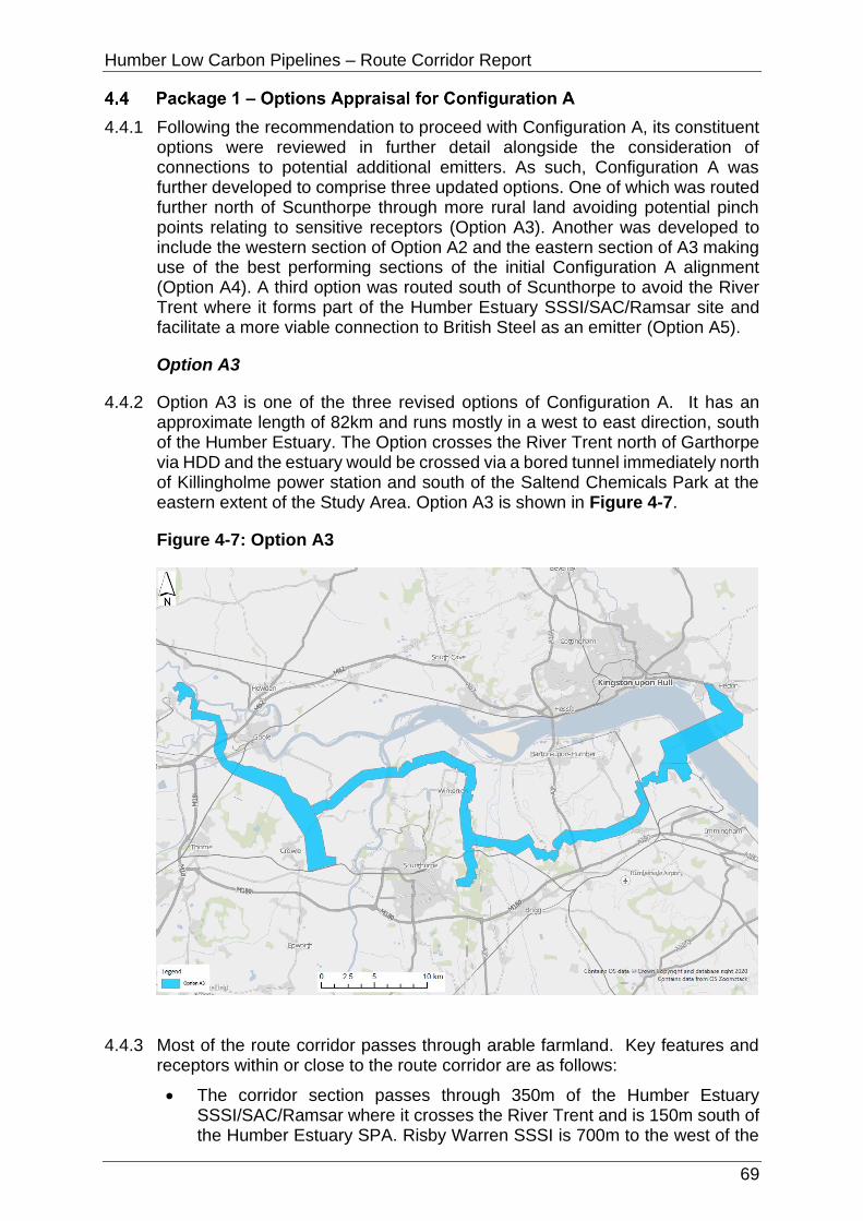
Humber Low Carbon Pipelines – Route Corridor Report
69
4.4.1 Following the recommendation to proceed with Configuration A, its constituent options were reviewed in further detail alongside the consideration of connections to potential additional emitters. As such, Configuration A was further developed to comprise three updated options. One of which was routed further north of Scunthorpe through more rural land avoiding potential pinch points relating to sensitive receptors (Option A3). Another was developed to include the western section of Option A2 and the eastern section of A3 making use of the best performing sections of the initial Configuration A alignment (Option A4). A third option was routed south of Scunthorpe to avoid the River Trent where it forms part of the Humber Estuary SSSI/SAC/Ramsar site and facilitate a more viable connection to British Steel as an emitter (Option A5).
Option A3
4.4.2 Option A3 is one of the three revised options of Configuration A. It has an approximate length of 82km and runs mostly in a west to east direction, south of the Humber Estuary. The Option crosses the River Trent north of Garthorpe via HDD and the estuary would be crossed via a bored tunnel immediately north of Killingholme power station and south of the Saltend Chemicals Park at the eastern extent of the Study Area. Option A3 is shown in Figure 4-7.
Figure 4-7: Option A3
4.4.3 Most of the route corridor passes through arable farmland. Key features and receptors within or close to the route corridor are as follows:
• The corridor section passes through 350m of the Humber Estuary SSSI/SAC/Ramsar where it crosses the River Trent and is 150m south of the Humber Estuary SPA. Risby Warren SSSI is 700m to the west of the
Humber Low Carbon Pipelines – Route Corridor Report
70
corridor section north of British Steel. Broughton Far Wood SSSI is 530m to the east of the corridor section. Broughton Alder Wood SSSI is also 850m to the east of the corridor section south of Broughton Far Wood. Spring Wood and Far Wood Ancient Woodland are partially within and adjacent to the corridor section east of British Steel. Wrawby Moor SSSI is 750m to the south of the corridor section near Elsham. The Corridor Section intersects some areas of Priority Habitat including: deciduous woodland (numerous locations throughout route), intertidal substrate foreshore, coastal saltmarsh, mudflats (River Trent Crossing) and lowland heahtland (east of British Steel).
• Drax Augustinian Priory Scheduled Monument is within the route corridor immediately north of Drax power station. Scurff Hall Moated Site Scheduled Monument is immediately adjacent the route corridor (Section A5) east of Drax. Heavy Anti-aircraft gunsite Scheduled Monument is within the route corridor south of Winteringham. There are several scheduled monuments close to route corridor Section A6 at West Halton, Winteringham and East Halton (including Thornton Abbey Augustinian Monastery and the three Grade I listed buildings within its grounds).
• On the northern/eastern side of the Humber Estuary, the route corridor (Section C) passes between the Paull Holme Moated Site and Tower and the World War II Decoys for Hull Docks Scheduled Monuments before passing immediately south of Hedon Medieval Town Scheduled Monument as the route corridor connects to Saltend Chemicals Park.
• The route corridor crosses several National Character Areas including the Humber Estuary, Lincolnshire Coast and Marshes, Lincolnshire Wolds, Central Lincolnshire Vale, Northern Lincolnshire Edge with Coversands, and Humberhead Levels.
• The route corridor intersects Source Protection Zone (SPZ) 3 (SPZ3) for approximately 4km at Drax power station and SPZ3, SPZ2 and SPZ1 (for approximately 8km, 5km, and 1km respectively) between Elsham and Killingholme. There is a cluster of historic landfill sites at the approach to Keadby power station, some or all of which are likely to be subject to remediation as part of the Keadby 3 (low carbon gas power station) project. The route corridor is partially within the Drax landfill site at the northern boundary of Drax power station and the historic landfill site at Haven, south of Hedon; these can be avoided via careful routeing. The corridor is adjacent to another two historic landfill sites, one south east of Winteringham and one west of Ulceby.
• There are extensive areas of Flood Zone 2 and Flood Zone 3 within the route corridor due to extensive areas of low-lying flood plains surrounding the various rivers that feed into the Humber Estuary. The route corridor crosses many of these rivers and man-made land drains including River Aire, Dutch River, Swinefleet Warping Drain, River Trent, River Trent, Old River Ancholme, New Rover Ancholme, East Halton Beck and the Humber Estuary/River Humber.
• The majority (53%) of Route Corridor Section A6 is Grade 2 Agricultural Land (very good quality), 26% is Grade 3 (good to moderate quality), 16% is Grade 1 (excellent quality) and the remaining 5% is a combination of Grade 4 (poor quality), Grade 5 (very poor quality) and non-agricultural land.

Humber Low Carbon Pipelines – Route Corridor Report
71
• The route corridor interacts with several major planning and DCO applications and permissions including the National Grid Scotland to England Green Link (SEGL2) project, Drax Bioenergy with Carbon Capture and Storage project, Keadby 3 (low carbon gas power station) project, Able Marine Energy Park at Killingholme, Yorkshire Energy Park at Saltend and Humber Enterprise Park at Saltend.
• The route corridor intersects Minerals Safeguarding Areas (MSA) at Section A5 (at Rawcliffe, south of Goole, and Eastoft) and Section C (between Paull and Saltend).
• Several transport routes are intersected by the route corridor including railway lines, A161 by Eastoft, A1077 by Winteringham, B1207 by Appleby, B1204 by Worlaby, B1606 by Elsham and the A1077 a second time by Ulceby, and the M62 at Rawcliffe (Section A5).
4.4.4 Table 4-8 provides a summary of the relevant environmental, socio-economic, technical and cost considerations for Option D.
Table 4-8: Option A3 Appraisal Summary
Discipline Summary of Option A3
Biodiversity Notable local, national and international designated sites include the Humber Estuary SSSI/SAC/SPA/Ramsar, Risby Warren SSSI, River Derwent SSSI, Eskamhorn Meadows SSSI, Thorne, Crowle and Goole Moors SSSI, Thorne and Hatfield Moors SPA, Eastoft Meadow SSSI, River Derwent SSSI/SAC, Broughton Far Wood SSSI, Broughton Alder Wood SSSI, Wrawby Moor SSSI. With the exception of the Humber Estuary none of these sites are within the route. There are potential risks to the Humber Estuary SSSI/SAC/Ramsar where it would be crossed; mitigation including trenchless crossing and timing works to avoid key seasons for qualifying features are likely to be required.
Surveys on land suitable for birds associated with the Humber Estuary SSSI/SAC/SPA/Ramsar are required to inform mitigation. Data collection and/or surveys on designated sites would inform mitigation relevant to qualifying features. Mitigation measures to reduce noise, and potentially light, disturbance pollution and pollution prevention should be applied where necessary.
Several priority habitats are within this option: deciduous woodland (numerous locations throughout route), intertidal substrate foreshore, coastal saltmarsh, mudflats (River Trent Crossing) and lowland heathland (east of British Steel). Most could be avoided with careful routeing, with the remaining likely to be avoidable by implementing trenchless techniques.
Surveys on any waterbodies potentially suitable for great crested newts within 500m of works would likely need surveying to determine mitigation requirements. Trenchless crossings may be appropriate, including but not limited to the River Trent, Old River Ancholme and East Halton Beck to avoid adverse impacts on the habitats and, if present, species.
Landscape and Visual
There are no nationally important designated landscapes that constrain Option A3. Local level designated landscapes are

Humber Low Carbon Pipelines – Route Corridor Report
72
Discipline Summary of Option A3
relatively close to parts of this option. Parts of Option A3 may route through landscapes that have a locally high value but are not recognised through designation.
Opportunities to avoid constraints on landscape character, including valued or sensitive landscape features/elements, exists through more detailed assessment, routeing, and siting.
The underground nature of these options means that the potential for residual significant effects on visual receptors is reduced; nonetheless, routeing close to receptors that are typically of higher sensitivity such as residential dwellings/settlement and recreational receptors should be avoided where feasible.
Historic Environment
There would likely be no physical impacts to designated assets, such as scheduled monuments and listed buildings, as it is assumed the site of Drax Priory and associated remains (SM1016857) would be avoided at the western extent of the route corridor. Physical impacts would be limited to non-designated assets and previously unrecorded assets, although these were not assessed as part of this appraisal.
There are several Listed Buildings and Scheduled Monuments close to the route. However, impacts from construction of the pipeline on setting would be temporary due to the underground nature of the works.
Mitigation would be required and could include a phased programme of works including geophysical survey, archaeological evaluation trenching, and full archaeological excavation to mitigate physical impacts.
Water Environment
Flood zones and the crossing of 13 watercourses would be unavoidable (including six main river crossings). Approximately 40% of this option is within Flood Zone 2 and 3. Works within the floodplain (Flood Zone 2 and 3) would likely require the application of the Exception Test and any future flood risk assessment would need to demonstrate how the Exception Test has been met. Pollution prevention measures and best available techniques should be adopted during construction. Some opportunities exist for mitigation including the use of best practice guidelines and trenchless techniques at main river crossing points and large floodplain crossings. Compensatory storage may be required to offset any loss in floodplain storage because of the temporary or permanent works.
Soils and Geology
Ground investigation would be required across much of the route. Precise routeing should take account of the presence of historic landfill and Regionally Important Geological/Geomorphological Sites (RIGS)/Geological Conservation Review (GCR) sites within the route corridor. Landfills in Section A5 (near Keadby) would be unavoidable. Routeing through SPZ 1 presently unavoidable, suitable hydrogeological risk assessment, construction management and

Humber Low Carbon Pipelines – Route Corridor Report
73
Discipline Summary of Option A3
suitable backfill material may be required. However, underlying glacial till would reduce risk to groundwater resources.
Settlement and Population
There are no educational facilities, medical facilities or emergency facilities in the route corridor. No urban settlements are crossed or overlapped, and population density is in the lowest band at 0-20 persons per hectare. There are approximately 22 residential properties within the route corridor. There is potential for direct impacts (e.g. noise disturbance and dust emissions) on all of these properties; however, routeing and siting of construction activities and the route alignment should avoid being close to these residential properties to minimise potential direct and indirect impacts.
Tourism and Recreation
The National Cycle Network (NCN) is crossed in one place. Temporary closure of the NCN is likely to be unavoidable at this location and would necessitate diversions which could result in adverse direct impacts. Minimising the length of diversions and duration of closure would mitigate these direct impacts.
Other than the potential closure of the NCN, there would be no direct or indirect impacts regarding Tourism and Recreation.
Traffic and Access
Option A3 is well situated for access with the A161 by Eastoft, A1077 by Winteringham, B1207 by Appleby, B1204 by Worlaby, B1606 by Elsham and the A1077 a second time by Ulceby allowing for good accessibility for all vehicle types although an in-depth assessment of the local roads would need to be undertaken to determine accessibility. Mitigation may be required to minimise residual impacts on highway safety and exposure of sensitive receptors to construction traffic. This option also benefits from the M180 running east/west along the route corridor which is capable is supporting all types of vehicles however Highways England (HE) would have to be consulted in relation the impact on the strategic road network (SRN). The crossing of the Humber is also an important consideration with respect to the transportation of spoil on the local road network and more general disturbance/amenity issues associated with a relatively long-term operation in one locality.
Land Use Temporary construction works (including access) are unlikely to significantly affect agricultural land use or the long-term viability of functionality of any affected operations due to the temporary nature of the works. Access land and rural businesses can be avoided through routeing.
During operation, the (predominately agricultural) land would be restored back to its former use; the loss of agricultural land (regardless of Grade) would be temporary (no permanent loss) and any standard agricultural land use operations above the pipelines would be able to continue during the operation phase. Operational effects are unlikely to be significant.
Planning Section A5 requires an understanding of the interaction with Twin Rivers wind farm. Section A6 overlaps with several planning
Humber Low Carbon Pipelines – Route Corridor Report
74
Discipline Summary of Option A3
applications including a 10MW solar farm, and three housing developments ranging from 50 to 317 dwellings. Sections A1 and C which are mainly within the South Humber Bank strategic employment allocation (and which has been the subject of major planning applications). Section C to the east of the Humber near Saltend is also subject to applications/permissions that could impede routeing and act as a pinch point for northerly onward connections. Routeing through MSA is seemingly unavoidable and therefore requires an early (more detailed) policy assessment to understand the likelihood of policy accordance.
Technical (Engineering)
Constructability across the Humber crossing is good albeit the North bank is heavily drained. Terrain is flat, access reasonable from public roads and ground conditions acceptable. Crossings of High Pressure (HP) pipelines on North Bank will probably involve auger bores. Humber crossing poses a challenge, but a similar tunnel has been installed in recent years by National Grid in the same area and therefore feasibility is confirmed. Constructability across the Trent in this location is considered potentially more challenging than for other options due to the nature of the topography at this location.
Constructability may be impacted by factors associated with heavily drained farmland and river flood plains i.e. high-water table and possibility of sand and gravels in underlying geology making trench stabilisation subject to dewatering measures in this instance. There are lock out sections, but these are readily accessible from public roads and there seems to be ample room for the logistics associated with the crossings such as room for the pipe string for an HDD.
Cost Capital costs were considered taking into account the length of the corridor (82km) and the major watercourse crossings (HDD under the River Trent and bored tunnel under the Humber Estuary). On that basis, it was estimated that the costs for Options A3, A4 and A5 would be comparable.
Lands Potential issues over land purchase agreements. Agreement with The Crown Estate would require detailed negotiations, although as the River Ouse would be crossed under all configuration options this issue is not limited to Option A3.
Option A4
4.4.5 Option A4 is one of the three revised options of Configuration A. It has an approximate length of 79km and runs mostly in a west to east direction, south of the Humber Estuary. The Option crosses the River Trent north of Amcotts via HDD and the Humber Estuary would be crossed via a bored tunnel immediately north of Killingholme power station and south of the Saltend Chemicals Park at the eastern extent of the Study Area. Option A4 is shown in Figure 4-8.

Humber Low Carbon Pipelines – Route Corridor Report
75
Figure 4-8: Option A4
4.4.6 of the route corridor passes through arable farmland. Key features and receptors within or close to the route corridor are as follows:
• The route corridor runs south and parallel to the Humber Estuary SAC/SPA/Ramsar/SSSI/RSPB IBA with two crossings of the estuary required; one at Flixborough Industrial Estate (the River Trent); and one via a bored tunnel at Killingholme. The route corridor is approximately 500m north of Thorne and Hatfield Moors SPA/RSPB IBA, Thorne Moor SAC, Thorne, Crowle and Goole Moors SSSI, Humberhead Peatlands NNR south of Goole, approximately 750m east of Risby Warren SSSI, 900m west of Broughton Far Wood SSSI and Broughton Alder Wood SSSI and 800m north of Wrawby Moor SSSI.
• Drax Augustinian Priory Scheduled Monument is within the route corridor immediately north of Drax power station. Scurff Hall Moated Site Scheduled Monument is immediately adjacent the route corridor (Section A5) east of Drax. A grouping of scheduled monuments is close to the eastern extent of route corridor Section A3/C at Killingholme (including Thornton Abbey Augustinian Monastery and the three Grade I listed buildings within its grounds). On the northern/eastern side of the Humber Estuary, the route corridor (Section C) passes between the Paull Holme Moated Site and Tower and the World War II Decoys for Hull Docks Scheduled Monuments before passing immediately south of Hedon Medieval Town Scheduled Monument as the route corridor connects to Saltend Chemicals Park.
• The route corridor crosses several National Character Areas including the Humber Estuary, Lincolnshire Coast and Marshes, Lincolnshire Wolds, Central Lincolnshire Vale, Northern Lincolnshire Edge with Coversands,

Humber Low Carbon Pipelines – Route Corridor Report
76
and Humberhead Levels.
• The route corridor intersects SPZ3 for approximately 4km at Drax power station and SPZ3, SPZ2 and SPZ1 (for approximately 5.5km, 9.5km, and 500m respectively) between Horkstow and Killingholme; SPZ1 is avoidable in this location via careful routeing. SPZ1 is also intersected for approximately 4km between Roxby and Winterton. There is a cluster of historic landfill sites at the approach to Keadby power station, some or all of which are likely to be subject to remediation as part of the Keadby 3 (low carbon gas power station) project. The route corridor is partially within the Drax landfill site at the northern boundary of Drax power station and the historic landfill site at Haven, south of Hedon. There are two historic landfill sites and one authorised landfill adjacent of the route near Elsham Wolds.
• There are extensive areas of Flood Zone 2 and Flood Zone 3 within the route corridor due to extensive areas of low-lying flood plains surrounding the various rivers that feed into the Humber Estuary. The route corridor crosses many of these rivers and man-made land drains including River Aire, Dutch River, Swinefleet Warping Drain, River Trent, Winterton Beck, Weir Dike, East Halton Beck and the Humber Estuary/River Humber.
• Most of the route corridor consists of Grade 1 (excellent quality), Grade 2 (very good quality) and Grade 3 (good to moderate quality) Agricultural Land, with significantly smaller areas of land either lower grade (4 or 5) Agricultural Land, non-agricultural land or urban land.
• The route corridor interacts with several major planning and DCO applications and permissions including the SEGL2 project, Drax Bioenergy with Carbon Capture and Storage project, Keadby 3 (low carbon gas power station) project, North Lincolnshire Green Energy Park at Flixborough, Able Marine Energy Park at Killingholme, Yorkshire Energy Park at Saltend and Humber Enterprise Park at Saltend.
• The route corridor intersects MSA at Section A5 (at Rawcliffe, south of Goole, and Eastoft) and Section C (between Paull and Saltend).
• Several transport routes are intersected by the route corridor including railway lines, A roads, and the M62 at Rawcliffe (Section A5).
4.4.7 Table 4-9 provides a summary of the relevant environmental, socio-economic, technical and cost considerations for Option A4.
Table 4-9: Option A4 Appraisal Summary
Discipline Summary of Option A4
Biodiversity Notable local, national and international designated sites (most of these being notable for their bird assemblages) include the Humber Estuary SSSI/SAC/Ramsar, Warren Risby SSSI, Thorne, Crowle and Goole Moors SSSI/Thorne and Hatfield Moors SPA/RSPB IBA, Risby Warren SSSI, Broughton Far Wood SSSI, Broughton Alder Wood SSSI and Wrawby Moor SSSI.
Surveys on land suitable for birds associated with surrounding SPA/Ramsar/SSSI/RSPB IBA, may be required to confirm this and inform mitigation. Data collection and/or surveys on designated sites would inform mitigation relevant to qualifying features. Mitigation measures to reduce noise, and potentially

Humber Low Carbon Pipelines – Route Corridor Report
77
Discipline Summary of Option A4
light, disturbance pollution and pollution prevention should be applied where necessary. Risks to the Humber Estuary SSSI/SAC/Ramsar would be more significant where it crosses; mitigation including trenchless crossing and timing works to avoid key seasons for qualifying features likely to be required.
Several priority habitats are within this option: deciduous woodland (numerous locations throughout route), intertidal substrate foreshore, coastal saltmarsh, mudflats (River Trent Crossing) and lowland heathland (east of British Steel). Most could be avoided with careful routeing, with the remaining likely to be avoidable by implementing trenchless technique approach.
Surveys on any waterbodies potentially suitable for great crested newts within 500m of works would likely need surveying to determine mitigation requirements. Trenchless crossings may be appropriate, including but not limited to the River Trent, Old River Ancholme and East Halton Beck to avoid adverse impacts on the habitats and, if present, species.
Landscape and Visual
There are no nationally important designated landscapes that constrain Option A4. Local level designated landscapes lie within approximately 400m of parts of this option. Parts of Option A4 may route through landscapes that have a locally high value but are not recognised through designation.
Opportunities to avoid constraints on landscape character, including valued or sensitive landscape features/elements, exists through more detailed assessment, routeing, and siting.
The underground nature of the options means that the potential for residual significant effects on visual receptors is reduced; nonetheless, routeing close to receptors that are typically of higher sensitivity such as residential dwellings/settlement and recreational receptors should be avoided where feasible.
Historic Environment
There would likely be no physical impacts to designated assets, such as scheduled monuments and listed buildings, as it is assumed the site of Drax Priory and associated remains (SM1016857) would be avoided at the western extent of the route corridor. Physical impacts would be limited to non-designated assets and previously unrecorded assets, although these were not assessed as part of this appraisal.
There is also the potential for impacts on the setting of the Grade II listed buildings within Section A6, although it is assumed the pipeline would avoid the assets and therefore remove any physical impacts.
Mitigation would be required and could include a phased programme of works including geophysical survey, archaeological evaluation trenching, and full archaeological excavation to mitigate physical impacts.
Water Environment
Flood zones and the crossing of multiple watercourses would be unavoidable (including six main river crossings). Approximately

Humber Low Carbon Pipelines – Route Corridor Report
78
Discipline Summary of Option A4
two thirds of the route corridor is within Flood Zone 2 and 3. Works within the floodplain (Flood Zone 2 and 3) would likely require the application of the Exception Test and any future flood risk assessment would need to demonstrate how the Exception Test has been met. Pollution prevention measures and best available techniques should be adopted during construction. Some opportunities exist for mitigation including the use of best practice guidelines and trenchless techniques at main river crossing points and large floodplain crossings. Compensatory storage may be required to offset any loss in floodplain storage because of the temporary or permanent works.
Soils and Geology
Ground investigation would be required across much of the route corridor. Precise routeing should take account of the presence of historic landfill and RIGS/GCR sites within the route corridor. Routeing through SPZ1 is presently unavoidable, suitable hydrogeological risk assessment, construction management and suitable backfill material may be required. However, underlying glacial till reduces risk to groundwater resources.
Settlement and Population
There are no educational facilities, medical facilities or emergency facilities in the route corridor. No urban settlements are crossed or overlapped, and population density is in the lowest band at 0-20 persons per hectare. There are approximately 45 residential properties within the route corridor. There is potential for direct impacts (e.g. noise disturbance and dust emissions) on all of these properties; however, routeing and siting of construction activities and the route alignment should avoid being close to these residential properties to minimise potential direct and indirect impacts.
Tourism and Recreation
The NCN is crossed in one place. Temporary closure of the NCN is likely to be unavoidable in this location and would necessitate diversions which could result in adverse direct impacts. Minimising the length of diversions and duration of closure would mitigate these direct impacts; however, routeing and siting of construction activities and the route alignment should avoid being close to the Acorn Wood Caravan Park and Glamping Park to minimise potential indirect impacts.
Traffic and Access
Option A4 is well situated for access with the A1033, A15, A1077, A161, A645 running across the route corridor allowing for good accessibility for all vehicle types although an in-depth assessment of the local roads would need to be undertaken to determine accessibility; mitigation may be required to minimise residual impacts on highway safety and exposure of sensitive receptors (at Roxby, Normanby, Burton upon Stather, Winterton) to construction traffic. This option also benefits from the M180 running east/west along the route corridor which is capable is supporting all types of vehicles however HE would have to be consulted in relation the impact on the SRN. The crossing of the Humber is also an important consideration with respect to the transportation of spoil on the local road network and more
Humber Low Carbon Pipelines – Route Corridor Report
79
Discipline Summary of Option A4
general disturbance/amenity issues associated with a relatively long-term operation in one locality. Whilst this has generally good access to the highway network, the access to the area to the south of Goole would need to be assessed in more detail due to the need to use more "country lane" type roads.
Land Use Temporary construction works (including access) are unlikely to significantly affect agricultural land use or the long-term viability of functionality of any affected operations due to the temporary nature of the works. The allotment and rural businesses can be avoided through routeing.
During operation, the (predominately agricultural) land would be restored back to its former use; the loss of agricultural land (regardless of Grade) would be temporary (no permanent loss) and any standard agricultural land use operations above the pipelines would be able to continue during the operation phase. Operational effects are unlikely to be significant.
Planning Section A5 requires an understanding of the interaction with Twin Rivers wind farm. Section A1 and Section C have a major obstacle in that they are mainly within the South Humber Bank strategic employment allocation (and which has been the subject of major planning applications). Section C to the east of the Humber is also subject to applications/permissions that could impede routeing. Routeing through MSA is seemingly unavoidable for all corridors and therefore requires an early policy assessment to understand the likelihood of policy accordance.
Technical (Engineering)
Constructability across the Humber crossing is good albeit that the North bank is heavily drained. Terrain is flat, access reasonable from public roads and ground conditions ok. Crossings of HP pipelines on North Bank will probably involve auger bores. Humber crossing poses a challenge, but a similar tunnel has been installed in recent years by National Grid in the same area and therefore feasibility is confirmed.
The constructability of the route is generally good except this route does involve a major crossing of the River Trent, a reservoir west of Winterton and Roxby Catchwater. There will be a special section around the New River Anchome area which forms a major water course corridor. There is some question about contaminated ground potential near the former open cast mining area and Roxby Catchwater.
Constructability may be impacted by factors associated with heavily drained farmland and river flood plains i.e. high-water table and possibility of sand and gravels in underlying geology making trench stabilisation subject to dewatering measures in this instance. There are lock out sections, but these are readily accessible from public roads and there seems to be ample room for the logistics associated with the crossings such as room for the pipe string for an HDD.
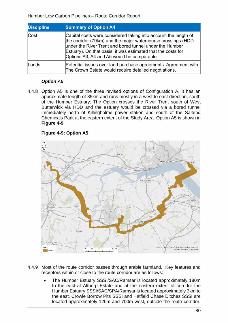
Humber Low Carbon Pipelines – Route Corridor Report
80
Discipline Summary of Option A4
Cost Capital costs were considered taking into account the length of the corridor (79km) and the major watercourse crossings (HDD under the River Trent and bored tunnel under the Humber Estuary). On that basis, it was estimated that the costs for Options A3, A4 and A5 would be comparable.
Lands Potential issues over land purchase agreements. Agreement with The Crown Estate would require detailed negotiations.
Option A5
4.4.8 Option A5 is one of the three revised options of Configuration A. It has an approximate length of 85km and runs mostly in a west to east direction, south of the Humber Estuary. The Option crosses the River Trent south of West Butterwick via HDD and the estuary would be crossed via a bored tunnel immediately north of Killingholme power station and south of the Saltend Chemicals Park at the eastern extent of the Study Area. Option A5 is shown in Figure 4-9.
Figure 4-9: Option A5
4.4.9 Most of the route corridor passes through arable farmland. Key features and receptors within or close to the route corridor are as follows:
• The Humber Estuary SSSI/SAC/Ramsar is located approximately 180m to the east at Althorp Estate and at the eastern extent of corridor the Humber Estuary SSSI/SAC/SPA/Ramsar is located approximately 3km to the east. Crowle Borrow Pits SSSI and Hatfield Chase Ditches SSSI are located approximately 120m and 700m west, outside the route corridor.

Humber Low Carbon Pipelines – Route Corridor Report
81
Section D3 intersects Ashbyville LNR where approximately half (~13.5ha) of the designated site is located within the D3 corridor. Manton and Twigmoor SSSI is located immediately to the north of the corridor. Wrawby Moor SSSI is located 3km to the north of the corridor. Messingham Sand Quarry SSSI is located approximately 800m to the south-west of the corridor. Messingham Heath SSSI is located approximately 1.3km to the south. There are no areas of ancient woodland within the route corridor. The closest is an area of Ancient and Semi-Natural Woodland is located approximately 1km to the north of the corridor and on the northen side of Barnetby le Wold. A SINC south of Brigg designated within the West Lindsey Local Plan is located within the corridor. The Sweeting Thorns SINC also covers a large proportion of the corridor up to British Steel north of the A180. The Corridor Section intersects some areas of Priority Habitat including: deciduous woodland (numerous locations throughout route), intertidal substrate foreshore, coastal saltmarsh, mudflats (River Trent Crossing) and lowland heathland (east of British Steel).
• Drax Augustinian Priory Scheduled Monument is within the route corridor immediately north of Drax power station. Scurff Hall Moated Site Scheduled Monument is immediately adjacent the route corridor (Section A5) east of Drax. The following Listed Buildings are within Section D3: Grade II Listed Building (Syphon Carrying South Level Engine Drain Under the River Torne approximately 200m south east of Pilfrey Farm); Grade 1 Church of St Mary; Grade II Windmill Tower; Grade II Pump House, Grade II High Wood Farmhouse, Grade II Ulceby Grance. There are numerous Listed Buildings within 1km of the section associated with the villages of Ulceby, Wootton, Melton Ross, Barnetby, Brigg Scawby Brook, Scawby, Messingham, West Butterwisk and Althorpesta. The Grade 1 Brocklesby Park is adjacent to much of the corridor and within 50m at its closest point. The Yarborough Camp large univallate hillfort Scheduled Monument, Medieval settlement of Croxton Schedule Monument and the Roman Settlement Scheduled Monument are within the corridor. The following Scheduled Monuments are within 1km of the Setion: Keadby Lock 150m to the east, Raventhorpe medieval settlement earthworks, 300m to the east, Romano-British settlement near Staniwells Farm 30m to the south, Moated site 285m east of Castlethorpe House Scheduled Monument 800m to the north, Moated site and fishpond 200m south-east of Melton Hall 95m to the west, Medieval settlement of Croxton 350m to the east, Roman Settlement 400m to the east, Thornton Abbey Augustinian Monastery 100m to the west. No Registered Parks and Gardens or Battlefields have been recorded in the Corridor Section. On the northern/eastern side of the Humber Estuary, the route corridor (Section C) passes between the Paull Holme Moated Site and Tower and the World War II Decoys for Hull Docks Scheduled Monuments before passing immediately south of Hedon Medieval Town Scheduled Monument as the route corridor connects to Saltend Chemicals Park.
• The route corridor crosses several National Character Areas including the Humber Estuary, Lincolnshire Coast and Marshes, Lincolnshire Wolds, Central Lincolnshire Vale, Northern Lincolnshire Edge with Coversands, and Humberhead Levels.
• The route corridor intersects Source Protection Zone (SPZ) 3 (SPZ3) for approximately 4km at Drax power station and SPZ3, SPZ2 and SPZ1 (for

Humber Low Carbon Pipelines – Route Corridor Report
82
approximately 8km, 5km, and 1km respectively) between Elsham and Killingholme. There is a cluster of historic landfill sites at the approach to Keadby power station, some or all of which are likely to be subject to remediation as part of the Keadby 3 (low carbon gas power station) project. The route corridor is partially within the Drax landfill site at the northern boundary of Drax power station and the historic landfill site at Haven, south of Hedon; these can be avoided via careful routeing. Keadby Power Station historic landfill juts into a 2.2ha area at the north western extent of the corridor and also includes an isolated parcel 200m to the south and located towards the centre of the corridor. The South Side of Crowle Bank Road historic landfill is likely to be easily avoided as it only extends 100m past the eastern boundary of the corridor south of Keadby. The Kettleby Quarry historic landfill juts 50m intot the northern boundary of the corridor south east of Wrawby is likely to be easily avoided. The Melton Ross Quarry historic landfill (0.5ha) is located in the centre of the corridor route west of Humberside Airport. Ulceby historic landfill (1ha) is entirely within the corridor west of Ulceby but would be likely avoidable.
• There are extensive areas of Flood Zone 2 and Flood Zone 3 within the route corridor due to extensive areas of low-lying flood plains surrounding the various rivers that feed into the Humber Estuary. The route corridor crosses many of these rivers and man-made land drains including River Trent, the Sheffield and South Yorkshire Navigation canal, East Halton Beck, Skegger Beck, Roscarr Dike, Kettleby Beck and the Humber Estuary.
• Approximately 16% of Section D3 is Grade 1 Agricultural Land (excellent quality), 34% is Grade 2 Agricultural Land (very good quality), 45% is Grade 3 Agricultural Land (good to moderate quality) with remaining land made up of Grade 4 (poor quality), Urban and non agricultural land.
• The route corridor interacts with several major planning and DCO applications and permissions including the National Grid Scotland to England Green Link (SEGL2) project, Drax Bioenergy with Carbon Capture and Storage project, Keadby 3 (low carbon gas power station) project, Able Marine Energy Park at Killingholme, Yorkshire Energy Park at Saltend and Humber Enterprise Park at Saltend. The corridor also intersects the Lincolnshire Lakes Flood Mitigation Scheme (SCO/2017/2) where the corridor crosses the River Trent; PV Array (PA/2015/0114) where the corridor crosses the A18 before meeting British Steel; underground high voltage (400kV) electric cable (PA/2019/519) and haul road (PA/SCR/2019/6) at Keadby Power Station; extension to existing silica sand extraction operations (PA/2018/1245) east of Messingham; erect 6 grain silos (PA/2018/117) north of Bigby; new anaerobic digestion facility (PA/2018/2471) west of Humberside Airport; sewage pumping station (PA/2019/759) north of ulceby.
• The route corridor intersects Minerals Safeguarding Areas (MSA) at Section A5 (at Rawcliffe, south of Goole, and Eastoft) and Section C (between Paull and Saltend). The corridor intersects approximately 40ha of a Mineral Safeguarding Area (MIN6-6p: Manton Quarry) south east of Messingham. A proposed site allocation for Minerals (limestone) that is immediately south of the M180 on Holme Lane intersects the entirery of the corridor and would be unavoidable.

Humber Low Carbon Pipelines – Route Corridor Report
83
• Several transport routes are intersected by the route corridor including railway lines, A161, A18, A159, B1398, A15, B1207, B1206 A1084, B1434, B1211, A180 and A1077 and the M62 at Rawcliffe (Section A5).
4.4.10 Table 4-10 provides a summary of the relevant environmental, socio-economic, technical and cost considerations for Option A5.
Table 4-10: Option A5 Appraisal Summary
Discipline Summary of Option A5
Biodiversity Notable local, national and international designated sites (some of these being notable for their bird assemblages) include the Humber Estuary SSSI/SAC/SPA/Ramsar, Warren Risby SSSI, Crowle Borrow Pits SSSI, Hatfield Chase Ditches SSSI, Manton and Twigmoor SSSI, Wrawby Moor SSSI, Messingham Sand Quarry SSSI and Messingham Heath SSSI. All of these sites can be avoided through careful routeing with the exception of where Section C crosses the Humber Estuary. Risks to the Humber Estuary SSSI/SAC/Ramsar would be mitigated through a trenchless crossing and timing works to avoid key seasons for qualifying features.
Surveys on land suitable for birds associated with the Humber Estuary SSSI/SAC/SPA/Ramsar would be required to inform mitigation. Mitigation measures would likely include measures to reduce noise, and potentially light, disturbance pollution and pollution prevention.
Several priority habitats are within this option; most could be avoided with careful routeing, with the remaining likely to be avoidable by implementing a trenchless technique approach.
A great crested newt District Level Licence point occurs adjacent to Section C; surveys would be required to confirm presence/likely absence of this species; results would inform any mitigation requirements. Surveys on any waterbodies potentially suitable for great crested newts within 500m of works would likely need surveying to determine mitigation requirements.
There are numerous watercourses, waterbodies and drains within the route including the Carr Dike, River Aire, Aire and Calder Navigation, Dutch River, River Torne, River Trent, the Sheffield and South Yorkshire Navigation canal, East Halton Beck, Skegger Beck, Roscarr Dike, Kettleby Beck and multiple others. These may be of value for species such as water vole, therefore trenchless techniques (potentially following surveys to determine presence) may avoid adverse impacts on the habitats and, if present, species.
Landscape and Visual
There are no nationally important designated landscapes that constrain Option A5. Local level designated landscapes are relatively close to parts of this option. Parts of Option A5 may route through landscapes that have a locally high value but are not recognised through designation.
Opportunities to avoid constraints on landscape character, including valued or sensitive landscape features/elements, exists through more detailed assessment, routeing, and siting.

Humber Low Carbon Pipelines – Route Corridor Report
84
Discipline Summary of Option A5
The underground nature of these options means that the potential for residual significant effects on visual receptors is reduced; nonetheless, routeing close to receptors that are typically of higher sensitivity such as residential dwellings/settlement and recreational receptors should be avoided where feasible.
Historic Environment
There would likely be no physical impacts to designated assets, such as scheduled monuments and listed buildings, as it is assumed the site of Drax Priory and associated remains (SM1016857) would be avoided at the western extent of the route corridor. Grade II Listed Building (Syphon Carrying South Level Engine Drain Under the River Torne approximately 200m south east of Pilfrey Farm); Grade 1 Church of St Mary; Grade II Windmill Tower; Grade II Pump House, Grade II High Wood Farmhouse, Grade II Ulceby Grance.
Physical impacts would be limited to non-designated assets and previously unrecorded assets, although these were not assessed as part of this appraisal.
There are numerous Listed Buildings within 1km of the section assoicated with the villages of Ulceby, Wootton, Melton Ross, Barnetby, Brigg Scawby Brook, Scawby, Messingham, West Butterwisk and Althorpesta. However, impacts from construction of the pipeline on setting would be temporary due to the underground nature of the works.
Mitigation would be required and could include a phased programme of works including geophysical survey, archaeological evaluation trenching, and full archaeological excavation to mitigate physical impacts.
Water Environment
Flood zones and the crossing of 18 watercourses would be unavoidable (including 14 main river crossings). Approximately 60% of this option is within Flood Zone 2 and 3. Works within the floodplain (Flood Zone 2 and 3) would likely require the application of the Exception Test and any future flood risk assessment would need to demonstrate how the Exception Test has been met. Pollution prevention measures and best available techniques should be adopted during construction. Some opportunities exist for mitigation including the use of best practice guidelines and trenchless techniques at main river crossing points and large floodplain crossings. Compensatory storage may be required to offset any loss in floodplain storage because of the temporary or permanent works.
Soils and Geology
Ground investigation would be required across much of the route. Precise routeing should take account of the presence of historic landfill and Regionally Important Geological/Geomorphological Sites (RIGS)/Geological Conservation Review (GCR) sites within the route corridor. Landfills in Section A5 (near Keadby) would be unavoidable. Routeing through SPZ 1 presently unavoidable, suitable hydrogeological risk assessment, construction management and

Humber Low Carbon Pipelines – Route Corridor Report
85
Discipline Summary of Option A5
suitable backfill material may be required. However, underlying glacial till would reduce risk to groundwater resources.
Settlement and Population
There are no educational facilities, medical facilities or emergency facilities in the route corridor. No urban settlements are crossed or overlapped, and population density is in the lowest band at 0-20 persons per hectare. There is a very large number of residential properties within the route corridor. There is potential for direct impacts (e.g. noise disturbance and dust emissions) on all of these properties; however, routeing and siting of construction activities and the route alignment should avoid being close to these residential properties to minimise potential direct and indirect impacts.
Tourism and Recreation
The National Cycle Network (NCN) is crossed in two places. Temporary closure of the NCN is likely to be unavoidable at this location and would necessitate diversions which could result in adverse direct impacts. Minimising the length of diversions and duration of closure would mitigate these direct impacts.
Other than the potential closure of the NCN, there would be no direct or indirect impacts regarding Tourism and Recreation.
Traffic and Access
Option A5 is well situated for access with the numerous A roads (A161, A18, A159, B1398, A15, B1207, B1206 A1084, B1434, B1211, A180 and A1077) running across the corridor allowing for good accessibility for all vehicle types although an in-depth assessment of the local roads would need to be undertaken to determine accessibility. Mitigation may be required to minimise residual impacts on highway safety and exposure of sensitive receptors to construction traffic. This option also benefits from the M180 running east/west along the route corridor which is capable is supporting all types of vehicles however Highways England (HE) would have to be consulted in relation the impact on the strategic road network (SRN). The crossing of the Humber is also an important consideration with respect to the transportation of spoil on the local road network and more general disturbance/amenity issues associated with a relatively long-term operation in one locality.
Land Use Temporary construction works (including access) are unlikely to significantly affect agricultural land use or the long-term viability of functionality of any affected operations due to the temporary nature of the works. Access land and rural businesses can be avoided through routeing.
During operation, the (predominately agricultural) land would be restored back to its former use; the loss of agricultural land (regardless of Grade) would be temporary (no permanent loss) and any standard agricultural land use operations above the pipelines would be able to continue during the operation phase. Operational effects are unlikely to be significant.
Planning Section A5 requires an understanding of the interaction with Twin Rivers wind farm. Section D3 overlaps with several planning

Humber Low Carbon Pipelines – Route Corridor Report
86
Discipline Summary of Option A5
applications including the Keadby 3 Low Carbon Gas Power Station; Lincolnshire Lakes Flood Mitigation Scheme (SCO/2017/2) where the corridor crosses the River Trent; PV Array (PA/2015/0114) where the corridor crosses the A18 before meeting British Steel; underground high voltage (400kV) electric cable (PA/2019/519) and haul road (PA/SCR/2019/6) at Keadby Power Station; extension to existing silica sand extraction operations (PA/2018/1245) east of Messingham; erect 6 grain silos (PA/2018/117) north of Bigby; new anaerobic digestion facility (PA/2018/2471) west of Humberside Airport; sewage pumping station (PA/2019/759) north of Ulceby. The corridor intersects approximately 40ha of a Mineral Safeguarding Area (MIN6-6p: Manton Quarry) south east of Messingham. A proposed site allocation for Minerals (limestone) that is immediately south of the M180 on Holme Lane intersects the entirety of the corridor and would be unavoidable. This site is proposed in the preferred options Local Plan. The corridor is within an Area of High Historic Landscape Value designated in the North Lincolnshire Local Plan. Sections A1 and C which are mainly within the South Humber Bank strategic employment allocation (and which has been the subject of major planning applications). Section C to the east of the Humber near Saltend is also subject to applications/permissions that could impede routeing and act as a pinch point for northerly onward connections. Routeing through MSA is seemingly unavoidable and therefore requires an early (more detailed) policy assessment to understand the likelihood of policy accordance.
Technical (Engineering)
Constructability across the Humber crossing is good albeit the North bank is heavily drained. Terrain is flat, access reasonable from public roads and ground conditions acceptable. Crossings of HP pipelines on North Bank will probably involve auger bores. Humber crossing poses a challenge, but a similar tunnel has been installed in recent years by National Grid in the same area and therefore feasibility is confirmed.
Constructability may be impacted by factors associated with heavily drained farmland and river flood plains i.e. high-water table and possibility of sand and gravels in underlying geology making trench stabilisation subject to dewatering measures in this instance. There are lock out sections, but these are readily accessible from public roads and there seems to be ample room for the logistics associated with the crossings such as room for the pipe string for an HDD.
Cost Capital costs were considered taking into account the length of the corridor (85km) and the major watercourse crossings (HDD under the River Trent and bored tunnel under the Humber Estuary). On that basis, it was estimated that the costs for Options A3, A4 and A5 would be comparable.
Lands Potential issues over land purchase agreements. Agreement with The Crown Estate would require detailed negotiations, although

Humber Low Carbon Pipelines – Route Corridor Report
87
Discipline Summary of Option A5
as the River Ouse would be crossed under all configuration options this issue is not limited to Option A5.
4.5.1 Environment/socio-economic. The updated Configuration A options (A3, A4 and A5) perform well across the environment/socio-economic sub-topics including Biodiversity, Landscape and Visual, Historic Environment, Water Environment, Soils and Geology, Settlement and Population, Tourism and Recreation, Traffic and Access, and Land Use. This is because all three options largely avoid interactions with the key receptor groups of each sub-topic or the alignment of the pipelines could be adjusted through careful routeing to avoid interactions or substantially minimise the environmental effects.
4.5.2 Biodiversity. All the options would include a bored tunnel crossing under the Humber Estuary and an HDD crossing under the River Trent which have the potential to impact the internationally designated sites (SSSI/SAC/SPA/Ramsar) of the Humber Estuary which is notable for its bird assemblages (although where Option A5 crosses the River Trent, it is over 5km south of the designated sites). An HRA will be prepared to assess the potential for likely significant effects on the designated site which may include the identification of mitigation measures to ameliorate adverse effects.
4.5.3 Planning. From a planning perspective, all options interact with various planning permissions including Keadby 3 Low Carbon Gas Power Station, a 27 MW PV array south of British Steel, an anaerobic digestion plant west of Humberside Airport, a sewage pumping station north of Ulceby and several housing developments ranging from 50 to over 300 dwellings. The route corridors also intersect several Minerals Safeguarding Areas (MSA) and allocations including MSAs south of Goole, between Paull and Saltend, southeast of Messingham and a proposed site allocation for Minerals (limestone) south of Scunthorpe. However, it is considered likely that many of these developments, MSAs and allocations will be avoidable with detailed routing. Where this is not possible, early engagement with the developers and local planning authorities should enable the projects/plans to accommodate each other.
4.5.4 Overall Balance. Taking the above into account, the Project team challenged judgements made as to the effects of particular options and associated mitigation and management measures, checked understanding and assumptions, and compiled an overall view of the relative performance of each option based on the available information. These discussions concluded all three Configuration A Options (A3, A4 and A5) should be taken forward to Non-Statutory Consultation based on the overall balance of environmental, socio-economic, technical and costs considerations.

Humber Low Carbon Pipelines – Route Corridor Report
88
5 PACKAGE 2 OPTIONS APPRAISAL
5.1.1 As set out in Table 1-1 and Section 3.4 of this report, Package 2 comprises the pipeline route corridor options from the three landfall options (Easington, Aldbrough, and Atwick) to a connection with the main route corridors (set out in Package 1 Configuration A) including the provision for pumping facilities. Specific sites for the pumping facilities have not yet been identified but they would be located within the corridors on the coasts. The pumping facilities are required for onward transportation of carbon dioxide to the Endurance saline aquifer under the North Sea.
5.1.2 Initially there were five Package 2 options that provided a connection to main route corridor Configuration A, and five complete combination Package 2 options that provide a connection to main route corridor Configuration B. However, following the review of the Easington Options it was determined that an additional option should be developed. This was due to tight constraints on the Easington A Section which followed the same path as several NTS pipelines. The new option deviated away from the NTS pipelines north of Thorngumbald before re-joining the Easington A Section north of Welwick.
5.1.3 As such, eleven options were considered in the final Options Appraisal for Package 2. A summary of the complete combination options for Package 2 is provided in Table 5-1.
Table 5-1: Summary of Package 2 Options
Option Route Corridor Sections Connection to Package 1 Configuration
Easington A Easington Landfall Route Corridor Section A
A
Easington B Easington Landfall Route Corridor Sections A and B
B
Easington C Easington Landfall Route Corridor Sections A, B, C/D and E
A
Aldbrough A Aldbrough Landfall Route Corridor Sections A, B, D, and E
A
Aldbrough B Aldbrough landfall Route Corridor Sections A, C, D, and E
A
Aldbrough C Aldbrough Landfall Route Corridor Sections A, B, and D
B
Aldbrough D Aldbrough Landfall Route Corridor Sections A, C, and D
B

Humber Low Carbon Pipelines – Route Corridor Report
89
Option Route Corridor Sections Connection to Package 1 Configuration
Atwick A Atwick Landfall Route Corridor Sections A, B, D, and E
A
Atwick B Atwick landfall Route Corridor Sections A, C, D, and E
A
Atwick C Atwick Landfall Route Corridor Sections A, B, and D
B
Atwick D Atwick Landfall Route Corridor Sections A, C, and D
B
5.1.4 The Easington A route corridor has an approximate length of 20km whilst the Easington B route corridor has an approximate length of 24.5km. Both options pass through arable farmland between the landfall north of Easington and land south of Thorngumbald; however, Easington B is a longer route as it extends further west than Easington A to connect to Package 1 Configuration B at Saltend Chemicals Park. Easington C is the longest option as it diverts north around Thorngumbald before rejoining the other corridor options at Welwick.
5.1.5 The Aldbrough A and B route corridors have an approximate length of 16km whilst the Aldbrough C and D route corridors have an approximate length of 12km. All four options pass through arable farmland between the landfall south of Aldbrough and land north of Preston; however, Aldbrough A and B are longer routes as they extend further west and south than Aldbrough C and D to connect to Package 1 Configuration A at Saltend Chemicals Park. Aldbrough A and C provide a route south of Humbleton whilst Aldbrough B and D provide an alternative route north of Humbleton.
5.1.6 Atwick A and B route corridors have an approximate length of 22km whilst the Atwick C and D route corridors have an approximate length of 15km. All four options pass through arable farmland between the landfall north of Atwick and land between Routh, Riston Grange and Long Riston; however, Atwick A and B are longer routes as they extend further south than Atwick C and D to connect to Package 1 Configuration A at Saltend Chemicals Park. Atwick A and C provide a route south of Sigglesthorne whilst Aldbrough B and D provide an alternative route north of Sigglesthorne.
5.1.7 The options appraisal process for Package 2 is summarised in Section 5.2 of this report and has been undertaken in accordance with the approach described in Section 3.1 and Section 3.4 of this report.

Humber Low Carbon Pipelines – Route Corridor Report
90
Easington A
5.2.1 Easington A (route corridor) is shown at Figure 5-1.
Figure 5-1: Easington A (Route Corridor)
5.2.2 Key features and receptors within or close to the route corridor are as follows:
• The route corridor runs approximately 2km north of and parallel to the Humber Estuary SAC/SPA/Ramsar/SSSI/RSPB IBA. Dimlington Cliff SSSI is across the entirety of the route corridor’s foreshore area at the Holderness coast whilst the Lagoons SSSI is approximately 2km to the south of the landfall area. The foreshore and the wider offshore environment are designated as the Greater Wash SPA and the Holderness Inshore MCZ which both stretch along the entirety of the Holderness coast.
• Hodgson’s Fields YWT Site Boundary and the Outer Humber YWT Living Landscape is at the centre of the route corridor north of Skeffling on the approach to the landfall area. Enholmes Plantation Local Wildlife Site (LWS) is a woodland at the centre of the route corridor south east of Patrington; Out Newton – Skeffling LWS runs in a north to south direction at the centre of the route corridor and along the route of the Punda Drain.
• Notable heritage features in the Easington A route corridor include a cluster of scheduled monuments south of and at the western extent of the route corridor adjacent the Humber Estuary (including World War II Decoys for Hull Docks, Old Little Humber Moated Site, and Paull Holme Moated Site and Tower). There is a cluster of listed buildings in the centre of Easington including the Grade I listed Church of All Saints.

Humber Low Carbon Pipelines – Route Corridor Report
91
• The route corridor is within the Humber Estuary National Character Area and the Holderness National Character Area. The coastal region is subject to coastal erosion.
• There are extensive areas of Flood Zone 2 and Flood Zone 3 within the route corridor (particularly the western extent, west of Patrington) due to extensive areas of low-lying flood plains surrounding the various rivers that feed into the Humber Estuary. The route corridor crosses many of these rivers and man-made land drains including Keyingham Drain, Ryhill Old Drain, Winestead Drain, Welwick Drain, and Punda Drain.
• Most of the route corridor consists of Grade 2 (very good quality) Agricultural Land, with the remainder Grade 3 (good to moderate quality) Agricultural Land. A PRoW runs through the corridor.
• The route corridor interacts with the Thorne Marsh Wet Grassland Mitigation Area (Planning Ref: 18/02470/STPLF) in association with the Yorkshire Energy Park development, on the northern side of the Humber Estuary near Thorngumbald.
• The route corridor intersects MSA at various locations but predominately north of Weeton and south of Patrington.
5.2.3 Table 5-2 provides a summary of the relevant environmental, socio-economic, technical and cost considerations for Easington A.
Table 5-2: Easington A Appraisal Summary
Discipline Summary of Easington A
Biodiversity The Humber Estuary SSSI/SAC/SPA (with marine components)/Ramsar/RSPB IBA and The Lagoons SSSI are close; therefore mitigation to avoid adverse impacts would be required. This is also the case for the Greater Wash SPA (with marine components) which is partially within Section A. Qualifying bird species associated with these designated sites could potentially be at risk of adverse impacts, notably through visual and noise disturbance, if present within the immediately surrounding area; therefore, data on species presence and distribution would be required (potentially collected from surveys) to determine potential impacts and any mitigation required. Dimlington Cliff SSSI is partially within Section A and therefore consultation with Natural England to determine potential impacts to important geological features and any mitigation required would be needed. Species associated with Paull Holme Strays YWT Reserve/LNR could potentially be at risk of adverse impacts, notably through visual and noise disturbance, including if present within Section A or the immediately surrounding area; therefore, data on species presence and distribution would be required (potentially collected from surveys) to determine potential impacts and any mitigation required. Hodgson's Fields YWT Reserve/LNR is within Section A; adverse effects to this site could potentially be avoided through careful routeing away from the reserve, other measures may include trenchless techniques, pollution prevention measures, timings of works to
Humber Low Carbon Pipelines – Route Corridor Report
92
Discipline Summary of Easington A
avoid sensitive months or physical screening to avoid visual (and to some degree noise) disturbance. Enholmes Plantation is within Section A, southwest of Partington; Adverse effects to this site could be avoided through careful routeing, otherwise reinstatement, compensation and/or enhancement of habitat would likely be required. Priority habitats are present within Section A; most of such habitats could be avoided through careful routeing, however, the implementation of trenchless crossing should be considered where this is unavoidable (deciduous woodland southwest of Patrington (south of the A1033) and potentially the semi-improved grassland and lowland meadows and pasture, otherwise reinstatement and potentially compensation of habitats to be impacted would be required. The presence of great crested newt District Level Licensing points indicated this species is present within the wider area; surveys to determine presence on any potentially suitable waterbodies within 500m of works would be required and results would inform any mitigation requirements. Further trenchless crossings may be appropriate to mitigate for potential species using these watercourses and reduce potential indirect effects on the River Humber and Humber Estuary designated sites.
Landscape and Visual
There are no nationally important designated landscapes that constrain the Easington A route corridor. Easington A and Easington B both pass close to several settlements, thus similar visual receptor groups are likely to be affected.
Within the generally open landscape it is likely that the pumping facilities would have relatively unrestricted visibility without mitigation that might help their assimilation into the landscape. Opportunities to avoid constraints on landscape character, including valued or sensitive landscape features/elements, exists through more detailed assessment, routeing and siting. The underground nature of the works in the route corridor means that the potential for residual significant effects on visual receptors is reduced; nonetheless, routeing close to receptors that are typically of higher sensitivity such as residential dwellings/settlement and recreational receptors should be avoided where feasible. More direct options with fewer trenchless crossings are likely to be more favourable. On this basis the Easington options may be broadly comparable to Atwick, but less favourable than Aldbrough.
Historic Environment
There would likely be no physical impacts to designated assets, such as scheduled monuments and listed buildings, as it is assumed they would be avoided. Physical impacts would be limited to non-designated assets and previously unrecorded assets, although these were not assessed as part of this appraisal.
Impacts on setting would be largely temporary due to the underground nature of most works. Where above ground works are unavoidable, such as the pump facilities which would likely be located at the eastern extent of the route corridor, these AGIs

Humber Low Carbon Pipelines – Route Corridor Report
93
Discipline Summary of Easington A
have the potential to result in impacts on the setting of designated assets. This includes the listed buildings within the Conservation Area of Easington. However, areas where AGIs might result in impacts on the setting of designated assets include Easington, Patrington and Ottringham.
Mitigation would be required and could include a phased programme of works including geophysical survey, archaeological evaluation trenching, and full archaeological excavation to mitigate physical impacts. The design of the AGIs, as well as screening/planting, could potentially mitigate impacts on the setting of designated assets.
Water Environment
Flood zones and the crossing of multiple watercourses would be unavoidable. Approximately 63% of the route corridor is within Flood Zone 2 and 3, concentrated in the east and around Weeton and Skeffling in the west. Works within the floodplain (Flood Zone 2 and 3) would likely require the application of the Exception Test and any future flood risk assessment would need to demonstrate how the Exception Test has been met. Pollution prevention measures and best available techniques should be adopted during construction including the use of trenchless techniques at Main River crossing points and large floodplain crossings. Compensatory storage may be required to offset any loss in floodplain storage because of the temporary or permanent works.
Soils and Geology
There are no hydrogeological or landfill constraints associated with Easington A. However, the route corridor crosses a GCR site at the landfall and would likely require adjustment (routeing) to avoid this feature.
Settlement and Population
There are no educational facilities, medical facilities or emergency facilities in either the route corridor. No urban settlements are crossed or overlapped, and population density is in the lowest band at 0-20 persons per hectare. However, there are approximately 85 residential properties within the route corridor. There is potential for direct impacts (e.g. noise disturbance and dust emissions) on all of these properties; however, routeing and siting of construction activities and the route alignment should avoid being close to these residential properties to minimise potential direct and indirect impacts.
Tourism and Recreation
A holiday park (Patrington Haven Leisure Park) and a caravan site (Millhouse Caravan Site) are in the route corridor. Routeing and siting of construction activities and the route alignment should avoid being close to these resources to minimise potential direct and indirect impacts. There are no other direct or indirect impacts in regard to Tourism and Recreation.
Traffic and Access
There is excellent access from the trunk road and A/B road network. There could be potential impacts in villages along the A1033 to the east of Hull. Some engineering works may be required to accommodate two-way HGV movements along local

Humber Low Carbon Pipelines – Route Corridor Report
94
Discipline Summary of Easington A
access roads. There is potential to provide direct access from A/B road network via temporary bellmouths supported by access tracks. Access track provision could help avoid receptors fronting the highway but would result in higher overall vehicular movements during construction. All effects however could be managed with standard mitigation measures and engineering solutions.
Land Use Temporary construction works (including access) are unlikely to significantly affect agricultural land use or the long-term viability of functionality of any affected operations due to the temporary nature of the works. Following construction, the (predominately agricultural) land would be restored back to its former use; the loss of agricultural land (regardless of Grade) would be temporary (no permanent loss) and any standard agricultural land use operations above the pipelines would be able to continue during the operation phase.
Land take for the pumping facility would result in the permanent loss of Grade 3 Agricultural Land. However, the surrounding land where the pumping facility could reasonably be sited is Grade 2 or Grade 3, land take as a percentage of Grade 3 land in the surrounding area is relatively small, and its loss from an agricultural productivity perspective would be appropriately compensated where applicable. Operational effects are unlikely to be significant.
Planning The Thorne Marsh Wet Grassland Mitigation Area should be able to be avoided through careful routeing.
Technical (Engineering)
This is a well-used pipeline corridor. The main issue will be detailed routeing to maintain safe distances from existing pipelines running parallel in this corridor and protection of these pipelines if they impinge on the working width.
Indicative construction programme for this section of dual pipelines is a one season build.
Cost The Atwick C and D options are shorter connections to Configuration B (approximately 12km in length compared to 20km for Easington B and 16km for Aldbrough C and D). On that basis it is estimated that the Atwick options would offer less expensive connections to Configuration B compared to the Easington and Aldborough options.
Lands Potential issues over land purchase agreements. Agreement with The Crown Estate land parcels within this option would require detailed negotiations.

Humber Low Carbon Pipelines – Route Corridor Report
95
Overview of Easington B
5.2.4 Easington B (route corridor) is shown at Figure 5-2.
Figure 5-2: Easington B (Route Corridor)
5.2.5 Key features and receptors within or close to the route corridor are the same as for Easington A, with the addition of the following:
• Hedon Medieval Town Scheduled Monument is approximately 150m north of the route corridor close to Saltend Chemicals Park.
• The route corridor is partially within the historic landfill site at Haven, south of Hedon; this can be avoided via careful routeing.
• The route corridor crosses Burstwick Drain.
• The route corridor interacts with several major planning permissions including the Humber Enterprise Park and Yorkshire Energy Park on the northern side of the Humber Estuary near Saltend.
• There are more extensive MSA as the route corridor passes between Saltend and Thorgumbald.
5.2.6 Table 5-3 provides a summary of the relevant environmental, socio-economic, technical and cost considerations for Easington A.

Humber Low Carbon Pipelines – Route Corridor Report
96
Table 5-3: Easington B Appraisal Summary
Discipline Summary of Easington B
Biodiversity The Humber Estuary SSSI/SAC/SPA (with marine components)/Ramsar/RSPB IBA and The Lagoons SSSI are close; therefore mitigation to avoid adverse impacts as a result of pollution would be required; this is also the case for the Greater Wash SPA (with marine components) which is partially within Section A. Qualifying bird species associated with these designated sites could potentially be at risk of adverse impacts, notably through visual and noise disturbance, if present within the immediately surrounding area; therefore, data on species presence and distribution would be required (potentially collected from surveys) to determine potential impacts and any mitigation required. Dimlington Cliff SSSI is partially within Section A and therefore consultation with Natural England to determine potential impacts to important geological features and any mitigation required would be needed. Species associated with Paull Holme Strays YWT Reserve/LNR could potentially be at risk of adverse impacts, notably through visual and noise disturbance, including if present within or the immediately surrounding area; therefore, data on species presence and distribution would be required (potentially collected from surveys) to determine potential impacts and any mitigation required. Hodgson's Fields YWT Reserve/LNR is within Section A; adverse effects to this site could potentially be avoided through careful routeing away from the reserve, other measures may include trenchless techniques, pollution prevention measures, timings of works to avoid sensitive months or physical screening to avoid visual (and to some degree noise) disturbance. Enholmes Plantation is within Section A, southwest of Partington; Adverse effects to this site could be avoided through careful routeing, otherwise reinstatement, compensation and/or enhancement of habitat would likely be required. Priority habitats are present within Sections A and B; most of such habitats could be avoided through careful routeing, however, the implementation of trenchless crossing should be considered where this is unavoidable (deciduous woodland southwest of Patrington (south of the A1033) and potentially the semi-improved grassland and lowland meadows and pasture west of Siting Option B (straddling Out Newton Road, north of Skeffling)), otherwise reinstatement and potentially compensation of habitats to be impacted would be required. The presence of great crested newt District Level Licensing points indicated this species is present within the wider area; surveys to determine presence on any potentially suitable waterbodies within 500m of works would be required and results would inform any mitigation requirements. Further trenchless crossings may be appropriate to mitigate for potential species using watercourses and reduce potential indirect effects on the River Humber and Humber Estuary designated sites.

Humber Low Carbon Pipelines – Route Corridor Report
97
Discipline Summary of Easington B
Landscape and Visual
There are no nationally important designated landscapes that constrain this option. Easington A and Easington B both pass close to several settlements, thus similar visual receptor groups are likely to be affected.
Within the generally open landscape it is likely that the pumping facility will have relatively unrestricted visibility without mitigation that might help their assimilation into the landscape. Opportunities to avoid constraints on landscape character, including valued or sensitive landscape features/elements, exists through more detailed assessment, routeing, and siting. The underground nature of the works in the route corridor means that the potential for residual significant effects on visual receptors is reduced; nonetheless, routeing close to receptors that are typically of higher sensitivity such as residential dwellings/settlement and recreational receptors should be avoided where feasible. More direct options with fewer trenchless crossings are likely to be more favourable. On this basis the Easington options may be broadly comparable to Atwick, but less favourable than Aldbrough.
Historic Environment
There would likely be no physical impacts to designated assets, such as scheduled monuments and listed buildings, as it is assumed they would be avoided. Physical impacts would be limited to non-designated assets and previously unrecorded assets, although these were not assessed as part of this appraisal.
Impacts on setting would be largely temporary due to the underground nature of most works. Where above ground works are unavoidable, such as the pumping facility which would likely be at the eastern extent of the route corridor, this AGI has the potential to result in impacts on the setting of designated assets. This includes the listed buildings within the Conservation Area of Easington. However, areas where AGIs might result in impacts on the setting of designated assets include Easington, Patrington, Ottringham, and Hedon.
Mitigation would be required and could include a phased programme of works including geophysical survey, archaeological evaluation trenching, and full archaeological excavation to mitigate physical impacts. The design of the AGIs, as well as screening/planting, could potentially mitigate impacts on the setting of designated assets.
Water Environment
Flood zones and the crossing of multiple watercourses would be unavoidable. Approximately 80% of the route corridor is within Flood Zone 2 and 3, concentrated in the east and around Weeton and Skeffling in the west. Works within the floodplain (Flood Zone 2 and 3) would likely require the application of the Exception Test and any future flood risk assessment would need to demonstrate how the Exception Test has been met. Pollution prevention measures and best available techniques should be adopted during construction including the use of trenchless

Humber Low Carbon Pipelines – Route Corridor Report
98
Discipline Summary of Easington B
techniques at Main River crossing points and large floodplain crossings. Compensatory storage may be required to offset any loss in floodplain storage because of the temporary or permanent works.
Soils and Geology
There are no hydrogeological constraints associated with Easington B. However, the route corridor crosses a GCR site at the landfall and would likely require adjustment (routeing) to avoid this feature. There is also an historic landfill site at Hedon which should be avoidable via routeing; ground investigation would be required prior to installation in the event the landfill is not avoidable.
Settlement and Population
There are no educational facilities, medical facilities or emergency facilities in either the route corridor. No urban settlements are crossed or overlapped, and population density is in the lowest band at 0-20 persons per hectare. However, there are approximately 90 residential properties within the route corridor. There is potential for direct impacts (e.g. noise disturbance and dust emissions) on all of these properties; however, routeing and siting of construction activities and the route alignment should avoid being close to these residential properties to minimise potential direct and indirect impacts.
Tourism and Recreation
A holiday park (Patrington Haven Leisure Park) and a caravan site (Millhouse Caravan Site) are in the corridor. Routeing and siting of construction activities and the route alignment should avoid being close to these resources to minimise potential direct and indirect impacts. There are no other direct or indirect impacts in regard to Tourism and Recreation.
Traffic and Access
There is excellent access from Trunk road and A/B road network. Some engineering works may be required to accommodate two-way HGV movements along local access roads. There is potential to provide direct access from A/B road network via temporary bellmouths supported by access tracks. Access track provision could help avoid receptors fronting the highway but would result in higher overall vehicular movements during construction. All effects however could be managed with standard mitigation measures and engineering solutions. Potential impacts in villages along the A1033 to the east of Hull; additional works required to provide access to extended part of this corridor (Section B).
Land Use Temporary construction works (including access) are unlikely to significantly affect agricultural land use or the long-term viability of functionality of any affected operations due to the temporary nature of the works.
Following construction, the (predominately agricultural) land would be restored back to its former use; the loss of agricultural land (regardless of Grade) would be temporary (no permanent loss) and any standard agricultural land use operations above

Humber Low Carbon Pipelines – Route Corridor Report
99
Discipline Summary of Easington B
the pipelines would be able to continue during the operation phase.
Land take for the pumping facility would result in the permanent loss of Grade 3 Agricultural Land. However, the surrounding land where the pumping facility could reasonably be sited is Grade 2 or Grade 3, land take as a percentage of Grade 3 land in the surrounding area is relatively small, and its loss from an agricultural productivity perspective would be appropriately compensated where applicable. Operational effects are unlikely to be significant.
Planning The Thorne Marsh Wet Grassland Mitigation Area should be able to be avoided through careful routeing.
The route corridor interacts with the Humber Enterprise Park which has high potential to result in difficulties for the pipelines to be able to physically route through. Early engagement with the developer and the local planning authority should be undertaken to determine the extent to which the Project and the approved planning permission could accommodate each other.
Technical (Engineering)
This is a well-used pipeline corridor. The main issue will be detail routeing to maintain safe distances from existing pipelines running parallel in this corridor and protection of these pipelines if they impinge on the working width.
Indicative construction programme for this section of dual pipelines is a one season build.
Cost The Atwick C and D options are shorter connections to Configuration B (approximately 12km in length compared to 20km for Easington B and 16km for Aldbrough C and D). On that basis it is estimated that the Atwick options would offer less expensive connections to Configuration B compared to the Easington and Aldborough options.
Lands Potential issues over land purchase agreements. Agreement with The Crown Estate land parcels within this option would require detailed negotiations.

Humber Low Carbon Pipelines – Route Corridor Report
100
Overview of Easington C
5.2.7 Easington C (route corridor) is shown at Figure 5-3.
Figure 5-3: Easington C (Route Corridor)
5.2.8 Key features and receptors within or close to the route corridor are as follows:
• The route corridor runs approximately 2km north of and parallel to the Humber Estuary SAC/SPA/Ramsar/SSSI/RSPB IBA. Dimlington Cliff SSSI is across the entirety of the route corridor’s foreshore area at the Holderness coast whilst the Lagoons SSSI is approximately 2km to the south of the landfall area. The foreshore and the wider offshore environment are designated as the Greater Wash SPA and the Holderness Inshore MCZ which both stretch along the entirety of the Holderness coast.
• Hodgson’s Fields YWT Site Boundary and the Outer Humber YWT Living Landscape is at the centre of the route corridor north of Skeffling on the approach to the landfall area.
• Notable heritage features in the Easington A route corridor include a cluster of scheduled monuments south of and at the western extent of the route corridor adjacent the Humber Estuary (including World War II Decoys for Hull Docks, Old Little Humber Moated Site, and Paull Holme Moated Site and Tower). There is a cluster of listed buildings in the centre of Easington including the Grade I listed Church of All Saints.
• The route corridor is within the Humber Estuary National Character Area and the Holderness National Character Area. The coastal region is subject to coastal erosion.
• There are extensive areas of Flood Zone 2 and Flood Zone 3 within the route corridor (particularly the western extent, west of Patrington) due to

Humber Low Carbon Pipelines – Route Corridor Report
101
extensive areas of low-lying flood plains surrounding the various rivers that feed into the Humber Estuary. The route corridor crosses many of these rivers and man-made land drains including Keyingham Drain, Ryhill Old Drain, Winestead Drain, Welwick Drain, and Punda Drain.
• Most of the route corridor consists of Grade 2 (very good quality) Agricultural Land, with the remainder Grade 3 (good to moderate quality) Agricultural Land. A PRoW runs through the corridor.
• The route corridor interacts with the Thorne Marsh Wet Grassland Mitigation Area (Planning Ref: 18/02470/STPLF) in association with the Yorkshire Energy Park development, on the northern side of the Humber Estuary near Thorngumbald.
• The route corridor intersects MSA at various locations but predominately north of Weeton and south of Patrington.
5.2.9 Table 5-4 provides a summary of the relevant environmental, socio-economic, technical and cost considerations for Easington C.
Table 5-4: Easington C Appraisal Summary
Discipline Summary of Easington C
Biodiversity The Humber Estuary SSSI/SAC/SPA (with marine components)/Ramsar/RSPB IBA and The Lagoons SSSI are close; therefore mitigation to avoid adverse impacts as a result of pollution would be required; this is also the case for the Greater Wash SPA (with marine components) which is partially within the corridor. Qualifying bird species associated with these designated sites could potentially be at risk of adverse impacts, notably through visual and noise disturbance, if present within the immediately surrounding area; therefore, data on species presence and distribution would be required (potentially collected from surveys) to determine potential impacts and any mitigation required. Dimlington Cliff SSSI is partially within the corridor and therefore consultation with Natural England to determine potential impacts to important geological features and any mitigation required would be needed. Species associated with Paull Holme Strays YWT Reserve/LNR could potentially be at risk of adverse impacts, notably through visual and noise disturbance, including if present within Section A or the immediately surrounding area; therefore, data on species presence and distribution would be required (potentially collected from surveys) to determine potential impacts and any mitigation required. Priority habitats including orchard, deciduous woodland, coastal and floodplain grazing marsh, semi-improved grassland, lowland meadows and pastures and maritime cliff and slope are present within the corridor; most of such habitats could be avoided through careful routeing, however, the implementation of trenchless crossing should be considered where this is unavoidable, otherwise reinstatement and potentially compensation of habitats to be impacted would be required. The presence of great crested newt District Level Licensing points indicated this species is present within the wider
Humber Low Carbon Pipelines – Route Corridor Report
102
Discipline Summary of Easington C
area; surveys to determine presence on any potentially suitable waterbodies within 500m of works would be required and results would inform any mitigation requirements. Further trenchless crossings may be appropriate to mitigate for potential species using these watercourses and reduce potential indirect effects on the River Humber and Humber Estuary designated sites.
Landscape and Visual
There are no nationally important designated landscapes that constrain the Easington C route corridor.
Within the generally open landscape it is likely that the pump facilities would have relatively unrestricted visibility without mitigation that might help their assimilation into the landscape. Opportunities to avoid constraints on landscape character, including valued or sensitive landscape features/elements, exists through more detailed assessment, routeing, and siting. The underground nature of the works in the route corridor means that the potential for residual significant effects on visual receptors is reduced; nonetheless, routeing close to receptors that are typically of higher sensitivity such as residential dwellings/settlement and recreational receptors should be avoided where feasible. More direct options with fewer trenchless crossings are likely to be more favourable. On this basis the Easington options may be broadly comparable to Atwick, but less favourable than Aldbrough.
Historic Environment
There would likely be no physical impacts to designated assets, such as scheduled monuments and listed buildings, as it is assumed they would be avoided. Physical impacts would be limited to non-designated assets and previously unrecorded assets, although these were not assessed as part of this appraisal.
Impacts on setting would be largely temporary due to the underground nature of most works. Where above ground works are unavoidable, such as the pump facilities which would likely be located at the eastern extent of the route corridor, these AGIs have the potential to result in impacts on the setting of designated assets. This includes the listed buildings within the Conservation Area of Easington. However, areas where AGIs might result in impacts on the setting of designated assets include Easington, Patrington and Ottringham.
Mitigation would be required and could include a phased programme of works including geophysical survey, archaeological evaluation trenching, and full archaeological excavation to mitigate physical impacts. The design of the AGIs, as well as screening/planting, could potentially mitigate impacts on the setting of designated assets.
Water Environment
Flood zones and the crossing of multiple watercourses would be unavoidable. Approximately 25% of the route corridor is within Flood Zone 2 and 3, concentrated around Halsham and Winestead. Works within the floodplain (Flood Zone 2 and 3) would likely require the application of the Exception Test and any

Humber Low Carbon Pipelines – Route Corridor Report
103
Discipline Summary of Easington C
future flood risk assessment would need to demonstrate how the Exception Test has been met. Pollution prevention measures and best available techniques should be adopted during construction including the use of trenchless techniques at Main River crossing points and large floodplain crossings. Compensatory storage may be required to offset any loss in floodplain storage because of the temporary or permanent works.
Soils and Geology
There are no hydrogeological or landfill constraints associated with Easington C. However, the route corridor crosses a GCR site at the landfall and would likely require adjustment (routeing) to avoid this feature.
Settlement and Population
There are no educational facilities, medical facilities or emergency facilities in either the route. No urban settlements are crossed or overlapped, and population density is in the lowest band at 0-20 persons per hectare. However, there are approximately 43 residential properties within the route corridor. There is potential for direct impacts (e.g. noise disturbance and dust emissions) on all of these properties; however, routeing and siting of construction activities and the route alignment should avoid being close to these residential properties to minimise potential direct and indirect impacts.
Tourism and Recreation
Routeing and siting of construction activities and the route alignment should avoid being close to these resources to minimise potential direct and indirect impacts.
Traffic and Access
There is excellent access from the trunk road and A/B road network. There could be potential impacts in villages along the B1362 to the east of Hull. Some engineering works may be required to accommodate two-way HGV movements along local access roads. There is potential to provide direct access from A/B road network via temporary bellmouths supported by access tracks. Access track provision could help avoid receptors fronting the highway but would result in higher overall vehicular movements during construction. All effects however could be managed with standard mitigation measures and engineering solutions.
Land Use Temporary construction works (including access) are unlikely to significantly affect agricultural land use or the long-term viability of functionality of any affected operations due to the temporary nature of the works. Following construction, the (predominately agricultural) land would be restored back to its former use; the loss of agricultural land (regardless of Grade) would be temporary (no permanent loss) and any standard agricultural land use operations above the pipelines would be able to continue during the operation phase.
Land take for the pumping facility would result in the permanent loss of Grade 3 Agricultural Land. However, the surrounding land where the pumping facility could reasonably be sited is

Humber Low Carbon Pipelines – Route Corridor Report
104
Discipline Summary of Easington C
Grade 2 or Grade 3, land take as a percentage of Grade 3 land in the surrounding area is relatively small, and its loss from an agricultural productivity perspective would be appropriately compensated where applicable. Operational effects are unlikely to be significant.
Planning The Thorne Marsh Wet Grassland Mitigation Area should be able to be avoided through careful routeing.
Technical (Engineering)
This is a well-used pipeline corridor. The main issue will be detail routeing to maintain safe distances from existing pipelines running parallel in this corridor and protection of these pipelines if they impinge on the working width.
Indicative construction programme for this section of dual pipelines is a one season build.
Cost The Atwick A and B options are substantially longer connections to Configuration A (approximately 33km in length compared to 20km for Easington A and C and 16km for Aldbrough A and B). On that basis it is estimated that the Easington and Aldborough options would be less expensive.
Lands Potential issues over land purchase agreements. Agreement with The Crown Estate land parcels within this option would require detailed negotiations.
Overview of Aldbrough A
5.2.10 Aldbrough A (and Aldbrough B) (route corridors) are shown at Figure 5-4 below.
Figure 5-4: Aldbrough A and Aldbrough B (Route Corridors)

Humber Low Carbon Pipelines – Route Corridor Report
105
5.2.11 Key features and receptors within or close to the route corridor are as follows:
• The western extent of the route corridor close to Saltend is approximately 1.5km from the Humber Estuary SAC/SPA/Ramsar/SSSI/RSPB IBA. The foreshore and the wider offshore environment are designated as the Greater Wash SPA and the Holderness Inshore MCZ which both stretch along the entirety of the Holderness coast. Bail Wood Ancient Woodland and LWS is at the centre of the route corridor, immediately east of Garton Road.
• Lambwath Valley YWT Living Landscape is at the coastal extent of the landfall area and partly overlapped by the far eastern extents of the corridor.
• Hedon Medieval Town Scheduled Monument is approximately 500m east of the route corridor close to Saltend Chemicals Park and North Park Farm Scheduled Monument is approximately 600m south of the route corridor south of Lelley. The Two Moated Sites and Associated Features 520m North of Grimston Garth Scheduled Monument is to the south east of the corridor. There are several listed buildings in the vicinity of the corridor in the nearby villages of Garton and Grimston to the south and Aldbrough to the north, including the Grade II listed Blue Hall and the Grade I listed Church of St Michael approximately.
• The route corridor is predominately within the Holderness National Character Area with a small proportion within the Humber Estuary Character Area close to Saltend Chemicals Park. The coastal region is subject to coastal erosion.
• Sproatley Grange historic landfill site is approximately 500m north of the route corridor as it passes east of Lelley.
• There are extensive areas of Flood Zone 2 and Flood Zone 3 within the route corridor (particularly the south western extent between Saltend, Preston and Wyton) due to extensive areas of low-lying flood plains surrounding the various rivers that feed into the Humber Estuary. The route corridor crosses many of these rivers and man-made land drains including Preston New Drain, Northfield Drain, Humbleton Beck, Bail Drain, East Newton Drain, and Cess Dale Drain.
• Most of the route corridor consists of Grade 2 (very good quality) Agricultural Land, with the remainder Grade 3 (good to moderate quality) Agricultural Land.
• The route corridor interacts with the electrical corridor associated with the Whitehill Gas Storage development and Yorkshire Energy Park on the northern side of the Humber Estuary near Saltend.
• The route corridor slightly intersects a small proportion of a MSA north of Preston and south of Humbleton. The route corridor also intersects the MSA north of Fitling.
5.2.12 Table 5-5 below provides a summary of the relevant environmental, socio-economic, technical and cost considerations for Aldbrough A.

Humber Low Carbon Pipelines – Route Corridor Report
106
Table 5-5: Aldbrough A Appraisal Summary
Discipline Summary of Aldbrough A
Biodiversity The Greater Wash SPA (with Marine Components) and Humber Estuary SSSI/SAC/SPA (with marine components)/ Ramsar/ RSPB IBA are close to the route corridor. Pollution prevention would be required to mitigate potentially adverse effects on these sites, as would the consideration of timing works to avoid sensitive months, careful routeing to increase distance of works and potentially implementing physical screening, to avoid potentially adverse effects on the qualifying features. Furthermore, data collection (potentially including surveys) to determine the potential use of terrestrial habitats by qualifying birds would be required to inform any required mitigation. Similarly, pollution prevention, careful routeing and physical screening should be considered to protect Bail Wood LWS/Ancient Woodland,. The presence of a great crested newt District Level Licensing point, just northwest of Hedon, suggests this species could be present within the wider area; data collection (likely through surveys) would be required on any potentially suitable waterbodies for great crested newts within 500m of works; the results of which would inform any mitigation. Priority habitats could primarily be avoided through careful routeing, however, where this is less likely (notably two areas of Priority coastal and floodplain grazing marsh, one adjacent to the B1238 southeast of Bilton and the other north of the A1033 west of Hedon) then trenchless crossing should be considered, otherwise reinstatement and potentially compensation of lost habitat would be required. Further trenchless crossings may be appropriate to mitigate for potential species using watercourses and reduce potential indirect effects on the River Humber and Humber Estuary designated sites.
Landscape and Visual
There are no nationally important designated landscapes that constrain this option. Aldbrough A - D all pass close to several settlements, thus similar visual receptor groups are likely to be affected. The landscape context of Aldbrough A - D is broadly similar, and with avoidance of sensitive landscape features through siting and routeing and good-practice construction methods the potential effects are likely to be broadly comparable.
The underground nature of the scheme means that the potential for residual significant effects on visual receptors is reduced; nonetheless, routeing close to receptors that are typically of higher sensitivity such as residential dwellings/settlement and recreational receptors should be avoided where feasible. Taking the above into account, more direct options are likely to be more favourable.
Within the generally open landscape it is likely that the pumping facility will have relatively unrestricted visibility without mitigation that might help with assimilation into the landscape.

Humber Low Carbon Pipelines – Route Corridor Report
107
Discipline Summary of Aldbrough A
Historic Environment
There would likely be no physical impacts to designated assets, such as scheduled monuments and listed buildings, as it is assumed they would be avoided. Physical impacts would be limited to non-designated assets and previously unrecorded assets, although these were not assessed as part of this appraisal.
Impacts on setting should be largely temporary due to the underground nature of most works. Where above ground works are unavoidable, such as the pumping facility likely to be located at the eastern extent of the route corridor, this AGI has the potential to result in impacts on the setting of designated assets. This includes the small number of listed buildings within the Garton area. However, areas where AGIs might result in impacts on the setting of designated assets include the Conservation Areas of Lelley and Hedon, as well as Aldbrough further north, and the small number of listed buildings in Garton and Aldbrough Conservation.
Mitigation would be required and could include a phased programme of works including geophysical survey, archaeological evaluation trenching, and full archaeological excavation to mitigate physical impacts. The design of the AGIs, as well as screening/planting, could potentially mitigate impacts on the setting of designated assets.
Water Environment
Flood zones and the crossing of multiple watercourses would be unavoidable. Approximately a quarter of this option is within Flood Zone 2 and 3, mainly within Section E. Works within the floodplain (Flood Zone 2 and 3) would likely require the application of the Exception Test and any future flood risk assessment would need to demonstrate how the Exception Test has been met. Pollution prevention measures and best available techniques should be adopted during construction including the use of trenchless techniques at Main River crossing points and large floodplain crossings. Compensatory storage may be required to offset any loss in floodplain storage because of the temporary or permanent works.
Soils and Geology
There are no hydrogeological constraints, no current or historic landfill sites, and no RIGS sites associated with the route corridor. There are two MSA within the route corridor, but these are avoidable through routeing.
Settlement and Population
There are no educational facilities, medical facilities or emergency facilities in either the route corridor. No urban settlements are crossed or overlapped, and population density is in the lowest band at 0-20 persons per hectare. However, there is approximately 5 residential properties within the route corridor. There is potential for direct impacts (e.g. noise disturbance and dust emissions) on all of these properties; however, routeing and siting of construction activities and the route alignment should avoid being close to these residential properties to minimise potential direct and indirect impacts.
Humber Low Carbon Pipelines – Route Corridor Report
108
Discipline Summary of Aldbrough A
Tourism and Recreation
A holiday park (North Star Sanctum) and a self-catering facility (Stables Cottage) are in the route corridor. Routeing and siting of construction activities and the route alignment should avoid being close to these resources to minimise potential direct and indirect impacts. There are no other direct or indirect impacts regarding Tourism and Recreation.
Traffic and Access
There is excellent access from Trunk road and A/B road network. Section B is the most challenging section to access due to the requirement to utilise geometrically challenged routes. Engineering works may be required to accommodate two-way HGV movements along local access roads. There is potential to provide direct access from A/B road network via temporary bellmouths supported by access tracks. Access track provision could help avoid receptors fronting the highway but would result in higher overall vehicular movements during construction. All effects however could be managed with standard mitigation measures and engineering solutions.
Land Use Temporary construction works (including access) are unlikely to significantly affect agricultural land use or the long-term viability of functionality of any affected operations due to the temporary nature of the works. Following construction, the (predominately agricultural) land would be restored back to its former use; the loss of agricultural land (regardless of Grade) would be temporary (no permanent loss) and any standard agricultural land use operations above the pipelines would be able to continue during the operation phase.
Land take for the pumping facility would result in the permanent loss of Grade 3 Agricultural Land. However, the surrounding land where the pumping facility could reasonably be sited is Grade 2 or Grade 3, land take as a percentage of Grade 3 land in the surrounding area is relatively small, and its loss from an agricultural productivity perspective would be appropriately compensated where applicable. Operational effects are unlikely to be significant.
Planning Routeing is required around/through the underground natural gas storage caverns at the east end of the route corridor and required to avoid the electrical corridor associated with the Whitehill Gas storage development.
The route corridor interacts with the Yorkshire Energy Park which has high potential to result in difficulties for the pipelines to be able to physically route through. Early engagement with the developer and the local planning authority should be undertaken to determine the extent to which the Project and the approved planning permission could accommodate each other.
Technical (Engineering)
None of the sections pose any constructability issues. Land drainage will need to be carefully managed.
Indicative construction programme for this section of dual pipelines is a one season build.
Humber Low Carbon Pipelines – Route Corridor Report
109
Discipline Summary of Aldbrough A
Cost The Atwick A and B options are substantially longer connections to Configuration A (approximately 33km in length compared to 20km for Easington A and C and 16km for Aldbrough A and B). On that basis it is estimated that the Easington and Aldborough options would be less expensive.
Lands Potential issues over land purchase agreements which would require detailed negotiations. SSE gas facility sites consisting of underground caverns may be a potential risk to construction and requires further investigation. Marginal preference for Aldbrough over Easington.
Overview of Aldbrough B
5.2.13 Aldbrough B (route corridors) are shown at Figure 5-4 above.
5.2.14 Key features and receptors within or close to the route are as follows:
• The western extent of the route corridor close to Saltend is approximately 1.5km from the Humber Estuary SAC/SPA/Ramsar/SSSI/RSPB IBA. The foreshore and the wider offshore environment are designated as the Greater Wash SPA and the Holderness Inshore MCZ which both stretch along the entirety of the Holderness coast. Bail Wood Ancient Woodland and LWS is at the centre of the route corridor.
• Lambwath Valley YWT Living Landscape is at the coastal extent of the landfall area.
• Hedon Medieval Town Scheduled Monument is approximately 500m east of the route corridor close to Saltend Chemicals Park and Shaw Fosse Moated Site Scheduled Monument is immediately south of and adjacent the route corridor north of Humbleton.
• The route corridor is predominately within the Holderness National Character Area with a small proportion within the Humber Estuary Character Area close to Saltend Chemicals Park. The coastal region is subject to coastal erosion.
• Sproatley Grange historic landfill site is north of and immediately adjacent the route corridor as it passes east of Lelley.
• There are extensive areas of Flood Zone 2 and Flood Zone 3 within the route corridor (particularly the south western extent between Saltend, Preston and Wyton) due to extensive areas of low-lying flood plains surrounding the various rivers that feed into the Humber Estuary. The route corridor crosses many of these rivers and man-made land drains including Preston New Drain, Gallows Bridge Drain, Fox Covert Drain, Humbleton Beck, Bail Drain, East Newton Drain, and Cess Dale Drain.
• Most of the route corridor consists of Grade 2 (very good quality) Agricultural Land, with the remainder Grade 3 (good to moderate quality) Agricultural Land.
• The route corridor interacts with the electrical corridor associated with the Whitehill Gas Storage development and Yorkshire Energy Park on the northern side of the Humber Estuary near Saltend.

Humber Low Carbon Pipelines – Route Corridor Report
110
• The route corridor slightly intersects a small proportion of a MSA north of Preston.
5.2.15 Table 5-6 provides a summary of the relevant environmental, socio-economic, technical and cost considerations for Aldbrough B.
Table 5-6: Aldbrough B Appraisal Summary
Discipline Summary of Aldbrough B
Biodiversity The Greater Wash SPA (with Marine Components) and Humber Estuary SSSI/SAC/SPA (with marine components)/ Ramsar/ RSPB IBA are close to the route corridor. Pollution prevention would be required to mitigate potentially adverse effects on these sites, as would the consideration of timing works to avoid sensitive months, careful routeing to increase distance of works and potentially implementing physical screening, to avoid potentially adverse effects on the qualifying features. Furthermore, data collection (potentially including surveys) to determine the potential use of terrestrial habitats by qualifying birds would be required to inform any required mitigation. Similarly, pollution prevention, careful routeing and physical screening should be considered to protect Bail Wood LWS/Ancient Woodland. The presence of a great crested newt District Level Licensing point, just northwest of Hedon, suggests this species could be present within the wider area; data collection (likely through surveys) would be required on any potentially suitable waterbodies for great crested newts within 500m of works; the results of which would inform any mitigation requirements. Priority habitats could primarily be avoided through careful routeing, however, where this is less likely (notably two areas of Priority coastal and floodplain grazing marsh, one adjacent to the B1238 southeast of Bilton and the other north of the A1033 west of Hedon) then trenchless crossing should be considered, otherwise reinstatement and potentially compensation of lost habitat would be required. Further trenchless crossings may be appropriate to mitigate for potential species using watercourses and reduce potential indirect effects on the River Humber and Humber Estuary designated sites.
Landscape and Visual
There are no nationally important designated landscapes in this option. Aldbrough A - D all pass close to several settlements, thus similar visual receptor groups are likely to be affected. The landscape context of Aldbrough A - D is broadly similar, and with avoidance of sensitive landscape features through siting and routeing and good-practice construction methods the potential effects are likely to be broadly comparable.
The underground nature of the scheme means that the potential for residual significant effects on visual receptors is reduced; nonetheless, routeing close to receptors that are typically of higher sensitivity such as residential dwellings/settlement and recreational receptors should be avoided where feasible. Taking

Humber Low Carbon Pipelines – Route Corridor Report
111
Discipline Summary of Aldbrough B
the above into account, more direct options are likely to be more favourable.
Within the generally open landscape it is likely that the pumping facility would have relatively unrestricted visibility without mitigation that might help their assimilation into the landscape.
Historic Environment
There would likely be no physical impacts to designated assets, such as scheduled monuments and listed buildings, as it is assumed they would be avoided. Physical impacts would be limited to non-designated assets and previously unrecorded assets, although these were not assessed as part of this appraisal.
Impacts on setting should be largely temporary due to the underground nature of most works. Where above ground works are unavoidable, such as the pumping facility likely to be located at the eastern extent of the route corridor, this AGIs has the potential to result in impacts on the setting of designated assets. This includes the small number of listed buildings within the Garton area, as well as Aldbrough Conservation Area to the north. However, areas where AGIs might result in impacts on the setting of designated assets include the Conservation Areas of Lelley and Hedon, as well as designated assets in Flinton and Humbleton.
Mitigation would be required and could include a phased programme of works including geophysical survey, archaeological evaluation trenching, and full archaeological excavation to mitigate physical impacts. The design of the AGIs, as well as screening/planting, could potentially mitigate impacts on the setting of designated assets.
Water Environment
Flood zones and the crossing of multiple watercourses would be unavoidable. Approximately a quarter of this option is within Flood Zone 2 and 3, mainly within Section E. Works within the floodplain (Flood Zone 2 and 3) would likely require the application of the Exception Test and any future flood risk assessment would need to demonstrate how the Exception Test has been met. Pollution prevention measures and best available techniques should be adopted during construction including the use of trenchless techniques at Main River crossing points and large floodplain crossings. Compensatory storage may be required to offset any loss in floodplain storage because of the temporary or permanent works.
Soils and Geology
There are no hydrogeological constraints and no RIGS sites associated with the route corridor. There is one historic landfill site (Sproatley Grange) adjacent to the route corridor, but it is avoidable through routeing. There is one MSA within the route corridor, but these are avoidable through routeing.
Settlement and Population
There are no educational facilities, medical facilities or emergency facilities in either the route corridor. No urban settlements are crossed or overlapped, and population density is

Humber Low Carbon Pipelines – Route Corridor Report
112
Discipline Summary of Aldbrough B
in the lowest band at 0-20 persons per hectare. However, there are approximately five residential properties within the route corridor. There is potential for direct impacts (e.g. noise disturbance and dust emissions) on all of these properties; however, routeing and siting of construction activities and the route alignment should avoid being close to these residential properties to minimise potential direct and indirect impacts.
Tourism and Recreation
There are no direct or indirect impacts on accommodation facilities, cultural facilities, historical landmarks, sports and leisure facilities, the NCN or National Trust land (always open).
Traffic and Access
There is excellent access from trunk road and A/B road network. Engineering works may be required to accommodate two-way HGV movements along local access roads. There is potential to provide direct access from A/B road network via temporary bellmouths supported by access tracks. Access track provision could help avoid receptors fronting the highway but would result in higher overall vehicular movements during construction. All effects however could be managed with standard mitigation measures and engineering solutions.
Land Use Temporary construction works (including access) are unlikely to significantly affect agricultural land use or the long-term viability of functionality of any affected operations due to the temporary nature of the works. Following construction, the (predominately agricultural) land would be restored back to its former use; the loss of agricultural land (regardless of Grade) would be temporary (no permanent loss) and any standard agricultural land use operations above the pipelines would be able to continue during the operation phase.
Land take for the pumping facility would result in the permanent loss of Grade 3 Agricultural Land. However, the surrounding land where the pumping facility could reasonably be sited is Grade 2 or Grade 3, land take as a percentage of Grade 3 land in the surrounding area is relatively small, and its loss from an agricultural productivity perspective would be appropriately compensated where applicable. Operational effects are unlikely to be significant.
Planning Routeing is required around/through the underground natural gas storage caverns at the east end of the route corridor and required to avoid the electrical corridor associated with the Whitehill Gas storage development.
The route corridor interacts with the Yorkshire Energy Park which has high potential to result in difficulties for the pipelines to be able to physically route through. Early engagement with the developer and the local planning authority should be undertaken to determine the extent to which the Project and the approved planning permission could accommodate each other.
Technical (Engineering)
None of the sections pose any constructability issues except Section C which has an existing HP gas pipeline running the
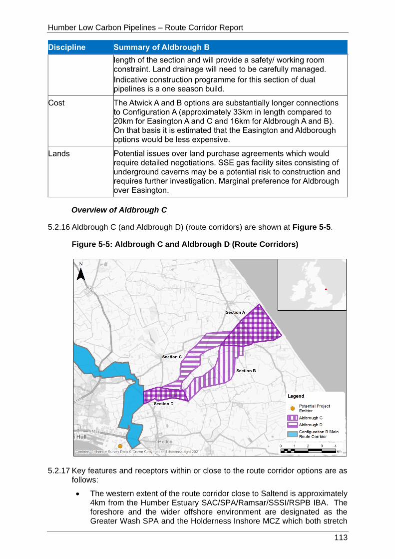
Humber Low Carbon Pipelines – Route Corridor Report
113
Discipline Summary of Aldbrough B
length of the section and will provide a safety/ working room constraint. Land drainage will need to be carefully managed.
Indicative construction programme for this section of dual pipelines is a one season build.
Cost The Atwick A and B options are substantially longer connections to Configuration A (approximately 33km in length compared to 20km for Easington A and C and 16km for Aldbrough A and B). On that basis it is estimated that the Easington and Aldborough options would be less expensive.
Lands Potential issues over land purchase agreements which would require detailed negotiations. SSE gas facility sites consisting of underground caverns may be a potential risk to construction and requires further investigation. Marginal preference for Aldbrough over Easington.
Overview of Aldbrough C
5.2.16 Aldbrough C (and Aldbrough D) (route corridors) are shown at Figure 5-5.
Figure 5-5: Aldbrough C and Aldbrough D (Route Corridors)
5.2.17 Key features and receptors within or close to the route corridor options are as follows:
• The western extent of the route corridor close to Saltend is approximately 4km from the Humber Estuary SAC/SPA/Ramsar/SSSI/RSPB IBA. The foreshore and the wider offshore environment are designated as the Greater Wash SPA and the Holderness Inshore MCZ which both stretch
Humber Low Carbon Pipelines – Route Corridor Report
114
along the entirety of the Holderness coast. Lambwath Valley YWT Living Landscape is at the coastal extent of the landfall area.
• North Park Farm Scheduled Monument is approximately 600m south of the route corridor south of Lelley.
• The route corridor is within the Holderness National Character Area. The coastal region is subject to coastal erosion.
• Sproatley Grange historic landfill site is approximately 500m north of the route corridor as it passes east of Lelley.
• There are extensive areas of Flood Zone 2 and Flood Zone 3 within the route corridor (particularly the south western extent between Saltend, Preston and Wyton) due to extensive areas of low-lying flood plains surrounding the various rivers that feed into the Humber Estuary. The route corridor crosses many of these rivers and man-made land drains including Northfield Drain, Humbleton Beck, Bail Drain, East Newton Drain, and Cess Dale Drain.
• Most of the route corridor consists of Grade 2 (very good quality) Agricultural Land, with the remainder Grade 3 (good to moderate quality) Agricultural Land.
• The route corridor interacts with the electrical corridor associated with the Whitehill Gas Storage development.
• The route corridor slightly intersects a small proportion of a MSA north of Preston and south of Humbleton. The route corridor also intersects the MSA north of Fitling.
5.2.18 Table 5-7 provides a summary of the relevant environmental, socio-economic, technical and cost considerations for Aldbrough C.
Table 5-7: Aldbrough C Appraisal Summary
Discipline Summary of Aldbrough C
Biodiversity The Greater Wash SPA (with Marine Components) is close to the route corridor. Pollution prevention would be required to mitigate potentially adverse effects on this site, as would the consideration of timing works to avoid sensitive months, careful routeing to increase distance of works and potentially implementing physical screening, to avoid potentially adverse effects on the qualifying features. Qualifying bird species associated with the Humber Estuary SSSI/SPA (with marine components)/Ramsar/RSPB IBA could potentially use terrestrial land and would therefore need to be confirmed through data collected (potentially including surveys) to inform any mitigation requirements. Pollution prevention, careful routeing and physical screening should be considered to protect Bail Wood LWS/Ancient Woodland, just west of the B1242 south of Aldbrough. Priority habitats could primarily be avoided through careful routeing, however, where this is less likely (notably the area of Priority coastal and floodplain grazing marsh adjacent to the B1238 southeast of Bilton) then trenchless crossing should be considered, otherwise reinstatement and potentially

Humber Low Carbon Pipelines – Route Corridor Report
115
Discipline Summary of Aldbrough C
compensation of lost habitat would be required. Further trenchless crossings may be appropriate to mitigate for potential species using watercourses and reduce potential indirect effects on the River Humber and Humber Estuary designated sites.
Landscape and Visual
There are no nationally important designated landscapes that constrain this option. Aldbrough A - D all pass close to several settlements, thus similar visual receptor groups are likely to be affected. The landscape context of Aldbrough A - D is broadly similar, and with avoidance of sensitive landscape features through siting and routeing and good-practice construction methods the potential effects are likely to be broadly comparable.
The underground nature of the scheme means that the potential for residual significant effects on visual receptors is reduced; nonetheless, routeing close to receptors that are typically of higher sensitivity such as residential dwellings/settlement and recreational receptors should be avoided where feasible. Taking the above into account, more direct options are likely to be more favourable.
Historic Environment
There would likely be no physical impacts to designated assets, such as scheduled monuments and listed buildings, as it is assumed they would be avoided. Physical impacts would be limited to non-designated assets and previously unrecorded assets, although these were not assessed as part of this appraisal.
Impacts on setting should be largely temporary due to the underground nature of most works. Where above ground works are unavoidable, such as the pumping facility likely to be located at the eastern extent of the route corridor, this AGI has the potential to result in impacts on the setting of designated assets. This includes the small number of listed buildings within the Garton area, as well as Aldbrough Conservation Area to the north. However, areas where AGIs might result in impacts on the setting of designated assets include the Conservation Area of Lelley, as well as the small number of listed buildings in Garton.
Mitigation would be required and could include a phased programme of works including geophysical survey, archaeological evaluation trenching, and full archaeological excavation to mitigate physical impacts. The design of the AGIs, as well as screening/planting, could potentially mitigate impacts on the setting of designated assets.
Water Environment
Flood zones and the crossing of multiple watercourses would be unavoidable. Approximately a quarter of this option is within Flood Zone 2 and 3, mainly within Section E. Works within the floodplain (Flood Zone 2 and 3) would likely require the application of the Exception Test and any future flood risk assessment would need to demonstrate how the Exception Test has been met. Pollution prevention measures and best available techniques should be adopted during construction including the

Humber Low Carbon Pipelines – Route Corridor Report
116
Discipline Summary of Aldbrough C
use of trenchless techniques at Main River crossing points and large floodplain crossings. Compensatory storage may be required to offset any loss in floodplain storage because of the temporary or permanent works.
Soils and Geology
There are no hydrogeological constraints, no current or historic landfill sites, and no RIGS sites associated with the route corridor. There are two MSA within the route corridor, but these are avoidable through routeing.
Settlement and Population
There are no educational facilities, medical facilities or emergency facilities in either the route corridor. No urban settlements are crossed or overlapped, and population density is in the lowest band at 0-20 persons per hectare. However, there are approximately two residential properties within the route corridor. There is potential for direct impacts (e.g. noise disturbance and dust emissions) on all of these properties; however, routeing and siting of construction activities and the route alignment should avoid being close to these residential properties to minimise potential direct and indirect impacts.
Tourism and Recreation
A holiday park (North Star Sanctum) and a self-catering facility (Stables Cottage) are in the route corridor. Routeing and siting of construction activities and the route alignment should avoid being close to these resources to minimise potential direct and indirect impacts. There are no other direct or indirect impacts regarding Tourism and Recreation.
Traffic and Access
There is excellent access from trunk road and A/B road network. Section B is the most challenging section to access due to the requirement to utilise geometrically challenged routes. Engineering works may be required to accommodate two-way HGV movements along local access roads. There is potential to provide direct access from A/B road network via temporary bellmouths supported by access tracks. Access track provision could help avoid receptors fronting the highway but would result in higher overall vehicular movements during construction. All effects however could be managed with standard mitigation measures and engineering solutions. Restricted access between the B1242 and Newfield Lane in Section B.
Land Use Temporary construction works (including access) are unlikely to significantly affect agricultural land use or the long-term viability of functionality of any affected operations due to the temporary nature of the works. Following construction, the (predominately agricultural) land would be restored back to its former use; the loss of agricultural land (regardless of Grade) would be temporary (no permanent loss) and any standard agricultural land use operations above the pipelines would be able to continue during the operation phase.
Land take for the pumping facility would result in the permanent loss of Grade 3 Agricultural Land. However, the surrounding land where the pumping facility could reasonably be sited is
Humber Low Carbon Pipelines – Route Corridor Report
117
Discipline Summary of Aldbrough C
Grade 2 or Grade 3, land take as a percentage of Grade 3 land in the surrounding area is relatively small, and its loss from an agricultural productivity perspective would be appropriately compensated where applicable. Operational effects are unlikely to be significant.
Planning Routeing is required around/through the underground natural gas storage caverns at the east end of the route corridor and required to avoid the electrical corridor associated with the Whitehill Gas storage development.
Aldbrough C and D are slightly preferred over Aldbrough A and B as they would avoid Section E (and the constraints associated with the Yorkshire Energy Park planning permission). However, it is acknowledged that Aldbrough C and D would provide a connection to Package 1 Configuration B which already includes interaction with that part of Aldbrough (Route Corridor) Section E.
Technical (Engineering)
None of the sections pose any constructability issues. Land drainage will need to be carefully managed.
Indicative construction programme for this section of dual pipelines is a one season build.
Cost The Atwick C and D options are shorter connections to Configuration B (approximately 12km in length compared to 20km for Easington B and 16km for Aldbrough C and D). On that basis it is estimated that the Atwick options would offer less expensive connections to Configuration B compared to the Easington and Aldborough options.
Lands Potential issues over land purchase agreements would require detailed negotiations. SSE gas facility sites consisting of underground caverns may be a potential risk to construction and requires further investigation. Marginal preference for Aldbrough over Easington.
Overview of Aldbrough D
5.2.19 Aldbrough D (route corridors) are shown at Figure 5-5.
5.2.20 Key features and receptors within or close to the route corridor are as follows:
• The western extent of the route corridor close to Saltend is approximately 4km from the Humber Estuary SAC/SPA/Ramsar/SSSI/RSPB IBA. The foreshore and the wider offshore environment are designated as the Greater Wash SPA and the Holderness Inshore MCZ which both stretch along the entirety of the Holderness coast. Bail Wood Ancient Woodland and LWS is at the centre of the route corridor. Lambwath Valley YWT Living Landscape is at the coastal extent of the landfall area.
• Shaw Fosse Moated Site Scheduled Monument is immediately south of and adjacent the route corridor north of Humbleton.
• The route corridor is within the Holderness National Character Area. The coastal region is subject to coastal erosion..
• Sproatley Grange historic landfill site is north of and immediately adjacent

Humber Low Carbon Pipelines – Route Corridor Report
118
the route corridor as it passes east of Lelley.
• There are extensive areas of Flood Zone 2 and Flood Zone 3 within the route corridor (particularly the south western extent between Saltend, Preston and Wyton) due to extensive areas of low-lying flood plains surrounding the various rivers that feed into the Humber Estuary. The route corridor crosses many of these rivers and man-made land drains including Gallows Bridge Drain, Fox Covert Drain, Humbleton Beck, Bail Drain, East Newton Drain, and Cess Dale Drain.
• Most of the route corridor consists of Grade 2 (very good quality) Agricultural Land, with the remainder Grade 3 (good to moderate quality) Agricultural Land.
• The route corridor interacts with the electrical corridor associated with the Whitehill Gas Storage development.
• The route corridor slightly intersects a small proportion of a MSA north of Preston.
5.2.21 Table 5-8 provides a summary of the relevant environmental, socio-economic, technical and cost considerations for Aldbrough D.
Table 5-8: Aldbrough D Appraisal Summary
Discipline Summary of Aldbrough D
Biodiversity The Greater Wash SPA (with Marine Components) is close to the route corridor. Pollution prevention would be required to mitigate potentially adverse effects on this site, as would the consideration of timing works to avoid sensitive months, careful routeing to increase distance of works and potentially implementing physical screening, to avoid potentially adverse effects on the qualifying features. Qualifying bird species associated with the Humber Estuary SSSI/SPA (with marine components)/Ramsar/RSPB IBA could potentially use terrestrial land and would therefore need to be confirmed through data collected (potentially including surveys) to inform any mitigation requirements. Pollution prevention, careful routeing and physical screening should be considered to protect Bail Wood LWS/Ancient Woodland, just west of the B1242 south of Aldbrough. Priority habitats could primarily be avoided through careful routeing, however, where this is less likely (notably the area of Priority coastal and floodplain grazing marsh adjacent to the B1238 southeast of Bilton) then trenchless crossing should be considered, otherwise reinstatement and potentially compensation of lost habitat would be required. Further trenchless crossings may be appropriate to mitigate for potential species using watercourses and reduce potential indirect effects on the River Humber and Humber Estuary designated sites.
Landscape and Visual
There are no nationally important designated landscapes that constrain this option. Aldbrough A - D all pass close to several settlements, thus similar visual receptor groups are likely to be affected. The landscape context of Aldbrough A - D is broadly similar, and with avoidance of sensitive landscape features

Humber Low Carbon Pipelines – Route Corridor Report
119
Discipline Summary of Aldbrough D
through siting and routeing and good-practice construction methods the potential effects are likely to be broadly comparable.
The underground nature of the scheme means that the potential for residual significant effects on visual receptors is reduced; nonetheless, routeing close to receptors that are typically of higher sensitivity such as residential dwellings/settlement and recreational receptors should be avoided where feasible. Taking the above into account, more direct options are likely to be more favourable.
Historic Environment
There would likely be no physical impacts to designated assets, such as scheduled monuments and listed buildings, as it is assumed they would be avoided. Physical impacts would be limited to non-designated assets and previously unrecorded assets, although these were not assessed as part of this appraisal.
Impacts on setting should be largely temporary due to the underground nature of most works. Where above ground works are unavoidable, such as the pumping facility like to be located at the eastern extent of the route corridor, this AGI has the potential to result in impacts on the setting of designated assets. This includes the small number of listed buildings within the Garton area, as well as Aldbrough Conservation Area to the north. However, areas where AGIs might result in impacts on the setting of designated assets include the Conservation Area of Lelley, as well as designated assets in Flinton and Humbleton.
Mitigation would be required and could include a phased programme of works including geophysical survey, archaeological evaluation trenching, and full archaeological excavation to mitigate physical impacts. The design of the AGIs, as well as screening/planting, could potentially mitigate impacts on the setting of designated assets.
Water Environment
Flood zones and the crossing of multiple watercourses would be unavoidable. Approximately a quarter of this option is within Flood Zone 2 and 3, mainly within Section E. Works within the floodplain (Flood Zone 2 and 3) would likely require the application of the Exception Test and any future flood risk assessment would need to demonstrate how the Exception Test has been met. Pollution prevention measures and best available techniques should be adopted during construction including the use of trenchless techniques at Main River crossing points and large floodplain crossings. Compensatory storage may be required to offset any loss in floodplain storage because of the temporary or permanent works.
Soils and Geology
There are no hydrogeological constraints and no RIGS sites associated with the route corridor. There is one historic landfill site (Sproatley Grange) adjacent to the route corridor, but it is avoidable through routeing. There is one MSA within the route corridor, but these are avoidable through routeing.

Humber Low Carbon Pipelines – Route Corridor Report
120
Discipline Summary of Aldbrough D
Settlement and Population
There are no educational facilities, medical facilities or emergency facilities in either the route corridor. No urban settlements are crossed or overlapped, and population density is in the lowest band at 0-20 persons per hectare. However, there are approximately 2 residential properties within the route corridor. There is potential for direct impacts (e.g. noise disturbance and dust emissions) on all of these properties; however, routeing and siting of construction activities and the route alignment should avoid being close to these residential properties to minimise potential direct and indirect impacts.
Tourism and Recreation
There are no direct or indirect impacts on accommodation facilities, cultural facilities, historical landmarks, sports and leisure facilities, the NCN or National Trust land (always open).
Traffic and Access
There is excellent access from Trunk road and A/B road network. Engineering works may be required to accommodate two-way HGV movements along local access roads. There is potential to provide direct access from A/B road network via temporary bellmouths supported by access tracks. Access track provision could help avoid receptors fronting the highway but would result in higher overall vehicular movements during construction. All effects however could be managed with standard mitigation measures and engineering solutions. This option is preferred (to Aldbrough A, B, and C) due to Section C offering greater flexibility in terms of access, management and mitigation than Section B and the removal of Section E.
Land Use Temporary construction works (including access) are unlikely to significantly affect agricultural land use or the long-term viability of functionality of any affected operations due to the temporary nature of the works. Following construction, the (predominately agricultural) land would be restored back to its former use; the loss of agricultural land (regardless of Grade) would be temporary (no permanent loss) and any standard agricultural land use operations above the pipelines would be able to continue during the operation phase.
Land take for the pumping facility would result in the permanent loss of Grade 3 Agricultural Land. However, the surrounding land where the pumping facility could reasonably be sited is Grade 2 or Grade 3, land take as a percentage of Grade 3 land in the surrounding area is relatively small, and its loss from an agricultural productivity perspective would be appropriately compensated where applicable. Operational effects are unlikely to be significant.
Planning Routeing is required around/through the underground natural gas storage caverns at the east end of the route corridor and required to avoid the electrical corridor associated with the Whitehill Gas storage development.
Aldbrough C and D are slightly preferred over Aldbrough A and B as they would avoid Section E (and the constraints associated with the Yorkshire Energy Park planning permission). However,

Humber Low Carbon Pipelines – Route Corridor Report
121
Discipline Summary of Aldbrough D
it is acknowledged that Aldbrough C and D would provide a connection to Package 1 Configuration B which already includes interaction with that part of Aldbrough (Route Corridor) Section E.
Technical (Engineering)
None of the sections pose any constructability issues except Section C which has an existing HP gas pipeline running the length of the section and will provide a safety/ working room constraint. Land drainage will need to be carefully managed.
Indicative construction programme for this section of dual pipelines is a one season build.
Cost The Atwick C and D options are shorter connections to Configuration B (approximately 12km in length compared to 20km for Easington B and 16km for Aldbrough C and D). On that basis it is estimated that the Atwick options would offer less expensive connections to Configuration B compared to the Easington and Aldborough options.
Lands Potential issues over land purchase agreements would require detailed negotiations. SSE gas facility sites consisting of underground caverns may be a potential risk to construction and requires further investigation. Marginal preference for Aldbrough over Easington.
Overview of Atwick A
5.2.22 Atwick A (and Atwick B) (route corridors) are shown at Figure 5-6.
Figure 5-6: Atwick A and Atwick B (Route Corridors)

Humber Low Carbon Pipelines – Route Corridor Report
122
5.2.23 Key features and receptors within or close to the route corridor are as follows:
• The southern extent of the route corridor close to Saltend is approximately 1.5km from the Humber Estuary SAC/SPA/Ramsar/SSSI/RSPB IBA. The foreshore and the wider offshore environment are designated as the Greater Wash SPA and the Holderness Inshore MCZ which both stretch along the entirety of the Holderness coast. The Hornsea Mere RSPB SPA, SSSI and RSPB IBA and Low Wood Ancient Woodland (within the boundary of Hornsea Mere) are approximately 500m south of the route corridor at Hornsea; the Leven Canal SSSI is approximately 1.7km north of the route corridor between Riston Grange and Leven. Noddle Hill LNR is approximately 200m south of the route corridor between Bransholme and Swine.
• Part of the route corridor intersects part of the Hull Green Arc YWT Living Landscape and part of the River Hull YWT Living Landscape in Section E. Hornsea Disused Railway Line is a linear LWS that spreads across most of the route corridor (Section E) south of Swine. The route corridor is immediately adjacent to Sigglesthorne – Goxhill LWS, Crofting Ponds LWS, Low Wood, Wassand LWS, and Wassand Hall LWS and passes through the northern extent of Rise – Huddlecross LWS.
• Hedon Medieval Town Scheduled Monument is approximately 500m east of the route corridor close to Saltend Chemicals Park. The route corridor passes close to and between the Scheduled Monuments of Site of Swine Cisterian Nunnery, Swine Castle Hill, and Round Barrow 300m South of Castle Hill Farm, and is approximately 600m east of Site of Meaux Cistercian Abbey Scheduled Monument at Meaux. There is a small cluster of Grade II listed buildings and the Village Cross Scheduled Monument in the village of Atwick.
• The route corridor is predominately within the Holderness National Character Area with a small proportion within the Humber Estuary Character Area close to Saltend Chemicals Park. The coastal region is subject to coastal erosion.
• Part of the route corridor intersects SPZ3 as it passes east of Meaux and Routh. High Bransholme Farm historic landfill site is west of and immediately adjacent the route corridor as it passes west of Swine.
• There are extensive areas of Flood Zone 2 and Flood Zone 3 within the route corridor (particularly the southern extent between Saltend and Routh) due to extensive areas of low-lying flood plains surrounding the various rivers that feed into the Humber Estuary. The route corridor crosses many of these rivers and man-made land drains including Monkbridge Stream, Foredyke Stream, Swine Church Drain, Ganstead Drain, Old Fleet, Preston New Drain, Monk Dike, Meaux and Routh East Drain, Stonleygoat Dike, Stream Dike, and No Man’s Friend.
• The route corridor consists of Grade 3 (good to moderate quality) Agricultural Land and Grade 2 (very good quality) Agricultural Land.
• The route corridor interacts with potential flood alleviation works (EIA Screening Opinion issued) at Sutton on Hull, the electrical corridor associated with the Whitehill Gas Storage development, and Yorkshire Energy Park on the northern side of the Humber Estuary near Saltend.

Humber Low Carbon Pipelines – Route Corridor Report
123
• The route corridor intersects MSA at Section B (at Sigglesthorne), Section D (at Riston Grange), and Section E (at Meaux and Ganstead).
• Several A roads are intersected by the route corridor including the A1033 at Hedon, the A165 (Ganstead Lane) at Ganstead, the A165 (White Cross Road) at Long Riston, and the A1035 (Hornsea Road) at Sigglesthorne.
5.2.24 Table 5-9 provides a summary of the relevant environmental, socio-economic, technical and cost considerations for Atwick A.
Table 5-9: Atwick A Appraisal Summary
Discipline Summary of Atwick A
Biodiversity The Greater Wash SPA (with Marine Components), Hornsea Mere SPA/SSSI/RSPB IBA, Noddle Hill LNR, the Humber Estuary SSSI/SAC/SPA (with marine components)/Ramsar/RSPB IBA, Low Wood, Crofting Ponds, and Sigglesthorne - Goxhill LWS and Low Wood Ancient Woodland are close; pollution prevention would be required to mitigate potentially adverse effects on these sites, as would the consideration of timing works to avoid sensitive months, careful routeing to increase distance of works and potentially implementing physical screening, to avoid potentially adverse effects on the qualifying features. Qualifying bird species associated with the Humber Estuary SSSI/SPA (with marine components)/Ramsar/RSPB IBA could potentially use terrestrial land and would therefore need to be confirmed through data collected (potentially including surveys) to inform any mitigation requirements. Rise-Huddlecross LWS is partially within Section B, along the B1243 south of Sigglesthorne and Hornsea Disused Railway Line LWS is partially within Section E, just west of Coniston; adverse effects to these sites could be avoided through careful routeing, otherwise habitat reinstatement and potentially compensation or enhancement may be required. The presence of two great crested newt District Level Licensing points, just northwest of Hedon and northeast of Bransholme, suggests this species could be present within the wider area; data collection (likely through surveys) would be required on any potentially suitable waterbodies for great crested newts within 500m of works; the results of which would inform any mitigation requirements. Priority habitats could primarily be avoided through careful routeing, however, where this is less likely (notably two areas of Priority coastal and floodplain grazing marsh, one adjacent to the B1238 southeast of Bilton and the other north of the A1033 west of Hedon) then trenchless crossing should be considered, otherwise reinstatement and potentially compensation of lost habitat would be required. Further trenchless crossings may be appropriate to mitigate for potential species using watercourses and reduce potential indirect effects on the River Humber and Humber Estuary designated sites.
Landscape and Visual
There are no nationally important designated landscapes that constrain this option. Atwick A - D all pass close to several settlements, thus similar visual receptor groups are likely to be

Humber Low Carbon Pipelines – Route Corridor Report
124
Discipline Summary of Atwick A
affected. The landscape context of Atwick A - D is broadly similar, and with avoidance of sensitive landscape features through siting and routeing and good-practice construction methods the potential effects are likely to be broadly comparable. The underground nature of the options means that the potential for residual significant effects on visual receptors is reduced; nonetheless, routeing close to receptors that are typically of higher sensitivity such as residential dwellings/settlement and recreational receptors should be avoided where feasible. Taking the above into account, more direct options are likely to be more favourable. Options with fewer trenchless crossings would be favourable in terms of limiting likely landscape and visual effects.
Historic Environment
There will likely be no physical impacts to designated assets, such as scheduled monuments and listed buildings, as it is assumed they would be avoided. Physical impacts would be limited to non-designated assets and previously unrecorded assets, although these were not assessed as part of this appraisal.
Impacts on setting should be largely temporary due to the underground nature of most works. Where above ground works are unavoidable, such as the pumping facility likely to be located at the eastern extent of the route corridor, the scheme has the potential to result in impacts on the setting of designated assets. This includes the small number of listed buildings within the Garton area. However, areas where AGIs might result in impacts on the setting of designated assets include the Conservation Areas that flank the scheme, as well as other listed buildings and scheduled monuments.
Mitigation would be required and could include a phased programme of works including geophysical survey, archaeological evaluation trenching, and full archaeological excavation to mitigate physical impacts. The design of the AGIs, as well as screening/planting, could potentially mitigate impacts on the setting of designated assets.
Water Environment
Flood zones and the crossing of multiple watercourses would be unavoidable. Approximately half of this option is within Flood Zone 2 and 3, concentrated in the south in Section E. Works within the floodplain (Flood Zone 2 and 3) would likely require the application of the Exception Test and any future flood risk assessment would need to demonstrate how the Exception Test has been met. Pollution prevention measures and best available techniques should be adopted during construction including the use of trenchless techniques at Main River crossing points and large floodplain crossings. Compensatory storage may be required to offset any loss in floodplain storage because of the temporary or permanent works.
Soils and Geology
The route corridor passes through a part of SPZ3 but is avoidable through routeing. There are no unavoidable current or

Humber Low Carbon Pipelines – Route Corridor Report
125
Discipline Summary of Atwick A
historic landfills impacted by the route corridor. There are no RIGS sites within the route corridor. There are several MSA; some of which are avoidable through routeing whilst some are unavoidable.
Settlement and Population
There are no educational facilities, medical facilities or emergency facilities in either the route corridor. No urban settlements are crossed or overlapped, and population density is in the lowest band at 0-20 persons per hectare. However, there are approximately five residential properties within the route corridor. There is potential for direct impacts (e.g. noise disturbance and dust emissions) on all of these properties; however, routeing and siting of construction activities and the route alignment should avoid being close to these residential properties to minimise potential direct and indirect impacts.
Tourism and Recreation
A holiday park (Wassand Croft Glamping Site) is in the route corridor and another holiday park (the Wood Carr Holiday Centre) is adjacent to the route corridor. Routeing and siting of construction activities and the route alignment should avoid being close to these resources to minimise potential direct and indirect impacts.
The route corridor crosses the NCN once. Temporary closure of the NCN is likely to be unavoidable at the location where the route corridor crosses it and would necessitate diversions which could result in adverse direct impacts. Minimising the length of diversions and duration of closure would mitigate these direct impacts.
Traffic and Access
There is excellent access from Trunk road and A/B road network. Section E is the most challenging section to access due to the requirement to utilise geometrically challenged routes. Engineering works may be required to accommodate two-way HGV movements along local access roads. Access track provision could help avoid receptors fronting the highway but would result in higher overall vehicular movements during construction. All effects however could be managed with standard mitigation measures and engineering solutions.
Land Use Temporary construction works (including access) are unlikely to significantly affect agricultural land use or the long-term viability of functionality of any affected operations due to the temporary nature of the works.
Following construction, the (predominately agricultural) land would be restored back to its former use; the loss of agricultural land (regardless of Grade) would be temporary (no permanent loss) and any standard agricultural land use operations above the pipelines would be able to continue during the operation phase.
Land take for the pumping facility would result in the permanent loss of Grade 3 Agricultural Land. However, the surrounding land where the pumping facility could reasonably be sited is Grade 2 or Grade 3, land take as a percentage of Grade 3 land

Humber Low Carbon Pipelines – Route Corridor Report
126
Discipline Summary of Atwick A
in the surrounding area is relatively small, and its loss from an agricultural productivity perspective would be appropriately compensated where applicable. Operational effects are unlikely to be significant.
Planning The route corridor interacts with the electrical corridor associated with the Whitehill Gas storage development and the Yorkshire Energy Park; the latter has high potential to result in difficulties for the pipelines to be able to physically route through. Early engagement with the developer and the local planning authority should be undertaken to determine the extent to which the Project and the approved planning permission could accommodate each other.
Technical (Engineering)
None of the sections pose any constructability issues except Section E where it approaches Saltend. This will be difficult, but not impossible, to route two pipelines circa 25m apart through this area given the urban and industrial development in the area.
Indicative construction programme for this section of dual pipelines is a one season build.
Cost The Atwick A and B options are substantially longer connections to Configuration A (approximately 33km in length compared to 20km for Easington A and C and 16km for Aldbrough A and B). On that basis it is estimated that the Easington and Aldborough options would be less expensive.
Lands Potential issues over land purchase agreements. Agreement with The Crown Estate land parcels within this option would require detailed negotiations.
Overview of Atwick B
5.2.25 Atwick B (route corridors) are shown at Figure 5-6.
5.2.26 Key features and receptors within or close to the route corridor are as follows:
• The southern extent of the route corridor close to Saltend is approximately 1.5km from the Humber Estuary SAC/SPA/Ramsar/SSSI/RSPB IBA. The foreshore and the wider offshore environment are designated as the Greater Wash SPA and the Holderness Inshore MCZ which both stretch along the entirety of the Holderness coast. The Hornsea Mere RSPB SPA, SSSI and RSPB IBA and Low Wood Ancient Woodland (within the boundary of Hornsea Mere) are approximately 500m south of the route corridor at Hornsea; the Leven Canal SSSI is approximately 1.7km north of the route corridor between Riston Grange and Leven. Noddle Hill LNR is approximately 200m south of the route corridor between Bransholme and Swine
• Part of the route corridor intersects part of the Hull Green Arc YWT Living Landscape and part of the River Hull YWT Living Landscape (in Section E), and part of the River Hull Headwaters YWT Living Landscape (in Section C). Hornsea Disused Railway Line is a linear LWS that spreads across most of the route corridor (Section E) south of Swine. The route corridor is approximately 300m north of Crofting Ponds LWS, Low Wood,

Humber Low Carbon Pipelines – Route Corridor Report
127
Wassand LWS, and Wassand Hall LWS.
• Hedon Medieval Town Scheduled Monument is approximately 500m east of the route corridor close to Saltend Chemicals Park. The route corridor passes close to and between the Scheduled Monuments of Site of Swine Cisterian Nunnery, Swine Castle Hill, and Round Barrow 300m South of Castle Hill Farm, and is approximately 600m east of Site of Meaux Cistercian Abbey Scheduled Monument at Meaux.
• The route corridor is predominately within the Holderness National Character Area with a small proportion within the Humber Estuary Character Area close to Saltend Chemicals Park. The coastal region is subject to coastal erosion; however, the pumping facility siting options are outside of the (long term) coastal erosion areas.
• Part of the route corridor intersects SPZ3 as it passes east of Meaux and Routh. High Bransholme Farm historic landfill site is west of and immediately adjacent the route corridor as it passes west of Swine. A large proportion of the route corridor passes through the historic landfill sites of Catfoss and Catwick Crossroads as it heads in a northerly direction east of Catwick and west of Sigglesthorne.
• There are extensive areas of Flood Zone 2 and Flood Zone 3 within the route corridor (particularly the southern extent between Saltend and Routh) due to extensive areas of low-lying flood plains surrounding the various rivers that feed into the Humber Estuary. The route corridor crosses many of these rivers and man-made land drains including Monkbridge Stream, Foredyke Stream, Swine Church Drain, Ganstead Drain, Old Fleet, Preston New Drain, Monk Dike, Meaux and Routh East Drain, Stonleygoat Dike, Stream Dike, and No Man’s Friend.
• The route corridor consists of Grade 3 (good to moderate quality) Agricultural Land and Grade 2 (very good quality) Agricultural Land.
• The route corridor interacts with potential flood alleviation works (EIA Screening Opinion issued) at Sutton on Hull, the electrical corridor associated with the Whitehill Gas Storage development, and Yorkshire Energy Park on the northern side of the Humber Estuary near Saltend.
• The route corridor intersects MSA at Section C (at Sigglesthorne), Section D (at Riston Grange), and Section E (at Meaux and Ganstead).
• Several A roads are intersected by the route corridor including the A1033 at Hedon, the A165 (Ganstead Lane) at Ganstead, the A165 (White Cross Road) at Long Riston, and the A1035 (West Road) at Sigglesthorne.
5.2.27 Table 5-10 provides a summary of the relevant environmental, socio-economic, technical and cost considerations for Atwick B.
Table 5-10: Atwick B Appraisal Summary
Discipline Summary of Atwick B
Biodiversity The Greater Wash SPA (with Marine Components), Hornsea Mere SPA/SSSI/RSPB IBA, Noddle Hill LNR, the Humber Estuary SSSI/SAC/SPA (with marine components) /Ramsar/RSPB IBA, Low Wood, Crofting Ponds, and Sigglesthorne - Goxhill LWSs and Low Wood Ancient Woodland

Humber Low Carbon Pipelines – Route Corridor Report
128
Discipline Summary of Atwick B
are close; pollution prevention would be required to mitigate potentially adverse effects on these sites, as would the consideration of timing works to avoid sensitive months, careful routeing to increase distance of works and potentially implementing physical screening, to avoid potentially adverse effects on the qualifying features. Qualifying bird species associated with the Humber Estuary SSSI/SPA (with marine components)/Ramsar/RSPB IBA could potentially use terrestrial land and would therefore need to be confirmed through data collected (potentially including surveys) to inform any mitigation requirements. Hornsea Disused Railway Line LWS is partially within Section E, just west of Coniston; adverse effects to these sites could be avoided through careful routeing, otherwise habitat reinstatement and potentially compensation or enhancement may be required. The presence of two great crested newt District Level Licensing points, just northwest of Hedon and northeast of Bransholme, suggests this species could be present within the wider area; data collection (likely through surveys) would be required on any potentially suitable waterbodies for great crested newts within 500m of works; the results of which would inform any mitigation requirements. Priority habitats could primarily be avoided through careful routeing, however, where this is less likely (notably two areas of Priority coastal and floodplain grazing marsh, one adjacent to the B1238 southeast of Bilton and the other north of the A1033 west of Hedon) then trenchless crossing should be considered, otherwise reinstatement and potentially compensation of lost habitat would be required. Further trenchless crossings may be appropriate to mitigate for potential species using watercourses and reduce potential indirect effects on the River Humber and Humber Estuary designated sites.
Landscape and Visual
There are no nationally important designated landscapes that constrain Atwick B. Atwick A - D all pass close to several settlements, thus similar visual receptor groups are likely to be affected. The landscape context of Atwick A - D is broadly similar, and with avoidance of sensitive landscape features through siting and routeing and good-practice construction methods the potential effects are likely to be broadly comparable. The underground nature of the options means that the potential for residual significant effects on visual receptors is reduced; nonetheless, routeing close to receptors that are typically of higher sensitivity such as residential dwellings/settlement and recreational receptors should be avoided where feasible. Taking the above into account, more direct options are likely to be more favourable. Options with fewer trenchless crossings would be favourable in terms of limiting likely landscape and visual effects.
Historic Environment
There will likely be no physical impacts to designated assets, such as scheduled monuments and listed buildings, as it is assumed they would be avoided. Physical impacts would be limited to non-
Humber Low Carbon Pipelines – Route Corridor Report
129
Discipline Summary of Atwick B
designated assets and previously unrecorded assets, although these were not assessed as part of this appraisal.
Impacts on setting should be largely temporary due to the underground nature of most works. Where above ground works are unavoidable, such as the pumping facility likely to be located at the eastern extent of the route corridor, the scheme has the potential to result in impacts on the setting of designated assets. This includes the small number of listed buildings within the Garton area. However, areas where AGIs might result in impacts on the setting of designated assets include the Conservation Areas that flank the scheme, as well as other listed buildings and scheduled monuments.
Mitigation would be required and could include a phased programme of works including geophysical survey, archaeological evaluation trenching, and full archaeological excavation to mitigate physical impacts. The design of the AGIs, as well as screening/planting, could potentially mitigate impacts on the setting of designated assets.
Water Environment
Flood zones and the crossing of multiple watercourses would be unavoidable. Approximately half of this option is within Flood Zone 2 and 3, concentrated in the south in Section E. Works within the floodplain (Flood Zone 2 and 3) will likely require the application of the Exception Test and any future flood risk assessment would need to demonstrate how the Exception Test has been met. Pollution prevention measures and best available techniques should be adopted during construction including the use of trenchless techniques at Main River crossing points and large floodplain crossings. Compensatory storage may be required to offset any loss in floodplain storage because of the temporary or permanent works.
Soils and Geology
The route corridor passes through a part of SPZ3 but is avoidable through routeing. There several historic landfill sites adjacent to the route corridor, but they are avoidable through routeing (Catfoss and Catwick Crossroads would be the hardest to avoid and would require further technical investigation). There are no RIGS sites within the route corridor. There are several MSA within the route corridor, but these are avoidable through routeing.
Settlement and Population
There are no educational facilities, medical facilities or emergency facilities in either the route corridor. No urban settlements are crossed or overlapped, and population density is in the lowest band at 0-20 persons per hectare. However, there are approximately 10 residential properties within the route corridor. There is potential for direct impacts (e.g. noise disturbance and dust emissions) on all of these properties; however, routeing and siting of construction activities and the route alignment should avoid being close to these residential properties to minimise potential direct and indirect impacts.
Humber Low Carbon Pipelines – Route Corridor Report
130
Discipline Summary of Atwick B
Tourism and Recreation
The route corridor crosses the NCN once. Temporary closure of the NCN is likely to be unavoidable at the location where the route corridor crosses it and would necessitate diversions which could result in adverse direct impacts. Minimising the length of diversions and duration of closure would mitigate these direct impacts.
A holiday park (the Wood Carr Holiday Centre) is adjacent to the route corridor. Routeing and siting of construction activities and the route alignment should avoid being close to this resource to minimise potential direct and indirect impacts.
Traffic and Access
There is excellent access from Trunk road and A/B road network. Section E is the most challenging section to access due to the requirement to utilise geometrically challenged routes. Section C would require further engineering works to provide access in comparison to Section B (in Atwick A). Engineering works may be required to accommodate two-way HGV movements along local access roads. Access track provision could help avoid receptors fronting the highway but would result in higher overall vehicular movements during construction. All effects however could be managed with standard mitigation measures and engineering solutions. Access to part of Section E is restricted.
Land Use Temporary construction works (including access) are unlikely to significantly affect agricultural land use or the long-term viability of functionality of any affected operations due to the temporary nature of the works. Following construction, the (predominately agricultural) land would be restored back to its former use; the loss of agricultural land (regardless of Grade) would be temporary (no permanent loss) and any standard agricultural land use operations above the pipelines would be able to continue during the operation phase.
Land take for the pumping facility would result in the permanent loss of Grade 3 Agricultural Land. However, the surrounding land where the pumping facility could reasonably be sited is Grade 2 or Grade 3, land take as a percentage of Grade 3 land in the surrounding area is relatively small, and its loss from an agricultural productivity perspective would be appropriately compensated where applicable. Operational effects are unlikely to be significant.
Planning The route corridor interacts with the electrical corridor associated with the Whitehill Gas storage development and the Yorkshire Energy Park; the latter has high potential to result in difficulties for the pipelines to be able to physically route through. Early engagement with the developer and the local planning authority should be undertaken to determine the extent to which the Project and the approved planning permission could accommodate each other.
Preference for Atwick C and D over Atwick A and B as it would avoid the constraints associated with the Yorkshire Energy Park planning permission. However, it is acknowledged that Atwick C

Humber Low Carbon Pipelines – Route Corridor Report
131
Discipline Summary of Atwick B
and D would provide a connection to Package 1 Configuration B which already includes interaction with this planning permission.
Technical (Engineering)
None of the sections pose any constructability issues except Section E where it approaches Saltend. This will be difficult, but not impossible, to route two pipelines circa 25m apart through this area given the urban and industrial development in the area.
Indicative construction programme for this section of dual pipelines is a one season build.
Cost The Atwick A and B options are substantially longer connections to Configuration A (approximately 33km in length compared to 20km for Easington A and C and 16km for Aldbrough A and B). On that basis it is estimated that the Easington and Aldborough options would be less expensive.
Lands Potential issues over land purchase agreements. Agreement with The Crown Estate land parcels within this option would require detailed negotiations.
Overview of Atwick C
5.2.28 Atwick C (and Atwick D) (route corridors) are shown at Figure 5-7.
Figure 5-7: Atwick C and Atwick D (Route Corridors)
5.2.29 Key features and receptors within or close to the route corridor are as follows:
• The foreshore and the wider offshore environment are designated as the Greater Wash SPA and the Holderness Inshore MCZ which both stretch along the entirety of the Holderness coast. The Hornsea Mere RSPB

Humber Low Carbon Pipelines – Route Corridor Report
132
SPA, SSSI and RSPB IBA and Low Wood Ancient Woodland (within the boundary of Hornsea Mere) are approximately 500m south of the route corridor at Hornsea; the Leven Canal SSSI is approximately 1.7km north of the route corridor between Riston Grange and Leven.
• The route corridor is immediately adjacent Sigglesthorne – Goxhill LWS, Crofting Ponds LWS, Low Wood, Wassand LWS, and Wassand Hall LWS and passes through the northern extent of Rise – Huddlecross LWS.
• There is a small cluster of Grade II listed buildings and the Village Cross Scheduled Monument in the village of Atwick.
• The route corridor is within the Holderness National Character Area. The coastal region is subject to coastal erosion.
• Part of the route corridor intersects SPZ3 as it passes east of Routh.
• There are small areas of Flood Zone 2 and Flood Zone 3 within the route corridor due to areas of low-lying flood plains surrounding the various rivers that feed into the Humber Estuary. The route corridor crosses many of these rivers and man-made land drains including Monk Dike, Meaux and Routh East Drain, Stonleygoat Dike, Stream Dike, and No Man’s Friend.
• Most of the route corridor consists of Grade 3 (good to moderate quality) Agricultural Land, with the remainder Grade 2 (very good quality) Agricultural Land.
• The route corridor intersects MSA at Section B (at Sigglesthorne) and Section D (at Riston Grange).
• The A165 (White Cross Road) at Long Riston and the A1035 (Hornsea Road) at Sigglesthorne are intersected by the route corridor.
5.2.30 Table 5-11 provides a summary of the relevant environmental, socio-economic, technical and cost considerations for Atwick C.
Table 5-11: Atwick C Appraisal Summary
Discipline Summary of Atwick C
Biodiversity The Greater Wash SPA (with Marine Components), Hornsea Mere SPA/SSSI/RSPB Important Bird, Low Wood, Crofting Ponds, and Sigglesthorne - Goxhill LWSs and Low Wood Ancient Woodland are close; pollution prevention would be required to mitigate potentially adverse effects on these sites, as would the consideration of timing works to avoid sensitive months, careful routeing to increase distance of works and potentially implementing physical screening, to avoid potentially adverse effects on the qualifying features. Rise-Huddlecross LWS is partially within Section B, along the B1243 south of Sigglesthorne; adverse effects to this site could be avoided through careful routeing, otherwise habitat reinstatement and potentially compensation or enhancement may be required. Priority habitats could primarily be avoided through careful routeing, otherwise reinstatement and potentially compensation of lost habitat would be required. Further trenchless crossings

Humber Low Carbon Pipelines – Route Corridor Report
133
Discipline Summary of Atwick C
may be appropriate to mitigate for potential species using watercourses and reduce potential indirect effects on the River Humber and Humber Estuary designated sites.
Landscape and Visual
There are no nationally important designated landscapes that constrain this option. Atwick A - D all pass close to several settlements, thus similar visual receptor groups are likely to be affected. The landscape context of Atwick A - D is broadly similar, and with avoidance of sensitive landscape features through siting and routeing and good-practice construction methods the potential effects are likely to be broadly comparable. The underground nature of the options means that the potential for residual significant effects on visual receptors is reduced; nonetheless, routeing close to receptors that are typically of higher sensitivity such as residential dwellings/settlement and recreational receptors should be avoided where feasible. Taking the above into account, more direct options are likely to be more favourable. Options with fewer trenchless crossings would be favourable in terms of limiting likely landscape and visual effects.
Within the generally open landscape it is likely that the pumping facility will have relatively unrestricted visibility without mitigation that might help their assimilation into the landscape.
Historic Environment
There will likely be no physical impacts to designated assets, such as scheduled monuments and listed buildings, as it is assumed they would be avoided. Physical impacts would be limited to non-designated assets and previously unrecorded assets, although these were not assessed as part of this appraisal.
Impacts on setting should be largely temporary due to the underground nature of most works. Where above ground works are unavoidable, such as the pumping facility like to be located at the eastern extent of the route corridor, the scheme has the potential to result in impacts on the setting of designated assets. This includes the small number of listed buildings within the Garton area. However, areas where AGIs might result in impacts on the setting of designated assets include the Conservation Areas that flank the scheme, as well as other listed buildings and scheduled monuments.
Mitigation would be required and could include a phased programme of works including geophysical survey, archaeological evaluation trenching, and full archaeological excavation to mitigate physical impacts. The design of the AGIs, as well as screening/planting, could potentially mitigate impacts on the setting of designated assets.
Water Environment
Flood zones and the crossing of multiple watercourses would be unavoidable. Approximately a third of this option is within Flood Zone 2 and 3, concentrated in the western edge of Section D and around Stream Dike and No Mans Friend River. Works within the floodplain (Flood Zone 2 and 3) will likely require the

Humber Low Carbon Pipelines – Route Corridor Report
134
Discipline Summary of Atwick C
application of the Exception Test and any future flood risk assessment would need to demonstrate how the Exception Test has been met. Pollution prevention measures and best available techniques should be adopted during construction including the use of trenchless techniques at Main River crossing points and large floodplain crossings. Compensatory storage may be required to offset any loss in floodplain storage because of the temporary or permanent works.
Soils and Geology
The route corridor passes through a part of SPZ3 but is avoidable through routeing. There are no unavoidable current or historic landfills impacted by the route corridor. There are several MSA; some of which are avoidable through routeing whilst some are unavoidable.
Settlement and Population
There are no educational facilities, medical facilities or emergency facilities in either the route corridor. No urban settlements are crossed or overlapped, and population density is in the lowest band at 0-20 persons per hectare. However, there are approximately 3 residential properties within the route corridor. There is potential for direct impacts (e.g. noise disturbance and dust emissions) on all of these properties; however, routeing and siting of construction activities and the route alignment should avoid being close to these residential properties to minimise potential direct and indirect impacts.
Tourism and Recreation
A holiday park (Wassand Croft Glamping Site) is in the route corridor. Routeing and siting of construction activities and the route alignment should avoid being close to these resources to minimise potential direct and indirect impacts.
There are no other direct or indirect impacts regarding Tourism and Recreation.
Traffic and Access
There is excellent access from Trunk road and A/B road network. Engineering works may be required to accommodate two-way HGV movements along local access roads. Access track provision could help avoid receptors fronting the highway but would result in higher overall vehicular movements during construction. All effects however could be managed with standard mitigation measures and engineering solutions. The removal of Section E (compared to Atwick A and B) means this option would have fewer environmental effects arising and thus less mitigation would be required
Land Use Temporary construction works (including access) are unlikely to significantly affect agricultural land use or the long-term viability of functionality of any affected operations due to the temporary nature of the works. Following construction, the (predominately agricultural) land would be restored back to its former use; the loss of agricultural land (regardless of Grade) would be temporary (no permanent loss) and any standard agricultural land use operations above the pipelines would be able to continue during the operation phase.

Humber Low Carbon Pipelines – Route Corridor Report
135
Discipline Summary of Atwick C
Land take for the pumping facility would result in the permanent loss of Grade 3 Agricultural Land. However, the surrounding land where the pumping facility could reasonably be sited is Grade 2 or Grade 3, land take as a percentage of Grade 3 land in the surrounding area is relatively small, and its loss from an agricultural productivity perspective would be appropriately compensated where applicable. Operational effects are unlikely to be significant.
Planning Minor preference for Section C over Section B as this would not sever a MSA. Preference for Atwick C and D over Atwick A and B as it would avoid the constraints associated with the Yorkshire Energy Park planning permission. However, it is acknowledged that Atwick C and D would provide a connection to Package 1 Configuration B which already includes interaction with this planning permission.
Technical (Engineering)
None of the sections pose any constructability issues.
Indicative construction programme for this section of dual pipelines is a one season build.
Cost The Atwick C and D options are shorter connections to Configuration B (approximately 12km in length compared to 20km for Easington B and 16km for Aldbrough C and D). On that basis it is estimated that the Atwick options would offer less expensive connections to Configuration B compared to the Easington and Aldborough options.
Lands Potential issues over land purchase agreements. Agreement with The Crown Estate land parcels within this option would require detailed negotiations.
Overview of Atwick D
5.2.31 Atwick D (route corridors) are shown at Figure 5-7.
5.2.32 Key features and receptors within or close to the route corridor are as follows:
• The foreshore and the wider offshore environment are designated as the Greater Wash SPA and the Holderness Inshore MCZ which both stretch along the entirety of the Holderness coast. The Hornsea Mere RSPB SPA, SSSI and RSPB IBA and Low Wood Ancient Woodland (within the boundary of Hornsea Mere) are approximately 500m south of the route corridor at Hornsea; the Leven Canal SSSI is approximately 1.7km north of the route corridor between Riston Grange and Leven.
• Part of the route corridor intersects part of the River Hull Headwaters YWT Living Landscape in Section C) and is approximately 300m north of Crofting Ponds LWS, Low Wood, Wassand LWS, and Wassand Hall LWS.
• There is a small cluster of Grade II listed buildings and the Village Cross Scheduled Monument in the village of Atwick.
• The route corridor is within the Holderness National Character Area. The coastal region is subject to coastal erosion.
• Part of the route corridor intersects SPZ3 as it passes east of Routh. A

Humber Low Carbon Pipelines – Route Corridor Report
136
large proportion of the route corridor passes through the historic landfill sites of Catfoss and Catwick Crossroads as it heads in a northerly direction east of Catwick and west of Sigglesthorne.
• There are small areas of Flood Zone 2 and Flood Zone 3 within the route corridor due to areas of low-lying flood plains surrounding the various rivers that feed into the Humber Estuary. The route corridor crosses many of these rivers and man-made land drains including Monk Dike, Meaux and Routh East Drain, Stonleygoat Dike, Stream Dike, and No Man’s Friend.
• The route corridor consists of Grade 3 (good to moderate quality) Agricultural Land and Grade 2 (very good quality) Agricultural Land.
• The route corridor intersects MSA at Section C (at Sigglesthorne) and Section D (at Riston Grange).
• The A165 (White Cross Road) at Long Riston and the A1035 (West Road) at Sigglesthorne are intersected by the route corridor.
5.2.33 Table 5-12 provides a summary of the relevant environmental, socio-economic, technical and cost considerations for Atwick D.
Table 5-12: Atwick D Appraisal Summary
Discipline Summary of Atwick D
Biodiversity The Greater Wash SPA (with Marine Components), Hornsea Mere SPA/SSSI/RSPB IBA, Low Wood and Crofting Ponds LWSs and Low Wood Ancient Woodland are close; pollution prevention would be required to mitigate potentially adverse effects on these sites, as would the consideration of timing works to avoid sensitive months, careful routeing to increase distance of works and potentially implementing physical screening, to avoid potentially adverse effects on the qualifying features. Priority habitats could primarily be avoided through careful routeing, otherwise reinstatement and potentially compensation of lost habitat would be required. Further trenchless crossings may be appropriate to mitigate for potential species using watercourses and reduce potential indirect effects on the River Humber and Humber Estuary designated sites.
Landscape and Visual
There are no nationally important designated landscapes that constrain this option. Atwick A - D all pass close to several settlements, thus similar visual receptor groups are likely to be affected. The landscape context of Atwick A - D is broadly similar, and with avoidance of sensitive landscape features through siting and routeing and good-practice construction methods the potential effects are likely to be broadly comparable. The underground nature of the options means that the potential for residual significant effects on visual receptors is reduced; nonetheless, routeing close to receptors that are typically of higher sensitivity such as residential dwellings/settlement and recreational receptors should be avoided where feasible. Taking the above into account, more direct options are likely to be more favourable.
Humber Low Carbon Pipelines – Route Corridor Report
137
Discipline Summary of Atwick D
Options with fewer trenchless crossings would be favourable in terms of limiting likely landscape and visual effects.
Within the generally open landscape it is likely that the pumping facility will have relatively unrestricted visibility without mitigation that might help their assimilation into the landscape. Potential impacts on other visual receptors such as PRoW/local road users would be broadly similar across the siting options.
Historic Environment
There will likely be no physical impacts to designated assets, such as scheduled monuments and listed buildings, as it is assumed they would be avoided. Physical impacts would be limited to non-designated assets and previously unrecorded assets, although these were not assessed as part of this appraisal.
Impacts on setting should be largely temporary due to the underground nature of most works. Where above ground works are unavoidable, such as the pumping facility likely to be located at the eastern extent of the route corridor, the scheme has the potential to result in impacts on the setting of designated assets. This includes the small number of listed buildings within the Garton area. However, areas where AGIs might result in impacts on the setting of designated assets include the Conservation Areas that flank the scheme, as well as other listed buildings and scheduled monuments.
Mitigation would be required and could include a phased programme of works including geophysical survey, archaeological evaluation trenching, and full archaeological excavation to mitigate physical impacts. The design of the AGIs, as well as screening/planting, could potentially mitigate impacts on the setting of designated assets.
Water Environment
Flood zones and the crossing of multiple watercourses would be unavoidable. Approximately a third of this option is within Flood Zone 2 and 3, concentrated in the western edge of Section D and around Stream Dike and No Mans Friend River. Works within the floodplain (Flood Zone 2 and 3) will likely require the application of the Exception Test and any future flood risk assessment would need to demonstrate how the Exception Test has been met. Pollution prevention measures and best available techniques should be adopted during construction including the use of trenchless techniques at Main River crossing points and large floodplain crossings. Compensatory storage may be required to offset any loss in floodplain storage because of the temporary or permanent works.
Soils and Geology
The route corridor passes through a part of SPZ3 but is avoidable through routeing. There several historic landfill sites adjacent to the route corridor, but they are avoidable through routeing (Catfoss and Catwick Crossroads would be the hardest to avoid and would require further technical investigation). There

Humber Low Carbon Pipelines – Route Corridor Report
138
Discipline Summary of Atwick D
are several MSA within the route corridor, but these are avoidable through routeing.
Settlement and Population
There are no educational facilities, medical facilities or emergency facilities in either the route. No urban settlements are crossed or overlapped, and population density is in the lowest band at 0-20 persons per hectare. However, there are approximately 5 residential properties within the corridor. There is potential for direct impacts (e.g. noise disturbance and dust emissions) on all of these properties; however, routeing and siting of construction activities and the route alignment should avoid being close to these residential properties to minimise potential direct and indirect impacts.
Tourism and Recreation
There are no direct or indirect impacts on accommodation facilities, cultural facilities, historical landmarks, sports and leisure facilities, the NCN or National Trust land (always open).
Traffic and Access
There is excellent access from Trunk road and A/B road network. Section E is the most challenging section to access due to the requirement to utilise geometrically challenged routes. Section C would require further engineering works to provide access in comparison to Section B (in Atwick A and C). Engineering works may be required to accommodate two-way HGV movements along local access roads. Access track provision could help avoid receptors fronting the highway but would result in higher overall vehicular movements during construction. All effects however could be managed with standard mitigation measures and engineering solutions.
Land Use Temporary construction works (including access) are unlikely to significantly affect agricultural land use or the long-term viability of functionality of any affected operations due to the temporary nature of the works.
Following construction, the (predominately agricultural) land would be restored back to its former use; the loss of agricultural land (regardless of Grade) would be temporary (no permanent loss) and any standard agricultural land use operations above the pipelines would be able to continue during the operation phase.
Land take for the pumping facility would result in the permanent loss of Grade 3 Agricultural Land. However, the surrounding land where the pumping facility could reasonably be sited is Grade 2 or Grade 3, land take as a percentage of Grade 3 land in the surrounding area is relatively small, and its loss from an agricultural productivity perspective would be appropriately compensated where applicable. Operational effects are unlikely to be significant.
Planning Minor preference for Section C over Section B as this would not sever an MSA. Preference for Atwick C and D over Atwick A and B as it would avoid the constraints associated with the Yorkshire Energy Park planning permission. However, it is acknowledged

Humber Low Carbon Pipelines – Route Corridor Report
139
Discipline Summary of Atwick D
that Atwick C and D would provide a connection to Package 1 Configuration B which already includes interaction with this planning permission.
Technical (Engineering)
None of the sections pose any constructability issues.
Indicative construction programme for this section of dual pipelines is a one season build.
Cost The Atwick C and D options are shorter connections to Configuration B (approximately 12km in length compared to 20km for Easington B and 16km for Aldbrough C and D). On that basis it is estimated that the Atwick options would offer less expensive connections to Configuration B compared to the Easington and Aldborough options.
Lands Potential issues over land purchase agreements. Agreement with The Crown Estate land parcels within this option would require detailed negotiations.
5.3.1 The Atwick A and B options are substantially longer connections to (Package 1) Configuration A (approximately 33km in length compared to 20km for Easington A and 16km for Aldbrough A and B). Therefore, the Atwick options were considered least favourable from an environment, socio-economic, technical, and cost perspective as these options had the greater potential to result in environmental effects to a greater number of receptors and greater costs.
5.3.2 For Easington and Aldbrough, the options that provide a connection to (Package 1) Configuration A are Easington A, Aldbrough A and Aldbrough B.
5.3.3 From a biodiversity perspective, there was a slight preference for the Aldbrough options due to their shorter length and general potential for reduced effects whilst the Easington options were less preferrable due to their closer proximity to the Humber Estuary and increased potential for effects on biodiversity.
5.3.4 From a landscape and visual perspective, there was a slight preference for Easington A due to there being slightly less interaction with receptors than the Aldbrough options. At Aldbrough, there is a slight preference for Aldbrough A over Aldbrough B.
5.3.5 From a historic environment perspective, the proximity of designated heritage assets and the greater potential for impacts on the settings of those heritage assets means that Easington is slightly preferred to Aldbrough B, which in turn is slightly preferred to Aldbrough A.
5.3.6 From a soils and geology perspective, there is the potential for interaction with a GCR at the Easington landfall, although direct effects would likely be avoided through careful routeing. The shorter length of the Aldbrough options means it is slightly preferred over Easington A.
5.3.7 From a socio-economic perspective, Aldbrough is slightly preferred to Easington as there are fewer residential properties, holiday parks, caravan sites, and self-catering facilities in the route corridor. Aldbrough B is slightly preferred to Aldbrough A for the same reasons.

Humber Low Carbon Pipelines – Route Corridor Report
140
5.3.8 From a traffic and access perspective, Easington A is preferred to the Aldbrough options as it has slightly better access from the trunk road and A/B road network, particularly as it runs parallel to the A1033 and B1455 for most of the route corridor enabling more frequent and shorter connection points along the haul road to the established road network. Aldbrough B is slightly preferred to Aldbrough A due to slightly better existing access arrangements from the surrounding road network.
5.3.9 From a planning perspective, Easington A is preferred over the Aldbrough options. Easington A interacts with the Thorne Marsh Wet Grassland Mitigation Area associated with the Yorkshire Energy Park development, although careful routeing should enable direct interaction to be avoided. The Aldbrough options interact with the electrical corridor associated with the Whitehill Gas Storage development and Yorkshire Energy Park on the northern side of the Humber Estuary near Saltend; the electrical corridor is likely to be able to be avoided via careful routeing, however the interaction with the Yorkshire Energy Park has the greatest potential to result in difficulties for the pipelines to be able to be physically routed the area to provide a connection to Saltend Chemicals Park. This planning application has recently been approved; early engagement should be undertaken with the developers and the local planning authority to determine the extent to which the Project and the approved development could accommodate each other.
5.3.10 The remaining sub-topics of Water Environment and Land Use were unable to identify any notable differentiators and therefore this leads to a slight preference for the Aldbrough options due to their shorter length. Aldbrough A was a slight preference (to Aldbrough B) from a water environment perspective due to its potential for fewer river crossings.
5.3.11 On balance, from an environment and socio-economic perspective, there are few differentiators between Easington A and the Aldbrough options (Easington A is slightly preferred for the sub-topics of Landscape and Visual, Historic Environment, Traffic and Access, and Planning; Aldbrough is slightly preferred for the sub-topics of Biodiversity, Soils and Geology, Settlement and Population, and Tourism and Recreation). On balance, Aldbrough B is slightly preferred to Aldbrough A.
5.3.12 From a technical perspective, Easington A is preferred over the Aldborough options. Easington A is preferred on the basis that the connection to the rest of the pipeline network would be recommended to be at a multi-junction adjacent to the Humber crossing to avoid the construction of four pipelines to Saltend for interconnection (this will require further investigation throughout the development of the project including a review of AGI siting options in due course). Aldborough B is slightly preferred over Aldborough A.
5.3.13 From a lands perspective, Atwick options are the least preferred due to the longer route which would introduce more land interests and crossings. There is a marginal preference for the Aldbrough options due to their overall shorter length (fewer land interests and crossings).
5.3.14 Taking the above into account, the Project team challenged judgements made as to the effects of particular options and associated mitigation and management measures, checked their understanding and assumptions, and compiled an overall view of the relative performance of each option based on the available information.

Humber Low Carbon Pipelines – Route Corridor Report
141
5.3.15 A recommendation was made that Easington (A or C) or Aldbrough (A or B) is the Preferred Landfall Option to be taken forward to Non-Statutory Consultation.

Humber Low Carbon Pipelines – Route Corridor Report
142
6 CONCLUSION
6.1.1 An options appraisal process has been undertaken in accordance with the approach described in Section 3 of this report.
6.1.2 The Project team discussions held as part of the options appraisal process recommended that the following options should be taken forward for Non-statutory Consultation:
• Package 1 (Route Corridor Options) – Options A3, A4 or A5
• Package 2 (Landfall Route Options) – Easington (A or C) or Aldbrough (A or B)
6.1.3 Figure 6-1 shows the final configuration of options that form the potential Route Corridors.
Figure 6-1: Route Options for Non-statutory Consultation
6.1.4 At this early stage in the development of the Project it is necessary to maintain a degree of optionality due to the uncertainty associated with site level constraints. Following feedback from Non-statutory Consultation in September - October 2021 and further studies to consider environmental, socio-economic, technical and planning constraints, the route will be refined and consulted on in a second round of Non-statutory Consultation in 2022. An AGI siting study will also be undertaken to identify and appraise locations for the PIG Traps, block valves and pumping station.
6.1.5 Integration of the offshore and onshore routeing work is underway to ensure that decisions made regarding routeing are robust and provide, on balance, the optimum Project solution with respect to offshore and onshore environmental, socio-economic, technical and cost considerations. This will be combined with further understanding of coastal erosion and topography at the landfalls to

Humber Low Carbon Pipelines – Route Corridor Report
143
inform likely landfall installation approach and any associated technical difficulties and mitigation measures required.
6.1.6 The Project will be subject to the outcome of BEIS' CCUS sequencing decisions which will then require a review of the work undertaken to date. Information regarding prospective hydrogen production facilities will also be reviewed to further inform the requirements of the hydrogen network.
Humber Low Carbon Pipelines – Route Corridor Report
144
7 REFERENCES
Hartley Anderson (2020) Humber CCUS Project Offshore Elements: Offshore Routeing Constraints Study

Humber Low Carbon Pipelines – Route Corridor Report