hume city council sunbury hume … city council sunbury hume integrated growth area plan (higap)...
TRANSCRIPT

HUME CITY COUNCILSUNBURY HUME INTEGRATED GROWTH AREA PLAN (HIGAP)Preferred Options Paper (November 2011)
www.hume.vic.gov.au

1
Contents Page 1. Introduction ..............................................................................................2 1.1. Purpose of this Document ..........................................................................2 1.2. Structure of Document ...............................................................................4 2. Vision & Objectives..................................................................................5 2.1. The Preferred Vision and Objectives..........................................................5 3. The Future Spatial Structure of Sunbury ...............................................6 3.1. Employment ...............................................................................................6 3.2. Activity Centres & Large Scale Community Infrastructure..........................9 3.3. Transport Connectivity .............................................................................12 3.4. Open Space Network ...............................................................................13 3.5. Phasing and Sequencing of Development ...............................................14 4. Sunbury’s Precincts ..............................................................................19 4.1. Sunbury West Precinct.............................................................................20 4.2. Sunbury South .........................................................................................23 4.3. Sunbury South East and East ..................................................................27 4.4. Sunbury North East..................................................................................32 4.5. Sunbury North ..........................................................................................37 4.6. Central Sunbury .......................................................................................37 4.7. Diggers Rest Precinct ..............................................................................39 5. Delivery & Implementation ....................................................................40 5.1. Infrastructure ............................................................................................40 5.2. Key Development Areas ..........................................................................44 6. Next Steps...............................................................................................45 6.1. Further Work ............................................................................................45 6.2. Next Steps................................................................................................46

2
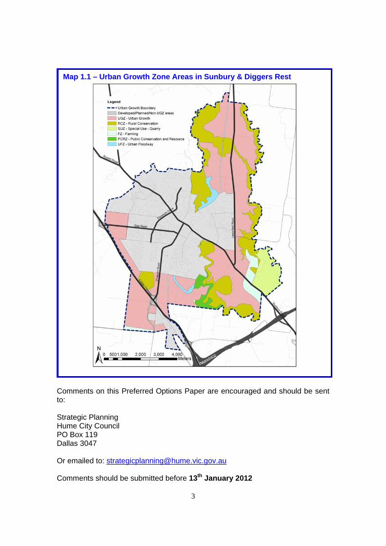
1. Introduction In August 2010, the State Government confirmed changes to the Urban Growth Boundary (UGB) in Melbourne, effectively releasing further land for development in growth areas to meet the needs of a fast growing Melbourne population. Sunbury is one area where the boundary has been changed along with the Hume Corridor and areas within Casey, Whittlesea, Wyndham, Melton and Mitchell Shire Councils. The areas for new development zoned Urban Growth Zone (UGZ) in Sunbury are shown in Map 1.1. The implications of this change for Sunbury are significant. Ensuring that the opportunities presented by this change benefit communities in Sunbury and deliver new development which is sustainable long into the future requires a comprehensive planning approach. Sunbury Hume Integrated Growth Area Plan (HIGAP) is a comprehensive review of planning for Sunbury that will be Council’s new plan for the township. It will identify, amongst other matters, where and when Council thinks that new housing, employment and infrastructure should be delivered whilst retaining Sunbury’s rural setting and character. It will also inform the growth area planning of the Growth Areas Authority as well as the investment strategies of Council, State Agencies and developers.
1.1. Purpose of this Document This Preferred Options Paper is the third paper prepared to inform the Sunbury HIGAP and outlines Councils preferred approach to the management of growth in Sunbury. An Emerging Options Paper and a Detailed Options Paper were previously prepared and outlined options for the future management of growth in Sunbury. Both were informed and subject to community and stakeholder consultation in May/June 2011 and August/September 2011 respectively. This Preferred Options Paper responds to the feedback received from the community, stakeholders and State Agencies and reflects the outcomes of technical work on: employment, transport, activity centres, community infrastructure, visual and landscape impact and open space. The Emerging and Detailed Options Paper and the Community Consultation Reports are available from the following link and it is recommended that readers of this document also read these: http://www.hume.vic.gov.au/Whats_On/Your_Say/HIGAP
3
Comments on this Preferred Options Paper are encouraged and should be sent to: Strategic Planning Hume City Council PO Box 119 Dallas 3047 Or emailed to: [email protected] Comments should be submitted before 13th January 2012
Map 1.1 – Urban Growth Zone Areas in Sunbury & Diggers Rest

4
1.2. Structure of Document
This document adopts the following structure: Section 2: Vision and Objectives Section 2 outlines the preferred Vision and Objectives. Section 3: Future Spatial Structure of Sunbury This section details the preferred future Spatial Structure of Sunbury and shows at a broad level the preferred location of employment areas, activity centres, open space, road infrastructure and public transport, as well as open space. It also shows the preferred phasing and sequencing of development Section 4: Sunbury’s Precincts Section 4 then provides greater detail and guidance on the preferred future development for the different precinct areas in Sunbury where the greatest change is going to occur:
Sunbury West Sunbury South (including land the beyond the UGB) Sunbury South East Sunbury North East Central Sunbury Diggers Rest
This includes detail on the broad scale of different land uses, future infrastructure and specific design considerations for development in these areas. Section 5: Delivery & Implementation Section 5 outlines Council’s position on the roles and responsibilities for delivering the development in Sunbury. Section 6: Next Steps Section 6 outlines the next steps involved in finalising the Spatial Strategy and Delivery Strategy for Sunbury HIGAP.
5
2. Vision & Objectives
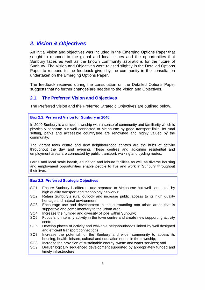
An initial vision and objectives was included in the Emerging Options Paper that sought to respond to the global and local issues and the opportunities that Sunbury faces as well as the known community aspirations for the future of Sunbury. The Vision and Objectives were revised slightly in the Detailed Options Paper to respond to the feedback given by the community in the consultation undertaken on the Emerging Options Paper. The feedback received during the consultation on the Detailed Options Paper suggests that no further changes are needed to the Vision and Objectives.
2.1. The Preferred Vision and Objectives
The Preferred Vision and the Preferred Strategic Objectives are outlined below.
Box 2.1: Preferred Vision for Sunbury in 2040
In 2040 Sunbury is a unique township with a sense of community and familiarity which is physically separate but well connected to Melbourne by good transport links. Its rural setting, parks and accessible countryside are renowned and highly valued by the community. The vibrant town centre and new neighbourhood centres are the hubs of activity throughout the day and evening. These centres and adjoining residential and employment areas are connected by public transport, walking and cycling routes. Large and local scale health, education and leisure facilities as well as diverse housing and employment opportunities enable people to live and work in Sunbury throughout their lives.
Box 2.2: Preferred Strategic Objectives
SO1 Ensure Sunbury is different and separate to Melbourne but well connected by high quality transport and technology networks;
SO2 Retain Sunbury’s rural outlook and increase public access to its high quality heritage and natural environment;
SO3 Encourage use and development in the surrounding non urban areas that is supportive and complimentary to the urban area;
SO4 Increase the number and diversity of jobs within Sunbury; SO5 Focus and intensify activity in the town centre and create new supporting activity
centres; SO6 Develop places of activity and walkable neighbourhoods linked by well designed
and efficient transport connections; SO7 Increase the potential for the Sunbury and wider community to access its
housing, health, leisure, cultural and education needs in the township; SO8 Increase the provision of sustainable energy, waste and water services; and SO9 Deliver logically sequenced development supported by appropriately funded and
timely infrastructure.

6
3. The Future Spatial Structure of Sunbury
Both the Emerging Options Paper and the Detailed Options Paper discussed the future development of Sunbury by themes: Working in Sunbury, Living in Sunbury, Moving in and out of Sunbury, and Sunbury’s Resource Future. In the Detailed Options Paper, emerging preferred options were outlined for the future location of employment land, activity centres, community infrastructure, transport infrastructure and open space. Emerging preferred positions were also outlined on how to retain Sunbury’s rural outlook, visual and landscape qualities, as well as resource sustainability and the future phasing of development. Whilst there was considerable support in the feedback for many of the emerging preferred options and positions in the Detailed Options Paper, some feedback did not support the emerging preferred options for the location of employment land, the phasing of development and the location of activity centres. In response to this, further work has been undertaken to consider the feedback and some revisions have been made accordingly. The preferred approach for each theme has been combined to give a Future Spatial Structure of Sunbury shown in Map 3.1 with the component parts then outlined. More detail on specific precincts of Sunbury is provided in Section 4.
3.1. Employment
The Detailed Options Paper outlined the work undertaken by AEC Group to identify an appropriate and realistic target for future employment in Sunbury and the additional land and development required to achieve this target.
3.1.1. Preferred Approach - Employment
The preferred approach is to adopt the targets and land requirements identified in the Sunbury Economic Assessment1 with additional industrial land identified to allow existing businesses in Sunbury to relocate to more suitable premises. These targets and land requirements are outlined in Box 3.1 below and are in addition to the land currently zoned for industrial or business development in Sunbury. As shown on Map 3.1, the preferred locations for the industrial land are along Vineyard Road to the Calder Freeway, in land north of Diggers Rest and along Sunbury Road with the split as follows:
40 to 50ha of industrial (transport and logistics) development in the area adjoining Diggers Rest
1 Sunbury Economic Assessment 2011 – undertaken by AEC Group for Hume City Council

7
MAP 3.1 – Preferred Growth Strategy for Sunbury

8
50 to 60 ha of industrial and office type land along Vineyard Road 50 to 70 ha of industrial type land along Sunbury Road
The preferred approach is for the land at Diggers Rest and along Vineyard Road to be targeted at regional and state sized companies as well as local companies seeking large lots in good proximity to the road network and a strong labour force. Given the flat and large nature of the land at Diggers Rest this land is targeted primarily at transport and logistics companies whilst land along Vineyard road is targeted primarily at light industrial and commercial companies. However a flexible approach and zoning is preferred to enable these areas to be able to provide land and premises for a full range of companies. The land on Sunbury – Bulla Road does not have the same access qualities with limited access to the major road network and public transport. The preferred approach is therefore for this land to be targeted at smaller scale local companies, including those existing within Sunbury who need to or may chose to relocate to more suitable premises. This land is also targeted at companies that may complement the quarry and future recycling activities in this area.
Some of the land to the south of Sunbury that is currently outside of the UGB is shown as a long term option for employment development as it is dependent upon a future review of the UGB and confirmation from Vic Roads that access will be retained on to the Calder Freeway at this location with construction of the Outer Metropolitan Ring (OMR). If these issues are resolved, the preferred approach would be to review the scale of development in the preferred locations. For retail, the majority of commercial floorspace and for future health and education facilities, the preferred location is in the existing Sunbury Town Centre and in the new supporting activity centres. As the scale of retail development is not solely about generating jobs but also about meeting demand by the community for access to goods and services, the requirement for retail
Box 3.1: Preferred Jobs Target and Land Requirements The Preferred Employment Targets for Sunbury are:
25,000 jobs in Sunbury by 2041 30,000 jobs in Sunbury assuming a population of 100,000 people
The Required Land to achieve these targets is:
140 to 180ha of industrial land 93,000 sq.m of commercial floorspace 100,000 sq.m of retail floorspace Additional education and health facilities

9
floorspace in Box 3.1 is a guide. Final retail floorspace figures will be determined through the detailed planning of the activity centres.
3.1.2. Why is this the Preferred Approach for Employment
Having a large number and diversity of jobs in Sunbury is a critical objective for the future of Sunbury. The jobs target and the land requirements in Box 3.1 are based on a detailed Economic Assessment by AEC Group which sought to marry aspirations for jobs growth and reduced out-commuting with the realities of the challenges and opportunities for employment growth in the Sunbury area.
The challenges of providing the scale and diversity of employment in Sunbury are and will remain significant, meaning that the land that is most suitable for employment must be zoned and developed for employment. The preferred future employment locations are the most suitable of all the sites appraised by AEC Group, particularly the land along Vineyard Road and at Diggers Rest given their existing access on to the Calder Freeway. Land on Sunbury-Bulla Road is suitable but until the OMR and Bulla Bypass is constructed will have a more limited access to the major road network. Design and landscape measures will be required in all three preferred locations to minimise the impact of potential large buildings on the landscape and entry into Sunbury (see Section 4).
Whilst the land to the south of Sunbury outside the UGB and south of Diggers Rest has some potential, their development is heavily reliant upon the provision of major new transport infrastructure or changes to the UGB which are uncertain. Given the importance of providing additional employment in Sunbury it is not considered appropriate to have employment growth in Sunbury dependent upon these sites at this stage.
The preferred scale of employment development on each site reflects the need to maximise the development potential of the best employment sites and the need to provide critical mass and presence. It also ensures that a range of sites and opportunities for different sectors of the economy and potential needs of different businesses are provided for. In the case of the land at Diggers Rest, the scale of development also enables the Diggers Rest community to grow to a scale of around 10,000 to 11,000 people and therefore be able to support critical services like a supermarket, a primary school and community services.
3.2. Activity Centres & Large Scale Community Infrastructure The Detailed Options Paper identified the importance of balancing the need to provide new activity centres with the desire and aspiration to maintain the importance and primacy of Sunbury Town Centre. It also identified the need to identify potential locations now for large scale community infrastructure.

10
3.2.1. Preferred Approach - Activity Centre & Large Scale Community Infrastructure
The preferred approach is to have activity centres of varying sizes and importance in the locations shown on Map 3.1. Under this approach, the Sunbury Town Centre would be the primary activity centre in Sunbury and be classified as a Principal Activity Centre (PAC) in the future. Whilst it would continue to provide for the everyday needs of the Sunbury community, the emphasis would be more on servicing the higher order requirements of Sunbury and the wider region, particularly for retail and service needs. It would provide:
Over 90,000 sq.m of retail including discount department stores, mini majors and high street retailers
Around 45,000 sq.m of office and commercial floorspace Leisure, eating and drinking opportunities Community facilities, including: an enlarged community health centre, a
library and learning centre, and an enlarged youth centre. If the State Government commit to delivering a new hospital (or equivalent) the town centre would be the preferred location owing to its high accessibility with the Major Activity Centre (MAC) a preferred secondary location if a town centre site is unachievable. For a new university/TAFE, the preferred location is the former VU site with the town centre and the proposed MAC preferred secondary locations. The former VU Site is discussed more in Section 4. In addition to the Sunbury town centre, the preferred approach is to have a series of new Neighbourhood Activity Centres (NACs) and Local Activity Centres (LACs) supporting the town centre, primarily in the new development areas. The NACs would be based around a large supermarket, multi purpose community centre, a primary school and active sporting facilities. They will also include a small range of uses like cafes, restaurants, speciality food shops, real estate agents and small scale office and medical facilities. Where the demand is sufficient a secondary school and indoor sports facility may also be provided. Medium and higher density housing will also be planned for in and on the edge of the NACs especially those which adjoin a train station. For LACs, the preferred approach would be for them to be far smaller and be based around a small supermarket with a small range of convenience shops and maybe some community and active sport facilities. A MAC is preferred to north east of Sunbury adjacent to the proposed train station. This MAC would be larger than a NAC, principally because it will also support a second library, some large scale sports facilities and potentially a new hospital (or equivalent) and university/TAFE if neither the VU site or a town centre site is considered suitable. Importantly, it is not proposed that this MAC support a large scale of retail or commercial development to ensure it does not

11
adversely impact on the Sunbury Town Centre. As with NACs, medium and high density housing is proposed in and adjoining this MAC. A bulky goods centre of approximately 50,000 sq.m is also preferred on the eastern side of Vineyard Road near to the Calder Freeway and adjacent to the proposed employment area. This will provide an alternative and complimentary location to the land identified for bulky goods on the edge of Sunbury Town Centre to the south of Station Street. Each new centre is discussed in more detail in the respective precinct area in Section 4.
3.2.2. Why is this the Preferred Approach for Activity Centres and Large Scale Community Infrastructure
Sunbury Town Centre is the current focus for community activity and its prominence is an important part of the character of Sunbury. Keeping it the primary centre whilst delivering new smaller supporting centres is an important part of the vision for Sunbury. In particular, it will help to retain the character of Sunbury and enable people to access retail and services largely within 1km of their home.
The scale of development proposed in the town centre is based on work undertaken by Hassell Studios with Charter Keck Cramer which assessed the capacity of the existing town centre to accommodate future development whilst retaining its specific design qualities. Whilst the town centre could potentially support a higher level of floorspace than outlined above and will be encouraged to do so, the figures above are considered more realistic given the costs associated with redeveloping some areas.
Charter Keck Cramer also identified that the scale and format of the new activity centres must not provide significant additional opportunities for competing development, particularly in the short to medium term, to ensure investment is directed to the Sunbury Town Centre. The preferred location, scale and phasing of the development of new activity centres achieves this by ensuing that the majority of new development in the new activity centres is directed at meeting local need. In particular, the MAC is planned to have limited retail and to be delivered later in the longer term, enabling Sunbury Town Centre to consolidate its position as the primary centre.
Land and opportunities for bulky goods development is highly constrained at present to land immediately adjoining the town centre which is placing inappropriate pressure for such uses to locate in industrial land. A bulky goods retail park along Vineyard Road would provide and alternative location and meet the requirements of large format retailers to be on and near the major road network. It would also ensure these high traffic generating uses do not adversely impact upon the road network in Sunbury town centre. Whilst the land is not

12
perfectly flat, it is considered developable and can be designed to have a minimal impact on Bald Hill and the gateway appeal of Vineyard Road.
3.3. Transport Connectivity Improving road and public transport connectivity between Sunbury and Melbourne and enabling people to move in and around Sunbury is critical to the Sunbury township being able to support the level of growth proposed.
3.3.1. Preferred Approach – Transport Connectivity
The preferred approach for connecting people in Sunbury with Melbourne is to pursue the following combination of road and public transport upgrades:
An upgrade to Sunbury Bulla Road and the construction of the Bulla Bypass;
An extension to the Smart Bus Service to connect Sunbury to Melbourne Airport and Broadmeadows;
The delivery of 3 additional train stations with the first being to the south of Jacksons Hill; and
An off road cycle path connecting Sunbury with Melbourne Airport and wider Brimbank area.
Road and public transport connections from Lancefield Road to the Hume Corridor will also continue to be considered until the OMR is confirmed to ensure that Sunbury has suitable transport connectivity to the Hume Corridor and its many employment opportunities if the OMR is not delivered. To enable people to move better in Sunbury, the preferred approach is to extend Elizabeth Drive to Vineyard Road and Racecourse Road, upgrade Lancefield Road and develop a Northern and Southern Link to complete an orbital loop within Sunbury that is used by a high frequency bus service. This will be supported by a network of off and on road walking and cycling opportunities and additional rail crossings for road, public transport and walking and cycling. As a combination, these will enable people to access different parts of Sunbury and enable through traffic to bypass the town centre. Work undertaken to date has shown that there are two feasible and potentially viable alignments of the Southern Link. A detailed examination of the physical, financial and environmental constraints will be undertaken to assess the different cost and environmental implications of these alignments. These alignments are discussed more in Sections 4 and 5. Further work is also required to confirm the feasibility of the Northern Link as this could also have implications on the environmental qualities of Sunbury that need to be appropriately considered.

13
3.3.2. Why is this the Preferred Approach for Transport Connectivity Improved road and public transport connections between Sunbury and Melbourne Airport and the Hume Corridor will be critical to achieving the vision of a Sunbury that is separate but connected by enabling people to access work and services outside of Sunbury, particularly by public transport. Whilst the number and scale of improvements are significant and costly, they are critical to ensuring appropriate, sustainable and safe travel for the significantly increased population. Likewise, the orbital connections in Sunbury will be critical to relieving traffic travelling through Sunbury Town Centre and enabling people in different parts of Sunbury to be connected to each other and to new community infrastructure. Without these improvements, the existing transport network will be placed upon significant and unacceptable strain and undermine the quality of life of existing and future residents. The Northern and Southern Links are particularly important and need to be delivered. However, given the environmental and landscape sensitivities of Jacksons Creek and its escarpment, and the Holden Flora and Fauna Reserve, a detailed assessment is needed of different alignments to ensure the most appropriate is identified. Funding and delivering this number and scale of improvements to the transport network is challenging and is discussed more in Section 5.
3.4. Open Space Network Sunbury’s topography, landscape and rural qualities, present significant and plentiful opportunities to provide an open space network that is the envy of many and that creates a real point of difference between Sunbury and other areas. These opportunities were mapped and included in the Detailed Options Paper. Further work has subsequently been undertaken to prioritise these areas.
3.4.1. Preferred Approach – Open Space Network The preferred approach, as shown in Map 3.1, is to develop regional open space parks along both Jackson’s Creek and Emu Creek and their associated escarpments. These Regional Parks would be based on linear trails for walking and cycling along the escarpments and the creeks with larger open space areas located along them for informal activity. The preferred approach is to also develop two regional hill top parks at Mount Holden and at Redstone Hill. In combination these links and hill tops will provide a highly significant open space area for the Sunbury community and enable them to access and enjoy Sunbury’s unique landscape. Their delivery is dependent upon support of DSE, Parks Victoria and Melbourne Water as well as numerous landowners and is discussed more in Section 5.

14
To ensure a more complete and continuous open space network, the preferred approach is to also provide a range of smaller links through neighbourhoods which connect people to these regional spaces as well as to neighbourhood parks, sporting reserves and activity centres. Where possible these will follow creek and drainage lines to enhance these as landscape and biodiversity opportunities and will be designed to enable walking and cycling. These more local open spaces are discussed more in Section 4. Neighbourhood parks will be provided throughout the new development areas and provide a range of formal and informal open space and play areas and ensure everyone has good access to open spaces.
3.4.2. Why is this the Preferred Approach for the Open Space Network
A strong and important part of the vision for Sunbury is for the community to have high levels of public access and enjoyment of the unique landscapes and rural areas of Sunbury. Jackson’s Creek, Emu Creek and their escarpments as well as Mount Holden and Redstone Hill are the largest and most significant landscape features in Sunbury and offer huge potential for a high quality open space experience for the community. They also have significant native vegetation and biodiversity qualities that need to be conserved. Initial work suggests that delivering these spaces is potentially feasible and affordable but will require funding and resources of developers, Council, DSE, Melbourne Water and Parks Victoria to be directed to these areas in Sunbury if they are to be realised. Whilst Bald Hill is another potential hill top park, the level of resource required to achieve public access is significant and therefore the preferred approach is to keep it as an area for conservation protection.
3.5. Phasing and Sequencing of Development Map 3.2 shows the preferred phasing and sequencing approach for the development of the UGZ land. This reflects the variations in the relative certainty of the transport capacity within different areas to support new development now and into the future as upgrades are enabled. Those most dependent on new transport infrastructure are shown in the later sequencing. Map 3.3. shows how these areas should be planned and reflects the need for areas that share infrastructure requirements to be planned at the same time. Notably, the preferred approach would see the land to the south and south east of Sunbury being planned together to facilitate the delivery of the Southern Link. This Map aligns closely with the boundaries proposed by the GAA.

15
MAP 3.2 – Preferred Phasing Strategy for Sunbury

16
MAP 3.3 – Preferred Precinct Planning Strategy for Sunbury

17
3.5.1. Sunbury South and Sunbury West
The preferred approach would be for the UGZ land to the South and West of Sunbury to be developed first with development potentially starting within 3 to 5 years subject to the resolution of the planning and funding of the Southern Link, and commitment from State Government to the delivery of the future train station to the south of Jacksons Hill. However, should State Government not commit to delivering a train station within a reasonable period of development starting, the preferred approach would be to delay or slow the development of the southern area to avoid inappropriate pressure on the existing town centre station and road network. Fragmented landownership in these areas may mean that development occurs later and over a more lengthy timeframe. To ensure a comprehensive approach to the planning of the Southern Link, the preferred approach is to plan the land to the east of Jackson’s Creek up to the Sunbury Road with the land to the south as per Map 3.3. Likewise, the preferred approach is for the UGZ land to the west of Sunbury to be planned at the same time as the land off Barrington Lane which is subject to a future rezoning from Rural Living Zone to Residential 1 Zone.
3.5.2. Sunbury South East and East
For land to the South East and East of Sunbury, as outlined in 3.5.1, the preferred approach would have some of the land to the South East of Sunbury planned at the same time as the land to the South of Sunbury to ensure that the planning and funding of the Southern Link is comprehensive and appropriate. Much of this land is controlled by developers with the capability to develop land quickly. However, traffic along Sunbury – Bulla Road at present is significant and there is limited scope for increased traffic prior to its upgrade and the construction of the Bulla Bypass. The development of this area in the short term is therefore constrained until the Southern Link is constructed to provide access to the Calder Freeway and an alternative train station. The preferred approach is therefore to limit development until the capacity constraints on the Sunbury Bulla Road are resolved and until the Southern Link and the future train station is funded and constructed. For this reason, the preferred approach is for the land to the East and South East to be medium term development options. That said, if additional capacity along Sunbury - Bulla Road is achieved, either through the construction of the Bulla Bypass or the upgrade of Sunbury - Bulla Road, and access to a train station appropriately achieved from these areas, the preferred approach would be for these areas to be developed sooner.

18
3.5.3. Sunbury North East and Land to the South of the UGB The UGB land to the North East of Sunbury is considered to be a long term and very long term development opportunity and should not proceed until there is certainty around the timing and funding of the potential train stations and the Northern Link. Land to the south of the current UGB is preferred in the longer term and only when there is certainty around the access from this area to the Calder Freeway and/or the OMR. It is also preferred for this land to developed when the majority of development within the UGB to the south of Sunbury is completed. However, the preferred approach is for this area to be considered in the planning of the land in Sunbury South and Sunbury South East to ensure appropriate access and connectivity is achieved.
3.5.4. Why is this the Preferred Approach for Phasing
Having development appropriate sequenced and supported by appropriately funded and timely infrastructure is an important objective for the future growth of Sunbury and a fundamental purpose of the Victorian Planning System. The preferred approach ensures that development is sequenced and promotes development where there is capacity in the transport network to support new development. It also seeks to constrain development where there is not capacity or where there is uncertainty around future investment in upgrading the infrastructure to support development. However, it does not preclude the comprehensive and appropriate planning of areas and has the flexibility for areas to be developed sooner should capacity be improved.

19
4. Sunbury’s Precincts This Section outlines in more detail the preferred approach for different precincts in Sunbury based on Map 4.0 below.
MAP 4.0 – Precincts of Sunbury

20
4.1. Sunbury West Precinct The Sunbury West Precinct comprises land principally from Vineyard Road and Elizabeth Drive to the Calder Freeway. The majority of this land is developed or being developed. However, there are large areas that are subject to further planning including a large area zoned Residential 1 Zone off Vineyard Road and Mitchells Lane and an area to the west zoned Rural Living Zone and Urban Growth Zone. There is also an area adjacent to the Calder Freeway off Gap Road that Council consider should be brought inside the UGB. The Preferred Spatial Structure of Sunbury outlined in Section 3 shows that the main planned change in this area is the continuation of residential development from Vineyard Road to the Calder Freeway. A new NAC is proposed on Gap Road with a LAC on the intersection of the extended Elizabeth Drive and Vineyard Road. The principle development proposed in this precinct is summarized in Box 4.1 and shown spatially in Map 4.1.
4.1.1. The Preferred Approach for Sunbury West The preferred approach for Sunbury West is for the NAC on Gap Road to include a large supermarket (approximately 3,000 sq.m), other speciality shops (around 3,000 sq.m), cafes, restaurants and other uses (around 3,000sq.m). In or adjoining this NAC, the preferred approach is to have a primary school, a multi-purpose community facility, and a large sporting reserve. For the LAC on Vineyard Road, the preferred approach is for it to comprise a small supermarket (approximately 1,500 sq.m), and minimal other shops and uses reflecting its more convenience role. Transport Connectivity The main transport improvements proposed in this location is an extension to Elizabeth Drive to Vineyard Road that will form part of the Orbital Link with associated high frequency bus services. The preferred approach is for Gap Road
Box 4.1 – Principle Development in Sunbury West Precinct
Mix of residential development densities to the south of Mitchells lane and to the west up to the Calder Freeway;
A NAC comprising a supermarket, active sports and community uses, other shops and services;
A hill top park at Mount Holden and other linear and neighbourhood parks; and
A high frequency bus service and improved walking and cycling facilities to connect this area to the town centre.

21
MAP 4.1 – Preferred Plan for Sunbury West

22
to be upgraded with a dedicated cycle lane and high frequency bus service running along it to link the future residential areas with the town centre. To connect the fragmented open space areas and linear parks, improved walking and cycling facilities are preferred. This will be delivered through the Walking and Cycling Strategy (see Section 5). Housing The preferred approach is to have a range of housing densities with some medium density around the NAC comprising a mix of townhouses, apartments and units. In the remainder of the area, conventional density (minimum 15 d.p.h) is preferred. If developed in this way, this precinct area could deliver a further 3200 to 3700 dwellings on top of the 9,000 dwellings that exist now or are already planned in this part of Sunbury Open Space & Community Facilities As well as the active sports in the proposed NAC, the preferred approach is to have a hilltop park on Mount Holden. A series of linear parks and neighbourhood parks are also preferred to connect the new development areas with the existing area. Whilst Bald Hill is not a preferred open space area, it will be protected from increased development and conserved as an important landscape feature. To accommodate the demand for increased community facilities, in addition to the proposed multi-purpose community facility and primary school in the NAC, the preferred approach is to provide expanded or additional facilities in the existing area or in the proposed LAC on Elizabeth Drive. Design Considerations In this area, the preferred approach will be for design of residential development to have particular regard to the interface between residential development and the Calder Freeway to ensure that noise issues are appropriately considered. A continuation of the strong and very characteristic landscape treatments along Gap Road is also preferred to maintain the more rural feel to this part and entry into Sunbury. Around the foot of Bald Hill, the preferred approach is for detailed consideration to be given to the height and scale of residential development to ensure that the visual importance and dominance of the hilltop is retained.

23
4.2. Sunbury South The southern precinct of Sunbury includes the Jackson's Hill area and the land to the south between Jackson's Creek and Vineyard Road. The Jackson's Hill estate is largely developed with only the small activity centre and a small number of lots remaining to be developed. To the west of Jacksons Hill and beyond the train line, there is some mixed industrial and retail uses, including the Bunnings Warehouse. To the south of this there is approximately 40ha of currently undeveloped land zoned for industrial development. The main changes in this precinct area are located in the areas zoned Industrial Zone and Urban Growth Zone to the west and south of Jackson's Hill to the east of the Vineyard Road. The principle development proposed in this precinct is summarized in Box 4.2 and shown spatially in Map 4.2
4.2.1. The Preferred Approach for Sunbury South
The Former Victoria University (VU) Site The preferred approach for the former VU site is for it to remain as a location for a potential university/TAFE, education and wider community uses, including active sports use. Council is committed to working with VU and State Government to achieve this and to ensure the preservation of and community access to the historically significant buildings. Land West of the Train Line To the west of the train line, the preferred approach is for the existing undeveloped industrial land between Vineyard Road and the railway line to be developed for industrial uses as per the current zoning controls.
Box 4.2 – Principle Development in Sunbury South Precinct
A Southern Link connecting Vineyard Road with Sunbury – Bulla Road Continued use of the former VU Site as a university/TAFE; Industrial, business and bulky goods development along Vineyard Road A new train station with adjoining NAC comprising supermarket, other
shops, schools, active sports and community facilities; Residential development of a mix of densities and type including
medium and high density development around the train station and NAC; and
Regional open space along Jacksons Creek with other linear parks.

24
MAP 4.2 – Preferred Planning for Sunbury South

25
Further south in the land adjacent to the intersection with the Calder Freeway a mix of light industrial and business development (50-60ha) is preferred. Whilst planning controls will need to be flexible, the aspiration for this area is for a high quality designed employment area comprising a mix of flexible light industrial and office premises suitable for low intensity manufacturing, general business and logistics users. Adjacent to this, the preferred approach is for a bulky goods retail park (around 50,000sq,m). Again, planning controls will need to be flexible, but the preferred approach would be for a homemaker style retail park. Given the need to protect the views across this area and the remaining rural qualities of Vineyard Road, the preferred approach is to mitigate the visual intrusion of large scale buildings through landscape and vegetation buffers along Vineyard Road, height restrictions and appropriate use of materials to all new buildings. To maximize the proximity to the proposed train station and to help achieve a more appropriate entrance to the proposed residential area to the east of the railway line, some mixed use and residential development is also preferred on the western side of the train line. Land East of the Train Line The land to the east of the train line and south of Jackson's Hill is preferred for residential development with a NAC adjacent to the train station. The NAC in this area is intended to be the focus for the new community in this area as well as helping to provide greater accessibility to local facilities for residents in Jacksons Hill. The preferred approach is for this NAC to include a large supermarket (approximately 3,000sq.m), a range of speciality shops (around 3,000sq.m), cafes, restaurants and other uses (around 3,000sq.m) and a multi purpose community facility. In the NAC, or adjoining it, the preferred approach is to have a primary school, a secondary school and active sporting reserves. High and medium density housing comprising a mix of townhouses, apartments and units is also preferred in and adjoining the NAC and train station to maximize the accessibility to public transport and amenity of local facilities. Land Beyond the UGB Another area of potential significant change is to the south of this area and beyond the boundary of the current UGB. Both Council and State Government consider this area to be a long term direction for further development in Sunbury subject to appropriate measures to mitigate the potential impact on the flight paths of Melbourne Airport and subject to appropriate access. The preferred approach is therefore to consider this area for potential development in the longer term for a mix of residential and employment development. Work needs to be undertaken to confirm the extent of the

26
constraint of developing the land under the flight path and the potential for access to be retained on to the Calder Freeway and/or the OMR. To provide appropriate access for this area, the preferred approach is to also explore how to best connect this area to the proposed Southern Link. Transport Connectivity For transport, the preferred approach is to develop the Southern Link from Vineyard Road through this precinct to the south of Jackson's Hill and across Jackson's Creek to the Sunbury-Bulla Road. A grade separated crossing will be required to go over the train line with potential for additional pedestrian and cycle crossings further south to provide access to the employment area and bulky goods centre. The potential to link Jackson’s Hill with Vineyard Road under the viaduct will also continue to be explored. Two alignments for the Southern Link are being explored and are shown in Map 4.2.1. The northern option traverses to the south of the incised Harpers Creek and across Jackson’s Creek via an elevated bridge. The southern option traverses further south, down the escarpment and crosses Jackson’s Creek via a smaller bridge. The two alignments then traverse around Redstone Hill to connect to Sunbury Bulla Road. Both these alignments traverse through the Holden Flora and Fauna Reserve and therefore the environmental impacts of each option needs to be explored. This is discussed further in Section 5. To maximise connectivity of the Sunbury community with the proposed train station and the NAC whilst maintaining a good level of amenity, the preferred approach is for the Southern Link to be designed for low speeds and good quality pedestrian and cycle facilities along and across it. The preferred approach is to also provide connectivity between the Jackson's Hill estate and these new areas of development through vehicular, walking and cycling connections with Belleview Drive and Ironbark Drive. Housing Around the NAC and land immediately adjoining the train station, the preferred approach is to have high and medium density housing comprising a mix of apartments, town houses and units. In the remainder of the area, the preferred approach is to have largely conventional residential development (minimum 15d.p.h). The exception to this a ridged area adjacent to Jackson’s Creek which is highly sensitive in visual and landscape terms. Here, lower density development may be required to ensure that the design, orientation and scale of development minimises the visual impact of development. If this approach were adopted this could result in 3,200 to 3,700 additional dwellings in this area.
27
Open Space The creation of a regional linear park along Jackson’s Creek will provide a significant area of open space on the eastern edge of this area and provide walking and cycling trails into the centre of Sunbury and southwards potentially to Organ Pipes Regional Park. The preferred approach is to supplement this with additional linear parks with walking and cycling connectivity along drainage corridors, notably the Harpers Creek at the foot of Jacksons Hill. These east west open space links will connect this community to the Jackson's Creek Park, the Holden Flora and Fauna Reserve and the potential future Redstone Hill Park. The preferred approach is to also have neighbourhood parks to provide more local and immediate access to green spaces. Urban Design The principal urban design consideration in this Sunbury South Precinct is the creation of a suitable gateway appearance along Vineyard Road. The preferred approach is to develop specific guidelines for setbacks, building heights, materials, signage and landscaping to ensure that the proposed industrial, commercial and bulky goods development provides this and retains the visual dominance of Bald Hill in the landscape. Consideration will also be given to landscaping throughout this area to ensure that views across this area remain rural in feel. Another important design consideration in the area is the interface between residential development, the open space areas and the important landscape features, particularly Jacksons Creek and the Holden Flora and Fauna Reserve. The preferred approach is to ensure appropriate setbacks and road frontages are achieved and ensure that development is appropriately orientated towards these features. The design of the train station and how it integrates and is connected to the NAC will also be important. It will be particularly important to ensure that car parking does not separate the train station from the NAC and residential areas surrounding it.
4.3. Sunbury South East and East The Sunbury East precinct comprises land to the east of Jackson's Creek to the escarpment of Emu Creek. With the exception of the Goonawarra Estate very little of this precinct is developed with the majority zoned UGZ and RCZ. Jackson's Creek and its escarpment provide a unique and high quality landscape but act as a barrier to connectivity between this area and the rest of Sunbury.

28
The RCZ protects Jackson's Creek and Emu Creek and their escarpments, though further set backs will be required to prevent development being too visually prominent, particularly when viewed from the creeks. The RCZ also includes two vineyards and an olive farm that currently contribute to Sunbury's rural character and are important attractions for the township. The principle development proposed in this precinct is summarized in Box 4.3 and shown spatially in Map 4.3.
4.3.1. The Preferred Approach for Sunbury South East & East
The main changes in this area will occur almost exclusively in the UGZ areas on the plateau above Jacksons Creek and Emu Creek and within the existing Goonawarra Local activity Centre. The preferred approach is for this area to be developed for residential development with three new activity centres of varying sizes. A large NAC will be located at the intersection of Lancefield Road and Sunbury Bulla Road to maximise its location at the intersection of two important roads. The centre will serve a wide area to the immediate south and north and the preferred approach is for this centre to comprise: a large supermarket (approximately 3,000 sq,m) and potentially a second supermarket, other speciality shops, cafes and restaurants (around 5,000 sq.m), commercial office space (around 4,000 sq.m) and a multipurpose community centre. Within or adjoining this NAC, the preferred approach is to also have a primary school, secondary school and active sports reserves.
Box 4.3 – Principle Development in Sunbury South East & East Precinct
A Southern Link connecting Vineyard Road with Sunbury – Bulla Road Upgrade to Sunbury - Bulla Road and Lancefield Road; A large NAC comprising two supermarkets, other shops and
commercial uses, schools, community and active sports facilities on Sunbury – Bulla Road;
Enhancement and expansion of the community facilities and retail offer at the existing Goonawarra Local Activity Centre;
Residential development of a mix of densities and type including medium density development around the large NAC;
Around 50ha of employment land targeted at local industrial and business companies; and
Regional open space along Jacksons Creek and a hilltop park on Redstone Hill with other linear parks.

29
MAP 4.3 – Preferred Planning for Sunbury South East

30
To the south of this large NAC, the preferred approach is for a LAC to be provided which provides a more local convenience offer with a small supermarket (1,500 sq.m), a small range of speciality shops, an active sports reserve and potentially another primary shcool. The third activity centre in this location will be located to the east of Lancefield Road opposite the active sports reserves in the Goonawarra Estate. The preferred approach is for this LAC to help provide a greater activity around the active sporting reserves and to complement the existing community and convenience facilities in the Goonawarra Estate through provision of additional retail and community facilities. Approximately 100ha of land to the east of Sunbury Bulla Road is potentially available for development but currently restricted for residential development owing to the quarrying and related buffer area activities further east. The preferred approach is for around 50ha of this area to be developed for employment in the short term with the remaining area developed for further employment (subject to demand) or residential development in the longer term when quarrying activity ceases. Given the area’s current limited access to the major road network and public transport network, the preferred approach is for this employment land to be targeted at local companies and at businesses associated with the quarry and future recycling activities. Transport Connectivity Ultimately, the main transport connectivity to and through this area will be the upgrade to the Sunbury - Bulla Road, Lancefield Road and the provision of the Bulla Bypass. The Southern Link will also provide connectivity from this area to the proposed train station and the Calder Freeway and is therefore a critical infrastructure requirement to facilitate the development of this area in the short to medium term. Two potential alignments of the Southern Link are being explored and are shown in Map 4.3. The first traverses to the north of Redstone Hill and adjacent to the large NAC to connect to the Sunbury - Bulla Road at or adjacent to the intersection with Lancefield Road. The second alignment runs to the south of Redstone Hill and adjacent to the LAC. This link will provide this area with access to the potential train station south of Jackson's Hill as well as the Calder Freeway without the need to travel through Sunbury Town Centre. The preferred approach is for high frequency public transport services to be provided along Lancefield Road and the Southern Link ensuring good public transport connectivity from this area to the rest of Sunbury, including the new train stations and the proposed MAC. The preferred approach is also for an extension to the Smart Bus service to connect this area quickly and frequently with the Town Centre, Melbourne Airport and Broadmeadows area. The

31
preferred approach would have these two services connecting at the large NAC in this precinct. Housing The preferred approach is for the majority of this precinct to be developed at conventional density (15d.p.h) with medium density comprising townhouses, unit and apartments in and around the large NAC. The potential for development to have a serious adverse impact on Redstone Hill and the escarpments of Jackson's Creek and Emu Creek may make a lower density appropriate in the southern section of this precinct and in areas adjoining these features. If such an approach were adopted, this precinct could support 8,500 to 9,500 new dwellings. Open Space As with Sunbury South, the proposed Jackson's Creek Park will provide high quality accessible open space and conservation areas in this precinct with walking and cycling trails along the top of the escarpment and along the creek. Likewise the Emu Creek Park provides opportunities on the eastern side, though consideration will need to be given to the steep and complex topography particularly to the east of Lancefield Road as well as the quarry. The proposed Redstone Hilltop Park also provides a potential unique and high quality open space area and provides the local community and wider Sunbury community with wide ranging views across Sunbury and the wider area. The preferred approach is for a series of linear parks and neighbourhood parks to traverse through the future residential areas providing high quality open space, walking and cycling links between the two creeks, the two escarpments, Redstone Hill Park, and the NAC and the LACs. Urban Design The key design consideration in this area is the potential impact of residential development on the dominance of Redstone Hill. Unlike other hilltops in Sunbury which are much steeper, Redstone Hill is fairly shallow hill but is critical to the rural outlook and visual qualities of this area, particularly when viewed from the existing Sunbury area and Jackson’s Hill. It is also a highly important visual feature when travelling along Sunbury – Bulla Road. Consideration will therefore need to be given to building heights, landscaping and the extent of development at the foot of Redstone Hill to protect the dominance and visual qualities of Redstone Hill. Options to use roads and open space to maintain uninterrupted views to and from Redstone Hill will also be pursued. Design measures, particularly setbacks from the escarpment edge, will also need to be considered to minimise the visual impact of development on the

32
escarpments of Jacksons Creek and Emu Creek, particularly when viewed from these creeks. The Sunbury - Bulla Road, Lancefield Road and the Southern Link will also need to be carefully designed to ensure that they can provide efficient movement for vehicles whilst also enabling appropriate walking and cycling along and across it. In particular, it will be important for intersections to be appropriately located and designed to minimise the potential for them to create barriers to movement and divide communities.
4.4. Sunbury North East
The Sunbury North East precinct is defined by Jackson's Creek and Emu Creek to the west and east respectively. The train line and Lancefield Road both run through the area in a north-south direction. A large area of land which is Rural Conservation Zone splits this precinct in two and effectively creates two large areas for potential development. With the exception of the Rolling Meadows area, this land is largely undeveloped. The Visual and Landscape Assessment identified that development within large areas of this precinct, particularly the northern parts, would have a significant visual and landscape impact owing to it's very rural nature and long ranging views. Whilst not developing this area would help to retain these qualities, the land is already zoned UGZ making no development in this location an unlikely outcome. Therefore, the preferred approach is to design the area to maintain long ranging views from public areas, particularly along the escarpments and to consider design measures to maintain the rural qualities of this area. The principle development proposed in this precinct is summarized in Box 4.4 and shown spatially in Map 4.4. This area is considered unlikely to be planned or developed until the long term and so the preferred approach outlined below is potentially subject to change.
Box 4.4 – Principle Development in Sunbury North East Precinct A Northern Link connecting Lancefield Road with Racecourse Road; Upgrade to Lancefield Road; A MAC comprising two supermarkets, other shops and commercial uses, a
potential regional outdoor sports complex and additional large scale indoor sports facility, a library, schools, community and active sports facilities;
Land for a hospital or equivalent and a university/TAFE; A NAC and two LACs comprising supermarkets, schools, active sports
community facilities and other uses; Residential development of a mix of densities and type including high and
medium density development around the train stations and MAC; and Regional open space along Jacksons Creek and Emu Creek and their
escarpments with other linear parks.

33
MAP 4.4 – Preferred Planning for Sunbury North East

34
4.4.1. The Preferred Approach for Sunbury North East
The preferred approach is for this land to be developed for residential development with a MAC adjoining the proposed southern train station and a NAC adjoining the proposed northern station. The MAC would be the second largest activity centre in Sunbury. As it would developed in the longer term and when Sunbury Town Centre has had time to expand and consolidate its position as the primary activity centre in Sunbury, it could comprise: 1 or 2 supermarkets (up to 7,000sq.m), additional speciality retail development, small scale office development, cafes and restaurants, a library, and other community uses. The preferred approach is to initially cap retail floorspace at 25,000 sq.m with increases potentially permitted subject to findings of a retail impact assessment. Within or adjoining this MAC the preferred approach is to safeguard land for a potential regional scale outdoor complex and potential additional large scale indoor sports facility, a multi purpose community centre and a primary and secondary school. The MAC would also be a preferred alternative location for a hospital or equivalent and a university/TAFE. The NAC would comprise: a medium sized supermarket (2,500sq.m), a small range of speciality shops (up to 2,000sq.m) and a small number of cafes and restaurants and other uses (up to 2,000sq.m). In or adjoining this NAC, the preferred approach is to also have a primary school and active sports reserves. In addition to these activity centres, the preferred approach is to also have two LACs comprising a small supermarket (1,500sq.m), a small number of additional shops or cafe/restaurants, a sub district sports facility and a potential community facility. Transport Connectivity The preferred approach is for this precinct to be supported by two additional train stations to provide the new community with public transport access to Sunbury Town Centre and to inner Melbourne. The preferred approach is for the Northern Link to provide connectivity from Racecourse Road to an upgraded Lancefield Road through this precinct area and form part of the orbital high frequency public transport link around Sunbury. Considerable further work is required to identify an appropriate alignment for this Northern Link to ensure that it has the minimal impact on the landscape and the biodiversity qualities of Jacksons Creek and its escarpment. The preferred approach is for these large transport facilities to be supported by high quality walking and cycling facilities through the regional open spaces areas along the escarpment and valley of Jackson's Creek and the escarpment of Emu

35
Creek, as well as along Lancefield Road and the railway line. These will be connected by a range of walking and cycling facilities within open space links and along other roads. Housing To ensure the critical mass needed to support additional train stations and to maximize the opportunity to provide transit orientated development, the preferred approach is for high and medium density housing comprising a mix of apartments, townhouses and units in and immediately adjoining the NAC and MAC. In the remainder of the precinct area, the preferred approach is to have conventional density housing. If developed in this manner, this precinct could support 8,500 to 9,500 lots. Open Space The preferred approach is to maximise and provide public access to the landscape and visual qualities of Jackson's Creek and Emu Creek and their associated escarpments through the development of the Jacksons Creek and Emu Creek Regional Linear Parks with associated walking and cycling trails. To maximise the opportunity for the local and wider Sunbury community to enjoy the long ranging views that define the existing character of this area, the preferred approach is for open spaces with seating and other facilities to be provided along the two escarpments. This will help ensure that the community can still enjoy the long ranging views and rural qualities of this precinct even when fully developed. To connect the two regional parks, the preferred approach is to provide linear open space within or adjoining the RCZ area that dissects this area. Further smaller linear parks through the residential areas are also preferred to link residential areas with the activity centres, particularly the MAC, the train stations and the regional parks areas. Urban Design To protect the landscape and visual qualities of the escarpment when viewed from the creek valley, the preferred approach is to set development back from the escarpment edge. Appropriate interface treatments will also be needed with the large area of open space and conservation in the centre of the precinct. Roads and linear open spaces will also be designed and aligned to maintain views across and through development in this area to the hills beyond. As in Sunbury East, the design of Lancefield Road will be important to ensure that it does not become a barrier for east - west movement, particularly by pedestrians and cyclists, and measures are put in place to control vehicle speeds.

36
MAP 4.5 – Preferred Planning for Sunbury North

37
As potentially the second largest activity centre in Sunbury and home to a number of large new community and other large scale facilities, the design of the MAC will be important. The preferred approach would be for this MAC to be subject to detailed community consultation in the future.
4.5. Sunbury North The Sunbury North precinct is largely completely developed to the UGB with the exception of some remaining land at Canterbury Hills and the proposed development of Council land off Racecourse Road. There is limited retail or other local services in this area. The area is dominated by the numerous hilltops and ridgelines which are critical to defining the northern edge of Sunbury and the rural outlook from existing developed areas, particularly the town centre and from land to the south and east of Sunbury. These hilltops, the ridgeline and the land beyond comprise areas susceptible to significant erosion and areas of native vegetation importance. This creates land management issues but also conservation, open space and biodiversity opportunities.
4.5.1. The Preferred Approach for Sunbury North To protect the hilltops and ridgelines in this area, the preferred approach is to prevent development proceeding further up the hills than already permitted in approved plans. Beyond the hilltops and ridge line, and beyond the current UGB, the preferred approach would be for the land of most conservation value to be brought into public authority ownership with community access enabled to widen the open space and conservation network of Sunbury. To enable this, the preferred approach would be to allow some further subdivision of this land in lots of approximately 1 ha (and no smaller than 0.8ha) with the respective development contributions directed to achieving a high quality conservation and land management outcome. Importantly, the preferred approach would not see significant or dense development permitted in this area or any development on the hilltops or ridgelines. Land to the east of Racecourse Road is currently zoned RCZ and offers the potential to form part of the open space linear park between Emu Bottom Homestead and the Sunbury Town Centre. It is also land that would be needed for the construction of the Northern Link. To enable these opportunities to be realised, there may be a need for some of this land to be developed.
4.6. Central Sunbury The Central Sunbury Precinct comprises the Sunbury Town Centre and the surrounding area. This area is the primary focus at the moment for activity in

38
Sunbury with shops, schools, employment opportunities, restaurants and cafes, community facilities and transport facilities all located there. This area is the oldest part of Sunbury and has many historic and rich townscape qualities that make Sunbury feel like more like a country town. Sunbury Town Centre will need to grow and change to accommodate the higher order needs of a much larger population but it is important that it does not lose its unique design qualities and character. The current Sunbury Town Centre Framework Plan guides the future development of the town centre, including a number of actions for streetscape improvements which are underway.
4.6.1. The Preferred Approach for Central Sunbury The preferred approach for the Central Sunbury precinct is to enable the Town Centre to consolidate itself as the primary activity centre in Sunbury and provide: A minimum of 90,000 sq.m of retail floorspace; A minimum of 40,000 sq.m of office and commercial floorspace; Additional leisure, eating and drinking opportunities; Additional and enlarged community facilities including: a library and learning
centre, enlarged youth centre, enlarged community health facilities; and A potential site for a university/TAFE and a hospital or equivalent To enable this, the preferred approach is to consult, review and update the Town Centre Framework Plan and introduce measures to create additional floorspace on the western side of the railway line along Horne Street and in the core of the town centre along Evans Street and O’Shanessy Street. In so doing, the preferred approach is build on the principles in the Town Centre Framework Plan to: consolidate the development in the Sunbury Town Centre and make it more
visibly defined; enhance and retain the fine grain qualities of the land and buildings to the
east of the train line and make this the focus for high street retailers with office space above;
enable significant redevelopment to the west of the train line along Horne Street for large format retail, leisure and community facilities;
improve pedestrian connectivity between Horne Street and Evans Street across the railway line;
provide decked car parking adjacent to the train station and in other locations within the town centre and encourage a ‘park once’ attitude;
retain and extend the generous and high quality public realm along Evans Street and O’Shanessy Street to other parts of the town centre; and
encourage multi storey development up to four floors whilst ensuring that key views to the wider landscape and hilltops are retained.

39
Beyond the edge of the Sunbury Town Centre, the preferred approach is to expand the Sunbury Aquatic and Leisure Centre and continue to manage the redevelopment of the older areas in accordance with the current design guidelines.
4.7. Diggers Rest Precinct The Diggers Rest Precinct lies beyond the Calder Freeway and outside of the municipal area of Hume City Council and its planning is managed by Melton shire Council. However, it has a significant relationship with Sunbury. With the development in the Sunbury South Precinct extending along Vineyard Road to the Calder Freeway, this connection and relationship will become stronger.
4.7.1. The Preferred Approach for Diggers Rest Precinct The preferred approach of Hume City Council for the Diggers Rest precinct is for the UGZ land to be developed for a mix of employment and residential development. The preferred approach would be for around 40 to 50ha of land be developed for transport and logistics development to provide an employment type that is not currently available in the Sunbury/Diggers Rest area and which has strong growth forecasts. To take advantage of the flat nature of the land, its immediate access on the Calder Freeway and to protect the amenity of residents, the preferred approach would be to locate this development in the north of the UGZ area. The preferred approach would see the remainder of the area developed for residential development to enable the Diggers Rest township to grow to a population size of around 10,000 to 11,000 people and be able to support a range of local retail, community facilities and other services. The preferred approach would be for some of the development contributions from the development of this area be directed towards large scale transport, community and active sports facilities in Sunbury that will be used by the future community in Diggers Rest, notably the expanded aquatic and leisure centre, the proposed library and learning centre and potential regional outdoor complex and additional large scale indoor sports facility.

40
5. Delivery & Implementation This section outlines the preferred approach for the delivery of the key elements of the preferred growth strategy for Sunbury/Diggers Rest. Specifically, it outlines how the major infrastructure will be delivered and funded, who is responsible for it's delivery and the preferred timing. Precinct Structure Plans (PSPs) will be prepared for different parts of the Sunbury area and will be the detailed plans that will guide and implement the development of the new development areas. Development Contribution Plans (DCPs) will accompany these PSPs and outline what contributions will need to be made from developers to what local infrastructure. Whilst the Growth Areas Authority (GAA) will be the authority responsible for their preparation, Council and developers will play a key role in the preparation and will ultimately be the ones that will deliver them. This section outlines Council's preferred approach for delivery and implementation.
5.1. Infrastructure
5.1.1. Transport Infrastructure The most important and costly infrastructure for Sunbury is transport infrastructure. Without its delivery, new development will place a significant and unacceptable strain upon the existing road and public transport infrastructure. The new development areas to the north east, east and south east of Sunbury are particularly dependent upon the provision of the Bulla Bypass and an upgrade to Sunbury Bulla Road. All new development areas are dependent upon the provision of new train stations and improved bus services. As outlined in Table 5.1, there is no committed funding for any of the major state transport infrastructure required in Sunbury in the Victorian Transport Budget. Whilst both the Northern and Southern Links should be funded by State Government, the preferred approach is for them to be funded and delivered by developers as part of their GAIC contributions. This will enable these important links to be constructed early and in step with development. For the OMR, Bulla Bypass and upgrade to Sunbury Bulla Road, the preferred approach is for these to be funded and delivered by Vic Roads with the Bulla Bypass and Sunbury Bulla Road priorities for delivery in the coming 5 years to enable development to the east of Sunbury to be delivered. The extensions to Elizabeth Drive and connection between Jackson’s Hill and Vineyard Road are to be funded and delivered primarily through the development of the land immediately adjoining. With no development adjoining the potential

41
Shields Street Crossing there is no funding stream available and so no commitment can be given at this stage to its delivery. The delivery of the additional train stations, high frequency smart bus extension and high frequency bus service is the responsibility of the Department of Transport. The preferred approach is to develop the new train station to the South of Jackson's Hill at the same time as the grade separated crossing needed for the Southern Link. Table 5.1 – Transport Infrastructure Funding and Delivery Infrastructure Item
Scale Responsible Agency for delivery
Timing Source of Funding
Allocated in a Budget
Southern Link Sunbury Wide
Vic Roads Short Term Works by developers
-
Northern Link Sunbury Wide
Vic Roads Long Term Works by developers & State
-
Jacksons Hill Station
Regional Dept of Transport
Short Term State No
Northern Station 1 Regional Dept of Transport
Long Term State No
Northern Station 2 Regional Dept of Transport
Very Long Term
State No
Smart Bus Extension
Regional Dept of Transport
Short/ Medium Term
State No
Bulla Bypass Regional Vic Roads Medium Term
State No
Upgrade to Sunbury Road
Regional Vic Roads Medium Term
State No
Outer Metropolitan Ring
Regional Vic Roads Long Term State No
Upgrade to Lancefield Road
Regional Vic Roads Medium Term
State -
Jacksons Hill to Vineyard Road Rail Crossing
Local Developers & Council
Short Term Works by developers & Council
-
Shield Street Rail Crossing
Sunbury Wide
Council TBC Council No
Elizabeth Drive Extension – South
Sunbury Wide
Developers Short Term Works by developers
-
Elizabeth Drive Extension – North
Sunbury Wide
Developers Short Term Works by developers
-
Walking and Cycling Trail to Melbourne Airport & Beyond
Regional Parks Victoria, Melbourne Water & Vic Roads
Short/ Medium Term
State No

42
The walking and cycling paths along the large regional open space links will be funded through development contributions as well as funding from State Agencies and Council's Capital Works Budget. Smaller walking and cycling links within the new development areas will be funded and delivered by developers in step with the development and be managed by Council.
5.1.2. Community Infrastructure
Table 5.2 outlines the required funding and delivery responsibilities for community infrastructure. The potential hospital (or equivalent), and university/TAFE as well as all schools will be the responsibility of State Government to fund and deliver potentially in partnership with other levels of Government or a private company. Victoria University, State Government and Council are currently working to identify an education user for the former VU site with the resources to maintain the historic buildings. The new community infrastructure classified as ‘local’ in Table 5.2 and to be delivered in activity centres will be funded by development contributions and Council's capital works budget. It will be delivered by Council in step with development and the needs identified by service providers. Where it makes financial sense, the preferred approach will be for the developers to construct the community infrastructure in lieu of their financial contributions. To meet demands arising from population growth in the existing built area and the early phases of development in new areas, the preferred approach is for Council to manage the expansion of some existing facilities and services until new facilities are provided using development contributions. For community infrastructure classified as Sunbury Wide, the preferred approach is for Council to be responsible for its delivery with all new development areas making a financial contribution towards its construction. Additional funding maybe required from State Government and Council's capital works budget to meet any shortfall.
5.1.3. Open Space Infrastructure Like community infrastructure, the preferred approach for local open space infrastructure is for it to be funded by development contributions from new areas and Council's Capital Works Budget with Council responsible for its maintenance. For ‘Sunbury Wide/Regional’ open space, like the Regional Park along Jackson's Creek, the preferred approach is for Council, Melbourne Water, DSE and Parks Victoria to be responsible for their delivery and maintenance with all new development areas making land and/or financial contributions to it's delivery.

43
Table 5.2 – Community Infrastructure Funding and Delivery Infrastructure Item
Scale Responsible Agency for delivery
Timing Source of Funding
Allocated in a Budget
Multi purpose community centres
Local Council With development
Works by Developers, Development Contributions & Council
-
Early Years centres
Local Council With development
Works by Developers, Development Contributions & Council
-
Primary Schools Local DEECD With development
State No
Secondary Schools
Local DEECD With development
State No
Sunbury Library & Learning Centre
Sunbury Wide
Council Medium / Long term
Development Contributions & Council
No
New Library Local Council Long Term Development Contributions & Council
No
University/TAFE Sunbury Wide
State Long Term State No
New Hospital Regional State Long Term State No Extension to Community Health
Sunbury Wide
State Long Term State No
Expanded Aquatic and Leisure Centre
Sunbury Wide
Council Medium / Long Term
Development Contributions & Council
No
Expanded Youth Facility
Sunbury Wide
Council Medium / Long Term
Development Contributions & Council
No
Additional Large Scale Indoor Sports Facility
Regional Council Long Term Development Contributions & Council
No
Regional Outdoor Sports Complex
Regional Council Long Term Development Contributions & Council
No
Active Sports Reserves
Local Council With development
Works by Developers, Development Contributions & Council
-
Neighbourhood Parks
Local Developers With development
Works by Developers

44
Table 5.3 – Open Space Infrastructure Funding and Delivery Infrastructure Item
Scale Responsible Agency for delivery
Timing Source of Funding
Allocated in a Budget
Local Linear Parks
Local Developer With development
Works by Developers
-
Regional Linear Links along Jacksons Creek & Emu Creek
Sunbury Wide/ Regional
Council/Parks Victoria & Melbourne Water
Short to Long Term
Development Contributions, Council & State
No
Regional Linear Links along escarpments
Sunbury Wide/ Regional
Council/Parks Victoria
Short to Long Term
Development Contributions, Council & State
No
Hilltop Parks – Mt Holden & Redstone Hill
Sunbury Wide/ Regional
Council/Parks Victoria
Short to Medium Term
Development Contributions, Council & State
No
Walking and Cycling Facilities
Local Council/Parks Victoria
With development
Works by Developers, Council & State
No
5.1.4. Servicing Infrastructure Western Water is responsible for delivering water and waste water services for the new development areas. They are developing a Strategy to deliver future services in a manner that meets high environmental standards for water and energy efficiency. This includes the provision of Class A recycled water. Western Water support the proposed phasing and sequence of development.
5.2. Key Development Areas
5.2.1. New Employment Sites The identified preferred employment sites at Diggers Rest, along Vineyard Road and on Sunbury Bulla Road will be delivered by developers. Council will assist developers to find businesses to locate in these sites and will market Sunbury to potential companies and investors. It will also assist businesses in Sunbury expand and be successful. The work that Council does in this area is outlined in more detail in Council's Economic Development Strategy.
5.2.2. Sunbury Town Centre The Sunbury Town Centre Framework Plan will be reviewed and subject to further community consultation. Developers will be responsible for providing the additional retail, commercial and leisure facilities. Council and State Agencies will be responsible for the delivery of the additional community facilities.

45
6. Next Steps
6.1. Further Work The further work undertaken since the Emerging Options Paper has advanced Council’s understanding on key issues, particularly around employment, infrastructure, future activity centres, the landscape and visual amenity of Sunbury and open space. Further work is required to test further the Emerging Preferred Detailed Options and to particularly gain more certainty around the timing and funding of development and infrastructure. The following table provides a summary of the further work identified Table 6.1: Further Work Required to Progress Sunbury HIGAP Further Work Required Transport Modelling, Transport Network Design and Feasibility Work
Further modelling, design and feasibility assessment work is required to test the achievability of the potential transport network identified and provide Council with greater certainty on the timing and costs associated with the upgrades. Detailed examination of the two options for the Southern Link is also required to examine in detail the environmental impacts, feasibility and cost implications. This further work will also look at the design options for Lancefield Road and the Northern and Southern Link Roads. Transport Advocacy Plan
The Hume Integrated Land Use and Transport Strategy (HILATS) proposes to prepare an Advocacy Plan for public transport which will articulate Council’s position on the need and importance of new stations and new public transport connections. Future Infrastructure Plan, Leisure Strategy and Learning Together 3 Actions
Further and continued discussion will be undertaken with service providers and State Agencies on the need for a new hospital or equivalent and a university/TAFE. The timing of upgrades to existing facilities and the delivery of new facilities will also established and inform Council’s Delivery and Funding Strategy and the future Capital Works Program. Precinct Concept Plans
Precinct concept plans are being developed for all potential new neighbourhoods and will provide more certainty on the design of the new neighbourhoods including the location of activity centres, open space, new roads and train stations, community facilities and different density housing. These Precinct Concept Plans will inform the preparation of Precinct Structure Plans.

46
Further Work Required Further Open Space Work
Further work in collaboration with State Agencies such as Parks Victoria and the Department of Sustainability and Environment as well as Melbourne Water will confirm the funding and management arrangements for the regional open spaces areas identified. These will then be master planned.
6.2. Next Steps Feedback received on this paper and the further work will be used to confirm and refine the contents of this paper. A Draft Spatial Strategy and Delivery Strategy will be prepared for further consideration by stakeholders. When finalised, this will be Council’s approved strategic planning strategy for Sunbury to 2040 and beyond.