hydrologic analysis
TRANSCRIPT
Co
nce
pt
Co
urs
e o
n S
pa
tial A
na
lyst
@ D
r. A
.K.M
. S
aifu
l Isl
am
Co
nce
pt
Co
urs
e o
n S
pa
tial A
na
lyst
@ D
r. A
.K.M
. S
aifu
l Isl
am
Application of GIS in Application of GIS in Watershed AnalysisWatershed Analysis
Dr. A.K.M. Saiful IslamInstitute of Water and Flood Management (IWFM)Bangladesh University of Engineering and Technology (BUET)
Co
nce
pt
Co
urs
e o
n S
pa
tial A
na
lyst
@ D
r. A
.K.M
. S
aifu
l Isl
am
Co
nce
pt
Co
urs
e o
n S
pa
tial A
na
lyst
@ D
r. A
.K.M
. S
aifu
l Isl
am
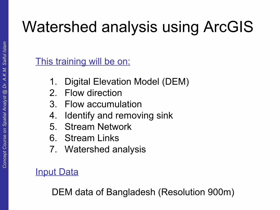
Watershed analysis using ArcGIS
This training will be on:
1. Digital Elevation Model (DEM)2. Flow direction3. Flow accumulation4. Identify and removing sink5. Stream Network6. Stream Links7. Watershed analysis
Input Data
DEM data of Bangladesh (Resolution 900m)
Co
nce
pt
Co
urs
e o
n S
pa
tial A
na
lyst
@ D
r. A
.K.M
. S
aifu
l Isl
am
Co
nce
pt
Co
urs
e o
n S
pa
tial A
na
lyst
@ D
r. A
.K.M
. S
aifu
l Isl
am
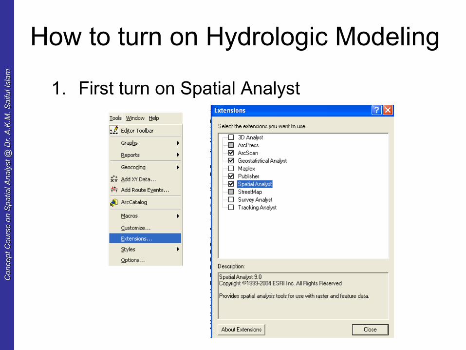
How to turn on Hydrologic Modeling
1. First turn on Spatial Analyst

Co
nce
pt
Co
urs
e o
n S
pa
tial A
na
lyst
@ D
r. A
.K.M
. S
aifu
l Isl
am
Co
nce
pt
Co
urs
e o
n S
pa
tial A
na
lyst
@ D
r. A
.K.M
. S
aifu
l Isl
am
Hydrology Tools
Activate ArcToolbox from window menu
Expand “Hydrology” from “Spatial Analyst” Tools
Co
nce
pt
Co
urs
e o
n S
pa
tial A
na
lyst
@ D
r. A
.K.M
. S
aifu
l Isl
am
Co
nce
pt
Co
urs
e o
n S
pa
tial A
na
lyst
@ D
r. A
.K.M
. S
aifu
l Isl
am
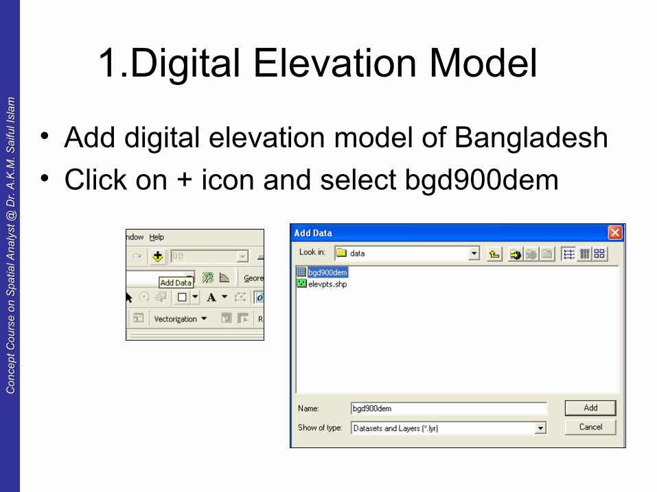
1.Digital Elevation Model
• Add digital elevation model of Bangladesh
• Click on + icon and select bgd900dem
Co
nce
pt
Co
urs
e o
n S
pa
tial A
na
lyst
@ D
r. A
.K.M
. S
aifu
l Isl
am
Co
nce
pt
Co
urs
e o
n S
pa
tial A
na
lyst
@ D
r. A
.K.M
. S
aifu
l Isl
am
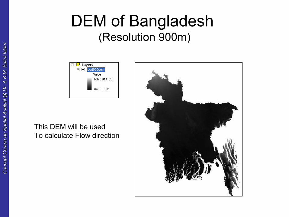
DEM of Bangladesh (Resolution 900m)
This DEM will be used To calculate Flow direction

Co
nce
pt
Co
urs
e o
n S
pa
tial A
na
lyst
@ D
r. A
.K.M
. S
aifu
l Isl
am
Co
nce
pt
Co
urs
e o
n S
pa
tial A
na
lyst
@ D
r. A
.K.M
. S
aifu
l Isl
am
2. Flow direction
Flow directions simplified: “Dump a bucket of water on your surface and see which of way it flows!”
Shows the direction water will flow out of each cell of a filled elevation raster.
WFM 6202: Remote Sensing and GIS in Water Management © Dr. Akm Saiful Islam
Co
nce
pt
Co
urs
e o
n S
pa
tial A
na
lyst
@ D
r. A
.K.M
. S
aifu
l Isl
am
Co
nce
pt
Co
urs
e o
n S
pa
tial A
na
lyst
@ D
r. A
.K.M
. S
aifu
l Isl
am
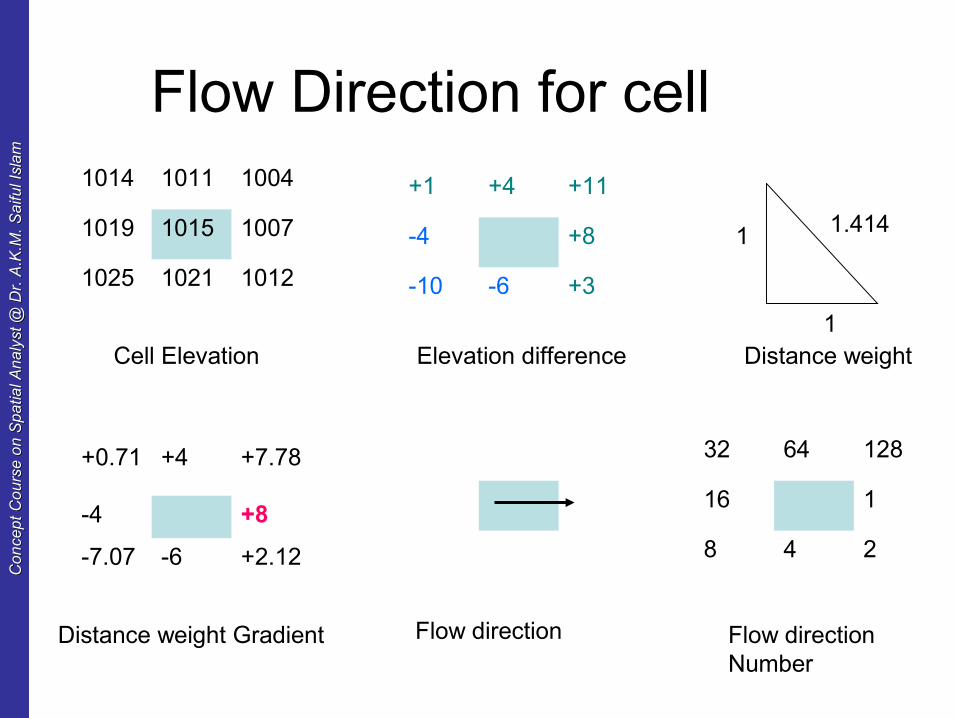
Flow Direction for cell1014 1011 1004
1019 1015 1007
1025 1021 1012
+1 +4 +11
-4 +8
-10 -6 +3
+0.71 +4 +7.78
-4 +8
-7.07 -6 +2.12
1
1 1.414
Cell Elevation Elevation difference Distance weight
Distance weight Gradient Flow direction
32 64 128
16 1
8 4 2
Flow direction Number
Co
nce
pt
Co
urs
e o
n S
pa
tial A
na
lyst
@ D
r. A
.K.M
. S
aifu
l Isl
am
Co
nce
pt
Co
urs
e o
n S
pa
tial A
na
lyst
@ D
r. A
.K.M
. S
aifu
l Isl
am
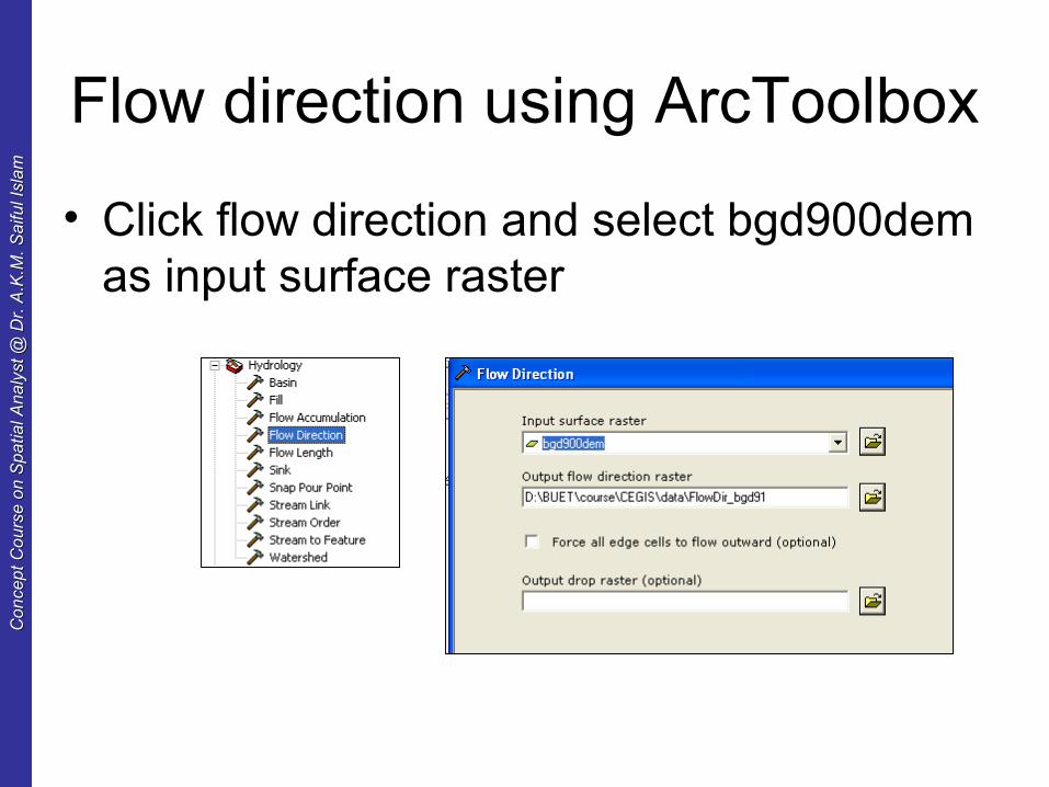
Flow direction using ArcToolbox
• Click flow direction and select bgd900dem as input surface raster
Co
nce
pt
Co
urs
e o
n S
pa
tial A
na
lyst
@ D
r. A
.K.M
. S
aifu
l Isl
am
Co
nce
pt
Co
urs
e o
n S
pa
tial A
na
lyst
@ D
r. A
.K.M
. S
aifu
l Isl
am
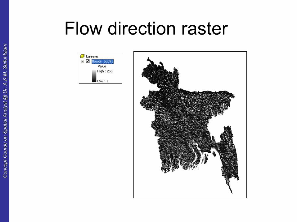
Flow direction raster
Co
nce
pt
Co
urs
e o
n S
pa
tial A
na
lyst
@ D
r. A
.K.M
. S
aifu
l Isl
am
Co
nce
pt
Co
urs
e o
n S
pa
tial A
na
lyst
@ D
r. A
.K.M
. S
aifu
l Isl
am
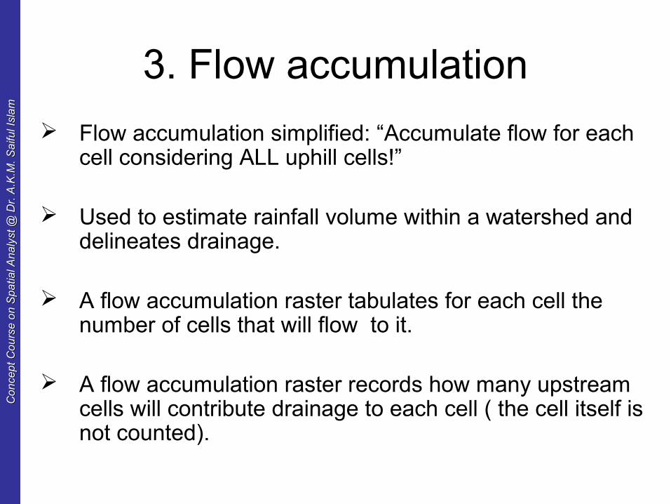
3. Flow accumulation
Flow accumulation simplified: “Accumulate flow for each cell considering ALL uphill cells!”
Used to estimate rainfall volume within a watershed and delineates drainage.
A flow accumulation raster tabulates for each cell the number of cells that will flow to it.
A flow accumulation raster records how many upstream cells will contribute drainage to each cell ( the cell itself is not counted).
Co
nce
pt
Co
urs
e o
n S
pa
tial A
na
lyst
@ D
r. A
.K.M
. S
aifu
l Isl
am
Co
nce
pt
Co
urs
e o
n S
pa
tial A
na
lyst
@ D
r. A
.K.M
. S
aifu
l Isl
am
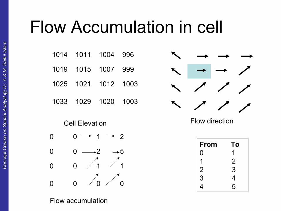
Flow Accumulation in cell
1014 1011 1004 996
1019 1015 1007 999
1025 1021 1012 1003
1033 1029 1020 1003
Cell Elevation Flow direction
0 0 1 2
0 0 2 5
0 0 1 1
0 0 0 0
Flow accumulation
From To0 11 22 33 44 5
Co
nce
pt
Co
urs
e o
n S
pa
tial A
na
lyst
@ D
r. A
.K.M
. S
aifu
l Isl
am
Co
nce
pt
Co
urs
e o
n S
pa
tial A
na
lyst
@ D
r. A
.K.M
. S
aifu
l Isl
am
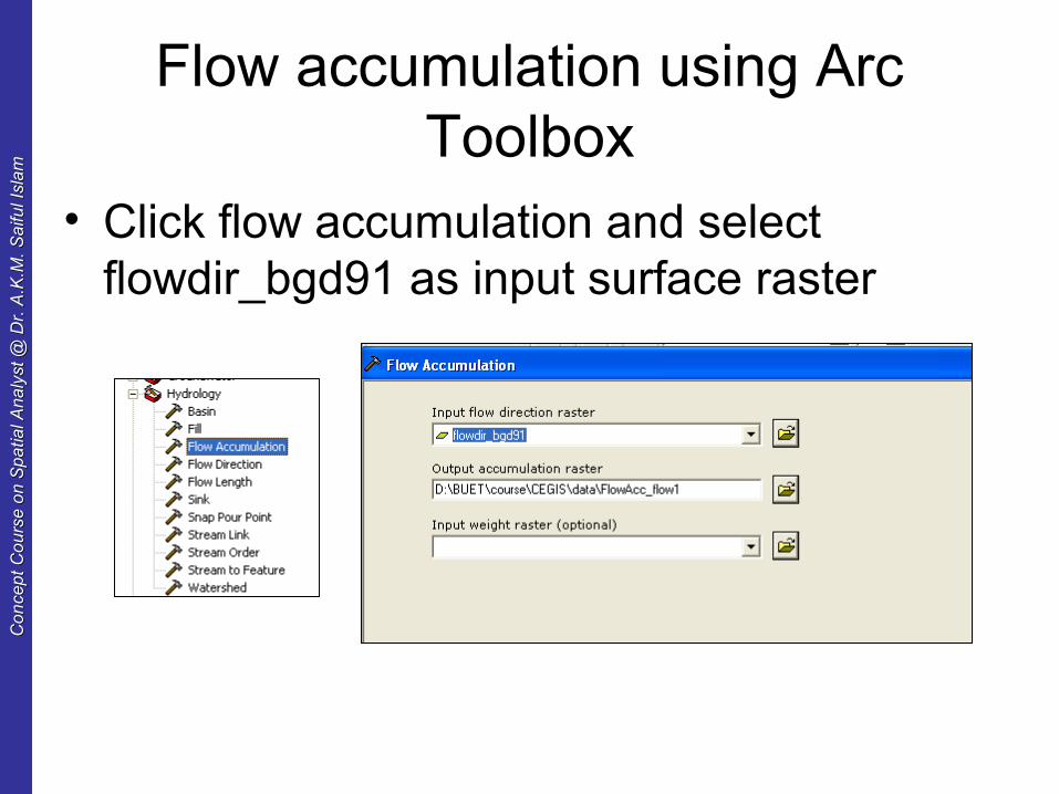
Flow accumulation using Arc Toolbox
• Click flow accumulation and select flowdir_bgd91 as input surface raster

Co
nce
pt
Co
urs
e o
n S
pa
tial A
na
lyst
@ D
r. A
.K.M
. S
aifu
l Isl
am
Co
nce
pt
Co
urs
e o
n S
pa
tial A
na
lyst
@ D
r. A
.K.M
. S
aifu
l Isl
am
Flow accumulation raster
Co
nce
pt
Co
urs
e o
n S
pa
tial A
na
lyst
@ D
r. A
.K.M
. S
aifu
l Isl
am
Co
nce
pt
Co
urs
e o
n S
pa
tial A
na
lyst
@ D
r. A
.K.M
. S
aifu
l Isl
am
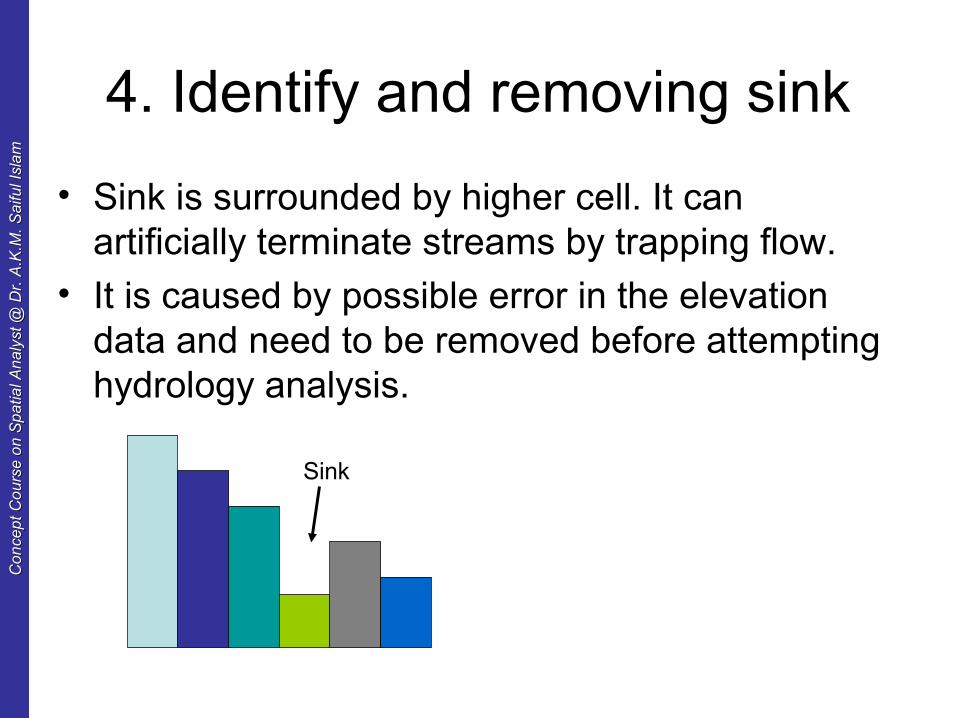
4. Identify and removing sink
• Sink is surrounded by higher cell. It can artificially terminate streams by trapping flow.
• It is caused by possible error in the elevation data and need to be removed before attempting hydrology analysis.
Sink
Co
nce
pt
Co
urs
e o
n S
pa
tial A
na
lyst
@ D
r. A
.K.M
. S
aifu
l Isl
am
Co
nce
pt
Co
urs
e o
n S
pa
tial A
na
lyst
@ D
r. A
.K.M
. S
aifu
l Isl
am
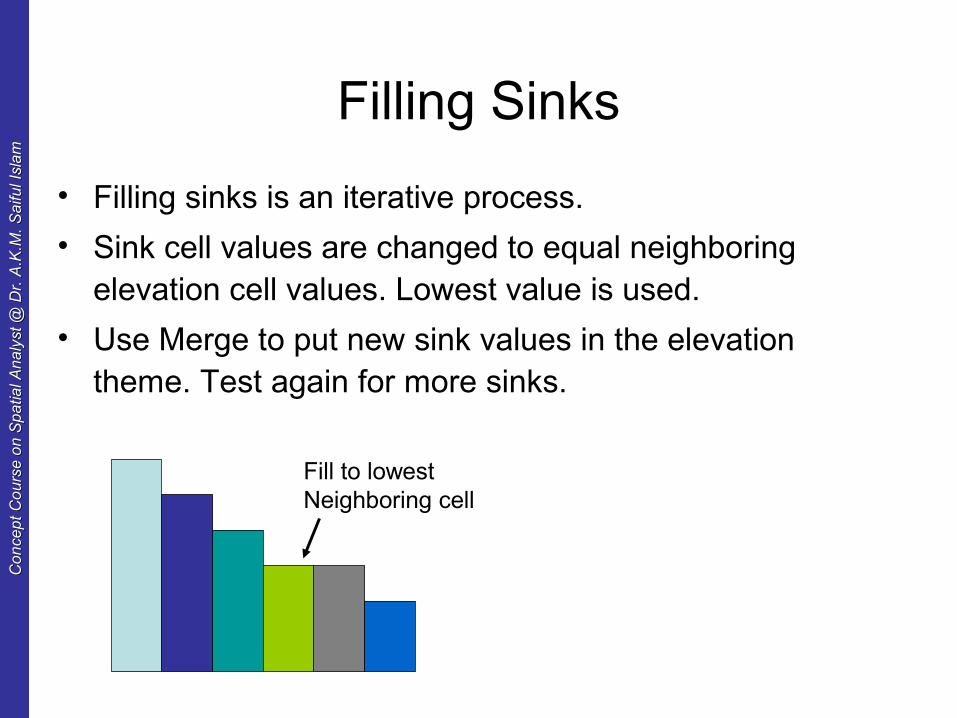
Filling Sinks
• Filling sinks is an iterative process.
• Sink cell values are changed to equal neighboring elevation cell values. Lowest value is used.
• Use Merge to put new sink values in the elevation theme. Test again for more sinks.
Fill to lowest Neighboring cell
Co
nce
pt
Co
urs
e o
n S
pa
tial A
na
lyst
@ D
r. A
.K.M
. S
aifu
l Isl
am
Co
nce
pt
Co
urs
e o
n S
pa
tial A
na
lyst
@ D
r. A
.K.M
. S
aifu
l Isl
am
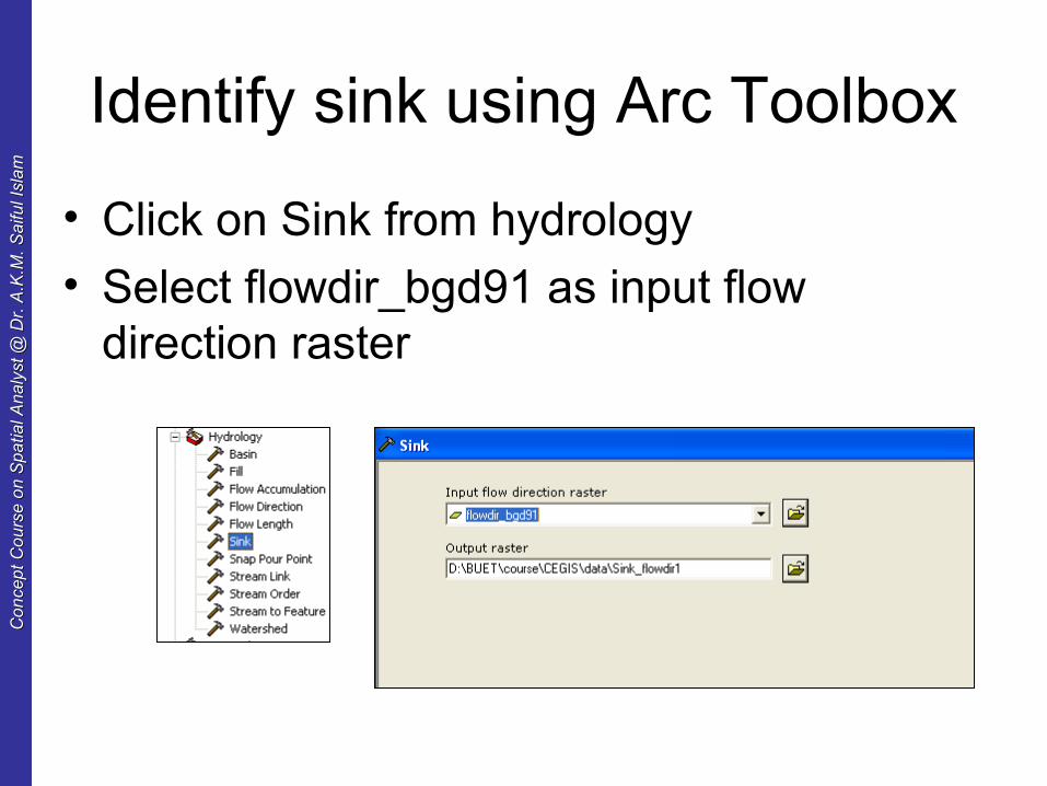
Identify sink using Arc Toolbox
• Click on Sink from hydrology
• Select flowdir_bgd91 as input flow direction raster
Co
nce
pt
Co
urs
e o
n S
pa
tial A
na
lyst
@ D
r. A
.K.M
. S
aifu
l Isl
am
Co
nce
pt
Co
urs
e o
n S
pa
tial A
na
lyst
@ D
r. A
.K.M
. S
aifu
l Isl
am
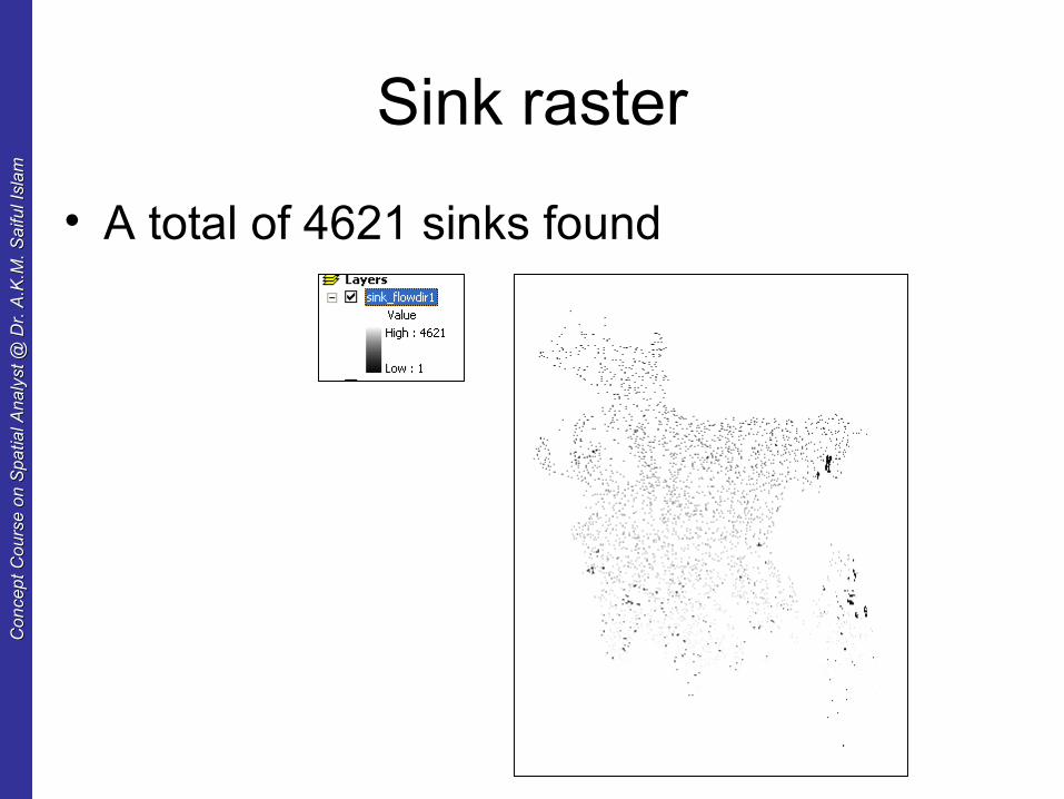
Sink raster
• A total of 4621 sinks found
Co
nce
pt
Co
urs
e o
n S
pa
tial A
na
lyst
@ D
r. A
.K.M
. S
aifu
l Isl
am
Co
nce
pt
Co
urs
e o
n S
pa
tial A
na
lyst
@ D
r. A
.K.M
. S
aifu
l Isl
am
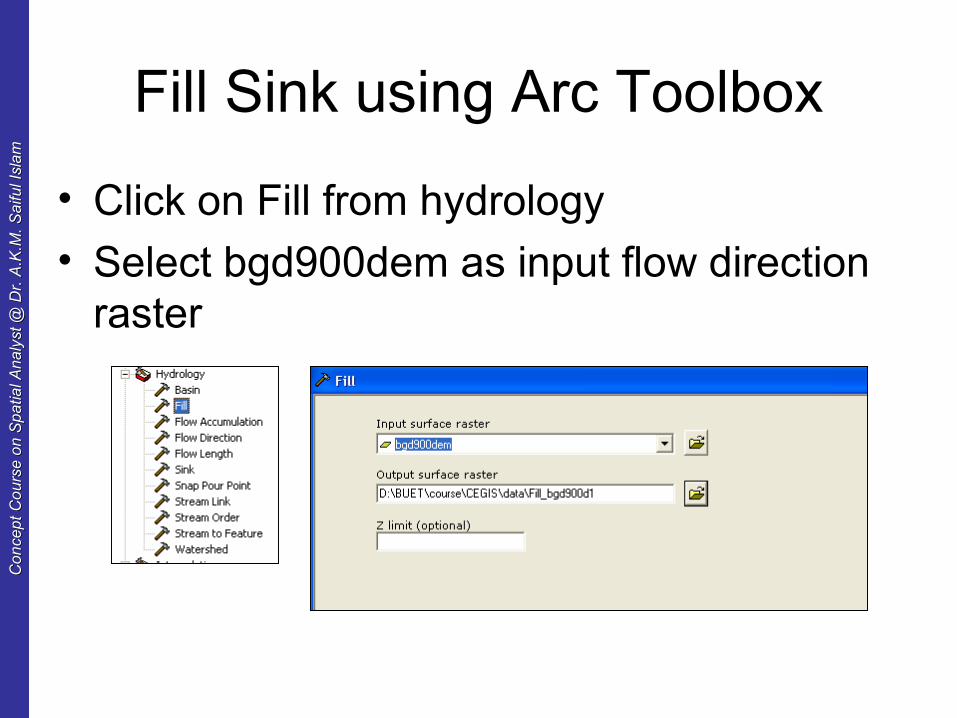
Fill Sink using Arc Toolbox
• Click on Fill from hydrology
• Select bgd900dem as input flow direction raster
Co
nce
pt
Co
urs
e o
n S
pa
tial A
na
lyst
@ D
r. A
.K.M
. S
aifu
l Isl
am
Co
nce
pt
Co
urs
e o
n S
pa
tial A
na
lyst
@ D
r. A
.K.M
. S
aifu
l Isl
am
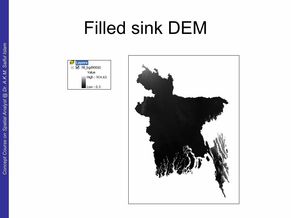
Filled sink DEM
Co
nce
pt
Co
urs
e o
n S
pa
tial A
na
lyst
@ D
r. A
.K.M
. S
aifu
l Isl
am
Co
nce
pt
Co
urs
e o
n S
pa
tial A
na
lyst
@ D
r. A
.K.M
. S
aifu
l Isl
am
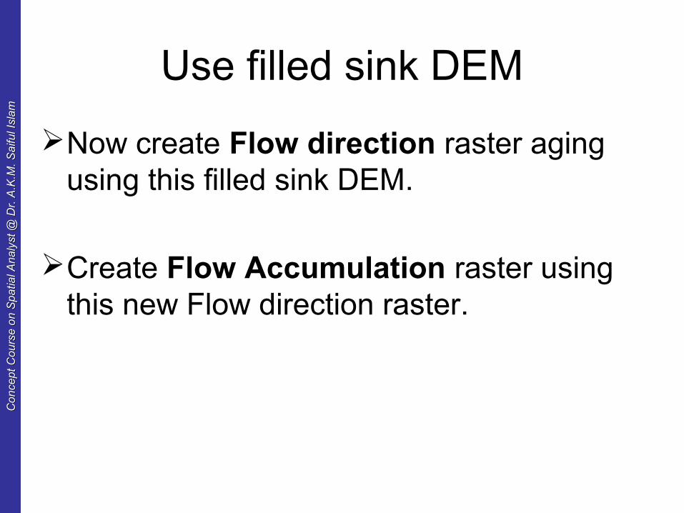
Use filled sink DEM
Now create Flow direction raster aging using this filled sink DEM.
Create Flow Accumulation raster using this new Flow direction raster.
Co
nce
pt
Co
urs
e o
n S
pa
tial A
na
lyst
@ D
r. A
.K.M
. S
aifu
l Isl
am
Co
nce
pt
Co
urs
e o
n S
pa
tial A
na
lyst
@ D
r. A
.K.M
. S
aifu
l Isl
am
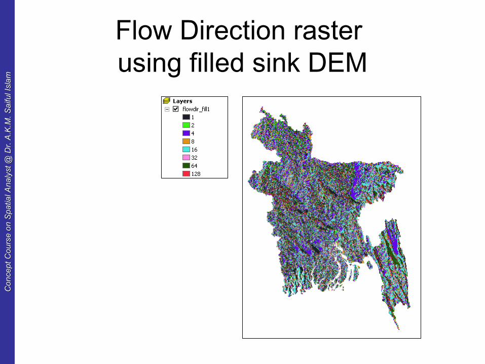
Flow Direction raster using filled sink DEM
Co
nce
pt
Co
urs
e o
n S
pa
tial A
na
lyst
@ D
r. A
.K.M
. S
aifu
l Isl
am
Co
nce
pt
Co
urs
e o
n S
pa
tial A
na
lyst
@ D
r. A
.K.M
. S
aifu
l Isl
am
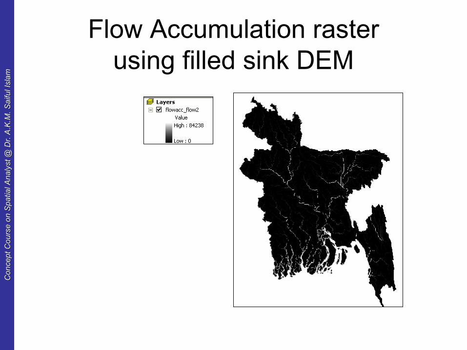
Flow Accumulation rasterusing filled sink DEM
Co
nce
pt
Co
urs
e o
n S
pa
tial A
na
lyst
@ D
r. A
.K.M
. S
aifu
l Isl
am
Co
nce
pt
Co
urs
e o
n S
pa
tial A
na
lyst
@ D
r. A
.K.M
. S
aifu
l Isl
am
5. Stream network
• You can use the flow accumulation grid to identify drainage courses by extracting those cells with the highest accumulated flow values ( cell contains the most water are stream channel).
• You can create a drainage network of any detail by choosing the appropriate volume values (300 is used for this data).
• Choice of threshold value can be arbitrary. It should be corresponding to high resolution topographic maps of filed maps.
Co
nce
pt
Co
urs
e o
n S
pa
tial A
na
lyst
@ D
r. A
.K.M
. S
aifu
l Isl
am
Co
nce
pt
Co
urs
e o
n S
pa
tial A
na
lyst
@ D
r. A
.K.M
. S
aifu
l Isl
am
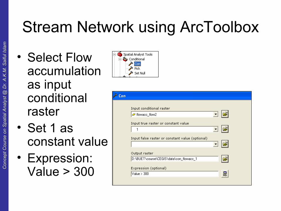
Stream Network using ArcToolbox
• Select Flow accumulation as input conditional raster
• Set 1 as constant value
• Expression: Value > 300
Co
nce
pt
Co
urs
e o
n S
pa
tial A
na
lyst
@ D
r. A
.K.M
. S
aifu
l Isl
am
Co
nce
pt
Co
urs
e o
n S
pa
tial A
na
lyst
@ D
r. A
.K.M
. S
aifu
l Isl
am
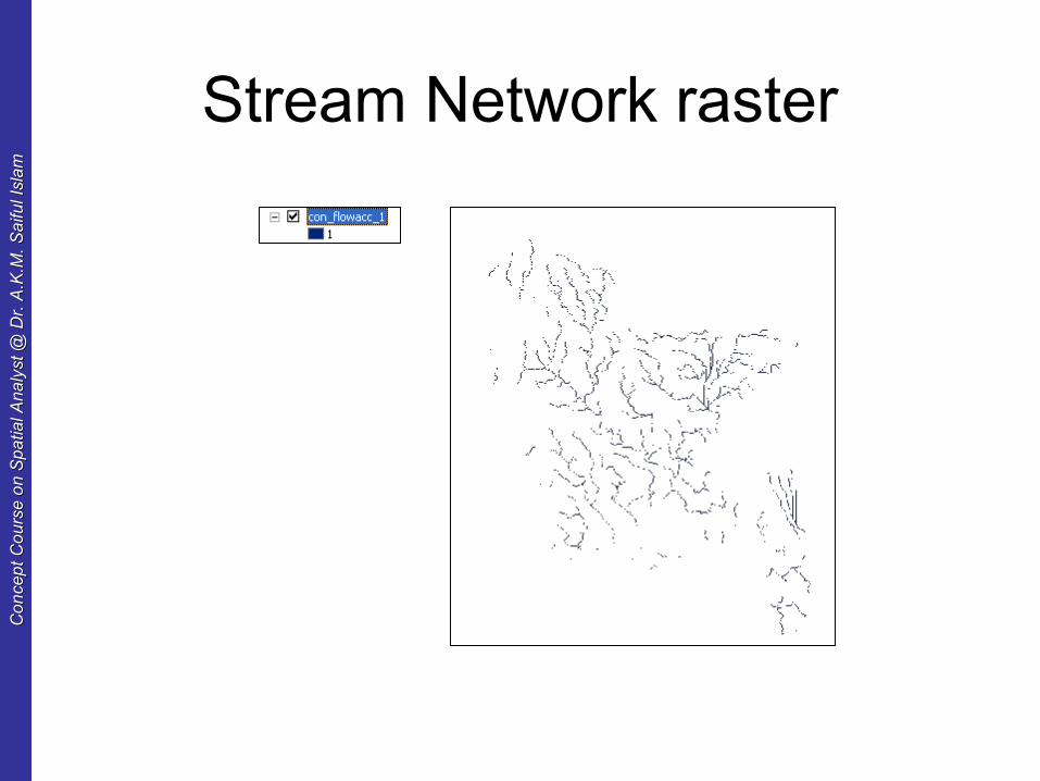
Stream Network raster
Co
nce
pt
Co
urs
e o
n S
pa
tial A
na
lyst
@ D
r. A
.K.M
. S
aifu
l Isl
am
Co
nce
pt
Co
urs
e o
n S
pa
tial A
na
lyst
@ D
r. A
.K.M
. S
aifu
l Isl
am
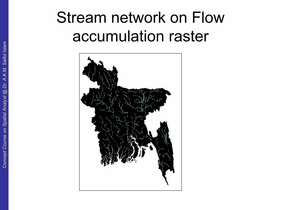
Stream network on Flow accumulation raster
Co
nce
pt
Co
urs
e o
n S
pa
tial A
na
lyst
@ D
r. A
.K.M
. S
aifu
l Isl
am
Co
nce
pt
Co
urs
e o
n S
pa
tial A
na
lyst
@ D
r. A
.K.M
. S
aifu
l Isl
am
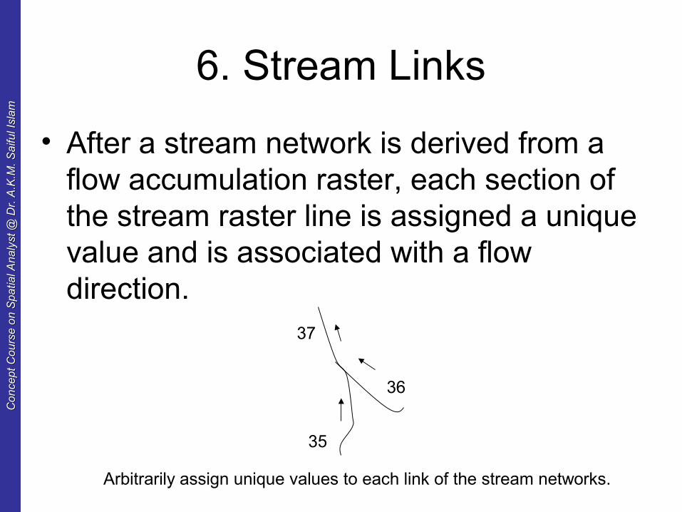
6. Stream Links
• After a stream network is derived from a flow accumulation raster, each section of the stream raster line is assigned a unique value and is associated with a flow direction.
37
35
36
Arbitrarily assign unique values to each link of the stream networks.

Co
nce
pt
Co
urs
e o
n S
pa
tial A
na
lyst
@ D
r. A
.K.M
. S
aifu
l Isl
am
Co
nce
pt
Co
urs
e o
n S
pa
tial A
na
lyst
@ D
r. A
.K.M
. S
aifu
l Isl
am
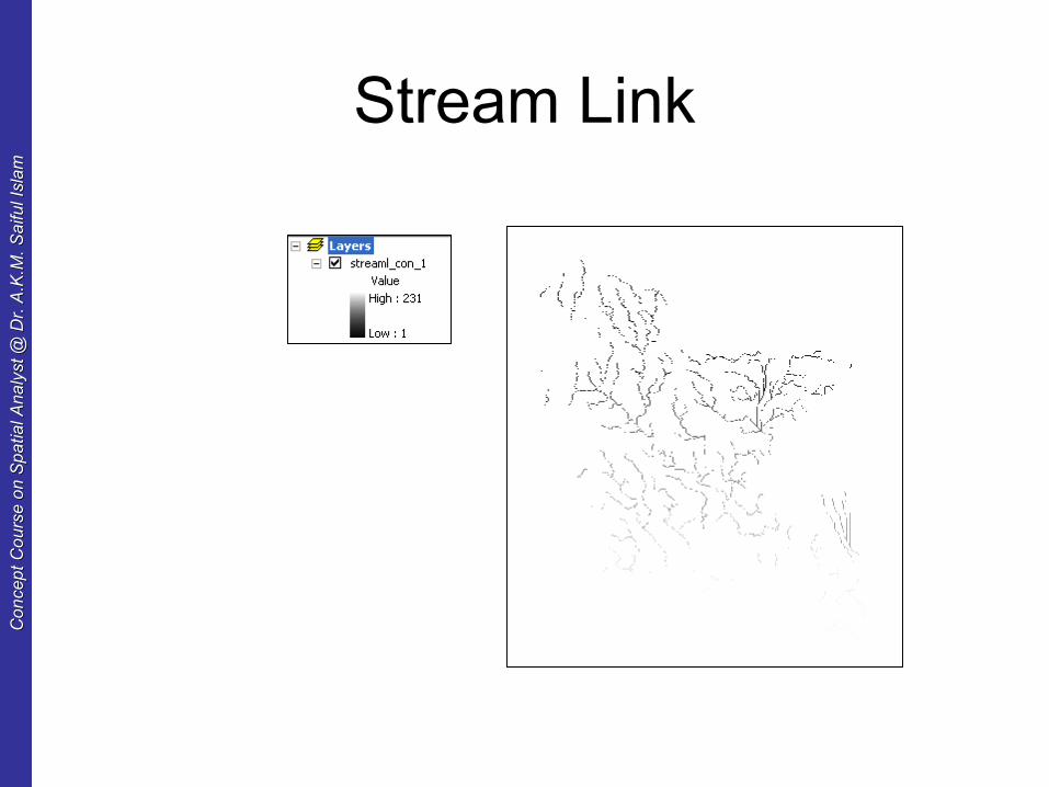
Stream link using Arc Toolbox
• Select Stream network as input stream raster
Co
nce
pt
Co
urs
e o
n S
pa
tial A
na
lyst
@ D
r. A
.K.M
. S
aifu
l Isl
am
Co
nce
pt
Co
urs
e o
n S
pa
tial A
na
lyst
@ D
r. A
.K.M
. S
aifu
l Isl
am
Stream Link
Co
nce
pt
Co
urs
e o
n S
pa
tial A
na
lyst
@ D
r. A
.K.M
. S
aifu
l Isl
am
Co
nce
pt
Co
urs
e o
n S
pa
tial A
na
lyst
@ D
r. A
.K.M
. S
aifu
l Isl
am
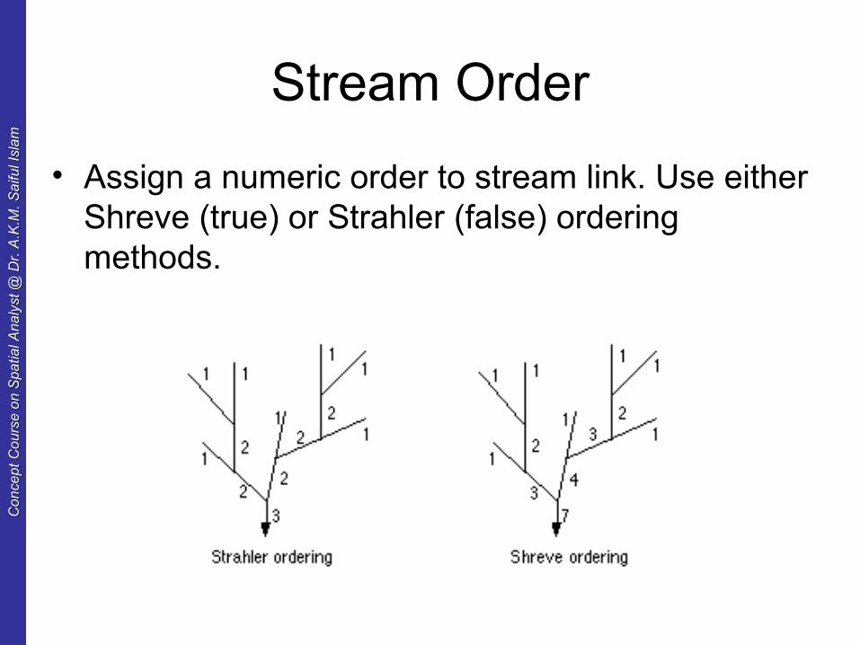
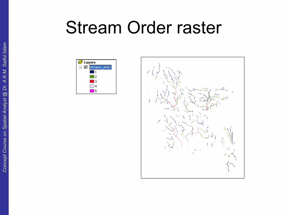
Stream Order
• Assign a numeric order to stream link. Use either Shreve (true) or Strahler (false) ordering methods.
Co
nce
pt
Co
urs
e o
n S
pa
tial A
na
lyst
@ D
r. A
.K.M
. S
aifu
l Isl
am
Co
nce
pt
Co
urs
e o
n S
pa
tial A
na
lyst
@ D
r. A
.K.M
. S
aifu
l Isl
am
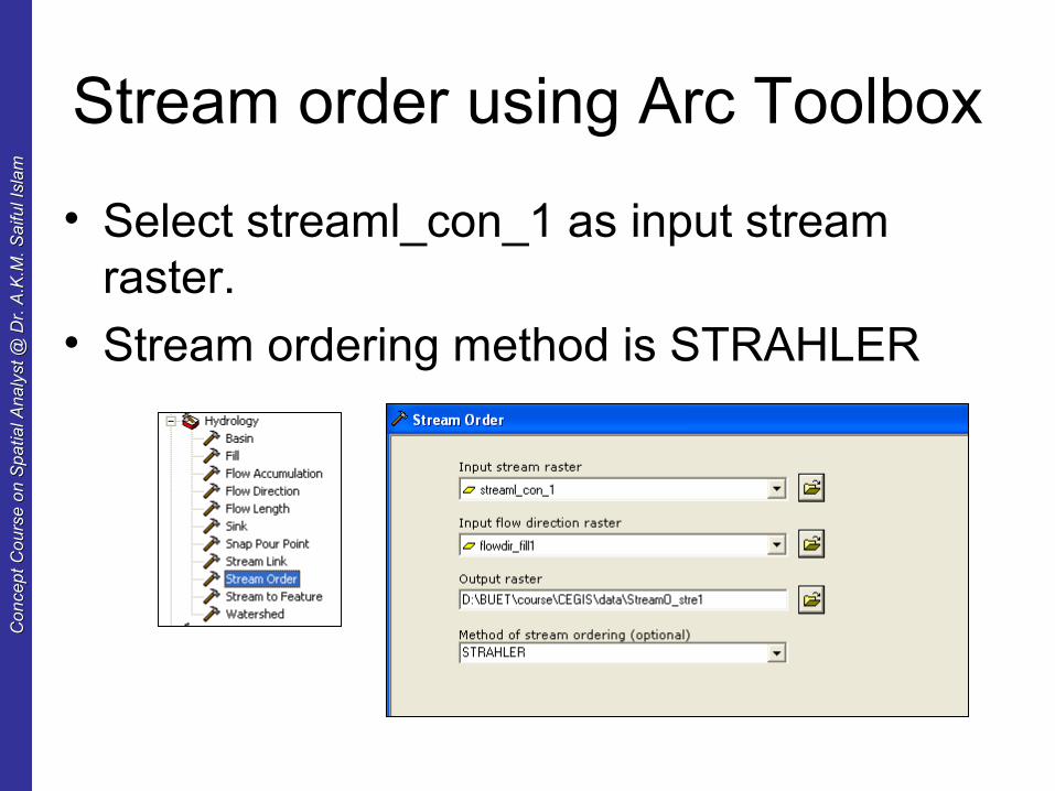
Stream order using Arc Toolbox
• Select streaml_con_1 as input stream raster.
• Stream ordering method is STRAHLER
Co
nce
pt
Co
urs
e o
n S
pa
tial A
na
lyst
@ D
r. A
.K.M
. S
aifu
l Isl
am
Co
nce
pt
Co
urs
e o
n S
pa
tial A
na
lyst
@ D
r. A
.K.M
. S
aifu
l Isl
am
Stream Order raster
Co
nce
pt
Co
urs
e o
n S
pa
tial A
na
lyst
@ D
r. A
.K.M
. S
aifu
l Isl
am
Co
nce
pt
Co
urs
e o
n S
pa
tial A
na
lyst
@ D
r. A
.K.M
. S
aifu
l Isl
am
Steam as Shape object
• The stream link raster file can be converted into line feature class.
• Streams can be represented as shape file.
Co
nce
pt
Co
urs
e o
n S
pa
tial A
na
lyst
@ D
r. A
.K.M
. S
aifu
l Isl
am
Co
nce
pt
Co
urs
e o
n S
pa
tial A
na
lyst
@ D
r. A
.K.M
. S
aifu
l Isl
am
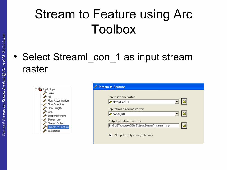
Stream to Feature using Arc Toolbox
• Select Streaml_con_1 as input stream raster
Co
nce
pt
Co
urs
e o
n S
pa
tial A
na
lyst
@ D
r. A
.K.M
. S
aifu
l Isl
am
Co
nce
pt
Co
urs
e o
n S
pa
tial A
na
lyst
@ D
r. A
.K.M
. S
aifu
l Isl
am
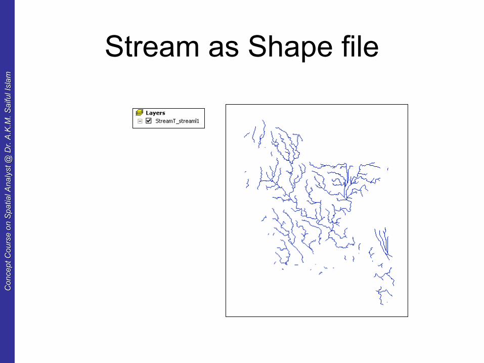
Stream as Shape file
Co
nce
pt
Co
urs
e o
n S
pa
tial A
na
lyst
@ D
r. A
.K.M
. S
aifu
l Isl
am
Co
nce
pt
Co
urs
e o
n S
pa
tial A
na
lyst
@ D
r. A
.K.M
. S
aifu
l Isl
am
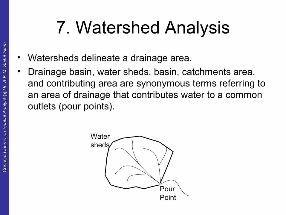
7. Watershed Analysis
• Watersheds delineate a drainage area.• Drainage basin, water sheds, basin, catchments area,
and contributing area are synonymous terms referring to an area of drainage that contributes water to a common outlets (pour points).
PourPoint
Watersheds
Co
nce
pt
Co
urs
e o
n S
pa
tial A
na
lyst
@ D
r. A
.K.M
. S
aifu
l Isl
am
Co
nce
pt
Co
urs
e o
n S
pa
tial A
na
lyst
@ D
r. A
.K.M
. S
aifu
l Isl
am
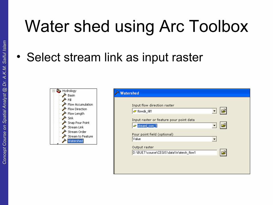
Water shed using Arc Toolbox
• Select stream link as input raster
Co
nce
pt
Co
urs
e o
n S
pa
tial A
na
lyst
@ D
r. A
.K.M
. S
aifu
l Isl
am
Co
nce
pt
Co
urs
e o
n S
pa
tial A
na
lyst
@ D
r. A
.K.M
. S
aifu
l Isl
am
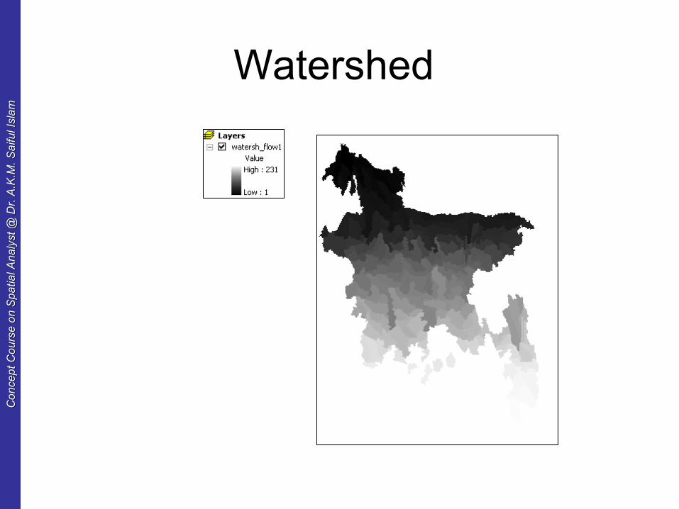
Watershed
Co
nce
pt
Co
urs
e o
n S
pa
tial A
na
lyst
@ D
r. A
.K.M
. S
aifu
l Isl
am
Co
nce
pt
Co
urs
e o
n S
pa
tial A
na
lyst
@ D
r. A
.K.M
. S
aifu
l Isl
am
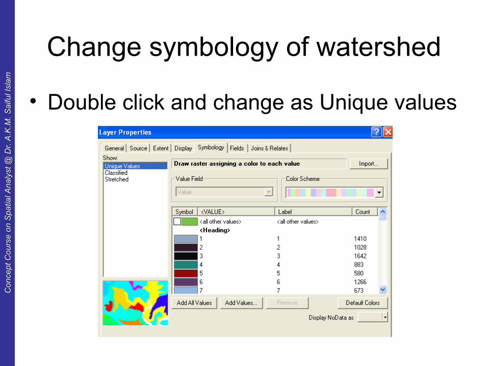
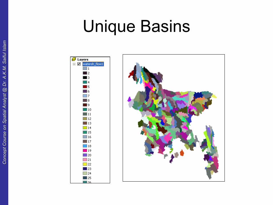
Change symbology of watershed
• Double click and change as Unique values
Co
nce
pt
Co
urs
e o
n S
pa
tial A
na
lyst
@ D
r. A
.K.M
. S
aifu
l Isl
am
Co
nce
pt
Co
urs
e o
n S
pa
tial A
na
lyst
@ D
r. A
.K.M
. S
aifu
l Isl
am
Unique Basins