hydrologic modeling with lidaregis3.lacounty.gov/dataportal/wp-content/uploads/2014/01/... ·...
TRANSCRIPT

Hydrologic Modeling with LIDAR
Dr. Dean Djokic, Esri Inc.
LARIAC4 Status and User Group Meeting
January 28, 2016

Stormwater Drainage System
Implementation Using Arc Hydro
and LARIAC LIDAR Data
Copyright © 2016 ESRI. All rights reserved. Arc Hydro Stormwater System Development
What is Arc Hydro?
Template database design and design principles
Free toolset for advanced water resources functionality
(~250 tools)
Implementation strategy philosophy and best practices
Available since 2002 for all desktop versions of ArcGIS
(including current transition to Pro)

Copyright © 2016 ESRI. All rights reserved. Arc Hydro Stormwater System Development
Basic Arc Hydro Design Concepts
Define core feature classes for water resources
analyses
Establish relationships between core feature classes
Use geometric network for tying pieces together
Mobilization of standard ArcGIS functionality
Custom tools for some of the attribute management
Custom tools for advanced “water resources”
functionality

Copyright © 2016 ESRI. All rights reserved. Arc Hydro Stormwater System Development
The Arc Hydro Implementation Mantra
Arc Hydro is a “system” of tools and data structures that work in unison
to provide rich and effective experience for GIS users in water resources
community.
If you are using Arc Hydro, you will most likely be doing ANALYSES –
there are important considerations for GIS implementation when doing
analyses that are different than using GIS just for mapping. Respect that.
When using the tools, you are building a “system”, not just using a
“bunch” of independent tools to produce a “bunch” of independent data.
Of course, there are plenty of Arc Hydro tools that can be used independently of the
“system”. Use them as such and enjoy.
When starting an Arc Hydro project, think ahead of the system you will be
building. Plan ahead. Organize, then execute.
Keep it simple – Ockham’s Razor is alive and well!
Do not reinvent the wheel, leverage established processing workflows.
Analytical system, analytical system, analytical system, …

Copyright © 2016 ESRI. All rights reserved. Arc Hydro Stormwater System Development
Arc Hydro Storm Water Implementation (1)
Leverage vector drainage representation for movement
through drainage infrastructure (pipes, channels, inlets).
Use geometric networks and vector data
Leverage raster drainage representation for overland
flow until drainage infrastructure is reached.
Use Spatial Analyst and raster data
Use Arc Hydro tools for preprocessing and execution.

Copyright © 2016 ESRI. All rights reserved. Arc Hydro Stormwater System Development
Arc Hydro Storm Water Implementation (2)
Drainage infrastructure – fully integrated geometric
network:
Pipes (below surface - no direct surface contribution). Edges.
Channels (direct surface contribution). Edges.
Inlets (direct surface contribution – ties surface and pipe
components). Junctions.
Terrain model. Derivation of drainage areas
contributing to inlets and channels (sinks).
Relationship class between drainage areas and inlets
and channels to connect overland areas to inlets.
Arc Hydro, LARIAC LIDAR, and
Stormwater Infrastructure Data in
Action

Copyright © 2016 ESRI. All rights reserved. Arc Hydro Stormwater System Development
Data Review – No Such Thing As Perfect Data
Drainage infrastructure (lines and points):
Connectivity
Directionality (lines)
Attributes
Completeness
LIDAR:
Horizontal/vertical accuracy
Bare terrain derivation methodology and artefacts
DEM:
Point to raster conversion artefacts
Copyright © 2016 ESRI. All rights reserved. Arc Hydro Stormwater System Development
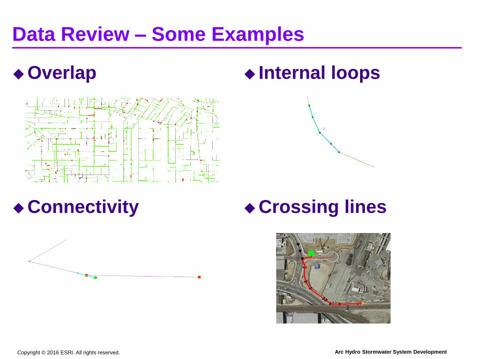
Data Review – Some Examples
Overlap
Connectivity
Internal loops
Crossing lines
Copyright © 2016 ESRI. All rights reserved. Arc Hydro Stormwater System Development
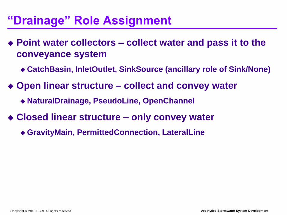
“Drainage” Role Assignment
Point water collectors – collect water and pass it to the
conveyance system
CatchBasin, InletOutlet, SinkSource (ancillary role of Sink/None)
Open linear structure – collect and convey water
NaturalDrainage, PseudoLine, OpenChannel
Closed linear structure – only convey water
GravityMain, PermittedConnection, LateralLine

Copyright © 2016 ESRI. All rights reserved. Arc Hydro Stormwater System Development
“Raw” Terrain Processing
Use “raw” LIDAR derived 3ft DEM as is and identify
depressions.

Copyright © 2016 ESRI. All rights reserved. Arc Hydro Stormwater System Development
“Raw” Terrain Processing
Need help in “raw” DEM flow pattern interpretation.

Copyright © 2016 ESRI. All rights reserved. Arc Hydro Stormwater System Development
Terrain Reconditioning
“Help” the data with processing methodology
Enforce the role – define “collector” elements as sinks to attract
water (buffer around to get sink polygons or use alternative sink
poly definition techniques).
Ignore imperfections in the DEM by filling depressions in the
DEM outside of the sink polygons.
Copyright © 2016 ESRI. All rights reserved. Arc Hydro Stormwater System Development
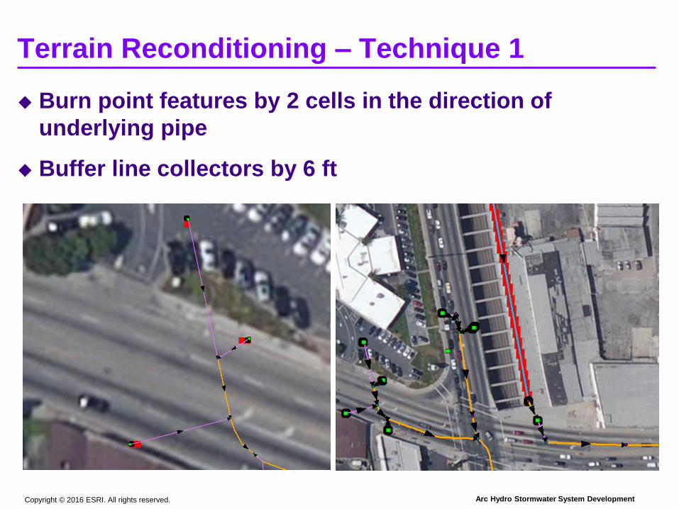
Terrain Reconditioning – Technique 1
Burn point features by 2 cells in the direction of
underlying pipe
Buffer line collectors by 6 ft
Copyright © 2016 ESRI. All rights reserved. Arc Hydro Stormwater System Development
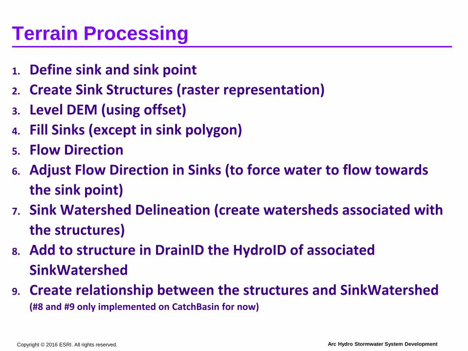
Terrain Processing
1. Define sink and sink point
2. Create Sink Structures (raster representation)
3. Level DEM (using offset)
4. Fill Sinks (except in sink polygon)
5. Flow Direction
6. Adjust Flow Direction in Sinks (to force water to flow towards
the sink point)
7. Sink Watershed Delineation (create watersheds associated with
the structures)
8. Add to structure in DrainID the HydroID of associated
SinkWatershed
9. Create relationship between the structures and SinkWatershed(#8 and #9 only implemented on CatchBasin for now)

Copyright © 2016 ESRI. All rights reserved. Arc Hydro Stormwater System Development
Watershed Delineation
Four “types” of delineation (different outcomes)
On CatchBasin feature (sink)
On land
On open channel
On closed pipe

Copyright © 2016 ESRI. All rights reserved. Arc Hydro Stormwater System Development
Watershed Delineation
Four “types” of delineation (different outcomes)
On CatchBasin feature (sink)
Copyright © 2016 ESRI. All rights reserved. Arc Hydro Stormwater System Development
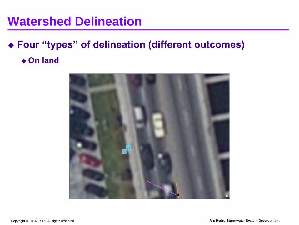
Watershed Delineation
Four “types” of delineation (different outcomes)
On land

Copyright © 2016 ESRI. All rights reserved. Arc Hydro Stormwater System Development
Watershed Delineation
Four “types” of delineation (different outcomes)
On open channel

Copyright © 2016 ESRI. All rights reserved. Arc Hydro Stormwater System Development
Watershed Delineation
Four “types” of delineation (different outcomes)
On closed pipe

Copyright © 2016 ESRI. All rights reserved. Arc Hydro Stormwater System Development
Terrain Reconditioning – Technique 2
Burn point features by 6 ft (focus on local comparison, so pipes were
not burned)

Hydrology and Hydraulics Discussion
Copyright © 2016 ESRI. All rights reserved. Arc Hydro Stormwater System Development
H&H Discussion
Fully developed stormwater infrastructure and DEM
based watershed delineation and characterization
functionality provide foundation for hydrologic and
hydraulic modeling.
For design modeling (e.g. 25-year capacities) using
standard design techniques (e.g. Rational or SCS
methods) most of the work can be done within GIS.
Additional spatial data like impervious cover, land use,
precipitation, can be easily mobilized using existing
tools.
For dynamic modeling, an external numerical model
linked to GIS database would be required.

Conclusions

Copyright © 2016 ESRI. All rights reserved. Arc Hydro Stormwater System Development
Conclusions
LARIAC DEM can be quickly mobilized for watershed
delineation purposes that make foundation for
hydrologic and hydraulic modeling.
Even the 3ft resolution DEM needs “help” in properly
identifying drainage patterns.
Availability of good stormwater infrastructure is critical
for proper results.
Exiting Arc Hydro tools and processing workflows
provide most of required functionality.
Final results are sensitive to techniques and parameters
used in terrain processing.

Questions