hydrological validation of h saf precipitation products on ... · from different regions (lowland,...
TRANSCRIPT

Hydrological validation of H–SAF precipitation products on Polish basins
from different regions (lowland, upland, mountainous
catchments) Maurycy Ciupak, Marcin Dominikowski, Michał Kasina, Michał Ziemski
Hydrological Forecasting Office in KrakowInstitute of Meteorology and Water Management – National Research Institute
ECMWF/ H-SAF and HEPEX Workshops on coupled hydrology

The main goals of hydrologicalvalidation

OE 5100
Product interfacing and utilization improvement
Make software for blended products
Development of tools to assimilate soilmoisture and snow
cover products to hydrological models
Perform the analysis of possible
product utility for hydrological tasks
Development of tools (software) for data format conversion acceptable by
hydrological models
Sensitivity analysis – influence of eachproduct on final output data
The main goals of HV

OE 5200
Impact studies and hydrological validation
Hydrological validation of Products
Satelital data assesment and model calibration
Case studies

Hydrological validation of operational or pre-operational H-SAF products:
PR: H03; H04; H05 SM: H08; H14 SN: H10; H12; H13
Hydrological Validation
Results are presented in Hydrological Impact Validation Report (HVR)

Validation Teams, test sites, models

Validation Teams, test sites, models

CountryProduct
H03 H04 H05 H08 H14 H10 H12 H13
Belgium - - YES - - - - -
Bulgaria - - YES - YES - - -
Finland - - - - - - - YES
Germany - - YES ~ ~ ~ ~ ~
Italy YES - YES YES YES - - -
Poland YES YES YES - ~ ~ ~ ~
Slovakia YES YES YES YES - - - -
TurkeyITU - - YES - - - - -
AU - - - - - YES ~ YES
Hungary - - - - - - - ~
- not validated~ validation in future
YES validated
Status of validation

Validation period and products

Period
from 1/7/2012 to 30/6/2013

Precipitation products
Product Resolution
Cycle
H03 Precipitation rate at ground by GEO/IR supported by LEO/MW
~ 8 km 15 min
H04 Precipitation rate at ground by LEO/MW supported by GEO/IR (with flag for phase)
~ 8 km 3 hours
H05 Accumulated precipitation at ground by blended MW and IR
~ 8 km Each 3 hours: MW+IR integrated over the previous 3, 6, 12 and 24

Methods

Methods: General idea of HV
How to define „ground truth”?
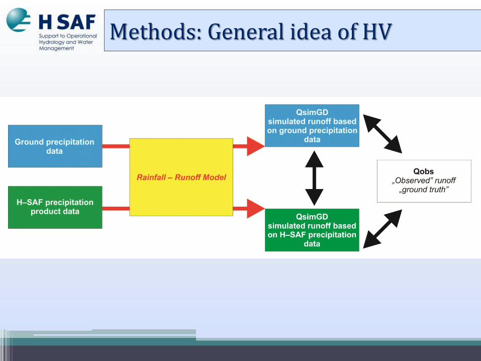
Methods: General idea of HV

Methods: HBV model
Snow routine
Soil routine
Responsefunction
Routing routine
distributed
lumped

Methods

Methods
Precipitation• Weighted mean• Elevation zones
Temperature• Weighted mean• Elevation zones
Potential evaporation*• Penman-Monteith/Thornthwaite equation• Usually long-term monthly mean values
Discharge observations are used to calibrate the model, and to verify and correct the model before a runoff forecast.
Data for stationsThe time step is
ONE HOUR

Calibration of rainfall-runoff model (using historical, long time series of grounddata)
Validation runoff simulation using precipitation
ground data as an input runoff simulation using satellite
precipitation product as an input
Methods

Results for each month and for the wholeperiod
Comparison the obtained run-offs with the measurements
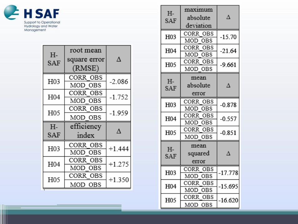
Evaluations of the H–SAF products were performed, in terms of discharges, by the calculation of the Nash–Sutcliffe model efficiency coefficient, the correlation coefficient, the RMSE and ME and MAE.
Results: graphs, statistics scores
Methods

Study area

Study area
lowland
upland
mountain
Wkra
Soła
Raba
Czarna Łagowianka
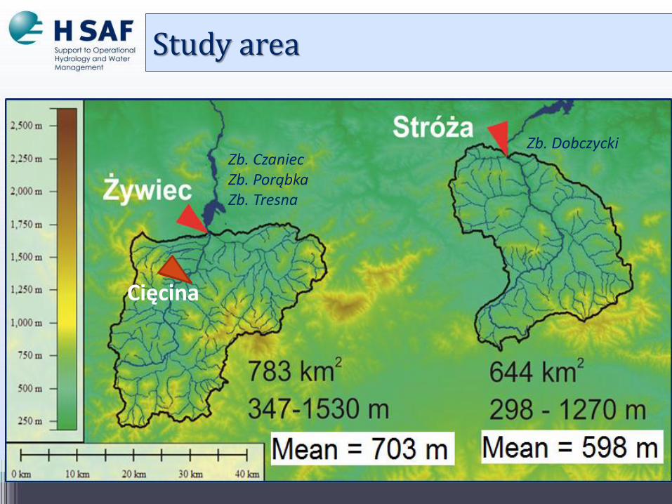
Cięcina
Zb. DobczyckiZb. CzaniecZb. PorąbkaZb. Tresna
Study area

Study area
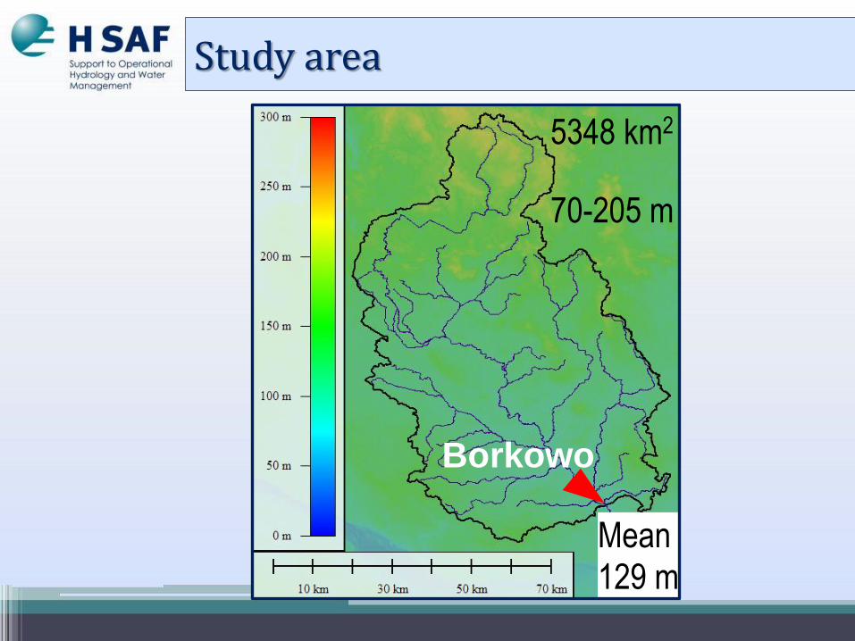
Study area
Borkowo
5348 km2
70-205 m
Mean129 m
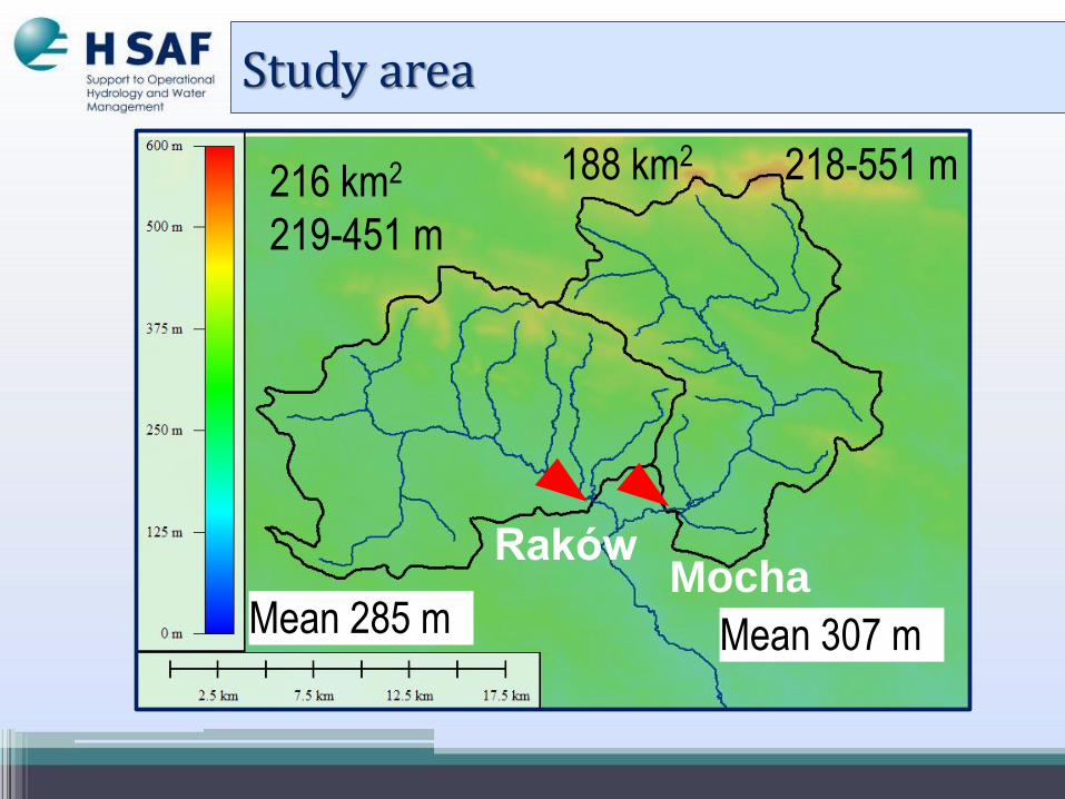
Raków
188 km2 218-551 m
Mean 285 mMocha
Mean 307 m
216 km2
219-451 m
Study area

Results

2012-2013

2012-2013

2012-2013H04

2012-2013H04

H-SAF products in Operational Hydrology

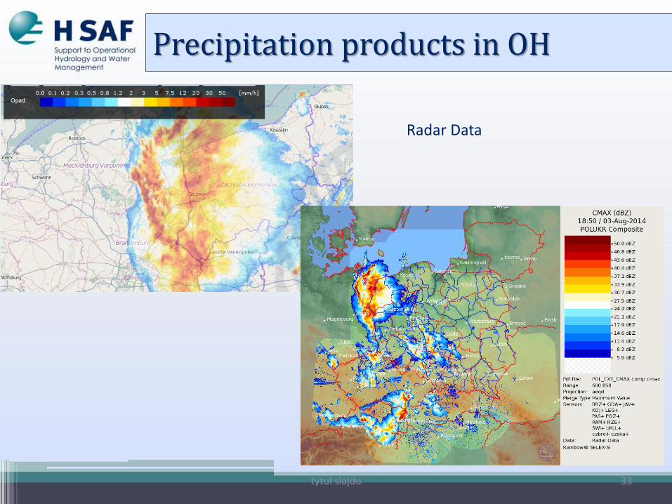
Precipitation products in OH
tytuł slajdu 33
Radar Data
Precipitation products in OH

SatelliteData
Precipitation products in OH

tytuł slajdu
Rain gauges
Precipitation products in OH

Bias-Correction

Satellite precipitation products have systematic errors called bias, which need to be corrected since the biases can affect the hydrological processing in the mathematical models…
• Problem to solve:
(…) to transform precipitation derived from H-SAF, to the observed precipitation
BIAS-correction

• based on simple changes (Lehner et al., 2006),DELTA method
• parametric transformation (Piani et al., 2010; Maraun et al., 2013; Rojas et al., 2011),
• nonparametric transformation (Wood et al., 2004; Boé et al., 2007; Bennet et al., 2011),
• distribution derived transformation (Sharma, 2007; Salvi et al., 2011; Kurnik et al., 2012).
BIAS-correction: methods

(…) to find the optimum function, that maps the modeled variable PMOD from H-SAF precipitationProduct in such way that a new distribution equals the distribution of the observed variable POBS, i.e.,
POBS = f(PMOD)
Distribution derived transformation


Density and quantile functions
for selected probability
distributions
Sets of equations obtained
by MLM method for
GA, GE probability distributions.

Goodness-of-fit tests for probability distributions of random
variables POBS, PH03, PH04 and PH05

• Statistical charactristics


Summary

The usage of precipitation products sometimes can improve the performance of the models…
Some peaks are well simulated (some events were partly successfully simulated)…
Precipitation products can be useful if there is no other information on precipitation amounts…
Some „operations” can make precipitation products more useful in hydrological modeling („updating”)
To make precipitation products more useful for hydrological purposes it is necessary to develop merge products/blended products (H-SAF products + ground data + radar data) and correction methods
Status of validation: Results