hypothesis versus fact: august petermann and polar...
TRANSCRIPT
ARCTIC
VOL. 52, NO. 3 (SEPTEMBER 1999) P. 237–244
Hypothesis Versus Fact: August Petermann and Polar ResearchE. TAMMIKSAAR,1 N.G. SUKHOVA2 and I.R. STONE3
(Received 7 August 1997; accepted in revised form 8 December 1998)
ABSTRACT. The history of polar exploration has witnessed several conceptions of the climate, presence of lands, conditions ofice, and currents in the Arctic Ocean that were hypothetical or based on scarce research data. One such conception was the viewof the physical geography of polar areas put forward in 1865 by the German geographer and publicist August Petermann, whichwas based mainly on the findings of English and Russian polar explorers. Although the actual course of polar research disprovedPetermann’s hypotheses, his conception not only exerted considerable influence on the development of the theoretical knowledgeof polar areas, but also promoted practical steps in Arctic exploration during the second half of the 19th century.
Key words: August Petermann, history, exploration, Arctic Ocean, open polar sea, Gulf Stream, extension of Greenland, OstrovVrangelya (Wrangel Island)
RÉSUMÉ. L’histoire de l’exploration polaire a été témoin de conceptions variées du climat, de la présence de terres, de conditionsde la glace, et de courants dans l’océan Arctique, conceptions fondées sur des hypothèses ou de rares données de recherches. Unede ces conceptions, remontant à 1865, concernait la géographie physique des régions polaires telle que la voyait le géographe etpubliciste allemand August Petermann, qui s’appuyait surtout sur les travaux d’explorateurs polaires anglais et russes. Bien quele cours récent de la recherche polaire réfute les hypothèses de Petermann, non seulement sa conception exerça une influenceconsidérable sur le développement des connaissances théoriques des régions polaires, mais elle pava aussi la voie à des étapespratiques dans l’exploration arctique durant la deuxième moitié du XIXe siècle.
Mots clés: August Petermann, histoire, exploration, océan Arctique, mer polaire ouverte, Gulf Stream, extension du Groenland,Ostrov Vrangelya (île Wrangell)
Traduit pour la revue Arctic par Nésida Loyer.
1 Institute of Zoology and Botany, Karl Ernst von Baer Museum, Veski str. 4, EE-51005 Tartu, Estonia; [email protected] St. Petersburg Institute for History of Science and Technology, Russian Academy of Sciences, Universitetskaya nab. d. 5, 199034
St. Petersburg, Russia3 ‘Laggen Juis’, Larivane Close, Andreas, Isle of Man, 1M7 4HD British Isles
© The Arctic Institute of North America
INTRODUCTION
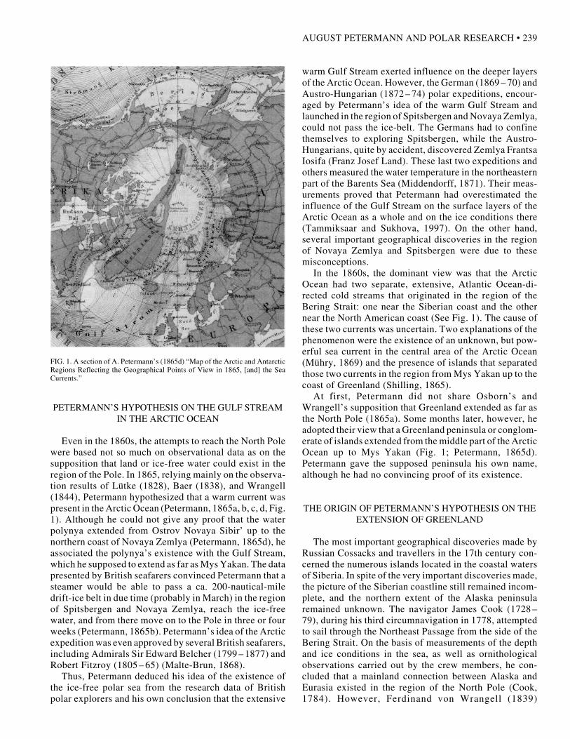
The German publicist and geographer August Petermann(1822 – 1878) delineated his view of the physical geogra-phy of the Arctic Ocean on the map entitled Karte derarktischen und antarktischen Regionen zur Übersicht desgeographischen Standpunktes im J. 1865, der Meereströmungen (Map of the Arctic and Antarctic RegionsReflecting the Geographical Points of View in 1865, [and]the Sea Currents) (Petermann 1865d; Figure 1). The threemost important hypotheses put forward by Petermannconcerned a continuous warm current in the Arctic Oceancoming from the south (the Gulf Stream); an extension ofGreenland to the north; and the navigability of certainpolar sea areas from March to October (Petermann, 1865b;Weller, 1911).
The present paper surveys the works on which Petermannbased his views, points out the great importance ofPetermann’s ideas for polar research, beginning in the1860s, and discusses why his views were so popular.
PETERMANN AND POLAR RESEARCH
The adopted son of the noted German cartographerHeinrich Berghaus (1797 – 1884), August Petermann ofGotha began to take an interest in the geography of polarregions during his stay in England in the 1850s (Petermann,1852, 1853). First he took part in the compilation of ThePhysical Atlas (1848), by Alexander Keith Johnston (basedon Berghaus’s Physikalischer Atlas of 1837 – 48). Later heworked as head of the geographical department of thejournal Athenaeum. In London, the young cartographermet several well-known British geographers and readthrough the rich geographical literature available in thelibraries. In 1855, Petermann founded the journalMittheilungen aus Justus Perthes’ Geographischer Anstaltüber wichtige neue Erforschungen auf dem Gesammt-gebiete der Geographie (Reports from Justus Perthes’Geographical Institution upon Important New Investiga-tions in the Whole Subject of Geography), which in thesecond half of the 19th century had an important position
238 • E. TAMMIKSAAR et al.
among the journals disseminating geographical knowl-edge in Europe (Tammiksaar and Sukhova, 1997).
The launching of the first polar exploration projects inGermany and Austria-Hungary can also be associated withPetermann’s name; he is known as “father of German polarresearch” (Hübsch, 1978; Krause, 1992). An active publi-cist, he wrote over 600 articles on the practical course ofpolar exploration. As a consequence, polar research beganto advance in Russia, Sweden, France, and Norway duringthe second half of the 19th century. Petermann’s conceptsalso served as an impetus to several British and Americanexpeditions to the Arctic Ocean, especially those explor-ing Greenland (Hübsch, 1978). In the 1860s, Petermanngradually became an authority in Germany, where hisviews on the geography of the polar regions were nevercriticized (Krause, 1992). Later studies have shown thatseveral European polar researchers and scholars overval-ued the views and hypotheses proposed by the devotedarmchair geographer (see Tammiksaar and Sukhova, 1997).The first critical remarks on Petermann’s views came fromRussia and England. Petermann took every opportunity toprove the validity of his hypotheses on the physical geog-raphy of the Arctic Ocean, even though the actual resultsof polar exploration did not confirm them.
THE ORIGIN OF PETERMANN’S HYPOTHESES
The first to provide information on the severe weatherand ice conditions in the Arctic Ocean were English andDutch seafarers, who tried to find a northeast passage atthe end of the 16th century. To the same period belong thefirst suppositions of undiscovered polar lands. The contro-versial suppositions that came into being in the course ofpolar exploration in the 17th and 18th centuries—such asmild climate in the region of the North Pole, the presenceof extensive land or a continuous ice field, or data aboutnumerous lands and islands seen in the polar sea bynomads—were reproduced, with smaller or greater varia-tions, in the polar literature and on the maps of the 19thcentury. Because there was little navigation in the Arctic,it was almost impossible to check their validity.
The investigation of the system of currents in the ArcticOcean became an important aspect of polar exploration inthe 19th century, as knowledge of currents could be con-ducive to reaching the North Pole or discovering a north-east passage. Such investigations were performed mainlyby the British expeditions to the coastal waters of theAmerican continent and Greenland. Their results gavereason to believe that two extensive cold currents directedtoward the Atlantic Ocean were present in this region: onebetween Greenland and the American mainland, and theother between Iceland and Greenland. In the region ofGreenland and the Labrador peninsula, those streams joinedto form one: the Labrador stream. The two cold streamsmade ship expeditions from the directions of Labrador andGreenland impossible.
The English navigator Martin Frobisher (1535 – 94)was the first (in 1578) to suppose that the warm, northeast-directed current (the Gulf Stream) extended from theAmerican coast to the Norwegian coast (Kohl, 1868). The1806 whaling expedition under the leadership of WilliamScoresby (1789 – 1857) proved that the extension of theGulf Stream reached the western coast of Spitsbergen andprevented the arctic current from entering the North Sea(Scoresby, 1820). In 1827, relying on the research resultsof Scoresby, Sir William Parry (1790 – 1855) attempted toapproach the North Pole in this region on a ship andsledged boats. Although the expedition advanced as far as82˚45' N, the attempt to reach the pole failed because ofdifficult ice conditions. Another unsuccessful attempt inthe same region, which was not made known in Europe,had been undertaken in 1765 and 1766 by Vasilij Chichagov(1726 – 1809), who followed the instructions of MikhailLomonosov (1711 – 65) (Belov, 1956). Despite the failureof all those expeditions, Sir William Parry in 1845, SirJohn Barrow (1764 – 1848) in 1846, and others still sup-ported the idea of an expedition from Spitsbergen to theNorth Pole (Malte-Brun, 1868).
The Baltic-German explorer Ferdinand von Wrangel(l)(1797 – 1870) considered it impossible to approach thePole by ship (regarding the spelling of his name, seeTammiksaar, 1998). As the leader of the Russian North-east-Siberian expedition, carried out on dog-sledges alongthe coast of the Arctic Ocean in 1820 – 24, Wrangell waswell aware of the ice conditions and currents in the ArcticOcean. Relying on his own experience, he suggested that onlya dog-sledge expedition along the coast of Greenland couldbe successful. He thought that Greenland extended up to thePole (Wrangell, 1848). The English polar researcher SherardOsborn (1822–75) supported this view (Osborn, 1865).
The Baltic-German scholar Karl Ernst von Baer (1792 –1876), known as the founder of contemporary embryol-ogy, was also an active geographer. Baer was the first toconclude—on the basis of materials from expeditions byWilliam Barents (1594 – 97), Friedrich Lütke (1821 – 24),and Petr K. Pakhtusov (1833–34)—that a branch of theGulf Stream extended as far as the coast of Novaya Zemlya(Kohl, 1868). During his expedition in 1820 – 24, Ferdinandvon Wrangell had discovered a polynya—an extensiveopen-water area—that extended from Ostrov Novaya Sibir’to Mys Yakan regardless of the season (Wrangell, 1839).This discovery largely determined the views of the nextgeneration of geographers and polar explorers on the iceand climate conditions in the Arctic Ocean. The results ofWrangell’s expedition were first published by GeorgFriedrich Parrot (1767 – 1852), professor of physics of theUniversity of Tartu (Parrot, 1827). Parrot wrote that thewater polynya discovery allowed Wrangell and his com-panions to believe that an exit to the Bering Strait existedin the vicinity of Novaya Zemlya. Petermann’s plan for apolar expedition, which he put forth as an alternative toOsborn’s plan, was based on the incomplete research datadiscussed above (Petermann, 1865a).
AUGUST PETERMANN AND POLAR RESEARCH • 239
warm Gulf Stream exerted influence on the deeper layersof the Arctic Ocean. However, the German (1869 – 70) andAustro-Hungarian (1872 – 74) polar expeditions, encour-aged by Petermann’s idea of the warm Gulf Stream andlaunched in the region of Spitsbergen and Novaya Zemlya,could not pass the ice-belt. The Germans had to confinethemselves to exploring Spitsbergen, while the Austro-Hungarians, quite by accident, discovered Zemlya FrantsaIosifa (Franz Josef Land). These last two expeditions andothers measured the water temperature in the northeasternpart of the Barents Sea (Middendorff, 1871). Their meas-urements proved that Petermann had overestimated theinfluence of the Gulf Stream on the surface layers of theArctic Ocean as a whole and on the ice conditions there(Tammiksaar and Sukhova, 1997). On the other hand,several important geographical discoveries in the regionof Novaya Zemlya and Spitsbergen were due to thesemisconceptions.
In the 1860s, the dominant view was that the ArcticOcean had two separate, extensive, Atlantic Ocean-di-rected cold streams that originated in the region of theBering Strait: one near the Siberian coast and the othernear the North American coast (See Fig. 1). The cause ofthese two currents was uncertain. Two explanations of thephenomenon were the existence of an unknown, but pow-erful sea current in the central area of the Arctic Ocean(Mühry, 1869) and the presence of islands that separatedthose two currents in the region from Mys Yakan up to thecoast of Greenland (Shilling, 1865).
At first, Petermann did not share Osborn’s andWrangell’s supposition that Greenland extended as far asthe North Pole (1865a). Some months later, however, headopted their view that a Greenland peninsula or conglom-erate of islands extended from the middle part of the ArcticOcean up to Mys Yakan (Fig. 1; Petermann, 1865d).Petermann gave the supposed peninsula his own name,although he had no convincing proof of its existence.
THE ORIGIN OF PETERMANN’S HYPOTHESIS ON THEEXTENSION OF GREENLAND
The most important geographical discoveries made byRussian Cossacks and travellers in the 17th century con-cerned the numerous islands located in the coastal watersof Siberia. In spite of the very important discoveries made,the picture of the Siberian coastline still remained incom-plete, and the northern extent of the Alaska peninsularemained unknown. The navigator James Cook (1728 –79), during his third circumnavigation in 1778, attemptedto sail through the Northeast Passage from the side of theBering Strait. On the basis of measurements of the depthand ice conditions in the sea, as well as ornithologicalobservations carried out by the crew members, he con-cluded that a mainland connection between Alaska andEurasia existed in the region of the North Pole (Cook,1784). However, Ferdinand von Wrangell (1839)
FIG. 1. A section of A. Petermann’s (1865d) “Map of the Arctic and AntarcticRegions Reflecting the Geographical Points of View in 1865, [and] the SeaCurrents.”
PETERMANN’S HYPOTHESIS ON THE GULF STREAMIN THE ARCTIC OCEAN
Even in the 1860s, the attempts to reach the North Polewere based not so much on observational data as on thesupposition that land or ice-free water could exist in theregion of the Pole. In 1865, relying mainly on the observa-tion results of Lütke (1828), Baer (1838), and Wrangell(1844), Petermann hypothesized that a warm current waspresent in the Arctic Ocean (Petermann, 1865a, b, c, d, Fig.1). Although he could not give any proof that the waterpolynya extended from Ostrov Novaya Sibir’ up to thenorthern coast of Novaya Zemlya (Petermann, 1865d), heassociated the polynya’s existence with the Gulf Stream,which he supposed to extend as far as Mys Yakan. The datapresented by British seafarers convinced Petermann that asteamer would be able to pass a ca. 200-nautical-miledrift-ice belt in due time (probably in March) in the regionof Spitsbergen and Novaya Zemlya, reach the ice-freewater, and from there move on to the Pole in three or fourweeks (Petermann, 1865b). Petermann’s idea of the Arcticexpedition was even approved by several British seafarers,including Admirals Sir Edward Belcher (1799 – 1877) andRobert Fitzroy (1805 – 65) (Malte-Brun, 1868).
Thus, Petermann deduced his idea of the existence ofthe ice-free polar sea from the research data of Britishpolar explorers and his own conclusion that the extensive
240 • E. TAMMIKSAAR et al.
disagreed with the view of Cook and Cook’s crew member,James Burney (1750 – 1821). In the course of the North-east-Siberian expedition, Wrangell had not only provedthat the Asian and American continents were not con-nected, but also succeeded in disproving the presence ofextensive land north of the Medvezh’i Ostrova (BearIslands). The Cossack Stepan Andreyev had reported see-ing that land during the 1763 –1764 expedition, and it hadbeen drawn on British maps (Burney, 1819; Cochrane,1824). Another land, between Capes “Erri” (MysShelagskiy) and “Irkajpij” (Cape North, today MysShmidta), had been described by a Chukchi chief in thesewords: “One might in a clear summer’s day descry snow-covered mountains at a great distance to the north”(Wrangell, 1844:325). Wrangell could not prove the pres-ence of this land; nonetheless, he considered the Chukchi’sdata reliable enough for the land north of Mys Yakan to bedrawn on a map, accompanied by the Chukchi chief’sdescription. Having proclaimed Andreyev’s data incor-rect, Wrangell wrote that he definitely did not want todeclare that there could not be any undiscovered land inany region of the Arctic Ocean. On the contrary, headmitted that 530 Russian versts (ca. 565 km) east of theKolyma River, north of Mys Yakan, there was an undis-covered land; however, this land had nothing to do with theso-called discovery of Andreyev, which, in fact, did notexist (Wrangell, 1839).
The results of the Wrangell expedition, which werepublished in German (1839), Russian (1841), French(1843), and English (1844), elicited different interpreta-tions. Some considered Wrangell’s most important con-clusion to be that there was no land north of Mys Shelagskiy.Others considered the data on the land north of Mys Yakanto be most important. Still others supported the idea of theexistence of “Andreyev land,” but not the mountains theChukchi chief had claimed to see on clear summer days.Despite these multiple interpretations, Heinrich Berghausincluded the land that Wrangell believed to exist on a mapof his atlas (Berghaus, 1838).
In 1849, the British polar explorer Henry Kellett (1806 –75) discovered a land in the region Wrangell had indicated(Petermann, 1868) and called it Plover Island. Not verywidely known is the fact that the first person to succeed inlanding there was the German whaler Eduard Dallmann(1830 – 96) in 1866 (Dallmann, 1881). In 1867, the Ameri-can whaler Thomas Long (died in 1875) confirmed theexistence of this land and plotted its location as 70˚40' N,178˚51' W. In honour of Ferdinand von Wrangell, henamed it Wrangell Land (Anonymous, 1868).
DISCUSSIONS CONNECTED WITH THE NAME OF THELAND DISCOVERED BY LONG
Petermann (1868) considered Long’s choice of nameabsolutely unsuitable: Long seemed not to know that it wasactually Wrangell who had done everything possible to
contest and throw doubt on the existence of lands in theArctic Ocean. For that reason, Petermann thought it wouldbe more appropriate to give this land the name of Andreyevor Kellett or somebody else. Controversial data about“Andreyev land”—and even more, the discoveries of Kellettand Long—convinced Petermann that his hypothesis con-cerning the extension of Greenland towards the northeastcoast of Siberia was correct. Petermann’s hypothesis pro-ceeded in part from the multiple interpretations ofWrangell’s work on the land opposite Mys Yakan, in partfrom the influence of Berghaus’s maps, and partly alsofrom Wrangell’s and Osborn’s supposition that Greenlandextended as far as the North Pole. Petermann was wellaware of the various concepts of the physical geography ofthe Arctic Ocean. Wishing to be more particular thanBerghaus, Wrangell, or Osborn, he put forward his viewthat the supposed land represented an extension of theeastern part of Greenland. He denoted it as “WahrscheinlichLand oder Inseln (Petermann)” (Probably land or islands[Petermann]), as shown in Figure 1. According toPetermann, the land discovered by Long (which Petermannlocated at 73˚30'N, 180˚ W) exactly coincided with theland drawn on his own map of 1865 (Petermann, 1868:5).
Petermann’s critical attitude towards the name“Wrangell Land,” which Long had given to the newlydiscovered land, gave rise to lively interest and oppositionin Russia. The geographer Nikolai von Schilling (1822–1910) pointedly wrote that Petermann found Wrangell’sname unacceptable because he regarded the land as hisown geographical discovery (Schilling, 1868). InSchilling’s opinion, Petermann “confused people whowere not specially active in the field of geography” as hebegan to draw his suppositions on the map not with adotted line, but as if the lands had been discovered longago (Schilling, 1868:62).
Most resolute in defending Wrangell was his friendKarl Ernst von Baer (1868). Baer proved once again theinvalidity of Andreyev’s views concerning the land northof the Kolyma River and explained that Wrangell had notdenied the presence of a land north of Mys Yakan. Toprove Wrangell’s point of view, Baer suggested thatGerhard von Maydell (1835 – 94), the leader of the North-east Siberian expedition (1861– 71), check Wrangell’ssupposition of the presence of a land that was seen north ofMys Yakan on bright summer days (Maydell, 1870). Al-though for some reason Maydell did not reach Mys Yakan,and thus could not fulfill the task, the information hereceived from the local people confirmed the existence ofsuch a land (Maydell, 1893).
Baer was one of the few scholars who criticizedPetermann’s overall hypothesis. He compared the exten-sion of Greenland drawn by Petermann with a huge “el-ephant trunk” or a “plait,” writing sceptically that ifPetermann’s hypothesis could be proved, it would be rightto give the peninsula Petermann’s name (Baer, 1868).
In his article “Das neu entdeckte Polar-Land” (The newlydiscovered Polar Land) in 1869, Petermann repeated
AUGUST PETERMANN AND POLAR RESEARCH • 241
his disapproval of giving Wrangell’s name to Long’sdiscovery, reminding readers that this land had been dis-covered and named Plover Island by Captain Kellett 20years previously. However, Petermann also mentionedthat the name Wrangell Land should not be used north ofthe 71st. parallel, because Kellett’s land started there(Petermann, 1869a). It means that to some extent Petermann(1869b) took into account Baer’s remarks, and acceptedthe existence of Wrangell Land in the southern part of hissupposed peninsula, which he even drew on his map.Hence, he never gave up his hypothesis (Petermann, 1874).
The publications of numerous authors at the end of the19th. century confirmed that Petermann’s abstract concep-tion exercised greater influence on them than did the datapresented by Wrangell and Baer (e.g., Chavanne, 1874;Nordenskiöld, 1881). Even the authors who considered itcorrect that the land discovered by Long should bearWrangell’s name believed that the extension of Green-land, as suggested by Petermann, actually existed(Helmersen, 1876; Hiekisch, 1883). Nils Adolf ErikNordenskiöld (1832 – 1901), as well, in his monograph onthe well-known Vega expedition through the NortheastPassage (1878 – 79), considered Andreyev’s data to bemore reliable than those of Wrangell (Nordenskiöld, 1881).
In 1876, the first true archival materials on Andreyev’sexpedition were published (Helmersen, 1876). They con-firmed Baer’s view that Andreyev’s data concerning thediscovery of land had been “a falsification” (Baer, 1868:20).Although Helmersen and Baer had successfully disprovedthe existence of “Andreyev land,” it was impossible tocheck the validity of Petermann’s hypothesis that Green-land extended as far as the coast of Siberia.
In 1876, Petermann met James Gordon Bennett (1795 –1872), the publisher of the New York Herald and a gener-ous patron of geography. Bennett told Petermann about theintention of George de Long (1844 – 81) to conquer theNorth Pole. Petermann recommended that de Long planhis route not via Smith Sound, but through the BeringStrait as far as the southern end of the peninsula ofGreenland, and from there on to the Pole. If the iceprevented reaching the Pole by boat, Petermann thought, itwould be possible to go there by sledges along the main-land. However, contrary to expectation, de Long’s expedi-tion on the Jeannette in 1879 – 81 proved instead thatWrangell Land was an island. This fact was confirmed bythe rescue expeditions dispatched in search of the Jeannette,e.g., that led by Berry in 1881. Despite this evidence, thebelief in the existence of “Petermann land” persistedtenaciously; however, the location of the land was nowthought to be considerably closer to the Pole. FridtjofNansen (1861 – 1930) also proved the invalidity of the“Petermann land” hypothesis. His audacious drift in theArctic Ocean in the Fram (1894 – 97), from the mouth ofthe Yenisey River to Franz Josef Land, allowed him toconfirm that there was no “Petermann land” in the regionof the North Pole. The supposition that the Arctic Oceanwas shallow, based on data of Wrangell and Joseph Wiggins
(1832 – 1905), also turned out to be a fantasy (Nansen,1898 – 1905).
CONCLUSIONS
August Petermann based his concept of the physicalgeography of the Arctic Ocean along the Siberian coast onvery scarce data. The disproving of Petermann’s geo-graphical creation in the course of advancing polar re-search showed how difficult it was to refute a hypotheticalcreation, even when observational data disproving thehypothesis were at hand. Petermann wanted no more thanto secure evidence supporting his own ideas and to refer tothe ignorance of those who had criticized him. Critics ofpopular notions are seldom listened to. This is clearlyrevealed by the fact that discussions about the suitabilityof attaching Wrangell’s name to the land discovered byLong continued until the 1880s. Furthermore, even as lateas the beginning of the 20th century, there were supportersof the concept of Petermann land, although the expeditionof the Fram (1894 – 97) under Fridtjof Nansen, whichcomprehensively demolished it, had already taken place.
Petermann’s concept was a false deduction based oncontemporary knowledge of the Arctic Ocean. This wrongconception influenced not only the theoretical views in thefield of the geography of the Arctic Ocean, but also thepractical course of Arctic exploration in the second half ofthe 19th century. Although most of Petermann’s hypoth-eses on the physical geography of polar areas proved to bewrong, it should not be forgotten that Petermann was animportant figure in German polar research. On his initia-tive, the first German Arctic expeditions were organized,and polar exploration in England, France, Sweden, Nor-way and Russia began to advance. Petermann’s instruc-tions were also followed in the preparation of theAustro-Hungarian polar expedition. The latter, in its turn,was the precondition for organizing the first internationalpolar year in 1882 – 83.
ACKNOWLEDGEMENTS
The authors express their gratitude to Mrs. M. Roos of the KarlErnst von Baer Museum for her valuable help in the preparation ofthis article.
REFERENCES
ANONYMOUS. 1868. Recent discovery of Arctic Land. TheNautical Magazine and Naval Chronicle for 1868: A Journal ofPapers. Maritime Affairs 37(2):93 –100.
BAER, K.E.von. 1838. Expédition a Novaia Zemlja et en Laponie.Bulletin scientifique, publié par l’Académie Imperiale dessciences de St. Pétersbourg 3(5 –7):96 –107.
———. 1868. Das neuentdeckte Wrangells–Land. Dorpat [nowTartu, Estonia]: W. Gläsers Verlag.
242 • E. TAMMIKSAAR et al.
BELOV, M.I. 1956. Arkticheskoe moreplavanie s drevnejshikhvremen do serediny XIX veka. Istoriya otkrytiya osnovaniyaSevernogo morskogo puti. Vol. 1. Leningrad, USSR: Morskojtransport.
BERGHAUS, H. 1838. Alexander von Humboldt’s System derIsotherm–Kurven; in Merkator’s Projection. Karte Nr 1. In:Berghaus, H. 1837–1848. Physikalischer Atlas. Gotha, Germany:Justus Perthes Verlag.
BURNEY, J. 1819. A chronological history of north eastern voyagesof discovery and of the early eastern navigations of the Russians.London: Payne and Foss and John Murray.
CHAVANNE, J. 1874. Das arktische Festland und Polarmeer.Mittheilungen aus Justus Perthes’ Geographischer Anstalt überwichtige neue Erforschungen auf dem Gesammtgebiete derGeographie 20:241 –252.
COCHRANE, J. 1824. Narrative of a pedestrian journey throughRussia and Siberian Tartary, from the Frozen Sea and Kamtchatka,performed during the years 1820, 1821, 1822 and 1823. London:Murray.
COOK, J. 1784. A Voyage to the Pacific Ocean, undertaken by thecommand of his Majesty for making discoveries in the NorthernHemisphere to determine the position and extent of the west sideof Northern America, its distance from Asia, and the practicabilityof a northern passage to Europe. 3 vols. London: G. Nicol and T.Cadell.
DALLMANN, E. 1881. Wrangels-Land im Jahre 1866 durchKapitän Dallmann besucht. Deutsche Geographische Blätter4:54 –57.
HELMERSEN, L.v. 1876. Zur Streitfrage über das Wrangell-Land.St. Petersburg: Eggers.
HIEKISCH, C. 1883. Noch einmal die Streitfrage über das Wrangell-Land. Dorpat [Tartu, Estonia].
HÜBSCH, U. 1978. August Petermann. Polarforschung 48(1/2):183–187.
JOHNSTON, A.K. 1848. The Physical Atlas. Based on thePhysikalischer Atlas of H. Berghaus (Gotha: Justus Perthes Verlag,1837–1848). Edinburgh, Scotland: W. and A.K. Johnston.
KOHL, J.G. 1868. Geschichte des Golfstroms und seinerErforschung von den ältesten Zeiten bis auf den grossenamerikanischen Bürgerkrieg. Bremen: Verlag von C. Ed. Müller.
KRAUSE, R.A. 1992. Die Gründungsphase deutscherPolarforschung, 1865 –1875. Berichte zur Polarforschung. Vol.114. Bremenhaven: Alfred-Wegener-Institut für Polar-undMeeresforschung.
LÜTKE, F. B. (LITKE, F. P) [1828]. Chetyrechkratnoe putehsestviev Severnyj Ledovityj okean na voennom brige “Novaja Zemlja”v 1821 –1824 godakh. 2 vols. St. Petersburg. Modern edition,1948. Moskva: Gosudarstvennoe izdatel’stvo geograficeskojliteratury (Russian).
MALTE-BRUN, V.A. 1868. Les trois projets: Anglais (S. Osborn),Allemand (A. Petermann), Français (G. Lambert). D’explorationau pole Nord exposé historique et géographiqe de la questionaccompagné d’une Carte polaire nouvelle. Paris: ChallamelAiné, Libraire-Éditeur.
MAYDELL, G. 1870. Otvety Chukotskoj ékspeditsii na voprosyakademika Béra. Izvestiya Sibirskago Otdela RusskagoGeograficheskago Obshchestva 1(2–3):67 –69.
———. 1893. Reisen und Forschungen im Jakutskischen GebietOstsibiriens in den Jahren 1861 –1871. Vol. 1. St. Petersburg:Buchdruckerei der Kaiserlichen Akademie der Wissenschaften.
MIDDENDORFF, Al.Th.v. 1871. Der Golfstrom ostwärts vomNordkap. Mittheilungen aus Justus Perthes’ GeographischerAnstalt über wichtige neue Erforschungen auf demGesammtgebiete der Geographie 17:25 – 34.
MÜHRY, A. 1869. Ueber die Lehre von den Meeresströmungen.Göttingen: Vandenhoeck & Ruprecht’s Verlag.
NANSEN, F. 1898 –1905. The Norwegian North Polar Expedition,1893 –1896: Scientific Results. 6 vols. Christiania (now Oslo),Norway: Jacob Dybwad.
NORDENSKIÖLD, N.A. 1881. The voyage of the Vega round Asiaand Europe. Vol. 2. London: Macmillan and Co.
OSBORN, S. 1865. On the exploration of the North Polar region.Proceedings of the Royal Geographical Society of London9(2):42 –70.
PARROT, G.F. 1827. Physikalische Beobachtungen des Capitain–Lieutenant Baron v. Wrangel während seiner Reisen auf demEismeere in den Jahren 1821, 1822 und 1823. Berlin: G. Reimer.
PETERMANN, A. 1852. The search for Franklin: A suggestionsubmitted to the British public. London: Brown, Green andLongmans.
———. 1853. Sir John Franklin, the Sea of Spitzbergen, andWhalefisheries in the Arctic Regions. The Journal of the RoyalGeographical Society 23:129 –136.
———. 1865a. Über S. Osborn’s Plan. Mittheilungen aus JustusPerthes’ Geographischer Anstalt über wichtige neueErforschungen auf dem Gesammtgebiete der Geographie 11:99 –104.
———. 1865b. Die Eisverhältnisse in den Polar-Meeren und dieMöglichkeit des Vordringens in Schiffen bis zu den höchstenBreiten. Mittheilungen aus Justus Perthes’ GeographischerAnstalt über wichtige neue Erforschungen auf demGesammtgebiete der Geographie 11:136 –146.
———. 1865c. Der Nordpol und Südpol, die Wichtigkeit ihrerErforschung in Geographischer und kulturhistorischerBeziehung. Mittheilungen aus Justus Perthes’ GeographischerAnstalt über wichtige neue Erforschungen auf demGesammtgebiete der Geographie 11:146 –160.
———. 1865d. Karte der arktischen & antarktischen Regionen zurÜbersicht geographischen Standpunktes im J. 1865, derMeeresströmungen. Mittheilungen aus Justus Perthes’Geographischer Anstalt über wichtige neue Erforschungen aufdem Gesammtgebiete der Geographie 11: Tafel 5.
———. 1868. Entdeckung eines neuen Polar–Landes durch denAmerikanischen Kapitän Long, 1867. Mittheilungen aus JustusPerthes’ Geographischer Anstalt über wichtige neueErforschungen auf dem Gesammtgebiete der Geographie 14:1 –6.
———. 1869a. Das neu entdeckte Polar-Land und die Expeditionenim Eismeere nördlich der Bering-Strasse von 1648 bis 1867.Mittheilungen aus Justus Perthes’ Geographischer Anstalt überwichtige neue Erforschungen auf dem Gesammtgebiete derGeographie 15:26 –37.
———. 1869b. Wrangel-Land und Übersicht derEntdeckungsgeschichte im Eismeer nördl. der Bering-Strasse
AUGUST PETERMANN AND POLAR RESEARCH • 243
1648 –1867. Mittheilungen aus Justus Perthes’ GeographischerAnstalt über wichtige neue Erforschungen auf demGesammtgebiete der Geographie 15: Tafel 2.
———. 1874. Originalkarte zur Übersicht des Standpunktes neuesterPolarforschungen bis Ende September 1874. Mittheilungen ausJustus Perthes’ Geographischer Anstalt über wichtige neueErforschungen auf dem Gesammtgebiete der Geographie 20:Tafel 20.
SCHILLING, N. 1865. Soobrazheniya o novom puti dlya otkrytijv Severnom Polyarnom okeane. Morskoj Sbornik 78(5):213 –224.
———. 1868. Geograficheskaya zametka. Morskoj Sbornik95(4):59 –63.
SCORESBY, W. 1820. An account of the Arctic regions, andnorthern whale-fishery. Vol. 1. Edinburgh: Archibald Constableand Co.
TAMMIKSAAR, E. 1998. Wrangell or Wrangel—Which is it?Polar Record 34(188):55–56.
TAMMIKSAAR, E., and SUKHOVA, N.G. 1997. KontseptsiyaSevernogo Ledovitogo okeana Avgusta Petermana i vzglyadyuchenykh Rossii. Izvestiya Russkogo GeograficheskogoObshchestvo 129(6):12–22.
WELLER, E. 1911. August Petermann. Ein Beitrag zur Geschichteder geographischen Entdeckungen und der Kartographie in 19.Jahrhundert. Quellen und Forschungen zur Erd- und Kulturkunde.Vol. 4. Leipzig: Otto Wigand m.b.H.
WRANGELL, F.v. 1839. Reise längs der Nordküste von Sibirienund auf dem Eismeere in den Jahren 1820 bis 1824. Edited andtranslated by G. v. Engelhardt. 2 vols. Berlin: Voss’scheBuchhandlung.
———. [Vrangel’, F.P.] 1841. Puteshestvie po severnym beregamSibiri i po Ledovitomu moryu, sovershennoe v 1820, 1821,1822, 1823 i 1824 g., ékspeditsieyu, sostoyavsheyu podnachal’stvom flota lejtenanta Ferdinanda fon Vrangelya. 2 vols.St. Petersburg: Tipografiya A. Borodina.
———. 1843. Le Nord de la Sibérie. Voyage parmi les peuplades dela Russie asiatique et dans la mer Glaciale. Traduit du russe parle Prince E. Galitzin. 2 vols. Paris.
———. 1844. Narrative of an expedition to the polar sea in the years1820, 1821, 1822 & 1823. 2nd ed. Edited by E. Sabine. London:James Madden and Co.
———. 1848. On the best means of reaching the Pole. The Journalof the Royal Geographical Society of London 18:19 –23.