i archaeological assessmentnswaol.library.usyd.edu.au/data/pdfs/12974_id_bickford...archaeological...
TRANSCRIPT
ARCHAEOLOGICAL ASSESSMENT
IIIIIIIIIIIIIIIIIIIII
~EN
ARK
BOVIS LEND LEASE
\\\
BITUMEN D BT
lItPHILLIP LANE .r
PIDLLIPLANE
CITY OF SYDNEY
Anne Bickford MAACAIHeritage Consultants
135 Catherine St Leichhardt NSW 2040Phone 02-95699672 Fax 02-95500261
Email [email protected]
November 2002
ARCHAEOLOGICAL ASSESSMENT FOR THE NORTHERN END OF PIDLLIP LANE NOVEMBER 2002 1
5.0 PHYSICAL ANALYSIS - SITE SURVEY 525.1 The Site As Identified by Historical Research5.2 Description ofthe Site
3.0 METHODOLOGY 303.1 Cultural Significance3.2 Archaeological Assessment3.3 Assessing Heritage Significance
2.0 PREVIOUS REPORTS ON PHILLIP LANE 152.1 The Archaeological Zoning Plan for Central Sydney2.2 Sydney City Council Reports
2.2.1 Policy for the Management ofLaneways in Central Sydney2.2.2 Central Sydney Heritage Local Environmental Plan 2000 162.2.3 Central Sydney Development Control Plan 1996 172.2.4 Comment on City of Sydney Documents
2.3 NSW Heritage Office2.3.1 State Heritage Inventory2.3.2 The Chief Secretary's Building Permanent Conservation Order
2.4 The Conservation Management Plan for the Chief Secretary's Building18
56
7
PAGE·CONTENTS
EXECUTIVE SUMMARY1.0 INTRODUCTION1.1 Purpose of this Report1.2 A Note on Terminology1.3 The Development Proposal and This Report1.4 The Study Area1.5 Authorship and Research1.6 Liaison1.7. Form of This Report
4.0 HISTORICAL DEVELOPMENT OF THE SITE . 314.1 Phillip Lane Sydney Section 1074.21788-1840s4.3 1830s-1840s 324.4 1840s-1870s Residential Development 334.5 The Colonial Secretary and Public Works Offices 344.6 19th Century Detailed Surveys4.7 20th Century Developments 354.8 The State Office Block 1961-19684.9 Aurora Place 364.10 The Change ofName from Macquarie Lane to Phillip Lane4.11 Heritage Listings 374.12 Heritage Significance4.13 Recommended Management
IIIIIIIIIIIIIIIIIIII
Anne Bickford Heritage Consultants 135 Catherine St Leichhardt NSW 2040 Ph02/95699672 Fx02/95500261
~==--).--------
Anne Bickford Heritage Consultants 135 Catherine St Leichhardt NSW 2040 Ph02/95699672 Fx02/95500261
10.0 CONCLUSIONS AND RECOMMENDATIONS 88
. 7.0 SYNTHESIS OF PHYSICAL AND DOCUMENTARY EVIDENCE 67
5.3 Condition of the Site 535.4 PHOTOGRAPHS OF THE SITE TAKEN 31 OCTOBER 2002
NOVEMBER 2002 2ARCHAEOLOGICAL ASSESSMENT FOR THE NORTHERN END OF PHILLIP LANE
6.0 REPORT ON HERITAGE VALUES AND CONSERVATIONOF STONE MATERIALS 62
6.1 Introduction6.2 General Description6.3 Heritage Evaluation
6.3.1 Cobblestones·6.3.2 Flagstones 636.3.3 Stone Kerbing and Gutters 646.3.4 Conclusions
6.4 Comment by Anne Bickford 65
8.0 ASSESSMENT OF CULTURAL SIGNIFICANCE 688.1 The Concept of Cultural Significance8.2 General Assessment Processes and Criteria8.3 NSW fIeritage Assessment Criteria8.4 The Cultural Significance of the Study Area 69
8.4.1 Aesthetic Significance 708.5 Conclusion8.6 The Archaeological Significance of the Study Area 71
8.6.1 The Archaeological Resource
9.0 DEVELOPMENT IMPACT 729.1 The Development Proposal9.2 Detailed Description and Explanation by Bovis Lend Lease
9.2.1 Original Scope9.2.2 Heritage Components of the Original Scope 739.2.3 Heritage Discovery 749.2.4 Revised S<?ope9.2.5 Heritage Impacts and Reasoning 75
9.2.5.1 Coal tar macadam9.2.5.2 Sandstone flagging 769.2.5.3 Bluestone, trachyte, and sandstone kerbs/gutters9.2.5.4 Bluestone cobbles 779.2.5.5 Bluestone flagging9.2.5.6 Moat grates including stone surround
9.3 The Impact of the Development on the Archaeological Resource:9.3.1 On the potential archaeological remains in the ground9.3.2 On the archaeological remains which are above ground 78
APPENDIX A The Burra Charter 89(The Australia ICOMOS Charter for Places of Cultural Significance)
IIIIIIIIIIIIIIIIIIII,I]
Anne Bickford Heritage Consultants 135 Catherine St Leichhardt NSW 2040 Ph02/95699672 Fx02/95500261
ARCHAEOLOGICAL ASSESSMENT FOR THE NORTHERN END OF PHILLIP LANE NOVEMBER 2002 3
Figure 1.1 Location Map Phillip Lane 8Figure 1.2 Plan of the Whole of the Study Area North End ofPhillip Lane 9Figure 1.3 Plan of Intersection Area and Area ofExcavation 1:100 10Figure 1.4 Plan ofDetail ofArea ofExcavation 1:50 Page 1-2 11Figure 1.5 Plan ofDetail ofArea ofExcavation 1:50 Page 2-2 12Figure 1.6 Phillip Lane West - Phillip Street End 13Figure 1.7 Phillip Lane East - Macquarie Street End
14Figure 2.1 Archaeological Zoning Plan for Central Sydney
. Showing Phillip Lane 19Figure 2.2 City of Sydney Heritage Database Inventory Report Page 1-5 20Figure 2.3 City of Sydney Heritage Database Inventory Report Page 2-5 21Figure 2.4 City of Sydney Heritage Database Inventory Report Page 3-5 22Figure 2.5 City of Sydney Heritage Database Inventory Report Page 4-5 23Figure 2.6 City of Sydney Heritage Database Inventory Report Page 5-5 24Figure 2.7 NSW Heritage Office State Heritage Inventory. Item
- Phillip Lane Page 1-2 25Figure 2.8 NSW Heritage Office State Heritage Inventory. Item
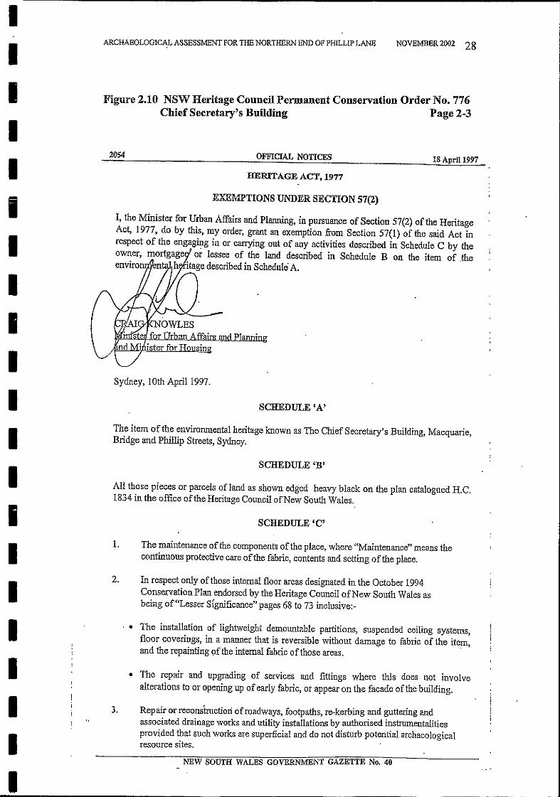
- Phillip Lane Page 2-2 26Figure 2.9 NSW Heritage Council Permanent Conservation Order No. 776
Chief Secretary's Building Page 1-3 27Figure 2.10 NSW Heritage Council Permanent Conservation Order No. 776
Chief Secretary's Building Page 2-3 28Figure 2.11 NSW Heritage Council Permanent Conservation Order No. 776
Chief Secretary's Building Page 3-3 29Figure 4.1 1827 Study Area - Grounds to east of Government House 38Figure 4.2 1829 Grounds to east of Government House 39Figure 4.3 1816 The Cartwright Plan of 1816 40Figure 4.4 1831 Detail ofMap ofthe Town of Sydney 1831 41Figure 4.5 1842 Phillip Lane First Appears. Site of Chief Secretary's
Building shown as 'Site for Public Offices 42Figure 4.6 1842 Detail ofFigure 4.5 43Figure 4.7 1845 Plan by Townsend showing location ofPhillip Street
once Government House was demolished 44Figure 4.8 1850 'Tracing Shewing the line ofMacquarie Street from Bent
Street to Bridge Street' with names ofPurchasers 45Figure 4.9 1865 'Trigonometric Survey of Sydney' Section D1 46Figure 4.10 1870s Terrace Houses in Macquarie Street between Bent
Street and Phillip Lane 47Figure 4.11 c.1880 Chief Secretary's Building showing Entrance to Phillip
Lane from Macquarie Street, with Terraces on South side ofLane 48Figure 4.12 1880 Phillip Lane east and west are shown as 'Right ofWay' 49Figure 4.13 1884 Metropolitan Detail Survey Sheet 49, 1884 50Figure 4.14 After 1900 Fire Underwriters' Plan 51
IIIIIIIIIIIIIIIIIIIII
LIST OF FIGURES PAGE
Anne Bickford Heritage Consultants 135 Catherine St Leichhardt NSW 2040 Ph02/95699672 Fx02/95500261
Figure 5.1 The Intersection. Looking into the yard of Chief Secretary'sBuilding 54
Figure 5.2 Close up of Sandstone Flagstones Showing two LayersFigure 5.3 Trench with Kerb Removed on North Side ofPhillip Lane East55Figure 5.4 Trench Showing Sandstone Flagging on South Side ofPhillip
Lane EastFigure 5.5 Sandstone Flagging in Two Layers. Phillip Lane East 56Figure 5.6 Detail of Coal Tar Macadam Below Bitumen SurfaceFigure 5.7 Bluestone Cobbles and Sandstone Gutter at Rear of Chief
Secretary's Building 57Figure 5.8 As Above Looking WestFigure 5.9 Bluestone Flagging and Sandstone Gutter Looking West 58Figure 5.10 Phillip Lane Macquarie Street End. Stone KerbFigure 5.11 Phillip Lane West From Intersection Corner Showing
Stone Kerb and Gutter . 59Figure 5.12 Bowral Trachyte Lintel in 5.11. Scale is 1metre long.Figure 5.13 Bowral Trachyte Lintel on 'The Astor' Corner 60Figure 5.14 Bowral Trachyte Lintel on South West Corner of IntersectionFigure 5.15 Plan of Site Showing Direction ofPhotographs 61Figure 6.1 1854 Woolcott & Clarke's Map ofthe City of Sydney 66Figure 9.1 SKC01 Phillip Lane. Redesign for Existing Flagstone Paving 79Figure 9.2 SKC02 Raised Crossing Detail for Sandstone Flagging 80Figure 9.3 SKC03 Across Intersection-Detail ofBluestone Cobbles 81Figure 9.4 Revised Kerb Detail Showing Insertion ofBond Breaker 82Figure 9.5 Plan ofIntersection area with Proposed Revised Works 83Figure 9.6 Plan ofPhillip Lane East with Proposed Revised Works 84Figure 9.7 Plan of S-W Corner ofIntersection with Revised Works 85Figure 9.8 Plan ofPhillip Lane & Macquarie Street with Revised Works 86Figure 9.9 Plan ofPhillip Lane & Phillip Street with Revised Works 87
IIIIIIIIIIIIIIIIIIII
~\I
ARCHAEOLOGICAL ASSESSMENT FOR THE NORTHERN END OF PHILLIP LANE NOVEMBER 2002 4
Anne Bickford Heritage Consultants 135 Catherine St Leichhardt NSW 2040 Ph02/95699672 Fx02/95500261
Archaeological monitoring is the recommended method of archaeologicalmanagement during the completion of the upgrading process.
Bovis Lend Lease have revised their plans for the lane upgrading in the light ofthis research. The Report includes their revised scope of works and plans forretaining in situ and conserving the sandstone flagging and other remains.
Phillip Lane was fonned in the 1840s as the back lane to the new imposing terracehouses fronting Macquarie Street and Phillip Street. Throughout the 19th centuryit was known as Macquarie Lane.
NOVEMBER 2002 5
EXECUTIVE SUMMARY
This Report reviews the heritage issues relating to the laneway. In relation to thesandstone flagging the evidence suggests that it was laid when the ChiefSecretary's Building which backs onto the lane was completed in 1880.Other stone remains in the lane such as bluestone paving, sandstone gutters, andbluestone and Bowral trachyte kerbing are also assessed.This group of elements fonns a rare survival of such infrastructure in the city area.
In October 2002 the northern end of Phillip Lane was being upgraded by BovisLend Lease when substantial sandstone flagging was found under the road inPhillip Lane east. Work was stopped so that an Archaeological Excavation PermitApplication from the NSW Heritage Office could be applied for. ThisArchaeological Assessment Report is a Heritage Office requirement to accompanythe Application.
ARCHAEOLOGICAL ASSESSMENT FOR THE NORTHERN END OF PHILLIP LANE
IIIIIIIIIIIIIIII
1II1I
III
Anne Bi~kfordHeritage Consultants 135 Catherine St Leichhardt NSW 2040 Ph02/95699672 Fx02/95500261
1.2 A Note on Terminology
1.3 The Development Proposal and This Report
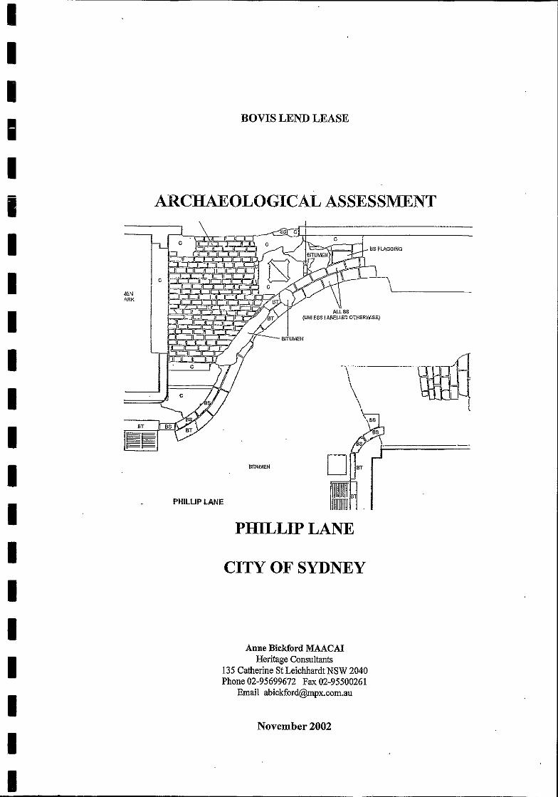
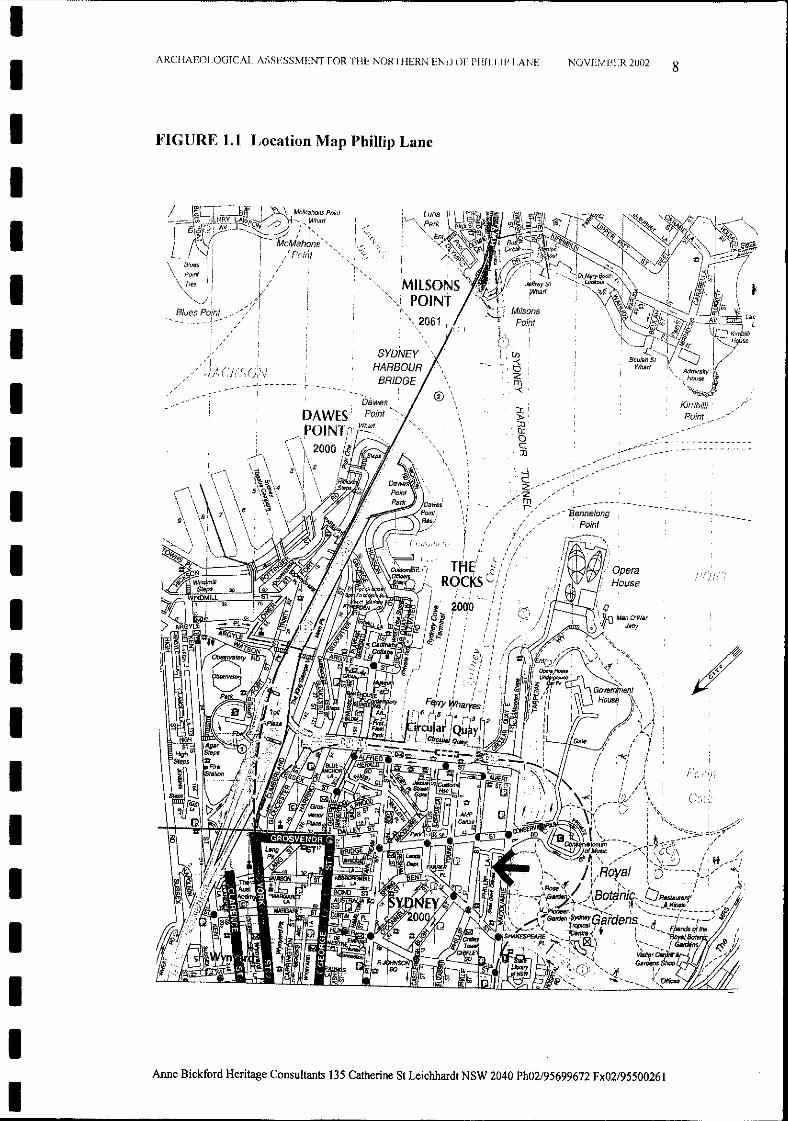
This is an Archaeological Assessment Report on Phillip Lane. Phillip Lane is a'T' shape the shaft of which runs north-south at the rear of the buildings facingPhillip Street and Macquarie Street. The northern end ends in a 'T' intersection;the southern end in the pedestrian plaza of the building complex called AuroraPlace. The 'T' intersection at the north of the lane is offset. One half runs toPhillip Street (for convenience called in this Report Phillip Lane West) and theother half runs to Macquarie Street (called in this Report Phillip Lane East) (SeeFigure1.1). This Report deals with this northern end ofPhillip Lane.
NOVEMBER 2002 6
This Report is about a historic laneway in the city whose earlier surfacingmaterials were recently found, and whose stone kerbs, gutters, and fragments ofpaving are of several different types of stone. The names of the stone and itsformations here are not in common use, and clarity of description is needed.Therefore from the outset I am in this Report using the terms used by thematerials specialist, geologist Dr. George Gibbons, in his contribution, which ispresented in this Report as Chapter 6.He makes a distinction between the smaller fitted blocks of bluestone at the reargate of the Chief Secretary's Building which he calls cobblestones or cobbles; andthe larger blocks of sandstone which were found in Phillip Lane East forming theformer surface of the laneway, which he calls flagstones or flagging. I will usethese terms in this Report.
Bovis Lend Lease had prepared a detailed plan to upgrade Phillip Lane for itsowners, the City of Sydney Council, by renewing the surface, kerbing, and pavingin key areas of the northern end. In commencing the work by starting to removethe bitumen road and the footpath from Phillip Lane East sandstone flagstones ofold appearance were revealed. In the discussions which followed withrepresentatives of the City Council, the DPWS, and the NSW Heritage Office, itwas agreed that as the flagstones were covered by the NSW Heritage Act 1977,work would have to stop, and Bovis Lend Lease apply for an Excavation Permitunder Section 140 of the NSW Heritage Act. As that part of the laneway to therear of the Chief Secretary's Building which stands at the northern end of the 'T"intersection was also included in the upgrade, Section 60 of the NSW Heritage Actwas also relevant. This Section covers Excavation Permits for sites on theHeritage Office's State Heritage Register and the Chief Secretary's Building isone such site.
1.1 Purpose of this Report
1.0 INTRODUCTION
ARCHAEOLOGICAL ASSESSMENT FOR THE NORTHERN END OF PHILLIP LANE
IIIIIIIIIIIIIIII
IIIII
Anne Bickford Heritage Consultants was commissioned to prepare bothExcavation Permit Applications. This Archaeological Assessment Report is thatrequired to accompany the Section 140 Application.A separate Statement ofHeritage Impact Report has been prepared for the Section60 Application and as part of the Sydney City Council's heritage assessmentrequirement.
II-III
ARCHAEOLOGICAL ASSESSMENT FOR THE NORTHERN END OF PIDLLIP LANE NOVEMBER 2002 7
iIIIIIIIIIIIIIII
1.4 The Study Area
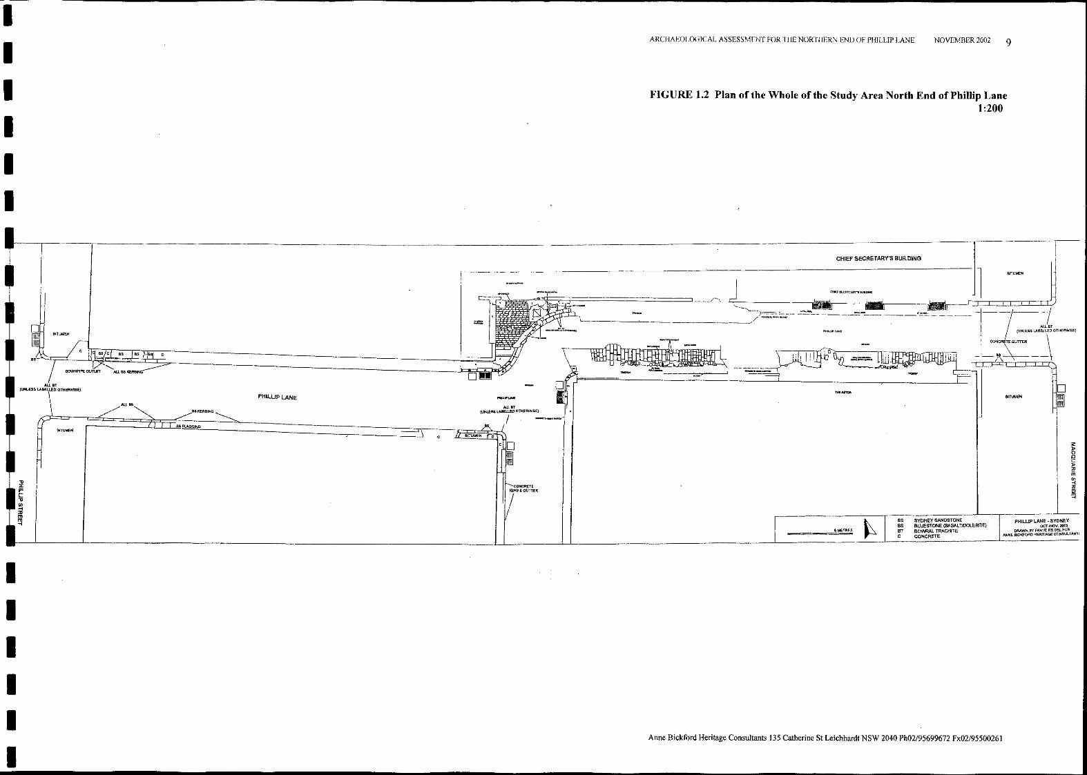
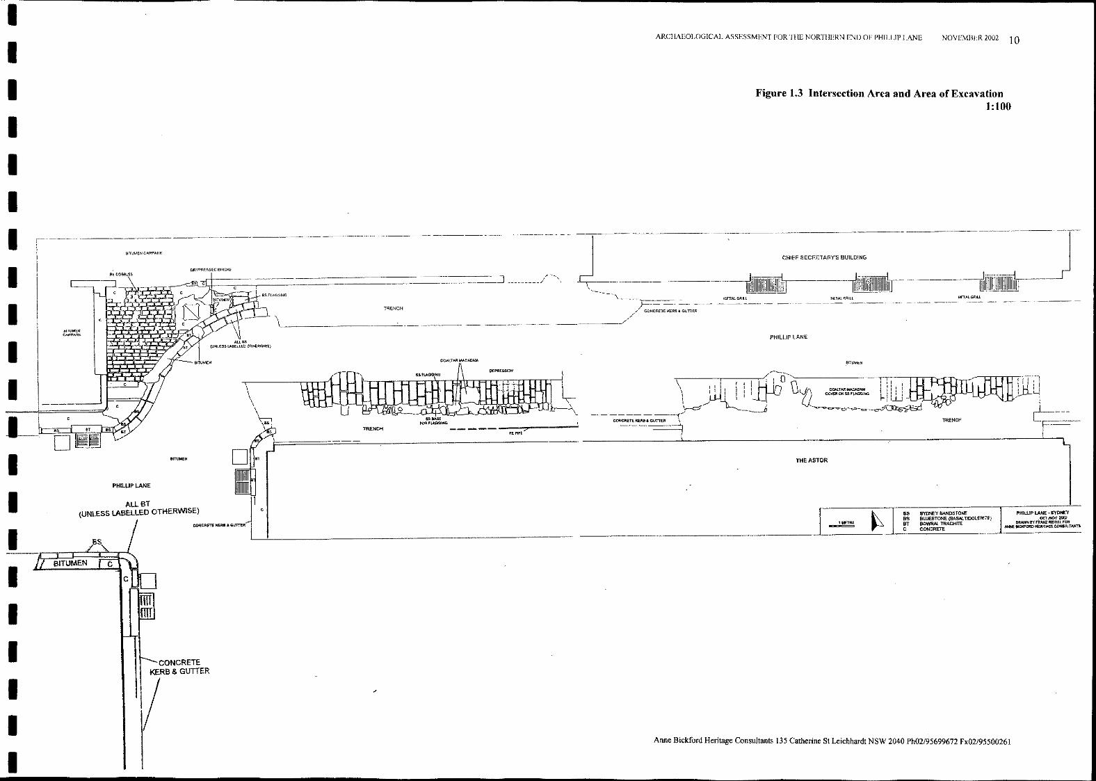
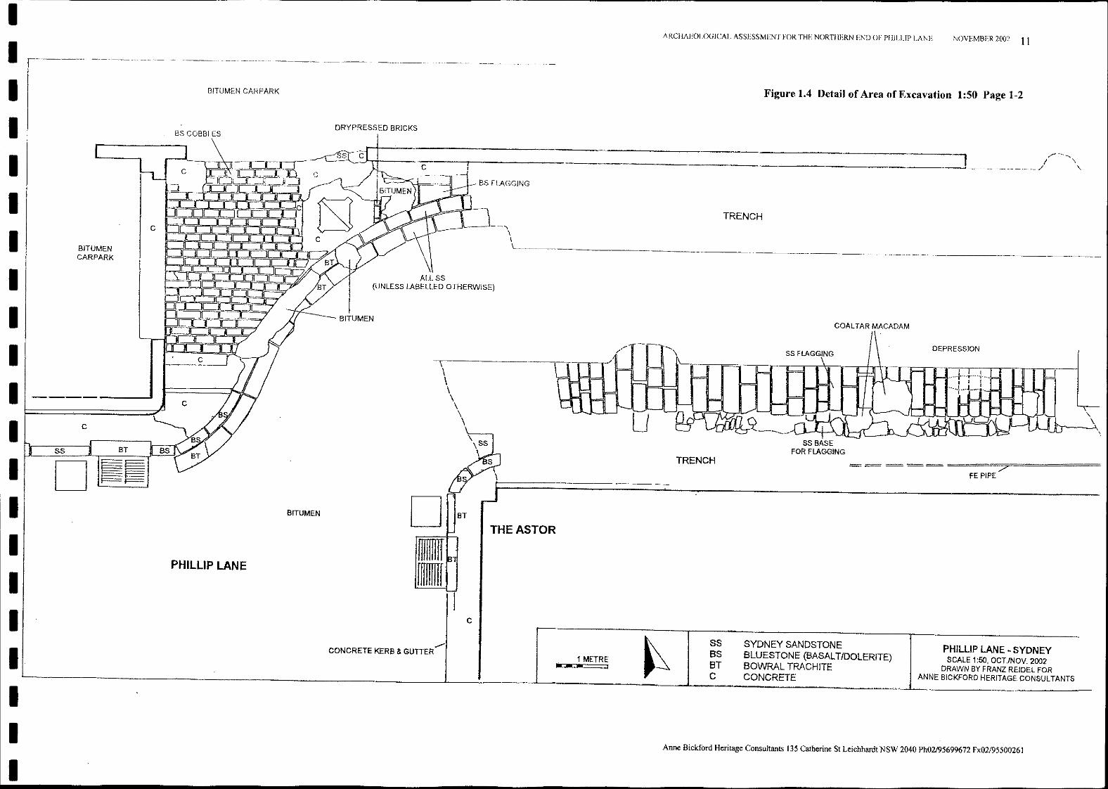
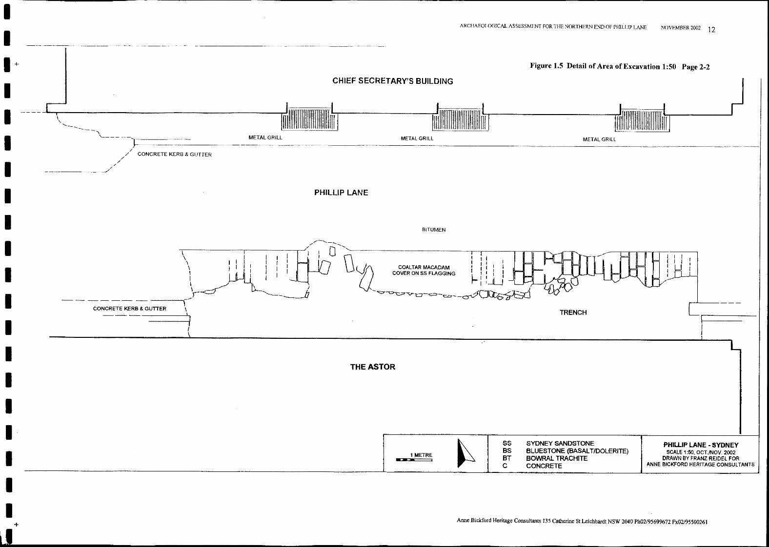
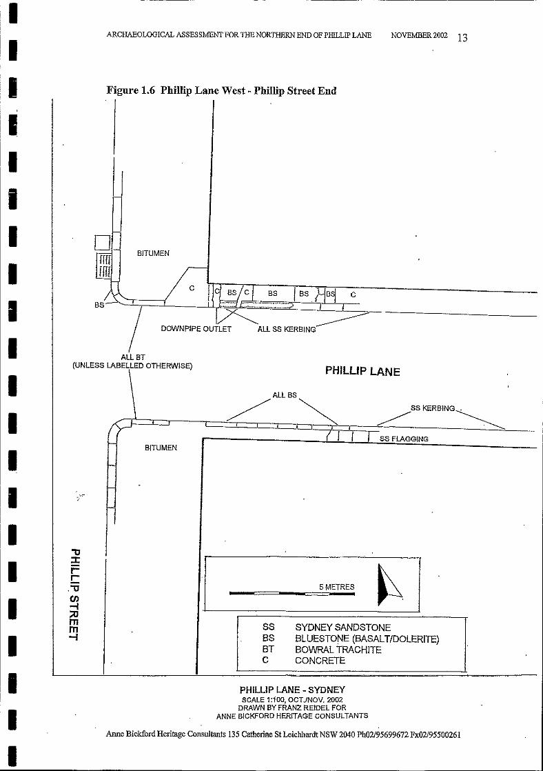
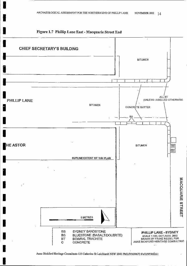
The Study Area is the northern end of Phillip Lane. It is shaped like an offset 'T'intersection. It includes all of the northern part of Phillip lane, from the PhillipStreet end to the Macquarie Street end and the intersection of the two with the topof the 'T' shaft. The whole Study Area is shown in Figurel.2 of this Report at ascale of 1:200. A plan of the Intersection area and the area where the sandstoneflagging was excavated is Figure 1.3 at a scale of 1:100. Figures 1.4 and 1.5 showthe excavation area in detail at a scale of 1:50.
1.5 Authorship and Research
This Report has been written by Anne Bickford except for specialist chapters bythe historian Dr. Rosemary Annable and materials science specialist Dr. GeorgeGibbons which have been inserted largely unedited into this Report. As they areboth experts in their field, and their contributions are essential to ourunderstanding of this site their work has been reproduced in full, even if theremight be some small repetition in the text of the Report as a whole.
1.6 Liaison
The client for this Report is Bovis Lend Lease Pty Ltd. The liaison officer is BarrySteele, ofBovis Lend Lease, Level 9 Tower Building, Australia Square Sydney.
1.7. Form of This ReportThe Figures referred to in the text are placed at the end of each chapter where theyare first referred to. ego Figure 1.1 Location Map and 1.2 Plan of the Study Areaare at the end of Chapter 1. "Introduction".
Anne Bickford Heritage Consultants 135 Catherine St Leichhardt NSW 2040 Ph02/95699672 Fx02/9550026l
IIII
ARCHAEOJ ,OGICAL ASSESSMENT FOR THE NORTHERN END OF PHILIlP LANE
FIGURE 1.1 Location Map Phillip Lane
NOVEMBER 2002 8
IIIIIIIIIIIIIIII
\1
\\
" 1\111111
, 1, 1
\ 1
"" \
\ ;,\ ,
\ ,1 ,1 ,
" ,1 '\ 'I'"
j
::I: ,»:1)'t:lJoC
.:1)
-,...-----
IAnne Bickford Heritage Consultants 135 Catherine St Leichhardt NSW 2040 Ph02/95699672 Fx02/95500261
II
ARCHAEOLOGICAL ASSESSMENT FOR TIlE NORTIlERN END OF PHlLLIP LANE NOVEMBER 2002 9
II
FIGURE 1.2 Plan of the Whole ofthe Study Area North End ofPhillip Lane1:200
II
PHILLIP LANE • SYDNEYoctMOll. 2002
DRAWN BY PRAm R!.lOEt FORANNE BtcKFORO HERITAGE CONSULTANT:
ss SYDNEY SANDSTONEas BLUESTONE (BASALTIOOI.ERlTE)Br BOWIW. mACH/TEC CONCRETE
cO
PHIWPLANE
c
AUBT(UNlESS LABEU.ED OTHERWISE)
IIIIII
Anne Bickford Heritage Consultants 135 Catherine St Leichhardt NSW 2040 Ph02/95699672 Fx02/9550026I
II
ARCHAEOLOGICAL ASSESSMENT FOR THE NORTHERN END OF PHILLlP LANE NOVEMBER 2002 10
II
Figure 1.3 Intersection Area and Area of Excavation1:100
II
, I I1'1I
PHIWP lANE • SYDNEYOCTJNQV. 2002
DRAWN BY FRAN2 RElDEl FORANH£ ateKfORO HERITAGE CONSULTANTS
Mf.TAlGR1U
ss SYDNEY SANDSTONE8S BLUESTONE (BASALTIDOLERlTE)aT !lOWRAl. TRACHITEC CONCRETE
BITUMEN
THEASTOR
MElAtGRILl
CHIEF SECRETARY'S BUILDING
PHILLlP LANE
METALGRIU
Anne Bickford Heritage Consultants 135 Catherine St Leichhardt NSW 2040 Ph02/95699672 Fx02l9550026I
ss .....fORFtAOOtNG -.>_-----
"PiPE
TRENCH
TRENCH
\
\\
eITUMEN
CONCRETEKERB & GUTIER
/
ORYPRESSEO smeRS
BITUMEN CARPARK
PHIWPlANE
8SCOBBLES
ALLBT ~I(UNLESS LABELLED OTHERWISE) C
CONCRET£ KERB I. GUTTER
Li _
bllUMENCARP'ARK
I----
I- s.
IIIIIIIII
II
II
\
\.\
NOVEMBER 2002 11
DEPRESSION
PHILLlP LANE - SYDNEYSCALE 1:50, OCTJNOV. 2002
DRAWN BY FRANZ RElDEL FORANNE BICKFORO HERITAGE CONSULTANTS
COALTAR MACADAM
"",..---.I '\'----0- ---1'___ _/ '\
Figure 1.4 Detail of Area of Excavation 1:50 Page 1-2
SS BASEFOR FLAGGING
= = = == =====7;;;========FE PIPE
SYDNEY SANDSTONEBLUESTONE (BASALT/DOLERITE)BOWRAl TRACHlTECONCRETE
TRENCH
SSBSBTC
TRENCH
ARCHAEOLOGICAL ASSESSMENT FOR THE NORTHERN END OF PH1LLlP LANE
Anne Bickford Heritage Consultants 135 Catherine St Leichhardt NSW 2040 Ph02l95699672 Fx02l95500261
u
1 METRE*.. I
THE ASTOR
C
BT
\\\\\\\\
D•[[If
ALL SS(UNLESS LABELLED OTHERWISE)
DRYPRESSED BRICKS
,./"CONCRETE KERB & GUTTER
BITUMEN
BITUMEN CARPARK
BS COBBLES
PHILLlP LANE
C
C
BITUMENCARPARK
Dss
---- --:1
IIIIIIIIIII
l===================i"-'
IIIIIIIIII
,...-"---- - - -
I I I II I I I
UL',/
NOVEMBER 2002 12
PHILLIP LANE - SYDNEYSCALE 1:50, OCT./NOV. 2002
DRAWN BY FRANZ REIDEL FORANNE BICKFORD HERITAGE CONSULTANTS
METAL GRILL
TRENCH
SYDNEY SANDSTONEBLUESTONE (BASALT/DOLERITE)BOWRAL TRACHITECONCRETE
SSBSBTC
ARCHAEOLOGICAL ASSESSMENT FOR THE NORTHERN END OF PHILLIP LANE
1 METRE... ,
METAL GRILL
BITUMEN
CHIEF SECRETARY'S BUILDING
PHILLlP LANE
rfrlrrrrrrflrrrrrmrrrrrrrrMETAL GRILL
I(
,
CONCRETE KERB & GUTTER
CONCRETE KERB & GUTTER
Figure 1.5 Detail of Area of Excavation 1:50 Page 2-2
Anne Bickford Heritage Consultants 135 Catherine St Leichhardt NSW 2040 Ph02/95699672 Fx02l9550026I
THE ASTOR
/- ....... _---,. "-;"\------.------,---"/ 0 \j'----------------,'.-----.l-l-----r-----.r----..-........,,--
\ I I I I I I\ I I I I 'f) COALTARMACADAM I I I : I, I I 'V} COVER ON SS FLAGGING ~ I I I I\ ~ J ::-LJ\r-~ ----,--- fJ -~~-..;,;.-L.:J-~-= ,.frll..... - ,,-...,--.....{
--- --~\...AUO~------ -------if..-\\
\\.'-------,
'----
+
II1+11111III111I11III
III
,
II
ARCHAEOLOGICAL ASSESSMENT FOR THE NORTHERN END OF PHILUP LANE
Figure 1.6 Phillip Lane West - Phillip Street End
NOVEMBER 2002 13
SS FLAGGING
SSKERBING~
~ ~~--...::::-_-
PHILLlP LANE
5 METRES
SYDNEY SANDSTONEBLUESTONE (BASALT/DOLERITE)BOWRAL TRACHITECONCRETE
SSBSBTC
ALLBS
/
BITUMEN
/BS
BITUMEN
ALLBT(UNLESS LABELLED OTHERWISE)
PHILLlP LANE - SYDNEYSCALE 1:100, OCTJNOV. 2002
DRAWN BY FRANZ REIDEL FORANNE BICKFORD HERITAGE coNSULTANTS
Anne Bickford Heritage Consultants 135 Catherine St Leichhardt NSW 2040 Ph02/95699672 Fx02/95500261
'"tJ:rr=c
.'"tJen-;;0mm-;
IIIIIIIIIIIIIIII
III
ARCHAEOLOGICAL ASSESSMENT FOR THE NORTHERN END OF PHILUP LANE
Figure 1.7 Phillip Lane East - Macquarie Street End
NOVEMBER 2002 14
CHIEF SECRETARY'S BUILDINGI11----------
IBITUMEN
Anne Bickford Heritage Consultants 135 Catherine St Leichhardt NSW 2040 Ph02/95699672 Fx02/95500261
-- Dj j~ I I' ......
1--
DI-
I'HEASTOR BITUMEN ;mrr
Ii r
OUTLINE/EXTENT OF 1:50 PLAN -
.
Is:
1 ». ():0c»
I ;0men--f
I ;0
~mm
5 METRES --f
I --
SS SYDNEY SANDSTONE PHILLlP LANE - SYDNEY
I BS BLUESTONE (BASALT/DOLERITE) SCALE 1:100, OCTJNOV, 2002BT BOWRAL TRACHITE DRAWN BY FRANZ REIDEL FOR
C CONCRETE ANNE BICKFORD HERITAG~ CONSULTANl- -
II
If----------------------O==LI_--l_--.l,..,.,_-&---I-----L----'--'
t1 ~~PHILLlP LAN E (UNLESS LABELLED OTHERWISE
I ~ruM~' \CONCRETE GUTTER
1 --i\~--
Anne Bickford Heritage Consultants 135 Catherine St Leichhardt NSW 2040 Ph02/95699672 Fx02/95500261
1 Published by the Sydney City Council May 1995.
2.2 Sydney City Council Reports
p.20. 4.00 RECOMMENDATIONS FOR THE MANAGEMENT OFINDIVIDUAL LANES
NOVEMBER 2002 15
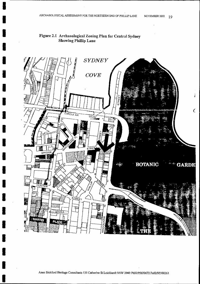
2.1 The Archaeological Zoning Plan for Central Sydney
ARCHAEOLOGICAL ASSESSMENT FOR THE NORTHERN END OF PillLLIP LANE,
2.0 PREVIOUS REPORTS ON PHILLIP LANE
p.30. 26.PRIVATE LANE BETWEEN 48 AND 50 PHILLIP STREETThis laneway runs behind the Chief Secretary's Building on Bridge Street andforms the context for a significant group ofheritage items.An elaborate carriage entrance frames the Phillip Street Entrance to the lanewhich connects Phillip Lane and Macquarie Street.
The Archaeological Zoning Plan for Central Sydney 1992(Figure 2.1) wasprepared for the Sydney City Council by Siobhan Lavelle and Dana Mider.1
The Plan specifically refers to roads and lanewayswhich in the absence ofevidence to the contrary,should be considered an area of archaeological potential.
On pA Section 3.2 the Plan discussesThe Archaeological Assessment ofRoads, Lanes, ParIes, Plazas, and other openspacesThe archaeological potential of roads, laneways,.. was not surveyed or assessed indetail.In general, in the absence of evidence to the contrary, all open spaces, whetheridentified in this study or not, should be considered as containing somearchaeological potential until a further assessment is undertaken.
2.2.1 Policy for the Management of Laneways in Central SydneySydney City Council. Policy for the Management ofLaneways in Central Sydney.Adopted October 1993.
p.18. The Conservation ofHeritage Lanes· Where work on a listed lane is proposed the AGM Planning and Building shallbe notified:· Where work on a listed lane is proposed the AGM Planning and Buildingmay require a statement of heritage impact, a conservation plan, or a detailed planofmanagement to be prepared;· Listed lanes and lanes in Heritage Conservation areas shall be conserved inaccordance with Burra Charter principles;· Significant built fabric of the lane such as timber blocks, stone setts and otherevidence of the heritage significance ofthe lane, shall be retained in situ;
The Sydney City Council has produced three documents which refer to PhillipLane. These are discussed below.
IIIIIiIIIIIIIIIIIIIII
Anne Bickford Heritage Consultants 135 Catherine St Leichhardt NSW 2040 Ph02/95699672 Fx02/95500261
2.2.2 Central Sydney Heritage Local Environmental Plan 2000
p.31. RecommendationLane in private ownership. Enhance pedestrian amenity. Maintain lane as contextfor significant heritage item.
The map itself, called Schedule 3. Archaeological/Townscape/Landscape ItemsMap, shows in the 'Laneways' category (coloured yellow) that part of PhillipLane forming the offset top of the 'T' shape of the Lane. ie. the northern sectiononly.
NOVEMBER 2002 16
p.31. 27. PHILLIP LANEPhillip Lane is Item 9043 in the Central Sydney LEP - Conservation of HeritageItems. The northern most portion of the lane is included in the pedestrian networkin the Central Sydney Strategy. The laneway provides vehicle access and serviceto buildings on both Phillip Street and Macquarie Street thus reducing the needfor vehicle crossings on either of those streets. The lane is substantially enclosedby buildings which are of heritage significance and it should be noted thatMacquarie Street is item 9040 on the Central Sydney LEP - Conservation ofHeritage Items. The lane contains significant active uses.RecommendationHeritage item, retain and conserve in accordance with Burra Charter principles.Enhance pedestrian amenity.
Part 2 ProvisionspA 8 Consent authority must have regard to heritage conservationThe consent authority must not grant consent to a development applicationrequired by clause 7 unless it has taken into consideration:a) the heritage significance of the heritage item concerned or the heritagesignificance of the heritage streetscape concerned, andb) the extent to which the carrying out of the proposed development would affectthe heritage significance ofthe heritage item or ofthe heritage streetscape,..c) the heritage inventory assessment report prepared in relation to the heritageitem or heritage streetscape, andd) any conservation management plan or heritage impact statement required bythe consent authority, and...Schedule 3 Archaeological/townscape/landscape itemsNo. 53CSHI No. 9043Address Phillip Lane (phillip Street to Macquarie Street)Name Phillip Lane
This section ofPhillip Lane, which is arched over by part of the Chief Secretary'sBuilding, is not part of the upgrading project which is the subject of this Report.Original bluestone and sandstone flagging and kerbing remains in situ in the lanein t1',is area. Adjacent to it is the work to take place on the Phillip Street footpath,where most of the bluestone and Bowral trachyte kerbing is of a more recent date,being part of the street refurbishment in 1988.
ARCHAEOLOGICAL ASSESSMENT FOR THE NORTHERN END OF PIDLLIP LANE
IIIIIIIIIIIIIIIIIIIII
Anne Bickford Heritage Consultants 135 Catherine St Leichhardt NSW 2040 Ph02/95699672 Fx02/95500261
2.3 NSW Heritage Office
2.3.1 State Heritage Inventory
2.3.2 The Chief Secretary's Building Permanent Conservation Order
NOVEMBER 2002 17
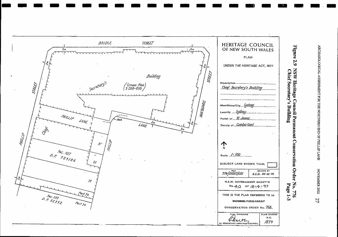
In April 1997 under the NSW Heritage Act the Minister for Urban Affairs andPlanning placed a Permanent Conservation Order on the Chief Secretary'sBuilding (See Figures 2.9, 2.10, and 2.11). As with all such places under aPermanent Conservation Order this site has since been placed on the NSW
The State Heritage Inventory lists Phillip Lane. The listing is given below (fromthe NSW Heritage Office website). (Figures 2.7 and 2.8) The listing is obviouslytaken from the Central Sydney Heritage LEP 2000 (2.2.2 above) as the sameinformation has been entered.
The NSW Heritage Office administers the NSW Heritage Act 1977 for theHeritage Council.
These documents and their policies were not referred to Bovis Lend Lease beforetheir planning for the Phillip Lane upgrade work. Not being aware of a need tocommission any advice relating to the heritage significance of the area, their planwas to remove most of the old kerb and gutter elements and replace them withnew materials. This work was underway, and part of the original sandstone kerbhad already been removed in Phillip Lane East before it was stopped. and ameeting held. Bovis Lend Lease, now that they have been informed, have engagedconsultants to give advice, and have revised their plans to be consistent with allheritage requirements. This Archaeological Assessment Report is one such Reportcommissioned. They have also commissioned a Statement of Heritage Impactreport as requested by the Council following its recommendation in 2.2.3 above.This is a separate report, also written by Anne Bickford.
2.2.4 Comment on City of Sydney Documents
On the Map Figure 3.1 Lanes and }';[idbIDCk Connections the whole length ofPhillip Lane including the north-south arm which extends to Bent Street isincluded under the category Existing Lanes.
p.3-1 3 Pedestrian Amenity3.1 LanesProvisions
3.1.5 Any change to a heritage lane or any building fronting such a lane requires aHeritage Impact Statement or a Conservation Plan.
2.2.3 Central Sydney Development Control Plan 1996. Dated JanuaiOY 2001
ARCHAEOLOGICAL ASSESSMENT FOR THE NORTHERN END OF PHILLIP LANE
IIIIIIIIIIIIIIIIIIIII
Anne Bickford Heritage Consultants 135 Catherine St Leichhardt NSW 2040 Ph02/95699672 Fx02/95500261
2.4 The Conservation Management Plan for the Chief Secretary's Building
This information was also not available to Bovis Lend Lease when machinedigging and removal ofpart of footpath, bitumen roadway, and sandstone flaggingcommenced. The areas removed can be seen on the Archaeological site planFigures 1.4 and 1.5 as 'TRENCH'.
Heritage Office State Heritage Register. The curtilage at the rear of the site inPhillip Lane includes the sandstone curbing and bluestone cobbles and flagging inthe corner of the Lane leading from the building's driveway. The curtilage alsoincludes part of the Lane, being an area 2m from the carpark wall and buildingwall further to the east.
NOVEMBER 2002 18
The Heritage Design Services group of the Department of Public Works andServices has produced a First Draft of the revised and updated Conservation Planfor the building, originally prepared in 1994. This Draft is dated 'Revised 2002.'This document has proved very useful in providing the history of the constructionof the building, and thus the information as to the date of the sandstone pavingand bluestone cobbles and other features of the Lane.
ARCHAEOLOGICAL ASSESSMENT FOR THE NORTHERN END OF PlllLLIP LANE
IIIIIIIIIIIIIIIIIIIII
IIIIIIIIIIIIIIIIIIIII
ARCHAEOLOGICAL ASSESSMENT FOR THE NORTHERN END OF PHILLIP LANE NOVEMBER 2002 19
Figure 2.1 Archaeological Zoning Plan for Central SydneyShowing Phillip Lane
SYDNEY
COVE
Anne Bickford Heritage Consultants 135 Catherine St Leichhardt NSW 2040 Ph02/95699672 Fx02/95500261
(
II
ARCHAEOLOGICAL ASSESSMENT FOR THE NORTHERN END OF PHILLIP LANE NOVEMBER 2002 20
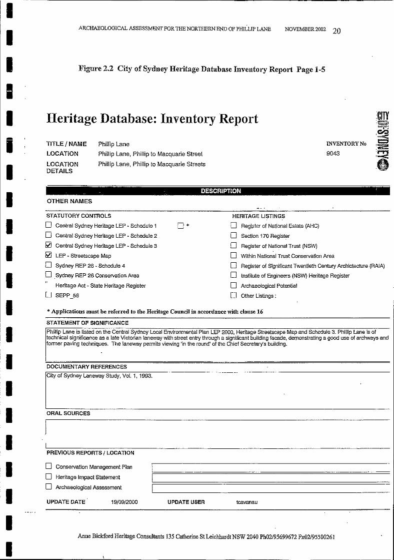
I Figure 2.2 City of Sydney Heritage Database Inventory Report Page 1-5
IHeritage Database: Inventory ReportI
II
TITLE/NAME
LOCATION
LOCATIONDETAILS
Phillip Lane
Phillip Lane, Phillip to Macquarie Street
Phillip Lane, Phillip to Macquarie Streets
INVENTORY No
9043
I.. . .. DESCRIPTION '
OTHER NAMES
* Applications must be referred to the Heritage Council in accordance with clause 16
IIII
STATUTORY CONTROLS
o Central Sydney Heritage LEP - Schedule 1
o Central Sydney Heritage LEP - Schedule 2
~ Central Sydney Heritage LEP - Schedule 3
~ LEP - Streetscape Map
o Sydney REP 26 - Schedule 4
o Sydney REP 26 Conservation Area
Heritage Act - State Heritage Register
U SEPP_56
0*HERITAGE LISTINGS
o Reg~ter of National Estate (AHC)
o Section 170 Regist~r
o Register of National Trust (NSW)
D Within National Trust Conservation Area
D Register of Significant Twentieth Century Archictecture (RAIA)
D Institute of Engineers (NSW) Heritage Register
D Archaeological Potential
D Other Listings:
ISTATEMENT OF SIGNIFICANCE
Phillip Lane is listed on the Central Sydney Local Environmental Plan LEP 2000, Heritage Streetscape Map and Schedule 3. Phillip Lane is oftechnical significance as a late Victorian laneway with street entry through a significant building facade, demonstrating a good use of archways andformer paVing techniques. The laneway permits viewing 'in the round' of the Chief Secretary's bUilding.
DOCUMENTARY REFERENCES
ORAL SOURCES
PREVIOUS REPORTS / LOCATION
1.
tcavanauUPDATE USER19/09/2000UPDATE DATE
o Conservation Management Plan
o Heritage Impact Statement
o Archaeological Assessment
ICily of Sydoey Laooway Study, Vol. 1, 1993.
I
I
II
I
III
Anne Bickford Heritage Consultants 135 Catherine St Leichhardt NSW 2040 Ph02/95699672 Fx02/95500261
II
ARCHAEOLOGICAL ASSESSMENT FOR THE NORTHERN END OF PHILLIP LANE NOVEMBER 2002 21
II
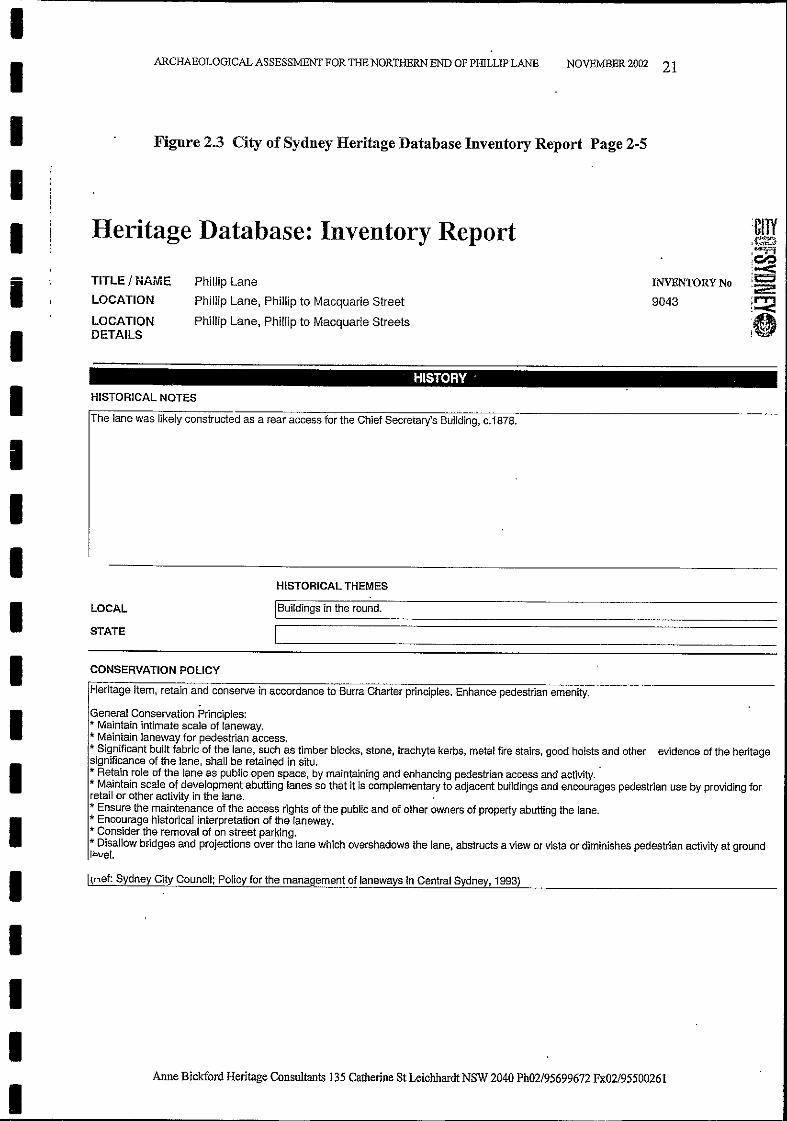
Figure 2.3 City of Sydney Heritage Database Inventory Report Page 2-5
Heritage Database: Inventory ReportIII
TITLE/NAME
LOCATION
LOCATIONDETAILS
Phillip Lane
Phillip Lane, Phillip to Macquarie Street
Phillip Lane, Phillip to Macquarie Streets
INVENTORY No
9043
III
HISTORY . ,
HISTORICAL NOTES
The lane was likely constructed as a rear access for the Chief Secretary's BUilding, c.1878.
II LOCAL
STATE
HISTORICAL THEMES
IBUildings in the round.
IIIIIIIII
CONSERVATION POLICY
Heritage Item, retain and conserve in accordance to Burra Charter principles. Enhance pedestrian emenity..
General Conservation Principles:* Maintain intimate scale of laneway.* Maintain laneway for pedestrian access.* Significant built fabric of the lane, such as timber blocks, stone, trachyte kerbs, metal fire stairs, good hoists and other evidence of the heritagesignificance of the lane, shall be retained in situ.* Retain role of the lane as public open space, by maintaining and enhancing pedestrian access and activity.* Maintain scale of development abutting lanes so that it is complementary to adjacent bUildings and encourages pedestrian use by providing forretail or other activity in the lane.* Ensure the maintenance of the access rights of the public and of other owners of property abutting the lane.* Encourage historical interpretation of the laneway.* Consider the removal of on street parking.* Disallow bridges and projections over the lane which overshadows the lane, abstructs a view or vista or diminishes pedestrian activity at groundIi:>vel.
Itnef: Sydney City Council; Policy for the management of laneways in Central Sydney, 1993)
Anne Bickford Heritage Consultants 135 Catherine St Leichhardt NSW 2040 Ph02/95699672 Fx02/95500261
II
ARCHAEOLOGICAL ASSESSMENT FOR THE NORTHERN END OF PHILLIP LANE NOVEMBER 2002 22
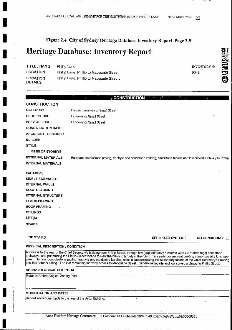
I Figure 2.4 City of Sydney Heritage Database Inventory Report Page 3-5
Heritage Database: Inventory ReportIII
TITLE / NAME
LOCATION
LOCATIONDETAILS
Phillip Lane
Phillip Lane, Phillip to Macquarie Street
Phillip Lane, Phillip to Macquarie Streets
INVENTORY No
9043
IIIII
CONSTRUCTIONCATEGORY
CURRENT USE
PREVIOUS USE
CONSTRUCTION DATE
ARCHITECT I DESIGNER
BUILDER
STYLE
MBER OF STOREYS
EXTERNAL MATERIALS
INTERNAL MATERIALS
, ~ CONSTRUCTION· ".:' ,.~ .
Historic Laneway or Small Street
Laneway or Small Street
Laneway or Small Street
Remnant cobblestone paving, trachyte and sandstone kerbing, sandstone facade and low curved archway to Phillip.
PHYSICAL DESCRIPTION I CONDITION
IIIII
FACADE(S)
SIDE I REAR WALLS
INTERNAL WALLS
ROOF CLADDING
INTERNAL STRUCTURE
FLOOR FRAMING
ROOF FRAMING
CEILINGS
LlFT(S)
STAIRS
"',E STAIRS SPRINKLER SYSTEM 0 AIR CONDITIONED c::
IIIII
Access is to the rear of the Chief Secretary's bUilding from Phillip Street, through low (approximately 4 metres wide x 4 metres high) sandstonearchways, and puncturing the Phillip Street facade to view the bUilding largely in the round. This early government building comprises of a U -shaperplan. Remnant cobblestone paving, trachyte and sandstone kerbing, exist in land accessing the secondary facade of the Chief Secretary's Buildingand the Astor BUilding. The last remaining laneway access to Macquarie Street. Sandstone facade and low curved archway to Phillip Street.
ARCHAEOLOGICAL POTENTIAL
IRefe, to A"haeologl"" Zoolog PI""
MODIFICATION AND DATES
Recent alterations made to the rear of the Astor Building.
Anne Bickfbrd Heritage Consultants 135 Catherine St Leichhardt NSW 2040 Ph02/95699672 Fx02/95500261
I1
ARCHAEOLOGICAL ASSESSMENT FOR THE NORTHERN END OF PHILLIP LANE NOVEMBER 2002 23
I1
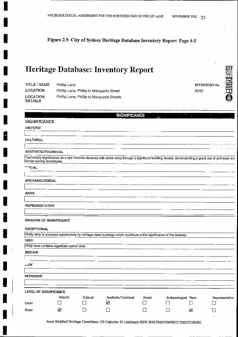
Figure 2.5 City of Sydney Heritage Database Inventory Report Page 4-5
Heritage Database: Inventory Report1i1
TiTLE/NAME
LOCATION
LOCATIONDETAILS
Phillip Lane
Phillip Lane, Phillip to Macquarie Street
Phillip Lane, Phillip to Macquarie Streets
INVENTORY No
9043
.CtlV:~),~
:~,0-<:c:::;i~
:~:0
1I1II1I111
, SIGNIFICANCE "'c.' ~.,: ' .
SIGNIFICANCE
HISTORIC
CULTURAL
AESTHETICffECHNICAL
Technically significance as a late Victorian laneway with street entry through a significant building facade, demonstrating a good use of archways amformer paving techniques.
"'''CIAL
ARCHAEOLOGICAL
RARE
REPRESENTATIVE
GRADING OF SIGNIFICANCE
EXCEPTIONAL
IPhillip lane is enclosed substantially by heritage listed buildings which contribute to the significance of the laneway.
HIGH
\Philip lane contains significant active uses.
MEDIUM
L.vW
Anne Bickford Heritage Consultants 135 Catherine St Leichhardt NSW 2040 Ph02/95699672 Fx02/95500261
1II
III
INTRUSIVE
LEVEL OF SIGNIFICANCE
Historic
Local
State
Cultural
oo
Aestheticffechnical
~
o
Social
oo
Archaeological Rare
o 0o ~
Representative
o'0
II
ARCHAEOLOGICAL ASSESSMENT FOR THE NORTHERN END OF PHItLIP LANE NOVEMBER 2002 24
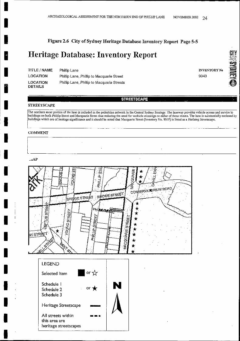
I Figure 2.6 City of Sydney Heritage Database Inventory Report Page 5-5
Heritage Databas~: Inventory ReportIII
TITLE/NAME
LOCATION
LOCATIONDETAILS
Phillip Lane
Phillip Lane, Phillip to Macquarie Street
Phillip Lane, Phillip to Macquarie Streets
INVENTORY No
9043
III
,I
IIIIII
STREETSCAPE . -
STREETSCAPE
The northern most portion of the lane is included in the pedestrian network in the Central Sydney Strategy. The laneway provides vehicle access and service tobuildings on both Phillip Street and Macquarie Street thus reducing the need for vechicle crossings on either of those streets. The lane is substantial!y enclosed bybuildings which are of heritage significance and it should be noted that Macquarie Street (Inventory No. 9040) is listed as a Heriateg Streetscape.
COMMENT
[------,----
.. ,
,'~ '",:' ,
':( , , ,
LEGEND
Selected Item
IIII
Schedule ISchedule 2 or *Schedule 3
Heritage Stree~scape _
All streets within - ...this area areheritage streetscapes
N
A
II ARCHAEOLOGICAL ASSESSMENT FOR THE NORTHERN END OF PHILLIP LANE NOVEMBER 2002 25
:: Hf&oriC3P Archaeorogy
;'; Maritime HerItage annne
:: . Movable Heritage
r:, Muttlcultural Heritage
.• Natural HerItage.
:": Heritage Funding
£: State Government Resources
r." I.ocal Government Resources
, "ForStudents
Aboriginal Heritage~--~ -......_~-----_ ..---_.._._-_._..._-- ...- ~._------ .~. _..~.__ ._--- ..- ---~_._---- .._---._. -- _.~_.,.
':'~. A.bout the Heritage Office
"i About the Heritage Council
i~ Ustlng: HcrfmJ;',t; ltems
"! Researching Herltage It~
:':' Consenrlng Heritage Places
NSWHeritage
~ Office
il'State Heritage Inventory - Item View
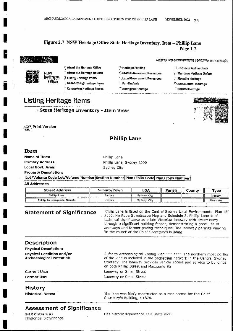
Figure 2.7 NSW Heritage Office State Heritage Inventory. Item - PhilIip LanePage 1-2
listing Heritage Items-.- --_._----------
II
II
I
I
I~ Print VersionSJ
Phillip Lane
I ItemPhillip Lane
Phillip Lane, Sydney 2000Sydney CityI
I
Name of Item:
Primary Address:
Local Govt. Area:Property Description:
, J~~~/Vo,l_u~e c~~~II.-L-O-tj-..'!-_.~-I-u-m-_e-__-~-~-~-b-e-rll~=~!()~ ~~ITI~e_rJlpl~n/Folio,~odellpl.a~/F,ol~o NlJm~erllAll Addresses
IStreet Address 11 Suburb/Town 11 LGA I1 Parish 11 County
11 TypePhillip Lane 11 Sydney 11 Sydney City 11 11 11 Primary
PhiJIip to Macquarie Streets 11 Sydney 11 Sydney City 11 11 11 Alternate
II
Statement of Significance Phillip Lane is listed on the Central Sydney Local Environmental Plan LE!2000, Heritage Streetscape Map and Schedule 3. Phillip Lane is oftechnical significance as a late Victorian laneway with street entrythrough a significant building facade, demonstrating a good use ofarchways and former paving techniques. The laneway permits viewing'in the round' of the Chief Secretary's building.
III
DescriptionPhysical Description:
Physical Condition and/orArchaeological Potential:
Current Use:
Former Use:
Refer to Archaeological Zoning Plan *** **** The northern most portiorof the lane is included in the pedestrian network in the Central SydneyStrategy. The laneway prOVides vehicle access and service to buildingson both Phillip Street and Macquarie Str
Laneway or Small Street
Laneway or Small Street
IHistoryHistorical Notes: The lane was likely constructed as a rear access for the Chief
Secretary's Building, c.1878.
II
Assessment of SignificanceSHR Criteria a)[Historical Significance]
Has histo~ic significance at a State level.
II
ARCHAEOLOGICAL ASSESSMENT FOR THE NORTHERN END OF PHILLIP LANE NOVEMBER 2002 26
II
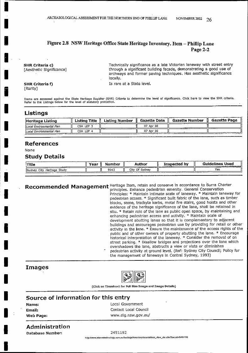
Figure 2.8 NSW Heritage Office State Heritage Inventory. Item - PhiIlip LanePage 2-2
II
SHR Criteria c)[Aesthetic Significance]
SHR Criteria f)[Rarity]
Technically significance as a late Victorian laneway with street entrythrough a significant bUilding facade, demonstrating a good use ofarchways and former paving techniques. Has aesthetic significancelocally.
Is rare at a State level.
IItems are assessed against the State Heritage Register (SHR) Criteria to determine the level of significance. Click here to view the SHR criteria.Refer to the Listings below for the level of statutory protection.
Listings
Study Details
ReferencesNone
ITitle 11 Year 11 Number 11 Author 11 Inspected by 11 Guidelines Used 11:=ls=Yd=n=e=y=c:==it=Y=H=e=rit=a=ge==::s=tU=:d=Y======il::=,====:II~==9=:0=43:==~II~=:::::ci=ty=0::::::f:=s::::::Y=:d=ne=y=:::jIl:==============='::=1=====:Ye=s======:n
IIIIIIIIII
IHeritage ListingILocal Environmental Plan
\Local Environmental Plan
Recommended
Images
11 Listing Title 11 Listing Number I1 Ga~ette Date 11 Gazette Number 11 Gazette Page 1111 CSH LEP 3 11 11 07 Apr 00 11 11 I!11 CSH LEP 4 11 11 07 Apr 00 11 11 11
Management Heritage Item, retain and conserve in accordance to 'Burra Charterprinciples. Enhance pedestrian emenity. General ConservationPrinciples: * Maintain intimate scale of laneway. * Maintain laneway forpedestrian access. * Significant built fabric of the lane, such as timberblocks{ stone{ trachyte kerbs{ metal fire stairs{ good hoists and otherevidence of the heritage significance of the lane, shall be retained insitu. * Retain role of the lane as public open space{ by maintaining andenhancing pedestrian access and actiVity. * Maintain scale ofdevelopment abutting lanes so that it is complementary to adjacentbuildings and encourages pedestrian use by providing for retail or other'actiVity in the lane. * Ensure the maintenance of the access rights of thepublic and of other owners of property abutting the lane. * Encouragehistorical interpretation of the laneway. * Consider the removal of onstreet parking. * Disallow bridges and projections over the lane whichovershadows the lane, abstructs a view or vista or diminishespedestrian actiVity at ground level. (Ref: Sydney City CounCil; Policy forthe management of laneways in Central Sydney, 1993)
II
(Click on Thumbnail for Full Size Image and Image Details)
Source of information for this entryName: Local Government
Email: Contact Local Council
Web Page: www.dlg.nsw.gov.au/
II
AdministrationDatabase Number: 2451192
http://www.interimtechnology.com.au/heritage/inventorylsearchJitem_view_shr.cfm?itemid=2451192
- - - - - - - - - - - - - - - - - - _.-
PLAN
SUBJECT LAND SHOWN THUS:
~
~....~
= ~""l~
N t2\e 0
8n~
()
=",00 ~;. ~ >-CI.l
~=CI.ltI1CI.l
~ ~ CI.l~ ""l
~""l ....~ .......... ~~~ >...,J
~ ~>-r:I0",("'j ::t1
rIJ 0~0:;=
= == a=.:~....Q..- Cl.... "tI== ~ fii~ ""le ~
~
~==~== ~.....Cl '"tJ
i:E0 t"'
== ~rIJ~
~ i~.........0
==0~""l
Q..tI1
~
~""l
'"C~ tI1::t1
~ 0 IV~. 0~ -.....! 0
I-l-.....!IV
.0\NCH-....l
DRAWN BY
R.£./J. 20-/2- fir
UNDER THE HERITAGE ACT, 1977
FILE
J'J!fjO/067/00/
HERITAGE COUNCILOF NEW SOUTH WALES
N.S.W. GOVERNMENT GAZETTE
NO'4_Q OF 1.8......4:: '17
m:a:mJIll/PERMANENT
CONSERVATION ORDER No. 76.6..
-1'N
THIS jS THE PLAN REFERRED TO IN
Scale ..!:}f}IL. .
Descrtption.•.............. ~ ......••...•_....•..•..•.. _0
..9tr."if..f.w.ifi!!J/.'?.i!.w1.cti.'!!f. .
Mtin/S·hire/City .••f,;j.c/Il.q .
Locality ••.•.fj;.c/.!l.Iljf. .....•..... ........•...........
Parish of •••.1t.,j(J/!l.~7.. .
County of ••.Q(@..t!I?I:I.i!tlrt...••..•.....••..........
................................................................
fJoilq'ill!!
51/l££r
/ Crown Hen}I51.68-858/
fJIJJJ)(if.
~ APPROVED
lot SECRETARY~OUNCIL
PLAN NUMBER
H.C.
/81f-
II
ARCHAEOLOGICAL ASSESSMENT FOR THE NORTHERN END OF PHILLIP LANE NOVEMBER 2002 28
Figure 2.10 NSW Heritage Council Permanent Conservation Order No. 776Chief Secretary's Building Page 2-3
III
2054 OFFICIAL NOTICES
HERITAGE ACT, 1977
18 April 1997
IIIIIIIIIIIIIIII
EXEMPTIONS UNDER SECTION 57(2)
I, the Minister for Urban Affairs and Planning, in pursuance of Section 57(2) of the HeritageAct, 1977, do by this, my order, grant an exemption from Section 57(1) of the said Act inrespect of the engaging in or carrying out of any activities described in Schedule C by theowner, mortgage or lessee of the land described in Schedule B on the item of .theenviro nt h .tage described in Schedule' A.
Sydney, 10th April 1997.
SCHEDULE 'A'
The item of the environmental heritage known as The Chief Secretary's Building, Macquarie,Bridge and Phillip Streets, Sydney.
SCHEDULE 'B'
All those pieces or parcels of land as shown edged heavy black on the plan catalogued RC.1834 in the office of the Heritage Council ofNew South Wales.
SCHEDULE 'C'
1. The maintenance of the components of the place, where "Maintenance" means thecontinuous protective care of the fabric, contents and setting of the place.
2. In respect only ofthose internal floor areas designated in the October 1994Conservation Plan endorsed by the Heritage Council ofNew South Wales asbeing of"Lesser Slgnificance" pages 68 to 73 inclusive:-
. • The installation of lightweight demountable partitions, suspended ceiling systems,floor coverings, in a manner that is reversible without damage to fabric of the ite:m,and the repainting ofthe internal fabric of those areas.
• The repair and upgrading of services and fittings where this does not involvealterations to or opening up ofearly fabric, or appear on the facade of the building.
3. Repair or reconstruction ofroadways, footpaths, re-kerbing and guttering andassociated drainage works and utility installations by authorised instrumentalitiesprovided that such works are superficial and do not disturb potential archaeologicalresource sites.
NEW SOUTH WALES GOVERNMENT GAZETTE No. 40
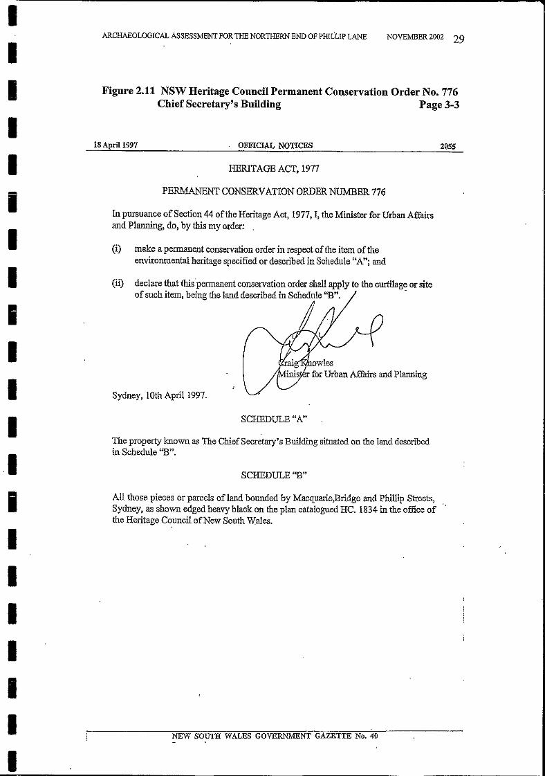
Figure 2.11 NSW Heritage Council Permanent Conservation Order No. 776Chief Secretary's Building Page 3-3
NEW SOUTH WALES GOVERNMENT GAZETTE No. 40
SCHEDULE "A"
2055
NOVEMBER 2002 29
f\!r<J i<>"'1<r", owlesr for Urban Affairs and Planning
HERITAGE ACT, 1977
. OFFICIAL NOTICES
PER1vf...A.NENT CONSERVATION ORDER NUMBER 776
SCHEDULE "B"
Sydney I 10th April 1997.
(i) .make a permanent conservation order in respect of the item oftheenvironmental heritage specified or described in Schedule "A"; and
All those pieces or parcels of land bounded by Macquarie,Bridge and Phillip Streets,Sydney, as shown edged heavy black on the plan catalogued HC. 1834 in the office ofthe Heritage Council ofNew South Wales.
In pursuance ofSection 44 ofthe Heritage Act, 1977, I, the Minister for Urban Affairsand Planning, do, by this my order: .
(H) declare that this'permanent conservation order shall apply to the curtilage or siteof such item, being the land described in Schedule "B". .
The property known as The ChiefSecretary's Building situated on the land describedin Schedule "B".
ARCHAEOLOGICAL ASSESSMENT FOR THE NORTHERN END OF PHILLIP LANE
18 April 1997
IIIIIIIIIIII.1iIIIIIII
Anne Bickford Heritage Consultants 135 Catherine St Leichhardt NSW 2040 Ph02/95699672 Fx02/95500261
3.2 Archaeological Assessment
3.3 Assessing Heritage Significance
Assessing Heritage Significance. The NSW Heritage Office produced this NSWHeritage Manual update in 2001. This document was consulted in the Assessmentof Cultural Significance chapter ofthis Report.
NOVEMBER 2002 30
3.0 METHODOLOGY
The NSW Heritage Office and the Department of Urban Mfairs and Planning ofNSW have produced a volume of Archaeological Assessment Guidelines 1996.This document has been used in the preparation of this study.The processes outlined in the Archaeological Assessment Guidelines are to carryout detailed historical work on the site; to conduct a physical survey of the site; tosynthesise these two fields of research, and from this to assess the significance ofthe site. The impact of the proposed development on the site is then analyzed, anda mitigation strategy to manage this impact is then proposed. Once the ExcavationPermit Application to the Heritage Office is approved the client is then contactedand the excavation procedures put in place.
3.1 Cultural Significance
ARCHAEOLOGICAL ASSESSMENT FOR THE NORTHERN END OF PHILLIP LANE
This project has been carried out in accordance with the principles set out in theAustralia ICOMOS Burra Charter (The Australia ICOMOS Charter for Places ofCultural Significance) 1999 including Guidelines to the Burra Charter: CulturalSignificance, and the NSW Heritage Manual produced by the NSW HeritageOffice and the Department ofUrban Affairs and Planning, 1996.I
IIIIIIIIIIIIIII
IIIII
Anne Bickford Heritage Consultants 135 Catherine St Leichhardt NSW 2040 Ph02/95699672 Fx02/95500261
4.2 1788-1840s
4.1 Phillip LaneSydney Section 107 - Bounded by Macquarie Street, Bridge Street, PhillipStreet and Bent Street
The lane that runs down the centre of this block, with connections at the north endto Phillip Street and Macquarie Street, is now known as Phillip Lane. On all 19th
century plans it is called Macquarie Lane.
NOVEMBER 2002 31
Two panoramas, drawn in the 1820s from Palmer's windmill (the site nowoccupied by the statue of Governor Phillip in the Domain) show this area in somedetail:• Robert Burford's panorama (drawn in 1827 and published in 1829 as a
Description ofa view ofthe Town ofSydney, New South Wales. Painted by theproprietor, Robert Burford, London 1829)
• Thomas Woore's panorama, drawn in 1829 (Mitchell Library SVI/1829/l)
Part of the area delineated in 1792 by Governor Phillip as separate from the townof Sydney (later called the Government Domain) and of the 'Domain of theGovernor's residence' as defined by Governor Bligh in 1807, that is, the estate ofGovernment House. The configuration and landscaping of the area between 1788and 1845 when the First Government House was in use are well known from anumber ofhistorical studies and contemporary maps, plans and illustrations.For example:• 1816 C Cartwright's Map of the Governor's Demesne Land (reproduced in H
Proudfoot et al: Australia's First Government House, 1991)• T McCormack et al: First Views ofAustralia 1788-1825: a history ofearly
Sydney (1987) .• M Kelly & R Crocker: Sydney Takes Shape. A collection of contemporary
maps from foundation to Federation (1978)
Michael Lehany's study of the gardens and grounds of First Government Houseprovides an analysis of this material. In its two major phases of development,before and after much of the Domain was opened to the public, the area whichlater became Section 107 of the City of Sydney was part of the grounds directlyassociated with Government House.Woore and Burford's illustrations show this fenced area at the back ofGovernment House and the back entrance drive, leading from the corner of BentStreet and Macquarie Street to the east side of the house and the carriage loop atthe front. The line of this entrance drive roughly approximates the later line ofMacquarie Street, as extended north in the 1840s, from the corner of Bent Streetto the eastward continuation of Bridge Street.
4.0 HISTORICAL DEVELOPMENT OF THE SITEBy Dr. Rosemary Annable
ARCHAEOLOGICAL ASSESSMENT FOR THE NORTHERN END OF PillLLIP LANE
IIIIIIIIIIIIIIIIIIIII
Anne Bickford Heritage Consultants 135 Catherine St Leichhardt NSW 2040 Ph02/95699672 Fx02/95500261
4.3 18308-18408
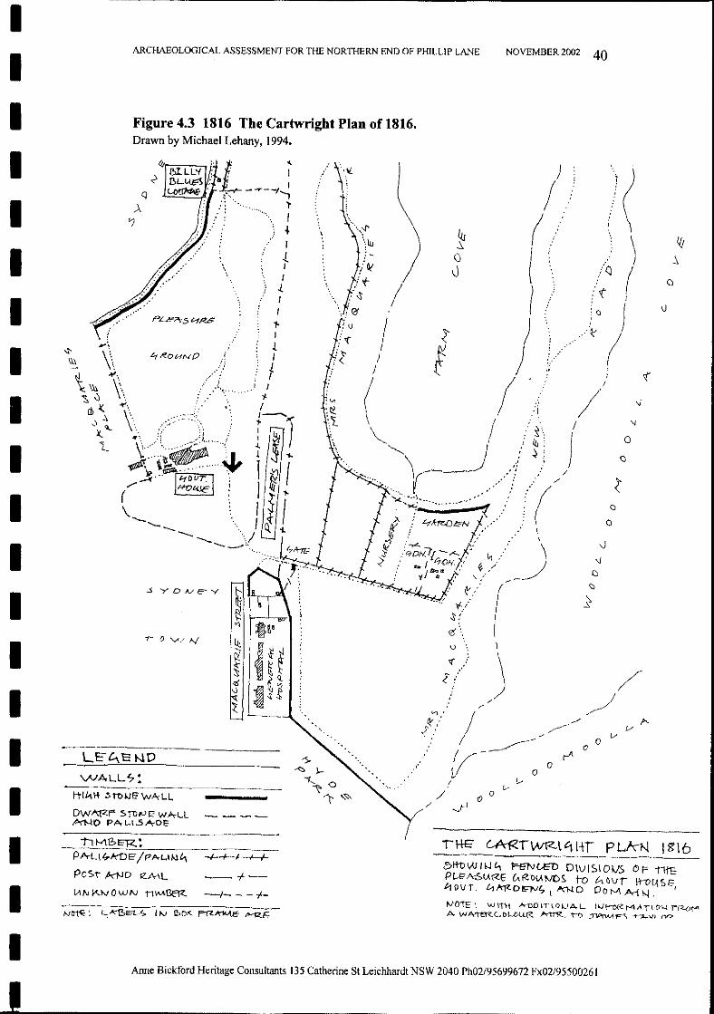
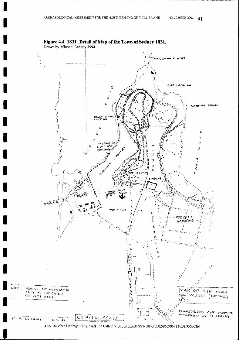
• The Cartwright plan 1816 & Map of the Town of Sydney 1831 (detail) fromMichael Lehany: 'First Government House grounds and garden history', 1994[Prepared for the Historic Houses Trust] Copy held at the Historic HousesTrust Library.
In the 1830s as plans for a new government house became a reality, the choice oflocation for the new house was closely associated with plans to surrender of partof government domain and to extend the existing streets north to the waterfront.This had the double advantage of opening up access to the new Semi-CircularQuay and of paying for the new government house by the sale of allotments alongthe new streets.In the early 1840s, before the new government house was completed and the oldhouse vacated, part of this plan had already been formed and some of the landearmarked for use for government purposes. In 1841 Caroline Chisholm openedthe Female Immigrants' Home at the corner of Bent Street and Macquarie Street(along what would become Phillip Street) and in 1845 the Australian SubscriptionLibrary moved to a new building at the corner of Macquarie Street, at what hadonce been the back entrance to Government House.When the new street plan was finalised, Phillip Street and Macquarie Street werecontinued north from Bent Street to Bridge Street, which had been extended to theeast up to the entrance to the new Government House. The new block bounded byMacquarie Street, Bridge Street, Phillip Street and Bent Street was numberedsection 107 in the City of Sydney. Like all newer city blocks, the allotments wereserviced by a back lane. For residents, the laneways provided pedestrian andvehicle access to the back of their properties, access for the removal of night soiland some space for stormwater drainage and sewerage, where these connectionswere eventually installed. The laneways also provided short cuts through cityblocks for non-residents.From the 1840s onwards, the north end of this new block was proposed as a sitefor public offices. As much of the rest of the land in Sydney had been sold, thegovernment needed to reserve land for future needs. The site was close toGovernment House and the workings of government in Macquarie Street and toexisting government offices in Macquarie Place. These were the residences to thewest of the First Government House that had formerly served the main civilofficers of the Colony and which continued in use, housing their respectivedepartments, after the Governor moved to the new Government house in 1845.As a result of the proposal to use the Bridge Street frontage between Phillip Streetand Macquarie Street for government offices, the central laneway between thePhillip Street and Macquarie Street allotments was designed to fork in two at thenorth end of the block. Here it ran along the back of the proposed office site toconnect with Macquarie Street and Phillip Street. This was part of the intent fromthe time the block was created in the early 1840s and the laneway continues inuse, in this configuration, to the present day.
NOVEMBER 2002 32ARCHAEOLOGICAL ASSESSMENT FOR THE NORTHERN END OF PIDLLIP LANE
IIIIIIIIIIIIIIIIIIIII

Anne Bickford Heritage Consultants 135 Catherine St Leichhardt NSW 2040 Ph02/95699672 Fx02/95500261
4.4 1840s-1870s Residential Development
2 Land Titles Office Crown Plan 145.858
3 NSW Government Gazette 1 October 1847 fols 1035-1036
4 Survey by W Darke 4 January 1848 S 105.858, Map 5509 (State Records NSW)
The allotments on the west side of Macquarie Street between Bent Street andBridge Street were put up for sale in the late1840s. With an uninterrupted viewoverlooking the Government Domain, the new Government House, the BotanicGardens and the harbour, this part of Macquarie Street became a most desirableresidential address, where many of Sydney's best known names built new houses.The west side of Macquarie Street, between Bridge Street and Bent Street, wassubdivided in the late 1840s at the request of Messrs Kemp and Fairfax. 2 Eightallotments numbered 12 to 19 were advertised for sale in the Government Gazette
in 1847. 3 These were soon followed by allotments 23 and 24, which had been
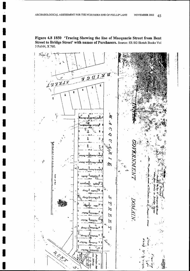
requested by Colonel Barney. 4 By 1850 all but three of the allotments on theMacquarie Street side of the block had been sold. From the late-1840s until theearly 1870s new town houses of good quality were built along this desirablelength of Macquarie Street. The last house to be constructed was the present No.133 Macquarie Street, 'History House', which was built in 1871.• 1850 'Tracing shewing the line of Macquarie Street from Bent Street to
Bridge Street' with names of purchasers. Surveyor General's Sketch BooksVol5 Fo164, X 760 (State Records NSW)
NOVEMBER 2002 33
There were many plans of proposals for the site for the new government houseand a new arrangement of the streets associated with this. These had crystallisedby the early 1840s into the street pattern which is largely still current.For example:• c.1842 plans for extension of streets to the Quay and subdivision of new
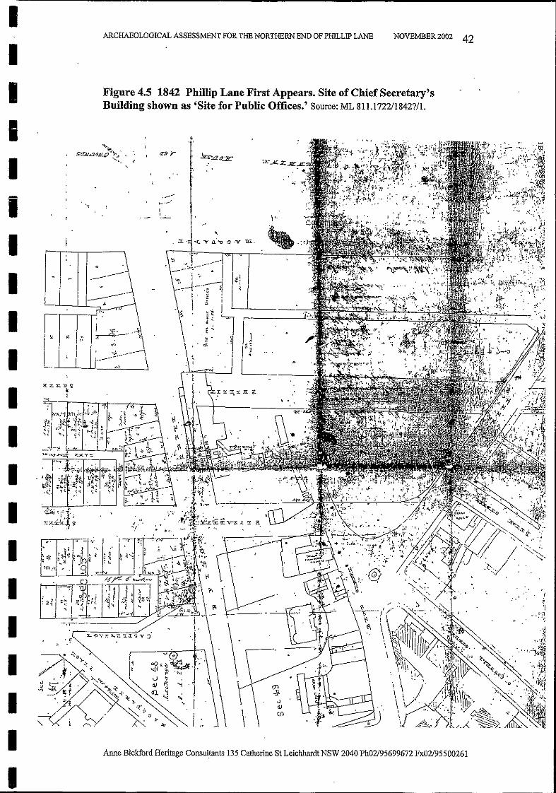
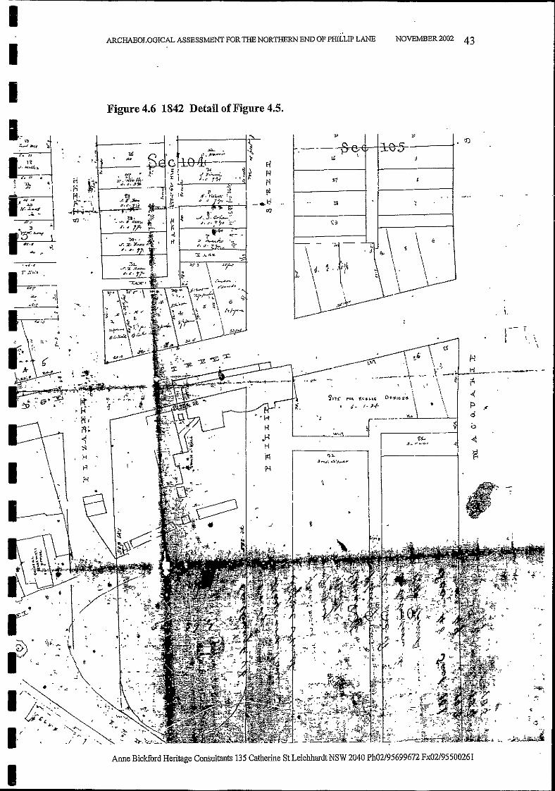
blocks within the area formerly part of the grounds of First GovernmentHouse (Mitchell Library 811.1722/1842?/1). The Bridge Street frontagebetween Phillip Street and Macquarie Street is shown as 'Site for PublicOffices'. The area remained unoccupied until the 1870s when the ColonialSecretary and Public Works' building was constructed. The subdivision ofSection 107 bounded by Macquarie Street, Bridge Street, Phillip Street andBent Street has a centrallaneway, dividing in two behind the proposed site forpublic offices to give access to Phillip Street and Macquarie Street.
• 1845 Plan by Townsend showing First Government House and the civilofficers' residences on Macquarie Place. The boundary of the 'field' at theback of Government House, as seen in Woore and Burford's views, is shown.The structures along Phillip Street at south end of block are the Immigrants'Barracks, associated with the work of Caroline Chisholm. (State Records Map5679, Lands Dept S1.1272)
ARCHAEOLOGICAL ASSESSMENT FOR THE NORTHERN END OF PHILLIP LANE
IIIIIIIIIIIIIIII
IIIII
Anne Bickford Heritage Consultants 135 Catherine St Leichhardt NSW 2040 Ph02/95699672 Fx02/95500261
4.6 19th Century Detailed Surveys
4.5 The Colonial Secretary and Public Works Offices 1873-1880 & 1890-1894[now known as the Chief Secretary's Building]
Development was not so rapid on the Phillip Street frontage of the block. Thiswas dominated by the Government Printing Office, which had been built in 18551856 on the site formerly used as the Female Immigrants' Home. A number ofhouses were built on Phillip Street at the other end of the block, but these too weretaken over for government purposes in 1863, to be used as offices for theDepartment of Public Works. The centre of the Phillip Street side of the blockremained vacant for much of the 19th century.
NOVEMBER 2002 34
The general progress of development on the block can be illustrated by a numberof 19th century detailed surveys.• The 1865 Trigonometric survey shows the block at this period, with some
later additions including the outline of the government offices on BridgeStreet. Macquarie Lane bends at the Bent Street end to run between the PublicLibrary and the Government Printing Office. There would appear to be adrainage line along Macquarie Lane running into the main drainage line inPhillip Street. (1865 Trigonometric survey Section D1, State Records NSW)
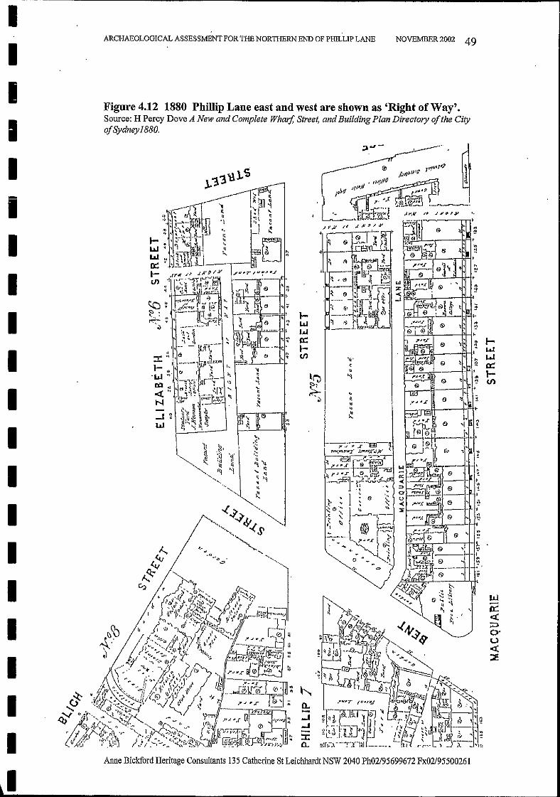
• H Percy Dove: A New and Complete Wharf, Street and Building PlanDirectory of the City ofSydney 1880. The lane between Phillip Street andMacquarie Street is called Macquarie Lane. The lanes at the north end leadingto Phillip Street and Macquarie Street are shown as 'Right ofway' .
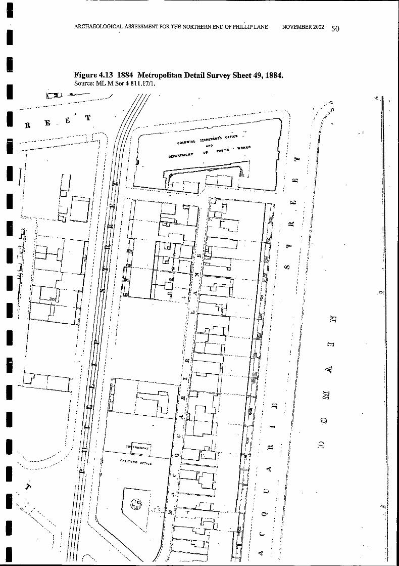
• Metropolitan Detail Survey Sheet 49, dated1884 (Mitchell Library M Ser 4811.17 /1)
The public offices anticipated in the 1840s were finally built on the Bridge Streetfrontage between 1873 and 1880. These accommodated the Colonial Secretary, onthe Macquarie Street side of the building and the Public Works offices on thePhillip Street side, next to some of the houses they already occupied in PhillipStreet. The new offices were built within the area reserved in the 1840s, withpedestrian and vehicle access to the rear of the premises from both Phillip Streetand Macquarie Street via the back lane. Here there were stables and coach housesfor the new government offices, as well as the usual out offices and a largedetached toilet block.Between 1890 and 1894 a substantial addition was constructed along PhillipStreet, on the site of some of the houses that had previously accommodated thePublic Works staff. This addition bridged the lane leading into Phillip Street,which was retained for both pedestrian and vehicle access.
ARCHAEOLOGICAL ASSESSMENT FOR THE NORTHERN END OF PHILLIP LANE
IIIIIIIIIIIIIIIIIIIII
Anne Bickford Heritage Consultants 135 Catherine St Leichhardt NSW 2040 Ph02/95699672 Fx02/95500261
4.8 The State Office Block 1961-1968
The first major change to this city block after the 150 feet height limit wasabolished in 1957, occurred when the State Office block was built on the site ofboth the former library and government printing office. Built in the 1960s, theState Office Block was the first major office building erected for the New SouthWales Public Service since the Department of Agriculture in 1927. Designed bythe Government Architect E H Farmer with design architect Ken Woolley, thebuilding consisted of a tower block of 35 floors at the corner of Bent and Phillip
From the mid-19th century the custom ofliving in the city, close to, or even aboveone's business premises began to decline. With the growth of suburban Sydneyand the development of an extended and reasonably cheap public transportsystems, middle class home owners preferred to enjoy more extensive premises inhealthier situations than those offered in city living. In common with many otherareas of Sydney, large family homes in Macquarie Street were converted intoboarding houses or clubs, to accommodate those who lived alone, or who residedin the city for only a part of their time. Where owners continued to live inMacquarie Street, these were often their town houses and they also owned otherhomes elsewhere.In the early 20th century new building technology offered the opportunity for theredevelopment of comparatively small allotments, now occupied by aging andunfashionable 19th century houses, to a maximum building height of 150 feet.New buildings of distinction were designed by well-known architects to meet anew market, purpose built for their clientele with up-to-date facilities. Suchredevelopment was particularly profitable when as many as a hundred or moreprofessional suites (medical consulting rooms and associated facilities) could bebuilt on sites which had previously accommodated one or two houses. In additionto the construction of new buildings for the medical profession, the dominantoccupation in the area, there were also a number of high-rise, high quality flatswhich addressed the problems of modem living with a limited amount of domestichelp. This sort of development, typically comprising the amalgamation of two orthree original allotments, took place on both Macquarie Street and Phillip Street.The ability to redevelop to commercial advantage within one or two of theexisting allotment boundaries meant that the plan of the block, as laid down in the1840s, was still recognisable throughout much of the 20th ,century. This includedthe lane, which continued to serve the buildings on Phillip Street and MacquarieStreet and to provide vehicle access for car parking beneath new buildings or atthe back of older ones.• The Fire Underwriters' Plan of the area shows examples of this amalgamation.
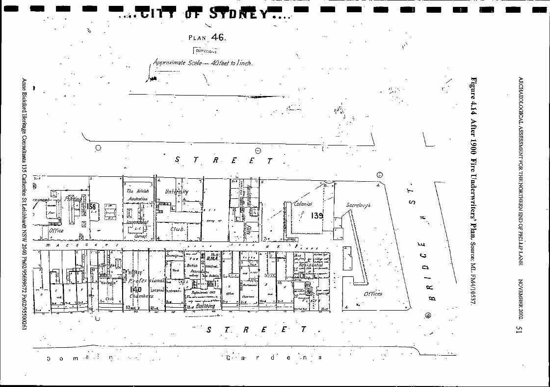
These plans date from 1901 but were updated regularly and so a precise datecannot be attributed to the plan. It includes developments such as The Astor,the BMA building and the University Club which were built in the early 20th
century. (Mitchell Library FM4/l0537)
NOVEMBER 2002 35
4.7 20th Century Developments
ARCHAEOLOGICAL ASSESSMENT FOR THE NORTHERN END OF PHILLIP LANE
IIIIIIIIIIIIIIIIIIIII
Anne Bickford Heritage Consultants 135 Catherine St Leichhardt NSW 2040 Ph02/95699672 Fx02/95500261
4.9 Aurora Place
5 'Facts about the Block' in Progress Vol. 6 No. 3 (1967) pp 4-12
Aurora Place, the ABN AMRO Tower, was designed by architect Renzo Pianoand constructed by Lend Lease Developments and the East Asia Property Group.The project combines a 41-storey commercial development on Phillip Street witha 16-storey residential development on Macquarie Street. As a part of the newdevelopment the south end of Phillip Lane was closed. Pedestrian access fromBent Street through to Phillip Lane has been retained in the form of public space,but there is no longer any vehicular access. This is now provided from PhillipStreet, on the north side ofAurora Place.
NOVEMBER 2002 36
4.10 The Change of Name From Macquarie Lane to Phillip Lane
During the 19th century the lane was known as Macquarie Lane. By 1910 it wascalled Phillip Lane. (Sands Directory 1910 - description of the north side of BentStreet).The name change probably took place in 1905 when the City Council decided tominimise confusion and rationalised street names, getting rid of repeated names.In the process over one hundred street and lane names were altered. (ShirleyFitzgerald: Sydney's Streets. A guide to Sydney City street names, 1995)Prior to 1905 there was both a Macquarie Lane and a Phillip Lane in Surry Hills.In 1905 these were renamed Arnold Lane (formerly Phillip Lane) andCommonwealth Lane (formerly Macquarie Lane). It is most likely that it was atthis date that the other Macquarie Lane in the city, between Macquarie Street andPhillip Street, was renamed Phillip Lane, an equally appropriate designation as itran at the back ofPhillip Street.The original use of the name Macquarie Lane probably reflected the greaterimportance of the Macquarie Street frontage of this block when it was formed inthe 1840s.
Streets, a nine-floor building fronting Phillip Street and a ten-floor Premier's wingfronting Macquarie Street. More than 2,100 public servants were accommodatedin the new offices. On the corner of Macquarie and Bent Street, in a granite pavedplaza, was a fountain of copper and unpolished black granite in the form of a
helical spiral. 5 Although the design effectively wrapped around and combinedthe Phillip, Bent and Macquarie Street frontages of the site, the lane was retainedbetween the two parts, a one-way street, providing vehicle access to the rear of theMacquarie Street and Philip Street premises. The site was sold by the NSWGovernment in the 1990s and the State Office Block demolished. It was replacedby a combined residential and commercial development.
ARCHAEOLOGICAL ASSESSMENT FOR THE NORTHERN END OF PIDLLIP LANE
-IIIIIIIIIIIIIIIIIIIII
Anne Bickford Heritage Consultants 135 Catherine St Leichhardt NSW 2040 Ph02/95699672 Fx02/95500261
4.12 Heritage Significance
4.13 Recommended Management
Recommended management policies are included in the State Heritage Inventorylisting.Provisions for the management of the city's laneways are included in the DraftCentral Sydney Development Control Plan, 1996. Section 3.1.5 of the ControlPlan states that:Any changes to a heritage lane or any building /ronting such a lane requires astatement ofheritage impact or a conservation plan.
NOVEMBER 2002 37
4.11 Heritage Listings
ARCHAEOLOGICAL ASSESSMENT FOR THE NORTHERN END OF PHILLIP LANE
The State Heritage Inventory listing identifies Phillip Lane as:• ofhistoric significance at a State level• rare at a State level• of technical significance as a late Victorian laneway with street entry through
a significant building fa<;ade, demonstrating a good use of archways andformer paving techniques
• of aesthetic significance locallyThe State Heritage Inventory listing also notes that the laneway permits viewing'in the round' of the Chief Secretary's Building. The Chief.Secretary's Building isof State heritage significance and is included on the State Heritage Register. Anumber of other heritage items also back on to Phillip Lane.
Phillip Lane is:• included in the Sydney City Council document: 'Policy for the management
oflaneways in Central Sydney', 1993• listed in the Draft Central Sydney Development Control Plan, 1996• listed on the Central Sydney LEP 2000, Heritage Streetscape Map and
Schedule 3, Heritage Item No. 9043e is listed on the State Heritage Inventory by virtue of its inclusion in the
Central Sydney LEP 2000
IIIIIIIIIIIII'IIIIIIII

11
ARCHAEOLOGICAL ASSESSMENT FOR THE NORTHERN END OF PHILLIP LANE NOVEMBER 2002 38
11111111
4.14 HISTORIC PLANS
Figure 4.1 1827 Study Area showing grounds to east of Government House.Description ofaview ofthe Town ofSydney, New South Wales, Robert Burford, London 1829.
122 Laud.Br·anl (}ri'iu
U Jir ,/;'-lm Jmme,mn:r?I ((,/r'fIliJl1Jt>,t.J'Urt',,;
12/f .fmblt Xii,!.·It; (od1" /Id"U .\'t.i'll/lIt;;,r28 .~·Ydnf.vgotd
1111I
1
2i1 tn/et' ,li/.ftiru.JtJ ((.b.mid: I'rrr"t'u.'I':"
I :11 (J,l'lwn ,ldul(,1 ,.3? .l'yd"n· {;azdffo (#/u'r
I:~'I jltllt;I':Y Br"'P, /t,,1.J.f ;;./tI'luflp,'I;; 11(/1(' .Afo"nhuns
,'In Ji'Tit,/",.woods31.1l,l!1); "t..JlIshn!li,,V" (;(/1./.'I!)"{/,...trol/tlll .d!lrirllltllTal f'mnpa.1!r.r-:It} r;fl vr'rll (lrJ# H,),,~r~
11 (;m"uil.rar",t .rf"~.King.r"Whorf'?'.lJod•-f:! lvnval (lri'1,'"
41 M:"ll£ampbell
44 BafY,.".:,. I'tYlnt &-LJall
45 flwelli.,. flit/I.:#illXJ: Suca:/j.
Anne Bickford Heritage Consultants 135 Catherine St Leichhardt NSW 2040 Ph02/95699672 Fx02/95500261
I
Anne Bickford Heritage Consultants 135 Catherine St Leichhardt NSW 2040 Ph02/95699672 Fx02/95500261
IIIIIIIIIIIIIIIIIIIII
ARCHAEOLOGICAL ASSESSMENT FOR THE NORTHERN END OF PHILLIP LANE
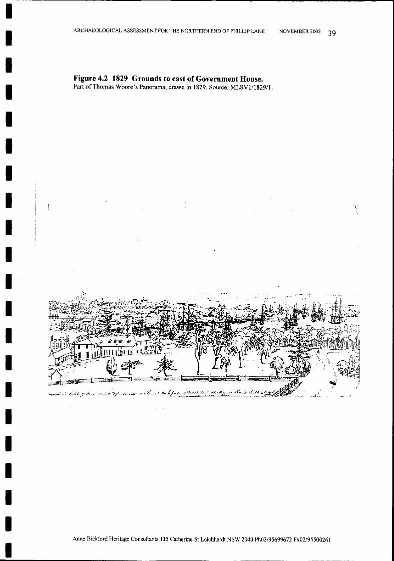
Figure 4.2 1829 Grounds to east of Government House.Part ofThomas Woore's Panorama, drawn in 1829. Source: MLSVl/1829/1.
NOVEMBER 2002 39
()
o
{)
NOVEMBER 2002 40
o 0
TH-E" CA1<TWtz.tt1Hf PLM Igl6.5I+OWII.Jl., t=€1vum D\VIS\oV.s Op -ntEPt...I::=k;SV,(ZE lA !<?-ov,M)$ to ?l. bV, troLl SE'~ovr. l1~OE1V~ t ~o OOl'J\MN. I
rvOiE ~ WI1"Ici ""'-OOI.. \OUA-L IlJr-oR.t'4ATI0""' f"R<>t""IA W~<"'()LllUR. A-tr1't. \() ~F"'. -r:a...VI rv:>
//
..I
ARCHAEOLOGICAL ASSESSMENT FOR THE NORTHERN END OF PHILLIP LANE
Figure 4.3 1816 The Cartwright Plan of 1816.Drawn by Michael Lehany, 1994.
Anne Bickford Heritage Consultants 135 Catherine St Leichhardt NSW 2040 Ph02/95699672 Fx02/9550026l
L-INKlVOWN T1\M~ -1- - --1--
\.NALL$>:-----------
l-tlttl+ ~Tt>kJE'wA-LL
DWi'<;fZF SrolVE WA-LLA'NO PAL\5A-OE
PAL\l;,.,A(()EIf?AL.1Mt., I" ,t .. ,I
POST k1JO !<A\L _ + -
IIIIIIIIIIIIIIIIIIIIJ _
-~~~~~~~~---~~------------------------------,
II
ARCHAEOLOGICAL ASSESSMENT FOR THE NORTHERN END OF PHILLlP LANE NOVEMBER 2002 41
J
UJ
Figure 4.4 1831 Detail of Map ofthe Town of8ydney 1831.Drawn by Michael Lehany 1994.
I
I
II
I
II
I
II
I
I
I
III
IIJ _
II
ARCHAEOLOGICAL ASSESSMENT FOR THE NORTHERN END OF PHILLIP LANE NOVEMBER 2002 42
Anne Bickford Heritage Consul,tants 135 Catherine St Leichhardt NSW 2040 Ph02/95699672 Fx02/95500261
Figure 4.5 1842 Phillip Lane First Appears. Site of Chief Secretary'sBuilding shown as 'Site for Public Offices.' Source: ML 811.1722/1842?/1.
IIIIIIIIIIIIIIIIIII
'....St7.AlLZ1tL.g'"':..''!:-,.,· ...
''-.o:.~ r
.-~-
1-··... '
II. t.
I
II
ARCHAEOLOGICAL ASSESSMENT FOR THE NORTHERN END OF PHILLIP LANE NOVEMBER 2002 43
II .. '"
.;...J J/Jr,(t
l;;·I'~
J ••...t4,~
" 1'." •; ~
..~.,
•.\
Figure 4.6 1842 Detail of Figure 4.5.
-S,Te
[~.._._-
~'o --l I~~~. II .\ 0
.,.
1
) <:,
~~ ~.$ .. .,- ...""# ~
~
\.
'lO.
:~
IAnne Bickford Heritage Consultants 135 Catherine St Leichhardt NSW 2040 Ph02/95699672 Fx02/95500261
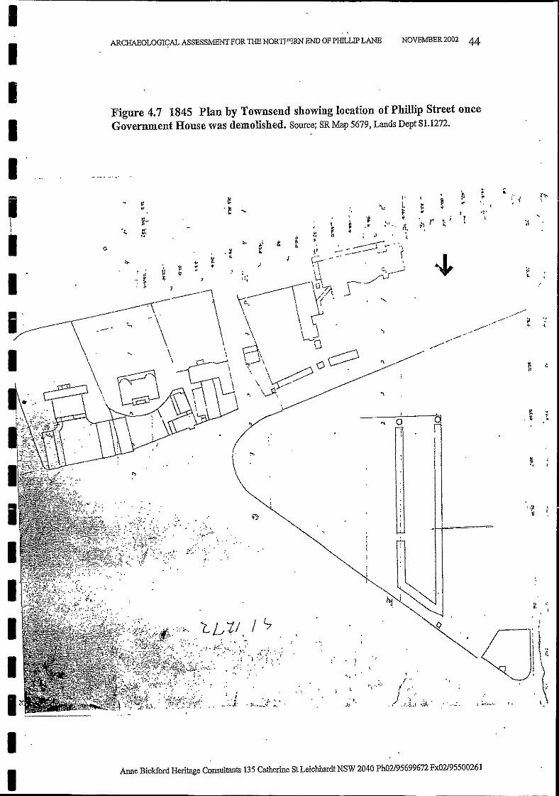
Figure 4.7 1845 Plan by Townsend showing location of Phillip Street onceGovernment House was demolished. Source; SR Map 5679, Lands Dept S1.1272.
IIIII
ARCHAEOLOGI~AL ASSESSMENT FOR THE NORTFERN END OF PHILLIP LANE NOVEMBER 2002 44
~. ,", ..
'f"I'~
.."I. ,
'" l: ort: .. I .~ .
.~ * r . ; r ,:.. : -,
n. :"i ;; t!
Anne Bickford Heritage Consultants 135 Catherine St Leichhardt NSW 2040 Ph02/95699672 Fx02/95500261
.~
!
'"r,
I '•.~
.."t!
"....
..--~~.-'
~.---
1
j "
l.·-,,./.:.7j.": ..~'
..... 0
\.! ...:.'
"~.
",
"."
, t.. ~ ~.,"
•...
,_:·.:l
,~
.~ ......~-...~.
IIIII1,_-II
--- ----~~~~----------------------------------------,
Figure 4.8 1850 'Tracing Shewing the line of Macquarie Street from BentStreet to Bridge Street' with names of Purchasers. Source: SR SG Sketch Books Vol5 Fol 64, X 760.
.. ,~ .' ~
NOVEMBER 2002 45
't.;...
.."\ 1
.)
.' "
ARCHAEOLOGICAL ASSESSMENT FOR THE NORTHERN END OF PHILLIP LANE
I
~..
IIIIIIIIIIIIIIIIIIIII

o
z
z
iI
\
\I
\I
I,.II
,,Ii
I!
I\I
\
I
NOVEMBER 2002 46
\. ," .....
I': Z r
t .!'~""fOJI
-t
I.c
I, I
J:, I
i' i! J!l'
-I ;, : I
• I, ~
. , ;m,, , '
-------:
."
~ 1
1
[":j::-:-C";i' II -,': I'~, .:'.'-:.' 'jiifil. -" ,. ' ". , 1£1I •• , .....__T, .: :
:":,','T-iJ;, I' ,
n' -, !, I '
'.L_ - i'L I' ,-- ,---11
,-__ i I, '.-- I---:""1 J'
.1 r
:l':iI
.j
P
Ij:,'I
j!\
I:
Figure 4.9 1865 'Trigonometric Survey of Sydney' Section D1. Source: SR.
ARCHAEOLOGICAL ASSESSMENT FOR THE NORTHERN END OF PIDLLIP LANE
(\
,- -- -.---i
IIIII
I n·· .. ',1!: I --- '-:"1
I
III ,.I:..
I ~. if
Ir'II ;~:,,: .,
_ iJ .-=-=
i "t·,"
II1·-,. ......
I' "'~~,
1~,'~, .>---.....
. / '-.....
. ./ ~~·r
, / ' 1
1;.- , ,I,'-:) ,
Anne Biekford Heritage Consultants 135 Catherine St Leichhardt NSW 2040 Ph02/95699672 Fx02/95500261
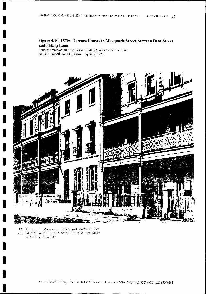
NOVEMBER 2002 47ARCllAEOIOGICAL ASSESSMENT FOR THE NORTHERN END OF PHlLUP LANE
Figure 4.10 1870s Terrace Houses in Macquarie Street between Bent Streetand Phillip Lane.Source: Victorian and Edwardian Sydney From Old Photographs.ed. Eric Russell. John Ferguson, Sydney. 1975.
12] Houses in Street, lust norTh of BentStreet Taken in the 1870s by Professor John Smith
of
IIIIIIIIIIIIIIIIIIIII
II
ARCHAEOLOGICAL ASSESSMENT FOR THE NORTHERN END OF PHILLlP LANE NOVEMBER 2002 48
IIIIIIII
IIIIIIIII
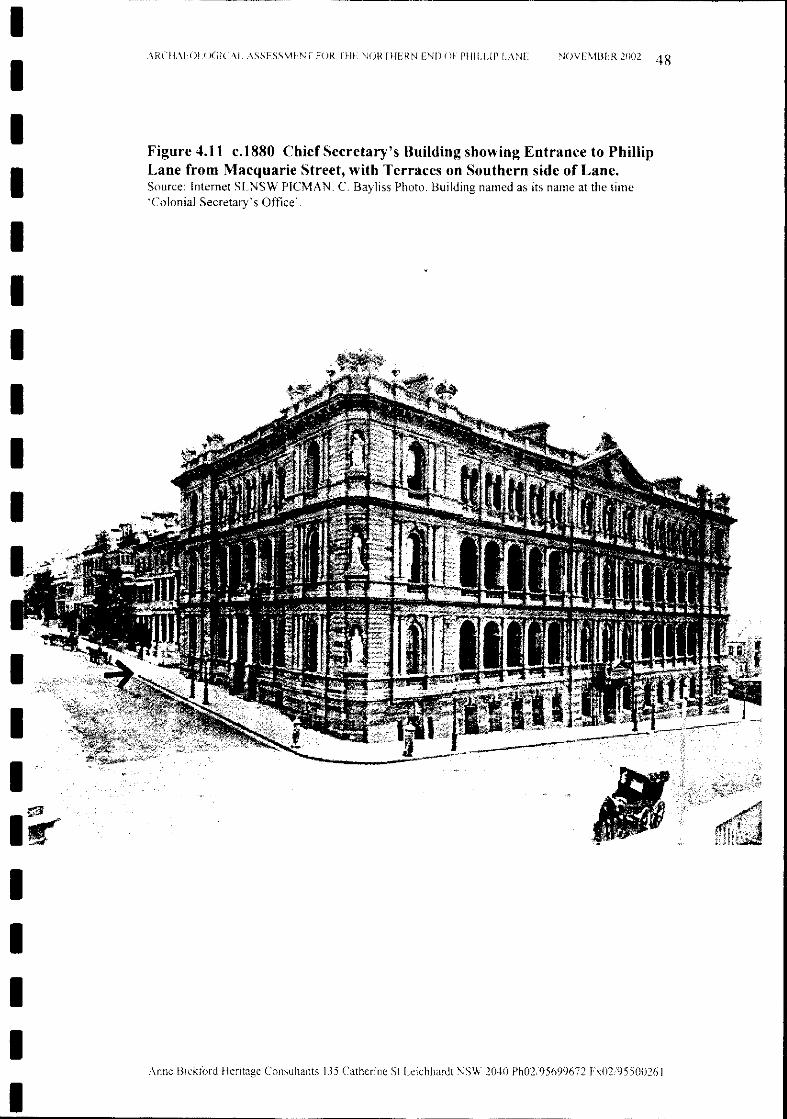
Figure 4.11 c.1880 Chief Secretary's Building showing Entrance to PhillipLane from Macquarie Street, with Terraces on Southern side of Lane.Source: Internet SLNSW PICMAN. C. Bayliss Photo. Building named as its name at the time'Colonial Secretary's Office'.
Anne Bickford Heritage Consultants 135 Catherine St Leichhardt NSW 2040 Ph02/95699672 Fx02/95500261
II
ARCHAEOLOGICAL ASSESSMENT FOR THE NORTHERN END OF PHILLIP LANE NOVEMBER 2002 49
IIIIIIIIIIIIIIIIIII
Figure 4.12 1880 PhilIip Lane east and west are shown as 'Right of Way'.Source: H Percy Dove A New and Complete Wharf, Street, and Building Plan Directory ofthe CityofSydney1880.
..~
~
l- t·,LU -' "" :?Wn:: n I-1- ~
LLlen "\l' E J.oJ
~ n::b • l-lr:-> ~ :: Ul.;:,.
~.
~ '"~ ~ !
"~,b....
I
I''"'L !
... ~
I..,- ~~-"~~--"-fl'
Anne Bickford Heritage Consultants 135 Catherine 8t Leichhardt NSW 2040 Ph02/95699672 Fx02/95500261
II
ARCHAEOLOGICAL ASSESSMENT FOR THE NORTHERN END OF PIDLLIP LANE NOVEMBER 2002 50
';
,1--"
. ,
)1
":;.
ji! .:
"I if
I
"11
/i,:!Ii!ilii,I
I!
t1Ii,11!;I1
i!
:1i:"i,!iif
1I
/1.1/';::.
I.
I:j;
"
I
"
,I,,
II
,IJJJII
Figure 4.13 1884 Metropolitan Detail Survey Sheet 49, 1884.Source: ML M Ser 4 811.17/1.
"
",
It
"' ._~ ._._._0 ...
II
I
i
I 11I
III
I
- - - - ~.:~ .-e.,.,. .",. ~"'D 1ft~ ... - - _.- .. - - - - -~\
"-PLAN 46.
../ ~ ;;;....~
CJCI=""l('D
0~ t""
0~ 8~()
> ~::l? ~('D
r/.l""l trlr/.lI-'r/.l\0
~00
>-3~ "I:I.... 0""l ::0('D
>-3cj gJ1:1 Z0- 0('D
Cl~~""l....-('D~
""ll:I.l"
"'t1 ~-~
~
Ft"".
CI.l ea0s::
~..,()
~
~J-:tj
Z~ 0-' ~0
~UlW;-.:x
~N00N
VlI-'
"
cc.
to.
.J
.@
-~
L
;;;"
e:.."
41
\' \
I;:\ ~
Offices
..
o
Secrefdr)lS
4-
4
.,
I
,\ ;;:';'. 't h'.
. \\
/"':6.,,: ..--",II
139IIII
,/"
T
I". i
--tolonia!
\/~A ... r
"
:,'-' .!._-..
E'
E
. /' l'~.' 1~
T
N
7••
E
8£
R
. ... ,
'"
£
&".1 :~! ! jl6
~---{~ !:~---...!~~~ .---jl~---
! _...:~l· .1\ ::"rl~.1t..
r~
R
s
1
,
T
( COP'n:I(,I-lj
s
I-I 1_ t=" ...,,_:~A' r ,
Ji , ..... = .... AI'~...,. ...qlub.
r._ !
.··il~
)~(~:~:~~fe .5ca/e...•...~Ofeef ~ J,n.ch.
- \',... \- \
~I!
;"li
The B~jlish
[D
, /fusfralian.... I'lcl'!tn
I. ,114-
H
fis1r.1~;:;:::Zi~----~ .1_~,:LJ j ln~eddi~~{
Au
~ -' \.0
3"
rn~.-d
i iOfrice, ,~-~"-'-.-.
~
,itJ:jo'~a~::I.gG
~~g!itwUl(')
Se-~.CZlno
IzCZl
::E:N M·A C'O
~ t 3 , 1 i '-r .. 4- .1 I ' "o .. I ~I.' T$ ~'"0 :: 3 ,., ~ __ 3'i:l" ': I ;...§ , f : ... 1 ,.~ 3 H~TrrY [~n.:. __$ /':.'r';("·; ..\0 ... '1 I'rur~JmnJt .00\ 11A1". •......:I M"jU l,oc;mo Ardn"c1n. IJiJJ..N I I ~ _
'":t:l 0 ..L C1/ambe :>. t"""~ .X I i 3.,.. 0 3.', • 3t.." 0 3 .. 1 0S 3.,8 ., ~,.. ~t' T i: . # .. ._ ..~.: ~ ..
-- • • • • 101rld. 10.1. . " 'Q
~ 3.6 0 All "" I.' '''' ..''rf lie ,nU1 "iir-- ~.
g 'lJN0\-
----------- .
:J o m .a -: t~.·. . 'C·, a-- r d' e .n s:\. -.
Anne Bickford Heritage Consultants 135 Catherine St Leichhardt NSW 2040 Ph02/95699672 Fx02/95500261
5.2 Description of the Site
The bluestone cobbles at the gates of the Chief Secretary's Building yard and thesandstone gutter in front of them are other features ofheritage significance. Thereis no need to list them all here because George Gibbons' Report in the nextchapter describes these and other road and footpath features and their heritagequalities in more detail. In addition to this the photographs below and thearchaeological scale plans show the artefacts in detail.
The Study Area is the northern end of Phillip Lane. The area of the lane to bedeveloped is the Intersection of the two arms of the lane with the shaft of the "T"up to about the level of the Dry Cleaning Shop under The Astor; the PhillipSt/Phillip Lane roadway and footpath, and the Macquarie Street/Phillip Laneroadway and footpath. The area of road and footpath under the archway in PhillipLane West is not included in this work. All of the area from the Intersection toMacquarie Street is to be developed as part of the project.
NOVEMBER 2002 52
At present the area which was dug up in Phillip Lane East is cordoned off, with anarrow pedestrian access along the centre of the road where the bitumen remains.The Intersection and Phillip Lane West is available to pedestrians and vehicles,and the yard of the Chief Secretary's Building is used as its carpark.Phillip Lane East shows two trenches adjacent to the buildings lining either sideof the lane. The Northern Trench adjacent to the Chief Secretary's Building backwall shows gravel where the sandstone flagging was removed before work wasstopped. The flagging can be seen in section under the cut of the bitumen.The Southern Trench, next to The Astor, shows the two layers of flagging in situ.Above this can be seen remaining in some parts the layer of coal tar macadamwhich had been placed over the flagstones, and above this again, the bitumenwhich is the current road surface material.
5.1 The Site As Identified by Historical Research
On all 19th century plans the laneway is known as Macquarie Lane. The area ofthe lane was originally part of the First Government House grounds. From the1840s onwards the block on which the Chief Secretary's Building now stands was.seiected for public offices. From this time the laneway was designed to fork intwo at the north end of the block, at the back of the proposed offices site. Inessence, the laneway was the shape it is now from the 1840s. Large residentialterrace houses were built along Macquarie and Phillip streets and the lane wasused for many purposes for access to their backyards, and behind the ChiefSecretary's Building for stabling for horses and carriages taking people to andfrom the offices.
5.0 PHYSICAL ANALYSIS - SITE SURVEY
ARCHAEOLOGICAL ASSESSMENT FOR THE NORTHERN END OF PIDLLIP LANE
IIIIIIIIIIIIIIII
IIIII
Anne Bickford Heritage Consultants 135 Catherine St Leichhardt NSW 2040 Ph02/95699672 Fx02/95500261
Having been in their locations and actively used as surfaces for walking andvehicles since their construction with the Chief Secretary's Building in the late1870s, the flagstones, cobblestones, paving, and gutters all show wear from over100 years ofuse.
The unevenn.ess, depressions, and wheel grooves on the stones is seen as a patinaof use, and is valued for its signs of age and antiquity. Current heritage practice,supported in the Burra Charter, would not support the 'flipping over' of thesestones to put their unused base on top.
The sandstone gutter, bluestone cobbles and flagging have been partly coveredwith bitumen or concrete. It is recommended that this be sensitively removed by aspecialist/conservator. The bluestone cobbles have bits of grass, cigarette buts,and dirt between them. Consideration should be given to cleaning out the cracksand putting an appropriate soft mortar between them. This would also deal withthe unevenness of the cobbles as they have settled and worn since being laid.
NOVEMBER 2002 53
5.3 Condition of the Site
ARCHAEOLOGICAL ASSESSMENT FOR THE NORTHERN END OF PI-llLLIP LANE
IIIIIIIIIIIIIIIIIIIII
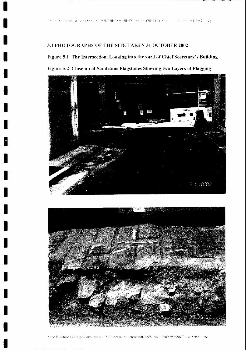
\l1l1c !3lckt()ftJ Ikrltagc Clll1sultants 135 Clthcril1C St l.clchhardt \JSW 2040 Ph02!95699672 h02955IJ0261
\11\11<\I« II\I( (I (I( ri, \1
Figure 5.1 The Intersection. Looking into the yard of Chief Secretary's Building
Figure 5.2 Close up of Sandstone Flagstones Showing two Layers of Flagging
SA PHOTOGRAPHS OF THE SITE TAKEN 31 OCTOBER 2002
IIIIIIIIIIIIIIIIIIIII
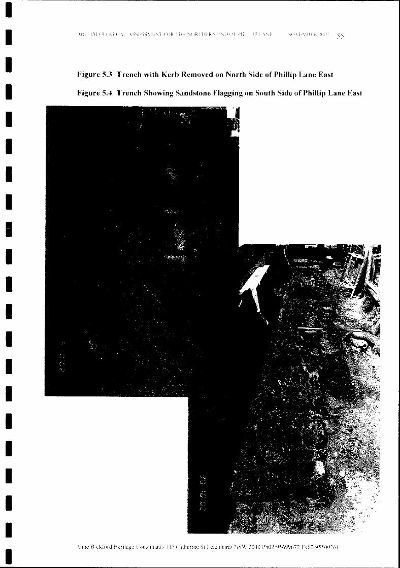
HlRlIll
COllsultants 135 Catherine St Leichhardt NSW 2040 Ph02/95699672 Fx()2;95500261
)( d(
Figure 5.3 Trench with Kerb Removed on North Side of Phillip Lane East
Figure 5.4 Trench Showing Sandstone Flagging on South Side of Phillip Lane East
IIIIIIIIIIIIIIIIIIIII
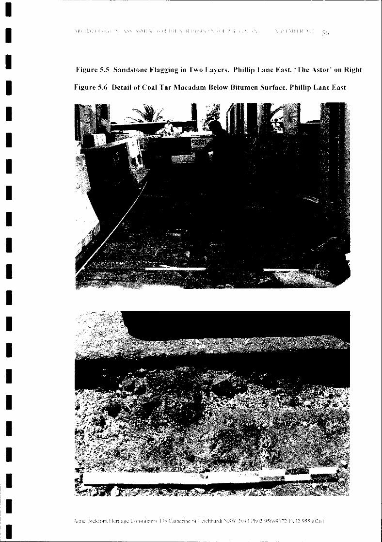
Figure 5.5 Sandstone Flagging in Two Layers. Phillip Lane East. 'l'he Astor' on Right
Figure 5.6 Detail of Coal Tar Macadam Below Bitumen Surface. Phillip Lane East
1\ iIII i'\iI iilR iill iRllili, I ili
Consultants 135 Cath.:nnc St L':lchhardt SW 21l41l Ph02 95699672 hll295SIl0261
\ i'f i if li i I( ill
IIIIIIIIIIIIIIIIIIIII
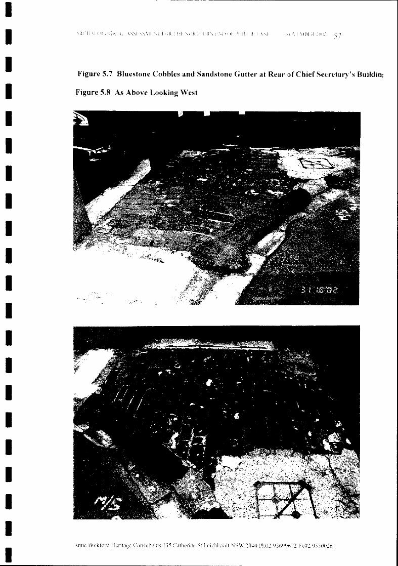
1111 [ I1111{ 1111 il{ 1111
Figure 5.7 Bluestone Cobbles and Sandstone Gutter at Rear of Chief Secretary's BUildin;
Figure 5.8 As Above Looking West
\nne Blekt(Jr(] Heritage Consultants 135 Catherine St Lelchhardt NSW 2040 Ph02/95699672 Fx02;95500261
IIIIIIIIIIIIIIIIIIIII
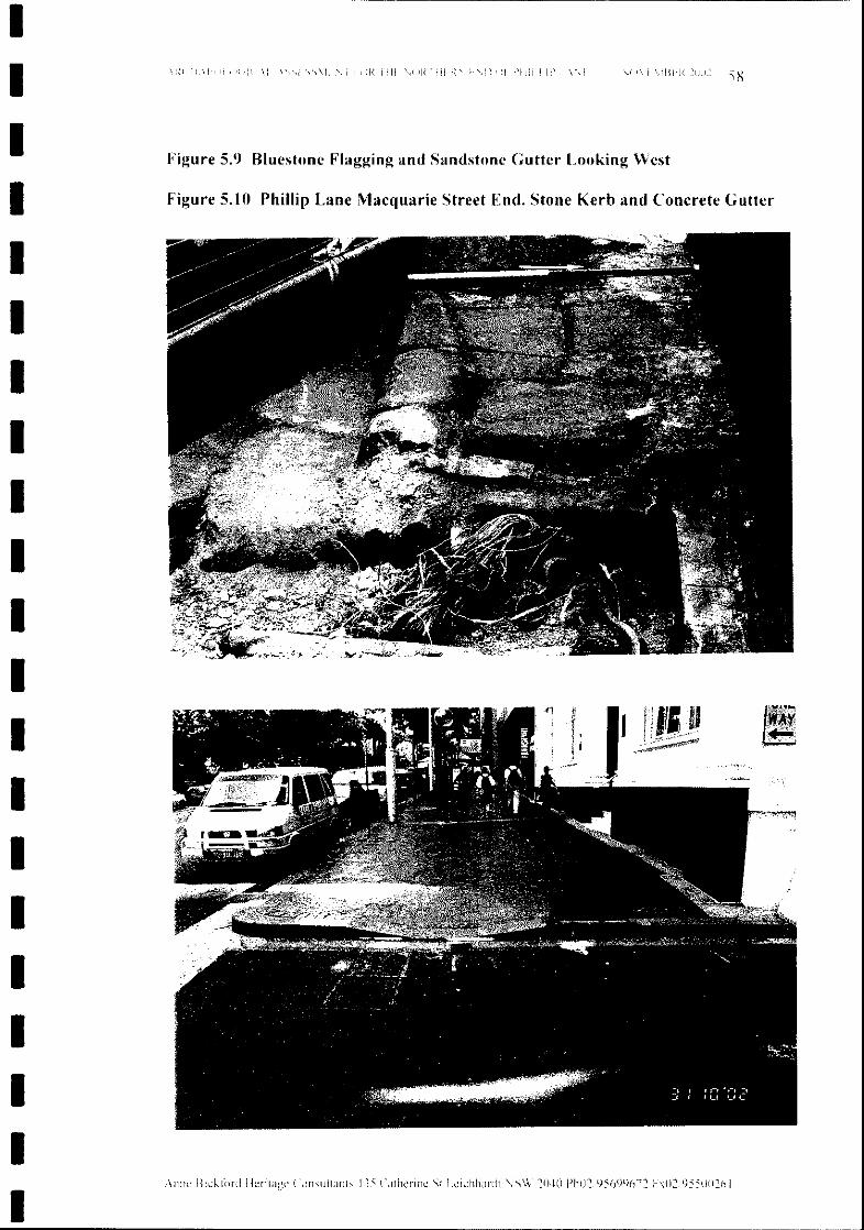
Figure 5.9 Bluestone Flagging and Sandstone Gutter Looking West
Figure S.lO Phillip Lane Macquarie Street End. Stone Kerb and Concrete Gutter
l\mlRI'II!I!!!' III! 1111 )R! I11
Consultants 135 Catherlne St Leichhardt '\is\V 2040 Ph0295699672 Fxll2J9550026I
11.\1111 )( ill .\1
\nl1e BIckt()rd
IIIIIIIIIIIIIIIIIIIII
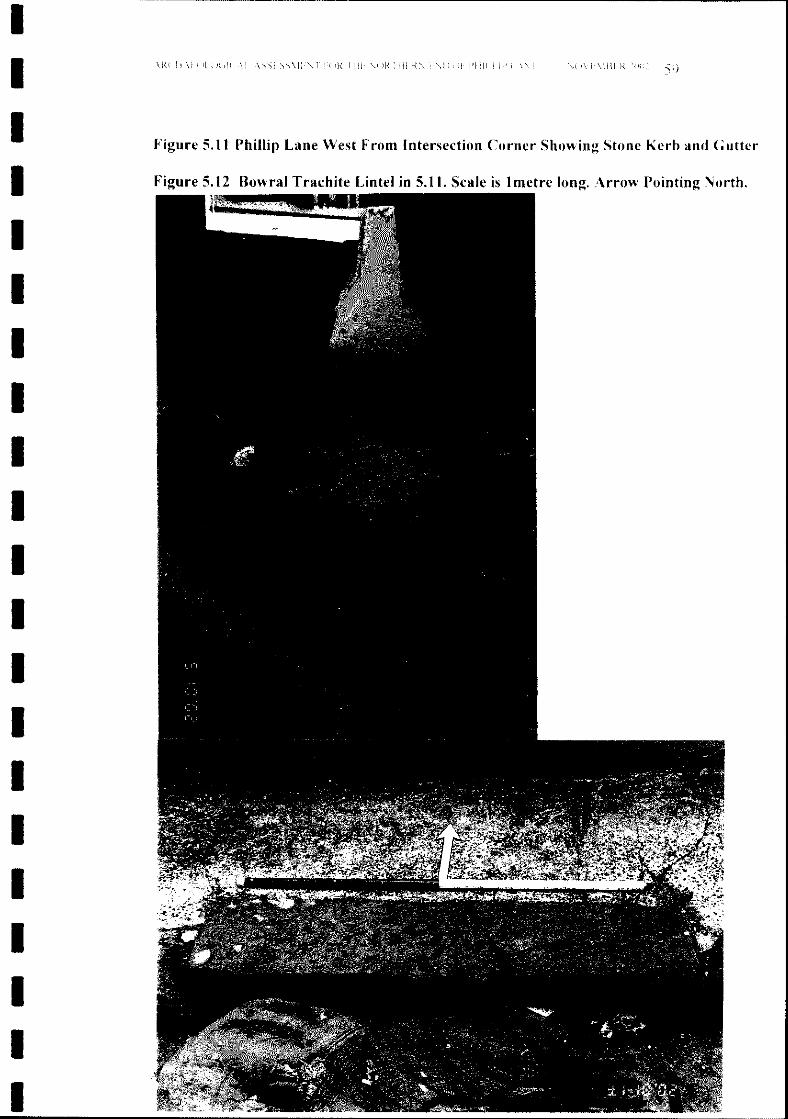
Figure 5.11 Phillip Lane West From Intersection Corner Showing Stone Kerb and Gutter
Figure 5.12 Bowral Trachite Lintel in 5.11. Scale is 1metre long. Arrow Pointing North.
I J I 1'1111 I I iJI{
IIIIIIIIIIIIIIIIIIIII
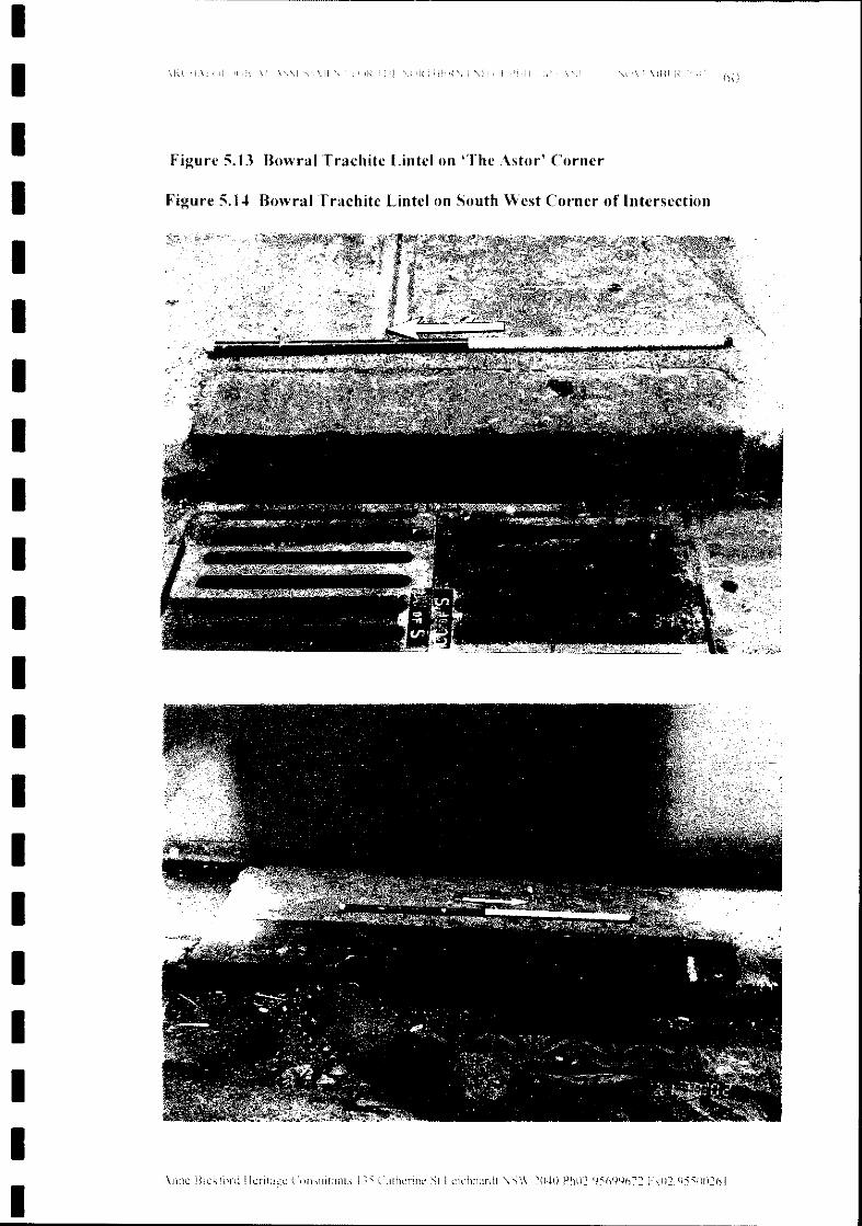
hUIi, 11
COl1sultanrs 13:' Calhcnnc St I.clchhardt \SW 2040 Ph0295699672 F,,0295500261
it J I( .\ j
\11f1c Hlcklbrd
Figure 5. t3 Bowral Trachite Lintel on 'The Astor' Corner
Figure 5. t~ Bowral Trachite Lintel on South West Corner of Intersection
IIIIIIIIIIIIIIIIIIIII
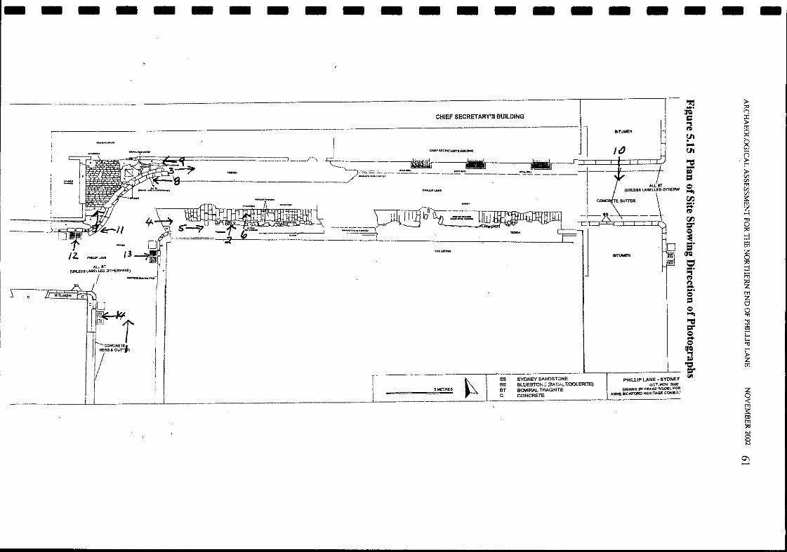
- - - - - - - - - - - - - - - - - - - - -CHIEF SECRETARY'S BUILDING
,;-
/2............ [3Al.lBT
(UNl.ESS lABElLED OTHERWISE)
IlllTUMEN
,,->
_~~_~=5MET==R_E' ~SS SYDNEY SANDSTONEBS BLUESTON" (llASALTJOOtERITElBT BOWRAL TRACHITEC CONCRETE
It)
l1IlIl1IlI
PHILUP LANE - SYDNEYQCTJKO\('2007
DRAWH BY FRANZ Ftg)£L, FOIlANNI BlCJ<FQRO HEfUTAGE COHSUL'
~ ».... p;(JQ
= ~.,('\)
0Y' r'.... 8U'l n"'C:l ~-= »1:1 t/.l
t/.l<:) t'l'l~
t/.lt/.l
r:J'1 ::....~
~('\)
r:J'1 ."
=- 0<:) ;x:I
~ -l
5' ~(JQ z
0=' ~.....,('\)t':l ~~....
~<:)1:1 0<:) 0~ ."
"'C:l '"l;l
=- i5<:) r'~ r'<:) ::a~ r'
= ~"0=-I<i!l
Z0<t'l'l::ttIt'l'l;x:IN00N
0\.....
Anne Bickford Heritage Consultants 135 Catherine St Leichhardt NSW 2040 Ph02/95699672 Fx02/95500261
6.3.1 Cobblestones
6.1 Introduction
By George Gibbons
NOVEMBER 2002 62
The cobblestones consist of fitted blocks of bluestone (dolerite or basalt) whichwas widely quarried from various small deposits around Sydney, from earlyColonial days. Such bluestone cobbled areas are extremely rare. Their shapes,placement and degree of wear are all of major significance on grounds of rarityand workmanship. The association with bluestone flagging (of which a remnantis visible just to the east, where a footpath ran) is even rarer. There would be
6.3 Heritage Evaluation
The cobbles probably date to the erection of the Chief Secretary's Building, orshortly thereafter.
The significant area is an offset T-intersection at the northern end ofPhillip Lane.
The cobblestone driveway is effectively at the northern termination of the main,north-south section of Phillip Lane. The flagging is in a section of lanewayrunning east from the lane proper, while a second laneway (which is covered) runswestward, offset a few metres south of the cobblestone driveway. (Forconvenience, these will be referred to respectively as Phillip Lane East and PhillipLane West.) Most of the main, north-south laneway has modem concrete kerbsand gutters, and the southern end is currently being further refurbished.
The plan of these laneways was laid out by 1854 (Woolcott and Clarke's map)(Figure 6.1) with town allotments backing on to Phillip Lane E and W. However,these lanes would have been only access-ways, even when the allotments wereoccupied, so the map is no guide to the date of the flagging.
6.2 General Description
A third heritage element around the laneway junctions consists of kerbs andgutters comprised of three different stone types of various periods.
Detailed proposals have been prepared to improve the amenity of Phillip Lane,Sydney. Initial advice from the archaeologist is that these proposals areincompatible with significant heritage values of cobblestones at a gate into theChief Secretary's Building yard, and also with sandstone flagging of the lanewayeast of this gate.
6.0 REPORT ON HERITAGE VALUES AND CONSERVATIONOF STONE MATERIALS
ARCHAEOLOGICAL ASSESSMENT FOR THE NORTHERN END OF PHILLIP LANE
IIIIIIIIIIIIIIIIIIIII
Anne Bickford Heritage Consultants 135 Catherine St Leichhardt NSW 2040 Ph02/95699672 Fx02/95500261
Apart from a probable poor surface condition, only about half the original widthof flagging is still present.
The cobblestones should not be disturbed. If they cannot be retained as is, to trulyreveal their heritage significance, the cobbles should be covered.
It is concluded that there are actually three factors arguing against the exposureand use of the old flagged surface:
NOVEMBER 2002 63
(a) the flagged surface is probably very irregular and relatively weak;(b) removal of the macadam would be difficult, and removal of tar stainingfrom the flagstones even more so;(c) removing the macadam may be undesirable; a coal tar road surfaceoverlying sandstone flagging is much rarer than such flagging itself, and isalso of interest and heritage value historically, technologically andscientifically.
Retention of both the flagging and tar-macadam would appear highly desirableand this can possibly be done only by covering both layers. As this has been thesituation for many decades it should be feasible, although it clearly constrains thepossible level and grade of the final road surface (which, as explained above, islargely constrained anyway if the cobbles are to be best conserved by retentionand exposure).
6.3.2 Flagstones
When inspected on 28th September 2002 only one layer of flagstones was visible;it is understood (Anne Bickford, pers. comm.) that a lower layer has now beenfound. Neither sandstone nor sandstone flagging is rare in Sydney, so the heritagevalue of this area depends on its associations. There may be significantarchitectural and/or historical associations; this report will consider onlytechnological associations.
The flagging seen on 28th September was the lowest of four layers, beingsuccessively overlaid by coal tar macadam, concrete, and asphalt. The macadamcovering appeared (from limited exposures) to have become necessary because ofirregularity in the cobble surface. This was partly due to irregular settlement offlagstones into the subsoil below. Breakage of sandstone surfaces and edgesunder the impact of iron-tyred cartwheels would also have been a factor.
major loss of value in any displacement or re-laying, which is basicallyunjustifiable on grounds of serviceability. The minor cement coatings will wearaway naturally.
ARCHAEOLOGICAL ASSESSMENT FOR THE NORTHERN END OF PHILLIP LANE
IIIIIIIIIIIIIIIIIIIII
Anne Bickford Heritage Consultants 135 Catherine St Leichhardt NSW 2040 Ph02/95699672 Fx02/95500261
6.3.4 Conclusions
Adjacent to the cobblestone area is a broad sandstone gutter which firstly hashistorical and rarity value in its own right, but also is an intrinsic component ofthe cobbled driveway.
1) There are significant heritage values at this site related to:• cobblestones at a gate into the Chief Secretary's Building yard,• sandstone flagging of the side lane east of this gate,• kerbs and gutters around the laneway junctions comprised of three
different stone types.
NOVEMBER 2002 64
2) The bluestone cobbles, together with the bluestone flagging to the east and thesandstone gutter to the south, should be retained and preferably exposed.
3) The sandstone flagging should be retained and covered. Its significance isenhanced by the overlying tar-macadam, and in any case it would probably be .impractical to clean the flagstones off and use the surface for vehicular traffic.
4) Runs of sandstone kerb-and-gutter as in Phillip Street West are already rare inthe CBD, and this example is relatively protected from damage. It should beretained ifpracticable.
5) The formed kerbing blocks of bluestone and trachyte around the T-intersectionare an excellent example of practices which are rapidly being "concreted out";they have much enhanced significance here in association with the runs ofsandstone kerbing, the cobblestones and the sandstone flagging.
There is some sandstone also around the convex corners ofthe T-intersection, butthe original sandstone has mainly been replaced with shaped blocks of eitherbluestone or "Bowral trachyte" (microsyemite from Mt Gibraltar at Mittagong).Both have been used extensively in Sydney over more than a century, but theassociation here with other stone elements provides an unusually high degree ofsignificance. Certainly these significant stones should not be removed for thesake ofuniformity.
Most of Phillip Lane West has sandstone kerbing and guttering which is stillserviceable. Once very common throughout Sydney, such kerbing is becomingrare, especially in the CBD, largely because of damage from car parking. It islikely that prohibition of parking, is a major reason why these kerbs havesurvived. (They are also largely protected from particulate city air pollution.)
6.3.3 Stone Kerbing and Gutters
ARCHAEOLOGICAL ASSESSMENT FOR THE NORTHERN END OF PHILLIP LANE
IIIIIIIIIIIIIIIIIIIII
Anne Bickford Heritage Consultants 135 Catherine St Leichhardt NSW 2040 Ph02/95699672 Fx02/95500261
6.4 Comment by Anne Bickford
Dr. Gibbons inspected the site with me on Saturday 28 September, the day after Iwas engaged by Bovis Lend Lease to investigate the site and produce this andother Reports concerning the heritage issues. Since Dr. Gibbons wrote thisChapter discussions with Bovis Lend Lease has led to them discarding theiroriginal plan for the Lane. Bovis Lend Lease has taken note of these and othercomments, and all of Dr. Gibbons' conclusions here have been assessed andincluded in the new plans produced.
IIIIIIIIIIIIIIIIIIIII
ARCHAEOLOGICAL ASSESSMENT FOR THE NORTHERN END OF PHILLIP LANE NOVEMBER 2002 65
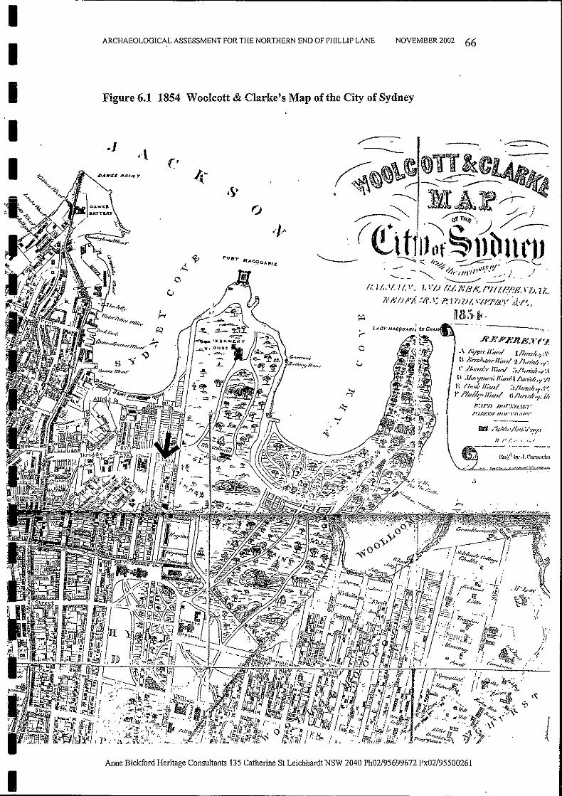
II
ARCHAEOLOGICAL ASSESSMENT FOR THE NORTHERN END OF PHILLIP LANE NOVEMBER 2002 66
III
Figure 6.1 1854 Woolcott & Clarke's Map of the City of Sydney
.]
.J ...< •
-
--~~..f(;S'P .f;'R.E,r (Ii':.
.\ "'if,/<d/;ml l//,rwi.~,\"
B /:n.f~"I/lrlf;ru/2/:,n:,,·/, '1:(' '/1".",1." mml :-1/~,n:rh"/:\
Il .lit;,>!",,,.,; II",,/-I Ilm.</,"I '/1J.; (;",/'-lIiml :)/I/n:I-/;'7'S'(v /711/1" IIiml li/hrt4l,y:!/'
l1;lIW IJ'Jf:I1.J,tNr
~m;.,F.\'J~~r:::.."~'
_ /JI.hIt,·lltli.~/'.I!I/.f
/1 IJ /.~••••, ..---~~- .-... -.-- ---
. 1·:m!.lll~·J.('annu-IJ;1
......:..,~~
1I
Anne Bickford Heritage Consultants 135 Catherine St Leichhardt NSW 2040 Ph02/95699672 Fx02/95500261
Anne Bickford Heritage Consultants 135 Catherine St Leichhardt NSW 2040 Ph02/95699672 Fx02/95500261
7.0 SYNTHESIS OF PHYSICAL AND DOCUMENTARY EVIDENCE
6 Pers Comm Anne Higham, architect at RAJA.
The Phillip Street addition to the original building (now called 50 Phillip Street)was constructed in 1890-1894. It is possible that the kerb, guttering, and pavingunder the archway spanning the Lane was laid down, or reworked, at that time.
NOVEMBER 2002 67
The coal tar macadam was probably surfaced over the sandstone flagging at a laterdate to fill in the ruts and breakages from the iron tyred carts and carriages usingthe Lane, especially to enter and exit the Chief Secretary's Building yard.The bitumen surface is obviously a later road layer.
Some of the bluestone and trachyte kerbing at the Phillip St and Macquarie Stfootpaths and corners appears newer than the other pieces in the Lane. The recentbrick paving of the footpaths shows that the whole area of footpath, kerb andgutter was remade and upgraded. This was done in 1988. The bluestone kerbingcould even have been brought from other city sites and placed here. The trachytekerbing is significant in that it came from the last trachyte quarry to be used.6
There is an integrity to the elements in the Intersection area that makes themappear to be of a similar age. Two test squares by Bovis Lend Lease in theroadway of the Intersection area showed that the sandstone flagging was present,and therefore it can be assumed that it was laid behind the whole of the ChiefSecretary's Building, from Phillip to Macquarie Street.
The documentary evidence shows that the Lane has existed since the 1840s,initially serving the rear of the terraces backing on to it. There is no physicalmethod to date the stone cobbles, flagstones, kerbs and gutters.They could date from as early as the 1840s when the Lane was constructed.However, it is more likely that they were placed there in the late 1870s - to 1880when the Chief Secretary's Building was built, as they appear to be an integralpart of that building 'in the round'. .
ARCHAEOLOGICAL ASSESSMENT FOR THE NORTHERN END OF PHILLIP LANE
IIIIIIIIIIIIIIIIIIIII
Anne Bickford Heritage Consultants 135 Catherine St Leichhardt NSW 2040 Ph02/95699672 Fx02/95500261
8.2 General Assessment Processes and Criteria
7 NSW Heritage Manual "Heritage Assessments" p. 5.
8.3 NSW Heritage Assessment Criteria
NOVEMBER 2002 68
An item will be considered to be of State or local heritage significance if it meetsone or more of the following criteria:a) an item is important in the course, or pattern, of NSWs cultural or naturalhistory;b) an item has strong or special association with the life or works of a person, orgroup of persons, of importance in NSWs cultural or natural history;c) an item is important in demonstrating aesthetic characteristics and/or a highdegree of creative or technical achievement in NSW;d) an item has strong or special association with a particular community orcultural group in_NSW for social, cultural or spiritual reasons;
The NSW heritage assessment criteria encompass the four values in the AustraliaICOMOS Burra Charter (See Appendix A), which are commonly accepted asgeneric values by Australian heritage agencies and professional consultants.
- historical significance- aesthetic significance- scientific significance- social significance
In NSW the heritage system requires three steps:1) investigate significance2) assess significance3) manage significance.
ARCHAEOLOGICAL ASSESSMENT FOR THE NORTHERN END OF PHILLIP LANE
8.1 The Concept of Cultural Significance
In Australia the process of finding out whether an item is important or not "iscalled assessing significance. The importance of the archaeological resources ofthe Study Area will be evaluated by following the established heritage procedures.The criteria for assessment have been standardised in NSW by the Heritage Officeand published in the NSW Heritage Manual in 1996. This procedure makes itpossible to compare the significance of like items between local governmentareas, or between states.7 The NSW Heritage Office has recently published a"NSW Heritage Manual update" in 2001. This is called Assessing HeritageSignificance and is an update to the Heritage Assessments guideline of 1996. Thisnew guideline has also been used in the preparation of this Report.
8.0 ASSESSMENT OF CULTURAL SIGNIFICANCE
IIIIIIIIIIIIIIIIIIIII

Anne Bickford Heritage Consultants 135 Catherine St Leichhardt NSW 2040 Ph02/95699672 Fx02/95500261
The laneway permits viewing 'in the round' of the Chief Secretary's Building.
Its level of significance is
Under Significance (Figure 2.5) it states that it is of
NOVEMBER 2002 69
8 This list was taken from a document 'Criteria for Listing on the State Heritage Register'provided through the NSW Heritage Office Website.
The NSW Heritage Office's State Heritage Inventory assesses the significance ofthe lane under the criteria (a) to (g) listed above in Section 8.3. The entry adds tothe Statement of Significance that
Phillip Lane is enclosed substantially by heritage listed buildings which contribute to thesignificance ofthe laneway.
It is graded as ofExceptional Significance because
For Historic of State SignificanceFor Technical of Local SignificanceFor Rare or Endangered aspects of State Significance
8.4 The Cultural Significance of the Study Area
The site has already been assessed for the City of Sydney's Central SydneyHeritage LEP 2000 (Figures 2.2 to 2.6).
In this document under Conservation Policy (Figure 2.3) it states that it isa
Technically [sic] significance as a late Victorian laneway with street entry through asignificant building fac;:ade, demonstrating a good use of archways and former pavingtechniques.
Heritage item, retain and conserve in accordance to Burra Charter principles.Enhance pedestrian amenity.andSignificant built fabric of the lane, such as timber blocks, stone, trachyte kerbs ... andother evidence ofthe heritage significance ofthe lane, shall be retained in situ.Retain the role of the lane as public open space, by maintaining and enhancing pedestrianaccess and activity.
ARCHAEOLOGICAL ASSESSMENT FOR THE NORTHERN END OF PIllLLIP LANE
e) an item has potential to yield information that will contribute to anunderstanding ofNSWs cultural or natural history;f) an item possesses uncommon, rare or endangered aspects of NSWs culturalor natural history;g) an item is important in demonstrating the principal characteristics of a class ofNSWs- cultural or natural places; or- cultural or natural environments.8
IIIIIIIIIIIIIIII
IIIII
Anne Bickford Heritage Consultants 135 Catherine St Leichhardt NSW 2040 Ph02/95699672 Fx02/95500261
8.5 Conclusion
P
(c) an item is important in demonstrating aesthetic characteristics... in NSW
NOVEMBER 2002 70
All of the stone elements described above can be classified as archaeologicalremains and of heritage significance. However, the most significant
8.6.1 The Archaeological Resource
8.6 The Archaeological Significance of the Study Area
By retaining the stone materials the heritage significance of the laneway ismaintained.
There are very few such areas ofhistoric infrastructure left in the city.
For this project it will be increased by the cleaning off of the bitumen on thesandstone gutter and bluestone paving, and the concrete on the bluestone cobbles,thus revealing more of the original stonework and adding to its visual andaesthetic appeal.
The original plan for upgrading the area by Bovis Lend Lease used all newmaterials, except for the bluestone cobbles which were to be 'flipped over' toreveal their opposite unused face. This seemed to me to tie in with the aestheticof Aurora Place, at the other end of the laneway - a new building with all newgranite setts, paving and detailing, though this may not have been the consciousintention of the Bovis Lend Lease designers. Such changes will not now takeplace.
There is also an aesthetic feature in the original bluestone cobbles and flaggmg,sandstone gutters, and bluestone and trachyte kerbs and lintels which are visible inthe Intersection area. These add to the aesthetic ambience of the rear of the ChiefSecretary's Building, being all of the same antiquity, and their 'old' worn surfacesadd to this effect.
ARCHAEOLOGICAL ASSESSMENT FOR THE NORTHERN END OF PHILLIP LANE
8.4.1 Aesthetic Significance
These listings do not consider the aesthetic significance of the Study Area. TheNSW Heritage Assessment Criteria includes:
This is partly expressed in the Statement of Significance entry quoted above thatIt "permits viewing 'in the round' ofthe Chief Secretary's Building."
IIIIIIIIIIIIIII'IIIIII
Anne Bickford Heritage Consultants 135 Catherine St LeichhardtNSW 2040 Ph02/95699672 Fx02/95500261
Because the sandstone flagstones are so fragile and friable it will not be possibleto have them exposed and used as a surface as long as cars and trucks are to driveover them. If it is later decided to use the lane only as a pedestrian walkway, thenconsideration can be given to removing the bitumen and coal tar macadam, andusing them as a pedestrian walkway.
archaeological resource in the Study Area is the sandstone flagging - the evidenceof the original road surface which was revealed when part of the present bitumenlayer and coal tar macadam underneath was removed.This flagging has been fully recording by a scale plan drawing at 1:50 (SeeFigures 1.4 and 1.5) and by a series of photographs (See Figures 5.2, 5.4 and5.5).The coal tar macadam above it which is also of significance has also been drawnand photographed.Two test pits in the Intersection area to the west by Bovis Lend Lease have shownthat the sandstone flagging continues under the road.It was probably laid down all along the offset "T" section of the lane as part of theconstruction process forming the rear of the Chief Secretary's Building.
II
.1IIIIIIIIIIIIIIIIII
ARCHAEOLOGICAL ASSESSMENT FOR THE NORTHERN END OF PIDLLIP LANE NOVEMBER 2002 71
This Report has described above how the original plan to upgrade the Study Areawas revised once discussions of the heritage significance of the stone elementsvisible and revealed by excavation had taken place.
I1I1I·
ARCHAEOLOGICAL ASSESSMENT FOR THE NORTHERN END OF PillLLIP LANE
9. 0 DEVELOPMENT IMPACT
9.1 The Development Proposal
NOVEMBER 2002 72
Anne Bickford Heritage Consultants 135 Catherine St Leichhardt NSW 2040 Ph02/95699672 Fx02/95500261
9.2 Detailed Description and Explanation by Bovis Lend Lease
Barry Steele of Bovis Lend Lease has provided the description of the proposal andexplanation of the work, and this is presented below:
The bluestone cobb.1es, paving, and sandstone gutter are to be retained andenhanced by being cleaned of the bitumen and concrete obscuring parts of them.
Where the main north-south section of the lane terminatesat the Astor House/Chief Secretary's drive
From 3-way intersection through "tunnel" to Phillip St
From 3-way intersection though to Macquarie St
Phillip Lane west
Phillip Lane east
Terminology
3-way intersection
9.2.1 Original Scope
The Phillip Lane works involve the resurfacing of the entire lane (except that areain the "tunnel" under the Industrial Relations Commission) from building face tobuilding face i.e. road and footpaths.
Area of Concern: The east-west section of Phillip Lane from Phillip St toMacquarie St
The stone kerbs and lintels in the Intersection area are also to be retained.Some ofthe stones where the wombat crossings are to be built at the Phillip Streetand Macquarie Street ends of the lane will have to be removed, but as these werelaid in 1988, they are not so significant.
The development proposal now is to continue the work of upgrading Phillip Lane,but with an emphasis on retaining in situ as much as possible of the historicremains of the laneway. The sandstone flagging uncovered in the Phillip Lane eastroadway will be conserved and preserved by covering it with special materials, sothat if required, the work is reversible in the future.
I1IIIIIIIII1IIII
Anne Bickford Heritage Consultants 135 Catherine St Leichhardt NSW 2040 Ph02/95699672 Fx02/95500261
The Development Consent noted that unexpected heritage relics were to bereported to the Heritage Council.
The original scope was documented in the Development Application DA00/00428. Consent for this DA was granted on 10/1/02. The design wassubsequently developed and the final scope for the area of concern is documentedon Group GSA drawing # 02 030-1102/03. Various other drawings provideddetails. The final design drawings were approved by Council.
9.2.2 Heritage Components of the Original Scope
The original scope recognised the following (included above):
• Chief Secretary's drive cobbles - to be removed and reinstated
• Chief Secretary's moat grates - to be removed and reinstated
• Macquarie/Phillip trachyte kerbs - remove/reinstate or provide new asrequired.
NOVEMBER 2002 73
Key components of the original scope were:
• Roadway generally (except at crossings and 3-way intersection) to beoversheeted with 40mm layer ofnew bitumen
• Roadway at 3-way intersection to be granite setts on a level with theoversheeted roadway
• Raised "wombat" crossings in granite setts to be constructed at Macquarieand Phillip Streets
• Generally existing kerbs to be removed and replaced with new granite kerbs
• Footpath adjacent to Astor House to be widened to 1650mm to improvepedestrian amenity and discourage illegal parking
• Phillip Lane west entrance at Phillip St to be reduced in width to reducepotential for damage to heritage Industrial Relations Commission anddiscourage illegal traffic movement
• Trachyte kerbstones at Phillip St and Ma~quarie St to be removed andreinstated to new alignment at raised crossings
• Footpath areas to be renewed with new base slab under brick pavers orbitumen. Existing cobbles at Chief Secretary's drive to be carefully removedand reinstated over new base slab
• Chief Secretary's moat grates to be removed and reinstated to adjusted levelsto match road and footpath
ARCHAEOLOGICAL ASSESSMENT FOR THE NORTHERN END OF PIDLLIP LANE
IIIIIIIIIIIIIIII
IIIII
Anne Bickford Heritage Consultants 135 Catherine St Leichhardt NSW 2040 Ph02/95699672 Fx02/95500261
The original scope did not consider the following known/visible items
• Existing kerbs generally (sandstone kerb/layback, trachyte kerb inlet lintels,bluestone kerbs)
The discovery and subsequent investigations have raised the focus andunderstanding of the heritage significance of the area. As such the entirearea/work has been reassessed, including those works that had previously been(apparently) acceptable.
9.2.3 Heritage Discovery
Works to Phillip Lane east and subsequent investigations have revealed thefollowing additional heritage items:
• Sandstone flagging with coal tar macadam overlay in Phillip Lane east, 3-wayintersection, and probably continuing west to Phillip St
• Bluestone flagging approximately lm east of the previously identifiedbluestone cobbles at the Chief Secretary's drive
NOVEMBER 2002 74
9.2.4 Revised Scope
The proposed revised scope is shown in preliminary form on Jeff Moulsdale &Associates drawings # SKCOl, SKC02, SKC03 (Figures 9.1-9.3). There remainssome detailing work to complete the revised proposal.
Key components of the revised scope are:
• Roadway generally (except at crossings and 3-way intersection) to beoversheeted with 40mm layer of new bitumen. The existing sandstoneflagging/coal tar macadam will remain in situ in the oversheeted areas. Thearea of sandstone flagging already exposed in Phi/lip Lane east will becovered with layered bitumen to the appropriate level.
• Roadway at 3-way intersection to be granite setts - these will now be at araised level (nominally level with footpaths). Setts will be founded onstabilised roadbase placed over the existing sandstone flagging
• Raised "wombat" crossings in granite setts to be constructed at Macquarieand Phillip Streets - these will now be constructed with setts on stabilisedroadbase placed over the existing sandstone flagging
• Generally existing concrete kerbs to be removed and replaced with newgranite kerbs with some exceptions. Sandstone layback at ChiefSecretary'sdrive is to be retained in situ. Trachyte kerb inlet lintels at 3-way intersectionare to be removed and reinstated on new footing to new level. Bluestone
ARCHAEOLOGICAL ASSESSMENT FOR THE NORTHERN END OF PI-llLLIP LANE
III11II1I11I.IIIIIIIII
Anne Bickford Heritage Consultants 135 Catherine St Leichhardt NSW 2040 Ph02/95699672 Fx02/95500261
9.2.5 Heritage Impacts and Reasoning
The revised scope has some impact on the heritage items. Specific issues areexplained as follows:
An additional item is also expected to be added to the scope in preparation forfuture refurbishment works at the Chief Secretary's building:
• Provided new water connection from main below 3-way intersection to ChiefSecretary's building. Trench to be cut through 3-way intersection, followingline of previously trench so as not to disturb any untouched areas ofsandstone flagging
9.2.5.1. Coal Tar Macadam (overlaying sandstone flagging)
a) Phillip Lane east - removed during initial discovery and cannot be replaced
b) 3-way intersection and raised crossings - must be removed to achieveappropriate depth of roadbase bed for granite setts. Setts cannot be raisedhigher as this would make crossing too high for traffic
c) Near Chief Secretaries moat grates - possible removal during profiling tomake road levels work.
NOVEMBER 2002 75
kerbs at corner ofAstor House are to be removed and reinstated on newfooting to new level.
• Footpath adjacent to Astor House to be widened to 1400mm to improvepedestrian amenity and discourage illegal parking. The reduction in widthfrom the original scope allows the sandstone flagging to remain undisturbed.A special detail (refer JMA "Revised Kerb Detail" A4 size sketch)(Figure9.4) concrete footing will beplaced over the existing lower levelflagging.
e PhiHip Lane west entrance at Phillip St to be reduced in width to reducepotential for damage to heritage Industrial Relations Commission anddiscourage illegal traffic movement
• Trachyte kerbstones at Phillip St and Macquarie St to be removed andreinstated to new alignment at raised crossings
• Footpath areas generally to be renewed with new base slab under brick paversor bitumen. Existing cobbles at Chief Secretary's drive to remain in situ (i.e.no new base slab or relevelling) except for approximately 20 cobbles to becut/removed or adjusted to suit the drive layback bridging detail. Existingbluestone flagging will be carefully removed, cleaned and reinstated overnew base slab
• Chief Secretary's moat grates to remain in situ. Existing road will be''profiled'' down as required (up to 50mm) to ensure correct levels.
ARCHAEOLOGICAL ASSESSMENT FOR THE NORTHERN END OF PHILLIP LANE
IIIIIIIIIIIIIIIIIIIII
Anne Bickford Heritage Consultants 135 Catherine St Leichhardt NSW 2040 Ph02/95699672 Fx02/95500261
9.2.5.3 Bluestone, Trachyte and Sandstone Kerbs/Gutters
a) Phillip Lane east (north side) - section approximately 3m long alreadyremoved and disposed. Cannot be replaced.
b) Chief Secretary's drive layback - concrete flush kerb to be installed both sidesof gutter to support grate. Bond breaker can be installed between kerbs andgutter. Some minor disturbance of gutter is expected in detailing. Attempt toclean off existing bitumen may affect gutter.
c) Adjacent to Chief Secretary's layback - stones will be retained/reused,however in order to accommodate ramping at the edges of the raised road andrequired footpath levels it is expected that adjustment will be required. It isfurther noted that a footpath base slab will be installed directly behind thesekerbs. Disturbance may include removal and reinstatement on a footing, orpossibly removal and re-bedding on roadbase. Some stone will need to be cutto create an inset for the drain grate to sit in.
d) Astor House corner - bluestone and trachyte pit lintel will be removed andreinstated to new levels on new footing. This is necessary to achieve correctlevels.
9.2.5.2. Sandstone Flagging
a) Phillip Lane east - top level of exposed area will be "tack sealed" withbitumen and then overlaid with layers of bitumen. To ensure adequate roadperformance a bond must be formed between the road base, in this case theflagging, and the road surface. Therefore a bond breaker cannot be used.
b) Phillip Lane east - second layer will have concrete footing cast over it(separated by bond breaker). Generally the second layer will be "cast-in" butundisturbed, however occasional flagstones may need to be removed oradjusted to achieve an adequate depth of footing above.
c) 3-way intersection and raised crossings - flagging will be overlaid withstabilised roadbase. A minimal bond will occur between flagging androadbase, however roadbase is removable and sandstone could be cleaned ofany residual in future. A bond breaker cannot be used as variable (in somecases minimum) depths require that the roadbase not "slide".
d) 3-way intersection and raised crossings - flagging may require someadjustment at edges/gutters to ensure correct details for road performance.This may involve cutting, removal or level adjustment. If required this workis expected to be contained within a zone of200mm from the gutter lip.
e) 3-way intersection - stone has already been disturbed to make waterconnection for Chief Secretary's building. It is intended to use the sametrench line to upgrade the water connection, however some additionaldisturbance may occur. This is necessary as any other route to the existingwater main would create even greater disturbance.
IIIIIIIIIIIIIIIIIIIII
ARCHAEOLOGICAL ASSESSMENT FOR THE NORTHERN END OF PIDLLIP LANE NOVEMBER 2002 76
Anne Bickford Heritage Consultants 135 Catherine St Leichhardt NSW 2040 Ph02/95699672 Fx02/95500261
9.3 The Impact of the Development on the Archaeological Resource
9.3.1 On the potential archaeological remains in the ground
9 Turning over the stones is not a favoured option from the heritage conservation point of view. Steps havebeen taken to find a specialist stone conservator who can clean off the bitumen without damaging ordiscolouring the stone. The aesthetic and historic value of the patina of age has been discussed above inSection 5.3.
NOVEMBER 2002 77
It is known from the two test pits that sandstone flagging topped by coal tarmacadam exists in areas of the Intersection to the west of that already revealed. Itis assumed that it continues down Phillip Lane west to Phillip Street. Someflagstones may require cutting, removal, or level adjustment at their contact with
9.2.5.6 Moat Grates Including Stone Surround
These will be essentially untouched. Footpath around will be demolished andreinstated. This is to be done carefully. Concrete will be chipped off stone ifpossible.
9.2.5.5 Bluestone Flagging
a) The small section of flagging will be removed and reinstated over a newfootpath base slab. This area sits between two areas of new footpath and isnot feasible to keep in situ. The flagging is mostly covered in bitumen. It willbe cleaned ifpossible, but more likely turned over when reinstated.9
9.2.5.4 Bluestone Cobbles
a) The zone 400mm from the back of the sandstone layback will be disturbed.This will require cutting out the first 100mm, to create the flush kerb for thedrain grate, and raising the level of the next 300mm to match the grate level.The cut out stones can be relaid nearby if necessary, however they will besmall irregular pieces.
e) Raised Crossings - where kerb alignment changes stones must be removedand reinstated on new footing to new alignment. Kerbstones are not requiredfor the width of the top of the crossing. Existing stones in this area will beremoved/relocated to assist with alignment changes. Any spare will beprovided to Council. This is necessary as the alignment changes requireextension of some kerbs.
f) Generally - significantly damaged stone will not be reused.
ARCHAEOLOGICAL ASSESSMENT FOR THE NORTHERN END OF PHILLIP LANE
IIIIIIIIIIIIIIII
IIIII
Anne Bickford Heritage Consultants 135 Catherine St Leichhardt NSW 2040 Ph02/95699672 Fx02/95500261
the gutters for the proper functioning of the road. It is expected that this work willbe contained within 200mm from the gutter lip.
9.3.2 On the archaeological remains which are above ground - the kerbs,gutters, lintels, cobbles, and paving
Where the granite setts are to be laid in the Intersection area the ground level willhave to be shaved off to the sandstone flagging level. This will mean the removalof the coal tar macadam layer in this area. As this needs -to be done to reach therequired level for the granite setts there is no alternative to the coal tar removal.It is assumed that more of this coal tar macadam level remains in situ between theIntersection and Phillip Street, and in the rest of Phillip Lane East which was notremoved when road excavation work fIrst began on the site.
NOVEMBER 2002 78ARCHAEOLOGICAL ASSESSMENT FOR THE NORTHERN END OF PIllLLIP LANE
, To conform with the concrete base for the new road level some ofthe stone kerbs,lintels, and the bluestone paving will have to be lifted and then replaced in thesame place, but at a higher level. The bluestone cobbles will remain in situ exceptfor the fIrst 400mm which will need to be moved for the correct positioning of thedrain grate. The purpose of the drain grate is to allow the sandstone kerbing toremain in situ, by protecting it from the weight of cars and trucks entering andexiting the rear yard of the Chief Secretary's Building. This is the successfulcompromise which was reached between leaving all of the cobbles undisturbed,and removing the sandstone gutter, whose stones are too fragile to take the weightofvehicles directly.
IIIIIIIIIIIIIIIIIIIII
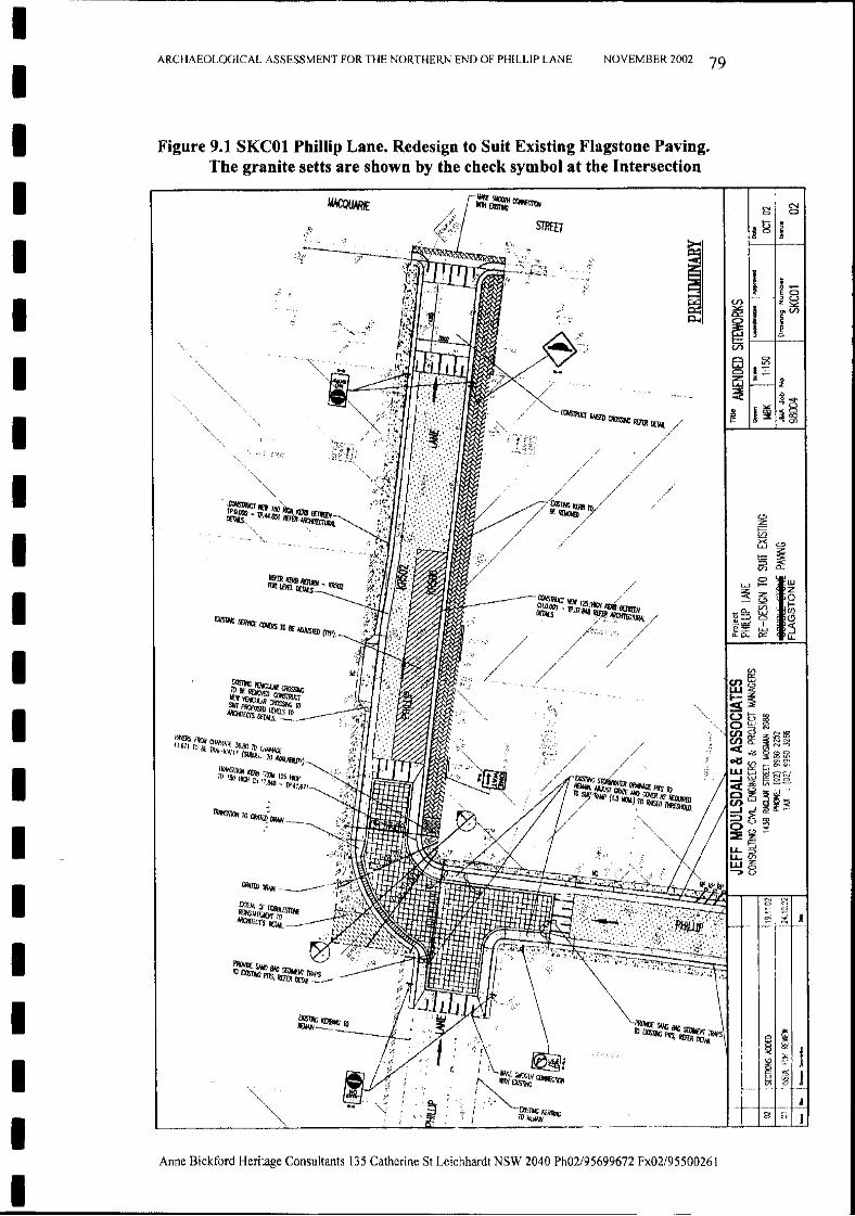
II
ARCHAEOLOGICAL ASSESSMENT FOR THE NORTHERN END OF PHILLIP LANE NOVEMBER 2002 79
Figure 9.1 SKCOl Phillip Lane. Redesign to Suit Existing Flagstone Paving.The granite setts are shown by the check symbol at the Intersection
~I~~ ;;:1 i
c.:>:z:~GS c.:>
:z:t::: ~::::>(j') Cl..
~gr~:z: Z~ ~
_Q- UJ (f)~:::::J Cl Cl,-=' I ::i2::r:: LWn.c- a::: u..
Ul
CI)~W<!;i:~C3 t> ~O~NN(oCJ)~ 3~~cna..:3Ncc"'d ~li5~olS Ul ~ 0'
wt'§--I z ,
"~~ ;~'Cl) :t::~-' "-
5~~0",,;,::::iE 5IJ-::>IJ- Ulwi§-:> <.>
~I NJgjO
~.
I 'r-Eo
!Q 1- ;~0:: ,_~
~ ~V'l
8 ~
~ F' 0z~ .0
0 ...."'0
.l! j§l ~gj!! .., 0>
EXislr.c /'~'.~l!R~
7~~rl~~ro
-...._../L/,'oco/ ,,'/
STRfIT
~ /~lXJO _~125ilt:li-:
j~/:r:!;7
AW:ouARIr
O!srt«;!!1Ill!I;1OR!llIII__
EXislr.c S!JMcr CO\fliS 10 oc IIlA.57m (IlpJ,
PAIfRs fJ10II OW!W;f 36,00 10~11.6/1 To Iif lTWH;),,~r (SI.!w[Ci TO~
TiWIsocw IC!IiB fJ10II 125~III 1S/)~CliJ7,Ill8_1P,4l.671
II
II
I
IIIIIIIII
II
I
II
Anne Bickford Heritage Consultants 135 Catherine St Leichhardt NSW 2040 Ph02/95699672 Fx02/95500261
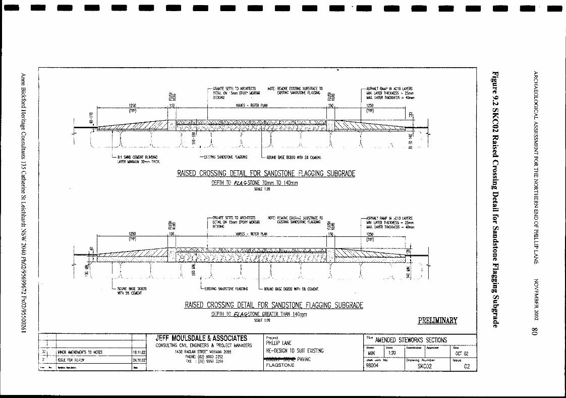
- - - - - - - - - - - - _.- - - - - - - -"!!j ~....~
()
., ~ftl 0I,(,'> t"'
N 800 n~ .~
~ >-<:> C/IlN C/Il
tTl
~C/IlC/Il~....t:2~
ftlCl.. -l
'Tl
~ 0., ::cCl -l~ iii~.... Z== 0IJCl ::c~
-l
ftl iii- ~~=:t:2c:>' t:l.,0
00 'Tl
~ '"==
;;Cl.. t"'
t"'~ ;;-Cl t"'
== ;Zftl
"!!j tTl-~IJClIJCl Z.... 0== <:IJCl tTl00 ~C tIl:l
tTl0- ::c
IJCl N., 8~ NCl..ftl
000
02
OCT02Issue
PRELIMINARY
TItle AMENDED SITEWORKS SECTIONS
ASPHALT RAUP IN ACl0 LAYERS1.lIN. LAYER THICKNESS = 25mmIotAlL LAYER THICKNESS =40mm
1250
--
ASPHALT RAUP IH AC10 LAYERSUIN. LAYER THICKNESS = 25mmUAX. LAYER THICKNESS = 40mm
1250
(ftP)
MBK 1:20JMA Job No Drawing Number
98004 SKC02
NOTE: REMOVE EXiST",G SUIlSTRATE TOEXJSTlNG SANDSTONE FlAGGING ~~
150
NOTE: Rf},(()\I£ EXISllNG SUIlSTRATE TOEXISllNG SANDSTONE FLlGGING "'<Xl
~~150
BOUND BAS[ 1lGB20 WITH 5% CEMENT.
BOUND BASE IlGB20 WITH 5% CElIENT.
Project
PHILUP LANERE-DESIGN TO SUIT EXISTING
~_I!'"!lil_PAViNGFLAGSTONE
VARIES - RtFER PLAN
VARIES - RIJl:R PLAN
GRANITE SETTS TO ARCHITECTSDETAIL ON 15mm EPOXY UORTARBEDDING
,CRANlT[ sms TO ARCHm:TSI DETAIL ON ISmm EPOXY UORTAR
BEDDING
ii.
L~:G SANDSTONE FLAGGING
RAISED CROSSING DETAIL FOR SANDSTONE FLAGGING SUBGRADEDEPTH TO FL,4<rSTONE GREATER THAN 140mm
SCAl£ 1:20
RAISED CROSSING DETAIL FOR SANDSTONE FLAGGING SUBGRADEDEPTH TO ciA !CSTONE 70mm TO 140mm
SCAl£ 1:20
JEFF MOULSDALE &ASSOCIATESCONSULTING CML ENGINEERS & PROJECT MANAGERS
1438 RAGlAN STREET UOSMAN 2088PHONE: (02) 9960 2252FI-X : (02) 9960 326624.10.02
19.11.02
...
1250
(TYP)1250
BOUND BAS[ 1lGB20WITH 5% C!lIOO
L 9:1 SAHll C!lIOO BliNDINGLAYER IoIINIlIUII :JOmm THICK.
UIHOR MtENOUENTS TO NOTES
ISSUE FOR REYlEW
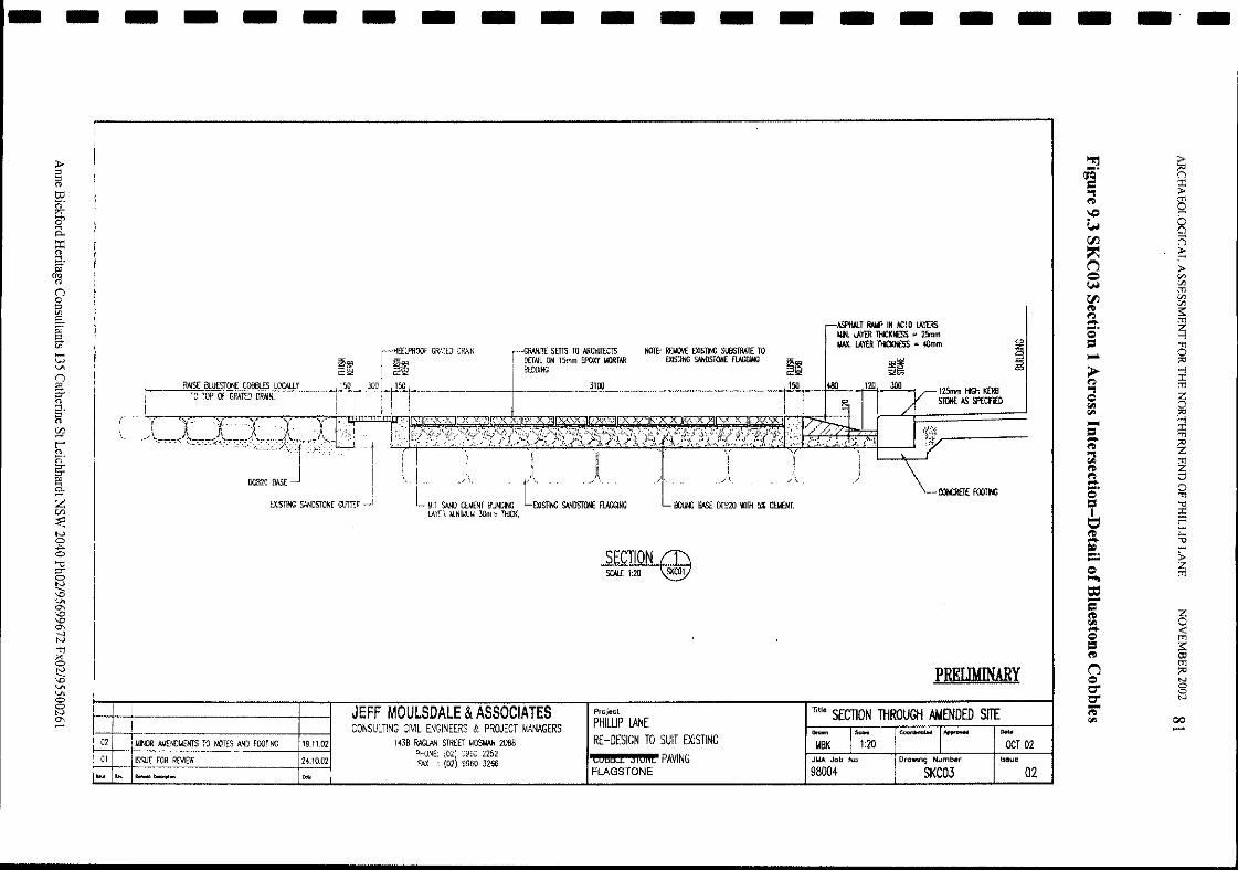
- - - - - - - - - - - - - - - - - - - - -
SCAlE 1:20 SKCO1
~ ;>.... ;:0(JQ n= ~"'ltD 0\C) r-~ 800 n~ ~(") ;><= Vl~ Vlm00 Vl
VltD s:l")- m....
~I:>
=='Tl
1-6 0;:0
>- -ll") @a z~ 0~ ::;.....==
@- ~tD"'l~
~tDl") Cl- 0....I:> 'Tl
b '"t:l
i:Er-
tD r-- ::al» r-:::
~I:>~
m
t:=-= a~~- <:I:> m
==s:
tD i;tl
(") m;:0
I:> N
0' 00
0' N-tD~ 00--
02
ocr 02Issue
....-SKC03
~~120 JOO
PRELOONARY
I RAIlP IN AC10 lA\'£RSIotIN. lAYER THICl<N£SS = 25mmUAX. lAYER THICKNESS = 40mm
TIll. SECTION THROUGH AWENDED SITE
98004
OOUNO BAS£ OG920 WI1H 5% eatOO,
NOJ£: REllOI'£ EXISTING SUBSlRAJ£ 10EXIS1ING SANOSION£ FUGGlNG
Project
PHILUP LANERE-DESIGN TO SUIT EXISTING
COMd SiUilt PAVINGFLAGSTONE
3100
GRANI1£ srns TO ARCHI1£C15DETAIL ON 15mm £POXY I.KlRTAR8EDDING
SECTION
9:1 SAND C8.1ENT BlINDING t~sn~ SANDSTONE FUGGINGlAYLR MINIMUM 30mm THICK,
HffiPROOf GRATED DRkN
~~150
JEFF MOULSDALE &ASSOCIATESCONSULTING CML ENGINEERS & PROJECT MANAGERS
143B IlAG!JIN STREET MOSMAN 2088PHONE: (021 9900 2252F/>II. : (02) 9960 326624,10,02
19.11.02
EXISTING SANDSTONE GUTTER
TO TOP Of GRATED DRAIN.RAISE BlU£5fOO£ COO6l£S lJJCJ\llY
ISSUE FOR REVIEW
MINOR AIM£'IOMEN15 10 NOTES AND FOOTING
01
02
.......
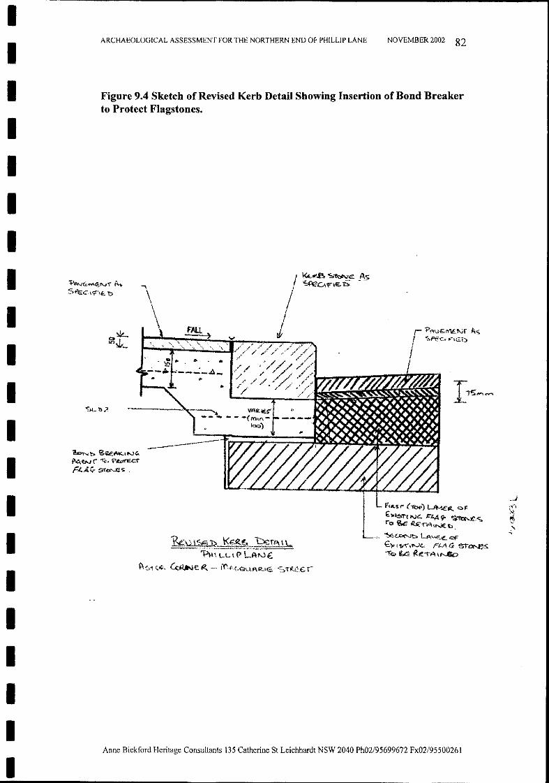
II
ARCHAEOLOGICAL ASSESSMENT FOR THE NORTHERN END OF PHlLLlP LANE NOVEMBER 2002 82
II
Figure 9.4 Sketch of Revised Kerb Detail Showing Insertion of Bond Breakerto Protect Flagstones.
III
F•.c,'S1'" (1l:;x» L4-1Ett. <:::>FE: lfl.$'l"l Ne. 1="£.,4 r '$...n:r..~.<;"0~ ~-rA\t'.J(b.
~~ LA",,-,_oL <:'IF€'l< I S,"'f'.N4:, Ft.A G $f"~-rO i..ta k:'iA'~
\
~\)\~~ \<Etctl!)~ CerA \\",--" 'PH, Lt. I€> LA;"~
~St(."'. ~e~ il'\j\<,OUAR.<,;; ~,T~£.T~
~b ~~~.t"H'I\~~(" "t'<;.> ?~cr
PLA<:r S\"~5
~~{;,""~Ni"A ..
bI
I
II
I
II
II
IIIII
Anne Bickford Heritage Consultants 135 Cathcrine St Leichhardt NSW 2040 Ph02/95699672 Fx02/9550026 I
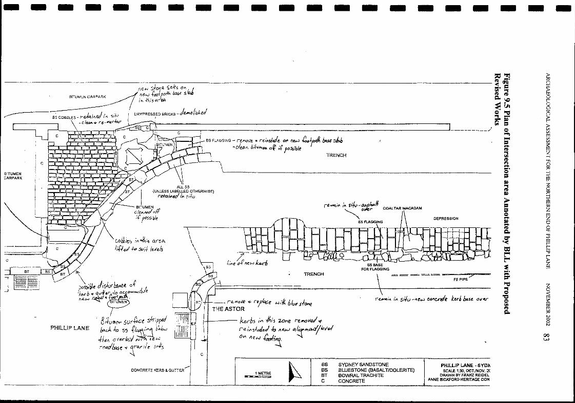
- - - - - - - - - - - - - - - - - - - - -~~ ~<0'Cle;;' = ~~ riQ.~ 0r~u. 8e "'C ;::;., - F:~~ ::>
e '"..... Cl>tTl..... Cl>= Cl>.... :s::
~~.,
fI.l ....,~ 'Tjt':I 0........ ;>:le ....,= ~to?
ri z0
to? ;>:l....,
> ~= ~=e~....
to? 0....~ 0Q. 'Tj
~ '""i:Er
= r::at"'" r
t"'" ~~ tTl........=-"'C z~ 0
<:"'l:l tTle ~fI.l~ tTlQ. ;>:l
IVgIV
00W
DEPRESSION
== = ==-~~-~?-~-FE PIPE
ss BASEFOR FLAGGING
. . '/ l..fI.re_If< I" f/f1J -()..r.p COALTAR MACADAM
~Ol'fer
ss FLAGGING
TRENCH
BS FLAGGING - re"'Ol/e .. re/Aside 011 flew ~Jr'" bue s/:.b-cJeM biftJ",1U1 o~ it'I'05!>ible
TRENCH
H--_ ruol/e q- r'7~e <-J;/{. 6tu, $Iov.eTHE ASTOR
H----- kbs i" -#lis 2Ol1e r-elt1Ove! <f
rei"5fo:/e.J.fr, lieN tl{icrlt\~level
0", ne"" fdr4
~
c
,,\
\\\
ALL SS
I(UNLESS LABELLED OTHERWISE)
reto.i...td I.... Sift)
BITUMEN 111cle...-Jott;t:rWble
DRYPRESSED BRICKS - j€A'\~ (,jJ..edI,
c.oWe":> il\ ~iS ~re.o..
title<!.j.d 5lIil t"'e-b
BITUMEN CARPARK
PHILLlP LANE
r--L--,--,\-"-...--r--..--rl~~~~..::J.,4-----;::-----,-------------------------------- ...1 ",'
BITUMEN::ARPARK
/'CONCRETE KERB & GUTTER
1 METRE• I
SSBSBTC
SYDNEY SANDSTONEBLUESTONE (BASALTIDOLERITE)BOWRAL TRACHITECONCRETE
PHIWP LANE - SYO"SCALE 1:50, OCT)NOV. 2(
DRAWN BY FRANZ REIDELANNE BICKFORO HERITAGE CON
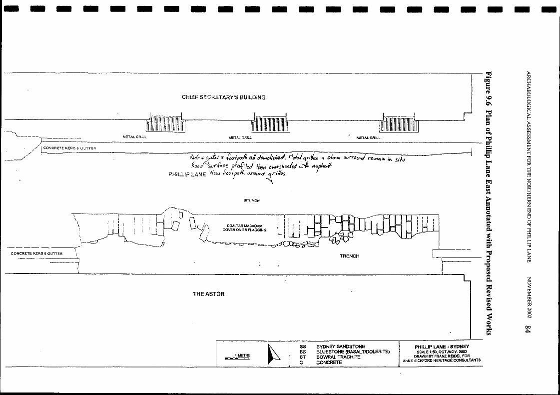
- - - - - - - - - - - - - - - - - - - - -~
~....(JQ
= ~..,tI> 0\C r'
~ 8""::1 (=)- ~;.;
==»-en
c:> en~ men""::1 ener
~....=...."CS '"'1
t'" 0::0;.; -l
== ffitI>
t:ri z;.; ~(l!l -l- m>==
'Z== ~c:>- t:!;.;
0-tI> '"'1Q.. '"ll
~iEr'.... r'- :eer
""::1 r'.., ~c:> m"CS
c:>(l!l
tI>
~Q..
~ <:m~ ~....(l!l mtI> ::0Q.. tv
~8tv
c:>
a- 00~
TRENCH
CHIEF SECRETARY'S BUILDING
rrrlrrmrm;rrrrmrrrrrrS-rr-------JmfnJriTifiTfrfrifrf.L..--.---~==:.::.:.::J
BITUMEN
THE ASTOR
.\--------,:r------.,-"/-----O-....\J'--------------,r-r---r-o........---,.--..\ I I I I 11 I
\ I I I I I 'f) COALTARMACADAM ': I I II LJ-.II I 'V) COVER ON SS FLAGGING ~ J 1 i I\ __r/ -1.~ J ILu
_)-<-../ ---- fJ -'="~"""l::J-"""-<:= __~~--------,CONCRETE KERB & GUTTER \
\1
"--"\'-------l=J======- ~M:E~TA::L~G:RI.~LL=_ M_ET_A_LG_R_IL_L ME_T_AL_G_R_IL_L _
,/
•/,./" ~NCRETEKERB & GiJTTER
------,,"
1 METRE
SS SYDNEY SANDSTONEBS BLUESTONE (BASALTIOOLERITE)BT BOWRAL TRACHITEC CONCRETE
PHllLIP LANE • SYDNEYSCALE 1:50, OCT./NOV. 2002
DRAWN BY FRANZ RElDEL FORAl\NE 51CKFORD HERITAGE CONSULTANTS
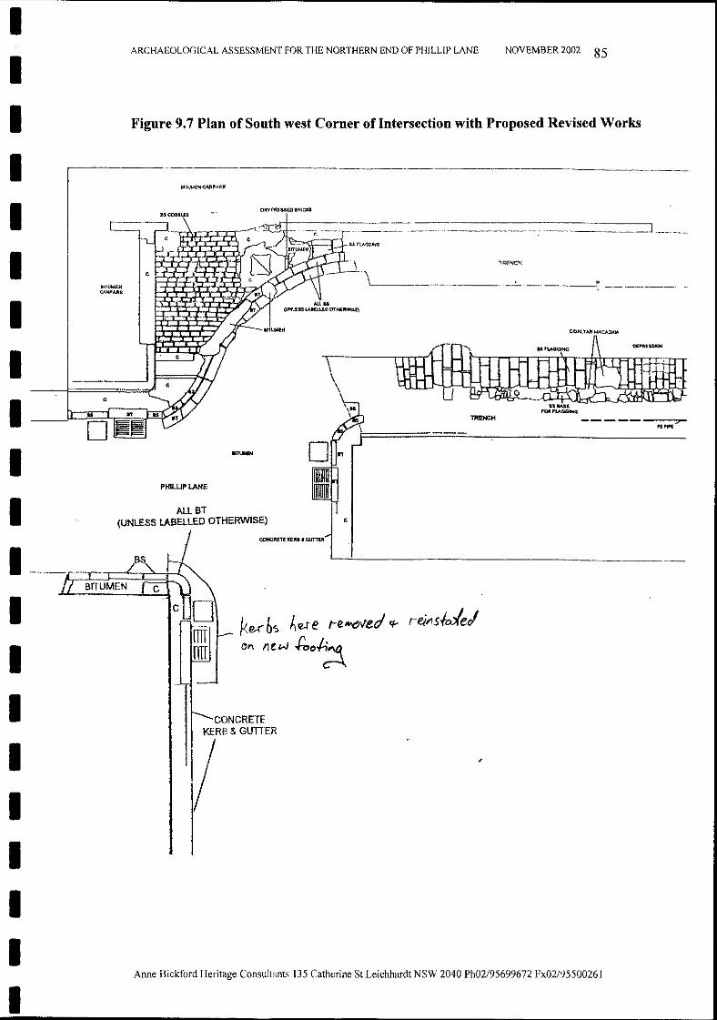
-- - ----.. _---,:>-
NOVEMBER 2002 85
lRENCH
TRENCH
'--------------_._.__-': -----'._--'-
\
IITUMEIl
CONCRETE!<ERB & GUTIER
c
DR'(PA;lSS£Q BRiCKS
PHILUPLANE
a,coDllE.'
Anne Bickford Heritage Consultants 135 Cathcrine St Leichhardt NSW 2040 Ph02/95699672 Fx02/95500261
ARCHAEOLOGICAL ASSESSMENT FOR THE NORTHERN END OF Pi"ULLIP LANE
Figure 9.7 Plan of South west Corner oflntersection with Proposed Revised Works
ALLBT ~(UNlESS LABELLED OTHERWISE) ,
CONCIUiTI" ""RI. ClITTtA _
'--~---------------------
IIIIIIII ---
Ic
---
IIIIIIIIIIII
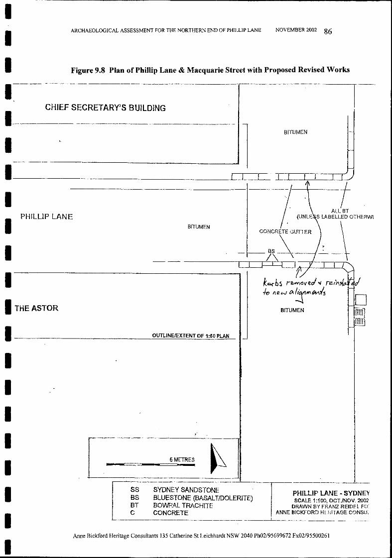
BITUMEN
NOVEMBER 2002 86
1- -
PHILUP LANE - SYDNEVSCALE 1:100, OCT./NOV. 2002
DRAWN BY FRANZ REIDEL FO'ANNE BICKFORD HERITAGE CONSUL
I
BITUMEN
5 METRES
SYDNEY SANDSTONEBLUESTONE (BASALTIDOLERITE)BOWRAL TRACHlTECONCRETE
SSBSBTC
-
--------------------
Anne Bickford Heritage Consultants 135 Catherine St Leichhardt NSW 2040 Ph02/95699672 Fx02/95500261
Figure 9.8 Plan ofPhillip Lane & Macquarie Street with Proposed Revised Works
ARCHAEOLOGICAL ASSESSMENT FOR THE NORTHERN END OF PHILLlP LANE
I THE ASTOR
1 --=-O.:::.UT~U~N:.=E~fE~XT~E~N~T~O~F~1:~50~P:=LA~N~
IIIIIIII
III1----
CHIEF SECRETARY'S BUILDING
I--I1-------- --1--.1-1._ -r--r----,---,r-----~
II PHILLlP LANE
I - -j\-----'I,------/- - -----iDt --.J-1==:r1~1:=J:;;=~~~=~=~1....:...
1-----------------. 1ko.rbS r~()veJ "" rerY---10 flew ()..'!jll""~
BITUMEN
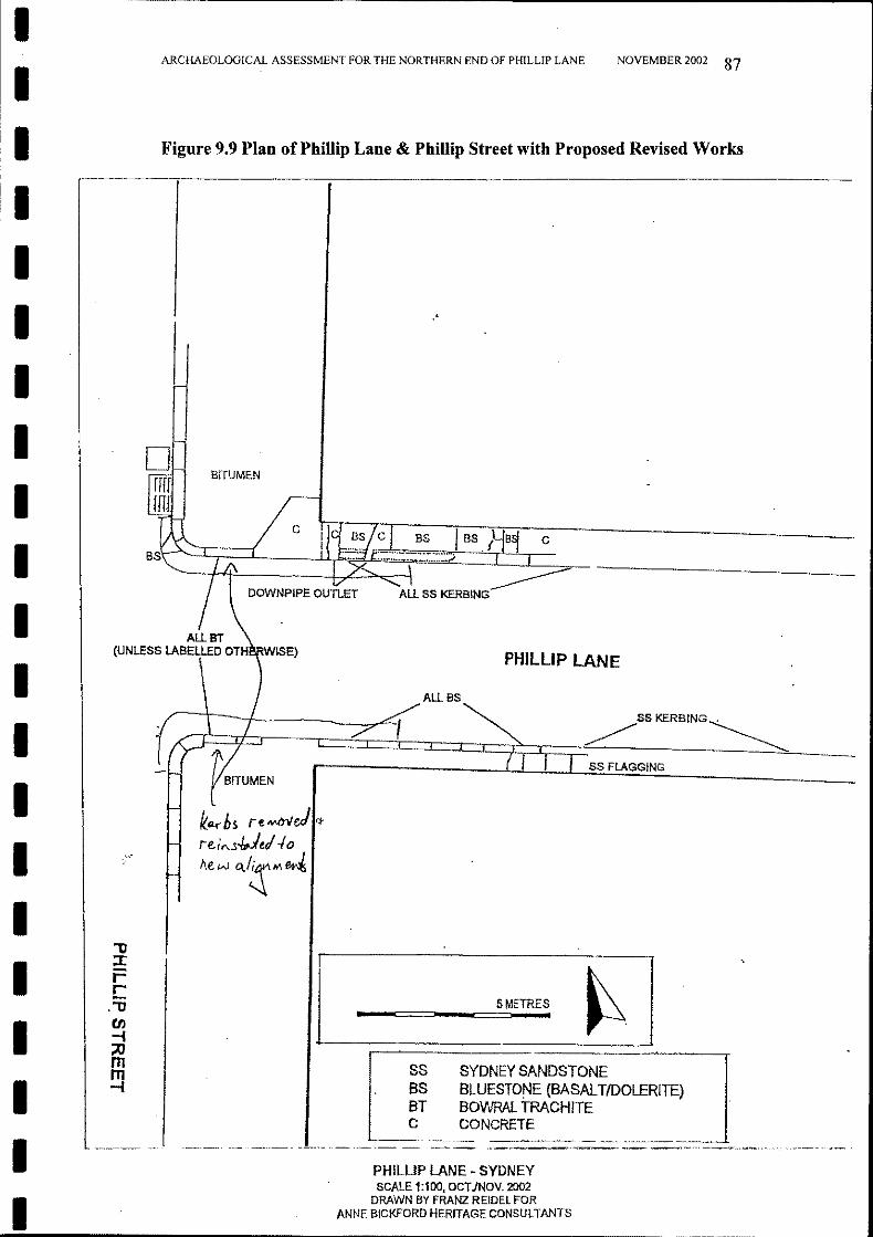
Figure 9.9 Plan of Phillip Lane & Phillip Street with Proposed Revised Works
NOVEMBER 2002 87
PHILlIP LANE
SYDNEY SANDSTONEBLUEST0r-JE (BASALTIDDLERITE)BDV\IRAL TRACHITECONCRETE
AltBS~
_~ ~SSKERBING~
---=---(1 , , ss FLAGGING
SSBSBTC
,
••_-===-_-===5=M.ET_R_E...S, ~
PH1LLlP LANE - SYDNEYSCALE 1:100, OCTJNOV. 2002
DRAWN BY FRANZ REIDEl FORANNE BICKFORD HERITAGE CONSULTANTS
/
ARCHAEOLOGICAL ASSESSMENT FOR THE NORTHERN END OF PHILLlP LANE
DJ~
rfr BITUMEN
fITJ r-?h / c11d~q-::;I~Tk;r-;::----------__BS~ I" c il~~L i~~::J BS~
/ DOWNP'PE ouKEr A!.t SS KERB'NG
AltBT(UNLESS LABELLED OTH RWISE)
"'0:::r::-rC
."'0CIJ-I;;0mm-I
IIIIIIIIIIIIIIIIIIIII
Anne Bickford Heritage Consultants 135 Catherine St Leichhardt NSW 2040 Ph02/95699672 Fx02/95500261
In all cases minimal disturbance to the historic stone remains will take place.
At the completion of the work a report will be made to the Heritage Councildetailing the action, archaeological recording, results, and storage location of anystone remains which had to be moved in the process.
This Archaeological Assessment Report is to accompany a Section 140Excavation Permit Application to the NSW Heritage Council. Anne Bickford isnamed as the Excavation Director, Bovis Lend Lease as the Applicant, and theSydney City Council as the owner.
NOVEMBER 2002 88ARCHAEOLOGICAL ASSESSMENT FOR THE NORTHERN END OF PIDLLIP LANE
The Application recommends Archaeological Monitoring as the archaeologicalmethodology to take place on the site. When the upgrading work is to take placewhere it is considered that the archaeological remains may be impacted, anarchaeologist will be on site to record such remains by photography and plandrawing, and any other methods as necessary.
10.0 CONCLUSIONS AND RECOMMENDATIONS
IIIIIIIIIIIIIIIIIIIII
Anne Bickford Heritage Consultants 135 Catherine St Leichhardt NSW 2040 Ph02/95699672 Fx02/95500261
THE BURRA CHARTER
(The Australia ICOMOS Charter for Places of Cultural Significance)
IIIIIIIIIIIIIIIIIIIII
ARCHAEOLOGICAL ASSESSMENT FOR THE NORTHERN END OF PHILLIP LANE
APPENDIX A
NOVEMBER 2002 89
II The Burra Charter
(The Australia ICOMOS Charter for Places of Cultural Significance)
The Burra Charter, 1999
Article 1. Definitions
For the purposes of this Charter:
1.1 Place means site, area, land, landscape, building or otherwork, group of buildings or other works, and may includecomponents, contents, spaces and views.
IIIIIIIIIIIIIIIIIII
PreambleConsidering the International Charter for theConservation and Restoration of Monuments andSites (Venice 1964), and the Resolutions of the 5thGeneral Assembly of the International Council onMonuments and Sites (ICOMOS) (Moscow 1978),the Burra Charter was adopted by AustraliaICOMOS (the Australian National Committee ofICOMOS) on 19 August 1979 at Burra, SouthAustralia. Revisions were adopted on 23 February1981,23 April 1988 and 26 November 1999.
The Burra Charter provides guidance for theconservation and management of places of culturalsignificance (cultural heritage places), and is basedon the knowledge and experience of AustraliaICOMOS members.
Conservation is an integral part of the managementof places of cultural significance and is an ongoingresponsibility.
Who is the Charter for?
The Charter sets a standard of practice for thosewho provide advice, make decisions about, orundertake works to places of cultural significance,including owners, managers and custodians.
Using the Charter
The Charter should be read as a whole. Manyarticles are interdependent. Articles in theConservation Principles section are often furtherdeveloped in the Conservation Processes andConservation Practice sections. Headings havebeen included for ease of reading but do not formpart ofthe Charter.
The Charter is self-contained, but aspects of its useand application are further explained in thefollowing Australia ICOMOS documents:
Articles
• Guidelines to the Burra Charter: CulturalSignificance;
• Guidelines to the Burra Charter: ConservationPolicy;
• Guidelines to the Burra Charter: Procedures forUndertaking Studies and Reports;
• Code on the Ethics of Coexistence in ConservingSignificant Places.
What places does the Charter apply to?
The Charter can be applied to all types of places ofcultural significance including natural, indigenousand historic places with cultural values.
The standards of other organisations may also berelevant. These include the Australian NaturalHeritage Charter and the Draft Guidelines for theProtection, Management and Use of Aboriginal andTorres Strait Islander Cultural Heritage Places.
Why conserve?
Places of cultural significance enrich people's lives,often providing a deep and inspirational sense ofconnection to community and landscape, to the pastand to lived experiences. They are historicalrecords, that are important as tangible expressionsof Australian identity and experience. Places ofcultural significance reflect the diversity of ourcommunities, telling us about who we are and thepast that has formed us and the Australianlandscape. They are irreplaceable and precious.
These places of cultural significance must beconserved for present and future generations.
The Burra Charter advocates a cautious approach tochange: do as much as necessary to care for theplace and to make it useable, but otherwise changeit as little as possible so that its cultural significanceis retained.
Explanatory Notes
The concept of place should be broadlyinterpreted. The elements described in Article1.1 may include memorials, trees, gardens,parks, places of historical events, urban areas,towns, industrial places, archaeological sitesand spiritual and religious places.
Australia ICOMOS Iue
IIIIIIIIIIIIIIIIIIII
1.2 Cultural significance means aesthetic, historic, scientific,social or spiritual value for past, present or future generations.
Cultural significance is embodied in the place itself, its fabric,setting, use, associations, meanings, records, related places andrelated objects.
Places may have a range of values for different individuals orgroups.
1.3 Fabric means all the physical material of the place includingcomponents, fixtures, contents, and objects.
1.4 Conservation means all the processes of looking after a placeso as to retain its cultural significance.
1.5 Maintenance means the continuous protective care of thefabric and setting of a place, and is to be distinguished from repair.Repair involves restoration or reconstruction.
1.6 Preservation means maintaining the fabric of a place in itsexisting state and retarding deterioration.
1.7 Restoration means returning the existing fabric of a place to aknown earlier state by removing accretions or by reassemblingexisting components without the introduction ofnew material.
1.8 Reconstruction means returning a place to a known earlierstate and is distinguished from restoration by the introduction ofnew material into the fabric.
1.9 Adaptation means modifying a place to suit the existing use ora proposed use.
1.10 Use means the functions of a place, as well as the activitiesand practices that may occur at the place.
1.11 Compatible use means a use which respects the culturalsignificance of a place. Such a use involves no, or minimal, impacton cultural significance.
1.12 Setting means the area around a place, which may include thevisual catchment.
1.13 Related place means a place that contributes to the culturalsignificance of another place.
1.14 Related object means an object that contributes to the culturalsignificance of a place but is not at the place.
1.15 Associations mean the special connections that exist betweenpeople and a place.
1.16 Meanings denote what a place signifies, indicates, evokes orexpresses.
1.17 Interpretation means all the ways of presenting the culturalsignificance of a place.
The term cultural significance is synonymouswith heritage significance and cultural heritagevalue.
Cultural significance may change as a result ofthe continuing history ofthe place.
Understanding of cultural significance maychange as a result ofnew information.
Fabric includes building interiors and subsurface remains, as well as excavated material.
Fabric may define spaces and these may beimportant elements of the significance of theplace.
The distinctions referred to, for example inrelation to roof gutters, are:• maintenance - regular inspection and
cleaning ofgutters;• repair involving restoration - returning of
dislodged gutters;• repair involving reconstruction - replacing
decayed gutters.
It is recognised that all places and theircomponents change over time at varying rates.
New material may include recycled materialsalvaged from other places. This should not beto the detriment of any place of culturalsignificance.
Associations may include social or spiritualvalues and cultural responsibilities for a place.
Meanings generally relate to intangible aspectssuch as symbolic qualities and memories.
Interpretation may be a combination of thetreatment of the fabric (e.g. maintenance,restoration, reconstruction); the use of andactivities at the place; and the use ofintroduced explanatory material.
IThe Burra Charter, 1999 2 Australia ICOMOS Inc
I
The use of modem materials and techniquesmust be supported by firm scientific evidenceor by a body of experience.
Conservation of places with naturalsignificance is explained in the AustralianNatural Heritage Charter. This Charter definesnatural significance to mean the importance ofecosystems, biological diversity andgeodiversity for their existence value, or forpresent or future generations in terms of theirscientific, social, aesthetic and life-supportvalue.
The traces of additions, alterations and earliertreatments to the fabric of a place are evidenceof its history and uses which may be part of itssignificance. Conservation action should assistand not impede their understanding.
The Burra Charter process, or sequence ofinvestigations, decisions and actions, isillustrated in the accompanying flowchart.
A cautious approach is needed, asunderstanding of cultural significance maychange. This article should not be used tojustify actions which do not retain culturalsignificance.
Article 6. Burra Charter Process
6.1 The cultural significance of a place and other issues affectingits future are best understood by a sequence of collecting andanalysing information before making decisions. Understandingcultural significance comes first, then development of policy andfinally management ofthe place in accordance with the policy.
6.2 The policy for managing a place must be based on anunderstanding of its cultural significance.
6.3 Policy development should also include consideration of otherfactors affecting the future of a place such as the owner's needs,resources, external constraints and its physical condition.
Article 7. Use
7.1 Where the use of a place is of cultural significance it shouldbe retained.
5.2 Relative degrees of cultural significance may lead to differentconservation actions at a place.
3.2 Changes to a place should not distort the physical or otherevidence it provides, nor be based on conjecture.
Article 4. Knowledge, skills and techniques
4.1 Conservation should make use of all the knowledge, skills anddisciplines which can contribute to the study and care ofthe place.
4.2 Traditional techniques and materials are preferred for theconservation of significant fabric. In some circumstances modemtechniques and materials which offer substantial conservationbenefits may be appropriate.
Article 5. Values
5.1 Conservation of a place should identify and take intoconsideration all aspects of cultural and natural significance withoutunwarranted emphasis on anyone value at the expense of others.
I
I
I
II
I Conservation PrinciplesArticle 2. Conservation and management
2.1 Places ofcultural significance should be conserved.
2.2 The aim of conservation is to retain the cultural significanceof a place.
2.3 Conservation is an integral part of good management ofplaces ofcultural significance.
2.4 Places of cultural significance should be safeguarded and notput at risk or left in a vulnerable state.
Article 3. Cautious approach
3.1 Conservation is based on a respect for the existing fabric, use,associations and meanings. It requires a cautious approach ofchanging as much as necessary but as little as possible.
II
I
I
I
II
I
I
II
III
The Burra Charter, 1999 3 Australia ICOMOS Inc
IIIIIIIIIIIIIIIIIIII
7.2 A place should have a compatible use.
Article 8. Setting
Conservation requires the retention of an appropriate visual settingand other relationships that contribute to the cultural significance ofthe place.
New construction, demolition, intrusions or other changes whichwould adversely affect the setting or relationships are notappropriate.
Article 9. Location
9.1 The physical location of a place is part of its culturalsignificance. A building, work or other component of a place shouldremain in its historical location. Relocation i.s generallyunacceptable unless this is the sole practical means of ensuring itssurvival.
9.2 Some buildings, works or other components of places weredesigned to be readily removable or already have a history ofrelocation. Provided such buildings, works or other components donot have significant links with their present location, removal maybe appropriate.
9.3 If any building, work or other component is moved, it shouldbe moved to an appropriate location and given an appropriate use.Such action should not be to the detriment ofany place ofculturalsignificance.
Article 10. Contents
Contents, fixtures and objects which contribute to the culturalsignificance of a place should be retained at that place. Theirremoval is unacceptable unless it is: the sole means of ensuring theirsecurity and preservation; on a temporary basis for treatment orexhibition; for cultural reasons; for health and safety; or to protectthe place. Such contents, fixtures and objects should be returnedwhere circumstances permit and it is culturally appropriate.
Article 11. Related places and objects
The contribution which related places and related objects make tothe cultural significance of the place should be retained.
Article 12. Participation
Conservation, interpretation and management of a place shouldprovide for the participation of people for whom the place hasspecial associations and meqnings, or who have social, spiritual orother cultural responsibilities for the place.
Article 13. Co-existence of cultural values
Co-existence of cultural values should be recognised, respected andencouraged, especially in cases where they conflict.
The policy should identify a use orcombination of uses or constraints on uses thatretain the cultural significance of the place.New use of a place should involve minimalchange, to significant fabric and use; shouldrespect associations and meanings; and whereappropriate should provide for continuation ofpractices which contribute to the culturalsignificance ofthe place.
Aspects of the visual setting may include use,siting, bulk, form, scale, character, colour,texture and materials.
Other relationships, such as historicalconnections, may contribute to interpretation,appreciation, enjoyment or experience of theplace.
For some places, conflicting cultural valuesmay affect policy development andmanagement decisions. In this article, the termcultural values refers to those beliefs which areimportant to a cultural group, including but notlimited to political, religious, spiritual andmoral beliefs. This is broader than valuesassociated with cultural significance.
IThe Burra Charter, 1999 4 Australia ICOMOS Iue
IIIIIIIIiIIIIIIIIIII
Conservation ProcessesArticle 14. Conservation processes
Conservation may, according to circumstance, include the processesof: retention or reintroduction of a use; retention of associations andmeanings; maintenance, preservation, restoration, reconstruction,adaptation and interpretation; and will commonly include acombination ofmore than one of these.
Article 15. Change
15.1 Change may be necessary to retain cultural significance, butis undesirable where it reduces cultural significance. The amount ofchange to a place should be guided by the cultural significance ofthe place and its appropriate interpretation.
15.2 Changes which reduce cultural significance should bereversible, and be reversed when circumstances permit.
15.3 Demolition of significant fabric of a place is generally notacceptable. However, in some cases minor demolition may beappropriate as part of conservation. Removed significant fabricshould be reinstated when circumstances permit.
15.4 The contributions of all aspects of cultural significance of aplace should be respected. If a place includes fabric, uses,associations or meanings of different periods, or different aspects ofcultural significance, emphasising or interpreting one period oraspect at the expense of another can only be justified when what isleft out, removed or diminished is of slight cultural significance andthat which is emphasised or interpreted is of much greater culturalsignificance.
Article 16. Maintenance
Maintenance is fundamental to conservation and should beundertaken where fabric is of cultural significance and itsmaintenance is necessary to retain that cultural significance.
Article 17. Preservation
Preservation is appropriate where the existing fabric or its conditionconstitutes evidence of cultural significance, or where insufficientevidence is available to allow other conservation processes to becarried out.
Article 18. Restoration and reconstruction
Restoration and reconstruction should reveal culturally significantaspects of the place.
Article 19. Restoration
Restoration is appropriate only if there is sufficient evidence of anearlier state ofthe fabric.
There may be circumstances where no action isrequired to achieve conservation.
When change is being considered, a range ofoptions should be explored to seek the optionwhich minimises the reduction of culturalsignificance.
Reversible changes should be consideredtemporary. Non-reversible change should onlybe used as a last resort and should not preventfuture conservation action.
Preservation protects fabric without obscuringthe evidence of its construction and use. Theprocess should always be applied:• where the evidence of the fabric is of such
significance that it should not be altered;• where insufficient investigation has been
carried out to permit policy decisions to betaken in accord with Articles 26 to 28.
New work (e.g. stabilisation) may be carriedout in association with preservation when itspurpose is the physical protection of the fabricand when it is consistent with Article 22.
IThe Burra Charter, 1999 5 Australia ICOMOS Iue
IIIIIIIIII
Article 20. Reconstruction
20.1 Reconstruction is appropriate only where a place isincomplete through damage or alteration, and only where there issufficient evidence to reproduce an earlier state of the fabric. In rarecases, reconstruction may also be appropriate as part of a use orpractice that retains the cultural significance ofthe place.
20.2 Reconstruction should be identifiable on close inspection orthrough additional interpretation.
Article 21. Adaptation
21.1 Adaptation is acceptable only where the adaptation hasminimal impact'on the cultural significance ofthe place.
21.2 Adaptation should involve minimal change to significantfabric, achieved only after considering alternatives.
Article 22. New work
22.1 New work such as additions to the place may be acceptablewhere it does not distort or obscure the cultural significance of theplace, or detract from its interpretation and appreciation.
22.2 New work should be readily identifiable as such.
Article 23. Conserving use
Continuing, modifying or reinstating a significant use may beappropriate and preferred forms of conservation.
Adaptation may involve the introduction ofnew services, or a new use, or changes tosafeguard the place.
New work may be sympathetic if its siting,bulk, form, scale, character, colour, texture andmaterial are similar to the existing fabric, butimitation should be avoided.
These may require changes to significantfabric but they should be minimised. In somecases, continuing a significant use or practicemay involve substantial new work.
Article 24. Retaining associations and meanings
24.1 Significant associations between people and a place should berespected, retained and not obscured. Opportunities for theinterpretation, commemoration and celebration of these associationsshould be investigated and implemented.
24.2 Significant meanings, including spiritual values, of a placeshould be respected. Opportunities for the continuation or revival ofthese meanings should be investigated and impl~mented.
Article 25. Interpretation
The cultural significance of many places is not readily apparent, andshould be explained by interpretation. Interpretation shouldenhance understanding and enjoyment, and be culturally appropriate.
Conservation PracticeArticle 26. Applying the Burra Charter process
26.1 Work on a place should be preceded by studies to understandthe place which should include analysis of physical, documentary,oral and other evidence, drawing on appropriate knowledge, skillsand disciplines.
26.2 Written statements of cultural significance and policy for theplace should be prepared, justified and accompanied by supportingevidence. The statements of significance and policy should beincorporated into a management plan for the place.
26.3 Groups and individuals with associations with a place as wellas those involved in its management should be provided withopportunities to contribute to and participate in understanding thecultural significance of the place. Where appropriate they shouldalso have opportunities ·to participate in its conservation andmanagement.
IIIIIIIIIII
The Burra Charter, 1999 6
For many places associations will be linked touse.
The results of studies should be up to date,regularly reviewed and revised as necessary.
Statements of significance and policy shouldbe kept up to date by regular review andrevision as necessary. The management planmay deal with other matters related to themanagement of the place.
Australia ICOMOS Iue

Article 27. Managing change
27.1 The impact of proposed changes on the cultural significanceof a place should be analysed with reference to the statement ofsignificance and the policy for managing the place. It may benecessary to modify proposed changes following analysis to betterretain cultural significance.
27.2 Existing fabric, use, associations and meanings should beadequately recorded before any changes are made to the place.
Article 28. Disturbance of fabric
28.1 Disturbance of significant fabric for study, or to obtainevidence, should be minimised. Study of a place by any disturbanceof the fabric, including archaeological excavation, should only beundertaken to provide data essential for decisions on theconservation of the place, or to obtain important evidence about tobe lost or made inaccessible.
28.2 Investigation of a place which requires disturbance of thefabric, apart from that necessary to make decisions, may beappropriate provided that it is consistent with the policy for theplace. Such investigation should be based on important researchquestions which have potential to substantially add to knowledge,which cannot be answered in other ways and which minimisesdisturbance of significant fabric.
Article 29. Responsibility for decisions
The organisations and individuals responsible for managementdecisions should be named and specific responsibility taken for eachsuch decision.
Article 30. Direction, supervision and implementation
Competent direction and supervision should be maintained at allstages, and any changes should be implemented by people withappropriate knowledge and skills.
Article 31. Documenting evidence and decisions
A log ofnew evidence and additional decisions should be kept.
Article 32. Records
32.1 The records associated with the conservation of a placeshould be placed in a permanent archive and made publiclyavailable, subject to requirements of security and privacy, and wherethis is culturally appropriate.
32.2 Records about the history of a place should be protected andmade publicly available, subject to requirements of security andprivacy, and where this is culturally appropriate.
Article 33. Removed fabric
Significantfabric which has been removed from a place includingcontents, fixtures and objects, should be catalogued, and protected inaccordance with its cultural significance.
Where possible and culturally appropriate, removed significantfabric including contents, fixtures and objects, should be kept at theplace.
Article 34. Resources
Adequate resources should be provided for conservation.
IIIIIIIIIIIIII.1IIIIII
Words in italics are defined in Article 1.
The Burra Charter, 1999 7
The best conservation often involves the leastwork and can be inexpensive.
Australia lCOMOS Ine
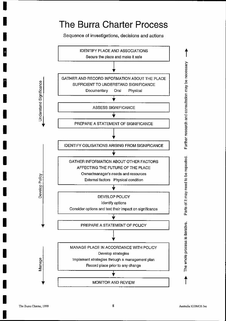
IIIIIiIIIIIIIIIIIIIII
(])uccesu~c0)
Ci5""ClC.s~(])
""ClC
:::>
.~(50..0.oa;>(])
o
The Burra Charter, 1999
The Surra Charter ProcessSequence of investigations, decisions and actions
IDENTIFY PLACE AND ASSOCIATIONS
Secure the place and make it safe
,Ir
GATHER AND RECORD INFORMATION ABOUT THE PLACE
SUFFICIENT TO UNDERSTAND SIGNIFICANCE
Documentary Oral Physical
ASSESS SIGNIFICANCE
PREPARE A STATEMENT OF SIGNIFICANCE
IDENTIFY OBLIGATIONS ARISING FROM SIGNIFICANCE
GATHER INFORMATION ABOUT OTHER FACTORS
AFFECTING THE FUTURE OF THE PLACE
Owner/manager's needs and resources
External factors Physical condition
DEVELOP POLICY
Identify options
Consider options and test their impact on significance
PREPARE A STATEMENT OF POLICY
MANAGE PLACE IN ACCORDANCE WITH POLICY
Develop strategies
Implement strategies through a management plan
Record place prior to any change
MONITOR AND REVIEW
8
ti::-cesenen(])u(])c(]).0
~Eco
~:3encoU
""Cl
~.c2ces(])en~...(]).c1:::3U.
-d(])
1tl(])0.~(]).0
.9""Cl(])(])c
~E
ID.<::~:m.!Qenen(])ue0.(])(5.c:::(]).cI-
t
Australia ICOMOS Inc