i ca.m.p ~~. ~:; ~~~ prince william public library system...
TRANSCRIPT
Hl$TORIC SITE FILE: R a·s i "-C\ Hi l I Ca.m.p ~~. ~:; ~~~ PRINCE WILLIAM PUBLIC LIBRARY SYSTEM
R~LIC/Rull Run Rea Lib, Manassas, VA United States Depamneltr of the lntitlOr National Park Service
National Register of Historic Places Registration Form
OMB Approval No. 1024-0018 (Expires Jan. 2005)
This form is for use in nominating or requesting determinations for individual properties and districts. See instructions in How to Complete the National Register of Historic Places Registration Form (National Register Bulletin 16A). Complete each item by marking "x" in the appropriate box or by entering the information requested. If an item does not apply to the property being documented, enter "NIA" tor "not applicable." For functions. architectural classification, materials, and areas of significance, enter only categories and subcategories from the instructions. Place additional entries and narrative items on continuation sheets (NPS Form 10-9008). Use a typewriter, word proceSSO(, or computer, to complete all items.
1. Name of PropertY
historic name Rising Hill Camp - 44PW1412
other names/site number _W_ a_ll_e_r _H_il-'-1; _V_D_H_R_ F_i_le_N_o_._: _0_7_6_-_5_3_14--';'--4_4_P_W_ 1_4_1_2 ___ _
2. Location
street & number Between Neville Road and Draper Street
city or town Marine Corps Base, Quantico
state Virginia code VA county Prince William
3. State/Federal Agency Certification
[] not for publication
0 vicinity
code 1fil_ zip code 22134
As the designated authority under the National Historic Preservation Act, as amended, I hereby certify that thisX nomination 0 request for determination of eligibility meets the documentation standards fol' registering properties in the National Register of Historic Places and meets the procedural and professional requirements set forth in 36 CFR Part 60. In my opinion, the property X meets 0 does not meet the National Register criteria. I recommend that this property be considered significant D nationally 0 statewide£ " locally. (0 See continuation sheet fol' additional comments.)
Signature of certifying official/Title Date
Department of Navy, United States Marine Corps State or Federal Agency or Tribal government
In my opinion. the property 0 meets 0 does not meet the National Register criteria. (0 See continuation sheet for additional comments.)
Signature of commenting officialmtle
State or Federal agency and bureau
4. National Park Service Certification I hereby certify that the property is:
[ I entered in the National Register. 0 See continuation sheet.
LJ determined eligible for the National Register
0 See continuation sheet.
I I determined not eligible for the Na11onal Register.
f J removed from the National Register.
I J other. (explain:) ____ _
Date
Signature of the Keeper Date of Action

USDI/NPS NRHP Registration Form Rising Hill Camp - 44PW1412 Prince William County, Virginia , 1- "l
Properties Associated with Campaigns for the Control ofNavigation on the Lower Potomac River, 1861-1862; Virginia, Maryland, and the District of Columbia MPD Page 2
5. Classification
Ownership of Property (Check as many boxes as apply) _ private _ public-local _ public-State _X_ public-Federal
Category of Property (Check only one box) _ building(s)
district X site
structure _ object
Contributing Noncontributing 0 l 0 0 I
_ O_ buildings 0 sites 0 structures
_ O_ objects 0 Total
Number of contributing resources previously listed in the National Register _ 0 _
Name ofrelated multiple property listing (Enter "NIA" if property is not part of a multiple property listing.) Properties Associated with Campaigns for the Control of Navigation on the Lower Potomac River, 1861-1862; Virginia, Maryland, and the District of Columbia
===6. Function or Use ------- ---------- ---------------------
Historic Functions (Enter categories from instructions) Cat: Defense Sub: _ _ Military camp ____ _
Current Functions (Enter categories from instructions) Cat: Other Sub: Forest _______ _
7. Description
Architectural Classification (Enter categories from instructions) ______ NIA ________ _
Materials (Enter categories from instructions) foundation NIA ___ ____ _ roof ______________ _ _
walls------------ ----
other ______ _ ___ ____ _
Narrative Description (Describe the historic and current condition oftbe property on one or more continuation sheets.)
USDJINPS NRHP Registration Form Rising Hill Camp - 44PW1412 Prince William County, Virginia Properties Associated with Campaigns for the Control of Navigation on the Lower Potomac River, 1861-1862; Virginia, Marvland, and the District of Columbia MPD Page 3
=====--========--===========--====================
8. Statement of Significance ======================--===========--=========
Applicable National Register Criteria (Mark "x" in one or more boxes for the criteria qualifying the property for National Register listing)
X A
B
c
X D
Property is associated with events that have made a significant contribution to the broad patterns of our history.
Property is associated with the lives of persons significant in our past.
Property embodies the distinctive characteristics of a type, period, or method of construction or represents the work of a master, or possesses high artistic values, or represents a significant and distinguishable entity whose components lack individual distinction.
Property has yielded, or is likely to yield information important in prehistory or history.
Criteria Considerations (Mark "X" in all the boxes that apply.)
A owned by a religious institution or used for religious purposes.
B removed from its original location.
C a birthplace or a grave.
D a cemetery.
E a reconstructed building, object, or structure.
F a commemorative property.
G less than 50 years of age or achieved significance within the past 50 years.
Areas of Significance (Enter categories from instructions) __ Military _______ _ __ Archaeology _____ _
Period of Significance __ 1861-1862 ----
Significant Dates __ September 1861-March 1862 __
Significant Person (Complete if Criterion Bis marked above) _____ NIA _________ _ Cultural Affiliation N/ A ------------Architect/Builder NI A ------------
Narrative Statement of Significance (Explain the significance of the property on one or more continuation sheets.)
USDI/NPS NRHP Registration Form Rising Hill Camp - 44PW1412 Prince William County, Virginia Properties Associated with Campaigns for the Control of Navigation on the Lower Potomac River, 1861-1862; Virginia, Marv land, and the District of Columbia MPD Page 4 9. Major Bibliographical References ========== = ==--==--=== = =--==--==================== ===
(Cite the books, articles, and other sources used in preparing this form on one or more continuation sheets.)
Previous documentation on file (NPS) _ preliminary determination of individual listing (36 CFR 67) has been
requested. _ previously listed in the National Register _ previously determined eligible by the National Register _ designated a National Historic Landmark _ recorded by Historic American Buildings Survey # ___ _ _ _ recorded by Historic American Engineering Record # ____ _
Primary Location of Additional Data X State Historic Preservation Office
_ Other State agency _X_ Federal agency _ Local government _University
Other Name of repository: Virginia Department of Historic Resources; and NREA Branch, Marine Corps Base, Quantico, Virgnia
10. Geographical Data = ===== =========================== ==============
Acreage of Property 1. 71
UTM References (Place additional UTM references on a continuation sheet)
Zone Easting Northing 1 18 299665 4266394
See continuation sheet.
Verbal Boundary Description (Describe the boundaries of the property on a continuation sheet.)
Boundary Justification (Explain why the boundaries were selected on a continuation sheet.)
11. Form Prepared By ============================ ==== ===========--=========
name/title _____ J"'""'o~hn~H~. ~H=a ...... v~ne~s~·~Jr~·-RP~A_,~Ar_ch_a_e~o_lo ...... g_._i~st __ _
organization NREA Branch (B046) Marine Corps Base Quantico, VA date 22 July 2005
street & number 3250 Catlin Avenue telephone 703-432-6781
city or town ____ O_u_an_ti_co _ ________ state VA zip code 22134-5001
USDJ/NPS NRHP Registration Form Rising Hill Camp-44PW1412 Prince William County, Virginia Properties Associated with Campaigns for the Control of Navigation on the Lower Potomac River, 1861-1862; Virginia, Maryland, and the District of Columbia MPD Page 5
Additional Documentation ================================================================ Submit the following items with the completed form:
Continuation Sheets
Maps A USGS map (7.5 or 15 minute series) indicating the property's location. A sketch map for historic districts and properties having large acreage or numerous resources.
Photographs Representative black and white photographs of the property.
Additional items (Check with the SHPO or FPO for any additional items)
Property Owner -------------------------------------------------------
(Complete this item at the request of the SHPO or FPO.) name Col. C.A. Dallachie, Base Commander, Marine Corps Base
street & number_---"3~2=5-=-0_C=at=li=n~A~v~e=n=u-=-e ______ telephone 703-784-5900
city or town __ __,O'""'u=an=ti"""co=------------ state VA zip code 22134-5001
==============--==--=======--==--=======================
Paperwork Reduction Act Statement: This information is being collected for applications to the National Register of Historic Places to nominate properties for listing or determine eligibility for listing, to list properties, and to amend existing listings. Response to this request is required to obtain a benefit in accordance with the National Historic Preservation Act, as amended (16 U.S.C. 470 et seq.). A federal agency may not conduct or sponsor, and a person is not required to respond to a collection of information unless it displays a valid OMB control number.
Estimated Burden Statement: Public reporting burden for this form is estimated to range from approximately 18 hours to 36 hours depending on several factors including, but not limited to, how much documentation may already exist on the type of property being nominated and whether the property is being nominated as part of a Multiple Property Documentation Form. In most cases, it is estimated to average 36 hours per response including the time for reviewing instructions, gathering and maintaining data, and completing and reviewing the form to meet minimum National Register documentation requirements. Direct comments regarding this burden estimate or any aspect of this form to the Chief, Administrative Services Division, National Park Service, 1849 C St., NW, Washington, DC 20240.
NPS Form 10-900-a (8-86)
United States Department of the Interior National Park Service
NATIONAL REGISTER OF HISTORIC PLACES CONTINUATION SHEET
Section _ 7_ Page 1
S UMMARY STATEMENT
OMB No. 1024-0018 (Expiration 1-31-2009)
Rising Hill Camp - 44PW1412 Prince William County, Virginia
Properties Associated with Campaigns for the Control of Navigation on the Lower Potomac River, 1861-1862;
Virginia, Maryland, and the District of Columbia
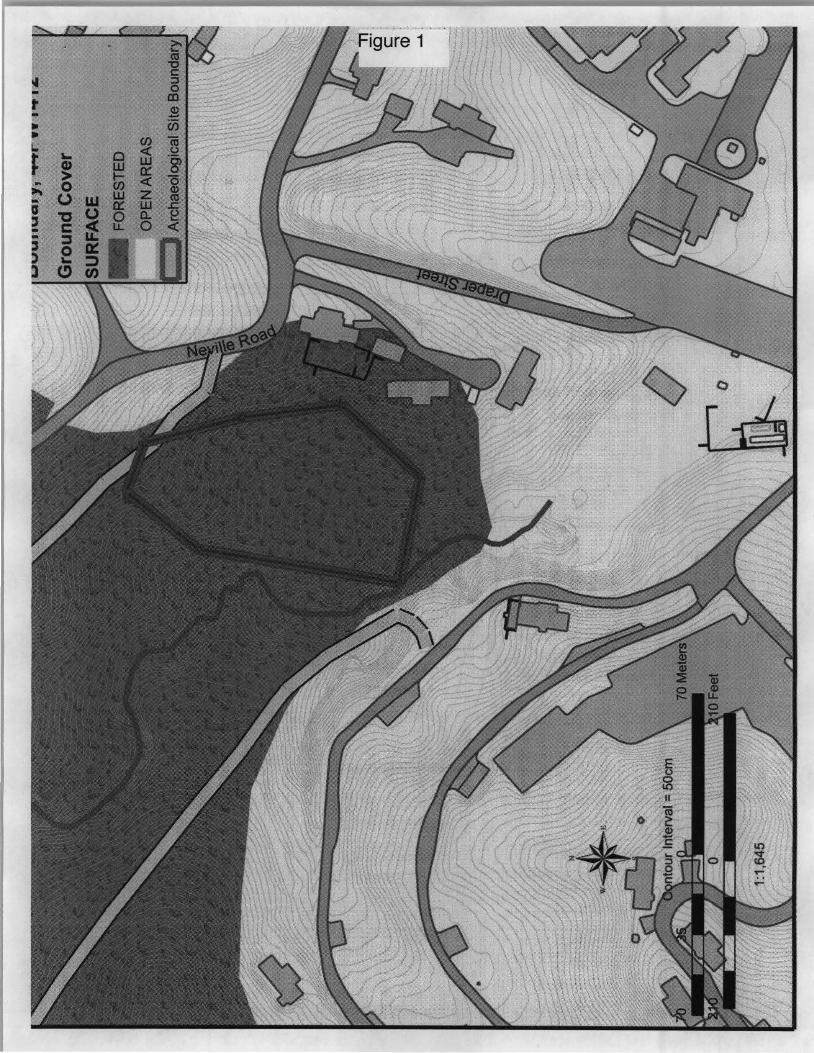
Site 44 PWl 412 is an area of numerous surface features representing the remains of dug-out huts from the Confederate positions at Evansport in 1861 and 1862. Due to its position behind 'Rising Hill' (later known as Waller Hill), where a battery was positioned, the camp at 44PW1412 was very likely to have been associated with manning and defending this battery. References to the Rising Hill battery indicate that it was an emplacement for only one gun, although no gun was mounted at the time of the observation on November 10, 1861 (O.R. Vol. 5: 648). Similarly, though the "country around is lined with rifle pits and breastworks thrown up (but no guns mounted) on a hill back commanding the rear of Shipping Point batteries." (O.N.R. Vol. 5: 25) This statement was likely about Geiger Ridge rather than Waller (Rising) Hill.
General Beauregard was very explicit in the importance he attached to fortifying the high ground near the batteries: "Have Triplett's and Powhatan Hills been fortified, as had been determined upon; if not already, why not? Those and Talbot Hill are the keys of that position; no time ought to be lost in fortifying them, even if it were only for infantry, for ifthe enemy takes them, how long would the batteries hold out? Not ten minutes! Can you not have it done at once if not already done?" (O.R. Vol. 5: 950) General LR. Trimble commanding at Evansport, but due to be relieved by Gen. S. G. French, did not agree. In his opinion these hills were too far from the batteries to protect them, and they guarded an unlikely approach if there were a Union land attack. General J.E. Johnston agreed with French, in a letter to Whiting "By the way, have you seen General Trimble' s arrangement for a land defense? If my ideas of the ground are correct, given to me by a pencil sketch, they amount to nothing." (O.R. Vol. 5: 949)
Rising Hill, so named later in maps made by Union soldiers, was later known as Waller Hill after a late 19th century hotel located there. Triplett' s Hill and Powhatan Hill, are most likely to the north behind Shipping (Hospital) Point. Talbot Hill was on the north side of Quantico Creek. Similar to Rising Hill, these fortifications that may have been made on Geiger Ridge have been destroyed by residential construction. A lithograph based on a drawing of the Shipping Point battery by "an officer of the Potomac Flotilla" shows three hill top fortifications in the background, the southern most appears to be Rising Hill (Harper' s Weekly, November 23, 1861 , page 742). It seems that Johnston and Beauregard had their wishes carried out before a week had gone by.
D ETAILED DESCRJPTIION
Field investigations by The Louis Berger Group, Inc. of Washington, D.C. are reported below (Fiedel, et al. 2004:5-10):
Site 44PW1412 is located on a ridge just west of the developed center of the Marine Corps base. The site has been identified by collectors as a camp of Virginia and North Carolina infantry from the blockade period of October 1861 to March 1862. The units from those states assigned to French' s Brigade at that time were the 47thVirginia Infantry and the 22ndNorth Carolina Infantry.

NPS Form 10-900-a (8-86)
United States Department of the Interior National Park Service
NA TI ON AL REGISTER OF HISTORIC PLACES CONTINUATION SHEET
Section _7_ Page 2
OMB No. 1024-0018 (Expiration 1-31-2009)
Rising Hill Camp - 44PW1412 Prince William County, Virginia
Properties Associated with Campaigns for the Control of Navigation on the Lower Potomac River, 1861-1862;
Virginia, Maryland, and the District of Columbia
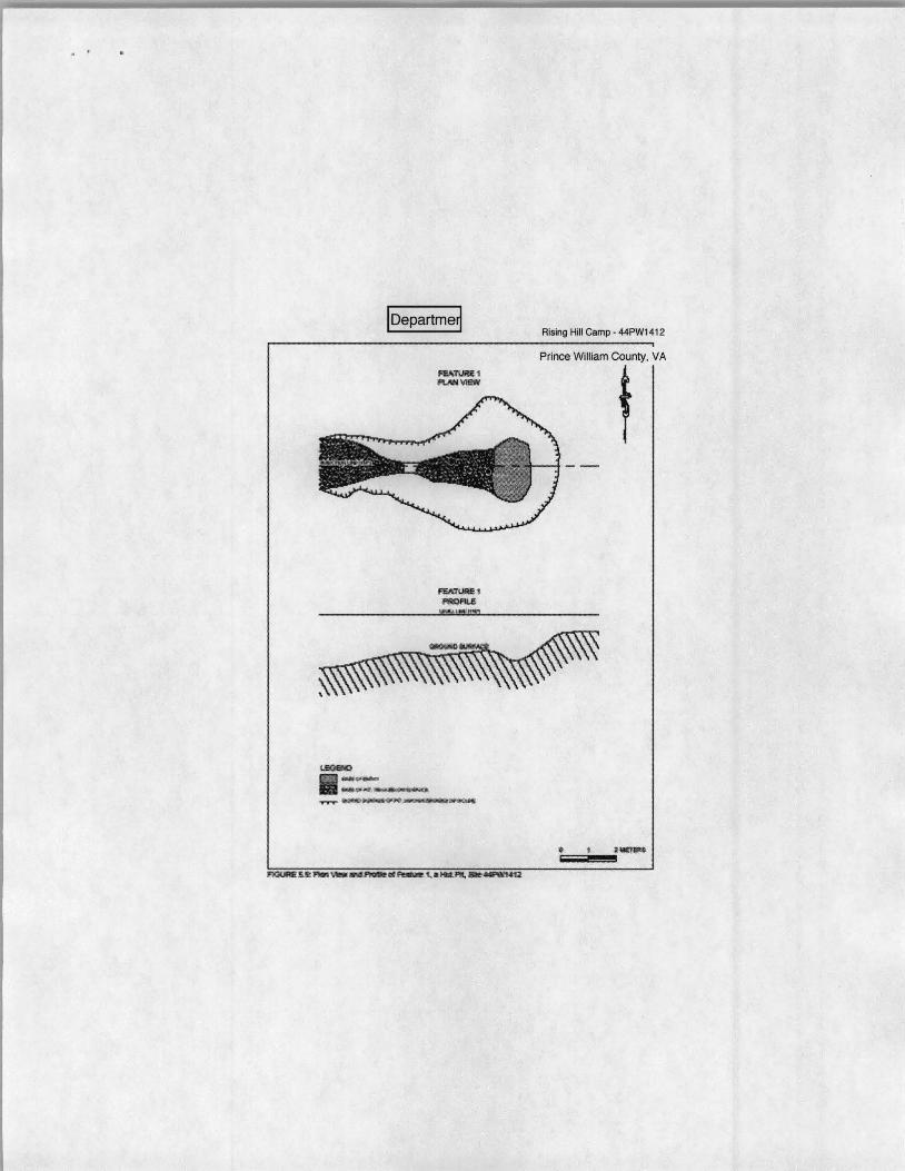
The site is defined by visible hut pits. At least 86 hut pits are present, along with numerous smaller or shallower features that may be additional Civil War remains (Figure 5.8 [Figure 2]). The pits are arranged in rows running down the western slope of the ridge. Three of the pits (Features l[Figure 3], 12, and 25) were drawn both in plan view and in profile (Figures 5.9, 5.10, and 5.11). A metal detector survey was made in the area, but almost all the targets investigated proved to be cut nails and spikes, and there was one fragment of what may be a military button. Berger' s field investigations indicated that the campsite measures approximately 200x90 meters (650x300 feet).
The 4 7th Infantry Regiment was formed in June, 1861, with men recruited in Caroline, Middlesex, Essex, and Stafford counties (NPS 2005). It' s commanding officer was Col. Richardson. Prior to being placed in Gen. LR. Trimble' s brigade at Evansport, the 47th Virginia was stationed at Clifton Church, about 5 miles southwest ofEvansport, in Stafford County (O.R. Vol. 5: 851). In Special Order No. 129 from Headquarters of the Department of Fredericksburg, General Theodophilus H. Holmes effected this change of assignment, and shortly after its date, 13 September 1861, the 47th Virginia would have been under the command of Gen. Trimble. Gen. Samuel G. French succeeded Gen. Isaac R. Trimble in command of the troops and batteries at Evansport in November 1861 (O.R. Vol. 5: 952). In discussing the state of affairs in his command in a communique on 30 December 1861 he mentions," To guard the river between the Chopawamsic and Aquia Creek I have one fine regiment, the Second Tennessee (and a very weak one), the Forty-seventh Virginia, one battery of artillery, and one company of cavalry." (O.R. Vol. 5: 1013). French's description of the 47th Virginia as "weak" probably meant few in numbers, as reflected in their muster report for that month (O.R. Vol. 5: 1028-1031).
This statement, along with another in a letter from Gen. Holmes to Gen. Johnston dated 17 January 1862, where Holmes says, " ... the two regiments between Evansport and Aquia are part of the Evansport command ... " (O.R. Vol.5 : 1035) suggest that the 47th Virginia had never moved from Camp Clifton, at Clifton Church and, if they had, not so close to Evansport as 44PW1412. It may have been that the camp was for one or two companies detached from the 47th Virginia, or other units. Balicki, et al. (2003: 48-49) discusses infantry companies detached from their regiments and serving under naval officers, but none are from the 4 7th Virginia Regiment.
Other units were in place at Evansport, not all of which were in General French' s (or earlier Trimble's) Brigade. The 14th Alabama Regiment was ordered to Richmond from Evansport in December 1861. Although a part of Gen. Whiting' s Brigade, they had been positioned for the defense of the batteries, commanded by Gen. French. In a letter to Gen. Johnston, Gen. Holmes implored Johnston to order another regiment from Whiting' s command (O.R. Vol. 5: 1013). It was not specified what finds Fiedel' s (Fiedel et al. 2004) informants based their assignment of the 22nd North Carolina and 47th Virginia regiments to site 44PW1412. The southeastern cluster of hut features at 44PW917 is of sufficient size to quarter an entire regiment, and has been identified with the 22nd North Carolina regiment, although it could be that a company of this regiment was camped closer to the hill top fortifications for quicker response. The
NPS Form 10-900-a (8-86)
United States Department of the Interior National Park Service
NATIONAL REGISTER OF HISTORIC PLACES CONTINUATION SHEET
Section _7~ Page 3
OMB No. 1024-0018 (Expiration 1-31 -2009)
Rising Hill Camp - 44PW1412 Prince William County, Virginia
Properties Associated with Campaigns for the Control of Navigation on the Lower Potomac River, 1861-1862;
Virginia, Maryland, and the District of Columbia
number of hut features at 44PW1412 is less than that which would be expected for a full regiment. This question remains open, and among others, one that could be answered by archaeological evidence from site 44PW1412.
NPS Form 10-900-a (8-86)
United States Department of the Interior National Park Service
NATIONAL REGISTER OF HISTORIC PLACES CONTINUATION SHEET
Section _8~ Page 4
SIGNIFICANCE STATEMENT
OMB No. 1024-0018 (Expiration 1-31-2009)
Rising Hill Camp - 44PW1412 Prince William County, Virginia
Properties Associated with Campaigns for the Control of Navigation on the Lower Potomac River, 1861-1862;
Virginia. Maryland, and the District of Columbia
Site 44PW1412 is a well preserved area of archaeological remains from a Confederate Civil War camp dating sometime between October 1861 and March 1862. Surface features belie the camp as a winter camp where ' dug-out' huts were excavated by troops settling to endure the season. Archaeological excavations at site 44PW917 and 44ST302 have shown the presence of significant subsurface remains and features associated with identical features. Unlike 44PW917 and 44ST302, site 44PW1412 was immediately associated with the location of a fortification. The battery, and other likely infantry fortifications at Rising Hill were most likely manned by troops here.
Fiedel, et al. (2004: 5-10) conducted a surface and metal detector survey of the site, and concluded:
... site 44PW1412, tentatively identified as the remains of a Civil War camp occupied by the 47thVirginia Infantry and the 22nd North Carolina Infantry in the winter of 1861to1862, is considered potentially significant. In view of the site's high degree of integrity, demonstrated by the many visible house pits, and the extensive historical context available from the study of other Civil War camps in the area, Site 44PW1412 can probably be recommended for listing in the National Register of Historic Places under Criteria A, C, and D without any additional testing.
This nomination recommends listing under Criterion A and Criterion D. The pit features associated with Civil War dugout huts are well preserved at this site, however, they would not appear to meet the requisites of Criterion C. Criterion A is supported for the immediate role the batteries, camps, and fortifications at Evansport played in the strategic Battle of the Potomac - the campaign of the Union and Confederate armies and navies to control the tidal Potomac in 1861 and 1862. Criterion D is supported by the observed surficial integrity of the site, augmented by the close similarity of the site with others, previously tested with excavation, in the area. Site 44PW1412 has considerable potential to contribute to our knowledge of history for this period of the Civil War.
HISTORIC CONTEXT
Although winter camps are duplicated at a much larger scale at 44PW0917 and 44ST0302 there are important questions about the history ofthis era, and the Campaigns to Control Navigation on the Lower Potomac River in 1861 and 1862 that can be answered by evidence from 44PW1412. This camp was immediate to a battery which played both an offensive and defensive roll in the campaign. The battery fired upon the USS Seminole in the earliest action at Evansport. i This was weeks before troops began to construct winter huts. If the troops manning and supporting the Rising Hill battery were in or near the site of the winter camp, the transition to these new quarters and their construction could be contrasted by remains from this site. Another distinction of 44PW1412 is that it is thought to have been a camp occupied by the 4 7th Virginia Infantry, a local unit mustered from Stafford County, in contrast to the other winter Confederate camps occupied by out of state troops. Housing material conditions, food, and personal items may reflect, or not reflect, close ties kept with the local community. Because the 47th Virginia was local, it may be that this site was occupied much earlier than other camps in the area. Finally, other camps in the vicinity of

NPS Form 10-900-a (8-86)
United States Department of the Interior National Park Service
NATIONAL REGISTER OF HISTORIC PLACES CONTINUATION SHEET
Section _8~ Page 5
OMB No. 1024-0018 (Expiration 1-31-2009)
Rising Hill Camp - 44PW1412 Prince William County, Virginia
Properties Associated with Campaigns for the Control of Navigation on the Lower Potomac River, 1861-1862;
Virginia, Maryland, and the District of Columbia
Evansport, 44PW0917 and 44ST0302, are not immediate to fighting positions, while the Rising Hill Camp was adjacent to the single gun battery, and most likely to breastworks and field entrenchments described by occupying Union forces in March 1862.
Endnotes
1 National Register of Historic Places Multiple Property Documentation: Properties Associated with Campaigns for the Control of Navigation on the Lower Potomac River, 1861-1862; Virginia, Maryland, and the District of Columbia, Section E, Page 9 (Virginia Department of Historic Places file number 076-5312)
NPS Form 10-900-a (8-86)
United States Department of the Interior National Park Service
NATIONAL REGISTER OF HISTORIC PLACES CONTINUATION SHEET
Section _9_ Page 6
BIBLlOGRAPHIC DATA
Balicki, Joseph, Bryan Corle, and Sarah Goode
OMB No. 1024-0018 (Expiration 1-31-2009)
Rising Hill Camp-44PW1412 Prince William County, Virginia
Properties Associated with Campaigns for the Control of Navigation on the Lower Potomac River, 1861-1862;
Virginia. Marvland, and the District of Columbia
2004 Multiple Cultural Resources Investigations at Eight Locations and Along Five Tank Trails, Marine Corps Base, Quantico, Prince William, Stafford, and Fauquier Counties, Virginia, John Milner Associates, Alexandria, Virginia.(Report, artifacts, field notes repository: Virginia Department of Historic Resources, Richmond, VA; Report Copies at the NEPA Coordination Section, Natural Resources and Environmental Affairs Branch, Marine Corps Base, Quantico, VA)
Fiedel, Stuart, John Bedell, and Eric Griffitts 2004 Phase I Cultural Resource Investigations, Marine Corps Base Quantico, Prince William and Stafford Counties,
Virginia. The Louis Berger Group, Inc., Washington, D.C.(Report, artifacts, field notes repository: Virginia Department of Historic Resources, Richmond, VA; Report Copies at the NEPA Coordination Section, Natural Resources and Environmental Affairs Branch, Marine Corps Base, Quantico, VA)
National Park Service 2005 Civil War Soldiers and Sailors System (web site): http://www.civilwar.nps.gov/cwss/
regiments.htm
(O.N.R. Vol. 5) Rush, Lt.Cmdr. Richard, and Robert H. Woods 1897 Official Records of the Union and Confederate Navies in the War of the Rebellion, Series I,
Volume 5, Government Printing Office, Washington, D.C.
(O.R. Vol. 5) Scott, Lt. Col. Robert N. 1881 The War of the Rebellion: A Compilation of the Official Records of the Union and Confederate Armies. Series I,
Volume 5, Government Printing Office, Washington, D.C.

NPS Form 10-900-a (8-86)
United States Department of the Interior National Park Service
NATIONAL REGISTER OF HISTORIC PLACES CONTINUATION SHEET
Section _JQ_ Page 7
V ERBAL BOUNDARY D ESCRIPTION
OMB No. 1024-0018 (Expiration 1-31-2009)
Rising Hill Camp - 44PW1412 Prince William County, Virginia
Properties Associated with Campaigns for the Control of Navigation on the Lower Potomac River, 1861-1862;
Virginia, Maryland, and the District of Columbia
The extent of site 44 PWl 412 was determined through GPS mapping of the extent of surface features. This boundary encompasses observed dugout hut pits, and does not take in additional areas. Adjacent ridgetop areas were developed as residential areas for the Marine Corps in the early 20th Century. Intact site components in these adjacent upland areas are unlikely.
BOUNDARY JUSTIFICATION
The site boundaries in this submission have been projected as complex angular polygons.This term means that irregular curvilinear shapes projected as site boundaries in the original site reports have been transferred to the MCB Quantico GIS as polygons that closely encompass the curvilinear projections, with a number of vertices. The number of vertices is kept at the minimum possible while preserving the shape and extent of the curvilinear boundary. The original report or field maps were measured, or the map was scanned and brought into the GIS as a scaled and georeferenced raster layer. Polygon vertices were plotted in the archaeological site boundaries GIS layer using these techniqes, and subsequently rounded off to the nearest meter. As a result, the exact location, dimensions, and shape of the site boundary can be reproduced on a GIS, or on the ground using GPS or conventional survey by plotting the vertice coordinates. This offers considerable improvement over curvilinear boundaries which can only be accurately reproduced on maps by tracing on a light table, and would be very difficult and prohibitively expensive to reproduce in the field. This alternative to curvilinear boundaries results in no loss of information, while improving record keeping and real world resource management. Original reports and maps can be referenced for curvilinear or other boundaries during detailed analysis.
~
~ II ~ -t .! -.. c;; ..
~ -~ L. c i .. ~ ~ 0:: g> .. en i I .... ... u w ~ a ,, ~ f2 ' - c 0 c( .. ::s I I :s e :>
a CJ

Figure 2
loepartme~
t.EQaiD --.. ---.. .-.--......... --!" ... , __ FIQIJREs..!<Rml,_ __ ,,,Falilllo 1,atMN.--4t2
Rising Hill Camp - 44PW1412
Prince William County, VA
t
·--'1!!!!!!!!!!!!1" ......