i geography: it's nature and perspectives€¦ · human geography a division of geography,...
TRANSCRIPT

Enduring Understandings Learning Objectives Essential Knowledge
A. Geography, as a field of inquiry, looks at the world from a
spatial perspective
Explain the importance of geography as a field of study
Geographic information provides context for understanding spatialrelationships and human-environment interaction
B. Geography offers a set of concepts, skills, and tools that facilitate critical thinking and
problem solving
Explain major geographicalconcepts underlying the geographic perspective
Geographical concepts include location, place, scale, space, pattern, nature and society, networks, flows, regionalization and globalization
Use landscape analysis to examine the human
organization of space
Landscape analysis (e.g. field observations, photographic interpretations) provides a context for understanding the location of people, places, regions,
and events; human-environment relationships; and interconnections between and among places and regions
C. Geographical skills provide a foundations for analyzing world
patterns and processesUse spatial thinking to
analyze the human organization of space
People apply spatial concepts to interpret and understand population and migration, cultural patterns and processes; political organization of space,
agriculture, food production, and rural land use; industrialization and economic development; and cities and urban land use
Use and interpret maps Maps are used to represent and identify spatial patterns and processes at different scales
Types of maps include reference maps (e.g. physical and political maps) and thematic maps (e.g. choropleth, dot, graduated symbol, isoline,
cartogram)
All map projections (e.g. Mercator, polar) inevitably distort spatial relationships (e.g. shape, area, distance, and direction)
Apply mathematical formulas and graphs to interpret geographic concepts
Mathematical formulas and graphs are used to analyze rates of natural increase in population, population doubling time, rank-size rule for cities,
and distance-decay functions
Use and interpret geographic models
Geographers use models and generalizations to think systematically about topics such as land use (e.g. von Thünen model, Latin American city model), industrial location (e.g. Weber model) and the distribution of
settlements (e.g. Christaller’s central place theory)
Use concepts such as space, place, and region to examine
geographic issues
Geographic issues include problems related to human-environment interactions (e.g. sustainable agriculture); conflict and cooperation among countries (e.g. European Union); and planning and public-policy decision
making (e.g. pronatalist policies)
Interpret patterns and processes at different scales
Patterns and processes at different scales reveal variations in and different interpretations of data (e.g. age-sex pyramids, population density)
Define regions as a concept, identify world regions, and understand regionalization
processes
Regions are defined on the basis of one or more unifying characteristics (e.g. corn belt) or on patterns of activity (e.g. hinterlands of ports)
Types of regions include formal, functional, and perceptual
World regions are defined for this course by the maps in the course curriculum section of the AP Human Geography Course Description
World regions may overlap (e.g. Southeast Asia and Asia) and often have transitional boundaries (e.g. North Africa and Sub-Saharan Africa)
Explain and evaluate the Regional thinking is applied a local, national, and global scales
I Geography: It's Nature and Perspectives
Unit 1 Geography Page 1

Explain and evaluate the regionalization process
Regional thinking is applied a local, national, and global scales
Regionalism refers to a group’s perceived identification with a particular region at any scale
Analyze changing interconnections among
places
Interconnections among places include exchanges of natural resources, agricultural commodities, finished products, services, people, information,
money, and pollutants
D. Geospatial technologies increase the capability for gathering and analyzing
geographic information with applications to everyday life
Use and interpret geospatialdata
Geospatial technologies include geographic information systems (GIS), satellite navigation systems (e.g. global positioning system), remote
sensing, and online mapping and visualization
Geospatial data (e.g. census data, satellite imagery) is uses at all scales for personal (e.g. navigation), business (e.g. marketing), and governmental (e.g.
environmental planning) purposes
E. Field experiences continue to be important means of gathering geographic information and data
Use quantitative and qualitative geographic data
Data may be gathered in the field by organizations (e.g. census data) or by individuals (e.g. interviews, surveys, photography, informal
observations)
Quantitative and qualitative geographic data are used in economic, environmental, political and social decision making
From <https://sites.google.com/a/lphs.org/lphumangeo/unit-i---geography-it-s-nature-and-perspectives>
Unit 1 Geography Page 2

human geography a division of geography, spatial analysis of human population, cultures, activities, and landscapes
globalization expansion of economic, political, and cultural processes to the point that they are global in scope, effect all levels
fieldwork study of phenomena by visiting places and observing how people interact and thereby change those places
physical geography the branch of geography that studies structures, processes, and location of the Earth's natural phenomena (climate, soil, plants, animals, topography)
spatial pertaining to space on the Earth's surface,
spatial distribution physical location of geographic features across space
medical geography study of health and disease from a geographic context and perspective
pandemics worldwide outbreak of disease
epidemic disease particular to a locality or region
spatial perspective observing variations in geographic phenoms across space
meridians lines of longitude
parallels lines of latitude
Azimuthal Projection, shows poles, used by pilots
Mercator Projection, used for ship navigation, right diections, wrong land mass areas
Fuller Projection, right size and shape of land, distorted compass
Robinson Projection, used by Nat Geo, nothing is accurate but all errors are minimized
It's all about Spatial Perspective and Scale!!!
DefinitionsTuesday, May 2, 2017 8:17 AM
Unit 1 Geography Page 3

cartogram, thematic map where the unit is shown larger due to importance than actual size
choropleth map thematic map that uses colors of tones or such to represent a particular data
dot map, hows a thematic map with locations marked of a particular idea or occurance
proportional symbols map, thematic map where size of symbols denote importance or size of the given attribute
isoline maps (contour lines), has lines used to show areas that are relatively equal
reference maps used to navigate from one place to another
political maps shows borders and capitals
Times Zones change 1 hour per 15 degress
small scale maps show large area, little detail
large scale maps show small area in great detail
spatial perspective observing variations in geographic phenomena across space
location theory logical attempt to explain the location & patter of an economic activity and how producing areas are related
Unit 1 Geography Page 4

how producing areas are related
sense of place state of mind derived from the infusion of a place with meaning and emotion from memories
perceptions of place belief or understanding about a place from books, movies, stories, or pictures
spatial interaction degree of flow of people, ideas, and goods among places
distance measurement of the physical space between 2 places
accessibility degree of ease with which it is possible to reach a location from elsewhere, varies place to place, can be measured
connectivity connectedness of a node in the world economy to other nodes
landscape overall appearance of an area, usually naturally and human induced
cultural landscape visible imprint of human activity and culture on the landscape, sequentially imprinted
sequent occupance successive societies leave their cultural imprint on a place, each adding to the cumulative cultural landscape
cartography science of map making
reference maps map that shows absolute location of a place and geographic features
thematic maps maps that tell stories, usually one attribute or movement
absolute location position on earth's surface, usually by latitude and longitude
Global Positioning system system for determining the absolute location of places or features, often with satellites
geocaching a hunt for a cahe, the GPS coordinates which are placed on the internet by other geocachers
relative location regional position of a place (situation), relative to other places
mental map image or picture based on perceptions and impressions
activity spaces space in which one's daily acitvities take plae
remote sensing use of planes or satellites to collect data or information from places physically distant
geographic information systems collection of pc software and hardware that allows spatial data to be collected, recorded, stored, and ustilized
rescale change the scale or area of study to gain support
formal region region that has one or more shared physical or cultural traits
functional region region defined by a set of activities or interactions
perceptual region region that exists a an idea and not based on a physical entity
culture sum of knowledge, attitudes, and habitual behaviors shared amongst a group
culture trait an element of a culture
culture complex set of cultural traits
cultural hearth origin of a culture
independent invention The independent development of a cultural feature in different societies.
cultural diffusion expansion and adoption of a cultural element
time-distance decay declining acceptance of an idea the farther it is from the hearth
cultural barriers attitude that refuses the adoption of another culture's traits
expansion diffusion spread of innovation or idea through a population, increased the the numbers involved
contagious diffusion spread by immediate and direct contact person to person
hierarchical diffusion idea that passes from the hearth to the most connected nodes (people or places)
stimulus diffusion an accepted cultural trait with adaptations
relocation diffusion trait carried by people who move from one location to another
isotherms lines connecting similar values like temperature or elevations on a topographic map
possiblism environment influences culture but man is the final decision maker
Unit 1 Geography Page 5

possiblism environment influences culture but man is the final decision maker
cultural ecology interactions and relationships between a culture and its' environment
environmental determinism environment determines culture and development
political ecology study of nature and society relationships and reflects as a result of political and socioeconomic contexts
Unit 1 Geography Page 6

1.Five Themes of Geography
Locationa. absolute location - gives precise locationb. relative location - gives location based on position to other places
SITE VS SITUATIONSITE - physical attributes of a place including absolute location, spatial character, and internal physical settingSITUATION - relative location, position based on external objects
2. Human - Environment Interactionsa. the effect humans have on the environment
(ex. dams, mining, Greenhouse Effect, man made lakes and canals, etc).
ANDb. the impact that the environment has on humans
(ex. floods, earthquakes, tsunamis, hurricanes, landslides, etc.)
5 ThemesTuesday, May 2, 2017 8:26 AM
Unit 1 Geography Page 7

3. RegionRegions are areas that share a distinct trait. Geographers use them to compare and contrast places. There is no real one set of qualifiers to decide what is or is not a region. For example, many people use the term "Middle East". When we discuss Middle East we may not agree on what is included. Should we count Egypt which is technically part of Northern Africa? What about Pakistan which shares some traits with nearby countries by certainly not all?
a. Regional Geography - study of religions (ex. Southern US, New England, etc)b. Functional Regions - political, social, or economic relationships create regions (ex. DMV - DC, VA, MD•)c. Formal Regions - share a cultural or physical trait (ex. Appalachians, Megalopolis)
one example of regions
4. Placea. Sense of Place - the meaning, emotion, or attachment one gives to a place from memories and experiences ex. homeb. Perceptions of Place - the way a place is perceived due to exposure from media (books, movies, etc)
What makes you feel like you are "home"?
What have movies, books, and pictures made you think of when you hear the word "France"?
5. Movementa. Movement deals with the mobility of goods, ideas, and people.
Spatial interaction depends on the distance between places, the accessibility (degree of difficulty to move between the places), and connectivity (how good the communication between the places is). Bigger urban areas have more ability to attract people to it. People move based on reasons to leave a place (push factors) and reasons to seek the new place (pull factors). There are many things that can encourage or derail movement (see Unit on Population and Migration).
Unit 1 Geography Page 8

CREATE A FREE WEBSITEPOWERED BY
From <http://newellta.weebly.com/5-themes.html>
Unit 1 Geography Page 9

Eratosthenes - early cartographer, coined the term geography, made a nearly accurate measurement of the Earth's CircumferenceVIDEO ON ERATOSTHENES
Ptolemy - early cartography, used a grid system
George Perkins Marsh - wrote about how human actions change or affect physical/natural systems
Carl Sauer- cultural landscape is the fundamental unit of geographical analysis, this is from human interaction with physical environment, ALL landscape is effected by humans
W.D. Pattison -geography comes from 4 traditions: earth science, culture-environment, locations, and area-analysis.
AP Human Unit 1 Crash Course Mona McElroy 3B Part 1moneha140
Important PeopleTuesday, May 2, 2017 8:34 AM
Unit 1 Geography Page 10

From <http://newellta.weebly.com/geography-people-and-maps.html>
Unit 1 Geography Page 11

Map Partsabsolute location - exact position on a map grid systemlongitude/meridians- lines to the east or west of the Prime Meridian, run verticallylatitude/parallels - lines to the north or south of the Equator, (go horizontally)Prime Meridian-0 degree line of longitude through Greenwich, EnglandInternational Date Line -180 degree line of longitude, starts a new dayEquator - 0 degree line of latitude, separates northern and southern hemispherecoordinate system - grid (longitude and latitude) used to find absolute location
MapsTuesday, May 2, 2017 8:37 AM
Unit 1 Geography Page 12

Maps Types to know!Thematic Maps - type of map that attempts to display one or morecartography - the science of making mapscognitive/mental map - map drawn from one's memories and experienceslocation charts - map, chart, graph, etc that show statistics of a particular place
Azimuthal Projection - flat constructed map of a particular area (often poles) with correct direction and evident circles for scales
Unit 1 Geography Page 13

scales
cartograms - thematic map where the unit is shown larger due to importance than actual size
choropleth map - thematic map that uses colors of tones or such to represent a particular data
dot maps - shows a thematic map with locations marked of a particular idea or occurrence
Unit 1 Geography Page 14
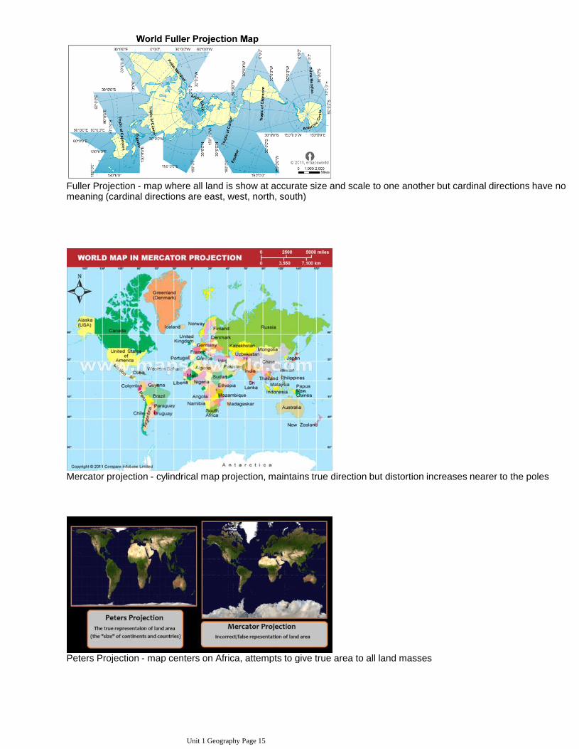
Fuller Projection - map where all land is show at accurate size and scale to one another but cardinal directions have no meaning (cardinal directions are east, west, north, south)
Mercator projection - cylindrical map projection, maintains true direction but distortion increases nearer to the poles
Peters Projection - map centers on Africa, attempts to give true area to all land masses
Unit 1 Geography Page 15

Robinson Projection - map projection that is not accurate to any one proportion or size, etc but minimizes as errors on all fronts as much at possible
Proportional Symbols Map - thematic map where size of symbols denote importance or size of the given attribute
Isoline maps - has lines used to show areas that are relatively equal
Unit 1 Geography Page 16

Newton's model of gravity is used to explain how much interaction there is in cities using size (mass) and distance (pull)
AP Human Geography Maps and ProjectionsMaxwell Johnson
25 Maps That Will Change The Way You See The Worldlist25
Maps That Prove You Don't Really Know Earth
Unit 1 Geography Page 17

Gall--Peters Projection
From <http://newellta.weebly.com/geography-people-and-maps.html>
Unit 1 Geography Page 18

World Regions - KNOW THIS MAP!
Types of RegionsRegions are the basic unit that geographers deal with.
FORMAL REGION - area in which certain characteristics are found throughout the area, has shared trait(s) either physical or cultural
Example: Countries, Cities, States, or French speaking, one religion, etc. This can change based on scale.
RegionsTuesday, May 2, 2017 8:42 AM
Unit 1 Geography Page 19

one religion, etc. This can change based on scale.
Formal Map of Woodbridge
FUNCTIONAL REGION - a central place and the area surrounding it, defined by a particular set or activities or interactions that happen in it, has several nodes (or places) in the region that interact and create connectivityExample: the "DMV" (DC, northern VA, and Maryland),
RVA (Richmond, Ashland, Glenn Allen, Henrico County, Hanover County, etc), Northern Virginia (Loudon, Prince William, Alexandria, Springfield, Fairfax, etc), Newspaper delivery area, Radio broadcast area
PERCEPTUAL REGION - area defined by people's feelings and attitudes, can include people and their cultures or physical traits, types of environment, etc - can change person to personExample: The Midwest, The South, Middle East, Redskins
Unit 1 Geography Page 20

Example: The Midwest, The South, Middle East, Redskins Territory
Formal, Functional, and Perceptual Regions
From <http://newellta.weebly.com/regions.html>
Unit 1 Geography Page 21

Environmentalism vs. Possiblism(environmental determinism)
human behavior is affected or controlled by the physical environment
•
assumes Europeans and North Americans are superior due to climate (obviously a racist theory)
•
response to environmental determinism•
natural resources limit what is available to people
•
people make choices based on technology and resources available
•
From <http://newellta.weebly.com/environmentalism-vs-possiblism.html>
These are theories as to how much geography shapes culture. Environmental Determinism: The theory that the climate and the ph ysical landscape of an area greatly affect the behavior and culture of the people living there. Factors of physical geography that a ffect the culture include: climate, landforms, access to water (including whether a country is landlocked) and arability of land, Examples: ~ T ropical climates cause relaxed attitudes ~ Variety of weather in middle latitudes cause more driven work ethics ~ Cold climates make the peopl e who live their brutish and harsh Easy to see how this philosophy can be pushed by Europeans and Americans, who live in those middle latitude s, to ascribe to themselves a greater work ethic. Carl Sauer and others started to point out that the theory was faulty in the 1920s. Possi bilism (sometimes called Cultural Determinism): A modification of environmental determinism theory that states that physical geography can limi t the possibilities of a culture but it doesn’t control them. The culture is also shaped by social conditions. Basically this theor y states that the environment creates obstacles that people must overcome, but allows that people can overcome those obstacles. As technology a dvances this becomes more and more apparent. Possibilism is believed by far more people than environmental determinism. Things like t he Valens aqueduct that provided fresh water from 400 miles away to Constantinople (now Istanbul), work against the notion of people be ing locked in by their surroundings
Determinism Vs. PossiblismTuesday, May 2, 2017 8:48 AM
Unit 1 Geography Page 22

The 3 Types/Terms of Expansion Diffusion
CONTAGIOUS DIFFUSION: Occurs when numerous places or people near the point of origin become adopters (or infected, in the case of a disease)Example: Hinduism spreading throughout the Indian subcontinent
HIERARCHICAL DIFFUSION: Occurs when the diffusion innovation or concept spreads from a place or person of power or high susceptibility to another in a leveled patternExample: Many people cutting their hair the way Taylor Swift did.
STIMULUS DIFFUSION: Occurs when the innovative idea diffuses from its hearth outward,
Diffusion TypesTuesday, May 2, 2017 8:50 AM
Unit 1 Geography Page 23

STIMULUS DIFFUSION: Occurs when the innovative idea diffuses from its hearth outward, but the original idea is changed by the new adoptersExample: Different Menu items from McDonalds around the world.
Relocation Diffusion
RELOCATION DIFFUSION: Involves the actual movement of the original adopters from their point of origin, or hearth, to a new placeExample: Spread of Christianity, when people moved and brought it with them
Time-Distance DecayTIME-DISTANCE DECAY:The declining degree of acceptance of an idea or innovation with increasing time and distance from its point of origin or source.Do you think technology has changed this idea?
Diffusion- expansion, hierarchical, contagious, stimuluscamiroueche
Unit 1 Geography Page 24

From <http://newellta.weebly.com/types-of-diffusion.html>
Unit 1 Geography Page 25
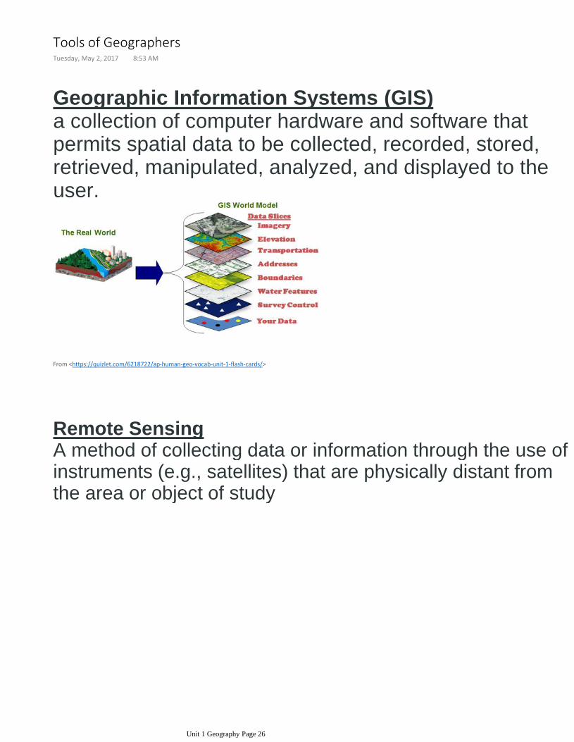
Geographic Information Systems (GIS)a collection of computer hardware and software that permits spatial data to be collected, recorded, stored, retrieved, manipulated, analyzed, and displayed to the user.
From <https://quizlet.com/6218722/ap-human-geo-vocab-unit-1-flash-cards/>
Remote SensingA method of collecting data or information through the use of instruments (e.g., satellites) that are physically distant from the area or object of study
Tools of GeographersTuesday, May 2, 2017 8:53 AM
Unit 1 Geography Page 26

From <https://quizlet.com/6218722/ap-human-geo-vocab-unit-1-flash-cards/>
Global Positioning System (GPS)Satellite-based system for determining the absolute location of places or geographic features.Geocaching: A hunt for a cache, the GPS coordinates which are placed on the Internet by other geocachers.
Variety of Sources for Geographic Inquiry
Unit 1 Geography Page 27

From <https://quizlet.com/1111427/ap-human-geography-chapter-1-vocab-flash-cards/>
Unit 1 Geography Page 28

Other Important ConceptsFriday, May 5, 2017 8:37 AM
Unit 1 Geography Page 29

Unit 1 Geography Page 30

Unit 1 Geography Page 31