ibhh - azgs document...
TRANSCRIPT
ARIZONA OIL AND GAS CONSERVATION COMMISSION JOHN BANNISTER, EXECUTIVE SECRETARY
STRUCTURE AND CORRELATION SECTIONS
EASTERN MOGOLLON SLOPE REGION ARIZONA
JUNE 1977
BY J.N. CONLEY
ARIZONA OIL AND GAS CONSERVATION COMMISSION
INTRODUCTION
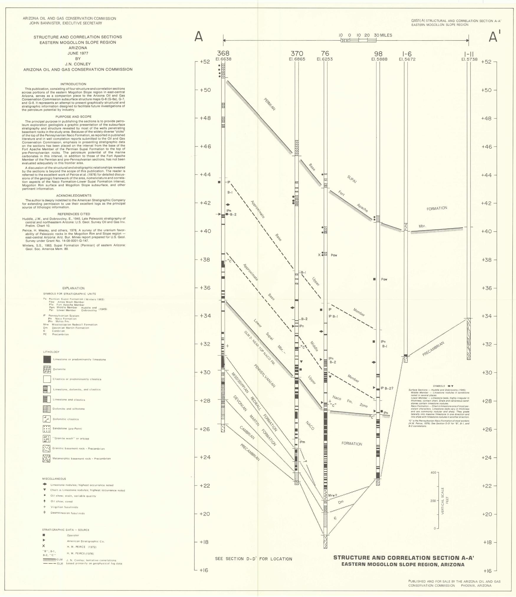
This publication, consisting of four structure and correlation sections across portions of the eastern Mogollon Slope region in east-central Arizona, serves as a companion piece to the Arizona Oil and Gas Conservation Commission subsurface structure maps G-6 (G-6a), G-7, and G-8. It represents an attempt to present graphically structural and stratigraphic information designed to facilitate future investigations of the petroleum potential by industry.
PURPOSE AND SCOPE
The principal purpose in publishing the sections is to provide petroleum exploration geologists a graphic presentation of the subsurface stratigraphy and structure revealed by most of the wells penetrating basement rocks in the study area. Because of the widely diverse "picks" of the top of the Pennsylvanian Naco Formation, as reported in published literature and in well completion reports submitted to the Oil and Gas Conservation Commission, emphasis in presenting stratigraphic data on the sections has been placed on the interval from the base of the Fort Apache Member of the Permian Supai Formation to the top of pre-Pennsylvanian rocks. The petroleum potential of the marine carbonates in this interval, in addition to those of the Fort Apache Member of the Permian and pre-Pennsylvanian sections, has not been evaluated adequately in this frontier area.
A discussion of the structural and stratigraphic relationships revealed by the sections is beyond the scope of this publication. The reader is referred to the excellent work of Peirce et al. (1976) for detailed discussions of the geologic framework of the area, nomenclature and correlation aspects of the Naco Formation-Lower Supai Formation interval, Mogollon Rim surface and Mogollon Slope subsurface, and other pertinent information.
ACKNOWLEDGMENTS
The author is deeply indebted to the American Stratigraphic Company for extending permission to use their excellent logs as the principal source of lithologic information.
REFERENCES CITED
Huddle, J.W., and Dobrovolny, E., 1945, Late Paleozoic stratigraphy of central and northeastern Arizona: U.S. Geol. Survey Oil and Gas Inv. Prelim. Chart 10.
Peirce, H. Wesley, and others, 1976, A survey of the uranium favorability of Paleozoic rocks in the Mogollon Rim and Slope region -east-central Arizona: Ariz. Bur. Mines report prepared for U.S. Geol. Survey under Grant No. 14-08-0001-G-147.
Winters. S.S., 1963, Supai Formation (Permian) of eastern Arizona: Geol. Soc. America Mem. 89.
EXPLANATION
SYMBOLS FOR STRATIGRAPH IC UN ITS
Ps Permian Supai Formation (Winters i963) Paw Amos Wash Member Pta Fort Apache Member Psm Midd le Member Huddle and Ps i Lower Member Dobrovolny 11945)
IP Pennsylv an ian System IPn Naco Format ion IPm Mol as Fm.
Mrw Mississippian Redvvall Formation
Om Devonian Martin Format ion € Cambrian
Precambrian
LITHOLOGY
II ~ D iJ iJ m:·
'.' ....
Limestone or predominantly limestone
Dolomite
Clastics or predominantly clastics
L imestone. dolomite. and clastics
Limestone and clastics
Dolomite and siltstone
I~, ' I ..... - Dolomitic clastics
D· · .. · .. Sandstone (pre~Penn)
I~~ I ., Granite wash" or arkose <a •
GranItic basement rock· Precambrian
Metamorphic basement rock - Prec;;lmbrian
MISCELLANEOUS
• T
• + +
L imestone nodu les; highest occurrence noted
Chert in Limestone nodules; highest Occurrence noted
Oil show; stain. variable quality
Oi I show; cored
Virgilian fusul i n ids
.:f: DesmOinesian fusulInids
STRATIGRAPHIC DATA - SOURCE
• ~
X "B". B·1.
B-2. "C"
Operator
American Stratigraphic Co.
H. W. PEIRCE (1972)
H. W. PEIRCE (1976)
.:.:.:.:.:.:.:.:.:.:.GLM J, N. Conley; tentative correlations - -- GLM based primarily on geophvsical log data
A
+52
+50
+48
+46
+44
+42
+40
+38
+36
+34
+32
+30
+28
+26
+24
+22
+20
+18
+16
368 EI.6638
• •
• IP , 8-1 '
• IPn
-tM.. ..... t-H_2
\ , \ ~
, :z> ..... , a+.
~ , Q>~
\ (9
\ \
\ , <P
, <;;>11'(9
\ \ ,
\
370 EI.6865
\ , ,
SEE SECTION 0-0' FOR LOCATION
10 0 10 20 30 MILES IBHH I I
76 98 EI.6253 EI.5888
GXS1(A) STRUCTURAL AND CORRELATION SECTION A-A' EASTERN MOGOLLON SLOPE REGION
·1 AI
1-6 I-II EI.5672 EI.5738 +52
+50
+48
+46
+44
+42 FORMATION
Mbr . 0:::·:0:':':':':':';':':':':::':':':':':':':':':';':':':':.;.:.:.:.:.:.:.:.:.;.;~~ +40
Pow
•
•
•
FORMATION
Paw
IPn 8-1
SYMBOLS ."
Surface Sections - Huddle and Dobrovolny (1945) Middle Member - Limestone nodules in sandstone noted In several places. Lower Member - Limestone beds, highly irregular in thickness, contain chert. Shale and calcareous sand· stones contain fimestone nodules Naco Formation - Chert In limestone one of most per· sistant characters. Limestone beds vary in fhielmess and arB commonly nodular and sha/y. They grade larerafly into massive limestone in one direction and into shale with limestone nodufes in another directiOn.
"C" is the Pennsylvanian Naco Formation of most workers (H. W. Peirce. 1976). See Section D-D' tor "8", 8- 1. and 8-2 correlations.
400
LlJ ...J <{ U CfJ I-
200 ...J w <{ LlJ
U LL
I-a: LlJ
>
o
STRUCTURE AND CORRELATION SECTION A_A' EASTERN MOGOLLON SLOPE REGION, ARIZONA
+38
+36
+34
+32
+30
+28
+26
+24
+22
+20
+18
+16
PUBLISHED AN 0 FOR SALE BY THE ARIZONA 01 L AND GAS CONSERVATION COMMISSION PHOENIX, ARIZONA