ibm passport advantage offerings | weather company data ... · ibm passport advantage offerings |...
TRANSCRIPT

IBM Passport Advantage Offerings | Weather Company Data for Advanced Analytics - PremiumThe Weather Company Data APIs are served from our Enterprise Data Platform built upon the latest, most robust and globally distributed cloud technologies leveraging the core competence of our weather systems and next-generation globally distributed, highly available, low latency platforms. The Enterprise Data Platform has been architected from the beginning with extreme scale and performance as key factors of success and is automatically scales to deliver tens of Billions average daily requests with extremely low latency.
Overview The IBM Passport Advantage offering of Weather Company Data API Products includes products bundled together in unique product offering packages.
● See the common usage and style guide which describes the common elements, error handling, language support and terminology used by the Weather Company Data APIs.○ Guide on page 81
Weather Company Data for Advanced Analytics - Premium Common Usage Guide Gridded (Tiler) & Polygonal (Featurizer) Common Usage Guide
Guide on page 81 N/A
Domain Portfolio Domain Atomic API Name API Details on Page:
Forecast Daily Forecast Daily Forecast (3, 5, 7, 10 Days)
Forecast Hourly Forecast Hourly Forecast (15 Days)
Forecast Intraday Forecast Intraday Forecast (3, 5, 7, 10 Days)
Forecast Short-Range Forecast 15 Minute Forecast
Forecast Short-Range Forecast Precipitation Forecast
Observations Current Conditions Currents on Demand
Observations Current Conditions PWS Observations - Current Conditions
Observations Current Conditions Site-Based Current Conditions
Observations Current Conditions Site-Based Time-Series Observations
Observations Historical Site-Based Historical Observations
Observations Historical Clean Historical * (Separate API Key Required)
Observations Historical PWS Daily Summary - 7 Day History
Observations Historical PWS Recent History - 1 Day - Rapid History
3
13
18
24
29
32
37
40
45
50
56
68
71

Observations Historical PWS Recent History - 7 Day - Hourly History
Utility Search Location Services - Point
Utility Search Location Services - Search
74
77
77

Weather Company Data for Advanced Analytics | Daily Forecast (3-Day, 5-Day, 7-Day, 10-Day) - v1 Domain Portfolio: Forecast | Domain: Daily Forecasts | API Name: Daily Forecast (3-Day, 5-Day, 7-Day, 10-Day) - v1
Standard HTTP Cache-Control headers are used to define caching length. The TTL value is provided in the HTTP Header as an absolute time value using the “Expires” parameter. Example: “Expires: Fri, 12 Jul 2013 12:00:00 GMT”. The response provides a data element expire_time_gmt, this should be used to expire and remove a record from your system.
Geography: Global Attribution Required: NO Attribution Requirements: N/A
Overview The Daily Forecast API is sourced from the The Weather Company Forecast system. This TWC API returns weather forecasts starting current day. Your content licensing agreement with TWC determines the number of days returned in the API response and is constrained by the API Key that is provided to your company. Please refer to the Data Elements section later in this document for more details.
Forecast Composition The TWC daily forecast product can contain multiple days of daily forecasts for each location. Each day of a forecast can contain up to (3) "temporal segments" meaning three separate forecasts. For any given forecast day we offer day, night, and a 24-hour forecast (daily summary). Implementing our forecasts requires your applications to perform basic processing in order to properly ingest the forecast data feeds.
Forecast Implementation The data values in this API are correctly populated into Day, Night, or 24-hour temporal segments. These segments are separate objects in the response.
PLEASE NOTE: The Day object will no longer appear in the API after 3:00pm Local Apparent Time. At 3pm Local Apparent Time, we recommend that your application no longer displays the Day object.
Translated Fields: This TWC API handles the translation of phrases. However, when formatting a request URL a valid language must be passed along (see the language code table for the supported codes).
● daypart_name● dow● golf_category
● long_daypart_name● lunar_phase● narrative
● phrase_32char● shortcast● temp_phrase
● wdir_cardinal● wind_phrase
Unit of Measure Requirement The unit of measure for the response. The following values are supported:
● e = English units ● m = Metric units ● h = Hybrid units (UK)
URL Construction
Request by Geocode (Latitude & Longitude): Required Parameters: language, format, units, geocode, apiKey=yourApiKey
https://api.weather.com/v1/geocode/34.063/-84.217/forecast/daily/3day.json?language=en-US&units=e&apiKey=yourApiKey https://api.weather.com/v1/geocode/34.063/-84.217/forecast/daily/5day.json?language=en-US&units=e&apiKey=yourApiKey https://api.weather.com/v1/geocode/34.063/-84.217/forecast/daily/7day.json?language=en-US&units=e&apiKey=yourApiKey https://api.weather.com/v1/geocode/34.063/-84.217/forecast/daily/10day.json?language=en-US&units=e&apiKey=yourApiKey

Request by Postal Code: Required Parameters: language, format, units, postal code apiKey=yourApiKey The Postal Code has a TWC proprietary location type (4) with the following format: location/<postal code>:<location type>:<country code>
https://api.weather.com/v1/location/30339:4:US/forecast/daily/10day.json?language=en-US&units=e&apiKey=yourApiKey
Data Elements & Definitions Note: Field names are sorted alphabetically in the table below for presentation purposes. The table below does not represent the sort order of the API response.
Field Name Description Type Range Sample Nulls Allowed
[Forecast Object] - Daily Summary Section
class Data identifier string fod_long_range_daily N
blurb A handwritten local or regional text forecast created by a meteorologist to supplement the system-generated forecast.
string
The Palomar fire is now about 45% contained. Smoke remains a significant problem in the LA basin.
N
blurb_author The name initials of the meteorologist who authored the forecast blur. string SO N
dow Day of week string Thursday N
expire_time_gmt Expiration time in UNIX seconds epoch 1369252800 N
fcst_valid Time forecast is valid in UNIX seconds epoch 1369252800 N
fcst_valid_local Time forecast is valid in local apparent time. ISO ISO 8601 - YYYY-MM-DDTHH:MM:SS-NNNN; NNNN=GMT offset
2014-08-20T10:47:59-05:00 N
lunar_phase Description phrase for the current lunar phase string Waning Gibbous N
lunar_phase_code 3 character short code for lunar phases string WNG N
lunar_phase_day Day number within monthly lunar cycle integer 1 through 28 17 N max_temp Daily maximum temperature integer 82 Y
min_temp Daily minimum temperature integer 59 N
moonrise First moonrise in local time. It reflects daylight savings time conventions. ISO ISO 8601 - YYYY-MM-DDTHH:MM:SS-NNNN; NNNN=GMT offset
2014-08-20T10:47:59-05:00 Y
moonset First Moonset in local time. It reflects daylight savings time conventions. ISO ISO 8601 - YYYY-MM-DDTHH:MM:SS-NNNN; NNNN=GMT offset
2014-08-20T10:47:59-05:00 Y
narrative The narrative forecast for the 24-hour period. string
A few thunderstorms possible. Lows overnight in the low 60s.
N
num This data field is the sequential number that identifies each of the forecasted days in the API. They start on day 1, which is the forecast for the current day. Then the forecast for tomorrow uses number 2, then number 3 for the day after tomorrow, and so forth.
Integer 1 - 15 1 N
qpf The forecasted measurable precipitation (liquid or liquid equivalent) during 12 or 24 hour period. decimal 0.06 N
qualifer_code A code for special forecasted weather criteria for the 12 and 24 hour dayparts string Q9015 N

qualifier A phrase associated to the qualifier_code describing special forecasted weather criteria for the 12 and 24 hour dayparts.
string
Winds could occasionally gust over 70 mph. N
snow_code Residual snow accumulation code for the 12 or 24 hour forecast period. string A9015 N
snow_phrase A shortened text description of the forecasted snow accumulation during the forecast period (24 hours or 12 hours).
string
Potential for 6-12 inches of snow. N
snow_qpf The forecasted measurable precipitation as snow during the 12 or 24 hour forecast period. decimal 1.3 N
snow_range The expected amount of residual snow for the 12 or 24 hour period. string 6 - 12 N
stormcon The estimate of the likelihood of winter storm activity during a given 24 hour forecast period. integer 0 to 10 0 Y sunrise The local time of the sunrise. It reflects any local daylight savings conventions. For a few Arctic and Antarctic
regions, the Sunrise and Sunset data values may be the same (each with a value of 12:01am) to reflect conditions where a sunrise or sunset does not occur.
ISO ISO 8601 - YYYY-MM-DDTHH:MM:SS-NNNN; NNNN=GMT offset
2014-08-20T10:47:59-05:00 N
sunset The local time of the sunset. It reflects any local daylight savings conventions. For a few Arctic and Antarctic regions, the Sunrise and Sunset data values may be the same (each with a value of 12:01am) to reflect conditions where a sunrise or sunset does not occur.
ISO ISO 8601 - YYYY-MM-DDTHH:MM:SS-NNNN; NNNN=GMT offset
2014-08-20T10:47:59-05:00 N
torcon The estimate of the likelihood of tornado activity during a given 24 hour forecast period. integer 0 to 10 0 Y [Day Object] || * Note: [Night Object] - repeats all fields in the [Day Object] ** [Night Object] - Collapsed for presentation purposes class accumulation_phrase An accumulation phrase of any precipitation type in the 12 hour forecast period. string Additional rainfall over 2 inches expected. N
alt_ daypart_name A specialized version of the Daypart Name field. Certain holidays or historic events may replace the usual daypart name.
string
Christmas Day N
clds Average cloud cover expressed as a percentage. integer 0 to 100 82 N day_ind Day or night indicator string D N
daypart_name The name of a 12 hour daypart not including day names in the first 48 hours. String Today, Tonight Today N expire_time_gmt Expiration time in UNIX seconds epoch 1369252800 N
fcst_valid Time forecast is valid in UNIX seconds epoch 1369252800 N
fcst_valid_local Time forecast is valid in local apparent time. ISO ISO 8601 - YYYY-MM-DDTHH:MM:SS-NNNN; NNNN=GMT offset
2014-08-20T10:47:59-05:00 N
golf_category The Golf Index Category expressed as a phrase for the weather conditions for playing golf. string Very Good Y
golf_index The Golf Index expresses on a scale of 0 to 10 the weather conditions for playing golf. Not applicable at night. 0-2=Very Poor, 3=Poor, 4-5=Fair, 6-7=Good, 8-9=Very Good, 10=Excellent
integer 1-10 8 Y
hi Heat Index - Maximum heat index. An apparent temperature. It represents what the air temperature “feels like” on exposed human skin due to the combined effect of warm temperatures and high humidity. When the temperature is 70°F or higher, the Feels Like value represents the computed Heat Index. For temperatures between 40°F and 70°F, the Feels Like value and Temperature are the same, regardless of wind speed and humidity, so use the Temperature value.
integer
84 N
icon_code This number is the key to the weather icon lookup. The data field shows the icon number that is matched to represent the observed weather conditions. Please refer to the Forecast Icon Code, Weather Phrases and Images document.
integer
26 N

icon_extd Code representing explicit full set sensible weather. Please refer to the Forecast Icon Code, Weather Phrases and Images document.
integer
2600 N
long_daypart_name The named time frame for the valid weather forecast in an expanded format. The named time frame can be either for 12-hour periods or 24-hour periods.
string Monday, Monday Night, Tuesday, Tuesday Night, Wednesday, Wednesday Night, Thursday, Thursday Night, Friday, Friday Night, Saturday, Saturday Night, Sunday, Sunday Night
Tuesday Night N
narrative The narrative forecast for the daytime period. string
A few thunderstorms possible. Lows overnight in the low 60s.
N
num The sequential number that identifies each of the forecasted days in your feed. They start on day 1, which is the forecast for the current day. Then the forecast for tomorrow uses number 2, then number 3 for the day after tomorrow, and so forth.
integer
1 N
phrase_12char Sensible weather phrase string Windy N
phrase_22char Sensible weather phrase string Cloudy N
phrase_32char Sensible weather phrase string Heavy Rain/Wind N
pop Sensible maximum probability of precipitation. integer 20 N
pop_phrase Probability of precipitation phrase. string Chance of snow 90% N
precip_type Type of precipitation to display with the probability of precipitation (pop) data element. string rain, snow, precip rain N qpf The forecasted measurable precipitation (liquid or liquid equivalent) during the 12 hour forecast period. decimal 0.04 N
qualifier A forecast qualifier that is applicable to the 12 hour forecast period. string Winds could occasionally gust over 70 mph. N
qualifier_code A code for the forecast qualifier applicable to the 12 hour forecast period. string Q9015 N
rh The daytime relative humidity of the air, which is defined as the ratio of the amount of water vapor in the air to the amount of vapor required to bring the air to saturation at a constant temperature. Relative humidity is always expressed as a percentage.
integer 0 to 100 83 N
shortcast An abbreviated sensible weather portion of narrative forecast. string Cloudy N
snow_code Residual snow accumulation code for the 12 or 24 hour forecast period. string A9015 N
snow_phrase Snow accumulation phrase for the 12 hour forecast period. string
Additional snow and ice accumulating 4 to 6 inches
N
snow_qpf The forecasted measurable precipitation as snow during the 12 hour forecast period. decimal 5.3 N
snow_range Snow accumulation amount for the 12 hour forecast period. decimal 4 - 6 N
subphrase_pt1 Part 1 of 3-part daytime sensible weather phrase string Cloudy N
subphrase_pt2 Part 2 of 3-part daytime sensible weather phrase string windy N
subphrase_pt3 Part 3 of 3-part daytime sensible weather phrase string Thunder N
temp The forecasted temperature for midpoint day (1pm) or midpoint night (1am) for a 12 hour daypart. integer 81 N
temp_phrase The short phrase containing the forecasted high or low temperature for 12 hour forecast period. string High 81F N
thunder_enum The enumeration of thunderstorm probability within an area for a 12 hour daypart. integer 0 through 5 3 N

thunder_enum_phrase The description of probability thunderstorm activity in an area for 12 hour daypart. string Severe thunderstorms possible N
uv_desc The UV Index Description which complements the UV Index value by providing an associated level of risk of skin damage due to exposure. 2 is Not Available, -1 is No Report, 0 to 2 is Low, 3 to 5 is Moderate, 6 to 7 is High, 8 to 10 is Very High, 11 to 16 is Extreme
string -1 to 16 Low N
uv_index Maximum UV index for the 12 hour forecast period. integer 2 N
uv_index_raw The non-truncated UV Index which is the intensity of the solar radiation based on a number of factors. decimal 2.22 N
uv_warning TWC-created UV warning based on UV index of 11 or greater. integer 0 N
vocal_key An encoded narrative forecast used for creating computer-generated audio narratives of the forecast period. TWC use only.
string
D1:DA01:X2600260011:S260011:TH81:W07R02 N
wc Wind Chill - Minimum wind chill. An apparent temperature. It represents what the air temperature “feels like” on exposed human skin due to the combined effect of the cold temperatures and wind speed. When the temperature is 61°F or lower the Feels Like value represents the computed Wind Chill so display the Wind Chill value. For temperatures between 61°F and 75°F, the Feels Like value and Temperature are the same, regardless of wind speed and humidity, so display the Temperature value.
integer
68 N
wdir Daytime average wind direction in magnetic notation. integer 0 to 359 148 N wdir_cardinal Daytime average wind direction in cardinal notation. string N , NNE , NE, ENE, E, ESE, SE,
SSE, S, SSW, SW, WSW, W, WNW, NW, NNW, CALM, VAR
SE N
wind_phrase The phrase that describes the wind direction and speed for a 12 hour daypart. string Winds SSE at 5 to 10 mph. N
wspd Wind Speed - The maximum forecasted wind speed. The wind is treated as a vector; hence, winds must have direction and magnitude (speed). The wind information reported in the hourly current conditions corresponds to a 10-minute average called the sustained wind speed. Sudden or brief variations in the wind speed are known as “wind gusts” and are reported in a separate data field. Wind directions are always expressed as "from whence the wind blows" meaning that a North wind blows from North to South. If you face North in a North wind the wind is at your face. Face southward and the North wind is at your back.
integer
7 N
wxman The code to enable the Weather Man animation for forecast period. TWC use only. string wx4400 N
[Night Object] || * Note: [Night Object] - repeats all fields in the [Day Object] ** [Night Object] - Collapsed for presentation purposes
JSON Sample { "metadata": { "language": "en-US", "transaction_id": "1471537802651:851047427", "version": "1", "latitude": 34.06, "longitude": -84.21, "units": "e", "expire_time_gmt": 1471539254,

"status_code": 200 }, "forecasts": [ { "class": "fod_long_range_daily", "expire_time_gmt": 1471539254, "fcst_valid": 1471518000, "fcst_valid_local": "2016-08-18T07:00:00-0400", "num": 1, "max_temp": 92, "min_temp": 72, "torcon": null, "stormcon": null, "blurb": null, "blurb_author": null, "lunar_phase_day": 15, "dow": "Thursday", "lunar_phase": "Full Moon", "lunar_phase_code": "F", "sunrise": "2016-08-18T07:00:50-0400", "sunset": "2016-08-18T20:19:22-0400", "moonrise": "2016-08-18T20:35:50-0400", "moonset": "2016-08-18T07:10:32-0400", "qualifier_code": null, "qualifier": null, "narrative": "Scattered thunderstorms possible. Highs in the low 90s and lows in the low 70s.", "qpf": 0.02, "snow_qpf": 0, "snow_range": "", "snow_phrase": "", "snow_code": "", "night": { "fcst_valid": 1471561200, "fcst_valid_local": "2016-08-18T19:00:00-0400", "day_ind": "N", "thunder_enum": 1, "daypart_name": "Tonight", "long_daypart_name": "Thursday night", "alt_daypart_name": "Tonight", "thunder_enum_phrase": "Thunder possible", "num": 2, "temp": 72, "hi": 91, "wc": 73,
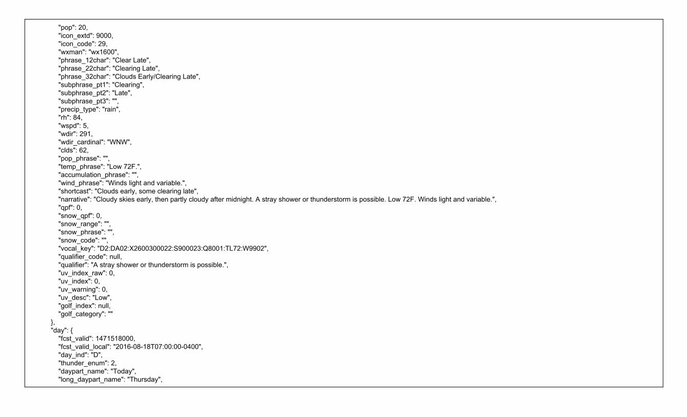
"pop": 20, "icon_extd": 9000, "icon_code": 29, "wxman": "wx1600", "phrase_12char": "Clear Late", "phrase_22char": "Clearing Late", "phrase_32char": "Clouds Early/Clearing Late", "subphrase_pt1": "Clearing", "subphrase_pt2": "Late", "subphrase_pt3": "", "precip_type": "rain", "rh": 84, "wspd": 5, "wdir": 291, "wdir_cardinal": "WNW", "clds": 62, "pop_phrase": "", "temp_phrase": "Low 72F.", "accumulation_phrase": "", "wind_phrase": "Winds light and variable.", "shortcast": "Clouds early, some clearing late", "narrative": "Cloudy skies early, then partly cloudy after midnight. A stray shower or thunderstorm is possible. Low 72F. Winds light and variable.", "qpf": 0, "snow_qpf": 0, "snow_range": "", "snow_phrase": "", "snow_code": "", "vocal_key": "D2:DA02:X2600300022:S900023:Q8001:TL72:W9902", "qualifier_code": null, "qualifier": "A stray shower or thunderstorm is possible.", "uv_index_raw": 0, "uv_index": 0, "uv_warning": 0, "uv_desc": "Low", "golf_index": null, "golf_category": "" }, "day": { "fcst_valid": 1471518000, "fcst_valid_local": "2016-08-18T07:00:00-0400", "day_ind": "D", "thunder_enum": 2, "daypart_name": "Today", "long_daypart_name": "Thursday",

"alt_daypart_name": "Today", "thunder_enum_phrase": "Thunder expected", "num": 1, "temp": 92, "hi": 97, "wc": 87, "pop": 40, "icon_extd": 3800, "icon_code": 38, "wxman": "wx2030", "phrase_12char": "Sct T-Storms", "phrase_22char": "Sct Thunderstorms", "phrase_32char": "Scattered Thunderstorms", "subphrase_pt1": "Scattered", "subphrase_pt2": "T-Storms", "subphrase_pt3": "", "precip_type": "rain", "rh": 51, "wspd": 6, "wdir": 273, "wdir_cardinal": "W", "clds": 59, "pop_phrase": "Chance of rain 40%.", "temp_phrase": "High 92F.", "accumulation_phrase": "", "wind_phrase": "Winds W at 5 to 10 mph.", "shortcast": "A few thunderstorms possible", "narrative": "Mixed clouds and sun with scattered thunderstorms. High 92F. Winds W at 5 to 10 mph. Chance of rain 40%.", "qpf": 0.01, "snow_qpf": 0, "snow_range": "", "snow_phrase": "", "snow_code": "", "vocal_key": "D1:DA01:X3800380013:S380013:TH92:W12R02:P9041", "qualifier_code": null, "qualifier": null, "uv_index_raw": 9.07, "uv_index": 9, "uv_warning": 0, "uv_desc": "Very High", "golf_index": 4, "golf_category": "Fair" } },

{ "class": "fod_long_range_daily", "expire_time_gmt": 1471539254, "fcst_valid": 1471604400, "fcst_valid_local": "2016-08-19T07:00:00-0400", "num": 2, "max_temp": 89, "min_temp": 71, "torcon": null, "stormcon": null, "blurb": null, "blurb_author": null, "lunar_phase_day": 16, "dow": "Friday", "lunar_phase": "Waning Gibbous", "lunar_phase_code": "WNG", "sunrise": "2016-08-19T07:01:33-0400", "sunset": "2016-08-19T20:18:11-0400", "moonrise": "2016-08-19T21:16:42-0400", "moonset": "2016-08-19T08:14:55-0400", "qualifier_code": null, "qualifier": null, "narrative": "Scattered thunderstorms. Highs in the upper 80s and lows in the low 70s.", "qpf": 0.33, "snow_qpf": 0, "snow_range": "", "snow_phrase": "", "snow_code": "", "night": { "fcst_valid": 1471647600, "fcst_valid_local": "2016-08-19T19:00:00-0400", "day_ind": "N", "thunder_enum": 0, "daypart_name": "Tomorrow night", "long_daypart_name": "Friday night", "alt_daypart_name": "Friday night", "thunder_enum_phrase": "No thunder", "num": 4, "temp": 71, "hi": 86, "wc": 72, "pop": 20, "icon_extd": 2900, "icon_code": 29,

"wxman": "wx1600", "phrase_12char": "P Cloudy", "phrase_22char": "Partly Cloudy", "phrase_32char": "Partly Cloudy", "subphrase_pt1": "Partly", "subphrase_pt2": "Cloudy", "subphrase_pt3": "", "precip_type": "rain", "rh": 88, "wspd": 4, "wdir": 274, "wdir_cardinal": "W", "clds": 60, "pop_phrase": "", "temp_phrase": "Low 71F.", "accumulation_phrase": "", "wind_phrase": "Winds light and variable.", "shortcast": "Partly cloudy", "narrative": "Partly to mostly cloudy. Low 71F. Winds light and variable.", "qpf": 0, "snow_qpf": 0, "snow_range": "", "snow_phrase": "", "snow_code": "", "vocal_key": "D4:DA15:X2800300043:S300041:TL71:W9902", "qualifier_code": null, "qualifier": null, "uv_index_raw": 0, "uv_index": 0, "uv_warning": 0, "uv_desc": "Low", "golf_index": null, "golf_category": "" }, //This API will repeat additional times per response ** // Response Collapsed for Presentation Purposes {}, // - Response Repeats for Day 2 {}, // - Response Repeats for Day 3… {} // - Response Repeats for Day 10 } } ] }

Weather Company Data for Advanced Analytics | 15 Day - Hourly Forecast - v1 Domain Portfolio: Forecast | Domain: Hourly Forecasts | API Name: 15 Day - Hourly Forecast - v1
Standard HTTP Cache-Control headers are used to define caching length. The TTL value is provided in the HTTP Header as an absolute time value using the “Expires” parameter. Example: “Expires: Fri, 12 Jul 2013 12:00:00 GMT”. The response provides a data element expire_time_gmt, this should be used to expire and remove a record from your system.
Geography: Global Attribution Required: NO Attribution Requirements: N/A
Overview The Hourly Forecast API is sourced from the The Weather Company Forecast system. This TWC API returns weather forecasts starting current day. Your content licensing agreement with TWC determines the number of days returned in the API response and is constrained by the API Key that is provided to your company. Please refer to the Data Elements section later in this document for more details.
Translated Fields: This TWC API handles the translation of phrases. However, when formatting a request URL a valid language must be passed along (see the language code table for the supported codes).
● dow ● golf_category ● phrase_32char ● uv_desc ● wdir_cardinal
Unit of Measure Requirement The unit of measure for the response. The following values are supported:
● e = English units ● m = Metric units ● h = Hybrid units (UK)
URL Construction
Request by Geocode (Latitude & Longitude): Required Parameters: language, format, units, geocode, postal code apiKey=yourApiKey
https://api.weather.com/v1/geocode/34.063/-84.217/forecast/hourly/360hour.json?language=en-US&units=e&apiKey=yourApiKey
Request by Postal Code: Required Parameters: language, format, units, geocode, postal code apiKey=yourApiKey The Postal Code has a TWC proprietary location type (4) with the following format: location/<postal code>:<location type>:<country code>
https://api.weather.com/v1/location/30339:4:US/forecast/hourly/360hour.json?language=en-US&units=e&apiKey=yourApiKey
Data Elements & Definitions Note: Field names are sorted alphabetically in the table below for presentation purposes. The table below does not represent the sort order of the API response.
Field Name Description Type Range Sample Nulls Allowed
class Data identifier string fod_long_range_hourly N
clds Hourly average cloud cover expressed as a percentage. integer 0 to 100 82 N day_ind This data field indicates whether it is daytime or nighttime based on the Local Apparent Time of
the location. string D = Day,
N = Night, X = missing (for extreme northern and southern hemisphere
D N
dewpt The temperature which air must be cooled at constant pressure to reach saturation. The Dew integer -80 to 100 (°F) or -62 to 37 (°C) 63 N

Point is also an indirect measure of the humidity of the air. The Dew Point will never exceed the Temperature. When the Dew Point and Temperature are equal, clouds or fog will typically form. The closer the values of Temperature and Dew Point, the higher the relative humidity.
dow Day of week string Thursday N
expire_time_gmt Expiration time in UNIX seconds epoch 1369252800 N
fcst_valid Time forecast is valid in UNIX seconds epoch 1369306800 N
fcst_valid_local Time forecast is valid in local apparent time. ISO 2013-08-06T07:00:00-0400 N
feels_like Hourly feels like temperature. An apparent temperature. It represents what the air temperature “feels like” on exposed human skin due to the combined effect of the wind chill or heat index.
integer 84 N
golf_category The Golf Index Category expressed as a worded phrase the weather conditions for playing golf. string Very Good Y
golf_index The Golf Index expresses on a scale of 0 to 10 the weather conditions for playing golf. Not applicable at night. 0-2=Very Poor, 3=Poor, 4-5=Fair, 6-7=Good, 8-9=Very Good, 10=Excellent
integer 1-10 8 Y
gust The maximum expected wind gust speed. integer 7 Y
hi Hourly maximum heat index. An apparent temperature. It represents what the air temperature “feels like” on exposed human skin due to the combined effect of warm temperatures and high humidity. When the temperature is 70°F or higher, the Feels Like value represents the computed Heat Index. For temperatures between 40°F and 70°F, the Feels Like value and Temperature are the same, regardless of wind speed and humidity, so use the Temperature value.
integer 84 Y
icon_code This number is the key to the weather icon lookup. The data field shows the icon number that is matched to represent the observed weather conditions. Please refer to the Forecast Icon Code, Weather Phrases and Images document.
integer 26 N
icon_extd Code representing explicit full set sensible weather. Please refer to the Forecast Icon Code, Weather Phrases and Images document.
integer 5500 N
mslp Hourly mean sea level pressure decimal 30.21 N
num This data field is the sequential number that identifies each of the forecasted days in the API. They start on day 1, which is the forecast for the current day. Then the forecast for tomorrow uses number 2, then number 3 for the day after tomorrow, and so forth.
Integer 1 - 15 1 N
phrase_12char Hourly sensible weather phrase string Cloudy N
phrase_22char Hourly sensible weather phrase string Cloudy N
phrase_32char Hourly sensible weather phrase string Fog Late N
pop Hourly maximum probability of precipitation integer 0 to 100 20 N
precip_type The short text describing the expected type accumulation associated with the Probability of Precipitation (POP) display for the hour.
string rain,snow, precip rain N
qpf The forecasted measurable precipitation (liquid or liquid equivalent) during the hour. decimal 0.06 N
rh The relative humidity of the air, which is defined as the ratio of the amount of water vapor in the air to the amount of vapor required to bring the air to saturation at a constant temperature. Relative humidity is always expressed as a percentage.
integer 0 to 100 83 N

severity A number denoting how impactful is the forecasted weather for this hour. Can be used to determine the graphical treatment of the weather display such as using red font on weather.com.
integer 0 = no threat 6 = dangerous / life threatening
2 N
snow_qpf The forecasted hourly snow accumulation during the hour. decimal 0 N
subphrase_pt1 Part 1 of 3-part hourly sensible weather phrase string Cloudy N
subphrase_pt2 Part 2 of 3-part hourly sensible weather phrase string Late N
subphrase_pt3 Part 3 of 3-part hourly sensible weather phrase string Thunder N
temp The temperature of the air, measured by a thermometer 1.5 meters (4.5 feet) above the ground that is shaded from the other elements. You will receive this data field in Fahrenheit degrees or Celsius degrees.
integer -140 to 140 (F) 68 N
uv_desc The UV Index Description which complements the UV Index value by providing an associated level of risk of skin damage due to exposure.
string -2 is Not Available -1 is No Report 0 to 2 is Low 3 to 5 is Moderate 6 to 7 is High 8 to 10 is Very High 11 to 16 is Extreme
Low N
uv_index Hourly maximum UV index integer 2 N
uv_index_raw The non-truncated UV Index which is the intensity of the solar radiation based on a number of factors.
decimal
2.22 N
uv_warning TWC-created UV warning based on UV index of 11 or greater. integer 0 N
vis Prevailing hourly visibility decimal 0 to 999 5.2 N wc Hourly minimum wind chill.
An apparent temperature. It represents what the air temperature “feels like” on exposed human skin due to the combined effect of the cold temperatures and wind speed. When the temperature is 61°F or lower the Feels Like value represents the computed Wind Chill so display the Wind Chill value. For temperatures between 61°F and 75°F, the Feels Like value and Temperature are the same, regardless of wind speed and humidity, so display the Temperature value.
integer
68 N
wdir Hourly average wind direction in magnetic notation. integer 0 to 359 145 N wdir_cardinal Hourly average wind direction in cardinal notation. string N , NNE , NE, ENE, E, ESE, SE, SSE, S, SSW, SW, WSW,
W, WNW, NW, NNW, CALM, VAR SE N
wspd The maximum forecasted hourly wind speed. The wind is treated as a vector; hence, winds must have direction and magnitude (speed). The wind information reported in the hourly current conditions corresponds to a 10-minute average called the sustained wind speed. Sudden or brief variations in the wind speed are known as “wind gusts” and are reported in a separate data field. Wind directions are always expressed as "from whence the wind blows" meaning that a North wind blows from North to South. If you face North in a North wind the wind is at your face. Face southward and the North wind is at your back.
integer
5 N
wxman Code combining Hourly sensible weather and temperature conditions string wx4400 N

JSON Sample { "metadata": { "language": "en-US", "transaction_id": "1471555597232:1367959664", "version": "1", "latitude": 34.06, "longitude": -84.21, "units": "e", "expire_time_gmt": 1471555970, "status_code": 200 }, "forecasts": [ { "class": "fod_short_range_hourly", "expire_time_gmt": 1471555970, "fcst_valid": 1471557600, "fcst_valid_local": "2016-08-18T18:00:00-0400", "num": 1, "day_ind": "D", "temp": 91, "dewpt": 68, "hi": 96, "wc": 91, "feels_like": 96, "icon_extd": 2600, "wxman": "wx1230", "icon_code": 26, "dow": "Thursday", "phrase_12char": "Cloudy", "phrase_22char": "Cloudy", "phrase_32char": "Cloudy", "subphrase_pt1": "Cloudy", "subphrase_pt2": "", "subphrase_pt3": "", "pop": 15, "precip_type": "rain", "qpf": 0, "snow_qpf": 0, "rh": 47, "wspd": 7, "wdir": 284, "wdir_cardinal": "WNW",

"gust": null, "clds": 85, "vis": 10, "mslp": 29.99, "uv_index_raw": 1.13, "uv_index": 1, "uv_warning": 0, "uv_desc": "Low", "golf_index": 8, "golf_category": "Very Good", "severity": 1 }, //This API will repeat additional times per response ** Collapsed for presentation purposes {}, // - Response Repeats hourly for Day 2 {}, // - Response Repeats hourly for Day 3… {} // - Response Repeats hourly for Day 15 ] }

Weather Company Data for Advanced Analytics | Intraday Forecast (3-Day, 5-Day, 7-Day, 10-Day) - v1 Domain Portfolio: Forecast | Domain: Intraday Forecasts | API Name: Intraday Forecast (3-Day, 5-Day, 7-Day, 10-Day) - v1
Standard HTTP Cache-Control headers are used to define caching length. The TTL value is provided in the HTTP Header as an absolute time value using the “Expires” parameter. Example: “Expires: Fri, 12 Jul 2013 12:00:00 GMT”. The response provides a data element expire_time_gmt, this should be used to expire and remove a record from your system.
Geography: Global Attribution Required: NO Attribution Requirements: N/A
Overview The Intraday Forecast API is sourced from the The Weather Company Forecast system. This TWC API returns weather forecasts in 6-hour periods starting current day. The 6-hour periods are Morning, Afternoon, Evening, and Overnight. Your content licensing agreement with TWC determines the number of days returned in the API response and is constrained by the API Key that is provided to your company.
Understanding Intraday Forecasts The Intraday Forecast product breaks down the days forecasts into (four) 6-hour segments for each of the included days.
Intraday Segment Intraday Segment Name Reference Description
1 Morning 7 AM - 1 PM Local Apparent Time; the midpoint defined as 10 AM.
2 Afternoon 1 PM - 7 PM Local Apparent Time; the midpoint defined as 4 PM.
3 Evening 7 PM - 1 AM Local Apparent Time; the midpoint defined as 10 PM.
4 Overnight 1 AM - 7 AM Local Apparent Time; the midpoint defined as 4 AM.
Translated Fields: This TWC API handles the translation of phrases. However, when formatting a request URL a valid language must be passed along (see the language code table for the supported codes).
● daypart_name ● dow ● phrase32_char ● wdir_cardinal
Unit of Measure Requirement The unit of measure for the response. The following values are supported:
● e = English units ● m = Metric units ● h = Hybrid units (UK)
URL Construction
Request by Geocode (Latitude & Longitude): Required Parameters: language, format, units, geocode, postal code apiKey=yourApiKey
https://api.weather.com/v1/geocode/34.063/-84.217/forecast/intraday/3day.json?language=en-US&units=e&apiKey=yourApiKey https://api.weather.com/v1/geocode/34.063/-84.217/forecast/intraday/5day.json?language=en-US&units=e&apiKey=yourApiKey https://api.weather.com/v1/geocode/34.063/-84.217/forecast/intraday/7day.json?language=en-US&units=e&apiKey=yourApiKey https://api.weather.com/v1/geocode/34.063/-84.217/forecast/intraday/10day.json?language=en-US&units=e&apiKey=yourApiKey

Request by Postal Code: Required Parameters: language, format, units, geocode, postal code apiKey=yourApiKey The Postal Code has a TWC proprietary location type (4) with the following format: location/<postal code>:<location type>:<country code>
https://api.weather.com/v1/location/30339:4:US/forecast/intraday/10day.json?language=en-US&units=e&apiKey=yourApiKey
Data Elements & Definitions Note: Field names are sorted alphabetically in the table below for presentation purposes. The table below does not represent the sort order of the API response.
Field Name Description Type Range Sample Nulls Allowed
class Data identifier string fod_long_range_intraday N
clds 6-hour average cloud cover expressed as a percentage. integer 0 to 100 82 N daypart_name The name for the 6-hour period of the day. string Morning
Afternoon Evening Overnight
Morning N
dow Day of week string Thursday N
expire_time_gmt Expiration time in UNIX seconds epoch 1369252800 N
fcst_valid Time forecast is valid in UNIX seconds epoch 1369306800 N
fcst_valid_local Time forecast is valid in local apparent time. ISO 2013-08-06T07:00:00-0400 N
icon_code This number is the key to the weather icon lookup. The data field shows the icon number that is matched to represent the observed weather conditions. Please refer to the Forecast Icon Code, Weather Phrases and Images document.
integer
26 N
icon_extd Code representing explicit full set sensible weather. Please refer to the Forecast Icon Code, Weather Phrases and Images document.
integer
5500 N
num This data field is the sequential number that identifies each of the forecasted days in the API. They start on day 1, which is the forecast for the current day. Then the forecast for tomorrow uses number 2, then number 3 for the day after tomorrow, and so forth.
Integer 1 - 15 1 N
phrase_12char 6-hour sensible weather phrase string Cloudy N
phrase_22char 6-hour sensible weather phrase string Cloudy N
phrase_32char 6-hour sensible weather phrase string Fog Late N
pop Daytime maximum probability of precipitation. integer 20 N
precip_type The short text describing the expected type accumulation associated with the Probability of Precipitation (POP) display for the hour.
string rain,snow, precip rain N
qualifier A qualifier sensible weather extension for the 6-hour period. string Winds could occasionally gust over 70 mph. Y
qualifier_code 6-hour sensible weather qualifier code. string Q9015 Y
rh The relative humidity of the air, which is defined as the ratio of the amount of water vapor in the air to the integer 0 to 100 83 N

amount of vapor required to bring the air to saturation at a constant temperature. Relative humidity is always expressed as a percentage.
subphrase_pt1 Part 1 of 3-part daypart sensible weather phrase string Cloudy N
subphrase_pt2 Part 2 of 3-part daypart sensible weather phrase string Late N
subphrase_pt3 Part 3 of 3-part daypart sensible weather phrase string Thunder N
temp The temperature of the air, measured by a thermometer 1.5 meters (4.5 feet) above the ground that is shaded from the other elements. You will receive this data field in Fahrenheit degrees or Celsius degrees.
integer -140 to 140 (F) 68 N
wdir 6-hour average wind direction in magnetic notation. integer 0 to 359 145 N wdir_cardinal 6-hour average wind direction in cardinal notation. string N , NNE , NE, ENE, E, ESE, SE,
SSE, S, SSW, SW, WSW, W, WNW, NW, NNW, CALM, VAR
SE N
wspd The maximum forecasted 6-hour wind speed. The wind is treated as a vector; hence, winds must have direction and magnitude (speed). The wind information reported in the hourly current conditions corresponds to a 10-minute average called the sustained wind speed. Sudden or brief variations in the wind speed are known as “wind gusts” and are reported in a separate data field. Wind directions are always expressed as "from whence the wind blows" meaning that a North wind blows from North to South. If you face North in a North wind the wind is at your face. Face southward and the North wind is at your back.
integer
5 N
JSON Sample { "metadata": { "language": "en-US", "transaction_id": "1471548007907:1671560253", "version": "1", "latitude": 34.06, "longitude": -84.21, "units": "e", "expire_time_gmt": 1471548260, "status_code": 200 }, "forecasts": [ { "class": "fod_long_range_intraday", "expire_time_gmt": 1471548260, "fcst_valid": 1471539600, "fcst_valid_local": "2016-08-18T13:00:00-0400", "num": 1, "temp": 90, "pop": 24,

"icon_extd": 3000, "icon_code": 30, "dow": "Thursday", "daypart_name": "Afternoon", "phrase_12char": "P Cloudy", "phrase_22char": "Partly Cloudy", "phrase_32char": "Partly Cloudy", "subphrase_pt1": "Partly", "subphrase_pt2": "Cloudy", "subphrase_pt3": "", "precip_type": "rain", "rh": 50, "wspd": 6, "wdir": 274, "wdir_cardinal": "W", "clds": 62, "qualifier_code": null, "qualifier": "A stray shower or thunderstorm is possible." }, { "class": "fod_long_range_intraday", "expire_time_gmt": 1471548260, "fcst_valid": 1471561200, "fcst_valid_local": "2016-08-18T19:00:00-0400", "num": 2, "temp": 79, "pop": 53, "icon_extd": 3809, "icon_code": 47, "dow": "Thursday", "daypart_name": "Evening", "phrase_12char": "Sct T-Storms", "phrase_22char": "Sct Thunderstorms", "phrase_32char": "Scattered Thunderstorms", "subphrase_pt1": "Scattered", "subphrase_pt2": "T-Storms", "subphrase_pt3": "", "precip_type": "rain", "rh": 77, "wspd": 6, "wdir": 281, "wdir_cardinal": "W", "clds": 75, "qualifier_code": null,

"qualifier": null }, { "class": "fod_long_range_intraday", "expire_time_gmt": 1471548260, "fcst_valid": 1471582800, "fcst_valid_local": "2016-08-19T01:00:00-0400", "num": 3, "temp": 74, "pop": 15, "icon_extd": 2900, "icon_code": 29, "dow": "Friday", "daypart_name": "Overnight", "phrase_12char": "P Cloudy", "phrase_22char": "Partly Cloudy", "phrase_32char": "Partly Cloudy", "subphrase_pt1": "Partly", "subphrase_pt2": "Cloudy", "subphrase_pt3": "", "precip_type": "rain", "rh": 92, "wspd": 2, "wdir": 291, "wdir_cardinal": "WNW", "clds": 57, "qualifier_code": null, "qualifier": "A stray shower or thunderstorm is possible." }, { "class": "fod_long_range_intraday", "expire_time_gmt": 1471548260, "fcst_valid": 1471604400, "fcst_valid_local": "2016-08-19T07:00:00-0400", "num": 4, "temp": 78, "pop": 43, "icon_extd": 3800, "icon_code": 38, "dow": "Friday", "daypart_name": "Morning", "phrase_12char": "Sct T-Storms", "phrase_22char": "Sct Thunderstorms", "phrase_32char": "Scattered Thunderstorms",

"subphrase_pt1": "Scattered", "subphrase_pt2": "T-Storms", "subphrase_pt3": "", "precip_type": "rain", "rh": 80, "wspd": 4, "wdir": 279, "wdir_cardinal": "W", "clds": 52, "qualifier_code": null, "qualifier": null }, //This API will repeat additional times per response ** Collapsed for presentation purposes {}, // - Response Repeats for Day 2 {}, // - Response Repeats for Day 3… ] }

Weather Company Data for Advanced Analytics | 15 Minute Forecast - v1 Domain Portfolio: Forecast | Domain: Short-Range Forecast | API Name: 15 Minute Forecast - v1
Standard HTTP Cache-Control headers are used to define caching length. The TTL value is provided in the HTTP Header as an absolute time value using the “Expires” parameter. Example: “Expires: Fri, 12 Jul 2013 12:00:00 GMT”. The response provides a data element expire_time_gmt, this should be used to expire and remove a record from your system.
Geography: Global Attribution Required: NO Attribution Requirements: N/A
Overview The short range 15 Minute Forecast API is sourced from the TWC Forecast system. This API returns weather content consisting of forecasted weather for the next 15 minutes increment time steps out to 7 hours. Understanding the 15-Minute Forecasts Implementing our forecasts requires your applications to perform basic processing in order to properly ingest the forecast data feeds.
Forecast Composition The TWC 15 Minute forecast product can contain up to 28 short range forecasts for each location. You should discard all previous hourly forecasts for a given forecast location when a new record is received.
Forecast Implementation To request and display the 15 Minute Forecast product there is no need to pass a parameter to select an hour. Each request will return the full 15 Minute Forecast.
Translated Fields: This TWC API handles the translation of phrases. However, when formatting a request URL a valid language must be passed along (see the language code table for the supported codes).
● dow ● golf_category ● phrase_32char ● uv_desc ● wdir_cardinal
Unit of Measure Requirement The unit of measure for the response. The following values are supported:
● e = English units ● m = Metric units ● h = Hybrid units (UK)
URL Construction Note: Field names are sorted alphabetically in the table below for presentation purposes. The table below does not represent the sort order of the API response.
Request by Geocode (Latitude & Longitude): Required Parameters: language, units, geocode, postal code apiKey=yourApiKey
https://api.weather.com/v1/geocode/34.063/-84.217/forecast/fifteenminute.json?language=en-US&units=e&apiKey=yourApiKey
Data Elements & Definitions Note: Field names are sorted alphabetically in the table below for presentation purposes. The table below does not represent the sort order of the API response.
Field Name Description Type Range Sample Nulls Allowed
class Data identifier string fod_short_range_fifteen_minute N
clds Average cloud cover expressed as a percentage for the 15-minute period. integer 0 to 100 82 N

day_ind This data field indicates whether it is daytime or nighttime based on the Local Apparent Time of the location. string D = Day, N = Night, X = missing (for extreme northern and southern hemisphere
D N
dewpt Dew point for the 15-minute forecast period The temperature which air must be cooled at constant pressure to reach saturation. The Dew Point is also an indirect measure of the humidity of the air. The Dew Point will never exceed the Temperature. When the Dew Point and Temperature are equal, clouds or fog will typically form. The closer the values of Temperature and Dew Point, the higher the relative humidity.
integer -80 to 100 (°F) or -62 to 37 (°C) 63 N
dow Day of week string Thursday N
expire_time_gmt Expiration time in UNIX seconds epoch 1369252800 N
fcst_valid Time forecast is valid in UNIX seconds epoch 1369252800 N
fcst_valid_local Time forecast is valid in local apparent time. ISO ISO 8601 - YYYY-MM-DDTHH:MM:SS-NNNN; NNNN=GMT offset
2014-08-20T10:47:59-05:00 N
feels_like 15-minute feels like temperature. An apparent temperature. It represents what the air temperature “feels like” on exposed human skin due to the combined effect of the wind chill or heat index.
integer
84 N
gust The maximum expected wind gust speed. integer 7 Y
hi 15-minute maximum heat index. An apparent temperature. It represents what the air temperature “feels like” on exposed human skin due to the combined effect of warm temperatures and high humidity. When the temperature is 70°F or higher, the Feels Like value represents the computed Heat Index. For temperatures between 40°F and 70°F, the Feels Like value and Temperature are the same, regardless of wind speed and humidity, so use the Temperature value.
integer
84 Y
icon_code This number is the key to the weather icon lookup. The data field shows the icon number that is matched to represent the observed weather conditions. Please refer to the Forecast Icon Code, Weather Phrases and Images document.
integer
26 N
icon_extd Code representing explicit full set sensible weather. Please refer to the Forecast Icon Code, Weather Phrases and Images document.
integer
5500 N
mslp Mean sea level pressure decimal 30.21 N
num This data field is the sequential number that identifies each of the forecasted days in the API. They start on day 1, which is the forecast for the current day. Then the forecast for tomorrow uses number 2, then number 3 for the day after tomorrow, and so forth.
Integer 1 - 15 1 N
phrase_12char 15-minute sensible weather phrase string Cloudy N
phrase_22char 15-minute sensible weather phrase string Cloudy N
phrase_32char 15-minute sensible weather phrase string Fog Late N
pop 15-minute maximum probability of precipitation integer 0 to 100 20 N precip_type The short text describing the expected type accumulation associated with the Probability of Precipitation
(POP) display for the 15-minute period. string rain,snow, precip rain N
rh The relative humidity of the air, which is defined as the ratio of the amount of water vapor in the air to the amount of vapor required to bring the air to saturation at a constant temperature. Relative humidity is always expressed as a percentage.
integer 0 to 100 83 N

severity A code denoting how impactful is the forecasted weather for this 15-minute period. integer 0 = no threat 6 = dangerous / life threatening
2 N
snow_rate The forecasted hourly snow accumulation during the 15-minute period. decimal 0.2 N
subphrase_pt1 Part 1 of 3-part 15-minute sensible weather phrase string Cloudy N
subphrase_pt2 Part 2 of 3-part 15-minute y sensible weather phrase string Late N
subphrase_pt3 Part 3 of 3-part 15-minute sensible weather phrase string Thunder N
temp Temperature for the 15-minute forecast period. The temperature of the air, measured by a thermometer 1.5 meters (4.5 feet) above the ground that is shaded from the other elements. You will receive this data field in Fahrenheit degrees or Celsius degrees.
integer -140 to 140 (F) 68 N
uv_desc The UV Index Description which complements the UV Index value by providing an associated level of risk of skin damage due to exposure. -2 is Not Available -1 is No Report, 0 to 2 is Low, 3 to 5 is Moderate, 6 to 7 is High, 8 to 10 is Very High, 11 to 16 is Extreme
string -2 to 16 Low N
uv_index Maximum UV index for the 15-minute period. integer 2 N
uv_index_raw The non-truncated UV Index which is the intensity of the solar radiation based on a number of factors. decimal 2.22 N
uv_warning TWC-created UV warning based on UV index of 11 or greater. integer 0 N
vis Prevailing hourly visibility decimal 0 to 999 5.2 N wc 15-minute minimum wind chill.
An apparent temperature. It represents what the air temperature “feels like” on exposed human skin due to the combined effect of the cold temperatures and wind speed. When the temperature is 61°F or lower the Feels Like value represents the computed Wind Chill so display the Wind Chill value. For temperatures between 61°F and 75°F, the Feels Like value and Temperature are the same, regardless of wind speed and humidity, so display the Temperature value.
integer
68 N
wdir Average wind direction in magnetic notation for the 15-minute period. integer 0 to 359 145 N wdir_cardinal Average wind direction in cardinal notation for the 15-minute period. string N , NNE , NE, ENE, E, ESE, SE,
SSE, S, SSW, SW, WSW, W, WNW, NW, NNW, CALM, VAR
SE N
wspd The maximum forecasted hourly wind speed for the 15-minute period. The wind is treated as a vector; hence, winds must have direction and magnitude (speed). The wind information reported in the hourly current conditions corresponds to a 10-minute average called the sustained wind speed. Sudden or brief variations in the wind speed are known as “wind gusts” and are reported in a separate data field. Wind directions are always expressed as "from whence the wind blows" meaning that a North wind blows from North to South. If you face North in a North wind the wind is at your face. Face southward and the North wind is at your back.
integer
5 N
wxman Code combining Hourly sensible weather and temperature conditions string wx4400 N
JSON Sample { "metadata": { "language": "en-US",

"transaction_id": "1473207176956:-15066738", "version": "1", "latitude": 34.06, "longitude": -84.21, "units": "e", "expire_time_gmt": 1473207296, "status_code": 200 }, "forecasts": [ { "class": "fod_short_range_fifteen_minute", "expire_time_gmt": 1473207206, "fcst_valid": 1473207300, "fcst_valid_local": "2016-09-06T20:15:00-0400", "num": 1, "day_ind": "N", "temp": 81, "dewpt": 58, "hi": 82, "wc": 81, "feels_like": 82, "icon_extd": 3100, "wxman": "wx1500", "icon_code": 31, "dow": "Tuesday", "phrase_12char": "Clear", "phrase_22char": "Clear", "phrase_32char": "Clear", "subphrase_pt1": "Clear", "subphrase_pt2": "", "subphrase_pt3": "", "pop": 0, "precip_type": "rain", "precip_rate": 0, "snow_rate": 0, "rh": 46, "wspd": 1, "wdir": 255, "wdir_cardinal": "WSW", "uv_desc": "Low", "uv_index": 0, "gust": null, "clds": 8, "vis": 10,

"mslp": 30.13, "uv_index_raw": 0, "uv_warning": 0, "severity": 1 }, // Response Collapsed for Presentation Purposes ] }

Weather Company Data for Advanced Analytics | Precipitation Forecast - v1 Domain Portfolio: Forecast | Domain: Short-Range Forecast | API Name: Precipitation Forecast - v1
Standard HTTP Cache-Control headers are used to define caching length. The TTL value is provided in the HTTP Header as an absolute time value using the “Expires” parameter. Example: “Expires: Fri, 12 Jul 2013 12:00:00 GMT”. The response provides a data element expire_time_gmt, this should be used to expire and remove a record from your system.
Geography: Global Attribution Required: NO Attribution Requirements: N/A
Overview The Precipitation Events Forecast API provides a weather forecast for precipitation events(rain, snow, sleet, freezing rain) onset and offset times for 28 time steps over the next 7 hours. Understanding the Precipitation Forecast Forecast Composition
1. The Precipitation Events Forecast (aka "onset/offset", aka "precip events") is the summary "events" of the raw 15-minute data. In practice 24 time steps are almost never returned. There is often only 1 event (e.g., "dry through the entire 6hr period"). However, there will always be at least one event returned. While the theoretical maximum is 24 events, in practice it rarely goes above 10-12 events.
2. During a 6 hour period if the weather changes from dry to cloudy to rain or snow then you have a record for each part with start time and end time. Unlike like hourly or other time sliced forecast that are based on time period. This forecast is based on weather events and not on time.
Forecast Implementation To request and display the Precipitation Events product. You need not pass a parameter to select an hour or day. Each request will return the full precipitation events for the next 6 hours.
Translated Fields: This TWC API handles the translation of phrases. However, when formatting a request URL a valid language must be passed along (see the language code table for the supported codes).
● characteristic ● event_type ● intensity ● severity
Unit of Measure Requirement The unit of measure for the response. The following values are supported:
● e = English units ● m = Metric units ● h = Hybrid units (UK)
URL Construction Note: Field names are sorted alphabetically in the table below for presentation purposes. The table below does not represent the sort order of the API response.
Request by Geocode (Latitude & Longitude): Required Parameters: language, format, units, geocode, apiKey=yourApiKey
https://api.weather.com/v1/geocode/34.063/-84.217/forecast/precipitation.json?language=en-US&units=e&apiKey=yourApiKey
Request by Postal Code: Required Parameters: language, format, units, postal code apiKey=yourApiKey The Postal Code has a TWC proprietary location type (4) with the following format: location/<postal code>:<location type>:<country code>
https://api.weather.com/v1/location/30075:4:US/forecast/precipitation.json?language=en-US&units=e&apiKey=yourApiKey

Data Elements & Definitions Note: Field names are sorted alphabetically in the table below for presentation purposes. The table below does not represent the sort order of the API response.
Field Name Description Type Range Sample Nulls Allowed
characteristic A number which corresponds to the precipitation characteristic description. 0 = none, 1 = intermittent, 2 = continuous
Integer 0 - 2 1 N
class Data identifier string fod_short_range_precipitation N
event_end The end time for a forecasted precipitation event in UNIX seconds. epoch 1369252800 N
event_end_local The local end time for a forecasted precipitation event in UNIX seconds in the location’s local time. ISO ISO 8601 - YYYY-MM-DDTHH:MM:SS-NNNN; NNNN=GMT offset
2014-08-20T10:47:59-05:00 N
event_start The start time for a forecasted precipitation event in UNIX seconds. epoch 1369252800 N
event_start_local The start time for a forecasted precipitation event in UNIX seconds in the location’s local time. ISO ISO 8601 - YYYY-MM-DDTHH:MM:SS-NNNN; NNNN=GMT offset
2014-08-20T10:47:59-05:00 N
event_type A number which corresponds to the precipitation event type description. 0=none, 1=rain, 2=snow, 3=mix, 4=thunder
Integer 0 - 4 2 N
imminence A number which corresponds to the imminence of precipitation as a color. 0 = green, 1 = yellow, 2 = red
Integer 0 - 3 1 N
intensity A number which corresponds to the precipitation intensity description. 0 = none, 1 = light, 2 = moderate, 3 = heavy
Integer 0 - 3 1 N
num Precipitation event number within the API response Integer Usually less than 10 7 N qpf The measurable precipitation (liquid or solid) during a given forecasted event. Decimal 0 to 99.99 5.65 N severity A number which corresponds to the precipitation severity. Integer 1 through 6 , 1=lowest...6=highest 6 N snow_qpf The forecasted measurable precipitation as snow during the forecast event. Decimal 0 to 999.99 123.9 N
JSON Sample { "metadata": { "language": "en-US", "transaction_id": "1473206165118:2068731322", "version": "1", "latitude": 34.06, "longitude": -84.21, "units": "e", "expire_time_gmt": 1473206600, "status_code": 200 }, "forecasts": [ { "class": "fod_short_range_precipitation",

"expire_time_gmt": 1473206600, "num": 1, "event_start": 1473206400, "event_end": 1473231600, "event_start_local": "2016-09-06T20:00:00-0400", "event_end_local": "2016-09-07T03:00:00-0400", "event_type": 0, "intensity": 0, "severity": 1, "characteristic": 0, "imminence": 0, "qpf": 0, "snow_qpf": 0 } ] }

Weather Company Data for Advanced Analytics | Currents On Demand - v1 Domain Portfolio: Observations | Domain: Current Conditions | API Name: Currents On Demand - v1
Standard HTTP Cache-Control headers are used to define caching length. The TTL value is provided in the HTTP Header as an absolute time value using the “Expires” parameter. Example: “Expires: Fri, 12 Jul 2013 12:00:00 GMT”. The response provides a data element expire_time_gmt, this should be used to expire and remove a record from your system.
Geography: Global Attribution Required: NO Attribution Requirements: N/A
Overview The Weather Current Conditions are generated on demand from The Weather Company (TWC) Currents On Demand (COD) system. The COD data feed returns a similar set of data elements as traditional site-based observations. The API provides information on temperature, precipitation, wind, barometric pressure, visibility, ultraviolet (UV) radiation, and other related weather observations elements as well as date/time, weather icon codes and phrases. The COD is gridded across the globe at a 4KM geocode resolution.
Translated Fields: This TWC API handles the translation of phrases. However, when formatting a request URL a valid language must be passed along (see the language code table for the supported codes).
● dow ● phrase_32char
● ptend_desc ● sky_cover
● uv_desc ● wdir_cardinal
Unit of Measure Requirement The unit of measure for the response. The following values are supported:
● e = English units ● m = Metric units ● h = Hybrid units (UK)
URL Construction Note: Field names are sorted alphabetically in the table below for presentation purposes. The table below does not represent the sort order of the API response.
Request by Geocode (Latitude & Longitude): Required Parameters: geocode, language, format, units, postal code apiKey=yourApiKey
https://api.weather.com/v1/geocode/34.063/-84.217/observations/current.json?language=en-US&units=e&apiKey=yourApiKey
Request by Postal Code: Required Parameters: geocode, language, format, units, postal code apiKey=yourApiKey The Postal Code has a TWC proprietary location type (4) with the following format: location/<postal code>:<location type>:<country code>
https://api.weather.com/v1/location/30075:4:US/observations/current.json?language=en-US&units=e&apiKey=yourApiKey
Data Elements & Definitions Note: Field names are sorted alphabetically in the table below for presentation purposes. The table below does not represent the sort order of the API response.
Field Name Description Type Range Sample Nulls Allowed
class Data Identifier string observation N
clds Cloud cover description code string SKC, CLR, SCT, FEW, BKN, OVC SKC N day_ind This data field indicates whether it is daytime or nighttime based on the Local Apparent Time of the location. string D = Day, D N

N = Night, X = missing (for extreme northern and southern hemisphere
dow day of week string Wednesday N
expire_time_gmt Expiration time in UNIX seconds epoch 1369252800 N
icon_code This number is the key to the weather icon lookup. The data field shows the icon number that is matched to represent the observed weather conditions. Please refer to the Forecast Icon Code, Weather Phrases and Images document.
integer
30 N
icon_extd Code representing explicit full set sensible weather. Please refer to the Forecast Icon Code, Weather Phrases and Images document.
integer
3000 N
obs_qualifier_100char 100 character version of obs qualifier Note: This Obs qualifier field is unit of measure independent when populated. However, obs Qualifier fields will be null until further notice.
string
Dangerous wind chills, limit outdoor exposure Y
obs_qualifier_32char 32 character version of obs qualifier Note: This Obs qualifier field is unit of measure independent when populated. However, obs Qualifier fields will be null until further notice.
string
Dangerous wind chills Y
obs_qualifier_50char 50 character version of obs qualifier Obs Qualifier fields will be null until further notice.
string
Dangerous wind chills, limit outdoor exposure Y
obs_qualifier_code The observation qualifier. It provides a qualitative description of current conditions, comparing the observation to climate averages, records, precip reports, severe weather warnings, etc NOTE: Obs Qualifier fields will be null until further notice.
string “OQ” + 4-digit integer OQ0031 Y
obs_qualifier_severity An objective index or enumeration of the severity or significance of the observation qualifier. Note: This Obs qualifier field is unit of measure independent when populated. However, obs Qualifier fields will be null until further notice.
integer 1 (low) through 6 (high) 3 Y
obs_time Time observation is valid epoch 1369252800 N
obs_time_local Time observation is valid ... . in local, but at top of next UTC hour ISO ISO 8601 - YYYY-MM-DDTHH:MM:SS-NNNN; NNNN=GMT offset
2014-08-20T10:47:59-05:00 N
phrase_12char 12 char phrase Note: This field will be NULL for all languages other than US English (en_US)
string
P Cloudy N
phrase_22char 22 char phrase Note: This field will be NULL for all languages other than US English (en_US)
string
Partly Cloudy N
phrase_32char Accompanying string to icon_extd Note: This field is translated for all supported languages
string
Partly Cloudy N
ptend_code Code of pressure tendency Note: This field will be NULL outside of CONUS and Europe 0 = steady, 1 = rising, 2 = falling, 3=rising rapidly, 4= falling rapidly
integer 0 - 4 0 N
ptend_desc Descriptive text of pressure tendency over the past three hours. Note: This field will be NULL outside of CONUS and Europe
string steady, rising, falling, rising rapidly, falling rapidly
Steady N
sky_cover Descriptive sky cover - based on percentage of cloud cover string coverage < 0.09375, Clear; coverage < .59375 Partly Cloudy; coverage < .75, Mostly Cloudy; coverage >= .75, Cloudy
Partly Cloudy N
sunrise This field contains the local time of the sunrise. It reflects any local daylight savings conventions. For a few Arctic and Antarctic regions, the Sunrise and Sunset data values may be the same (each with a
ISO ISO 8601 - YYYY-MM-DDTHH:MM:SS-NNNN;
2014-08-20T10:47:59-05:00 N

value of 12:01am) to reflect conditions where a sunrise or sunset does not occur. NNNN=GMT offset sunset This field contains the local time of the sunset. It reflects any local daylight savings conventions.
For a few Arctic and Antarctic regions, the Sunrise and Sunset data values may be the same (each with a value of 12:01am) to reflect conditions where a sunrise or sunset does not occur.
ISO ISO 8601 - YYYY-MM-DDTHH:MM:SS-NNNN; NNNN=GMT offset
2014-08-20T10:47:59-05:00 N
uv_desc The UV Index Description which complements the UV Index value by providing an associated level of risk of skin damage due to exposure. -2 is Not Available, -1 is No Report, 0 to 2 is Low, 3 to 5 is Moderate, 6 to 7 is High, 8 to 10 is Very High, 11 to 16 is Extreme
string -2 through 16 Low N
uv_index TWC-created UV index integer 6 N
uv_warning TWC-created UV warning based on UV index of 11 or greater bool 1 N
wdir The direction from which the wind blows expressed in degrees. The magnetic direction varies from 0 to 359 degrees, where 0° indicates the North, 90° the East, 180° the South, 270° the West, and so forth.
integer 0<=wind_dire_deg<=350, in 10 degree interval
60 N
wdir_cardinal This field contains the cardinal direction from which the wind blows in an abbreviated form. Wind directions are always expressed as “from whence the wind blows” meaning that a North wind blows from North to South. If you face North in a North wind, the wind is at your face. Face southward and the North wind is at your back.
string N, NNE, NE, ENE, E, ESE, SE, SSE, S, SSW, SW, WSW, W, WNW, NW, NNW, CALM
ENE N
wxman The Weather Man animation code. Based upon the current weather and the current temperature. TWC use only.
string “wx” + 4-digit integer wx1050 N
JSON Sample { "metadata": { "language": "en-US", "transaction_id": "1473204794361:-1611744004", "version": "1", "latitude": 34.06, "longitude": -84.21, "units": "e", "expire_time_gmt": 1473205392, "status_code": 200 }, "observation": { "class": "observation", "expire_time_gmt": 1473205392, "obs_time": 1473203100, "obs_time_local": "2016-09-06T19:05:00-0400", "wdir": 190, "icon_code": 32, "icon_extd": 3200, "sunrise": "2016-09-06T07:14:23-0400", "sunset": "2016-09-06T19:55:18-0400", "day_ind": "D", "uv_index": 0, "uv_warning": 0,
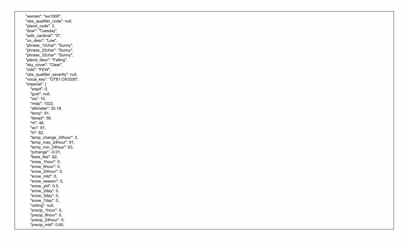
"wxman": "wx1000", "obs_qualifier_code": null, "ptend_code": 2, "dow": "Tuesday", "wdir_cardinal": "S", "uv_desc": "Low", "phrase_12char": "Sunny", "phrase_22char": "Sunny", "phrase_32char": "Sunny", "ptend_desc": "Falling", "sky_cover": "Clear", "clds": "FEW", "obs_qualifier_severity": null, "vocal_key": "OT81:OX3200", "imperial": { "wspd": 0, "gust": null, "vis": 10, "mslp": 1022, "altimeter": 30.18, "temp": 81, "dewpt": 58, "rh": 46, "wc": 81, "hi": 82, "temp_change_24hour": 3, "temp_max_24hour": 91, "temp_min_24hour": 63, "pchange": -0.01, "feels_like": 82, "snow_1hour": 0, "snow_6hour": 0, "snow_24hour": 0, "snow_mtd": 0, "snow_season": 0, "snow_ytd": 0.5, "snow_2day": 0, "snow_3day": 0, "snow_7day": 0, "ceiling": null, "precip_1hour": 0, "precip_6hour": 0, "precip_24hour": 0, "precip_mtd": 0.65,

"precip_ytd": 27.32, "precip_2day": 0, "precip_3day": 0, "precip_7day": 0.65, "obs_qualifier_100char": null, "obs_qualifier_50char": null, "obs_qualifier_32char": null } } }

Weather Company Data for Advanced Analytics | PWS Observations - Current Conditions - v2 Domain Portfolio: Observations | Domain: Current Conditions | API Name: PWS Observations - Current Conditions - v2
Standard HTTP Cache-Control headers are used to define caching length. The TTL value is provided in the HTTP Header as an absolute time value using the “Expires” parameter. Example: “Expires: Fri, 12 Jul 2013 12:00:00 GMT”. The response provides a data element expire_time_gmt, this should be used to expire and remove a record from your system.
Geography: Global Attribution Required: NO Attribution Requirements: N/A
Overview Personal Weather Station (PWS) Current Conditions returns the current conditions observations for the current record.Current record is the last record reported within 60 minutes. If the station has not reported a current conditions in the past 60 minutes, the response will not return an expired observation record (older than 60 minutes); a 'Data Expired' message will be returned instead.
Unit of Measure Requirement The unit of measure for the response. The following values are supported:
● e = English units ● m = Metric units ● h = Hybrid units (UK)
URL Construction
Request by Geocode (Latitude & Longitude): Required Parameters: format, units, stationId, apiKey apiKey=yourApiKey
https://api.weather.com/v2/pws/observations/current?stationId=KMAHANOV10&format=json&units=e&apiKey=yourApiKey
Data Elements & Definitions Note: Field names are sorted alphabetically in the table below for presentation purposes. The table below does not represent the sort order of the API response.
Field Name Description Type Range Sample Nulls Allowed
country Country Code string US Y
epoch Time in UNIX seconds epoch 1475157931 Y
humidity The relative humidity of the air. long 71 Y
lat Latitude of PWS decimal Any valid latitude value. -90 to 90 32.50828934 Y lon Longitude of PWS decimal Any valid longitude value. -180 to 180 -110.8763962 Y neighborhood Neighborhood associated with the PWS location string WOW Arizona! Y
obsTimeLocal Time observation is valid in local apparent time by timezone - tz ISO YYYYY-MM-dd HH:mm:ss 2016-09-29 14:05:31 Y obsTimeUtc GMT(UTC) time ISO ISO 8601 - yyyy-MM-dd'T'HH:mm:ssZZ 2016-09-29T14:05:31Z Y realtimeFrequency Frequency of data report updates in minutes decimal 5 Y
softwareType Software type of the PWS string WS-1001 V2.2.9 Y
solarRadiation Solar Radiation decimal 91.96 Y
stationID ID as registered by wunderground.com string KAZTUCSO539 N

uv UV reading of the intensity of solar radiation decimal 1 Y
winddir Wind Direction long 52 Y
imperial metric metric_si uk_hybrid
Object containing fields that use a defined unit of measure. The object label is dependent on the units parameter assigned in the request. "imperial", "metric", "metric_si", "uk_hybrid"
object imperial: {.....} N
dewpt The temperature which air must be cooled at constant pressure to reach saturation. The Dew Point is also an indirect measure of the humidity of the air. The Dew Point will never exceed the Temperature. When the Dew Point and Temperature are equal, clouds or fog will typically form. The closer the values of Temperature and Dew Point, the higher the relative humidity.
decimal -80 to 100 (°F) or -62 to 37 (°C)
58 Y
elev Elevation long 3094 Y
heatIndex Heat Index - An apparent temperature. It represents what the air temperature “feels like” on exposed human skin due to the combined effect of warm temperatures and high humidity. When the temperature is 70°F or higher, the Feels Like value represents the computed Heat Index.
long 67 Y
precipRate Rate of precipitation - instantaneous precipitation rate. How much rain would fall if the precipitation intensity did not change for one hour
decimal 0.03 Y
precipTotal Accumulated precipitation for today decimal 0.03 Y
pressure Mean Sea Level Pressure, the equivalent pressure reading at sea level recorded at this station decimal 30.06 Y
temp Temperature in defined unit of measure. long 67 Y
windChill Wind Chill - An apparent temperature. It represents what the air temperature “feels like” on exposed human skin due to the combined effect of the cold temperatures and wind speed. When the temperature is 61°F or lower the Feels Like value represents the computed Wind Chill so display the Wind Chill value.
long -34 Y
windGust Wind Gust - sudden and temporary variations of the average Wind Speed. The report always shows the maximum wind gust speed recorded during the observation period. It is a required display field if Wind Speed is shown.
decimal 56 Y
windSpeed Wind Speed - The wind is treated as a vector; hence, winds must have direction and magnitude (speed). The wind information reported in the hourly current conditions corresponds to a 10-minute average called the sustained wind speed. Sudden or brief variations in the wind speed are known as “wind gusts” and are reported in a separate data field. Wind directions are always expressed as ""from whence the wind blows"" meaning that a North wind blows from North to South. If you face North in a North wind the wind is at your face. Face southward and the North wind is at your back.
decimal 56 Y
JSON Sample { "observations": [ { "stationID": "KMAHANOV10", "obsTimeUtc": "2016-10-03T11:16:30Z", "obsTimeLocal": "2016-10-03 11:16:30", "neighborhood": "1505Broadway", "softwareType": "Rainwise IP-100",

"country": "US", "solarRadiation": null, "lon": -70.86485291, "realtimeFrequency": 3, "epoch": 1475493390, "lat": 42.09263229, "uv": null, "winddir": 90, "humidity": 100, "metric": { "temp": 13, "heatIndex": 13, "dewpt": 13, "windChill": null, "windSpeed": 0, "windGust": 0, "pressure": 1014.56, "precipRate": 1.52, "precipTotal": 1.02, "elev": 31 } } ] }

Weather Company Data for Advanced Analytics | Site-Based Observations - v1 Domain Portfolio: Observations | Domain: Current Conditions | API Name: Site-Based Observations - v1
Standard HTTP Cache-Control headers are used to define caching length. The TTL value is provided in the HTTP Header as an absolute time value using the “Expires” parameter. Example: “Expires: Fri, 12 Jul 2013 12:00:00 GMT”. The response provides a data element expire_time_gmt, this should be used to expire and remove a record from your system.
Geography: Global Attribution Required: NO Attribution Requirements: N/A
Overview Current Conditions are sourced from both physical site-based observation stations and synthetic weather observations produced by the TWC Currents system. This API returns the latest weather observation for the location supplied to include current temperatures, winds, pressure and other observed weather information. Weather observations from physical devices deployed worldwide (weather data collected from METAR, SYNOP, BUOY, CMAN devices).
Current Condition & Time-Series Data Access to retained site-based and synthetic data will be distributed on-demand in Current Conditions and Time Series data feeds. These recent observations are retained in the primary TWC database up to 48 hours ( 2 days ) on specific reporting stations and nn hours of observations per station. Observations per station within a 24 hour period varies due to station operation requirements (i.e. modified operating hours, number of observations recorded per hour, maintenance issues, etc).
The recent observations data will be continuously updated and replaced with a first-in / first-out methodology, (rotating data with newest observation and moving the oldest observations to the archive storage) based on date/time stamping of the observations. The amount of data retained and available from any given station may be more than a single observation or more than 24 individual observation reports for any given station id. The number of observations is determined by the type of observation it is, i.e. NWS, PWS, etc.
Translated Fields: This TWC API handles the translation of phrases. However, when formatting a request URL a valid language must be passed along (see the language code table for the supported codes).
● pressure_desc ● uv_desc ● wx_phrase ●
Unit of Measure Requirement The unit of measure for the response. The following values are supported:
● e = English units ● m = Metric units ● h = Hybrid units (UK)
URL Construction
Request by Geocode (Latitude & Longitude): Required Parameters: geocode, language, format, units, apiKey=yourApiKey
https://api.weather.com/v1/geocode/34.063/-84.217/observations.json?language=en-US&units=e&apiKey=yourApiKey
Request by Postal Code: Required Parameters: language, format, units, postal code apiKey=yourApiKey The Postal Code has a TWC proprietary location type (4) with the following format: location/<postal code>:<location type>:<country code>
https://api.weather.com/v1/location/30075:4:US/observations.json?language=en-US&units=e&apiKey=yourApiKey

Data Elements & Definitions Note: Field names are sorted alphabetically in the table below for presentation purposes. The table below does not represent the sort order of the API response.
Field Name Description Type Range Sample Nulls Allowed
blunt_phrase Weather description qualifier short phrase string Warmer than yesterday. Y
class data identifier string default observation N clds Cloud cover description code string SKC, CLR, SCT, FEW, BKN, OVC SKC Y day_ind Daytime or nighttime of the local apparent time of the location string D = Day, N = Night, X = Missing (for
extreme northern and southern hemisphere
D Y
dewpt The temperature which air must be cooled at constant pressure to reach saturation. The Dew Point is also an indirect measure of the humidity of the air. The Dew Point will never exceed the Temperature. When the Dew Point and Temperature are equal, clouds or fog will typically form. The closer the values of Temperature and Dew Point, the higher the relative humidity.
integer -80 to 100 (°F) or -62 to 37 (°C)
60 Y
expire_time_gmt Expiration time in UNIX seconds epoch 1369252800 N
feels_like An apparent temperature. It represents what the air temperature “feels like” on exposed human skin due to the combined effect of the wind chill or heat index.
integer -140 to 140 60 Y
gust Wind gust speed. This data field contains information about sudden and temporary variations of the average Wind Speed. The report always shows the maximum wind gust speed recorded during the observation period. It is a required display field if Wind Speed is shown. The speed of the gust can be expressed in miles per hour or kilometers per hour.
integer
35 Y
heat_index An apparent temperature. It represents what the air temperature “feels like” on exposed human skin due to the combined effect of warm temperatures and high humidity. When the temperature is 70°F or higher, the Feels Like value represents the computed Heat Index. For temperatures between 40°F and 70°F, the Feels Like value and Temperature are the same, regardless of wind speed and humidity, so use the Temperature value.
integer
70 Y
icon_extd The four-digit number to represent the observed weather conditions. Refer to the Icon Code, Weather Phrases and Images document
integer
5500 N
key Primary data field to group or access data string same as observation ID KATL N max_temp High temperature in the last 24 hours integer -140 to 140 81 Y min_temp Low temperature in the last 24 hours integer -140 to 140 48 Y obs_id Observation station ID string KATL N
obs_name Observation station name string Hartsfield-Jackson Airport N
precip_hrly Precipitation for the last hour decimal 0.00 to 99.99 0.5 Y precip_total Precipitation amount in the last rolling 24 hour period decimal 0.00 to 99.99 0.3 Y pressure Barometric pressure is the pressure exerted by the atmosphere at the earth's surface, due to the weight
of the air. This value is read directly from an instrument called a mercury barometer and its units are expressed in millibars (equivalent to HectoPascals).
double
30.06 Y
pressure_desc A phrase describing the change in the barometric pressure reading over the last hour. string Steady, Rising, Rapidly Rising, Falling,
Steady Y

Rapidly Falling pressure_tend The change in the barometric pressure reading over the last hour expressed as an integer. integer 0 = Steady
1 = Rising or Rapidly Rising 2 = Falling or Rapidly Falling
0 Y
qualifier Weather description qualifier code string QQ0063 Y
qualifier_svrty Weather description qualifier severity string 1 (low) to 6 (high) 1 Y rh The relative humidity of the air, which is defined as the ratio of the amount of water vapor in the air to
the amount of vapor required to bring the air to saturation at a constant temperature. Relative humidity is always expressed as a percentage.
integer 0 to 100 91 Y
snow_hrly Snow increasing rapidly in inches or centimeters per hour depending on whether or not the snowfall is reported by METAR or TECCI (synthetic observations). METAR snow accumulation for the last hour is in inches and TECCI is in centimeters.
decimal 0 to 15 1 Y
temp The temperature of the air, at the time of the observation, measured by a thermometer 1.5 meters (4.5 feet) above the ground that is shaded from the other elements.
integer -140 to 140 62 Y
terse_phrase Weather description qualifier terse phrase string Dangerous wind chills. Limit outdoor exposure. Y
uv_desc Ultraviolet index description string Extreme, High, Low, Minimal, Moderate, No Report, Not Available
High Y
uv_index Ultraviolet index integer 0 to 11 and 999 7 Y valid_time_gmt Valid time of observation as a Unix epoch value (seconds since start of 1970, UTC) epoch 1369252800 N
vis The horizontal visibility at the observation point. Visibilities can be reported as fractional values particularly when visibility is less than 2 miles. Visibilities greater than 10 statute miles(16.1 kilometers) which are considered “unlimited” are reported as “999” in your feed. You can also find visibility values that equal zero. This occurrence is not wrong. Dense fogs and heavy snows can produce values near zero. Fog, smoke, heavy rain and other weather phenomena can reduce visibility to near zero miles or kilometers.
double 0 to 999 or null; For greater than 1 = no decimal. For less than 1 = 2 (Metric) & 2 (Imperial) decimal places.
10, 0.25 (Metric) 0.25 (Imperial)
Y
wc An apparent temperature. It represents what the air temperature “feels like” on exposed human skin due to the combined effect of the cold temperatures and wind speed. When the temperature is 61°F or lower the Feels Like value represents the computed Wind Chill so display the Wind Chill value. For temperatures between 61°F and 75°F, the Feels Like value and Temperature are the same, regardless of wind speed and humidity, so display the Temperature value.
integer Use only if temperature is below 40 degrees Fahrenheit OR below 5 degrees Celsius
-25 Y
wdir The direction from which the wind blows expressed in degrees. The magnetic direction varies from 1 to 360 degrees, where 360° indicates the North, 90° the East, 180° the South, 270° the West, and so forth. A ‘null’ value represents no determinable wind direction.
integer 1 to 360 45 Y
wdir_cardinal This field contains the cardinal direction from which the wind blows in an abbreviated form. Wind directions are always expressed as “from whence the wind blows” meaning that a North wind blows from North to South. If you face North in a North wind, the wind is at your face. Face southward and the North wind is at your back.
string N , NNE , NE, ENE, E, ESE, SE, SSE, S, SSW, SW, WSW, W, WNW, NW, NNW, CALM, VAR
ENE Y
wspd Wind Speed. The wind is treated as a vector; hence, winds must have direction and magnitude (speed). The wind information reported in the hourly current conditions corresponds to a 10-minute average called the sustained wind speed. Sudden or brief variations in the wind speed are known as “wind gusts” and are reported in a separate data field. Wind directions are always expressed as "from whence the wind blows" meaning that a North wind blows from North to South. If you face North in a North wind the wind is at your face. Face southward and the North wind is at your back.
integer
15 Y

wx_icon The two-digit number to represent the observed weather conditions. Refer to the Icon Code, Weather Phrases and Images document
integer 0 to 48 47 Y
wx_phrase A text description of the observed weather conditions at the reporting station string 257 phrases Mostly sunny Y clds Cloud cover description code string SKC, CLR, SCT, FEW, BKN, OVC SKC N water_temp Water temperature integer 25 to 100 80 Y primary_wave_period Primary wave period integer 0-99 13 Y primary_wave_height Primary wave height decimal 0-99.99 3.28 Y primary_swell_period Primary swell period integer 0-99 13 Y primary_swell_height Primary swell height decimal 0-99.99 1.64 Y primary_swell_direction Primary swell direction integer 0 to 359 190 Y secondary_swell_period Secondary swell period integer 0-99 null Y secondary_swell_height Secondary swell height decimal 0-99.99 null Y secondary_swell_direction Secondary swell direction integer 0 to 359 null Y
JSON Sample { "metadata": { "language": "en-US", "transaction_id": "1473201321183:-1106734720", "version": "1", "latitude": 34.06, "longitude": -84.21, "units": "e", "expire_time_gmt": 1473207900, "status_code": 200 }, "observation": { "key": "T72227031", "class": "observation", "expire_time_gmt": 1473207900, "obs_id": "T72227031", "obs_name": "Duluth", "valid_time_gmt": 1473200700, "day_ind": "D", "temp": 90, "wx_icon": 32, "icon_extd": 3200, "wx_phrase": "Sunny", "pressure_tend": 0, "pressure_desc": "Steady", "dewPt": 54,

"heat_index": 88, "rh": 29, "pressure": 30.18, "vis": 10, "wc": 90, "wdir": 70, "wdir_cardinal": "ENE", "gust": null, "wspd": 1, "max_temp": 92, "min_temp": 63, "precip_total": 0, "precip_hrly": 0, "snow_hrly": 0, "uv_desc": "Low", "feels_like": 88, "uv_index": 1, "qualifier": "OQ0047", "qualifier_svrty": "1", "blunt_phrase": "Hot.", "terse_phrase": "Hot.", "clds": "SKC", "water_temp": null, "primary_wave_period": null, "primary_wave_height": null, "primary_swell_period": null, "primary_swell_height": null, "primary_swell_direction": null, "secondary_swell_period": null, "secondary_swell_height": null, "secondary_swell_direction": null } }
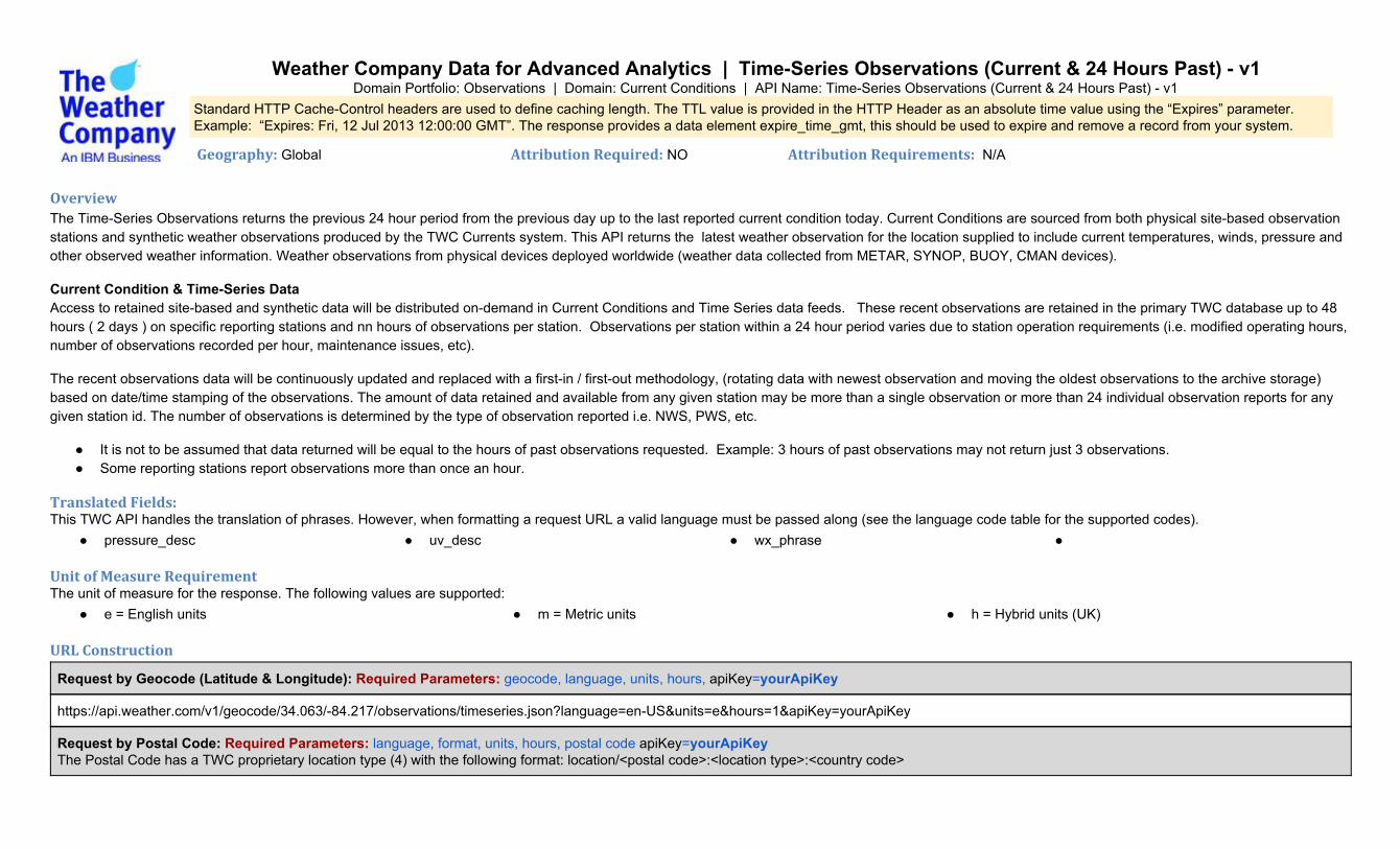
Weather Company Data for Advanced Analytics | Time-Series Observations (Current & 24 Hours Past) - v1 Domain Portfolio: Observations | Domain: Current Conditions | API Name: Time-Series Observations (Current & 24 Hours Past) - v1
Standard HTTP Cache-Control headers are used to define caching length. The TTL value is provided in the HTTP Header as an absolute time value using the “Expires” parameter. Example: “Expires: Fri, 12 Jul 2013 12:00:00 GMT”. The response provides a data element expire_time_gmt, this should be used to expire and remove a record from your system.
Geography: Global Attribution Required: NO Attribution Requirements: N/A
Overview The Time-Series Observations returns the previous 24 hour period from the previous day up to the last reported current condition today. Current Conditions are sourced from both physical site-based observation stations and synthetic weather observations produced by the TWC Currents system. This API returns the latest weather observation for the location supplied to include current temperatures, winds, pressure and other observed weather information. Weather observations from physical devices deployed worldwide (weather data collected from METAR, SYNOP, BUOY, CMAN devices).
Current Condition & Time-Series Data Access to retained site-based and synthetic data will be distributed on-demand in Current Conditions and Time Series data feeds. These recent observations are retained in the primary TWC database up to 48 hours ( 2 days ) on specific reporting stations and nn hours of observations per station. Observations per station within a 24 hour period varies due to station operation requirements (i.e. modified operating hours, number of observations recorded per hour, maintenance issues, etc).
The recent observations data will be continuously updated and replaced with a first-in / first-out methodology, (rotating data with newest observation and moving the oldest observations to the archive storage) based on date/time stamping of the observations. The amount of data retained and available from any given station may be more than a single observation or more than 24 individual observation reports for any given station id. The number of observations is determined by the type of observation reported i.e. NWS, PWS, etc.
● It is not to be assumed that data returned will be equal to the hours of past observations requested. Example: 3 hours of past observations may not return just 3 observations. ● Some reporting stations report observations more than once an hour.
Translated Fields: This TWC API handles the translation of phrases. However, when formatting a request URL a valid language must be passed along (see the language code table for the supported codes).
● pressure_desc ● uv_desc ● wx_phrase ●
Unit of Measure Requirement The unit of measure for the response. The following values are supported:
● e = English units ● m = Metric units ● h = Hybrid units (UK)
URL Construction
Request by Geocode (Latitude & Longitude): Required Parameters: geocode, language, units, hours, apiKey=yourApiKey
https://api.weather.com/v1/geocode/34.063/-84.217/observations/timeseries.json?language=en-US&units=e&hours=1&apiKey=yourApiKey
Request by Postal Code: Required Parameters: language, format, units, hours, postal code apiKey=yourApiKey The Postal Code has a TWC proprietary location type (4) with the following format: location/<postal code>:<location type>:<country code>

https://api.weather.com/v1/location/30075:4:US/observations/timeseries.json?language=en-US&units=e&hours=1&apiKey=yourApiKey
Data Elements & Definitions Note: Field names are sorted alphabetically in the table below for presentation purposes. The table below does not represent the sort order of the API response.
Field Name Description Type Range Sample Nulls Allowed
blunt_phrase Weather description qualifier short phrase string Warmer than yesterday. Y
class data identifier string default observation N clds Cloud cover description code string SKC, CLR, SCT, FEW, BKN, OVC SKC Y day_ind Daytime or nighttime of the local apparent time of the location string D = Day, N = Night, X = Missing (for
extreme northern and southern hemisphere
D Y
dewpt The temperature which air must be cooled at constant pressure to reach saturation. The Dew Point is also an indirect measure of the humidity of the air. The Dew Point will never exceed the Temperature. When the Dew Point and Temperature are equal, clouds or fog will typically form. The closer the values of Temperature and Dew Point, the higher the relative humidity.
integer -80 to 100 (°F) or -62 to 37 (°C)
60 Y
expire_time_gmt Expiration time in UNIX seconds epoch 1369252800 N
feels_like An apparent temperature. It represents what the air temperature “feels like” on exposed human skin due to the combined effect of the wind chill or heat index.
integer -140 to 140 60 Y
gust Wind gust speed. This data field contains information about sudden and temporary variations of the average Wind Speed. The report always shows the maximum wind gust speed recorded during the observation period. It is a required display field if Wind Speed is shown. The speed of the gust can be expressed in miles per hour or kilometers per hour.
integer
35 Y
heat_index An apparent temperature. It represents what the air temperature “feels like” on exposed human skin due to the combined effect of warm temperatures and high humidity. When the temperature is 70°F or higher, the Feels Like value represents the computed Heat Index. For temperatures between 40°F and 70°F, the Feels Like value and Temperature are the same, regardless of wind speed and humidity, so use the Temperature value.
integer
70 Y
icon_extd The four-digit number to represent the observed weather conditions. Refer to the Icon Code, Weather Phrases and Images document
integer
5500 N
key Primary data field to group or access data string same as observation ID KATL N max_temp High temperature in the last 24 hours integer -140 to 140 81 Y min_temp Low temperature in the last 24 hours integer -140 to 140 48 Y obs_id Observation station ID string KATL N
obs_name Observation station name string Hartsfield-Jackson Airport N
precip_hrly Precipitation for the last hour decimal 0.00 to 99.99 0.5 Y precip_total Precipitation amount in the last rolling 24 hour period decimal 0.00 to 99.99 0.3 Y pressure Barometric pressure is the pressure exerted by the atmosphere at the earth's surface, due to the weight of
the air. This value is read directly from an instrument called a mercury barometer and its units are expressed in millibars (equivalent to HectoPascals).
double
30.06 Y

pressure_desc A phrase describing the change in the barometric pressure reading over the last hour. string Steady, Rising, Rapidly Rising, Falling, Rapidly Falling
Steady Y
pressure_tend The change in the barometric pressure reading over the last hour expressed as an integer. integer 0 = Steady 1 = Rising or Rapidly Rising 2 = Falling or Rapidly Falling
0 Y
qualifier Weather description qualifier code string QQ0063 Y
qualifier_svrty Weather description qualifier severity string 1 (low) to 6 (high) 1 Y rh The relative humidity of the air, which is defined as the ratio of the amount of water vapor in the air to the
amount of vapor required to bring the air to saturation at a constant temperature. Relative humidity is always expressed as a percentage.
integer 0 to 100 91 Y
snow_hrly Snow increasing rapidly in inches or centimeters per hour depending on whether or not the snowfall is reported by METAR or TECCI (synthetic observations). METAR snow accumulation for the last hour is in inches and TECCI is in centimeters.
decimal 0 to 15 1 Y
temp The temperature of the air, at the time of the observation, measured by a thermometer 1.5 meters (4.5 feet) above the ground that is shaded from the other elements.
integer -140 to 140 62 Y
terse_phrase Weather description qualifier terse phrase string Dangerous wind chills. Limit outdoor exposure. Y
uv_desc Ultraviolet index description string Extreme, High, Low, Minimal, Moderate, No Report, Not Available
High Y
uv_index Ultraviolet index integer 0 to 11 and 999 7 Y valid_time_gmt Valid time of observation as a Unix epoch value (seconds since start of 1970, UTC) epoch 1369252800 N
vis The horizontal visibility at the observation point. Visibilities can be reported as fractional values particularly when visibility is less than 2 miles. Visibilities greater than 10 statute miles(16.1 kilometers) which are considered “unlimited” are reported as “999” in your feed. You can also find visibility values that equal zero. This occurrence is not wrong. Dense fogs and heavy snows can produce values near zero. Fog, smoke, heavy rain and other weather phenomena can reduce visibility to near zero miles or kilometers.
double 0 to 999 or null; For greater than 1 = no decimal. For less than 1 = 2 (Metric) & 2 (Imperial) decimal places.
10, 0.25 (Metric) 0.25 (Imperial)
Y
wc An apparent temperature. It represents what the air temperature “feels like” on exposed human skin due to the combined effect of the cold temperatures and wind speed. When the temperature is 61°F or lower the Feels Like value represents the computed Wind Chill so display the Wind Chill value. For temperatures between 61°F and 75°F, the Feels Like value and Temperature are the same, regardless of wind speed and humidity, so display the Temperature value.
integer Use only if temperature is below 40 degrees Fahrenheit OR below 5 degrees Celsius
-25 Y
wdir The direction from which the wind blows expressed in degrees. The magnetic direction varies from 1 to 360 degrees, where 360° indicates the North, 90° the East, 180° the South, 270° the West, and so forth. A ‘null’ value represents no determinable wind direction.
integer 1 to 360 45 Y
wdir_cardinal This field contains the cardinal direction from which the wind blows in an abbreviated form. Wind directions are always expressed as “from whence the wind blows” meaning that a North wind blows from North to South. If you face North in a North wind, the wind is at your face. Face southward and the North wind is at your back.
string N , NNE , NE, ENE, E, ESE, SE, SSE, S, SSW, SW, WSW, W, WNW, NW, NNW, CALM, VAR
ENE Y
wspd Wind Speed. The wind is treated as a vector; hence, winds must have direction and magnitude (speed). The wind information reported in the hourly current conditions corresponds to a 10-minute average called the sustained wind speed. Sudden or brief variations in the wind speed are known as “wind gusts” and are reported in a separate data field.
integer
15 Y
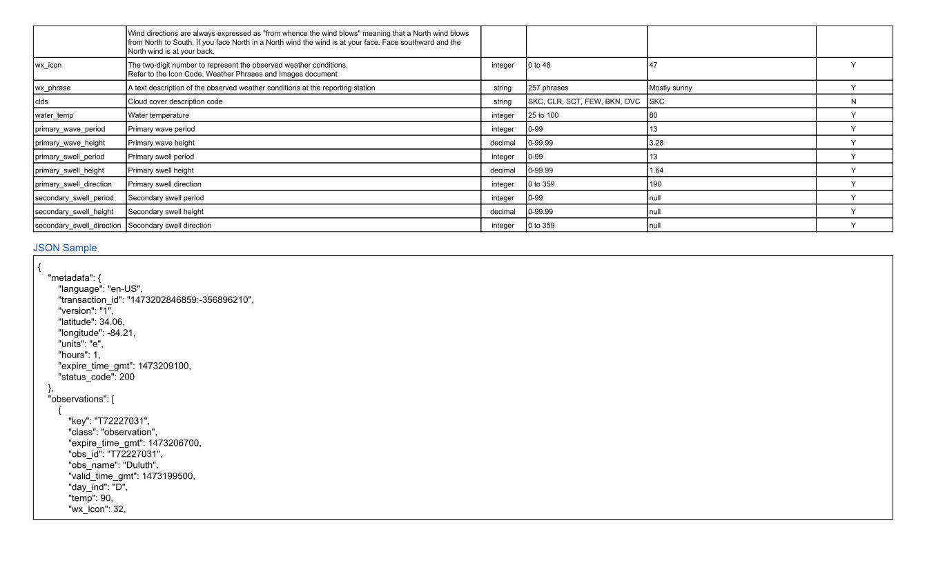
Wind directions are always expressed as "from whence the wind blows" meaning that a North wind blows from North to South. If you face North in a North wind the wind is at your face. Face southward and the North wind is at your back.
wx_icon The two-digit number to represent the observed weather conditions. Refer to the Icon Code, Weather Phrases and Images document
integer 0 to 48 47 Y
wx_phrase A text description of the observed weather conditions at the reporting station string 257 phrases Mostly sunny Y clds Cloud cover description code string SKC, CLR, SCT, FEW, BKN, OVC SKC N water_temp Water temperature integer 25 to 100 80 Y primary_wave_period Primary wave period integer 0-99 13 Y primary_wave_height Primary wave height decimal 0-99.99 3.28 Y primary_swell_period Primary swell period integer 0-99 13 Y primary_swell_height Primary swell height decimal 0-99.99 1.64 Y primary_swell_direction Primary swell direction integer 0 to 359 190 Y secondary_swell_period Secondary swell period integer 0-99 null Y secondary_swell_height Secondary swell height decimal 0-99.99 null Y secondary_swell_direction Secondary swell direction integer 0 to 359 null Y
JSON Sample { "metadata": { "language": "en-US", "transaction_id": "1473202846859:-356896210", "version": "1", "latitude": 34.06, "longitude": -84.21, "units": "e", "hours": 1, "expire_time_gmt": 1473209100, "status_code": 200 }, "observations": [ { "key": "T72227031", "class": "observation", "expire_time_gmt": 1473206700, "obs_id": "T72227031", "obs_name": "Duluth", "valid_time_gmt": 1473199500, "day_ind": "D", "temp": 90, "wx_icon": 32,

"icon_extd": 3200, "wx_phrase": "Sunny", "pressure_tend": 2, "pressure_desc": "Falling", "dewPt": 54, "heat_index": 88, "rh": 29, "pressure": 30.18, "vis": 10, "wc": 90, "wdir": 40, "wdir_cardinal": "NE", "gust": null, "wspd": 1, "max_temp": 92, "min_temp": 63, "precip_total": 0, "precip_hrly": 0, "snow_hrly": 0, "uv_desc": "Low", "feels_like": 88, "uv_index": 1, "qualifier": "OQ0047", "qualifier_svrty": "1", "blunt_phrase": "Hot.", "terse_phrase": "Hot.", "clds": "SKC", "water_temp": null, "primary_wave_period": null, "primary_wave_height": null, "primary_swell_period": null, "primary_swell_height": null, "primary_swell_direction": null, "secondary_swell_period": null, "secondary_swell_height": null, "secondary_swell_direction": null }, { // Response Collapsed for Presentation Purposes } ] }

Weather Company Data for Advanced Analytics | Historical Site-Based Observations - v1 Domain Portfolio: Observations | Domain: Historical | API Name: Historical Site-Based Observations - v1
Standard HTTP Cache-Control headers are used to define caching length. The TTL value is provided in the HTTP Header as an absolute time value using the “Expires” parameter. Example: “Expires: Fri, 12 Jul 2013 12:00:00 GMT”. The response provides a data element expire_time_gmt, this should be used to expire and remove a record from your system.
Geography: Global Attribution Required: NO Attribution Requirements: N/A
Overview Historical site-based observations are sourced from both physical site-based observation stations and synthetic weather observations produced by the TWC Currents system. This API returns the latest weather observation for the location supplied to include current temperatures, winds, pressure and other observed weather information. Weather observations from physical devices deployed worldwide (weather data collected from METAR, SYNOP, BUOY, CMAN devices).
Site-based Historical Observations Access to retained site-based and synthetic data will be distributed on-demand in historical data feeds. Past weather observations, up to one month (31 days max) of archived weather observation data for the location and date or daterange requested.
Limitation: Archived observation data varies significantly by station and location. The earliest date of data recorded is from January 1931, but not all months from this time forward are available. Observations per station within a 24 hour period varies due to station operation requirements (i.e. modified operating hours, number of observations recorded per hour, maintenance issues, etc).
Historical Observations Data and Their Limitations Historical observations are “archived” and originate from METAR and SYNOP observation stations/devices. Although there is archived observation data dating back to January 1931 from some METAR stations, the available historical data is not contiguous for all months in a given year, for every year, and for all locations. Please be aware that there is a large volume of historical records that can be retrieved. However there are gaps in which a “no data found” message will be displayed for a period. When observation data is provided, it is recommended that processing rules be applied to ensure the desired ordering of the observations (oldest to newest, newest to oldest) using the observation date/time element in the feed. Reporting stations report weather observations at different intervals. Some observations are reported hourly, some every 3 hours, every 6 hours, etc. Some stations do not report during nighttime hours.
● Please Note: that minimum and maximum temperature values are often null. The National Weather Service in the U.S. did not begin to provide these elements until recent years.
Translated Fields: This TWC API handles the translation of phrases. However, when formatting a request URL a valid language must be passed along (see the language code table for the supported codes).
● pressure_desc ● uv_desc ● wx_phrase ●
Unit of Measure Requirement The unit of measure for the response. The following values are supported:
● e = English units ● m = Metric units ● h = Hybrid units (UK)

URL Construction
Request by Geocode (Latitude & Longitude): Required Parameters: geocode, language, units, startDate (YYYYMMDD), endDate (YYYYMMDD), apiKey=yourApiKey
https://api.weather.com/v1/geocode/34.063/-84.217/observations.json?language=en-US&units=e&startDate=20140615&endDate=20140704&apiKey=yourApiKey
Request by Postal Code: Required Parameters: language, format, units, postal code, startDate (YYYYMMDD), endDate (YYYYMMDD), apiKey=yourApiKey The Postal Code has a TWC proprietary location type (4) with the following format: location/<postal code>:<location type>:<country code>
https://api.weather.com/v1/location/30075:4:US/observations.json?language=en-US&units=estartDate=20140615&endDate=20140704&apiKey=yourApiKey
Data Elements & Definitions Note: Field names are sorted alphabetically in the table below for presentation purposes. The table below does not represent the sort order of the API response.
Field Name Description Type Range Sample Nulls Allowed
blunt_phrase Weather description qualifier short phrase string Warmer than yesterday. Y
class data identifier string default observation N clds Cloud cover description code string SKC, CLR, SCT, FEW, BKN, OVC SKC Y day_ind Daytime or nighttime of the local apparent time of the location string D = Day, N = Night, X = Missing (for
extreme northern and southern hemisphere
D Y
dewpt The temperature which air must be cooled at constant pressure to reach saturation. The Dew Point is also an indirect measure of the humidity of the air. The Dew Point will never exceed the Temperature. When the Dew Point and Temperature are equal, clouds or fog will typically form. The closer the values of Temperature and Dew Point, the higher the relative humidity.
integer -80 to 100 (°F) or -62 to 37 (°C)
60 Y
expire_time_gmt Expiration time in UNIX seconds epoch 1369252800 N
feels_like An apparent temperature. It represents what the air temperature “feels like” on exposed human skin due to the combined effect of the wind chill or heat index.
integer -140 to 140 60 Y
gust Wind gust speed. This data field contains information about sudden and temporary variations of the average Wind Speed. The report always shows the maximum wind gust speed recorded during the observation period. It is a required display field if Wind Speed is shown. The speed of the gust can be expressed in miles per hour or kilometers per hour.
integer
35 Y
heat_index An apparent temperature. It represents what the air temperature “feels like” on exposed human skin due to the combined effect of warm temperatures and high humidity. When the temperature is 70°F or higher, the Feels Like value represents the computed Heat Index. For temperatures between 40°F and 70°F, the Feels Like value and Temperature are the same, regardless of wind speed and humidity, so use the Temperature value.
integer
70 Y
icon_extd The four-digit number to represent the observed weather conditions. Refer to the Icon Code, Weather Phrases and Images document
integer
5500 N
key Primary data field to group or access data string same as observation ID KATL N max_temp High temperature in the last 24 hours integer -140 to 140 81 Y min_temp Low temperature in the last 24 hours integer -140 to 140 48 Y

obs_id Observation station ID string KATL N
obs_name Observation station name string Hartsfield-Jackson Airport N
precip_hrly Precipitation for the last hour decimal 0.00 to 99.99 0.5 Y precip_total Precipitation amount in the last rolling 24 hour period decimal 0.00 to 99.99 0.3 Y pressure Barometric pressure is the pressure exerted by the atmosphere at the earth's surface, due to the weight
of the air. This value is read directly from an instrument called a mercury barometer and its units are expressed in millibars (equivalent to HectoPascals).
double
30.06 Y
pressure_desc A phrase describing the change in the barometric pressure reading over the last hour. string Steady, Rising, Rapidly Rising, Falling, Rapidly Falling
Steady Y
pressure_tend The change in the barometric pressure reading over the last hour expressed as an integer. integer 0 = Steady 1 = Rising or Rapidly Rising 2 = Falling or Rapidly Falling
0 Y
qualifier Weather description qualifier code string QQ0063 Y
qualifier_svrty Weather description qualifier severity string 1 (low) to 6 (high) 1 Y rh The relative humidity of the air, which is defined as the ratio of the amount of water vapor in the air to
the amount of vapor required to bring the air to saturation at a constant temperature. Relative humidity is always expressed as a percentage.
integer 0 to 100 91 Y
snow_hrly Snow increasing rapidly in inches or centimeters per hour depending on whether or not the snowfall is reported by METAR or TECCI (synthetic observations). METAR snow accumulation for the last hour is in inches and TECCI is in centimeters.
decimal 0 to 15 1 Y
temp The temperature of the air, at the time of the observation, measured by a thermometer 1.5 meters (4.5 feet) above the ground that is shaded from the other elements.
integer -140 to 140 62 Y
terse_phrase Weather description qualifier terse phrase string Dangerous wind chills. Limit outdoor exposure. Y
uv_desc Ultraviolet index description string Extreme, High, Low, Minimal, Moderate, No Report, Not Available
High Y
uv_index Ultraviolet index integer 0 to 11 and 999 7 Y valid_time_gmt Valid time of observation as a Unix epoch value (seconds since start of 1970, UTC) epoch 1369252800 N
vis The horizontal visibility at the observation point. Visibilities can be reported as fractional values particularly when visibility is less than 2 miles. Visibilities greater than 10 statute miles(16.1 kilometers) which are considered “unlimited” are reported as “999” in your feed. You can also find visibility values that equal zero. This occurrence is not wrong. Dense fogs and heavy snows can produce values near zero. Fog, smoke, heavy rain and other weather phenomena can reduce visibility to near zero miles or kilometers.
double 0 to 999 or null; For greater than 1 = no decimal. For less than 1 = 2 (Metric) & 2 (Imperial) decimal places.
10, 0.25 (Metric) 0.25 (Imperial)
Y
wc An apparent temperature. It represents what the air temperature “feels like” on exposed human skin due to the combined effect of the cold temperatures and wind speed. When the temperature is 61°F or lower the Feels Like value represents the computed Wind Chill so display the Wind Chill value. For temperatures between 61°F and 75°F, the Feels Like value and Temperature are the same, regardless of wind speed and humidity, so display the Temperature value.
integer Use only if temperature is below 40 degrees Fahrenheit OR below 5 degrees Celsius
-25 Y
wdir The direction from which the wind blows expressed in degrees. The magnetic direction varies from 1 to 360 degrees, where 360° indicates the North, 90° the East, 180° the South, 270° the West, and so
integer 1 to 360 45 Y

forth. A ‘null’ value represents no determinable wind direction. wdir_cardinal This field contains the cardinal direction from which the wind blows in an abbreviated form. Wind
directions are always expressed as “from whence the wind blows” meaning that a North wind blows from North to South. If you face North in a North wind, the wind is at your face. Face southward and the North wind is at your back.
string N , NNE , NE, ENE, E, ESE, SE, SSE, S, SSW, SW, WSW, W, WNW, NW, NNW, CALM, VAR
ENE Y
wspd Wind Speed. The wind is treated as a vector; hence, winds must have direction and magnitude (speed). The wind information reported in the hourly current conditions corresponds to a 10-minute average called the sustained wind speed. Sudden or brief variations in the wind speed are known as “wind gusts” and are reported in a separate data field. Wind directions are always expressed as "from whence the wind blows" meaning that a North wind blows from North to South. If you face North in a North wind the wind is at your face. Face southward and the North wind is at your back.
integer
15 Y
wx_icon The two-digit number to represent the observed weather conditions. Refer to the Icon Code, Weather Phrases and Images document
integer 0 to 48 47 Y
wx_phrase A text description of the observed weather conditions at the reporting station string 257 phrases Mostly sunny Y clds Cloud cover description code string SKC, CLR, SCT, FEW, BKN, OVC SKC N water_temp Water temperature integer 25 to 100 80 Y primary_wave_period Primary wave period integer 0-99 13 Y primary_wave_height Primary wave height decimal 0-99.99 3.28 Y primary_swell_period Primary swell period integer 0-99 13 Y primary_swell_height Primary swell height decimal 0-99.99 1.64 Y primary_swell_direction Primary swell direction integer 0 to 359 190 Y secondary_swell_period Secondary swell period integer 0-99 null Y secondary_swell_height Secondary swell height decimal 0-99.99 null Y secondary_swell_direction Secondary swell direction integer 0 to 359 null Y
JSON Sample { "metadata": { "language": "en-US", "transaction_id": "1474388670432:-282484419", "version": "1", "latitude": 33.4, "longitude": -83.19, "units": "e", "expire_time_gmt": 1474392270, "status_code": 200 }, "observations": [ { "key": "K3J7",

"class": "observation", "expire_time_gmt": 1402812900, "obs_id": "K3J7", "obs_name": "Greensboro", "valid_time_gmt": 1402805700, "day_ind": "N", "temp": 72, "wx_icon": 33, "icon_extd": 3300, "wx_phrase": "Fair", "pressure_tend": null, "pressure_desc": null, "dewPt": 66, "heat_index": 72, "rh": 83, "pressure": 29.29, "vis": 10, "wc": 72, "wdir": null, "wdir_cardinal": "CALM", "gust": null, "wspd": 0, "max_temp": null, "min_temp": null, "precip_total": null, "precip_hrly": 0, "snow_hrly": null, "uv_desc": "Low", "feels_like": 72, "uv_index": 0, "qualifier": null, "qualifier_svrty": null, "blunt_phrase": null, "terse_phrase": null, "clds": "CLR", "water_temp": null, "primary_wave_period": null, "primary_wave_height": null, "primary_swell_period": null, "primary_swell_height": null, "primary_swell_direction": null, "secondary_swell_period": null, "secondary_swell_height": null, "secondary_swell_direction": null

}, // Response Collapsed for Presentation Purposes ] }

CLEANED OBSERVATION
API DOCUMENTATION
UPDATED: MAY 10, 2017

TWC GLOBAL DATA SETS
Page 1 | The Weather Company business.weather.com
TWC Global Data Sets The method which may be used to access the WSI global data sets programmatically is via a REST web services data request. First, establish an account with WS where in which an account with a unique ID will be created and provided. You may have multiple accounts. Each key is configured to allow up to X number of calls per month which was discussed and agreed upon in conversations with your TWC account manager. The definition of a call is noted below.
An API call is defined as 7 days or less of data. For example, if you request 14 days of data it would be counted as 2 calls against your monthly call allowance.
1.) Standard/Premium Weather Variables
2.) Degree Day Variables
3.) Hi-Resolution Precipitation
1. STANDARD/PREMIUM WEATHER VARIABLES
Certain parameters are required to initiate a weather request. As is standard in URIs, all parameters are separated using the ampersand (&) character. The list of parameters and their possible values are enumerated below.
Each API key is provisioned to provide data for a specific set of Standard Weather Variables. In addition, your key can be provisioned for access to a special set of 6 Premium Weather Variables. The specific set of Standard and Premium Variables can be found in tables listed below.
• userKey (required) — this unique client identifier is assigned by WSI • lat/long or zipcode (required) – Data can be requested either by latitude/longitude or zip code.
Currently searching by zip code is only supported for US zip codes. • startDate (required) — “mm/dd/yyyy” Indicates the starting date for weather request (Start date
is first hour of requested date)

TWC GLOBAL DATA SETS
Page 2 | The Weather Company business.weather.com
• endDate (required) — “mm/dd/yyyy” indicates the ending date for weather request (End date is first hour of date requested, Data will be returned between the first hour of start date and first hour of end date. Make end date an extra day if you would like data for that day.)
• interval (required) — The desired temporal resolution of the data being retrieved. Accepted values are:
• hourly
• daily
• monthly
• units (required) — The desired units in which to express the data being retrieved. Accepted values are:
• imperial • metric
• format (required) — The desired format in which to return the data being retrieved. Accepted values are:
• json
• xml • csv
• version – The specific version of the API to be utilized. Currently accepted values are: • 2
x station – The specific data source to use for the requested location. o cfsr – Use the closest virtual grid point to the requested location. You are
guaranteed to have data returned for the entire time frame requested when using this value - Default
o metar – Will conduct a nearest neighbor search and chooses a METAR station if it is 17.5 km or less from the requested location. If a METAR station is used, you are not guaranteed to have data returned for the entire time frame requested. METAR data is only returned for the period of the requested time period in which it is available. Premium Weather Variables are not available when using this option.
x fields – Specify the specific set of variables to return in the data being retrieved. Accepted values are in the table provided below. You can specify more than one variable by separating each value by a comma, i.e. fields=windSpeedMph,surfaceTemperatureFahrenheit. If no fields are specified, all parameters will be returned.
x time – Specify the time unit the requested data is returned in. Accepted values are: • lwt (local wall time) • gmt (Greenwich mean time) - Default
x delivery – Specify how the data is returned. Accepted values are: x stream – Data is delivered directly to the browser or the application that makes the
API call x file – Data is delivered in a file that is downloaded to your system – Default

TWC GLOBAL DATA SETS
Page 3 | The Weather Company business.weather.com
Available Standard Weather Variables Name Description SiteId Site / location identifier (either Virtual Grid Square ID or
METAR ID) dateHrGmt Greenwich Mean Time (GMT) date-time (also known as
Universal Time) dateHrLwt Valid local date-time (Local wall time {includes daylight
savings time}) surfaceTemperatureFahrenheit Surface air (dry bulb) temperature at 2 meters
surfaceDewpointTemperatureFahrenheit Atmospheric humidity metric (temperature at which dew will form)
surfaceWetBulbTemperatureFahrenheit Atmospheric humidity metric (evaporative cooling potential of moist surface)
relativeHumidityPercent Percent of water vapor in the air relative to its saturation point
apparentTemperatureFahrenheit Air temperature that includes impact of wind and humidity
windChillTemperatureFahrenheit Air temperature that includes impact of wind heatIndexFahrenheit Air temperature that includes the impact of humidity
precipitationPreviousHourInches Liquid equivalent for types: warm rain, freezing rain, sleet, snow
snowfallInches Total Snowfall surfaceAirPressureMillibars Atmospheric pressure at the Surface
mslPressureMillibars Mean Sea Level Pressure cloudCoveragePercent Percentage of the sky covered by clouds
windSpeedMph Unobstructed wind speed at 10 meters windDirectionDegrees Upwind direction (e.g., wind from east = 270, from south
= 180, etc.) at 10 meters surfaceWindGustsMph Unobstructed wind gusts at 10 meters
diffuseHorizontalRadiationWsqm Diffuse (indirect) solar radiation flux on a plane parallel to the Earth's surface
directNormalIrradianceWsqm Direct solar radiation flux on a surface 90 deg to the sun downwardSolarRadiationWsqm Total solar radiation flux on a plane parallel to the
Earth's surface surfaceTemperatureCelsius Surface air (dry bulb) temperature at 2 meters
surfaceDewpointTemperatureCelsius Atmospheric humidity metric (temperature at which dew will form)
surfaceWetBulbTemperatureCelsius Atmospheric humidity metric (evaporative cooling potential of moist surface)
apparentTemperatureCelsius Air temperature that includes impact of wind and humidity
windChillTemperatureCelsius Air temperature that includes impact of wind

TWC GLOBAL DATA SETS
Page 4 | The Weather Company business.weather.com
heatIndexCelsius Air temperature that includes the impact of humidity snowfallCentimeters Total Snowfall
precipitationPreviousHourCentimeters Liquid equivalent for types: warm rain, freezing rain, sleet, snow
surfaceAirPressureKilopascals Atmospheric pressure mslPressureKilopascals Mean Sea Level Pressure surfaceWindGustsKph Unobstructed wind gusts at 10 meters
windSpeedKph Unobstructed wind speed at 10 meters
Available Premium Weather Variables
Name Description potentialEvapotranspirationMicrometersPerHour
Maximum evaporation rate possible (sum of
evaporation and plant transpiration) surfaceWaterRunOffMillimeters Precipitation in previous hour expected to run
off (not be absorbed) zeroToTenLiquidSoilMoisturePercent Layer-average by volume zeroToTenSoilTemperatureFahrenheit Layer-average
zeroToTenSoilTemperatureCelsius Layer-average tenToFortyLiquidSoilMoisturePercent Layer-average by volume tenToFortySoilTemperatureFahrenheit Layer-average
tenToFortySoilTemperatureCelsius Layer-average
Response Messages HTTP Status Code Reason 400 Bad Request 401 Unauthorized 403 Forbidden 404 Not Found 429 Too many requests
Date Range Restriction: There is a max of 1 year of historical data allowed per request. If you request more than 1 year of data your end date will be shortened. You would receive data from your start date to 1 year out.
Examples to Retrieve Standard Parameters
Sample {Lat/Long} URL request (Required Parameters)

TWC GLOBAL DATA SETS
Page 5 | The Weather Company business.weather.com
http://cleanedobservations.wsi.com/CleanedObs.svc/GetObs?version=2&lat=42.134&long=-78.132&startDate=05/01/2015&endDate=05/02/2015&interval=hourly&units=imperial&format=json&userKey=99999999999999999999999999999999
Sample {Lat/Long} URL request (All Parameters)
http://cleanedobservations.wsi.com/CleanedObs.svc/GetObs? version=2&lat=42.303&long=99.062&startDate=05/01/2015&endDate=05/02/2015&interval=hourly&units=imperial&format=json&fields=surfaceTemperatureFahrenheit,relativeHumidity,windSpeedMph,downwardSolarRadiation&delivery=file&userKey=99999999999999999999999999999999
Sample {Zipcode} URL request (Required Parameters)
http://cleanedobservations.wsi.com/CleanedObs.svc/GetObs? version=2&zipcode=01810&startDate=05/01/2015&endDate=05/02/2015&interval=hourly&units=imperial&format=json&userKey=99999999999999999999999999999999
Sample {Zipcode} URL request (All Parameters)
http://cleanedobservations.wsi.com/CleanedObs.svc/GetObs? version=2&zipcode=01810&startDate=05/01/2015&endDate=05/02/2015&interval=hourly&units=imperial&format=json&fields=surfaceTemperatureFahrenheit,relativeHumidity,windSpeedMph,downwardSolarRadiation&delivery=stream&userKey=99999999999999999999999999999999
Examples to Retrieve Standard & Premium Parameters Sample {Lat/Long} URL request (Required Parameters)
http://cleanedobservations.wsi.com/CleanedObs.svc/premium?version=2&lat=42.134&long=-78.132&startDate=05/01/2015&endDate=05/02/2015&interval=hourly&units=imperial&format=json&userKey=99999999999999999999999999999999
Sample {Lat/Long} URL request (All Parameters)
http://cleanedobservations.wsi.com/CleanedObs.svc/premium? version=2&lat=42.303&long=99.062&startDate=05/01/2015&endDate=05/02/2015&interval=hourly&units=imperial&format=json&fields=TenToFortyLiquidSoilMoisture&delivery=file&userKey=99999999999999999999999999999999
Sample {Zipcode} URL request (Required Parameters)

TWC GLOBAL DATA SETS
Page 6 | The Weather Company business.weather.com
http://cleanedobservations.wsi.com/CleanedObs.svc/premium? version=2&zipcode=01810&startDate=05/01/2015&endDate=05/02/2015&interval=hourly&units=imperial&format=json&userKey=99999999999999999999999999999999
Sample {Zipcode} URL request (All Parameters)
http://cleanedobservations.wsi.com/CleanedObs.svc/premium? version=2&zipcode=01810&startDate=05/01/2015&endDate=05/02/2015&interval=hourly&units=imperial&format=json&fields=TenToFortyLiquidSoilMoisture&delivery=file&userKey=99999999999999999999999999999999
2. DEGREE DAY VARIABLES
Certain parameters are required to initiate a weather request. As is standard in URIs, all parameters are separated using the ampersand (&) character. The list of parameters and their possible values are enumerated below.
• userKey (required) — this unique client identifier is assigned by WSI
• lat/long (required) – latitude/longitude for which data is being requested for
• startDate (required) — “mm/dd/yyyy” Indicates the starting date for weather request (Start date
is first hour of requested date)
• endDate (required) — “mm/dd/yyyy” indicates the ending date for weather request (End date is
first hour of date requested, Data will be returned between the first hour of start date and first
hour of end date. Make end date an extra day if you would like data for that day.)
• units (required) — The desired units in which to express the data being retrieved. Accepted
values are:
• imperial
• metric
• format (required) — The desired format in which to return the data being retrieved. Accepted
values are:
• json
• xml
• csv
x delivery – Specify how the data is returned. Accepted values are:

TWC GLOBAL DATA SETS
Page 7 | The Weather Company business.weather.com
x stream – Data is delivered directly to the browser or the application that makes the
API call
x file – Data is delivered in a file that is downloaded to your system – Default
• version – The specific version of the API to be utilized. Currently accepted values are:
• 2
• crop – Specific to Growing Degree Days and Killing Degree Days. Currently accepted values
are:
• Corn - Default
• Wheat
• Potato
• Cotton
• Peanut
• basetemp – The base temperature to be used in the Growing/Killing Degree Day calculation.
The value can be provided in either Fahrenheit or Celsius but needs to be consistent with the
value used for the “units” parameter.
If both the “crop” and “basetemp” parameters are not provided a Default value of 50F is
used. Otherwise, the default basetemp for the entered crop will be used which are listed below
within the Definitions section.
Definitions:
Cooling Degree Days - Difference of average daily temperature and 65 F / 18 C. If positive, equals the difference. Else is 0.
Heating Degree Days - Difference of 65 F / 18 C and average daily temperature. If positive, equals the difference. Else is 0.
Growing/Killing Degree Days - Difference from average daily temperature from base temperature of a crop (base temperature is defined by crop). Equals 0 if average daily temperature is below 32 F / 0 C or above 86 F / 30 C.
Default basetemp based on crop:
Corn: 50 F / 10 C Wheat: 40 F / 4 C Cotton: 60 F / 16 C Peanut: 56 F / 13 C

TWC GLOBAL DATA SETS
Page 8 | The Weather Company business.weather.com
Potato: 45 F / 7 C
Response Messages HTTP Status Code Reason 400 Bad Request 401 Unauthorized 403 Forbidden 404 Not Found 429 Too many requests
Date Range Restriction: There is a max of 1 year of historical data allowed per request. If you request more than 1 year of data your end date will be shortened. You would receive data from your start date to 1 year out.
Examples Calculate Growing/Killing Degree Days for Corn with a basetemp of 55F
http://cleanedobservations.wsi.com//CleanedObs.svc/GetDegreeDay?lat=42.134&long=-78.132&startDate=05/01/2015&endDate=05/02/2015&station=metar&units=imperial&crop=corn&basetemp=55&format=xml&userKey=999999999999999999999999999&delivery=stream
Calculate Growing/Killing Degree Days for Wheat with a basetemp of 10C
http://cleanedobservations.wsi.com//CleanedObs.svc/GetDegreeDay?lat=42.134&long=-78.132&startDate=05/01/2015&endDate=05/02/2015&station=metar&units=metric&crop=wheat&basetemp=10&format=xml&userKey=9999999999999999999999999999&delivery=stream
3. Hi-Resolution Precipitation
Our standard datasets provide precipitation data at 30km resolution but we now provide access to a higher resolution suite of precipitation data. Data can be retrieved for locations in the Continental United States at both 1km and 4km resolution. Data is available globally at 8km resolution between 60 degrees N and 60 degrees S. Temporal availability for each resolution is outlined below.
1km: June 1, 2015 to Present
4km: January 1, 2002 to Present
8km: December 1, 2015 to Present

TWC GLOBAL DATA SETS
Page 9 | The Weather Company business.weather.com
Certain parameters are required to initiate a weather request. As is standard in URIs, all parameters are separated using the ampersand (&) character. The list of parameters and their possible values are enumerated below.
• userKey (required) — this unique client identifier is assigned by WSI
• lat/long (required) – latitude/longitude for which data is being requested for
• startDate (required) — “mm/dd/yyyy” Indicates the starting date for weather request (Start date
is first hour of requested date)
• interval (required) — The desired temporal resolution of the data being retrieved. Accepted values are:
• hourly
• daily
• monthly
• endDate (required) — “mm/dd/yyyy” indicates the ending date for weather request (End date is
first hour of date requested, Data will be returned between the first hour of start date and first
hour of end date. Make end date an extra day if you would like data for that day.)
• units (required) — The desired units in which to express the data being retrieved. Accepted
values are:
• imperial
• metric
x time – Specify the time unit the requested data is returned in. Accepted values are: • lwt (local wall time) • gmt (Greenwich mean time) – Default
• peril (required) — The parameter type desired. Accepted values are:
• precipitation
• rain
• snow
• freezingrain

TWC GLOBAL DATA SETS
Page 10 | The Weather Company business.weather.com
• resolution (required) – The desired spatial resolution
• 1km (Data only available over the Continental United States)
• 4km (Data only available over the Continental United States)
• 8km (Data available globally between 600N and 600S)
• format (required) — The desired format in which to return the data being retrieved. Accepted
values are:
• json
• xml
• csv
x delivery – Specify how the data is returned. Accepted values are:
x stream – Data is delivered directly to the browser or the application that makes the
API call
x file – Data is delivered in a file that is downloaded to your system – Default Value
• version – The specific version of the API to be utilized. Currently accepted values are:
• 1 – Default Value
Date Range Restriction: There is a max of 1 year of historical data allowed per request. If you request more than 1 year of data your end date will be shortened. You would receive data from your start date to 1 year out.
Examples Retrieve 8km hourly rainfall data in a CSV file
http://cleanedobservations.wsi.com//CleanedObs.svc/precip?version=1&lat=42.134&long=-78.132&startDate=02/11/2017&endDate=02/12/2017&peril=rain&interval=hourly&units=imperial&time=gmt&format=csv&userKey=999999999999999999999999999&delivery=file&resolution=8km

ABOUT THE WEATHER COMPANY
Page 11 | The Weather Company business.weather.com
Retrieve 4km hourly rainfall data in XML format displayed in your browser and streamed directly to your custom software
http://cleanedobservations.wsi.com//CleanedObs.svc/precip?version=1&lat=42.134&long=-78.132&startDate=02/11/2017&endDate=02/12/2017&peril=rain&interval=hourly&units=imperial&time=gmt&format=xml&userKey=999999999999999999999999999&delivery=stream&resolution=4km
About The Weather Company The Weather Company, an IBM Business, is the world's largest private weather enterprise, helping people make informed decisions – and take action – in the face of weather. The company offers the most accurate, personalized and actionable weather data and insights to millions of consumers and thousands of businesses via Weather’s API, its business solutions division, and its own digital products from The Weather Channel (weather.com) and Weather Underground (wunderground.com).
The company delivers up to 26 billion forecasts daily. Its products include a top weather app on all major mobile platforms globally; the world’s largest network of personal weather stations; a top-20 U.S. website; the seventh most data-rich site in the world; one of the world’s largest IoT data platforms; and industry-leading business solutions. Weather Means Business™. The world’s biggest brands in aviation, energy, insurance, media, and government rely on The Weather Company for data, technology platforms and services to help improve decision-making and respond to weather’s impact on business.
Contact Information
The Weather Company 400 Minuteman Road Andover, MA 01810
Phone: (978) 983-6300 Website: http://business.weather.com

Weather Company Data for Advanced Analytics | PWS Daily Summary - 7 Day History - v2 Domain Portfolio: Observations | Domain: Historical | API Name: PWS Daily Summary - 7 Day History - v2
Standard HTTP Cache-Control headers are used to define caching length. The TTL value is provided in the HTTP Header as an absolute time value using the “Expires” parameter. Example: “Expires: Fri, 12 Jul 2013 12:00:00 GMT”. The response provides a data element expire_time_gmt, this should be used to expire and remove a record from your system.
Geography: Global Attribution Required: NO Attribution Requirements: N/A
Overview Personal Weather Station (PWS) Daily Summary Historical Observations returns the daily summary of daily observations for each day's observations report.
Unit of Measure Requirement The unit of measure for the response. The following values are supported:
● e = English units ● m = Metric units ● h = Hybrid units (UK)
URL Construction
Request by Geocode (Latitude & Longitude): Required Parameters: format, units, stationId, apiKey apiKey=yourApiKey
https://api.weather.com/v2/pws/dailysummary/7day?stationId=KMAHANOV10&format=json&units=e&apiKey=yourApiKey
Data Elements & Definitions Note: Field names are sorted alphabetically in the table below for presentation purposes. The table below does not represent the sort order of the API response.
Field Name Description Type Range Sample Nulls Allowed
epoch Time in UNIX seconds epoch 1369252800 Y
humidityAvg Average Humidity of the period long 32 Y
humidityHigh Highest Humidity of the period long 32 Y
humidityLow Lowest Humidity of the period long 32 Y
lat Latitude of PWS decimal Any valid latitude value. -90 to 90 29.8972 Y
lon Longitude of PWS decimal Any valid longitude value. -180 to 180 -97.9362 Y
obsTimeLocal Time observation is valid in local apparent time by timezone ISO YYYYY-MM-dd HH:mm:ss 2016-09-27 00:59:39 Y
obsTimeUtc GMT(UTC) time ISO ISO 8601 - yyyy-MM-dd'T'HH:mm:ssZZ 2016-09-27T06:59:39Z Y
solarRadiationHigh Highest Solar Radiation of the period decimal 947 Y
stationID ID as registered by wunderground.com string KAZTUCSO539 N
tz Time zone of PWS string America/Chicago Y
uvHigh Highest UV Index of the period decimal 2 Y
winddirAvg Wind direction average of the period long 170 Y
imperial Object containing fields that use a defined unit of measure. The object label is dependent on the units object imperial: {.....} N

metric metric_si uk_hybrid
parameter assigned in the request. "imperial", "metric", "metric_si", "uk_hybrid"
dewptAvg Average dew point of the period decimal -80 to 100 (°F) or -62 to 37 (°C)
43.0 Y
dewptHigh Maximum dew point of the period decimal -80 to 100 (°F) or -62 to 37 (°C)
43.0 Y
dewptLow Minimum dew point of the period decimal -80 to 100 (°F) or -62 to 37 (°C)
43.0 Y
heatindexAvg Heat index average of the period long 68.2 Y
heatindexHigh Heat index high temperature of the period long 71.8 Y
heatindexLow Heat index low temperature of the period long 61.7 Y
precipRate Rate of precipitation - instantaneous precipitation rate. How much rain would fall if the precipitation intensity did not change for one hour
decimal 0.03 Y
precipTotal Accumulated Rain for the day in defined unit of measure decimal 0.03 Y
pressureMax Highest Barometric pressure in defined unit of measure of the period decimal 30.12 Y
pressureMin Lowest Barometric pressure in defined unit of measure of the period decimal 0.01 Y
pressureTrend Pressure tendency over the preceding period decimal 28.09 Y
tempAvg Temperature average of the period long 72.7 Y
tempHigh High Temperature of the period long 87.3 Y
tempLow Low Temperature of the period long 63.7 Y
windchillAvg Windchill average of the period long 32 Y
windchillHigh High Windchill temperature of the period long 45 Y
windchillLow Low Windchill temperature of the period long 35 Y
windgustAvg Wind gust average of the period decimal 54 Y
windgustHigh Highest Wind gust of the period decimal 56 Y
windgustLow Lowest Wind gust of the period decimal 43 Y
windspeedAvg Wind speed average of the period decimal 3 Y
windspeedHigh Highest Wind speed of the period decimal 5 Y
windspeedLow Lowest Wind speed of the period decimal 1 Y
JSON Sample { "summaries": [ { "stationID": "KMAHANOV10", "tz": "America/New_York", "obsTimeUtc": "2016-09-28T03:59:54Z", "obsTimeLocal": "2016-09-27 23:59:54",

"epoch": 1475035194, "lat": 42.09263229, "lon": -70.86485291, "solarRadiationHigh": null, "uvHigh": null, "winddirAvg": 0, "humidityHigh": 97, "humidityLow": 77, "humidityAvg": 88, "metric": { "tempHigh": 21, "tempLow": 11, "tempAvg": 17, "windspeedHigh": 0, "windspeedLow": 0, "windspeedAvg": 0, "windgustHigh": 0, "windgustLow": 0, "windgustAvg": 0, "dewptHigh": 18, "dewptLow": 9, "dewptAvg": 14, "windchillHigh": null, "windchillLow": null, "windchillAvg": null, "heatindexHigh": 21, "heatindexLow": 12, "heatindexAvg": 17, "pressureMax": null, "pressureMin": null, "pressureTrend": null, "precipRate": 0, "precipTotal": 10.41 } }, // Response Collapsed for Presentation Purposes ] }

Weather Company Data for Advanced Analytics | PWS Recent History - 1 Day - Rapid History - v2 Domain Portfolio: Observations | Domain: Historical | API Name: PWS Recent History - 1 Day - Rapid History - v2
Standard HTTP Cache-Control headers are used to define caching length. The TTL value is provided in the HTTP Header as an absolute time value using the “Expires” parameter. Example: “Expires: Fri, 12 Jul 2013 12:00:00 GMT”. The response provides a data element expire_time_gmt, this should be used to expire and remove a record from your system.
Geography: Global Attribution Required: NO Attribution Requirements: N/A
Overview Personal Weather Station (PWS) Rapid Historical Observations returns the daily observations records in rapid frequency as frequent as every 5 minutes. Actual frequency of reports ranges and is dependent on how frequently an individual Personal Weather Station (PWS) reports data.
Unit of Measure Requirement The unit of measure for the response. The following values are supported:
● e = English units ● m = Metric units ● h = Hybrid units (UK)
URL Construction
Request by Geocode (Latitude & Longitude): Required Parameters: format, units, stationId, apiKey apiKey=yourApiKey
https://api.weather.com/v2/pws/observations/all/1day?stationId=KMAHANOV10&format=json&units=e&apiKey=yourApiKey
Data Elements & Definitions Note: Field names are sorted alphabetically in the table below for presentation purposes. The table below does not represent the sort order of the API response.
Field Name Description Type Range Sample Nulls Allowed
epoch Time in UNIX seconds epoch 1369252800 Y
humidityAvg Average Humidity of the period long 32 Y
humidityHigh Highest Humidity of the period long 32 Y
humidityLow Lowest Humidity of the period long 32 Y
lat Latitude of PWS decimal Any valid latitude value. -90 to 90 29.8972 Y
lon Longitude of PWS decimal Any valid longitude value. -180 to 180 -97.9362 Y
obsTimeLocal Time observation is valid in local apparent time by timezone ISO YYYYY-MM-dd HH:mm:ss 2016-09-27 00:59:39 Y
obsTimeUtc GMT(UTC) time ISO ISO 8601 - yyyy-MM-dd'T'HH:mm:ssZZ 2016-09-27T06:59:39Z Y
solarRadiationHigh Highest Solar Radiation of the period decimal 947 Y
stationID ID as registered by wunderground.com string KAZTUCSO539 N
tz Time zone of PWS string America/Chicago Y
uvHigh Highest UV Index of the period decimal 2 Y
winddirAvg Wind direction average of the period long 170 Y

imperial metric metric_si uk_hybrid
Object containing fields that use a defined unit of measure. The object label is dependent on the units parameter assigned in the request. "imperial", "metric", "metric_si", "uk_hybrid"
object imperial: {.....} N
dewptAvg Average dew point of the period decimal -80 to 100 (°F) or -62 to 37 (°C)
43.0 Y
dewptHigh Maximum dew point of the period decimal -80 to 100 (°F) or -62 to 37 (°C)
43.0 Y
dewptLow Minimum dew point of the period decimal -80 to 100 (°F) or -62 to 37 (°C)
43.0 Y
heatindexAvg Heat index average of the period long 68.2 Y
heatindexHigh Heat index high temperature of the period long 71.8 Y
heatindexLow Heat index low temperature of the period long 61.7 Y
precipRate Rate of precipitation - instantaneous precipitation rate. How much rain would fall if the precipitation intensity did not change for one hour
decimal 0.03 Y
precipTotal Accumulated Rain for the day in defined unit of measure decimal 0.03 Y
pressureMax Highest Barometric pressure in defined unit of measure of the period decimal 30.12 Y
pressureMin Lowest Barometric pressure in defined unit of measure of the period decimal 0.01 Y
pressureTrend Pressure tendency over the preceding period decimal 28.09 Y
tempAvg Temperature average of the period long 72.7 Y
tempHigh High Temperature of the period long 87.3 Y
tempLow Low Temperature of the period long 63.7 Y
windchillAvg Windchill average of the period long 32 Y
windchillHigh High Windchill temperature of the period long 45 Y
windchillLow Low Windchill temperature of the period long 35 Y
windgustAvg Wind gust average of the period decimal 54 Y
windgustHigh Highest Wind gust of the period decimal 56 Y
windgustLow Lowest Wind gust of the period decimal 43 Y
windspeedAvg Wind speed average of the period decimal 3 Y
windspeedHigh Highest Wind speed of the period decimal 5 Y
windspeedLow Lowest Wind speed of the period decimal 1 Y
JSON Sample { "observations": [ { "stationID": "KMAHANOV10", "tz": "America/New_York", "obsTimeUtc": "2016-10-03T04:04:57Z",

"obsTimeLocal": "2016-10-03 00:04:57", "epoch": 1475467497, "lat": 42.09263229, "lon": -70.86485291, "solarRadiationHigh": null, "uvHigh": null, "winddirAvg": 0, "humidityHigh": 100, "humidityLow": 100, "humidityAvg": 100, "metric": { "tempHigh": 12, "tempLow": 12, "tempAvg": 12, "windspeedHigh": 0, "windspeedLow": 0, "windspeedAvg": 0, "windgustHigh": 0, "windgustLow": 0, "windgustAvg": 0, "dewptHigh": 12, "dewptLow": 12, "dewptAvg": 12, "windchillHigh": null, "windchillLow": null, "windchillAvg": null, "heatindexHigh": 12, "heatindexLow": 12, "heatindexAvg": 12, "pressureMax": 1015.58, "pressureMin": 1015.58, "pressureTrend": 0, "precipRate": 0, "precipTotal": 0 } }, // Response Collapsed for Presentation Purposes ] }

Weather Company Data for Advanced Analytics | PWS Recent History - 7 Day - Hourly History - v2 Domain Portfolio: Observations | Domain: Historical | API Name: PWS Recent History - 7 Day - Hourly History - v2
Standard HTTP Cache-Control headers are used to define caching length. The TTL value is provided in the HTTP Header as an absolute time value using the “Expires” parameter. Example: “Expires: Fri, 12 Jul 2013 12:00:00 GMT”. The response provides a data element expire_time_gmt, this should be used to expire and remove a record from your system.
Geography: Global Attribution Required: NO Attribution Requirements: N/A
Overview Personal Weather Station (PWS) Hourly Historical Observations returns the hourly records for each day's observations report.
Unit of Measure Requirement The unit of measure for the response. The following values are supported:
● e = English units ● m = Metric units ● h = Hybrid units (UK)
URL Construction
Request by Geocode (Latitude & Longitude): Required Parameters: format, units, stationId, apiKey apiKey=yourApiKey
https://api.weather.com/v2/pws/observations/hourly/7day?stationId=KMAHANOV10&format=json&units=e&apiKey=yourApiKey
Data Elements & Definitions Note: Field names are sorted alphabetically in the table below for presentation purposes. The table below does not represent the sort order of the API response.
Field Name Description Type Range Sample Nulls Allowed
epoch Time in UNIX seconds epoch 1369252800 Y
humidityAvg Average Humidity of the period long 32 Y
humidityHigh Highest Humidity of the period long 32 Y
humidityLow Lowest Humidity of the period long 32 Y
lat Latitude of PWS decimal Any valid latitude value. -90 to 90 29.8972 Y
lon Longitude of PWS decimal Any valid longitude value. -180 to 180 -97.9362 Y
obsTimeLocal Time observation is valid in local apparent time by timezone ISO YYYYY-MM-dd HH:mm:ss 2016-09-27 00:59:39 Y
obsTimeUtc GMT(UTC) time ISO ISO 8601 - yyyy-MM-dd'T'HH:mm:ssZZ 2016-09-27T06:59:39Z Y
solarRadiationHigh Highest Solar Radiation of the period decimal 947 Y
stationID ID as registered by wunderground.com string KAZTUCSO539 N
tz Time zone of PWS string America/Chicago Y
uvHigh Highest UV Index of the period decimal 2 Y
winddirAvg Wind direction average of the period long 170 Y
imperial Object containing fields that use a defined unit of measure. The object label is dependent on the units object imperial: {.....} N

metric metric_si uk_hybrid
parameter assigned in the request. "imperial", "metric", "metric_si", "uk_hybrid"
dewptAvg Average dew point of the period decimal -80 to 100 (°F) or -62 to 37 (°C)
43.0 Y
dewptHigh Maximum dew point of the period decimal -80 to 100 (°F) or -62 to 37 (°C)
43.0 Y
dewptLow Minimum dew point of the period decimal -80 to 100 (°F) or -62 to 37 (°C)
43.0 Y
heatindexAvg Heat index average of the period long 68.2 Y
heatindexHigh Heat index high temperature of the period long 71.8 Y
heatindexLow Heat index low temperature of the period long 61.7 Y
precipRate Rate of precipitation - instantaneous precipitation rate. How much rain would fall if the precipitation intensity did not change for one hour
decimal 0.03 Y
precipTotal Accumulated Rain for the day in defined unit of measure decimal 0.03 Y
pressureMax Highest Barometric pressure in defined unit of measure of the period decimal 30.12 Y
pressureMin Lowest Barometric pressure in defined unit of measure of the period decimal 0.01 Y
pressureTrend Pressure tendency over the preceding period decimal 28.09 Y
tempAvg Temperature average of the period long 72.7 Y
tempHigh High Temperature of the period long 87.3 Y
tempLow Low Temperature of the period long 63.7 Y
windchillAvg Windchill average of the period long 32 Y
windchillHigh High Windchill temperature of the period long 45 Y
windchillLow Low Windchill temperature of the period long 35 Y
windgustAvg Wind gust average of the period decimal 54 Y
windgustHigh Highest Wind gust of the period decimal 56 Y
windgustLow Lowest Wind gust of the period decimal 43 Y
windspeedAvg Wind speed average of the period decimal 3 Y
windspeedHigh Highest Wind speed of the period decimal 5 Y
windspeedLow Lowest Wind speed of the period decimal 1 Y
JSON Sample { "observations": [ { "stationID": "KMAHANOV10", "tz": "America/New_York", "obsTimeUtc": "2016-10-03T04:04:57Z", "obsTimeLocal": "2016-10-03 00:04:57",

"epoch": 1475467497, "lat": 42.09263229, "lon": -70.86485291, "solarRadiationHigh": null, "uvHigh": null, "winddirAvg": 0, "humidityHigh": 100, "humidityLow": 100, "humidityAvg": 100, "metric": { "tempHigh": 12, "tempLow": 12, "tempAvg": 12, "windspeedHigh": 0, "windspeedLow": 0, "windspeedAvg": 0, "windgustHigh": 0, "windgustLow": 0, "windgustAvg": 0, "dewptHigh": 12, "dewptLow": 12, "dewptAvg": 12, "windchillHigh": null, "windchillLow": null, "windchillAvg": null, "heatindexHigh": 12, "heatindexLow": 12, "heatindexAvg": 12, "pressureMax": 1015.58, "pressureMin": 1015.58, "pressureTrend": 0, "precipRate": 0, "precipTotal": 0 } }, // Response Collapsed for Presentation Purposes ] }

Weather Company Data - [Utility Offered In Multiple Packages] | Location Service - v3 Domain Portfolio: Utility | Domain: Search | API Name: Location Service - v3
Standard HTTP Cache-Control headers are used to define caching length. The TTL value is provided in the HTTP Header as an absolute time value using the “Expires” parameter. Example: “Expires: Fri, 12 Jul 2013 12:00:00 GMT”. The response provides a data element expire_time_gmt, this should be used to expire and remove a record from your system.
Geography: Global Attribution Required: NO Attribution Requirements: N/A
Overview The Location Service API provides the ability to lookup a location name or geocode (latitude and longitude) to retrieve a set of locations matching the request. The Location Service supports search by; City Name, Address, Geocode (Latitude and Longitude), Postal Code, IATA Code, ICAO Code.
Translated Fields: This TWC API handles the translation of phrases. However, when formatting a request URL a valid language must be passed along (see the language code table for the supported codes).
● address ● adminDistrict ● city ● country
URL Construction
Request by City Name: Required Parameters: query, language, format || Optional Parameters: countryCode, adminDistrictCode, locationType=(city, address) Returns an information in an array for search string ="atlanta" and locationType filter applied as locationType = “city”
https://api.weather.com/v3/location/search?query=atlanta&locationType=city&language=en-US&format=json&apiKey=yourApiKey https://api.weather.com/v3/location/search?query=Lincoln Memorial Circle SW&locationType=address&language=en-US&format=json&apiKey=yourApiKey
Search by Geocode: Required Parameters: geocode, language, format Returns information for search string ="33.74,-84.39".
https://api.weather.com/v3/location/point?geocode=33.74,-84.39&language=en-US&format=json&apiKey=yourApiKey
Search by Postal Code: Required Parameters: postalKey, language, format Returns information for search string postalKey = “30339:US” Postal Key is a composite of <Postal Code>:<Country Code>
https://api.weather.com/v3/location/point?postalKey=30339:US&language=en-US&format=json&apiKey=yourApiKey
Search by IATA Code: Required Parameters: iataCode, language, format Returns information for search string = “ATL”
https://api.weather.com/v3/location/point?iataCode=ATL&language=en-US&format=json&apiKey=yourApiKey
Search by icao Code: Required Parameters: icaoCode, language, format Returns information for search string = “KATL”
https://api.weather.com/v3/location/point?icaoCode=KATL&language=en-US&format=json&apiKey=yourApiKey

Data Elements & Definitions Note: Field names are sorted alphabetically in the table below for presentation purposes. The table below does not represent the sort order of the API response.
Field Name Description Type Range Sample Nulls Allowed
location Object for location data object
address Address level location detail. [string] Atlanta, Georgia, United States
Y
adminDistrict The internationalized State, Region, District or Province identifier for ‘state’ or geopolitical area. - level 1 administrative division.
[string] Any valid state, region, district or province name.
Georgia, Y
adminDistrictCode The internationalized State, Region, District or Province identifier code for ‘state’ or geopolitical area. - level 1 administrative division.
[string] Any valid state, region, district or province code.
GA, Y
airportName The airport name associated to the (ICAO / IATA) airport code. [string] Any valid airport name. Hartsfield-Jackson Intl, Y
city The recognized City or Place name of the requested location. [string] Any valid city name. Atlanta Y
country Full name of location Country [string] Any valid country name. United States, Y
countryCode ISO Country Code [string] Any valid ISO country code. US, Y
displayName The common display name for a location. [string] Any valid location display name. Atlanta Y
ianaTimeZone The standard IANA Time Zone for the location requested. [string] Any valid IANA time zone. America/New_York, Y
iataCode The International Air Transport Association (IATA) airport codes of the requested location. [string] Any valid IATA code. ATL Y
icaoCode The International Civil Aviation Organization (ICAO) airport codes of the requested location. [string] Any valid ICAO code. KATL Y
latitude Latitude of the requested location. [decimal] Any valid latitude value. 33.638271, N
longitude Longitude of the requested location. [decimal] Any valid longitude value. -84.429369, N
neighborhood The recognized Neighborhood name of the requested location [string] Any valid neighborhood name. Eagan Park, Y
postalCode The Postal Code of the requested location. [string] Any valid postal code. 30337, Y
postalKey Postal Key is a composite location identifier key of <Postal Code>:<Country Code> [string] Any valid postal key value. 30337:US, Y
placeId A unique place identifier [string] Unique Place Identifier 25d07eca1bcda02800c1a9e699d7eb1c8132cad9bc2d6efa8a2531f0ee4a81cd
Y
locale Object for additional city & sub-city locale information. [object]
locale1 City or Sub-City locale information - depending on country. [string] Any valid city or sub-city locale Y
locale2 City or Sub-City locale information - depending on country. [string] Any valid city or sub-city locale Y

locale3 City or Sub-City locale information - depending on country. [string] Any valid city or sub-city locale Y
locale4 City or Sub-City locale information - depending on country. [string] Any valid city or sub-city locale Y
Fields Unique To Location / Point
dstEnd The date time which the location ends daylight savings time observation. [ISO] Any valid ISO date time. 2017-11-05T01:00:00-0500 Y
dstStart The date time which the location starts daylight savings time observation. [ISO] Any valid ISO date time. 2017-03-12T03:00:00-0400 Y
JSON Sample
City Name [Response Returned As Array] Geocode
{ "location": { "latitude": [33.7491,33.1137,40.2153,] "longitude": [-84.3902,-94.1644,-86.0264,] “address”: ["Atlanta, Georgia, United States","Atlanta, Texas, United States","Atlanta, Indiana, United States",] "city": ["Atlanta","Atlanta",”Atlanta", ] “locale”:[{“locale1”:”Atlanta”,”locale2”;”Atlanta”,”locale3”:”Atlanta”,locale4”:”Atlanta”}] "neighborhood": [null,null,null], "adminDistrict": ["Georgia", “Texas”, “Illinois”, ] "adminDistrictCode": ["GA", “TX”, "IL", ] "postalCode": ["30303","75551","46031",] "postalKey": ["30303:US","75551:US","46031:US",], "country": ["United States", “United States", “United States", ] "countryCode": ["US", "US", "US", ] "ianaTimeZone": ["America/New_York","America/Chicago","America/Indiana/Indianapolis",] “displayName”: ["Atlanta", "Atlanta", "Atlanta"] "placeId": ["ecf640b12d9d6154defc02422801cac7362562935c5221d83a5572c1dfdedd97"...] }}
{ "location": { "latitude": 33.740131, "longitude": -84.389743, "city": "Atlanta", “locale”:[{“locale1”:”Atlanta”,”locale2”;”Atlanta”,”locale3”:”Atlanta”}] "neighborhood": "Summerhill", "adminDistrict": "Georgia", "adminDistrictCode": "GA", "postalCode": "30312", "postalKey": "30312:US", "country": "United States", "countryCode": "US", "ianaTimeZone": "America/New_York" "displayName": "Summerhill", "dstEnd": "2017-11-05T01:00:00-0500", "dstStart": "2017-03-12T03:00:00-0400", "placeId": "25d07eca1bcda02800c1a9e699d7eb1c8132cad9bc2d6efa8a2531f0ee4a81cd" }}
Postal Code IATA Code ICAO Code
{ "location": { "latitude": 33.8688221, "longitude": -84.4674759, "city": "Atlanta", “locale”:[{“locale1”:”Atlanta”,”locale2”;”Atlanta”,”locale3”:”Atlanta”,”locale4”:”Atlanta”}] "neighborhood": "Cumberland Bridge", "adminDistrict": "Georgia",
{ "location": { "latitude": 33.638271, "longitude": -84.429369, "city": "Atlanta", “locale”:[{“locale1”:”Atlanta”,”locale2”;”Atlanta”,”locale3”:”Atlanta”,”locale4”:”Atlanta”}] "neighborhood": "Eagan Park", "adminDistrict": "Georgia",
{ "location": { "latitude": 33.638271, "longitude": -84.429369, "city": “locale”:[{“locale1”:”Atlanta”,”locale2”;”Atlanta”,”locale3”:”Atlanta”,”locale4”:”Atlanta”}] "neighborhood": "Eagan Park", "adminDistrict": "Georgia",
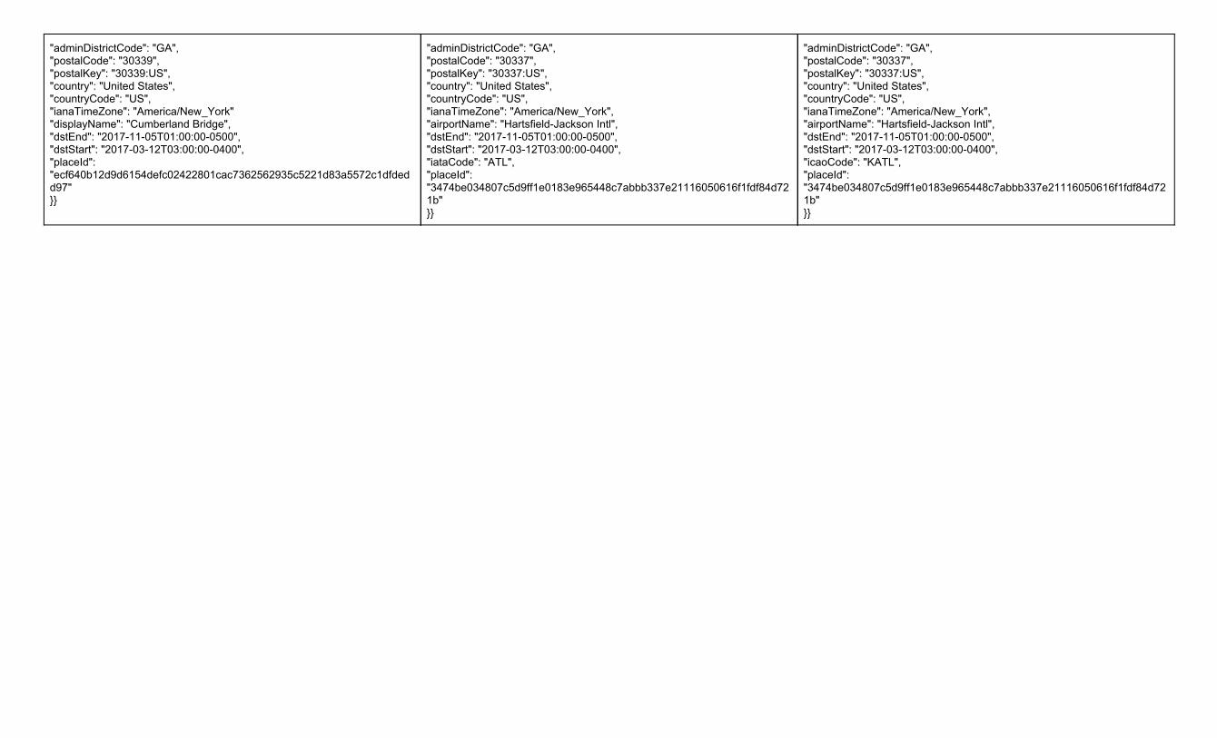
"adminDistrictCode": "GA", "postalCode": "30339", "postalKey": "30339:US", "country": "United States", "countryCode": "US", "ianaTimeZone": "America/New_York" "displayName": "Cumberland Bridge", "dstEnd": "2017-11-05T01:00:00-0500", "dstStart": "2017-03-12T03:00:00-0400", "placeId": "ecf640b12d9d6154defc02422801cac7362562935c5221d83a5572c1dfdedd97" }}
"adminDistrictCode": "GA", "postalCode": "30337", "postalKey": "30337:US", "country": "United States", "countryCode": "US", "ianaTimeZone": "America/New_York", "airportName": "Hartsfield-Jackson Intl", "dstEnd": "2017-11-05T01:00:00-0500", "dstStart": "2017-03-12T03:00:00-0400", "iataCode": "ATL", "placeId": "3474be034807c5d9ff1e0183e965448c7abbb337e21116050616f1fdf84d721b" }}
"adminDistrictCode": "GA", "postalCode": "30337", "postalKey": "30337:US", "country": "United States", "countryCode": "US", "ianaTimeZone": "America/New_York", "airportName": "Hartsfield-Jackson Intl", "dstEnd": "2017-11-05T01:00:00-0500", "dstStart": "2017-03-12T03:00:00-0400", "icaoCode": "KATL", "placeId": "3474be034807c5d9ff1e0183e965448c7abbb337e21116050616f1fdf84d721b" }}

Weather Company Data | API | Common Usage Guide
Overview This common usage and style guide describes the common elements, error handling, language support and terminology used by the Weather Company Data APIs.
HTTP Headers Standard HTTP Cache-Control headers are used to define caching length. The TTL value is provided in the HTTP Header as an absolute time value using the “Expires” parameter. Example: “Expires: Fri, 12 Jul 2013 12:00:00 GMT”.
The following HTTP headers should be set to the appropriate values:
Header Documentation Usage
Accept-Encoding: gzip *http://www.w3.org/Protocols/rfc2616/rfc2616-sec14.html#sec14.3 REQUIRED: All requests to the API’s should request that the response be compressed. Unless noted otherwise; the only supported encoding format is: gzip
Cross-Origin Resource Sharing All TWC APIs support Cross-Origin Resource Sharing or CORS. For additional information on this communications mechanism, please refer to the following documents:
Resource Documentation
W3 CORS Specification http://www.w3.org/TR/cors/
CORS Tutorial http://www.html5rocks.com/en/tutorials/cors/
URL Path Components URL Part URL Part Type Description
hostname host api.weather.com is the host for these API’s
version Path Part Current API version (example: "v2")
product Path Part Product name (example: “observations/current”)
apiKey Query Parameter Your API key for accessing the API
format Query Parameter The format of the response (“json”)

geocode Query Parameter For API’s which require a location for the data, the geocode is a listed in order of latitude and longitude (ex. 34.53,-84.50)
language Query Parameter Language to return the response in (ex. en-US, es, es-MX, fr-FR)
units Query Parameter The unit of measure for the response. The following values are supported:
● e = English units ● m = Metric units ● h = Hybrid units (UK) ● s = Metric SI units
HTTP Error Status Codes There are some differences in error status codes between v1 and v2/v3 APIs; the difference in HTTP status codes is noted in the table below for v1 APIs and v2/v3 APIs.
v1 API - HTTP Status Code Description
200 OK. The request has succeeded.
400 Bad request. The request could not be understood by the server due to malformed syntax or there is no data found for the location requested.
401 Unauthorized. The request requires authentication.
403 Forbidden. The server understood the request but is refusing to fulfill it.
404 Not found. The endpoint requested is not found.
500 Internal server error. The server encountered an unexpected condition which prevented it from fulfilling the request.
v2/v3 API - HTTP Status Code Description
204 No Data Found for specific query. The 204 status code will have an empty response body.
400 Bad request. The request could not be understood by the server due to malformed syntax. This is implemented for all API’s. API will reject the request if any invalid parameters are supplied.
401 Unauthorized. The request requires authentication.
403 Forbidden. The server understood the request but the API key is not authorized to perform the requested operation.
404 Not found. The endpoint requested is not found.
405 Method Not Allowed. For example, sending a POST instead of a GET.
406 Not Acceptable. For example, not accepting gzip compressed responses.
408 Request Timeout. Client did not produce request within time server was willing to wait.

500 Internal server error. The server encountered an unexpected condition which prevented it from fulfilling the request.
502-504 Service Unavailable or Gateway issue. These error codes are returned if the service is temporarily unavailable.
Standard Units of Measure Data attributes that respond to the ‘units’ parameter follow the pattern below for the different units of measure applied to the data.
Long Name Imperial (English) - e Metric - m Metric SI - s Hybrid UK - h
Temperature f (fahrenheit) c (celsius) c (celsius) c (celsius)
Pressure hg (inches of mercury) mb (millibars of mercury) mb (millibars of mercury) mb (millibars)
Precipitation Amount in (inches) - rain/snow mm (millimeters - rain), cm (centimeters - snow)
mm (millimeters - rain), cm (centimeters - snow)
mm (millimeters - rain), cm (centimeters - snow)
Distance mi (miles) km (kilometer) m (meter) mi (miles)
Visibility mi (miles) km (kilometer) km (kilometer) km (kilometer)
Wind Speed mh (miles/hour) km (kilometer/hour) m/s (meters per second) mph (miles per hour)
Wave Height ft (feet) mtr (meter) ft (feet)
Language Translations & Language Codes Some attributes support language translations. Any attribute that supports translated content will be noted as such in the ‘Translated Fields’ section of the API specific documentation. The ‘Translated Fields’ section denotes which fields respond to the valid ‘language’ parameter in the API request. Translated content will only be provided for valid supported languages as noted in the Language Code table.
Language Code Description Short Language Code Unit of Measure
ar-AE Arabic - UAE ar m
bn-BD Bengali (Bangladesh) bn m
bn-IN Bengali (India) m
ca-ES Catalan ca m
cs-CZ Czech (Czech Republic) cs m
da-DK Danish da m
de-DE German/Germany de m

de-CH German/Switzerland de m
el-GR Greek el m
en-GB English/Great Britain h
en-AU English/Australia h
en-IN English/India m
en-US English/United States en e
es-AR Spanish/Argentina m
es-ES Spanish/Spain m
es-US Spanish/US m
es-LA Spanish (LATAM) m
es-MX Spanish/Mexico m
es-UN Spanish (International) m
es-ES Spanish/Spain es e
fa-IR Persian (Farsi) fa m
fi-FI Finnish fi m
fr-CA French (Canada) m
fr-FR French/France fr m
fr-CH French/Switzerland fr m
he-IL Hebrew he m
hi-IN Hindi hi m
hr-HR Croatian hr m
hu-HU Hungarian hu m

in-ID Indonesian in m
it-IT Italian/Italy it m
it-CH Italian/Switzerland it m
iw-IL Hebrew iw m
ja-JP Japanese ja m
kk-KZ Kazakh kk m
ko-KR Korean ko m
ms-MY Malay ms m
nl-NL Dutch nl m
no-NO Norwegian no m
nn-NO Norwegian nn m
pl-PL Polish pl m
pt-BR Portuguese/Brazil pt m
pt-PT Portuguese pt m
ro-RO Romanian ro m
ru-RU Russian ru m
sk-SK Slovak - Slovakia sk m
sv-SE Swedish - Sweden sv m
th-TH Thai - Thailand th m
Postal Code Support Some APIs support requests by postal code. There is limited postal code support for v1 APIs. If noted with postal code support; the following countries postal codes are supported.
● United States ● Country Code: US
● United Kingdom ● Country Code: GB
● France ● Country Code: FR
● Germany ● Country Code: DE
● Italy ● Country Code: IT