ices/nafo joint working group on deep-water ecology
TRANSCRIPT

ICES SCIENTIFIC REPORTS
RAPPORTS SCIENTIFIQUES DU CIEM
ICES INTERNATIONAL COUNCIL FOR THE EXPLORATION OF THE SEA
CIEM COUNSEIL INTERNATIONAL POUR L’EXPLORATION DE LA MER
ICES/NAFO JOINT WORKING GROUP ON DEEP-WATER ECOLOGY (WGDEC)
This report has been republished after addition of Annexes 5 and 6, and can be found here: https://doi.org/10.17895/ices.pub.7503
VOLUME 2 | ISSUE 62

International Council for the Exploration of the Sea Conseil International pour l’Exploration de la Mer
H.C. Andersens Boulevard 44-46
DK-1553 Copenhagen V
Denmark
Telephone (+45) 33 38 67 00
Telefax (+45) 33 93 42 15
www.ices.dk
The material in this report may be reused for non-commercial purposes using the recommended cita-
tion. ICES may only grant usage rights of information, data, images, graphs, etc. of which it has owner-
ship. For other third-party material cited in this report, you must contact the original copyright holder
for permission. For citation of datasets or use of data to be included in other databases, please refer to
the latest ICES data policy on ICES website. All extracts must be acknowledged. For other reproduction
requests please contact the General Secretary.
This document is the product of an expert group under the auspices of the International Council for the
Exploration of the Sea and does not necessarily represent the view of the Council.
ISSN number: 2618-1371 I © 2020 International Council for the Exploration of the Sea

ICES Scientific Reports
Volume 2 | Issue 62
ICES/NAFO JOINT WORKING GROUP ON DEEP-WATER ECOLOGY (WGDEC)
Recommended format for purpose of citation:
ICES. 2020. ICES/NAFO Joint Working Group on Deep-water Ecology (WGDEC).
ICES Scientific Reports. 2:62. 171 pp. http://doi.org/10.17895/ices.pub.6095
Editors
Laura Robson
Authors
James Albrecht • Lindsay Beazley • Andreia Braga-Henriques • Paco Cardenas • Marina Carreiro-Silva •
Ana Colaço • Konstantin Fomin • Neil Golding • Kerry Howell • Jeroen Ingels • Georgios Kazanidis •
Ellen Kenchington • Igor Manushyn • Lenaick Menot • Anna Metaxas • Pål Mortensen • Steinunn Hilma
Olafsdottir • Covadonga Orejas • Carlos Pinto • Laura Robson • David Stirling • Sebastian Valanko • Ida
Vee • Rui Vieira • Les Watling

ICES | WGDEC 2020 | I
Contents
i Executive summary .......................................................................................................................iv ii Expert group information .............................................................................................................. v 1 Opening of the meeting ................................................................................................................ 7 2 Adoption of the agenda ................................................................................................................. 8 3 Collate new information on the distribution of vulnerable habitats and important
benthic species and communities in the North Atlantic and adjacent waters, archive
appropriately using the ICES VME Database, and disseminate via the Working Group
report and ICES VME Data Portal – ToR [a] ................................................................................. 10 3.1 Vulnerable Marine Ecosystem (VME) terminology used by WGDEC ............................. 10 3.2 Background .................................................................................................................... 10 3.3 Quality assurance of new VME data submissions .......................................................... 11 3.3.1 Guidelines for VME data providers ................................................................................ 11 3.3.2 Quality control processes by the ICES data centre and WGDEC .................................... 12 3.4 Data providers for ToR [a] .............................................................................................. 12 3.4.1 United Kingdom (Joint Nature Conservation Committee) ............................................. 13 3.4.2 United Kingdom (Marine Scotland Science) .................................................................. 15 3.4.3 United Kingdom (National Oceanography Centre) ........................................................ 17 3.4.4 Ireland (Marine Institute, Ireland) ................................................................................. 21 3.4.5 Sweden (Swedish University of Agricultural Sciences) .................................................. 24 3.4.6 Estonia (Estonian Marine Institute) ............................................................................... 25 3.4.7 Iceland (Marine and Freshwater Research Institute) .................................................... 25 3.4.8 Oceana ........................................................................................................................... 30 3.4.9 Russia ............................................................................................................................. 32 3.5 Absence data ................................................................................................................. 33 3.6 References ..................................................................................................................... 33
4 Provide all available new information on the distribution of vulnerable habitats (VMEs)
in the NEAFC Convention Area. In addition, provide new information on location of
habitats sensitive to particular fishing activities (i.e. vulnerable marine ecosystems,
VMEs) within EU waters – ToR [b] ............................................................................................... 35 4.1 Areas with new, historical or resubmitted VME data .................................................... 35 4.2 Areas considered within the NEAFC Regulatory Area .................................................... 35 4.2.1 Rockall Bank ................................................................................................................... 35 4.2.2 Reykjanes Ridge ............................................................................................................. 38 4.3 Areas considered within the NAFO Regulatory Area ..................................................... 41 4.3.1 Flemish Cap .................................................................................................................... 41 4.4 Areas considered within the EEZs of various countries ................................................. 44 4.4.1 Rockall Bank and George Bligh Bank .............................................................................. 44 4.4.2 Anton Dohrn Seamount ................................................................................................. 47 4.4.3 Faroe Shetland Channel ................................................................................................. 50 4.4.4 Darwin Mounds ............................................................................................................. 53 4.4.5 Hebridean Slope (Scotland) ........................................................................................... 56 4.4.6 Scottish and Irish Continental Slope .............................................................................. 59 4.4.7 Porcupine Bank and Seabight ........................................................................................ 62 4.4.8 Icelandic Continental Slope............................................................................................ 65 4.4.9 Norwegian Trench and Danish and Swedish Continental Slopes ................................... 77 4.5 Analysis of the 2019 VMS submission from NEAFC, in order to provide
information and maps on fisheries activities in the vicinity of vulnerable habitats
(VMEs) ............................................................................................................................ 80 4.5.1 Methods ......................................................................................................................... 80 4.5.2 Results ............................................................................................................................ 82

ii | ICES SCIENTIFIC REPORTS 2: 62 | ICES
4.5.3 Hatton Bank ................................................................................................................... 82 4.5.4 Rockall Bank ................................................................................................................... 89 4.5.5 South of Iceland ............................................................................................................. 93 4.5.6 Mid Atlantic Ridge Seamounts ....................................................................................... 96 4.5.7 Josephine Seamount ...................................................................................................... 98 4.6 References ................................................................................................................... 100
5 Develop standards for the provision of absence data and OSPAR habitat data to the ICES
VME database, and utilise VME indicator data records to further develop and test kernel
density estimation methods to assess VME likelihood – ToR [c] .............................................. 101 5.1 Introduction ................................................................................................................. 101 5.2 Absence data ............................................................................................................... 101 5.2.1 Uses of Absence data ................................................................................................... 102 5.2.2 Considerations when using absence data .................................................................... 103 5.2.3 Criteria for absence data submissions ......................................................................... 104 5.2.4 Summary of absence records 2020 .............................................................................. 104 5.2.5 Conclusions .................................................................................................................. 106 5.3 OSPAR data .................................................................................................................. 106 5.3.1 Method for importing OSPAR records into the VME database ................................... 107 5.3.2 Quality Assurance of OSPAR data ................................................................................ 108 5.3.3 Other sources of VME data .......................................................................................... 109 5.4 References ................................................................................................................... 110
6 Building on work initiated in 2019, work jointly with the WGMHM to test the use of
habitat suitability models for mapping VME presence, to assess how such information
could be incorporated when, for example, recommending proposals for VME closures –
ToR [d] ....................................................................................................................................... 111 6.1 Clarification on change in ToR ..................................................................................... 111 6.2 Future use of Predictive Habitat Models within ICES advice ....................................... 111 6.2.1 Draft Terms of Reference for Predictive Habitat Models workshop ........................... 112 Supporting information ............................................................................................................. 112 6.3 VME element mapping ................................................................................................ 113 6.3.1 VME elements .............................................................................................................. 114 6.3.2 VME element mapping methods ................................................................................. 115 6.3.3 Caveats and limitations ................................................................................................ 115 6.4 References ................................................................................................................... 116
7 Request from the European Commission to provide updates on representative taxa for 2
VME habitats, and advice on additional VME indicators to be included in Annex III of the
EU deep-sea access regulations – ToR [e] ................................................................................. 117 7.1 Introduction ................................................................................................................. 117 7.2 Review against FAO criteria ......................................................................................... 118 7.3 Updates to VME habitat and representative taxa lists ................................................ 119 7.3.1 Hydrothermal vents ..................................................................................................... 119 7.3.2 Cold seeps .................................................................................................................... 121 7.3.3 Cold-water coral reef ................................................................................................... 123 7.3.4 Coral gardens ............................................................................................................... 124 7.4 Deep-sea sponge aggregations .................................................................................... 129 7.5 Sea pen fields ............................................................................................................... 131 7.6 Additional VME habitats .............................................................................................. 133 7.7 Conclusions .................................................................................................................. 133 7.8 The need for revising the criteria for selecting VME indicators and defining
VMEs ............................................................................................................................ 136 7.9 Acknowledgments ....................................................................................................... 136 7.10 References ................................................................................................................... 136
Annex 1: List of participants........................................................................................................ 147

ICES | WGDEC 2020 | III
Annex 2: Resolutions .................................................................................................................. 149 Annex 3: Catches of Coldwater Corals and Sponges in the North Atlantic as reported in
observations obtained by Russian fishing vessels in 2019 ........................................... 151 Annex 4: Updated VME habitat and indicator (representative taxa) lists following review
against the FAO criteria ............................................................................................... 162

IV | ICES SCIENTIFIC REPORTS 2:62 | ICES
i Executive summary
The joint ICES/NAFO Working Group on Deep-water Ecology (WGDEC) collates new infor-
mation on the distribution of Vulnerable Marine Ecosystems (VMEs) for use in annual ICES ad-
visory processes and the development of new methods/techniques to further our understanding
of deep-sea ecosystems, and further suggests novel management tools to ensure human activities
do not adversely affect them.
This year, a total of 4609 new presence records and 181 absence records, were submitted through
the ICES VME data call in 2020 and were included within the ICES VME database. This infor-
mation was collated and mapped by WGDEC, to support ICES in providing advice on the dis-
tribution of VMEs in the North Atlantic. All presence records from the VME database were pre-
sented as outputs from the VME weighting system, showing the likelihood of VMEs being en-
countered on the seabed along with an associated confidence assessment. VMS data from
NEAFC was analysed by the Working Group on Spatial Fisheries Data (WGSFD), and outputs
were used by WGDEC to assess whether fishing activity was occurring in the vicinity of VMEs
in the NEAFC Convention Area, to support ICES advice.
Another objective this year was to further develop approaches for the inclusion of absence data
and data from the OSPAR habitats database, into the ICES VME database. Absence data would
add value to development of predictive habitat models for VMEs. However, some challenges
with collection of absence data include the survey method used and associated spatial scales,
where different approaches would mean data were not comparable. Furthermore, absence data
should not be confused with ‘missing data’, which is particularly prudent for the deep sea where
limited surveys have taken place. A series of criteria to be fulfilled for any submissions of VME
absence data to the VME database were identified by the group.
Methods to bring OSPAR records into the ICES VME database have been developed. However,
the need to quality assure OSPAR data before it is transferred to the database is vital to avoid
duplication of records already in the VME database. Additionally, further work needs to be done
to encourage data providers to submit records to both the ICES VME and OSPAR databases to
avoid the need for annual exchanges of data between the two.
Due to restrictions of working remotely this year, further testing on the use of predictive habitat
models for the provision of information on potential VME presence was not undertaken. How-
ever, WGDEC agreed that an intersessional benchmark workshop prior to WGDEC 2021 would
provide a more effective forum to complete this work, with the aim of developing a set of criteria,
against which new and existing models will be reviewed to determine appropriate standards for
their use for future ICES advice.
A final objective this year was to finalise the proposed changes to the list of VME habitats and
representative taxa, for submission to the European Commission. Work undertaken during
WGDEC 2019 and an intersessional sub-group was built upon, and proposed taxa were evalu-
ated against the FAO criteria for the prevention of significant adverse impacts on VMEs and
protection of the marine biodiversity. Proposals were drafted for hydrothermal vents and cold
seeps, cold-water coral reefs, coral gardens, deep-sea sponge aggregations and sea pen fields.
This list will be finalised intersessionally to include tube-dwelling anemone aggregations,
stalked crinoid aggregations, xenophyophore aggregations and bryozoan patches.
ICES | WGDEC 2020 | V
ii Expert group information
Expert group name ICES/NAFO Joint Working Group on Deep-water Ecology (WGDEC)
Expert group cycle Annual
Year cycle started 2020
Reporting year in cycle 1/1
Chair Laura Robson, United Kingdom
Meeting venue(s) and dates 4-8 May 2020, By correspondence (25 participants)

6 | ICES SCIENTIFIC REPORTS 2:62 | ICES
Ole Secher Tendal
It was with great sadness that WGDEC learned of the recent passing of our friend and colleague
Ole Tendal, a valued member of WGDEC from its early days through to 2014. Ole had profound
knowledge of deep-sea invertebrate fauna and of the xenophyophores, sponges and octocorals
of the North Atlantic and Arctic in particular, which he was always willing to share with others.
He was instrumental in providing the detailed explanation for why sponge grounds qualified as
vulnerable marine ecosystems for WGDEC which has led to their widespread conservation
around the globe, including the Polar seas, where some WGDEC members had the opportunity
to join him in a Polarstern expedition in 1996 to Antarctica. For early career scientists it was an
honour to share two months on board with scientists such as Ole, who transmitted to the stu-
dents his fascination of the large sponge fields of the Weddell Sea. In his retirement he continued
to work as an Emeritus Associate Professor at the Zoological Museum at the University of Co-
penhagen. His many contributions have been recognized by his colleagues who named a genus
of xenophyophore, Tendalia, and three species of sponge, Lycopodina tendali, Clathrina tendali and
Hymedesmia (Hymedesmia) tendali, in his honour; something that Ole was deeply proud of.
On the personal side, Ole was always happy and proud to share his Danish heritage. When the
meetings were held in Copenhagen, some WGDEC members were able to partake of a Danish
lunch, being led by Ole to a little sandwich shop on Langebro St. for open Danish sandwiches,
after which the group would retire to the Langebro café and bar to wash the sandwich down
with a local brew. He was very generous, and probably the gentlest, person that most of us had
ever known.
We dedicate the 2020 report of WGDEC to Ole and will miss his wisdom and guidance.

ICES | WGDEC 2020 | 7
1 Opening of the meeting
In consultation with the ICES Secretariat and ACOM Leadership, the physical meeting of the
Working Group on Deep-water Ecology (WGDEC), scheduled to be held at ICES HQ, Copenha-
gen, Denmark, 4-8 May 2020, was moved to a WebEx meeting and work by correspondence due
to travel restrictions in place as a result of the COVID19 outbreak. It was also agreed that
WGDEC would focus its efforts this year on immediate advisory related TORs (a, b and e) and
reduce the scope of the other TORs (c and d).
The meeting was run in parallel with the Working Group on Marine Habitat Mapping
(WGMHM), chaired by James Strong (UK), for the week. Joint plenary sessions were arranged
for Monday 4 May and Wednesday 6 May.
WGDEC commenced in plenary at 10:30 am BST on Monday 4 May 2020. Following confirmation
of no conflicts of interest from the group, the leads for each Term of Reference (ToR) were ap-
pointed, and are outlined below:
ToR [a] lead: Laura Robson
ToR [b] lead: Laura Robson and David Stirling
ToR [c] lead: James Albrecht
ToR [d] lead: James Strong (WGMHM)
ToR [e] lead: Marina Carreiro Silva and Ana Colaço
Following the review and adoption of the agenda, WGDEC began working through the Terms
of Reference. A short presentation for each ToR was provided by the chair, ToR leads and data
suppliers. The group then agreed how they would tackle each ToR, and the group was split into
small groups to work on each ToR remotely. Smaller sub-groups were identified for ToR e to
work on separate habitat types.
Dedicated plenary sessions were held throughout the week via WebEx. During these plenary
sessions, ToR leads updated the group with progress and issues were discussed. Participants
joining through correspondence only could comment on working documents via the WGDEC
SharePoint site. At the end of the week, the Working Group was formally closed at 5:15 pm on
Thursday 7 May 2020 by the Chair. Work continued on Friday 8 May by correspondence only.

8 | ICES SCIENTIFIC REPORTS 2:62 | ICES
2 Adoption of the agenda
The Joint ICES/NAFO Working Group on Deep-water Ecology (WGDEC), chaired by Laura Rob-
son, UK, will meet by correspondence, 4–8 May 2020 to:
a) Collate new information on the distribution of vulnerable habitats as well as important
benthic species and communities in the North Atlantic and adjacent waters, archive ap-
propriately using the ICES VME Database, and disseminate via the Working Group re-
port and ICES VME Data Portal;
b) Provide all available new information on the distribution of vulnerable habitats (VMEs)
in the NEAFC Convention Area. This should also include information on the distribution
of vulnerable habitats in subareas of the Regulatory Area that are closed to fishing for
other purposes than VME protection, e.g. the haddock box at Rockall Bank. In addition,
provide new information on location of habitats sensitive to particular fishing activities
(i.e. vulnerable marine ecosystems, VMEs) within EU waters;
c) Develop standards for the provision of absence data and OSPAR habitat data to the ICES
VME database, and utilise VME indicator data records to further develop and test kernel
density estimation methods to assess VME likelihood;
d) Building on work initiated in 2019, work jointly with the WGMHM to test the use of
habitat suitability models for mapping VME presence, to assess how such information
could be incorporated when, for example, recommending proposals for VME closures
e) Provide recommendations on additional VME indicators to be included in Annex III of
the EU deep-sea access regulations, together with a full list of representative taxa for each
of the new VME indicators and an indication of the classification under the VME Habitat
type as per the table in Annex III.
WGDEC will report on TOR a, b and e by 22 May 2020 and all TORs by 15 June 2020 to the
attention of the Advisory Committee.
Supporting Information
Priority The current activities of this Group will enable ICES to respond to advice requests from
a number of clients (NEAFC/EC). Consequently, these activities are considered to have a
high priority.
Scientific justifi-
cation
ToR [a]
The Joint ICES/NAFO Working Group on Deep-water Ecology undertake a range of
Terms of Reference each year; the scope of these cover the entire North Atlantic, and in-
clude aspects such as ocean basin processes. Therefore, collating information on vulnera-
ble habitats (including important benthic species and communities) across this wide geo-
graphic area (and adjacent waters) is essential. To this end, a VME data call will be run
from January to March 2020, facilitated by the ICES Data Centre. Data will be quality
checked/prepared one month in advance of WGDEC 2020. New data will be incorporated
into the ICES VME database and data portal. This ToR includes any development work
on the ICES VME database and data portal, as identified by WGDEC, with support from
the ICES Data Centre.
ToR [b]
Collation of information and associated maps (using TOR a) are required to meet the an-
nual NEAFC and EU requests. ICES provides advice, via its working groups and its ad-
visory committee (ACOM), “to continue to provide all available new information on the
distribution of vulnerable habitats in the NEAFC Convention Area”, which includes “in-
formation on the distribution of vulnerable habitats in subareas of the Regulatory Area
that are closed to fishing for other purposes than VME protection, e.g. the haddock box

ICES | WGDEC 2020 | 9
at Rockall Bank”. This information is also used in combination with NEAFC VMS data
(analysed by WGSFD) to advise on “fisheries activities in and in the vicinity of such hab-
itats”. This ICES advice supports the objective of NEAFC recommendation 19:2014 to “en-
sure the implementation by NEAFC of effective measures to prevent significant adverse
impacts of bottom fishing activities on vulnerable marine ecosystems known to occur or
likely to occur in the NEAFC Regulatory Area based on the best available scientific infor-
mation provided or endorsed by the ICES”. Furthermore, ICES provides advice, via its
working groups and its advisory committee (ACOM), to support the European Commis-
sion request to provide “new information on the impact of fisheries on sensitive habitats.
This should include new information on the location of habitats sensitive to particular
fishing activities”. The location of newly discovered/mapped sensitive habitats (i.e. vul-
nerable marine ecosystems, VMEs) is critical to these NEAFC and EU requests.
ToR [c]
The VME weighting algorithm was developed in 2015/2016 to utilise data in the ICES
VME database from a range of survey types, to determine likelihood of VME presence
and associated confidence. In 2019, new methods of determining VME likelihood were
explored via kernel density estimation (KDE). This ToR will further this work and look to
address limitations in the use of KDE on datasets from the VME database, to optimise its
use for assessing VME likelihood. The inclusion of absence data, and additional presence
records from the OSPAR database, to the VME database would further enhance any as-
sessment of VME likelihood, therefore this ToR will also identify standards to include
these data types.
ToR [d]
The potential use of Species Distribution Modelling (SDM) and Habitat Suitability Mod-
elling (HSM) as a tool to identify areas where VME are likely to occur has arisen several
times over the last ten years in WGDEC. However it has not yet been used to provide
recommendations to ACOM on how to incorporate such information when suggesting
VME closures through draft ICES advice. This ToR will utilise the considerations for
model creation and criteria for model use developed at WGDEC 2019, to test the use of
HSM for assessing VME likelihood, and document the methods, decisions taken, and is-
sues encountered.
ToR [e]
For the ongoing request work for the EU with regard to the deep sea access regulation
(ref. (EU)2016/2336), ICES have been asked to provide scientific input on the list of VME
indicators to be included in Annex III of the EU deep-sea access regulations. This input
should include a full list of representative taxa for each of the new VME indicators and
an indication of the classification under the VME Habitat type as per the table in Annex
III.
Resource require-
ments
Some support will be required from the ICES Secretariat.
Participants The Group is normally attended by some 15–20 members and guests.
Secretariat facili-
ties
None, apart from WebEx and SharePoint site provision.
Financial No financial implications.
Linkages to advi-
sory committees
ACOM is the parent committee and specific ToRs from WGDEC provide information for
the Advice Committee to respond to specific requests from clients.
Linkages to other
committees or
groups
While there are currently no direct linkages to other groups, WGDEC should develop
stronger links (ideally through the establishment of joint Terms of Reference) with
WGSFD, WGMHM, WGDEEP and WGFBIT.
Linkages to other
organizations
As a Joint ICES/NAFO group, the work of this group links to work being undertaken by
Working Groups under the NAFO Scientific Council; specifically, WGESA.

10 | ICES SCIENTIFIC REPORTS 2:62 | ICES
3 Collate new information on the distribution of vul-nerable habitats and important benthic species and communities in the North Atlantic and adjacent wa-ters, archive appropriately using the ICES VME Da-tabase, and disseminate via the Working Group re-port and ICES VME Data Portal – ToR [a]
3.1 Vulnerable Marine Ecosystem (VME) terminology used by WGDEC
The inclusion of data on VMEs in the ICES VME database has required some informal definitions
to be created by WGDEC to enable users to include data on VME elements, habitats and indica-
tors, based on different collection methods. WGDEC considers information relating to VMEs in
three ways:
1. 'VME habitat' records are generally those from visual survey data (e.g. remotely operated
vehicle (ROV) or towed/drop camera seabed imagery) that demonstrates the presence
and location of a VME with a high degree of confidence and spatial accuracy. VME hab-
itats = VME (ICES, 2016a).
2. 'VME indicator' refers to records of VME indicator species from data sources for which
there is a degree of uncertainty that a VME is, or was, present. Typical examples are
trawl-survey or static longline bycatch records (ICES, 2016a).
3. 'VME element' refers to seabed topographic features, readily identified using high reso-
lution multibeam data, and with which VMEs are often associated. Examples include
seamounts, ridges, canyons (ICES, 2013).
3.2 Background
The ICES VME data call in January 2020 requested ICES member states to submit data to the
ICES VME database. All data submitted to the database since the previous WGDEC meeting in
June 2019 is considered new data for WGDEC 2020.
The database stores records of VME habitats, VME indicators and the locations of where neither
of these have been observed (absence data), as described by the database schema. The records in
the ICES VME database can therefore be split into two broad categories;
Presence records are samples where a VME habitat and/or a VME indicator have been
identified
Absence records are samples where neither a VME habitat, nor a VME indicator, have
been identified
Presence records can include mixed (mosaic) habitats, where more than one habitat type and/or
sub-type occur together in the same location (for example, two sub-types of coral garden or a
cold-water coral reef and coral garden). They can also include species lists from data analyses

ICES | WGDEC 2020 | 11
that, combined, form a community which comprise a VME habitat. The mosaic habitats and spe-
cies lists are input to the database as separate records but are linked together by a ‘VME Key’
indicating that they occur in the same patch of habitat. Therefore, some VME locations will be
represented in the database by multiple records with the same coordinates. These records pro-
vide information on the species communities and habitat (sub)types that make up that VME.
4609 new presence records have been submitted to the ICES VME database since June 2019,
which increases the total number of presence records in the database to 61 200. This count con-
sists of all individual records in the database, and it should be noted that some VMEs will be
represented by more than one record, as detailed above.
Of the newly submitted presence records, 21 are within the NEAFC Regulatory Area, 5 are within
the NAFO Regulatory Area, and the remaining 4583 are within the Exclusive Economic Zones of
North Atlantic ICES/NAFO member states. In addition, 181 absence records were submitted. For
more information on absence data, see Section 5.
The new data has been submitted by data providers from five ICES member countries (UK, Ire-
land, Sweden, Iceland and Estonia) and one Non-Governmental Organisation (Oceana).
3.3 Quality assurance of new VME data submissions
Since its founding in 1902, ICES has developed a strong reputation in delivering robust scientific
advice to governments and regional fisheries management organisations. Data calls, such as the
request for new information on VMEs, are an essential mechanism for WGDEC to widen its
knowledge, and supplement its central database, holding information on the distribution and
abundance of habitats and species considered to be indicators of VMEs across the North Atlantic.
Data providers should note that data of relevance to WGDEC may also be submitted by Con-
tracting Parties, including WGDEC members, through the OSPAR threatened and/or declining
habitats database1, specifically for cold water coral reefs, coral gardens and deep-sea sponge ag-
gregations.
ICES uses the VME database to provide scientifically-robust advice on the distribution of VMEs
and recommendations for management solutions. Therefore, to maintain the integrity of its ad-
vice, it is essential that any data submitted through the VME data call has been subjected to an
appropriate level of quality assurance during its collection and interpretation. WGDEC have
therefore identified some initial guidelines for data providers who are submitting new data rec-
ords to the VME database and have proposed a new intersessional WGDEC data call subgroup
to quality control data submissions.
3.3.1 Guidelines for VME data providers
By submitting data to ICES through the VME data call process, data providers are confirming
that they have followed national and international best practice guidelines in the quality assur-
ance of their data. Best practice in the quality assurance of VME data will vary according to data
type (e.g. Batley, 1999; Rumohr, 2009; Howell et al, 2014; Turner et al, 2016).
Of particular relevance to data providers is the understanding of the difference between VME
habitats, VME indicators and absence records (ICES, 2016). In light of the significance of new
VME habitat records (Section 3.1), evidence of each new VME record could also be submitted
through the data call; this evidence could take the form of peer reviewed published literature
1 https://odims.ospar.org/search/?limit=100&offset=0&datastream=habitats

12 | ICES SCIENTIFIC REPORTS 2:62 | ICES
reporting on the record(s), grey literature in the form of cruise reports, and/or imagery (photo-
graphs/video clips) of the habitat(s). There are data fields within the VME Cruise record where
a reference for the data source can be provided.
WGDEC therefore recommend that data suppliers provide supporting evidence for VME Da-
tabase submissions wherever possible.
3.3.2 Quality control processes by the ICES data centre and WGDEC
To maintain the high quality of the final advice, each national data submission shall be quality
assured/quality checked by the ICES Data Centre and a newly created formal intersessional
WGDEC VME data call subgroup.
A series of automated quality control (QC) checks for new data submissions are already in exist-
ence, generated by the ICES Data Centre. These flag initial problems to the data provider that
need addressing before the data can be formally accepted to the database. QC checks include, for
example, warnings for invalid habitat sub-types for specific VME habitat types; incorrect coor-
dinates (e.g. if the data point appears on land); and ensuring only the VME indicator or habitat
field is filled in, to avoid a mix of data types for one record. Any issues are flagged to the data
provider during the submission process for checking (and potentially correcting) before resub-
mission. Support is available via the ICES Data Centre for any queries over these errors.
This year, a number of further data issues were identified by the ICES Data Centre and WGDEC
members. As a result, the group agreed that an intersessional WGDEC VME data call subgroup
would be beneficial to quality assure all new data submissions in advance of the WGDEC meet-
ings. This group will therefore review and map new data submissions, and check for any prob-
lems that cannot be caught by automated QC checks. For example, additional errors/queries dur-
ing the WGDEC 2020 data call included misidentification of VME species from trawl data; sub-
mission of data from regions on the continental shelf of the UK EEZ < 200 m considered to be
outside the remit of the WGDEC group; and verification of the analytical methods used to iden-
tify VME habitats from imagery data.
An audit trail of the data quality checks will be tabulated and will be produced as an Annex to
each WGDEC report.
WGDEC has therefore developed the following recommendations:
Recommendation 1: The annual VME data call should detail the need for data suppliers to fol-
low national and international best practice guidelines in the quality assurance of their data,
and that supporting evidence for new VME records should ideally be included as part of the VME
data submission.
Recommendation 2: A new formal intersessional subgroup of WGDEC will be created, charged
with quality assuring/quality checking new VME presence and absence data submissions prior
to the annual WGDEC meeting.
3.4 Data providers for ToR [a]
New records of VME indicators and habitats were submitted to the ICES VME database by the
following ICES Member Countries (organisations/affiliations in brackets):

ICES | WGDEC 2020 | 13
3.4.1 United Kingdom (Joint Nature Conservation Committee)
3.4.1.1 Institute of Oceanographic Sciences (Rice et al., 1990)
The Joint Nature Conservation Committee (JNCC) submitted historical data records from litera-
ture, from the Institute of Oceanographic Sciences (IOS), Deacon Laboratory (Rice et al., 1990).
Data were collected on annual and bi-annual cruises to the Porcupine Seabight, between 1979
and 1985. Three survey methods were used – IOS epibenthic sledge, Granton trawl and semi-
balloon otter trawl. All records were of Pheronema carpenteri, representing sponge VME indica-
tors (Table 3.1).
Table 3.1 Summary of VME indicator records submitted by JNCC from literature (Rice et al., 1990).
VME Indicator Type No. of indicator records
Sponge 22
Total 22
3.4.1.2 James Cook survey JC136: Deeplinks
JNCC, on behalf of the NERC funded DeepLinks project partners (University of Plymouth, Uni-
versity of Oxford, JNCC and British Geological Survey), submitted new VME habitat records
from the JC136 “DeepLinks” cruise in 2016. Records came from analysis of remotely operated
vehicle (ROV) footage collected on the survey from Anton Dohrn Seamount, North Rockall Bank
and George Bligh Bank.
A total of 68 records of VME habitats were submitted, including cold water coral reefs, coral
gardens and deep-sea sponge aggregations (Table 3.2 and Figure 3.1, Figure 3.2 and Figure 3.3).
The coral garden records included the habitat sub-types: Hard-bottom coral garden: colonial
scleractinians on rocky outcrops; Hard-bottom coral garden: hard-bottom gorgonian and black
coral gardens, and; Soft bottom coral gardens, some of which occurred as mosaic habitats.
Previous data from this survey had been submitted to WGDEC in 2017, but these represent ad-
ditional data records for these areas.
Table 3.2 Summary of VME habitat records submitted by the JNCC on behalf of DeepLinks project partners.
VME Habitat Type No. of habitat records
Cold water coral reef 5
Coral garden 62
Deep sea sponge aggregation 1
Total 68

14 | ICES SCIENTIFIC REPORTS 2:62 | ICES
Figure 3.1 VME coral garden habitat from dive 269 at Anton Dohrn Seamount provided by JNCC from the JC136 DeepLinks survey. Image source: NERC funded DeepLinks project - University of Plymouth, University of Oxford, JNCC and BGS (2016).
Figure 3.2 VME cold-water coral reef habitat, from dive 270 at Anton Dohrn Seamount provided by JNCC from the JC136 DeepLinks survey. Image source: NERC funded DeepLinks project - University of Plymouth, University of Oxford, JNCC and BGS (2016).
ICES | WGDEC 2020 | 15
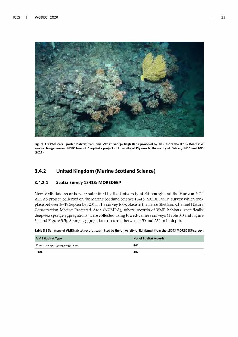
Figure 3.3 VME coral garden habitat from dive 292 at George Bligh Bank provided by JNCC from the JC136 DeepLinks survey. Image source: NERC funded DeepLinks project - University of Plymouth, University of Oxford, JNCC and BGS (2016).
3.4.2 United Kingdom (Marine Scotland Science)
3.4.2.1 Scotia Survey 1341S: MOREDEEP
New VME data records were submitted by the University of Edinburgh and the Horizon 2020
ATLAS project, collected on the Marine Scotland Science 1341S ‘MOREDEEP’ survey which took
place between 8–19 September 2014. The survey took place in the Faroe Shetland Channel Nature
Conservation Marine Protected Area (NCMPA), where records of VME habitats, specifically
deep-sea sponge aggregations, were collected using towed-camera surveys (Table 3.3 and Figure
3.4 and Figure 3.5). Sponge aggregations occurred between 450 and 530 m in depth.
Table 3.3 Summary of VME habitat records submitted by the University of Edinburgh from the 1314S MOREDEEP survey.
VME Habitat Type No. of habitat records
Deep sea sponge aggregations 442
Total 442

16 | ICES SCIENTIFIC REPORTS 2:62 | ICES
Figure 3.4 Fan-shaped sponge aggregations (possibly Phakellia sp.) within the Faroe-Shetland Channel Nature Con-servation MPA. Depth 498.5 m. Image collected on 11/09/2014 during the MoreDeep_1314S research expedition. Image source: Marine Scotland Science.
Figure 3.5 Massive (possibly Geodia sp.) and fan-shaped sponge aggregations (possibly Phakellia sp.) within the Faroe-Shetland Channel Nature Conservation MPA. Depth 492 m. Image collected on 11/09/2014 during the More-Deep_1314S research expedition. Image source: Marine Scotland Science.
3.4.2.2 Scotia survey 1419S
Marine Scotland Science (MSS) submitted data on VME indicator taxa from the Deepwater Slope
survey from 28 September to 11 October 2019 (survey code 1419S). A Jackson BT 184 bottom
trawl with groundgear bag net was used to survey the demersal fish assemblages along the con-
tinental slope of Scottish and Irish offshore waters. A total of 64 VME indicator records were

ICES | WGDEC 2020 | 17
submitted from the bycatch of 25 hauls (Table 3.4). A further 11 hauls were recorded as absences
as no VME indicator taxa were collected (Table 3.22).
Table 3.4 Summary of VME indicator records submitted by Marine Scotland Science from the 1419S survey.
VME Indicator Type No. of indicator records
Black coral 2
Cup coral 6
Gorgonian 8
Sea pen 16
Soft coral 8
Sponge 24
Total 64
3.4.3 United Kingdom (National Oceanography Centre)
3.4.3.1 James Cook survey JC062
The benthos of the Porcupine Seabight was surveyed extensively in the 1980s, including an as-
sessment of the mass occurrence of Pheronema carpenteri (Rice et al., 1990; Rice et al., 1991). Pho-
tographic transects at four sites in the northern Porcupine Seabight were also conducted in Au-
gust 2011 through the RRS James Cook survey “JC062” (Ruhl, 2012). The aim of the transects was
to assess the status of the same sponge aggregation sites identified by Rice et al. (1990, 1991) using
comparable photographic survey methods (Vieira et al., 2020).
Transects were carried out using the National Oceanography Centre (NOC) Wide-Angle Seabed
Photography (WASP) off-bottom, towed camera system. A vertically mounted stills camera was
used and augmented with an obliquely mounted digital stills camera. A total of 1713 images
were analysed. For each image, all invertebrate megafauna were identified to morphotype and
counted. Geolocation and water depth data for the camera platform were derived from an ultra-
short baseline navigation transponder attached directly to the WASP vehicle (Ruhl, 2012).
A total of 29 VME habitats and 26 VME indicator records were submitted to the ICES VME da-
tabase from the JC062 survey, summarised in Table 3.5 and

18 | ICES SCIENTIFIC REPORTS 2:62 | ICES
Table 3.6. These included deep-sea sponge (Figure 3.6) and tube-dwelling anemone aggrega-
tions, soft-bottom cup coral gardens and sea pen fields, and the indicators; xenophyophores, sea
pens, anemones and gorgonians.
Table 3.5 Summary of VME habitat records submitted by the National Oceanography Centre from JC062.
VME Habitat Type No. of habitat records
Coral garden 6
Deep sea sponge aggregations 21
Sea pen fields 1
Tube-dwelling anemone aggregations 1
Total 29

ICES | WGDEC 2020 | 19
Table 3.6 Summary of VME indicator records submitted by the National Oceanography Centre from JC062.
VME Indicator Type No. of indicator records
Anemones 11
Gorgonians 6
Sea pen 4
Xenophyophores 5
Total 26
Figure 3.6 Examples of deep-sea sponge aggregations (Pheronema carpenteri) as observed in oblique (a, b), and vertical (c, d) photographs in the northern Porcupine Seabight. Image source: National Oceanography Centre, UK.
3.4.3.2 Discovery survey DY108
In 2019, the RRS Discovery (DY)108 cruise from 6 September to 2 October 2019, funded by NERC
through the CLASS (Climate-Linked Atlantic Sector Science) programme, investigated the Dar-
win Mounds area in search of signs of recovery of the benthic community after trawling was
banned in 2003.
The Darwin Mounds are small geological features up to 70 m across and up to 5 metres high,
located south-west of the Wyville-Thomson Ridge, within the EEZ of the United Kingdom. The
region is a Special Area of Conservation (SAC EU Code: UK0030317).
The data, submitted by the NOC, included presence records of the VME habitat, xenophyophore
aggregations, comprising the species Syringammina fragilissima (Table 3.7) and the VME indicator
species: Lophelia pertusa/Desmophylum pertusum and Madrepora oculata (

20 | ICES SCIENTIFIC REPORTS 2:62 | ICES
Table 3.8 and Figure 3.7). Data were collected as image samples taken with the HyBis camera
platform from the NOC, deployed from RRS Discovery. More information on collection and lo-
cation of these samples is available in Huvenne and Thornton, 2020.
Table 3.7 Summary of VME habitat records submitted by the National Oceanography Centre from DY108.
VME Habitat Type No. of habitat records
Xenophyophore aggregations 9
Total 9
Table 3.8 Summary of VME indicator records submitted by the National Oceanography Centre from DY108.
VME Indicator Type No. of indicator records
Stony coral 18
Total 18
Figure 3.7 VME records of Lophelia pertusa/Desmophylum pertusum and Syringammina fragilissima from the DY108 sur-vey. Image source: National Oceanography Centre, UK.
3.4.3.3 Discovery survey D248
Data were collected on the RRS Discovery (D)248 cruise in 2000, which aimed to carry out a
multidisciplinary study of the environment and ecology of deep-water coral ecosystems and as-
sociated seabed features in the north-east Atlantic (Bett et al., 2001). Three areas were surveyed:
Darwin Mounds, northern Rockall Trough and the Porcupine Seabight. The survey took place
over two legs, between 8 July to 10 August 2000. Various methods were used to collect data on
both VME habitats and indicators, including box corers, Agassiz trawls and the Seabed High
Resolution Imaging Platform (SHRIMP).
JNCC reviewed the Bett et al., 2001 paper, where observations in the Darwin Mounds confirmed
the common occurrence of deep-water corals in this area. Xenophyophores were observed in

ICES | WGDEC 2020 | 21
association with the mounds, however no live specimens were recovered. At the Porcupine
Seabight, imagery of associated coral communities was obtained, from which biological samples
were also recovered. Based on these records, together with records from trawl and box corer
samples detailed in the report, VME habitats of cold-water coral reefs, coral gardens and xeno-
phyophore aggregations and VME indicators of soft corals, sponges, stony corals and xenophy-
ophores were submitted to the VME database by JNCC following QC by NOC (Table 3.9 and
Table 3.10).
Table 3.9 Summary of VME habitat records submitted by JNCC from the NOC’s D248 cruise.
VME Habitat Type No. of habitat records
Cold water coral reef 3
Coral garden 4
Xenophyophore aggregations 2
Total 9
Table 3.10 Summary of VME indicator records submitted by JNCC from the NOC’s D248 cruise.
VME Indicator Type No. of indicator records
Soft corals 1
Sponge 1
Stony coral 12
Xenophyophores 5
Total 19
3.4.4 Ireland (Marine Institute, Ireland)
3.4.4.1 SeaRover project
SeaRover (Sensitive Ecosystem Assessment and ROV Exploration of Reef Habitat) was a three-
year project from 2017 to 2019 to collect data on VME habitats within Irish waters. The project
aim was to carry out extensive mapping surveys of offshore reefs to evaluate status and intro-
duce conservation and management measures in proportion to status and pressures from fish-
ing. The survey used the ROV Holland I to search for vulnerable marine species and habitats
along the slope and was funded by the Irish government and the European Maritime and Fish-
eries Fund (EMFF) through the Marine Institute and the Geographical Society of Ireland. It is
planned that by 2021 all data and images will be made publicly available via a mapping portal.
VME habitat data from SeaRover 2017 and 2018 were submitted to the VME database in 2020,
including records of cold-water coral reefs, coral gardens and deep-sea sponge aggregations
(Figure 3.8). Data from SeaRover 2017 were previously submitted in 2019 and were re-submitted
this year to correct some minor errors. A summary of the new and re-submissions is provided in
Table 3.11. In addition, absence data was provided, see Table 3.22Error! Reference source not
found.. These data provide substantial new records of VMEs within the Irish EEZ for the VME
database.

22 | ICES SCIENTIFIC REPORTS 2:62 | ICES
Table 3.11 Summary of VME habitat records submitted by Marine Institute from the SeaRover project.
VME Habitat Type No. of habitat records
Cold water coral reef 34
Coral garden 387
Deep sea sponge aggregation 115
Sea pen fields 89
Tube-dwelling anemone aggregations 56
Xenophyophore aggregations 30
Stalked crinoids 6
Total 717

ICES | WGDEC 2020 | 23
Figure 3.8. Images of sponge and coral VMEs identified during the SeaRover survey showing A) Asconema sp. (Porifera massive globular), B) Geodia atlantica, C) Caryophyllia sp., D) Hexadella dedritifera, E) Lophelia pertusa/Desmophyllum pertusum, and F) Mycale lingua. Image source: SeaRover survey/ Irish Government/ European Maritime and Fisheries Fund.
3.4.4.2 Irish Groundfish Surveys (IGFS)
Additional VME data was submitted by the Irish Marine Institute from the Irish Groundfish
survey (IGFS). The IGFS is part of the ICES International Bottom Trawl Survey and its main aim
is to collect data for fish stock assessments. Oceanographic, habitat, litter and non-fish data are
also collected during the surveys. The IGFS covers Irish waters to 1500 m, although most stations
are shallower than this. The survey uses a GOV trawl to survey fish and other species along
30 minute, randomly stratified tracks each year.
VME indicator records submitted to the database from the IGFS from 2017, 2018 and 2019 in-
cluded anemones, cup corals, sea pens, soft corals and sponges (Table 3.12). The most abundant
species in hauls were sea pens and anemones, with the largest haul comprising 4516 anemones

24 | ICES SCIENTIFIC REPORTS 2:62 | ICES
(Hexacorallia). Table 3.12 summarises the number of hauls with each type of VME indicator pre-
sent. Abundance of indicator taxa is provided in the database, per record, where data was avail-
able. Two absence data records were also provided (Table 3.22).
Table 3.12 Summary of VME indicator records submitted by the Irish Marine Institute from the Irish Groundfish Surveys.
VME Indicator Type No. of indicator records
Anemones 78
Cup coral 17
Sea pen 33
Soft coral 2
Sponges 12
Total 142
3.4.4.3 Underwater TV surveys (UWTV)
A series of underwater TV (UWTV) surveys are conducted annually by the Irish Marine Institute.
This survey series uses a camera attached to a towed sled to count prawns, Nephrops norvegicus,
and prawn burrows on commercially-fished prawn grounds around Ireland. The Porcupine
Bank is the deepest area surveyed and the only relevant prawn ground for this Working Group.
Sea pens were identified as presence/absence from survey data from 2012–2019 and provided to
the VME database in 2020 (Table 3.13 and Table 3.22Error! Reference source not found.).
Table 3.13 Summary of VME indicator data submitted by the Irish Marine Institute from the Underwater TV survey series.
VME Indicators No. of indicator records
Sea pens 502
Total 502
3.4.5 Sweden (Swedish University of Agricultural Sciences)
3.4.5.1 Bratten MPA
New data were submitted by the Swedish University of Agricultural Sciences, for VMEs within
the Bratten Natura 2000 MPA. The Bratten MPA is located on the Swedish shelf slope, at depths
from 100 to >500 m towards the Norwegian Deep in the East Skagerrak. It is a large Natura 2000
area that has been surveyed extensively. The area is cut by large canyons and has several pock-
marks where hard bottoms are exposed. These habitats are surrounded by soft seafloor with sea
pens. The Natura 2000 area has 14 zones with fishery closures for VME protection.
VME data records from a canyon area of the MPA were submitted to the VME database in 2020.
Data came from a research cruise aboard the M/V Franklin in 2013 using a drop camera system
(Kilnäs, 2013), and included 3 key habitat types: coral gardens, deep-sea sponge aggregations
and sea pen fields, comprising multiple species records (Table 3.14). However, additional data
from the area have been collected from other surveys, detailing multiple occurrences of these
habitats which the MPA area protects. These data are not yet in the database.

ICES | WGDEC 2020 | 25
Table 3.14 Summary of VME habitat data submitted by the Swedish University of Agricultural Sciences for the Bratten Natura 2000 MPA.
VME Habitat Type No. of habitat records
Coral garden 3
Deep-sea sponge aggregations 5
Sea pen fields 4
Total 12
3.4.6 Estonia (Estonian Marine Institute)
3.4.6.1 Flemish Cap fisheries observer data
Data on VME indicators were submitted by the Estonian Marine Institute, University of Tartu
from 2004 and 2005 surveys to the Flemish Cap, off Canada. The data were collected by scientific
observers onboard fishing vessels operating in the NAFO area. Fishing operations were carried
out using bottom trawls, with observers taking pictures of any invertebrates seen. These pictures
were then later used for identification. VME indicator taxa identified included a large gorgonian
coral (likely Paragorgia sp.), sea pens, soft corals and sponges (Table 3.15).
Table 3.15 Summary of VME indicator data submitted by the Estonian Marine Institute from fisheries observers.
VME Indicator Type No. of indicator records
Gorgonian 1
Sea pen 1
Soft coral 1
Sponge 2
Total 5
3.4.7 Iceland (Marine and Freshwater Research Institute)
The Marine and Freshwater Research Institute (MFRI) is responsible for the submission of data
from the Iceland EEZ and the Reykjanes Ridge.
3.4.7.1 BIOICE project
New VME indicator species records were compiled during the Benthic Invertebrates of Icelandic
waters (BIOICE) project, which was conducted within the Icelandic EEZ from 1991–2004. This
project was an initiative of the Icelandic Ministry for the Environment in collaboration with the
MFRI, the Icelandic Institute of Natural History (IINH) and the University of Iceland Institute of
Biology.
Data were sampled using a set of different gear types: Agassiz trawl, Rothlisberg and Pearcy
(RP) sledge, Sneli sledge, triangle dredge and the grabs Shipek and Van Veen. Only data records
collected at or below 200 m were submitted.

26 | ICES SCIENTIFIC REPORTS 2:62 | ICES
VME indicator species were collected in nineteen BIOICE cruises between 1991–2004 around Ice-
land (Steingrímsson et al. 2020). A total of 28 species, representing six VME indicator types, com-
prising gorgonians, sea pens, soft corals, stony corals, sponges and stylasterids (Table 3.16), were
identified and submitted to the ICES VME database.
Table 3.16 Summary of VME indicator data submitted by the MFRI from the BIOICE project.
VME Indicator Type No. of indicator records
Gorgonian 48
Sea pen 257
Soft coral 137
Stony coral 49
Sponge 23
Stylasterids 9
Total 523
3.4.7.2 Benthic habitat mapping project
The Icelandic data submission also included VME habitat data identified and collected by the
MFRI during the Benthic habitat mapping project. Data was collected with a towed camera sys-
tem called Campod and included both photos and video.
VME habitats and VME indicator species were identified in the Háfadjúp canyon, south of Ice-
land, during a single cruise of the benthic habitat mapping project in 2012 (Óðinsson et al. 2020).
The transects were taken at a depth range of 200–730 m. Four types of VME habitats were iden-
tified: cold-water coral reefs, coral gardens, sea pen fields and deep-sea sponge aggregations
(Table 3.17). In addition, a total of 23 taxa represented eight VME indicator types, comprising
gorgonian, sea pens, soft corals, stony corals, black corals, cup corals, sponges and stylasterids (

ICES | WGDEC 2020 | 27
Table 3.18 and Figure 3.9).
Table 3.17 Summary of VME habitat data submitted by the MFRI from the benthic habitat mapping project.
VME Habitat Type No. of habitat records
Cold water coral reef 14
Coral garden 18
Deep sea sponge aggregation 14
Sea pen fields 55
Total 101

28 | ICES SCIENTIFIC REPORTS 2:62 | ICES
Table 3.18 Summary of VME indicator data submitted by the MFRI from the benthic habitat mapping project.
VME Indicator Type No. of indicator records
Black coral 4
Cup coral 3
Gorgonian 75
Sea pen 226
Soft coral 10
Sponge 3
Stony coral 75
Stylasterids 12
Total 408

ICES | WGDEC 2020 | 29
Figure 3.9 VME indicators and habitats located in the Háfadjúp canyon, south of Iceland. Top Left: Gorgonian cf. Cal-logoria sp.; Top Right: Sea pen field and Bamboo coral garden with Acanella arbuscula; Middle Left: Gorgonian cf. An-thothelia grandiflora; Middle Right: Lophelia pertusa/Desmophyllum pertusum cold-water coral reef; Bottom Left: Black coral cf. Bathypathes sp., Bottom Left: Stony coral Madrepora oculate. Image source: Marine and Freshwater Research Institute.
3.4.7.3 Icelandic marine Animals: Genetics and Ecology (IceAGE) project
Further VME data was submitted by the MFRI from the IceAGE project led by Saskia Brix in
Senckenberg Research Institute, Germany. The survey was conducted on the Reykjanes Ridge,
both within the Icelandic EEZ and in locations on the ridge south of the EEZ. Data was collected
with an ROV system including seabed images and sample collection.
The VME habitats hydrothermal vents/fields and cold-water coral reef, subtype Solenosmilia var-
iabilis reef, were identified during a survey of the IceAGE Reykjanes Ridge project in 2018 (Table
3.19). The hydrothermal vents (Figure 3.10) were in the known hydrothermal area called
Steinahóll, located on the Reykjanes Ridge within the Icelandic EEZ. These data confirm that
active hydrothermal chimneys are found in the Steinahóll area (Taylor et al. in prep.). The cold-
water coral reef made by Solenosmilia variabilis was located on the Reykjanes Ridge (59.19, -30.33),
at 1200 m south of the Icelandic EEZ (Devey et al., 2018).

30 | ICES SCIENTIFIC REPORTS 2:62 | ICES
Table 3.19 Summary of VME habitat data submitted by the MFRI from the IceAGE project.
VME Habitat Type No. of habitat records
Cold water coral reef 1
Hydrothermal vents/fields 1
Total 2
Figure 3.10 Hydrothermal chimneys in the Steinahóll area in Reykjanes Ridge. Image source: IceAGE_RR 2018 Secken-berg/GEOMAR.
3.4.8 Oceana
3.4.8.1 Norwegian Trench and Danish continental shelf
Oceana submitted new data in response to the 2020 VME data call for VME habitat types and
indicators in the waters of Denmark and Norway. These data were collected during the North
Sea expeditions that Oceana carried out in the years 2016 and 2017 on board the RV Neptune.
These expeditions covered a range of survey areas in the North Sea, with the submitted data
from the Norwegian Trench (Norwegian waters) and the Danish continental shelf.
A total of 1479 VME habitat type records were submitted. These data were obtained using a Saab
Seaeye Falcon DR ROV, equipped with a high-definition video (HDV) camera. Images were rec-
orded both in high definition (to film specific features of interest) and low definition (for the total
duration of surveys), along with position, depth, course and time. Lasers on the ROV were used
in order to estimate sizes and abundances.
An additional 12 VME indicator records submitted were derived from infaunal grab sampling,
using a 12 L Van Veen grab sampler with a penetration capability of 20 cm and a sampling area
of 0.1 m2 per grab.

ICES | WGDEC 2020 | 31
VME habitats included coral gardens, deep-sea sponge aggregations, sea pen fields and tube-
dwelling anemone aggregations (Table 3.20). VME indicators comprised chemosynthetic species
and sea pens (
Table 3.21). Images from the surveys are shown in Figure 3.11, Figure 3.12 and Figure 3.13.
As the governance group of ICES VME data, WGDEC QC’ed these data during the WGDEC 2020
meeting. The submitted data were confirmed to be representing VME habitats, based on expert
knowledge from the group of the surveyed areas and review of images provided by Oceana.
Table 3.20 Summary of VME habitat data submitted by Oceana from the North Sea expeditions 2016 and 2017.
VME Habitat Type No. of habitat records
Coral garden 130
Deep sea sponge aggregation 597
Sea pen fields 720
Tube dwelling anemone aggregations 32
Total 1479
Table 3.21 Summary of VME indicator data submitted by Oceana from the North Sea expeditions 2016 and 2017.
VME Indicator Type No. of indicator records
Chemosynthetic species 11
Sea pen 1
Total 12
Figure 3.11 Deep-sea sponge aggregation VME habitat, comprising Geodia sp., from the Oceana North Sea expeditions. Image source: Oceana.

32 | ICES SCIENTIFIC REPORTS 2:62 | ICES
Figure 3.12 Sea pen field VME habitat, comprising Funiculina quadrangularis, from the Norwegian Trench. Image source: Oceana.
Figure 3.13 Sea pen field of Funiculina quadrangularis, and coral garden of the bamboo coral, Isididae, from the Norwe-gian Trench. Image source: Oceana.
3.4.9 Russia
3.4.9.1 NAFO Regulatory Area
VME data were collated by Russia from January–September 2019 from fishing trawl bycatch rec-
ords. Data were collected from fisheries observers on six cruises to the Grand Bank of Newfound-
land and the Flemish Cap (NAFO divisions 3LMNO). In the NAFO Regulatory Area (RA), VME
ICES | WGDEC 2020 | 33
indicators were recorded in the waters of the Flemish Cap, the Flemish Pass and the Grand Banks
of Newfoundland. VME indicators included soft corals, sea pens and sponges.
3.4.9.2 Norwegian Sea
A single encounter of VME indicator species (sponges) occurred on 27 December 2019, in the
Norwegian Sea.
These data were not ready to be uploaded to the ICES VME database for the 2020 VME data call
but will be submitted in 2021 for consideration at WGDEC 2021. A working paper submitted by
Russia detailing the records discussed above is included in Annex 3.
3.5 Absence data
In 2019, WGDEC discussed the inclusion of absence records in the VME database and decided
not to consider these at the time for ToR [b] due to uncertainties on a range of issues related to
inconsistencies in how absence data is collected through different methods. At WGDEC 2020,
the group considered these issues further; more detail can be found in Section 5.
As a result of discussions on the use of absence data, new absence records were included within
the VME database this year. These records were provided by data suppliers through the 2020
VME data call and comprised records from the Marine Scotland Science 1491S survey; the
SeaRover 2017 and 2018 surveys; the Irish Groundfish Surveys; and the Irish Underwater TV
surveys from a towed sled camera system (see Table 3.22).
Table 3.22 Absence records submitted to the ICES VME database in 2020.
Survey Gear type Absence records
Marine Scotland Science 1491S Bottom trawl 11
SeaRover 2017 and 2018 ROV 8
Irish Groundfish Surveys GOV trawl 2
Underwater TV surveys Towed camera sled 160
3.6 References
Batley. G.E., 1999. Quality Assurance in Environmental Monitoring. Marine Pollution Bulletin. Volume 39,
Issues 1–12, January 1999, Pages 23-31
Bett, B.J., Billett, D.S.M., Masson, D.G., Tyler, P.A. et al. 2001. RRS Discovery Cruise 248, 07 Jul-10 Aug 2000.
A multidisciplinary study of the environment and ecology of deep-water coral ecosystems and associ-
ated seabed facies and features (The Darwin Mounds, Porcupine Bank and Porcupine Seabight). South-
ampton Oceanography Centre Cruise Report, No. 36, (108pp.).
Devey C., Brix S. & Scientific Shipboard Party of MSM75. 2018. Reykjanes – Detailed Mapping and Sam-
pling of the Reykjanes Ridge. Cruise No. MSM75. 29 June 2018- 8 August 2018, Reykjavík.
Howell, K.L., Bullimore, R.D. & Foster, N.L. 2014. Quality assurance in the identification of deep-sea taxa
from video and image analysis: response to Henry and Roberts, ICES Journal of Marine Science, Volume
71, Issue 4, May/June 2014, Pages 899–906, https://doi.org/10.1093/icesjms/fsu052
Huvenne, V.A.I. & Thornton, B. 2020. RRS Discovery Cruise 108, 6 September – 2 October 2019. Darwin
Mounds Marine Protected Areas habitat monitoring, BioCAM equipment trials and BLT pilot study.

34 | ICES SCIENTIFIC REPORTS 2:62 | ICES
National Oceanography Centre Cruise Report, No. 66. National Oceanography Centre, Southampton,
224 pp. Available at: https://www.bodc.ac.uk/resources/inventories/cruise_inventory/report/17228/.
ICES. 2013. Report of the ICES/NAFO Joint Working Group on Deep-water Ecology (WGDEC). ICES CM
2013/ACOM: 28.
ICES. 2016a. Report of the Joint ICES/NAFO Working Group on Deep-water Ecology (WGDEC), 15–19 Feb-
ruary 2016, Copenhagen, Denmark. ICES CM 2016/ACOM:28. 82 pp.
ICES. 2016b. Report of the Workshop on Vulnerable Marine Ecosystem Database (WKVME), 10–11 Decem-
ber 2015, Peterborough, UK. ICES CM 2015/ACOM:62. 42 pp
Kilnäs, M. 2013. Marinbiologisk inventering i Brattens djupravin. Lansstyrelsen i Vastra Gotalands lan,
Naturva rdsenheten. Rapport 2013:102. Available at: https://www.lansstyrelsen.se/down-
load/18.4df86bcd164893b7cd9452da/1536045736112/2013-102.pdf
Óðinsson D., Ólafsdóttir SH., Burgos J. 2020. Characterization of the geomorphology and biotopes of the
Háfadjúp canyon system, south Iceland. Seafloor Geomorphology as Benthic Habitat, 753-767.
Rice, A.L., Thurston, M.H. & New, A.L. 1990. Dense aggregations of a hexactinellid sponge, Pheronema car-
penteri, in the Porcupine Seabight (northeast Atlantic Ocean), and possible causes. Prog. Oceanog., 24,
179-196.
Rice, A.L., Billett, D.S.M., Thurston, M.H., Lampitt, R.S., 1991. The Institute of Oceanographic Sciences Bi-
ology Programme in the Porcupine Seabight; background and general introduction. J. Mar. Biol. Assoc.
UK 71, 281–310
Ruhl, H.A., 2012. RRS James Cook Cruise 62, 24 Jul-29 Aug 2011. Porcupine Abyssal Plain – sustained ob-
servatory research. National Oceanography Centre Southampton, Southampton, UK, pp. 119 (National
Oceanography Centre Cruise Report 12).
Rumohr, H. 2009. Soft-bottom macrofauna: collection, treatment, and quality assurance of samples. ICES
Techniques in Marine Environmental Sciences No. 43. 20 pp.
Steingrímsson, S.A, Gudmundsson, G, Helgason, G.V., 2020. The BIOICE station and sample list: revised
compilation, March 2020. [Data set]. Zenodo. http://doi.org/10.5281/zenodo.3728257
Taylor, J., Devey, C., Le Saout, M., Petersen, S., Frutos, I., Linse, K., Loerz, A.-N., Pałgan, D., Tandberg,
A.H., Svavarsson, J., Thorhallsson, D., Tomkowicz, A. , Egilsdottir, H., Ragnarsson, S.A., Renz, J.,
Markhaseva E.L., Gollner, S., Paulus, E., Kongsrud, J., Beermann, J., Kocot, K.M., Meißner, K., Barthol-
omä, A., Hoffman, L., Vannier, P., Marteinsson, V. Þ., Rapp H.T., Diaz, G., Tato, R. & Brix, S. The
geological and faunal composition of Steinahóll Vent Sites, Reykjanes Ridge, Iceland. In prep.
Turner, J.A., Hitchin, R., Verling, E., van Rein, H. 2016. Epibiota remote monitoring from digital imagery:
Interpretation guidelines.
Vieira, R.P., Bett, B.J., Jones, D.O., Durden, J.M., Morris, K.J., Cunha, M.R., Trueman, C.N., Ruhl, H. A., 2020.
Deep-sea sponge aggregations (Pheronema carpenteri) in the Porcupine Seabight (NE Atlantic) poten-
tially degraded by demersal fishing. Prog. Oceanogr., 183, 102189.

ICES | WGDEC 2020 | 35
4 Provide all available new information on the distri-bution of vulnerable habitats (VMEs) in the NEAFC Convention Area. In addition, provide new infor-mation on location of habitats sensitive to particu-lar fishing activities (i.e. vulnerable marine ecosys-tems, VMEs) within EU waters – ToR [b]
4.1 Areas with new, historical or resubmitted VME data
This chapter is split according to areas within the NEAFC and NAFO Regulatory Areas and those
areas within the EEZs of EU countries and wider.
Areas considered within the NEAFC Regulatory Area:
Rockall Bank
Reykjanes Ridge
Areas considered within the NAFO Regulatory Area:
Flemish Cap
Areas considered within the EEZs of various countries:
Rockall Bank and George Bligh Bank
Anton Dohrn Seamount
Faroe Shetland Channel
Darwin Mounds
Hebridean Slope (Scotland)
Scottish and Irish Continental Slopes
Porcupine Bank and Seabight
Icelandic Continental Slope and Reykjanes Ridge
Norwegian Trench and Danish and Swedish Continental Slopes
For each area, maps are shown of the new VME indicator and/or habitat records, the outputs of
the VME likelihood index based on the VME weighting algorithm, and the associated VME index
confidence layer. Details of the method for the VME weighting algorithm are reported in Section
7 of the WGDEC 2018 report (ICES, 2018). It should be noted that the absence records described
in Section 3.4.9 are not included in the VME weighting algorithm or the ToR [b] maps. More
information on the use of absence data can be found in Section 5.
4.2 Areas considered within the NEAFC Regulatory Area
4.2.1 Rockall Bank
Rockall Bank is located off the west coast of Scotland and Ireland. The more gently sloping west-
ern side of the bank is located within the NEAFC Regulatory Area whereas the steeper, eastern
side of the bank is located within the EEZ of both the UK and Ireland.

36 | ICES SCIENTIFIC REPORTS 2:62 | ICES
New VME habitat data within the NEAFC Regulatory Area on Rockall Bank were submitted by
Ireland (Figure 4.1). Records came from the Irish Marine Institute’s SeaRover 2018 expedition
(see Section 3.4.4.1).
These new data have contributed to updated outputs from the VME weighting algorithm. The
updated VME index for Rockall Bank (within NEAFC waters) is shown in Figure 4.2. The algo-
rithm has a gridded output layer, which shows the likelihood of encountering a VME for each
grid cell; either low (yellow), medium (orange) or high (red). Those grid cells containing bona
fide records of VME habitat are shown in blue and were excluded from the VME weighting al-
gorithm and confidence layer.
The confidence layer associated with the VME weighting algorithm’s VME Index layer is shown
in Figure 4.3. High confidence cells are shaded black, medium confidence cells are shaded grey
and low confidence cells are shaded white.
Figure 4.1 New VME records submitted in 2020 for Rockall Bank within the NEAFC Regulatory Area (new records outside the NEAFC Regulatory Area are displayed as transparent). Note, other VME records from the VME database for this area are not displayed.

ICES | WGDEC 2020 | 37
Figure 4.2 Output of the VME weighting algorithm for the area shown in Figure 4.1 showing the VME Index; the likelihood of encountering a VME within each grid cell (ranging from low to high); and presence of actual VME. Note, this includes all (not only 2020) records from the ICES VME database.

38 | ICES SCIENTIFIC REPORTS 2:62 | ICES
Figure 4.3 The confidence layer associated with the VME weighting algorithm’s VME Index layer (Figure 4.2). Note that actual records of VME (e.g. VME habitats) are not assigned a confidence rating. This includes all (not only 2020) records from the ICES VME database.
4.2.2 Reykjanes Ridge
One new VME habitat record was also submitted by Iceland on the Reykjanes Ridge within the
NEAFC Regulatory Area (Figure 4.4). Records came from the Icelandic marine Animals: Genetics
and Ecology (IceAGE) project and detailed an area of Solenosmilia variabilis cold-water coral reef
(see Section 0).
Updated outputs of the weighting algorithm with these new VME data are shown in Figure 4.5,
and the confidence layer for the VME index is shown in Figure 4.6.

ICES | WGDEC 2020 | 39
Figure 4.4 New VME record (highlighted with a red circle) submitted in 2020 for the Reykjanes Ridge within the NEAFC Regulatory Area. Note, other VME records from the VME database for this area are not displayed.

40 | ICES SCIENTIFIC REPORTS 2:62 | ICES
Figure 4.5 Output of the VME weighting algorithm for the area shown in Figure 4.4 showing the VME Index; the likelihood of encountering a VME within each grid cell (ranging from low to high); and presence of actual VME. Note, this includes all (not only 2020) records from the ICES VME database.

ICES | WGDEC 2020 | 41
Figure 4.6 The confidence layer associated with the VME weighting algorithm’s VME Index layer (Figure 4.5). Note that actual records of VME (e.g. VME habitats) are not assigned a confidence rating. This includes all (not only 2020) records from the ICES VME database.
4.3 Areas considered within the NAFO Regulatory Area
4.3.1 Flemish Cap
Small numbers of new VME indicator data within the NAFO Regulatory Area on the Flemish
Cap off Canada were submitted by the Estonian Marine Institute, University of Tartu (Figure
4.7). Five VME indicators records, from scientific observers onboard fishing vessels, were pro-
vided (note some records overlap in location) (see Section 0).
Updated outputs of the weighting algorithm with these new VME data are shown in Figure 4.8
and the confidence layer for the VME index is shown in Figure 4.9.

42 | ICES SCIENTIFIC REPORTS 2:62 | ICES
Figure 4.7 New VME records submitted in 2020 for the Flemish Cap within the NAFO Regulatory Area. Note, other VME records from the VME database for this area are not displayed.

ICES | WGDEC 2020 | 43
Figure 4.8 Output of the VME weighting algorithm for the area shown in Figure 4.7 showing the VME Index; the likelihood of encountering a VME within each grid cell (ranging from low to high); and presence of actual VME. Note, this includes all (not only 2020) records from the ICES VME database.

44 | ICES SCIENTIFIC REPORTS 2:62 | ICES
Figure 4.9 The confidence layer associated with the VME weighting algorithm’s VME Index layer (Figure 4.8). Note that actual records of VME (e.g. VME habitats) are not assigned a confidence rating. This includes all (not only 2020) records from the ICES VME database.
4.4 Areas considered within the EEZs of various countries
4.4.1 Rockall Bank and George Bligh Bank
New VME habitat data for Rockall Bank and George Bligh Bank were submitted by the UK and
Ireland (Figure 4.10). George Bligh Bank is located at the north-eastern end of the Rockall Plateau.
New VME habitat records were located on the North Rockall Bank and George Bligh Bank within
the UK’s EEZ, collated from the JC136 ‘DeepLinks’ survey in 2016 (see Section 0). Additional
VME habitat records were located on the South East Rockall Bank, in the Irish EEZ, from the
Irish Marine Institute’s SeaRover 2018 survey (see Section 3.4.4.1).
No new VME data were submitted this year for the ‘Haddock Box’ closure area on Rockall Bank.
However, the closure remains an important area for VMEs, as indicated by the outputs of the
VME weighting algorithm shown in Figure 4.11.
Updated outputs of the weighting algorithm with these new VME data for Rockall Bank and
George Bligh Bank are shown in Figure 4.11, and the confidence layer for the VME index is
shown in Figure 4.12.

ICES | WGDEC 2020 | 45
Figure 4.10 New VME records submitted in 2020 for the Rockall Bank and George Bligh Bank within EU waters (new records outside EU waters are displayed as transparent). Note, other VME records from the VME database for this area are not displayed.

46 | ICES SCIENTIFIC REPORTS 2:62 | ICES
Figure 4.11 Output of the VME weighting algorithm for the area shown in Figure 4.10 showing the VME Index; the likeli-hood of encountering a VME within each grid cell (ranging from low to high); and presence of actual VME. Note, this includes all (not only 2020) records from the ICES VME database.

ICES | WGDEC 2020 | 47
Figure 4.12 The confidence layer associated with the VME weighting algorithm’s VME Index layer (Figure 4.11). Note that actual records of VME (e.g. VME habitats) are not assigned a confidence rating. This includes all (not only 2020) records from the ICES VME database.
4.4.2 Anton Dohrn Seamount
Anton Dohrn Seamount is an extinct volcano located west of the Outer Hebrides, to the west of
Scotland and occurs within the UK EEZ.
New VME habitat data for the Anton Dohrn Seamount were submitted by the UK (Figure 4.13).
Data came from the JC136 ‘DeepLinks’ survey in 2016 (see Section 0).
Updated outputs of the weighting algorithm with these new VME data for Anton Dohrn Sea-
mount are shown in Figure 4.14, and the confidence layer for the VME index is shown in Figure
4.15.

48 | ICES SCIENTIFIC REPORTS 2:62 | ICES
Figure 4.13 New VME records submitted in 2020 for the Anton Dohrn Seamount within EU waters. Note, other VME records from the VME database for this area are not displayed.

ICES | WGDEC 2020 | 49
Figure 4.14 Output of the VME weighting algorithm for the area shown in Figure 4.13 showing the VME Index; the likeli-hood of encountering a VME within each grid cell (ranging from low to high); and presence of actual VME. Note, this includes all (not only 2020) records from the ICES VME database.

50 | ICES SCIENTIFIC REPORTS 2:62 | ICES
Figure 4.15 The confidence layer associated with the VME weighting algorithm’s VME Index layer (Figure 4.14). Note that actual records of VME (e.g. VME habitats) are not assigned a confidence rating. This includes all (not only 2020) records from the ICES VME database.
4.4.3 Faroe Shetland Channel
The Faroe-Shetland Channel is a deep channel located north of Scotland within the EEZ of two
countries; the UK and the Faroe Islands (Denmark).
New VME habitat data with were submitted by the UK (Figure 4.16) from the Marine Scotland
Science 1341S “MOREDEEP” cruise (see Section 3.4.2.1). VME indicator records for the region
were also submitted from the Marine Scotland Science 1419S cruise (see Section 3.4.2.2).
Updated outputs of the weighting algorithm with these new VME data for the Faroe Shetland
Channel are shown in Figure 4.17, and the confidence layer for the VME index is shown in Figure
4.18.

ICES | WGDEC 2020 | 51
Figure 4.16 New VME records submitted in 2020 for the Faroe Shetland Channel within EU waters. Note, other VME records from the VME database for this area are not displayed.

52 | ICES SCIENTIFIC REPORTS 2:62 | ICES
Figure 4.17 Output of the VME weighting algorithm for the area shown in Figure 4.16 showing the VME Index; the likeli-hood of encountering a VME within each grid cell (ranging from low to high); and presence of actual VME. Note, this includes all (not only 2020) records from the ICES VME database.

ICES | WGDEC 2020 | 53
Figure 4.18 The confidence layer associated with the VME weighting algorithm’s VME Index layer (Figure 4.17). Note that actual records of VME (e.g. VME habitats) are not assigned a confidence rating. This includes all (not only 2020) records from the ICES VME database.
4.4.4 Darwin Mounds
The Darwin Mounds are located at the north end of the Rockall Trough and are comprised of
sandy mounds with cold-water coral thickets.
New VME habitat and indicator data for the Darwin Mounds were submitted by the UK (Figure
4.19), with historical data from the NOC Discovery 248 cruise (see Section 3.4.3.3) and more re-
cent records from the NOC Discovery 108 Cruise (see 3.4.3.2).
Updated outputs of the weighting algorithm with these new VME data for the Darwin Mounds
are shown in Figure 4.20, and the confidence layer for the VME index is shown in Figure 4.21.

54 | ICES SCIENTIFIC REPORTS 2:62 | ICES
Figure 4.19 New VME records submitted in 2020 for the Darwin Mounds within EU waters. Note, other VME records from the VME database for this area are not displayed.

ICES | WGDEC 2020 | 55
Figure 4.20 Output of the VME weighting algorithm for the area shown in Figure 4.19 showing the VME Index; the likeli-hood of encountering a VME within each grid cell (ranging from low to high); and presence of actual VME. Note, this includes all (not only 2020) records from the ICES VME database.

56 | ICES SCIENTIFIC REPORTS 2:62 | ICES
Figure 4.21 The confidence layer associated with the VME weighting algorithm’s VME Index layer (Figure 4.20). Note that actual records of VME (e.g. VME habitats) are not assigned a confidence rating. This includes all (not only 2020) records from the ICES VME database.
4.4.5 Hebridean Slope (Scotland)
New VME indicator records for the Hebridean Slope were submitted by the UK (Figure 4.22).
Data came from the Marine Scotland Science 1419S survey (see Section 3.4.2.2) and detailed new
records of sea pens.
Updated outputs of the weighting algorithm with these new VME data for the Hebridean Slope
are shown in Figure 4.23, and the confidence layer for the VME index is shown in Figure 4.24.

ICES | WGDEC 2020 | 57
Figure 4.22 New VME records submitted in 2020 for the Hebridean Slope within EU waters. Note, other VME records from the VME database for this area are not displayed.
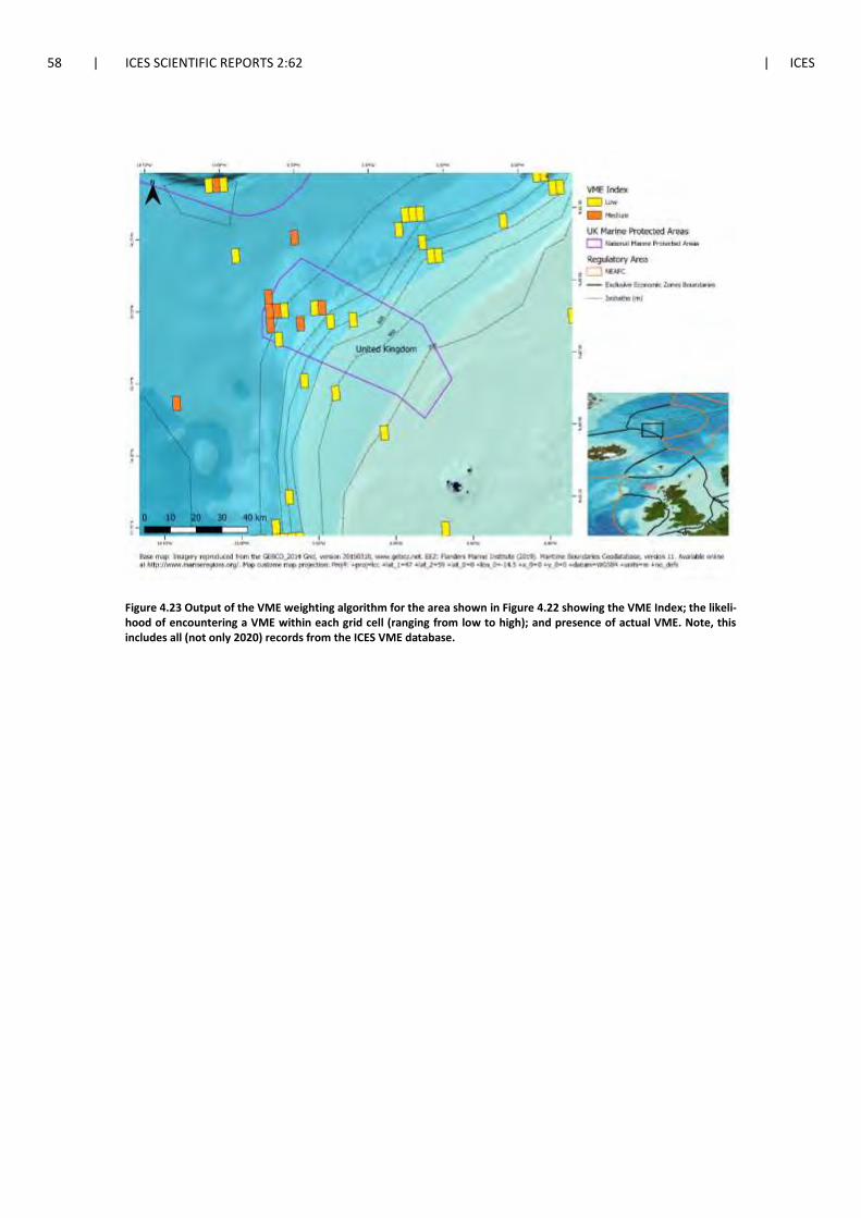
58 | ICES SCIENTIFIC REPORTS 2:62 | ICES
Figure 4.23 Output of the VME weighting algorithm for the area shown in Figure 4.22 showing the VME Index; the likeli-hood of encountering a VME within each grid cell (ranging from low to high); and presence of actual VME. Note, this includes all (not only 2020) records from the ICES VME database.

ICES | WGDEC 2020 | 59
Figure 4.24 The confidence layer associated with the VME weighting algorithm’s VME Index layer (Figure 4.23). Note that actual records of VME (e.g. VME habitats) are not assigned a confidence rating. This includes all (not only 2020) records from the ICES VME database.
4.4.6 Scottish and Irish Continental Slope
New VME habitat and indicator records for the Scottish and Irish Continental Slope were sub-
mitted by the UK and Ireland (Figure 4.25). New VME indicators were submitted from the Ma-
rine Scotland Science 1419S Survey (see Section 3.4.2.2) and the Irish Groundfish surveys (IGFS)
(see Section 3.4.4.2). New VME habitat records were submitted from the Irish SeaRover 2017
survey (see Section 3.4.4.1).
Updated outputs of the weighting algorithm with these new VME data for the Scottish and Irish
Continental Slope are shown in Figure 4.26, and the confidence layer for the VME index is shown
in Figure 4.27.

60 | ICES SCIENTIFIC REPORTS 2:62 | ICES
Figure 4.25 New VME records submitted in 2020 for the Scottish and Irish Continental Slope within EU waters. Note, other VME records from the VME database for this area are not displayed.

ICES | WGDEC 2020 | 61
Figure 4.26 Output of the VME weighting algorithm for the area shown in Figure 4.25 showing the VME Index; the likeli-hood of encountering a VME within each grid cell (ranging from low to high); and presence of actual VME. Note, this includes all (not only 2020) records from the ICES VME database.

62 | ICES SCIENTIFIC REPORTS 2:62 | ICES
Figure 4.27 The confidence layer associated with the VME weighting algorithm’s VME Index layer (Figure 4.26). Note that actual records of VME (e.g. VME habitats) are not assigned a confidence rating. This includes all (not only 2020) records from the ICES VME database.
4.4.7 Porcupine Bank and Seabight
The Porcupine Bank is located west of Ireland, and is a plateau forming the north-western mar-
gin of the Porcupine Seabight Basin. To the north and west, the Porcupine Bank slopes steeply
down a shelf break towards the Rockall Trough. To the south and southwest the bank slopes
more gently to the Porcupine Seabight (Thébaudeau et al., 2015).
A large number of new VME habitat and indicator data were submitted by the UK and Ireland
to the database in 2020 for this region, in addition to absence records (Figure 4.28).
New VME indicator data were provided from a range of sources: historic records from the Insti-
tute of Oceanographic Sciences report (Rice et al., 1990) (see Section 3.4.1.1); the NOC JC062 sur-
vey (see Section 3.4.3.1); the NOC D248 survey (see Section 3.4.3.3); the Irish Groundfish Surveys
(see Section 3.4.4.2) and the Irish Underwater TV surveys (see Section 0).
VME habitat data were provided from the NOC JC062 survey (see Section 3.4.3.1); the SeaRover
2017 and 2018 surveys (see Section 3.4.4.1), and; the NOC D248 survey (see Section 3.4.3.3).
Absence data were provided from the Irish Underwater TV surveys.
Updated outputs of the weighting algorithm with these new VME data for The Porcupine Bank
and Seabight are shown in Figure 4.29, and the confidence layer for the VME index is shown in
Figure 4.30.

ICES | WGDEC 2020 | 63
Figure 4.28 New VME records submitted in 2020 for the Porcupine Bank and Seabight within EU waters. Note, other VME records from the VME database for this area are not displayed.

64 | ICES SCIENTIFIC REPORTS 2:62 | ICES
Figure 4.29 Output of the VME weighting algorithm for the area shown in Figure 4.28 showing the VME Index; the likeli-hood of encountering a VME within each grid cell (ranging from low to high); and presence of actual VME. Note, this includes all (not only 2020) records from the ICES VME database.

ICES | WGDEC 2020 | 65
Figure 4.30 The confidence layer associated with the VME weighting algorithm’s VME Index layer (Figure 4.29). Note that actual records of VME (e.g. VME habitats) are not assigned a confidence rating. This includes all (not only 2020) records from the ICES VME database.
4.4.8 Icelandic Continental Slope
New VME habitat and indicator records were provided by Iceland for the Icelandic Continental
Slope. New VME indicator data was provided from the Benthic Invertebrates of Icelandic waters
(BIOICE) projects from 1991–2004 (see Section 3.4.7.1) and the Marine and Freshwater Research
Institute’s benthic habitat mapping project (see Section 0). New VME habitat data was also pro-
vided from the benthic habitat mapping project. An additional VME habitat record for a hydro-
thermal vent was submitted from the Icelandic marine Animals: Genetics and Ecology (ICEAGE)
project (see Section 0).
Maps are split by North, East, South and West of Iceland to show the new records more clearly
(Figure 4.31,Figure 4.34, Figure 4.37 and Figure 4.40). Updated outputs of the weighting algo-
rithm with these new VME data are shown in Figure 4.32, Figure 4.35, Figure 4.39 and Figure
4.41), and the confidence layer for the VME index is shown in Figure 4.33, Figure 4.36, Figure
4.39 and Figure 4.42.

66 | ICES SCIENTIFIC REPORTS 2:62 | ICES
Figure 4.31 New VME records submitted in 2020 for the North of Iceland within EU waters. Note, other VME records from the VME database for this area are not displayed.
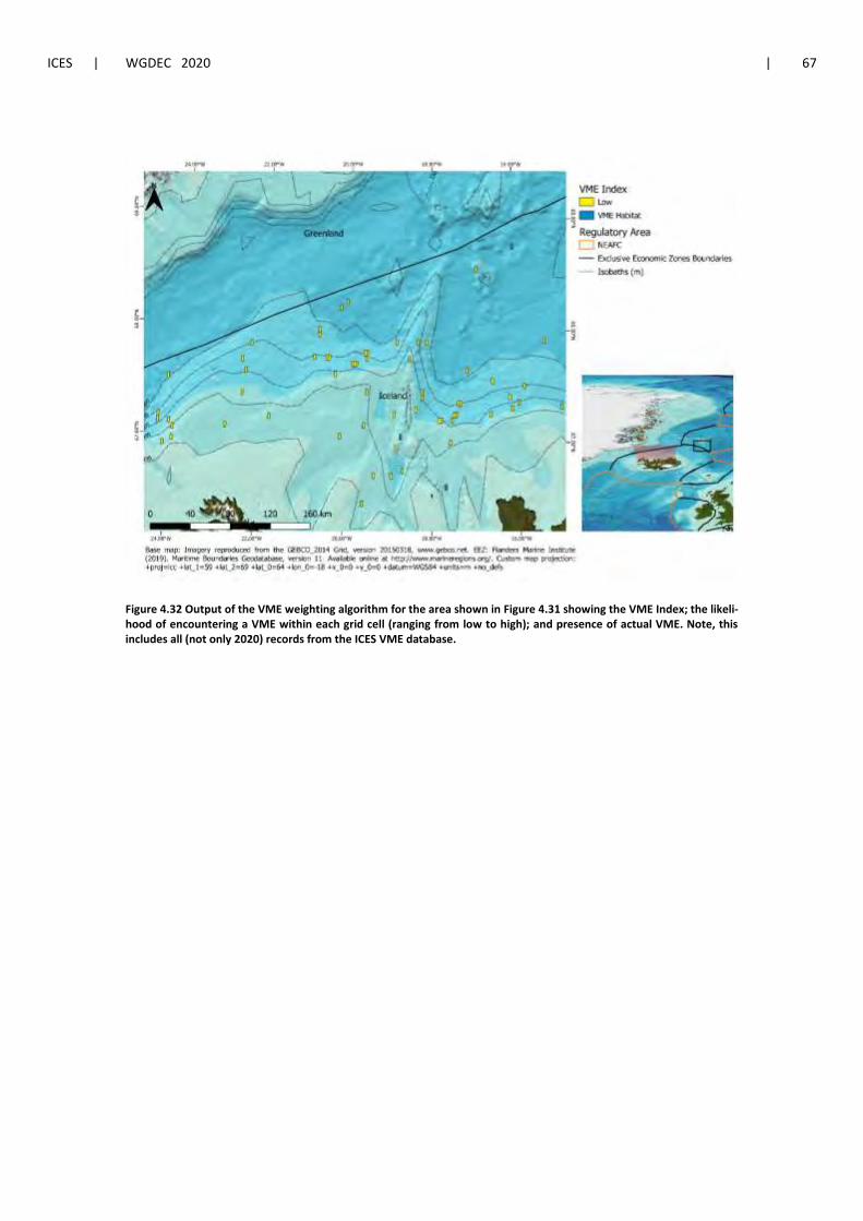
ICES | WGDEC 2020 | 67
Figure 4.32 Output of the VME weighting algorithm for the area shown in Figure 4.31 showing the VME Index; the likeli-hood of encountering a VME within each grid cell (ranging from low to high); and presence of actual VME. Note, this includes all (not only 2020) records from the ICES VME database.

68 | ICES SCIENTIFIC REPORTS 2:62 | ICES
Figure 4.33 The confidence layer associated with the VME weighting algorithm’s VME Index layer (Figure 4.32). Note that actual records of VME (e.g. VME habitats) are not assigned a confidence rating. This includes all (not only 2020) records from the ICES VME database.

ICES | WGDEC 2020 | 69
Figure 4.34 New VME records submitted in 2020 for East of Iceland within EU waters. Note, other VME records from the VME database for this area are not displayed.

70 | ICES SCIENTIFIC REPORTS 2:62 | ICES
Figure 4.35 Output of the VME weighting algorithm for the area shown in Figure 4.34 showing the VME Index; the likeli-hood of encountering a VME within each grid cell (ranging from low to high); and presence of actual VME. Note, this includes all (not only 2020) records from the ICES VME database.

ICES | WGDEC 2020 | 71
Figure 4.36 The confidence layer associated with the VME weighting algorithm’s VME Index layer (Figure 4.35). Note that actual records of VME (e.g. VME habitats) are not assigned a confidence rating. This includes all (not only 2020) records from the ICES VME database.

72 | ICES SCIENTIFIC REPORTS 2:62 | ICES
Figure 4.37 New VME records submitted in 2020 for South of Iceland within EU waters. Note, other VME records from the VME database for this area are not displayed.

ICES | WGDEC 2020 | 73
Figure 4.38 Output of the VME weighting algorithm for the area shown in Figure 4.37 showing the VME Index; the likeli-hood of encountering a VME within each grid cell (ranging from low to high); and presence of actual VME. Note, this includes all (not only 2020) records from the ICES VME database.

74 | ICES SCIENTIFIC REPORTS 2:62 | ICES
Figure 4.39 The confidence layer associated with the VME weighting algorithm’s VME Index layer (Figure 4.38). Note that actual records of VME (e.g. VME habitats) are not assigned a confidence rating. This includes all (not only 2020) records from the ICES VME database.

ICES | WGDEC 2020 | 75
Figure 4.40 New VME records submitted in 2020 for West of Iceland within EU waters. Note, other VME records from the VME database for this area are not displayed.

76 | ICES SCIENTIFIC REPORTS 2:62 | ICES
Figure 4.41 Output of the VME weighting algorithm for the area shown in Figure 4.40 showing the VME Index; the likeli-hood of encountering a VME within each grid cell (ranging from low to high); and presence of actual VME. Note, this includes all (not only 2020) records from the ICES VME database.

ICES | WGDEC 2020 | 77
Figure 4.42 The confidence layer associated with the VME weighting algorithm’s VME Index layer (Figure 4.41). Note that actual records of VME (e.g. VME habitats) are not assigned a confidence rating. This includes all (not only 2020) records from the ICES VME database.
4.4.9 Norwegian Trench and Danish and Swedish Continental Slopes
New VME habitat and indicator data were provided for areas of the Norwegian, Danish and
Swedish Continental Slopes (Figure 4.43). VME data were provided by Oceana within the Nor-
wegian Trench and the Danish Continental Slope. In addition, VME habitat data were submitted
by the Swedish University of Agricultural Sciences for the Swedish Continental Slope. These
records summarise data collected to define the area of VME represented by the Bratten MPA
(Figure 4.43, Section 0).
Updated outputs of the weighting algorithm with these new VME data for these regions are
shown in Figure 4.44, and the confidence layer for the VME index is shown in Figure 4.45.

78 | ICES SCIENTIFIC REPORTS 2:62 | ICES
Figure 4.43 New VME records submitted in 2020 for the Norwegian Trench and Danish and Swedish continental slopes within EU waters. Note, other VME records from the VME database for this area are not displayed.
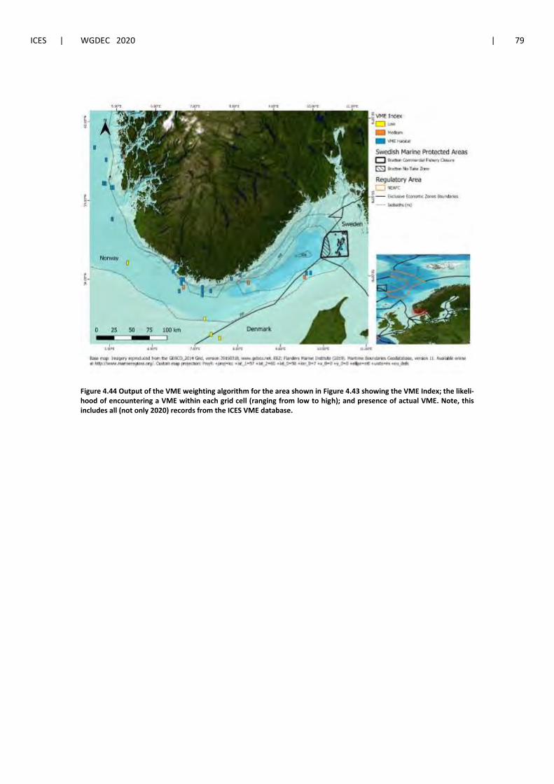
ICES | WGDEC 2020 | 79
Figure 4.44 Output of the VME weighting algorithm for the area shown in Figure 4.43 showing the VME Index; the likeli-hood of encountering a VME within each grid cell (ranging from low to high); and presence of actual VME. Note, this includes all (not only 2020) records from the ICES VME database.
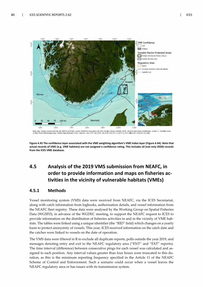
80 | ICES SCIENTIFIC REPORTS 2:62 | ICES
Figure 4.45 The confidence layer associated with the VME weighting algorithm’s VME Index layer (Figure 4.44). Note that actual records of VME (e.g. VME habitats) are not assigned a confidence rating. This includes all (not only 2020) records from the ICES VME database.
4.5 Analysis of the 2019 VMS submission from NEAFC, in order to provide information and maps on fisheries ac-tivities in the vicinity of vulnerable habitats (VMEs)
4.5.1 Methods
Vessel monitoring system (VMS) data were received from NEAFC, via the ICES Secretariat,
along with catch information from logbooks, authorisation details, and vessel information from
the NEAFC fleet registry. These data were analysed by the Working Group on Spatial Fisheries
Data (WGSFD), in advance of the WGDEC meeting, to support the NEAFC request to ICES to
provide information on the distribution of fisheries activities in and in the vicinity of VME hab-
itats. The tables were linked using a unique identifier (the “RID” field) which changes on a yearly
basis to protect anonymity of vessels. This year, ICES received information on the catch date and
the catches were linked to vessels on the date of operation.
The VMS data were filtered in R to exclude all duplicate reports, polls outside the year 2019, and
messages denoting entry and exit to the NEAFC regulatory area (“ENT” and “EXT” reports).
The time interval (difference) between consecutive pings for each vessel was calculated and as-
signed to each position. Any interval values greater than four hours were truncated to this du-
ration, as this is the minimum reporting frequency specified in the Article 11 of the NEAFC
Scheme of Control and Enforcement. Such a scenario could occur when a vessel leaves the
NEAFC regulatory area or has issues with its transmission system.

ICES | WGDEC 2020 | 81
Quality of the speed data was much improved on previous years (Figure 4.46). It was validated
against a derived speed, calculated as the great-circle (orthodromic) distance between consecu-
tive points reported by a vessel, divided by the time difference between them. Fishing effort is
inferred from VMS data on the basis of speed, with pings at slower speeds deemed to represent
fishing activity, and those at faster speeds to represent steaming and/or searching. In this in-
stance, a speed of 5 knots or lower has been used to demarcate fishing from non-fishing pings
for mobile bottom gears, 4 knots for vessels using static gears, and 6 knots for vessels with un-
defined gear types. Consecutive pings at fishing speeds for vessels using mobile-bottom contact-
ing gears were grouped into putative “tows”, manually reviewed to remove any erroneous se-
quences, and plotted, as a means to validate where fishing is taking place with the vessel tracks
running parallel to bathymetric contours, as would be expected.
Table 4.1 Number of pings (N) registered against each fishing gear type (Gear) in the speed filtered (0–5 knots) NEAFC VMS data.
Gear N
LL 76
LLS 745
NIL 39 448
OTB 54 579
PTB 1237

82 | ICES SCIENTIFIC REPORTS 2:62 | ICES
Figure 4.46 Histogram of reported speeds for bottom trawls, static gears and vessels without recorded gear which con-forms to expected distribution for that gear type.
4.5.2 Results
The VMS data were reviewed by WGDEC and mapped together with the VME Index outputs,
showing likelihood of VME presence based on the VME weighting algorithm, to assess whether
fishing activity was occurring in the vicinity of VMEs in the NEAFC Convention Area. Results
of this analysis are shown for Hatton Bank, Rockall Bank, Iceland, the Mid Atlantic Ridge Sea-
mounts and the west of the Bay of Biscay (Josephine Seamount).
4.5.3 Hatton Bank
The closures to the northern side of Hatton Bank are generally well observed (Figure 4.47). A
small number of bottom trawl tows appear to extend into the closed area at its northernmost
edge, however, these incursions are limited. The highest intensities of trawling are closely asso-
ciated with the boundary of the closed areas, particularly to the northeast (Figure 4.48). There
was little evidence of vessels using static bottom contact gears (Figure 4.49), or activity of vessels
without a registered gear type (Figure 4.50), in this area. Closures on the western side of the bank
are also well observed (tow tracks: Figure 4.51 and gridded trawl data: Figure 4.52), no activity
of static gears was observed in the area and only very limited activity from vessels without a
registered gear type (Figure 4.53).

ICES | WGDEC 2020 | 83
Figure 4.47 Bottom contacting otter trawl tow tracks to the north of Hatton Bank, overlain with the VME Index, VME closures, existing NEAFC fishing areas and EEZ boundaries.

84 | ICES SCIENTIFIC REPORTS 2:62 | ICES
Figure 4.48 Gridded data (fishing hours) for bottom contacting trawl gears to the north of Hatton Bank, overlain with existing NEAFC fishing areas and EEZ boundaries.

ICES | WGDEC 2020 | 85
Figure 4.49 Gridded data (fishing hours) for bottom contacting static gears to the north of Hatton Bank, overlain with VME closures, existing NEAFC fishing areas and EEZ boundaries.

86 | ICES SCIENTIFIC REPORTS 2:62 | ICES
Figure 4.50 Gridded data (fishing hours) where no gear was registered to the north of Hatton Bank, overlain with VME closures, existing NEAFC fishing areas and EEZ boundaries.

ICES | WGDEC 2020 | 87
Figure 4.51 Bottom contacting otter trawl tow tracks to the west of Hatton Bank, overlain with the VME Index, VME closures and existing NEAFC fishing areas.

88 | ICES SCIENTIFIC REPORTS 2:62 | ICES
Figure 4.52 Gridded data (fishing hours) for bottom contacting trawl gears to the west of Hatton Bank, overlain with VME closures and existing NEAFC fishing areas.

ICES | WGDEC 2020 | 89
Figure 4.53 Gridded data (fishing hours) where no gear was registered to the west of Hatton Bank, overlain with VME closures and existing NEAFC fishing areas.
4.5.4 Rockall Bank
The VME closures on the eastern side of Rockall Bank are generally well observed, with the
highest intensity of fishing occurring in an area that stretches along the western boundaries of
the Northwest Rockall closure and the Haddock Box (Figure 4.54, Figure 4.55). A small number
of bottom trawl tows appear to extend into the north-western quadrant of the Haddock Box,
however, these incursions are limited. Similarly, there are a small number of tows in the larger
closed area in southwest Rockall and in the Logachev Mounds closure, but again these are lim-
ited. Vessels registered as using static gears were active, at low levels, in the very northern part
of the existing fishing areas on Rockall Bank and in the northwest quadrant of the Haddock Box
(Figure 4.56). There is some evidence of vessels with no registered gear type operating within
the Haddock Box, particularly in the western half of the area (Figure 4.57).

90 | ICES SCIENTIFIC REPORTS 2:62 | ICES
Figure 4.54 Bottom contacting otter trawl tow tracks on Rockall Bank, overlain with the VME Index, VME closures, exist-ing NEAFC fishing areas and EEZ boundaries.

ICES | WGDEC 2020 | 91
Figure 4.55 Gridded data (fishing hours) for bottom contacting trawl gears on Rockall Bank, overlain with VME closures, the Haddock Box, existing NEAFC fishing areas and EEZ boundaries.

92 | ICES SCIENTIFIC REPORTS 2:62 | ICES
Figure 4.56 Gridded data (fishing hours) for bottom contacting static gears on Rockall Bank, overlain with VME closures, the Haddock Box, existing NEAFC fishing areas and EEZ boundaries.
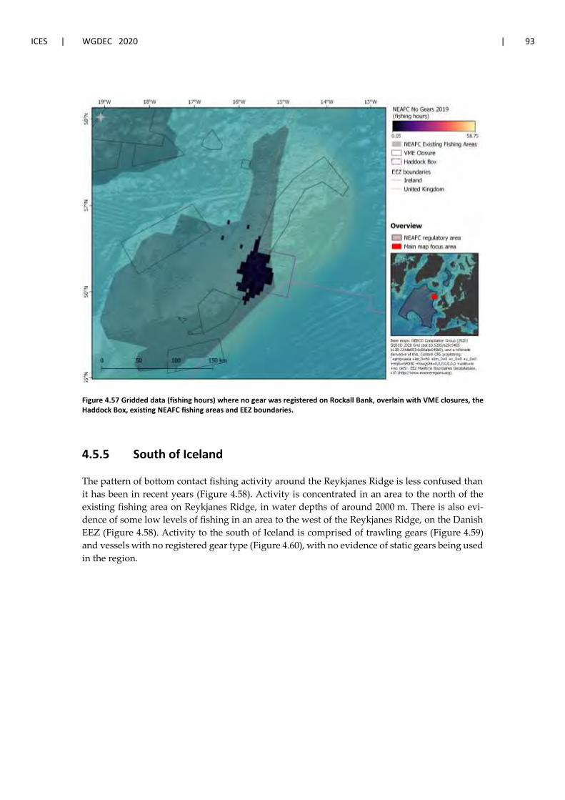
ICES | WGDEC 2020 | 93
Figure 4.57 Gridded data (fishing hours) where no gear was registered on Rockall Bank, overlain with VME closures, the Haddock Box, existing NEAFC fishing areas and EEZ boundaries.
4.5.5 South of Iceland
The pattern of bottom contact fishing activity around the Reykjanes Ridge is less confused than
it has been in recent years (Figure 4.58). Activity is concentrated in an area to the north of the
existing fishing area on Reykjanes Ridge, in water depths of around 2000 m. There is also evi-
dence of some low levels of fishing in an area to the west of the Reykjanes Ridge, on the Danish
EEZ (Figure 4.58). Activity to the south of Iceland is comprised of trawling gears (Figure 4.59)
and vessels with no registered gear type (Figure 4.60), with no evidence of static gears being used
in the region.

94 | ICES SCIENTIFIC REPORTS 2:62 | ICES
Figure 4.58 Bottom contacting otter trawl tow tracks south of Iceland, overlain with the VME Index, VME closures, exist-ing NEAFC fishing areas and EEZ boundaries.

ICES | WGDEC 2020 | 95
Figure 4.59 Gridded data (fishing hours) for bottom contacting trawl gears to the south of Iceland, overlain with existing NEAFC fishing areas and EEZ boundaries.

96 | ICES SCIENTIFIC REPORTS 2:62 | ICES
Figure 4.60 Gridded data (fishing hours) where no gear was registered to the south of Iceland, overlain with VME closures, existing NEAFC fishing areas and EEZ boundaries.
4.5.6 Mid Atlantic Ridge Seamounts
As seen in previous years, bottom trawling activity appears to be taking place at low intensities
on an unnamed seamount to the south of the MAR closure, outside the existing bottom fishing
area (Figure 4.61). Further south, bottom trawling takes place at low levels in and around the
existing bottom fishing areas, as well as on a seamount to the west of the Olympus Knoll (Figure
4.62). The fishing observed in the years previous to last year on the Chaucer Seamounts to the
south, including within the Southern MAR (C) closure area, continues to be absent this year.
There is no evidence of static gears, or vessels with no registered gear type, operating in the area.

ICES | WGDEC 2020 | 97
Figure 4.61 Bottom contacting otter trawl tow tracks on the Mid Atlantic Ridge seamounts, overlain with the VME Index, VME closures and existing NEAFC fishing areas.

98 | ICES SCIENTIFIC REPORTS 2:62 | ICES
Figure 4.62 Gridded data (fishing hours) for bottom contacting trawl gears on the Mid Atlantic Ridge Seamounts, overlain with existing NEAFC fishing areas.
4.5.7 Josephine Seamount
The Josephine Seamount area that was noted last year, again shows high levels of static gear
activity (Figure 4.63). The seamount represents a VME Element and a number of VME indicator
records, for gorgonians and black corals, have previously been submitted to the VME database
for this area. The low intensity use of static gears in the area to the west of the Josephine Sea-
mount occurs across a larger area than was observed in 2019 (Figure 4.64). There was no activity
of bottom trawling, or vessels without a registered gear type fishing in the area.

ICES | WGDEC 2020 | 99
Figure 4.63 Gridded data (fishing hours) for bottom contacting static gears in the Josephine seamount area, existing NEAFC fishing areas and EEZ boundaries.

100 | ICES SCIENTIFIC REPORTS 2:62 | ICES
Figure 4.64 Gridded data (fishing hours) for bottom contacting static gears in the area northwest of the Josephine Sea-mount, overlain with existing NEAFC fishing areas and EEZ boundaries.
4.6 References
ICES. 2018. Report of the ICES/NAFO Joint Working Group on Deep-water Ecology (WGDEC), 5–9 March
2018, Dartmouth, Nova Scotia, Canada. ICES CM 2018/ACOM:26. 126 pp.
Thébaudeau, B., Monteys, X., McCarron, S., O’Toole, R. & Caloca, S. 2015. Seabed geomorphology of the
Porcupine Bank, West of Ireland. Journal of Maps, 12, 947-958.

ICES | WGDEC 2020 | 101
5 Develop standards for the provision of absence data and OSPAR habitat data to the ICES VME data-base, and utilise VME indicator data records to fur-ther develop and test kernel density estimation methods to assess VME likelihood – ToR [c]
5.1 Introduction
Prior to the start of the WGDEC 2020 meeting it was agreed by the chair of WGDEC and the ICES
Secretariat, in consultation with ACOM Leadership, that this ToR would be reduced to a brief
introduction on the availability and provision of absence data and OSPAR habitat data to the
ICES VME database. This was decided due to the restrictions on the ability to hold a full, pro-
ductive meeting via WebEx and correspondence only. As such, the development of standards
for the provision of absence data and OSPAR habitat data, and the utilisation of VME indicator
data records to further develop and test kernel density estimation methods to assess VME like-
lihood, will be postponed until the WGDEC 2021 meeting.
This ToR has been split into two sections. The first section (Section 5.2) relates to how absence
data should be entered into the ICES VME database and how these data could be used by
WGDEC within future work. The second section (Section 5.3) relates to how data held in the
OSPAR database of threatened and/or declining habitats could be imported into the ICES VME
database.
5.2 Absence data
WGDEC 2019 considered issues on how to bring absence data in the ICES VME database. How-
ever, due to some outstanding questions on appropriate methods for the collection and reporting
of absence data, it was decided that absence records would not be considered as part of ToR [b]
(ICES, 2019a). Instead a ToR focused on developing standards for provision of absence data was
proposed for WGDEC 2020. Due to time constraints the group has not been able to fully develop
those standards and, instead, advice on the use and provision of absence data is provided.
An absence record reflects a specific position/location that has been sampled, but where no VMEs
or VME indicators have been observed or sampled. Absence data should not be confounded with
missing data, since the latter refers to a lack of sampling or survey in a specific position/location,
where it is therefore not known if VMEs or VME indicators are present or absent. One of the
reasons to include absence data is to better understand where these data gaps (missing data) are.
For this reason, absences, specific to the sampling method, provide an overview of the areas
surveyed. Typically, these will be more important for data collected from trawls which cover a
larger area.

102 | ICES SCIENTIFIC REPORTS 2:62 | ICES
5.2.1 Uses of Absence data
5.2.1.1 Habitat mapping and species distribution modelling
Absence data are fundamental to fully evaluating the occurrence of VME habitats and indicators,
and, specifically, for the performance of species distribution models (SDMs) and habitat suita-
bility models (HSMs) to support mapping of benthic habitats. However, verified absence data
for deep-water species and habitats (e.g. VMEs) are not often generated from research surveys.
This hampers the ability to perform a proper assessment of the occurrence of VMEs, as it is dif-
ficult to establish if the lack of data plotted in maps is due to the actual absence of VMEs or due
to a lack of sampling in the area.
One of the topics included in the ICES Working Group on Marine Habitat Mapping (WGMHM)
2019 meeting was the issue of reliable absence data availability and its use within marine habitat
mapping and SDMs (ICES, 2019b). They noted that whilst SDMs can use presence-only data,
they tend to be poorer than models using presence and absence data. To address this, methods
have been developed by modellers to generate pseudo-absence and background data which in-
clude, for instance, designating absence status to species records that are known not to co-occur
with the modelled species, or including randomly placed points within the modelled domain,
often buffered away from presence observations (ICES, 2019b). There are, however, limitations
to these methods and it is difficult to ensure that pseudo-absence and background points truly
represent absences. As such, models relying on pseudo-absence and background data are more
uncertain than those using observed absence data. One of the main conclusions extracted by the
WGMHM in their 2019 meeting was the importance that modellers using absence data state:
i. how absence data were generated;
ii. how many absence points were included, in comparison to the number of presence
points, and;
iii. any implications of the absence data method on overlap map accuracy and interpretabil-
ity.
5.2.1.2 Loss of VME habitats and linking anthropogenic impacts to absence rec-ords
As more absence data is added to the VME database over time, it may become possible to identify
areas where VME habitats have previously occurred but no longer do. Understanding how this
loss occurred would be critical, especially if it were to happen in areas protected for VME habi-
tats. In order to identify the cause of habitat loss, information on variables such as the fishing
footprint will be important. Data have been submitted to the VME database from at least two
studies which have attempted to identify causes of VME habitat loss.
1) A study based on towed-camera transects examined the structure of deep-sea sponge aggre-
gations in areas inside and outside the Faroe-Shetland Channel Nature Conservation Marine
Protected Area (FSC NCMPA) in the UK EEZ. Here, it was shown that deep-sea sponges (mainly
massive and fan-shaped morphotypes likely belonging to the genera Geodia and Phakellia, respec-
tively) had higher diversity of morphotypes, higher density (ind/m2) and larger body size (cm)
in areas inside than outside the MPA (see Figure 8 and Table 4 in Kazanidis et al., 2019). The
main parameter driving these differences was lower bottom fishing activity occurring inside the
MPA (see Table 5 in Kazanidis et al., 2019). It was, however, also shown that other parameters
such as the type of substrate and water-mass characteristics (temperature, salinity), had a statis-

ICES | WGDEC 2020 | 103
tically significant contribution in explaining the differences in deep-sea sponge aggregations in-
side and outside the MPA. Specifically, higher values of sponge density (up to 1.8 ind./m2) were
found where cobble/cobble with boulder were the major types of substrate, in contrast to the
much lower values of sponge density in areas with a high coverage of soft sediments.
2) A study using towed-camera transects was conducted in 1983/4 and later in 2011, in the same
area of the Porcupine Seabight. This study found that Pheronema carpenteri deep-sea sponge ag-
gregations had declined in both numerical and biomass density. This decline was linked to in-
creased demersal fishing activity in the study area since the 1980s, although the authors were not
able to exclude other causes of changes in the sponge populations, due to the lack of data in the
intervening period (Vieira et al., 2020).
5.2.2 Considerations when using absence data
5.2.2.1 Survey methods and scale
An added difficulty when dealing with absence data is the issue of scale. Benthic samples are
collected in multiple ways, for example bottom trawling scientific surveys, box corers, video
transects and photographs. These methods cover different spatial scales in terms of seafloor area
and have different “sample catchability”; this makes comparison between different survey re-
sults challenging, and also illustrates a problem with the collection of absence data.
Without information on scale, absence data from imagery would be problematic to include in
analyses with datasets collated from different methods. For example, it would be challenging to
combine data on absence of VMEs from an image covering 6 m2 seabed with absence data from
videos representing aggregated information along a 1 km distance of the seabed. One solution is
to present still images as points, and video transects as lines, so as not to interchange between
the two scales.
Similar scale issues are also evident from presence or abundance data. For example, the physical
extension or distribution pattern of VMEs on the seabed caught in a trawl is unknown. For video
analysis results, there is the possibility of choosing the scale of reporting, however there is great
variation in how video data are analysed and presented. In a video record of the seabed, all
occurrences could be recorded as single events, providing a series of point data. Or, as applied
more commonly; the video could be divided into subsamples of a chosen scale (distance along
the seabed). This therefore results in two potential different scales of presence data.
These issues also illustrate the importance of knowing the scale of sampling units for absence
data, since one single video could either be presented as a great number of consecutive absences,
or only one absence, depending on the chosen scale of reporting.
It is also advised that absence data should not be scaled up to larger areas. For this reason, ab-
sence data are not incorporated into the VME weighting algorithm.
5.2.2.2 Absence vs missing data
As detailed above, absence data should not be confused with missing data. Missing data may
consist of areas where sampling has not occurred, but could also include areas where sampling
has occurred, but absence information was not recorded due lack of requirement/need from the
specific survey. However, this provides another justification for the submission of absence data,
as it also enables improved understanding of whether an area has been sampled or not.
When using absence records from the VME database, it is important to consider the list of VME
habitats and indicators that were used by the data provider at the time of submission. The list of

104 | ICES SCIENTIFIC REPORTS 2:62 | ICES
VME habitat and indicators accepted by the VME database has changed on two occasions, firstly
in December 2015 (ICES, 2016) and then in January 20202, with follow up changes due to take
place following this 2020 meeting (see Section 7). Changes to the list would need to be considered
when using absence data for certain applications. For example, for before/after comparisons, it
would be incorrect to compare presence and absence of xenophyophore indicators using data
submitted before 2015, as the xenophyophore indicator was only added in December 2015.
For this reason, it is suggested that the date of insertion into the database is checked if absence
records are used for data analysis purposes, to confirm that the VME habitat and indicator cate-
gories are comparable. Date of insertion is provided as a field of the VME database extract.
5.2.3 Criteria for absence data submissions
Based on the discussions above, and in line with the guidance provided in the WGDEC 2020 data
call3, WGDEC 2021 agreed a series of criteria that must be fulfilled for any submissions of VME
absence data to the VME database:
1. Record must not be of a VME habitat type;
2. Record must not have been collected using a commercial fishing trawl (due to difficulties
in knowing if observers are recording the full suite of VME indicators during these sur-
veys or just a ‘subset’);
3. Record must be from a survey where the presence of VMEs has been recorded on the
same survey (this is to ensure that VMEs were being recorded during the survey, and
that the record would therefore be a definite absence rather than missing data);
4. Record must not be from a sample that also contains presence records (i.e. two records
with matching SampleIDs cannot have both presence and absence VME data)
5.2.4 Summary of absence records 2020
To summarise the absence records in the VME database, the definition from Section 5.2.3 has
been followed. In order to meet this definition, Norwegian records for the Barents Sea which
observed species that are indicators, as well as species not considered indicators, have been re-
moved as they do not meet rule 4. These data will be reviewed prior to WGDEC 2021, to be
updated in the database.
This resulted in 315 absence records in the VME database, mostly within the UK and Irish EEZs,
but also a small proportion in the NEAFC area of Rockall Bank. All records are from research
surveys conducted between 2012 and 2019. 43% were submitted to the VME database between
December 2015 and January 2020 and the remaining 57% since January 2020 (thus using the up-
dated VME indicator list). Absence records are available from four different methods of trawl
sampling, and two different methods of seabed imagery sampling (Table 5.1). Table 5.1 replaces
previous summaries of absence data provided in WGDEC 2019 (ICES, 2019a) as it uses the new,
stricter definition of absence data.
It is important to note that due to differences in survey methods and scale, not all the data sum-
marised in Table 5.1 will be suitable to compare in an analysis of presence and absence data. The
2A suggestive list of deep-water VMEs and their characteristic taxa – updated Jan 2020 https://www.ices.dk/data/Docu-
ments/VME/VMEs%20and%20their%20taxa.pdf
3 WGDEC data call 2020 for Vulnerable Marine Ecosystems (VME) data; http://ices.dk/sites/pub/Publication%20Re-
ports/Data%20calls/datacall.2020.WGDEC_VME_data.pdf. Accessed May 2020

ICES | WGDEC 2020 | 105
underwater TV survey data submitted by the Marine Institute (Ireland) is presented here as an
example of where absence and presence could be compared.
In the example of the Marine Institute’s Underwater TV surveys, data was collected using a
towed camera sledge from the southern flank of the Porcupine Bank. The sampling effort can be
summarised as 444 camera transects, collected across 7 surveys between 2012 and 2019, in an
area of approximately 7900 km2. Sea pen presence and absence was recorded at each sampling
station, resulting in 284 stations where sea pens were present and 160 where they were absent
(Figure 5.1). Data were submitted in 2020 using the VME indicators from the updated, January
2020, VME list4.
Table 5.1 Summary of absence data observations in the ICES VME database as of May 2020
Survey method Trawls
Survey method Seabed imagery
Bot-tom trawl
GOV trawl
Jack-son Deep-water Trawl
Rock hopper otter trawl
ROV system
Towed camera system
Survey method not re-ported
Total per in-sertion period
Da
tab
ase
inse
rtio
n p
erio
d
31/12/2015 –
31/12/2020
0 23 35 22 1 0 53 134
Since 01/01/2020
11 2 0 0 8 160 0 181
Total pre- survey method
11 25 35 22 9 160 53 315
4 https://www.ices.dk/data/Documents/VME/VMEs%20and%20their%20taxa.pdf

106 | ICES SCIENTIFIC REPORTS 2:62 | ICES
Figure 5.1 Spatial distribution of presence and absence records of sea pens collected by Marine Institute Underwater TV Surveys at Porcupine Bank.
5.2.5 Conclusions
Absence data have not, to date, been used by WGDEC within their work, but there is an increas-
ing amount of absence data in the ICES VME database. These data have the potential for future
use by WGDEC and other ICES groups, primarily for habitat mapping and species distribution
modelling, but VME data providers should be encouraged to submit absence records only when
they meet the four criteria detailed in Section 5.2.3.
Furthermore, absence data can be misinterpreted and therefore WGDEC recommend that for
any future use, the considerations provided in Section 5.2.2 are taken into account. Additionally,
the datasets that include absence data, should be checked to ensure they have used a comparable
list of VME habitats and indicators, and that the dates of insertion into the database are stated
(i.e. before December 2015, between December 2015 and January 2020, after January 2020). Lastly,
absence data should not be scaled up to the level of the VME index c-square.
5.3 OSPAR data
The OSPAR database5 contains information on the presence of OSPAR’s 15 threatened and/or
declining habitats (Table 5.2). These data are collated from the northeast Atlantic and include
shelf sea and deep-sea habitats. Although much of the data in the OSPAR database has been
submitted to the VME database, there are a significant number of records which have not.
In previous years, OSPAR records have been considered by WGDEC in parallel to the ICES VME
database. This is not ideal as the databases have different formats which makes including them
5 OSPAR Habitats 2018 point data : https://odims.ospar.org/layers/geonode:ospar2018_points. Accessed May 2020

ICES | WGDEC 2020 | 107
both in the same analyses, such as production of the VME weighting algorithm, difficult or im-
possible. This section describes a process which can be used to import OSPAR records into the
ICES VME database, firstly through the identification of records which are relevant to the ICES
VME database and are currently not included, and secondly through quality assurance of these
records, as well as other potential sources of VME data.
Table 5.2 List of all 15 OSPAR threatened and/or declining habitats and the ICES VME habitat types which have direct or partially matching definitions. *equivalent definition is classified as a VME Element by ICES (see Section 6.3.1), rather than a VME habitat.
OSPAR Habitat Type VME
Habitat Type
VME match to OSPAR
Carbonate Mounds - None
Coral Gardens Coral garden Direct match
Cymodocea Meadows - None
Deep-Sea Sponge Aggregations Deep-sea sponge
Aggregations
Direct match
Intertidal Mytilus edulis Beds on Mixed & Sandy Sediments - None
Intertidal Mudflats - None
Lophelia pertusa Reefs Cold-water coral reef Direct match
Maerl Beds - None
Modiolus modiolus beds - None
Oceanic Ridges with Hydrothermal Vents Hydrothermal
vents/fields
Direct match
Ostrea edulis Beds - None
Sabellaria spinulosa Reefs - None
Seamounts - None*
Sea pen & Burrowing Megafauna Communities Sea pen fields Partial match
Zostera Beds - None
5.3.1 Method for importing OSPAR records into the VME database
The OSPAR threatened and/or declining habitats database was translated into the same format
as the ICES VME database template, to enable comparison of records. Fields were mapped from
point records from the OSPAR habitats database to the fields in the ICES VME database using R
(R Core Team, 2018). All mandatory fields for the VME database were mapped from OSPAR
data, using ICES vocabularies, and where optional information was available that was also
mapped.
OSPAR threatened and/or declining habitats that had a direct correlation to VME habitat types
were selected (Table 5.2), namely:
Coral Gardens
Deep-sea sponge aggregations
Lophelia pertusa reefs = Cold-water coral reef
Oceanic ridges with hydrothermal vents/fields

108 | ICES SCIENTIFIC REPORTS 2:62 | ICES
Seamounts were excluded because they are a VME Element (see Section 6.3.1). Sea pen and bur-
rowing megafauna communities were excluded because the definition of the OSPAR habitat
meant that it would not be possible to include only those records where sea pens were present.
Data in the OSPAR database were further cleaned to include only records assigned as “certain”
and whose data collection methods from the “OSPAR Survey” table included visual imagery
(e.g. drop camera). Where multiple collection methods were listed, the data were assigned to the
first method in the following order:
Seabed imagery - ROV system
Seabed imagery – drop camera system (photo/video)
Seabed imagery – towed camera system (photo/video)
All the methods provided were also added to the comments field to allow further examination
or change in assignment order if required.
Records depths were checked using the EMODnet Bathymetry REST service “avg” field and
those shallower than 200 m were excluded.
Only those records not already in the ICES VME database were required and therefore, removal
of “duplicates” was required. Owing to differences in data input, survey keys, date formats and
variations in the number of decimal places used for the decimal degrees coordinates, it was not
possible to match or exclude records automatically by field or directly by spatial intersection.
It was therefore decided to place a buffer around records from the VME database to spatially
identify OSPAR records that could be the same as existing VME database records. The buffer
size used was 11.1 km, which was based on the precision that a decimal degree to one decimal
place would provide6. Most coordinate data in the databases were provided to at least two deci-
mal points. If the OSPAR records did not intersect the VME buffered record, they were defined
as not already occurring in the ICES VME database. For those records intersecting the VME buff-
ered records, further manual checking of the OSPAR attributes (i.e., date range and similar sur-
vey name), to ensure the record was not already in the VME database, would be required before
the record could be used. A spreadsheet of the spatially intersected OSPAR and buffered VME
records, providing relevant attributes for comparison, was produced for this purpose.
5.3.2 Quality Assurance of OSPAR data
As the ICES VME database will be used to inform management decisions, it is critical that the
data included meets a high standard of quality. For this reason, all data being transferred to the
ICES VME database from OSPAR will need to be quality assured by members of the group before
being imported. Part of this quality assurance check will be confirmation that an OSPAR record
does match the requirements of a VME habitat. If this is not the case, OSPAR records may be
entered as a VME indicator. If neither an appropriate VME habitat or indicator can be assigned,
then the record should not be imported into the VME database.
For future submissions, data providers submitting the habitats listed above to OSPAR should be
encouraged to submit the same data to ICES as well. To ensure ease of submission for data sup-
pliers to both databases, WGDEC agreed that discussions between the ICES Data Centre and
OSPAR database managers would be important, to establish ways to streamline the two data
templates.
6 https://en.wikipedia.org/wiki/Decimal_degrees. Accessed May 2020

ICES | WGDEC 2020 | 109
5.3.3 Other sources of VME data
During the group discussion at WGDEC 2020, it was noted that there are other likely sources of
VME data, some of which may not be present in the VME database.
Although there was not time to check other sources for data that could be added to the VME
database during the meeting, some databases of relevance are described below. Three of the da-
tabases (EMODnet Biology, OBIS, and PANGAEA) serve to collate data on all marine (and some-
times terrestrial) species across specified geographic regions. The UNEP database is more spe-
cifically a collation of cold-water coral occurrences.
European Marine Observation and Data Network (EMODnet) Biology
The EMODnet Biology7 database provides species data for European regional seas.
Ocean Biodiversity Information System OBIS
The OBIS8 database collates data from other sources and provides a global marine species data
portal.
PANGAEA
PANGAEA is a data publisher for Earth and Environmental Science. It hosts data on various
topics, including Oceans, Biosphere, Ecology, Fisheries and Geophysics, with a global geo-
graphic coverage. It is operated as an open access library, which aims to archive and publish
georeferenced data. Each dataset can be identified, shared, published and cited using a Digital
Object Identifier (DOI). The data can be accessed at PANGAEA’s website9. A search of PAN-
GAEA in May 2020 using “cold-water corals” as the search term recovered 554 data sets.
United Nations Environment Programme (UNEP) Database on Cold-water corals
The UNEP Global Distribution of Cold-water Corals database, hereafter referred to as the UNEP
database, shows the worldwide distribution of cold-water corals, as well as other taxa relevant
to WGDEC. Occurrence records are given for 86 Families under the subclass Octocorallia (octo-
corals; also known as Alcyonaria) and four Orders (in Class Anthozoa): Scleractinia (reef-form-
ing corals), Antipatharia (black corals), Zoanthidae (encrusting or button polyps), and Pennatu-
lacea (sea pens). Occurrence records are also available for the Sub-Order Filifera (lace corals) in
Class Hydrozoa (Freiwald et al., 2017; Freiwald et al., 2004). The UNEP database is available to
download in a shapefile format (both point and polygon)10.
Freiwald et al., (2017) also specifically state that the UNEP database is of relevance to VME policy
as well as the following areas;
Convention on Biological Diversity (CBD)
Ecologically or Biologically Significant Area (EBSA)
Specially Protected Areas of Mediterranean Importance (SPAMI)
Convention on International Trade in Endangered Species of Wild Fauna and Flora
(CITES)
Note that this database also cites OSPAR (2015) and there is likely duplication of records between
the UNEP database and the OSPAR database, as well as potential duplication between the UNEP
7 EMODnet Biology website https://www.emodnet-biology.eu/. Accessed May 2020 8 OBIS’s website https://obis.org/. Accessed May 2020 9 PANGEAEA’s website https://www.pangaea.de/. Accessed May 2020 10 UNEP database records can be downloaded from https://data.unep-wcmc.org/datasets/3. Accessed May 2020

110 | ICES SCIENTIFIC REPORTS 2:62 | ICES
database and the ICES VME database. These sources of duplication would need to be reviewed
before any data could be brought into the VME database or utilised separately by WGDEC.
5.4 References
Freiwald A, Rogers A, Hall-Spencer J, Guinotte JM, Davies AJ, Yesson C, Martin CS, Weatherdon LV (2017).
Global distribution of cold-water corals (version 5.0). Fifth update to the dataset in Freiwald et al. (2004)
by UNEP-WCMC, in collaboration with Andre Freiwald and John Guinotte. Cambridge (UK): UN En-
vironment World Conservation Monitoring Centre. URL: http://data.unep-wcmc.org/datasets/3
Freiwald A, Fosså JH, Grehan A, Koslow T, Roberts JM (2004). Cold-water coral reefs: out of sight – no
longer out of mind. Biodiversity Series 22. Cambridge (UK): UNEP World Conservation Monitoring
Centre. 86 pp. URL: https://archive.org/details/coldwatercoralre04frei
ICES. 2016. Report of the Workshop on Vulnerable Marine Ecosystem Database (WKVME), 10–11 Decem-
ber 2015, Peterborough, UK. ICES CM 2015/ACOM:62. 42 pp. http://www.ices.dk/sites/pub/Publica-
tion%20Reports/Expert%20Group%20Report/acom/2015/WKVME/wkvme_2015.pdf
ICES. 2019a. ICES/NAFO Joint Working Group on Deep-water Ecology (WGDEC). ICES Scientific Reports.
1:56. 119 pp. http://doi.org/10.17895/ices.pub.5567
ICES. 2019b. Working Group on Marine Habitat Mapping (WGMHM). ICES Scientific Reports. 1:54. 28 pp.
http://doi.org/10.17895/ices.pub.5578
Kazanidis G., Vad J., Henry L-A., Neat F., Berx B., Georgoulas K., Roberts J.M. (2019). Distribution of deep-
sea sponge aggregations in an area of multisectoral activities and changing oceanic conditions. Fron-
tiers in Marine Science 6:163. doi: 10.3389/fmars.2019.00163.
OSPAR Commission. (2015) OSPAR Threatened and/or Declining Habitats 2015. URL:
http://www.ospar.org/work-areas/bdc/species-habitats/list-of-threatened-declining-species-habitats.
Data URL: http://www.emodnet-seabedhabitats.eu/download.
R Core Team (2018) R: A Language and Environment for Statistical Computing. R Foundation for Statistical
Computing. Vienna, Austria. https://www.R-project.org/
Vieira RP, Bett BJ, Jones DOB, Durden JM, Morris KJ, Cunha MR, Trueman CT, Ruhl HA. (2020). Deep-sea
sponge aggregations (Pheronema carpenteri) in the Porcupine Seabight (NE Atlantic) potentially de-
graded by demersal fishing. Progress in Oceanography, 183, 102189.

ICES | WGDEC 2020 | 111
6 Building on work initiated in 2019, work jointly with the WGMHM to test the use of habitat suitability models for mapping VME presence, to assess how such information could be incorporated when, for example, recommending proposals for VME clo-sures – ToR [d]
6.1 Clarification on change in ToR
WGDEC have previously reviewed the potential for using Species Distribution Models (SDMs)
and Habitat Suitability Models (HSMs) within their work to support understanding of likely
presence of VMEs. In 2019, the group noted that these have not yet been used to provide recom-
mendations to ACOM on how to incorporate such information when suggesting VME closures
through draft ICES advice. The group therefore identified the availability and differing resolu-
tions of existing models and proposed next steps for model use (ICES, 2019a). Furthermore, the
2019 meeting was held jointly with the WGMHM, who reviewed the use of predictive models
for estimating presence of VMEs and developed a ‘roadmap’ identifying the steps required for
the implementation of their use by WGDEC and within ICES advice (ICES, 2019b).
This ToR planned to work jointly with WGMHM to test the use of SDM/HSMs for assessing VME
likelihood for a case study area. However, following discussions between the WGDEC and
WGMHM chairs, together with the ICES Secretariat and ACOM Leadership, it was agreed that
this ToR would be further developed in 2021 when an in-person meeting was possible. Discus-
sions were therefore held at WGDEC 2020 on the best way to take this work forward and the
main focus for this ToR was changed to undertake mapping of VME Elements to support advice
to the European Commission (see section 6.3).
6.2 Future use of Predictive Habitat Models within ICES ad-vice
HSMs and SDMs are a commonly used method to predict the distribution of vulnerable marine
ecosystems (VMEs) and can be particularly useful in deep-sea regions to fill gaps in observational
data. These models utilise data on environmental variables, such as depth and water properties,
to predict the occurrence of VMEs and indicator species. A range of models exist in the peer
reviewed literature for different VME types and at different spatial scales (e.g. Yesson et al., 2012;
Howell et al., 2016; Rooper et al., 2014; Ross et al., 2015; Kenchington et al., 2016).
The ‘roadmap’ developed by WGMHM (ICES, 2019) clarifies the need to generate a specification
for the modelled outputs, to identify aspects such as which habitats/species to model, the spatial
extent of the model, the minimum mapping resolution and how often the model should be re-
run. In addition, they recommended a trial run for a subset of VME features, to optimise the
model approaches, with the final methods published as part of the ICES ‘Transparent Assess-
ment Framework’.

112 | ICES SCIENTIFIC REPORTS 2:62 | ICES
Whilst the ToR for WGDEC/WGMHM was changed for WGDEC 2020, the group still considered
the outputs from WGMHM 2019 and options for implementing the roadmap to ensure momen-
tum was maintained on the best approaches to support future use of predictive models in ICES
advice work. It was agreed that use of predictive models would provide a practical tool to sup-
port understanding of the likelihood of data-poor areas of the North Atlantic containing VMEs.
However, the group also determined that a set of criteria should be derived, against which new
and existing models could be reviewed to determine appropriate standards for their use for sci-
entific advice. These outputs could then be used in the future to support the ICES advice process
to the European Commission (EC) and NEAFC. In particular, it would add value to the advice
to the EC on the deep-sea access regulations (EU) 2016/2336, for recommendations of closures to
bottom trawling in areas where ‘VMEs are likely to occur’ within the 400–800 m footprint.
It was decided that it would be beneficial to run an intersessional benchmark workshop, prior to
WGDEC 2021, to further this work and allow sufficient time to go through the ‘roadmap’ steps.
A set of draft Terms of Reference were proposed by the group, see below.
The outputs of this workshop will be provided to ICES to determine the potential future appli-
cation of predictive models within the ICES advice process.
6.2.1 Draft Terms of Reference for Predictive Habitat Models work-shop
The Benchmark Workshop on the Use of Predictive Habitat Models in ICES Advice
(WKPHM), chaired jointly by [TBC] will be established and will meet in [TBC] to:
Review and recommend a set of criteria, similar to the existing ICES benchmarking sys-
tem for regional fish stock assessments11, underwhich new and existing predictive habitat
models can be used for ICES scientific advice related to the distribution of vulnerable
marine ecosystems (VMEs) (Science Plan code 6.2);
Based on existing approaches, identify the methods for modelling VMEs that would be
most appropriate for use within ICES advice, detailing ‘required’ and ‘desirable’ criteria,
with emphasis on the deep-sea environment (considering bias of preferential sampling),
PHM techniques (including spatial display of uncertainty) and required validation steps
for the modelled outputs (Science Plan code 3.2);
Develop clear standards for recording the caveats and assumptions inherent in the mod-
elling method, for future use (Science Plan code 6.2);
Conduct a trial run for a small number of existing models to ensure that both the ap-
proach and outputs are fit-for-purpose.
WKPHM will report by [TBC] for the attention of ACOM.
Supporting information
Priority WGMHM and WGDEC have strongly advocated for the inclusion of predictive
habitat models in ICES advice related to the distribution of vulnerable marine
ecosystems. In order for ICES to utilize such models in their advice an agreed set
of standards is required. With recurring requests from NEAFC, and potentially the
EU, on the best scientific advice on where VMEs are known or likely to occur, this
workshop is of a high priority.
11https://community.ices.dk/ExpertGroups/benchmarks/Shared%20Documents/Guidelines%20for%20Bench-
mark%20and%20Data%20Compilation%20Workshops.pdf

ICES | WGDEC 2020 | 113
Scientific justification Term of Reference a)
Predictive habitat models (PHMs, also known as habitat suitability models, species
distribution models or environmental niche models) are models that predict the
likely distribution of a species or habitat using environmental variables as
predictors. WGMHM and WGDEC have identified that PHMs which meet specific
quality thresholds, represent the best available evidence for estimating where
VMEs are likely to occur at a broad scale. However there is no agreed upon
standard for what those quality thresholds should be. This ToR is aimed at
providing benchmark standards for the use of such models in ICES advice related
to the distribution of VMEs.
Term of Reference b)
WGMHM recommended in its 2019 report (ICES 2019) that guidance on the data
sources, resolution and modelling approaches to be used would help to
standardize ICES advice using PHMs and allow for direct comparison of outputs.
This will render the data, methods and results from ICES assessments easy to find,
explore and re-run and contribute to a Transparent Assessment Framework for
PHM-related advice.
Term of Reference c)
Any modeling approach has associated caveats and assumptions. Standards on
what should be reported will avoid misuse or misinterpretation of model outputs
and will give greater credibility to PHM model-based advice.
Term of Reference d)
Having agreed on a common set of standards it will be necessary to conduct trial
runs, using existing VME models,to make sure that the anticipated model outputs
are fit for purpose. This approach will also allow for testing of the impacts of the
recommendations from ToRs a and b.
Resource requirements
Participants The Group would likely by attended by some 20–25 members and guests.
Secretariat facilities None.
Financial No financial implications.
Linkages to advisory
committees
ACOM
Linkages to other
committees or groups
There is a very close working relationship with Working Groups on Benthic Ecology,
Marine Planning and Coastal Zone Management and Spatial Fisheries Data. Data
products will be used by WKEUVME in future.
Linkages to other
organizations
FAO, NEAFC, EC, EMODnet.
6.3 VME element mapping
In response to a request from DGMARE to provide further scientific input to support implemen-
tation of the EU deep-sea access regulations (EU 2016/233612), ICES organised a workshop on EU
regulatory area options for VME protection (WKEUVME) to take place 18–22 May. WKEUVME
will recommend a set of regulatory area options that vary in the degree of VME protection from
bottom fishing. These will draw upon evidence of where VMEs occur, or are likely to occur,
based on data collated through the ICES VME data calls and quality assured by WGDEC.
During the preparatory meeting for WKEUVME, a workflow was developed describing different
VME protection scenarios, with criteria for area selection that could be used with relevant ICES
datasets. This workflow proposed a stepwise approach to the inclusion of different data sources,
12 https://eur-lex.europa.eu/legal-content/EN/TXT/?uri=CELEX%3A32016R2336

114 | ICES SCIENTIFIC REPORTS 2:62 | ICES
with decreasing data quality and associated confidence in VME presence. This would include
known VME occurrences, using confirmed VME habitat data from the ICES VME database, and
areas where VME are likely to occur based on VME indicator records from the database. It could
also include, with lower levels of confidence, SDMs and HSMs of VME habitats/indicators, plus
mapped areas of VME elements, based on the list in the Annex of the FAO International Guide-
lines (FAO, 2009).
Since the use of SDMs/HSMs requires further thought and testing before these models can be
widely utilised within ICES work (see Section 6.2), this was not taken further during
WGDEC/WGMHM 2020. However, the mapping of VME elements was considered to be a more
achievable task. Whilst the location of VME elements is less certain than VME habitats and spe-
cies, these data are obtainable from existing maps and modelled data using, for example,
multibeam bathymetry datasets. It was therefore agreed that this year, the WGMHM would lead
work, with support from WGDEC, to delineate areas of VME elements that could guide the iden-
tification of areas likely to contain VMEs within ICES Ecoregions.
6.3.1 VME elements
The FAO International Guidelines define VME elements as topographical, hydrophysical or ge-
ological features, including fragile geological structures, that potentially support VMEs (FAO,
2009). Elements include:
i. submerged edges and slopes (e.g. corals and sponges);
ii. summits and flanks of seamounts, guyots, banks, knolls, and hills (e.g. corals, sponges,
xenophyphores);
iii. canyons and trenches (e.g. burrowed clay outcrops, corals);
iv. hydrothermal vents (e.g. microbial communities and endemic invertebrates); and
v. cold seeps (e.g. mud volcanoes for microbes, hard substrates for sessile invertebrates).
NAFO has also interpreted elements from these guidelines.
WGMHM therefore reviewed existing definitions, and developed working definitions for the
analysis, for the following VME elements:
Isolated seamounts;
Steep-slopes and peaks on mid-ocean ridges;
Knolls;
Canyons;
Steep flanks >6.4°
Hydrothermal vents
In addition, they identified other geomorphological features which might have merit as VME
Elements, and were termed ‘Candidate elements’, namely:
Guyots (isolated or groups of seamounts with a smooth, flat top);
Escarpments (elongated, linear, steep slopes separating gently sloping sectors of the sea-
floor in non-shelf areas); and
Glacial troughs (elongated troughs formed by shelf valleys at high latitudes incised by
glacial erosion during the Pleistocene).

ICES | WGDEC 2020 | 115
6.3.2 VME element mapping methods
Full details on the method used to map the VME elements are reported in the WGMHM, 2020
report (ICES, 2020). However, they are briefly summarised here.
To map the VME elements, WGMHM mainly used the Grid Arendal Global Geomorphological
maps provided by Harris et al. (2014), available as vector files from the Blue Habitats website13.
“Steep slopes and peaks on mid-ocean ridges” and “Steep flanks >6.4°” were generated using
the 2019 General Bathymetric Chart of the Oceans (GEBCO) bathymetric dataset. Slope was de-
rived from the bathymetry data and a prescribed threshold of 6.4° was used to extract steep slope
areas. The GRID-Arendal ‘Ridge’ feature polygon shapefile was used to extract the steep slopes
that were contained within the extent of ridges. For hydrothermal vents, point data was extracted
from the InterRidge database for active submarine hydrothermal vent fields. These were buff-
ered with a radius of 500 m.
The final data outputs were clipped to the ICES Ecoregions, with a 10 km buffer included to
ensure features on the ecoregion boundaries were included. These were provided to WKEUVME
as vector shapefiles. In addition, a second dataset displaying the extent of the elements within
the NEAFC region was also prepared.
Following mapping of these elements, WGMHM also reviewed the strength of association be-
tween VME elements and VME habitat and indicator observations. VME habitats from the ICES
VME database were overlaid and connected with each element and candidate element, to obtain
the percentage of VME observations contained within each element. The outputs of this work
are detailed in the WGMHM, 2020 report (ICES, 2020)
6.3.3 Caveats and limitations
WGMHM recommended that the distribution of VME elements is regularly updated when ele-
ments are more clearly defined, and as better data sources become available. It was found during
the analysis that the calculation of slope was highly dependent on the resolution of the bathy-
metric grid selected, and that the underlying data type (whether modelled/remotely sensed from
satellites or observed by single-beam and multibeam echosounders), and hence quality, influ-
enced the calculation of slope. Therefore, the reliance on slope, and thresholds of slope angles,
for defining some elements was considered a significant weakness, and the method for deriving
estimates of slope should be carefully stated when used.
WGMHM identified the following key points for the use of mapped VME element data:
1. Although VME elements have been provided, it is noted that the definition for each VME
element is inadequate to ensure the exact reproduction of elements;
2. Elements are also listed without clear rule-sets for their consistent calculation (i.e. a spec-
ification that states the acceptable input data sets, working resolution, underlying data
quality, exact method to produce terrain derivatives and the thresholds for delineating
features);
3. The strength of association between specific elements and individual VME habitats is
often poor;
4. Where the strength of association is high, the footprint of the Element is excessively large
(either as a small number of large units or numerous small units) and unlikely to be use-
ful for the fine-scale delineation of spatial advice;
13 http://www.bluehabitats.org/?page_id=58

116 | ICES SCIENTIFIC REPORTS 2:62 | ICES
5. Based on the above issues, WGMHM does not recommend the use of VME elements
without further refinement. We have however provided VME element maps for the im-
minent Workshop on EU regulatory area options for VME protection (WKEUVME). It is
likely that this workshop will also provide additional insights into the value of VME
elements within marine management.
6.4 References
FAO. 2009. International Guidelines for the Management of Deep-sea Fisheries in the High Seas. Rome,
FAO. 493 73 pp. http://www.fao.org/3/i0816t/i0816t00.htm
ICES, 2019a. ICES/NAFO Joint Working Group on Deep-water Ecology (WGDEC). ICES Scientific Reports.
1:56. 119 pp. http://doi.org/10.17895/ices.pub.5567
ICES. 2019b. Working Group on Marine Habitat Mapping (WGMHM). ICES Scientific Reports. 1:54. 28 pp.
http://doi.org/10.17895/ices.pub.5578
ICES. 2020. Working Group on Marine Habitat Mapping (WGMHM). ICES Scientific Reports. 2:50. 59 pp.
http://doi.org/10.17895/ices.pub.6034

ICES | WGDEC 2020 | 117
7 Request from the European Commission to provide updates on representative taxa for 2 VME habitats, and advice on additional VME indicators to be in-cluded in Annex III of the EU deep-sea access regu-lations – ToR [e]
7.1 Introduction
Following the implementation of the EU deep-sea access regulations (EU 2016/2336), ICES was
requested by the European Commission to:
1. Provide a full list of representative taxa and an indication of the classification under the
VME Habitat type, as per table in Annex III of the regulation, for hydrothermal
vents/fields and cold seeps, and;
2. Provide advice on additional VME indicators to be included in Annex III of the regula-
tion, together with a full list of representative taxa for each of the new VME indicators
and an indication of the classification under the VME Habitat type as per table in Annex
III
For request 1, experts at WGDEC 2019 developed a list of representative taxa for hydrothermal
vents/fields and cold seeps (see Annex 4, Table A4.1), as detailed in Section 8.3 of the WGDEC
2019 report (ICES, 2019) which was further reviewed and updated during WGDEC 2020, see
details below.
For request 2, the group also reviewed Annex III of the regulations and provided initial proposals
for updates to the list of VME habitats/sub-types, as detailed in Table 8.3 of the WGDEC 2019
report (ICES, 2019). These proposals were partly based on outputs of the ICES Workshop on
VME (WKVME) (ICES, 2016), which updated the VME list specifically for use in data submis-
sions to the ICES VME database, and partly based on new evidence provided by experts of the
group. During WGDEC 2019, however, the revised list could not be completed due to time con-
straints and because not all relevant experts were able to attend. Therefore, it was agreed that a
WGDEC sub-group would work intersessionally to finalise this request to ensure appropriate
expertise was used, which took place from July–Sept 2019. Outputs of this work were reviewed
during WGDEC 2020, with some further work taking place during the meeting. In particular, the
group agreed that it was important to review any changes and additions to the list against the
FAO criteria for VME, with further consideration of the potential for significant adverse impacts
(FAO, 2009).
This section presents the final proposed updates to the VME habitats/sub-types and representa-
tive taxa. Where decisions to add, remove or change a habitat/sub-type were made at WGDEC
2019, the reasons for the decisions are briefly stated in brackets, and further information can be
found in WGDEC 2019 report (ICES, 2019; section 8.3). Where the decision was made by the
intersessional sub-group and WGDEC 2020, the reasons for the decisions are provided in more
detail.
Changes to representative taxa are detailed in tables in Annex 4. In all cases, changes/additions
are denoted in bold text and the evidence for these proposals is provided in a separate column.
A full table recommended for submission to the European Commission, and as an update for the
VME database, is provided in Table 7.6.

118 | ICES SCIENTIFIC REPORTS 2:62 | ICES
7.2 Review against FAO criteria
Following discussion during WGDEC 2019 and the intersessional sub-group meeting, the group
agreed the need to evaluate all proposed VME indicator (representative) taxa against the FAO
criteria for the prevention of significant adverse impacts on VMEs and the protection of marine
biodiversity (FAO, 2009). This evaluation was accomplished using the criteria identified in Table
7.1 for properties relating to vulnerability, and potential for significant adverse impacts for spe-
cific characteristics of each property. Vulnerability is related to the likelihood that a population,
community, or habitat will experience substantial alteration from short-term or chronic disturb-
ance, and the likelihood that it would recover and in what time frame. Significant adverse im-
pacts are those that compromise ecosystem integrity (i.e. ecosystem structure or function) (FAO,
2009).
Table 7.1 FAO criteria for the prevention of significant adverse impacts on VMEs and protection of the marine biodiversity (FAO 2009).
Property Guidance
Vulnerability
Population, community, or habitat will experience substantial altera-tion from short-term or chronic disturbance (Para 14) by fishing gears (Para 15)
i. Uniqueness or rarity – an area or ecosystem that is unique or that contains rare species whose loss could not be compensated for by similar areas or ecosystems. These include:
• habitats that contain endemic species;
• habitats of rare, threatened or endangered species that occur only in discrete ar-eas; or
• nurseries or discrete feeding, breeding, or spawning areas.
ii. Functional significance of the habitat – discrete areas or habitats that are neces-sary for the survival, function, spawning/reproduction or recovery of fish stocks, particular life history stages (e.g. nursery grounds or rearing areas), or of rare, threatened or endangered marine species.
iii. Fragility – an ecosystem that is highly susceptible to degradation by anthropo-genic activities.
iv. Life-history traits of component species that make recovery difficult – ecosys-tems that are characterized by populations or assemblages of species with one or more of the following characteristics:
• slow growth rates;
• late age of maturity;
• low or unpredictable recruitment; or
• long-lived.
v. Structural complexity – an ecosystem that is characterized by complex physical structures created by significant concentrations of biotic and abiotic features. In these ecosystems, ecological processes are usually highly dependent on these structured systems. Further, such ecosystems often have high diversity, which is dependent on the structuring organisms (Para 42).
Timeframe in which a population, community, or habitat will re-cover from such disturbances (Para 14)
The most vulnerable ecosystems are those that are both easily disturbed and very slow to recover, or may never recover.
Examples of potentially vulnera-ble species groups, communities and habitats (Annex)
i. certain coldwater corals and hydroids, e.g. reef builders and coral forest includ-ing: stony corals (Scleractinia), alcyonaceans and gorgonians (Octocorallia), black corals (Antipatharia) and hydrocorals (Stylasteridae);
ii. some types of sponge dominated communities;
iii. communities composed of dense emergent fauna where large sessile protozo-ans (xenophyophores) and invertebrates (e.g. hydroids and bryozoans) form an important structural component of habitat; and

ICES | WGDEC 2020 | 119
Property Guidance
iv. seep and vent communities comprised of invertebrate and microbial species found nowhere else (i.e. endemic).
Compromises ecosystem integrity (i.e. ecosystem structure or func-tion). Impacts should be evalu-ated individually, in combination and cumulatively (Para 17)
Impacts that (i) impairs the ability of affected populations to replace themselves;
(ii) degrades the long-term natural productivity of habitats;
or (iii) causes, on more than a temporary basis, significant loss of species richness, habitat or community types.
Scale and significance of the im-pact (Para 18)
The following six factors should be considered: i. the intensity or severity of the impact at the specific site being affected;
ii. the spatial extent of the impact relative to the availability of the habitat type af-fected;
iii. The sensitivity/vulnerability of the ecosystem to the impact;
iv. the ability of an ecosystem to recover from harm, and the rate of such recov-ery;
v. the extent to which ecosystem functions may be altered by the impact;
and vi. the timing and duration of the impact relative to the period in which a spe-cies needs the habitat during one or more of its life-history stages.
Duration of impact (Para 19) Temporary impacts are those that are limited in duration and that allow the partic-ular ecosystem to recover over an acceptable time frame. Such time frames should be decided on a case-by-case basis and should be in the order of 5–20 years, taking into account the specific features of the populations and ecosystems (Para 19). In determining whether an impact is temporary, both the duration and the frequency at which an impact is repeated should be considered. If the interval between the expected disturbance of a habitat is shorter than the recovery time, the impact should be considered more than temporary (Para 20).
Precautionary Approach (Para 20) In circumstances of limited information, States and RFMO/As should apply the precautionary approach in their determinations regarding the nature and duration of impacts.
7.3 Updates to VME habitat and representative taxa lists
7.3.1 Hydrothermal vents
Hydrothermal vents are unique habitats defined by fluids emanating from the seafloor with tem-
peratures much higher than those of the surrounding deep sea. The process begins when sea-
water circulates downwards through the ocean crust in the presence of a heat source, resulting
in significant chemical and physical modifications of both the seawater and the ocean crust. The
heated and chemically modified seawater (hydrothermal fluid) is injected back into the ocean at
hydrothermal fields. This hydrothermal fluid, full of metals, sulphide and gases (such as me-
thane, carbon dioxide, etc.), creates a unique environmental chemistry that maintains a highly
productive habitat.
For the purpose of this report, an exhaustive list of species is not provided. Instead, only those
species that provide structure or habitat, or are large enough to be caught by some fishing gear,
are included. Macro- or meiofauna were not included because of the low catchability by fishing

120 | ICES SCIENTIFIC REPORTS 2:62 | ICES
gear unless attached or in combination with other, larger species or substrates. The selected spe-
cies are indicators of the presence of hydrothermal vents specifically at the North Mid-Atlantic
Ridge (MAR) and will vary across ocean basins.
In addition to listing species, geological structures are included in the list, i.e. sulphide or car-
bonate chimney-like structures, because they can serve as indicators of active or inactive hydro-
thermal vents and could be collected by fishing gear.
No representative fauna is included for inactive hydrothermal vents, because they are currently
not known. However, some of the species that inhabit inactive hydrothermal vents likely have
characteristics that would qualify them under the FAO VME criteria.
Indicator species for hydrothermal vent habitat were assessed against the FAO vulnerability cri-
teria (Table 7.2). All species are endemic at hydrothermal vent fields, except the fish Cataetyx lati-
ceps, which is mainly observed in association with the vent field Lucky Strike. The final list of
VME indicator species for hydrothermal vents is provided in Annex 4, Table A4.1.
Uniqueness
The hydrothermal vents of the North MAR may represent a unique biogeographic region of in-
vertebrate species (Van Dover et al., 2002). They have relatively high (>70%) (Wolf, 2004) propor-
tions of endemic species (Tunnicliffe and Fowler, 1996; Van Dover et al., 2018), such as the blind
shrimp Rimicaris exoculata and the mussel Bathymodiolus azoricus (Desbruyères et al., 2001).
Each vent is also unique in their diversity of geological and geophysical setting (depth, type of
host rock) and water mass distribution over oceanic ridge crests, that in turn influence biodiver-
sity and species composition (Van Dover et al., 2018).
Functional significance of the habitat
All hydrothermal vents rely on autotrophic production from microbes that oxidize the reduced
compounds emitted in the vent fluids (Le Bris et al., 2019). Hydrothermal vent communities oc-
cur in discrete patches of biodiversity that have developed specialized adaptations to these en-
vironments (Van Dover et al., 2018). Such adaptations, e.g. major reorganization of internal tis-
sues and physiologies to house microbial symbionts; biochemical adaptations to cope with sul-
phide poisoning; behavioural and molecular responses to high temperature; presence of metal-
binding proteins and development of specialized sensory organs to locate hot chimneys (Tunni-
cliffe et al., 1998), allow the organisms to exploit the chemical setting of vent habitats and result
in the most highly productive systems in the deep sea.
The endemic species are not known to survive for long periods outside the area of influence of
the deep-sea hydrothermal vents. At the same time, it is recognized that there are also many
levels of exchange between hydrothermal vents and the surrounding deep sea, including many
interactive processes between species and the environment, with significance for ecosystem ser-
vices, such as carbon cycling and sequestration, and fisheries production (e.g. Levin et al., 2016).
Fragility
The small spatial footprint (Van Dover et al., 2018) and linear distribution along the ridge axis
can result in unpredictable recruitment, making these habitats highly susceptible to degradation
by anthropogenic activities.
Life history
The lack of extensive knowledge on many aspects of early life histories of the species, such as
spawning times, planktonic larval durations, and dispersal characteristics, pre-empt an assess-
ment (but see below).

ICES | WGDEC 2020 | 121
Unpredictable recruitment
Connectivity among vent fields in the MAR is poorly known, with 2–3 studies showing genetic
and demographic exchange, but without an indication of the relevant temporal scales (Teixeira
et al., 2012, Breusing et al., 2016). Some studies suggest that supply of larvae is discontinuous in
time and varies between vent fields (Khripounoff et al., 2008).
Structural complexity
Hydrothermal vent fields are complex habitats that are comprised of both the geological struc-
ture and the biogenic structure generated by the large fauna distributed zonally along environ-
mental gradients. Based on that zonation, different species provide particular types of biogenic
structure that support and maintain associated biodiversity (Levin et al., 2016). This ecosystem
enhances trophic and structural complexity, relative to the surrounding deep sea, and provides
the setting for complex trophic interactions (e.g. Colaço et al., 2007; Portail et al., 2017). Chemo-
synthetic productivity from vents is exchanged with the nearby deep-sea environments, provid-
ing labile organic resources to benthic and pelagic ecosystems where food is otherwise limited
(Levin et al., 2016).
7.3.2 Cold seeps
Cold seeps are benthic habitats where reduced chemicals emanate from the seafloor, supplied
by sub-surface hydrocarbon reservoirs, gas hydrates, mud volcanoes or accumulations of or-
ganic matter. The methane and sulphides in these fluids are oxidised by free-living or symbiotic
bacteria to produce organic matter through a process known as chemosynthesis. As for hydro-
thermal vents, this local primary productivity yields high biomass that contrasts with the food-
poor deep sea. In particular, cold seeps are characterized by aggregations of large bivalves and
tubeworms. These aggregations are patchily distributed among a cold seep site that is usually
less than 1 km². In addition, many other species live in symbiosis with, or reliant on, chemosyn-
thetic bacteria.
In the North Atlantic, cold-seeps are known from a variety of settings: mud volcanoes in the Gulf
of Cadiz and on the continental slope of the Barents Sea, pockmarks on the Norwegian margin,
and a diapir in the western Atlantic (Van Dover et al., 2003; Vanreusel et al., 2009). A new cold
seep was recently discovered in the Hatton–Rockall Basin (Neat et al., 2019).
Indicator species for cold seep habitats were assessed against the FAO vulnerability criteria (Table
7.2). The final list of VME indicator species for cold seeps is provided in Annex 4, Error! Refer-
ence source not found..
Uniqueness or rarity
Cold seeps are discrete benthic habitats sustaining symbiont-bearing bivalves and/or tube-
worms. Most of these species are known from individual cold seeps and are thus considered
endemics. For example, Bobmarleya gadensis (Hilário and Cunha, 2008) is a tube worm only
known from a mud volcano in the Gulf of Cadiz, and Isorropodon mackayi (Oliver and Drewery,
2013) is a clam only known from a cold-seep in the Hatton–Rockall Basin. These symbiont-bear-
ing species, and the genus they belong to, are considered as VME indicator taxa and listed in
Annex 4, Error! Reference source not found..
Functional significance of the habitat
As for vents, cold seep habitats are characterized by a high biomass derived from chemoautotro-
phy. Invertebrates have developed special adaptations and co-evolved with bacteria to survive
in low O2 and high H2S concentrations. These large symbiont-bearing species rely on reduced
fluids and are endemic to cold seeps. Methane seeps provide a number of ecosystem functions,

122 | ICES SCIENTIFIC REPORTS 2:62 | ICES
particularly in global biogeochemical and elemental cycling. One important ecosystem function,
which is reliant on the presence of seep biota, is that it acts as a methane filter, preventing me-
thane stored in gas hydrates and the deep biosphere, from freely entering the hydrosphere and
atmosphere, thus contributing to stabilising natural greenhouse gas seepage (Grupe et al., 2015).
In addition, the three-dimensional complex seep microhabitats and associated structures (e.g.
carbonate outcrops, rubble, clam beds) may offer refuge and trophic enhancement through in-
creased biomass.
Fragility
Tube-worms are either partly buried in sediments or embedded in carbonate rocks. The latter
would be highly sensitive to trawling if carbonate rocks are damaged. Among the bivalves, the
mussels (Bathymodiolus sp.) are attached to carbonate concretions and are similarly sensitive. The
other bivalves are completely or partly buried in sediments. The larger clams found at the sedi-
ment surface would be the most sensitive to trawling.
Life history
Many species are endemic to a single cold seep, thus the connectivity with other populations is
unknown. Life history traits and the potential for recovery are also unknown for Northern At-
lantic populations. However, some siboglinid tube-worms have been shown to live for hundreds
of years in the Gulf of Mexico (Durkin et al., 2017).
Structural complexity
Authigenic carbonates in cold seeps provide a hard substrate for tube worms and mussels, as
well as a unique habitat for a large number of small invertebrates (Levin et al., 2015). Bushes of
tube worms also provide a structurally complex habitat that enhances local diversity (Bergquist
et al., 2003). Bioturbation and biodiffusion by large clams facilitate the recruitment of infaunal
communities (Guillon et al., 2017).
Table 7.2 Assessment of representative taxa of hydrothermal vents and cold seeps against the criteria for defining what
constitutes a vulnerable marine ecosystem (FAO 2009). ‘x’ means direct evidence fitting to the criteria, ‘(x)’ means crite-
rion was inferred from the literature on other species.
VME habitat type and sub-type
VME representative taxa Uniqueness Functional significance
Fragility Life History
Structural complexity
Hydrothermal vents/fields Active vents
KADOSACTINIDAE
Maractis rimicarivora x x x (x) x
MYTILIDAE
Bathymodiolus sp. x x x (x) x
Bathymodiolus azoricus x x x (x) x
ALVINOCARIDAE
Rimicaris exoculata x x x (x) x
Chorocaris chacei x x x (x) x
Mirocaris fortunata x x x (x) x
BYTHOGRAEIDAE
Segonzacia mesatlantica x x x (x)
BYTHITIDAE

ICES | WGDEC 2020 | 123
VME habitat type and sub-type
VME representative taxa Uniqueness Functional significance
Fragility Life History
Structural complexity
Cataetyx laticeps x x (x)
ZOARCIDAE
Pachycara sp. x x x (x)
Cold seeps LUCINIDAE
Lucinoma sp. x x x (x) x
VESICOMYIDAE
Isorropodon mackayi x x x (x) (x)
THYASIRIDAE
Thyasira sp. x x x (x) x
MYTILIDAE
Bathymodiolus sp. x x x (x) x
SOLEMYDAE
Acharax sp. x x x (x) x
SIBOGLINIDAE
Siboglinum sp. x x x (x) x
Polybrachia sp. x x x (x) x
Spirobrachia sp. x x x (x) x
Bobmarleya sp. x x x (x) x
Lamellisabella sp. x x x (x) x
Sclerolinum sp. Oligobrachia sp.
x x x (x) x
ZOARCIDAE
Lycodes squamiventer x x x (x)
7.3.3 Cold-water coral reef
During WGDEC 2019, the group agreed to change the Lophelia pertusa/Desmophyllum pertusum
reef sub-type to include the species Madrepora oculata. This scleractinian coral species is known
to be a reef-building species (Schembri et al., 2007) and has been found to be commonly associ-
ated with Lophelia pertusa/Desmophyllum pertusum, with similar abundances of both species iden-
tified in many reefs in the North East Atlantic (Arnaud-Haond, et al., 2017). Therefore, this hab-
itat type is changed to:
Lophelia pertusa/Madrepora oculata reef (based on WGDEC 2019 decision)
The representative taxa list was also updated to include Madrepora oculata, see Annex 4, Error!
Reference source not found..

124 | ICES SCIENTIFIC REPORTS 2:62 | ICES
7.3.4 Coral gardens
7.3.4.1 Habitat sub-types
During WGDEC 2020, the group agreed to add four new habitat sub-types:
Hard-bottom coral garden: Stylasterid corals (based on WGDEC 2019 decision)
Hard-bottom coral gardens: Cup coral fields (proposal based on new evidence)
Hard-bottom coral gardens: Cauliflower coral fields (proposal based on new evidence)
Soft-bottom coral gardens: Non-reefal scleractinian aggregations (proposal based on
new evidence)
Hard-bottom coral gardens: Cup coral fields
For coral gardens, the list currently includes soft-bottom coral gardens: cup-coral fields, but not
hard-bottom cup coral fields. During WGDEC 2019, examples of this habitat sub-type were noted
from the South Atlantic, and from the North East Atlantic in UK waters from the Wyville-Thom-
son Ridge, comprised of Caryophyllia sp. (ICES, 2019) (Figure 7.1).
Figure 7.1 Hard bottom cup coral field seen at the Wyville-Thomson Ridge in UK waters. Images from tow WTR_4, from the Department of Trade and Industry (DTI) SEA_SAC 2006 survey. Image source: DTI
During WGDEC 2020, it was noted that evidence of the occurrence of hard bottom coral gardens
formed by cup corals have also been documented in Pacific waters (Chilean fjords, Försterra et
al., 2017) as well as in the submarine canyons in the NW Mediterranean (Aymá et al., 2019) for
the cold-water coral solitary species Desmophyllum dianthus. In both cases the corals cover over-
hangs in remarkable densities (Figure 7.2(a)). In the Chilean fjords, densities of up to 1500 indi-
viduals m2 have been reported (Försterra and Häusserman, 2003); in the Mediterranean canyon
of La Fonera the density has not been quantified however large aggregations have been observed
(Figure 7.2(b))

ICES | WGDEC 2020 | 125
Figure 7.2 a) Hard bottom cup coral field formed by Desmophyllum dianthus seen at Chilean Fjords (Pacific waters) spe-cifically in the Comau fjord at 25 m depth, however the species show a large bathymetric range (up to 2500 m depth); b) Hard bottom cup coral field formed by Desmophyllum dianthus in the Mediterranan cayon of La Fonera, at 1400 m depth. In both cases the corals grow in overhangs. (Sources of images: a: Försterra et al., 2017; Aymá et al., 2019).
Following further discussion on the proposal to add this habitat to the VME list, WGDEC 2020
reviewed the representative taxa against the FAO criteria (Table 7.3). Although there were no
direct studies on the NE Atlantic Caryophyllia species, within NAFO waters attached cup coral
species such as Desmophyllym spp. are known to be vulnerable to trawl and gillnet gears (Ware-
ham and Edinger, 2007, in Fuller et al., 2008) and have been noted to be very slow growing and
long-lived (Lazier et al., 1999; Risk et al., 2002, in Fuller et al., 2008). Since these meet at least
two of the FAO criteria, the group agreed to add this as a new sub-type of coral gardens.
Hard-bottom coral gardens: Cauliflower coral fields
WGDEC 2020 also discussed whether another habitat sub-type should be included to represent
cauliflower corals (Nephtheidae) on hard substrates. These species are already included on the
VME list as a sub-type of coral gardens on soft substrata.
Understanding the geographic distribution of specific species in this family can be difficult due
to taxonomic uncertainty and there have been multiple changes in genus names over time, with
species moving between genera. However, four species of this family are known to occur in the
North Atlantic, observed on hard substrates, and example images are shown in Figure 7.3. Anal-
yses of an extensive species dataset from video surveys (MAREANO.no) in Arctic and sub-Arctic
Norwegian waters identified that different Nephtheidae species are the characteristic fauna of
four different biotopes (Buhl-Mortensen et al., 2020). These biotopes occur in different environ-
ments, but a confident species identification was not possible based on imagery. The most prom-
inent example of this VME was observed on the upper slope of the Norwegian continental shelf
in the northern Norwegian Sea. Here, dense aggregations of Nephtheidae were observed on
gravelly bottoms, with frequent occurrences of basket stars (juvenile individuals in the corals
and adults (Cf. Gorgonocephalus eucnemis on the substrate between the corals).
When considered against the FAO criteria, studies on life history traits indicate low reproductive
output with the release of few, fairly large planulae from the parent colony (internal brooding)
(Sun et al., 2010a,b; Sun et al., 2011). Laboratory studies on planulae suggest that when fertile
colonies are damaged or torn by anthropogenic activities (e.g., bottom trawling), planulae that
become free may grow into viable offspring (Henry et al., 2003; Sun et al., 2011). Gilkinson et al.
(2004) found no significant immediate effect of dredging on soft coral abundance in an area of
the Scotian Shelf, southeastern Atlantic Canada, or any long-term declines. Henry et al. (2006),
also found that biomass of soft corals (Clavularia sp.) after 3 years of trawling was not signifi-
cantly different from control areas, and there was no detectable indication of any accumulated

126 | ICES SCIENTIFIC REPORTS 2:62 | ICES
effect of repeated trawling year-on-year. Nevertheless, the slow growth of primary polyps sug-
gests slow recovery of deep-sea soft corals following damage by natural or anthropogenic dis-
turbances (Sun et al., 2010b; 2011).
The representative taxa species met a number of the FAO criteria (Table 7.3). As such, it was
agreed to add the hard substrata habitat as a sub-type of coral gardens.
Figure 7.3. Cauliflower corals on hard substrate at 580 and 590 m depth in the Denmark Strait, west of Iceland. In the area, Drifa glomerata, Duva florida, Pseudodrifa groenlandicus and Gersemia sp. were observed. Image source: Marine and Freshwater Research Institute (MFRI).
Soft-bottom coral gardens: Non-reefal scleractinian aggregations
During WGDEC 2020, the group further discussed the inclusion of a new subtype of soft bottom
coral gardens represented by the azooxanthellate scleractinian Eguchipsammia sp. (Dendrophyl-
liidae; Cairns, 2000). Eguchipsammia has an amphi-Atlantic distribution but is presently only
known to form extensive aggregations in the Azores (Tempera et al 2015; Morato et al 2019b).
Corals of the genus Eguchipsammia are free-lying on the seabed (Zibrowius, 1980; Cairns, 2000)
forming a semi-rigid network of inter-twined coral branches over soft sediments (< 1 m in height)
that provide a wide variety of microhabitats to epi- and endofauna (Morato et al 2019b). In some
areas, Eguchipsammia forms reef-like structures although these are smaller in extent and height
than traditional cold-water coral reefs (Figure 7.4).
The particular nature of this habitat, its singularity in the North Atlantic and high susceptibility
to trawling (Braga-Henriques pers. obs., cruise BIODIAZ M150) justifies its inclusion as a VME
habitat. Therefore, it was agreed to add the soft-bottom substrata habitat as a sub-type of coral
gardens.

ICES | WGDEC 2020 | 127
Figure 7.4 Proposed new habitat type “soft bottom coral gardens: non-reefal scleractinian aggregations” represented by the azooxanthellate scleractinian Eguchipsammia sp. at 300 m on Mon’t Ana, off the Faial-Pico Channel, Azores. Image source: Rebikoff-Niggeler Foundation (DEEP-ML, MAR2020-P06M02-0535P, SRAAC, Government of Madeira).
7.3.4.2 Representative taxa
For the coral garden habitat sub-types, the group used knowledge of coral experts present in the
meeting to review the list of representative taxa for all coral garden sub-types. The list was re-
viewed based on recent knowledge for the Mid-Atlantic Ridge, the Portuguese Archipelagos and
the Arctic/sub-Arctic regions. A substantial update has been made and the list of taxa is provided
in Annex 4, Error! Reference source not found. and illustrative images are shown in Figure 7.5.
Figure 7.5 Proposed new indicator taxa of hard bottom coral gardens (subtype hard bottom gorgonian and black coral gardens). (a) gorgonian Acanthogorgia hirsuta at 450 m depth on the Gigante Seamount Complex (Azores Archipelago); (b) whip octocoral Viminella flagellum and fanshaped octocoral Dentomuricea aff. meteor at 250 m depth on Condor Seamount (Azores Archipelago) (c) octocoral Paracalypthrophora josephinae at 300 m on Voador Seamount (Azores Ar-chipelago); (d) whip octocoral Narella versluysi and fanshaped octocoral Narella bellissima at 600 m on Cavalo seamount (Azores Archipelago); (e) octocoral Eunicella sp. at Madeira Archipelago; (f) stylasterid Errina dabneyi at 230 m depth on seamounts Southeast of Pico Island (Azores Archipelago). Images sources: (a,c,f) IMAR/OKEANOS-UAz, Drift camera, MapGES/ATLAS projects, (b) - Gavin Newman/Greenpeace, (d) NIOZ NICO 12a cruise; (e) Rebikoff-Niggeler Foundation (DEEP-ML, MAR2020-P06M02-0535P, SRAAC, Government of Madeira).

128 | ICES SCIENTIFIC REPORTS 2:62 | ICES
All proposed new indicator taxa were evaluated against the FAO criteria for VMEs (FAO 2009)
(Table 7.1) and met one or more of the vulnerability criteria (Table 7.3). In general, there was
limited information to assess the life history and functional significance of all species due to
knowledge gaps on species reproductive cycles, growth and longevity, larvae biology and dis-
persal and their role in the functioning of the ecosystems, such as nursery areas, as well as nutri-
ent regeneration, and carbon remineralization and sequestration. When available, information
on closely related species was used to infer decisions against these criteria. There was also limited
information on the potential for recovery of these species after impact, but given their life history
traits, it is assumed that recovery for these deep-sea species is at high risk for significant adverse
impacts by bottom-contact fishing, and the precautionary approach should be applied (code VIII
in Table 7.1).
Table 7.3 Assessment of proposed representative taxa of coral garden habitats against the criteria for defining what constitutes a vulnerable marine ecosystem (FAO 2009). ‘x’ means direct evidence fitting to the criteria, ‘(x)’ means crite-rion was inferred from the literature on other species; ‘?’ means no information available and blank cell means that the criterion was not met.
VME habitat sub-type
VME representative taxa
Uniqueness Functional significance
Fragility Life History
Structural complexity
Hard bottom coral garden: Hard bot-tom gorgonian and black coral gardens
ACANTHOGORGIIDAE
Acanthogorgia hirsuta (X) X ? X
PARAGORGIIDAE
Paragorgia johnsoni (X) X (X) X
ELLISELLIDAE
Viminella flagellum X X (X) X
PLEXAURIDAE
Dentomuricea X* X X (X) X
PRIMNOIDAE
Paracalypthrophora josephinae
X X (X) X
Narella (X) X ? X
Eunicella (X) X (X) X
Hard bottom coral garden: Non-reefal scleractinian aggre-gations
DENDROPHYLLIIDAE
Dendrophyllia cor-nigera
X X ? X
Dendrophyllia ramea X X ? X
Soft bottom coral garden: Non-reefal scleractinian aggre-gations
Eguchipsammia sp.
(X) X ? X
Hard bottom coral garden: Stylasterid corals on hard sub-strata
STYLASTERIDAE
Errina dabneyi X (X) X X X
Hard bottom coral garden: Cup coral fields
CARYOPHYLLIIDAE
Caryophyllia spp. (X) (X)
NEPHTHEIDAE

ICES | WGDEC 2020 | 129
VME habitat sub-type
VME representative taxa
Uniqueness Functional significance
Fragility Life History
Structural complexity
Hard bottom coral garden: Cauli-flower coral fields
Drifa glomerata X ? X X
Duva florida X ? X X
Pseudodrifa groen-landicus
X ? ? X
Gersemia spp. X ? X X
Soft bottom coral garden: Soft bot-tom gorgonian and black coral gardens
ISIDIDAE
Isidella elongata X X X X
Isidella lofotensis X X X X X
*Presence only confirmed in the Great Meteor complex and the Azores (Grassoff ,1977; Braga-Henriques et al.,
2013), but suspected in the Canary Islands.
7.4 Deep-sea sponge aggregations
During WGDEC 2019, the group agreed to remove the ‘glass sponge communities’ habitat su-
type for the deep-sea sponge aggregation VME habitat. The list of representative taxa associated
with these habitats were also reviewed and updated during WGDEC 2019, using expertise avail-
able (see ICES, 2019). Some minor amendments were made to this list by the intersessional sub-
group and further reviewed at the WGDEC 2020 meeting; the final list is provided in Annex 4,
Error! Reference source not found.. All reference to substrate type as a subcategory was re-
moved as many of these species live on both hard and soft bottoms and the categories were not
considered useful. For example, Geodia species attach to hard substrate but that can be a pebble
in an otherwise soft bottom or bedrock.
The list was cross-referenced with that produced by NAFO (NAFO, 2020) and was found to be
highly consistent at the species and genus levels. Some of the species were not found in the NE
Atlantic or vice versa, while some were present but not habitat-forming in the northeast. A few
species listed by NAFO were considered and included in the WGDEC list of representative taxa
(Annex 4, Error! Reference source not found.).
All species were evaluated against the FAO criteria for VMEs (FAO, 2009) (Table 7.1) and met
one or more of the vulnerability criteria (Table 7.4). Less is known on the potential for recovery
of these sponges, but given their presumed slow growth rates and high longevity (Leys and Lau-
zon, 1998; Fallon et al., 2010; Kahn et al., 2016), episodic recruitment and inability to reattach
once brought on the deck of a fishing vessel (ICES, 2009), it is assumed that recovery for these
deep-sea species is on a scale consistent with the potential for significant adverse impacts by
bottom-contact fishing.

130 | ICES SCIENTIFIC REPORTS 2:62 | ICES
Table 7.4 Assessment of proposed representative taxa of sponge aggregation habitats against the criteria for defining what constitutes a vulnerable marine ecosystem (FAO 2009). ‘x’ means direct evidence fitting to the criteria, ‘(x)’ means indirect evidence for fitting the criteria, ‘?’ means no information available and blank cell means not fitting to the criteria.
VME representative taxa Uniqueness Functional significance
Fragility Life History
Structural complexity
DEMOSPONGIAE
GEODIIDAE Geodia phlegraei X (X) X X
Geodia hentscheli
X X (X) X
Geodia parva X X (X) X
ANCORINIDAE
Stryphnus fortis (change in species name)
X X X (X) X
Stelletta normani (change in taxonomic level)
X X X (X) X
Stelletta rhaphidiophora
X X (X) X
THENEIDAE (change in family name)
Thenea spp.
X X X
AZORICIDAE
Leiodermatium spp
X X X
CORALLISTIDAE
Neophrissospongia nolitangere
X X (X) X
Neoschrammeniella spp.
X X (X) X
MACANDREWIIDAE
Macandrewia spp. X (X) X
TETILLIDAE
Craniella spp. X X
Tetilla longipilis X X
AXINELLIDAE
Axinella infundibuli-formis (change in taxonomic level)
X X
BUBARIDAE (change in family level)
Phakellia spp. X X X
COELOSPHAERIDAE
Lissodendoryx (Lissodendoryx) complicata
X X
MYCALIDAE
Mycale (Mycale) lingua
X X X
PETROSIIDAE
Petrosia spp. X X X
HEXACTINELLIDA
HYALONEMATIDAE
Hyalonema spp. X X (X) X

ICES | WGDEC 2020 | 131
VME representative taxa Uniqueness Functional significance
Fragility Life History
Structural complexity
ROSSELLIDAE
Asconema setubalense
X X (X) X
Asconema foliatum X X (X) X
Schaudinnia rosea X X (X) X
Scyphidium septentrionale
X X (X) X
Trichasterina borealis
X X (X) X
PHERONEMATIDAE
Poliopogon amadou X X X (X) X
7.5 Sea pen fields
The representative taxa list for the North Atlantic (including both the northeast and northwest)
was reviewed by the intersessional sub-group and WGDEC 2020. It was noted that for the NAFO
Regulatory Area, all sea pen species are considered VME indicators. WGDEC therefore followed
a similar approach. For sea pen fields, no habitat sub-types were proposed.
Data and evidence from Williams (2011) were used to determine which sea pen genera are pre-
sent in the North Atlantic Ocean. These were then reviewed within the WoRMS (2019) database
and the Ocean Biogeographic Information System (OBIS) to confirm their distribution. As confi-
dence in these datasets was not always high, recent taxonomic literature was consulted, and the
list was also further reviewed by a sea pen expert Dr. Pablo López-González (Universidad de
Sevilla, Seville, Spain), who examined the group for completeness and taxonomic validity. Based
on his expert opinion, several species belonging to the genera Protoptilum, Umbellula, and Pen-
natula were separated based on insufficient characteristics, and require further morphological
and/or molecular analyses to confirm their heterospecific status. Given their accepted status in
WoRMS, all species belonging to these genera with a reported distribution in the North Atlantic
were included but could be reviewed in the future if/when new evidence of their conspecific
status becomes available. The final list of representative sea pen taxa is provided in Annex 4,
Table A4.5.
During the WGDEC 2020 meeting, members reviewed all of the representative sea pen taxa
against the FAO criteria for VMEs (Table 7.5) and all were considered to have met at least one of
the vulnerability criteria. Although information on the distribution of sea pens is limited, none
were considered unique/rare or endemic. Information on the functional significance of sea pens
in terms of biodiversity enhancement and role as fish habitat, and on the life history traits which
make recovery difficult (e.g. slow growth, longevity) was available for some species (Baillon et
al., 2012; Murillo et al., 2020) that form expansive VME habitats in the NAFO Regulatory Area
and in Canadian waters (Kenchington et al., 2016; NAFO, 2019). For all other species where this
information was considered lacking, their functional significance and low recoverability was in-
ferred from this literature.
There was some uncertainty as to whether all proposed sea pen taxa form significant concentra-
tions and thereby meet the Structural Complexity criterion. Certain species, such as Funiculina
quadrangularis, Pennatula phosphorea, P. aculeata, Pteroeides griseum and Veretillum cynomorium are
known to form aggregations off Spain (Ruiz-Pico et al., 2017), but others lack evidence to confirm
this. For Norwegian waters, the MAREANO mapping programme (MAREANO.no), and various

132 | ICES SCIENTIFIC REPORTS 2:62 | ICES
coastal mapping surveys (Buhl-Mortensen & Buhl-Mortensen, 2014), have observed aggrega-
tions of mainly three species of sea pen: Funiculina quadrangularis, Virgularia mirabilis, and Ko-
phobelemnon stelliferum. These may co-occur, but there is a trend indicating that Kophobelemnon is
more dominant in coastal deep-waters, whereas Virgularia and Funiculina are more common in
offshore areas. In the deeper part of the Norwegian continental shelf, Umbellula encrinus occur
scattered and in low densities. In other parts of the Norwegian Sea, e.g. around the Jan Mayen
island, this species has been observed in denser aggregations (Fossum et al., 2012). However, all
taxa were considered to have the potential to aggregate under certain environmental conditions
and given the lack of information on the density of most species, all were deemed to have the
potential to meet this criterion. This information could be reviewed in the future if/when new
evidence becomes available.
An analysis of significant adverse impacts (SAI) on sea pen VME in the NAFO Regulatory Area
revealed that sea pens were at high risk of VME relative to large gorgonians and sponges (NAFO,
2011, 2016). Consequently, all proposed sea pen taxa that are known to occur in the NAFO Reg-
ulatory Area (NAFO, 2020) were deemed to be at high risk of SAI, while the precautionary ap-
proach was applied for those species where SAI have not yet been evaluated. Chimienti et al.
(2018) found Pennatula rubra particularly vulnerable to trawl gear impact and also showed that
it was morphologically similar to P. aculeata and P. grandis, two of the species listed here.
Table 7.5 Assessment of proposed representative taxa of sea pen fields against the criteria for defining what constitutes a vulnerable marine ecosystem (FAO 2009). ‘x’ means direct evidence fitting to the criteria, ‘(x)’ means indirect evidence for fitting the criteria, ‘?’ means no information available and blank cell means not fitting to the criteria.
VME representative taxa Uniqueness Functional significance
Fragility Life History
Structural complexity
ANTHOPTILIDAE Anthoptilum
Grandiflorum*
X (X) X X
CHUNELLIDAE Porcupinella pro-funda
(X) (X) (X) X
PENNATULIDAE
Pennatula aculeata**
X (X) X X
Pennatula grandis**
X (X) X X
Pteroeides spinosum
(X) (X) (X) X
HALIPTERIDAE Halipteris finmarchica*
X (X) X X
Halipteris christii*
X (X) (X) X
KOPHOBELEMNIDAE Kophobelemnon macrospinosum
(X) (X) (X) X
PROTOPTILIDAE Distichoptilum grac-ile*
X (X) (X) X
Protoptilum carpen-terii*
X X (X) X
Protoptilum thomso-nii
(X) (X) (X) X
SCLEROPTILIDAE Scleroptilum grandi-florum
(X) (X) (X) X
UMBELLULIDAE Umbellula mo-nocephalus
(X) (X) (X) X

ICES | WGDEC 2020 | 133
VME representative taxa Uniqueness Functional significance
Fragility Life History
Structural complexity
Umbellula thomsoni
(X) (X) (X) X
Umbellula durissima
(X) (X) (X) X
VIRGULARIDAE Virgularia glacialis
(X) (X) (X) X
Virgularia tubercu-lata
(X) (X) (X) X
Stylatula elegans
(X) (X) (X) X
VERETILLIDAE Cavernularia pusilla
(X) (X) (X) X
Veretillum cynomorium
(X) (X) (X) X
* High risk of Significant Adverse Impact (Kenchington et al., 2011; NAFO, 2016); Compromises Ecosystem Integ-
rity (SAI IV)
** High risk of Significant Adverse Impact (Chimienti et al. 2018; Kenchington et al., 2011; NAFO, 2016); Compro-
mises Ecosystem Integrity (SAI IV)
7.6 Additional VME habitats
During WGDEC 2019 and the intersessional sub-group, a few changes to habitat types and sub-
types were agreed for the remaining VME habitats on the existing list, as follows:
Tube-dwelling anemone patches changed to Tube-dwelling anemone aggregations
Mud and sand emergent fauna habitat type removed and split into two new types:
Stalked crinoid aggregations and Xenophyophore aggregations
The stalked sponge aggregation was considered to be most relevant to the ‘soft bottom
sponge aggregation’ sub-type instead and the representative taxa have been added to
this sub-type (see section 7.4).
There was not time at WGDEC 2020 to review the representative taxa for these habitat types
against the FAO VME and SAI criteria. Therefore, these have not been included in the report at
this time, but this work will be undertaken intersessionally.
7.7 Conclusions
It should be highlighted that the presence of VME indicator taxa in a particular location does not
automatically classify the area as a VME. In this regard, WGDEC considers that significant work
is still required to improve the ICES multi-criteria assessment method (VME index) and the pro-
vision of VME data by member countries (e.g. by providing abundance, size, and ecosystem
health information).
It was also noted that new evidence on deep-sea species is increasing over time, so updates to
the representative taxa list may be needed on a more regular basis. Further to this, consideration
needs to be made about how to address changes in taxonomy. The representative taxa proposed
by WGDEC reflect the taxonomy of these species at the time of writing. However, if/when a

134 | ICES SCIENTIFIC REPORTS 2:62 | ICES
species’ taxonomy changes, the revised species should be updated within the VME representa-
tive taxa list. This could be added as a task to ToR [a] each year, to ensure that the taxonomic list
is reviewed and edited if needed, particularly for the list used for the ICES VME database.
There were several issues the group discussed whilst defining new habitats and sub-types. One
question was how to define mixed VME habitats, for example mixes of deep-sea sponge aggre-
gations and coral gardens, or coral gardens and reefs. The group agreed to keep the habitat types
and sub-types separate but clarified that the VME database does enable users to submit mixed
habitat data. This is done by providing each habitat/sub-type as a separate record, using a dif-
ferent ‘Record Key’, but linking these records to the same ‘patch’ by providing them with the
same ‘VME key’.
The final list of VME habitats, sub-types and representative taxa is provided in Error! Reference
source not found.Table 7.6. This has been simplified to only include representative taxa at family
level, unless only specific species are relevant, in which case these species are listed.
The full list of representative taxa for each habitat and sub-type, including species, will also be
made available as an updated table for VME data submissions to support data providers in de-
cisions on which species data to submit to the database, following review of the remaining hab-
itats mentioned in section 7.6.
Table 7.6 Proposed list of VME habitats/sub-types and representative taxa for ICES request
Proposed VME Habitat type
Proposed VME habitat subtype Representative taxa
Cold-water coral reef Lophelia pertusa/Madrepora oculata reef Lophelia pertusa
Madrepora oculata
Solenosmilia variabilis reef Solenosmilia variabilis
Coral garden Hard-bottom coral garden
Hard-bottom coral garden: Hard-bottom gorgo-nian14 and black coral gardens
ACANTHOGORGIIDAE
ALCYONIIDAE
ANTHOTHELIDAE
ANTIPATHIDAE
CHRYSOGORGIIDAE
CORALLIIDAE
ELLISELLIDAE
ISIDIDAE, KERATOISIDINAE
LEIOPATHIDAE
PARAGORGIIDAE
PLEXAURIDAE
PRIMNOIDAE
SCHIZOPATHIDAE
Hard-bottom coral garden: Colonial scleractinians on rocky outcrops
Lophelia pertusa
Madrepora oculata
Solenosmilia variabilis
Hard-bottom coral garden: Non-reefal scleractin-ian aggregations
Enallopsammia rostrata
Lophelia pertusa
Madrepora oculata
Dendrophyllia cornigera
1 GORGONIAN IS NOW NOT A RECOGNISED TAXONOMIC TERM. HOWEVER, AS MANY DEEP-SEA BIOLOGISTS ARE FAMILIAR WITH
THIS TERM, THIS VME INDICATOR WAS RETAINED.

ICES | WGDEC 2020 | 135
Proposed VME Habitat type
Proposed VME habitat subtype Representative taxa
Dendrophyllia ramea
Hard-bottom coral garden: Stylasterid corals on hard substrata
Pliobothrus spp.
Stylaster spp.
Errina dabneyis
Hard-bottom coral garden: Cup coral fields CARYOPHYLLIIDAE
Hard-bottom coral garden: Cauliflower coral fields
NEPHTHEIDAE
Soft bottom coral garden
Soft-bottom coral garden: Soft-bottom gorgonian1 and black coral gardens
ALCYONIIDAE
ANTIPATHIDAE
CHRYSOGORGIIDAE
ISIDIDAE
Soft-bottom coral garden: Cup coral fields CARYOPHYLLIIDAE
Soft-bottom coral garden: Cauliflower coral fields NEPHTHEIDAE
Soft bottom coral garden: Non-reefal scleractinian aggregations
Eguchipsammia sp.
Deep-sea sponge aggregations
ANCORINIDAE
AXINELLIDAE
AZORICIDAE
BUBARIDAE
COELOSPHAERIDAE
CORALLISTIDAE
DEMOSPONGIAE
GEODIIDAE
HEXACTINELLIDA
HYALONEMATIDAE
MACANDREWIIDAE
MYCALIDAE
PETROSIIDAE
PHERONEMATIDAE
POLYMASTIIDAE
ROSSELLIDAE
TETILLIDAE
THENEIDAE
Sea pen fields ANTHOPTILIDAE
CHUNELLIDAE
FUNICULINIDAE
HALIPTERIDAE
KOPHOBELEMNIDAE
PENNATULIDAE
PROTOPTILIDAE
SCLEROPTILIDAE
UMBELLULIDAE
VERETILLIDAE
VIRGULARIDAE

136 | ICES SCIENTIFIC REPORTS 2:62 | ICES
Proposed VME Habitat type
Proposed VME habitat subtype Representative taxa
Hydrothermal vents/fields
Active vents KADOSACTINIDAE
MYTILIDAE
ALVINOCARIDAE
BYTHOGRAEIDAE
BYTHITIDAE
ZOARCIDAE
Inactive vents See ‘coral gardens’ and ‘deep-sea sponge aggregations’
Cold seeps LUCINIDAE
VESICOMYIDAE
THYASIRIDAE
MYTILIDAE
SOLEMYDAE
SIBOGLINIDAE
ZOARCIDAE
7.8 The need for revising the criteria for selecting VME in-dicators and defining VMEs
During the WGDEC 2020 meeting, the group had several discussions about how to apply the
FAO criteria to selected VME indicator species. When multiple criteria are used, a clear proce-
dure for deciding how to assess them in combination is needed to avoid subjectivity introduced
by individual understanding. It was agreed that this issue should be treated in a relevant ToR
for the next meeting of WGDEC. Similarly, to increase the confidence of accumulated infor-
mation about VME distributions, available from the ICES VME database, clearer definitions of
the VMEs should be developed. The existing VME definitions are generic and may vary from
expert to expert. The group realises that developing such definitions (based on density of indi-
cator species, occurrence of characteristic associated species, fulfilling of certain ecosystem func-
tions, etc.) are challenging. Regardless, even simple, pragmatic definitions that can be referred
to would aid the assessment of confidence to future VME mapped products. It would also be of
benefit for the data providers in order for them to filter the data or label the records with greater
confidence (i.e. indicating which definitions that have been applied when preparing the answer
to ICES VME data calls). It is therefore proposed a Term of Reference for WGDEC 2021 will
review, and consider revision of, existing VME definitions for specific use by WGDEC and the
ICES VME database.
7.9 Acknowledgments
WGDEC would like to acknowledge and thank Javier Murillo, Pablo Lopez-Gonzalez, Hans Tore
Rapp, Carlos Dominguez-Carrió and Manuela Ramos for their valuable input.
7.10 References
Altuna, A, Aguirreazabalaga, F, & Martínez, J. 2009. An exceptional occurrence of Cavernularia pusilla
(Anthozoa: Pennatulacea) off the Basque coast (south-east Bay of Biscay, north-eastern Atlantic). Mar
Biodivers Rec, 1, E29. doi:10.1017/S1755267206002624.

ICES | WGDEC 2020 | 137
Andrews, A. H., Stone, R. P., Lundstrom, C. C., and DeVogelaere, A. P. 2009. Growth rate and age determi-
nation of bamboo corals from the northeastern Pacific Ocean using refined 210Pb dating. Marine Ecol-
ogy Progress Series 397: 173-185.
Arnaud-Haond, S., Van den Beld, I.M.J., Becheler, R., Orejas, C., Menot, L., Frank, N., Grehan, A. and Bouril-
let, J.F. 2017. Two “pillars” of cold-water coral reefs along Atlantic European margins: Prevalent asso-
ciation of Madrepora oculata with Lophelia pertusa, from reef to colony scale. Deep Sea Research Part
II: Topical Studies in Oceanography, 145, 110-119.
Aymá A, Aguzzi J, Canals M, Company JB, Lastras G, Mecho A, Lo Iacono C. 2019. Occur-rence of living
cold-water corals at large depths within submaribe canyons of the Northwest-ern Mediterranean. In:
Orejas C, Jiménez C (eds) Mediterranean Cold-water corals, Coral Reefs of the World vol 9, Springer,
Cham Ch 26: 271-284
Baillon, S., Hamel, J-F., Wareham, V.E., & Mercier, A. 2012. Deep cold-water corals as nurseries for fish
larvae. Frontiers in Ecology and the Environment, 10: 351–356.
Baillon,S., Hamel, J-F., & Mercier, A. 2014. Diversity, distribution and nature of faunal associations with
deep-sea pennatulacean corals in the northwest Atlantic. PLoS ONE, 9(11): e111519. doi:10.1371/jour-
nal.pone.0111519.
Baker, KD, Wareham, VE, Snelgrove, PVR, Haedrich, RL, Fifield, DA, Edinger, EN, & Gilkinson, KD. 2012.
Distributional patterns of deep-sea coral assemblages in three submarine canyons off Newfoundland,
Canada. Mar Ecol Prog Ser, 445, 235-249.
Beazley LI, Kenchington EL, Murillo FJ, Sacau MdM. 2013. Deep-sea sponge grounds enhance diversity and
abundance of epibenthic megafauna in the Northwest Atlantic. ICES Journal of Marine Science: Journal
du Conseil 70 (7):1471-1490.
Bergquist, D.C., Ward, T., Cordes, E.E., McNelis, T., Howlett, S., Kosoff, R., Hourdez, S., Carney, R., Fisher,
C.R., 2003. Community structure of vestimentiferan-generated habitat islands from Gulf of Mexico cold
seeps. Journal of Experimental Marine Biology and Ecology 289 (2), 197-222.
Bo, M., Angiolillo, M., Calcagnile, L., Canese, S., Cannas, R., Cau, Al., Cau, A., D’Elia, M., D’Oriano, F.,
Follesa, C., Quarta, G., and Bavestrello G. 2015. Persistence of deep pristine coral forests in the Medi-
terranean Sea (SW Sardinia). PlosOne e0119393.
Braga-Henriques A, Carreiro-Silva M, Porteiro FM, de Matos V, Sampaio Í, Ocaña O, and Ávila S. 2011. The
association between a deep-sea gastropod Pedicularia sicula (Caenogastropoda: Pediculariidae) and
its coral host Errina dabneyi (Hydrozoa: Stylasteridae) in the Azores. ICES Journal of Marine Science,
68(2), 399–407. doi:10.1093/icesjms/fsq066
Braga-Henriques A et al. 2012. Carrying behavior in the deep-sea crab Paromola cuvieri (Northeast Atlan-
tic). Marine Biodiversity, 42(1), 37–46. doi: 10.1007/s12526-011-0090-3Braga-Henriques, A., Porteiro, F.
M., Ribeiro, P. A., de Matos, V., Sampaio, I., Ocaña, O., and Santos, R. S. 2013. Diversity, distribution
and spatial structure of the cold-water-coral fauna of the Azores (NE Atlantic), Biogeosciences, 10,
4009–4036.
Braga-Henriques, A. 2014. Cold-water coral communities in the Azores: diversity, habitat and conservation.
Ph.D. Thesis. University of the Azores, Portugal. http://hdl.handle.net/10400.3/3615
Braga-Henriques A, Biscoito M, et al. 2020. Data report: DEEP-Madeira surveys with LULA1000 manned
submersible. Project DEEP-ML (PO MAR2020) – Advance knowledge about the quantities, spatial dis-
tribution and composition of marine litter in the south coast of Madeira Island, from coastal to deeper
environments (MAR2020-P06M02-0535P, European Maritime and Fisheries Fund - EMFF). Secretaria
Regional de Ambiente, Recursos Naturais e Alterações Climáticas of Madeira Government
Breusing C., Biastoch, A., Drews, A., Metaxas, A., Jollivet, D., Vrijenhoek, R.C., Bayer, T., Melzner, F.,
Sayavedra, L., Petersen, J.M., Dubilier, N., Schilhabel, M.B., Rosenstiel, P, Reusch, T.B.H. 2016. Bio-
physical and population genetic models predict presence of "phantom" stepping stones connecting
Mid-Atlantic Ridge vent ecosystems. Current Biology 26, 2257-2267.
http://dx.doi.org/10.1016/j.cub.2016.06.062

138 | ICES SCIENTIFIC REPORTS 2:62 | ICES
Bridges et al., in prep. Depth and latitudinal gradients in seamount benthic communities of the South Atlan-
tic.
Brito, A. and Ocana, O. 2004. In: Corales de las Islas Canarias. Francisco Lemus. Tenerife.
Buhl-Mortensen, P., & L. Buhl-Mortensen. 2013. Diverse and vulnerable deep-water biotopes in the
Hardangerfjord. – Marine Biology Research, 10, 253-267,
http://dx.doi.org/10.1080/17451000.2013.810759
Buhl-Mortensen, L., Burgos, J., Steingrund, P., Buhl-Mortensen, P., Ólafsdottir, S., & Ragnarsson, S.Á. 2019.
Vulnerable marine ecosystems. Coral and sponge VMEs in Arctic and sub-Arctic waters - Distribution
and threats. TemaNord: 2019, 519.
Burgos J.M., Buhl-Mortensen L., Buhl-Mortensen P., Ólafsdóttir S.H., Steingrund P., Ragnarsson S.Á. &
Skagseth Ø. 2020. Predicting the Distribution of Indicator Taxa of Vulnerable Marine Ecosystems in
the Arctic and Sub-arctic Waters of the Nordic Seas. Front. Mar. Sci. 7:131.doi: 10.3389/fmars.2020.00131
Buhl-Mortensen P, Dolan MFJ, Ross RE, Gonzalez-Mirelis G, Buhl-Mortensen L, Bjarnadóttir LR and Al-
bretsen J. 2020. Classification and Mapping of Benthic Biotopes in Arctic and Sub-Arctic Norwegian
Waters. Front. Mar. Sci. 7:271. doi: 10.3389/fmars.2020.00271
Cairns S.D. 2000. A revision of the shallow-water azooxanthellate Scleractinia of the western Atlantic. Stud
Nat Hist Caribb Reg 75:1–321
Cárdenas, P., Rapp H.T. 2012. A review of Norwegian streptaster-bearing As-trophorida (Porifera:
Demospongiae: Tetractinellida), new records and a new species. Zootaxa 3253:1-53
Cárdenas, P., Rapp, H.T., Klitgaard, A.B., Best, M., Thollesson, M., Tendal, O.S. 2013. Taxonomy, biogeog-
raphy and DNA barcodes of Geodia species (Porifera, Demospongiae, Tetractinellida) in the Atlantic
boreo-arctic region. Zool J Linn Soc 169:251-311.
Cárdenas, P. and Rapp, H.T. 2015. Demosponges from the Northern Mid-Atlantic Ridge shed more light
on the diversity and biogeography of North Atlantic deep-sea sponges. Journal of the Marine Biological
Association of the United Kingdom, 95(7), 1475-1516.
Carreiro-Silva M., Ocaña O.V., Stanković D., Sampaio I., Porteiro F., Fabri M-C, Stefanni S. 2017. Zo-
anthids associated with cold-water corals in the Azores Region: hidden diversity in the deep-sea. Fron-
tiers in Marine Science, 4:88.
Cartes, J., LoIacono, C., Mamouridis, V., López-Pérez, C., and Rodríguez, P. 2013. Geomorphological,
trophic and human influences on the bamboo coral< i> Isidella elongata</i> assemblages in the deep
Mediterranean: To what extent does Isidella form habitat for fish and invertebrates? Deep Sea Research
Part I: Oceanographic Research Papers.;
Carvalho, F.C., Cárdenas, P., Ríos, P., Cristobo, J., Rapp, H.T., Xavier, J.R. 2020. Rock sponges (lithistid
Demospongiae) of the Northeast Atlantic seamounts, with the description of ten new species. PeerJ
8:e8703.
Chimienti, G., Angeletti, L., Rizzo, L, Tursi, A. and Mastrototaro, F. 2018. ROV vs trawling approaches in
the study of benthic communities: the case of Pennatula rubra (Cnidaria: Pennatulacea). JMBA, 11 pp.
doi:10.1017/S0025315418000851.
Cathalot, C., van Oevelen, D., Cox, T.J.S., Kutti, T., Lavaleye, M., Duineveld, G., Meysman, F.J.R. 2015. Cold-
water coral reefs and adjacent sponge grounds: hotspots of benthic respiration and organic carbon cy-
cling in the deep sea. Front. Mar. Sci. 2:37. doi: 10.3389/fmars.2015.00037.
Clark, A.M. 1970. Echinodermata, Crinoidea. In Marine Invertebrates of Scandinavia, Oslo, 3, 1-55.
Conan, G., Roux, M. & Sibuet, M. 1981. A photographic survey of a population of the stalked crinoid Dip-
locrinus (Annacrinus) wyvillethomsoni (Echinodermata) from the bathyal slope of the Bay of Biscay.
Deep-sea Research, 28A:5, 441-453.
Colaço, A.; Desbruyères, D.; Guezennec, J. 2007. The use of polar lipid fatty acids to determine trophic links
in chemosynthetic communities. Marine Ecology, 28(1): 15-24.

ICES | WGDEC 2020 | 139
Costello, M.J., Emblow, C.S. and White, R. (editors). 2001. European Register of Marine Species. A check-
list of the marine species in Europe and a bibliography of guides to their identification. Patrimoines
naturels. 50, 463 p.
de Moura Neves, B., Edinger, E., Layne, G.D., & Wareham, V.E. 2015. Decadal longevity and slow growth
rates in the deep-water sea pen Halipteris finmarchica (Sars, 1851) (Octocorallia: Pennatulacea): implica-
tions for vulnerability and recovery from anthropogenic disturbance. Hydrobiologia, 759: 147-170.
de Moura Neves, B., Edinger, E., Wareham Hayes, V., Devine, B., Wheeland, L., and Layne, G. 2018. Size
metrics, longevity, and growth rates in Umbellula encrinus (Cnidaria: Pennatulacea) from the eastern
Canadian Arctic. NRC Research Press 4: 722-749.
Desbruyères, D., Biscoito, M., Caprais, J. C., Colaco, A., Comtet, T., Crassous, P., Fouquet, Y., Khripounoff,
A., Le Bris, N., Olu, K., Riso, R., Sarradin, P. M., Segonzac, M. & Vangriesheim, A. 2001. Variations in
deep-sea hydrothermal vent communities on the Mid-Atlantic Ridge near the Azores plateau. Deep-
Sea Research, I48: 1325–1346.
Dominguez-Carrió C., Gollner, S., Visser, F. Morato, T. 2018. Cruise Report - NICO Cruise Leg 12, Hopper
dives on board of R/V Pelagia. https://zenodo.org/record/3416992#.XsZ2LkB2s2w
DFO. 2017. Guidance on the level of protection of significant areas of coldwater corals and sponge-domi-
nated communities in Newfoundland and Labrador waters. DFO Can. Sci. Advis. Sec. Sci. Resp.
2017/030.
Doyle, J., Lordan, C., Fitzgerald, R., O’Connor, S., Fee D., Nolan, C., and Hayes, J. 2011. Celtic Sea Nephrops
Grounds 2011 UWTV Survey Report. The Marine Institute, Fisheries Science Services, Renville,
Oranmore, Galway, Ireland.
Durkin, A., Fisher, C.R., Cordes, E.E., 2017. Extreme longevity in a deep-sea vestimentiferan tubeworm and
its implications for the evolution of life history strategies. The Science of Nature 104 (7), 63.
Edge, K.J., Johnston, E.L., Dafforn, K.A., Simpson, S.L., Kutti, T., Bannister, R.J. 2016. Sub-lethal effects of
water-based drilling muds on the deep-water sponge Geodia barretti. Environ. Pollut. 212, 525–534.
FAO. 2009. International Guidelines for the Management of Deep-sea Fisheries in the High Seas. FAO,
Rome. 73 p
Fallon, S.J., James, K., Norman, R., Kelly, M. & Ellwood, M.J. 2010. A simple radiocarbon dating method for
deter-mining the age and growth rate of deep-sea sponges. Nuclear Instruments and Methods in Phys-
ics Research, Sec-tion B: Beam Interactions with Materials and Atoms, 268(7–8): 1241–1243.
Fossum P., Mork, K.A., Tverberg, V., Boitsov, S., Heldal, H.E., Bagøien, E., Rønning, J., Slotte, A., Vollen, T.,
Wienerroither, R., Dahle, G., Buhl-Mortensen, P., Øien, N., Øigård, T.A., Fauchald, P. 2012. Description
of the marine environment and resources in the sea areas close to Jan Mayen. Rapport fra
Havforskningen Nr 16-2011, HI-prosjektnummer 13674, 119 pp.
Försterra, G. & Häusserman, V. 2003. First report on large scleractinian (Cnidaria: Anthozoa) accumulations
in cold-temperate shallow water of South Chileaa Fjords. Zoologische Verhandelingen Leiden 345: 117-
128.
Försterra, J., Hüsseramnn, V., Laudien, J. 2017. Animal forestin the chilean fjords: discoveries, perspectives,
and threats in shallow and deep waters. In: Rossi S, Bramanti L, Gori A, Orejas C (eds) Marine Animal
Forests. Springer, Cham, ch 10: 277-313
Fuller, S.D., Murillo-Perez, F.J., Wareham, V. and Kenchington, E. 2008. Vulnerable Marine Ecosystems
Dominated by Deep-Water Corals and Sponges in the NAFO Convention Area. NAFO SCR Doc. 08/22.
Serial No. N5524. 24 p.
García-Cárdenas, FJ, Drewery, J, & López-González, PJ. 2019. Resurrection of the sea pen genus Ptilella
Gray, 1870 and description of Ptilella grayi n. sp. from the NE Atlantic (Octocorallia: Pennatulacea).
Scientia Marina 83(3)
Gilkinson, K.D., D. C. Gordon, Jr., D. McKeown, E.L.R. Kenchington, K. MacIsaac, C. Bourbonnais & P.
Vass. 2004. Susceptibility of the Soft Coral Gersemia rubiformis to Capture by Hydraulic Clam Dredges
off Eastern Canada: The Significance of Soft Coral-Shell Associations. Proceedings of the Symposium

140 | ICES SCIENTIFIC REPORTS 2:62 | ICES
on Effects of Fishing Activities on Benthic Habitats: Linking Geology, Biology, Socieoeconomics and
Management, American Fisheries Society Special Publication 41: 383-390.
Giusti, M., Bo, M., Angiolillo, M., Cannas, R., Cau, A., Follesa, M. C., & Canese, S. 2017. Habitat preference
of Viminella flagellum (Alcyonacea: Ellisellidae) in relation to bathymetric variables in southeastern
Sardinian waters. Continental Shelf Research, 138, 41-50.
Gomes-Pereira, J. N., Carmo, V., Catarino, D., Jakobsen, J., Alvarez, H., Aguilar, R., ... & Colaço, A. 2017.
Cold-water corals and large hydrozoans provide essential fish habitat for Lappanella fasciata and Ben-
thocometes robustus. Deep Sea Research Part II: Topical Studies in Oceanography, 145, 33-48.
Gooday, A. J. 1996. Xenophyophores (Protista), including two new species, from two abyssal sites in the
Northeast Atlantic Ocean. Journal of Foraminiferal Research, 26, 193-208.
Gori, A., Reynaud, S., Orejas, C., Gili, J.M., and Ferrier-Pages, C. 2014. Physiological performance of the
cold-water coral Dendrophyllia cornigera reveals its preference for temperate environments. Coral
Reefs, 33, 665-674.
Grasshoff, M. 1977. Die Gorgonarien des ¨ostlichen Nordatlantik und des Mittelmeeres. III Die Familie
Paramuriceidae (Cnidaria, Anthozoa), “Meteor” Forsch.-Ergebnisse Reihe D, 27, 5–76.
Grinyó, J., Gori, A., Ambroso, S., Purroy, A., Calatayud, C., Dominguez-Carrió, C., Coppari, M., Lo Iacono,
C., López-González, P.J., and Gili, J.-M. 2016. Diversity, distribution and population size structure of
deep Mediterranean gorgonian assemblages (Menorca Channel, Western Mediterranean Sea). Progress
in Oceanography, 145, 42-56.
Grupe, B.M., Krach, M.L., Pasulka, A.L., Maloney, J.M., Levin, L.A. and Frieder, C.A. 2015, Methane seep
ecosystem functions and services from a recently discovered southern California seep. Mar Ecol, 36:
91-108. doi:10.1111/maec.12243
Guillon, E., Menot, L., Decker, C., Krylova, E., Olu, K., 2017. The vesicomyid bivalve habitat at cold seeps
supports heterogeneous and dynamic macrofaunal assemblages. Deep Sea Research Part I: Oceano-
graphic Research Papers 120, 1-13.
Henry, L.-A., Kenchington, E.L.R., and Silvaggio, A. 2003. Effects of experimental disturbance on aspects of
colony behaviour, reproduction and regeneration in the cold water octocoral Gersemia rubiformis (Eh-
renberg, 1834). Canadian Journal of Zoology 81:1691-1701.
Henry, L.-A., E. Kenchington, T.J. Kenchington, K. MacIsaac, C. Bourbonnais & D.C. Gordon Jr. 2006. Im-
pacts of otter trawling on colonial epifaunal assemblages on a cobble bottom ecosystem on Western
Bank (northwest Atlantic). Marine Ecology Progress Series 306:63-78.
Hilário, A., Cunha, M., 2008. On some frenulate species (Annelida : Polychaeta : Siboglinidae) from mud
volcanoes in the Gulf of Cadiz (NE Atlantic). Scientia Marina 72, 361-371.
Hoffmann F, Radax R, Woebken D, Holtappels M, Lavik G, Rapp HT, Schläppy M-S, Schleper C, Kuypers
MMM. 2009. Complex nitrogen cycling in the sponge Geodia barretti. Environmental Microbiology 11:
2228-2243.
ICES. 2009. Report of the ICES-NAFO Working Group on Deep-water Ecology (WGDEC), 9–13 March 2009,
ICES CM 2009\ACOM:23. 94 pp.
ICES. 2016a. Report of the Workshop on Vulnerable Marine Ecosystem Database (WKVME), 10–11 Decem-
ber 2015, Peterborough, UK. ICES CM 2015/ACOM:62. 42 pp
ICES. 2016b. Report of the Joint ICES/NAFO Working Group on Deep-water Ecology (WGDEC), 15–19 Feb-
ruary 2016, Copenhagen, Denmark. ICES CM 2016/ACOM:28. 82 pp.
ICES. 2019. ICES/NAFO Joint Working Group on Deep-water Ecology (WGDEC). ICES Scientific Reports.
1:56. 119 pp. http://doi.org/10.17895/ices.pub.5567
Jørgensen, L.L., Planque, B., Thangstad, T.H., and Certain, G. 2015. Vulnerability of megabenthic species to
trawling in the Barents Sea. ICES J Mar Sci 73: 84-97.

ICES | WGDEC 2020 | 141
Kahn, A.S., Vehring, L.J., Brown, R.R. & Leys, S.P. 2016. Dynamic change, recruitment and resilience in reef-
forming glass sponges. Journal of the Marine Biological Association of the United Kingdom, 96(2): 429–
436.
Kazanidis, G., Vad, J., Henry, L-A., Neat, F., Berx, B., Georgoulas, K., Roberts, J.M. 2019. Distribution of
deep-sea sponge aggregations in an area of multisectoral activities and changing ocean conditions.
Front. Mar. Sci. 6:163.doi: 10.3389/fmars.2019.00163.
Kenchington, E., Murillo, F.J., Cogswell, A., and Lirette, C. 2011. Development of Encounter Protocols and
Assessment of Significant Adverse Impact by Bottom Trawling for Sponge Grounds and Sea Pen Fields
in the NAFO Regulatory Area. NAFO SCR Doc. 11/75. Serial No. N6005. 51 p.
Kenchington, E, Beazley, L, Murillo, FJ, Tompkins MacDonald, G, & Baker E. 2015. Coral, Sponge, and
Other Vulnerable Marine Ecosystem Indicator Identification Guide, NAFO Area. NAFO Scientific
Council Studies, 2015. Number 47. Doi: 10.2960/S.v47.m1.
Kenchington, E., L. Beazley, C. Lirette, F.J. Murillo, J. Guijarro, V. Wareham, K. Gilkinson, M. Koen Alonso,
H. Benoît, H. Bourdages, B. Sainte-Marie, M. Treble, and T. Siferd. 2016. Delineation of Coral and
Sponge Significant Benthic Areas in Eastern Canada Using Kernel Density Analyses and Species Dis-
tribution Models. DFO Can. Sci. Advis. Sec. Res. Doc. 2016/093. vi + 178 p.
Khripounoff, A., Vangriesheim, A., Crassous, P., Segonzac, M., Lafon, V. and Warén, A. 2008. Temporal
variation of currents, particulate flux and organism supply at two deep-sea hydrothermal fields of the
Azores Triple Junction. Deep Sea Research Part I: Oceanographic Research Papers, 55(4), pp.532-551.
Klitgaard, A.B. 1995. The fauna associated with outer shelf and upper slope sponges (Porifera,
Demospongiae) at the Faroe Islands, northeastern Atlantic. Sarsia 80:1 -22.
Klitgaard, A.B. & Tendal O.S. 2004. Distribution and species composition of mass occurrences of large-sized
sponges in the northeast Atlantic. Prog. Oceanogr, 61, 57–98.
Kutti, T., Bannister, R.J. & Fosså, J.H. 2013. Community structure and ecological function of deep-water
sponge grounds in the Traenadypet MPA—Northern Norwegian continental shelf. Cont. Shelf Res, 69,
21–30. https://doi.org/10.1016/j.csr.2013.09.011
Kutti, T., Bannister, R.J., Fosså, J.H., Krogness, C.M., Tjensvoll, I., Søvik, G. 2015. Metabolic responses of the
deep-water sponge Geodia barrette to suspended bottom sediment, simulated mine tailings and drill
cuttings. Journal of Experi-mental Marine Biology and Ecology 473: 64-72.
Last, E.K. & Robson, L.M. 2019. [Leptometra celtica] assemblage on Atlantic mid bathyal sand. In Tyler-Wal-
ters H. and Hiscock K. (eds) Marine Life Information Network: Biology and Sensitivity Key Infor-
mation Reviews, [on-line]. Plymouth: Marine Biological Association of the United Kingdom. [cited 15-
10-2019]. Available from: https://www.marlin.ac.uk/habitat/detail/1189
Lazier, A., J.E. Smith, M.J. Risk, and H.P. Schwarcz. 1999. The skeletal structure of Desmophyllum crista-
galli: the use of deep-water corals in sclerochronology. Lethaia, 32: 119-130.
Le Bris, N., Yücel, M., Das, A., Sievert, S. M., LokaBharathi, P., & Girguis, P. R. 2019. Hydrothermal Energy
Transfer and Organic Carbon Production at the Deep Seafloor. Frontiers in Marine Science, 5. doi:
10.3389/fmars.2018.00531
Levin, L.A., Baco, A.R., Bowden, D.A., Colaco, A., Cordes, E.E., Cunha, M.R., Demopoulos, A.W., Gobin, J.,
Grupe, B.M., Le, J. and Metaxas, A., 2016. Hydrothermal vents and methane seeps: rethinking the
sphere of influence. Frontiers in Marine Science, 3, p.72.
Levin, L.A., Mendoza, G.F., Grupe, B.M., Gonzalez, J.P., Jellison, B., Rouse, G., Thurber, A.R., Waren, A.,
2015. Biodiversity on the Rocks: Macrofauna Inhabiting Authigenic Carbonate at Costa Rica Methane
Seeps. PloS One 10 (7), e0131080.
Leys, S.P. & Lauzon, N.R.J. 1998. Hexactinellid sponge ecology: growth rates and seasonality in deep water
spong-es. Journal of Experimental Marine Biology and Ecology, 230(1): 111–129.
Liefmann, S., Järnegren, J., Johnsen, G., Murray, F. 2018. Eco-physiological responses of cold-water soft
corals to anthropogenic sedimentation and particle shape. J. of Exp. Marine Biology and Ecology vol.
504; 61-71pp

142 | ICES SCIENTIFIC REPORTS 2:62 | ICES
López-González, P.J., & Williams, G.C. 2011. A new deep-sea pennatulacean (Anthozoa: Octocorallia:
Chunellidae) from the Porcupine Abyssal Plain (NE Atlantic). Helgol Mar Res, 65(3), 309-318
Maldonado, M., Aguilar, R., Blanco, J., García, S., Serrano, A., Punzón, A. 2015. Aggregated clumps of li-
thistid sponges: a singular, reef-like bathyal habitat with relevant paleontological connections. PLoS
ONE 10(5): e0125378. https://doi.org/10.1371/journal.pone.0125378
Mastrototaro, F., Chimienti, G., Capezzuto, F., Carlucci, R., & Williams, G. 2014. First record of Protoptilum
carpenteri (Cnidaria: Octocorallia: Pennatulacea) in the Mediterranean Sea. Ial J Zool, 1-8.
https://doi.org/10.1080/11250003.2014.982218
Mastrototaro, F., Chimienti, G., Acosta, J., Blanco, J., Garcia, S., Rivera, J., & Aguilar, R. 2017. Isidella elongata
(Cnidaria: Alcyonacea) facies in the western Mediterranean Sea: visual surveys and descriptions of its
ecological role. The European Zoological Journal, 84, 209-225.
Maynou, F., Cartes, J.E. 2012. Effects of trawling on fish and invertebrates from deep-sea coral facies of
Isidella elongata in the western Mediterranean. JMar Biol Ass UK 92 (7): 1501-1507.
https://doi.org/10.1017/S0025315411001603
McIntyre, F.D., Drewery, J., Eerkes-Medrano, D., Neat, F.C. 2016. Distribution and diversity of deep-sea
sponge grounds on the Rosemary Bank Seamount, NE Atlantic. Mar Biol 163 (6):1-11
Messing, C.G., David, J., Roux, M., Ameziane, N., & Baumiller, T.K. 2007. In situ stalk growth rates in trop-
ical western Atlantic sea lilies (Echinodermata: Crinoidea). Journal of Experimental Marine Biology
and Ecology, 353, 211-220.
Meyer, H.K., Roberts, E.M., Rapp, H.T., Davies, A.J. 2019. Spatial patterns of arctic sponge ground fauna
and demersal fish are detectable in autonomous underwater vehicle (AUV) imagery. Deep Sea Re-
search Part I: Oceanographic Re-search Papers 153:103137.
Mironov, A.N., Ameziane, N. & Eleaume, M.P. 2014. Deep-sea fauna of European seas: An annotated spe-
cies check-list of benthic invertebrates living deeper than 2000 m in the seas bordering Europe.
Crinoidea. Invertebrate Zoology, 11 (1), 112-119.
http://www.nature.air.ru/invertebrates/v11n1/invert11_1_112_119_Crinoidea.pdf
Molodtsova, T.N., Sanamyan, N.P. & Keller, N.B. 2008. Anthozoa from the northern Mid-Atlantic Ridge
and Charlie-Gibb Fracture Zone. Mar Biol Res, 4, 112-130.
Morato T, Carreiro-Silva M, Dominguez Carrió C et al. 2018. Cruise Report - Blue Azores program expedi-
tion 2018 on board the NRP Gago Coutinho https://zenodo.org/record/3416898#.XsZ0a0B2s2w
Morato T, Carreiro-Silva M, Dominguez Carrió C et al. 2018. Cruise Report - MapGES / ATLAS Project:
August 2018 Cruise on board of R/V Arquipélago. https://zenodo.org/rec-
ord/3417022#.XsludEB2s2wMorato, T., Pham, C.K., Pinto, C., Golding, N., Ardron, J.A., Duran-Munoz,
P. & Neat, F. 2018. A Multi Criteria Assessment Method for Identifying Vulnerable Marine Ecosystems
in the North-East Atlantic. Frontiers in Marine Science, 5, 1-13.
Morato T, Dominguez Carrió C et al. 2019a. MapGES 2019: Summer 2019 cruise on board of N/I Ar-
quipélago. https://zenodo.org/record/3727570#.XslvckB2s2w
Morato, T., González-Irusta, J.M., Dominguez-Carrió. C., (…) Carreiro-Silva M. 2019b. Biodiversity, bioge-
ography and GOODS classification system under current climate conditions and future IPCC scenar-
ios. Deliverable 3.3., ATLAS project.
https://www.cbd.int/doc/c/6bfb/b8f5/53b4a625a33821c4eacbc2c8/hatton-rockfall-plateau-atlas-d3.3-
en.pdf
Murillo, FJ, Durán Muñoz, P, Altuna, A, & Serrano, A. 2011. Distribution of deep-water corals of the Flemish
Cap, Flemish Pass, and the Grand Banks of Newfoundland (Northwest Atlantic Ocean): interaction
with fishing activities. – ICES J Mar Sci, 68: 319–332.
Murillo, F.J., Kenchington, E., Sacau, M., Piper, V.J.W., Wareham, V. & Muñoz, A. 2011. New VME Indicator
species (excluding corals and sponges) and some potential VME elements of the NAFO Regulatory
Area. NAFO SCR Doc. 11/73, Serial No. N6003. 20 p.

ICES | WGDEC 2020 | 143
Murillo F.J., MacDonald, B.W., Kenchington, E., Campana, S.E., Sainte-Marie, B., & Sacau, M. 2018. Mor-
phometry and growth of sea pen species from dense habitats in the Gulf of St. Lawrence, eastern Can-
ada. Marine Biology Research, 14(4): 366-382. https://doi.org/10.1080/17451000.2017.1417604
Murillo FJ, Kenchington E, Koen-Alonso M, Guijarro J, Kenchington TJ, Sacau M, Beazley L, Rapp HT. 2020.
Mapping benthic ecological diversity and inter-actions with bottom-contact fishing on the Flemish Cap
(northwest Atlantic). Ecol Indicators 112:106135.
Mytilineou, Ch., Smith, C.J., Anastasopoulou, Papadapoulou, K.N., Christidis, G., Bekas, P., Kavadas, S.
and Dokos, J. 2013. New cold-water coral occurences in the Eastern Ionian Sea: results from experi-
mental long line fishing. Deep-Sea Research II 9: 146-157 pp.
NAFO. 2011. Report of the 4th Meeting of the NAFO Scientific Council Working Group on Ecosystem Ap-
proach to Fisheries Management (WGEAFM). 30 November to 10 December 2011, Dartmouth, Canada.
NAFO SCS Doc. 11/22. Serial No. N6006. 126 p.
NAFO. 2016. Report of the Scientific Council meeting and its standing committees. 3-16 June 2016 Halifax,
Nova Scotia. NAFO SCS Doc. 16-14 Rev. Serial No. N6587. 296 p.
NAFO. 2019. Report of the 12th Meeting of the NAFO Scientific Council Working Group on Ecosystem
Science and Assessment (WG-ESA). NAFO Headquarters, Dartmouth, Canada, 19-28 November 2019.
NAFO SCS Doc. 19/25. Serial No. N7027.
NAFO. 2020. Northwest Atlantic Fisheries Organization. Conservation and Enforcement Measures 2020.
NAFO/COM Doc. 20-01. Serial No. N7028. 182 p.
Neat, F.C., Jamieson, A.J., Stewart, H.A., Narayanaswamy, B.E., Collie, N., Stewart, M., Linley, T.D., 2019.
Visual evidence of reduced seafloor conditions and indications of a cold-seep ecosystem from the Hat-
ton–Rockall basin (NE Atlantic). Journal of the Marine Biological Association of the United Kingdom
99 (2), 271-277.
OCEANA. 2005. The Seamounts of the Gorringe Bank. Available at 481 www.oceeana.org.
Oliveira F, Aguilar R, Monteiro P, Bentes L, Afonso CML, García S,et al. 2017. A photographic guide of the
species of the Gorringe. Centro de Ciências do Mar/Oceana, Faro.
https://zenodo.org/record/1009038#.XtEqhqj7Q2w
Oliver, P.G., Drewery, J., 2013. New species of chemosymbiotic clams (Bivalvia: Vesicomyidae and
Thyasiridae) from a putative ‘seep’ in the Hatton–Rockall Basin, north-east Atlantic. Journal of the
Marine Biological Association of the United Kingdom 94 (2), 389-403.
Orejas C, Gori A, Lo Iacono C, Puig P, Gili JM, Dale MRT. 2009. Cold-water corals in the Cap de Creus
canyon, northwestern Mediterranean: spatial distribution, density and anthropogenic impact. Mar Ecol
progr Ser 397:37-51 (2009) - DOI: https://doi.org/10.3354/meps08314 .
Orejas, C., Bo, M., Bavestrello, G., Antoniadou, C. & Garcia, S. 2015. Dendrophyllia cornigera. The IUCN
Red List of Threatened Species 2015: e.T50160903A51216323. Downloaded on 25 June 2020.
Orejas. C., Addamo, A., Álvarez, M., Aparicio, A., Alcoverro, D., Arnaud-Haond, S., Bilan, M., et al. 2017
Cruise report MEDWAVES survey. (MEDiterranean out flow WAter and Vulnerable EcosystemS) AT-
LAS Project H2020. 211 pp and Appendixes.
Orejas C, Gori A, Jiménez C, Rivera J, Kamidis N, Abu Alhaija R, Lo Iacono C. 2019. Occurrence and distri-
bution of the coral Dendrophyllia ramea in Cyprus insular shelf: Environmental setting and anthropo-
genic impacts. Deep Sea Res Part II. 164: 190-205
Pereira, R. 2013. Caracterização das megasesponjas do batial superior dos Açores, 124 pp. M.Sc. thesis, De-
partment of Oceanography and Fisheries of the University of the Azores [in Portuguese].
Pham CK, Diogo H, Menezes G, Porteiro FM, Braga-Henriques A, Vandeperre F, and Morato T (2014).
Deepwater longline fishing has reduced impact on Vulnerable Marine Ecosystems. Scientific Reports,
4, 4837, 1–6, doi: 10.1038/srep04837

144 | ICES SCIENTIFIC REPORTS 2:62 | ICES
Pham CK, Murillo FJ, Lirette C, Maldonado M, Colaço A, Ottaviani D, Kenchington E. 2019. Removal of
deep-sea sponges by bottom trawling in the Flemish Cap area: conservation, ecology and economic
assessment. Scientific Re-ports 9 (1):15843.
Portail M.; Brandily C.; Cathalot C.; Colaço A.; Gélinas Y, Husson B.; Sarradin P-M; Sarrazin J. 2018. Food-
web complexity across hydrothermal vents on the Azores triple junction. Deep-sea research I; 131: 101-
120
Porteiro, F. M., Gomes-Pereira, J. N., Pham, C. K., Tempera, F., & Santos, R. S. 2013. Distribution and habitat
association of benthic fish on the Condor seamount (NE Atlantic, Azores) from in situ observations.
Deep Sea Research Part II: Topical Studies in Oceanography, 98, 114-128.
Ramiro-Sanchez, B., Gonzalez-Irusta, J.M., Henry, L-A, Cleland, J., Yeo, I., Xavier, J.R., Carreiro-Silva, M.,
Sampaio, I., Spearman, J., Victorero, L., Messing, C.G., Kazanidis, G., Roberts, J.M. & Murton, B. 2019.
Characterization and mapping of a deep-Sea sponge ground on the Tropic seamount (Northeast trop-
ical Atlantic): implications for spatial management in the High Seas. Frontiers in Marine Sciences, 6,
278.
Redmond NE, Morrow CC, Thacker RW, Diaz MC, Boury-Esnault N, Cárdenas P, Hajdu E, Lôbo-Hajdu G,
Picton BE, Pomponi SA, Kayal E, Collins AG. 2013. Phylogeny and Systematics of Demospongiae in
Light of New Small Subunit Ribosomal DNA (18S) Sequences. Integr Comp Biol 53 (3):388-415.
Risk, M., J. M. Heikoop, M. Snow, and R. Beukens. 2002. Lifespans and growth patterns of two deep-sea
corals: Primnoa resedaeformis and Desmophyllum cristagalli. Hydrobiologia, 471: 125-131.
Rooks C, Fang JKH, Mørkved PT, Zhao R, Rapp HT, Xavier JR, Hoffmann F. 2020. Deep-sea sponge grounds
as nutrient sinks: denitrification is common in boreo-Arctic sponges. Biogeosciences 17 (5):1231-1245.
Roux, M. 1976. Aspects de la variabilité et de la croissance au sein d’une population de la pentacrine ac-
tuelle: Annacrinus wyvillethomsoni Jeffreys (Crinoidea). Thalassia Yogoslavica, 12: 307–320.
Roux, M. 1985. Les crinoïdes pédonculés (Echinodermes) de l’Atlantique N.E. : inventaire, écologie et bio-
géographie. In L. Laubier & C. Monniot (éd.) Peuplements profonds du Golfe de Gascogne, IFREMER
: 479-489.
Roux M. & Bohn J.M. 2010 Revision of the genus Gephyrocrinus Koehler & Bather, 1902 (Echinodermata,
Crinoidea, Hyocrinidae). Zoosystema, 32, 3: 425-437.
Roux, M., Eléaume M. & Améziane N. 2019. A revision of the genus Conocrinus d’Orbigny (Echinodermata,
Crinoidea, Rhizocrinidae) and its place among extant and fossil crinoids with a xenomorphic stalk.
Zootaxa, 4560, 51-84. DOI:10.11646/4560.1.3
Rueda, J.L., Gonzalez-Garcia, E., Krutzky, C., Lopez-Rodriguez, F.J., Bruque, G., Lopez-Gonzalez, N., Palo-
mino, D., Sanchez, R.F., Vazquez, J.T., Fernandez-Salas, L.M., et al. 2016. From chemosynthesis-based
communities to cold-water corals: Vulnerable deep-sea habitats of the Gulf of Cadiz. Marine
Biodiversity, 46, 473-482.
Ruiz-Pico, S., Serrano, A., Punzón Altuna, Á., Fernández-Zapico & Velasco, F. 2017. Sea pen (Pennatulacea)
aggregations on the northern Spanish shelf: distribution and faunal assemblages. Scientia Marina 81
(3): 000-000. doi: http://dx.doi.org/10.3989/scimar.04359.06A
Sampaio, Í., Braga-Henriques, A., Pham, C., Ocaña, O., de Matos, V., Morato, T., and Porteiro, F. 2012. Cold-
water corals landed by bottom longline fishery in the Azores, J. Mar. Biol. Assoc. UK, 92, 1547–1555.
Sampaio, Í., Freiwald, A., Porteiro, F.M., Menezes, G., & Carreiro-Silva, M. 2019. Census of Octocorallia
(Cnidaria: Anthozoa) of the Azores (NE Atlantic) with a nomenclature update. Zootaxa, 4550(4): 451-
498.
Schembri, P. J., Dimech, M., Camilleri, M., & Page, R. 2007. Living deep-water Lophelia and Madrepora
corals in Maltese waters (Strait of Sicily, Mediterranean Sea). Cahiers de Biologie Marine, 48, 77-83.
Sherwood, O. A., & Edinger, E. N. 2009. Ages and growth rates of some deep-sea gorgonian and antipathar-
ian corals of Newfoundland and Labrador. Canadian Journal of Fisheries and Aquatic Sciences, 66(1),
142-152.

ICES | WGDEC 2020 | 145
Sun Z, Hamel J-F, Edinger E, & Mercier A. 2010a. Reproductive biology of the deep-sea octocoral Drifa
glomerata in the Northwest Atlantic. Mar. Biol. 157: 863–873.
Sun Z., Hamel JF, Mercier A. 2010b. Planulation periodicity, settlement preferences and growth of two
deep-sea octocorals from the northwest Atlantic. Marine Ecology Progress Series 410:71–87.
Sun Z., Hamel JF., Mercier A. 2011. Planulation, larval biology, and early growth of the deep-sea soft corals
Gersemia fruticosa and Duva florida (Octocorallia: Alcyonacea). Invertebrate Biology 130:91–99. DOI:
10.1111/j.1744-7410.2011.00229.x.
Tempera, F., Atchoi, E., Amorim, P., Gomes-Pereira, J. & Gonçalves, J. 2013. Atlantic Area Marine Habitats.
Adding new Macaronesian habitat types from the Azores to the EUNIS Habitat Classification.
Technical Report No. 4/2013 - MeshAtlantic, IMAR/DOP-UAç, Horta, 126pp.
Tempera, F., Carreiro-Silva, M., Jakobsen, K., Porteiro, F. M., Braga-Henriques, A., and Jakobsen, J. 2015 An
Eguchipsammia (Dendrophylliidae) topping on the cone, Mar. Biodiv., doi: 10.1007/s12526-014-0220-
9.
Teixeira S, Serrão EA, Arnaud-Haond S. 2012. Panmixia in a Fragmented and Unstable Environment: The
Hydrothermal Shrimp Rimicaris exoculata Disperses Extensively along the Mid-Atlantic Ridge. PLoS
ONE 7(6): e38521. https://doi.org/10.1371/journal.pone.0038521
Tjensvoll, I., Kutti, T., Fossa°, J.H., Bannister, R.J., 2013. Rapid respiratory responses of the deep-water
sponge Geodia barretti exposed to suspended sediments. Aquat. Biol. 19, 65–73.
Tuck, I.D., Chapman, C.J., Atkinson, R.J.A., Bailey, N., and Smith, R.S.M. 1997. A comparison of methods
for stock assessment of the Norway lobster, Nephrops norvegicus, in the Firth of Clyde. Fish Res 32:
89-100.
Tunnicliffe, V. & Fowler, C. 1996. Influence of sea-floor spreading on the global hydrothermal vent fauna.
Nature, 379(6565): 531.
Tunnicliffe, V., McArthur, A. & McHugh, D. 1998. A Biogeographical Perspective of the Deep- Sea hydro-
thermal vent fauna. Advances in Marine Biology, 34: 353-442.
Tyler, P.A. & Zibrowius, H. 1992. Submersible observations of the invertebrate fauna on the continental
slope southwest of Ireland (NE Atlantic Ocean). Oceanol Acta, 15, 211–226.
Vad, J., Kazanidis, G., Henry, L.-A., Jones, D. O. B., Tendal, O. S., Christiansen, S., et al. 2018. Potential
impacts of offshore oil and gas activities on deep-sea sponges and the habitats they form. Advances in
Marine Biology 79, 33–60. doi: 10.1016/bs.amb.2018.01.001
Vad J, Kazanidis G, Henry L-A, Jones DOB, Gates AR, Roberts JM. 2020. Environmental controls and an-
thropogenic impacts on deep-sea sponge grounds in the Faroe-Shetland Channel, NE Atlantic: the im-
portance of considering spatial scale to distinguish drivers of change. ICES Journal of Marine Science
77:451-461.
Van Dover, C., German, C., Speer, K., Parson, L. & Vrijenhoek, R. 2002. Evolution and biogeography of
deep-sea vent and seep invertebrates. Science, 295(5558): 1253–1257.
Van Dover, C.L., Aharon, P., Bernhard, J.M., Caylor, E., Doerries, M., Flickinger, W., Gilhooly, W., Goffredi,
S.K., Knick, K.E., Macko, S.A., Rapoport, S., Raulfs, E.C., Ruppel, C., Salerno, J.L., Seitz, R.D., Sen
Gupta, B.K., Shank, T., Turnipseed, M., Vrijenhoek, R., 2003. Blake Ridge methane seeps: characteriza-
tion of a soft-sediment, chemosynthetically based ecosystem. Deep Sea Research Part I: Oceanographic
Research Papers 50 (2), 281-300.
Van Dover, C.L., Arnaud-Haond, S., Gianni, M., Helmreich, S., Huber, J.A., Jaeckel, A.L., Metaxas, A., Pend-
leton, L.H., Petersen, S., Ramirez-Llodra, E. and Steinberg, P.E., 2018. Scientific rationale and interna-
tional obligations for protection of active hydrothermal vent ecosystems from deep-sea mining. Marine
Policy, 90, pp.20-28.
Vanreusel, A., Andersen, A.C., Boetius, A., Connelly, D., Cunha, M., Decker, C., Hilario, A., Kormas, K.A.,
Maignien, L., Olu, K., Pachiadaki, M., Ritt, B., Rodrigues, C., Sarrazin, J., Tyler, P., Van Gaever, S.,
Vanneste, H., 2009. Biodiversity of Cold Seep Ecosystems Along the European Margins. Oceanography
22 (1), 110-127.

146 | ICES SCIENTIFIC REPORTS 2:62 | ICES
Vieira RP, Bett BJ, Jones DOB, Durden JM, Morris KJ, Cunha MR, Trueman CN, Ruhl HA. 2020. Deep-sea
sponge aggregations (Pheronema carpenteri) in the Porcupine Seabight (NE Atlantic) potentially de-
graded by demersal fish-ing. Prog Oceanogr 183:102189.
Wareham, V.E., and E.N. Edinger. 2007. Distributions of deep-sea corals in Newfoundland and Labrador
waters. Bulletin of Marine Science, 81:289-311.
Williams, A., Schlacher, T.A., Rowden, A.A., Althaus, F., Clark, M.R., Bowden, A., Stewart, R., Bax, N.J.,
Consalvey, M. & Kloser, R.J. 2010. Seamount megabenthic assemblages fail to recover from trawling
impacts. Marine Ecology, 31: 183-199. doi:10.1111/j.1439-0485.2010.00385.x
Williams, G.C. 2011. The Global Diversity of Sea Pens (Cnidaria: Octocorallia: Pennatulacea). PLoS ONE
6(7): e22747. https://doi.org/10.1371/journal.pone.0022747
Wolff. 2004. (71% exclusively from vents) Cahiers de Biologie Marine 46(2):97-104
WoRMS Editorial Board. 2019. World Register of Marine Species. Available from http://www.marinespe-
cies.org at VLIZ. Accessed 2019-10-10. doi:10.14284/170
Xavier, J.R., Tojeira, I. & Van Soest, R.W.M. 2015. On a hexactinellid sponge aggregation at the Great Meteor
seamount (North-east Atlantic). Journal of the Marine Biological Association of the United Kingdom,
95(7), 1389-1394.
Zibrowius, H. 1980. Les Scleractiniares de la Méditerranée et de l’Atlantique nord-oriental. Mem Inst
Oceanogr (Monaco) 11:1–284
Zibrowius, H., and Cairns, S. D. 1992. Revision of the northeast Atlantic and Mediterranean Stylasteridae
(Cnidaria: Hydrozoa). Me´moires du Muse´um National d’Histoire Naturelle (Serie A, Zoologie), 153.
136 pp.

ICES | WGDEC 2020 | 147
Annex 1: List of participants
Name Institute Country
(of institute) Email
Ana Colaço University of the Azores Portugal [email protected]
Andreia Braga-Henriques Regional Directorate for Fisheries, Government of the Azores
Portugal [email protected]
Anna Metaxas Dalhousie University Canada [email protected]
Carlos Pinto International Council for the Exploration of the Sea (ICES)
Denmark [email protected]
Covadonga Orejas Instituto Español de Ocea-nografía (IEO)
Spain [email protected]
David Stirling Marine Science Scotland UK [email protected]
Ellen Kenchington Fisheries and Oceans Can-ada
Canada [email protected]
Georgios Kazanidis University of Edinburgh UK [email protected]
Ida Vee Institute of Marine Re-search (IMR)
Norway [email protected]
Igor Manushyn By correspondence
Knipovich Polar Research Institute of Marine Fisheries and Oceangraphy (PINRO)
Russia [email protected]
James Albrecht Joint Nature Conservation Committee (JNCC)
Jeroen Ingels Florida State University Coastal and Marine Lab
United States [email protected]
Kerry Howell University of Plymouth UK [email protected]
Konstantin Fomin Knipovich Polar Research Institute of Marine Fisheries and Oceangraphy (PINRO)
Russia [email protected]
Laura Robson Chair
Joint Nature Conservation Committee (JNCC)
Lenaick Menot Ifremer France [email protected]
Lindsay Beazley Fisheries and Oceans Can-ada
Canada [email protected]
Les Watling By Correspondence
University of Hawaii at Manoa
United States [email protected]
Marina Carreiro-Silva University of the Azores Portugal [email protected]
Neil Golding Aquarius Survey & Mapping UK [email protected]
Pål Mortensen Institute of Marine Re-search (IMR)
Norway [email protected]
Paco Cardenas Uppsala University Sweden [email protected]
Rui Vieira Centre for Environment Fisheries and Aquaculture Science (Cefas)

148 | ICES SCIENTIFIC REPORTS 2:62 | ICES
Name Institute Country
(of institute) Email
Sebastian Valanko International Council for the Exploration of the Sea (ICES)
Denmark [email protected]
Steinunn Hilma Olafsdottir Marine and Freshwater Re-search Institute
Iceland [email protected]
ICES | WGDEC 2020 | 149
Annex 2: Resolutions
The Joint ICES/NAFO Working Group on Deep-water Ecology (WGDEC), chaired by Laura Rob-
son, UK, will meet [TBC] 2022 in [TBC] to:
a) Collate new information on the distribution of vulnerable habitats as well as important
benthic species and communities in the North Atlantic and adjacent waters, archive ap-
propriately using the ICES VME Database, and disseminate via the Working Group re-
port and ICES VME Data Portal;
b) Provide all available new information on the distribution of vulnerable habitats (VMEs)
in the NEAFC Convention Area. This should also include information on the distribu-
tion of vulnerable habitats in subareas of the Regulatory Area that are closed to fishing
for other purposes than VME protection. In addition, provide new information on loca-
tion of habitats sensitive to particular fishing activities (i.e. vulnerable marine ecosys-
tems, VMEs) within EU waters;
c) To support the use of the VME weighting algorithm outputs within future ICES advice,
and considering known limitations, identify and trial approaches to improve the
weighting algorithm method, and continue to explore alternative options for identifying
areas where VME are likely to occur;
d) Review existing definitions of, and ongoing work to define, VMEs to develop a clear
procedure for combining the FAO criteria for the assessment of taxa as VME indicators
and develop pragmatic definitions of VME habitats for specific use by WGDEC and the
ICES VME database.
Supporting Information
Priority The current activities of this Group will enable ICES to respond to advice requests from
a number of clients (NEAFC/EC). Consequently, these activities are considered to have
a high priority. Scientific
justification
ToR [a]
The Joint ICES/NAFO Working Group on Deep-water Ecology undertake a range of
Terms of Reference each year; the scope of these cover the entire North Atlantic, and
include aspects such as ocean basin processes. Therefore, collating information on
vulnerable habitats (including important benthic species and communities) across this
wide geographic area (and adjacent waters) is essential. To this end, a VME data call
will be run in 2021, facilitated by the ICES Data Centre. Data will be quality
checked/prepared at least one month in advance of WGDEC 2021 by the ICES Data
Centre and a newly formed intersessional subgroup of WGDEC. New data will be
incorporated into the ICES VME database and data portal. This ToR includes any
development work on the ICES VME database and data portal, as identified by
WGDEC, with support from the ICES Data Centre.
ToR [b]
This information and associated maps are required to meet the NEAFC request “to
continue to provide all available new information on distribution of vulnerable
habitats in the NEAFC Convention Area” as well as part of the European Commission
MoU request to “provide any new information regarding the impact of fisheries on
sensitive habitats”. The location of newly discovered/mapped sensitive habitats is
critical to these requests.
ToR [c]
The VME weighting algorithm was developed in 2015/2016 to utilise data in the ICES
VME database from a range of survey types, to determine likelihood of VME presence

150 | ICES SCIENTIFIC REPORTS 2:62 | ICES
and associated confidence. However, a number of limitations to the weighting
algorithm have been identified, including those detailed in the WGDEC 2017 report.
Furthermore, in 2019, new methods of determining VME likelihood were explored via
kernel density estimation (KDE) and predictive habitat models. This ToR will focus on
developing improvements to the method to the VME weighting algorithm, and will
further explore alternative methods for assessing likelihood of VME presence,
including considerations of outputs of the WKPHM.
ToR [d]
VMEs are currently defined within ICES work following the five FAO criteria;
uniqueness/rarity; functional significance; fragility; slow recovery; and structural
complexity. When multiple criteria are used, a clear procedure for deciding how to
assess these in combination is needed, to avoid subjectivity introduced by individual
understanding. Furthermore, to increase confidence in use of accumulated information
on VME distributions from the ICES VME database, clearer definitions of the VMEs
need to be developed. This ToR will therefore focus on the review of existing
definitions of, and ongoing work to define, VMEs to develop a clear procedure for
combining the FAO criteria for the assessment of taxa as VME indicators and to
develop pragmatic definitions of VME habitats for specific use by WGDEC and the
ICES VME database.
Resource
requirements
Some support will be required from the ICES Secretariat.
Participants The Group is normally attended by some 15–20 members and guests.
Secretariat
facilities
None, apart from WebEx and SharePoint site provision.
Financial No financial implications.
Linkages to
advisory
committees
ACOM is the parent committee and specific ToRs from WGDEC provide information
for the Advice Committee to respond to specific requests from clients.
Linkages to other
committees or
groups
While there are currently no direct linkages to other groups, WGDEC should develop
stronger links (ideally through the establishment of joint Terms of Reference) with
WGSFD, WGMHM, WGDEEP and WGFBIT.
Linkages to other
organizations
As a Joint ICES/NAFO group, the work of this group links to work being undertaken
by Working Groups under the NAFO Scientific Council; specifically, WGESA.
ICES | WGDEC 2020 | 151
Annex 3: Catches of Coldwater Corals and Sponges in the North Atlantic as re-ported in observations obtained by Russian fishing vessels in 2019
Joint ICES/NAFO Working Group on Deep-water Ecology (WGDEC) 2020
Working Document
K. Fomin
Polar Branch of FSBSI “VNIRO” (“PINRO” named after N.M. Knipovich)
Introduction
A targeted research of vulnerable marine ecosystems (VMEs) in the North Atlantic conducted
by Russian fishing vessels started in 2007–2008 (Vinnichenko et al., 2009). Afterwards, the re-
search was continued on a regular basis (Vinnichenko, 2010; Vinnichenko et al., 2011;
Vinnichenko and Sukhangulova, 2012; Vinnichenko and Kanishchev, 2013; Vinnichenko, Kan-
ishchev and Fomin, 2014; Vinnichenko and Kanishchev, 2015; Kanischev and Zavoloka, 2016;
Fomin, 2018; Fomin, 2019).
The objective of this document is to submit information on the results of Russian studies of VMEs
conducted in the North Atlantic in 2019 to ICES WGDEC. These data will be submitted to the
database for WGDEC 2021.
Material and methods
Data on VMEs was collected by observers during 6 cruises of fishing vessels on the Grand Bank
of Newfoundland and the Flemish Cap (NAFO divisions 3LMNO) in January-September 2019
(Table A3. 1). An encounter of VMEs also occurred on 27 Dec 2019 in the Norwegian Sea.
The observations included:
records of VME indicator species in catches;
taxonomic identification of coral and sponge indicators using relevant NAFO identification
guides (Kenchington et al., 2009, Best et al., 2010, Kenchington et al., 2015);
photographs of corals and sponges for their identification ashore;
registration of catch locations of corals and sponges using the GPS system.
Results
In 2019, in the NAFO Regulatory Area (RA), bottom trawling was conducted on a vast area of
the Flemish Cap, the Flemish Pass and the Grand Banks of Newfoundland between 42°46' –
48°26' N, 44°16' – 51°53' W over the depth range from 160 to 1224 m (Figure 3.1).
Coldwater corals were recorded in small amounts across the fishing areas (

152 | ICES SCIENTIFIC REPORTS 2:62 | ICES
Table A3. 2). Most of the encountered corals were identified as Duva florida. Representatives of
Drifa glomerata, Hormathia digitata and others of 9-324 g also occurred. Sea pens were mostly iden-
tified as Anthoptilum grandiflorum and Halipteris finnmarchica and were 12-746 g in mass. Sponges
in the catches were mainly of Axinella, Geodia and Polymastia genera and 14-430 g in mass. Some
VMEs indicator species in the hauls were impossible to weigh as they were too light in weight.
The amount of caught VME indicator species everywhere did not exceed 1 kg per haul.
Near the Norwegian Sea between 77°31´-77°59´ N and 9°35´-11°22´ W, one catch of the sponge,
Geodia sp., occurred with an overall mass of 14.5 kg (
Table A3. 3).
There were also 117 hauls registered with no VMEs indicator species (

ICES | WGDEC 2020 | 153
Table A3. 4).
Discussions and conclusions
The data on VME indicator species has been regularly collected by the Russian fishing vessels in
the NAFO RA for twelve years. Observations covered an extensive area of bottom fisheries out-
side of the closed areas to protect VMEs, and there was no evidence of coral and sponge aggre-
gations in the catches. Data collected in 2019 has reaffirmed the results of the previous research.
In traditional fishing grounds, catches of cold-water corals and sponges were significantly below
the threshold level established by the NAFO Fisheries Commission.
Despite the limited amount of Russian studies, in 2019 in the NAFO RA and the Norwegian Sea,
some new data was collected that contributes to understanding of corals species composition
and their distribution in the North-Eastern Atlantic.
Table A3. 1 Areas of North Atlantic VMEs research covered by Russian fishing vessels in 2019.
Area
Coordinates
Depths, m Target species Number of
hauls Northern latitude
Western longitude
Newfoundland area 4246' - 4826' 4416' - 5153' 160-1224
Greenland halibut, redfish, cod 959
Table A3. 2 Composition and amount of coldwater corals and sponges caught by Russian trawlers in NAFO RA in 2019. NB, species identifications need to be verified prior to entry into the database.
Coordinates of hauls
Depth, m
Species Amount of specimen
Length, sm Status Weight,
kg Set of gear Sampling
N W N W
43 49.72 42.97 49.73 293-305 Polymastia spp. 1 4 <1
Cladocroce spp. 2 10-20 <1
43 49.73 42.95 49.73 340-343 Tedania sp. 1 8 <1
Polymastia spp. 2 4-5 <1
Geodia spp. 1 3 <1
Drifa glomerata 2 3-4 <1
43 49.7 42.97 49.73 329-356 Cladocroce spp. 1 15 <1
42.92 49.85 42.85 49.88 279-330 Drifa glomerata 1 15 <1
Duva florida 1 7 <1
Tedania sp. 1 6 <1
43 49.7 43.03 49.77 324-346 Polymastia spp. 1 6 <1
Duva florida 1 15 <1
Drifa glomerata 4 7-15 <1
42.83 49.9 42.85 49.9 325-328 Duva florida 1 8 <1
Drifa glomerata 1 18 <1
42.82 49.93 42.93 49.83 316-326 Mycale sp. 1 8 <1
Polymastia spp. 2 4-5 <1
Vazella spp. 1 10 <1

154 | ICES SCIENTIFIC REPORTS 2:62 | ICES
Coordinates of hauls
Depth, m
Species Amount of specimen
Length, sm Status Weight,
kg Set of gear Sampling
N W N W
Geodia spp. 1 4 <1
Spongionella spp. 1 7 <1
Drifa glomerata 4 6-10 <1
42.85 49.88 42.82 49.77 310-334 Vazella spp. 2 5-7 <1
Eucratea loricata 1 10 <1
Haliclona spp. 2 10 <1
42.8 49.05 n/a n/a 373 Drifa glomerata 1 4 <1
42.87 49.85 42.85 49.88 360-361 Drifa glomerata 1 10 <1
Duva florida 1 7 <1
42.87 49.85 42.82 49.95 340-348 Polymastia spp. 1 4 <1
Geodia spp. 1 5 <1
42.9 49.85 42.82 49.93 305-395 Phakellia spp. 1 25 <1
42.82 49.93 42.88 49.98 372-374 Drifa glomerata 1 9 <1
43.78 49.02 43.83 49.05 320-365 Duva florida 2 8-10 <1
42.83 49.9 42.82 49.93 375-385 Drifa glomerata 2 10-15 <1
Polymastia spp. 1 4 <1
45.42 48.45 45.58 48.2 860-914 Anthoptilum sp. 2 20-25 <1
45.63 48.05 45.8 47.78 941-982 Anthoptilum sp. 3 15-25 <1
Duva florida 3 7-13 <1
Drifa glomerata 3 7-18 <1
Chonelasma spp. 1 8 <1
43.11 51.11 43.33 51.65 430-514 Anthoptilum gran-diflorum
2 30-33 0.13
43.42 49.3 43.37 49.3 380-390 Duva florida 1 9 0.055
42.92 49.84 42.81 49.97 325-375 Stauropathes spp. 2 8-10 0.009
Duva florida 4 4-5 0.084
43.32 49.32 43.31 49.34 390-405 Axinellidae 1 19 0.16
43.12 51.09 43.3 51.53 255-390 Anthoptilum gran-diflorum
1 51 0.075
Halipteris finmar-chica
1 57 0.035
43.18 51.34 43.14 51.15 325-385 Anthoptilum gran-diflorum
4 30-48 0.186
Halipteris finmar-chica
11 11-21 0.274
Pennatula 8 9-11 0.084
43.25 51.45 43.16 51.29 336-440 Anthoptilum gran-diflorum
3 13-50 0.117
Halipteris finmar-chica
2 35-47 0.058
Pennatula 2 8-10 0.017

ICES | WGDEC 2020 | 155
Coordinates of hauls
Depth, m
Species Amount of specimen
Length, sm Status Weight,
kg Set of gear Sampling
N W N W
43.4 51.69 43.15 51.21 400-445 Anthoptilum gran-diflorum
1 38 0.06
Halipteris finmar-chica
1 42 0.031
Pennatula 4 8-12 0.04
46.31 46.75 46.85 46.83 1180-1195
Anthoptilum gran-diflorum
12 12-40 0.19
Halipteris finmar-chica
2 40-45 0.072
46.82 46.78 46.66 46.77 1130-1175
Duva florida 1 14 0.072
Anthoptilum gran-diflorum
17 10-42 0.258
46.28 46.75 46.73 46.77 1105-1195
Anthoptilum gran-diflorum
2 38-47 0.138
Pennatula 2 10 0.018
46.29 46.76 46.8 46.78 1175-1224
Anthoptilum gran-diflorum
28 9-36 0.258
46.73 46.77 46.34 46.76 1110-1190
Anthoptilum gran-diflorum
16 10-32 0.242
47.76 46.72 48.12 46.59 990-1026
Halipteris finmar-chica
5 28-75 0.247
Pennatula 57 9-12 0.746
48.55 45.9 48.25 46.47 910-1070
Anthoptilum gran-diflorum
3 32-47 0.205
Pennatula 6 9-10 0.052
48.62 45.69 48.32 46.32 990-1105
Anthoptilum gran-diflorum
3 35-38 0.156
46.32 47.33 46.55 47.31 315-370 Geodia spp. 6 4-6 0.16
42.91 49.84 42.82 50.21 330-370 Duva florida 4 5-8 0.148
Euplectella spp. 3 15-25 0.43
42.79 50.04 42.78 50.25 385-405 Duva florida 6 7-13 0.324
Anthoptilum gran-diflorum
2 28-32 0.131
Polymastia spp. 4 4-6 0.082
Rhizaxinella sp. 2 6 0.028
42.93 49.86 42.82 50.28 270-385 Duva florida 5 9-13 0.292
Euplectella spp. 1 18 0.168
42.85 50.34 42.86 50.39 205-210 Duva florida 2 10 0.129
43.32 49.32 43.4 49.31 380-395 Duva florida 2 8 0.101
Axinellidae 1 6 0.039
44.26 48.97 44.07 48.97 375-410 Duva florida 2 4-5 0.049
43.32 49.31 43.4 49.3 370-385 Axinellidae 1 20 0.152

156 | ICES SCIENTIFIC REPORTS 2:62 | ICES
Coordinates of hauls
Depth, m
Species Amount of specimen
Length, sm Status Weight,
kg Set of gear Sampling
N W N W
47.36 44.56 47.405 44.785 195 Axinella sp. 1 20 0.089
47.22 44.82 47.20 45.17 170 Axinella sp. 1 21 0.028
Stryphnus fortis 1 12 0.09
Polymastia spp. 1 7 0.035
46.81 46.99 45.02 45.15 160 Hormathia digitata 2 3-5 0.074
Axinella sp. 1 14 0.022
Stryphnus fortis 1 7 0.086
47.01 45.17 46.82 45.03 170 Craniella cranium 1 5 0.019
46.76 45.04 47.01 45.15 180 Hormathia digitata 2 2-4 0.028
Axinella sp. 1 11 0.014
Polymastia spp. 1 5 0.042
Vazella pourtalesii 1 9 0.093
Forcepia sp. 1 16 0.023
Thenea muricata 1 6 0.062
46.84 45.1 47.04 45.22 180 Vazella pourtalesii 2 13-16 0.197
Axinella sp. 1 20 0.032
Forcepia sp. 1 19 0.042
47.13 44.95 47.03 45.12 160 Weberella bursa 1 14 0.17
47.40 44.36 47.36 44.29 260 Hormathia digitata 1 7 0.085
Axinella sp. 1 36 0.383
46.13 47.2 46.13 47.7 980 Duva florida 4 5-8 0.03
48.63 45.67 48.42 46.18 1145 Anthoptilum spp. 3 4-6 0.2
48.18 46.95 48.28 46.62 960 Duva florida 5 5-8 0.03
48.13 47.62 48.13 47.13 930 Anthoptilum spp. 3 4-6 0.1
48.32 46.52 48.15 47.05 1050 Duva florida 5 5-6 0.03
48.3 46.47 48.45 46.05 924-1021
Phakellia spp. 2 3-5 0.025
Polymastia spp. 2 4-5 0.046
Anthoptilum spp. 1 13 0.018
48.3 46.45 48.47 46.02 927-1034
Polymastia spp. 3 3-6 0.038
Duva florida 2 9-12 0.069
48.13 47.13 48.13 47.58 977-1012
Geodia spp. 2 3-4 0.055
Anthoptilum spp. 1 11 0.012
42.9 49.88 42.87 49.97 231-234 Geodia spp. 3 5-6 0.121
Anthoptilum spp. 1 17 0.023
Polymastia spp. 1 4 0.031
42.87 50.5 42.88 50.37 200-220 Duva florida 5 5-8 0.06

ICES | WGDEC 2020 | 157
Coordinates of hauls
Depth, m
Species Amount of specimen
Length, sm Status Weight,
kg Set of gear Sampling
N W N W
Polymastia spp. 3 3-4 0.084
Geodia spp. 1 5 0.032
42.87 50.3 42.85 50.35 215-220 Duva florida 2 7-11 0.112
Geodia spp. 1 5 0.037
43.8 49.07 43.78 49.07 235-240 Polymastia spp. 3 4-6 0.047
Phakellia spp. 1 7 0.015
48.13 47.62 48.13 47.1 1046-1070
Lophelia pertusa 1 3 0.016
Geodia spp. 3 4-5 0.078
Polymastia spp. 4 3-4 0.044
Table A3. 3 Composition and amount of sponges caught by Russian trawlers in the Norwegian Sea in 2019.
Coordinates of hauls
Depth, m Species Amount of specimen
Length, sm Sta-tus
Weight, kg Set of gear Sampling
N E N E
7731’ 1122’ 7759’ 0935' 420 Geodia sp. 4 20-45 14500

158 | ICES SCIENTIFIC REPORTS 2:62 | ICES
Table A3. 4 Coordinates of hauls with no VMEs indicator species, 2019.
Coordinates of hauls
Set of gear Sampling
N W N W
45.5384 48.4114 45.4321 48.5594
45.405 48.4767 45.6025 48.1704
45.57 48.225 45.4083 48.4683
44.4483 49.0117 44.32133 48.9987
44.2633 49.0167 44.17 48.995
43.0083 49.7183 42.98467 49.724
42.9933 49.7183 42.9767 49.7617
43.0246 49.7175 42.9983 49.7083
43.0033 49.705 42.99 49.8433
43.0167 49.7167 42.9733 49.73
42.958 49.7573 42.9783 49.715
42.8233 50.025 42.7777 50.1247
42.865 49.9167 42.8924 49.8676
42.9483 49.7833 42.975 49.7283
42.9431 49.7976 42.943 49.7904
43.0117 49.7067 42.9866 49.717
43.0467 49.72 42.96733 49.72
43.01933 49.7053 42.9615 49.7469
42.9478 49.7825 43.0309 49.707
43.0167 49.7067 42.9583 49.775
42.8433 49.945 42.905 49.855
42.8883 49.8783 42.83 49.9633
43.0183 49.7067 42.9954 49.7093
43.0146 49.7145 43.0435 49.6985
42.965 49.7425 43.0235 49.7098
42.9878 49.7451 43.03 49.725
43.0037 49.7149 43.0184 49.7025
43.0167 49.7 43.0354 49.734
42.9783 49.7433 43.0199 49.7258
43.0317 49.7267 43.0607 49.7147
43.0181 49.7111 42.9701 49.7452
42.9759 49.747 43.0333 49.7226
43.0167 49.72 42.9583 49.76
43.0117 49.7267 43.0381 49.7199
42.953 49.7889 43.0223 49.7217
43.0367 49.7217 42.9509 49.7729
43.0583 49.72 43.0048 49.7213
Coordinates of hauls
Set of gear Sampling
N W N W
42.9617 49.7667 42.97 49.7517
43.015 49.705 42.962 49.7367
42.9735 49.7313 42.9533 49.7667
42.9583 49.7617 43.0158 49.7127
43.0101 49.7133 42.9417 49.78
42.8945 49.8652 42.94 49.8417
42.906 49.8534 42.8555 49.9332
42.842 49.952 42.9317 49.8517
42.9617 49.7667 43.0226 49.7109
42.9283 49.8617 42.8967 49.8733
42.9111 49.8677 42.8724 49.9162
43.7867 49.0733 43.8267 49.0433
43.8417 49.0517 43.8892 49.0391
43.9017 49.0317 43.78 49.0517
43.7968 49.0442 43.89 49.0283
43.9 49.0317 43.9183 49.0433
43.7967 49.045 43.88 49.025
43.8417 49.0333 43.935 49.0817
43.9406 49.1029 43.83 49.0483
43.8202 49.0441 43.9298 49.0795
43.82533 49.0413 43.9271 49.0554
43.9363 49.0717 43.9417 49.09
42.905 49.855 42.8422 49.9529
42.8305 49.9671 42.9167 49.8533
43.8317 49.04 43.9 49.03
43.8867 49.0317 43.8392 49.0341
43.93 49.0525 43.93333 49.062
43.8583 49.0517 43.97 49.0867
44.355 48.9917 44.43 49.0053
43.79 49.0683 43.915 49.0567
43.9164 49.0613 43.8353 49.0575
43.8285 49.0374 43.9217 49.0417
43.0067 49.7145 42.9474 49.7853
42.9567 49.77 43.0067 49.7117
42.9967 49.715 42.9632 49.7887
42.9102 49.8472 42.8747 49.8857
42.9133 49.8483 42.8417 49.9667

ICES | WGDEC 2020 | 159
Coordinates of hauls
Set of gear Sampling
N W N W
42.9933 49.7117 42.985 49.7167
43.0017 49.7133 43.01 49.705
42.9583 49.7633 42.9733 49.73
43.7883 49.065 43.9233 49.0617
43.9267 49.0783 43.8 49.0467
42.98067 49.7293 43.0318 49.7795
42.9608 49.7401 42.9397 49.766
43.0033 49.7067 42.9433 49.815
42.92 49.8533 42.8714 49.8841
43.01267 49.706 43.0333 49.77
43.0148 49.7221 42.9486 49.8014
42.8702 49.9029 42.8351 49.9612
42.805 50.0606 42.8193 50.1233
42.9983 49.7367 42.9793 49.7467
43.01 49.73 42.9417 49.7767
42.92 49.8583 42.8467 49.9117
42.8433 49.9167 42.8217 49.97
43.0217 49.714 42.9696 49.7346
43.0083 49.7117 43.0262 49.7462
42.9367 49.77 43.0233 49.705
42.9817 49.74 43.015 49.7033
42.9517 49.7493 42.926 49.784
Coordinates of hauls
Set of gear Sampling
N W N W
42.9617 49.7383 43.0379 49.7207
42.9717 49.74 42.9315 49.7575
43.013 49.7131 42.9467 49.7767
42.9 49.8571 42.8467 49.9217
42.8583 49.9067 42.8551 49.9298
42.8833 49.85 42.91333 49.836
42.9133 49.835 42.9183 49.8367
42.8683 49.885 42.8633 49.8883
42.94 50.6733 42.9117 50.5817
42.82533 49.9567 42.8664 49.8934
42.9533 49.7617 43.015 49.7033
42.96 49.7417 43.0383 49.7067
43.02 49.7067 42.9283 49.7717
42.829 49.9491 42.825 49.9633
42.9683 49.7433 43.02 49.705
42.9383 49.765 42.9533 49.7467
42.9683 49.73 43.0328 49.7124
43.025 49.71 42.9382 49.7801
42.955 49.7467 43.0148 49.694
42.9747 49.7137 42.97 49.7217
42.9817 49.7433 42.965 49.7267

160 | ICES SCIENTIFIC REPORTS 2:62 | ICES
Figure A3. 1 Tracks of Russian vessels’ hauls with observers onboard (satellite monitoring) and occurrence of coldwater corals and sponges in the NAFO RA in 2019. Weight of caught VMEs indicator species was 0.019–0.746 kg.
References
Best, M., E. Kenchington, K. MacIsaac, V.E. Wareham, S.D. Fuller & A.B. Thompson. 2010. Sponge Identifi-
cation Guide: NAFO Area. NAFO Scientific Council Studies, 43:1-49. doi:10.2960/S.v43.m1.
Kanishchev A.A. and Zavoloka P.A. Russian catches of coldwater corals and sponges in the North Atlantic
based on the data of observations by fishing vessels in 2015. Working Document to the ICES/NAFO
WGDEC 2016. Copenhagen, Denmark, 2016.
Kenchington, E., M. Best, A. Cogswell, K. MacIsaac, J. Murillo-Perez, B. MacDonald, V. Wareham, S. D.
Fuller, H. I. Ø. Jørgensbye, V. Sklyar & A. B. Thompson, 2009. Coral Identification Guide NAFO Area.
Scientific Council Studies, 42: 1-23. doi:10.2960/S.v42.m1.
Kenchington, E., L. Beazley, F. J. Murillo, G. Tompkins MacDonald, E. Baker. 2015. Coral, Sponge, and
Other Vulnerable Marine Ecosystem Indicator Identification Guide, NAFO Area. NAFO Sci. Coun.
Studies, 47: 1–74. doi:10.2960/S.v47.m1.
Vinnichenko V.I., Sklyar V.V., Zhivov B.D. and Mashkov V.N. 2009. Encounter of coldwater corals in the
Iceland and Faeroe Islands areas (by the results on Russian researches in 2007-2008). Working Docu-
ment to the ICES WGDEC 2009 Copenhagen, Denmark, 9-13 March 2009.
Vinnichenko V.I. 2010. Russian investigations of Vulnerable Marine Ecosystems in the Newfoundland area.
Unreviewed Working Document to the ICES WGDEC 2010. Copenhagen, Denmark, 22–26 March 2010.

ICES | WGDEC 2020 | 161
Vinnichenko V.I., V.N. Zelinsky, K. Yu. Fomin, 2011. Russian catches of cold-water corals and sponges in
the Northwest Atlantic in 2010. Working Document to the ICES/NAFO WGDEC 2011. Copenhagen,
Denmark, 28 February- 4 March 2011.
Vinnichenko V.I. and K.O. Sukhangulova. 2012. Russian catches of coldwater corals and sponges in the
North Atlantic based on the data of observations by fishing vessels in 2011. Working Document to the
ICES/NAFO WGDEC 2012. Copenhagen, Denmark, 2012.
Vinnichenko V.I. and A.A. Kanishchev. Russian catches of coldwater corals and sponges in the North At-
lantic based on the data of observations by fishing vessels in 2012. Working Document to the
ICES/NAFO WGDEC 2013. Floedevigen, Norway, 2013.
Vinnichenko V.I., A.A. Kanishchev, K.Yu. Fomin. Russian catches of coldwater corals and sponges in the
North Atlantic based on the data of observations by fishing vessels in 2013. Working Document to the
ICES/NAFO WGDEC 2014. Copenhagen, Denmark, 2014.
Vinnichenko V.I. and A.A. Kanishchev. Russian catches of coldwater corals and sponges in the North At-
lantic based on the data of observations by fishing vessels in 2014. Working Document to the
ICES/NAFO WGDEC 2015. Horta, the Azores, 2015.
Fomin K.Yu. Russian catches of coldwater corals and sponges in the North Atlantic based on the data of
observations by fishing vessels in 2016-2017. Working Document to the ICES/NAFO WGDEC 2018.
Copenhagen, Denmark, 2018.
Fomin K.Yu. Russian catches of coldwater corals and sponges in the North Atlantic based on the data of
observations by fishing vessels in 2018. Working Document to the ICES/NAFO WGDEC 2019. Copen-
hagen, Denmark, 2019.

162 | ICES SCIENTIFIC REPORTS 2:62 | ICES
Annex 4: Updated VME habitat and indicator (representative taxa) lists following re-view against the FAO criteria
The tables below are split by VME habitat type. Table A4.1 represents a new habitat category for
hydrothermal vents and cold seeps, with associated sub-types and representative taxa. The other
tables, A4.2–A4.5, represent existing VME habitats from the EU deep-sea access regulations’ An-
nex III list, but with new sub-types and/or representative taxa proposed. Bold text denotes new
additions to the lists. Justification for new additions is provided in a separate column. Full refer-
ences are provided in Section 7.10.
Hydrothermal Vents and Cold seeps
Table A4.1 Proposed list of VME habitat types, sub-types and representative taxa for hydrothermal vents/fields and cold seeps.
Proposed VME habitat type
Proposed VME habitat subtype
Representative taxa
Hydrothermal vents/fields
Active vents KADOSACTINIDAE
Maractis rimicarivora
MYTILIDAE
Bathymodiolus sp.
Bathymodiolus azoricu
ALVINOCARIDAE
Rimicaris exoculata
Chorocaris chacei
Mirocaris fortunata
BYTHOGRAEIDAE
Segonzacia mesatlantica
BYTHITIDAE
Cataetyx laticeps
ZOARCIDAE
Pachycara sp.
Inactive vents Generally colonized by sponges and corals, some identified as VME in-dicators species under ‘coral gardens’ and ‘deep-sea sponge aggrega-tions’
Cold Seeps LUCINIDAE
Lucinoma sp.
VESICOMYIDAE
Isorropodon mackayi
THYASIRIDAE
Thyasira sp.
MYTILIDAE
Bathymodiolus sp.
SOLEMYDAE
Acharax sp.
SIBOGLINIDAE

ICES | WGDEC 2020 | 163
Proposed VME habitat type
Proposed VME habitat subtype
Representative taxa
Siboglinum sp.
Polybrachia sp.
Spirobracha sp.
Bobmarleya sp.
Lamellisabella sp.
Sclerolinum sp. Oligobrachia sp.
ZOARCIDAE
Lycodes squamiventer
Cold-water coral reef
Table A4.2 Proposed changes to VME habitat sub-types representative taxa for cold-water coral reefs. References are provided in Section 7.9.
VME habitat sub-type and proposed changes
Proposed changes to representative taxa Justification for changes/remarks
Lophelia pertusa/Madrepora oculata reef
Solenosmilia variabilis reef
Lophelia pertusa
1Madrepora oculata – new addition
Solenosmilia variabilis
1Madrepora oculata is known to be a reef-building species (Schembri et al., 2007) and has been found to be commonly associated with Lophelia pertusa, with similar abun-dances of both species identified in many reefs in the North East Atlantic (Arnaud-Haond, et al., 2017).
Coral gardens
Table A4.3 Proposed changes to VME habitat sub-types and representative taxa for coral gardens. References are pro-vided in Section 7.9.
VME habitat sub-type and proposed changes
Proposed changes to representative taxa Justification for changes/remarks
Hard bottom coral garden:
Hard bottom gorgonian and black coral gardens
ACANTHOGORGIIDAE
Acanthogorgia armata
1Acanthogorgia hirsuta – new addition
ANTHOTHELIDAE
CHRYSOGORGIIDAE
CORALLIIDAE
ISIDIDAE, KERATOISIDINAE
Acanella arbuscula
Keratoisis spp.
Lepidisis spp.
PARAGORGIIDAE
Paragorgia arborea
2Paragorgia johnsoni – new addition
ELLISELLIDAE – new addition
3Viminella flagellum – new addition
PLEXAURIDAE
Paramuricea spp.
Swiftia spp.
1Forms structurally complex habitats in Azores region; important as biodiversity enhancement (Braga-Henriques et al 2012, 2014; Morato et al 2018a,2019a; Orejas et al 2017). Often accidentally captured as bycatch during long-line fish-ing operations (Braga-Henriques et al 2013). The species is also abundant in bathyal rocky and/or dead coral bottoms in the Gulf of Cadiz (Rueda et al. 2016). Slow growth rates based on transplanta-tion studies (M. Carreiro-Silva, pers. comm., MERCES project)
2Forms structurally complex habitats in the MAR, with colonies attaining 1 m in height and 1.5 m in diameter important as biodiversity enhancement, often showing signs of damage by long-line fishing operations (Morato et al 2018a, 2019a)
3 Forms structurally complex habitats in the Azores, Madeira and the Mediterra-nean (Tempera et al 2012, 2013; Braga-

164 | ICES SCIENTIFIC REPORTS 2:62 | ICES
VME habitat sub-type and proposed changes
Proposed changes to representative taxa Justification for changes/remarks
4Swiftia dubia – change in species name
5Dentomuricea – new addition
PRIMNOIDAE
Callogorgia verticillata
Primnoa resedaeformis
6Paracalyptrophora josephinae – new addi-tion
7Narella – new addition
GORGONIIDAE
8Eunicella- new addition
ALCYONIIDAE
Anthomastus grandiflorus
Pseudoanthomastus agaricus
ANTIPATHIDAE
Stichopathes gravieri
LEIOPATHIDAE
Leiopathes spp.
SCHIZOPATHIDAE
Bathypathes spp.
Parantipathes hirondelle
Parantipathes spp.
Stauropathes arctica
Henriques 2014; Grinyó et al., 2016; Morato et al 2018a, 2019a; Braga-Hen-
riques et al 2020); important as biodiver-
sity enhancement (Gomes-Pereira et al 2013, Porteiro et al 2013; Braga-Hen-riques 2014, Angiolillo et al 2014; Giusti et al 2017). Highly vulnerable to bottom longline fishing operations (Sampaio et al 2012, Pham et al. 2014)
4 Swiftia pallida has been synonymized with Swiftia dubia
5 Presence confirmed in the Great Me-teor complex and the Azores (Grassoff 1977; Braga-Henriques et al. 2013), sus-pected in the Canary Islands. It forms structurally complex habitats; important as biodiversity enhancement in the Azores (Porteiro et al 2013; Tempera et al 2013; Braga-Henriques et al 2014; Gomes Pereira et al 2017; Morato et al 2018b; 2019a). Highly vulnerable to bot-tom longline fishing operations (Sampaio et al 2012; Pham et al 2014)
6 Forms large colonies (max. 2 m tall) as part of coral gardens in the Azores and MAR and is important as biodiversity en-hancement (Tempera et al 2013; Braga-Henriques 2014; Morato et al 2019a). Highly susceptible to bottom long-line fishing (Sampaio et al 2012). Low growth rates and recovery capacity based on transplantation studies (M. Carreiro-Silva, pers. comm., MERCES project)
7Species of the genus Narella (e.g. Nar-ella bellissima and Narella versluysi) form structurally complex habitats in the Azores region (Braga-Henriques 2014; Orejas et al. 2017; Morato et al 2019a,2019b) and Bay of Biscay (JS Da-vies, pers. Comm.) important as biodiver-sity enhancement (Orejas et al. 2017; Morato et al 2019a,b) Moderately vul-nerable to long-line fishing operations in the Azores (Sampaio et al 2012).
8Forms structurally complex habitats in the Mediterranean, Gorringe seamount (Oliveira et al 2017) and deep slopes of Madeira island with a few colonies show-ing signs of damage by fishing operations (Braga-Henriques pers. obs., DEEP-MADEIRA project).
Hard bottom coral garden:
Colonial scleractinians on rocky
outcrops
Lophelia pertusa
Madrepora oculata
Solenosmilia variabilis
Hard bottom coral garden:
Non-reefal scleractinian ag-gregations
Enallopsammia rostrata
Lophelia pertusa
Madrepora oculata
9Dendrophyllia cornigera – new addition
9 Forms non-reefal aggregations in some seamounts in the Azores, Gulf of Cadiz, shelf of Portugal (Ormonde Seamount) and in the Mediterranean, important as biodiversity enhancement (Oceana

ICES | WGDEC 2020 | 165
VME habitat sub-type and proposed changes
Proposed changes to representative taxa Justification for changes/remarks
10Dendrophyllia ramea – new addition
2005; Orejas et al 2009; Bo et al 2013; Gori et al 2014; Orejas et al 2017). Highly susceptible to trawling in the Mediterra-nean (Orejas et al., 2015) and bottom longline fishing operations in the Azores (Sampaio et al 2012; Braga-Henriques et al 2013). The species is categorised as “endangered” in the Mediterranean (IUCN red list) (Orejas et al., 2015) and in-cluded in the Barcelona Convention.
10 Forms dense aggregations in Atlantic waters, especially in the Canary Islands (Brito and Ocaña 2004), and recently it has been documented forming dense populations in softs substrate off Cyprus (Eastern Mediterranean, Orejas et al. 2019). The species is categorised as “vul-nerable” in the Mediterranean (IUCN red list) and included in Barcelona Conven-tion. Species is also present in the Azores and Madeira but not forming large ag-gregations (Braga-Henriques et al 2013, 2020).
Hard bottom coral garden:
Stylasterid corals on hard substrata – new addition
STYLASTERIDAE
Pliobothrus spp.
Stylaster spp.
11Errina dabneyi – new addition
11 Endemic to the Azores (Zibrowius and Cairns 1992; Braga-Henriques et al. 2013). Forms structurally complex habi-tats, important as biodiversity enhance-ment (Braga-Henriques et al 2011; Tem-pera et al 2013; Braga-Henriques 2014 ; Morato et al 2019). Very sensitive to physical impacts by bottom longline fish-ing operations (Sampaio et al 2012,). Slow growth (Wisshak et al 2009)
Hard bottom coral garden: Cup coral fields – new addi-tion
CARYOPHYLLIIDAE
12Caryophyllia spp. – new addition
12 Identified from imagery data at Wy-ville-Thomson Ridge in the North East At-lantic. Proxy species show very slow growth rates (Fuller et al., 2008) and are long-lived (Lazier et al., 1999; Risk et al., 2002). Vulnerable to trawl and gillnet gears (Wareham and Edinger, 2007).
Hard bottom coral garden:
Cauliflower coral fields – new addition
NEPHTHEIDAE
13Drifa glomerata – new addition
13Duva florida – new addition
13Pseudodrifa groenlandicus – new addi-tion
13Gersemia spp. – new addition
13 Forms dense aggregations to the west of Iceland (based on MFRI imagery data) and Artic and sub-Artic Norwegian wa-ters important as biodiversity enhance-ment (Buhl_Mortensen et al 2020); low reproductive output and slow growth (Sun 2010a,b, 2011)
Soft bottom coral garden:
Soft bottom gorgonian and black coral gardens
ALCYONIIDAE
Anthomastus grandiflorus
ANTIPATHIDAE
Stichopathes gravieri
CHRYSOGORGIIDAE
Radicipes spp.
ISIDIDAE
Acanella arbuscula
14Isidella elongata– new addition
15Isidella lofotensis – new addition
14 Forms structurally complex habitats in the Mediterranean important for com-mercial fish and biodiversity enhance-ment (Maynou and Cartes 2012; Mytilin-eou et al 2013; Cartes et al 2013) but cur-rently very scarce due to trawling im-pacts (Cartes et al. 2013; Mastrototaro et al. 2017); it is categorised as “critically endangered” in the Mediterranean (IUCN red list) and is included in the Bar-celona Convention. Isididae species dis-play low recovery capacity due to ex-tremely slow growth rates and a very

166 | ICES SCIENTIFIC REPORTS 2:62 | ICES
VME habitat sub-type and proposed changes
Proposed changes to representative taxa Justification for changes/remarks
long life span (Andrews et al. 2009; Sher-wood et al 2009)
15 Forms structurally complex habitats in various Norwegian fjords (Buhl-Morten-sen & Buhl-Mortensen 2013), suscepti-ble to trawling impacts; Isididae species display low recovery capacity due to ex-tremely slow growth rates and a very long life span (Andrews et al. 2009; Sher-wood et al 2009)
Soft bottom coral garden: Cup-coral fields
CARYOPHYLLIIDAE
Caryophyllia spp.
Stephanocyathus moseleyanus
Soft bottom coral garden: Cauliflower Coral Fields
NEPHTHEIDAE
Duva florida
Drifa glomerata
Gersemia spp.
Soft bottom coral garden:
Non-reefal scleractinian ag-gregations – new addition
16Eguchipsammia sp. 16 Forms dense aggregations in the Azores (Tempera et al 2015; Morato et al 2019a); Highly vulnerable to trawling (Braga-Henriques pers. obs., cruise BIO-DIAZ M150)
Deep-sea sponge aggregations
Table A4.4 Proposed changes to representative taxa for deep-sea sponge aggregations. References are provided in Sec-tion 7.9.
VME habitat type Proposed changes to representative taxa Justification for changes/remarks
Deep-sea sponge aggregations DEMOSPONGIAE
GEODIIDAE
Geodia barretti
Geodia macandrewi
Geodia atlantica
1Geodia phlegraei – new addition
2Geodia hentscheli* – new addition
2Geodia parva* – new addition
ANCORINIDAE
3Stryphnus fortis – change in species name
4Stelletta normani – change in taxonomic level
4Stelletta rhaphidiophora* – new addition
5THENEIDAE – change in family name
5Thenea spp.
AZORICIDAE
6Leiodermatium spp. – new addition
CORALLISTIDAE
6Neophrissospongia nolitangere – new addi-tion
6Neoschrammeniella spp. – new addition
1Geodia phlegraei is another geodiid typical of the boreal grounds (Klitgaard & Tendal, 2004; Cárdenas et al., 2013). Sponge grounds formed by Geodia spp. in Norway have been characterized as hot-spots of benthic respiration and nutrient cycling in the deep sea (Hoffmann et al., 2009; Kutti et al., 2013; Cathalot et al., 2015; Rooks et al., 2020). Studies have shown the vulnerability of Geo-dia to exploration drilling and subma-rine tailings disposal releasing large amounts of suspended crushed rock (Kutti et al. 2015), suspended sedi-ments (Tjensvoll et al. 2013; Edge et al. 2016) and fisheries (Kazanidis et al., 2019; Pham et al., 2019; Vad et al., 2018, 2020).
2,4,16 Species marked with* are char-acteristic of the arctic sponge grounds (Klitgaard & Tendal, 2004; Cárdenas et al., 2013; Meyer et al., 2019). In some areas they are found over a spicule mat several cm in
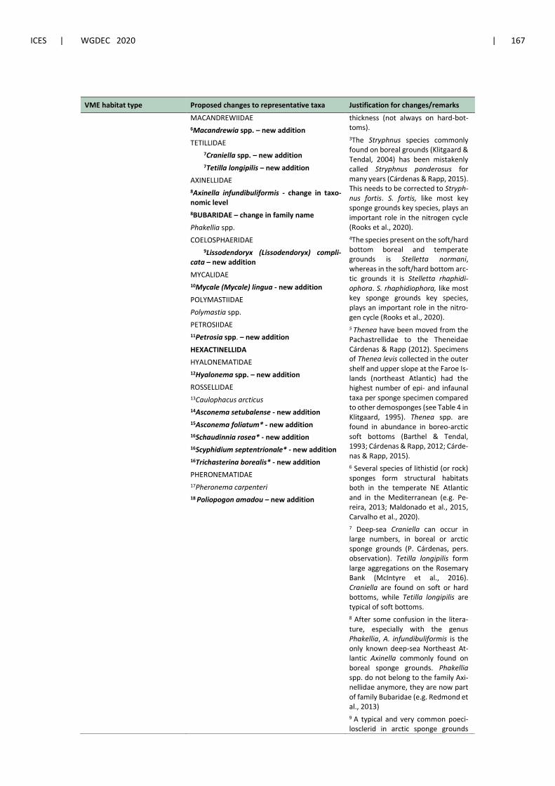
ICES | WGDEC 2020 | 167
VME habitat type Proposed changes to representative taxa Justification for changes/remarks
MACANDREWIIDAE
6Macandrewia spp. – new addition
TETILLIDAE
7Craniella spp. – new addition
7Tetilla longipilis – new addition
AXINELLIDAE
8Axinella infundibuliformis - change in taxo-nomic level
8BUBARIDAE – change in family name
Phakellia spp.
COELOSPHAERIDAE
9Lissodendoryx (Lissodendoryx) compli-cata – new addition
MYCALIDAE
10Mycale (Mycale) lingua - new addition
POLYMASTIIDAE
Polymastia spp.
PETROSIIDAE
11Petrosia spp. – new addition
HEXACTINELLIDA
HYALONEMATIDAE
12Hyalonema spp. – new addition
ROSSELLIDAE
13Caulophacus arcticus
14Asconema setubalense - new addition
15Asconema foliatum* - new addition
16Schaudinnia rosea* - new addition
16Scyphidium septentrionale* - new addition
16Trichasterina borealis* - new addition
PHERONEMATIDAE
17Pheronema carpenteri
18 Poliopogon amadou – new addition
thickness (not always on hard-bot-toms).
3The Stryphnus species commonly found on boreal grounds (Klitgaard & Tendal, 2004) has been mistakenly called Stryphnus ponderosus for many years (Cárdenas & Rapp, 2015). This needs to be corrected to Stryph-nus fortis. S. fortis, like most key sponge grounds key species, plays an important role in the nitrogen cycle (Rooks et al., 2020).
4The species present on the soft/hard bottom boreal and temperate grounds is Stelletta normani, whereas in the soft/hard bottom arc-tic grounds it is Stelletta rhaphidi-ophora. S. rhaphidiophora, like most key sponge grounds key species, plays an important role in the nitro-gen cycle (Rooks et al., 2020).
5 Thenea have been moved from the Pachastrellidae to the Theneidae Cárdenas & Rapp (2012). Specimens of Thenea levis collected in the outer shelf and upper slope at the Faroe Is-lands (northeast Atlantic) had the highest number of epi- and infaunal taxa per sponge specimen compared to other demosponges (see Table 4 in Klitgaard, 1995). Thenea spp. are found in abundance in boreo-arctic soft bottoms (Barthel & Tendal, 1993; Cárdenas & Rapp, 2012; Cárde-nas & Rapp, 2015).
6 Several species of lithistid (or rock) sponges form structural habitats both in the temperate NE Atlantic and in the Mediterranean (e.g. Pe-reira, 2013; Maldonado et al., 2015, Carvalho et al., 2020).
7 Deep-sea Craniella can occur in large numbers, in boreal or arctic sponge grounds (P. Cárdenas, pers. observation). Tetilla longipilis form large aggregations on the Rosemary Bank (McIntyre et al., 2016). Craniella are found on soft or hard bottoms, while Tetilla longipilis are typical of soft bottoms.
8 After some confusion in the litera-ture, especially with the genus Phakellia, A. infundibuliformis is the only known deep-sea Northeast At-lantic Axinella commonly found on boreal sponge grounds. Phakellia spp. do not belong to the family Axi-nellidae anymore, they are now part of family Bubaridae (e.g. Redmond et al., 2013)
9 A typical and very common poeci-losclerid in arctic sponge grounds

168 | ICES SCIENTIFIC REPORTS 2:62 | ICES
VME habitat type Proposed changes to representative taxa Justification for changes/remarks
(Meyer et al., 2019) and has been re-ported from the boreal sponge grounds of Flemish Cap, northwest (Kenchington et al., 2015)
10 Mycale lingua is a frequent species in the boreal tetractinellid grounds (e.g. Klitgaard & Tendal, 2004; Kutti et al., 2013) as well as living on CWC Lophelia reefs in Norway (P. Cárde-nas, pers. observation).
11 Petrosiids are very common in mul-tispecific sponge grounds of the tem-perate northeast Atlantic. In boreal sponge grounds, we usually have the species Petrosia crassa.
12Several species of Hyalonema occur in variable densities in soft bottom across mostly in boreal and temper-ate regions, sometimes alongside other hexactinellids (e.g. Pheronema carpenteri)
13Caulophacus arcticus - is found in various seabed types, but always at-tached to hard substrates such as pebbles.
14 Aggregations of A. setubalense are known to occur off Portugal, in the Cantabrian Sea and on islands and seamounts (sub-areas 8, 9 and CECAF 34.1.2).
15 Asconema foliatum is an important driver of benthic biodiversity in the Flemish Cap region, northwest (Beazley et al., 2013; NAFO, 2019; Murillo et al., 2020).
17 Pheronema carpenteri forms large aggregations in both soft and hard substrate (e.g. Rice et al., 1990) and is vulnerable to bottom trawling (Vieira et al., 2020).
18 The glass sponge Poliopogon ama-dou is known to form dense aggrega-tions on seamount slopes in Areas Beyond National Jurisdiction (Xavier et al. 2015; Ramiro-Sanchez et al. 2019) but in very deep areas (below 2000 m depth), so it may be less rel-evant to the deep-sea access regula-tions due to the bottom trawl ban at depths > 800 m. However, it has been included on the list for completeness.

ICES | WGDEC 2020 | 169
Sea pen fields
Table A4.5 Proposed changes to representative taxa for sea pen fields. References are provided in Section 7.9.
VME habitat type Proposed changes to representative taxa Justification for changes/remarks
Sea pen fields ANTHOPTILIDAE
Anthoptilum murrayi
1Anthoptilum grandiflorum – new addition
CHUNELLIDAE
2Porcupinella profunda – new addition
PENNATULIDAE
Pennatula phosphorea
3Pennatula aculeata – new addition
4Pteroeides spinosum – new addition
5Pennatula grandis – new addition
6Ptilella grayi
FUNICULINIDAE
Funiculina quadrangularis
HALIPTERIDAE
7Halipteris finmarchica – new addition
8Halipteris christii – new addition
KOPHOBELEMNIDAE
Kophobelemnon stelliferum
9Kophobelemnon macrospinosum – new ad-dition
PROTOPTILIDAE
10Distichoptilum gracile – new addition
11Protoptilum carpenterii – new addition
12Protoptilum thomsonii – new addition
SCLEROPTILIDAE – new addition
13Scleroptilum grandiflorum – new addition
UMBELLULIDAE
Umbellula encrinus
Umbellula huxleyi
Umbellula lindahli
14Umbellula monocephalus– new addition
15Umbellula thomsoni – new addition
16Umbellula durissima – new addition
VIRGULARIDAE
Virgularia mirabilis
17Virgularia glacialis – new addition
18Virgularia tuberculata – new addition
19Stylatula elegans– new addition
VERETILLIDAE – new addition
20Cavernularia pusilla – new addition
21Veretillum cynomorium – new addition
1Important as nursery grounds; biodi-versity enhancement (Baillon et al. 2012; 2014; Murillo et al., 2020); Slow growth; decadal longevity (Mu-rillo et al. 2018); Forms structurally complex habitats in the NW Atlantic: Kenchington et al., 2015; NE Atlantic: Williams, 2011, Ruiz-Pico et al., 2017
2 Forms structurally complex habitats in the NE Atlantic, Porcupine Abyssal Plain: López- González & Williams, 2001
3Important as nursery grounds; biodi-versi-ty enhancement (Baillon et al. 2012; Murillo et al., 2020); Slow growth; decadal longevity (Murillo et al. 2018); Forms structurally complex habitats in the NW Atlantic: Kench-ington et al., 2015; NE Atlantic: Ruiz-Pico et al., 2017
4 Forms structurally complex habitats in the NE Atlantic: WoRMS, Ruiz-Pico et al., 2017
5 Important as nursery grounds; bio-diversity enhancement (Baillon et al. 2012; Murillo et al., 2020); Slow growth; deca-dal longevity (Murillo et al. 2018); Forms structurally com-plex habitats in the NW Atlantic: Kenchington et al., 2015; NE Atlantic: WoRMS, Ruiz-Pico et al., 2017
6Newly described species. Forms structurally complex habitats in the NE Atlantic: García-Cárdenas et al., 2019
7
7 Important as nursery grounds; bio-diversity enhancement (Baillon et al. 2012; 2014; Murillo et al., 2020); Slow growth; decadal longevity (de Moura Neves 2015; Murillo et al. 2018); Forms structurally complex habitats in the NW & NE Atlantic: WoRMS; NW Atlantic: Kenchington et al., 2015
8 Forms structurally complex habitats in the NW & NE Atlantic: WoRMS;

170 | ICES SCIENTIFIC REPORTS 2:62 | ICES
VME habitat type Proposed changes to representative taxa Justification for changes/remarks
NW Atlantic: Murillo et al., 2011, NE Atlantic: Buhl-Mortensen et al., 2019
9 Important as biodiversity enhance-ment (Murillo et al., 2020); Forms structurally complex habitats in the Mid-Atlantic Ridge & NE Atlantic, WoRMS & Molodtsova et al., 2008
10 Important as biodiversity enhance-ment (Murillo et al., 2020); Forms structurally complex habitats in the
NW Atlantic: WoRMS & Kenchington et al., 2015
11 Important as biodiversity enhance-ment (Murillo et al., 2020); Forms structurally complex habitats in the NW & NE Atlantic: WoRMS; NW At-lantic: Baker et al., 2012; Mediterra-nean: Mastrototaro et al., 2014
12 Present in the NW & NE Atlantic, Gulf of Mexico: WoRMS; NE Atlantic (Spain): Ruiz-Pico et al., 2017
13 Present in the Azores: Sampaio et al., 2019; NW & NE Atlantic: WoRMS, Molodtsova et al., 2008
14 Present in the NE Atlantic, Porcu-pine Abyssal Plain: López- González & Williams, 2001
15 Present in the Mid-Atlantic Ridge: Molodtsova et al., 2008, South Africa: WoRMS, Azores: Sampaio et al., 2019
16 Present in the Azores: Sampaio et al., 2019; NW & NE, Mid-Atlantic Ridge: WoRMS, Molodtsova et al., 2008
17 Present in the NE Atlantic: WoRMS, Buhl-Mortensen et al., 2019
18 Present in the NE Atlantic: WoRMS, Ruiz-Pico et al., 2017, Buhl-Morten-sen et al., 2019
19 Present in the NW & NE Atlantic: WoRMS, NE Atlantic: Buhl-Morten-sen et al., 2019
20 Present in the NE Atlantic: WoRMS, Ruiz-Pico et al., 2017, Altuna et al. 2008)

ICES | WGDEC 2020 | 171
VME habitat type Proposed changes to representative taxa Justification for changes/remarks
21 Present in the NE Atlantic: WoRMS, Ruiz-Pico et al., 2017