icf/wyoming concept of operations concept of operations ... deployment concept overview –deepak...
TRANSCRIPT
1 U.S. Department of Transportation
Kate Hartman, CVP Deployment Program Mgr., ICF/Wyoming Site COR Deepak Gopalakrishna, ICF/Wyoming Project Manager
ICF/Wyoming Concept of Operations

2 U.S. Department of Transportation
TODAY’S AGENDA Purpose of this Webinar
□ To share the Concept Development Activities from the ICF/Wyoming Pilot site with the stakeholders of connected vehicle technologies.
Webinar Content □ Connected Vehicle Pilot Deployment Program Overview (Kate Hartman) □ ICF/Wyoming Concept of Operations (Deepak Gopalakrishna, Vince Garcia and
Ali Ragan) □ Stakeholder Q&A (Kate Hartman & Deepak Gopalakrishna) □ How to Stay Connected (Kate Hartman)
Webinar Protocol
□ We have muted all participant lines during the webinar in order to reduce background noise
□ You are welcome to ask questions via chatbox at the Q&A Section □ The webinar recording and the presentation material will be posted on the CV
Pilots website

3 U.S. Department of Transportation
CONNECTED VEHICLE PILOT DEPLOYMENT PROGRAM PR
OG
RA
M G
OA
LS
PILOT SITES
ICF/Wyoming DOT
NYCDOT
Tampa (THEA)
Participate in Concept Development Phase Webinars for the three Pilot Sites (see website for exact dates and times)
Visit Program Website for Updates: http://www.its.dot.gov/pilots Contact: Kate Hartman, Program Manager, [email protected]
Feb 2016 Mar 2016 Apr 2016 May 2016 Jun 2016 Jul 2016 Aug 2016
STAY
CO
NN
ECTE
D
Concept of Operations Webinars
Performance Measurement Webinars
Comprehensive Deployment Plan Webinars

4 U.S. Department of Transportation
Presentation Overview
Deepak Gopalakrishna, ICF/Wyoming Project Manager

5 U.S. Department of Transportation
ICF/WYOMING TEAM
• Wyoming Trucking Association • Wyoming Highway Patrol
• Freight Operators • Oil and Gas Industry Representatives
Led By ICF Partners • Wyoming DOT • Trihydro • NCAR • Univ of Wyoming • CATT Lab • McFarland Mgmt
Phase 1 Led By Wyoming DOT
Partners • Wyoming DOT • Trihydro • NCAR • Univ of Wyoming • CATT Lab • McFarland Mgmt
New Partners • DSRC Radio Vendors • On-board equipment vendors • Data providers • Weather Sensor Developers • Fleet Operators
Phase 2 Led By Wyoming DOT
Partners • Wyoming DOT • Trihydro • NCAR • Univ of Wyoming • CATT Lab • McFarland Mgmt
New Partners • Fleet Operators
Phase 3
• Wyoming Workforce Development
• Wyoming Chamber of Commerce
Stakeholders Engaged throughout Pilot
6 U.S. Department of Transportation
Presentation Overview WYDOT Opening Remarks – Ken Schultz, WYDOT Site Orientation and Key Issues – Vince Garcia, WYDOT Deployment Concept Overview –Deepak Gopalakrishna, ICF Stakeholder Engagement – Ali Ragan, WYDOT Next Steps – Deepak Gopalakrishna, ICF
Site Orientation and Key Issues
Vince Garcia, Wyoming DOT

8 U.S. Department of Transportation
I-80 in Wyoming
Major corridor for east/west freight in the northwest part of the country
402 miles long from Utah to Nebraska More than 32 million tons of freight per
year (at 16 tons per truck). Truck volume is 30 to 55% of the total
traffic stream on an annual basis □ can make up as much as 70% of the
traffic stream on a seasonal basis Elevation all above 6,000 feet, with the
highest point reaching 8,640 feet (2,633 m) above sea level at Sherman Summit

9 U.S. Department of Transportation
National Impacts
Origins and Destinations of Westbound Freight on I-80
(Source: FHWA-WY- 09/09F Interstate 80 Freight Corridor Analysis)

10 U.S. Department of Transportation
Challenging Road Conditions
Right over the project corridor

11 U.S. Department of Transportation
High Crash Rates
• Winter crash rate (October to April) has been found to be 3 to 5 times as high as the summer crash rates
• Speed management is critical
195 184 176 144
240 234
329
176
109
247 202
65 80 71 75 73 67 67 69 69 79 77
APR
15,
200
1 -
APR
14,
200
2
APR
15,
200
2 -
APR
14,
200
3
APR
15,
200
3 -
APR
14,
200
4
APR
15,
200
4 -
APR
14,
200
5
APR
15,
200
5 -
APR
14,
200
6
APR
15,
200
6 -
APR
14,
200
7
APR
15,
200
7 -
APR
14,
200
8
APR
15,
200
8 -
APR
14,
200
9
APR
15,
200
9 -
APR
14,
201
0
APR
15,
201
0 -
APR
14,
201
1
APR
15,
201
1 -
APR
14,
201
2
Cra
sh F
requ
ency
Reported Crashes from April 15, 2001 to April 14, 2012 by Season (MP 238 - 291)
Winter
4/13/2014 - Between Laramie and Rawlins - Speeds reduced to 45 mph in VSL zone – 0 Fatalities - 70+ vehicles 4/15/2015 - Between Cheyenne and Laramie - Speeds reduced to 45 mph in VSL zone – 0 Fatalities - 65+ vehicles 4/20/2015 - Between Laramie and Rawlins - Speeds 75 mph (no VSL available) – 2 Fatalities - 65+ vehicles

12 U.S. Department of Transportation
Video of a Multi-Vehicle Crash
Show video

13 U.S. Department of Transportation
Road Closures
For the three years from 2010 to 2012, there were 172 road closures
Average duration of the closures was over 8 hours long.
At conservative value of $370 per truck per hour of closure, there is an economic impact of around $11.7 million per closure.
[VALUE]%
[VALUE]%
[VALUE]%
[VALUE]%
Crashes Weather/Crashes Other Weather

14 U.S. Department of Transportation
Limited Parking
Extremely rural corridor Distances between towns along the I-80 corridor range from 60 to 115 miles No services between towns . 3,037 spaces with 18% of those locations being public facilities (e.g., rest areas,
truck parking lots, and truck parking turnouts) and the remainder being at private truck service locations.

15 U.S. Department of Transportation
Lack of Alternatives
During extended road closures two-lane highways are also typically closed, along with I-80, to prevent large-scale diversion of freight traffic.
Alternate routes are not always built to the same geometric standards as the interstate, increasing the hazards during severe weather events.
(I-90), approximately 250 miles to the north, Interstate 70 (I-70), approximately 100 miles to the south, both of which have
their own challenges of mountainous terrain and severe weather events.

16 U.S. Department of Transportation
WHAT DO I-80 USERS WANT?
• Improve road condition monitoring for operations and maintenance • Improve communication with on-road vehicles • Improve interaction with fleet managers • Improve emergency response times
DOT
• Spot-specific information of road conditions • Parking guidance • Customized advisories and alerts • Information on stopped vehicles ahead • Work Zone Alerts
Truckers
• Forecast conditions on I-80 • Closure information and parking guidance • Return to normal conditions • Construction information
Fleet Managers
• Forecast conditions • Stopped vehicles • Road closures Drivers

Deployment Concept Overview
Deepak Gopalakrishna, ICF/Wyoming Project Manager

18 U.S. Department of Transportation
Five Focus Areas
Manage following speed and distance between vehicles by alerting trucks to slowing traffic ahead to prevent multiple-vehicle crashes.
Provide custom alerts and advisories for vehicles that are at risk due to their weight, profile or traveling speeds due to high-winds, near work zones, include alerting drivers if their vehicles are too tall for bridges.
Provide location-based parking information with a focus on directing drivers to safe parking areas in the event of a road closure.
Allow first responders to be notified of a crash automatically based on vehicle metrics, such as airbag deployment.
Use data collected from vehicle’s weather sensors such as the status of windshield wipers and if anti-lock brake systems are activated. This information will be used to develop advisories and forecasts for travel to fleet management centers and the general public.

19 U.S. Department of Transportation
Goals for WYDOT
• Not an R&D effort. To be used by WYDOT
Operations for immediate needs Operational
• Ability to incorporate new fleets and applications Scalable and Sustainable
• Ability to start with a few applications/services but grow to an eco-system of services Evolutionary
• Be a model deployment for rural freight-heavy corridors Replicable
• Maximize use of already created federal investments and state initiatives. Do not recreate the wheel Leveraged

20 U.S. Department of Transportation
System Capabilities
CV Pilot System (Center) □ Collect road and weather data □ Collect work zone information □ Share integrated/fused road weather and travel advisories (e.g.,
segment-level, short-term) and warnings (e.g. height restrictions, road closure, VSL, work zone)
□ Collect dynamic travel information (e.g., parking facility location) □ Provide dynamic travel information (e.g., parking facility location)
CV Mobile Distribution (Field) □ Collect safety messages (e.g., road advisories, road warnings) □ Share safety and road condition messages) □ Generate emergency message □ Collect road conditions from other connected vehicles

21 U.S. Department of Transportation
Connected Trucks
Connected WYDOT Fleet
NWS
Truck Parking Facilities
RWIS
Collect road and weather data
CV Pilot System Major Capabilities
Adjacent State DOTs
WYDOT Maint. Mgmt.
Collect work zone information
Collect dynamic travel information (e.g.,
parking facility location)
Context Diagram (1/2)

22 U.S. Department of Transportation
Connected Trucks
Connected WYDOT Fleet
NWS
Truck Parking Facilities
Adjacent State DOTs
RWIS
Collect road and weather data
Connected Trucks
CV Pilot System
Share integrated/fused road weather and travel
advisories (e.g., segment-level, short-term) and warnings (e.g. height
restrictions, road closure, VSL, work zone)
Major Capabilities
Truck Parking Facilities
Adjacent State DOTs
DMS/HAR/511
Connected WYDOT Fleet
Provide dynamic travel information (e.g.,
parking facility location)
WYDOT Maint. Mgmt. WYDOT CVE
Collect work zone information
Collect dynamic travel information (e.g.,
parking facility location)
Fleet Management Centers
Context Diagram (1/2)

23 U.S. Department of Transportation
Collect safety and emergency messages (e.g., road advisories,
road warnings
CV Pilot System
Mobile Distribution System Major Capabilities
Collect road conditions from other connected vehicles [Situational
Awareness]
Connected Trucks
Connected WYDOT Fleet
Context Diagram (2/2)
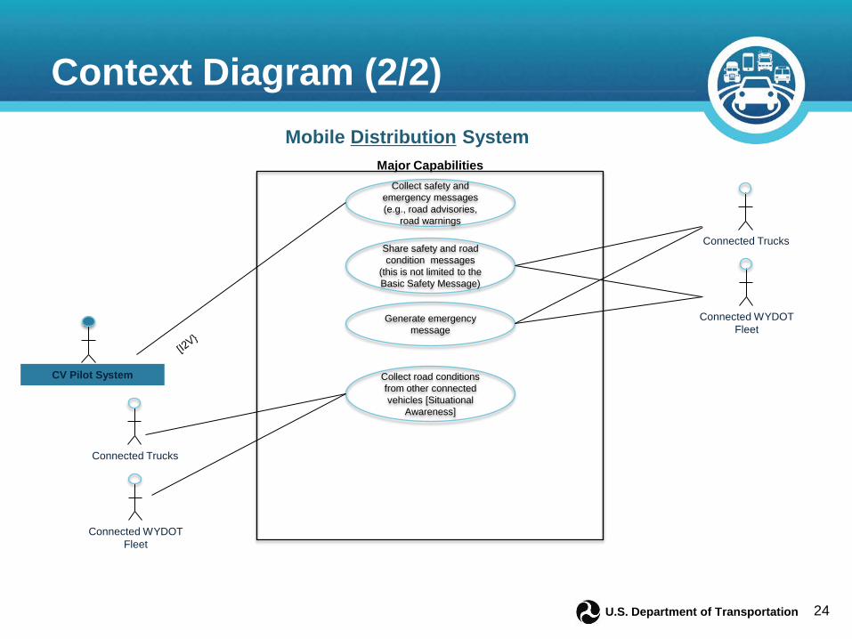
24 U.S. Department of Transportation
Collect safety and emergency messages (e.g., road advisories,
road warnings
CV Pilot System
Mobile Distribution System
Share safety and road condition messages
(this is not limited to the Basic Safety Message)
Major Capabilities
Connected Trucks
Connected WYDOT Fleet
Generate emergency message
Collect road conditions from other connected vehicles [Situational
Awareness]
Connected Trucks
Connected WYDOT Fleet
Context Diagram (2/2)

25 U.S. Department of Transportation
Physical Elements

26 U.S. Department of Transportation
Defined Scenarios Six scenarios and 16 use-cases are defined to demonstrate the capabilities and
desired functionality of the proposed system: □ Corridor Monitoring and Operations Support (4 use-cases)
□ Truck Advisories (3 use-cases)
□ Truck Warning (3 use-cases)
□ Incident Notification (2 use-cases)
□ Dynamic Travel Planning Support (2 use-cases)
□ Performance Management (2 use-cases)

27 U.S. Department of Transportation
Corridor Monitoring & Operations Support WYDOT will leverage data collected from mobile platforms, fuse them with existing
data sources and develop segment level advisories and warnings.
WYDOT will also initiate several actions that improve the operations of the corridor based on the information received from the field.
Four specific use-cases are identified:
• Identifies how weather and road weather data collection occurs during the pilot using both connected vehicles, existing road weather infrastructure, and atmospheric weather models.
V2I Road Weather Data Collection
•Defines how WYDOT TMC personnel, WYDOT TMC Weather providers and the vehicle data translator system fuses various sources of atmospheric and road weather data, quality-checks the data and develops segment level advisories and forecasts of conditions.
Data Fusion and Segment Advisories
•Defines how the WYDOT TMC proactively manages traffic conditions by a combination of advisory, control and treatment strategies.
Weather Responsive Traffic Management
•Describes how closure and road condition information is communicated from the WYDOT TMC to similar operating partners in Colorado, Nebraska and Utah.
Adjacent State DOT Coordination

28 U.S. Department of Transportation
Truck Advisories
Proposed system alerts truck drivers on I-80 about affected area or segments of the highway so they can optimize their route selection and overall travel time.
It should be noted that the advisories do not demand immediate action from drivers.
Three use cases are identified under this scenario:
• Represents advisories provided by RSE to connected vehicles as they pass by specific locations on the corridor. I2V Advisory
• Defines the wide-area advisories generated by the WYDOT TMC to support operations during adverse weather in the corridor
Wide Area Advisory
• Provides a V2V advisory between equipped trucks and WYDOT fleet vehicles especially between vehicles traveling in opposite directions.
V2V Advisory

29 U.S. Department of Transportation
Truck Warning
Mitigate the effects of incidents by warning drivers approaching an affected area or segment of the highway.
In contrast to advisories, warnings entail immediate action in order to optimize the driver’s route selection and avoid a potential incident.
Three specific use-cases are identified under this scenario:
• A RSE communicates with equipped vehicles about immediate threats to driving conditions. Warnings are not customized to vehicles and all equipped vehicles will receive the same message.
I2V Warning - General
• A RSE communicates with equipped vehicles about immediate threats to driving conditions. Warnings are generated based on the vehicle type or traveling speeds of the receiving vehicle.
V2I Warning-Custom
• V2V communications alert drivers of deteriorating conditions in front of the lead vehicle. Warnings provided by the lead vehicle are relayed backward in the traffic stream to other equipped vehicles.
V2V Warning

30 U.S. Department of Transportation
Incidents Notification
Improves notification of incidents to appropriate agencies within Wyoming.
Where communications are not present, connected vehicles also serve as a relay to collect and distribute emergency notification.
Two use-cases are identified under this scenario:
• WYDOT TMC receives a location-based notification, generated by an equipped vehicle involved in a crash in the corridor. The WYDOT TMC will then notify emergency response personnel based on location.
Incident Notification
• Relay of emergency and crash information occurs between equipped vehicles to ultimately notify WYDOT TMC when communication is available.
Emergency Relay

31 U.S. Department of Transportation
Dynamic Travel Planning Support
Provides travel planning support to third parties including freight management centers and third party application developers.
Two specific use-cases are identified under this scenario:
• WYDOT TMC and fleet management centers exchange information about travel conditions and forecasts on I-80 through the CVOP and other connections enabled by the proposed system.
Freight Travel Planning Guidance
• WYDOT TMC supports access to CV data feeds to third-party application developers to use segment alerts and advisories generated by the proposed system in their user-facing applications.
Third Party Application
Developer Support

32 U.S. Department of Transportation
Performance Management
Monitoring of daily operations and improved day-to-day performance of the proposed system.
Develops a post-hoc assessments of outcomes and impacts due to the proposed system.
Two specific use-cases are identified under this scenario:
• Continuously monitor the performance of the system both from measuring the outputs of the system (what is the system supposed to do) as well outcomes (what is the system achieving).
Performance Management
Support
• Activities necessary to establish the overall safety and mobility impacts of the proposed system.
Impact Evaluation Support
33 U.S. Department of Transportation
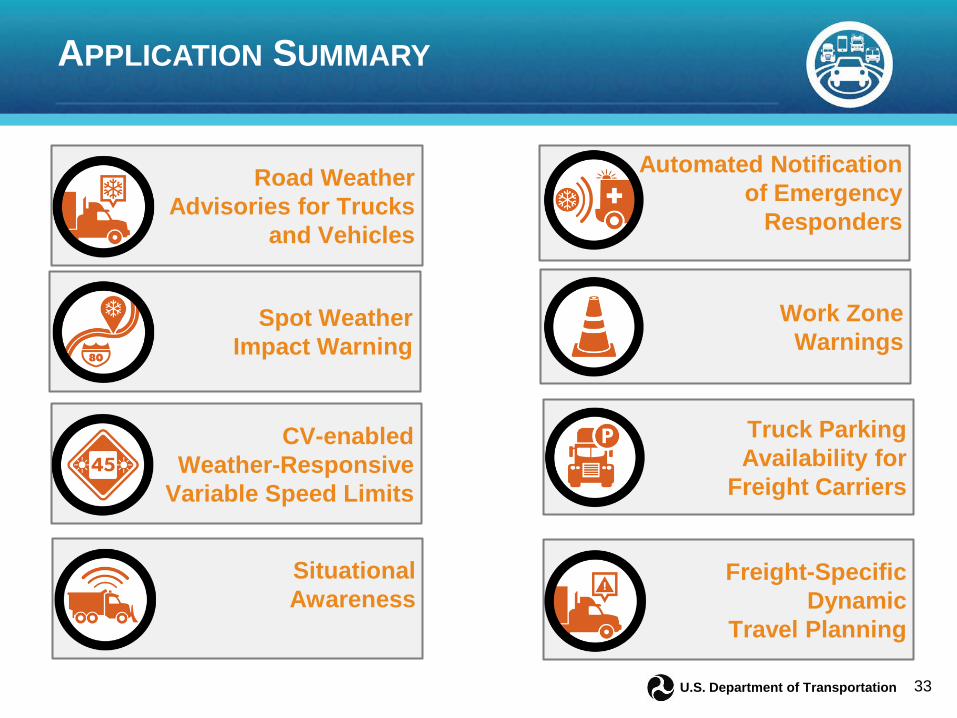
APPLICATION SUMMARY
Road Weather Advisories for Trucks
and Vehicles
Automated Notification of Emergency
Responders
Spot Weather Impact Warning
Work Zone Warnings
CV-enabled Weather-Responsive
Variable Speed Limits
Truck Parking Availability for
Freight Carriers
Situational Awareness
Freight-Specific Dynamic
Travel Planning

34 U.S. Department of Transportation
CONNECTED VEHICLE APPLICATIONS
• Advanced Traveler Information System • Freight-Specific Dynamic Travel Planning
and Performance Measurement (FRATIS)
V2I Safety Mobility • Spot Weather Impact Warning • Reduced Speed/Work Zone Warning
• Motorist Advisories and Warnings (MAW) • Vehicle Data Translator (VDT) • Weather Response Traffic Information
(WxTINFO)
Road Weather
• Smart Truck Parking
Smart Roadside
CV Application WYDOT Snow Plows
WYDOT Maintenance Fleet Vehicles
Emergency Vehicles
Private Trucks/ Commercial
Vehicles
1. Road Weather Advisories for Trucks and Vehicles ✔ ✔ ✔ ✔
2. Automatic Alerts for Emergency Responders ✔
3. CV-enabled Weather-Responsive Variable Speed Limits ✔ ✔ ✔ ✔
4. Spot Weather Impact Warning ✔ ✔ ✔ ✔ 5. Work Zone Warnings ✔ ✔ ✔ ✔ 6. Situational Awareness ✔ ✔ ✔ ✔ 7. Truck Parking Availability for
Freight Carriers ✔ 8. Freight-Specific Dynamic Travel
Planning ✔
35 U.S. Department of Transportation
Stakeholder Engagement Summary
Ali Ragan, Outreach Lead

36 U.S. Department of Transportation
Who we talked to Stakeholders Engaged in ConOps Development
□ U.S Department of Transportation □ WYDOT ▪ Traffic, Construction, Maintenance, GIS/ITS, IT, Telecom Programs,
Purchasing, Public Affairs, and Planning. □ Wyoming Highway Patrol □ Fleet Managers ▪ UPS, Crete Carrier, Werner ENT, Walmart Trans, Sage Truck Driving Schools,
Lowes Burgner/Transpro Trucking, Ram Trucking, Savage Trucking. □ Wyoming Trucking Association □ City managers and local traffic and law enforcement officials ▪ Rawlins, Laramie, Cheyenne, Green River, Rock Springs, Evanston.
□ National Weather Service □ County Emergency Management □ Private Truck Parking Services □ Wyoming Government

37 U.S. Department of Transportation
What we heard Specific system concerns and needs
□ Pass information to other states so drivers can plan ahead □ Need greater situational awareness of upstream conditions □ Truck parking is a real issue □ When necessary, take the TMC out of the loop. □ Be aware of distracted driving □ Keep in mind level of driver experience, as a driver in general and in
Wyoming in particular □ Be aware of possible concerns with data sent from vehicles (privacy and
security) □ Communicate with drivers on the other side of the road -- northbound
drivers know what southbound drivers need to know □ Keep in mind cell phone dead zones
Overall □ Great interest and support □ Unfamiliarity with systems engineering language and process □ Want it now!

38 U.S. Department of Transportation
What we learned Letting the user needs drive the process
Need different levels for engagement in the pilot for the freight community.
□ Diversity of freight and trucking operations.
Leveraging resources, existing initiatives and examples.
Performance management – Think early and often.
Look for applications that do not depend on critical mass of vehicles.
Set expectations.
Language barriers.
Simplicity of system.

39 U.S. Department of Transportation
Next Steps
Deepak Gopalakrishna, ICF/Wyoming Project Management Lead

40 U.S. Department of Transportation
Next Steps Phase I Tasks:
□ Task 1: Program Management □ Task 2: Pilot Deployment Concept of Operations (ConOps) □ Task 3: Security Management Operating Concept □ Task 4: Safety Management Plan □ Task 5: Performance Measurement and Evaluation Support Plan □ Task 6: Pilot Deployment System Requirements □ Task 7: Application Deployment Plan □ Task 8: Human Use Approval □ Task 9: Participant Training and Stakeholder Education Plan □ Task 10: Partnership Coordination and Finalization □ Task 11: Outreach Plan □ Task 12: Comprehensive Pilot Deployment Plan □ Task 13: Deployment Readiness Summary

41 U.S. Department of Transportation
Ongoing Activities Security Management Plan Safety Management Plan Performance Management and Evaluation Plan Partnership development
And most importantly, Vendor Engagement Activities
Please reach out to Ali Ragan, WYDOT ([email protected]), if you are a
vendor with interest in this project □ Setting up a 30 minute webinar in February to talk about your product and
our needs □ Engaging with vendors for On-Board Equipment, Roadside Equipment,
Application Developers, Weather Telematics, Fleet Data Providers

42 U.S. Department of Transportation
Stakeholder Q&A
Please keep your phone muted
Please use chatbox to ask questions
Questions will be answered in the order in which they were received

43 U.S. Department of Transportation
STAY CONNECTED Join us for the Getting Ready for Deployment Series Discover more about the 2015 CV
Pilot Sites Learn the Essential Steps to CV
Deployment Engage in Technical Discussion
Website: http://www.its.dot.gov/pilots Twitter: @ITSJPODirector Facebook: https://www.facebook.com/DOTRITA
Contact for CV Pilots Program: Kate Hartman, Program Manager [email protected] Public ConOps Webinars:
• ICF/Wyoming Pilot Site
2/5/2016, 1:00 – 2:00 pm EST
• Tampa (THEA) Pilot Site
2/8/2016, 2:00 – 3:00 pm EST
• NYC Pilot Site
TBD
Please visit the CV pilots website for the recording and the briefing material of the previous webinars.