identification of freshwater sites for aquatic reserves
TRANSCRIPT

Identification of Freshwater Sites for Aquatic Reserves
Lakes and Rivers of Washington State
March 2017
Washington State Department of Natural Resources, Aquatic Resources Division
Prepared for the Aquatic Reserves Program
Prepared by Joy Polston Barnes, Maps completed by Andrew Ryan and Corey Smith

2 -
1.0 Freshwater Aquatic Reserve Introduction
The Aquatic Reserve program aims to provide special management for native aquatic habitat
and species in the state of Washington. The program was established in 2002 as part of
Washington State Department of Natural Resources (DNR) efforts to promote preservation,
restoration and enhancement of state owned aquatic lands. Reserves are selected because the
aquatic lands are of special environmental importance, scientific value or educational interest
(WAC 332-30-151.). Since the foundation of the Aquatic Reserve program, the emphasis has
been on reserve selection within Puget Sound with the establishment of seven marine sites.
One of the goals of the Aquatic Reserve program is to be inclusive of all aquatic ecosystems,
including freshwater systems such as lakes and rivers.
This report identifies freshwater lakes and rivers with high conservation value in Washington
State by highlighting their scientific value and environmental importance. The Aquatic Reserve
program should use this report to help determine and prioritize lakes and rivers that should be
considered for DNR Aquatic Reserve status. Additional aspects of Aquatic Reserve selection
and planning should be considered and evaluated by the Aquatic Reserve Program, such as
community dynamics, multijurisdictional planning efforts, educational interests, internal agency
recommendations, and other identified criteria of importance. All water bodies recommended
in this report as potential Aquatic Reserves should be assessed by the Aquatic Reserve program
to make sure they meet their established criteria; so they go through the appropriate
implementation process; and so expertise and opinion outside of the DNR science and planning
unit can be appropriately considered. These dynamics of Aquatic Reserve selection and
planning will be discussed in greater detail in Section 5, Recommended Next Steps.
2.0 Selecting Priority Areas The study area includes all of Washington inland freshwater lakes and rivers. Water bodies are
reported as western and eastern Washington lakes and rivers, using the Cascade Mountain
range as the delineation. This separation is made because the ecosystems are vastly different
and water body selection should be compared and evaluated with water bodies providing
similar habitat and ecosystem function.
Freshwater aquatic ecosystems such as lakes and rivers are preserved at the local, state and
federal level for a variety of reasons. Within the United States they are prioritized for their
natural resources such as water supply; recreation use, esthetic value such as wild and scenic,
unusual or uncommon features such as geology or high salinity; climate change preparation
such as low evaporation rates; part of a larger preservation effort such as a lake within a

3 -
terrestrial preservation system; and connectivity such as from headwaters to outlet. WDNR
has considered these approaches and selected criteria reflective of agency stewardship values.
3.0 Evaluation Process The following criteria were used by DNR science staff to evaluate and determine the
recommended Aquatic Reserve lakes and rivers:
A. Wildlife Species Concentration
Lakes and rivers were evaluated and considered for selection if they had the highest number of
species within a given area compared to other state owned water bodies. The area being the
whole water body, or a significant portion of the water body. Species data provided by
Washington State Department of Fish and Wildlife (WDFW), Washington Audubon Society, and
research/monitoring papers were used to determine species presence. DNR acknowledges that
data could be missing from certain locations evaluated in the selection and recommendation
process however the best available data was used. Species concentrations considered include
the following:
Species Concentrations – Water bodies with a high concentration of one or more state
or federally listed and “uncommon” native species were considered for selection. This
includes water bodies recommended by species experts.
Species Diversity – Water bodies with the highest diversity of state or federally listed
and “uncommon” native species were considered for selection.
Uncommon Native Species – Water bodies with a high concentration of rare or
uncommon species were considered for selection. These species include DNR’s Natural
Heritage Program listed species with S1 or S2 status; and native freshwater bivalve
locations. Species experts were contacted and advice considered.
Important Bird Areas – The Washington Audubon Society has identified Important Bird
Areas (IBAs) throughout the state of Washington. These are areas where habitat for a
high diversity of bird species or rare and uncommon bird species are present compared
to other bird gathering locations in the state. These areas were considered for
selection.
B. Plant Species
Lakes and rivers were evaluated and considered for selection if they had uncommon plants or
the highest number of aquatic plant species within a given area compared to other state owned
water bodies. The area being the whole water body, or a significant portion of the water body.
Species data provided by Washington State Department of Ecology and DNRs Natural Heritage

4 -
Program were used to determine plant species presence. DNR acknowledges that data could
be missing from certain locations evaluated in the selection and recommendation process
however the best available data were used. Plant species concentrations considered include
the following:
Plant Diversity – Water bodies with higher plant diversity were considered for selection.
Uncommon Plants – Water bodies with plant species listed with S1 or S2 status by DNRs
Natural Heritage Program, or threatened or endangered by state or federal agencies
were considered for selection. Aquatic plant experts were contacted and their advice
considered.
C. Habitat Connectivity
Lakes and rivers were evaluated and considered for selection if they had habitat connectivity
with protected terrestrial, aquatic or wetland areas because connectivity could allow for
improved habitat conditions for a given water body and the species that utilize the habitat.
DNR’s Public and Tribal Lands data layer; the draft MAIDS data layer; and the National Wetlands
Inventory by United States Geological Survey (USGS) were used to determine habitat
connectivity. Areas included in these criteria include the following:
Terrestrial Habitat Connectivity - Water bodies bordering terrestrial habitat with
protection status were considered for selection. This includes DNR managed natural
areas.
Aquatic Habitat Connectivity/Freshwater Complexes – Water bodies selected for one
of the above listed criteria were assessed for an additional aquatic connection to SOAL
such as a river, lake or wetland. Those water bodies where a connection was found
were considered for recommendation as a freshwater complex. These water bodies will
be recommended as a group as well as separately in the lake or river sections of this
document.
D. Ecological Parameters
Other ecological parameters were considered to evaluate and determine recommended
Aquatic Reserve lakes and rivers. These include type of land cover including percent
development (USGS 2006), percent impermeable surfaces surrounding the lake (USGS 2006),
aquatic herbicide treatment (DOE 2012), dam presence (DOE 2011), outfall presence
(NPDES/DOE 2012), 303D and 305B listing (DOE 2012), and Water Resource Inventory Area
(WRIA) (DOE 2012).
4.0 Recommendations

5 -
The following are lake and river recommendations using the above described evaluation
process. Water bodies are reported as western and eastern lakes and rivers, using the Cascade
Mountain range as the delineation.
Lake Recommendations
The following identifies freshwater lakes with high conservation value to Washington State by
highlighting their scientific value and environmental importance. The Aquatic Reserve program
should use this list and water body descriptions to help determine and prioritize lakes that
should be considered for DNR Aquatic Reserve status (Appendix A and B). Numbers provided
on the list are not representative of water body ranking.
Lake County 1 Baker Lake Whatcom 2 Calligan Lake King 3 Bonaparte Lake Okanogan 4 Lake Wenatchee Chelan 5 Fish Lake Chelan 6 Sullivan Lake Pend Oreille 7 Diamond Lake Pend Oreille 8 Lake Calispell Pend Oreille 9 Sprague Lake Adams/Lincoln 10 Fishtrap Lake Lincoln
6 -
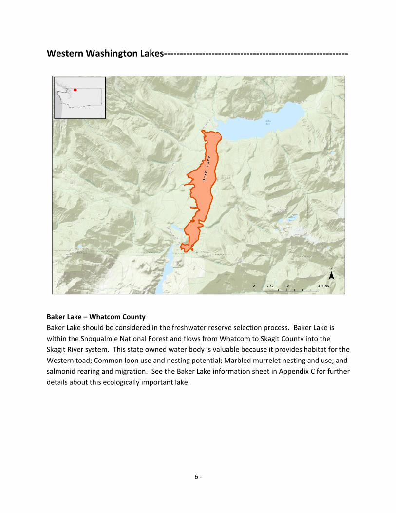
Western Washington Lakes----------------------------------------------------------
Baker Lake – Whatcom County
Baker Lake should be considered in the freshwater reserve selection process. Baker Lake is
within the Snoqualmie National Forest and flows from Whatcom to Skagit County into the
Skagit River system. This state owned water body is valuable because it provides habitat for the
Western toad; Common loon use and nesting potential; Marbled murrelet nesting and use; and
salmonid rearing and migration. See the Baker Lake information sheet in Appendix C for further
details about this ecologically important lake.
7 -
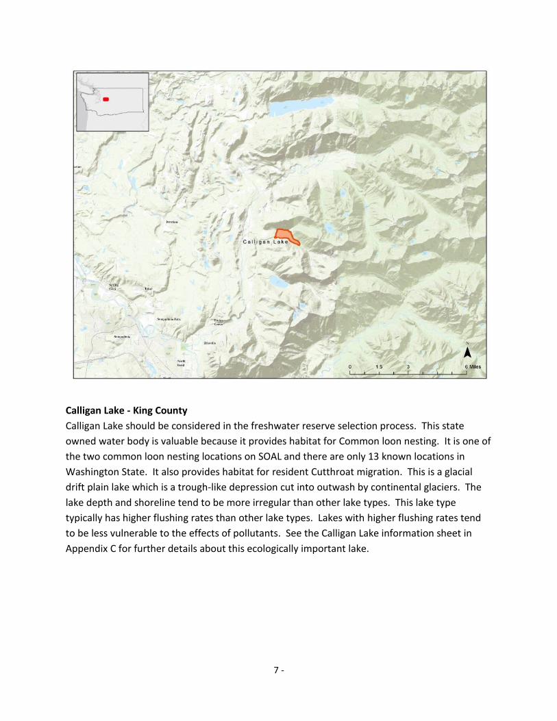
Calligan Lake - King County
Calligan Lake should be considered in the freshwater reserve selection process. This state
owned water body is valuable because it provides habitat for Common loon nesting. It is one of
the two common loon nesting locations on SOAL and there are only 13 known locations in
Washington State. It also provides habitat for resident Cutthroat migration. This is a glacial
drift plain lake which is a trough-like depression cut into outwash by continental glaciers. The
lake depth and shoreline tend to be more irregular than other lake types. This lake type
typically has higher flushing rates than other lake types. Lakes with higher flushing rates tend
to be less vulnerable to the effects of pollutants. See the Calligan Lake information sheet in
Appendix C for further details about this ecologically important lake.

8 -
Eastern Washington Lakes -----------------------------------------------------------
Bonaparte Lake – Okanogan County
Bonaparte Lake should be considered in the freshwater reserve selection process. This state
owned water body is valuable because it provides nesting habitat for the Common loon. It is
one of the two common loon nesting locations on SOAL and there are only 13 known locations
in Washington State. In addition, it is a spawning area for Kokanee, a breeding site for Black
tern, and is predominately surrounded by the Okanogan National Forest. See the Bonaparte
Lake information sheet in Appendix C for further details about this ecologically important lake.

9 -
Lake Wenatchee – Chelan County
Lake Wenatchee should be considered in the freshwater reserve selection process. This state
owned water body is predominately surrounded by the Wenatchee National Forest and is
valuable because it provides habitat for species such as the Western toad, Columbia spotted
frog, Common loon and Pacific lamprey. It also provides salmonid rearing habitat for Sockeye,
Dolly varden/Bull trout and Steelhead. Lake Wenatchee receives water from the Wenatchee
River and is just over 1 mile west of Fish Lake, another lake recommended for reserve selection.
Lake Wenatchee, Wenatchee River and Fish Lake should be considered as a freshwater complex
reserve (Appendix A). See the Lake Wenatchee information sheet in Appendix C for further
details about this ecologically important lake.
Fish Lake – Chelan County
Fish Lake should be considered in the freshwater reserve selection process. This state owned
water body is within the Wenatchee National Forest and is valuable because it provides habitat
for the western toad and Columbia spotted frog. It is just over one mile east of two other water
bodies recommended for reserve selection, Lake Wenatchee and Wenatchee River. These

10 -
water bodies should be considered as a freshwater complex reserve, including both lakes and
the river system (Appendix A). See the Fish Lake information sheet in Appendix C for further
details about this ecologically important lake.
Sullivan Lake - Pend Oreille County
Sullivan Lake should be considered in the freshwater reserve selection process. Sullivan Lake is
connected to Sullivan Creek, a tributary of the Pend Oreille River. This state owned water body
is valuable because it provides habitat for species such as the Western toad, Columbia spotted
frog, Common loon and Harlequin duck. It also provides salmonid migration habitat for
Kokanee, Cutthroat trout and Dollyvarden/Bull trout. The entire lake is within the Colville
National Forest and surrounded by Western Larch Larix occidentalis, the deciduous conifer.
This unique conifer bears yellow-green needles in spring, which turn a brilliant yellow in the fall
before they drop for the winter. See the Sullivan Lake information sheet in Appendix C for
further details about this ecologically important lake.

11 -
Diamond Lake - Pend Oreille County
Diamond Lake should be considered in the freshwater reserve selection process. This state
owned water body is valuable because it provides habitat for the Northern leopard frog and
Common loon. The southern portion of the lake shoreline consists of the rare wetland habitat
low elevation sphagnum bog. There are only 5 locations or less of this habitat type in
Washington State. This is a glacial flood scour lake which means it was formed by glaciers
eroding away fractured bedrock. This lake type typically has higher flushing and drainage rates
which can make it less vulnerable to impacts of runoff inputs. See the Diamond Lake
information sheet in Appendix C for further details about this ecologically important lake.

12 -
Calispell Lake – Pend Oreille County
Calispell Lake should be considered in the freshwater reserve selection process. Calispell Lake
receives water from Calispell Creek, a tributary of the Pend Oreille River. This state owned
water body is valuable because it provides habitat for the Western toad, Columbia spotted frog,
Northern leopard frog, and Common loon and Dolly varden/Bull trout migration. The
Washington Audubon Society has designated this area as an Important Bird Area because it
provides migration and nesting habitat for many bird species including the state endangered
Sandhill crane and White pelican. Calispell Lake receives water from Calispell Creek, a tributary
of the Pend Oreille River, both are additional water bodies recommended for reserve selection.
These water bodies should be considered as a freshwater complex reserve, including the entire
lake, creek and river system (Appendix A). See the Calispell Lake information sheet in Appendix
C for further details about this ecologically important lake.
13 -
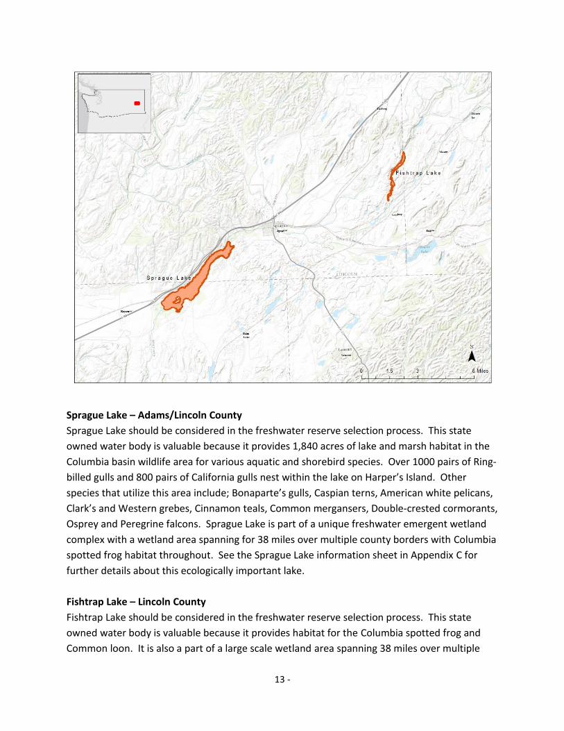
Sprague Lake – Adams/Lincoln County
Sprague Lake should be considered in the freshwater reserve selection process. This state
owned water body is valuable because it provides 1,840 acres of lake and marsh habitat in the
Columbia basin wildlife area for various aquatic and shorebird species. Over 1000 pairs of Ring-
billed gulls and 800 pairs of California gulls nest within the lake on Harper’s Island. Other
species that utilize this area include; Bonaparte’s gulls, Caspian terns, American white pelicans,
Clark’s and Western grebes, Cinnamon teals, Common mergansers, Double-crested cormorants,
Osprey and Peregrine falcons. Sprague Lake is part of a unique freshwater emergent wetland
complex with a wetland area spanning for 38 miles over multiple county borders with Columbia
spotted frog habitat throughout. See the Sprague Lake information sheet in Appendix C for
further details about this ecologically important lake.
Fishtrap Lake – Lincoln County
Fishtrap Lake should be considered in the freshwater reserve selection process. This state
owned water body is valuable because it provides habitat for the Columbia spotted frog and
Common loon. It is also a part of a large scale wetland area spanning 38 miles over multiple

14 -
county borders with Columbia spotted frog habitat throughout. See the Fishtrap Lake
information sheet in Appendix C for further details about this ecologically important lake.
River Recommendations
The following identifies freshwater river segments with high conservation value to Washington
state by highlighting their scientific value and environmental importance. The Aquatic Reserve
program should use this list and water body descriptions to help determine and prioritize river
segments that should be considered for DNR Aquatic Reserve status (Appendix A and B). River
segments are delineated by river miles since rivers typically span such a long distance.
Numbers provided on the list are not representative of water body ranking.
River County River Miles
1 Hoh River Jefferson 13-40
2 Black River Thurston 10-22 3 Nisqually River Thurston/Pierce All of SOAL
4 South Fork Nooksack Whatcom 0-7
5 Lewis and Columbia River Confluence Cowlitz 87-99, 0-4
6 Columbia River (Beacon Rock) Skamania/Klickitat 141-181
7 Similkamen River Okanogan 4-19
8 Methow River Okanogan 38-47
9 Pend Oreille River/Calispell Creek Pend Oreille 69-88 10 Wenatchee River (North) Chelan 46-54 11 Wenatchee River/Icicle Creek Chelan 23-25,0-3 12 Yakima River (Columbia River confluence) Benton 333-336,0-2

15 -
Western Washington Rivers---------------------------------------------------------
Hoh River – Jefferson County
The Hoh River should be considered in the freshwater reserve selection process from river mile
13 to river mile 40. This state owned water body is valuable because it provides habitat for the
Harlequin duck, Western toad and salmonid habitat for spawning, rearing and migration. It
may also provide habitat for Pacific lamprey spawning. The Hoh River originates at the Hoh
Glacier on Mount Olympus and flows west through the Olympic Mountains of Olympic National
Park and Olympic National Forest. It empties into the Pacific Ocean at the Hoh Indian
Reservation. The river is SOAL throughout this river reach. See the Hoh River information sheet
in Appendix D for further details about this ecologically important river segment.

16 -
Black River – Thurston County
The Black River should be considered in the freshwater reserve selection process from river
mile 10 to river mile 22, where the river meets the southern shore of Black Lake (Appendix A).
This state owned water body is valuable because it provides habitat for the largest known
concentration of the Oregon spotted frog, a state endangered species. In addition it provides
salmonid habitat for spawning, rearing and migration; and it may also provide spawning
grounds for the Pacific lamprey. Other rare and uncommon species distributed in the area
include the endemic Olympic mudminnow Novumbra hubbsi and the native freshwater mussel
Western floater Anodonta kennerlyi. There are three conservation areas adjacent to this river
segment; the Black River Preserve (The Nature Conservancy), the Scatter Creek Wildlife Area
(WDFW); and the Black River-Mima Prairie Glacial Heritage Preserve (Thurston County). See
the Black River information sheet in Appendix D for further details about this ecologically
important river segment.

17 -
Nisqually River – Thurston, Pierce and Lewis County
The entire Nisqually River should be considered in the freshwater reserve selection process
from where state ownership begins, near the Mt. Rainer headwaters, to the river mouth at the
Nisqually Wildlife Refuge, where the river flows into south Puget Sound. This state owned
water body is valuable because it provides habitat for the Western toad, Common loon, Pacific
lamprey, and salmonid habitat for spawning, rearing and migration. It is a unique river system
because from the headwaters to the river delta, the adjacent lands hold conservation status.
See the Nisqually River information sheet in Appendix D for further details about this
ecologically important river segment.

18 -
South Fork Nooksack River – Whatcom County
The South Fork Nooksack River should be considered in the freshwater reserve selection
process from river mile 7 to river mile 0, where the river meets and joins the North Fork
Nooksack River, then flows into the mainstem Nooksack River which eventually flows into
Bellingham Bay in north Puget Sound. This state owned water body is valuable because it
provides habitat for a concentration of the Oregon spotted frog, a state endangered species. In
addition it provides salmonid habitat for spawning, rearing and migration. It may also provide
spawning grounds for the Pacific lamprey and rare native mussel, the Western pearlshell. See
the South Fork Nooksack River information sheet in Appendix D for further details about this
ecologically important river segment.

19 -
Lewis and Columbia River Confluence - Cowlitz County
The Lewis and Columbia River confluence, in the Ridgefield National Wildlife Refuge area,
should be considered in the freshwater reserve selection process. There are three river
segments within this river system: the Columbia River from river mile 99 to river mile 87; a
portion of the Lewis River from river mile 0 to river mile 4 meeting with the mouth of the East
Fork Lewis River; this fork should also be included until SOAL ends, at river mile 0 to river mile 6
(Appendix A). These state owned water bodies are valuable because they provide habitat for a
concentration of birds in the pacific flyway including the the state endangered Sandhill crane,
15,000+ Canadian geese; Tundra swans; resident Bald eagles; wintering ducks such as Gadwalls,
American widgeons, Northern shovelers, Northern pintails, Ring-necked ducks, Green winged
teals, Buffleheads, Lesser scaups; in addition to Green herons, Black crowned night herons, and
Great egrets, Black terns and Black-necked stilts. This river segment includes adjacent shoreline
land management areas that provide habitat for bird migration populations including Paradise
Point State Park, Ridgefield National Wildlife Refuge and Shillapoo Wildlife Area (WDFW). In
addition these river segments provide habitat for the Pacific lamprey and Chinook for spawning,

20 -
rearing and migration. See the Lewis River and Columbia River confluence information sheet in
Appendix D for further details about these ecologically important river segments.
Columbia River (Beacon Rock) - Skamania/Klickitat
The Columbia River should be considered in the freshwater reserve selection process from river
mile 141to river mile 181, including Draino Lake between river mile 162 and 163. This state
owned water body is valuable because it provides habitat for a concentration of the Pacific
pond turtle, a state endangered species. In addition it provides habitat for the Western toad
and salmonid habitat for spawning, rearing and migration. Harlequin ducks utilize a tributary to
this river segment, the Little White Salmon River, which drains into Draino Lake and then the
Columbia River. There is the potential is also provides habitat for Pacific lamprey spawning as
tributary mouths within the river segment support this species. See the Columbia River
(Beacon Rock) information sheet in Appendix D for further details about this ecologically
important river segment.

21 -
Eastern Washington Rivers-----------------------------------------------------------
Similkameen River - Okanogan County
The Similkameen River should be considered in the freshwater reserve selection process from
river mile 0 to river mile 19. This state owned water body is valuable because there are
multiple locations and species of native freshwater mussels, which is a unique feature of this
river system and found nowhere else on SOAL. The following species are distributed from river
mile 4-19; Western ridgemussel Gonidea angulate, California floater Anodonta californiensis
and Western pearlshell Margaritifera falcata. This river segment also provides habitat for the
Western toad and salmonid spawning habitat for Chinook and Steehead. See the Similkameen
River information sheet in Appendix D for further details about this ecologically important river
segment.

22 -
Methow River – Okanogan County
The Methow River should be considered in the freshwater reserve selection process from river
mile 38 to river mile 47. This state owned water body is valuable because it provides habitat for
the Harlequin duck and salmonid habitat for spawning, rearing and migration. The river is a
tributary of the Columbia River in north central Washington and originates from a cluster of
high mountains and associated tributaries into the Methow Valley. See the Methow River
information sheet in Appendix D for further details about this ecologically important river
segment.

23 -
Pend Oreille River and Callispell Creek – Pend Oreille County
The Pend Oreille River and Calispell Creek tributary should be considered in the freshwater
reserve selection process from river mile 69 to the Idaho border at river mile 88. Calispell Lake
is connected to this river and creek and it should be considered as a freshwater complex
(Appendix A). These state owned water bodies are valuable because they provide habitat for
the Northern leopard frog, Columbia spotted frog, Western toad, Common loon, the state
endangered American white pelican and Sandhill crane; and salmonid migration habitat. The
Usk Bridge area, which is within this river segment, has been designated by the Washington
Audubon Society as an Important Bird Area. See the Pend Oreille River and Callispell Creek
information sheet in Appendix D for further details about these ecologically important river and
creek segments.

24 -
Wenatchee River (North) – Chelan County
The Wenatchee River should be considered in the freshwater reserve selection process from
river mile 46, just south of Beaver Creek, to river mile 54, the south shore of Lake Wenatchee.
This state owned water body is predominately within the Wenatchee National forest and is
valuable because it provides habitat for the Columbia spotted frog, Western toad and salmonid
habitat for spawning, rearing and migration. It may also provide spawning habitat for the
Pacific lamprey. River mile 46 was included in the river segment because the tributary, Beaver
Creek, supports Steelhead rearing. This river should be considered as a freshwater complex
with Lake Wenatchee, the river headwaters, and Fish Lake, just east of Lake Wenatchee,
because both lakes are recommended in the lake section of this document (Appendix A). See
the Wenatchee River North information sheet in Appendix D for further details about this
ecologically important river segment.

25 -
Wenatchee River and Icicle Creek – Chelan County
The Wenatchee River and Icicle Creek should be considered in the freshwater reserve selection
process. The Wenatchee River originates at Lake Wenatchee and flows south east for over 50
miles where it meets the Columbia River. The Wenatchee River should be considered as a
freshwater reserve from river mile 23 to river mile 25 where it meets Icicle Creek. The creek
should be considered for all of SOAL, from river mile 0 to river mile 3. This state owned water
body is valuable because it provides habitat for the Harlequin duck and salmonid habitat for
spawning, rearing and migration. Blackbird Island is within this river segment and has been
designated by the Washington Audubon Society as an Important Bird Area. This area is heavily
used by visitors to Leavenworth, a year round tourist destination. See the Wenatchee River and
Icicle Creek information sheet in Appendix D for further details about these ecologically
important river and creek segments.

26 -
Yakima River and Columbia River Confluence – Benton County
The Yakima River and Columbia River confluence should be considered in the freshwater
reserve selection process from river mile 0 to river mile 2 in the Yakima River and from river
mile 333 to river mile 336 in the Columbia River. This state owned water body is valuable
because it has been designated as an Important Bird Area by the Washington Audubon Society
providing a refuge for a variety of shorebirds such as Dunlins, Black-necked stilts, American
avocets, Greater and Lesser yellow legs, Long billed dowitchers, Spotted sandpipers, American
widgeons, Common loons, Pied-billed grebes, Hooded mergansers, Ring-necked ducks, Lesser
scaups, and Northern pintails. There are five nature reserves along the river shoreline within
this river segment and there is the potential the confluence provides habitat for Pacific lamprey
spawning as tributary mouths support this species. See the Yakima River and Columbia River
Confluence information sheet in Appendix D for further details about these ecologically
important river segments.

27 -
5.0 Next Steps
This report identifies freshwater lakes and rivers with high conservation value in Washington
State by highlighting their scientific value and environmental importance. The Aquatic Reserve
program should use this report to help determine and prioritize lakes and rivers that could be
considered for DNR Aquatic Reserve status. Additional aspects of Aquatic Reserve selection
and planning should be considered and evaluated by the Aquatic Reserve Program. Below are
some suggestions that should be evaluated to help determine the next steps in the
identification process.
Agency Internal Suggestions
Various water bodies are considered important by DNR internal staff that do not meet the
science or environmental criteria used in this report. Land management dynamics suggest that
a water body can be important even if not captured in the criteria used but are considered
valuable by DNR for other reasons such as unique attributes, lack of infrastructural
development, appreciation by the surrounding community, connectivity to DNR Natural Area
Preserves and more. A list of these water bodies could be constructed and considered in the
freshwater reserve evaluation process. If a list is generated it should include a description of
why it is considered valuable. DNR programs that should be consulted with include the Aquatic
Lands Planning and Stewardship Section DNR Aquatics Districts and Restoration Program.
External Entities
Various water bodies may be considered important by external entities that do not meet the
science or environmental criteria used in this report. Land management and community
dynamics suggest that a water body can be important even if not captured in the criteria used
but are considered valuable for other reasons such as local interests, on-going continued
efforts, funding opportunities, research, education and more. External entities to consult with
could include:
Washington State Conservation Commission – Review the Conservation District
websites or contact them for further discussion to determine if there are lakes or rivers
with ecological, scientific, educational, or another determined value.
http://www.scc.wa.gov/contacts/conservation-districts/
Lake Associations – Determine if there are lake associations or lake associated groups
with additional lakes to recommend. Consultation with their local efforts and obtaining
available information could be beneficial.
Regional Fishery Enhancement Groups - Consultation with their efforts and obtaining
available information could be beneficial. Review the Regional Fishery Enhancement

28 -
Groups websites or contact them for further discussion to determine if there are lakes
or rivers with ecological, scientific, educational, or other determined value.
http://wdfw.wa.gov/about/volunteer/rfeg/
Shoreline Management Plans - Recommendations at the county level with
conservation, preservation, restoration or other ecological, scientific or educational
designations.
http://www.ecy.wa.gov/programs/sea/shorelines/smp/status.html
WRIAs – Evaluate WRIAs for recommended river segments and determine if there is
information available for recommended lakes or rivers that would add to the ecological,
scientific, educational, or other determined value.
http://www.ecy.wa.gov/apps/watersheds/wriapages/
Further Data Collection
The findings in this report were determined using various data layers available to DNR. It is
recommended that people familiar with the local biology and ecology of a water body are
contacted to understand field knowledge. In addition, further research should be completed on
each water body to obtain a greater understanding of the lake or river history and current
status.
Considerations
The following entities were contacted in the initial criteria forming process of water body
selection. When DNR decides to move forward with the freshwater reserve selection process it
could be important to contact the following to determine what level of participation, if any,
they could have in the planning process.
Washington State Lake Protection Association (WALPA)
http://www.walpa.org/
North American Lake Management Society (NALMS)
http://www.nalms.org/
Oregon Lakes Association (OLA)
http://www.oregonlakes.org/
American Rivers, Wild and Scenic: Northwest/Pacific Region
http://www.americanrivers.org/region/northwest/
River Restoration Northwest
http://www.rrnw.org/Home
The Nature Conservancy

29 -
APPENDIX A
Lakes, Rivers and Freshwater Complex List
Lakes County 1 Baker Lake Whatcom 2 Calligan Lake King 3 Bonaparte Lake Okanogan 4 Lake Wenatchee Chelan 5 Fish Lake Chelan 6 Sullivan Lake Pend Oreille 7 Diamond Lake Pend Oreille 8 Lake Calispell Pend Oreille 9 Sprague Lake Adams/Lincoln 10 Fishtrap Lake Lincoln Rivers 1 Hoh River Jefferson 2 Black River Thurston 3 Nisqually River Thurston/Pierce 4 South Fork Nooksack River Whatcom 5 Lewis and Columbia River Confluence Cowlitz 6 Columbia River (Beacon Rock) Skamania/Klickitat 7 Similkamen River Okanogan 8 Methow River Okanogan 9 Pend Oreille River and Calispell Creek Pend Oreille 10 Wenatchee River North Chelan 11 Wenatchee River and Icicle Creek Chelan 12 Yakima and Columbia River Confluence Benton Freshwater Complexes (listed separately above) 1 Lake Wenatchee, Fish Lake and Wenatchee River Chelan 2 Black River and south shore of Black Lake Thurston 3 Lake Calispell, Calispell Creek and Pend Oreille River Pend Oreille 4 Lewis and Columbia River Confluence and East Fork
Lewis River Cowlitz

30 -
APPENDIX B
Maps of Lakes and Rivers Identified in Washington State
Quad Zoom Level
30 -
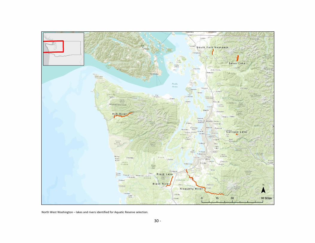
North West Washington – lakes and rivers identified for Aquatic Reserve selection.

31 -
North East Washington – lakes and rivers identified for Aquatic Reserve selection.

32 -
South West Washington – lakes and rivers identified for Aquatic Reserve selection.

33 -
South East Washington – lakes and rivers identified for Aquatic Reserve selection.

34 -
APPENDIX C
Lake Information Sheets
35 -
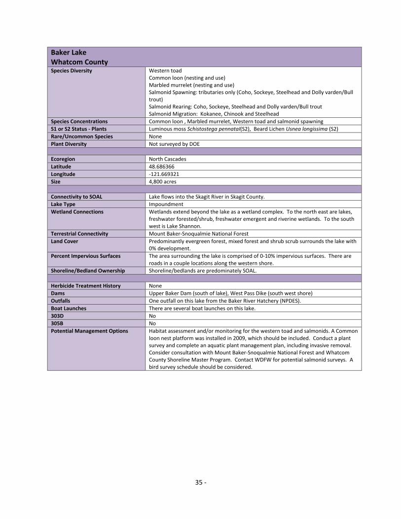
Baker Lake Whatcom County
Species Diversity Western toad Common loon (nesting and use) Marbled murrelet (nesting and use) Salmonid Spawning: tributaries only (Coho, Sockeye, Steelhead and Dolly varden/Bull trout) Salmonid Rearing: Coho, Sockeye, Steelhead and Dolly varden/Bull trout Salmonid Migration: Kokanee, Chinook and Steelhead
Species Concentrations Common loon , Marbled murrelet, Western toad and salmonid spawning
S1 or S2 Status - Plants Luminous moss Schistostega pennataI(S2), Beard Lichen Usnea longissima (S2)
Rare/Uncommon Species None
Plant Diversity Not surveyed by DOE
Ecoregion North Cascades
Latitude 48.686366
Longitude -121.669321
Size 4,800 acres
Connectivity to SOAL Lake flows into the Skagit River in Skagit County.
Lake Type Impoundment
Wetland Connections Wetlands extend beyond the lake as a wetland complex. To the north east are lakes, freshwater forested/shrub, freshwater emergent and riverine wetlands. To the south west is Lake Shannon.
Terrestrial Connectivity Mount Baker-Snoqualmie National Forest
Land Cover Predominantly evergreen forest, mixed forest and shrub scrub surrounds the lake with 0% development.
Percent Impervious Surfaces The area surrounding the lake is comprised of 0-10% impervious surfaces. There are roads in a couple locations along the western shore.
Shoreline/Bedland Ownership Shoreline/bedlands are predominately SOAL.
Herbicide Treatment History None
Dams Upper Baker Dam (south of lake), West Pass Dike (south west shore)
Outfalls One outfall on this lake from the Baker River Hatchery (NPDES).
Boat Launches There are several boat launches on this lake.
303D No
305B No
Potential Management Options Habitat assessment and/or monitoring for the western toad and salmonids. A Common loon nest platform was installed in 2009, which should be included. Conduct a plant survey and complete an aquatic plant management plan, including invasive removal. Consider consultation with Mount Baker-Snoqualmie National Forest and Whatcom County Shoreline Master Program. Contact WDFW for potential salmonid surveys. A bird survey schedule should be considered.

36 -
Calligan Lake King County
Species Diversity Common loon (nesting) Salmonid Migration: Cutthroat
Species Concentrations One of the two Common loon nesting locations on SOAL, only 13 known locations in Washington State.
S1 or S2 Status – Plants None
Rare/Uncommon Species None
Plant Diversity Not surveyed by DOE
Ecoregion North Cascades
Latitude 47.605157
Longitude -121.669085
Size 251+ acres
Connectivity to SOAL None
Lake Type Glacial Drift Plain
Wetland Connections None
Terrestrial Connectivity Southeast portion of lake borders Snoqualmie National Forest.
Land Cover Predominately evergreen forest, shrub scrub and herbaceous vegetation surrounds the lake with 0% development.
Percent Impervious Surfaces The area surrounding the lake is comprised of 0-10% impervious surfaces. There are roads along the north and east shore of the lake.
Shoreline/Bedland Ownership Shoreline/bedlands are predominately SOAL. Approximately 1,465 ft of shoreline are private.
Herbicide Treatment History None
Dams None
Outfalls None
Boat Launches There are no motorized boat launches on this lake
303D PCB, Alpha-BHC, Dioxin
305B Heptachlor, Hexachlorocyclopentadiene, Hexachloroethane, Isophorone, Mercury, Nitrobenzene, N-Nitrosodiphenylamine, Phenol, Pyrene, Gamma-bhc (Lindane), Fluorene, Fluoranthene, Endrin, Endosulfan Sulfate, Endosulfan I, Endosulfan II, Dioxin, Dibutyl phthalate, Dimethyl phthalate, Diethyl phthalate, Bis(2-Ethylhexyl) Phthalate, Bis(2-chloroisopropyl)ether, Beta-BHC, Anthracene, Alpha-BHC, 4,4’-DDT, 4,4’-DDE, 4,4’-DDD, 2,4-Dinitrophenol, 2,4-Dichlorophenol, PCB, Chlordane, 2,4,6-Trichlorophenol, 1,4-Dichlorobenzene, 1,3-Dichlorobenzene, 1,2-Dichlorobenzene
Potential Management Options Habitat assessment and/or monitoring with an emphasis on Common loon nesting. Conduct a plant survey and complete an aquatic plant management plan, including invasive removal. Consider consultation with Snoqualmie National Forest and King County Shoreline Master Program. Contact WDFW for potential salmonid surveys. A bird survey schedule should be considered. The Total Maximum Daily Load report should be evaluated for water body improvements at 303D and 305B listed areas.
37 -
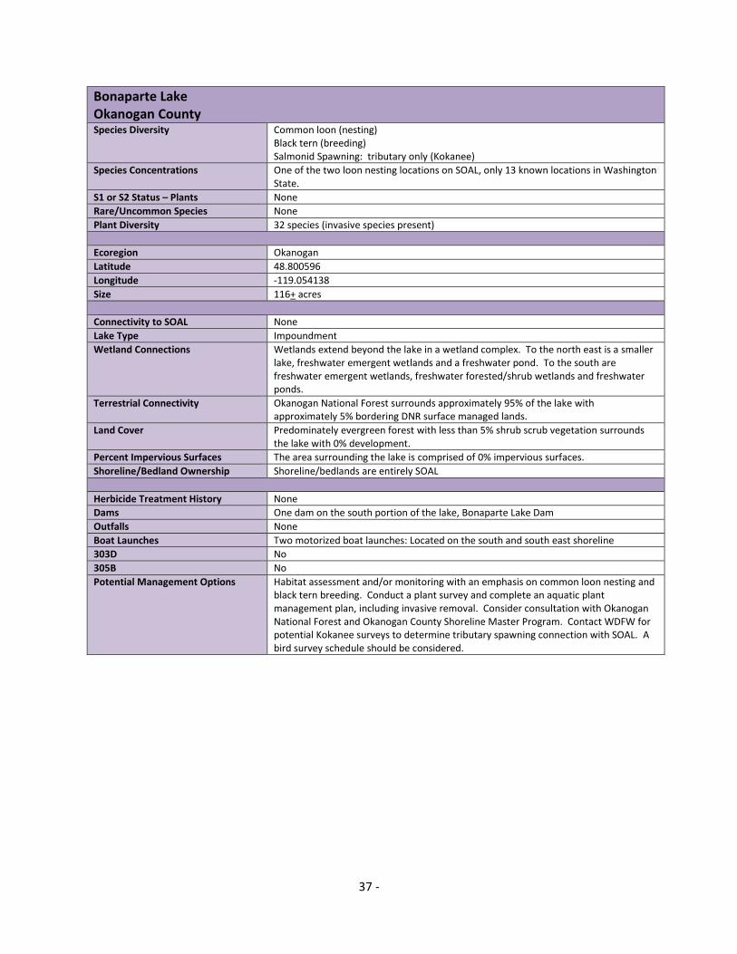
Bonaparte Lake Okanogan County
Species Diversity Common loon (nesting) Black tern (breeding) Salmonid Spawning: tributary only (Kokanee)
Species Concentrations One of the two loon nesting locations on SOAL, only 13 known locations in Washington State.
S1 or S2 Status – Plants None
Rare/Uncommon Species None
Plant Diversity 32 species (invasive species present)
Ecoregion Okanogan
Latitude 48.800596
Longitude -119.054138
Size 116+ acres
Connectivity to SOAL None
Lake Type Impoundment
Wetland Connections Wetlands extend beyond the lake in a wetland complex. To the north east is a smaller lake, freshwater emergent wetlands and a freshwater pond. To the south are freshwater emergent wetlands, freshwater forested/shrub wetlands and freshwater ponds.
Terrestrial Connectivity Okanogan National Forest surrounds approximately 95% of the lake with approximately 5% bordering DNR surface managed lands.
Land Cover Predominately evergreen forest with less than 5% shrub scrub vegetation surrounds the lake with 0% development.
Percent Impervious Surfaces The area surrounding the lake is comprised of 0% impervious surfaces.
Shoreline/Bedland Ownership Shoreline/bedlands are entirely SOAL
Herbicide Treatment History None
Dams One dam on the south portion of the lake, Bonaparte Lake Dam
Outfalls None
Boat Launches Two motorized boat launches: Located on the south and south east shoreline
303D No
305B No
Potential Management Options Habitat assessment and/or monitoring with an emphasis on common loon nesting and black tern breeding. Conduct a plant survey and complete an aquatic plant management plan, including invasive removal. Consider consultation with Okanogan National Forest and Okanogan County Shoreline Master Program. Contact WDFW for potential Kokanee surveys to determine tributary spawning connection with SOAL. A bird survey schedule should be considered.

38 -
Lake Wenatchee Chelan County
Species Diversity Western toad Columbia spotted frog (old) Common loon Pacific lamprey (old) Salmonid Rearing: Sockeye, Dolly varden/Bull trout and Steelhead
Species Concentrations None
S1 or S2 Status – Plants None
Rare/Uncommon Species None
Plant Diversity 30 species (invasive species present)
Ecoregion East Cascades
Latitude 47.820874
Longitude -120.771441
Size 2270+ acres
Connectivity to SOAL Wenatchee River
Lake Type Glacial Scour
Wetland Connections Wetlands extend beyond the lake as a wetland complex. To the north west are freshwater forested/shrub, freshwater emergent and riverine wetlands. To the south east are freshwater forested/shrub and riverine wetlands. Fish Lake is approximately 1 ¼ miles east of Lake Wenatchee and is a recommended lake.
Terrestrial Connectivity Wenatchee National Forest surrounds 75% of the lake. Lake Wenatchee State Park is located on the southeast shoreline.
Land Cover Predominately evergreen forest surrounds the lake with the north west portion consisting of woody wetlands. Development at low intensity surrounds the lake which is from roads.
Percent Impervious Surfaces The area surrounding the lake is comprised of 0-10% impervious surface however roads adjacent to 90% of the lake account for 10-100% impervious surface.
Shoreline/Bedland Ownership Approximately 50% of the lake shoreline is private
Herbicide Treatment History None
Dams None
Outfalls One outfall exists on this lake
Boat Launches Two motorized boat launches: The Glacier View Campground boat launch is located on the north west shoreline and Lake Wenatchee State Park boat launch is located on the south east shoreline.
303D No
305B No
Potential Management Options Habitat assessment and/or monitoring for the Western toad, Columbia spotted frog, Common loon, Pacific lamprey and salmonids. Conduct a plant survey and complete an aquatic plant management plan, including invasive removal. Consider partnerships with Wenatchee National Forest, Lake Wenatchee State Park, and Chelan County Shoreline Master Program. A bird survey schedule should be considered.

39 -
Fish Lake Chelan County Species Diversity Western toad
Columbia spotted frog
Species Concentrations None
S1 or S2 Status - Plants On the south east shoreline: Bristly sedge Carex comosa(S2), Bulb bearing water hemlock Cicuta bulbifera (S2)
Rare/Uncommon Species None
Plant Diversity 45 species (invasive species present)
Ecoregion East Cascades
Latitude 47.834837
Longitude -120.706095
Size 435+ acres
Connectivity to SOAL None
Lake Type Glacial Scour
Wetland Connections Wetlands extend beyond the lake as a wetland complex. To the west are freshwater emergent wetlands. To the south and east are freshwater forested/shrub wetlands. Lake Wenatchee is approximately 1 ¼ miles west of Fish Lake and is a recommended lake.
Terrestrial Connectivity The entire lake is within the Wenatchee National Forest
Land Cover The vegetation is predominately evergreen forest and emergent herbaceous or woody wetlands. Low intensity development surrounds 75% of the lake and appears to be from roads along the north and south shore.
Percent Impervious Surfaces The area surrounding the lake is comprised of 0-10% impervious surfaces.
Shoreline/Bedland Ownership Shoreline/bedlands are entirely SOAL
Herbicide Treatment History None
Dams None
Outfalls None
Boat Launches Motorized boat launches located on the north west and south west shoreline.
303D No
305B No
Potential Management Options Habitat assessment and/or monitoring for the Western toad and Columbia spotted frog. Conduct a plant survey and complete an aquatic plant management plan, including invasive removal. Consider consultation with Wenatchee National Forest and Chelan County Shoreline Master Program. A bird survey schedule should be considered.

40 -
Sullivan Lake Pend Oreille County
Species Diversity Western toad Columbia spotted frog (old) Common loon Salmonid Migration: Cutthroat, Kokanee and Dolly varden/Bull trout
Species Concentrations Common loon and Western toad
S1 or S2 Status – Plants South portion of shoreline: Crested Shield-fern Cryopteris cristata (S2) and Kidney-leaf White Violet Viola renifolia(S2)
Rare/Uncommon Species (other) The lake is surrounded by Western Larch Larix occidentalis, the deciduous conifer. This unique conifer bears yellow-green needles in spring, which turn a brilliant yellow in the fall before they drop for the winter.
Plant Diversity 11 species
Ecoregion Canadian Rocky Mountains
Latitude 48.815153
Longitude -117.292982
Size 1180+ acres
Connectivity to SOAL The lake is connected to Sullivan Creek, a tributary of the Pend Oreille River.
Lake Type Impoundment
Wetland Connections At the southern tip of the lake are freshwater emergent, forested/shrub and riverine wetlands.
Terrestrial Connectivity The entire lake is within the Colville National Forest.
Land Cover Predominately evergreen forest with 0% development surrounds the lake.
Percent Impervious Surfaces The area surrounding the lake is comprised of 0-10% impervious surfaces.
Shoreline/Bedland Ownership Shoreline/bedlands are entirely SOAL.
Herbicide Treatment History None
Dams One dam on the north lake shoreline, Sullivan Lake Dam
Outfalls None
Boat Launches Two motorized boat launches are located on the lake. East Sullivan Lake Campground on the north shore and Noisy Creek Campground boat launch on the south shore.
303D No
305B No
Potential Management Options Habitat assessment and/or monitoring for the Western toad, Columbia spotted frog, Common loon and salmonids. Conduct a plant survey and complete an aquatic plant management plan, including invasive removal. Consider consultation with Colville National Forest and Pend Oreille County Shoreline Master Program. A bird survey schedule should be considered.
41 -
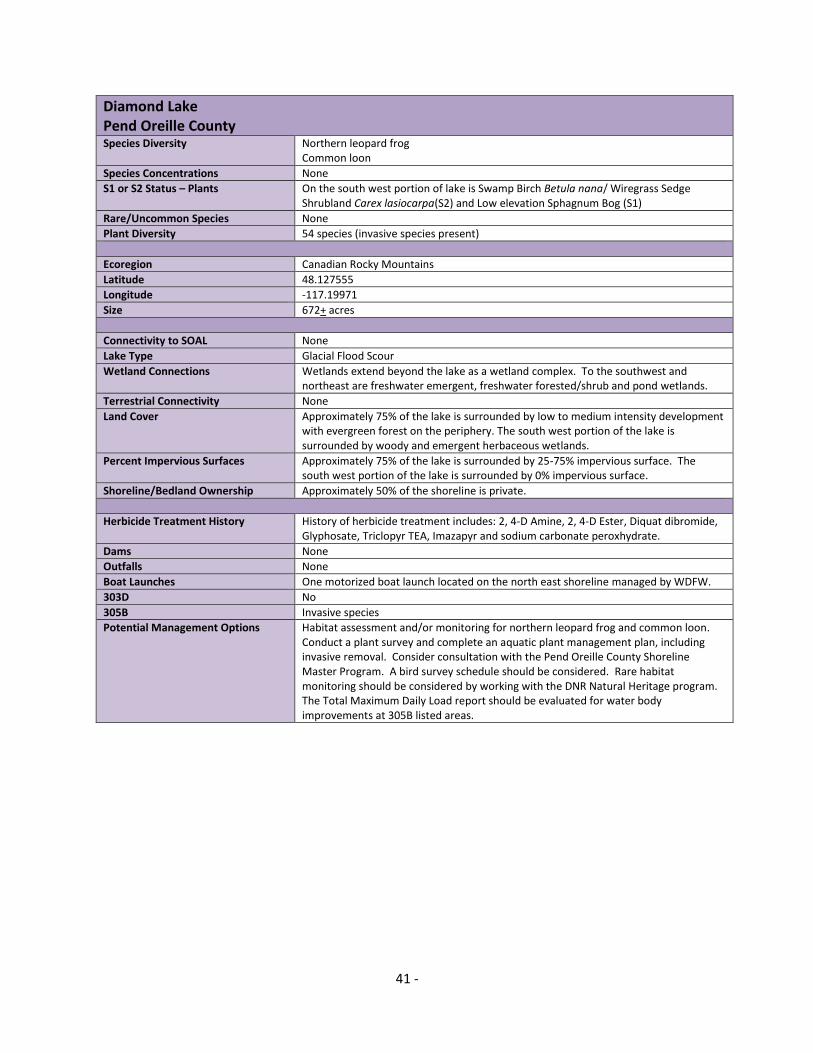
Diamond Lake Pend Oreille County
Species Diversity Northern leopard frog Common loon
Species Concentrations None
S1 or S2 Status – Plants On the south west portion of lake is Swamp Birch Betula nana/ Wiregrass Sedge Shrubland Carex lasiocarpa(S2) and Low elevation Sphagnum Bog (S1)
Rare/Uncommon Species None
Plant Diversity 54 species (invasive species present)
Ecoregion Canadian Rocky Mountains
Latitude 48.127555
Longitude -117.19971
Size 672+ acres
Connectivity to SOAL None
Lake Type Glacial Flood Scour
Wetland Connections Wetlands extend beyond the lake as a wetland complex. To the southwest and northeast are freshwater emergent, freshwater forested/shrub and pond wetlands.
Terrestrial Connectivity None
Land Cover Approximately 75% of the lake is surrounded by low to medium intensity development with evergreen forest on the periphery. The south west portion of the lake is surrounded by woody and emergent herbaceous wetlands.
Percent Impervious Surfaces Approximately 75% of the lake is surrounded by 25-75% impervious surface. The south west portion of the lake is surrounded by 0% impervious surface.
Shoreline/Bedland Ownership Approximately 50% of the shoreline is private.
Herbicide Treatment History History of herbicide treatment includes: 2, 4-D Amine, 2, 4-D Ester, Diquat dibromide, Glyphosate, Triclopyr TEA, Imazapyr and sodium carbonate peroxhydrate.
Dams None
Outfalls None
Boat Launches One motorized boat launch located on the north east shoreline managed by WDFW.
303D No
305B Invasive species
Potential Management Options Habitat assessment and/or monitoring for northern leopard frog and common loon. Conduct a plant survey and complete an aquatic plant management plan, including invasive removal. Consider consultation with the Pend Oreille County Shoreline Master Program. A bird survey schedule should be considered. Rare habitat monitoring should be considered by working with the DNR Natural Heritage program. The Total Maximum Daily Load report should be evaluated for water body improvements at 305B listed areas.

42 -
Calispell Lake Pend Oreille County
Species Diversity Western toad Columbia spotted frog (near/old) Northern leopard frog (near/old) Common loon (river) Salmonid Migration: Dolly varden/Bull trout
Species Concentrations Audubon IBA: Tundra swans, Greater and Lesser yellowlegs, Black-necked stilts, Wilsons’s phalaropes, Pied-billed grebes, Gadwalls, American boots, Blue-winged and Cinnamon teals, Northern shovelers, Redheads, Ring-necked and Ruddy ducks, Killdeer, Wilson’s snipes, Western bluebirds, Savannah sparrows, Yellow-headed blackbirds, American bittern, Bald eagles, Rough –legged and Red-tailed hawks, Horned larks, Snow bunting, Sandhill crane, White pelican, occasional Golden eagles and Prairie falcons.
S1 or S2 Status – Plants None
Rare/Uncommon Species Sandhill crane and white pelican
Plant Diversity Not surveyed by DOE
Ecoregion Canadian Rocky Mountains
Latitude 48.273823
Longitude -117.334614
Size 1124+ acres
Connectivity to SOAL Calispell Creek, a tributary to the Pend Oreille River
Lake Type Glacial Drift Plain
Wetland Connections Wetlands extend beyond the lake as a wetland complex. The tributary of the lake, Calispell Creek is connected to the Pend Oreille River and the entire river, creek, lake complex is composed of freshwater emergent wetlands.
Terrestrial Connectivity None
Land Cover Emergent herbaceous, woody wetlands, open water and herbaceous vegetation surround the lake with 0% development.
Percent Impervious Surfaces Predominately 0% impervious surface surrounds the lake.
Shoreline/Bedland Ownership Shoreline/bedlands are entirely SOAL
Herbicide Treatment History None
Dams None
Outfalls None
Boat Launches None
303D No
305B No
Potential Management Options Habitat assessment and/or monitoring with an emphasis on Columbia spotted frog, Northern leopard frog, Common loon, sandhill crane and white pelican. Conduct a plant survey and complete an aquatic plant management plan, including invasive removal. Consider consultation with Pend Oreille County Shoreline Master Program. Contact WDFW for potential Dolly varden/Bull trout surveys. A bird survey schedule should be considered.

43 -
Sprague Lake
Adams/Lincoln County
Species Diversity None
Species Concentrations Audubon IBA: Lake and marsh habitat in the Columbia basin wildlife area for 1000+ pairs of ring-billed gulls, 800+ pairs of California gulls nest on Harper’s Island on the west end of the lake. Other species include; Bonaparte’s gulls and Caspian terns, American white pelicans, Clark’s and Western grebes, Cinnamon teal, Common mergansers, Double-crested cormorants, Osprey fish in summer, Peregrine falcons hunt for duck in fall.
S1 or S2 Status – Plants None
Rare/Uncommon Species None
Plant Diversity 25 species (invasive species present)
Ecoregion Columbia Plateau
Latitude 47.258436
Longitude -118.064848
Size 1580+ acres
Connectivity to SOAL None
Lake Type Glacial Flood Scour
Wetland Connections Unique freshwater emergent wetland as a large scale wetland area spanning for 38 miles over multiple county borders and Columbia Spotted Frog occurrences throughout. Begins in Adams County with Cow Lake, moving diagonally north to north east through Whiteman, Lincoln and Spokane counties to include SOAL; Sprague Lake, Rock Lake, Fishtrap Lake, Williams Lake, Badger Lake, Chapman Lake, Bonnie Lake, Clear Lake, Granite Lake, Meadow Lake, West Medical Lake and Medical Lake.
Terrestrial Connectivity None
Land Cover Predominately woody and emergent wetlands surround the lake with the periphery consisting of shrub/scrub and cultivated crops and 0% development.
Percent Impervious Surfaces Predominately 0% impervious surface surrounds the lake.
Shoreline/Bedland Ownership Approximately 10-15% of the shoreline is privately owned. The island is not SOAL.
Herbicide Treatment History None
Dams Sprague Lake Dam on Sprague Creek, south of the lake.
Outfalls None
Boat Launches There are four motorized boat launches on the lake including: Sprague Lake (south east), Four Seasons Campground (south west), Sprague Lake Resort (north) and Sprague Lake – Lincoln County (north east).
303D PCB and 2, 3, 7, 8 - TCDD
305B Four areas including the 303D overlap. Total phosphorus. PCB, Heptachlor, Toxaphene, Chlordane, Mercury, Hexachlorobenzene, Heptachlor Epoxide, Endrin, Endosulfan II, Endosulfan I, Gamma-bhc (Lindane), Beta-BHC, Alpha-BHC, 4,4'-DDT, 4,4'-DDE, 4,4'-DDD, and 2,3,7,8-TCDD
Potential Management Options Habitat assessment and/or monitoring with an emphasis on the Columbia Spotted Frog, Sandhill crane and White pelican. Conduct a plant survey and complete an aquatic plant management plan, including invasive removal. Consider consultation with Adams/Lincoln County Shoreline Master Program. A bird survey schedule should be considered. The Total Maximum Daily Load report should be evaluated for water body improvements at 303D and 305B listed areas.

44 -
Fishtrap Lake Lincoln County Species Diversity Columbia spotted frog
Common loon
Species Concentrations None
S1 or S2 Status - Plants None
Rare/Uncommon Species None
Plant Diversity 12 species (invasive species present)
Ecoregion Columbia Plateau
Latitude 47.340973
Longitude -117.835724
Size 157+ acres
Connectivity to SOAL None
Lake Type Impoundment
Wetland Connections Very unique freshwater emergent wetland complex with a large scale wetland area spanning for 38 miles over multiple county borders and Columbia Spotted Frog occurrences throughout. Begins in Adams County with Cow Lake, moving diagonally north to north east through Whiteman, Lincoln and Spokane counties to include SOAL; Sprague Lake, Rock Lake, Fishtrap Lake, Williams Lake, Badger Lake, Chapman Lake, Bonnie Lake, Clear Lake, Granite Lake, Meadow Lake, West Medical Lake and Medical Lake.
Terrestrial Connectivity Bureau of Land Management (BLM) entire west and north shore comprising 7000 acres.
Land Cover Evergreen Forest, woody and emergent herbaceous wetlands, and shrub/scrub surround the lake. With 0% development and no roads along the shoreline.
Percent Impervious Surfaces Predominately 0% impervious surface surrounds the lake. At the northern most point there is 10-50% impervious surface on the shore but only where a resort is located.
Shoreline/Bedland Ownership Shoreline/bedlands are entirely SOAL
Herbicide Treatment History None
Dams One dam on the lake; Fishtrap Lake dam, south shoreline.
Outfalls None
Boat Launches There are two motorized boat launches are on the lake at the north shore Fishtrap Lake (WDFW) and Fishtrap Lake Resort.
303D No
305B No
Potential Management Options Habitat assessment and/or monitoring with an emphasis on the Columbia spotted frog and common loon. Conduct a plant survey and complete an aquatic plant management plan, including invasive removal. Consider consultation with BLM and the Lincoln County Shoreline Master Program. A bird survey schedule should be considered.

45 -
APPENDIX D
River Information Sheets

46 -
Hoh River (RM 13-40) Jefferson County
Species Diversity Western toad (RM 40-28) Harlequin duck (pairs, chicks use from RM 30-13) Pacific lamprey Salmonid Spawning: Chinook, Steelhead and Coho Salmonid Rearing: Dolly varden/Bull Trout (RM 29-40) Salmonid Migration: Sockeye, Chum, Dolly Varden/Bull Trout and Steelhead
Species Concentrations None
S1 or S2 Status - Plants None
Rare/Uncommon Species None
Ecoregion Northwest Coast
Latitude 47.809904
Longitude -124.128526
Connectivity to SOAL The Hoh River originates at the Hoh Glacier on Mount Olympus and flows west through the Olympic Mountains of Olympic National Park and Olympic National Forest. It empties into the Pacific Ocean at the Hoh Indian Reservation. The river is connected to SOAL throughout this river reach.
WRIA Soleduc-Hoh Watershed, 20: This watershed consists of the Soleduck, Hoh, Bogachiel and Calaweh Rivers and many additional tributary creeks and streams. Annual precipitation in the Soleduck-Hoh Watershed ranges from 100 inches per year along the coastal lowlands to 180 inches per year in the Olympic Mountains.
Wetland Connections Predominately freshwater forest/shrub wetland.
Terrestrial Connectivity Some of this river segment borders Clearwater Corridor NRCA, South Nolan NRCA, Olympic National Forest and Olympic National Park.
Land Cover Predominately evergreen forest and shrub scrub.
Percent Impervious Surfaces Predominately 0-10% impervious surface surrounds this river segment.
Shoreline/Bedland Ownership Shoreline/bedlands are predominately SOAL. Due to river and watershed dynamics some areas of the river may not be SOAL.
Herbicide Treatment History None
Dams None
Outfalls None
Boat Launches Three motorized boat launches are located on this river segment. Cottonwood (DNR), Hoh Oxbow (DNR) and Hoh River – Morgans Crossing (WDFW).
303D No
305B No
Potential Management Options Habitat assessment and/or monitoring for Harlequin duck, Western toad, Pacific lamprey, and salmonid species. Consider consultation with Jefferson County Shoreline Master Program and the conservation management areas adjacent to this river segment. Conduct a shoreline plant survey and complete an aquatic plant management plan, including invasive and debris removal. A bird survey schedule should be considered.

47 -
Black River (RM 10-22) Thurston County
Species Diversity Oregon Spotted Frog (recent) Pacific lamprey (presence) Salmonid Spawning: Chinook, Coho and Steelhead Salmonid Rearing: Chinook and Coho Salmonid Migration: Chinook, Coho and Steelhead
Species Concentrations Oregon Spotted Frog (largest known concentration in WA), RM 10 – 22 to the Black Lake outlet (south shoreline). Recommend 12 miles of river because 2006 wetland data shows wetland habitat presence.
S1 or S2 Status – Plants Low Elevation Riparian Wetland PTN (S2), Cornus sericea – Salix (hookeriana, sitchensis) Shrubland (Red-osier Dogwood – Hooker’s, Sitka Willow) (S2), Carex comosa (bristly sedge) (S2), Salix (hookeriana, sitchensis) – Spiraea douglasii Shrubland (Hooker’s, Sitka Willow – Douglas’ Spirea)(S2).
Rare/Uncommon Species Olympic Mudminnow Novumbra hubbsi and Western Floater Anodonta kennerlyi.
Ecoregion Puget Trough
Latitude 46.890176
Longitude -123.024987
Connectivity to SOAL River drains south west from Black Lake. Recommend considering the south shoreline of Black Lake to include in the river reserve because it could be potential frog habitat.
WRIA Upper Chehalis Watershed, 23: Annual precipitation in the Upper Chehalis Watersheds ranges from 40 inches in the lowland valleys to over 100 inches in the Cascade and Willapa foothills. During the summer, the snowpack is gone, there is little rain, and naturally low stream flows are dependent on groundwater inflow. (DOE 2012)
Wetland Connections (NWI-USGS): Freshwater wetland complex is nearly continuous and comprised of freshwater forested/shrub and emergent wetland. Within this river segment there is a 2 mile break in wetland connections according to the 2006 imagery.
Terrestrial Connectivity The Nature Conservancy–Black River Preserve, Washington Department of Fish and Wildlife–Scatter Creek Wildlife Area/Black River Unit, and Thurston County - Black River–Mima Prairie Glacial Heritage Preserve.
Land Cover Predominately woody and emergent herbaceous wetlands within a 200-500ft buffer. The area where there is a wetland break, there is low and medium intensity development.
Percent Impervious Surfaces Predominately 0-10% impervious surface. Only one area, about 1 mile of river, includes 10-100% impervious surfaces according to the 2006 imagery.
Shoreline/Bedland Ownership Shoreline/bedlands predominately SOAL.
Herbicide Treatment History No current history of herbicide treatment via DOE shp.
Dams None
Outfalls None (NPDES)
Boat Launches There are three boat launches on this river segment. Littlerock (WDFW), Black River–Gat–Rochester(WDFW) and Oakville (WDFW).
303D No
305B No
Potential Management Options Habitat assessment and/or monitoring for the Oregon spotted frog, Pacific lamprey and salmonid species. Consider consultation with conservation management areas adjacent to this river segment and Thurston County Shoreline Master Program. Additional habitat assessment and monitoring work should be explored for Olympic Mudminnow and Western Floater. Conduct a shoreline plant survey and complete an aquatic plant management plan, including invasive and debris removal. A bird survey schedule should be considered. This is a good location to consider education, outreach, and volunteer clean up opportunities.

48 -
Nisqually River (all) Thurston, Pierce and Lewis County Species Diversity Western toad (throughout)
Common loon (use) Pacific lamprey Salmonid Spawning: Chinook, Coho, Chum and Steelhead Salmonid Rearing: Pink Salmonid Migration: Sockeye and Dolly varden/Bull trout
Species Concentrations None
S1 or S2 Status – Plants T19R01E, T18R01E and T17R01E: Sandy, Moderate Salinity Low Marsh (S1); Moderate Salinity High Marsh (S2); Silty Moderate Salinity Low Marsh (S2); Salicornia virginica, Distichlis spicata, Triglochin maritime, Jaumea carnosa(S2); Freshwater Tidal Surge Plain Wetland PTN(S1), Low Elevation Riparian Wetland(S2), Populus balsamifera ssp. trichocarpa, Acer macrophyllum, Symphoricarpos albus Forest(S2); Quercus garryana, Symphoricarpos albus, Carex inops Woodland(S1), Oregon goldenaster Heterotheca oregona var. oregona(S1)
Rare/Uncommon Species None
Ecoregion Puget Trough and West Cascades
Latitude See Pierce, Thurston and Lewis County borders.
Longitude See Pierce, Thurston and Lewis County borders.
Connectivity to SOAL River drains from Mt. Rainer headwaters to Puget Sound. This would be the only headwaters to river mouth reserve in the state and would connect the river system to the Nisqually Aquatic Reserve.
WRIA Nisqually Watershed, 11: This watershed consists of the Nisqually River and numerous tributary creeks and streams. The annual precipitation in the Nisqually Watershed ranges from 40 inches in the lower Nisqually Watershed to over 120 inches per year in the Cascade Mountains. During the summer, the snowpack is gone, there is little rain, and naturally low stream flows are dependent on groundwater inflow.(DOE 2012)
Wetland Connections Various throughout river system. Predominately freshwater forested/shrub, freshwater emergent and lake wetlands.
Terrestrial Connectivity Nisqually Wildlife Refuge, Nisqually Tribe, Fort Lewis Military Base, Nisqually Land Trust, Nisqually- Mashel State Park, Charles L Pack Experimental Forest, Elbe Hills State Forest, Tahoma State Forest, Snoqualmie National Forest and Mt. Rainer National Park.
Land Cover Difficult to describe at current scale. Appears to be only two areas where low, medium high density developments are present. All other areas are different types of land cover such as evergreen, mixed forest, deciduous forest, hay/pasture, herbaceous and shrub/scrub.
Percent Impervious Surfaces Difficult to describe at current scale. Appears to be only two areas where impervious surfaces are 10-100% dominate. All other areas are 0-10% impervious surfaces.
Shoreline/Bedland Ownership Shoreline/bedlands predominately SOAL. Due to river and watershed dynamics some areas of the river may not be SOAL.
Herbicide Treatment History No current history of herbicide treatment via DOE shp.
Dams La Grande Dam – Tacoma Public Utilities
Outfalls Difficult to describe at current scale. Many outfalls throughout.
Boat Launches Two motorized boat launches are on this river. Alder Lake and Rocky Point Recreation Area.
303D No
305B A couple locations near Puget Sound. T18R01E and T19R01E. One other area further upriver in T17R02E.
Potential Management Options Consult experts and local entities that have already completed habitat and species assessment and monitoring work in this river. Consider an assessment for Oregon white oak presence. There is a strong association with this oak species and the Pacific pond turtle overwintering. Determine if there are other habitat parameters present to support this turtle species. Habitat assessment and/or monitoring for the Pacific lamprey. Consult DNR Natural Heritage Program and determine if monitoring should occur for the known S1 and S2 listed species. Review Pierce, Thurston and Lewis County Shoreline Master Program. The Total Maximum Daily Load report should be evaluated for water body improvements at 305B listed areas. Conduct a shoreline plant survey and complete an aquatic plant management plan, including invasive and debris removal. A bird survey schedule should be considered. This is a good location to consider education, outreach, and volunteer clean up opportunities.

49 -
South Fork Nooksack River (RM 0-7) Whatcom County
Species Diversity Oregon spotted frog Western toad Pacific lamprey (observed in the Nooksack so potential in NF Nooksack) Salmonid Spawning: Pink, Chinook, Sockeye and Steelhead Salmonid Rearing: Coho and Bull Trout/Dolly Varden Salmonid Migration: Steelhead and Chum
Species Concentrations Oregon spotted frog concentration is recent, 2011.
S1 or S2 Status – Plants None
Rare/Uncommon Species Western Pearlshell (in SF Tributary, east of river between RM 1 and 2, so potential in SF Nooksack.)
Ecoregion North Cascades
Latitude 48.774225
Longitude -122.212834
Connectivity to SOAL The river drains into and meets the North Fork Nooksack where it then flows into the main stem Nooksack River. It flows into Bellingham Bay of north Puget Sound.
WRIA Nooksack Watershed, 1: This watershed consists of the Nooksack River and originates in the Cascade Mountains, with its numerous tributaries. It also includes the Sumas River (tributary to the Fraser River), and coastal drainages including the Lummi River, and Dakota, California, Terrell, Squalicum, Whatcom, Padden, and Chuckanut Creeks. Average precipitation varies between 35 and 70 inches per year in the western portion of the watershed, and increases to maximum average of 140 inches at Mt. Baker. During the summer, there is little rain and many streams and rivers are dependent on groundwater inflow.
Wetland Connections Freshwater forested/shrub and freshwater emergent wetlands.
Terrestrial Connectivity None
Land Cover Predominately hay/pasture and mixed forest. Some evergreen, crops and deciduous forest.
Percent Impervious Surfaces Predominately 0-10% impervious surface.
Shoreline/Bedland Ownership Shoreline/bedlands predominately SOAL. Due to river and watershed dynamics some areas of the river may not be SOAL.
Herbicide Treatment History None
Dams No
Outfalls Between RM 1 and 2 there are three outfalls all related to the Potter Rd. Nooksack Bridge 148 (surface water – right bank, left bank and slough)
Boat Launches None
303D Entire river segment for temperature.
305B Entire river segment for temperature.
Potential Management Options Habitat assessment and/or monitoring for the Oregon spotted frog, Western toad, Pacific lamprey, and salmonids. Additional habitat assessment and monitoring should be explored for native mussel presence/absence. Consider consultation with Whatcom County Shoreline Master Program. The Total Maximum Daily Load report should be evaluated for water body improvements at 303D and 305B listed areas. Conduct a shoreline plant survey and complete an aquatic plant management plan, including invasive and debris removal. A bird survey schedule should be considered.

50 -
Lewis and Columbia River Confluence (RM 0-4)/(RM 87-99) Cowlitz and Clark County
Species Diversity Pacific lamprey Salmonid Spawning: Chinook Salmonid Rearing: Steelhead Salmonid Migration: Coho, Chinook, Steelhead, Dolly varden/Bull trout, Chum, Pink and Sockeye.
Species Concentrations Audubon Society selected Ridgefield National Wildlife Refuge as an Important Bird Area (IBA). It is a refuge to numerous bird species that utilize aquatic habitat including Sandhill cranes; 15,000+ Canadian geese; Tundra swans; resident Bald eagles; wintering ducks such as Gadwall, American widgeons, Northern shovelers, Northern pintails, Ring-necked ducks, Green winged teals, Buffleheads, Lesser scaups; Green herons, Black crowned night herons, and Great egrets visit along with white throated sparrows, white breasted nuthatches , black terns and black-necked stilts.
S1 or S2 Status – Plants Pacific Willow / Columbia River Willow Salix lucida ssp. Lasiandra / Salix fluviatilis Woodland (S2)
Rare/Uncommon Species Sandhill crane migratory concentration area, state endangered species.
Ecoregion Puget Trough
Latitude 45.807402
Longitude -122.788612
Connectivity to SOAL From the Columbia and Lewis River confluence, including the East Fork Lewis River, SOAL connections are various throughout the Columbia River, Lake River and Vancouver Lake.
WRIA Salmon-Washougal Watershed, 28, and Lewis, 27: The Salmon-Washougal and Lewis Watershed are located in southwest Washington and includes Salmon Creek, Washougal River, Lewis River and numerous tributaries and streams. Annual precipitation in the watershed ranges from 40 to 150 inches. Most of this precipitation arrives during the winter months. During the summer when there is little rain low stream flows are dependent on groundwater inflow.
Wetland Connections Mostly freshwater emergent and freshwater forested/shrub wetlands.
Terrestrial Connectivity Paradise Point State Park, Ridgefield National Wildlife Refuge and Shillapoo Wildlife Refuge (WDFW) are recognized valuable wetland buffers between terrestrial and shoreline areas.
Land Cover Predominately hay/pasture, cultivate crops, woody wetlands, emergent herbaceous wetlands, open water, and some deciduous and evergreen forest.
Percent Impervious Surfaces Predominately 0-10% impervious surface for these river segments. At the city of La Center, along the North Fork Lewis River, there is 10-100% impervious surface.
Shoreline/Bedland Ownership Shoreline/bedlands predominately SOAL.
Herbicide Treatment History None
Dams Various dams. The Columbia River, and many associated tributaries are controlled.
Outfalls Approximately 6 in the proposed river segments.
Boat Launches There are three motorized boat launches along this river segment.
303D Yes – Various locations throughout river segments for temperature, DO and bacteria.
305B Yes – Various locations throughout river segments for temperature, DO bacteria and invasive species.
Potential Management Options Contact experts and local entities that have already completed habitat and species assessment and/or monitoring work in these river segments. Pacific lamprey and salmonid habitat assessment and/or monitoring should be explored. Determine if there are shoreline enhancement efforts ongoing in the various wildlife refuges. Consider consultation with the Cowlitz County Shoreline Master Program. The Total Maximum Daily Load report should be evaluated for water body improvements at 303D and 305B listed areas. Conduct a shoreline plant survey and complete an aquatic plant management plan, including invasive and debris removal. A bird survey schedule should be considered.

51 -
Columbia River – Beacon Rock (RM 141-181) Skamania/Klickitat County
Species Diversity Pacific pond turtle Western toad Pacific lamprey Salmonid Spawning: Most tributaries along this river segment. Includes spawning habitat for Chum, Steelhead, Chinook and Coho. Salmonid Rearing: Most tributaries along this river segment. Includes rearing habitat for Chum, Steelhead and Chinook. Salmonid Migration: Includes migration habitat for Coho, Pink, Steelhead, Sockeye, Chum and Chinook.
Species Concentrations Pacific pond turtle
S1 or S2 Status – Plants Persistentsepal Yellowcress Rorippa columbiae(S1), Oregon ash (Black Cottonwood)/Red-osier Dogwood Fraxinus latifolia – (Populus balsamifera ssp. Trichocarpa)/Cornus sericea Forest (S2), Western ladies’ Tresses Spiranthes porrifolia(S2), White Oak Quercus garryana/Symphoricarpos albus Woodland (S2); Diffuse stickseed Hackelia diffusa var. diffusa(S2)
Rare/Uncommon Species None
Ecoregion West Cascades/East Cascades
Latitude 45.698207
Longitude -121.72401
Connectivity to SOAL Various water bodies through the Columbia River, including Draino Lake.
WRIA Wind-White Salmon Watershed, 29: Annual precipitation ranges from 20 inches per year along the Columbia River in southeast Skamania County to 140 inches per year in the Cascade Mountains. Most of this precipitation arrives during the winter months. During the summer, snow pack is gone, there is little rain, and naturally low stream flows are dependent on groundwater inflow.
Wetland Connections Mostly riverine throughout this river segment.
Terrestrial Connectivity Beacon Rock State Park, Pierce National Wildlife Refuge and Gifford Pinchot National Forest.
Land Cover Low, medium and high density development are present. All other areas are different types of land cover which include evergreen forest, shrub/scrub and herbaceous.
Percent Impervious Surfaces Appears to be 10-100% impervious surfaces along the entire river stretch due to the highway and associated towns.
Shoreline/Bedland Ownership Shoreline/bedland ownership varies throughout this river segment.
Herbicide Treatment History In Draino Lake with Diquat dibromide, Triclopyr TEA and 2,4-D Amine.
Dams Various dams. The Columbia River, and many associated tributaries.
Outfalls Difficult to describe at current scale. Many outfalls throughout.
Boat Launches There are several motorized boat launches along this river segment.
303D Various locations throughout river segment for temperature, DO and pH.
305B Various locations throughout river segment for temperature, dissolved gas, dioxin, pH, DO. One location near pacific pond turtle concentration has several toxins associated with the site.
Potential Management Options This river segment is a WDFW release area for the pacific pond turtle. DNR should contact experts involved in these efforts and evaluate if the agency can partner. Pacific lamprey and salmonid habitat assessment and/or monitoring should be explored. Consider consultation with the Skamania and Klickitat County Shoreline Master Program. The Total Maximum Daily Load report should be evaluated for water body improvements at 303D and 305B listed areas. Conduct a shoreline plant survey and complete an aquatic plant management plan, including invasive and debris removal. A bird survey schedule should be considered.

52 -
Similkameen River (RM 0-19) Okanogan County Species Diversity Western toad (RM 0-3)
Salmonid Spawning: Chinook and Steelhead (RM 3-9)
Species Concentrations There are multiple locations and species of native freshwater mussels. This is a unique feature of this river system and found nowhere else on SOAL. Western ridgemussel Gonidea angulate, California floater Anodonta californiensis and Western pearlshell Margaritifera falcata are distributed in this river segment (RM 4-19).
S1 or S2 Status – Plants None
Rare/Uncommon Species Western ridgemussel Gonidea angulate, California floater Anodonta californiensis and Western pearlshell Margaritifera falcata (RM 4-19).
Ecoregion Okanogan
Latitude 48.980649
Longitude -119.540469
Connectivity to SOAL River drains south east from southern British Columbia Canada into Osoyoos River near Oroville, Washington.
WRIA Okanogan Watershed, 49: This area is arid, receiving less than 20 inches of rain annually. During the summer, the snowpack is gone, there is little rain, and naturally low stream flows are dependent on groundwater inflow.
Wetland Connections None within the recommended river mile area however wetland connections are present at both river tributary ending points and onward in those systems. To the west, at RM 19, the river connects to Palmer Creek, Champneys Slough and then Palmer Lake where freshwater emergent wetland, forested/shrub and pond wetlands are present. To the east, at RM 4, the river connects to Osoyoos River which consists of freshwater emergent, forested/shrub and ponds wetlands.
Terrestrial Connectivity US Federal Government and US Bureau of Land Management comprise approximately half of the surrounding area.
Land Cover Predominately shrub scrub. Areas of hay/pasture and open space development border different portions of the river.
Percent Impervious Surfaces Predominately 0-10% impervious surface. Only one area, located at RM 4-6, includes 10-100% impervious surfaces.
Shoreline/Bedland Ownership Shoreline/bedlands predominately SOAL.
Herbicide Treatment History None
Dams No dams exist on this river. Proposal for development in BC Canada.
Outfalls There are 3 outfalls between RM 4-6. One outfall is for surface water for the City of Oroville, pedestrian project; one outfall is for surface water for the Oroville POTW; and one outfall is for surface water for the Similkameen Hatchery (WDFW).
Boat Launches None
303D RM 4-6 for temperature
305B Four locations; temperature, Arsenic, Ammonia-N, Bacteria, pH, Aldrin, Dieldrin, Heptachlor Epoxide, Heptachlor; 4,4'-DDD; 4,4'-DDE; DDT and DO
Potential Management Options Habitat assessment and/or monitoring for native freshwater mussels, Western toad and salmonids. Consider consultation with the Okanogan County Shoreline Master Program. The Total Maximum Daily Load report should be evaluated for water body improvements at 303D and 305B listed areas. Conduct a shoreline plant survey and complete an aquatic plant management plan, including invasive and debris removal. A bird survey schedule should be considered.

53 -
Methow River (RM 38-47) Okanogan County
Species Diversity Harlequin duck (use at RM 38-39) Salmonid Spawning: Chinook, Sockeye and Steelhead Salmonid Rearing: Chinook
Species Concentrations Chinook, Sockeye and Steelhead spawning
S1 or S2 Status – Plants None
Rare/Uncommon Species None
Ecoregion Okanogan
Latitude 48.368053
Longitude -120.118832
Connectivity to SOAL Not within the recommended area for reserve selection.
WRIA Methow Watershed, 48: This area is arid, receiving less than 20 inches of rain annually. Most of the precipitation arrives during the winter months when water demands are the lowest. During the summer, the snowpack is gone, there is little rain, and naturally low stream flows are dependent on groundwater inflow.
Wetland Connections Riverine, freshwater forested/shrub and freshwater emergent wetland.
Terrestrial Connectivity None
Land Cover Shrub/scrub, herbaceous and high to low intensity development along the river mile stretch. Further upriver, less development.
Percent Impervious Surfaces Due to the road being near and far from the road, 0-100% impervious surface is present the entire river stretch.
Shoreline/Bedland Ownership Shoreline/bedlands predominately SOAL.
Herbicide Treatment History None
Dams None
Outfalls One outfall within recommended area – Surface Water, Twisp POTW, Waste. (RM38-39)
Boat Launches None
303D No
305B At RM 38–39, Ammonia – N, Arsenic, Bacteria, pH (Just south of the outfall). Twisp River tributary – temperature (RM 40-41).
Potential Management Options Habitat assessment and/or monitoring for Harlequin duck and salmonids. Consider consultation with the Okanogan County Shoreline Master Program. The Total Maximum Daily Load report should be evaluated for water body improvements at 305B listed areas. Conduct a shoreline plant survey and complete an aquatic plant management plan, including invasive and debris removal. A bird survey schedule should be considered. DOE has a report on arsenic levels being naturally derived. Should research further.

54 -
Pend Oreille River and Calispell Creek (RM 69-88)/(all) Pend Oreille County
Species Diversity Northern leopard frog (1958 use at RM 71-72) Columbia spotted frog (1998 use at RM 72 - 86) Western toad (2000 use at creek and lake) Common loon (use) Salmonid Migration: Bull trout and Steelhead
Species Concentrations The Usk Bridge area has been designated by the Audubon Society as an Important Bird Area (IBA). Cliff swallows glue mud nests to the bottom of the bridge. In trees are Red-eyed vireos, Bullock’s orioles, American goldfinches, and nesting American redstarts and Black-headed grosbeaks. Ospreys fish in the river; Double crested cormorants perch on pilings, and Tundra swans visit in march.
S1 or S2 Status - Plants Prarie Cordgrass Spartina pectinata (S2), Canadian St. John’s-wort Hypericum majus (S2)
Rare/Uncommon Species American white pelican, Sandhill crane and Western pearlshell
Ecoregion Canadian Rocky Mountain
Latitude 48.343421
Longitude -117.28994
Connectivity to SOAL The Pend Oreille River, Calispell Creek tributary and Calispell Lake.
WRIA Pend Oreille Watershed, 62: Located in northeastern Washington includes a portion of the Pend Oreille River and numerous tributary creeks and streams lying between the Canadian Border and the Idaho border beginning in the mountains of Idaho, Montana and Canada. The annual precipitation ranges from 26 inches per year in the town of Newport to 55+ inches in the higher elevation mountainous area. During the summer, the snowpack is gone, there is little rain, and naturally, low stream flows are dependent on groundwater inflow.
Wetland Connections Freshwater emergent and some freshwater forested shrub wetlands.
Terrestrial Connectivity Kalispel Indian Reservation, DNR managed surface, US Federal government and State Park.
Land Cover Predominately evergreen forest, herbaceous and shrub/scrub. Some cultivated crops.
Percent Impervious Surfaces Predominantly 0-10% impervious surface, 10-100% boarders the river and appears to be from a road.
Shoreline/Bedland Ownership Most of the shoreline/bedland is SOAL. Some islands within the river system are not SOAL. A portion of Calispell Creek shorelines are not SOAL.
Herbicide Treatment History History of herbicide treatment including: 2, 4-D Ester, Diquat dibromide, Glyphosate, Sodium carbonate peroxyhydrate, Triclopyr TEA, 2, 4-D Amine and Imazapyr.
Dams None
Outfalls Three outfalls just south of the W 5th Street bridge. Ponderay Newsprint Company for process waste water; Skookum Rendezvous RV Resort surface water outfall; and Cusick WTP water treatment group surface water.
Boat Launches There are six motorized boat launches in this river stretch.
303D DO, pH, temperature, PCB
305B DO, pH, temperature, PCB, Aldrin, Bacteria, Ammonia-N, Total Dissolved Gas, Phenol, Fluoranthene, Mercury, 4,4'-DDT, Dimethyl phthalate, 1,4-Dichlorobenzene, Chlordane, Hexachlorocyclopentadiene, 4,4'-DDE, N-Nitrosodiphenylamine, Gamma-bhc (Lindane), Beta-BHC, Dioxin, 2,4-Dichlorophenol, Isophorone, 1,3-Dichlorobenzene, Endrin, Diethyl phthalate, Endosulfan II; 4,4'-DDD; Bis(2-Ethylhexyl) Phthalate, Pyrene, Nitrobenzene, Dibutyl phthalate, Fluorene, Anthracene; 2,4,6-Trichlorophenol; Hexachloroethane, 1,2-Dichlorobenzene; Endosulfan Sulfate, Heptachlor, Bis(2-chloroisopropyl)ether, Endosulfan I, 2,4-Dinitrophenol
Potential Management Options Habitat assessment and/or monitoring for Northern leopard frog, Columbia spotted frog, Western toad, Common loon and native mussels. Consider consultation with the Pend Oreille County Shoreline Master Program. The Total Maximum Daily Load report should be evaluated for water body improvements at 303D and 305B listed areas. Conduct a shoreline plant survey and complete an aquatic plant management plan, including invasive and debris removal. A bird survey schedule should be considered. Consider island management options and potential partnerships with Idaho.

55 -
Wenatchee River North (RM 46-54) Chelan County
Species Diversity Columbia spotted frog (old) Western toad (RM 55-48) Pacific lamprey Salmonid Spawning: Steelhead, Chinook and Dolly varden/Bull trout Salmonid Rearing: Sockeye and Dolly varden/Bull trout Salmonid Migration: Kokanee and Chinook
Species Concentrations Salmonid spawning and rearing. (need field confirmation by WDFW)
S1 or S2 Status – Plants None
Rare/Uncommon Species None
Ecoregion East Cascades
Latitude 47.80825
Longitude -120.725597
Connectivity to SOAL Lake Wenatchee
WRIA Wenatchee Watershed, 45: This area is arid, receiving less than 20 inches of rain annually. Most of the precipitation arrives during the winter months when water demands are the lowest. During the summer, the snow pack is gone, there is little rain, and naturally low stream flows are dependent on groundwater inflow.
Wetland Connections Freshwater forested/shrub wetlands throughout
Terrestrial Connectivity Wenatchee National Forest (RM 48 – 54)
Land Cover Predominately evergreen forest and woody wetlands. Some hay/pasture, shrub/scrub, herbaceous and low to medium intensity development.
Percent Impervious Surfaces Predominately 0-10% impervious. Only a couple areas near the river where 10-100% impermeability is present.
Shoreline/Bedland Ownership Shoreline appears to be publicly owned by state parks by commissioner order. Bedlands are SOAL.
Herbicide Treatment History None
Dams Tumwater Canyon Dam, Chelan PUD No1, approximately 15 miles south of this river segment.
Outfalls One outfall between river mile 48 and 49.
Boat Launches None
303D No
305B Temperature and DO in various segments. Arsenic, Ammonia-N, Bacteria and pH in the southern river segment.
Potential Management Options Habitat assessment and/or monitoring for the Columbia spotted frog, Western toad, Pacific lamprey, and salmonids. Consider consultation with the Chelan County Shoreline Master Program. The Total Maximum Daily Load report should be evaluated for water body improvements at 305B listed areas. Conduct a shoreline plant survey and complete an aquatic plant management plan, including invasive and debris removal. A bird survey schedule should be considered.
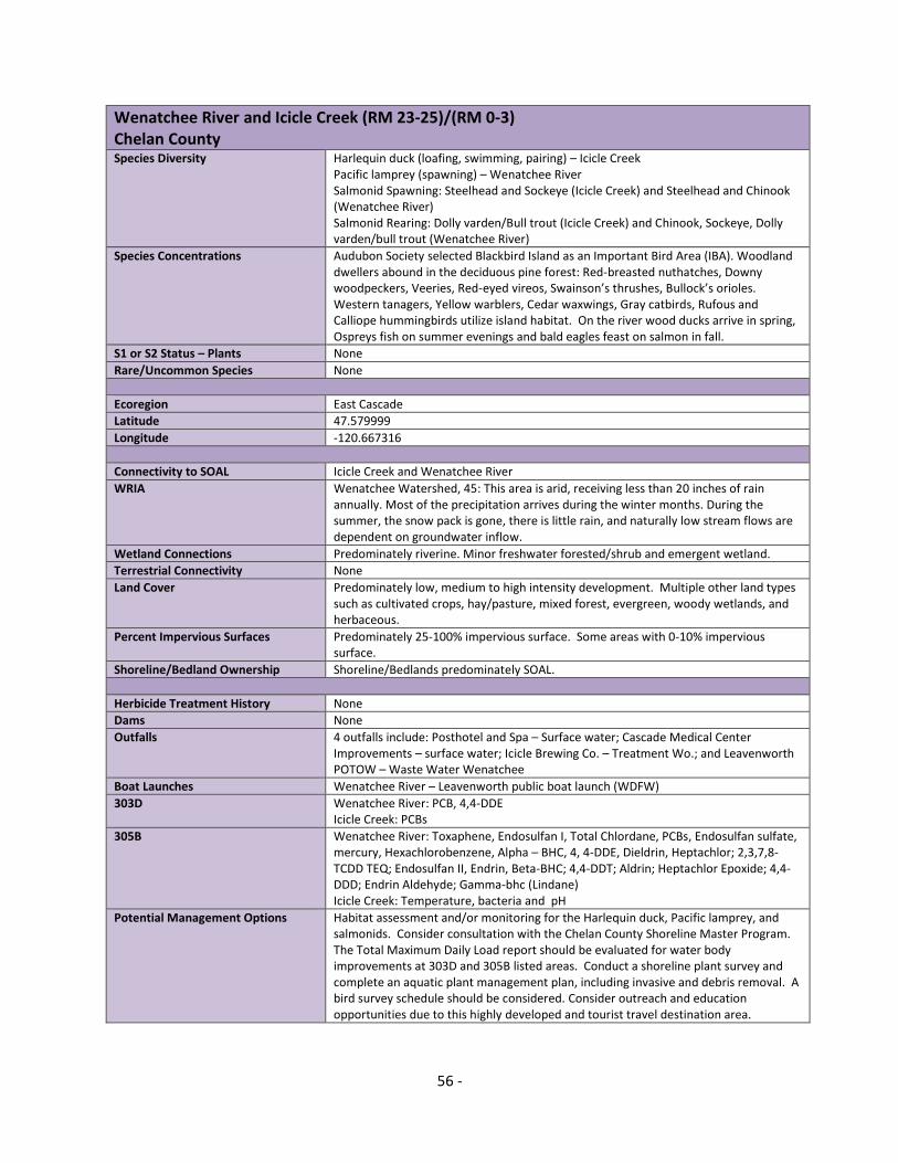
56 -
Wenatchee River and Icicle Creek (RM 23-25)/(RM 0-3) Chelan County
Species Diversity Harlequin duck (loafing, swimming, pairing) – Icicle Creek Pacific lamprey (spawning) – Wenatchee River Salmonid Spawning: Steelhead and Sockeye (Icicle Creek) and Steelhead and Chinook (Wenatchee River) Salmonid Rearing: Dolly varden/Bull trout (Icicle Creek) and Chinook, Sockeye, Dolly varden/bull trout (Wenatchee River)
Species Concentrations Audubon Society selected Blackbird Island as an Important Bird Area (IBA). Woodland dwellers abound in the deciduous pine forest: Red-breasted nuthatches, Downy woodpeckers, Veeries, Red-eyed vireos, Swainson’s thrushes, Bullock’s orioles. Western tanagers, Yellow warblers, Cedar waxwings, Gray catbirds, Rufous and Calliope hummingbirds utilize island habitat. On the river wood ducks arrive in spring, Ospreys fish on summer evenings and bald eagles feast on salmon in fall.
S1 or S2 Status – Plants None
Rare/Uncommon Species None
Ecoregion East Cascade
Latitude 47.579999
Longitude -120.667316
Connectivity to SOAL Icicle Creek and Wenatchee River
WRIA Wenatchee Watershed, 45: This area is arid, receiving less than 20 inches of rain annually. Most of the precipitation arrives during the winter months. During the summer, the snow pack is gone, there is little rain, and naturally low stream flows are dependent on groundwater inflow.
Wetland Connections Predominately riverine. Minor freshwater forested/shrub and emergent wetland.
Terrestrial Connectivity None
Land Cover Predominately low, medium to high intensity development. Multiple other land types such as cultivated crops, hay/pasture, mixed forest, evergreen, woody wetlands, and herbaceous.
Percent Impervious Surfaces Predominately 25-100% impervious surface. Some areas with 0-10% impervious surface.
Shoreline/Bedland Ownership Shoreline/Bedlands predominately SOAL.
Herbicide Treatment History None
Dams None
Outfalls 4 outfalls include: Posthotel and Spa – Surface water; Cascade Medical Center Improvements – surface water; Icicle Brewing Co. – Treatment Wo.; and Leavenworth POTOW – Waste Water Wenatchee
Boat Launches Wenatchee River – Leavenworth public boat launch (WDFW)
303D Wenatchee River: PCB, 4,4-DDE Icicle Creek: PCBs
305B Wenatchee River: Toxaphene, Endosulfan I, Total Chlordane, PCBs, Endosulfan sulfate, mercury, Hexachlorobenzene, Alpha – BHC, 4, 4-DDE, Dieldrin, Heptachlor; 2,3,7,8-TCDD TEQ; Endosulfan II, Endrin, Beta-BHC; 4,4-DDT; Aldrin; Heptachlor Epoxide; 4,4-DDD; Endrin Aldehyde; Gamma-bhc (Lindane) Icicle Creek: Temperature, bacteria and pH
Potential Management Options Habitat assessment and/or monitoring for the Harlequin duck, Pacific lamprey, and salmonids. Consider consultation with the Chelan County Shoreline Master Program. The Total Maximum Daily Load report should be evaluated for water body improvements at 303D and 305B listed areas. Conduct a shoreline plant survey and complete an aquatic plant management plan, including invasive and debris removal. A bird survey schedule should be considered. Consider outreach and education opportunities due to this highly developed and tourist travel destination area.

57 -
Yakima and Columbia River Confluence (RM 0-2)/(RM 333-336) Benton County
Species Diversity Pacific lamprey
Species Concentrations Audubon Society selected Ridgefield National Wildlife Refuge as an Important Bird Area (IBA). It is a refuge for shorebirds such as Dunlins, Black-necked stilts, American avocets, Greater and Lesser yellow legs, Long billed dowitchers, Spotted sandpipers, American widgeons, Common loons, Pied-billed grebes, Hooded mergansers, Ring-necked ducks, Lesser scaups, Northern pintails and Great horned owls.
S1 or S2 Status – Plants None
Rare/Uncommon Species None
Ecoregion Columbia Plateau
Latitude 46.249193
Longitude -119.247417
Connectivity to SOAL Various water bodies throughout the Columbia River
WRIA Lower Yakima Watershed, 37: This area is arid, receiving less than 20 inches of rain annually. Most of the precipitation arrives during the winter months. During the summer, the snow pack is gone, there is little rain, and naturally low stream flows are dependent on groundwater inflow.
Wetland Connections Freshwater forested/shrub, freshwater emergent, ponds and lake wetlands.
Terrestrial Connectivity Bateman Island, Columbia Park, Chiawana Park, Yakima Delta Wildlife Nature Area and Riverview Natural Preserve
Land Cover This is a high density developed area. Other types of land cover include shrub/scrub, cultivated crops and hay pasture.
Percent Impervious Surfaces Highly Impervious surfaces surround these river segments.
Shoreline/Bedland Ownership Shoreline/bedlands predominately SOAL.
Herbicide Treatment History None
Dams Various dams. The Columbia River, and many associated tributaries are very controlled.
Outfalls Difficult to describe at current scale. Many outfalls throughout. Would need to determine area and then identify.
Boat Launches Various motorized boat launches are on this river segment (4-6)
303D 4,4-DDT, 4,4-DDE
305B One area of PCBs, chlordane, 4,4-DDT, 4,4-DDE
Potential Management Options Contact experts and local entities that have already completed habitat and species assessment and/or monitoring work in these river segments. Habitat assessment and/or monitoring for the Pacific lamprey and northern leopard frog should be considered. Consider consultation with the Benton and Franklin County Shoreline Master Program. The Total Maximum Daily Load report should be evaluated for water body improvements at 303D and 305B listed areas. Conduct a shoreline plant survey and complete an aquatic plant management plan, including invasive and debris removal. A bird survey schedule should be considered. Consider outreach and education opportunities due to this highly developed recreational use area.