identifying hazards (part ii)
TRANSCRIPT

UNIT VII: IDENTIFYING HAZARDS (PART II)
IDENTIFYING HAZARDS (PART II)
INTRODUCTION
In coastal areas, proper siting and design require an accurate assessment of the vulnerability of any proposed structure, including the nature and extent of coastal hazards. In the previous unit, you learned about hazard-producing events that strike coastal areas and about natural hazards that affect coastal residential buildings and building sites, including: • Coastal flooding • High winds
In this unit, you will learn about: • Additional natural hazards that affect coastal residential buildings
and building sites, including: Erosion. Earthquakes. Other hazards.
• Coastal hazard zones, procedures used by FEMA to establish these
zones, and the importance of these zones in risk assessment. • Translating hazard information into practice—how designers put
hazard data to use when designing residential coastal buildings.
UNIT OBJECTIVES After completing this unit, you should be able to: 7.1 Identify causes of erosion. 7.2 Describe the potential effects on coastal residential structures of: Erosion. Earthquakes. Other natural hazards (including subsidence and uplift, landslides
and ground failures, salt spray and moisture, rain, hail, snow, ice, wood decay and termites, and wildfires).
7.3 Explain how coastal hazard zone mapping procedures can affect design decisions.
7.4 Identify key issues to be considered when using NFIP data in hazard assessments.
Introduction to Residential Coastal Construction Page VII-1
UNIT VII: IDENTIFYING HAZARDS (PART II)
EROSION
WHAT IS EROSION? Erosion is the wearing or washing away of coastal lands. The term erosion is commonly used to refer to the horizontal recession of the shoreline (i.e., shoreline erosion), but it can apply to other types of erosion as well. For example, seabed or lakebed erosion (also called downcutting) occurs when fine-grained sediments in the nearshore zone are eroded and carried into deep water. These sediments are lost permanently—resulting in a lowering of the seabed or lakebed. This process has several important consequences: • Increased local water depths. • Increased wave heights reaching the shoreline. • Increased shoreline erosion. • Undermining of erosion-control structures. Downcutting has been documented along some ocean-facing shorelines and much of the Great Lakes shoreline (which is largely composed of fine-grained glacial deposits).
Although the concept of erosion is simple, erosion is one of the most complex hazards to understand and predict at a given site.
This section reviews basic concepts related to coastal erosion, but it does not provide a comprehensive treatment of the many aspects of erosion that should be considered in planning, siting, and designing coastal residential buildings. It is recommended that designers develop an understanding of erosion fundamentals, but rely upon coastal erosion experts (at Federal, State, and local agencies; universities; and private firms) for specific guidance regarding erosion potential at a site.
WARNING
Page VII-2 Introduction to Residential Coastal Construction

UNIT VII: IDENTIFYING HAZARDS (PART II)
IMPACTS OF EROSION
Erosion is capable of threatening coastal residential buildings in a number of ways: • Destroying dunes or other natural protective features (see Fig. 7-1).
• Destroying erosion-control devices (see Fig. 7-2).
Figure 7-1. Hurricane Eloise (1975). Dune erosion in Walton County, Florida.
Figure 7-2. Hurricane Opal (1995). Failure of seawall in Bay County, Florida, led to undermining and collapse of the building behind the wall.
Introduction to Residential Coastal Construction Page VII-3

UNIT VII: IDENTIFYING HAZARDS (PART II)
• Lowering ground elevations, undermining shallow foundations, and
reducing penetration of deep foundations such as piles (see Fig. 7-3).
• Supplying overwash sediments that can bury structures farther landward (see Fig. 7-4).
Figure 7-3. Erosion undermining a coastal residence. Cape Shoalwater, WA (1992).
Figure 7-4. Removal of Hurricane Opal overwash from road at Pensacola Beach, FL. Sand that was washed landward from the beach buried the road, adjacent lots, and some at-grade buildings to a depth of 3–4 feet.
Page VII-4 Introduction to Residential Coastal Construction

UNIT VII: IDENTIFYING HAZARDS (PART II) • Breaching low-lying coastal barrier islands, destroying structures at the
site of the breach (see Fig. 7-5), and sometimes exposing structures on the mainland to increased flood and wave effects. (See Figure 4-5 in Unit IV).
• Eroding coastal bluffs that provide support to buildings outside the floodplain itself (see Fig. 7-6).
Figure 7-5. Hurricane Fran (1996). Breach and building damage at North Topsail Beach, North Carolina.
Figure 7-6. Bluff failure by a combination of marine, terrestrial, and seismic processes led to progressive undercutting of blufftop apartments at Capitola, CA. Six of the units were demolished after the 1989 Loma Prieta earthquake.
Introduction to Residential Coastal Construction Page VII-5

UNIT VII: IDENTIFYING HAZARDS (PART II)
• Washing away low-lying coastal landforms (Figs. 7-7 and 7-8).
Figure 7-7. Cape San Blas, Gulf County, FL, in November 1984 (before Hurricane Elena).
Figure 7-8. Same location in November 1985 (after Hurricane Elena).
Page VII-6 Introduction to Residential Coastal Construction

UNIT VII: IDENTIFYING HAZARDS (PART II)
DESCRIBING AND MEASURING
EROSION
Erosion should be considered part of the larger process of shoreline change: • When more sediment leaves a shoreline segment than moves into it,
erosion results.
• When more sediment moves into a shoreline segment than leaves it, accretion results.
• When the amounts of sediment moving into and leaving a shoreline segment balance, the shoreline is said to be stable.
Use care in classifying a particular shoreline as erosional, stable, or accretional. A shoreline classified as “erosional” may experience periods of stability or accretion. Likewise, a shoreline classified as “stable” or “accretional” may be subject to periods of erosion. Actual shoreline behavior will depend on the time period of analysis and on prevailing and extreme coastal processes during that period.
Short-Term vs. Long-Term Changes We classify shoreline changes as short-term changes and long-term changes. • Short-term changes occur over periods ranging from a few days to a
few years. They can be highly variable in direction and magnitude.
• Long-term changes occur over a period of decades, over which short-term changes tend to average out to the underlying erosion or accretion trend.
Both short-term and long-term shoreline changes should be considered in siting and design of coastal residential construction.
NOTE
Introduction to Residential Coastal Construction Page VII-7

UNIT VII: IDENTIFYING HAZARDS (PART II)
Erosion Rates
Erosion is usually expressed as a rate, in terms of: • Linear retreat (e.g., feet of shoreline recession per year)
or
• Volumetric loss (e.g., cubic yards of eroded sediment per foot of shoreline frontage per year).
In this discussion of erosion, erosion rates are cited as positive numbers, with corresponding shoreline change rates as negative numbers (e.g., an erosion rate of 2 feet/year is equivalent to a shoreline change rate of –2 feet/year). Accretion rates are stated as positive numbers, with corresponding shoreline change rates as positive numbers (e.g., an accretion rate of 2 feet/year is equivalent to a shoreline change rate of 2 feet/year).
It is not uncommon for short-term erosion rates to exceed long-term rates by a factor of 10 or more.
Variability of Erosion Rates Shoreline erosion rates are usually computed and cited as long-term, average annual rates. However, erosion rates are not uniform in time or space. Erosion rates can vary substantially: • From one location along the shoreline to another, even when the two
locations are only a short distance apart. • Over time at a single location.
• Seasonally.
NOTE
NOTE
Page VII-8 Introduction to Residential Coastal Construction

UNIT VII: IDENTIFYING HAZARDS (PART II)
EXAMPLES
Delaware coastline: Long-term, average annual shoreline change rates for the period 1845–1993 varied from approximately –1 foot/year to –10 feet/year, over a distance of less than 5 miles. East coast of the United States: The dominant trend is one of erosion (72 percent of the stations have experienced long-term erosion), with shoreline change rates averaging –3.0 feet/year (i.e., 3 feet/year of erosion). However, there is considerable variability along the shoreline. A few locations have experienced more than 20 feet/year of erosion. Over one-fourth of the stations have experienced accretion. Pacific County, Washington: Erosion rates as high as 150 feet/year contrast with accretion rates as high as 18 feet/year. Indian River Inlet, Delaware: Although the long-term, average annual shoreline change rate is approximately –2 feet/year, short-term shoreline change rates vary from –27 feet/year (erosion resulting from severe storms) to +6 feet/year (accretion associated with post-storm recovery of the shoreline). (See Fig. 7-9.)
Figure 7-9. Shoreline changes through time at a location approximately 1.5 miles south of Indian River Inlet, Delaware.
Introduction to Residential Coastal Construction Page VII-9

UNIT VII: IDENTIFYING HAZARDS (PART II)
Seasonal Fluctuations
Some shorelines experience large seasonal fluctuations in beach width and elevation (see Fig. 7-10). These changes—a result of seasonal variations in wave conditions and water levels—should not be taken as indicators of long-term shoreline changes. For this reason, shoreline change calculations at beaches subject to large seasonal fluctuations should be based on shoreline measurements taken at approximately the same time of year.
Figure 7-10. Seasonal fluctuations in beach width and elevation
Use Caution Erosion rates have been calculated by many States and communities for the establishment of regulatory construction setback lines. These rates are typically calculated from measurements made with aerial photographs, historical charts, or beach profiles. A number of potential errors are associated with measurements and calculations using each of these data sources—particularly the older data. Some studies have estimated that errors in most computed erosion rates are at least 1 foot/year. Therefore, the Coastal Construction Manual recommends that the siting of coastal residential structures not be based on smaller erosion rates—unless there is compelling evidence to support small erosion rates or to support accretion. Siting decisions should be based upon erosion rates greater than or equal to 1 foot/year.
Page VII-10 Introduction to Residential Coastal Construction

UNIT VII: IDENTIFYING HAZARDS (PART II)
CAUSES OF EROSION
Erosion can result from a variety of natural or manmade causes, including the following: • Erosion caused by storms and coastal flood events—usually rapid and
dramatic (also called storm-induced erosion).
• Erosion caused by natural changes associated with tidal inlets, river outlets, and entrances to bays (e.g., interruption of littoral transport by jetties and channels, migration or fluctuation of channels and shoals, formation of new inlets).
• Erosion induced by manmade structures and human activities (e.g., certain shore protection structures; damming of rivers; dredging; mining sand from beaches and dunes; alteration of vegetation, surface drainage, or groundwater at coastal bluffs).
• Long-term erosion—gradual erosion that occurs over a period of decades as a result of the cumulative effects of many factors, including changes in sea or lake level, sediment supply, and those factors mentioned above.
• Localized scour around structural elements, including piles and foundation elements.
Erosion can affect all coastal landforms except highly resistant geologic formations. Low-lying beaches and dunes are vulnerable to erosion, as are most coastal bluffs, banks, and cliffs. Improperly sited buildings—even those situated atop coastal bluffs and outside the floodplain—and buildings with inadequate foundation support are especially vulnerable to the effects of erosion.
Introduction to Residential Coastal Construction Page VII-11

UNIT VII: IDENTIFYING HAZARDS (PART II)
Storm-Induced Erosion
Storm-induced erosion can take place along open-coast shorelines (i.e., Atlantic, Pacific, Gulf of Mexico, and Great Lakes shorelines) and along shorelines of smaller enclosed or semi-enclosed bodies of water. If a body of water is subject to increases in water levels and generation of damaging wave action during storms, storm-induced erosion can occur. Erosion during storms can be dramatic and damaging. Although the event is usually short-lived, the resulting erosion can be equivalent to decades of long-term erosion. Effects on Dunes. During severe storms or coastal flood events, it is not uncommon for large dunes to be eroded 25–75 feet or more and for small dunes to be complete destroyed. The amount of erosion during a storm determines the level of protection that a dune or similar coastal landform will provide to buildings. The mere presence of a dune does not guarantee protection during a storm. Figure 7-11 illustrates this point: • Profile A: Areas experiencing dune or bluff retreat will form an
effective barrier to storm effects.
• Profile B: Areas experiencing wave overtopping and overwash may be subject to shallow flooding.
• Profile C: Areas experiencing dune disintegration will transmit—but attenuate—storm waves landward of the former dune location.
• Profile D: Areas experiencing dune flooding or submergence will not attenuate storm waves appreciably and will allow inland penetration of storm waves.
Page VII-12 Introduction to Residential Coastal Construction

UNIT VII: IDENTIFYING HAZARDS (PART II) Figure 7-11. Flood protection offered by eroded dunes
Introduction to Residential Coastal Construction Page VII-13

UNIT VII: IDENTIFYING HAZARDS (PART II)
Storms also exploit weaknesses in dune systems. A dune that is not
covered by well-established vegetation (i.e., in place for two or more growing seasons) will be more vulnerable to wind and flood damage. A dune crossed by a road or pedestrian path will offer a weak point that storm waves and flooding will exploit.
Erosion Volume. The volume of sediment eroded during a storm is controlled by the following parameters: • Storm tide elevation relative to upland elevation. • Storm duration. • Storm wave characteristics. • Beach width and condition. • Whether or not the area has been left vulnerable by the effects of other
recent storms. (The cumulative effects of two or more closely spaced minor storms can often exceed the effects of a single, more powerful storm.)
Erosion-Control Devices. Erosion during storms sometimes occurs
despite the presence of erosion-control devices such as seawalls, revetments, and toe protection. Storm waves frequently overtop, damage, or destroy poorly designed, constructed, or maintained erosion-control devices. Land and buildings situated behind such devices are not necessarily safe from coastal flood forces and storm-induced erosion.
Other Land Features. Narrow sand spits and low-lying coastal lands can be breached by tidal channels and inlets—often originating from the buildup of water on the back side—or washed away entirely. (See Figs. 7-7 and 7-8.) Storm-induced erosion damage to unconsolidated cliffs and bluffs typically takes the form of large-scale collapse, slumping, and landslides, with concurrent recession of the top of the bluff. (See Fig. 1-12 in Unit I.)
Page VII-14 Introduction to Residential Coastal Construction

UNIT VII: IDENTIFYING HAZARDS (PART II) Siting and Design Implications. When siting and designing structures to
be built on coastal dunes, spits, or bluffs—or any other subject to storm-induced erosion—it is important to consider the potential for significant loss of supporting soil during storms. • Buildings in low-lying coastal areas must have deep, well-designed,
and well-constructed pile or column foundations.
• Buildings constructed atop dunes and bluffs, and outside the floodplain, can still be subject to erosion. Designers therefore must account for the possibility of loss of supporting soil, using methods such as the following: Setbacks from the dune or bluff edge sufficient to offer protection
over the expected life of the building. Dune or bluff toe protection designed to withstand the base flood
event. (Many States and communities, however, restrict or prohibit the construction of dune protection and erosion-control structures.
Design of a moveable building, which can be lifted off its foundation and moved landward onto a new foundation.
Construction of a deep foundation. (Note that this method could result in a building standing high above the beach following a storm. It would probably be uninhabitable and require landward relocation.)
A combination of these methods.
Ground elevations in some V zones lie above the BFE (as a result of mapping procedures that account for storm erosion). V-zone requirements for a pile or column foundation capable of resisting flotation, collapse, and lateral movement still apply, even if the current ground level lies above the BFE.
WARNING
Introduction to Residential Coastal Construction Page VII-15

UNIT VII: IDENTIFYING HAZARDS (PART II)
The location of a tidal inlet or harbor, bay, or river entrance can be stabilized by jetties or other structures, but the shorelines in the vicinity can still fluctuate in response to storms, waves, and other factors.
Erosion from Tidal Inlets or Harbor, Bay, and River Entrances Many miles of coastal shoreline are situated on or adjacent to connections between two bodies of water. These connections can take the form of tidal inlets (i.e., short, narrow hydraulic connections between oceans and inland waters), harbor entrances, bay entrances, and river entrances. Governing Factors. The size, location, and adjacent shoreline stability of these connections are usually governed by five factors: • Tidal and freshwater flows through the connection. • Wave climate. • Sediment supply. • Local geology. • Jetties or stabilization structures. Temporary or permanent changes in any of these governing factors can cause the connection to migrate, change size, or change configuration. They can also cause sediment transport patterns in the vicinity of the inlet to change, thereby altering flood hazards in nearby areas.
Stabilization. Construction of jetties or similar structures at a tidal inlet or a bay, harbor, or river entrance often results in accretion on one side and erosion on the other, with a substantial shoreline offset. This offset results from the jetties trapping the littoral drift (i.e., wave-driven sediment moving along the shoreline) and preventing it from moving to the downdrift side.
WARNING
Page VII-16 Introduction to Residential Coastal Construction

UNIT VII: IDENTIFYING HAZARDS (PART II)
EXAMPLE
At Ocean City Inlet, Maryland, formation of the inlet in 1933 by a hurricane and construction of inlet jetties in 1934–35 have led to approximately 800 feet of accretion against the north jetty at Ocean City and approximately 1,700 feet of erosion on the south side of the inlet along Assateague Island (see Fig. 7-12). Figure 7-12. Ocean City Inlet, MD (1992). Note extreme shoreline offset and downdrift erosion resulting from inlet stabilization.
The downdrift erosion is ongoing. Post-inlet shoreline change rates on Assateague Island have been documented between –30 feet/year and –40 feet/year. Pre-inlet shoreline change rates were approximately –4 feet/year.
It should be noted that erosion and accretion patterns at stabilized inlets and entrances sometimes differ from this classic pattern. • In some instances, accretion occurs immediately adjacent to both
jetties, with erosion beyond.
• In some instances, erosion and accretion patterns near a stabilized inlet change over time.
Introduction to Residential Coastal Construction Page VII-17

UNIT VII: IDENTIFYING HAZARDS (PART II)
Channel Migration. Development in the vicinity of a tidal inlet or bay,
harbor, or river entrance is often affected by lateral migration of the channel and associated changes in sand bars—which may focus waves and erosion on particular shoreline areas. Often, these changes are cyclic in nature and can be identified and forecast through a review of historical aerial photographs and bathymetric data. When considering a building site near a tidal inlet or a bay, harbor, or river entrance, thoroughly investigate the following: • The history of the connection. • Associated shoreline fluctuations. • Migration trends. • Impacts of any stabilization structures. Failure to do so could result in increased building vulnerability or building loss to future shoreline changes.
Many State and local siting regulations allow residential development in areas where erosion is likely to occur. Do not assume that a building sited in compliance with minimum State and local requirements will be safe from future erosion.
WARNING
Page VII-18 Introduction to Residential Coastal Construction

UNIT VII: IDENTIFYING HAZARDS (PART II) Erosion from Human Intervention
Human actions along the shoreline can both reduce and increase flood hazards. For example— • In some instances, structures built or actions taken to facilitate
navigation will cause erosion elsewhere.
• In some cases, structures built or actions taken to halt erosion and reduce flood hazards at one site will increase erosion and flood hazards at nearby sites.
Therefore, when evaluating a potential coastal building site, it is important to consider the effects of both natural and human-induced shoreline changes, including: • Shore protection structures. • Dredging of navigation channels. • Sand mining from beaches. • Alteration of vegetation, drainage, or groundwater. • Damming of rivers. EFFECTS OF SHORE PROTECTION STRUCTURES In performing their intended function, shore protection structures can lead to or increase erosion on nearby properties. Potential impacts will vary from site to site and structure to structure. They can sometimes be mitigated by beach nourishment (the placement of additional sediment on the beach) in the vicinity of the erosion-control structure.
This is not an indictment of all erosion-control structures: many provide protection against erosion and flood hazards. But there is the potential for adverse impacts.
• Groins. Groins (see Fig. 4-3 in Unit IV) are short, shore-perpendicular structures designed to trap available littoral sediments. They can cause erosion to downdrift beaches if the groin compartments are not filled with sand and maintained in a full condition.
• Offshore Breakwaters. Offshore breakwaters (see Fig. 7-13) can trap
available littoral sediments and reduce the sediment supply to nearby beaches. This adverse effect should be mitigated by combining breakwater construction with beach nourishment.
NOTE
Introduction to Residential Coastal Construction Page VII-19

UNIT VII: IDENTIFYING HAZARDS (PART II)
Figure 7-13. Trapping of littoral sediments behind offshore breakwaters. Presque Isle, Pennsylvania.
• Seawalls, Bulkheads, and Revetments. These devices are shore-parallel structures built—usually along the shoreline or at the base of a bluff—to act as retaining walls and to provide some degree of protection against high water levels, waves, and erosion. The degree of protection they afford depends on their design, construction, and maintenance.
They do not prevent erosion of the beach; in fact, they can exacerbate ongoing erosion of the beach. The structures can: Impound upland sediments that would otherwise erode and nourish
the beach.
Lead to passive erosion—eventual loss of the beach as a structure prevents landward migration of the beach profile.
Lead to active erosion—localized scour waterward of the structure and on unprotected property at the ends of the structure.
Some communities distin-guish between erosion control structures built to protect existing development and those constructed to create a buildable area on an otherwise unbuildable site. Designers should investigate any local or state regulations and requirements pertaining to erosion control structures before undertaking building site selection and design.
The vast majority of privately financed seawalls, revetments, and erosion control devices fail during 100-year—or lesser—events. Either they are heavily damaged or destroyed, or they withstand the storm but fail to prevent flood damage to lands and buildings they are intended to protect (see Fig. 7-2). Reliance on these devices to protect upland sites and residential buildings is not a good substitute for proper siting and foundation design.
NOTE
Page VII-20 Introduction to Residential Coastal Construction

UNIT VII: IDENTIFYING HAZARDS (PART II)
It has been estimated that these two activities account for three-fourths of the beach erosion along the east coast of Florida.
EFFECTS OF DREDGING NAVIGATION CHANNELS Dredging navigation channels can interrupt the natural bypassing of littoral sediments across tidal inlets and bay entrances, altering natural sediment transport and erosion/accretion patterns. Disposal of beach-compatible dredged sediments into deepwater will result in a permanent loss to the littoral system and may ultimately lead to shoreline erosion. Dredging across natural barriers (e.g., inlet shoals, protective reefs, sand bars, and nearshore shoals) can also modify wave and current patterns and cause shoreline changes nearby. This activity has been cited as a cause of shoreline erosion in Hawaii and in many other locations.
EFFECTS OF SAND MINING FROM BEACHING Sand mining from beaches and dune areas is not permitted in most States and communities because it causes an immediate and direct loss of littoral sediments. However, the practice is allowed in some situations where shoreline trends are accretional.
EFFECTS OF ALTERATION OF VEGETATION, DRAINAGE, OR GROUNDWATER Altering vegetation, drainage, or groundwater can sometimes make a site more vulnerable to coastal storm or flood events. For example, removal of grasses, ground covers, and trees at a site can make the soil more prone to erosion by wind, rain, and flood forces. Altering natural drainage patterns and groundwater flow can increase erosion potential, especially on steep slopes and coastal bluffs. Irrigation and septic systems often contribute to bluff instability.
NOTE
Introduction to Residential Coastal Construction Page VII-21

UNIT VII: IDENTIFYING HAZARDS (PART II)
EFFECTS OF DAMMING RIVERS
Damming of rivers can reduce natural sediment loads transported to open coast shorelines. Most rivers carry predominantly fine sediments (i.e., silts and clays), but some rivers may carry higher percentages of sand, and some large rivers may yield significant quantities of sand. Although the exact shoreline impacts from damming rivers may be difficult to discern, the reduced sediment input may ultimately translate into shoreline erosion in some areas. It has been postulated that river damming and reduced sediment loads are responsible for the shift from long-term accretion to recent erosion along the portion of the Washington coast shown in Figure 7-14.
Figure 7-14. Buildings threatened by erosion at Ocean Shores, WA (1998). The rock revetments were built in response to shoreline erosion along an area adjacent to a jetty and thought to be accretional.
Page VII-22 Introduction to Residential Coastal Construction

UNIT VII: IDENTIFYING HAZARDS (PART II) Long-Term Erosion
Causes. Observed long-term erosion at a site represents the net effect of a combination of factors, which may include: • Rising sea levels (or subsidence of uplands).
• Rising lake levels or lakebed erosion (in the case of the Great Lakes).
• Reduced sediment supply to the coast.
• Construction of jetties, other structures, or dredged channels that
impede littoral transport of sediments along the shoreline.
• Increased incidence or intensity of storms.
• Alteration of upland vegetation, drainage, or groundwater flows (especially in coastal bluff areas).
Effects. Regardless of the cause, long-term shoreline erosion can increase
the vulnerability of coastal construction in a number of ways, depending on local shoreline characteristics, construction setbacks, and structure design. In essence, long-term erosion shifts flood hazard zones landward. For example, a site that was at one time mapped accurately as an A zone will become exposed to V-zone conditions. A site that was at one time accurately mapped as outside the 100-year floodplain may become exposed to A-zone or V-zone conditions.
Introduction to Residential Coastal Construction Page VII-23

UNIT VII: IDENTIFYING HAZARDS (PART II)
LONG-TERM EROSION AND FIRMs
Coastal FIRMs (even recently published coastal FIRMs) do not incorporate the effects of long-term erosion. Mapped V zones and A zones in areas subject to long-term erosion will underestimate the extent and magnitude of actual flood hazards that a coastal building may experience over its lifetime. FEMA has undertaken a series of studies to determine whether and how long-term erosion can be incorporated into coastal floodplain mapping. The studies mapped erosion in 27 coastal counties in 18 States and (for 18 of the mapped counties) inventoried structures within the erosion hazard areas. Results are being used to estimate future erosion and flood damage as part of economic impact and cost/benefit analyses and to determine whether it is economically and technically justified for FEMA to map and insure against erosion hazards through the NFIP.
Sources of Data. Despite the fact that FIRMs do not incorporate long-term
erosion, there are other sources of long-term erosion data available for much of the country’s shorelines. These data usually take the form of historical shoreline maps or erosion rates published by individual States or specific reports (from Federal or State agencies, universities, or consultants) pertaining to counties or other small shoreline reaches. There may be more than one source of long-term erosion rate data available for a given site, and the different sources may report different erosion rates because of: • Different study periods. • Different data sources (e.g., aerial photographs vs. maps vs. ground
surveys). • Different study methods.
Where multiple sources and long-term erosion rates exist for a given site, designers should use the highest long-term erosion rate in siting decisions, unless they conduct a detailed review of the erosion rate studies and conclude that a lower erosion rate is more appropriate for forecasting future shoreline positions.
Page VII-24 Introduction to Residential Coastal Construction

UNIT VII: IDENTIFYING HAZARDS (PART II) Localized Scour
Cause. Localized scour can occur when water flows at high velocities past an object embedded in or resting on erodible soil. Localized scour can also be caused or exacerbated by waves interacting with the object. Flow moving past a fixed object must accelerate, often forming eddies or vortices and scouring loose sediment from the immediate vicinity of the object. The scour is not caused by the flood or storm event, per se, but by the distortion of the flow field by the object. Localized scour occurs only around the object itself and is in addition to storm- or flood-induced erosion that occurs in the general area.
Effects. Localized scour around piles and similar objects (see Fig. 7-15) is generally limited to small, cone-shaped depressions less than 2 feet deep and several feet in diameter.
Figure 7-15. Determination of localized scour from changes in sand color, texture, and bedding. Hurricane Fran (1996).
Introduction to Residential Coastal Construction Page VII-25

UNIT VII: IDENTIFYING HAZARDS (PART II)
Localized scour is capable of undermining slabs and grade-supported
structures. In severe cases, the depth and lateral extent of localized scour can lead to structural failure (see Fig. 7-16). Designers should consider potential effects of localized scour when calculating foundation size, depth, or embedment requirements.
Figure 7-16. Extreme case of localized scour undermining a slab-on-grade house on Topsail Island, NC (Hurricane Fran, 1996). The lot was several hundred feet from the shoreline and mapped as an A zone on the FIRM prior to the storm.
Overwash and Sediment Burial Causes. Sediment eroded during a coastal storm event must travel to one of the following locations: • Offshore to deeper water. • Along the shoreline. • Inland. Overwash occurs when low-lying coastal lands are overtopped and eroded by storm surge and waves. The eroded sediments are carried landward by floodwaters, burying uplands, roads, and at-grade structures (see Fig. 7-4). Significant overwash deposits can occur when the waves are capable of suspending sediments in the water column and flow velocities exceed 3 feet/sec). Post-storm aerial photographs and/or videos can be used to identify likely future overwash locations.
Page VII-26 Introduction to Residential Coastal Construction

UNIT VII: IDENTIFYING HAZARDS (PART II) Effects. Depths of overwash deposits can reach 3–5 feet or more near the
shoreline, gradually decreasing away from the shoreline. It is not uncommon to see overwash deposits extending several hundred feet inland following a severe storm—especially in the vicinity of shore-perpendicular roads.
The physical processes required to create significant overwash deposits are also capable of damaging buildings. Thus, existing coastal buildings located in A zones (particularly the seaward portions of A zones) and built on slab or crawlspace foundations should be considered vulnerable to damage from overwash, high-velocity flows, and waves. Windblown Sand. Some coastal areas suffer from an excess of sand rather than from erosion. The excess usually translates into accretion of the shoreline and/or significant quantities of windblown sand. Unless this windblown sand is stabilized by vegetation or other means, it will likely be blown inland by coastal winds. Windblown sand can bury non-elevated coastal residential buildings and at-grade infrastructure—such as drainage structures and ground-mounted electrical and telephone equipment—and drift across roads (see Fig. 7-17).
Figure 7-17. Windblown sand drifting against coastal residences in Pacific City, Oregon.
Introduction to Residential Coastal Construction Page VII-27

UNIT VII: IDENTIFYING HAZARDS (PART II)
SELF-CHECK REVIEW: EROSION Instructions: Answer the following questions. Then turn the page to check your answers. If you answered any items incorrectly, you should review the related material before continuing. 1. Describe at least five ways that erosion threatens coastal residential buildings.
(1) ___________________________________________________________ (2) ___________________________________________________________ (3) ___________________________________________________________ (4) ___________________________________________________________ (5) ___________________________________________________________
2. When more sediment moves into a shoreline than leaves it, _____________________ results. 3. Long-term shoreline changes tend to be highly variable in direction and magnitude.
True False
4. Both short-term and long-term shoreline changes should be considered in siting and design of coastal residential buildings.
True False
5. Low-lying beaches and dunes are vulnerable to erosion, but coastal bluffs, banks, and cliffs are not.
True False 6. How can designers help avoid problems associated with errors in computed erosion rates?
Page VII-28 Introduction to Residential Coastal Construction

UNIT VII: IDENTIFYING HAZARDS (PART II) 7. List five main causes of erosion.
(1) ___________________________________________________________ (2) ___________________________________________________________ (3) ___________________________________________________________ (4) ___________________________________________________________ (5) ___________________________________________________________
8. When building atop dunes or bluffs, what strategies can be used to account for the possibility that
supporting soils will be lost to erosion? 9. How would you describe the potential impact on erosion of such human interventions as shoreline
protection structures and dredging of channels? 10. Long-term erosion shifts flood hazard zones:
a. Laterally b. Landward c. Seaward
11. Where different long-term erosion rates have been published for a site, designers should generally use the _____________________ erosion rate in siting decisions.
a. Most recent b. Lowest c. Oldest d. Highest
12. ________________________________ occurs when water flows at high velocities past an object that is embedded in or resting on erodible soil.
Introduction to Residential Coastal Construction Page VII-29

UNIT VII: IDENTIFYING HAZARDS (PART II)
ANSWER KEY NOTE: Some of your answers may be slightly different, but they should include the same main points. 1. Describe at least five ways that erosion threatens coastal residential buildings.
Any of the following: • Destroying dunes or other natural protective features. • Destroying erosion control devices. • Lowering ground elevations, undermining shallow foundations, and reducing penetration of
deep foundations. • Supplying overwash sediments that can bury structures farther landward. • Breaching low-lying coastal barrier islands. • Washing away low-lying coastal landforms. • Eroding coastal bluffs.
2. When more sediment moves into a shoreline than leaves it, accretion results. 3. Long-term shoreline changes tend to be highly variable in direction and magnitude.
False
4. Both short-term and long-term shoreline changes should be considered in siting and design of coastal residential buildings.
True
5. Low-lying beaches and dunes are vulnerable to erosion but coastal bluffs, banks, and cliffs are not.
False 6. How can designers help avoid problems associated with errors in computed erosion rates?
By basing siting decisions upon erosion rates of at least 1 foot/year.
Page VII-30 Introduction to Residential Coastal Construction

UNIT VII: IDENTIFYING HAZARDS (PART II) 7. List five main causes of erosion.
• Storms and coastal flood events • Natural changes associated with tidal inlets, river outlets, and entrances to bays • Manmade structures and human activities • Long-term erosion • Localized scour
8. When building atop dunes or bluffs, what strategies can be used to account for the possibility that
supporting soils will be lost to erosion?
• Setbacks from the dune or bluff edge • Dune or bluff toe protection designed to withstand the base flood event • Designing a moveable building • Constructing a deep foundation • A combination of these strategies
9. How would you describe the potential impact on erosion of such human interventions as shoreline
protection structures and dredging of channels?
They can both reduce and increase flood hazards, either at the site or at nearby sites. 10. Long-term erosion shifts flood hazard zones:
b. Landward
11. Where different long-term erosion rates have been published for a site, designers should generally use the _____________________ erosion rate in siting decisions.
d. Highest
12. Localized scour occurs when water flows at high velocities past an object that is embedded in or resting on erodible soil.
Introduction to Residential Coastal Construction Page VII-31

UNIT VII: IDENTIFYING HAZARDS (PART II)
EARTHQUAKES
Earthquakes can affect coastal areas just as they can affect inland areas—through ground shaking, liquefaction, surface fault ruptures, and other ground failures. Therefore, coastal construction in seismic hazard areas must take potential earthquake hazards into account. Proper design in seismic hazard areas must strike a balance between: • The need to elevate buildings above flood hazards and minimize
obstructions to flow and waves beneath a structure.
• The need to stabilize or brace the building against potentially violent accelerations and shaking from earthquakes.
CLASSIFICATION Earthquakes are classified according to two parameters: magnitude and
intensity. • Magnitude refers to the total energy released by the event. An
earthquake has a single magnitude. The Richter Scale is used to report earthquake magnitude.
• Intensity refers to the effects at a particular site. The intensity varies with location. The Modified Mercalli Intensity (MMI) Scale is used to report felt intensity. The MMI Scale (see Table 7.1) ranges from I (imperceptible) to XII (catastrophic).
Page VII-32 Introduction to Residential Coastal Construction

UNIT VII: IDENTIFYING HAZARDS (PART II)
Table 7.1. Modified Mercalli Earthquake Intensity Scale
MMI Level Felt Intensity
I Not felt except by a very few people under special conditions. Detected mostly by instruments.
II Felt by a few people, especially those on upper floors of buildings. Suspended objects may swing.
III Felt noticeably indoors. Standing automobiles may rock slightly.
IV Felt by many people indoors, by a few outdoors. At night, some people are awakened. Dishes, windows, and doors rattle.
V Felt by nearly everyone. Many people are awakened. Some dishes and windows are broken. Unstable objects are overturned.
VI Felt by nearly everyone. Many people become frightened and run outdoors. Some heavy furniture is moved. Some plaster falls.
VII Most people are alarmed and run outside. Damage is negligible in buildings of good construction, considerable in buildings of poor construction.
VIII Damage is slight in specially designed structures, considerable in ordinary buildings, great in poorly built structures. Heavy furniture is overturned.
IX Damage is considerable in specially designed buildings. Buildings shift from their foundations and partly collapse. Underground pipes are broken.
X Some well-built wooden structures are destroyed. Most masonry structures are destroyed. The ground is badly cracked. Considerable landslides occur on steep slopes.
XI Few, if any, masonry structures remain standing. Rails are bent. Broad fissures appear in the ground.
XII Virtually total destruction. Waves are seen on the ground surface. Objects are thrown in the air.
Introduction to Residential Coastal Construction Page VII-33

UNIT VII: IDENTIFYING HAZARDS (PART II)
IMPACT ON BUILDINGS
The ground motion produced by earthquakes can: • Shake buildings (both lateral and vertical building movements are
common) and cause structural failure by excessive deflection.
• Cause building failures by rapid, permanent displacement of underlying soils and strata (e.g., uplift, subsidence, ground rupture, soil liquefaction, and/or consolidation).
In coastal areas, the structural effects of ground shaking can be magnified when buildings are elevated (on piles, piers, posts, or columns in V zones or by fill in A zones) above the natural ground elevation in conformance with NFIP-compliant State and local floodplain management regulations.
SITE PARAMETERS One of the site parameters controlling seismic-resistant design of buildings is the maximum considered earthquake ground motion, which has been mapped by the U.S. Geological Survey for the National Earthquake Hazard Reduction Program (NEHRP) at two levels: • 0.2-sec spectral response acceleration (see Fig. 7-18). • 1.0-sec spectral response acceleration. (see Fig 7-19). Accelerations are mapped as a percent of “g,” the gravitational constant.
Page VII-34 Introduction to Residential Coastal Construction

UNIT VII: IDENTIFYING HAZARDS (PART II) Figure 7-18. 1.0-sec Spectral Response Acceleration—Maximum Earthquake Ground Motion (%g) (Legend appears on the next page)
Introduction to Residential Coastal Construction Page VII-35

UNIT VII: IDENTIFYING HAZARDS (PART II)
Figure 7-18 (Continued)
Page VII-36 Introduction to Residential Coastal Construction
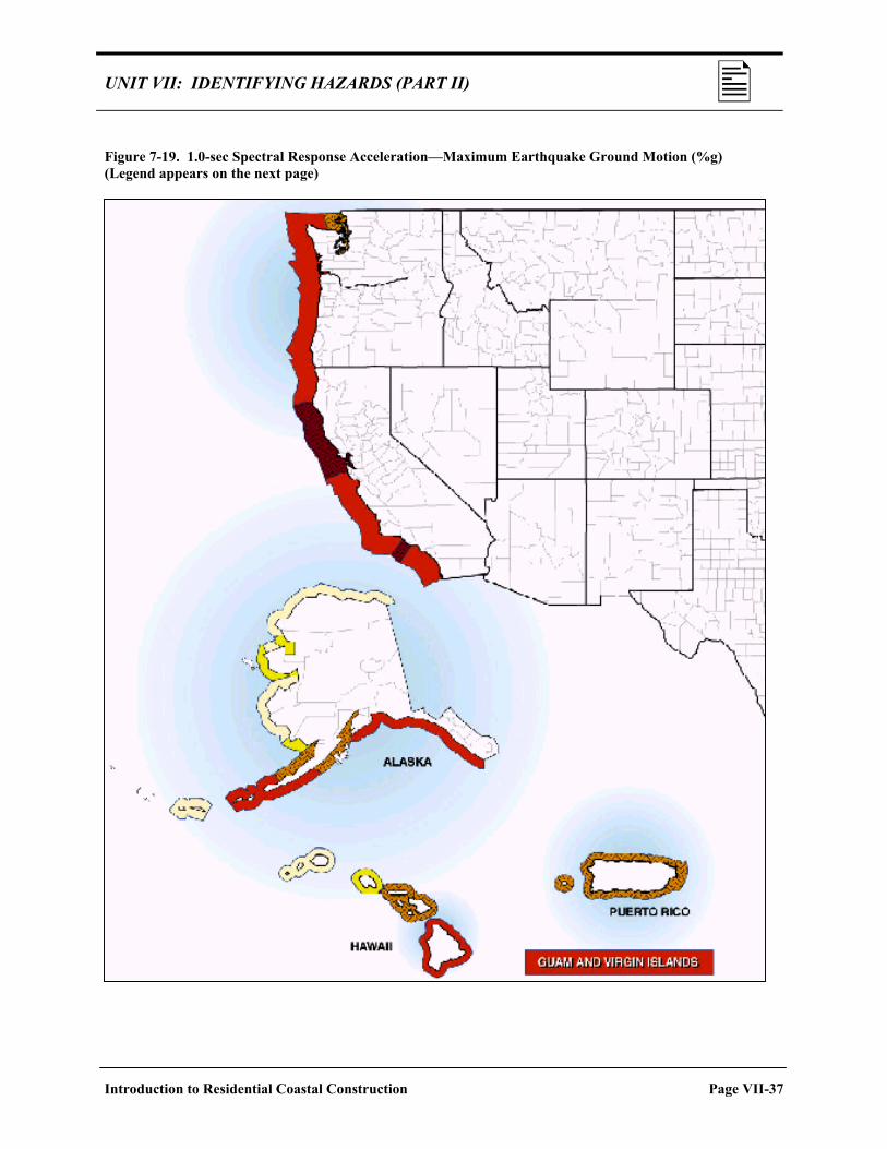
UNIT VII: IDENTIFYING HAZARDS (PART II) Figure 7-19. 1.0-sec Spectral Response Acceleration—Maximum Earthquake Ground Motion (%g) (Legend appears on the next page)
Introduction to Residential Coastal Construction Page VII-37

UNIT VII: IDENTIFYING HAZARDS (PART II)
Figure 7-19 (Continued)
Page VII-38 Introduction to Residential Coastal Construction

UNIT VII: IDENTIFYING HAZARDS (PART II) IMPLICATIONS FOR
BUILDING DESIGN The structural effects of earthquakes are a function of many factors, including: • Soil characteristics. • Local geology. • Building characteristics: Weight Shape. Height. Structural system. Foundation type.
Therefore, design of earthquake-resistant buildings requires careful
consideration of both site and structure.
Design In many cases, elevating a building 8–10 feet above grade on a pile or column foundation—a common practice in low-lying V zones and Z coastal zones—can result in what earthquake engineers term a “soft story” or “inverted pendulum,” a condition that requires the building be designed for a larger earthquake force. Thus, designs for pile- or column-supported residential buildings should be verified for necessary strength and rigidity below the first-floor level, to account for increased stresses in the foundation members when the building starts to move and deflect during an earthquake.
Foundation For buildings elevated on fill, earthquake ground motions can be exacerbated if the fill and underlying soils are not properly compacted and stabilized. Liquefaction of the supporting soil can be another damaging consequence of ground shaking. In granular soils with high water tables (like those found in many coastal areas), the ground motion will cause an increase in the pore water pressure, which overcomes soil cohesion and can create a semi-liquid state. The soil then can temporarily lose its bearing capacity, and settlement and differential movement of buildings can result.
Introduction to Residential Coastal Construction Page VII-39

UNIT VII: IDENTIFYING HAZARDS (PART II)
Construction
Seismic effects on buildings vary with structural configuration, stiffness, ductility, and strength. • Properly designed and built wood-frame buildings are quite ductile,
meaning that they can withstand large deformations without losing strength. Failures, when they occur in wood-frame buildings, are usually at connections.
• Properly designed and built steel construction is also inherently ductile but can fail at non-ductile connections.
• Modern concrete construction can be dimensioned and reinforced to provide sufficient strength and ductility to resist earthquakes. Older concrete structures typically are more vulnerable. Failures in concrete masonry structures are likely to occur if reinforcing and cell grouting do not meet seismic-resistant requirements.
Page VII-40 Introduction to Residential Coastal Construction

UNIT VII: IDENTIFYING HAZARDS (PART II)
SELF-CHECK REVIEW: EARTHQUAKES Instructions: Answer the following questions. Then turn the page to check your answers. If you answered any items incorrectly, you should review the related material before continuing. 1. What are the two main ways earthquakes affect buildings? 2. Describe the conflicting design challenges when designing a residence in a V zone vulnerable to
earthquakes.
Introduction to Residential Coastal Construction Page VII-41

UNIT VII: IDENTIFYING HAZARDS (PART II)
ANSWER KEY NOTE: Some of your answers may be slightly different, but they should include the same main points. 1. What are the two main ways earthquakes affect buildings?
The ground motion produced by earthquakes can: • Shake buildings and cause structural failure by excessive deflection. • Cause building failures by rapid, permanent displacement of underlying soils and strata.
2. Describe the conflicting design challenges when designing a residence in a V zone vulnerable to
earthquakes.
In V zones, buildings must be elevated above the BFE on a pile or column foundation to protect against flood damage. This kind of design results in an “inverted pendulum,” which requires that the building be designed to resist the larger forces that will occur in some members.
Page VII-42 Introduction to Residential Coastal Construction

UNIT VII: IDENTIFYING HAZARDS (PART II)
OTHER HAZARDS AND ENVIRONMENTAL EFFECTS
Other hazards to which coastal construction may be exposed include a wide variety of hazards whose incidence and severity may be highly variable and localized. Examples include:
• Subsidence and uplift. • Landslides and ground failures. • Salt spray and moisture. • Rain. • Hail.
• Wood decay and termites. • Wildfires. • Floating ice. • Snow. • Atmospheric ice.
These hazards do not always come to mind when coastal hazards are mentioned, but like the other hazards described earlier in this unit, they can impact coastal construction and should be considered in siting, design, and construction decisions.
SUBSIDENCE AND UPLIFT
Subsidence. Subsidence is a hazard that typically affects areas where any of the following situations exist: • Withdrawal of groundwater or petroleum has occurred on a large scale.
• Organic soils are drained and settlement results.
• Younger sediments deposit over older sediments and cause those older
sediments to compact (e.g., river delta areas).
• Surface sediments collapse into underground voids (rare in coastal areas).
One consequence of coastal subsidence—even when small in magnitude—
is an increase in coastal flood hazards because of an increase in flood depth.
Introduction to Residential Coastal Construction Page VII-43

UNIT VII: IDENTIFYING HAZARDS (PART II)
Uplift. Differential uplift in the vicinity of the Great Lakes can lead to
increased water levels and flooding. As the ground rises in response to the removal of the great ice sheet, it does so in a non-uniform fashion.
EXAMPLES
• On Lake Superior, the outlet at the eastern end of the lake is
rising at a rate of nearly 10 inches per century, relative to the city of Duluth-Superior at the western end of the lake. This causes a corresponding water level rise at Duluth-Superior.
• The northern ends of Lakes Michigan and Huron are rising relative to their southern portions. On Lake Michigan, the northern outlet at the Straits of Mackinac is rising at a rate of 9 inches per century, relative to Chicago. The outlet of Lakes Michigan and Huron is rising only about 3 inches per century relative to the land at Chicago.
Page VII-44 Introduction to Residential Coastal Construction

UNIT VII: IDENTIFYING HAZARDS (PART II) Landslides and Ground Failures
Landslides. Landslides occur when slopes become unstable and loose material slides or flows under the influence of gravity. Often, landslides are triggered by other events, such as erosion at the toe of a sleep slope, earthquakes, floods, or heavy rains. But they can be worsened by human actions such as destruction of vegetation or uncontrolled pedestrian access on steep slopes (see Fig. 7-20).
Figure 7-20. Unstable coastal bluff at Beacon’s Beach, San Diego, California
Ground Failures. Smaller, more subtle, and gradual movements of soil under or around residential buildings can also be destructive. These movements can result from natural or development-induced factors and can result in ground movements of just a few inches. For example, soil creep is the slow, downslope movement of overburden—usually in conjunction with subsurface drainage and slippage. Development on soils subject to creep may aggravate the problem. Settlement is the downward vertical movement of a building foundation or soil surface as a consequence of soil compression or lateral yielding. Creep, settlement, and other ground failures can occur in granular, cohesive, and rocky soils. Coastal bluff failures can be induced by seismic activity.
Introduction to Residential Coastal Construction Page VII-45

UNIT VII: IDENTIFYING HAZARDS (PART II)
SALT SPRAY AND MOISTURE
Salt spray and moisture effects frequently lead to corrosion and decay of building materials in the coastal environment. This is one hazard that is commonly overlooked or underestimated by designers. Any careful inspection of coastal buildings (even new or recent buildings) near a large body of water will reveal deterioration of improperly selected or installed materials. For example, metal connectors, straps, and clips used to improve a building’s resistance to high winds and earthquakes will often show signs of corrosion (see Fig. 7-21).
Figure 7-21. Example of corrosion, and resulting failure, of metal connectors
Corrosion is affected by many factors, but the primary difference between coastal and inland areas is the presence of salt spray, tossed into the air by breaking waves and blown onto land by onshore winds. Salt spray accumulates on metal surfaces, accelerating the electrochemical processes that cause rusting and other forms of corrosion—particularly in the humid conditions common along the coast.
Factors affecting the rate of corrosion include: • Humidity. • Wind direction and speed. • Seasonal wave conditions. • Distance from the shoreline. • Elevation above the ground. • Orientation of the building to the shoreline. • Rinsing by rainfall. • Shelter and air flow in and around the building. • Materials used to make the component.
Page VII-46 Introduction to Residential Coastal Construction

UNIT VII: IDENTIFYING HAZARDS (PART II)
RAIN Rain presents two principal hazards to coastal residential construction: • Penetration of the building envelope during high wind events. • Vertical loads from rainfall ponding on the roof. Ponding usually occurs on flat or slow-slope roofs where a parapet or other building element causes rainfall to accumulate, and where the roof drainage system fails. Every inch of accumulated rainfall causes a downward-directed load of approximately 5 lb/ft2. Excessive accumulation can lead to progressive deflection and instability of roof trusses and supports.
HAIL Hailstorms develop from severe thunderstorms and generate balls or lumps of ice capable of damaging agricultural crops, buildings, and vehicles. Severe hailstorms can damage roofing shingles and tiles, metal roofs, roof sheathing, skylights, glazing, and other building components. Accumulation of hail on flat or low-slope roofs—like accumulation of rain—can lead to significant vertical loads and progressive deflection of roof trusses and supports.
WOOD DECAY AND TERMITES
Decay of wood products and infestation by termites are common in coastal areas subject to high humidity and frequent and heavy rains. Improper preservative treatments, improper design and construction, and even poor landscaping practices, can all contribute to decay and infestation problems. One or more of the following can be used to protect against decay and termites: • Use of pressure-treated wood products (including field treatment of
notches, holes, and cut ends). • Use of naturally decay-resistant and termite-resistant wood species. • Chemical soil treatment. • Installation of physical barriers to termites (e.g., metal or plastic termite
shields).
Introduction to Residential Coastal Construction Page VII-47

UNIT VII: IDENTIFYING HAZARDS (PART II)
WILDFIRE
Reducing the wildfire hazard and the vulnerability of structures to wildfire hazards are discussed in Wildfire Mitigation in the 1998 Florida Wildfires, Wildfire Report FEMA-1223-DR-FL (FEMA 1998).
Wildfires occur virtually everywhere in the United States and can threaten buildings constructed in coastal areas. The three principal factors that impact wildfire hazards include: • Topography. • Availability of vegetative fuel. • Weather. One of the most effective ways of preventing loss of buildings to wildfire is to replace highly flammable vegetation around the buildings with minimally flammable vegetation. Clearing of vegetation around some buildings may be appropriate, but this action can lead to slope instability and landslide failures on steeply sloping land. Siting and construction on steep slopes requires careful consideration of multiple hazards with sometimes conflicting requirements.
FLOATING ICE Some coastal areas of the United States are vulnerable to problems caused by floating ice. These problems can take the form of: • Erosion and gouging of coastal shorelines. • Flooding resulting from ice jams. • Lateral and vertical ice loads on shore protection structures and coastal
buildings. On the other hand, the presence of floating ice along some shorelines will reduce erosion from winter storms and wave effects. Designers should investigate potential adverse and beneficial effects of floating ice in the vicinity of their building site.
SNOW The principal hazard associated with snow is its accumulation on roofs and the subsequent deflection and potential failure of roof trusses and supports. Calculation of snow loads is more complicated than rain loads because snow can drift and be distributed non-uniformly across a roof. Drainage of trapped and melted snow, like the drainage of rain water, must be addressed by the designer.
NOTE
Page VII-48 Introduction to Residential Coastal Construction

UNIT VII: IDENTIFYING HAZARDS (PART II) ATMOSPHERIC ICE Ice can sometimes form on structures as a result of certain atmospheric
conditions or processes (e.g., freezing rain or drizzle or in-cloud icing—accumulation of ice as supercooled clouds or fog come into contact with a structure). The formation and accretion of this ice is termed atmospheric. Typical coastal residential buildings are not considered ice-sensitive structures and are not subject to structural failures resulting from atmospheric ice. However, they may be affected by the failure of ice-sensitive structures, such as utility towers and utility lines.
Introduction to Residential Coastal Construction Page VII-49

UNIT VII: IDENTIFYING HAZARDS (PART II)
SELF-CHECK REVIEW: OTHER HAZARDS Instructions: Answer the following question. Then turn the page to check your answer. If you answered incorrectly, you should review the related material before continuing. 1. Identify three hazards (other than coastal flooding, high winds, erosion, and earthquakes) and describe their main effects on coastal residential structures.
Page VII-50 Introduction to Residential Coastal Construction

UNIT VII: IDENTIFYING HAZARDS (PART II)
The Answer Key for the preceding Self-Check Review is located on the next page.
Introduction to Residential Coastal Construction Page VII-51

UNIT VII: IDENTIFYING HAZARDS (PART II)
ANSWER KEY NOTE: Your answer may be slightly different, but it should include the same main points. 1. Identify three hazards (other than coastal flooding, high winds, erosion, and earthquakes) and describe their main effects on coastal residential structures.
Any of the following: • Subsidence/differential uplift: Increased flood hazards from increased flood depth. • Landslides/ground failures: Loss of supporting soil. • Salt spray/moisture: Corrosion and decay of building materials. • Rain: Penetration of building envelope; vertical loads on roof, which cause deflection of
roof supports. • Hail: Damage to roofing materials; vertical loads on roof, which cause deflection of roof
supports. • Wood decay/termites: Failure of building components. • Wildfire: Destruction of building. • Floating ice: Erosion, flooding, damage to shore protection structures. • Snow: Vertical loads on roof, which cause deflection of roof supports. • Atmospheric ice: Failure of ice-sensitive utilities.
Page VII-52 Introduction to Residential Coastal Construction

UNIT VII: IDENTIFYING HAZARDS (PART II)
COASTAL HAZARD ZONES
FACTORS TO CONSIDER
Assessing risk to coastal buildings and building sites requires the identification or delineation of hazardous areas. This, in turn, requires that the following factors be considered: • Types of hazards known to affect the region. • Geographic variations in hazard occurrence and severity. • Methods and assumptions underlying any existing hazard identification
maps or products. • Concept of “acceptable level” of risk. • Consequences of using (or not using) certain siting, design, and
construction practices.
Geographic Variations Geographic variations in coastal hazards occur, both along the coastline and relative (perpendicular) to the coastline. Hazards affecting one region of the country may not affect another. Hazards affecting construction close to the shoreline will, usually, have a lesser effect (or no effect) farther inland. For example, Figure 7-22 shows how building damage caused by Hurricane Eloise in 1975 was greatest at the shoreline but diminished rapidly in the inland direction. This damage pattern is typical of storm damage patterns in most coastal areas.
Figure 7-22. Average damage per structure vs. distance from the Florida Coastal Construction Control Line. Hurricane Eloise, Bay County, Florida (damage in thousands of 1975 dollars).
Introduction to Residential Coastal Construction Page VII-53

UNIT VII: IDENTIFYING HAZARDS (PART II)
Acceptable Level of Risk
FEMA provides reasonably detailed coastal flood hazard information via its FIS reports and FIRMs. However, these products do not consider a number of other hazards affecting coastal areas. Other Federal agencies and some States and communities have completed additional coastal hazard studies and delineations.
When reviewing hazard maps and delineations, designers should be aware of the fact that coastal hazards are often mapped at different levels of risk. Thus, the concept of consistent and acceptable level of risk (i.e., the level of risk judged appropriate for a particular structure) should be considered early in the planning and design process.
NFIP HAZARD ZONES
Understanding the methods and assumptions underlying NFIP FISs and FIRMs is beneficial—especially when the effective FIRM for a site is over a few years old and updated flood hazard determination is desired. FEMA relies on four basic items in determining flood hazards at a given site: • Flood conditions (stillwater level and wave conditions) during the base
flood event. • Shoreline type. • Topographic and bathymetric information. • Computer models to calculate flood hazard zones and BFEs.
Current guidelines and standards for coastal flood hazard zone mapping along the Atlantic and Gulf of Mexico coasts are described in Guidelines and Specifications for Wave Elevation Determination and V Zone Mapping (FEMA 1995). At the time the Coastal Construction Manual went to print, draft guidelines and standards for V zone mapping along the Great Lakes coast had been developed, and guidelines and standards for V zone mapping along the Pacific coast were under development.
NOTE
Page VII-54 Introduction to Residential Coastal Construction

UNIT VII: IDENTIFYING HAZARDS (PART II) Flooding Sources Considered by the NFIP
FEMA currently considers five principal sources of coastal flooding to establish BFEs in coastal areas: • Tropical cyclones such as hurricanes and typhoons. • Extratropical cyclones such as northeasters. • Tsunamis. • Tidal frequency analysis. • Lake levels (Great Lakes). Figure 7-23 shows the flood sources used by FEMA to determine flood elevations along specific areas of the Nation’s coastline.
Figure 7–23. BFE Determination Criteria for Coastal Hazard Areas in the United States
Introduction to Residential Coastal Construction Page VII-55

UNIT VII: IDENTIFYING HAZARDS (PART II)
Information presented here regarding the applicability and use of FEMA models is provided as background. Seek the assistance of qualified coastal engineers if a detailed or updated flood hazard analysis is needed at a site.
Models and Procedures Used by the NFIP In addition to storm surge models (or other means of determining stillwater elevations), FEMA currently uses three distinct flood hazard delineation techniques in its FISs, depending on local conditions and expected flood effects: • An erosion assessment procedure. (This procedure accounts for storm-
induced erosion but does not take long-term erosion into account.)
• A wave runup model.
• A wave height transformation model (WHAFIS).
Table 7.2 shows which techniques are applied by FEMA to different shoreline types.
Table 7.2. FIS Model/Procedure Selection by Shoreline Type (Atlantic and Gulf of Mexico Coasts)
Model/Procedure to Be Applied Type of Shoreline Erosion* Runup* WHAFIS*
Rocky bluffs x x Sandy bluffs, little beach x x x Sandy beach, small dunes x x Sandy beach, large dunes x x x Open wetlands x Protected by rigid structure x x *Variations of these models and procedures may be used for Great Lakes, New England, and Pacific Coasts.
NOTE
Page VII-56 Introduction to Residential Coastal Construction

UNIT VII: IDENTIFYING HAZARDS (PART II) The storm erosion calcula-tion procedures recom-mended in the Coastal Construction Manual differ from FEMA’s current procedures in two important ways: by (1) increasing the dune reservoir volume required to prevent dune removal and (2) accounting for future shoreline erosion.
In applying these techniques, FEMA follows the procedure summarized below and illustrated in Figure 7-24. 1. Draw analysis transect(s) perpendicular to the shoreline at the site or
region of interest.
2. Determine the type of shoreline (e.g., rocky bluff, sandy beach, rigid structure) at each transect.
3. Along each transect, determine profile bathymetry (ground elevations below the waterline) and topography (ground elevations above the waterline).
4. Determine the flood stillwater elevation and incident wave conditions during the base flood event.
5. If a shore protection structure is present on a transect, determine whether it has the structural capacity to survive the base flood event, and whether its crest elevation lies above the flood level.
• If not, neglect the structure in further analyses. • If so, apply the Runup and WHAFIS models.
6. If no shore protection structure exists on the transect, or if the structure
fails the tests described in step 5, determine whether the shoreline type is erodible.
• If not erodible, apply the Runup and WHAFIS models. • If erodible, apply the erosion assessment procedure, then apply the
Runup and WHAFIS models on the eroded profile.
7. Determine BFEs along the transect(s) using the higher of the flood elevations calculated by the Runup and WHAFIS models. Merge the results between transects to define flood hazard zones over the area of interest.
NOTE
Introduction to Residential Coastal Construction Page VII-57

UNIT VII: IDENTIFYING HAZARDS (PART II)
Figure 7-24. Procedural flowchart for defining coastal flood hazards
Page VII-58 Introduction to Residential Coastal Construction

UNIT VII: IDENTIFYING HAZARDS (PART II) Evolution of FEMA’s Flood Hazard Mapping Procedures
FEMA’s flood hazard mapping procedures have evolved over the years. Thus, a FIRM produced today might differ from an earlier FIRM—not only because of physical changes at the site, but also because of changes in FEMA hazard zone definitions, revised models, and updated storm data.
Many FIRMs (especially those produced before approximately 1989) may understate present-day flood hazards. Before a FIRM is used for siting and design purposes, review the accompanying FIS report to determine whether the study procedures used to produce the FIRM are consistent with the latest study procedures.
Major milestones in the evolution of FEMA flood hazard mapping procedures—which can render early FIRMs obsolete—are listed on the next page.
WARNING
Introduction to Residential Coastal Construction Page VII-59

UNIT VII: IDENTIFYING HAZARDS (PART II)
MILESTONES IN FEMA FLOOD HAZARD MAPPING PROCEDURES
Approximate Date
Milestone
Revised Coastal Water Level and Storm Data
1979 A FEMA storm surge model replaced NOAA tide frequency data as the source of storm tide stillwater elevations for the Atlantic and Gulf of Mexico coasts.
1988 Coastal tide frequency data from the New England District of the USACE replaced earlier estimates of storm tide elevations for New England.
1988 Return periods for Great Lakes water levels from the Detroit District of the USACE replaced earlier estimates of lake level return periods.
1995 (FL); varies locally
Localized changes in flood elevations have been made. For example, following Hurricane Opal (1995), a revised analysis of historical storm tide data in the Florida panhandle raised 100-year stillwater flood elevations and BFEs several feet.
Changes in the BFE Definition
Early 1980s Prior to Hurricane Frederic in 1979, BFEs in coastal areas were set at the storm surge stillwater elevation, not at the wave crest elevation. Since that time, FIRMs have been produced with V zones, using the WHAFIS model and the 3-foot wave height as the landward limit of V zones.
Changes in Coastal Flood Hazard Zone Mapping Procedures
1980, 1995 Since about 1980, tsunami hazard zones on the Pacific coast have been mapped using procedures developed by the USACE. These procedures were revised around 1995 for areas subject to both tsunami and hurricane effects.
May 1988 Before this time, flood hazard mapping for the Atlantic and Gulf of Mexico coasts resulted in V-zone boundaries being drawn near the crest of the primary frontal dune, based solely on ground elevations and without regard for erosion that would occur during the base flood event. 1988 changes in mapping procedures have accounted for storm-induced dune erosion and have shifted many V-zone boundaries to the landward limit of the primary frontal dune.
1989 FIRMs used a revised WHAFIS model, a runup model, and wave setup considerations to map flood hazard zones.
1989 Great Lakes wave runup methodology came into use.
1989 A standardized procedure for evaluating coastal flood protection structures is used.
Page VII-60 Introduction to Residential Coastal Construction

UNIT VII: IDENTIFYING HAZARDS (PART II)
FRONTAL DUNE RESERVOIR
FEMA’s dune erosion assessment procedure is largely based on studies that found that the volume of sediment contained in the dune or bluff above the 100-year storm tide stillwater level (SWL) is a key parameter in predicting the degree of storm-induced erosion. In the case of dunes, this volume of sediment is termed the frontal dune reservoir (see Fig. 7-25).
Figure 7-25. Definition sketch for frontal dune reservoir For beach/dune areas, the Coastal Construction Manual considers frontal dune reservoir volume the single most important parameter used to estimate post-storm eroded profile shapes and elevations.
Some studies have found the median dune erosion volume above the 100-year SWL to be 540 ft2 per linear foot of dune, with significant variability about the median value. Other studies have found wide variability in dune erosion volumes from one location to another, with maximum erosion volume ranging from 1.5 to 6.6 times the median volume.
NOTE
Introduction to Residential Coastal Construction Page VII-61

UNIT VII: IDENTIFYING HAZARDS (PART II)
FEMA’s 540 ft2 Rule
FEMA’s current V-zone mapping procedures require that a dune have a minimum frontal dune reservoir of 540 ft2 (i.e., median erosion volume) to be considered substantial enough to withstand erosion during a base flood event. According to this view: • A frontal dune reservoir less than 540 ft2 will result in dune removal
(dune disintegration). • A frontal dune reservoir greater than or equal to 540 ft2 will result in
dune retreat (see Fig. 7-26).
Note that FEMA also considers the dune origin and condition in its assessment. If the dune being evaluated was artificially constructed and does not have a well-established and long-standing vegetative cover, dune removal will be assumed even in cases where the frontal dune reservoir exceeds 540 ft2. FEMA’s current procedure for calculating the post-storm profile in the case of dune removal is relatively simple: a straight line is drawn from the pre-storm dune toe landward at an upward slope of 1 on 50 (vertical to horizontal) until it intersects the pre-storm topography landward of the dune (Fig. 7-26). Any sediment above the line is assumed to be eroded.
Figure 7-26. Current FEMA treatment of dune retreat and dune removal
Page VII-62 Introduction to Residential Coastal Construction

UNIT VII: IDENTIFYING HAZARDS (PART II) 1,100 ft2 Recommendation
The Coastal Construction Manual recommends that the size of the frontal dune reservoir used by designers to prevent dune removal during a 100-year storm be increased to 1,100 ft2 (see Fig. 7-27). This recommendation is made for three reasons: • FEMA’s 540 ft2 rule reflects dune size at the time of mapping and does
not account for future conditions, when beaches and dunes may be compromised by long-term erosion.
• FEMA’s 540 ft2 rule does not account for the cumulative effects of multiple storms that may occur within short periods of time—such as occurred in 1996, when Hurricanes Bertha and Fran struck the North Carolina coast within 2 months of each other.
• Even without long-term erosion and multiple storms, use of the median frontal dune reservoir will underestimate dune erosion 50 percent of the time.
Figure 7-27. Procedure for calculating dune retreat profile. Recommended in the Coastal Construction Manual.
Introduction to Residential Coastal Construction Page VII-63

UNIT VII: IDENTIFYING HAZARDS (PART II)
Present-day beach and dune topography alone should not be used to
determine whether dune retreat or dune removal will occur at a site. The most landward shoreline and beach/dune profile expected over the lifetime of a building or development should be calculated and used as the basis for dune retreat/dune removal determinations. The most landward shoreline should be based on long-term erosion and observed shoreline fluctuations at the site.
Dune erosion calculations at a site should also take dune condition into account. A dune that is not covered by well-established vegetation will be more vulnerable to wind and flood damage than one with well-established vegetation. A dune crossed by a road or pedestrian path will offer a weak point that storm waves and flooding will exploit. Post-storm damage inspections frequently show that dunes are breached at these weak points and that structures landward of them are more vulnerable to erosion and flood damage.
Page VII-64 Introduction to Residential Coastal Construction

UNIT VII: IDENTIFYING HAZARDS (PART II)
SELF-CHECK REVIEW: COASTAL HAZARD ZONES Instructions: Answer the following questions. Then turn the page to check your answers. If you answered any items incorrectly, you should review the related material before continuing. 1. FEMA’s flood hazard mapping procedures have remained essentially unchanged since the early
1970s.
True False
2. According to the Coastal Construction Manual, a dune must have a frontal dune reservoir of ________________ to be considered substantial enough to withstand erosion during a base flood event.
a. 540 ft2 b. 1,100 ft2
3. Dune condition:
a. Should have no bearing on dune erosion calculations. b. Is the most important predictor of dune erosion. c. Should be considered in dune erosion calculations.
4. Frontal dune reservoir is:
a. The volume of water trapped behind a dune. b. The volume of sediment in a dune above the SWL. c. The volume of sediment held in reserve behind a dune. d. The volume of water in front of a dune.
Introduction to Residential Coastal Construction Page VII-65

UNIT VII: IDENTIFYING HAZARDS (PART II)
ANSWER KEY 1. FEMA’s flood hazard mapping procedures have remained essentially unchanged since the early
1970s.
False
2. According to the Coastal Construction Manual, a dune must have a frontal dune reservoir of ________________ to be considered substantial enough to withstand erosion during a base flood event.
b. 1,100 ft2
3. Dune condition:
c. Should be considered in dune erosion calculations.
4. Frontal dune reservoir is:
b. The volume of sediment in a dune above the SWL.
Page VII-66 Introduction to Residential Coastal Construction

UNIT VII: IDENTIFYING HAZARDS (PART II)
TRANSLATING HAZARD INFORMATION INTO PRACTICE
In this unit and the previous one, you have reviewed a wide array of hazard information. How do you translate this information into practice when assessing hazards at a site? • At a minimum, collect the most up-to-date published hazard data and
use it to assess the vulnerability of the site, following the steps outlined in Unit IV (see “Evaluating Hazards and Potential Vulnerability,” page IV-22).
• Where there is reason to believe that physical site conditions have changed significantly over time, or that published hazard data are obsolete or not representative of a site, conduct an updated or more detailed hazard assessment.
• Where there is reason to believe that physical site conditions will change significantly over the expected life of a structure or development at the site, conduct a revised hazard assessment.
• After completing a suitable hazard assessment, review siting and design options available to address and mitigate those hazards.
The remainder of this unit focuses on procedures for completing and applying updated or more detailed flood hazard assessments (which may include erosion hazards).
EVALUATING THE EXISTING
INFORMATION
Evaluating the existing information to determine if updated or revised hazard assessments are needed involves asking two questions: • Does the FIRM accurately depict present flood hazards?
• Will expected shoreline erosion render the flood hazard zones shown on
the FIRM obsolete during the projected life of the building or development at the site?
Introduction to Residential Coastal Construction Page VII-67

UNIT VII: IDENTIFYING HAZARDS (PART II)
The date of the newest FIRM for a community can be determined on FEMA’s website under the heading “Community Status Book,” at http://www.FEMA.gov/ FEMA/CSB.htm Some sites lie outside flood hazard areas shown on FIRMs but may be subject to current or future flood and erosion hazards. These sites, like those within mapped flood hazard areas, should be evaluated carefully.
Does the FIRM Accurately Depict Present Flood Hazards? This question can be answered with a brief review of the FIRM, the accompanying FIS report, and site conditions. To undertake this review, complete the following steps: 1. Check dates. Obtain copies of the latest FIRM and FIS report for the
site. If the effective date precedes the milestones listed on page VII-59, an updated flood hazard assessment may be required.
2. Check revisions and study methods. Review the legend on the FIRM to determine the history of the panel (and revisions to it), and review the study methods described in the FIS. If the revisions and study methods are not consistent with current methods, an updated flood hazard assessment may be required.
3. Check dune erosion calculation. If the FIS calculated dune erosion using the 540 ft2 rule and placed the V-zone boundary on top of the dune, check the dune cross-section to see if it has a frontal dune reservoir of at least 1,100 ft2 above the 100-year SWL. If not, consider shifting the V-zone boundary to the landward limit of the dune and revising other flood hazard zones as needed.
4. Check flood event history. Review the description in the FIS report of the storm, water level, and flood source data used in the FIS to generate the 100-year stillwater elevation and BFEs. If significant storms or flood events have affected the area since the FIS report and FIRM were completed, the source data may need to be revised and an updated flood hazard assessment may be required.
5. Check for physical changes. Determine whether there have been significant physical changes to the site since the FIS and FIRM were completed (e.g., erosion of dunes, bluffs, or other features; modifications to drainage, groundwater, or vegetation on coastal bluffs; construction or removal of shore protection structures; filling or excavation of the site). If so, an updated and more detailed flood hazard assessment may be required.
6. Check adjacent properties. Determine whether there has been significant alteration of adjacent properties since the FIS and FIRM were completed (e.g., development, construction, excavation, etc., that could affect, concentrate, or redirected flood hazards on the site). If so, an updated and more detailed flood hazard assessment may be required.
NOTE
WARNING
Page VII-68 Introduction to Residential Coastal Construction

UNIT VII: IDENTIFYING HAZARDS (PART II) Will Long-Term Erosion Render a FIRM Obsolete?
The answer to this question depends on whether or not the site is experiencing long-term shoreline erosion. If the shoreline at the site is stable and does not experience long-term erosion, then the FIRM will not require revision for erosion considerations. However, FIRMs are currently produced without regard to long-term erosion. Therefore, if a shoreline fluctuates or experiences long-term erosion, the FIRM will cease to provide the best available data at some point in the future (if it has not already), and a revised flood hazard assessment will be required. The following steps should be completed to determine whether a FIRM is likely to become obsolete as a result of long-term erosion considerations, and whether a revised flood hazard assessment is required.
1. Check for erosion rate information or construction setback lines. Check with local or State coastal zone management agencies for any information on long-term erosion rates or construction setback lines. If such rates have been calculated, or if construction setback lines have been established from historical shoreline changes, long-term erosion considerations may require a revised flood hazard assessment.
2. Check the current shoreline against the FIRM. If no long-term erosion rates have been published, and no construction setback lines have been established based on historical shoreline movements, determine whether the current shoreline has remained in the same approximate location as that shown on the FIRM (e.g., has there been any significant shoreline erosion, accretion, or fluctuation?). If there has been significant change in the shoreline location or orientation since the FIS and FIRM were completed, the local floodplain administrator should require a revised flood hazard assessment.
Introduction to Residential Coastal Construction Page VII-69

UNIT VII: IDENTIFYING HAZARDS (PART II)
UPDATED OR REVISED FLOOD
HAZARD ASSESSMENTS
Updating or revising an existing flood hazard assessment—for siting and design purposes—can be fairly simple or highly complex, depending on the particular situation. • A simple change might involve shifting an A zone or X zone boundary,
based on topographic data better than those used to generate the FIRM. • A complex change might involve a detailed erosion assessment and
significant changes to mapped flood hazard zones.
Parameters The analyses should be directed at defining three important parameters: • Most landward shoreline location expected during the life of a building
or development.
• Lowest expected ground elevation at the base of a building during its life.
Highest expected BFE at the building during its life, and associated flood forces. Recalculation of Flood Depths and Wave Conditions If an assessment requires recalculation of local flood depths and wave conditions on a site, the FEMA models (Erosion, Runup, WHAFIS) can be run at the site (bearing in mind the recommended 1,100 ft2 rule). FEMA has also issued its Coastal Hazard Modeling Program (CHAMP) to facilitate the use of standard FEMA models for flood hazard mapping.
Where a new FIRM exists (i.e., one based on the most recent FEMA study procedures and topographic data), long-term erosion considerations can be approximated by shifting all flood hazard zones landward a distance equal to the long-term annual erosion rate multiplied by the life of the building or development (use 50 years as the minimum life). The shift in the flood hazard zones results from a landward shift of the profile (see Fig. 7-29).
Reassessment of Shoreline Erosion If an assessment requires careful consideration of shoreline erosion, the checklist, flowchart, and diagram shown in Figures 7-28, 7-29, and 7-30 can serve as a guide. However, a qualified coastal professional should be consulted. Much of the information and analyses described in the checklist and flowchart will probably have been developed and carried out previously by others and should be available in reports about the area. Check with the community. Cases where information is unavailable and where at least basic analyses have not been completed will be rare.
NOTE
Page VII-70 Introduction to Residential Coastal Construction

UNIT VII: IDENTIFYING HAZARDS (PART II)
Figure 7-28. Erosion Hazard Checklist
General Information • Property location and dimensions • Land use at site and adjacent properties • Historical flood and erosion damage descriptions at site and nearby Coastal Flood Conditions—Observed and Predicted • Flood elevations from tides, storm surge, tsunami, or seiche • Wave conditions at shoreline (height, period, direction) • Erosion of beach, dune, and/or bluff • Sediment overwash • Breaching or inlet formation Local Soils and Geology • Soils, geology, and vegetation—site and region • Site drainage—potential for erosion from surface water or groundwater • Coastal morphology and coastal processes • Wave climate • Presence and influence of nearby inlets, harbors, coastal structures • Littoral sediment supply and sediment budget • Topography of nearshore, beach, dune, bluff, uplands • Relative sea-level changes or lake-level changes—sand subsidence or uplift Shoreline History • Shoreline change maps and historical aerial photographs • Published erosion rates—long-term and short-term • Spatial variability in erosion rates • Temporal variability in erosion rates (seasonal, annual, long-term) • Erosion/accretion cycles—magnitude and periodicity • Most landward historical shoreline (most landward shoreline in past 5–70 years) • Errors and uncertainties associated with erosion rates Harbor/Inlet Navigation Projects; Erosion Control Projects • Navigation projects (jetties, dredged channels) affecting the site • Shore protection structures, on property or nearby • Dune/bluff stabilization projects, on property or nearby • Beach/dune nourishment projects—completed or planned Other Erosion/Sediment Considerations • Erosion by wind • Erosion by ice • Burial by storm overwash or windborne sand • Erosion from channeling of flow between buildings or obstructions • Local scour potential and presence of terminating strata
Introduction to Residential Coastal Construction Page VII-71
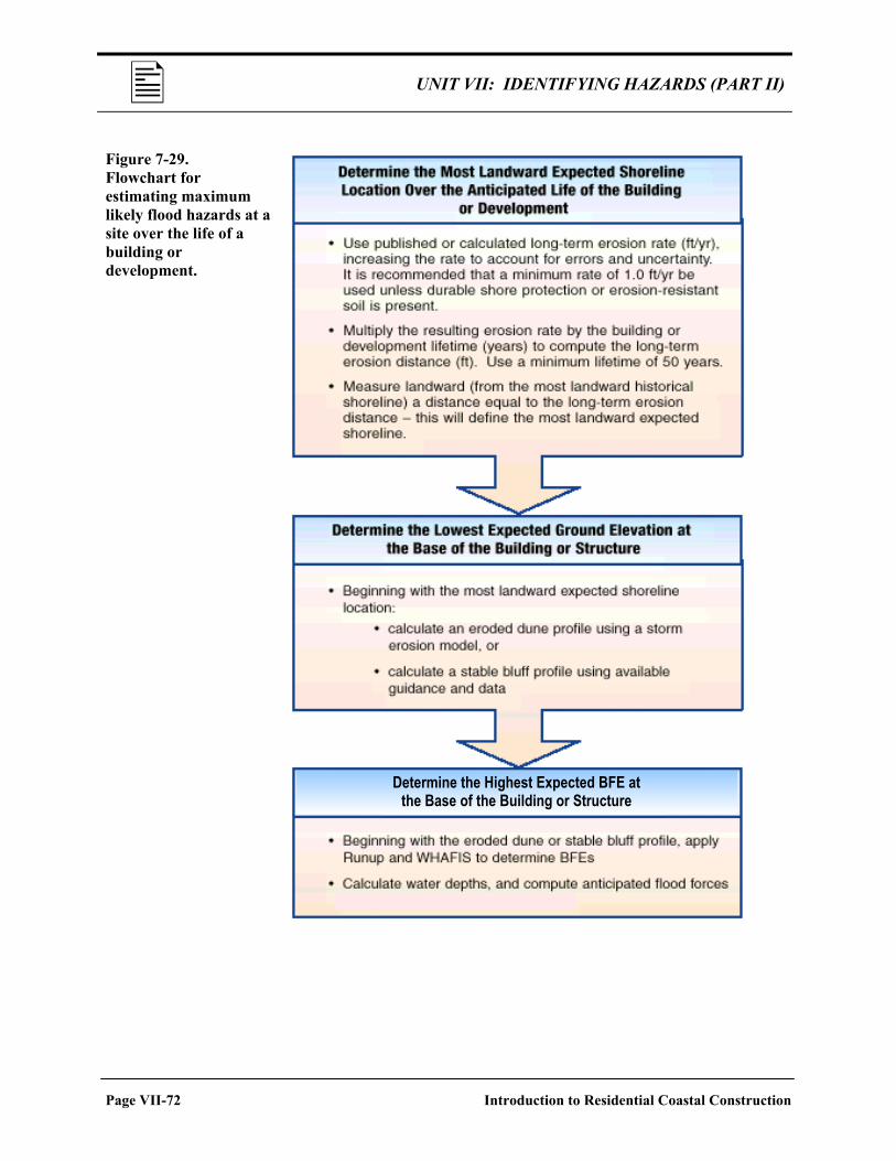
UNIT VII: IDENTIFYING HAZARDS (PART II)
Figure 7-29. Flowchart for estimating maximum likely flood hazards at a site over the life of a building or development.
Determine the Highest Expected BFE at the Base of the Building or Structure
Page VII-72 Introduction to Residential Coastal Construction
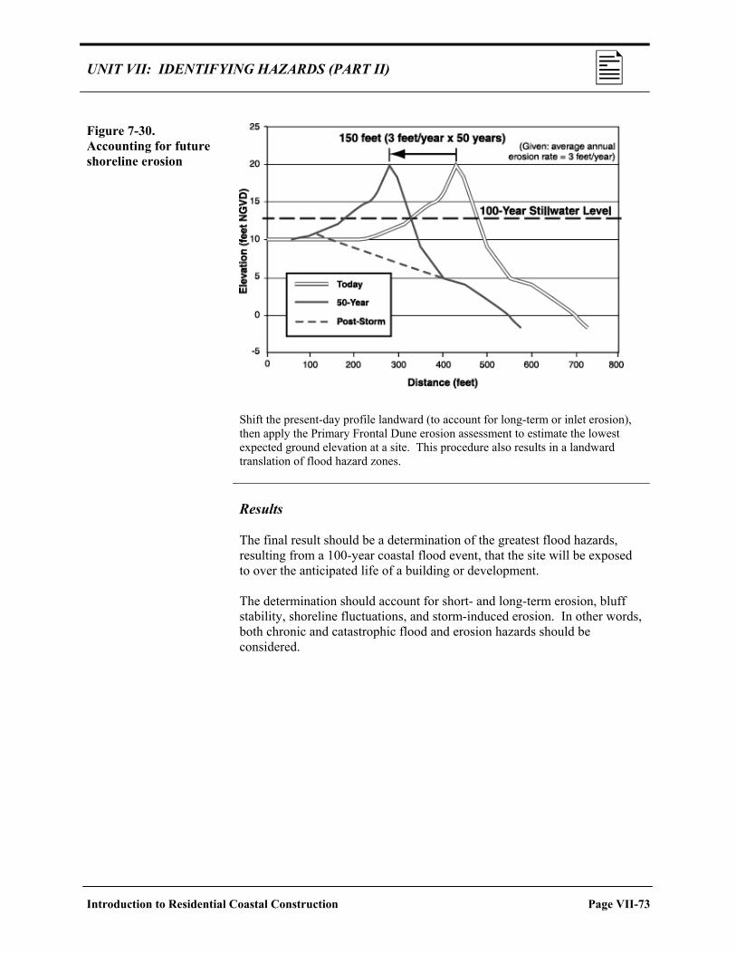
UNIT VII: IDENTIFYING HAZARDS (PART II) Figure 7-30. Accounting for future shoreline erosion
Shift the present-day profile landward (to account for long-term or inlet erosion), then apply the Primary Frontal Dune erosion assessment to estimate the lowest expected ground elevation at a site. This procedure also results in a landward translation of flood hazard zones.
Results The final result should be a determination of the greatest flood hazards, resulting from a 100-year coastal flood event, that the site will be exposed to over the anticipated life of a building or development. The determination should account for short- and long-term erosion, bluff stability, shoreline fluctuations, and storm-induced erosion. In other words, both chronic and catastrophic flood and erosion hazards should be considered.
Introduction to Residential Coastal Construction Page VII-73

UNIT VII: IDENTIFYING HAZARDS (PART II)
SELF-CHECK REVIEW: TRANSLATING HAZARD INFORMATION INTO PRACTICE Instructions: Answer the following questions. Then turn the page to check your answers. If you answered any items incorrectly, you should review the related material before continuing. 1. When reviewing a FIRM, what factors might indicate the need for a revised or updated flood hazard
assessment? 2. Identify three possible indicators that long-term erosion may render a FIRM obsolete:
(1) _______________________________________________________________ (2) _______________________________________________________________ (3) _______________________________________________________________
3. Fill in the blanks using words listed on the right.
Updated or revised flood hazard assessments should be directed at defining: • The __________________ shoreline expected during the life
of the building.
• The __________________ expected ground elevation.
• The __________________ expected BFE at the building during its life and the associated flood forces.
a. Lowest b. Highest c. Most landward d. Most seaward
Page VII-74 Introduction to Residential Coastal Construction

UNIT VII: IDENTIFYING HAZARDS (PART II)
The Answer Key for the preceding Self-Check Review is located on the next page.
Introduction to Residential Coastal Construction Page VII-75

UNIT VII: IDENTIFYING HAZARDS (PART II)
ANSWER KEY NOTE: Your answers may be slightly different, but they should include the same main points. 1. When reviewing a FIRM, what factors might indicate the need for a revised or updated flood hazard
assessment?
Any of the following: • The FIRM predates changes in FEMA’s mapping procedures. • The FIRM and FIS methods are not consistent with current methods. • Dune erosion was calculated using the 540 ft2 rule. • Major storms or flood events have occurred since the FIRM was completed. • Significant physical changes to the site have occurred since the FIRM was completed. • Significant alteration of adjacent property has occurred since the FIRM was completed.
2. Identify three possible indicators that long-term erosion may render a FIRM obsolete:
(1) Long-term erosion rates have been established. (2) Construction setback lines have been established. (3) Significant changes in the shoreline location or orientation have occurred.
3. Updated or revised flood hazard assessments should be directed at defining:
• The most landward shoreline expected during the life of the building.
• The lowest expected ground elevation.
• The highest expected BFE at the building during its life and the associated flood forces.
Page VII-76 Introduction to Residential Coastal Construction

UNIT VII EXERCISE
UNIT VII EXERCISE
Instructions: Use this Unit Exercise to test how well you learned the material presented in Unit VII. When you complete the exercise, check your answers against those in the Answer Key that follows. If you answered any questions incorrectly, be sure to review the corresponding section of the unit before proceeding to Unit VIII. 1. List three ways that erosion threatens coastal residential buildings. 2. Identify three causes of erosion. 3. Short-term erosion rates tend to be the same as long-term erosion rates.
True False
4. Seasonal fluctuations in beach width and elevation are a good indicator of long-term shoreline changes.
True False
5. Because storms are short-lived, the amount of erosion induced by storms tends to be minor.
True False
6. During coastal storms in dune-protected areas, areas experiencing _________________________ will form an effective barrier to storm effects.
a. Dune or bluff retreat b. Wave overtopping and overwash c. Dune disintegration d. Dune flooding or submergence
Introduction to Residential Coastal Construction Page VII-77

UNIT VII EXERCISE
7. Seawalls, bulkheads, and revetments prevent erosion of the beach.
True False 8. FIRMs do / do not incorporate long-term erosion. (Circle one.) 9. One of the ways that earthquakes damage coastal structures is through structural failure by excessive
deflection.
True False
10. In an earthquake, a building elevated on pilings may be subject to an “inverted pendulum” effect. This condition requires that the building be designed:
a. For a smaller earthquake force. b. For a larger earthquake force. c. To withstand earthquakes instead of flooding. d. On a solid foundation.
11. Match the “other hazards” on the left with effects on the right.
___ Subsidence ___ Salt spray and moisture ___ Rain ___ Hail ___ Landslides
a. Corrosion b. Loss of supporting soil c. Damage to roofing materials d. Increased flood depth e. Penetration of building envelope
12. Before basing siting decisions on FIS and FIRM information, it is important to consider the methods
that were used in conducting the study.
True False
Page VII-78 Introduction to Residential Coastal Construction

UNIT VII EXERCISE The Answer Key for the preceding Unit Exercise is located on the next page.
Introduction to Residential Coastal Construction Page VII-79

UNIT VII EXERCISE
UNIT VII EXERCISE—ANSWER KEY
NOTE: Some of your answers may be slightly different, but they should include the same main points. 1. List three ways that erosion threatens coastal residential buildings.
Any of the following: • Destroying dunes or other natural protective features. • Destroying erosion control devices. • Lowering ground elevations, undermining shallow foundations, and reducing penetration of
deep foundations. • Supplying overwash sediments that can bury structures farther landward. • Breaching low-lying coastal barrier islands. • Washing away low-lying coastal landforms. • Eroding coastal bluffs.
2. Identify three causes of erosion.
Any of the following: • Storms and coastal flood events. • Natural changes associated with tidal inlets, river outlets, and entrances to bays. • Manmade structures and human activities. • Long-term erosion. • Localized scour.
3. Short-term erosion rates tend to be the same as long-term erosion rates.
False
4. Seasonal fluctuations in beach width and elevation are a good indicator of long-term shoreline changes.
False
5. Because storms are short-lived, the amount of erosion induced by storms tends to be minor.
False
Page VII-80 Introduction to Residential Coastal Construction

UNIT VII EXERCISE 6. During coastal storms in dune-protected areas, areas experiencing _________________________
will form an effective barrier to storm effects.
a. Dune or bluff retreat 7. Seawalls, bulkheads, and revetments prevent erosion of the beach.
False 8. FIRMs do not incorporate long-term erosion. 9. One of the ways that earthquakes damage coastal structures is through structural failure by excessive
deflection.
True
10. In an earthquake, a building elevated on pilings may be subject to an “inverted pendulum” effect. This condition requires that the building be designed:
b. For a larger earthquake force.
11. Match the “other hazards” on the left with effects on the right.
d Subsidence a Salt spray and moisture e Rain c Hail b Landslides
a. Corrosion b. Loss of supporting soil c. Damage to roofing materials d. Increased flood depth e. Penetration of building envelope
12. Before basing siting decisions on FIS and FIRM information, it is important to consider the methods
that were used in conducting the study.
True
Introduction to Residential Coastal Construction Page VII-81